mission possible! kathy l. covert [email protected] federal geographic data committee
TRANSCRIPT


A few of those Federal Initiatives…
• National Spatial Data Infrastructure (NSDI)
• The National Map
• Geospatial One Stop
• I-Teams

The vision of the NSDI...
Current and accurate geospatial data will be readily available to contribute locally, nationally, and globally to economic growth, environmental quality and stability, and social progress.

National Spatial Data Infrastructure
• Technology• Policies• Standards• “Human resources”
• Framework• Clearinghouse• Standards• Partnerships

National Spatial Data Infrastructure
Framework
Data
Metadata
Clearinghouse
Standards Metadata
Clearinghouse
Standards
Data
Framework

National Spatial Data Infrastructure
Framework
Data
Metadata
Clearinghouse
Standards Metadata
Clearinghouse
Standards
Data
Framework

The National Map
“Our vision is that, by working with partners, we will provide the Nation with access to current, accurate, and nationally consistent digital data and topographic maps derived from those data.”

Geospatial One Stop
“The Geospatial Information One Stop Project will support “one stop” access…to the Federal Government’s geospatial data assets.”

I-Teams
“I-Teams are a collaboration to implement a portion of the NSDI; a process focused on actions and outcomes; a brand name to help build political awareness.”
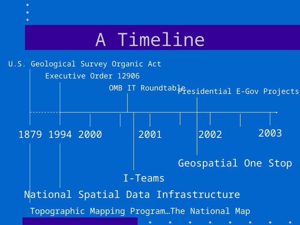
A Timeline
1879 1994 20012000 2002
Topographic Mapping Program…The National Map
U.S. Geological Survey Organic Act
National Spatial Data Infrastructure
Executive Order 12906
2003
OMB IT Roundtable Presidential E-Gov Projects
Geospatial One Stop
I-Teams

Initiatives at a glance…Authority What is it? Goal
NSDI EO 12906 A visionary organizing concept
Current, accurate and readily available geospatial data
The National Map
Organic Act1879
A national program
Seamless digital topographic data & maps
GeospatialOne Stop
OMB Exhibit 300
A presidential initiative
Web portal for Federal data
I-Teams OMB (not formalized)
A process I-Plans

What does it take?
• A vision
• Shared values
• Strategic plan
• Technical know-how
• Political support

Are we there yet ?

A few suggestions…
• Keep it simple
• Build on your successes
• Begin small
• Make it work for you
• Have fun!

A final paradox
“The key to a genuinely uncentralized system is mutually agreed standards on whatever is central to the system and
thus cannot be left to individual choices or market outcomes.”
Harlan Cleveland

Mahalo!
• Federal Geographic Data Committee
• http://www.fgdc.gov
• (703) 648-4144