missouri resources - dnrmissouri resources is printed with soy ink on recycled paper at walsworth...
TRANSCRIPT

MissouriResources
MissouriResources
Winter 2015 • Volume 32 • Number 1
40 yearsMissouri Department of Natural Resources
Gov. Nixon declares
2015the Year of Water

State of Missouri, Governor Jeremiah W. (Jay) Nixon
Department Director Sara Parker Pauley
Deputy Director Todd Sampsell
Director, Division of Administrative Support Lori Gordon
Director, Division of Environmental Quality Leanne Tippett Mosby
Director, Missouri State Parks Bill Bryan
Director, Missouri Geological Survey Joe Gillman
Director, Environmental Improvement and Energy Resources Authority Karen Massey
printed on recycled paper
EditorStuart Westmoreland
Design DirectorBelinda Hughes
PhotographersScott MyersAndrew Richmond
Assistant EditorAndrew Richmond
CirculationLuke PetreeShannon Hutton
Editorial BoardLarry ArcherAndrea BalkenbushHylan BeydlerRenee BungartSteph DeidrickStuart Westmoreland
MISSOURI RESOURCES is published quarterly by the MissouriDepartment of Natural Resources to inform readers about important natu-ral resource issues and how they are being addressed. Any correspon-dence should be directed to the editor at the Department of NaturalResources, Publications, PO Box 176, Jefferson City, MO 65102-0176, or call 800-361-4827. Email address: [email protected]. MoDNR home page: dnr.mo.gov. To subscribe or unsubscribe online:dnr.mo.gov/magazine/subscription.htm.
MISSOURI RESOURCES is available in alternative formats.
As a recipient of federal funds, the Department of Natural Resources can-not discriminate against anyone on the basis of race, color, national origin, religion, age, sex, disability, sexual orientation or veteran status.
If anyone believes he or she has been subjected to discrimination for anyof these reasons, he or she may file a complaint with either theDepartment of Natural Resources or the Office of Equal Opportunity, U.S.Department of the Interior, Washington, D.C., 20240.
Missouri Resources is printed with soy ink on recycled paper at Walsworth Publishing Co., Marceline, Mo.Mission Statement
The mission of the Missouri Department of Natural Resources is to protect our air, land and water; to preserve our unique natural and historic places; and to provide recreational and learning opportunities for everyone.
Winter 2015Volume 32 • Number 1
Additional content available forthis story – go todnr.mo.gov/education.
L ife is a journey with prob-lems to solve and lessons
to learn. When we are facedwith these challenges alongthe way, we can react one oftwo ways – give up out of frus-tration or persevere and real-ize they are only temporarysetbacks. How we choose toreact and the decisions wemake will determine the out-come of our journey.
Forty years ago, the Mis-souri Department of NaturalResources began its journey ofprotecting our natural re-sources. Many of our stake-holders, regulated entities andcitizens of Missouri havewalked alongside our agency.Together, we tackled many ofthe challenges faced duringthe last four decades. Our de-termination and commitmentto protecting our natural andcultural resources has brought us towhere we are today.
Last month, the department hostedthe Governor’s Conference on Natu-ral Resources to explore our legacyand celebrate our achievements. Theconference also provided us with theopportunity to pause from this jour-ney, check the map, reorient our-selves, if you will, and determine howwe must chart our future.
Attendees identified and discussednumerous topics during the confer-ence, as well as suggested and priori-tized future actions. The input provid-ed during the conference will beincluded as part of the department’sstrategic planning process. This planwill help ensure the department iscapturing what the public believesneeds to be addressed during the next10, 20 and 40 years.
director’s
MissouriResources
Sara Parker PauleyMissouri Department of Natural Resources
Gov. Nixon was the keynote speak-er during the evening banquet, andpresented the Governor’s Natural Re-sources Awards of Excellence to eightorganizations, businesses and individ-uals who are leading the way in theprotection and enhancement of ournatural resources. You can read moreabout these amazing award winnersin the DNR News section of this issueof Missouri Resources. Additional in-formation and video from the confer-ence are available at dnr.mo.gov/governor-conference.htm.
As the department’s 40th anniver-sary draws to a close, I’d like to ex-tend our appreciation for your contin-ued support in our journey andpursuit to enhance Missouri’s naturalresources. We all share a commongoal of protecting these most preciousnatural and cultural resources – be-cause they belong to all of us.
With your help, the department willcontinue to work to provide all Mis-sourians a healthy environment inwhich to live, work and enjoy thegreat outdoors!

Above: White pelicans begin showing up in mid-September at Riverlands Migratory Bird Sanctuary north of St. Louis. Photo by LaneRichter/National Audubon Society.Front Cover: Late afternoon sun shines through a snow shower on the Grassland Trail in Rock Bridge Memorial State Park, nearColumbia. DNR photo by Scott Myers.Back Cover: A Roaring River State Park volunteer pauses with First Day hikers on Jan. 1, 2014. DNR photo by Kerry Hays.
departments18 Explore Missouri 20 DNR News 22 Top Spots 25 … But Not Least
2 dnr40 Photo Contest WinnersThe photos are in and the votes are tallied. The top four are featured from our contest categories: Natural Resources, People and the Environment, and Special Places.
8 The Hole Storyby Larry ArcherNot all sinkholes are created equal. One Greene County sinkhole turned out to be a catastrophe-in-waiting.
10Missouri is a Hot Spot for Cold Weather Birdingby Tom Uhlenbrock
Converging flyways make Missouri ground zero for bird-watchers. Both the Mississippi and Missouri rivers serve as conduits that provide a steady influx of migrating waterfowl and other birds throughout the fall and winter months.
14 GeoSTRAT – Tried and Trueby Hylan Beydler
The Geosciences Technical Resource Assessment Tool has a long name. The list of things it can do for you is much longer.
40 yearsMissouri Department of Natural Resources

2 Missouri Resources
T he Missouri Depart-ment of Natural Re-sources has selected
the winners of the Missouri-DNR40 Photo Contest heldearlier this year to help cele-brate and publicize the depart-ment’s 40th anniversary.
“I am very pleased with the237 amazing photographs thatwere submitted in the depart-ment’s first photo contest,”said Sara Parker Pauley, di-rector of the Missouri Depart-ment of Natural Resources.“All of the photographs wereceived truly captured the di-versity of Missouri’s rich andoutstanding natural resources,making the final selections avery difficult decision.”
First, second and thirdplaces, as well as an honor-able mention, were selectedfrom each of the three cate-gories – Natural Resources,People and the Environment,and Special Places.
From the picturesque pho-tograph taken at the peak ofsunset on Table Rock Lake, tothe young adults exploringand enjoying Elephant RocksState Park, to the tree-framedimage taken of Dillard MillState Historic Site – we’revery proud of Missouri’s nat-ural resources and all theyhave to offer to its citizensand visitors.
These winning photo-graphs capture the reason whyit is critically important forthe department and Missouricitizens to continue to helpenhance our natural resources– after all, it’s in our nature!
FIRST PLACE David Dean White, KirbyvilleTable Rock Lake Sunset – Table Rock Lake, Taney County
dnr40 Photo Contest WinnersAnd the winners are …
Winter 2015 3
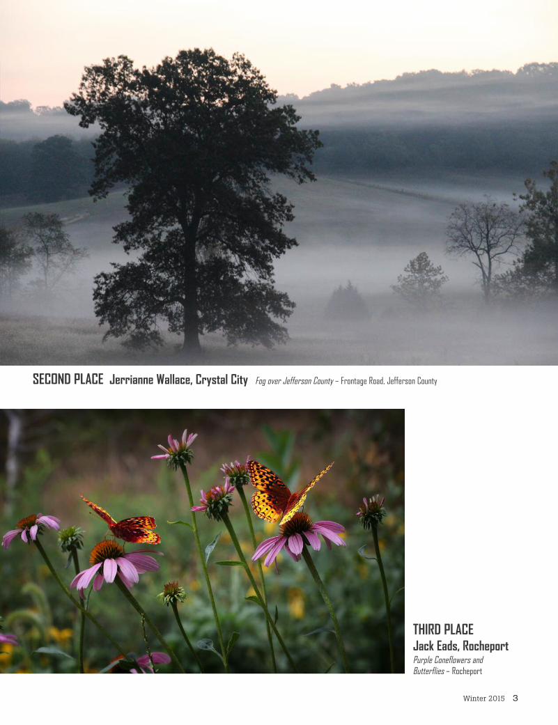
SECOND PLACE Jerrianne Wallace, Crystal City Fog over Jefferson County – Frontage Road, Jefferson County
THIRD PLACEJack Eads, RocheportPurple Coneflowers andButterflies – Rocheport

4 Missouri Resources
HONORABLE MENTIONJoe Herrick, BoonvilleBlue Heron – Eagle Bluffs Conservation Area, Boone County
FIRST PLACE Ivan Eugene Greer, Columbia Teamwork at Elephant Rocks – Elephant Rocks State Park, Belleview
SECOND PLACEBen Banet, St. Louis
Staying Warm Beneath Starry Skies –Taum Sauk Mountain State Park,
Middlebrook(right)
Winter 2015 5
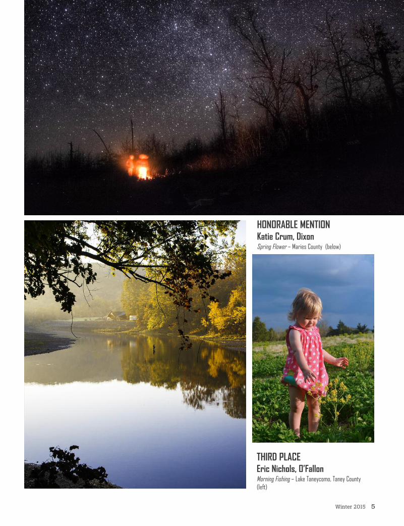
THIRD PLACEEric Nichols, O’FallonMorning Fishing – Lake Taneycomo, Taney County(left)
HONORABLE MENTIONKatie Crum, DixonSpring Flower – Maries County (below)

6 Missouri Resources
FIRST PLACE Alex Hanna, UnionDillard Mill – Dillard Mill State Historic Site, Davisville(above)
HONORABLE MENTION Jim Campbell, St. LouisSandy Creek Cathedral of Trees – Sandy Creek Covered Bridge State Historic Site, Goldman

Winter 2015 7
THIRD PLACEBen Banet, St. LouisStar Trails Over ProffitMountain Campsite –Taum Sauk MountainState Park,Middlebrook
SECOND PLACEJim Campbell,St. LouisSandy Creek Bridge in Winter – Sandy Creek CoveredBridge State Historic Site, Goldman(above)
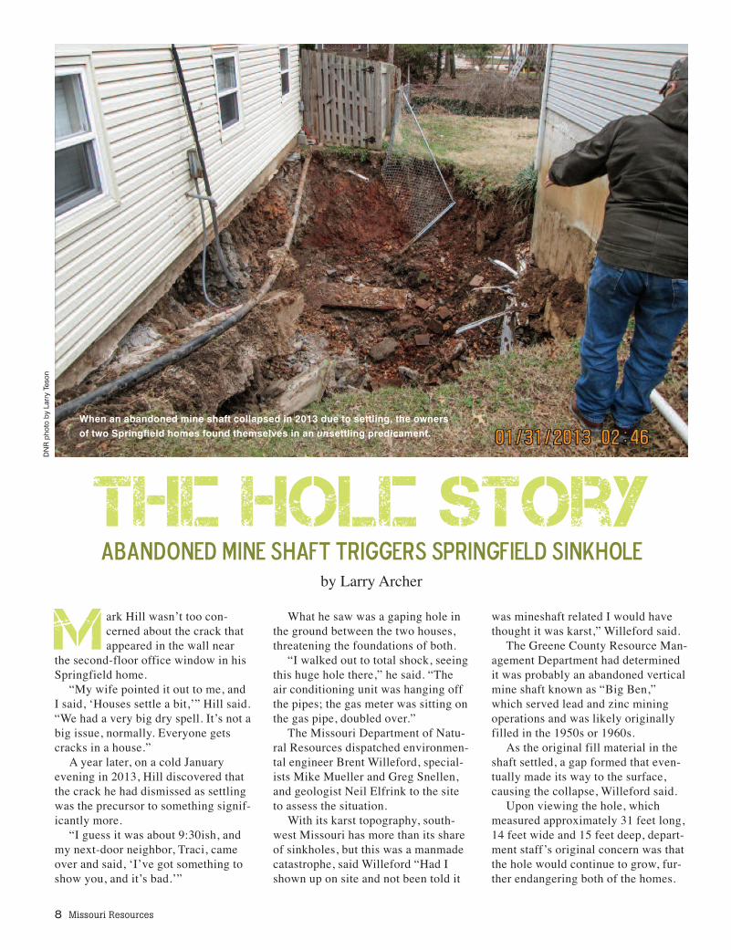
M ark Hill wasn’t too con-cerned about the crack thatappeared in the wall near
the second-floor office window in hisSpringfield home.
“My wife pointed it out to me, andI said, ‘Houses settle a bit,’” Hill said.“We had a very big dry spell. It’s not abig issue, normally. Everyone getscracks in a house.”
A year later, on a cold Januaryevening in 2013, Hill discovered thatthe crack he had dismissed as settlingwas the precursor to something signif-icantly more.
“I guess it was about 9:30ish, andmy next-door neighbor, Traci, cameover and said, ‘I’ve got something toshow you, and it’s bad.’”
What he saw was a gaping hole inthe ground between the two houses,threatening the foundations of both.
“I walked out to total shock, seeingthis huge hole there,” he said. “Theair conditioning unit was hanging offthe pipes; the gas meter was sitting onthe gas pipe, doubled over.”
The Missouri Department of Natu-ral Resources dispatched environmen-tal engineer Brent Willeford, special-ists Mike Mueller and Greg Snellen,and geologist Neil Elfrink to the siteto assess the situation.
With its karst topography, south-west Missouri has more than its shareof sinkholes, but this was a manmadecatastrophe, said Willeford “Had Ishown up on site and not been told it
was mineshaft related I would havethought it was karst,” Willeford said.
The Greene County Resource Man-agement Department had determinedit was probably an abandoned verticalmine shaft known as “Big Ben,”which served lead and zinc miningoperations and was likely originallyfilled in the 1950s or 1960s.
As the original fill material in theshaft settled, a gap formed that even-tually made its way to the surface,causing the collapse, Willeford said.
Upon viewing the hole, whichmeasured approximately 31 feet long,14 feet wide and 15 feet deep, depart-ment staff’s original concern was thatthe hole would continue to grow, fur-ther endangering both of the homes.
8 Missouri Resources
When an abandoned mine shaft collapsed in 2013 due to settling, the ownersof two Springfield homes found themselves in an unsettling predicament.
The Hole StoryAbandoned Mine Shaft Triggers Springfield Sinkhole
by Larry Archer
DN
R p
hoto
by
Larr
y Te
son

“The integrity ofthe house was the firstthing that jumped outat me,” Willeford said.“My first thought waswhat can we do to sta-bilize the site to buy ussome more time.”
Within a day of ar-riving on the scene,staff arranged for tem-porary fill material atthe site and a series oftimbers and jacks tosupport the homes’foundations. With thehomes temporarilysupported, staffworked with the engi-neer hired by thehomeowners on alonger-term solution.
A poured-in-place reinforcedconcrete beam was constructedto support Hill’s house, while aseries of pilings were used tosupport his neighbor’s home. Theprocess took more than six weeksto complete.
With the homes secured, thedepartment oversaw the properclosing of the shaft, which re-quired approximately 77 cubicyards of reinforced concrete.
Despite the cost and incon-venience, the homeowners werefortunate, Willeford said.
“Had the houses been 20-30feet either way, and that holeopened up underneath one ofthem, it would have been a com-pletely different situation,” hesaid. “The house would have like-ly had to be demolished.”
Homeowners interested infinding out what might be lurk-ing beneath their homes haveaccess to the same materialsstaff used through the MissouriGeological Survey’sGeoSTRAT system (see articleon page 14) and the State Archives, abranch of the Missouri Secretary ofState’s Office.
Now landscaped, the site bears noresemblance to the scene that Januaryevening when “all hell broke loose,”Hill said. “The whole team and the
whole approach was just so good,” hesaid. “From the initial work of gettingthings out and getting it stabilized, tothe engineer who really did his home-work on it, to the construction compa-ny, and most of all, to the guys fromDNR who just did a magnificent job. I
can’t speak highly enough of them –they saved my house. And that’s anincredible thing.”
Larry Archer is the division informa-tion officer for the department’s Divi-sion of Environmental Quality.
Winter 2015 9
*not to scale
MINE SHAFT COLLAPSE*
f mmmmmmmmmmmmmmmmmf mf mf mfr mfr mfr mfr mfromfromfrofrofrofrofrofrofro1950s-60s50s50s50s50s50s50s50s50s50s50s50s50s50s50s5050191911 60-60
sh d t d t d t d t d t d t d t d pt d p d p d p p p p p ep ep s s s s s s s h d h d h d h d h h h a a a a a a aft th h sh d t s s s s s s s s th h 90’0’’’9090909090909999999999
ft diame e e e e e e e e e e e e e t d d d d d d d s f s af s af s a s a s a s a s a s a s a s a s a s a s a s a sha diam diam diam dia dia dia dia ia ia ia ia a a a me me eter et r ete ete ete ete ete ete ete ete ete ete ete ete ete te te te app ox pp ox pp ox pp ox pp o pp o pp o pp o pp o pp o ppro ppro ppro pro pro pro pro a a
x 10’ 0’ 0’ 0’ 0’ 10’ 10’ 10 10 10 10 10 10 10 10 10 10 0 10
approx. 15’
MINE COLLAPSE REPAIR
Hill Residence Neighbor’s Residence
aftmiminene hsh faftt
chchchchchchatatatatatat/e/e/e/e/e/eararararararththththththenenenenenen f f f f f fililililililllllll
ccc gggcoconcncncrererer tetetet p p pluluuggg
After nearly 60 years ofsettling, gaps began toopen up in the original fillmaterial, eventually lead-ing to a collapse of thesoil into the opening of themine shaft (left). After sta-bilizing the homes’ foun-dations, crews overseenby the Department of Nat-ural Resources’ LandReclamation Programcapped the original shaftwith a concrete plug, cov-ered the plug with earthenfill and small rock (chat)and replanted the grassthat had been there origi-nally (below).

10 Missouri Resources

Winter 2015 11
Missouri’s big rivers serve as amigratory highway for water-fowl. Some of the nation’s
best bird watching happens within thestate with mass gatherings of ducks,geese, pelicans, eagles, trumpeterswans and other species.
Birds heading south for the winteruse four major flyways to cross thecontinent, and Missouri is smack dabin the middle of two of them – theMississippi Flyway and the CentralFlyway. The latter begins in the Arc-tic, crosses the Great Plains and headsacross Missouri, where it meets theMississippi Flyway at St. Louis.
“The big river systems in ourcountry are very visible landmarksfor birds – they can see the rivers dayand night,” said Lane Richter, a sen-ior ecologist with the NationalAudubon Society. “Although thelandscape has changed over the last200 years, the rivers still providevaluable habitat for over-winteringpurposes,” Richter said. “You get dif-ferent groups of birds that stop to re-fuel before moving on, and some thatstay to spend the winter.
“The nice thing is the MississippiRiver runs north and south, and is themost direct route from northernbreeding habitat to southern winter-ing grounds.”
Richter has the best seat in thehouse for watching the massive mi-gration. His office is at the AudubonCenter at Riverlands, a new bird-watching facility at the RiverlandsMigratory Bird Sanctuary developedby the U.S. Corps of Engineers on theMississippi River north of St. Louis.
Confluence Point State Park,which is the only place where a visi-tor can put one foot in the Mississippiand the other in the Missouri, is adja-cent to the sanctuary at the meeting ofthe two great rivers. The state park,federal refuges and the Missouri De-
by Tom Uhlenbrock
In 2013, Van Meter State Park, near Mar-shall, is almost completely obscured bythousands of snow geese that arrived at Grand Pass Conservation Area wetlands. DNR photo by Scott Myers

12 Missouri Resources
partment of Conservation’s Columbia Bot-tom Conservation Area join to create a10,000-acre welcome mat for migratingbirds that follow the freeze line south insearch of open water.
“One period last winter, I counted 26species right outside the center window,”Richter said. “You’d find a new species asfast as you could write them down.”
Among the arrivals were as many as 60bald eagles, flocks of 50 or more white peli-cans and more than 900 trumpeter swans, aregal bird with a wing span of up to 8 feet.
“That was double the high count fortrumpeters from the year before, probablybecause it was a harsh winter up north,”Richter said. “The trumpeters are the newall-stars out there – they’re a nice story.”
Confluence Point State Park provides acomplement to the large open water bays of
the sanctuary because it has a dozen shal-low pools that attract other species of birds.
“The sanctuary gets more ducks andgeese and we get the wading birds,” saidQuinn Kelner, natural resource manager ofthe park. “We get egrets and herons, yellowrail, phalarope, plovers and other waders.
“We get a few short-eared owls, and al-ways have groups of horned larks that feedon the shoulders of the roadway.”
Wintering bald eagles can be found atany of the state parks that have large lakesor are along rivers. During the 2013 annualwinter eagle count, 2,693 eagles wererecorded in the state. The three popularstate trout parks – Montauk, Bennett Springand Roaring River – attract eagles that dineon trout in the spring-fed streams.
Here are other excellent winter bird-watching spots in Missouri State Parks, in-cluding some that team with federal facili-ties and conservation areas to attractmassive numbers of birds. National wildliferefuges and state conservation areas allowhunting; state parks do not.
Wakonda State Park: Tucked in thenortheast corner of the state along the Mis-sissippi River, Wakonda State Park has sixlakes that serve as pit stops for birds migrat-ing down the big river.
“The teal will start arriving at the end ofAugust, followed by cormorants, pelicans,geese, trumpeters and every duck you canname,” said Kyle Scott, park manager. “Wehad more than 100 trumpeters for a whilelast year. A few eagles will stop by and will
After the ice begins to formon smaller impoundments,bald eagles often congre-gate near lakes and riverswith open pools or spring-fed waters, such as this
adult at Roaring River StatePark near Cassville.
DNR photo by Kerry Hays
Majestic trumpeter swansare welcome winter visitors
at Edward “Ted” and Pat Jones-Confluence
Point State Park.
DNR pho
to by Sco
tt Myers
“… last winter, I counted 26 species right outside the center window.”– Lane Richter, ecologist, National Audubon Society

“We get a lot of school groups that comeout and visit; most have only seen the Mis-sissippi River from the Arch grounds,”Richter said. “They go out to ConfluenceState Park to witness the power of therivers, and along the way see all thebirds in their natural habitat. It’s areal eye-opening experience.”
Tom Uhlenbrock is a writer for MissouriState Parks.
Winter 2015 13
stay when everything else freezes up be-cause the geese keep pools of water open.”
Pershing State Park: Located in north-central Missouri on Locust Creek, the parkhas created a wetlands area on 1,500 acresof land that has been sculpted into a mosaicof pools.
“I’m guessing on a good day, we’ll get150 bald eagles,” said Tom Woodward, parkmanager. The park is part of the Golden Tri-angle, which includes the neighboring Foun-tain Grove Conservation Area and SwanLake National Wildlife Refuge. Together,they hold nearly 25,000 acres of wildlifehabitat that is a magnet for waterfowl.
Van Meter State Park: South of theMissouri River near Marshall, the park fea-tures the 300-acre Oumessourit NaturalArea, which shows what the floodplainlooked like before the river was channelizedand constricted by levees. Three shortboardwalks lead out into themarsh, wet prairie and forest. Anactive bald eagle nest is nearby.Walk out onto the boardwalks infall and winter, and the skies aboveare lined with the V-formations ofwaterfowl flying in and out of thenearby Grand Pass ConservationArea, which is 5,300 acres of wet-lands along six miles of the river.The distant honking of the geese ismesmerizing.
Lewis and Clark State Park:Located north of Kansas Cityalong the Missouri River, the parkis named for the explorers whostopped there in 1804 and namedthe big oxbow lake Gosling Lakefor the huge numbers of geese. Thelake is still there and in winter at-tracts large numbers of waterfowl,many of them flying in from thenearby Squaw Creek NationalWildlife Refuge.
“In winter, we are like a mecca for ea-gles, last year it was well over 100,” saidJim Kunce, park manager. “We get thou-sands of snow geese and Canada geese. Wehave a really cool observation area on apaved plaza that sits beside the lake.”
Big Lake State Park: West of SquawCreek National Wildlife Refuge on the Mis-souri River, the park has hundreds of eagles
that visit during the winter and five residenteagles that live year-round in the park. Thepark features one of the state’s most dramat-ic displays of nature, with snow geese risinglike a noisy white tornado at daybreak, andeagles moving in to feed on those thatdidn’t make it through the night.
“We probably had 300,000 snow geeselast year because of low water in the refuge,and more than 150 bald eagles, which fol-low the snow goose migration,” said Rus-sell Burge, park manager. “They stayed herefor two weeks. The majority of the lake wasfrozen, but they were able to keep a big holeopen. Birdwatchers make the loop throughthe wildlife refuge then come here and drivethe three-mile park road.”
Lane Richter, the Audubon ecologist atRiverlands, said the wildlife show generallystarts in September and continues through the winter season until the warm-up ofMarch sends the birds back north.
Canada geese and trum-peter swans share ice andopen water at Big LakeState Park in Holt County.
DNR pho
to by Russel B
urge

If you haven’t used GeoSTRAT, the De-partment of Natural Resources’ Geo-sciences Technical Resource Assessment
Tool, you ought to give it a try.GeoSTRAT is a Web-based tool, built
using Google Earth and ESRI GIS mappingtechnology. It makes satellite imagery andgeologic and hydrologic data available tocitizens, planners, industry, academia andothers online 24/7.
Sinkholes, mines, springs, certified waterwells, groundwater depth, cave density andother features can be located on the interac-tive map using a Web browser. GeoSTRATcan be used for data assessments in disci-plines such as hazards assessment, environ-mental consulting and engineering, local
14 Missouri Resources
and regional planning, insurance assess-ment and others.
GeoSTRAT lets you fly anywhere inMissouri to see aerial views of the land-scape and navigate and explore the surfaceas if you are standing on the ground. Hav-ing data at one’s fingertips, instead ofstored on shelves, in cabinets and onlyavailable during conventional workdayhours, provides users critical informationaround the clock. It is invaluable to emer-gency personnel when natural or man-madedisasters occur. Numerous data layers nowcompiled in GeoSTRAT were used to aidplanners in properly locating sites for land-fills for debris removal following the torna-do that devastated Joplin in 2011. Having
While examining propertynear his family home, LucasTabor, a student at Missouri
State University-WestPlains, views the
Certified Wells layer inGeoSTRAT to determine
locations of existing and closed wells.
DNR photo by Scott Myers
GeoSTRAT – Tried and Trueby Hylan Beydler
Winter 2015 15
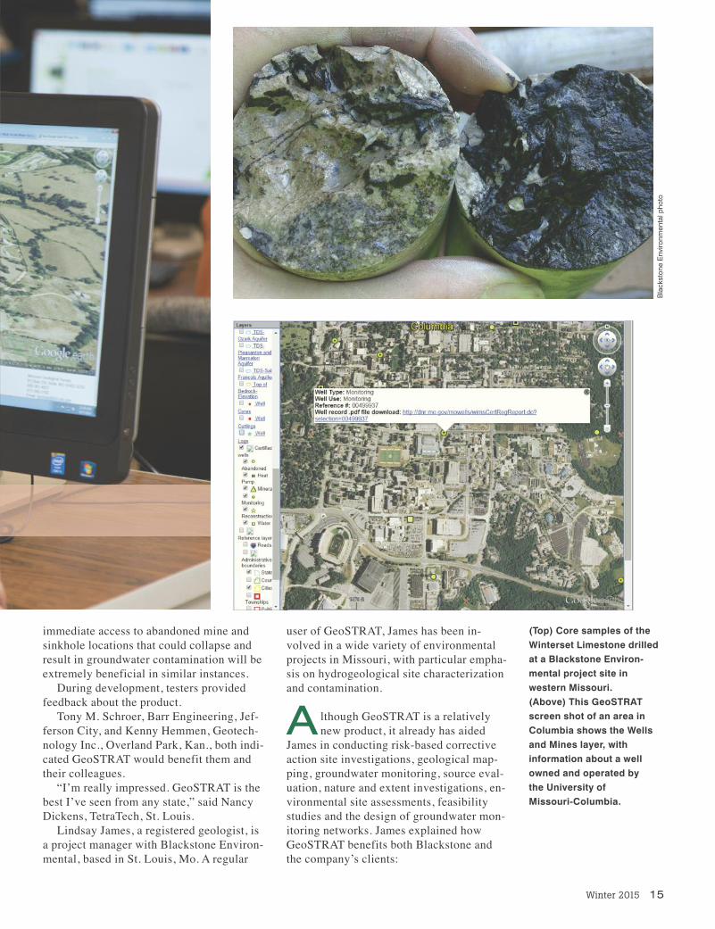
immediate access to abandoned mine andsinkhole locations that could collapse andresult in groundwater contamination will beextremely beneficial in similar instances.
During development, testers providedfeedback about the product.
Tony M. Schroer, Barr Engineering, Jef-ferson City, and Kenny Hemmen, Geotech-nology Inc., Overland Park, Kan., both indi-cated GeoSTRAT would benefit them andtheir colleagues.
“I’m really impressed. GeoSTRAT is thebest I’ve seen from any state,” said NancyDickens, TetraTech, St. Louis.
Lindsay James, a registered geologist, isa project manager with Blackstone Environ-mental, based in St. Louis, Mo. A regular
user of GeoSTRAT, James has been in-volved in a wide variety of environmentalprojects in Missouri, with particular empha-sis on hydrogeological site characterizationand contamination.
A lthough GeoSTRAT is a relativelynew product, it already has aided
James in conducting risk-based correctiveaction site investigations, geological map-ping, groundwater monitoring, source eval-uation, nature and extent investigations, en-vironmental site assessments, feasibilitystudies and the design of groundwater mon-itoring networks. James explained howGeoSTRAT benefits both Blackstone andthe company’s clients:
(Top) Core samples of theWinterset Limestone drilledat a Blackstone Environ-mental project site in western Missouri.(Above) This GeoSTRATscreen shot of an area in Columbia shows the Wellsand Mines layer, with information about a wellowned and operated by the University of Missouri-Columbia.
Blackston
e Enviro
nmen
tal p
hoto

“GeoSTRAT has proven invaluable in awide variety of projects for us, everythingfrom environmental site assessments, to ac-curately costing drilling services, to con-ducting even more complex hydrogeologi-cal site investigations.”
Blackstone Environmental recently em-ployed the GeoSTRAT tool on a bedrockcoring project that was part of a larger hy-drogeological site characterization.
“We were able to use the overburdenthickness (soil or other unconsolidated ma-
terial layered over bedrock) layer informa-tion and lithologic (physical characteristicsof rock) information from nearby well logsto provide more accurate subsurface infor-mation to our drilling subcontractor,” saidJames. “This enabled us to more efficientlyplan drilling work and to provide more real-istic drilling cost estimates to our client.”
The ability to overlay existing data onan aerial image from the U.S. Depart-
ment of Agriculture’s National Agriculture
GeoSTRAT: A Tool for EveryoneGeoSTRAT is easy to use. If you’re a history buff, educator or just curious about your surround-
ings, you will find something interesting using the tool. I discovered information about a limestonesurface mine located west of Dixon my late granddad Joe Beydler owned and operated as ayoung man. Hewas one of manywho helped buildour interstatehighway system. As it happened,
the first layer Ichose was “In-ventory of Mines,Occurrences andProspects.” Thislayer provides in-formation aboutthe commodity,operation statusand type, forma-tion mined orprospected, ele-vation, operatorname, and more. Being a native
of Dixon, I contin-ued to explorethat region. Next, Iturned on theWell Logs layerand located Com-munity PublicWell #1, owned and operated by the city of Dixon. Thewell was drilled in 1939 at a depth of 886 feet; depth tobedrock was 20 feet; static water level after it wascased was 180 feet; and the elevation at the location is1,162 feet above sea level. A wealth of information is available using GeoSTRAT.
You may discover things related to geology and yourfamily history, or other helpful information. ExploreGeoSTRAT and let us know what you discover. Sendquestions and suggestions to [email protected].
(Above) Mary Ann Mutrux assists Karley Good and Shaylee Conner in identifying watersheds,bedrock, springs and other features. Mutrux, geography instructor with Missouri State Universi-ty–West Plains, developed a project called “Geosystem Personal Profile.” Her students useGeoSTRAT to complete the project work.
16 Missouri Resources
DN
R p
hoto
by
Sco
tt M
yers
Dor
othy
Bey
dler
pho
to
(Above right) This limespreader was used in the1940s and 1950s at the
limestone mine owned bythe story author’s late
grandfather. Pictured as ayoung boy, standing on the
truck’s sideboard is her father, Bill. Mines and
other features are found in GeoSTRAT.

Winter 2015 17
Imagery Program was helpful in determin-ing locations for additional borings andwells. Blackstone used lithologic informa-tion from GeoSTRAT, along with field datato create geologic cross sections of the proj-ect site. James said having that informationreadily available helped streamline the proj-ect from its initial budgeting stage topreparing the job’s final report.
“Without GeoSTRAT, we likely wouldhave incurred additional expense to extractrock core and to characterize the rock,”James added.
Blackstone also uses GeoSTRAT whenconducting Phase I Environmental Site As-sessments, which are often used to assessenvironmental conditions of real estate aspart of property transactions. The CertifiedWell layer is a great screening tool for siteassessments because the existence of moni-toring wells on or near a property can indi-cate the current or past presence of contami-nation. Conversely, if a monitoring well isdiscovered during site reconnaissance, in-formation from the Certified Well layer canprovide ownership information and wellconstruction details.
Because Phase I Environmental Site As-sessment reports often are needed quickly,knowing details such as the well identifica-tion and ownership can help us obtain back-
ground documents more quickly. “The Bedrock layer is also an excellent
resource for general geological informationfor the area that is typically provided as partof a Phase I Environmental Site Assess-ment,” said James.
The department adds new and updated dataregularly that can be downloaded and used infree and commercial mapping software.Learn more and access GeoSTRAT atdnr.mo.gov/geostrat.
Hylan Beydler is division information offi-cer for the department’s Missouri Geologi-cal Survey.
DN
R p
hoto
by
Sco
tt M
yers
DN
R p
hoto
by
Sco
tt M
yers
(Above) To begin her re-search, Mandi Follis identi-fied the Galloway City Parkboundary using GeoSTRAT. (Below) Students Jeff Batesand Jessi Thomason usethe software to identify geo-logic, hydrologic and man-made features.

18 Missouri Resources
explore
The crowds are gone, wildlifeabounds and the fish are biting. The
catch-and-release season is a beautifultime to visit Missouri State Parks’ threepopular trout fishing parks.
March 1 marks the traditional openingof the trout season, and is a festive occa-sion with anglers lining the water to trytheir luck.
Montauk State Park near Salem, Ben-nett Spring State Park near Lebanon andRoaring River State Park near Cassvilleall will sell as many as 2,000 trout tags inwhat has become an annual rite of springfor generations of anglers, families andfriends alike.
The regular season closes at the end ofOctober, and a magical thing happens atthe parks. Each are located in deep wood-ed Ozark valleys cut by clear, spring-fedstreams, and a peaceful tranquility settlesover the pristine landscape.
by Tom Uhlenbrock
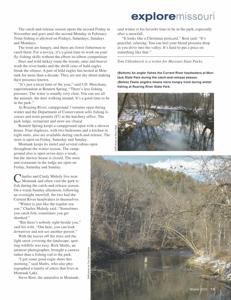
(Top) A solitary fisherman stalks a pool that normally is crowded during the regulartrout-fishing season. DNR photo by Tom Uhlenbrock
(Above) Snowfall paints a wintry scene for catch-and-release anglers to enjoy atMontauk State Park.
DNR pho
to by Kerry Hays
The catch-and-release season opens the second Friday inNovember and goes until the second Monday in February.Trout fishing is allowed on Fridays, Saturdays, Sundays and Mondays.
The trout are hungry, and there are fewer fishermen tocatch them. For a novice, it’s a good time to work on yourfly-fishing skills without the elbow-to-elbow competition.
Deer and wild turkey roam the woods, otter and beaverwork the river banks and the shrill cries of bald eaglesbreak the silence. A pair of bald eagles has nested at Mon-tauk for more than a decade. They are not shy about makingtheir presence known.
“It’s just a nicer time of the year,” said J.D. Muschany,superintendent at Bennett Spring. “There’s less fishingpressure. The water is usually very clear. You can see allthe animals, the deer walking around. It’s a good time to bein the park.”
At Roaring River, campground 1 remains open duringwinter and the Department of Conservation sells fishing li-censes and trout permits ($7) at the hatchery office. Thepark lodge, restaurant and store are closed.
Bennett Spring keeps a campground open with a showerhouse. Four duplexes, with two bedrooms and a kitchen ineight units, also are available during catch-and-release. Thestore is open on Friday, Saturday and Sunday.
Montauk keeps its motel and several cabins openthroughout the winter season. The camp-ground also is open seven days a week,but the shower house is closed. The storeand restaurant in the lodge are open onFriday, Saturday and Sunday.
Charles and Cindy Maledy live nearMontauk and often visit the park to
fish during the catch-and-release season.On a warm Sunday afternoon, followingan overnight snowfall, the two had theCurrent River headwaters to themselves.
“Winter is just like the regular sea-son,” Charles Maledy said. “Sometimesyou catch fish, sometimes you getskunked.”
“But there’s nobody right beside you,”said his wife. “Out here, you can lookdownriver and not see another person.”
With the leaves off the trees and thelight snow covering the landscape, spot-ting wildlife was easy. Rick Shults, anamateur photographer, brought a camerarather than a fishing rod to the park.
“I got some good eagle shots thismorning,” said Shults, who also pho-tographed a family of otters that lives atMontauk Lake.
Steve Bost, the naturalist at Montauk,
explore
Winter 2015 19
(Bottom) An angler fishes the Current River headwaters at Mon-tauk State Park during the catch-and-release season.(Below) Fewer anglers means more hungry trout during winterfishing at Roaring River State Park.
DNR pho
to by Tom Uhlen
broc
k
said winter is his favorite time to be in the park, especiallyafter a snowfall.
“It looks like a Christmas postcard,” Bost said. “It’speaceful, relaxing. You can feel your blood pressure dropas you drive into the valley. It’s hard to put a price onsomething like that.”
Tom Uhlenbrock is a writer for Missouri State Parks.
DNR pho
to by Kerry Hays
20 Missouri Resources
dnrGovernor’s NaturalResources Awards ofExcellence Winners
Gov. Jay Nixon andDNR Director Sara Park-er Pauley presentedawards of excellence dur-ing the Governor’s Confer-ence on Natural Resourcesrecognizing outstandinginnovations and contribu-tions in managing and protecting ourstate’s natural resources.
Mid-America Regional Council pro-vides a venue for collaboration amonglocal, state, federal, nonprofit andcommunity leaders to collectivelyidentify environmental protectionstrategies that also contribute to com-munity and economic development.
Green Circle Projects actively en-gages in promoting sustainable devel-opment in Springfield through its workwith Farmers Park and the Trail
Spring/Two Rivers Bike Park projects.Missouri American Water adopted a
special responsibility for river steward-ship and partnered with several or-ganizations to raise awareness andpreserve the Missouri River.
Missouri State University officialsare committed to using education andcommunity outreach to provide stu-dents with the knowledge and skillsthey need to be environmentally re-sponsible and to consider the globalramifications of their actions.
Harrison Creek Farm LLC, ownedand operated by the Brinker family,manages a farm – a state-of-the-art fa-cility designed to conserve the landfor future generations.
Watershed Committee of theOzarks sustains and improves thewater resources of Springfield andGreen County through education andeffective watershed management.
Vannessa Frazier was presented
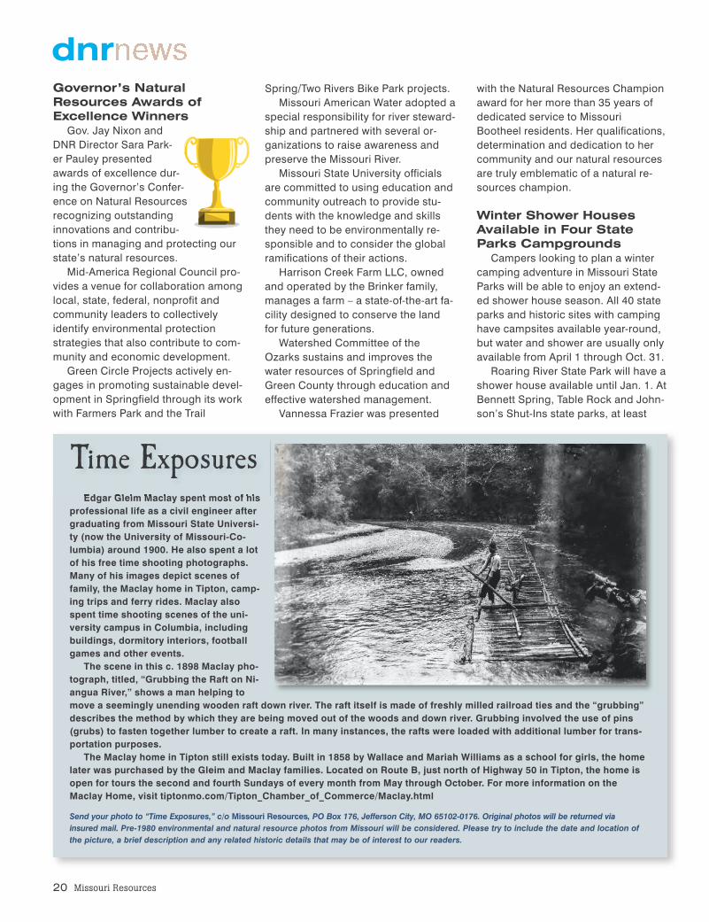
Edgar Gleim Maclay spent most of hisprofessional life as a civil engineer aftergraduating from Missouri State Universi-ty (now the University of Missouri-Co-lumbia) around 1900. He also spent a lotof his free time shooting photographs.Many of his images depict scenes offamily, the Maclay home in Tipton, camp-ing trips and ferry rides. Maclay alsospent time shooting scenes of the uni-versity campus in Columbia, includingbuildings, dormitory interiors, footballgames and other events. The scene in this c. 1898 Maclay pho-
tograph, titled, “Grubbing the Raft on Ni-angua River,” shows a man helping tomove a seemingly unending wooden raft down river. The raft itself is made of freshly milled railroad ties and the “grubbing”describes the method by which they are being moved out of the woods and down river. Grubbing involved the use of pins(grubs) to fasten together lumber to create a raft. In many instances, the rafts were loaded with additional lumber for trans-portation purposes.The Maclay home in Tipton still exists today. Built in 1858 by Wallace and Mariah Williams as a school for girls, the home
later was purchased by the Gleim and Maclay families. Located on Route B, just north of Highway 50 in Tipton, the home isopen for tours the second and fourth Sundays of every month from May through October. For more information on theMaclay Home, visit tiptonmo.com/Tipton_Chamber_of_Commerce/Maclay.html
Send your photo to “Time Exposures,” c/o Missouri Resources, PO Box 176, Jefferson City, MO 65102-0176. Original photos will be returned viainsured mail. Pre-1980 environmental and natural resource photos from Missouri will be considered. Please try to include the date and location ofthe picture, a brief description and any related historic details that may be of interest to our readers.
Time Exposures
with the Natural Resources Championaward for her more than 35 years ofdedicated service to MissouriBootheel residents. Her qualifications,determination and dedication to hercommunity and our natural resourcesare truly emblematic of a natural re-sources champion.
Winter Shower HousesAvailable in Four StateParks Campgrounds
Campers looking to plan a wintercamping adventure in Missouri StateParks will be able to enjoy an extend-ed shower house season. All 40 stateparks and historic sites with campinghave campsites available year-round,but water and shower are usually onlyavailable from April 1 through Oct. 31.
Roaring River State Park will have ashower house available until Jan. 1. AtBennett Spring, Table Rock and John-son’s Shut-Ins state parks, at least

one shower house is open throughoutthe year for guests who want to enjoya camping experience in all seasons.Dates are weather dependent, soguests should remember to check thepark website before planning a camp-ing trip. For full details of amenitiesavailable at campgrounds in theseparks, visit mostateparks.com.
To make a camping reservation,visit mostateparks.com 24 hours aday, or call 877-ICampMo (877-422-6766) 7 a.m.-7 p.m. CST, seven days a week.
February is EarthquakeAwareness Month
Each February,Missouri observesEarthquake Aware-
ness Month.Three of thelargest earth-
quakesexperi-
enced in the continental United Statesoccurred in the New Madrid SeismicZone in the winter of 1811-12. The riskof similar earthquakes remains. Earth-quakes are a natural hazard that noone can accurately predict. Smallearthquakes occur daily in Missouri.Preparing and planning is essential forearthquake safety and fortunately,there are things everyone can do tobe better prepared.
To raise awareness, geologists withthe Missouri Department of NaturalResources will partner with local, stateand federal agencies and organiza-tions by participating in a number ofpublic activities to provide educationalopportunities relating to earthquakes.
Everyone is encouraged to attendpublic events throughout the month.See an interactive map showing re-cent earthquakes and learn more atdnr.mo.gov/geology/geosrv/earthquakes.htm.
Water Commissions Hold Joint Meeting
On Oct. 1, the Department of Natu-ral Resources hosted the first-everjoint meeting of the four Missouri
boards and commissions with water-specific responsibilities.
Members of the Clean Water, SafeDrinking Water, Soil and Water Dis-tricts commissions, and the Well In-stallation Board met to discuss com-mon challenges and concerns, and tolearn more about the department’sstrategies for dealing with water-relat-ed issues in Missouri.
“Each of these entities has veryspecific, legislatively dictated respon-sibilities, which doesn’t always allowthem to become familiar with the workbeing completed by the other com-missions or the department,” said De-partment of Natural Resources’ Direc-tor Sara Parker Pauley. “The joint
meeting provided the department withthe opportunity to discuss its keyfunctions and planning efforts relatedto water resources management, andallowed the members to provide inputon ways to improve and continue toengage moving forward.”
Video of the joint meeting is availableonline at youtu.be/A0MVubrSxtQ.
Winter 2015 21
For news releases on the Web, visitdnr.mo.gov/newsrel.
For a complete listing of the department’supcoming meetings, hearings and events, visitthe department’s online calendar atdnr.mo.gov/calendar/search.do.
Looking for a job in natural resources?Go to dnr.mo.gov/hr.
dnr
The need for additional water supply for communities is a primary concern identifiedin the Lower Grand River Watershed, as part of the Department of NaturalResources’ Our Missouri Waters initiative. Many of the public systems in this water-shed rely on water from small community lakes and face a lack of water supply dur-ing periods of drought.
In April 2014, public watersupply operators, waterdistrict boards, countycommissioners and localtown leaders from a 10-county area in north-cen-tral Missouri attended aRegional Water SupplyWorkshop in Milan.Speakers at the workshopdiscussed plans to providea safe, reliable watersupply to the area. Aregional developmentplan for water transmission lines, including engineering, environmental and legalconsiderations was discussed. Attendees provided input about a regional watersupply transmission network to improve the connectivity of the water systems in theregion. There also was an update on the East Locust Creek Reservoir project, aproposed 2,200-acre lake northeast of Milan that would provide drinking water tosystems in 10 counties.
Sixty-six people attended the workshop, 44 ofthose representing public water systems or localgovernment from the area.
Our Missouri WatersImproving Regional Water Supplies inthe Lower Grand River Watershed
Lower Grand River, Livingston County.
DNR pho
to by Sco
tt Myers

22 Missouri Resources
In order to improve guests’ experi-ences in Missouri’s state parks and
historic sites, audio tours are avail-able. Anyone with a cellphone has away to take a guided hike on a trailand learn more about the history ofthe area.
Mastodon State Historic Site andWeston Bend State Park offer audiotours. Guests can take the tours by ac-cessing the OnCell app or by dialingthe number listed on signs at eachsite. Smartphone users also are ableto scan the QR code on the signs andbring up photos.
At Mastodon State Historic Sitenear St. Louis, guests can take anaudio tour of the Kimmswick BoneBed. The site provided the first evi-dence in North America that humansand mastodons coexisted during theIce Age – and there is plenty of histo-ry to explore.
At Weston Bend State Park nearKansas City, guests can follow alongan old farm road and learn a lot aboutthe westward American settlers fromthe 1800s. The tour includes a barrel-vault root cellar, an abandoned cornpicker and a rare Missouri River sur-vey marker.
To find out more about audio toursin Missouri State Parks, visitmostateparks.com.
topspots
(Clockwise from top left) Mastodon State Historic Site in St. Louis is one of two stateparks evaluating a new audio tour along one of its trails. DNR photo by Tom Uhlenbrock
At Weston Bend State Park, the first stop on the audio tour is at a barrel-vault root cellar built in the 1830s. DNR photo by Matt Carletti
The audio tour at Weston Bend includes an explanation of the historic corn picker along the trail. DNR photo by Matt Carletti
Brooke Mahar, who wrote the audio script at Mastodon State Historic Site, climbs the stairs along the trail that features the tour. DNR photo by Tom Uhlenbrock
Top Spots to Take anAudio Tour
Pershing State Park allowsguests the opportunity to wan-
der through a slice of pre-settlementlandscape, and the park’s accessibleBoardwalk Trail offers a great op-portunity for everyone to experi-ence the park’s diverse landscape.
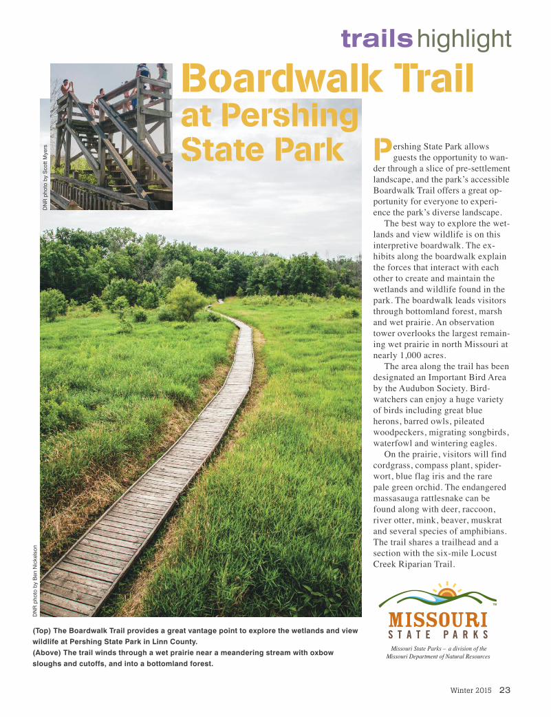
The best way to explore the wet-lands and view wildlife is on thisinterpretive boardwalk. The ex-hibits along the boardwalk explainthe forces that interact with eachother to create and maintain thewetlands and wildlife found in thepark. The boardwalk leads visitorsthrough bottomland forest, marshand wet prairie. An observationtower overlooks the largest remain-ing wet prairie in north Missouri atnearly 1,000 acres.
The area along the trail has beendesignated an Important Bird Areaby the Audubon Society. Bird-watchers can enjoy a huge varietyof birds including great blueherons, barred owls, pileatedwoodpeckers, migrating songbirds,waterfowl and wintering eagles.
On the prairie, visitors will findcordgrass, compass plant, spider-wort, blue flag iris and the rarepale green orchid. The endangeredmassasauga rattlesnake can befound along with deer, raccoon,river otter, mink, beaver, muskratand several species of amphibians.The trail shares a trailhead and asection with the six-mile LocustCreek Riparian Trail.
Winter 2015 23
trailshighlight
Boardwalk Trailat Pershing State Park
DNR pho
to by Sco
tt Myers
DNR pho
to by Ben
Nickelson
(Top) The Boardwalk Trail provides a great vantage point to explore the wetlands and viewwildlife at Pershing State Park in Linn County.(Above) The trail winds through a wet prairie near a meandering stream with oxbowsloughs and cutoffs, and into a bottomland forest.

24 Missouri Resources
Boil water orders are issued by government or healthofficials when a community’s drinking water supply is, orcould be contaminated by pathogens such as E.coli orother microbial indicators of sewage contamination. Boilwater orders also can be issued when the water systemhas a failure in distribution system integrity, indicated bya loss of system pressure. In this case, the loss of pres-sure does not necessarily mean water has been con-
taminated, but pathogens may have been able to enter the system due to a burst pipe orother system failure. The pathogens of most concern in the event of a boil water order typi-cally cause gastrointestinal illnesses such as diarrhea, vomiting and cramps. To effectivelykill these pathogens, the Centers for Disease Control recommends that consumers bringwater to a rolling boil for at least one minute before it is safe for consumption. In elevationsabove 6,562 feet, it is recommended to boil water for 3 minutes to kill pathogens andmake it safe for drinking. Boiled water should be used for drinking, brushing teeth and foodpreparation and cleanup.The Missouri Department of Natural Resources maintains a mapand report of current boil water orders at dnr.mo.gov/env/wpp/boil. For questions regardingboil water orders, contact the department’s Public Drinking Water Branch at 800-361-4827.
Boil Water Order!did youknow
visitors take in all the area has to offer, includingclimbing to the top of Taum Sauk Mountain to be ontop of Missouri – literally. Taum Sauk Mountain, inTaum Sauk Mountain State Park, rises to 1,772 feetabove sea level – the highest point in the state.
The park’s 7,500 acres also includes Mina Sauk Falls,the state’s tallest waterfall. The moderately ruggedMina Sauk Falls loop trail takes visitors to Mina SaukFalls, which drops 132 feet down a series of rockyrhyolite ledges into a clear, rock-bottom pool that sitsat the base.
Devil’s Tollgate lies one mile below the falls along theTaum Sauk Section of the Ozark Trail. This eight-foot-wide passage takes visitors through 50 feet of rhyolitestanding 30 feet high.
The Ozark Trail continues on to nearby Johnson’sShut-Ins State Park, in Reynolds County where theEast Fork of the Black River winds its way throughrhyolite bedrock. The Black River eroded a channeldown to the purplish volcanic rhyolite, creating aseries of rock shoots and channels – called a shut-in –making it a dramatically beautiful, natural place toenjoy the water.
Read more about rhyolite and other igneous rocks atdnr.mo.gov/geology/geosrv/imac/indminerals.htm anddnr.mo.gov/geology/docs/gcsummer8.pdf. Learn moreabout Missouri State Parks at mostateparks.com.
RockMatters
Rhyolite exposed in Missouri is extremely denseand fine-grained. Resistant to weathering, it is a
compact, hard, brittle rock. Referred to by stone pro-ducers as a “traprock,” Missouri rhyolite varies incolor from light gray through pink and red to dark pur-plish-red. Sometimes it has a distinct banded pattern.
The stone is known for its natural beauty, durabilityand utility. Rhyolite quarried in Missouri was historical-ly used in the manufacture of paving blocks and roof-ing shingles; for high-quality construction aggregate;as road metal (crushed rock used to construct aroad); and for other purposes.
Today, rhyolite continues to be a very importantresource for the state’s transportation infrastructureand construction industries as it is used as a roadmetal, a high-quality construction aggregate, and formaking granules for roofing shingles.
Rhyolite is a core feature in some of Missouri’s mostspectacular scenery and popular state parks, includ-ing Johnson’s Shut-Ins State Park and Taum SaukMountain State Park. Each of these parks owes itsunique character to the igneous rocks and to the geo-logic processes that have formed and shaped them.
The St. Francois Mountains provide a rare glimpseinto rocks formed by the most violent type of volcaniceruptions known on the earth. Consequently, geolo-gists come from around the world to study them, and
Rhyolite An igneous, volcanic rock composed chiefly of quartz and feldspar.
Rhyolite formed when lava and volcanic ash erupted from ancient vol-canos and cooled very rapidly. It makes up most of the steep, high knobsthat form the St. Francois Mountains, in southeast Missouri.
DNR photo by Hylan Beydler
DNR pho
to by And
rew Richm
ond

from which we draw much of ourdrinking water.
Limestone is widely used as anindustrial mineral and is soughtfor use in producing lime, phar-maceuticals and in glass-making.It has historically been used inconstruction, as many varietiesmake excellent building materi-als. The Missouri State Capitol ismade from Missouri limestone.Numerous spectacular fossils areembedded in the building’s walls,floors and stairways.
Read more about Missourilimestone, Missouri caves and
karst landscapes in The GeologicColumn of Missouri online atdnr.mo.gov/geology/geocol-umn.htm; and the Capitol Fossilsarticle in the Winter 2014 issueof Missouri Resources. It can beaccessed online atdnr.mo.gov/magazine/documents/mr-winter14.pdf#page=4.
Hylan Beydler is division infor-mation officer for the MissouriGeological Survey, a division ofthe Missouri Department of Nat-ural Resources.
M issouri’s geology consists of an abun-dant amount of limestone. This sedi-
mentary rock is predominantly composed ofthe calcium-bearing carbonate minerals cal-cite and dolomite, and is important to fishand aquatic life because it helps protectagainst rapid changes in pH.
As rainwater infiltrates into the groundand becomes groundwater, the limestoneand slightly acidic water react. The ground-water is neutralized, while at the same time,small amounts of limestone are dissolvedaway. This process produces Missouri’skarst landscape and is responsible for thelarge springs and some of the best trouthabitat in the Midwest.
“I have enjoyed fly fishing for manyyears, and as a geologist, I study the charac-teristic of limestone chemistry; its ability tobuffer acidic water has helped produce spec-tacular streams for trout, caught by myselfand countless others who love to fish,” saidLarry “Boot” Pierce, Geologic Resourcessection chief with the Department of NaturalResources’ Missouri Geological Survey.
In addition to the benefits of the mineral-rich, buffered water, the springs and spring-fed streams have a much more consistentyear-round water temperature,” Pierce said.This constant temperature allows for asteady growing cycle for vegetation andtrout food sources such as macroinverte-brates and other smaller fish.
Some limestone consists almost entirelyof skeletons of marine organisms and formvery distinctive fossiliferous rocks. Otherlimestone consists of lime mud and has avery small grain size and a smooth texture.Deposited in warm, shallow seas, limestoneis widely distributed across the earth. Lime-stone deposits often comprise the aquifers
Winter 2015 25
not least
Missouri Geology Makes a Great Trout StreamLimestone is important to fish and aquatic lifeby Hylan Beydlerphotograph by Scott Myers
The excellent trout fishing en-joyed by Missouri anglers isdue, in no small part, to thebeneficial qualities of lime-stone. Besides being the catalyst for creating naturalsprings, dissolved limestoneimproves water quality and supports aquatic food sources for trout.

MISSOURI DEPARTMENT OF NATURAL RESOURCESPO Box 176Jefferson City, MO 65102-0176
Nonprofit Org.US POSTAGE PAID
MO Dept. ofNatural
Resources
First Day Hikes!Hikers throughout the country
will be getting outdoors onJan. 1, 2015, for America’s
State Parks First Day Hikes.Join Missouri State Parks forguided hikes at state parks
and historic sitesthroughout thestate. Begin 2015
with this great wayto get outside, exer-
cise, enjoy natureand welcome the
New Year withfriends and family.
To find a hike near you, visitmostateparks.com.