module 15: disaster risk reduction: strengthening ... · 415 module 15: disaster risk reduction:...
TRANSCRIPT

Module 15:disaster risk reduction: strengthening livelihood resilience
Overview
This module will demonstrate how proven policies and practices in disaster risk reduction (DRR) can contribute to the objectives of climate-smart agriculture (CSA). There is a wide range of good practices in risk reduction and many potential contributions of DRR to CSA. This module presents some examples of practical methods, tools and technologies that have been applied successfully to reduce disaster risk in the agriculture sector. It also outlines the broad landscape of national institutional mechanisms, policy frameworks and strategies established in many countries for DRR, and looks at how these can create a supportive enabling environment for CSA. When capacity in DRR is combined with knowledge on adapta-tion, the results can be fruitful and far-reaching for CSA. Strategies designed to guide action and invest-ment in CSA will be more holistic in addressing the multiple threats to livelihoods with short- and long-term solutions. This module focuses on the potential contribution of risk reduction policy and practice to the achievement of the second pillar on which CSA is built: “strengthening resilience to climate change and variability”.
Section 15.1 provides an introduction to DDR and highlights the common ground it shares with emerg-ing practices in climate change adaptation. Section 15.2 illustrates how a multi-hazard approach that examines the diversity of threats to agriculture is effective for building resilient agricultural landscapes that are better protected against multiple shocks. Section 15.3 looks at community-based disaster risk management (CBDRM), and how it can support CSA as a proven bottom-up participatory approach to risk assessment, planning, implementation and monitoring at local levels. Section 15.4 makes reference to the vast pool of traditional knowledge and risk reduction technologies and practices used in the agri-cultural sector. It shows that CSA can achieve significant increases in scale by replicating these proven good practices. Section 15.5 reviews the current wealth of national institutional arrangements, policy and planning frameworks for DRR. It indicates that the significant achievements made in this area can be harnessed in support of CSA.
Key messages
• Multi-hazard risk assessment and mapping combined with climate change scenarios provide a holis-tic framework for assessing all relevant hazards in specific geographic areas.
• Proven DRR technologies and practice provide a rich resource-base for promoting and scaling up CSA.• CBDRM is a proven participatory method for assessing local risks and for informing local planning. It
can be a vehicle and methodology for promoting CSA at local levels. • At national and regional levels, well-established legislation, institutional structures, policies and
plans for DRR can provide CSA with a strong supportive enabling environment. • Building on the accumulated knowledge and practice in DRR increases the efficiency of international
aid and government investments in CSA.
• For farmers, there is no distinction between risk reduction and adaptation. From their perspective, there are only threats to livelihoods and family food security from which they need to be protected.systems; improved feeding and reduced losses from disease in aquaculture; the reduction of post-harvest and production losses; and the further development of regional trade.
• The transition to CSA in fisheries and aquaculture will need to take place at all levels (individual, business, community, national and regional) and time scales. All stakeholders from private and public sectors will need to be involved in the development of context-specific options to ensure the fisheries and aquaculture sector is climate-smart.
• To make the transition to CSA in fisheries and aquaculture, it will be necessary to ensure that the most vulnerable states, production systems, communities and stakeholders have the potential to develop and apply CSA approaches.
• Markets and trade may help buffer the impact of changes in production that affect food security, consumer prices and supply-demand gaps. However, the implications of climate change impacts and climate change policies on the entire supply and value chain need to be better understood. Appropri-ate policy measures need to be defined and implemented.
415
MODULE 15: Disaster Risk Reduction: Strengthening Livelihood Resilience
Contents
Overview 413Key Messages 41315.1 Disaster risk reduction and climate change adaptation 41715.2 Planning for resilience against multiple risks 417 The multiple threats to agriculture and food security 417 Mapping multiple risk scenarios for sustainable planning 419 Combining risk assessment and climate change scenarios for effective CSA 42215.3 Building on community-based approaches to DRR and adaptation 42515.4 Scaling up proven technologies and practices for resilient livelihoods 427 Building on and expanding DRR knowledge and practice in agriculture 427 Combining DRR knowledge with innovations in climate change adaptation 43015.5 The enabling framework of DRR to support CSA 434 Governance: national institutional structures and policy frameworks for DRR 434 Region-wide platforms and inter-governmental strategies for DRR 43715.6 Concluding remarks and recommendations 438Notes 441Acronyms 442References 443Additional Resources 448
List of Figures
Figure 15.1 Risk Assessment and Mapping 419Figure 15.2 Nepal risk assessment and mapping framework 420Figure 15.3 Threats to agriculture 421Figure 15.4 Farming practices resulting in vulnerability to hazards 421Figure 15.5 Maps of Negril pilot area 423Figure 15.6 Distribution and location of coastal ecosystems 424Figure 15.7 Use of biodiversity to mitigate hazard impact on a flood
and landslide susceptible house plot 428Figure 15.8 The conceptual and operational framework of CBIWM for DRR and CCA 433Figure 15.9 The CBIWM activities by phases 434Figure 15.10 Institutional structures supporting DRR and CCA in the Pacific region 436Figure 15.11 A holistic approach that builds on established DRR and CCA capacities to Support CSA 439
List of Tables
Table 15.1 Strategic entry areas in risk reduction for CSA and integration opportunities with climate change adaptation 440
List of Boxes
Box 15.1 Multihazard assessment for DRR in Bicol Region, Philippines 421Box 15.2 The standardized community risk assessment model in Bangladesh 422Box 15.3 Jamaica -the Risk and Vulnerability Assessment Methodology (RiVAMP) 423Box 15.4 Integrated community approaches to DRR and adaptation in Papua New Guinea 426Box 15.5 Local practices in hazard risk management in Jamaica 428Box 15.6 Nepal’s strategy on knowledge sharing and management
in climate change adaptation and DRR 429Box 15.7 Building the resilience and adaptive capacity of potatoes in the Andes 431

416
CLIMATE-SMART AGRICULTURE SOURCEBOOK
Box 15.8 Community-based integrated watershed management approach to DRR and climate change adaptation in Uganda 433
Box 15.9 The enabling environments in the Philippines integrating DRR and CCA 437Box 15.10 A Regional Approach to Joint DRR and climate change adaptation: the Incheon REMAP in Asia 438

417
MODULE 15: Disaster Risk Reduction: Strengthening Livelihood Resilience
15.1 Disaster risk reduction and climate change adaptation
Climate change is expected to result in more frequent and intensive climate-related hazards. It will also reduce the predictability and change the geographic distribution of extreme climatic hazards, such as extreme tem-peratures, floods and droughts, heat waves, wild fires and storms. Existing vulnerabilities will be compounded by climate change-related processes, such as rising sea levels, increased glacier melt, stressed ecosystems and the degradation of natural resources (IPCC, 2007).
Meanwhile, the world continues to cope with the devastating effects of natural disasters stemming from geo-logical and weather-related hazards. Experience shows that the negative and cumulative impact of these dis-asters erodes livelihoods and coping capacities over time, reduces food production and increases hunger. The clear link between disasters and hunger is an indication of the fragility of food production systems and their vulnerability to natural hazards (FAO, 2011b). Evidence reveals the direct contribution these disasters make to reversing development and the gains made in poverty reduction. Worldwide, vigorous efforts have helped to strengthen the capacity of communities and nations to cope with natural hazards, and to reduce their exposure and vulnerability. This has been accomplished through the establishment of national and local institutional structures and DRR strategies, as well as the development and effective application of methodologies, practi-cal tools and community-based approaches to reduce risk.
Global experiences and established capacities in addressing disaster risk are directly relevant to climate change adaptation and CSA. By now, many countries have made significant progress in meeting the priorities agreed to in the Hyogo Framework for Action (HFA). Endorsed by 193 member states and implemented under the coordination of the United Nations International Strategy for Disaster Reduction (UNISDR), the HFA is a 10-year plan to make the world safer from natural hazards (UNISDR, 2005). DRR is understood as the “concept and practice of reducing disaster risks through systematic efforts to analyse and manage the causal factors of disasters, including through reduced exposure to hazards, lessened vulnerability of people and property, wise management of land and the environment, and improved preparedness for adverse events”(UNISDR, 2009c). While distinct in scope, DRR and climate change adaptation share a common concern over climate-related extreme events. In the agriculture sector, they both aim to build resilient livelihoods.
Recognizing this interconnectedness, the parties to the United Nations Framework Convention on Climate Change (UNFCCC) adopted the Cancun Adaptation Framework, which calls for enhanced climate change-related DRR strategies that take into consideration the HFA where appropriate. This link is also formally ac-knowledged in the UNFCCC’s Bali Action Plan. The United Nations Secretary-General noted that “better DRR will help the world adapt to climate change”; and that DRR should be applied “...as a first line of defence in adapting to climate change” (Ban, 2008). The aim should be to “capitalize on the common concerns of adap-tation and risk reduction in policies and practical action, and to seek the triple win of lower disaster risks, adaptation to climate change, and sustainable development outcomes” (UNISDR, 2009c). Building resilience through sound safety nets, DRR and adaptation planning is one of the six priority areas for action in the re-cent Report of the Secretary General’s High-level Panel on Global Sustainability (High-level Panel on Global Sustainability, 2012). The post-2015 United Nations development agenda agreed to at the Rio+20 conference calls for the integration of risk reduction and adaptation into sustainable development strategies (UN System Task Team on the Post-2015 UN Development Agenda, 2012). CSA will benefit significantly from following this holistic approach that blends adaptation measures with global experience in risk reduction.
15.2 Planning for resilience against multiple risks
the multiple threats to agriculture and food securityBuilding resilience requires that we “grasp the dimension of multiple challenges” (High-level Panel on Global Sustainability, 2012). An examination of the diversity of natural hazards affecting agriculture and food secu-rity indicates that, even without climate change, a multiplicity of hazards are already eroding livelihoods and

418
CLIMATE-SMART AGRICULTURE SOURCEBOOK
compromising gains made in food security. These hazards contribute to the difficulties in meeting the Mil-lennium Development Goal to halve the proportion of people who suffer from hunger by 2015. This includes geological hazards, such as earthquakes, tsunamis and volcanic eruptions; human-induced hazards, such as conflict, economic crises, high food prices; and traditional weather-related hazards, such as floods, drought and storms.
In 2012, over 18 million people faced food insecurity in the Sahel region of West and Central Africa (FAO, 2012a and b). The Sahel last experienced a major food crisis in 2010 affecting ten million people. In the Horn of Af-rica, the ongoing food security crisis, which began in 2011, has threatened the lives and livelihoods of over 12 million people.
In 2010, Pakistan experienced the worst flooding since 1929, with over 20 million people affected. The impact on agriculture was severe. Over two million hectares of cultivatable land and 1.3 million hectares of standing crops were damaged. Six million poultry and 1.2 million large and small animals were lost (World Bank and Asian Development Bank, 2010). Heavy rains during the 2011 monsoon season caused renewed and devastat-ing flooding that affected almost 10 million people. On average, households lost 66 percent of their cattle and 33 percent of their poultry. The flood also caused a significant increase in commodity prices, with the price of paddy increasing by 25 percent on average. At the same time, the purchasing power of labour decreased by 13 percent (UN, 2011).
Geological hazards also cause serious direct and indirect damage to agriculture and livelihood security. The Haitian earthquake caused nearly US$ 26 million in damages to the agricultural sector (Republic of Haiti, 2010). The destruction of the Haitian capital severely affected access to markets and other production infra-structure. This, together with the migration of over half a million people from urban to rural areas, put addi-tional pressure on rural livelihoods. In agricultural areas hit by the earthquake, debris and landslides damaged farmland irrigation systems, permanent storage facilities and processing centres, and the administrative and technical buildings of the Ministry of Agriculture. All these factors combined to produce sharp declines in income, food reserves and food availability, and helped trigger price hikes (FAO, 2010b; FAO and WFP, 2010). The tsunami of December 2004, which affected 12 countries in the Indian Ocean, had a devastating impact on the agriculture and fisheries sectors. Some 40 000 hectares of irrigated land were destroyed by floods on the island of Sumatra in Indonesia, and in Banda Aceh nearly 70 percent of the small-scale fishing fleet and as-sociated gear was destroyed.
Frequently, disasters combine with other factors and underlying vulnerabilities to produce food insecurity and hunger. High food prices, which added 75 million people to the total number of undernourished worldwide in 2008 relative to 2003-2005 (FAO, 2008a), was the result of several factors including: the fuel crisis, slower growth in food production, lower stock levels, and increased use of agrofuels (IFRC, 2011). The current crisis in the Horn of Africa is the result of drought caused by erratic and failed rains over two rainy seasons combined with high food prices due to soaring fuel costs. In Somalia, the situation has been exacerbated by civil insecu-rity (USAID and FEWSNET, 2011a and b). In the Sahel, “a lethal mix of drought, high grain prices, environmen-tal degradation, entrenched poverty and other factors is behind the crisis” (FAO, 2012a).
Not surprisingly, countries in protracted crisis situations show high levels of food insecurity. Protracted crises are characterized by recurrent natural disasters and/or conflict, longevity of food crises, breakdown of liveli-hoods and insufficient institutional capacity to react to the crises. On average, the proportion of people who are undernourished is almost three times as high in countries in protracted crisis as in other developing countries (FAO, 2012a).
Food crises have become more frequent since the early 1980s. There have been between 50 and 65 food emer-gencies every year since 2000, up from 25-45 during the 1990s (FAO, 2008a). Climate change multiplies risk by increasing the number and scale of extreme climate-related events. Disaster risks and climate change produce similar negative impacts on agriculture, and both threaten to increase hunger over time. In addition,

419
MODULE 15: Disaster Risk Reduction: Strengthening Livelihood Resilience
there is growing probability of ‘simultaneous crises’ where different hazards occur at the same time, ‘sequen-tial crisis’ where hazards trigger cascading disasters in a range of interlocked systems, and ‘synchronous failures’ where different risks converge and interact (FAO, 2008a). The challenge is to ensure food security in the face of multiple hazards and climate change.
Mapping multiple risk scenarios for sustainable planningUnderstanding risk is a vital part of policy formulation, planning and decision making. The assessment of threats to agriculture or ‘agricultural risks’ is a necessary first step in designing effective risk reduction meas-ures for food security. Hazard, vulnerability and risk assessments or mapping are some of the practical tools that have been developed and applied in many countries as the basis for planning appropriate DRR policies and practices. Increasingly, they have been used in sustainable land-use planning and development investments. Given that effective strategies can only be achieved by understanding the risks already facing farmers, these tools can also support planning for climate change adaptation and CSA.
Hazard maps delineate the geographic areas exposed to a specific type of hazard, such as floods, earthquakes, drought or tsunamis. Typically, they indicate the likelihood or probability of occurrence, frequency and potential severity or magnitude. Hazard maps are based on historical data and knowledge of past events. Vulnerability mapping identifies the elements exposed to hazards that may be adversely affected, such as populations, prop-erty, agricultural areas, livelihoods, services, health facilities, etc. Vulnerability assessments may also include social or economic dimensions, including livelihoods. Risk is determined through the combined analysis of potential hazards and existing conditions of vulnerability. Hazard and risk maps can be developed at different spatial scales to display the risk distribution across geographical areas. They can be site-specific, encompass municipal or provincial administrative areas and other subnational landscapes, such as river basins, or they can be national and even regional in scope.
Figure 15.1 Risk Assessment and Mapping
Hazards Vulnerability Risk Used to inform:•DRR-specific plans•Adaptation-specific plans•CSA strategies• Land-use or territorial
planning•Development
investments•Post-disaster recovery
planning
Photo Credits: Hazards - Republic of Nicaragua, Direccion de Hidrologia Superficial
Vulnerability - ©FAO, Thomas Hofer Risk - ©FAO, Truls Brekke
Methodologies and tools used in hazard and risk assessment and mapping vary considerably, but some of the most advanced follow an all-hazards, all-risks approach. Effective planning always needs to consider every spatially relevant hazard and not limit the focus to only one hazard or threat. Mapping multiple-risk sce-narios at different spatial scales is the key to understanding the various hazards affecting the same exposed geographic area or landscape. This makes it possible to assess the cumulative consequences of hazards and their potential interactions. For instance, some areas may be prone to drought during the dry season but also to floods during the wet season. This has important implications for the design of appropriate risk reduction and adaptation measures. Following an all-hazards, all-risks approach also reduces the likelihood that efforts to safeguard against one type of hazard will not be lost to another hazard or increase vulnerability to other hazards. For instance, regulations that seek to protect socio-economic investments against floods, such as

420
CLIMATE-SMART AGRICULTURE SOURCEBOOK
safe location or flood-resistant infrastructure, will only provide a partial solution unless it safeguards against earthquakes in areas that are also prone to seismic activity. Risk assessments and mapping provide an effec-tive tool for spatial planning and for supporting sound decision making. Figure 15.2 below shows an example of the comprehensive multi-hazard risk assessment framework used in Nepal to guide risk reduction meas-ures (Federal Democratic Republic of Nepal et al., 2011). The framework included a hazard assessment of earthquakes, floods, droughts, landslides and other hazards at the national level. The assessment was based on historical information, with maps indicating the spatial distribution of hazards in the country, and was fol-lowed by an analysis of exposure, vulnerability and risk for various physical, social and infrastructural assets, including agriculture.
Figure 15.2 Nepal risk assessment and mapping framework
Administrative boundaries
Infrastructure
•Housing•Health•Education•Transportation• Irrigation•Fisheries•Power and Telecom•Tourism•Trade and Financial
Earthquake exposure on Housing, Education, Hospital, Irrigation, Infrastructure, Industry, Power, Tourism and Trade sectors
Earthquake vulnerability on Housing, Education, Hospital, Irrigation, Infrastructure, Industry, Power, Tourism and Trade sectors
Production, Physical, Infrastructure, Social and Human Resources & Environmental Sectors
Economic Analysis of
Losses Detailed economic analysis through loss probability modeling
Reccomendationsfor DRR Strategy
Sectoral DRR strategy in close consultation with national agencies
Flood exposure on Agriculture, Transportation, Housing, Fisheries, Education, Hospital, Tourism, Industry, Irrigation and Trade sectors
Flood vulnerability of Agriculture, Transportation, Housing, Fisheries, Education, Hospital, Tourism, Industry, Irrigation and Trade sectors
Drought exposure on Agriculture, Irrigation sectors
Drought vulnerability assessment on Agriculture, Irrigation sectors
Landslide exposure on Transportation sectors
Landslide vulnerability assessment of Transportation sectors
Health Hazards exposure on Healt and Social System
Epidemic vulnerability of Health and Social System
Socio Economics
•Housing•Health•Education•Demographic Data•Economics
Disaster Events
•MOHA Disaster Catalog•Departments Disaster Database•DesInventar•EM-DAT
Hazard Related
•Geology•PGA•Extreme Discharge•Precipitation• Landslide Inventory
Baselinedata
Hazardassessment
Hazardexposure
Riskassessment
Vulnerabilityassessment
Earthquake
Flood
Drought
Landslide
Epidemics
Gap A
ssessment
Source: Adapted from Federal Democratic Republic of Nepal et al., 2011

421
MODULE 15: Disaster Risk Reduction: Strengthening Livelihood Resilience
In the Bicol region of the Philippines local-level planning for DRR was based on the use of a multi-hazard as-sessment that identified the threats to agriculture and the farming practices that made farmers more vulner-able to natural hazards. It was instrumental in the selection of the most appropriate DRR technologies and practices.
The value of risk assessments is well recognized. A number of countries have institutionalized the use of risk assessments as the basis for planning risk reduction strategies. For instance, South Africa’s policy framework on disaster risk management underscores the importance of disaster risk assessments as a guide for na-tional, provincial and municipal DRR efforts. All national government bodies are required to carry out disaster risk assessments to identify priority disaster risks relevant to their work. They are also committed to develop-ing “a national standard for conducting comprehensive disaster risk assessments, including guidelines for the application of a uniform disaster risk assessment methodology and approach, as well as the standardization of reporting formats for disaster risk assessments” (NDMC, 2005). The disaster management model in Bang-ladesh, illustrated in Box 15.2 below, is another good example of an institutionalized risk assessment model.
Box 15.1 Multihazard assessment for DRR in Bicol Region, Philippines
In a DRR project implemented by FAO in the Bicol region, a situation assessment was carried out in pilot areas as a starting point to evaluate a variety of factors, including: the physical and environmental context and local hazards; the socio-economic conditions, livelihoods and agricultural land use; the existing vulnerabilities of vulnerable groups, their capacity and coping strategies and their existing agricultural practices (e.g. crops, livestock, fisheries, forestry, homestead); and the local institutional disaster risk management systems.
The multi-hazard assessment identified eight types of threats to agriculture, including geological and climate-related hazards, and assessed the level of risk and impact of each. In the diagram below, when the intensity level goes up, the further from the centre, the greater is the hazard and its impact on the elements at risk.
Figure 15.3 Threats to agriculture
Figure 15.4 Farming practices resulting in vulnerability to hazards
Strong Wind
Drought
LandslideAsh Fall
Soil Erosion Lahar Flow
Volcanic Eruptions
Plant Pest
Solofarmingsystem
4%
Lack of alternative livelihood
8%Poor
irrigation water use
management6%
Practiceof ricestraw
burning4%
Use of commercial
fertilizer without soil
analysis17%
Use of hybrid variaties
4%
Use of inappropriate
varieties6%
Constant use of single variety
17%
Wrong timingof planting
18%
Absence of seed source
for saline prone areas
6%
Low irrigation maintenance
system10%
In addition to the types of threats to agriculture, the assessment in Bicol identified farming practices that made farmers more vulnerable to hazards, such as the use of inappropriate crop varieties or incorrect timing for planting.
Source: Republic of the Philippines Department of Agriculture and FAO, 2010

422
CLIMATE-SMART AGRICULTURE SOURCEBOOK
The application of risk assessments for various planning objectives is growing. Risk assessments are now used in land-use planning and territorial development, urban planning, the design of public infrastructure, scenario analysis and disaster preparedness. Some countries are starting to carry out risk assessments for develop-ment planning and public investment. Peru has been one of the pioneers in this respect. It has formally incor-porated disaster risk into its National System for Public Investment. A legal framework now requires disaster risk to be included in the evaluation criteria for public investment projects. The approval of financing rests on this evaluation. This ensures projects are not vulnerable to future disasters (UNISDR, 2010a). To support the mainstreaming of DRR into the National Public Investment System, particularly the project development and approval cycle, Peru’s Ministry of the Economy and Finance has developed standard methodologies and tools for national and local public institutions and government authorities. This includes an analysis of the location of public investments, its potential exposure to risks identified and the factors that can make them vulnerable.
In post-disaster situations, risk assessments are being used to guide prospective disaster risk management measures, such as sustainable land-use planning during the recovery process. These assessments enable sound spatial planning that can prevent the reconstruction of infrastructure in high risk areas exposed to re-current natural hazards. Following the 2010 earthquake in Haiti, the Office of the Special Envoy, in partnership with government agencies and other international organizations, undertook a rapid multi-hazard analysis to map the risk of floods, wind, tsunamis, landslides and earthquakes in the affected areas. They have used the results to guide the safe positioning of transitional shelters and support long-term recovery efforts. In Chile and Mexico, risk assessments are used to establish prerequisites for their Global Catastrophe Mutual Bonds. In the Pacific Islands, the assessments are used to determine the viability of financial risk pooling opportuni-ties.
Combining risk assessment and climate change scenarios for effective CSACSA proposes a shift away from single-objective production systems to the management of landscapes with multiple objectives (see for example Module 2 on landscape approach). This demands integrated planning and
Box 15.2 The standardized community risk assessment model in Bangladesh
Bangladesh promotes the use of scientific analysis, including the analysis of climate change impacts, as the basis for accurately assessing future risk related to all hazards, all sectors and all geographical areas. The country’s Disaster Management Model gives priority to defining the risk environment as the basis for developing ‘risk treatment options’. In this model, defining the risk environment involves:
•understanding the social, political and community environment (establishing the context);• establishing the likely threats (identifying hazards and risks);•understanding the likelihood and consequences (analyse the risks);• ranking risks in priority (evaluate risks); and • determining what can be done to eliminate, reduce or manage risk (identify risk treatment strategies).
The Ministry of Food and Disaster Management executed a Comprehensive Disaster Management Programme (CDMP) as a national multi-hazard, multi-sector and multi-stakeholder strategy to build the capacity of local authorities and their communities to understand disaster management, assess risk, and provide local funding to implement priority DRR measures.
The CDMP supports local authorities and Union Disaster Management Committees to conduct standard community risk assessments (CRA) using participatory processes that identify, analyse and evaluate hazards, risks and vulnerabilities combining local knowledge with scientific data and predictions. The assessments follow an all-hazards, all-risks approach and are used in the formulation of risk-reduction plans and development projects. Guidelines for CRA and for risk-reduction action planning procedures have been developed to facilitate this process. Roughly 611 union action plans have been prepared following these guidelines (Djalante et al., 2010). The CRA process is considered a successful example that can be replicated across all risk environments. The intention is to expand its use across the country.
Source: UNISDR, 2010a

423
MODULE 15: Disaster Risk Reduction: Strengthening Livelihood Resilience
management. Risk assessments and mapping, as described above, can be instrumental for achieving this goal. Integrated landscape management requires an understanding of all natural hazards affecting a given landscape combined with an assessment of the potential impact of climate change on agricultural systems.
This blended approach provides the evidence-base to help countries at the national or local level to design holistic CSA policies, strategies and practices (see also Module 13 on policies) that are based on geographic-specific assessments of current disaster risks and future climate change scenarios. For this to happen, it is necessary to develop a harmonized framework that integrates data and analysis of natural hazards with pro-jected climate change scenarios using computer modelling (see also Module 18 on assessments, monitoring and evaluation). This gives planners short-, medium- and long-term perspectives that can help in the design and implementation of appropriate measures along the same timescale. Recent risk assessment approaches that are used in combination with climate change models may shape future practices and bring about innova-tions that are needed to scale up CSA. An example of such an approach can be found in a pilot project from Jamaica, which is illustrated below in Box 15.3.
Box 15.3 Jamaica -the Risk and Vulnerability Assessment Methodology (RiVAMP)
Jamaica is exposed to frequent meteorological hazards, particularly hurricanes. As a small island state, it is also highly exposed to rising sea levels, which could worsen the secondary impacts of tropical cyclones along the coast. At the same time, Jamaica’s tourism industry and growing population are putting pressures on its diverse ecosystems and rich biodiversity.
A Risk and Vulnerability Assessment Methodology (RiVAMP) was piloted in Negril on the western coast of Jamaica. It is an evidence-based assessment tool that assists national and local decision makers in making informed choices that reduce risk and support sustainable development through improved ecosystem management. RiVAMP was designed particularly for land-use and spatial development planners, as well as for key stakeholders in natural resource management and disaster management. It is innovative in that its risk assessment method integrates climate change and environmental considerations, including ecosystem degradation.
The project examined the impacts of tropical cyclones and their secondary effects, particularly storm surges and flooding, as well as the potential impacts of rising sea levels. Environmental features were analysed to determine the extent to which coral reefs and sea grasses serve as a natural protective barrier for shorelines against storm surges and rising sea levels.
RiVAMP used a blend of proven scientific methods, such as risk mapping with the use of the Geographic Information System (GIS), satellite imagery analysis and other remote sensing techniques, statistical analysis and the modelling of buffering effects of coastal ecosystems (coral and sea grass). The science-based analysis was complemented by stakeholder interviews and consultation workshops.
Figure 15.5 Maps of Negril pilot area
Flood hazard map 50-year return period exposure for a) population and b) assets

424
CLIMATE-SMART AGRICULTURE SOURCEBOOK
There are opportunities for CSA to build on the growing resources available for multi-hazard risk assessment
and mapping. The Probabilistic Risk Assessment Initiative (CAPRA) is an example of a state-of-the-art, open-source multi-hazard tool for risk assessment and visualization, with a platform that integrates databases with exposure and physical vulnerability data. It facilitates the evaluation of risk in terms of physical damage and direct economic and human losses in standard risk metrics to visualize hazards and risk on GIS. CAPRA was developed by Latin American experts and governments with the support of the Central American Coordination Centre for Disaster Prevention in partnership with a number of international organizations. Another available resource is the large col lection of geospatial information on disaster risks for Pacific Island countries that is accessible through the Pacific Risk Information System (PacRIS) platform. PacRIS includes detailed country-specific information on hazards, assets, population and risks for 15 countries in the region. It also contains the most comprehensive analysis of building, infrastructure and cash crop ex posure (World Bank, 2012).
Figure 15.6 Distribution and location of coastal ecosystems
GIS mapping and analysis assisted in the computation of exposure to storm surge and flooding associated with tropical cyclones. The analysis included population distribution, infrastructure and other exposed assets. Remote sensing used high resolution satellite images and aerial photographs from 1968 to determine the types and distribution of coastal ecosystems, especially coral and sea grasses. These images and photographs were also used in the analysis of coastline erosion due to tropical cyclones and rising sea levels. An ensemble of six widely-used, numerical models were applied to assess the range of shoreline retreat of Negril beaches under various rates of sea level rise and storm surges. Multiple regression analyses were used to identify the positive influence of coral reefs and sea grass meadows on the observed beach erosion patterns along the Negril coastline.
Estimations based on global projections of long-term or accelerated sea level rise (ASLR) together with local predictions of extreme storm waves and surges showed that by 2060, the combination of ASLR and extreme wave surges will have a devastating impact on Negril’s beaches and the coastal infrastructure behind it. This has significant implications for risk reduction and adaptation planning. RiVAMP was intended to be used for Small Island Developing States (SIDS) with similar risks as Jamaica, and holds potential for other island states highly exposed to rising sea levels.
Source: UNEP, 2010

425
MODULE 15: Disaster Risk Reduction: Strengthening Livelihood Resilience
15.3 Building on community-based approaches to DRR
and adaptation
CSA promotes integrated planning and management at many levels, including local site-specific landscapes. The DRR and climate change adaptation communities of practice have complementary community-based ap-proaches that can support local-level CSA planning. In spite of their inter-connectedness, however, communi-ty-based disaster risk management (CBDRM) and community-based adaptation (CBA) are often implemented separately. Overcoming this division presents a challenge. Nevertheless, it is possible for CSA to articulate both of these community-based approaches and harness the benefits of this blended approach.
CBDRM was developed in the 1980s as a process through which at-risk communities can become actively engaged in the identification, analysis, treatment, monitoring and evaluation of disaster risks, to reduce their vulnerabilities and enhance their capacities. Communities, including the most vulnerable, participate in deci-sion making and implementation. In the CBDRM process, the assessment of hazard exposure and analysis of vulnerabilities and capacities (discussed in the previous section) forms the basis for activities, projects and programmes to reduce disaster risks (Asian Disaster Preparedness Center, 2004).
CBA has evolved more recently and has been applied to promote adaptation in the agriculture sector. CBA shares a similar definition and approach with CBDRM. It is understood as “a community-led process, based on communities’ priorities, needs, knowledge, and capacities, which should empower people to plan for and cope with the impacts of climate change.” (IIED, 2009).
Given the evolution and distinct history of climate change adaptation, CBA and CBDRM are differentiated in practice through separate projects and funding mechanisms. The need for an integrated approach is clear at the local community level, where multiple risks converge and threaten the lives and livelihoods of households and farming communities, and where solutions in risk reduction and adaptation in agriculture can be mutually reinforcing. CBDRM and CBA have the same objective of enhancing livelihood resilience at local levels, use the same bottom-up grassroots approach, target the same populations and apply the same participatory methods at the community level.
CSA should build on the valuable opportunities found in the short- and long-term measures that CBDRM and CBA offer through joint projects and partnerships at the local level. Through existing CBDRM practices, CSA can support measures that farmers prioritize because they address known and immediate risks and pro-vide tangible improvements to families’ food security. For local authorities, providing support for short-term risk reduction measures is more viable than investing in adaptation against future uncertainties. At the same time, CBA projects can complement these initiatives by addressing the longer-term impact of climate change through innovative measures. These projects may involve bringing scientific knowledge and climate change data and predictions to communities that would otherwise not have access to it. It may also involve addressing emerging risks associated with climate change, such as rising temperatures, changes in rainfall patterns, ris-ing sea levels, melting glaciers and other expected changes.
This blended approach enables more holistic local planning processes. It has the additional advantage of mak-ing available for CSA local institutional structures and partnerships already established for CBDRM and CBA projects, such as farmers’ networks, cooperatives, women’s groups, etc. and involving all relevant stakehold-ers in the local landscape (see also Module 12 on institutions). Initiatives that promote CSA can realize this approach by basing projects on a situation analysis that maps existing CBDRM and CBA initiatives, key stake-holders, institutional partnerships and local DRR projects. For local authorities, an integrated approach to CSA will help remove the administrative burden and cost of managing a diversity of CBA and CBDRM projects in an environment already facing institutional and financial constraints. Such win-win benefits optimize resources and make aid more cost-effective.

426
CLIMATE-SMART AGRICULTURE SOURCEBOOK
While practices in linking CBDRM and CBA still need to be explored further, the example below of Papua New Guinea provides a practical framework that demonstrates the value of combining DRR and climate change adaptation at the community level to guide agricultural practice.
The expansion and institutionalization of CBDRM in many parts of Asia and Latin America offers a wide plat-form on which CSA can build. In some Asian countries, CBDRM has been institutionalized and mainstreamed. Cambodia, the Philippines and Viet Nam have developed national strategic CBDRM plans for legislative and executive approval. A wide range of key stakeholders have been involved in the process to ensure support and institutionalization, including top-level government leaders, related line ministries, non-governmental organizations (NGOs), local governments, grassroots organizations, donors and other agencies (EC et al., 2008a).
In addition, in Southeast Asia, progress has been made in mainstreaming CBDRM into socio-economic devel-opment policies that build the resilience of communities, including action plans at national, subnational and local levels to support CBDRM (EC et al., 2008a). In the Philippines, CBDRM is practiced nationwide, and in Viet Nam it has evolved since the early 1990s to become an example of good practice with strong involvement and commitment from local and national governments (EC et al., 2008b). Recently, the government of Viet Nam approved a national CBDRM programme to establish CBDRM initiatives in 6 000 of the most vulnerable communes and villages in the country by 2020, a decision that will significantly up-scale CBDRM throughout Viet Nam (UNISDR, 2011b). These robust enabling environments for CBDRM can support community-based efforts in CSA.
Box 15.4 Integrated community approaches to DRR and adaptation in Papua New Guinea
In Papua New Guinea the community-based framework for addressing DRR, which had been previously developed with some indigenous communities in Papua New Guinea, was used and adjusted to address climate change at the village level.
The original community-based framework for DRR used participatory techniques, such as guided discovery, mapping exercises, timelines and matrix rankings to collect information from community members on village history, hazards and event timelines, maps, and environmental and social trends. This baseline information was used to identify, in collaboration with communities, underlying vulnerability factors, both external and internal. Lastly, communities identified past and present indigenous and scientific strategies used, and prioritized possible risk and vulnerability reduction strategies. This DRR framework addressed short-term DRR needs as well as addressed floods, storms, landslides, and volcanic eruptions.
The framework was then used as a practical entry point for discussing why and how communities are also vulnerable to climate change and what measures could be taken to address these challenges. The concerns and priorities of communities identified in the original DRR framework were combined with information about how global climate change was linked to local conditions. The assessment of climate change impacts, vulnerability, and adaptation on SIDS prepared by Center for International Climate and Environmental Research – Oslo (CICERO) and the United Nations Environment Programme (UNEP) was used as a baseline (CICERO and UNEP/GRID-Arendal, 2008). External scientific information on the historical and potential future consequences of climate variability and change, such as satellite observations and downscaled climate projections, were integrated for short- and long-term scenarios. Invasive species were identified as an additional threat that could change the pest or disease profile of local agricultural systems. To identify indigenous strategies for reducing vulnerability to climate change, the focus was on determining how local communities had responded to longer-term changes in the past.
The combined community-based framework for DRR and climate change adaptation articulates local and global knowledge, linking community knowledge with external scientific information and approaches. The process resulted in a combination of short-term solutions such as appropriate cropping patterns and land use, with longer-term solutions using external knowledge such as identifying previously unknown suitable crops or crops grown locally.
Source: Kelman et al., 2009

427
MODULE 15: Disaster Risk Reduction: Strengthening Livelihood Resilience
15.4 Scaling up proven technologies and practices
for resilient livelihoods
Building on and expanding drr knowledge and practice in agricultureCSA promotes the application of proven practices and approaches and recognizes the need for increased scale. Knowledge and practice gained from DRR offers a resource pool from which to draw proven approaches and technologies that are effective in building resilient livelihoods.
Research has shown that indigenous peoples cultivate an enormous diversity of traditional crop varieties using a variety of effective traditional practices (IIED, 2011a). Five elements of traditional knowledge systems can be useful for climate change adaptation in agriculture (IIED, 2011b):
1. resilient properties (resilient crop species and varieties for adaptation);2. plant breeding (conservation of local landraces and seed selection for preferred and adaptive characteristics);3. wild crop relatives (crop improvement and domestication as well as to supplement diets);4. farming practices (water, soil or pest management, erosion control and land restoration); and 5. climate forecasting (traditional knowledge for forecasting weather and predicting extreme events).
In many societies, resilience has been a natural, evolving process for absorbing shocks and adjusting to chang-es that impact people’s livelihoods (Pandey et al., 2003). Numerous case studies on indigenous knowledge of risk reduction have been documented1. For instance, in many regions of the world, a diversity of rainwater harvesting and management practices has evolved over millennia to cope with climate variability, particularly drought. In South Asia, rainwater harvesting dates back over 8 000 years. In India alone, more than 1.5 million traditional village tanks, ponds and earthen embankments harvest rainwater in 660 000 villages across the country (Pandey et al., 2003; IUCN, 2008).
In the Andes, mixed farming systems, agricultural diversity and crop biodiversity have evolved over time as farmers adjusted to shifting environmental conditions (see also Module 6 on genetic resources). For gen-erations, local farmers have domesticated, improved and conserved traditional crop species and varieties. In Peru, where about 4 000 varieties of potatoes are grown, the conservation and cultivation of a rich diversity of potatoes is well recognized as an effective traditional technology for reducing the risk of loss and for protect-ing against pests and diseases. Farmers identify the varieties that have the capacity to resist drought, cold temperatures or frost. Planting in a diversity of altitudes and terrains also contributes to the conservation of potato varieties and helps to ensure that crops survive in some locations even when they fail in others (EC and Practical Action, 2010).
In the rangelands of the Horn of Africa, pastoralism emerged thousands of years ago and has evolved and adjusted as a response to weather uncertainty. It is a resilient livelihood mechanism for coping with the harsh environment of arid and semi-arid lands and optimizing the use of its natural resources. It allows rural communities to manage risk and conserve their resource base (WISP et al., 2009; HPG, 2009b). “Pastoralism is highly compatible with conservation and makes the most of livestock production opportunities within vari-able and unpredictable rangeland ecosystems. Pastoral strategies of herd diversity, flexibility and mobility are rational and crucial for survival in risk prone environments and are based on the need to respond rapidly to changing climatic and vegetative conditions” (WISP et al., 2007) (see also Module 8 on climate-smart live-stock).
Government investments in DRR, which have increased over the past several decades, can provide exam-ples of effective practices that can be replicated. In India, the government has adopted a number of national programmes for reducing the impact of drought, including: the 1973 Drought Prone Areas Programme; the
1 See for example SAARC Disaster Management Center, 2008 and UNISDR et al., 2008.
428
CLIMATE-SMART AGRICULTURE SOURCEBOOK
Desert Development Programme initiated in 1977-78; and the Watershed Programme, which is seen as a key vehicle for drought proofing in rainfed areas. The country has introduced specific schemes, such as the 1985 Comprehensive Crop Insurance Scheme to “provide a measure of financial support to farmers in the event of crop failure due to droughts, floods, etc.” (Venkateswarlu, 2010; Republic of India Ministry of Agri-culture, 2009).
There are an extensive number of technologies and practices for reducing the vulnerability of farming systems and building their resilience. Some examples include: crop diversification, crop insurance schemes, drought or flood-tolerant crop varieties, hazard-proof grain storage facilities and livestock shelters, strategic fodder
Box 15.5 Local practices in hazard risk management in Jamaica
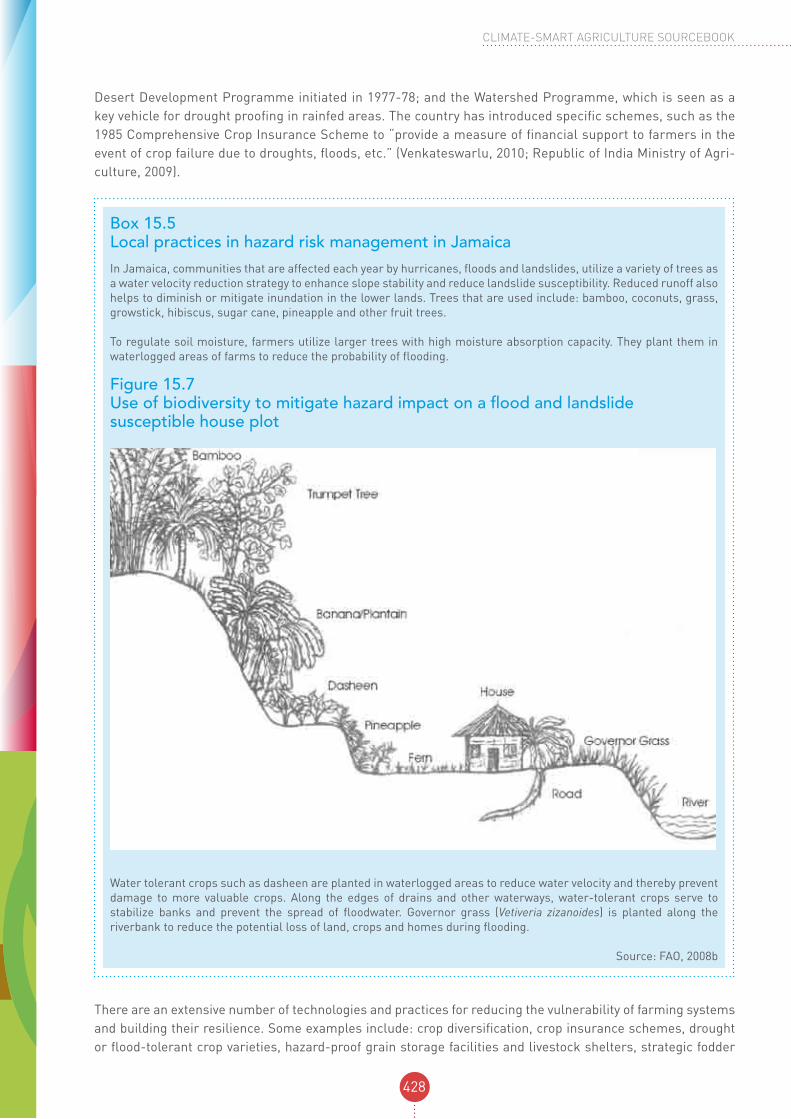
In Jamaica, communities that are affected each year by hurricanes, floods and landslides, utilize a variety of trees as a water velocity reduction strategy to enhance slope stability and reduce landslide susceptibility. Reduced runoff also helps to diminish or mitigate inundation in the lower lands. Trees that are used include: bamboo, coconuts, grass, growstick, hibiscus, sugar cane, pineapple and other fruit trees.
To regulate soil moisture, farmers utilize larger trees with high moisture absorption capacity. They plant them in waterlogged areas of farms to reduce the probability of flooding.
Figure 15.7 Use of biodiversity to mitigate hazard impact on a flood and landslide susceptible house plot
Water tolerant crops such as dasheen are planted in waterlogged areas to reduce water velocity and thereby prevent damage to more valuable crops. Along the edges of drains and other waterways, water-tolerant crops serve to stabilize banks and prevent the spread of floodwater. Governor grass (Vetiveria zizanoides) is planted along the riverbank to reduce the potential loss of land, crops and homes during flooding.
Source: FAO, 2008b

429
MODULE 15: Disaster Risk Reduction: Strengthening Livelihood Resilience
reserves, bio-security of animal production systems, water reserves to buffer droughts and resilient animal breeding (FAO, 2011b). Because of their adaptive value, many of these practices are also promoted by adap-tation strategies. Some practices, such as conservation agriculture, serve multiple functions. Conservation agriculture is an approach promoted for both risk reduction and adaptation because it is particularly suitable for areas that have low soil productivity and are exposed to difficult climatic conditions, such as drought and rainfall irregularity (see for example Module 7 on climate-smart crop production systems). It is also seen as a way to manage agro-ecosystems for improving and sustaining productivity and food security while preserving and enhancing the resource base and the environment (FAO, 2011a).
Technologies and practices promoted by DRR and climate change adaptation can be delivered as a coherent package of solutions to climate variability and change. CSA can provide the common platform for integrating these technologies. At the same time, CSA can achieve significant increases in the scale of its implementa-tion by adopting and promoting DRR practices that are already field tested and proven for building resilient livelihoods. Given the long history of DRR practices, these validated practices offer a large portfolio and broad evidence base for significantly scaling up CSA. The design of CSA initiatives should begin with mapping exist-ing local-specific good practices. One challenge is to identify practices that are effective across different land-scapes and against different types of hazards. Where DRR technologies are known and proven to be effective locally, they can serve as immediate entry points to CSA.
Scaling up proven risk reduction practices can be achieved through policies that support their systematic ex-pansion. Nepal provides a good example of a country that has made knowledge sharing a core priority of its integrated strategy for disaster risk reduction and climate change adaptation. Box 15.6 below describes this in more detail.
Box 15.6 Nepal’s strategy on knowledge sharing and management in climate change adaptation and DRRNepal’s Priority Framework for Action on Climate Change Adaptation and Disaster Risk Management in Agriculture represents an innovative policy framework that addresses climate change adaptation and DRR in an integrated and coherent manner. The Framework acknowledges the existence of good practice technologies and approaches, and the vital importance of knowledge sharing. The following is a summary of the framework’s strategy for knowledge management.
Priority Area III: Improved knowledge management, database and awareness-raising on climate change impacts, adaptation and disaster risk management.
Objective: Use knowledge to build a culture of innovation and resilience, and institutionalize training on climate change adaptation and disaster risk management in agriculture.
Some key activities planned:• organizing local-level awareness raising campaigns and training programmes for farmers on lessons learned
and best practices of disaster risk management, sustainable land management and climate change adaptation;• developing information centres for documentation of local knowledge, risks and vulnerabilities at the village and
district level;• establishing a good practice database (includes indigenous and local practices) relevant to agriculture and
livestock for climate change adaptation and DRR;• integrating climate change, disaster risk management and sustainable land management into farmer field
schools and promoting agricultural extension systems that can demonstrate and disseminate good practices;• promoting the establishment of model demonstrations at regional research centres by involving local
communities to showcase relevant good practice examples on climate change adaptation and disaster risk management;
• organizing periodical capacity development and knowledge sharing sessions with staff, local institutions and farmers on aspects of climate change adaptation and disaster risk management; and
• disseminating tested good practice examples of climate change adaptation and disaster risk management.
Source: Federal Democratic Republic of Nepal Ministry of Agriculture and Cooperatives et al., 2012

430
CLIMATE-SMART AGRICULTURE SOURCEBOOK
The scale of CSA activities can also be expanded through existing local, national and regional networks, knowledge fairs and South-South cooperation. Within traditional societies, the transfer of indigenous knowl-edge and technologies is often limited by oral communication and confined to local groups. If this knowl-edge is to have significant impact, external support is required to share these proven practices with a wider audience. Extension programmes and farmer organizations are recognized as viable cost-effective vehicles for the sharing of knowledge, the transfer of technology and know-how, and developing capacity (see more on capacity development in Module 17). In Peru, the Association for Nature and Sustainable Development (ANDES) is an indigenous NGO that has contributed to the establishment of the protected areas known as Indigenous Biocultural Heritage Areas. The Potato Park brings together six Quechua communities to protect a 12 000 hectare area as a microcenter of origin of the potato and other native Andean crops. ANDES works in close collaboration with formal and informal Quechua technicians in researching, training and developing adaptive management models for indigenous biocultural heritage. Working together, they organize South-South learning exchanges in the Potato Park for the design and implementation of indigenous biocultural territories as agrobiodiversity conservation areas (IIED, 2008).
CSA provides a fresh opportunity to tackle some long-standing challenges. For instance, there has been inadequate investment made to support and strengthen the coping capacity of pastoralists in the Horn of Africa. This is partly the result of the underestimated value of pastoralist systems as a viable way of life. It is also due to political marginalization of pastoral communities and adverse policies and practices, such as restrictions on their mobility and access to key natural resources (HPG, 2009a; IIED et al., 2008). Yet, the re-silience of pastoralist livelihoods has untapped potential that can be strengthened through CSA. Pastoralist systems can be an effective measure against rising temperatures and the increased incidence of drought ex-pected over the next four decades based on regional climate projections for East Africa. As one study shows: “...of all the natural resource-based land uses in the drylands, pastoralism functions best within the preva-lent context of wide rainfall variability and unpredictability... [It] has an important role to play where other livelihoods are likely to fail... Evidence suggests that…it would be more effective to enable and strengthen the inherent adaptive capacity of pastoralists, finding ways to encourage their autonomous adaptation... Pastoralism is a rational use of the drylands. Pastoralists respond to and use, even choose and profit from, variability. This allows for a vibrant and productive livelihood system in some of the harshest landscapes in the world” (HPG, 2009b).
combining drr knowledge with innovations in climate change adaptation In addition to the expansion of indigenous knowledge and risk reduction practices as valuable measures to advance adaptation and CSA, there are other opportunities and benefits for combining DRR and CSA efforts. Climate change creates risks that are not addressed by risk reduction measures (e.g. rising sea levels, in-creased temperatures and the expected spread of plant pests and diseases). In some cases, local knowledge is useful for reducing risks, but it is insufficient to cope with climate change. For this reason, local expertise needs to be combined with scientific knowledge, research and technological innovations. In practice, there are still only a few cases where DRR and climate change adaptation technologies have been combined. The example below in Box 15.7 on potatoes in the Andes illustrates how traditional risk reduction practices can be effectively combined with new adaptive technologies.

431
MODULE 15: Disaster Risk Reduction: Strengthening Livelihood Resilience
DRR and climate change adaptation both acknowledge one vital area: the importance of an ecosystem approach and sustainable natural resource management in strengthening resilience (see also Module 2 on landscape approach and management of ecosystems). DRR recognizes the inherent interconnected-ness between the environment and natural hazards (UNISDR, 2004b). Deforestation, the degradation of catchments and watersheds, the degradation of land and desertification, the depletion of reefs and coastal ecosystems (especially of corals and mangroves) reduce nature’s defence capacity against climate-related hazards and aggravate the impact of disasters such as floods, landslides, storm surges, hurricanes and drought (FAO, 2011b). In upland watersheds, deforestation and destruction of the protective cover of veg-etation can accelerate soil erosion, reduce the soil’s water-retention capacity and make sloping areas more prone to flooding and landslides. Eroded material may be carried downhill into rivers and streams, choking channels with gravel, sand and sediments. This can influence the frequency and severity of flooding and increase downstream damage (UNESCAP, 1997). Disasters in turn contribute to ecosystem degradation and loss, such as deforestation, declining rangeland quality, salinisation of soils and reduced biodiversity. On the island of Sumatra, the 2004 Asian Tsunami damaged approximately 20 percent of sea grass beds; 25-35 percent of wetlands; about 60 000 hectares of agricultural land; nearly 49 000 hectares of coastal forests: and 32 000 hectares of mangroves (UNEP, 2005; UNEP, 2007). Increased environmental degrada-
Box 15.7 Building the resilience and adaptive capacity of potatoes in the Andes
In some regions of the world, climate change is expected to increase plant diseases and pests that affect potato production. This phenomenon is already being observed in some areas. Late blight, the fungus responsible for the Irish potato famine in the 1800s, is expected to expand into previously unaffected areas. In addition, increases in temperature will put additional pressure on the potato’s wild relatives. By the year 2055, 16-22 percent of all wild potato species will be threatened with extinction. This is an urgent problem given the importance of wild relatives as gene pools for breeding new varieties. Potatoes constitute the fourth most important food crop after rice, wheat and maize. They are vital to the diets and livelihoods of millions of people.
Although Andean communities have demonstrated their resilience to adverse weather and changing environments, additional assistance can help strengthen this capacity. This assistance can also bridge science and traditional knowledge and generate innovative solutions. A project by Association Andes supports Andean potato farmers through the protection of traditional knowledge and conservation efforts that prevent the disappearance of potato varieties from local fields. This ensures farmers have more options for dealing with the impact of climate change. The project includes the following:
• conservation of 1 345 accessions of local potatoes through the Potato Park communities;• establishment of a database of native potatoes, traditional knowledge and climate change;• collection of information on the effects of climate change on the cultivation of local potato varieties;• documentation of traditional knowledge about climate change and extreme events; and• transfer of land for the construction of the Centre for Traditional Knowledge and Native Potatoes in the Potato Park.
Another new potato breeding initiative in Bolivia is helping local farmers cope with the increasingly shorter rainy seasons and the resulting declines in yields. The project, implemented by the International Potato Center (IPC) and the Fundación para Promoción e Investigación de Productos Andinos breeds potato varieties that are better adapted to the short rainy season without any loss in yield. With local farmers, the project tests new varieties in the field under real conditions.
The IPC, together with local organizations, is evaluating the tolerance to water and temperature stress of the genetic resources of its potato collection and those of new varieties that are being bred. The IPC can draw on the world’s largest genetic reservoir of potato varieties. Its gene bank contains 5 000 distinct types of cultivated potatoes and more than 2 000 wild relatives of the potato belonging to around 140 wild species. The goal is to identify the desired key characteristics and genes that determine tolerance to abiotic stress. Climate change and other factors that increase pressure on ecosystems are threatening the existence of many wild relatives. The establishment and maintenance of gene banks is intended to curb the loss of this diversity in varieties. To date, the IPC has repatriated over 400 native potatoes varieties among communities across the Andes. The long-term goal is to establish community gene banks to ensure that the genetic resources underpinning the food supply are secured.
Sources: Centre for Development and Environment, 2008; International Treaty on Plant Genetic Resources for Food and Agriculture, 2011

432
CLIMATE-SMART AGRICULTURE SOURCEBOOK
tion reduces the goods and services available to local communities, shrinks economic opportunities and livelihood options, and ultimately contributes to greater food insecurity and hunger (FAO, 2011b).
Effective risk reduction depends significantly on the ability to promote sound environmental and natural re-source management practices and the sustainable use of ecosystems. Healthy and diverse ecosystems are more resilient to natural hazards. Forests and reforestation are used as shelterbelts and windbreaks, and play an important role in protecting against landslides, floods and avalanches. Trees stabilize riverbanks and mitigate soil erosion (see also Module 9 on climate-smart forestry). Wetlands serve to store water and provide storm protection, flood mitigation, shoreline stabilization and erosion control (FAO, 2011b).
There are numerous examples of ecosystem approaches that have been promoted through risk reduction measures. Since the 1960s, Bangladesh has been investing in coastal afforestation and creating coastal green belts, such as mangroves, to reduce the impact of cyclones and tidal surges. In the watersheds of the Suchiate, Coatán and Cahoacán Rivers on the border area between the department of San Marcos, Guate-mala, and the state of Chiapas, Mexico, integrated watershed management is helping to restore ecosystems through soil conservation and sustainable agricultural practices by securing downstream water supply to settlements, agriculture and livestock, reversing watershed degradation and reducing the risk of devastat-ing floods caused by tropical storms and hurricanes. Sri Lanka’s Road Map for Disaster Risk Reduction outlines a range of activities that integrate both risk reduction and environmental management objectives, including the integration of DRR in environmental impact assessments and the promotion of coastal vegeta-tion or green belts (PEDRR and The Council of Europe, 2010).
Recognizing the interconnectedness between risk reduction and good environmental stewardship, the HFA identifies the “reduction of the underlying risk factors” as one of its five Priorities for Action. One of the key areas emphasized under this priority for action is environmental and natural resource manage-ment, which includes the following objectives: encourage the sustainable use and management of eco-systems; implement integrated environmental and natural resource management approaches that incor-porate DRR; and promote the integration of risk reduction associated with existing climate variability and future climate change into strategies for the reduction of disaster risk and adaptation to climate change (UNISDR, 2005).
Ecosystem-based approaches are also well recognized as a critical element of adaptation by the UNFCCC and constitute a fundamental pillar in CSA (see for example Module 10 on climate-smart fisheries and aq-uaculture). Ecosystem services will become more vulnerable and fragile as climate change affects rainfall patterns and increases surface temperatures. Existing ecosystem-based DRR measures can strengthen ad-aptation efforts under CSA. Some examples of initiatives that combine DRR and climate change adaptation objectives are starting to emerge. In Mexico, for example, a large-scale coastal wetland and mangrove swamp restoration project is addressing coastal protection against hurricanes and saltwater intrusion due to rising sea levels (PEDRR and The Council of Europe, 2010). The project is also improving local water supply and food production. Box 15.8 illustrates a watershed management approach in Uganda that integrates DRR and climate change adaptation in project design.

433
MODULE 15: Disaster Risk Reduction: Strengthening Livelihood Resilience
Box 15.8 Community-based integrated watershed management approach to DRR and climate change adaptation in UgandaUganda is prone to droughts, floods, windstorms and hailstorms, landslides and crop and livestock diseases. The water-related hazards make up over 90 percent of the natural disasters and each year destroy an average of 800 000 hectares of crops (UNDP et al., 2009). These natural hazards are exacerbated by increasing environmental degradation. The most disaster-prone communities are located along the dry arid and semi-arid areas of the Cattle Corridor that stretches across the country. According to Uganda’s 2007 National Adaptation Program of Action, the country experienced seven drought episodes between 1991-2000 (Uganda NAPA, 2007). Also, in recent years, floods and landslides triggered by tropical cyclones and severe storms have become one of the most devastating natural hazards in Uganda.
FAO Uganda is currently promoting a community-based integrated watershed management (CBIWM) approach to planning, which integrates DRR and climate change adaptation strategies. The approach addresses socio-economic development, the restoration of the environment’s ecological integrity and institutional capacity development. This integrated, intersectoral approach places communities at the centre of the process and enables them to make qualified decisions about DRR based on watershed ecosystem functions and their interaction with natural resource management practices. Building and strengthening watershed organizations and linking them with District Disaster Management Committee and Village Disaster Management Committees is crucial. Farmer field schools are used to increase the knowledge and skills of farmers and pastoralists. Farmers can then solve problems for themselves and undertake their own initiatives in DRR and climate change adaptation. The conceptual and operational framework of community-based integrated watershed management for DRR and climate change adaptation is presented in Figures 15.3 and 15.4 below.
FAO conducted a week-long intensive training for personnel from local district governments, the United Nations and NGOs in the Karamoja region in North Eastern Uganda to enhance their knowledge and skills in planning, implementing, monitoring and evaluating CBIWM programmes. Each district that participated developed draft action plans on how to apply and replicate the approach in their local environment. As a result of the training, the Local Government of Moroto District has initiated an improved community-based watershed management programme in the Musopo watershed.
The CBIWM is consistent with, and supports the current efforts of the Uganda Ministry of Water and Environment to put into action catchment–based water resources management. Also, a recent Joint Programming Agreement between FAO and the World Food Programme in Uganda is being operationalized using a CBIWM approach in five districts of Karamoja.
Figure 15.8 The conceptual and operational framework of CBIWM for DRR and CCA
ENTRY PHASE(Pre-watershed
Management Phase - Awareness, sensitization and
community mobilization)
PREPARATORYPLANNING PHASE
(Participatory Dister Risk Assesment and planning)
IMPLEMENTATION PHASE (Building Community
resilience against Disaster risk)
PHASING OUT/ WITDRAWAL PHASE
(Consolidation of project outcomes/ achievements)
First Stage Second Stage Third Stage Fourth Stage
Watershed community
VDMC = Village Disaster Management CommitteeWDA = Watershed Development AssociationDDMC = District Disaster Management CommitteeDLG = District Local GovernmentFFS = Farmer Field School
LocalGovernment
DLG and DDMC
Technical Facilitating
Agency
Institutional Development(strengthening
community Institutional capacity)
Socio-economic Development
(creating opportunities for
Income and livelihood)
Restoring Ecologica Integrity
(improving biophysical Condition
of watershed)
The Basic Aims of CBIWM Approach Coordination
WDA/VDMC/
FFSDisaster Risk Reduction/
CCA(Enhanced community Resilience)

434
CLIMATE-SMART AGRICULTURE SOURCEBOOK
Protecting and building the resilience of rural livelihoods against disaster risks and climate change depends largely on sustainable practices in natural resource management. Sustainable ecosystem management pro-vides ‘the unifying base’ for promoting DRR and climate change adaptation and maximizing opportunities for achieving livelihood security (PEDRR and The Council of Europe, 2010). As the example from Uganda illus-trates, the integrated approach to watershed management necessarily brings together a diversity of stake-holders from governments, civil societies and the international community in the pursuit of win-win outcomes in risk reduction and adaptation.
15.5 The enabling framework of DRR to support CSA
governance: national institutional structures and policy frameworks for drrAn enabling environment and institutional partnerships are vital for achieving CSA’s multiple objectives. CSA supports the use of existing institutional arrangements, policies and incentives that enable and empower farmers to adopt climate-smart practices as well as recognizes the importance of improved coordination for collective decision making and action (Global Science Conference on Climate-Smart Agriculture, 2011; FAO, 2010a). This section presents elements of the existing enabling architecture for DRR that can support CSA.
Many countries have national legislations, institutional arrangements, policies and planning frameworks for DRR. Experience over the past decades has shown that good practice in DRR requires vertical links between a national enabling environment and decentralized support and implementation with adequate resourcing. Ul-timately, the success of local action depends on political will, legislative commitment, institutional structures and public investment to provide the necessary enabling environment for effective local action.
The 1990s witnessed the introduction or reform of disaster risk reduction and disaster risk management leg-islation in many countries. According to a report on the global state of DRR, of the 119 countries reporting, 80 percent indicated having some form of legislation for disaster management (UNISDR, 2004a). Legislation is
Figure 15.9 The CBIWM activities by phases
ENTRY PHASE(Pre-watershed
Management Phase - Awareness, sensitization and
community mobilization)
• Community orientation, sensitization and awareness on DRR/ CCA and watershed management approach
• Participatory identification of community watershed boundaries
PREPARATORYPLANNING PHASE
(Participatory Dister Risk Assesment and planning)
• Conducting participatory disaster risk assessment (PDRA) including climate risk & land degradation assessments
• Developing watershed management and land use plan
• Developing a community-based DRR and CC adaptation plans using a watershed approach
• Developing community based early warning system
• Developing contingency Plans
IMPLEMENTATION PHASE (Building Community
resilience against Disaster risk)
Implementation of community DRR and CC adaption plans focusing on:
• Improving bio-physical condition of the watershed.
• Creating opportunities for income, livelihood diversification and distributional equity among watershed communities
• Strengthening coordination and institutional capacities of watershed communities and Farmer Field Schools for disaster risk reduction and CCA
PHASING OUT/ WITDRAWAL PHASE
(Consolidation of project outcomes/ achievements)
Further strengthening Coordination and linkages between watershed DRR and CCA community groups, Farmer Field School and local government Institutions and relevant Development partners
First Stage (2 months) Second Stage (4 months) Third Stage (24 months) Fourth Stage (6 months)
435
MODULE 15: Disaster Risk Reduction: Strengthening Livelihood Resilience
binding and hence critical for ensuring accountability in DRR. Despite growing awareness and commitment to climate change adaptation, relatively few countries have legislation on climate change adaptation. There are opportunities for strengthening legislation on DRR to support adaptation and CSA, as well as to make use of this legislation as an enabling framework for CSA.
Between 73 and 80 national platforms for DRR exist today (UNISDR, 2013a). As national multistakeholder coordinating bodies for DRR, these platforms provide a solid foundation from which to build interinstitutional collaboration for CSA and catalyse CSA action. National DRR systems are at the core of countries’ capacity to cope with disaster risks. They typically bring together ministries, agencies, donors, NGOs, and civil society organizations around common DRR goals. Many of these national DRR platforms are multisectoral. In Sri Lanka, the National Disaster Management Coordination Committee represents 35 members from key sectors, including representatives of the Ministries of Environment, Home Affairs and Agriculture, the Department of National Planning, the Coastal Conservation Department, the Department for Irrigation and the Department of Meteorology (UNISDR, 2008).
Many of the same countries with national platforms also have Strategic National Action Plans for Disaster Risk Reduction (UNISDR, 2013b), which guide the direction of risk reduction actions and set priorities at the country level. Some countries have DRR structures and planning frameworks specifically for the agriculture sector. Ethiopia’s Ministry of Agriculture established the Disaster Risk Management and Food Security Sector to co-ordinate activities related to disaster prevention and preparedness. Jamaica has developed an Agricul-ture Disaster Risk Management Plan, and Belize has formulated a Plan of Action for Disaster Risk Reduction in Agriculture and Fisheries Sector. Nepal has also recently developed an integrated strategy, the Priority Framework for Action on Climate Change Adaptation and Disaster Risk Management in Agriculture.
In some countries, national policies and plans exist that are not specifically related to DRR but support risk reduction. Examples include: Namibia’s 1997 National Drought Policy and Strategy; Zimbabwe’s 1998 National Policy on Drought Management, which emphasizes forward planning, preparedness, prevention, mitigation response, recovery and rehabilitation (FAO, 2004); and Kenya’s 2002 National Action Plan to Combat Deserti-fication & Drought.
At the same time, considerable advances have been made in building national institutional mechanisms and policies for climate change adaptation. National adaptation policies are articulated in National Adaptation Programmes of Action (NAPAs). Progress in climate change adaptation efforts has been rapid and has led to a multitude of important initiatives. Experience, however, shows that these governance structures at national and local levels have developed separately from those for DRR. There is a need for greater coordination be-tween the institutional arrangements, policies and planning designed for climate change adaptation and those that have been set up for DRR (IISD, 2011). Figure 15.10 below illustrates the parallel mechanisms in place for climate change adaptation and DRR in countries in the Pacific region (UNISDR et al., 2012).
Supporters of CSA recognize the need for greater coherence and coordination, and that a “lack of coherence can prevent synergy capture and render the pursuit of the stated policy objectives ineffective” (FAO, 2010a). An inclusive and coherent pathway for CSA would include partnerships with the institutional architecture of both DRR and climate change adaptation, as well as joint dialogue and collective action in the agriculture sec-tor for the benefit of farmers (see also Module 13 on policies). Given the institutional constraints and limited resources in many developing countries, this is a rational and cost-effective approach. On the ground, people at risk also need coherent policies and support.

436
CLIMATE-SMART AGRICULTURE SOURCEBOOK
Figure 15.10 Institutional structures supporting DRR and CCA in the Pacific region
Local Government & Community Development Commitees
Nationl CC Tasks Forces
Pacific CC Roundtable
UNFCCC/GEF
Local Government & Community
DRM Commitees
Local Government & Community Development Commitees
Pacific Platform for
DRM
Global Platform for
DRR
Local Government & Community Development Commitees
National Adaptation
Plans of Action
(NAPAs)
PIFACC
Kyoto Protocol
Local & Community
Development Commitees
NationalDRM Action Plans
(NAPs)
Madang Framework
Hyogo Framework
Local Government/ NGOs/CSCs
Government/Donors/ Int. & Reg. Org./
NGOs
Development Partners
for Climate Change
International CC
Community
Local Government / NGOs/CSO
Government/ Donors/ Int. & Reg. Org./
NGOs
Pacific DRM Partnership
Network
ISDR System/GFDRR
The Pacific Plan for strenghtening Regional Cooperation and Integration
LOC
AL
NA
TIO
NA
LR
EG
ION
AL
GLO
BA
L
CSA can be the conceptual framework that connects DDR and climate change adaptation, fosters consistency and coherence in the agriculture sector and provides a unifying force within agriculture line agencies. By ac-knowledging the multiple challenges and the importance of aligning approaches, CSA can help to overcome “the legacy of fragmented institutions established around single-issue ‘silos’; and move towards integrated thinking and policymaking”, a flaw that has been recognized by the High-level Panel on Global Sustainability (High-level Panel on Global Sustainability, 2012). A strategic approach for planning CSA programmes should begin by taking stock of what is already in place at the country level and identifying the key gaps that need to be addressed to better manage risks and climate change in the agriculture sector.
Examples of good practice are emerging out of national enabling environments that combine the shared concerns over disaster risk and climate change. In Nepal, the Ministry of Agriculture in collaboration with FAO and the United Nations Development Programme (UNDP) recently developed the Priority Framework for Action for Climate Change Adaptation and Disaster Risk Management in Agriculture. The Framework promotes policy coherence by drawing on the actions previously outlined in the NAPA and National Strategy for Disaster Risk Management. Nepal’s integrated framework is a promising example of good practice. It can serve as an ideal platform for advancing CSA in the country by offering opportunities for partnerships, coordination and synergy in reaching practical technical solutions. Box 15.9 looks at the Philippines and provides a more detailed example of a country that has recently developed climate change legislation and policy that integrates DRR.

437
MODULE 15: Disaster Risk Reduction: Strengthening Livelihood Resilience
Since the above example of the Philippines is recent, it remains to be seen how it will translate into practice. Nonetheless, it illustrates an effective approach, based on an understanding of the multidimensional nature of risks, to improve coherence at the highest government level through explicit legislation and national policy with concrete strategies that better harmonize risk reduction and adaptation objectives.
region-wide platforms and inter-governmental strategies for drr DRR initiatives at regional levels also offer great potential for collaborative arrangements and for catalysing CSA. Worldwide, there are six regional platforms on DRR in place, such as the Regional Platform for Disaster Risk Reduction of the Southern Africa Development Community and the Regional Platform for Disaster Risk
Box 15.9 The enabling environments in the Philippines integrating DRR and CCA
The Philippines is the third most-disaster-prone country in the world. The country has the highest number of people exposed to natural disasters and displaced annually as a result of these disasters (UNISDR, 2009a). The country is prone to earthquakes and tsunamis, volcanic eruptions, drought and typhoons that trigger secondary effects, such as landslides, floods, flash flooding and storm surges. The Philippines is also affected by the periodic occurrence of El Niño and La Niña events. Many areas are exposed to multiple hazards: 22.3 percent of the land area is exposed to three or more hazards and 62.2 percent is exposed to two or more. The Philippines is expected to experience substantial rise in sea levels, with seventy percent of the 1 500 municipalities located along the coast vulnerable. Agriculture represents one-fifth of the total economy (18 percent of its gross domestic product) and generates one-third of national employment.
In 2010, the country enacted a Disaster Risk Reduction and Management Act, which included a policy to mainstream DRR and climate change into socio-economic development planning, budgeting, and governance, including the agriculture sector. Under the Act, Local Government Units (LGUs) are now obliged to use at least 5 percent of their budgets for DRR. The formulation of a disaster risk reduction and management plan by the LGUs forms the basis for the disbursement of the funds. The country also has a Strategic National Action Plan (SNAP) on DRR 2009-2019, which spells out the road-map for DRR. The Plan’s overall goal is to contribute to the country’s sustainable development and poverty alleviation agenda (Republic of the Philippines National Disaster Coordinating Council, 2009).
The Philippine´s Climate Change Act was enacted in 2009. The first of its kind in Southeast Asia, the Act recognizes that climate change and DRR are closely interrelated and that effective disaster risk reduction will enhance climate change adaptive capacity (UNISDR, 2011a). The Act mentions that “…the State shall integrate disaster risk reduction into climate change programs and initiatives”.
The Act also establishes a Climate Change Commission attached to the Office of the President and an advisory board composed of all relevant line Ministries, with the provision that “At least one of the sectoral representatives shall come from the disaster risk reduction community” (Republic of the Philippines, 2009). Among the functions of the Commission is ensuring the “…mainstreaming of climate change, in synergy with disaster risk reduction, into the national, sectoral and local development plans and programs”, and partnership with the National Disaster Coordinating Council in order to increase efficiency and effectiveness…” (Republic of the Philippines, 2009).
The National Framework Strategy on Climate Change 2010-2022 recognizes that the Philippines “faces increasing disaster risks with geological/seismic dangers closely interacting with...meteorological hazards”. The Strategy integrates DRR, including the enhancement of monitoring, forecasting and hazard warning systems, and mainstreams DRR and climate change adaptation into development and land-use planning based on disaster risk assessments.
Similarly, the national Development Plan identifies three goals for the agriculture sector, one of which is to increase “sector resilience to climate change risks” (Republic of the Philippines National Economic and Development Authority, 2011), which will include:
• reducing climate change-related risks and the vulnerability of natural ecosystems and biodiversity;• increasing the resilience of agriculture communities through the development of climate change-sensitive
technologies, climate-resilient agricultural infrastructure and climate-responsive food production systems;• strengthening the agriculture and fisheries insurance system as an important risk sharing mechanism;• incorporating natural hazards and climate risk in the agricultural land use plan; • strengthening the capacity of communities to respond effectively to climate risks and natural hazards; and• continuing vulnerability and adaptation assessments, especially in food production areas.
Source: Republic of the Philippines, 2009

438
CLIMATE-SMART AGRICULTURE SOURCEBOOK
Reduction in the Americas. Working through or with these networks enhances coherence, helps to build syner-gies and taps into existing expertise and practice.
In addition to the regional platforms, a number of regional inter-governmental organizations have developed disaster risk reduction strategies or frameworks for cooperation in DRR at the regional level, such as the ASEAN Regional Programme on Disaster Management. The African Union has developed the Africa Regional Strategy for Disaster Risk Reduction and adopted a Programme of Action for the Implementation of the Africa Regional Strategy for DRR. Africa’s Regional Economic Communities (RECs), including the Economic Commu-nity of Central African States, the Economic Community of West African States (ECOWAS), the Southern Africa Development Community and the Inter-Governmental Authority on Development (WB and GFDRR, 2010), are key partners in the implementation of the strategy. In 2009, Andean countries developed the Andean Strategy for Disaster Prevention and Relief. Central American heads of state adopted in 2010 the legally binding Central American Integrated Policy on Disaster Risk Reduction, which aims at an improved regional commitment to DRR through a common guiding framework (ISDR, 2011a).
At regional levels, links between DRR and climate change adaptation are not yet common. However, pioneering regional initiatives are underway, such as the Incheon REMAP in Asia, illustrated in Box 15.10 below.
15.6 Concluding remarks and recommendations
To achieve its multiple objectives, CSA promotes the application and scaling up of proven practices and ap-proaches. It follows a holistic pathway that brings together a number of areas of expertise. An enabling en-vironment and institutional partnerships are vital for achieving CSA. As a contribution to reaching these ob-jectives, this module has illustrated how proven policy and practice in DRR provides a rich resource-base for promoting and scaling up CSA. Key areas in DRR that can support CSA are summarized in Figure 15.11. DDR’s contribution specifically supports CSA’s objective of strengthening resilience to climate change and variability.
Box 15.10 A Regional Approach to Joint DRR and climate change adaptation: the Incheon REMAP in AsiaIn 2010, the Fourth Asian Ministerial Conference on Disaster Risk Reduction approved a five-year regional roadmap, the Incheon REMAP. The Incheon REMAP initiative is an example of how governments are providing an enabling policy environment and commitment for joint initiatives in DRR and climate change adaptation at the regional level. Fifty Asian and Pacific region governments agreed to: “By 2015, establish climate resilient disaster risk management systems that contribute to sustainable development at regional, national, subnational and community levels” (Fourth Asian Ministerial Conference on Disaster Risk Reduction, 2010). The roadmap promotes regional cooperation in Asia on DRR through climate change adaptation. It includes the integration of DRR and climate change adaptation into development for green growth.
The following priority targets were agreed:
• 10 countries with integrated ap proach and institutional structure to pro mote synergistic financing between disaster risk management and climate change adaptation;
•DRR and climate change adaptation investment tracking in place in 10 countries; and • all regional partners combine DRR and climate change adaptation programme or funding.
Other initiatives in the roadmap include: promoting multi-hazard risk assessments and capacities in local settlements; developing and sharing information, technology, sound practices, and lessons learned in climate and disaster risk management; collecting sound practices and lessons learned in DRR and climate change adaptation; developing a platform for sharing information, technologies and sound practices in DRR and climate change adaptation; improving linkages between climate change adaptation and DRR institutions at national and regional level; and implementing joint DRR and climate change projects in selected countries.

439
MODULE 15: Disaster Risk Reduction: Strengthening Livelihood Resilience
CSA follows a landscape approach with multiple objectives, and integrated landscape management requires an understanding of all natural hazards affecting a given territory. Multi-hazard risk assessments and map-ping was introduced in this module as an example of a tool that can help inform the design of appropriate CSA initiatives, identify the spatial distribution of hazards (climate-related hazards and geological hazards) at dif-ferent scales, assess the exposure to and vulnerability of farming systems to these and evaluate the overall level of risk. The combined analysis of multi-hazard risk assessment and mapping with downscaled climate change scenarios provides a harmonized framework for assessing all spatially relevant hazards in specific geographic areas, providing a complete picture of how food security is affected today by hazards and how it may be impacted in the future by climate change. This combined analysis facilitates short- and long-term holistic planning for CSA.
Figure 15.11 A holistic approach that builds on established DRR and CCA capacities to Support CSA
Climate-smart agriculture
A holistic pathway that harnesses the established capacity supporting DRR and CCA at the local,
national, regional and global levels
DRR ADAPTATION
DRR Capacity
• Global policy frameworks for DRR: Hyogo Framework for Action
• National enabling environment: legislation, institutional architecture, policies and plans for DRR
• Proven DRR technologies and practices that build resilience
• Community-based participatory processes (CBDRM)
• Risk assessment methods
Geological hazards
Address geological hazards affecting food security, such as tsunamis, volcanic eruptions and earthquakes
Increased frequency and intensity of climate related hazards
Emerging threats
Address the increased risk from
climate-change related processes such as sea level
rise and glacier melt, and the
reconfiguration in the spacial
distribution of climate hazards
such as extreme temperature
Degradation of coastal
ecosystemsDe-forestation Soil erosion Land
degradationSalinization
of soils
Deckine in ecosystem
servicesWater scarcity
Natural hazards and climate change contribute to ecosystem stress and the degradation of natural resources:DRR and CCA seek to redress these underlying drivers of risk
CCA Capacity
• Global policy frameworks for DRR: UNFCCC / IPCC
• National enabling environment: institutional architecture, policies and plans for CCA
• Innovative technologies and practices for adaptation
• Community-based participatory processes (CBA)
• Climate change scenarios
DroughtDrought
FloodsFloods
Hurricanes Hurricanes
*Note: CCA in this figure stands for climate change adaptation
CBDRM was presented as a proven participatory method for the assessment of local risks and for guiding local planning. It can serve as a vehicle and methodology for promoting CSA at local levels. Given the widespread application of CBDRM and its institutionalization across many countries, it provides considerable scope for contributing to CSA. Using joint community-based DRR and climate change adaptation approaches creates links with existing local institutional networks and builds coherence within communities and local authorities. In addition, there are many examples of local knowledge and risk reduction technologies and practices that have proven effective for reducing disaster risks. They represent a rich resource pool from which to draw to

440
CLIMATE-SMART AGRICULTURE SOURCEBOOK
scale up CSA. Knowledge sharing can be a vital strategy for CSA to gain scale given the wealth of proven DRR practices across most countries. By making use of technologies and practices that support both risk reduction and climate change adaptation, CSA can provide win-win benefits for farmers.
At the national and regional levels, well-established legislations, institutional structures, policies and plans for DRR provide CSA with a strong supportive enabling environment. By working in partnership with the national institutional architecture of DRR and climate change adaptation, CSA can act as a unifying force within agricul-ture line agencies. In this way, integrated and coherent plans for CSA can be articulated based on existing DRR and climate change adaptation policies and strategies.
Developing strategic frameworks to guide action on and investment in CSA at the country level will require mapping the national institutional landscape, policies and plans that can enable and catalyse CSA. This will be a challenging process, given the wide array of disciplines, actors and frameworks that are relevant to CSA and the complex relationships among them. Unquestionably, the mapping exercise should include DRR policies and practices relevant to livelihoods and food security. Table 15.1 presents suggestions for harnessing exist-ing DRR capacities to help reach CSA objectives. The table draws on the examples given in this module and on experience elsewhere.
Table 15.1 Strategic entry areas in risk reduction for CSA and integration opportunities with climate change adaptation
Enabling Environment Practical Tools Knowledge Sharing
Work with existing national platforms and institutional mechanisms for coordinating disaster risk reduction and adaptation.
Promote multistakeholder dialogue to identify opportunities and partnerships between the DRR and climate change adaptation communities, jointly address gaps and harmonize plans for CSA.
Take stock of and build coherence with national policies and plans already developed for reducing disaster risk and for adaptation in the country, including those that may be hazard-specific, such as drought mitigation policies.
Conduct integrated analysis of multiple risks to agriculture and food security, based on the collection of available information (data and maps) on hazards, vulnerabilities and risk assessments.
Enhance tools that blend risk assessments of current risks and downscaled climate change scenarios for improved and more holistic analysis.
Design CSA project initiatives that integrate adaptation and risk reduction measures, and that are in line with national DRR and climate change adaptation goals.
Implement CSA locally through integrated DRR and climate change adaptation community-based approaches that combine immediate short-term measures to reduce risks with long-term adaptation measures to slow-onset climate change.
Take stock of and promote proven traditional local knowledge.
Map and promote DRR technologies and practices that have been effective in reducing disaster risks to help meet the objectives of CSA.
Promote knowledge sharing among farmers, practitioners and policy makers on effective DRR and climate change adaptation technologies.
Support generation of integrated knowledge and practice.
Support stronger engagement of the DRR community.
Source: adapted from UNISDR, 2009b
The need for increasing the scale of CSA activities is becoming more urgent due to the pace of climate change. Southern Africa, for example, will be heavily affected by climate change with projections that indicate tem-perature increases of up to six degrees Celsius and a decrease in rainfall by as much as 40 percent in some parts of the region over the next 70 years. CSA offers fresh op portunities to improve food security. Those work-ing to advance CSA should make DRR a core element, harvest the wealth of good practice in DRR and forge strong partnerships with established institutional arrangements. Building on the accumulated expertise in

441
MODULE 15: Disaster Risk Reduction: Strengthening Livelihood Resilience
DRR increases the efficiency of international aid and government investments. This is a critical factor given the already severely constrained human resources and institutional environments in developing countries and aid budgets that are increasingly less able to attend to recurring and simultaneous disasters worldwide. For farm-ers, ultimately, there is no distinction between risk reduction and adaptation, but rather threats to livelihoods and family food security from which they need to be protected.
Notes
This module was written by Monica Trujillo (FAO) with contributions from Stephan Baas (FAO) and reviewed by Jim Hancock (FAO) and Kennedy Igbokwe (FAO).

442
CLIMATE-SMART AGRICULTURE SOURCEBOOK
Acronyms
ADPC Asian Disaster Preparedness CenterANDES Association for Nature and Sustainable DevelopmentASLR accelerated sea level riseCAPRA Probabilistic Risk Assessment InitiativeCBA community-based adaptationCBDRM community-based disaster risk managementCBIWM community-based integrated watershed managementCCA climate change adaptationCDMP Comprehensive Disaster Management ProgrammeCECI Centre for International Studies and CooperationCICERO Center for International Climate and Environmental Research – OsloCRA community risk assessmentsCSA climate-smart agricultureDRM Disaster Risk ManagementDRR Disaster Risk ReductionEC European CommissionECOWAS Economic Community of West African States GEF Global Environment FacilityGFDRR Global Facility for Disaster Reduction and RecoveryGIS Geographic Information System HARITA Horn of Africa Risk Transfer for Adaptation HFA Hyogo Framework for ActionHPG Humanitarian Policy GroupIIED International Institute for Environment and DevelopmentIISD International Institute for Sustainable DevelopmentIPC International Potato Center IPCC Intergovernmental Panel on Climate ChangeLGUs Local Government Units NAPA National Adaptation Programme of ActionNDMC National Disaster Management CentreNEPAD New Partnership for Africa’s DevelopmentNGI Norwegian Geotechnical InstituteNGO non-governmental organizationPacRIS Pacific Risk Information SystemPEDRR Partnership for Environment and Disaster Risk ReductionRECs Regional Economic CommunitiesRiVAMP Risk and Vulnerability Assessment MethodologySIDS Small Island Developing StatesSNAP Strategic National Action Plan UN United Nations UNDP United Nations Development ProgrammeUNEP United Nations Environment ProgrammeUNFCCC United Nations Framework Convention on Climate ChangeUNISDR United Nations International Strategy for Disaster ReductionUSAID United States Agency for International DevelopmentWFP World Food ProgrammeWISP World Initiative for Sustainable Pastoralism

443
MODULE 15: Disaster Risk Reduction: Strengthening Livelihood Resilience
References
Asian Disaster Preparedness Center (ADPC). 2004. Community-based disaster risk management: field practi-tioners handbook, by I. Abarquez & Z. Murshed.
BAN, K. 2008. Risk reduction and climate change. Speech by the United Nations (UN) Secretary-General, New York, USA, UN Headquarters.
Centre for Development and Environment. 2008. Potatoes and climate change. In InfoResources: Focus. No. 1.
CICERO and United Nations Environment Programme (UNEP)/GRID-Arendal. 2008. Many strong voices: out-line for an assessment project design. Norway. (available at http://www.cicero.uio.no/media/6359.pdf)
Djalante, R., Halder, S.R., Mulyasari, F. & Khan, S. 2010. Linking disaster risk reduction and climate change adaptation: comparing experiences from developed and developing countries. In Disaster Risk Reduction and Climate Change Adaptation: Case Studies from South and Southeast Asia. Studies of the University: Research, Counsel, Education. Publication Series of UN University and Environment and Human Security. No. 14. (available at http://www.ehs.unu.edu/file/get/7666)
European Commission (EC) & Practical Action. 2010. Climate change adaptation in Peru: the local experiences. Lima.
EC, United Nations Economic and Social Commission for Asia and the Pacific (UNESCAP) & ADPC. 2008a. Regional experiences on the integration of CBDRM into the local development planning in South East Asia, by E.Torrente, J. Zhang & T. Le-Huu.
EC, UNESCAP & ADPC. 2008b. CBDRM and poverty reduction in PDR-SEA4, by E.Torrente, J. Zhang & T. Le-Huu. (available at http://www.unescap.org/esd/Energy-Security-and-Water-Resources/water/projects/pdr_sea/documents/new/cbdrm&poverty.pdf)
FAO. 2004. Drought impact mitigation and prevention in the Limpopo River Basin: a situation analysis. Land and Water Discussion Paper. No. 4. Rome.
FAO. 2008a. The state of food insecurity in the world. Rome.
FAO. 2008b. Good practices for hazard risk management in agriculture: summary report Jamaica. Rome.
FAO. 2010a. ‘Climate-smart’ agriculture: policies, practices and financing for food security, adaptation and mitiga-tion. Rome.
FAO. 2010b. Executive brief: Haiti emergency and rehabilitation response. Rome.
FAO. 2011a. Evaluation of supporting conservation agriculture for sustainable agriculture and rural development (CA for SARD). Phase II report.
FAO. 2011b. Resilient livelihoods: disaster risk reduction for food and nutrition security. Rome.
FAO. 2012a. The Sahel crisis: executive brief. March. Rome.
FAO. 2012b. The Sahel crisis: executive brief. July. Rome.
FAO & WFP. 2010. Crop and food security assessment mission to Haiti. Rome.

444
CLIMATE-SMART AGRICULTURE SOURCEBOOK
Federal Democratic Republic of Nepal, ADPC, Norwegian Geotechnical Institute (NGI) & Centre for Interna-tional Studies and Cooperation (CECI). 2011. Nepal hazard risk assessment part 2: exposure, vulnerability and risk assessment. (available at http://www.gfdrr.org/sites/gfdrr.org/files/documents/Nepal_HazardAssess-ment_Part2.pdf)
Federal Democratic Republic of Nepal Ministry of Agriculture and Cooperatives, FAO & United Nations De-velopment Programme (UNDP). 2012. Priority framework for action on climate change adaptation and disaster risk management in agriculture: 2011—2020.
Fourth Asian Ministerial Conference on Disaster Risk Reduction. 2010. Incheon regional roadmap and action plan on DRR through CCA in Asia and the Pacific. Disaster Risk Reduction Through Climate Change Adaptation. Incheon, Korea.
Global Science Conference on Climate-Smart Agriculture. 2011. The Wageningen statement: climate-smart agriculture –science for action. (available at http://www.gscsa2011.org/LinkClick.aspx?fileticket=eDIto5l7E0E=)
High-level Panel on Global Sustainability. 2012. Resilient people, resilient planet: a future worth choosing.
Humanitarian Policy Group (HPG). 2009a. Pastoralists’ vulnerability in the Horn of Africa: exploring political marginalization, donors’ policies, and cross-border issues: literature review, by S. Pavanello. London, Overseas Development Institute.
HPG. 2009b. Pastoralism and climate change: enabling adaptive capacity. HPG Synthesis Paper. London.
International Federation of Red Cross and Red Crescent Societies (IFRC). 2011. World disasters report 2011: focus on hunger and malnutrition. (available at http://www.ifrc.org/PageFiles/99868/307000-WDR-2011-FI-NAL-email-1.pdf)
International Institute for Environment and Development (IIED). 2008. Association ANDES: conserving indig-enous biocultural heritage in Peru, by A. Argumedo & T. Stenner. Peru.
IIED. 2009. Community-based adaptation to climate change.
IIED. 2011a. Protecting and promoting the rights of indigenous people benefits us all, by K. Swiderska. (available at http://www.iied.org/protecting-promoting-rights-indigenous-people-benefits-us-all)
IIED. 2011b. Adapting agriculture with traditional knowledge, by K. Swiderska. IIED Briefing.
IIED, UNDP & International Union for Conservation of Nature (IUCN). 2008. Drylands – an economic asset for rural livelihoods and economic growth, by M. Mortimore.
International Institute for Sustainable Development (IISD). 2011. Review of current and planned adaptation ac-tion: southern Africa. Adaptation Partnership.
Intergovernmental Panel on Climate Change (IPCC). 2007. The fourth assessment report of the IPCC. 104 pp. (available at http://www.ipcc.ch/publications_and_data/ar4/syr/en/contents.html)
IPCC. 2012. Managing the risks of extreme events and disasters to advance climate change adaptation (SREX).
International Treaty on Plant Genetic Resources for Food and Agriculture. 2011. Peruvian ‘guardians’ lead potato park to a secure future. FAO. (available at http://www.planttreaty.org/sites/default/files/FACTSHEET%20PERUok.pdf)

445
MODULE 15: Disaster Risk Reduction: Strengthening Livelihood Resilience
IUCN. 2008. Indigenous and traditional peoples and climate change: issues paper, by M. Macchi.
Kelman, I., Mercer, J. & West, J.J. 2009. Combining different knowledges: community-based climate change adaptation in small island developing states. In IIED Participatory Learning and Action 60: Community-based Adaptation to Climate Change. (available at http://pubs.iied.org/G02812.html)
National Disaster Management Centre(NDMC). 2005. A policy framework for disaster risk management in South Africa. (available at http://www.ndmc.gov.za/LinkClick.aspx?fileticket=woMQMWNuU9k%3D&tabid=61)
Pandey, D.N., Gupta, A.K. & Anderson, D.M. 2003. Rainwater harvesting as an adaptation to climate change. Current Science, 85(1): 46—59. 2003.
Partnership for Environment and Disaster Risk Reduction (PEDRR) & The Council of Europe. 2010. Demon-strating the role of ecosystems-based management for disaster risk reduction.
Republic of Haiti. 2010. Haiti earthquake PDNA: assessment of damage, losses, general and sectoral needs.
Republic of India Ministry of Agriculture. 2009. Manual for drought management. New Delhi.
Republic of Philippines. 2009. Climate change Act of 2009 (Republic Act 9729).
Republic of the Philippines Department of Agriculture & FAO. 2010. Strengthening capacities for climate risk management and disaster preparedness in selected provinces of the Philippines (Bicol region): situation assess-ment report.
Republic of the Philippines National Disaster Coordinating Council. 2009. Strengthening disaster risk reduc-tion in the Philippines: Strategic National Action Plan 2009—2019 (SNAP).
Republic of the Philippines National Economic and Development Authority. 2011. Philippine development plan 2011-2016.
Uganda National Adaptation Programmes of Action (NAPA). 2007. Climate change. (available at http://unfccc.int/resource/docs/napa/uga01.pdf)
UN. 2011. Multi-sector damage needs assessment in Sindh and Balochistan provinces, Pakistan.
UNDP, National Environment Management Authority (NEMA) & UNEP Poverty Environment Initiative. 2009. Enhancing the contribution of weather, climate and climate change to growth, employment and prosperity. Kam-pala.
UNEP. 2005. After the tsunami: rapid environmental assessment, Indonesia. Nairobi.
UNEP. 2007. Environment and reconstruction in Aceh: two years after the tsunami.
UNEP. 2010. Linking ecosystems to risk and vulnerability reduction: the case of Jamaica.
UNESCAP. 1997. Guidelines and manual on land use planning and practices in watershed management and disas-ter reduction.
United Nations Framework Convention on Climate Change (UNFCCC). 2011. Framework convention on climate change.

446
CLIMATE-SMART AGRICULTURE SOURCEBOOK
United Nations International Strategy for Disaster Reduction (UNISDR). 2004a. Summary of national informa-tion on the current status of disaster reduction. Background for the World Conference on Disaster Reduction. Kobe, Hyogo, Japan. (available at http://www.unisdr.org/2005/mdgs-drr/national-reports/summary-national-reports.pdf)
UNISDR. 2004b. Living with risk: a global review of disaster reduction initiatives. New York, USA and Geneva, Switzerland.
UNISDR. 2005. Hyogo framework for action: building the resilience of nations and communities to disasters.
UNISDR. 2008.Towards national resilience good practices of national platforms for disaster risk reduction.
UNISDR. 2009a. Global assessment report on disaster risk reduction: risk and poverty in a changing climate. Geneva, Switzerland, United Nations.
UNISDR. 2009b. Adaptation to climate change by reducing disaster risks: country practices and lessons. UNISDR Briefing Note 02.
UNISDR. 2009c. UNISDR terminology on disaster risk reduction.
UNISDR. 2010a. Local governments and disaster risk reduction: good practices and lessons learned.
UNISDR. 2011a. Disaster risk reduction legislation as a basis for effective adaptation, by S. Llosa & I. Zodrow. In Global Assessment Report on Disaster Risk Reduction 2011.
UNISDR. 2011b. Viet Nam ministry plans to implement a community-based disaster risk management pro-gramme in 6 000 communes by 2020. (available at http://www.unisdr.org/archive/20925)
UNISDR. 2013a. Countries and national platforms. (available at www.unisdr.org/partners/countries)
UNISDR. 2013b. Strategic National Action Plan (SNAP) for disaster risk reduction. (available at www.unisdr-apps.net/confluence/display/bib/Strategic+National+Action+Plan+%28SNAP%29+for+Disaster+Risk+Reduction)
UNISDR, World Bank, & UNDP. 2012. Disaster risk reduction and climate change adaptation in the Pacific: an institutional and policy analysis. Suva, Fiji.
UN System Task Team on the Post-2015 UN Development Agenda. 2012. Realizing the future we want for all: report to the Secretary-General. New York, USA.
United States Agency for International Development (USAID) & Famine Early Warning System (FEWSNET). 2011a. East Africa food security outlook update. July.
USAID & FEWSNET. 2011b. East Africa food security outlook update: Horn of Africa drought executive brief. Au-gust.
Venkateswarlu, B. 2010. Agricultural drought management in India. In Proc. Workshop on Drought Risk Man-agement in South Asia. SAARC. New Delhi.
WISP, IUCN & FAO. 2009. Harnessing pastoralists’ indigenous range management knowledge for drought-resil-ient livelihood systems in the Horn of Africa.

447
MODULE 15: Disaster Risk Reduction: Strengthening Livelihood Resilience
World Initiative for Sustainable Pastoralism (WISP), Global Environment Facility (GEF), UNDP & IUCN. 2007. Pastoralists as shrewd managers of risk and resilience in the Horn of Africa. WISP Policy Brief No. 4.
World Bank. 2012. Improving the Assessment of Disaster Risks to Strengthen Financial Resilience.
World Bank & Asian Development Bank. 2010. Pakistan floods 2010: preliminary damage and needs assess-ment.
World Bank & Global Facility for Disaster Reduction and Recovery (GFDRR). 2010a. Report on the status of disaster risk reduction in Sub-Saharan Africa.

448
CLIMATE-SMART AGRICULTURE SOURCEBOOK
Additional Resources
FAO. 2011c. Climate-smart agriculture: managing ecosystems for sustainable livelihoods. Rome.
GIZ & UNISDR. 2010. Experiencia en la incorporación de la gestión del riesgo en los proyectos de inversión públi-ca en el Perú, by N. Zapata. In Lecciones Aprendidas de la Gestión del Riesgo en Procesos de Planificación e Inversión para el Desarrollo: Memoria del Taller Internacional.
Ministerio del Ambiente del Peru. 2010. Plan de accion de adaptacion y mitigacion frente al cambio climatico.
New Partnership for Africa’s Development (NEPAD). 2009. CAADP pillar III: Framework for African Food Secu-rity (FAFS). In Comprehensive Africa Agriculture Development Programme (CAADP). South Africa.
SAARC Disaster Management Center. 2008. Indigenous knowledge for disaster risk reduction in South Asia. New Delhi.
United Nations (UN). 2002. Report of the World Summit on Sustainable Development. Johannesburg, South Africa, 26 August- 4 September 2002.
UNCSD. 2012. Disaster risk reduction and resilience building. RIO 2012 Issues Briefs. No. 8.
UNEP. 2009. Rainwater harvesting: a lifeline for human well-being.
UNEP. 2012. Applying ecosystem-based approaches for disaster risk reduction and climate change adaptation. Sub-theme Statement delivered by UNEP during UN General Assembly Debate on Disaster Risk Reduction.
UNISDR. 2010b. Strengthening climate change adaptation through effective disaster risk reduction. Briefing Note 03.
UNISDR. 2011c. Preparing for Rio+20: redefining sustainable development. UNISDR Discussion Paper.
UNISDR. 2011d. Global assessment report on disaster risk reduction 2011: revealing risk and redefining develop-ment. Geneva, Switzerland, United Nations.
UNISDR, European Union & Kyoto University. 2008. Indigenous knowledge for disaster risk reduction: good practices and lessons learned from experiences in the Asia-Pacific Region. Bangkok.
World Bank. 2011. Climate-smart agriculture: a call to action.
World Bank & GFDRR. 2010b. Disaster risk management in Latin America and the Caribbean region: GFDRR country notes: Peru.