monterey county subdivision committee 3 county subdivision committee meeting: june 8, 2006, 10:45 am...
TRANSCRIPT
MONTEREY COUNTY SUBDIVISION COMMITTE E
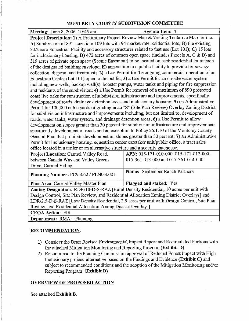
Meeting: June 8, 2006, 10 :45 am Agenda Item : 3Project Description : 1) A Preliminary Project Review Map & Vesting Tentative Map for the :A) Subdivision of 891 acres into 109 lots with 94 market-rate residential lots ; B) the existing20.2 acre Equestrian Facility and accessory structures related to that use (Lot 101) ; C) 15 lotsfor inclusionary housing ; D) 472 acres of common open space (includes Parcels A, C & D) and319 acres of private open space (Scenic Easement) to be located on each residential lot outsideof the designated building envelope ; E) annexation to a public facility to provide for sewagecollection, disposal and treatment ; 2) a Use Permit for the ongoing commercial operation of anEquestrian Center (Lot 101) open to the public ; 3) a Use Permit for an on-site water systemincluding new wells ; backup well(s), booster pumps, water tanks and piping for fire suppressionand residents of the subdivision; 4) a Use Permit for removal of a maximum of 890 protecte dcoast live oaks for construction of subdivision infrastructure and improvements, specificallydevelopment of roads, drainage detention areas and inclusionary housing ; 5) an AdministrativePermit for 100,000 cubic yards of grading in an "S" (Site Plan Review) Overlay Zoning Distric tfor subdivision infrastructure and improvements including, but not limited to, development o froads, water tanks, water system, and drainage detention areas ; 6) a Use Permit to allowdevelopment on slopes greater than 30 percent for subdivision infrastructure and improvements ,specifically development of roads and an exception to Policy 26 .1 .10 of the Monterey CountyGeneral Plan that prohibits development on slopes greater than 30 percent ; 7) an AdministrativePermit for inclusionary housing, equestrian center caretaker unit/public office, a tract sale soffice located in a trailer or an alternative structure and a security gatehouse.Project Location : Carmel Valley Road, APN : 015-171-010-000, 015-171-012-000 ,between Canada Way and Valley Green sDrive, Cannel Valley
015-361-013-000 and 015-361-014-00 0
Planning Number : PC95062 / PLN050001Name : September Ranch Partners
Plan Area: Carmel Valley Master Plan Flagged and staked : YesZoning Designation : RDR110-D-S-RAZ [Rural Density Residential, 10 acres per unit withDesign Control, Site Plan Review, and Residential Allocation Zoning District Overlays] andLDR/2.5-D-S-RAZ [Low Density Residential, 2 .5 acres per unit with Design Control, Site Pla nReview, and Residential Allocation Zoning District Overlays ]CEQA Action : ERDepartment : RMA – Planning
RECOMMENDATION :
1) Consider the Draft Revised Environmental Impact Report and Recirculated Portions wit hthe attached Mitigation Monitoring and Reporting Program (Exhibit D)
2) Recommend to the Planning Commission approval of Reduced Forest Impact with HighInclusionary project alternative based on the Findings and Evidence (Exhibit C) andsubject to recommended conditions and the adoption of the Mitigation Monitoring and/o rReporting Program (Exhibit D)
OVERVIEW OF PROPOSED ACTIO N
See attached Exhibit B .

OTHERAGENCYINVOLVEMENT : The following agencies have reviewed the project andthose that are checked (✓ ) have recommended conditions :
✓ Water Resources Agency ✓ Carmel Valley Fire Protection District✓ Environmental Health Division V Sheriff's Office✓ Public Works Department V Housing & Redevelopment✓ Parks Department
LUAC RECOMMENDATION :The Cannel Valley Land Use Advisory Committee (LUAC) unanimously recommended denia lof the project at their meeting in April 2005 .
SUBDIVISION SCORING COMMITTEE :The Carmel Valley LUAC had given the preliminary project review map an overall score of 7 5percent, but with a failing score of 44 percent for the water/hydrology category . The Board ofSupervisors modified the water/hydrology score to a passing score by adoption of Resolution 98-500. The scoring adopted by the Board of Supervisors, in Resolution 98-500 on December 1 ,1998, remains the scoring approved for this project .
Alana Knaster, Deputy Director of Resource Management Agency(831) 755-5322 or knastera@co .monterey.ca.usJune 1, 2006
cc :
Subdivision Committee Members (6) ; Sydney Reade – Cannel Valley Fire ProtectionDistrict; Donna Galletti – Sheriff's Office ; Marti Noel – Housing and RedevelopmentAgency; Monterey Peninsula Water Management District; Carmel Area WastewaterDistrict; Mike Novo ; Jacqueline Zischke – Lombardo & Gilles ; James Morgens –September Ranch Partners ; File .
Attachments: Exhibit A
Project Data Sheet
Exhibit B
Project Overview
Exhibit C
Findings and Evidence
Exhibit D
Recommended Conditions & Mitigation Measures
Exhibit E
Proposed Project Site Plan
Exhibit F
Alternative Project Site Plan
Mike Novo, Interim Director, Planning Department, reviewed this report .
2
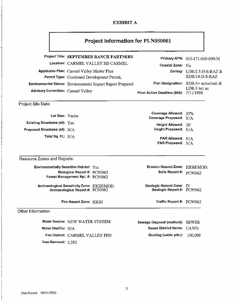
EXHIBIT A
Project Information for PLN05000 1
Project Title :
Location :
Applicable Plan :
Permit Type :
Environmental Status :
Advisory Committee :
SEPTEMBER RANCH PARTNER S
CARMEL VALLEY RD CARMEL
Carmel Valley Master Plan
Combined Development Permit,
Environmental Impact Report Prepare d
Cannel Valley
Primary APN : 015-171-010-000-M
Coastal Zone : No
Zoning: LDR/2.5-D-S-RAZ &RDR/10-D-S-RA Z
Plan Designation : RDR-5+ acres/unit &LDR-5 to l ac
Final Action Deadline (884) : 7/11/1996
Project Site Data :
Lot Size : Varies
Existing Structures (sf) : Yes
Proposed Structures (sf) : N/A
Total Sq . Ft. : N/A
Coverage Allowed : 25%Coverage Proposed : N/A
Height Allowed : 30'Height Proposed : N/A
FAR Allowed : N/AFAR Proposed: N/A
Resource Zones and Reports :
Environmentally Sensitive Habitat : YesBiological Report # : PC95062
Forest Management Rpt . # : pC95062
Archaeological Sensitivity Zone : HIGH/MOD .Archaeological Report # : PC95062
Fire Hazard Zone : HIGH
Erosion Hazard Zone : HIGH/MOD .Soils Report #: pC95062
Geologic Hazard Zone: IVGeologic Report #: PC95062
Traffic Report #: pC95062
Other Information :
Water Source: NEW WATER SYSTEM
Water Dist/Co: N/A
Fire District : CARMEL VALLEY FPD
Tree Removal : 3,582
3
Sewage Disposal (method) : SEWER
Sewer District Name : CAWD
Grading (cubic yds .) : 100,000
Date Printed: 06/0 1 /2006
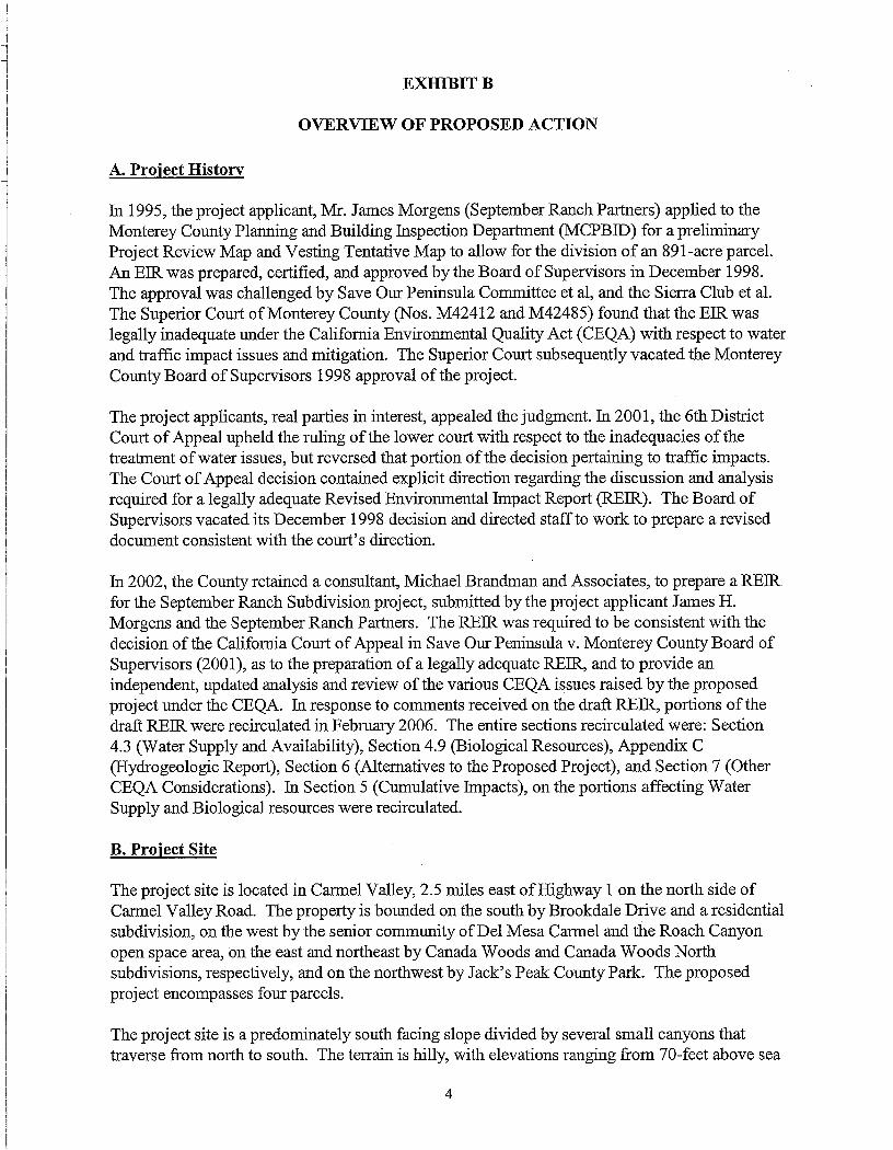
EXHIBIT B
OVERVIEW OF PROPOSED ACTIO N
A. Project History
In 1995, the project applicant, Mr . James Morgens (September Ranch Partners) applied to th eMonterey County Planning and Building Inspection Department (MCPBID) for a preliminaryProject Review Map and Vesting Tentative Map to allow for the division of an 891-acre parcel .An EIR was prepared, certified, and approved by the Board of Supervisors in December 1998 .The approval was challenged by Save Our Peninsula Committee et al, and the Sierra Club et al .The Superior Court of Monterey County (Nos . M42412 and M42485) found that the EIR waslegally inadequate under the California Environmental Quality Act (CEQA) with respect to wate rand traffic impact issues and mitigation . The Superior Court subsequently vacated the Montere yCounty Board of Supervisors 1998 approval of the project .
The project applicants, real parties in interest, appealed the judgment . In 2001, the 6th DistrictCourt of Appeal upheld the ruling of the lower court with respect to the inadequacies of th etreatment of water issues, but reversed that portion of the decision pertaining to traffic impacts .The Court of Appeal decision contained explicit direction regarding the discussion and analysi srequired for a legally adequate Revised Environmental Impact Report (REIR) . The Board ofSupervisors vacated its December 1998 decision and directed staff to work to prepare a revise ddocument consistent with the court's direction .
In 2002, the County retained a consultant, Michael Brandman and Associates, to prepare a REI Rfor the September Ranch Subdivision project, submitted by the project applicant James H .Morgens and the September Ranch Partners . The REIR was required to be consistent with thedecision of the California Court of Appeal in Save Our Peninsula v . Monterey County Board o fSupervisors (2001), as to the preparation of a legally adequate REIR, and to provide a nindependent, updated analysis and review of the various CEQA issues raised by the propose dproject under the CEQA . In response to comments received on the draft REIR, portions of th edraft REIR were recirculated in February 2006 . The entire sections recirculated were: Section4.3 (Water Supply and Availability), Section 4 .9 (Biological Resources), Appendix C(Hydrogeologic Report), Section 6 (Alternatives to the Proposed Project), and Section 7 (Othe rCEQA Considerations) . In Section 5 (Cumulative Impacts), on the portions affecting Wate rSupply and Biological resources were recirculated.
B. Project Sit e
The project site is located in Carmel Valley, 2 .5 miles east of Highway 1 on the north side o fCannel Valley Road . The property is bounded on the south by Brookdale Drive and a residentia lsubdivision, on the west by the senior community of Del Mesa Cannel and the Roach Canyonopen space area, on the east and northeast by Canada Woods and Canada Woods Nort hsubdivisions, respectively, and on the northwest by Jack's Peak County Park . The proposedproject encompasses four parcels .
The project site is a predominately south facing slope divided by several small canyons tha ttraverse from north to south. The terrain is hilly, with elevations ranging from 70-feet above se a
4
level to 968 feet above sea level . Onsite vegetation consists primarily of Monterey pines, coasta llive oaks, coastal sage scrub and grasslands. An equestrian facility occupies the flat terraces thatfront on Cannel Valley Road . The facilities include a barn with box stalls, hay storage, a tac kroom and office, outdoor fenced stalls, training ring, training arena and fenced pasture areas .Two residential units that serve as employee housing are also on the project site .
A Monterey shale quarry ceased operations over thirty years ago on the southeastern portion o fthe property and near the entrance to Roach Canyon . Also evident are a few concrete slab sdenoting the site of a former concrete ready-mix batch plant that ceased operations around th esame time .
Graded trails cross the property providing access to the western and eastern portions of the site .There are currently five locations that provide access to Carmel Valley Road .
C. Project Description
The proposed project encompasses the subdivision of 891 acres into 94 market rate residentiallots, 15 units of inclusionary housing, a 20 .2 acre lot for an equestrian facility, and 791 acres ofopen space . Other elements include a potable water distribution system, water tanks for fir esuppression, drainage system, internal road system, common open space, tract sales office an dsecurity gate . Site improvements would require approximately 100,000 cubic yards of gradin gand removal of 3,582 trees .
Permits Required
The project will require approval of a Combined Development Permit that includes :• Subdivision of 891 acres into 109 lots• Use Permit for the equestrian facilit y• Use Permit for an on-site water system• Use Permit for removal of a maximum of 890 protected oak s• Administrative Permit for 100,000 cubic yards of gradin g• Use Permit for development on slopes greater than 30 percent and an exception to Polic y
26.1 .10• Administrative permit for inclusionary housing, a tract sales office and security gatehous e
Other agency approvals include:• Creation of a new water distribution system and final determination of water availabilit y
under Rule 22• NPDES Permit• Annexation to the Carmel Valley Fire Protection Distric t• Annexation to the Carmel Area Wastewater Distric t
Zoning/Phasing
The northern portion of the property, which contains 494 acres, is zoned RDR/10-D-S-RA Z(Rural Density Residential, 10 acres per unit with Design Control, Site Plan Review, an dResidential Allocation Zoning District Overlays) ; the southern portion is zoned LDR/2 .5-D-S-
5
RAZ (Low Density Residential, 2 .5 acres per unit with Design Control, Site Plan Review, andResidential Allocation Zoning District Overlays) . Development of the site under the CannelValley Master Plan (CVMP) would allow for a maximum of 208 units . Development under theslope density formula allows for a maximum of 269 units . Therefore, the proposed density of 109units (including 1 equestrian facility lot) is less than the maximum density of 208 units allowed .
Approximately 587 residential units remain that are subject to the Carmel Valley Master Planquota program. September Ranch would reduce this by 109 lots . Because the project site has aResidential Allocation Zoning District Overlay, the project would be phased up to a maximum of25 lots developed per year, again, consistent with CVMP policy. Inclusionary units would not b esubject to the phasing requirement, but would be subtracted from the overall residential unit sremaining in the quota program .
All of the lots would be subject to design review and site plan review. Development envelope sand building envelopes are designated on each residential lot . Conditions of approval have beenrecommended to ensure that final building envelopes are located on slopes of less than 30% andavoid ridgeline development .
Traffic/Circulation
Access to Carmel Valley Road is currently provided at five locations serving key areas in th eproperty frontage . The project will upgrade and extend the existing roadway network to createaccess to the residential lots . Access to the property would be via a main entrance at the Carme lValley Road/Brookdale Drive intersection . The applicant will be required to install a traffi csignal at this intersection. The existing entrance at the equestrian center would be limited t oemergency vehicle access. Emergency access will be provided on the existing ranch roads t oJack's Peak Park . There will public access to Parcel C, donated to the Monterey County ParksDepartment, which will provide pedestrian and non-motorized access to Roach Canyon andsubsequently to Jack's Peak Park .
Upgrading of the roads would result in approximately 100,000 cubic yards of grading wit hportions of the roadway on slopes in excess of 30 percent . The building envelopes on each parcelavoid areas of slopes in excess of 30 percent .
Channelization would be required for both the eastbound and westbound approaches to th eproject entry point and a signal would be installed at the intersection of Cannel Valley Road an dBrookdale Drive . Conditions of approval from the Department of Public Works require th eapplicant to bond these improvements prior to recording the final map and to install thes eimprovements prior to the issuance of building permits for any unit in the subdivision .
Water Supply
The property is located within the Carmel River watershed . It is served by on-site wells . In1995, The State Water Resources Control Board issued Order No . 95-10, which found thatCalifornia American Water Company, the primary water supplier to the area, had diverted exces swater from the Carmel River without a valid basis of right . Cal Am was ordered to substantiallylimit its diversions . The Monterey Peninsula Water Management District requested that the
6
September Ranch property develop a mutual water supply company and not connect to the Ca lAm system.
The project will require potable water for the 94 single family lots and 15 inclusionary units, a swell as for the existing equestrian board and care facility . Irrigation of the pastures will cease.The estimated annual usage for the project is 57 .21 AFY .
The County's independent hydrologist has indicated that the September Ranch GroundwaterBasin or September Ranch Aquifer is a small and nearly closed basin bound almost entirely b yMonterey Shale .
Wastewater
The applicant originally proposed to construct and operate an onsite wastewater treatment facilit ylocated on the southeastern portion of the project site . However, since the issuance of the NOP ,the applicant has indicated his desire to connect to the Carmel Valley Wastewater Distric t(CAWD). The District has indicated that it has sufficient capacity and would serve the project .It is anticipated that flows directed to CAWD from the Project will provide some supplementarytertiary treated water to the Carmel River Lagoon during periods that will benefit steelhead .
Drainage and Stormwater Runoff
A registered civil engineer has designed a drainage plan for detaining runoff and sediment for th eproject . Stormwater will be collected and stored in seven detention basins, located throughout th esite. Existing drainage facilities located along and underneath Carmel Valley Road will b eupgraded to accommodate the anticipated increase in runoff. Conditions of approval from theWater Resources Agency require the applicant to construct, operate and maintain detentio nbasins to accommodate a 100-year storm event and release the flows at pre-development, 10-yea rstorm levels . Ongoing maintenance of the facilities will be provided by the Homeowner' sAssociation.
Existing Structures
The existing equestrian facility/barn and residential unit will remain on the property . The projectapplicant had initially considered demolition of these structures, although this had not bee nincluded in the project application . Subsequently, based upon public comment and review by ahistorian, it was determined that these were likely to be designated as historic structures . Thesefacilities will be conditioned accordingly and future use will be consistent with this designation .The applicant intends to continue to operate the equestrian facility which will be open to th epublic . Trails on the property will be utilized by customers of the facility as well as propert yowners in the subdivision.
Parks/Access to Jack's Peak Park
The applicant will be required to provide a tot lot to serve the inclusionary units . The open spaceand trail system on the property will provide additional open space/recreational opportunities .The applicant has offered to dedicate a park parcel (Parcel C) at the base of Roach Canyon t oMonterey County Parks and Recreation Department as well as a trail easement from that entr y
7
point to Jack's Peak Park . Access to Jack's Peak Park from properties proposed at the norther nportion of the property will be limited to the Parks Department trail easement or emergenc yevacuation along the existing ranch roads .
Inclusionary Housing
The applicant has proposed to build 15 units of inclusionary housing at the eastern end of theproperty . These would be clustered, detached for-sale units . The units could be single or doublestory, but with a 24-foot height limit to address visibility from Cannel Valley Road . Accesswould be through the main entrance .
The applicant has also proposed an option for an alternative layout of the inclusionary housin gthat was presented in the Recirculated Chapters of the REIR that would occupy two differen tareas on the property and would provide better opportunity for reducing visibility from th eCarmel Valley Road and adjacent properties . See the Alternative Project discussion below i nSection D.
D. Alternative Project
The County has identified and analyzed several alternatives in the REIR that would avoid o rlessen some of the significant and less-than-significant impacts associated with the Propose dProject. In addition, the County has identified options for individual project components that ma yaddress concerns raised to date by the public and county staff in their review of the REIR an dProposed Project .
CEQA encourages public agencies to consider changes or incorporate alterations to a project tha tavoid or substantially lessen the significant environmental effects identified in the EIR . LeadAgencies are similarly required to consider alternatives that avoid or substantially lessen one o rmore of the significant effects . CEQA Section 21002 states " . . .public agencies should no tapprove projects as proposed if there are feasible alternatives or feasible mitigation measure swhich would substantially lessen the significant environmental effects of such projects . . . "
Although staff believes at this time that the Proposed Project is consistent with County policie sand that there are no significant unavoidable impacts, staff is proposing that a Project Alternativ ebe recommended for approval . This Alternative is described in Section 6 .7 (Reduced ForestImpact with High Inclusionary Housing/Reconfigured Inclusionary Housing Alternative) of th eRecirculated Portion of the REIR (February 2006) . This Alternative would :
• Further reduce the amount of tree removal and site gradin g• Further reduce water consumption• Further reduce traffic impacts• Further reduce potential changes in views from Carmel Valley Roa d• Make a significant contribution to meeting the goals of the County and the State o f
California in the provision of affordable housing
Components of the Alternative that distinguish it from the Proposed Project are as follows :• 73 market rate lots, 22 inclusionary lots and one equestrian facility parcel ;
8

• The inclusionary housing would be reconfigured to three different locations on th eproperty. Four units will be shifted to the southwest from the originally proposed site .Twelve units are sited to the middle of the property . Six units are sited to the west side ofthe property by replacing market rate lots, designated as 64 and 65 in the Propose dProject .
• A group of lots, designated as 46-58, 83-85, and 102 in the Proposed Project, would notbe developed and would be designated as permanent open space contiguous to Jack' sPeak Park.
• A group of lots, designated as 31-35 in the Proposed Project, would be merged into onelot .
• Two lots, designated as 70 & 71 in the Proposed Project, would be merged into one lot .• Three market rate lots will be located in the original inclusionary housing site .
E. Project Analysi s
Biological Resources
The Proposed Project would result in disturbance for clearing and grading of less than 80 acres ,or nine percent, of the site for creation of building sites and infrastructure . Site disturbance willbe limited through the creation of building envelopes and scenic/conservation easements .Approximately 34.90 acres of Monterey pine/coast live oak forest habitat will be directl yimpacted. This equates to six percent (890 out of 15,200) of oaks on the site and four percen t(2,692 out of 66,540) of pines that occur on the site .
The Alternative would reduce the total number of acres disturbed by clearing and grading . Treeremoval would be reduced to 768 oaks (5 .2%) and 1,459 (2 .1%) pines. Since the area eliminatedfrom proposed development is part of contiguous forest habitat, there would also be importan tecosystem benefits from this alternative .
Mitigation includes conservation easements on individual parcels, the preservation of habitat o nopen space parcels, and a tree replacement plan (Mitigation Measures 4 .9-2 through 4 .9-6.) .Impacts would be reduced to a level that is less than significant .
Impacts to coastal sage scrub, grasslands, and special status species are also mitigated to a les sthan significant level through a combination of directed mitigation measures, avoidance anddedication of open space .
Visual Resources
Carmel Valley is a scenic area. The portion of the project along Carmel Valley Road is primaril yflat and includes view of the existing equestrian center and views of the southwest frontal slopes .The portion of the project proposed for residential development is generally screened fro mCannel Valley Road by vegetation and steep topography near the road . This was affirmed by th eEIR consultant's visual analysis .
During the site visit conducted by the Planning Commission in April 2005, at the LUAC meetin gin April 2005, and in public comment on the REIR, there were concerns raised regarding th evisibility of the proposed 15 unit inclusionary home component of the project . Staff conducted a
9

visual analysis of this component and concluded that the visual impacts were not significant. Asa safeguard, staff met with the applicant to detennine the viability of modifying the design t oaddress the concerns raised about visual impact .
Changes to project design are encouraged under CEQA to address potential impacts . Theapplicant and County considered changes to the layout of the site as well as alternate locations .The analysis of alternate locations indicated that the inclusionary homes could be either mor efully screened or totally relocated from the Carmel Valley Road viewshed . An alternative layoutand location for inclusionary housing is accordingly included in the Alternative that staffrecommends for consideration by the Subdivision Committee . The visual analysis is provided inSection 6 of the Recirculated Chapters of the REIR (February 2006) .
Historic Resources
As part of the staff work related to the preparation of the Responses to Comments document, th eEIR consultant examined the existing structures that make up the equestrian center and employe eunits. Although the county's consultant did not conduct a formal Phase 1 historic analysis, th econsultant advised the County that it was likely these structures would be deemed historic . Theapplicant indicated that he intended to retain these structures without structural modification .Accordingly, conditions have been proposed that treat these structures and the area as historic .The gatehouse design will also be appropriately conditioned to be compatible with the existingstructures .
Wastewater
The applicant had proposed to build an on-site sewage treatment system and had set aside Parce lB as a potential location . The Monterey County Environmental Health Services Divisio ninformed staff that they were no longer supportive of new on-site treatment systems . Theapplicant accordingly initiated discussions with the Cannel Area Wastewater District (CAWD) .CAWD has indicated that they have sufficient capacity and would provide service to th esubdivision. The REIR addressed both an on-site and off-site option . It now appears that the off-site option is feasible . This option for the wastewater component of the Project is presented i nSection 2.1 of the Recirculated Chapters . The project has been conditioned accordingly .
Water Supply
The subject of water supply and availability has been exhaustively analyzed and considered a spart of the review of this project both during the initial review in 1995 – 1998 and as part of thepreparation of the REIR.
The draft REIR, Recirculated Chapters (Chapter 3), and accompanying Hydrogeologic Repor t(Appendix C) are drafted to be responsive to the issues raised by the Court of Appeal in Save ourPeninsula Committee v. Monterey County Bd. of Supervisors (2001) 87 Cal. App.4th 99. TheEIR consultant team prepared a hydrological report to a) assess the long-term water supply forthe project; b) prepare a water balance for the project ; c) determine where September Ranch' swater rights fit in the hierarchy of relevant water rights ; and d) to determine the potentialenvironmental impact of diversions for September Ranch on nearby water supplies .
1 0

The water consumption baseline detenuination was an issue raised in the September Ranc hlitigation . The REIR assumes that the environmental baseline for water usage is three (3) acre-feet per year (AFY). The three (3) AFY calculation is based on water usage for a singl eresidence (.5AFY) and the amount of water applied for 50 horses (45 gallons per day/2 .5 AFY) .Current consumption on September Ranch is approximately 99 AFY due to the equestrian use sand irrigation of the pasture .
The Project water demand is estimated at 57 .21 AFY. This is based on projected average wateruse of .5 AFY for market-rate single family residences and .231 AFY per unit for inclusionaryhousing. Total housing demand including landscaping is 50 .5 AFY with 3 AFY for theequestrian center and 3 .74 AFY for system losses. As a Planning condition of approval ,irrigation of pastures will cease upon approval of the first final map of the project .
There were questions raised regarding the validity of the water use assumptions utilized in theREIR. County staff reviewed records from several subdivisions in unincorporated County an dconfirmed that these assumptions were in a reasonable range of accuracy . Cal Am reports anaverage water use of about 220 gallons per day (0 .25 AFY) for the Cannel Valley . Nevertheless ,staff is proposing enforceable conditions that will restrict water fixture approvals as th esubdivision develops to ensure that future water consumption is consistent with these estimates .Additional conditions address landscaping requirements and site use restrictions . Adoption of theProject Alternative is calculated to reduce the total estimated consumption by 8 .89 AFY to 48.32AFY.
In order to address questions raised by the Court of Appeal related to whether September Ranc hPartners hold overlying or riparian rights, the County retained Downey Brand LLP to perform a nindependent review of the water rights of September Ranch . (Refer to REIR pages 4.3-1 through4.3-10 for the detailed analysis) . The consultant evaluated demand on the Carmel Valley Aquife rbased on water pumping and water rights data and concluded that the exercise of water rights b ySeptember Ranch will not result in injury to water rights that are more senior to, or of the sam epriority as, September Ranch.
The Kennedy/Jenks Consultants (the county's EIR consultant team) hydrogeologic reportexamines the characteristics of the September Ranch Aquifer (SRA) and its relationship to th eCarmel Valley Aquifer (CVA) and concludes that the SRA is an aquifer with a finite storage an din limited communication with the adjacent CVA . (Refer to REIR pages 4 .3-11 through 4.3-33 ofthe Recirculated Chapters) .
Kennedy/Jenks Consultants also concludes that based upon an historical record of variabl erainfall, that even in the driest years, there would be sufficient rainfall and recharge to ensur esufficient water is stored within the SRA to meet project demand, i .e . there is a long termsustainable water supply.
Finally, both Kennedy/Jenks Consultants and Entrix, Inc . examined the potential for impacts t ospecies in the Carmel River during different weather cycles that could occur as a result o freduced flow to the river from the minimal exchange between SRA and CVA. Theirexamination indicates that the difference in river flow cannot be measured and will have n oimpact on steelhead and the red-legged frog. Further, Kennedy/Jenks analysis indicates tha t
1 1
cumulative impacts due to foreseeable water use within the relevant area of the CVA are les sthan significant (Refer to REIR pages 4 .9-13 through 4 .9-18 of the Recirculated Chapters) .
Traffic/Circulation
There are currently several site access points on the property . The Proposed Project is reducingthese to one access point consistent with Cannel Valley Master Plan Policy 39 .2.5 .1 . Emergencyingress and egress will be provided at the equestrian center driveway and to Jack's Peak Park onexisting ranch roads, consistent with Carmel Valley Fire Protection District requirements .
A Traffic Impact Analysis was performed in October 2004 for the Proposed Project by TJK MConsultants (the county's EIR Consultant Team) . The analysis evaluated Carmel Valley Road ,Laureles Grade, SR1 and Cannel Rancho Boulevard as well as nine (9) intersections in th eproject study area . The Proposed Project will result in an increase in traffic generation within th eproject area of approximately 1,053 daily vehicle trips ; 83 of these will occur during the AMpeak hour and 111 will occur during the PM peak hour . Mitigation for these impacts includespayment of a pro-rata fair share traffic impact fee toward Highway 1 improvements, payment o fTAMC Regional Development Impact fee, overlap phasing techniques and installation o fadditional lanes at appropriate intersections .
The Traffic Analysis also identified a potential issue with sight distance for travelers on Carme lValley Road in the vicinity of the project . Mitigation would include signalization of the CannelValley RoadlBrookdale Drive intersection and warning signs . Conditions of approval from theDepartment of Public Works require the applicant to bond these improvements prior to recordin gthe final map and to install these improvements prior to the issuance of building permits for an yunit in the subdivision.
Affordable Housing
The inclusionary housing requirements in place at the time the September Ranch Projec tapplication was deeded complete was either to provide the equivalent of 15% inclusionar yhousing either as an in-lieu fee or as on-site housing . The Proposed Project is consistent with thi srequirement. The applicant has determined that there are several locations on the property thatcould accommodate the inclusionary housing that are better screened from public views an dwould better integrate the inclusionary housing with the market rate housing . Thisreconfiguration of the inclusionary housing component includes both the 15 units in the Propose dProject and 22 units in the Alternative recommended by staff. This Alternative would equate to a30% affordable housing contribution from the Project . The units would be deed restricted.
The Board of Supervisors has stressed the importance of support for providing additiona laffordable housing in the unincorporated area of the County and has been providing support forProjects whose applicants are willing to provide more than the required amount of housing .Cannel Valley is one of the areas identified by the Board to be targeted for increasing the amoun tof affordable housing to improve the jobs-housing balance in this area of the County . Inaddition, the State Legislature has made the provision of affordable housing one of the highes tpriorities of the State . Accordingly, staff believes that Reduced Forest Impact with HighInclusionary Alternative would be appropriately recommended by the Subdivision Committee t othe Planning Commission as contrasted with alternatives that provide less affordable housing .
1 2

EXHIBIT C
RECOMMENDED FINDINGS & EVIDENCE
1 . FINDING : CONSISTENCY – The September Ranch Partners CombinedDevelopment Permit, as conditioned and with the proposed General Planand Zoning Ordinance amendments, is consistent with applicable portion sof the Monterey County General Plan, Cannel Valley Master Plan ,Monterey County Zoning Ordinance Title 21, Monterey Count ySubdivision Ordinance Title 19, Monterey County Inclusionary HousingOrdinance, Air Quality Management Plan and Transportation Plans &Policies .
EVIDENCE : On June 16, 1995, September Ranch Partners filed an application for aCombined Development Permit (PC95062, September Ranch Partners)consisting of a preliminary Project Review Map, a Vesting Tentative Mapto allow the division of an 891-acre parcel creating 94 market rate units, 1 5inclusionary housing units, a 20 .2 acre lot for the existing equestrian facility(with one employee unit), and 791 acres of open space . The applicationwas deemed completed on July 13, 1995 . The application, plans, andsupport materials submitted by the project applicant to the Monterey CountyPlanning and Building Inspection Department for the proposed developmentare found in Project Files PC95062 and PLN050001 .
EVIDENCE: The project site is located on Cannel Valley Road (Assessor's ParcelNumbers 015-171-010-000, 015-171-012-000, 015-361-013-000, and 015-361-014-000), Cannel in the County of Monterey .
EVIDENCE: PBI staff has reviewed the project as contained in the application andaccompanying materials for conformity with the Monterey CountySubdivision Ordinance (Title 19), the Monterey County General Plan, th eCannel Valley Master Plan and the Monterey County Zoning Ordinance(Title 21) .
EVIDENCE : The proposed development has been reviewed by the Monterey CountyPlanning and Building Inspection Department, Water Resources Agency ,Public Works Department, Environmental Health Division, Parks &Recreation Department, the Housing and Redevelopment Agency, Sheriff' sDepai tment and the Cannel Valley Fire Protection District . Recommendedconditions for the proposed development have been incorporated.
EVIDENCE : Section 4 .1 .2 (Land Use and Planning Project Impacts) of the Draft REI Ranalyzes the project's consistency with applicable General Land Us ePolicies, Residential Land Use Policies and Open Space Policies of theCannel Valley Master Plan .
EVIDENCE : Section 4 .2 .1 (Geology and Soils Project Impacts) of the Draft REI Ranalyzes the project's consistency with applicable policies of the Canne lValley Master Plan and General Plan pertaining to geology and seismicity .
EVIDENCE : Section 4 .3 .4 (Water Supply and Availability Project Impacts) of th eRecirculated Draft REIR analyzes the project's consistency with applicabl epolicies of the Cannel Valley Master Plan pertaining to water supply an davailability.
EVIDENCE: Section 4 .4.2 (Hydrology and Water Quality Project Impacts) of the DraftREIR analyzes the project's consistency with applicable policies of th e
1
Carmel Valley Master Plan pertaining to stormwater runoff and erosioncontrol .
EVIDENCE : Section 4 .5.2 (Wastewater Treatment and Disposal Project Impacts) of th eDraft REIR analyzes the project's consistency with applicable policies o fthe Cannel Valley Master Plan pertaining to sewage disposal andwastewater reclamation.
EVIDENCE : Section 4 .6.2 (Transportation and Circulation Project Impacts) of the DraftREIR analyzes the project's consistency with applicable policies of th eCarmel Valley Master Plan pertaining to transportation and circulation .
EVIDENCE : Section 4 .7.2 (Air Quality Project Impacts) of the Draft REIR analyzes theproject's consistency with applicable goals and policies of the CarmelValley Master Plan pertaining to air quality.
EVIDENCE : Section 4 .8.2 (Noise Project Impacts) of the Draft REIR analyzes theproject's consistency with applicable policies of the Carmel Valley Maste rPlan pertaining to noise levels .
EVIDENCE : Section 4 .9 .2 (Biological Resources Project Impacts) of the Recirculate dDraft REIR analyzes the project's consistency with applicable policies o fthe Cannel Valley Master Plan pertaining to biological resources .
EVIDENCE : Section 4 .10.2 (Cultural Resources Project Impacts) of the Draft REI Ranalyzes the project's consistency with applicable policies of the Canne lValley Master Plan pertaining to archaeological, historic, ethnographic andethnohistoric resources .
EVIDENCE : Section 4 .11 .2 (Aesthetics Project Impacts) of the Draft REIR analyzes th eproject's consistency with applicable Policies of the Carmel Valley Maste rPlan and the Cannel Valley Visual Study (CVVS) pertaining to aesthetic sand viewshed .
EVIDENCE : Section 4 .12.2 (Population, Housing, and Employment Project Impacts) o fthe Draft REIR analyzes the project's consistency with the quota an dallocation system that guides development in the Cannel Valley Maste rPlan Area.
EVIDENCE : With regard to Public Services and Utilities, the only Cannel Valley Maste rPlan policies that are relevant to this project address development ofrecreation areas. Section 4 .13 .5 (Public Services and Utilities — Recreatio nServices) of the Draft REIR analyzes the project's consistency with Policie s51 .2.7 and 51 .2.11 of the Cannel Valley Master Plan pertaining t orecreational areas .
EVIDENCE : The property contains two land use designations and zoning districts . Thenortherly portion (494 acres) of the property is designated Rural Densit yResidential, 10 acres per unit, and is zoned Rural Density Residential, 1 0acres per unit, Design Control, Residential Allocation Zone, and Site PlanReview overlay districts ("RDR/10-D-S-RAZ") . The southerly portion (397acres) of the property is designated Low Density Residential, 2 .5 acres perunit, and is zoned Low Density Residential, 2 .5 acres per unit, DesignControl, Residential Allocation Zone, and Site Plan Review overlaydistricts ("LDR/2 .5-D-S-RAZ"). The property has a potential 208 parcel sunder the zoning district requirements if the development was determine dconsistent with all other regulations and policies . The project proposes 109units .
2
EVIDENCE : The equestrian center/stables and tract sales office are allowed pursuant toSections 21 .14.050.Y and 21 .14.040.B, respectively, of the Montere yCounty Code .
EVIDENCE : The proposed subdivision is consistent with the Monterey Count ySubdivision Ordinance Title 19 . See Evidence in Finding 6 .
EVIDENCE : The proposed project's allocation of 15 units of affordable housing i sconsistent with Inclusionary Housing Ordinance #3419, the requirement ineffect at the time the application was determined complete . Section 4 .1 .2(Land Use and Planning Project Impacts) and Section 4 .12.2 (Population,Housing, and Employment Project Impacts) of the Draft REIR analyze th eproject's consistency with the Monterey County Inclusionary Housin gOrdinance .
EVIDENCE : The project does not propose any lots that will result in Ridgelin eDevelopment, as required by Policy 26 .1 .9 of the Monterey County GeneralPlan. Section 4 .11 of the RDEIR analyzed the visual impact fro mdevelopment of the project and found that no significant environmenta leffects were identified . Topography of the site includes hillsides inproximity to Carmel Valley Road that block views of the majority of th esites parcels from public roads on the valley floor . Proposed parcels thatcan be seen from public roads in Cannel Valley have suitable area withi ntheir development envelopes to avoid ridgeline development throughexisting topography or vegetation, or through siting of the buildingenvelopes . Conditions of approval have been recommended to ensure tha tall building envelopes have adequate building sites to avoid ridgelin edevelopment .
EVIDENCE : The proposed subdivision is consistent with the 2000 Air QualityManagement Plan (AQMP). Section 4 .7.2 (Air Quality Project Impacts) o fthe Draft REIR analyzes the project's consistency with 2000 AQMP .
EVIDENCE : The project is consistent with 2000 Regional Transportation Plan Policie s1 .1 .1 and 1 .1 .3. Section 4 .6.2 (Transportation and Circulation Projec tImpacts) of the Draft REIR analyzes the project's consistency withapplicable Regional Transportation Policies .
EVIDENCE : Finding Number 9 of Resolution 98-500 adopted by the Board o fSupervisors on December 1, 1998, as amended by these findings .
2. FINDING :
NO VIOLATIONS – The subject property is in compliance with all rule sand regulations pertaining to zoning uses, subdivision and any otherapplicable provisions of the County's zoning ordinance . No violations existon the property. Zoning violation abatement costs, if any, have been paid .
EVIDENCE : Staff reviewed Monterey County Planning and Building Inspectio nDepartment records and is not aware of any violations existing on subjec tproperty .
EVIDENCE : Staff conducted an on-site inspection on March 16, 2005 to verify that theproject on the subject parcel conforms to the plans submitted unde rPLN050001 .
EVIDENCE : The application, plans, and support materials submitted by the projec tapplicant to the Monterey County Planning and Building Inspectio nDepartment for the proposed development are found in Project Files PC9506 2and PLN050001 .
3
3 . FINDING :
EVIDENCE :
EVIDENCE :
EVIDENCE :
EVIDENCE :
EVIDENCE :EVIDENCE :
EVIDENCE :
4. FINDING :
EVIDENCE:
EVIDENCE :
EVIDENCE :EVIDENCE :
TREE REMOVAL - The tree removal is the minimum required under th ecircumstances of the case . The removal will not involve a risk of adverseenvironmental impacts, as fully described in Monterey County Cod eSection 21 .64.260.D.5, such as soil erosion, impacts to water quality,ecological impacts, increases in noise pollution, reduce the ability ofvegetation to reduce wind velocities, or significantly reduce availablehabitat .Administrative record, including material in Planning and Buildin gInspection files PC95062 and PLN050001 .Forest Management Plan and supplemental reports prepared by Hugh E .Smith (June 13, 1995) and Stephen R. Staub (August 15, 2002 ; January 30 ,2004; February 28, 2005 ; June 30, 2005) .Biological Resources Assessment, September Ranch Project, prepared byMichael Brandman Associates, dated January 2004 .Site visits by staff from the Planning and Building Inspection Departmentand Monterey County's EIR consultant.Draft Revised EIR dated December 2004, Sections 3, 4 .1, 4.2, 4.9 and 4 .11 .Portion of Draft Revised EIR dated February 2006, Sections 2 .3, 2.4, 2 .7 ,4.9, and 5 .1 . Mitigation measures have been recommended in the EIR, an dincorporated as project conditions of approval, to minimize biological, soil,and aesthetic impacts related to the proposed tree removal .The tree removal involves six percent of the oak trees and four percent o fthe Monterey pine trees found on the project site .
HEALTH AND SAFETY – The establishment, maintenance or operationof the project applied for will not, under the circumstances of this particularcase, be detrimental to the health, safety, peace, morals, comfort, an dgeneral welfare of persons residing or working in the neighborhood of suc hproposed use; or be detrimental or injurious to property and improvement sin the neighborhood; or to the general welfare of the County .The proposed development has been reviewed by the Monterey CountyPlanning and Building Inspection Depaltulent, Water Resources Agency ,Public Works Department, Environmental Health Division, Parks andRecreation Department, Housing and Redevelopment Agency, Sheriff' sOffice and the Carmel Valley Fire Protection District as part of the projec tdesign and environmental review process . The respective departments haverecommended conditions, where appropriate, to ensure that the project wil lnot have an adverse effect on the health, safety, and welfare of person seither residing or working in the neighborhood ; or the County in general .The application, plans, and support materials submitted by the projec tapplicant to the Monterey County Planning and Building Inspectio nDepartment for the proposed development are found in Project Files PC9506 2and PLN050001 .Preceding Findings and supporting evidence .In order to construct internal access roads, the project proposes gradin gover slopes in excess of 30 percent . Therefore, the project requires thegranting of a Use Permit to allow development on slopes of 30 percent o rmore (Monterey County Code Section 21 .64.230) . See Evidence in Finding5.
4
EVIDENCE : Approximately 34.90 acres of Monterey pine/coast live oak forest habitatwill be impacted for construction of roads, utilities, and building pads .Therefore, the project requires a Use Permit for tree removal (MontereyCounty Code Section 21 .64.260.D). See Evidence in Finding 3 .
EVIDENCE : Draft Revised EIR dated December 2004, and portion of Draft Revised EI Rdated February 2006.
5. FINDING :
30 PERCENT SLOPES - There is no feasible alternative which wouldallow development to occur on slopes of less than 30 percent. The proposeddevelopment better achieves the goals, policies, and objectives of theMonterey County General Plan and Carmel Valley Master Plan than otherdevelopment alternatives .
EVIDENCE : Geologic, Soils, and Drainage Assessment, September Ranch, CarmelValley, Monterey County, California, June 30, 2003, prepared b yKleinfelder, Inc .
EVIDENCE : Biological Resources Assessment, September Ranch Subdivision Project ,January 2004, prepared by Michael Brandman Associates .
EVIDENCE : Development envelopes, including all building sites and septic disposa lareas, have been located on slopes of less than 30 percent .
EVIDENCE : To access areas of the property determined suitable for residentialdevelopment, limited areas of 30 percent slope must be crossed b yinfrastructure, such as roads and utilities . The areas of 30 percent slop ewhere development is allowed consist of existing ranch roads that need t obe improved to accommodate the project, fire safety requirements, andcounty private road requirements . The road system has been designed toachieve the maximum amount of resource protection while takingadvantage of existing ranch roads, where possible, to minimize resourc edisturbance .
EVIDENCE : Application materials found in project files PC95062 and PLN050001 .EVIDENCE : Draft Revised Environmental Impact Report for the September Ranc h
Subdivision Project, December 2004, Michael Brandman Associates ,Sections 4.1, 4.2, 4.4, 4.9, 4.11, 5 and 6 .
EVIDENCE : Recirculated Portion of Draft Revised Environmental Impact Report for th eSeptember Ranch Subdivision Project, February 2006, Michael BrandmanAssociates, Sections 4 .9, 5 and 6 .
EVIDENCE : See Evidence in Findings 1 and 4 .EVIDENCE : All areas of the project that will contain slopes over 30 percent will b e
placed into a conservation and scenic easement, per the requirements of th econditions of approval .
6. FINDING :
TENTATIVE MAP – None of the findings found in Section 19 .03.025.Fof the Monterey County Code Title 19 (Subdivision Ordinance) can b emade .
EVIDENCE: The proposed development has been reviewed by the Monterey CountyPlanning and Building Inspection Department, Water Resources Agency,Public Works Department, Environmental Health Division, Parks &Recreation Department, the Housing and Redevelopment Agency, Sheriff' sOffice and the Cannel Valley Fire Protection District . Recommendedconditions for the proposed development have been incorporated .
5
EVIDENCE : The tentative map is consistent with the Monterey County General Plan andCarmel Valley Master Plan (see Evidence in Finding 1 — Consistency) .Section 5 .1 .1 (Cumulative Impact Analysis) of the Draft REIR addressesthe project's cumulative impacts and consistency with the Monterey Count yGeneral Plan and Cannel Valley Master Plan .
EVIDENCE : The design or improvement of the proposed subdivision is consistent withthe Monterey County General Plan and Cannel Valley Master Plan .Section 4 .1 (Land Use and Planning) of the Draft REIR addresses th eproject's consistency with applicable General Land Use Policies,Residential Land Use Policies and Open Space Policies of the CarmelValley Master Plan .
EVIDENCE : The site is physically suitable for the proposed development . Sections 4 .1 . 2(Land Use and Planning Project Impacts) and 5 .1 .1 (Cumulative ImpactAnalysis) of the Draft REIR address the project's consistency wit happlicable General Land Use Policies, Residential Land Use Policies andOpen Space Policies of the Cannel Valley Master Plan .
EVIDENCE : The site is physically suitable for the proposed density of development .Sections 4 .1 .2 (Land Use and Planning Project Impacts) and 5 .1 . 1(Cumulative Impact Analysis) of the Draft REIR address the project' sconsistency with applicable General Land Use Policies, Residential Lan dUse Policies and Open Space Policies of the Carmel Valley Master Plan .
EVIDENCE: The design of the subdivision or the proposed improvements will not caus esubstantial environmental damage or will not substantially and avoidablyinjure fish or wildlife or their habitat. Sections 4.9.2 (Biological ResourcesProject Impacts) and 5 .1 .1 (Cumulative Impact Analysis) of theRecirculated Draft REIR address the project's consistency with applicabl ePolicies of the Cannel Valley Master Plan pertaining to biologica lresources .
EVIDENCE: The design of the subdivision or the type of improvements will not caus eserious public health problems. Section 5 .1 .1 (Cumulative ImpactAnalysis) of the Draft REIR addresses the project's cumulative impacts .See Evidence in Finding 1 .
EVIDENCE: The design of the subdivision or the type of improvements will not conflic twith an easement acquired by the public at large, for access through or useof property within the proposed subdivision. Staff has reviewed the titl ereport for the property and has not identified any easements with which theproject would conflict .
EVIDENCE: The subdivision meets the requirements imposed by the Subdivision MapAct and Monterey County Code, Title 19, as identified by staff review ofthe state law and local ordinance . See evidence in Finding 1 .
EVIDENCE: The project design allows for future passive or natural heating and coolingopportunities. The large lots for the market rate units allow residences to b edesigned to take advantage of solar opportunities, as desired by thehomeowner and architect . The smaller inclusionary lots also allow solaropportunities due to residences being sited such that either two sides o feach residence will be open to the sun or the residence faces the south ,which allows solar gain to the residence.
EVIDENCE: The application, plans, and support materials submitted by the projectapplicant to the Monterey County Planning and Building Inspectio n
6
Department for the proposed development are found in Project Files PC9506 2and PLN050001 .
EVIDENCE : The staff reports, minutes, public hearing records, maps, and other technicalreports contained in File PC95062 . The public and decision makersreviewed the EIR and Preliminary Project Review Map at public hearingsbefore the Subdivision Committee on May 28 and June 25, 1998, before th ePlanning Commission on July 29, August 26, and September 30, 1998, an dbefore the Board of Supervisors on December 1, 1998 . The project has beenreanalyzed according to the materials contained in File PLN050001, and anew REIR has been prepared by the County to address concerns identifie dby the court (see Finding 8) and to ensure that all environmental impactshave been analyzed against the appropriate baseline conditions .
7 . FINDING :
PERMIT - On June 16, 1995, September Ranch Partners filed anapplication for a Combined Development Permit (PC95062) consisting o fthe following: Combined Development Permit (PC95062, September Ranc hPartners) consisting of a Preliminary Project Review Map and a VestingTentative Map to allow the division of an 891-acre parcel into 94 parcelsfor market rate units, parcels for 15 inclusionary housing units, Use Permitfor a 20.2 acre lot for the existing equestrian facility, AdministrativePermits for the location of the inclusionary housing units, and 791 acres o fopen space. Other appurtenant facilities and uses proposed as part of th eproject include an on-site water treatment system, sewage collectio nsystem, drainage system, an internal road system, an Administrative Permi tfor tract sales office and security gate, a Use Permit for development o nslopes in excess of 30 percent, a Use Permit for tree removal, water storag etanks, and approximately 100,000 cubic yards of grading . A condition ofapproval requires that the project connect to an off-site wastewater facility .
EVIDENCE : Administrative record including material in Planning and Buildin gInspection files PC95062 and PLN050001 .
8. FINDING: INCLUSIONARY HOUSING – In approving the vesting tentative map ,the decision-making body has balanced the housing needs of the Countyagainst the public service needs of its residents and available fiscal an denvironmental resources. The applicant is required to comply withprovisions of Monterey County's Inclusionary Housing Ordinance .
EVIDENCE : Monterey County Ordinance #3419 is applicable to the project due to theproject being determined complete while that ordinance was in effect (se eFinding 1) .
EVIDENCE : The project proposes 15 on-site inclusionary housing units, which complie swith the requirement of the subject ordinance .
EVIDENCE : The project is in compliance with the requirements of the Inclusionar yHousing Ordinance.
EVIDENCE : Conditions of approval require that the applicant submit an Inclusionar yHousing Master Development Agreement . The condition identifies therequired components of the agreement.
9. FINDING: RECREATIONAL REQUIREMENTS - The applicant will be require dto comply with the recreational requirements of Title 19, Section 19 .02.010.
7
EVIDENCE : The applicant will provide on-site recreational facilities at the equestriancenter and will provide a trail system. The applicant will dedicate Parcel C(3 .2 acres) as identified on the Vesting Tentative Map . A public easementwill be provided for the construction of a trail from this parcel to Jack' sPeak Park, along the subdivision's western boundary. Trail constructionwithin the easement would be at the discretion of the Monterey CountyParks Department .
10. FINDING:
SITE SUITABILITY – The site is physically suitable for the proposeddevelopment.
EVIDENCE : The project has been reviewed for suitability by staff from the Planning an dBuilding Inspection Department, Public Works Department, Park sDepartment, Water Resources Agency, Environmental Health Division ,Sheriff's Office, and Cannel Valley Fire Protection District . There has beenno indication from these agencies that the site in not suitable for th eproposed development. Recommended conditions, designed to address anyconcerns and recommendations of these agencies, have been incorporatedinto the recommended conditions of approval .
EVIDENCE : Preceding Findings and Evidence .
11. FINDING:
SCORING – The project was given a passing score for the preliminaryproject review map by the Board of Supervisors, as required by MontereyCounty Code Chapter 19.07 and the Carmel Valley Master Plan .
EVIDENCE : Resolution 98-500, Finding 35, adopted by the Board of Supervisors onDecember 1, 1998. The Cannel Valley Land Use Advisory Committee ha dgiven the preliminary project review map an overall score of 75 percent, bu twith a failing score of 44 percent for the water/hydrology category . TheBoard of Supervisors modified the water/hydrology score to a passing scor eby adoption of the resolution. The scoring adopted by the Board ofSupervisors by Resolution 98-500 remains the scoring approved for thisproject.
EVIDENCE : The REIR identifies that the subdivision has an adequate water supply tomeet the requirements of Monterey County Code Title 19 and the policie sof the Carmel Valley Master Plan, which constitute the guidance for scorin gprojects under the Preliminary Project Review Map scoring system .
EVIDENCE : Preceding Findings and Evidence .
12. FINDING: BIOLOGICAL RESOURCES – For purposes of the Fish and Gam eCode, the project will have a potential for adverse impact on fish andwildlife resources upon which the wildlife depends .
EVIDENCE : Draft REIR, Chapter 4 .9, Biological Resources, contained in the projec tfile. The project may result in changes to the resources listed in Sectio n753 .5(d) of the Department of Fish and Game regulations .
13. FINDING:
An EIR was prepared and circulated for public review, and was consideredand certified by the Board of Supervisors in December 1998 . Aftercertification of the EIR, the Board of Supervisors approved the applicatio nfor the September Ranch subdivision project . The approval was challenge din court by Save Our Peninsula Committee et al . and the Sierra Club et al .The Superior Court of Monterey County (Nos . M42412 and M42485 )
8
EVIDENCE :
14. FINDING:
EVIDENCE :
15. FINDING:
EVIDENCE :
16. FINDING:
EVIDENCE:
EVIDENCE:
EVIDENCE:
17. FINDING:
EVIDENCE :
18. FINDING:
found that the EIR was legally inadequate under the Californi aEnvironmental Quality Act (CEQA) with respect to water and traffic impactissues and mitigation . The Superior Court subsequently vacated theMonterey County Board of Supervisors approval of the project . The projec tapplicants appealed the judgment .Administrative record including material in Planning and Buildin gInspection files PC95062 and PLN050001 .
In 2001, the 6 th District Court of Appeal upheld the ruling of the lowercourt with respect to the inadequacies of the water issues, but reversed tha tportion of the decision pertaining to traffic impacts. The Court of Appealdecision contained explicit direction regarding the discussion and analysi srequired for a legally adequate Revised Environmental Impact Repor t(REIR) . This direction formed the basis of a new judgment and writ ofmandate issued in the case (Save Our Peninsula v . Monterey County Boar dof Supervisors (2001) 87 Cal . App . 4th 99, 104 Cal Rptr .2d 326) . In 2002,Monterey County retained a consultant to prepare a REIR for the projec tsubmitted by September Ranch Partner sAdministrative record including material in Planning and BuildingInspection files PC95062 and PLN050001 .
On January 31, 2003, a Notice of Preparation for a Revised EnvironmentalImpact Report was circulated to agencies and interested parties .Administrative record including material in Planning and BuildingInspection files PC95062 and PLN050001 .
On December 31, 2004, a Draft Revised Environmental Impact Report(REIR) was distributed to responsible agencies, trustee agencies, othe rdepartments and agencies, and interested parties including the Stat eClearinghouse (SCH#1995083033) in accordance with the CaliforniaEnvironmental Quality Act . The public comment period for this documentwas from December 31, 2004 to February 28, 200 5Notice of Completion, dated December 29, 2004, was sent to the StateClearinghouse, along with copies of the Draft EIR, which were circulated toState agencies .A Notice of Availability was published, mailed to interested parties an dproperty owners within 300 feet of the project boundaries, and was poste don site.Administrative record including material in Planning and BuildingInspection files PC95062 and PLN050001 .
Comments on the Draft REIR were received from agencies and intereste dparties .Administrative record including material in Planning and BuildingInspection files PC95062 and PLN050001 .
On February 15, 2006, a portion of the Draft Revised Environmenta lImpact Report (REIR) was recirculated to responsible agencies, truste eagencies, other departments and agencies, and interested parties includin gthe State Clearinghouse (SCH#1995083033) in accordance with the
9
II
California Environmental Quality Act . The comment period for thi sdocument was from February 15, 2006 to April 3, 2006 .
EVIDENCE : A Notice of Completion was received at the State Clearinghouse onFebruary 15, 2006, along with copies of the Draft EIR, which werecirculated to State agencies .
EVIDENCE : A Notice of Availability was published, mailed to interested parties an dproperty owners within 300 feet of the project boundaries, and was postedon site .
EVIDENCE : Administrative record including material in Planning and Buildin gInspection files PC95062 and PLN050001 .
19. FINDING:
Comments on the recirculated portion of the Draft REIR were receive dfrom agencies and interested parties .
EVIDENCE : Administrative record including material in Planning and Buildin gInspection files PC95062 and PLN050001 .
1 0