morphological and sedimentary responses to ice mass
TRANSCRIPT

Morphological and sedimentary responses to ice massinteraction during the last deglaciation
RICHARD C. CHIVERRELL,* MATTHEW J. BURKE and GEOFFREY S.P. THOMASDepartment of Geography and Planning, School of Environmental Sciences, University of Liverpool, Roxby Building, LiverpoolL69 7ZT, UK
Received 16 February 2015; Revised 31 March 2016; Accepted 11 April 2016
ABSTRACT: During decline of the last British–Irish Ice Sheet (BIIS) down-wasting of ice meant that local sourcesplayed a larger role in regulating ice flow dynamics and driving the sediment and landform record. At the Last GlacialMaximum, glaciers in north-western England interacted with an Irish Sea Ice Stream (ISIS) occupying the eastern IrishSea basin (ISB) and advanced as a unified ice-mass. During a retreat constrained to 21–17.3 ka, the sediment landformassemblages lain down reflect the progressive unzipping of the ice masses, oscillations of the ice margin duringretreat, and then rapid wastage and disintegration. Evacuation of ice from the Ribble valley and Lancashire occurredfirst while the ISIS occupied the ISB to the west, creating ice-dammed lakes. Deglaciation, complete after 18.6–17.3 ka, was rapid (50–25ma�1), but slower than rates identified for the western ISIS (550–100ma�1). The slowerpace is interpreted as reflecting the lack of a calving margin and the decline of a terrestrial, grounded glacier. Icemarginal oscillations during retreat were probably forced by ice-sheet dynamics rather than climatic variation.These data demonstrate that large grounded glaciers can display complex uncoupling and realignment duringdeglaciation, with asynchronous behaviour between adjacent ice lobes generating complex landform records.Copyright # 2016 The Authors. Journal of Quaternary Science Published by John Wiley & Sons Ltd
KEYWORDS: British Irish Ice Sheet; deglaciation; geomorphology; Last Glacial Maximum (LGM); sedimentology.
Introduction
Given current concerns over accelerated retreat of large icesheets (Rignot et al., 2014; Thomas et al., 2011), there is aneed for well-constrained data on the retreat of former icemasses. It is difficult to directly observe these processes atcontemporary ice masses, and so it is only through investiga-tion of former ice sheets that the pattern and conditioning ofice marginal retreat over the timescales (1000s years) oflarge-scale deglaciation emerges. Over the last two decadesthe geomorphology and stratigraphy documenting the retreatof major ice streams draining the British–Irish Ice Sheet (BIIS)from its Last Glacial Maximum (LGM) limit has receivedconsiderable attention (reviewed in Chiverrell and Thomas,2010; Clark et al., 2012), and has included investigationsaround the former ice sheet (e.g. Knight and McCabe, 1997;Scourse and Furze, 2001; Knight, 2004; Jansson and Glasser,2005; McCabe et al., 2005; Carr et al., 2006; �O Cofaigh andEvans, 2007; Bradwell et al., 2008; Golledge et al., 2008;Dunlop et al., 2010; Carr and Hiemstra, 2013; Everest et al.,2013). In the Irish Sea sector research has addressed themorphology, stratigraphy and sedimentology of several majormoraine systems showing complex ice-marginal oscillationsduring retreat around the Irish Sea Basin (ISB) (e.g. Huddart,1971, 1991, 1994; McCabe et al., 1984, 1987; Thomas,1984b, 1989; Eyles and McCabe, 1989; Merritt and Auton,2000; Evans and �O Cofaigh, 2003; Thomas et al., 2004;McCabe and Dunlop, 2006; Thomas and Chiverrell, 2007;Parkes et al., 2009; Livingstone et al., 2010a,b). This paperpresents the glacial geomorphology and stratigraphy oflowland Lancashire, which was occupied by ice from threemain source areas, the Lake District, the Ribble ValleyGlacier and the larger east limb of the ISIS. Our aims are(i) to present the glacial geomorphology of lowland Lanca-shire; (ii) to identify a set of sediment–landform assemblagesthat define the primary glacial depositional environments;(iii) to interpret the depositional environments from thesedimentology of available major exposure; (iv) to define the
stratigraphical succession through the construction of a seriesof lithological cross-sections derived from borehole data;(v) to evaluate the impacts of regional ice mass reorganizationduring deglaciation in producing the sediment and landformrecord; and (vi) to model the published geochronologicaldata for regional deglaciation.
Methods
Geomorphology
The geomorphological mapping of the 4300-km2 region wasundertaken using the NEXTMAP Great Britain and BritishGeological Survey digital data on bedrock at the surface.Mapping comprised a two-stage process: (i) identifying thebreaks in slope together with symbols for primary, non-genetic landform geometries such as flats, ridges, moundsand basins; and (ii) interpretation using sediment landformassociations to produce a layered geomorphological ARCGISgeodatabase (Supporting Information 1). Ground-truth of themapping was carried out in selected areas by conventionalfield investigation. Interpretation of the geomorphology fol-lows conventional typologies for glacial landforms (e.g.Evans, 2003), and was underpinned by both the morphologyand associated sediments.
Lithostratigraphy
The Quaternary stratigraphy in Lancashire is underlain byPermo-Triassic sandstones and mudstones in the west and byCarboniferous sandstones and shales in the east (Earp et al.,1961; Aitkenhead et al., 1992). Exposure of solid rock islimited, but is more frequent to the east against the centralupland spine of England (Longworth, 1985). Exposures of theglacial stratigraphy are limited to sand and gravel operationsat Lydiate Lane, Hurst Green and Bradley’s Quarries (Fig. 1).Exposures were logged using field sketches, vertical lithofa-cies logs and photo-montages following standard procedures(e.g. Thomas et al., 2004). Characteristics recorded includetextural classification, sorting and grain size, palaeocurrent or
�Correspondence: R. C. Chiverrell, as above.E-mail: [email protected]
Copyright # 2016 The Authors. Journal of Quaternary Science Published by John Wiley & Sons LtdThis is an open access article under the terms of the Creative Commons Attribution License, which permits use, distribution and reproduction in anymedium, provided the original work is properly cited.
JOURNAL OF QUATERNARY SCIENCE (2016) 31(3) 265–280 ISSN 0267-8179. DOI: 10.1002/jqs.2864

Figure 1. Geomorphic map of Lancashire overlain on a hillshaded elevation model. The map extent is shown by the black box within the insetmap (top left). The mapped area has been divided into seven zones that are demarcated by the labelled black polygons. See text for fulldescription. Expanded large-scale version is available as Fig. S1. Locations providing geochronological information are identified on the mainpanel and inset: SE, Shap erratics; LWB, Low Wray Bay; FA, Four Ashes; D, Dowkabottom; NE, Norber erratics; WC, Warton Crag.
Copyright # 2016 The Authors. Journal of Quaternary Science Published by John Wiley & Sons Ltd J. Quaternary Sci., Vol. 31(3) 265–280 (2016)
266 JOURNAL OF QUATERNARY SCIENCE

till fabric indicators, sedimentary structures, nature of con-tacts and the lithofacies.Boreholes from over 6300 locations were assessed from the
British Geological Survey archives, reducing to 1400 sites byexcluding the confidential, shallow (<3m) or uncertainlocation boreholes. Lithologies were classified from the logdescriptions into gravel, sand and gravel, sand, silt/clay,laminated silt/clay and diamicton and used to constructstratigraphical cross-sections. Ground elevations of the sec-tions were interrogated from the NEXTMAP digital elevationmodel and cross-checked against the borehole log records.Interpretation of the stratigraphical sections is constrained bythe limited descriptive information available, especially inolder records; imprecision in the definition of clay/silt grainsizes; and the destruction of sedimentary bedforms bypercussion drilling. Uncertainties in the interpretation ofcross-sections arise from vertical and lateral variability inglacigenic sequences over short distances, limited lithologicalmarkers for correlation between boreholes and uncertainorigin (e.g. tectonic or cut and fill) for breaks in log profiles.However, combining the regional geomorphology withthe borehole stratigraphy gives us confidence in theseinterpretations.
Bayesian modelling of geochronological data
Following the approaches detailed in Chiverrell et al. (2013)all previously published geochronological data constrainingthe glacial stratigraphy and geomorphology in lowlandLancashire (Morgan, 1973; Telfer et al., 2009; Vincent et al.,2010; Wilson et al., 2013) have been compiled as ahypothetical ‘relative-order’ model of the expected youngingorder of events. Geochronological data obtained by 14C,optically stimulated luminescence (OSL) and terrestrial cos-mogenic nuclide (TCN) dating approaches have been ar-ranged into a pseudo-stratigraphical order reasoned solelyfrom landform–sediment relationships independent of thegeochronological measurements. This ‘prior model’, using theBayesian terminology, consists of the events or ice-marginalpositions arranged in the order of ice-marginal retreatreasoned from the geomorphology and stratigraphy. Bayesianmodelling was implemented using a simple Sequence modelin Oxcal (Ramsey, 2009; c14.arch.ox.ac.uk), which merelyrequires the dated events to be in an order. The modelthen uses a Markov chain Monte Carlo (MCMC) sampling tobuild up a distribution of possible solutions that fit theproposed ordering and the available ages in a sequence. Todo this the model generates a probability for each samplecalled a posterior density estimate, which is essentially aproduct of both the prior model and likelihood probabilities.Ultimately, the Bayesian modelling approach producesposterior density estimates or age ranges, italicized in thetext to differentiate them from the prior dating informationestimates.
Geomorphology, sedimentology andgeochronology
A map of the geomorphological record is presented in Fig. 1(with greater detail in supplementary Fig. S1). The mappedarea has been divided into seven broad zones to facilitatedescription and interpretation of the landform pattern. Iceflow patterns have been interpreted from the drumlinized andribbed terrain and comprise 13 flow-sets (Fig. 2a) (Mitchelland Hughes, 2012b). In general, the flow-set orientationsidentified from the detailed mapping in this paper (Fig. 2a)are similar to those documented by Hughes et al. (2014),
although here the interpreted sequencing of events differs.Together these flow-sets can be divided into three broad flowphases based on crest-line orientation and elongation ratio(Fig. 2a). Ice-marginal limits have been interpreted frommoraine ridges, the ice contact slopes of kame terracesand perpendicular orientations to drumlin crests and eskers(Fig. 2b). These ice limits were subdivided based on inter-pretations of ice source areas: the Irish Sea (IS), south-easternLake District (LD) and Ribble Valley (RV). Figure 2(b)distinguishes between major and minor ice limits drainingthese ice source areas based on interpretation of ridgecontinuity and geometry, with larger and more continuousridges interpreted as major ice limits and smaller, lesscontinuous ridges forming minor ice limits.
Geomorphology
Zone 1 comprises broadly flat low-lying terrain that ispunctuated by relatively subdued drumlins, which occurthroughout the area and form a NW–SE flow-set (Fs 1: Figs 1and 2a). Regional bedrock highs rising up to 175m above thesurrounding topography are aligned SW–NE and relativelylow in altitude, and are dissected by three NW–SE through-valleys probably incised by subglacial meltwaters and latermodified by proglacial outwash. Low-amplitude moraineridges occur throughout the zone, but form two majormoraines. The largest (IS1: Fig. 2b) extends east–west,includes kame terraces and small eskers or crevasse fillridges, and the multiple ridge crests record ice retreatnorthwards. Further north, the Tarleton moraine complex(IS2: Fig 2b) forms a large set of arcuate ridges aligned north–south then curving NE–SW towards the coast. Sets of troughand fan sandur are most common within and down glacier ofthese major moraines (Fig. 1). Zone 2 describes an undulatingbench of moraines and kames that formed between theretreating ice margins (LD1 and LD2) and the West PennineMoors (Fig. 1). The adjacent upland West Pennine Moors(Zone 3) have been dissected by deeply incised and misfitchannels. These channels are aligned NW–SE, form part of alarger network of channels, and most likely record meltwateroverflows from glacial lakes dammed in the lower RibbleValley (Earp et al., 1961; Aitkenhead et al., 1992). Zone 3 isdominated by ice-moulded bedrock with occasional drumlinsand moraines, with most glacigenic sediment concentrated inthe valleys.The Ribble Valley (Zone 4) dissects central Lancashire
and is flanked by a subdued low-amplitude glacial bench(Chiverrell et al., 2009a,b, 2010; Foster et al., 2009), which ismarked with sandur, kames and cross-valley orientatedmoraine ridges. The largest moraines form arcuate sets (RV1and 2) at the mouth of the Ribble Valley (Fig. 2b). This glacialbench and RV1 terminate at the apex of an extensive(�70-km2) low-angle spread of glacial diamicton with occa-sional sand and gravel (Fig. 1). Drumlins in zone 4 (Fig. 1),the Ribble-head drumlin field, form a valley-orientatedpattern that bifurcates SW towards the Ribble Valley (Fs 7)and SE towards the Rivers Aire and Wharf (Fs 8: Fig. 2a)(Mitchell, 1991; Mitchell and Hughes, 2012a). In the north ofzone 4 there are drumlins and the crests of drumlinizedsections of ribbed terrain that suggest ice flow SE up theWenning Valley around the Bowland Fells (Fs 10: Fig. 2a).Zone 5 is dominated a swathe of low, sub-parallel ridges
that arc west and north-west (LD3: Fig 2b), and comprisesthe ‘Kirkham End Moraine’ (Gresswell, 1967). Two majorentrenched proglacial channel systems dissect the moraine(Fig. 1). Further north arcuate moraines occur but are morecomplex with numerous sub-parallel ridges (LD4: Fig 2b),
Copyright # 2016 The Authors. Journal of Quaternary Science Published by John Wiley & Sons Ltd J. Quaternary Sci., Vol. 31(3) 265–280 (2016)
ICE MASS INTERACTION DURING THE LAST DEGLACIATION 267

intervening troughs, sandur, and enclosed and water-filledbasins (kettle holes) that are increasingly buried by extensiveHolocene deposits. In the east a NW–SE orientated glacigenicbench (30–90m OD) formed between the ice margin andthe Bowland Fells. The Bowland Fells (Zone 6) comprise ice-scoured bedrock lacking in situ glacigenic sediment, butoccasional high-altitude drumlinoid forms show a north–south ice flow direction (Figs 1 and 2a). Up ice from marginallimit LD4 (Fig. 2b), Zone 7 extends furthest north and isdominated by subglacial landforms with numerous drumlinsand widespread ribbed moraine. In the east, ribbed terrainshows west–east crest-line orientations, whereas the Lancas-ter–Kendall lowlands to the west are dominated by anextensive swarm of drumlins with cross-cutting flow direc-tions (Figs 1 and 2a).
Subglacial bedforms and ice flow
Ice flow in the region is divided in two three phases; flowphase 1 is composed of flow-sets 1–3 (Fs 1–3) that extend(probably from offshore) into the south of the region (Fs 1),north of the Ribble (Fs 2) and south across the Bowland Fells(Fs 3) where they are most common (Fig. 2a). Flow-sets 1–3comprise drumlins with a NW–SE trend and they displaymean elongation ratios of 2: 1 (can range from 8: 5 to 5: 1)(Fig. 1). Flow phase 1 is interpreted as reflecting IS iceadvancing onshore and onwards to maximum limits in the
English Midlands (Chiverrell and Thomas, 2010). Flow phase2 is associated with more restricted ice extent and recordedby Fs 4–6 (Fig. 2a). This phase is composed of drumlins withnorth–south crest-line orientations and a mean elongationratio of 3: 1 (range from 11: 5 to 9: 3). In the north Fs 5 and 6overprint Fs 2 and Fs 3 (flow phase 1), with drumlinorientations reflecting ice flow from the eastern Lake District.High-altitude drumlins on the Bowland Fells and similarlyelongated and north–south orientated drumlins in the upperRibble catchment (Fs 4) suggest flow phase 2 included iceextending southward at high elevations. Where the flow-setscross-cut each other, flow phase 2 appears to post-date flowphase 1.Associated with more reduced ice extent, there is a third
flow phase comprising Fs 7–13 (Fig. 2a) and this includes theRibble-head drumlin field (Mitchell, 1991; Mitchell andHughes, 2012a). These flow-sets are associated with ice flowsthat are more valley-confined and thus suggest greaterinfluence of bedrock topography than during previous flowphases. This bedrock constraint is reflected in the more localalignment of drumlins, although elongation ratios are typi-cally 5: 2 in all flow-sets (ranging from 8: 5 �23: 5). TheLancaster–Kendall drumlin field (Fs 11) has a NE–SW orienta-tion, cross-cutting Fs 3 and Fs 6 (flow phases 1 and 2,respectively), reflecting that during retreat stages ice sourcedin the eastern Lake District flowed out into MorecambeBay. In the upland valleys, drumlin orientations suggest
Figure 2. (a) Compilation of ice flow sets derived from glacigenic bedform orientation. Each zone shows a rose diagram of the drumlincrestline orientations (the colours correspond to those used for each flow set). (b) Major (labelled and bold) and minor ice margin positionsinterpreted from the geomorphic map, and colour coded for the ice sources for each margin [Irish Sea (IS1–2), Lake District (LD1–4), RibbleValley (RV1–3)].
Copyright # 2016 The Authors. Journal of Quaternary Science Published by John Wiley & Sons Ltd J. Quaternary Sci., Vol. 31(3) 265–280 (2016)
268 JOURNAL OF QUATERNARY SCIENCE

valley-parallel ice flow up the Wenning valley (Fs 10). Icegenerated in the Pennine Ice Field (Mitchell, 1991) extendssouth before splaying south-west into the Hodder (Fs 9) andRibble (Fs7) valleys, and south (Fs 8) to south-east (Fs13:Mitchell and Hughes, 2012) towards the eastward-drainingvalleys of the Pennines. This variation in drumlin orientationis mirrored by ice-flow indications in the ribbed terrain thatdisplay crest-lines perpendicular to the overprinting drumlins,lending further support to the splitting of ice-flow aroundhigher elevation terrain. This topographically confined flowappears to have been sourced from the Lake District andNorth Yorkshire (Fs 12) and given superimposition on earlier,cross-cutting flow-sets, this is interpreted as the final ice-flowphase recorded by the bedform record.We interpret the sequencing of flow-sets (Fig. 2b) to reflect
changes in ice source with thinning and back-wasting of theice sheet. Initially an IS component dominated, probablyduring the ice advance to maximum limits, but as the IS icemasses declined regional ice-flows switched to Lake Districtsources and were no longer confined by IS ice. Ice flowdirections became more confined by topography with furtherback-wasting and thinning of the ice masses. In general noneof the drumlins displays elongation ratios sufficiently attenu-ated to be diagnostic of ice streaming (Stokes and Clark,1999) in lowland Lancashire. However, other diagnosticcriteria are met, principally ice mass dimensions (width>30 km, maximum length >200 km) and convergent flowpatterns draining the eastern Lake District and ISB (Stokes andClark, 2001). It seems that while the ice masses here wereunlikely to be streaming at the time of bedform generation,they may have fed a larger ice mass that may have beenstreaming down-glacier.
Ice marginal limits and retreat
At a broad scale the identified limits (Fig. 2b) are similar tothose described by Clark et al. (2012), but contain greaterdetail and the moraines clearly document the unzipping ofdifferent ice-sources. In the south, these moraines are spaced�1–4 km (Zone 1: Figs 1 and 2b) apart and probably recordminor ice marginal still-stands, followed by a major standstillthat formed a belt of moraines and kames (IS1) during ageneral north-west retreat. Broadly synchronous morainesalong the flanks of the West Pennine Moors reflect down-wasting and decoupling of IS ice from the bedrock uplands.This interpretation is consistent with the belt of ice-marginalkames and moraines that dominate zone 2 (Figs 1 and 2b).The second major ice limit (IS2, Fig. 2b) was generated as ISice retreated north-west, with IS moraines up-glacier of IS2either more subdued or offshore. The remainder of the regionrecords the northward retreat of LD ice margins and retreat ofthe RV Glacier. South of the Ribble, moraines are relativelyminor and fragmentary, with the exception of a more continu-ous set of moraines (LD1 and LD2) against the bedrock rise(Figs 1 and 2f). Between LD1 and LD2 moraine spacingreduces to <1 km, suggesting a slowdown in retreat, perhapsassociated with unzipping from the bedrock uplands. Northof the RV the more substantial moraine complexes (LD3 toLD4) record major ice-margin still-stands or repeatedoscillations (ridge spacing of �0.5–2 km) (Figs 1 and 2b).Connected to the south-east end of the LD3 limit are a setof major moraines with crest-lines orthogonal to the axis ofthe RV (the Chorley moraine, cf. Price et al., 1963) andrecord a synchronous still-stand (RV1 to RV2) of theretreating RV Glacier. The extensive fan fronting RV1points to extensive sedimentation into a lake basin createdbetween a retreating RV Glacier (RV1 and RV2) and the
damming IS ice at or around IS2. The accommodationspace indicated by creating this ice-dammed lake basinrequires retreat of LD ice to LD3, while IS ice remainedaround IS2 (Fig. 2b). Up ice of LD3/4 and RV2, ice-marginal indicators are less frequent and more subdued,suggesting either rapid retreat of ice margins northward or areduction in sediment availability (Fig. 2b).
Sedimentology
Exposure of the Quaternary succession in Lancashire islimited to sand and gravel operations that reveal detail on thestratigraphy and sedimentology of the ice-marginal kame beltin Zone 2, the ridges of the Kirkham Moraine (Zone 5) andthe glacigenic bench in the Ribble Valley (Zone 4). Elsewhere(zones 1, 5 and 6) stratigraphical information has beenderived from boreholes, but data are lacking from uplandareas (zones 3 and 7) (Fig. 1).
Manchester embayment (Zone 1)
Extending south-east of zone 1, a borehole series (line 1) hasbeen constructed along a 10-km west–east stretch of the M62motorway (Fig. 3), and shows a thick sediment sequence thatburies a bedrock terrain marked by lows that are part ofbedrock-incised valleys that cross the region (Howell, 1973;Johnson, 1985). This series (more than eight) of NW–SEaligned troughs are incised into bedrock, >40 km in lengthand 2–3 km wide, and they include the Dee and Merseyestuaries (Howell, 1973; Johnson, 1985). The over-deepeninghas incised up to 30–60m below sea level in places and theyhave been described as tunnel valleys (Johnson, 1985). OnFig. 3 these valleys are filled with a basal sandy stonydiamicton >5m in thickness that appears to interdigitatewith, and in places is buried by, 7–8-m-thick proglacialoutwash sand and gravels, and laminated glacilacustrine siltsand clays (Thomas, 1984a; Thomas et al., 2004). FlankingGlaze Brook a further sandy stony diamicton caps the glacialsequence. This sequence represents the deglaciation andpull-back of ice, with glacigenic sediments filling an erosivelandscape with a succession of glacial diamicton andproglacial sediments dominated by laminated muds of proba-ble glacilacustrine origin. The lake waters were probablydammed between ice to the north and west by an ice marginthat extended to the rising bedrock of the mid-Cheshiresandstone ridge (blocking drainage towards the Mersey andDee estuaries).
Ice-marginal kame belt (Zone 2)
Exposures in zone two are limited to Lydiate Lane Quarry(NGR SD 556 241) located in gently sloping terrain upslopefrom the RV1/2 outwash fan (Fig. 1). The quarry is cut into abench composed of sand and gravel, truncated in the eastby an NW–SE aligned and misfit glacial outwash channel.Working faces showed a generalized vertical succession ofoutwash sands and gravels overlying a basal diamicton(Fig. 4). The sand and gravels reflect their derivation fromeroded Permo-Triassic sandstones with a sand matrix brightorange in colour and including numerous erratic clastsfrom the Lake District (e.g. Shap granite). In character thedeposits resemble the distal sandur model of Thomas et al.(1985), with two first-order fining-up cycles (Fig. 4).Within the second order, cycles reflect falling flow regimein a distal sandur produced either by aggradation of bar-forms or by channel migration (Miall, 1977; Thomas et al.,1985). In summary, the sequence shows progression from anice-contact setting to an ice-distal outwash sandur, which
Copyright # 2016 The Authors. Journal of Quaternary Science Published by John Wiley & Sons Ltd J. Quaternary Sci., Vol. 31(3) 265–280 (2016)
ICE MASS INTERACTION DURING THE LAST DEGLACIATION 269
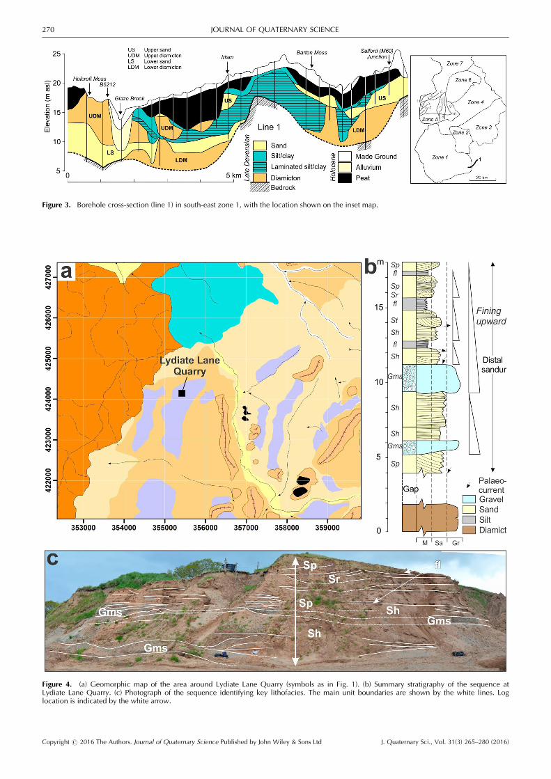
Figure 3. Borehole cross-section (line 1) in south-east zone 1, with the location shown on the inset map.
Figure 4. (a) Geomorphic map of the area around Lydiate Lane Quarry (symbols as in Fig. 1). (b) Summary stratigraphy of the sequence atLydiate Lane Quarry. (c) Photograph of the sequence identifying key lithofacies. The main unit boundaries are shown by the white lines. Loglocation is indicated by the white arrow.
Copyright # 2016 The Authors. Journal of Quaternary Science Published by John Wiley & Sons Ltd J. Quaternary Sci., Vol. 31(3) 265–280 (2016)
270 JOURNAL OF QUATERNARY SCIENCE

from the geomorphology was being funnelled along theeastern margin of LD2 limit ice (Figs 1 and 2b).
Lower Ribble Valley (Zone 4)
Exposures in the entrenched part of the lower RV are almostentirely lacking, but limited borehole coverage and records ofhistorical exposures suggest it is underlain by extensivelaminated glacilacustrine muds indicative of ice-free condi-tions and the establishment of ice-dammed lakes (Earp et al.,1961; Aitkenhead et al., 1992; Foster et al., 2009). A formerquarry at Hurst Green (NGR SD394 378) 11.5 km inside icelimit RV2 (Figs 1 and 2) revealed a six-phase stratigraphicalsequence (Fig. 5) that showed steeply dipping sand and gravel(units 2–4) foresets reflecting an ice-proximal glacilacustrinedeltaic environment. These foresets are buried by eithermassive, gravelly debris flow diamicton containing sub-rounded clasts (unit 5) or horizontally laminated sandy silty
lacustrine bottom-set muds (unit 6) with occasional drop-stones (<5 cm) (Fig. 5). These bottom-sets reflect superimposi-tion of a further lake floor sequence not fully visible inthe degraded exposures and suggest that water levels weredynamic and highly variable, a characteristic typical of ice-dammed lakes (Thomas, 1984a). The overall sequence issuggestive of an ice-contact delta or subaqueous fan, whichis morphologically supported by the flat surface that thequarry is cut into, with a westward water flow from an icemargin located to the east.
Retreat from the Kirkham moraine (zone 5)
Lithostratigraphical sections
Bradley’s Quarry (NGR SD 507 339) provides the onlysignificant exposures in the Kirkham Moraine (LD3), and iscut into a flat surface bounded by moraine ridges (limit LD3)
Figure 5. (a) Geomorphic map of the area around Hurst Green Quarry (symbols as in Fig. 1), (b) lateral stratigraphical section and (c) generalizedvertical succession of the sediment exposures. Unit numbering corresponds to those used in the log.
Copyright # 2016 The Authors. Journal of Quaternary Science Published by John Wiley & Sons Ltd J. Quaternary Sci., Vol. 31(3) 265–280 (2016)
ICE MASS INTERACTION DURING THE LAST DEGLACIATION 271

(Fig. 1). A composite succession derived from adjacentexposures (Fig. 6B) shows an upward progression through thestratigraphy (Fig. 6C � east), composed of six stacked majorsedimentary phases (Fig. 6C). Phases 1 and 2 comprise afining sequence from parallel and ripple laminated fine sandto parallel laminated silt, probably reflecting an ice-proximalto distal series of turbidites lain down across a lake bed(Thomas, 1984a; Thomas et al., 2004). These are capped by
stiff, dark brown laminated muds and massive clays thatindicate deposition within standing water from suspension rain-out onto the basin floor. Phase 3 (Fig. 6C) consists of a series ofgravels and sands occurring in discrete 0.5–1.5-m-thick,laterally overlapping packages rarely more than 5–10m incross-section. The packages (Facies A�D) display no apparentcyclical order and only limited lateral continuity (Fig. 6C, D).Facies A is dominant and consists of parallel-laminated and
Figure 6. (A) Geomorphic map of the area around Bradley’s Quarry (symbols as in Fig. 1), (B) aerial photograph image (Google Earth) of thequarry, overlain by the pits investigated in 2009 and 2013, as well as their main section faces (black lines), and (C) summary stratigraphic logs ofthe exposed sequences. Annotated photograph of the stratigraphy in (C) Pit A and (D) Pit B. The main unit boundaries are shown by the whitelines and unit numbers correspond to those used in the log.
Copyright # 2016 The Authors. Journal of Quaternary Science Published by John Wiley & Sons Ltd J. Quaternary Sci., Vol. 31(3) 265–280 (2016)
272 JOURNAL OF QUATERNARY SCIENCE

rippled sand in upward-fining sets from granule gravel throughcoarse, medium to fine sand containing isolated oversize clastsand clast clusters, and was most probably deposited as cyclicaldelta front turbidite flows (Nemec et al., 1999; Lønne andNemec, 2004). Facies B consists of large cross-cutting dune-sets that comprise planar cross-beds and small trough struc-tures, <1m in thickness and filled with small-scale (<1–2cm)graded cycles from coarse to fine sand (Fig. 6C). The dunes,typical of the upper parts of delta foresets, are formed by dunemigration down the foreset slope. Facies C consists of troughsup to 1m thick and 12m wide, either filled with multiple,trough cross-stratified sets of upward-fining cycles from granulegravel to coarse sand, or fine to medium, massive or faintlylaminated sand. These channels pass down-current into FaciesB, perhaps serving to transfer sediment over the delta break-point between topset and foreset. In more ice-proximal settings,well-sorted, clast-supported cobble to occasional bouldergravel (Facies D) formed sheets <1m thick that thin rapidlydown current and wedge out (Fig. 6C), probably representingavalanching of coarser bedload down the delta slope (Thomas,1984a; Nemec et al., 1999; Lønne and Nemec, 2004; Thomasand Chiverrell, 2006).Phase 4 (Fig. 6C) comprises a down-flow thickening wedge
of stony diamicton, lying disconformably on delta slope sandsand gravels (Phase 3). The diamicton was poorly exposed, butgiven it is partially stratified and includes thin, discontinuoussheets of interstratified sand and gravel, it is probably either aflow-till or debris flow deposit (Lønne and Nemec, 2004).Phase 5 is represented by sands and gravels that generallyfine-upwards (Fig. 6C), but differ in character to those ofPhase 3 as they display stacked and repeating fining-upcycles. These cycles vary in order from (i) planar cross-bedded sets of graded small pebble to granule gravel, passinginto planar cross-bedded coarse to medium sands, parallel-laminated medium and fine sands and rippled sands, to(ii) truncated cycles of parallel-laminated sands, giving wayto Type A and B ripples and then thin sheets of massive,laminated and draped muds. These end-member lithofaciescycles reflect either the falling flow of floods or lateral barform migration within an ice-marginal sandur (Thomas et al.,1985). Disconformably capping the entire sequence, Phase 6(Fig. 6C) comprises predominantly massive diamicton, butcontaining thin beds <0.7m thick, or lenses of stratified sandand gravel. The boundary is marked by small-scale beddisruption in the underlying sands and by diamicton-filledchannel incision at the base. The diamicton is probably aflow-till composed of supraglacial debris from an adjacentglacier margin, or a subglacial till emplaced during minorre-advance (Thomas and Chiverrell, 2006).In summary, the sections show that the moraine was
initially composed of glacilacustrine deposits that showdecreasing proximity to the ice margin. This sequence givesway to progradation of a delta front with interbedded debrisflow diamicton (Nemec et al., 1999; Lønne and Nemec,2004), before ultimate deposition of distal outwash sandur(Thomas et al., 1985; Sambrook Smith et al., 2005, 2006).However, the capping subglacial diamictons and ridge-formdominated geomorphology indicate that readvance or minorice-marginal oscillations have ridden over what is predomi-nantly a glacilacustrine and glacifluvial succession.
Borehole sections
Lithostratigraphical cross-sections (lines 2–10) have beeninterpreted from borehole records crossing the Kirkhammoraine (LD3) and more subdued moraines further north(LD4) (Fig. 7). Lines 2–5 are aligned west–east (lines 2–5)
crossing the curved axis of the moraine (LD3) in the coastalzone (Fig. 7), and further east lines 6–9 cross major ice limitsLD3 and LD4 in a south–north direction (Fig. 7). Line 10follows the axis of the LD3 moraine west–east givinginformation on the lateral variability in the stratigraphy(Fig. 7).Lines 2–5 traverse ice limits IS2 and LD3, which form a
likely suture that developed between IS and LD ice as theyunzipped during deglaciation (Figs 2b and 7). In the north(Line 2) there is a complex stratigraphy between IS2 and LD3with laminated silt–clay lake muds interbedded with diamic-ton and outwash sands (Fig. 7). As ice retreated from LD3, a<15-m-thick sandur sequence developed. Line 3 ends eastof the suture zone and records a complex of moraines thatcomprise the LD3 limit and are composed of laminated lakemuds interbedded with diamicton (Fig. 7). The succession ofmoraine ridges and the stacking of glacilacustrine andprobably subglacial diamicton reflect creation and oblitera-tion of lake and outwash sandur depocentres by repeated ice-marginal oscillation (Evans and Twigg, 2002; Thomas andChiverrell, 2007). Line 4 shows a similar sequence but withoutwash deposits accumulating inside IS2 limits (Fig. 7). Fromnorth to south (lines 2–4) kettle-holes are an increasingcomponent of the land-system and reflect the melt-out ofstagnant or dead ice buried predominantly within theoutwash sediments, producing the complicated undulating orpitted terrain (Fig. 7). Line 5 includes an extensive pittedoutwash sandur developed between the ice margin and IS2moraines, with kettle basins reflecting melt-out of burieddead ice. At depth (line 4) fronting LD3 limit there is a<30-m-thick sand and gravel outwash fan (Fan A) (Fig. 7)(Fard, 2003). This is part of a repeating pattern of ice-front fanand delta forms filling the accommodation space createdbetween IS-, LD- and RV-sourced ice (Figs.- 1 and 2b).Lines 6–9, progressing from west to east, transect the major
moraine limits LD3 and LD4 south–north (Figs 2b and 7) andhighlight the pronounced lateral and vertical variability inthe lithostratigraphy. Ice limit LD3 describes a complex ofmoraine ridges, termed the Kirkham End Moraine (Gresswell,1967). The stratigraphy varies from sediments dominantlycomposed of diamicton (line 6) to complex ice front fanscomposed of diamicton, outwash sand and gravel, andglacilacustrine muds (line 7) similar to Bradley’s Quarryexposures crossed on this transect (Fig. 7). Further eastdiamicton dominates (line 8), with another outwash fanreflected by outwash sands and lake muds (line 9: Fig. 7). Theundulating geomorphology and diamicton at the surface pointto over-ride of these glacifluvial and glacilacustrine units byice during either a readvance or minor marginal oscillation.This lateral variation in lithofacies along the LD3 limit isconfirmed by line 10, which is parallel to the moraine axis. Ithighlights zones of proglacial outwash fan and glacilacustrinesediments in the east around (i) Bradley’s Quarry, (ii) Kirkhamand (iii) in the west towards the coast (Fig. 7). Passingnorthwards between LD3 and LD4 limits there is a compli-cated stratigraphy, with ice front fans and what the morpho-stratigraphy suggests are trough sandur in the generally lower-lying terrain. There are also other smaller moraines thatdocument minor ice still-stand or marginal oscillation duringthe LD3 to LD4 retreat. LD4 shows increasing bedrockcontrol over the geomorphology and a thinning of thelithostratigraphical sequence from west to east. The generalpattern is of a series of moraines comprising the LD4 complexand dominantly composed of diamicton, but with thicksequences of outwash sand and gravels in places (e.g. line 7)and glacilacustrine sand, silt and clay (lines 6 and 8). Thisvertical and lateral variability point to the dynamic nature of
Copyright # 2016 The Authors. Journal of Quaternary Science Published by John Wiley & Sons Ltd J. Quaternary Sci., Vol. 31(3) 265–280 (2016)
ICE MASS INTERACTION DURING THE LAST DEGLACIATION 273

proglacial environments during marginal retreat, with devel-opment of sandur and ice contact lakes often in turn over-ridden during minor ice margin readvance or oscillation(Evans and Twigg, 2002; Thomas and Chiverrell, 2007).
North Lancashire drumlin field (Zones 6 and 7)
Parallel to the north coast of the Fylde, two SW–NE-orientatedparallel cross-sections (lines 11 and 12; Fig. 8) characterize thestratigraphy across the zone 5/6 boundary. The rockhead liesat �20 to �25m OD on line 11 and is overlain by a thicksequence of diamicton, sand and gravel and laminated muds,buried by >20m of estuarine sands, organic silts and claysand peats of Holocene age. The glacigenic sediments arecomplex, with stacking of diamicton units, which in the westinclude interbedded laminated glacilacustrine muds and sand,and in the east glacifluvial sands. Line 12 shows an irregularrockhead that dips steeply to the west beneath the channel ofthe River Wyre, reaching depths of �20 to �40m, and isoverlain by ca. 20m of thick diamicton that locally interdigi-tates with gravels, sands and laminated muds in the west.These interbedded sediments probably form part of a formerlake basin and sandur that filled a suture that developedbetween the retreating IS4 and LD4 margins. At Preesall(Fig. 8; line 12) the diamicton thickens and rises to the surfaceforming a series of 10–15-m high drumlins (Wilson et al.,1990; Aitkenhead et al., 1992).
Regional deglacial chronology
An outline geochronology for advance and retreat of theice in the region during the late Devensian is secured by a
combination of 14C, OSL and TCN dating at six locationsidentified on Fig. 1 (SE, Shap erratics; LWB, Low Wray Bay;FA, Four Ashes; D, Dowkabottom; NE, Norber erratics; WC,Warton Crag). Discussion of the OSL and TCN ages is ‘ka’,with uncalibrated 14C measurements quoted as ‘k 14C a BP’and calibrated ages as ‘k cal a BP’. The advance to maximumlimits in the English Midlands is secured by the dating of ice-free conditions including the organic deposits at Four Ashes(Staffordshire) 14C dated to 30.5� 0.44 and 30.7�0.77k14C a BP (Morgan, 1973) and at Dowkabottom silt-richdeposits in karstic depressions in the Carboniferous limestonehave been OSL dated to 27.8� 2.6 ka (Telfer et al., 2009)(both locations shown on Fig. 1). The retreat of ice north ofthe LD4 ice limit is constrained by OSL dating that targetedsilt-rich loessal deposits in a karstic depression at WartonCrag (103m OD) (Carboniferous limestone) (Fig. 1), denotingice-free conditions at 19.3� 2.6 ka (Telfer et al., 2009).Retreat of ice margins from the mapped region are con-strained by TCN dating erratic boulders a short distance tothe north and east, and 14C dating the transition to organicmuds in Windermere in the south Lake District. This TCNdating has targeted a suite of granite boulders extendingsouth from the Shap granite in eastern Cumbria (Fig. 1)(Wilson et al., 2013) and the Norber (Silurian greywacke)erratic boulders in the upper Ribble Valley (Fig. 1) (Vincentet al., 2010). Wilson et al. (2013) report 10Be ages for fourboulders near Shap between 16.4�0.9 and 20.9� 1.1 ka.Four samples from the Norber erratics (Vincent et al., 2010;Wilson et al., 2012) have yielded 36Cl ages of between23.2�1.7 and 17.7� 1.6 ka using the production rate ofPhillips et al. (2001) and 18.9� 1.4 and 14.3�1.3 ka using
Figure 7. Borehole cross-sections within zone 5 (lines 2–10). The line locations are shown in the inset map. The main ice margin positionslabelled IS(1–2) or LD(1–4) correspond to those in Fig. 2(b).
Copyright # 2016 The Authors. Journal of Quaternary Science Published by John Wiley & Sons Ltd J. Quaternary Sci., Vol. 31(3) 265–280 (2016)
274 JOURNAL OF QUATERNARY SCIENCE

the production rate of Stone et al. (1996). The transition fromvarved clays to organic interstadial muds in Windermere hasbeen radiocarbon dated to 14.6� 0.28 and 14.6� 0.36k14C a BP (Fig. 1) (Harkness, 1981).Bayesian modelling of this geochronology used a relative
order model from oldest to youngest (Fig. 9) (cf. Chiverrellet al., 2013), with (i) the ice advance to maximum limits (FourAshes � Dowkabottom), (ii) a phase describing the deglacia-tion of lowland Lancashire (Warton Crag), (iii) marginal retreatbeginning to vacate ice source areas in the Lake District andupper Ribble Valley (Shap and Norber) and (iv) further retreatinto the central Lake District (Windermere). The erraticboulders at Norber include three that pass a x2 test (95% level)and the probabilities combine to an age of 20–15.8 ka. TheShap erratics are more problematic with two that pass a x2
test (95% level) and produce a combined age of 19–16.5 ka,but with both younger and older outlier boulders. TheBayesian model is conformable with agreement indices >60%(A¼ 128%: Fig. 9). The modelled ages or posterior densityestimates (identified in italics) constrain the deglaciation oflowland Lancashire, including the retreats from LD2 tonorth of LD4 and RV1 to RV3, to the period 21–17.5 ka(2 sigma range). Modelled as a group with the Windermere14C measurements, the age probability distributions for WartonCrag, Shap and Norber overlap and constrain the completedeglaciation of zones 4 and 6 to after 18.6–17.3 ka.
Discussion
Rates and styles of deglaciation in Lancashire
During the advances to LGM limits the identity of thesmaller glaciers in the eastern ISB that expanded fromthe three principal source areas (i.e. southern Scotland, the
Lake District and the northern Pennines) were probably lostas these ice masses expanded into the English Midlands(Chiverrell and Thomas, 2010; Clark et al., 2012). Ice flow atthis time probably generated the subglacial bedforms thatform flow-sets FS 1–3 (Fig. 2b). Although ice streamingbehaviour has been attributed to the ISIS draining south-westinto the Celtic Sea, we find no definitive evidence (cf. Stokesand Clark, 1999) for it in the geomorphology of Lancashire(Fig. 1). Instead, the sediment and landform signature inLancashire is mostly the product of rapid, late MIS 2,deglaciation of the region. This ice-marginal retreat andthinning resulted in the collapse of a single large ice massthat was fed from multiple sources into individual, semi-independent glaciers that gradually decoupled and becameindependent in the east Irish Sea, Lake District and RibbleValley. Our Bayesian modelling has produced age rangesvery similar to those obtained in equivalent modelling of theretreat of the ISIS further west, with ice-marginal retreatfrom Anglesey to the Isle of Man dated to 21.9–20.7 and 17.8–16.9 ka (Chiverrell et al., 2013). The modelled geochronologysuggests deglaciation was accomplished over 3.7–2.1k years atmarginal retreat rates that average 25–50m a�1.Two major retreat phases are evident in the geomorphology
(Fig. 2c–e) with, during Phase 1, the initial retreat of the icemargin into south Lancashire producing lakes in the Man-chester embayment dammed by IS ice. Further marginalretreat created accommodation space across and includingthe lower Ribble valley, in which further ice-dammed lakesdeveloped. The IS2 ice limit, including the Tarleton moraine,blocked the Ribble Valley as it extended south to bedrockhighs. The Bamber Bridge fan issues from coalescing LD andRV ice masses and the stratigraphy of ice limit LD3 showsfurther lake sediments fronting the retreating margin of LDice. Extensive glacilacustrine deposits throughout the lower
Figure 8. Borehole cross-sections within the north of zone 5 and zone 6 (lines 11 and 12). The line locations are shown in the inset map.
Copyright # 2016 The Authors. Journal of Quaternary Science Published by John Wiley & Sons Ltd J. Quaternary Sci., Vol. 31(3) 265–280 (2016)
ICE MASS INTERACTION DURING THE LAST DEGLACIATION 275

Ribble, Hodder and Calder, and well represented in the LD3Moraine (Kirkham), testify to damming of meltwater by aglacier in the eastern ISB. This suggests that LD and RV icedeglaciated more rapidly than IS ice, perhaps reflecting acontinued supply of ice to that in the ISB from south-westScotland, while that sourced from Cumbria and the NorthernPennines was exhausted earlier, supporting indications else-where in the Pennine–Cumbria region (Wilson et al., 2013;Wilson and Lord, 2014; Livingstone et al., 2015). Phase 2includes the building of the Kirkham moraine complex (IS2–LD3), where the geomorphology, sediment-landform assemb-lages and stratigraphy identify a signature of ice stagnationand disintegration in the west (e.g. chaotic patterns ofmoraine ridges and kettle holes) and more active oscillatoryice-margin behaviour against the eastern rock margin. Themarked curvature of the Kirkham moraine belt, incorporatinglimits IS2 and LD3, suggests that it represents a response tothe progressive ‘unzipping’ of an inter-glacier suture openingbetween the LD and adjacent IS glaciers. Thus, the retreatfrom limit IS2–LD3 was accompanied by contradictory
evidence for ice stagnation and disintegration in the south,with the generation of flow-set Fs-11 (Fig. 2e) in the northLancashire drumlin field slightly later in the sequence ofevents. Following the ice mass realignment interpreted here,the region deglaciated completely and the lack of marginalmoraines suggests this probably occurred rapidly duringwhich some subglacial forms were partially buried byoutwash deposits fronting the retreating ice margin.
Relationships to adjacent sectors of the ice sheet
Ice-marginal retreat in the eastern ISB was accomplished over3.7–2.1 ka at rates of roughly 25–50m a�1, and wassignificantly slower than rates reconstructed for the formerISIS in the Celtic and western ISB (550–100m a�1) (Chiverrellet al., 2013). However, the western and eastern ice masses inthe wider ISB were constrained by different bedrock top-ographies and complex ice-marginal interaction with oneanother, as well as by independent changes in individualflow rates, basal temperatures, sediment load and marginal
Figure 9. Bayesian model of the dating control and showing the OxCal keywords that defines the relative order used in the model (Ramsey,2009). The Sequence model (Ramsey, 2009) has the dated events in the order defined (oldest to youngest) interpreted solely from the pattern ofice-marginal retreat (Fig. 2b). The Sequence model is divided into Phases which contain dating information grounded for specific sites or sub-regions. Phases are separated by Boundaries which generate the modelled age estimates used to constrain deglaciation of the region. Each agedistribution (light grey) represents the original relative probability age measurement and is overlain by the modelled posterior density estimate(dark grey and italicized text). Outliers to the model that have been excluded or down-weighted in the modelling are underlined.
Copyright # 2016 The Authors. Journal of Quaternary Science Published by John Wiley & Sons Ltd J. Quaternary Sci., Vol. 31(3) 265–280 (2016)
276 JOURNAL OF QUATERNARY SCIENCE

environments. In the east slower rates probably reflect thedecline of an ice mass with a largely terrestrial margin.Instability afforded by a subaqueous margin (Dove et al.,2015) is supported to a certain extent by the more rapidmargin retreat from LD1 to LD3, compared with morestable IS2 limit (Fig. 2). The presence of an ice-dammed lakehere, when coupled with an already rapidly thinningice mass probably driven by exhaustion of local ice sources,renders the ice mass much less stable. It seems more thancoincidental that we have rapid retreat of LD and Ribble ice(reflected by fewer moraines) where we also have evidencefor a lake, whereas slower marginal retreat appears tohave dominated outside of the lake footprint to the west (fromIS1 to IS2) and north (from LD3 northwards) where there isclear imprint of more frequent moraines. Potentially rapiddecline of this lacustrine sector may have included flotationand break-up of the tongue until it reached a more stableterrestrial pinning point to the north (LD3).Van Landeghem et al. (2009) presented geomorphological
data from further west in the ISB, which show that westerlyfast and streaming ice flows were generated during thedrawback of ice margins into the western ISB. Bayesianmodelling of the western ISIS indicates this probably occurredafter 22.5–21.2 ka (Chiverrell et al., 2013), pre-dating thedeglaciation of Lancashire at 18.6–17.3 ka. Glacial bedformsin the western ISB between Anglesey and the Isle of Man (e.g.elongated drumlins and flutes) provide a signature of icestreaming (Van Landeghem et al., 2009), which contrastssharply with the non-streaming behaviour to the east inLancashire. We regard these differences in ice behaviour asreflecting the influence of a glacimarine margin in thewestern ISB, in contrast to the terrestrially retreating marginin the east. As western ISIS withdrew northwards, themodelled geochronology (Fig. 9; Chiverrell et al., 2013)points towards a temporal correspondence between marginalretreat from the Kirkham Moraine and the Bride Moraineacross the north of the Isle of Man (Thomas, 1984b),suggesting the eastern and western branches of ISISwere synchronous at this time. Although the western ISIS wassignificantly larger (width and length) than that in the east,the rapid discharge of ice into the ISB in the west (evidencediceberg keel scours preserved on the sea floor reflecting acalving ice margin cf. Van Landeghem et al., 2009) meantthat the western margin caught up with the slower terrestriallyretreating margin in the east.The differences in behaviour of regional ice masses on
retreat perhaps reflect the comparative scales of the icesources and the nature of the ice margin. Ice in the westernISB terminated in marine waters, was much less confined bytopography than ice to the east, and retreated as more orless two ice margins that split around the Isle of Man.Whereas in the east the margins were mostly terrestrial, therewas greater confinement by topography and the marginalgeometry was more complicated with the ice mass fed bysmaller, more local sources in the Lake District and Pennines.Ice retreat in the ISB shows variations in the degree ofsynchronization, with at maximum the west significantlyfurther advanced extending far into the Celtic Sea (Scourseand Furze, 2001; Hiemstra et al., 2006; Scourse et al., 2006;McCarroll et al., 2010; Chiverrell et al., 2013; Furze et al.,2014; Praeg et al., 2015). The western and eastern icemargins in the ISB synchronized in retreat north of Anglesey,but there is evidence of further asynchrony developingduring latter stages. For example, the accommodation spacecreated by the evacuation of a more dominant eastern ISglacier from an LS3 limit and linking Kirkham with the BrideMoraine (Thomas, 1984b) potentially allows for more rapid
south-westerly flows of LD ice, producing the overprinting offlow-set Fs11 in the north Lancashire drumlin field.
Wider implications for ice behaviour anddynamics
The former ice dynamics in the Lancashire region and widerISB are a behavioural model for what could happen tocontemporary ice masses as they thin and draw back. Thereare clear lateral differences in ice-marginal retreat ratesbetween these adjacent marine- and terrestrially terminatingice margins. The rates of retreat in Lancashire are significantlyslower than rates reconstructed for the former ISIS in theCeltic Sea and western ISB (550–100m a�1) (Chiverrell et al.,2013), and for the McMurdo Sound (WAIS) ice stream over7.6 ka timescales (120m a�1) (Conway et al., 1999), andrates of retreat recorded for WAIS (e.g. 450m a�1 for IceStream B/Whillans Ice Stream during 1968–1998; Conwayet al., 1999; Thomas et al., 2011; Jakobsson et al., 2012). Inaddition, the reversion to more local driving of glacierbehaviour that dominates lowland Lancashire is representedelsewhere in the former BIIS (e.g. the Solway lowlands;Livingstone et al., 2012), in modelling experiments using thepalaeo-BIIS (Boulton and Hagdorn, 2006), and has parallelsin contemporary glaciers in Iceland (e.g. Breiðamerkurj€okull;Evans and Twigg, 2002) and in West Antarctica (Rignot et al.,2014). With the reversion to ice dynamics being driven bylocal sources, lateral variation from marine to terrestrialmargins and undulating sub-ice topographies may mean thatlakes are likely to become a significant component of theland-system. Clearly this was the case in Lancashire, but isalso becoming prevalent in Iceland with contemporary rapidice-marginal retreat (e.g. Bennett and Evans, 2012). This hassignificant implications for retreat dynamics and rates, withlakes and over-deepened basins in general synonymous withinstability and more rapid decline during retreat episodes(Bennett and Evans, 2012; Dove et al., 2015). There is alsoconsiderable lateral variability in the dynamics of ice at majorstill-stand or re-advance positions, with central sectors (Kirk-ham moraine) showing stagnation and collapse resulting in adead-ice topography of basins and mounds, in contrast tomore dynamic behaviour against lateral margins shownby repeated well-defined moraine ridges documenting theretreat. Furthermore, longitudinal separations of stagnantice behaviour, with dead ice topography (LD3: Fig. 2b) at thereconstructed former ice margins, contrast with more activedeforming bed conditions up-glacier that produced drumlins(FS11: Fig. 2a). Similar passive distal margins with moreactive up-ice zones has been observed at rapidly retreatingcontemporary glacier margins in south-east Iceland (e.g.Fallj€okull; Phillips et al., 2014), while in Lancashire the icemasses were larger and the evidenced stagnant and activeice behaviour need not be contemporaneous.
Conclusions
Integrating fine-resolution mapping of the glacial landformrecord with exposure and borehole data, we document thedecline of ice masses in eastern Lancashire and the adjacentISB. The ice-marginal retreat, although at present poorly con-strained chronologically, was relatively rapid (50–25m a�1), butslower than retreat rates reconstructed for the former ISIS in theCeltic Sea and western ISB (Chiverrell et al., 2013). These ratesare equivalent to those reconstructed for other parts of the icesheet (Clark et al., 2012). Our work shows a complex andvaried behaviour of glaciers and ice streams during deglaciation,including differences within the same glacier (e.g. west and east
Copyright # 2016 The Authors. Journal of Quaternary Science Published by John Wiley & Sons Ltd J. Quaternary Sci., Vol. 31(3) 265–280 (2016)
ICE MASS INTERACTION DURING THE LAST DEGLACIATION 277

ISB). Although similar differences are being captured by glaciernumerical models (e.g. fig. 5 in Hubbard et al., 2009), theirincorporation in such models requires more detailed investiga-tion of glacier geometries and bed conditions during retreatstages. This can only be achieved by detailed investigation offormer ice sheet beds because contemporary analogues provideobservations over relatively short timescales (i.e. tens of years),while ice-sheet-scale processes occur over much longer time-scales (i.e. thousands of years). Likewise, when investigatingformer ice sheets it is not sufficient to explore glacial landformpatterns alone. Instead robust analysis requires a combination oflandform pattern, sediment records and chronology to decipherretreat patterns and ice dynamics. The disparity in retreatpatterns in the eastern ISB in part reflects the lack of a calvingmargin and the terrestrial nature of the ice masses in the easternISB and lowland Lancashire. However, there are also localdifferences in the retreat patterns and rates, with ice vacatingthe lower and middle Ribble Valley creating accommodationspace for an ice-dammed lake. The more rapid retreat in the RVand LD glaciers, relative to IS ice, probably reflects the smallerice source areas feeding these glaciers and development ofcalving margins associated with ice-dammed lakes. We con-clude that the drawdown and retreat of this sector of the lastBIIS displays a switch to local conditioning and control over icedynamics (Clark et al., 2012) and this may become anincreasing component in the projected decline of contemporaryice sheets and glaciers.
Supplementary information
Figure S1. High-resolution geomorphological map of Lanca-shire overlain on a hillshaded elevation model. The mapextent is shown by the black box within the inset map (topleft). The mapped area has been divided into seven zonesthat are demarcated by the labelled black polygons. This isan expanded large-scale version of Fig. 1.
Acknowledgments. R.C.C. and G.S.P.T. thank English Heritage fortheir financial support through Aggregate Levy Sustainibility FundGrant 3928 and for academic and logistical support. In particular, wewould like to thank Dr Jennie Stopford (English Heritage), Peter Iles[Specialist Advisor (Archaeology) Lancashire County Council] and PhilCatherall (Environment Agency) for their advice and assistance.Lancashire County Council and the Environment Agency are thankedfor providing digital data, particularly the LiDAR data. This work wasin part supported by the Natural Environment Research Councilconsortium grant BRITICE-CHRONO NE/J009768/1. We also thanklandowners for allowing access to land and for their general good-will.The paper is published with the permission of English Heritage butopinions expressed are entirely those of the authors.
Abbreviations. BIIS, British–Irish Ice Sheet; ISB, Irish Sea Basin; LD,Lake District; LGM, Last Glacial Maximum; OSL, optically stimulatedluminescence; RV, Ribble Valley; TCN, terrestrial cosmogenicnuclide.
References
Aitkenhead N, Bridge D, Riley NJ et al. 1992. Geology of the Countryaround Garstang. HM Stationery Office: London.
Bennett GL, Evans DJA. 2012. Glacier retreat and landform produc-tion on an overdeepened glacier foreland: the debris-chargedglacial landsystem at Kvı́�arj€okull, Iceland. Earth Surface Processesand Landforms 37: 1584–1602.
Boulton G, Hagdorn M. 2006. Glaciology of the British Isles Ice Sheetduring the last glacial cycle: form, flow, streams and lobes.Quaternary Science Reviews 25: 3359–3390.
Bradwell T, Stoker MS, Golledge NR et al. 2008. The northern sectorof the last British Ice Sheet: maximum extent and demise. Earth-Science Reviews 88: 207–226.
Carr SJ, Hiemstra JF. 2013. Sedimentary evidence against a localice-cap on the Shetland Isles at the Last Glacial Maximum.Proceedings of the Geologists’ Association 124: 484–502.
Carr SJ, Holmes R, van der Meer JJM et al. 2006. The Last GlacialMaximum in the North Sea Basin: micromorphological evidenceof extensive glaciation. Journal of Quaternary Science 21: 131–153.
Chiverrell RC, Foster GC, Marshall P et al. 2009a. Coupling relation-ships: hillslope-fluvial linkages in the Hodder catchment, NWEngland. Geomorphology 109: 222–235.
Chiverrell RC, Foster GC, Thomas GSP et al. 2010. Sedimenttransmission and storage: the implications for reconstructinglandform development. Earth Surface Processes and Landforms35: 4–15.
Chiverrell RC, Foster GC, Thomas GSP et al. 2009b. Robustchronologies for landform development. Earth Surface Processesand Landforms 34: 319–328.
Chiverrell RC, Thomas GSP. 2010. Extent and timing of the LastGlacial Maximum (LGM) in Britain and Ireland: a review. Journalof Quaternary Science 25: 535–549.
Chiverrell RC, Thrasher IM, Thomas GSP et al. 2013. Bayesianmodelling the retreat of the Irish Sea Ice Stream. Journal ofQuaternary Science 28: 200–209.
Clark CD, Hughes ALC, Greenwood SL et al. 2012. Pattern andtiming of retreat of the last British-Irish Ice Sheet. QuaternaryScience Reviews 44: 112–146.
Conway H, Hall BL, Denton GH et al. 1999. Past and futuregrounding-line retreat of the West Antarctic Ice Sheet. Science286: 280–283.
Dove D, Arosio R, Finlayson A et al. 2015. Submarine glaciallandforms record Late Pleistocene ice-sheet dynamics, InnerHebrides, Scotland. Quaternary Science Reviews 123: 76–90.
Dunlop P, Shannon R, McCabe M et al. 2010. Marine geophysicalevidence for ice sheet extension and recession on the Malin Shelf:new evidence for the western limits of the British Irish Ice Sheet.Marine Geology 276: 86–99.
Earp JR, Poole EG, Whiteman AJ. 1961. Geology of the Countryaround Clitheroe and Nelson. HM Stationery Office: London.
Evans DJA. 2003. Glacial Landsystems. Arnold: London.Evans DJA, Cofaigh C �O. 2003. Depositional evidence for marginaloscillations of the Irish Sea ice stream in southeast Ireland duringthe last glaciation. Boreas 32: 76–101.
Evans DJA, Twigg DR. 2002. The active temperate glacial land-system: a model based on BreiÐamerkurj€okull and Fjallsj€okull,Iceland. Quaternary Science Reviews 21: 2143–2177.
Everest JD, Bradwell T, Stoker M et al. 2013. New age constraints forthe maximum extent of the last British-Irish Ice Sheet (NW sector).Journal of Quaternary Science 28: 2–7.
Eyles N, McCabe AM. 1989. The Late Devensian (<22,000 BP) IrishSea Basin: the sedimentary record of a collapsed ice sheet margin.Quaternary Science Reviews 8: 307–351.
Fard AM. 2003. Large dead-ice depressions in flat-topped eskers:evidence of a Preboreal j€okulhlaup in the Stockholm area, Sweden.Global and Planetary Change 35: 273–295.
Foster GC, Chiverrell RC, Thomas GSP et al. 2009. Fluvial develop-ment and the sediment regime of the lower Calder, Ribblecatchment, northwest England. Catena 77: 81–95.
Furze MFA, Scourse JD, Pie�nkowski AJ et al. 2014. Deglacial topostglacial palaeoenvironments of the Celtic Sea: lacustrine con-ditions versus a continuous marine sequence. Boreas 43: 149–174.
Golledge NR, Finlayson A, Bradwell T et al. 2008. The last glacia-tion of Shetland, North Atlantic. Geografiska Annaler: Series A90: 37–53.
Gresswell RK. 1967. The geomorphology of Fylde. In LiverpoolEssays in Geography: a Jubilee Collection, Stell RW, Lawton R(eds). Longmans: London; 25–42.
Harkness DD. 1981. Scottish Universities Research and ReactorCenter radiocarbon measurements-Iv. Radiocarbon 23: 252–304.
Hiemstra JF, Evans DJA, Scourse JD et al. 2006. New evidence for agrounded Irish Sea glaciation of the Isles of Scilly, UK. QuaternaryScience Reviews 25: 299–309.
Howell FT. 1973. The sub-drift surface of the Mersey and Weavercatchment and adjacent areas. Geological Journal 8: 285–296.
Copyright # 2016 The Authors. Journal of Quaternary Science Published by John Wiley & Sons Ltd J. Quaternary Sci., Vol. 31(3) 265–280 (2016)
278 JOURNAL OF QUATERNARY SCIENCE

Hubbard A, Bradwell T, Golledge N et al. 2009. Dynamic cycles, icestreams and their impact on the extent, chronology and deglacia-tion of the British-Irish ice sheet. Quaternary Science Reviews28: 758–776.
Huddart D. 1971. Textural distinction of Main Glaciation andScottish Readvance tills in the Cumberland lowland. GeologicalMagazine 108: 317–324.
Huddart D. 1991. The glacial history and glacial deposits of the northand west Cumbrian lowlands. In Glacial Deposits of Great Britainand Ireland, Ehlers J, Gibbard PL, Rose J (eds). Balkema: Rotterdam151–167.
Huddart D. 1994. The Late Quaternary glacigenic sequence: land-forms and environments in coastal Cumbria. In The Quaternary ofCumbria� Field Guide, Boardman J, Walden J (eds). QuaternaryResearch Association: London 59–77.
Hughes ALC, Clark CD, Jordan CJ. 2014. Flow-pattern evolutionof the last British Ice Sheet. Quaternary Science Reviews89: 148–168.
Jakobsson M, Anderson JB, Nitsche FO et al. 2012. Ice sheet retreatdynamics inferred from glacial morphology of the central PineIsland Bay Trough, West Antarctica. Quaternary Science Reviews38: 1–10.
Jansson KN, Glasser NF. 2005. Palaeoglaciology of the Welsh sectorof the British-Irish Ice Sheet. Journal of the Geological Society162: 25–37.
Johnson RH. 1985. The imprint of glaciation on the west PenninesUplands. In The Geomorphology of North-West England, JohnsonRH (ed.). Manchester University Press: Manchester; 237–262.
Knight J. 2004. Sedimentary evidence for the formation mechanismof the Armoy moraine and Late Devensian glacial events in thenorth of Ireland. Geological Journal 39: 403–417.
Knight J, McCabe AM. 1997. Drumlin evolution and ice sheetoscillations along the NE Atlantic margin, Donegal Bay, westernIreland. Sedimentary Geology 111: 57–72.
Livingstone SJ, Evans DJA, �O Cofaigh C. 2010a. Re-advance ofScottish ice into the Solway Lowlands (Cumbria, UK) during theMain Late Devensian deglaciation. Quaternary Science Reviews29: 2544–2570.
Livingstone SJ, Evans DJA, �O Cofaigh C et al. 2012. Glaciodynamicsof the central sector of the last British–Irish Ice Sheet in NorthernEngland. Earth-Science Reviews 111: 25–55.
Livingstone SJ, �O Cofaigh C, Evans DJA et al. 2010b. Sedimentaryevidence for a major glacial oscillation and proglacial lakeformation in the Solway Lowlands (Cumbria, UK) during LateDevensian deglaciation. Boreas 39: 505–527.
Livingstone SJ, Roberts DH, Davies BJ et al. 2015. Late Devensiandeglaciation of the Tyne Gap Palaeo-Ice Stream, northern England.Journal of Quaternary Science 30: 790–804.
Longworth D. 1985. The Quaternary history of the Lancashire Plain.In The Geomorphology of Northwest England, Johnson RH (ed,).Manchester University Press: Manchester 178–200.
Lønne I, Nemec W. 2004. High-arctic fan delta recording deglacia-tion and environment disequilibrium. Sedimentology 51: 553–589.
McCabe AM, Clark PU, Clark J. 2005. AMS 14C dating of deglacialevents in the Irish Sea Basin and other sectors of the British-Irishice sheet. Quaternary Science Reviews 24: 1673–1690.
McCabe AM, Dardis GF, Hanvey PM. 1984. Sedimentology of a LatePleistocene submarine-moraine complex, County Down, NorthernIreland. Journal of Sedimentary Research 54: 716–730.
McCabe AM, Dardis GF, Hanvey PM. 1987. Sedimentation at themargins of a Late Pleistocene ice-lobe terminating in shallowmarine environments, Dundalk Bay, eastern Ireland. Sedimentol-ogy 34: 473–493.
McCabe AM, Dunlop P. 2006. The Last Glacial Termination inNorthern Ireland. Geological Survey of Northern Ireland: Belfast.
McCarroll D, Stone JO, Ballantyne CK et al. 2010. Exposure-ageconstraints on the extent, timing and rate of retreat of the last IrishSea ice stream. Quaternary Science Reviews 29: 1844–1852.
Merritt JW, Auton CA. 2000. An Outline of the Lithostratigraphy andDepositional History of Quaternary Deposits in the SellafieldDistrict, West Cumbria, Proceedings of the Yorkshire Geologicaland Polytechnic Society. Geological Society of London; 129–154.
Miall AD. 1977. A review of the braided-river depositional environ-ment. Earth Science Reviews 13: 1–62.
Mitchell WA. 1991. Western Pennines: a Field Guide. QuaternaryResearch Association: London.
Mitchell WA, Hughes ALC. 2012. The Late Devensian glaciation inthe Yorkshire Dales. In Cave Archaeology and Karst Geomorphol-ogy of North West England, O’Regan HJ, Faulkner T, Smith IR(eds). Quaternary Research Association: London 34–45.
Morgan AV. 1973. The Pleistocene geology of the area north andwest of Wolverhampton, Staffordshire, England. PhilosophicalTransactions of the Royal Society of London 265: 233–297.
Nemec W, Lønne I, Blikra LH. 1999. The Kregnes moraine inGauldalen, west-central Norway: anatomy of a Younger Dryasproglacial delta in a palaeofjord basin. Boreas 28: 454–476.
�O Cofaigh C, Evans DJA. 2007. Radiocarbon constraints on the ageof the maximum advance of the British–Irish Ice Sheet in the CelticSea. Quaternary Science Reviews 26: 1197–1203.
Parkes AA, Waller RI, Knight PG et al. 2009. A morphological,sedimentological and geophysical investigation of the WooreMoraine, Shropshire, England. Proceedings of the Geologists’Association 120: 233–244.
Phillips E, Finlayson A, Bradwell T et al. 2014. Structural evolutiontriggers a dynamic reduction in active glacier length duringrapid retreat: evidence from Falljokull, SE Iceland. Journal ofGeophysical Research-Earth 119: 2194–2208.
Phillips FM, Stone WD, Fabryka-Martin JT. 2001. An improvedapproach to calculating low-energy cosmic-ray neutron fluxesnear the land/atmosphere interface. Chemical Geology 175: 689–701.
Praeg D, McCarron S, Dove D et al. 2015. Ice sheet extension to theCeltic Sea shelf edge at the Last Glacial Maximum. QuaternaryScience Reviews 111: 107–112.
Price D, Wright WB, Jones RCB. 1963. Geology of the CountryAround Preston. HMSO: London.
Ramsey CB. 2009. Dealing with outliers and offsets in radiocarbondating. Radiocarbon 51: 1023–1045.
Rignot E, Mouginot J, Morlighem M et al. 2014. Widespread, rapidgrounding line retreat of Pine Island, Thwaites, Smith, and Kohlerglaciers, West Antarctica, from 1992 to 2011. GeophysicalResearch Letters 41: 3502–3509.
Sambrook Smith GH, Ashworth PJ, Best JL et al. 2005. Themorphology and facies of sandy braided rivers: some consider-ations of scale invariance. Special Publications of the InternationalAssociation of Sedimentologists 35: 145–158.
Sambrook Smith GH, Ashworth PJ, Best JL et al. 2006. Thesedimentology and alluvial architecture of the sandy braided SouthSaskatchewan River, Canada. Sedimentology 53: 413–434.
Scourse JD, Evans DJA, Hiemstra JF et al. 2006. Pleistocenestratigraphy, geomorphology and geochronology In The Isles ofScilly: Field Guide, Scourse JD (ed.). Quaternary Research Associa-tion: London; 13–22.
Scourse JD, Furze MFA. 2001. A critical review of the glaciomarinemodel for Irish sea deglaciation: evidence from southern Britain,the Celtic Shelf and adjacent continental slope. Journal ofQuaternary Science 16: 419–434.
Stokes CR, Clark CD. 1999. Geomorphological criteria for identifyingPleistocene ice streams. Annals of Glaciology 28: 67–74.
Stokes C, Clark CD. 2001. Palaeo-ice streams. Quaternary ScienceReviews 20: 1437–1457.
Stone JO, Allan GL, Fifield LK et al. 1996. Cosmogenic chlorine-36from calcium spallation. Geochimica et Cosmochimica Acta60: 679–692.
Telfer MW, Wilson P, Lord TC et al. 2009. New constraints on theage of the last ice sheet glaciation in NW England using opticallystimulated luminescence dating. Journal of Quaternary Science24: 906–915.
Thomas GSP. 1984a. A Late Devensian glaciolacustrine Fan-Delta atRhosesmor, Clwyd, North Wales. Geological Journal 19: 125–141.
Thomas GSP. 1984b. The origin of the glacio-dynamic structure ofthe Bride Moraine, Isle of Man. Boreas 13: 355–364.
Thomas GSP. 1989. The Late Devensian glaciation along the westernmargin of the Cheshire-Shropshire lowland. Journal of QuaternaryScience 4: 167–181.
Copyright # 2016 The Authors. Journal of Quaternary Science Published by John Wiley & Sons Ltd J. Quaternary Sci., Vol. 31(3) 265–280 (2016)
ICE MASS INTERACTION DURING THE LAST DEGLACIATION 279

Thomas G, Chiverrell R, Huddart D. 2004. Ice-marginal deposi-tional responses to readvance episodes in the Late Devensiandeglaciation of the Isle of Man. Quaternary Science Reviews23: 85–106.
Thomas GSP, Chiverrell RC. 2006. A model of subaqueoussedimentation at the margin of the late Midlandian Irish IceSheet, Connemara, Ireland, and its implications for regionallyhigh isostatic sea-levels. Quaternary Science Reviews 25: 2868–2893.
Thomas GSP, Chiverrell RC. 2007. Structural and depositionalevidence for repeated ice-marginal oscillation along the easternmargin of the Late Devensian Irish Sea Ice Stream. QuaternaryScience Reviews 26: 2375–2405.
Thomas GSP, Connaughton M, Dackombe RV. 1985. Facies variationin a Late Pleistocene supraglacial outwash sandur from the Isle ofMan. Geological Journal 20: 193–213.
Thomas R, Frederick E, Li J et al. 2011. Accelerating ice loss from thefastest Greenland and Antarctic glaciers. Geophysical ResearchLetters 38.
Van Landeghem KJJ, Wheeler AJ, Mitchell NC. 2009. Seafloorevidence for palaeo-ice streaming and calving of the grounded Irish
Sea Ice Stream: implications for the interpretation of its finaldeglaciation phase. Boreas 38: 119–131.
Vincent PJ, Wilson P, Lord TC et al. 2010. Cosmogenic isotope (36Cl)surface exposure dating of the Norber erratics, Yorkshire Dales:further constraints on the timing of the LGM deglaciation in Britain.Proceedings of the Geologists’ Association 121: 24–31.
Wilson AA, Evans WB, Warrington G. 1990. Geology of the CountryAround Blackpool. HM Stationery Office: London.
Wilson P, Barrows TT, Lord TC et al. 2012. Cosmogenic isotopeanalysis and surface exposure dating in the Yorkshire Dales InCave Archaeology and Karst Geomorphology of North WestEngland, O’Regan HJ, Faulkner T, Smith IR (eds). QuaternaryResearch Association: London 117–135.
Wilson P, Lord T. 2014. Towards a robust deglacial chronology forthe northwest England sector of the last British-Irish Ice Sheet.North West Geography 14: 1–11.
Wilson P, Lord T, Rod�es �A. 2013. Deglaciation of the easternCumbria glaciokarst, northwest England, as determined by cosmo-genic nuclide (10Be) surface exposure dating, and the pattern andsignificance of subsequent environmental changes. Cave and KarstScience 40: 22–27.
Copyright # 2016 The Authors. Journal of Quaternary Science Published by John Wiley & Sons Ltd J. Quaternary Sci., Vol. 31(3) 265–280 (2016)
280 JOURNAL OF QUATERNARY SCIENCE