mount dutton bay jetty site report - flinders...
TRANSCRIPT
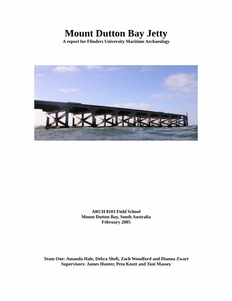
Mount Dutton Bay Jetty A report for Flinders University Maritime Archaeology
ARCH 8103 Field School Mount Dutton Bay, South Australia
February 2005
Team One: Amanda Hale, Debra Shefi, Zach Woodford and Dianna Zwart Supervisors: James Hunter, Peta Knott and Toni Massey

Table of Contents: 1. Introduction 2. History 3. Site Locations 4. Environmental Survey 4.1 Tidal information 4.2 Water condition 4.3 Seabed composition and seafloor condition 4.4 Environmental processes effecting the area 4.5 Flora 4.6 Fauna 4.7 Weather Conditions 5. Equipment 6. Methodology 6.1 Preliminary Survey 6.2 Survey Method 6.2a Trilateration 6.2b Baseline Offset 6.2c Compass Bearing 6.3 Underwater Photography 6.4 Procedure 7. Constraints 7.1 Tide 7.2 Visibility 7.3 Flora and Fauna 7.4 Temperature 7.5 Underwater Movement 8. Site Description 9. Results 9.1 Site Plan 9.2 Artefact Location 9.3 Total Station 9.4 Artefacts 10. Conclusion 11. Reference 12. Appendix A
3 3 4 5 5 5 6 7 7 7 8 8 9 9 9 9 9
10 10 10 11 11 11 11 11 11 12 12 13 13 13 16 17 17 17
1. Introduction
In February 2006 students from Flinders University conducted a survey of the Mount Dutton Bay Jetty, located on the Eyre Peninsula, as part of the Maritime Archaeology Field School. The field school was designed to give students an opportunity to gain practical experience in addition to the theoretical coursework. The project requires students to use contemporary, non-destructive field methods as a means of practicing proper research methods in the field of maritime archaeology. This report was produced by one of three dive teams in charge of surveying the Mount Dutton Bay Jetty, Team One, comprising of Amanda Hale, Debra Shefi, Zach Woodford and Dianna Zwart. The site was broken into three sections and each team, along with three supervisors, was responsible for surveying the underwater components of the assigned Jetty section; Team One was responsible for the last 25 m of the jetty, this included pylon forty-eight southward towards the end of the current jetty. The aim was to map the underwater components of the section, including the pylons and the artefacts in the surrounding within 10 m of the western and eastern side of the jetty.
2. History Mount Dutton Bay, located in the south-western part of the Eyre Peninsula and part of the Great Australian Bight, is approximately an eight and a half hour drive, 750 km, from the city of Adelaide. Coffin Bay and Horse Peninsula shelter Mount Dutton Bay from open water, therefore making the area a good place to moor lighters and ketches in the area. Mount Dutton remains a remote town; the closest city, Port Lincoln, is approximately 50 km away. The Bay is named after Charles Christian Dutton who explored the area around 1839; from the 1840’s until the 1930’s, guano, mined from Brothers Island and Rabbit Island, was unloaded in Mount Dutton Bay. Guano was not the only cargo loaded in the area. Mount Dutton is the home of the historic woolshed, which used to sheer thousands of sheep and prepare wool bales for transport to Adelaide. The Woolshed’s history began on August 9 1840, when Price Maurice from England arrived in South Australia at the age of 22. Across the Eyre Peninsula, Maurice was known as one of the most prominent pastoralists, as he gradually bought sheep at a minimal cost from other local small farmers due to a disease that devastated the sheep’s wool. Thus, over time Maurice gained control over a large percentage of the local wool production. By 1875 Maurice owned over 100 miles of coastline and over 20,000 sheep were sheared in the Woolshed; the bales were then transported onto ketches. The shed was only used for sheering 6 months out of the year, and for the remainder of the year the Shed was used as a local function hall. In 1880, in order to make it easier for the transportation of goods onto the cutters and ketches, the engineer in the chief department of the company created plans to erect the
4
Mount Dutton Bay Jetty; train tracks were laid from the Woolshed doors down to the end of the jetty.
The horse-drawn rail assisted the loading and offloading of goods; once loaded, the vessels would continue on to Port Adelaide and then be transferred to vessels bound for England. The structure was completed in 1881. Since the erection of the Jetty in 1881 modifications have been made on the original 18 bay jetty. The structure was extended by 23 bays in 1911, giving the jetty a total length of 680 feet (Lothar. ‘Mount
Dutton Bay Woolshed and Jetty’ Register of state heritage item South Australian Heritage Act 1978-82) In the 1970s the Woolshed ceased its annual sheering and was then used to store fishing nets and broom grass. During this time the building was not maintained and was listed as a building to be demolished. However, due to the importance of its local history, in 1984, the Mount Dutton Bay Woolshed was added to the State Heritage List. Following its historic title, the jetty underwent repairs commissioned by the Marine and Harbor’s department under the Community Employment Program scheme (Letter from Manager heritage conserve branch to South Australian heritage committee 14, sep. 1984). In 1990 the property was bought by Craig Brown and converted into a museum and tourist accommodation; the Brown family currently lives close to the Woolshed and maintains it.
3. Site Location The site is located south of the Woolshed. A Garmin Extrex GPS WGS84 was used, and was set on UTM and the accuracy was 5 m. The following contains the GPS information for the jetty, including the Team’s section from pylons 48, 49 and 50 to the southern most end of the jetty.
EASTINGS NORTHINGS DESCRIPTION D1 539684 6178806 Datum marker with yellow tape in car park D2 539730 6178790 Datum/survey marker on west side EA 539708 6178781 First pylon on east side
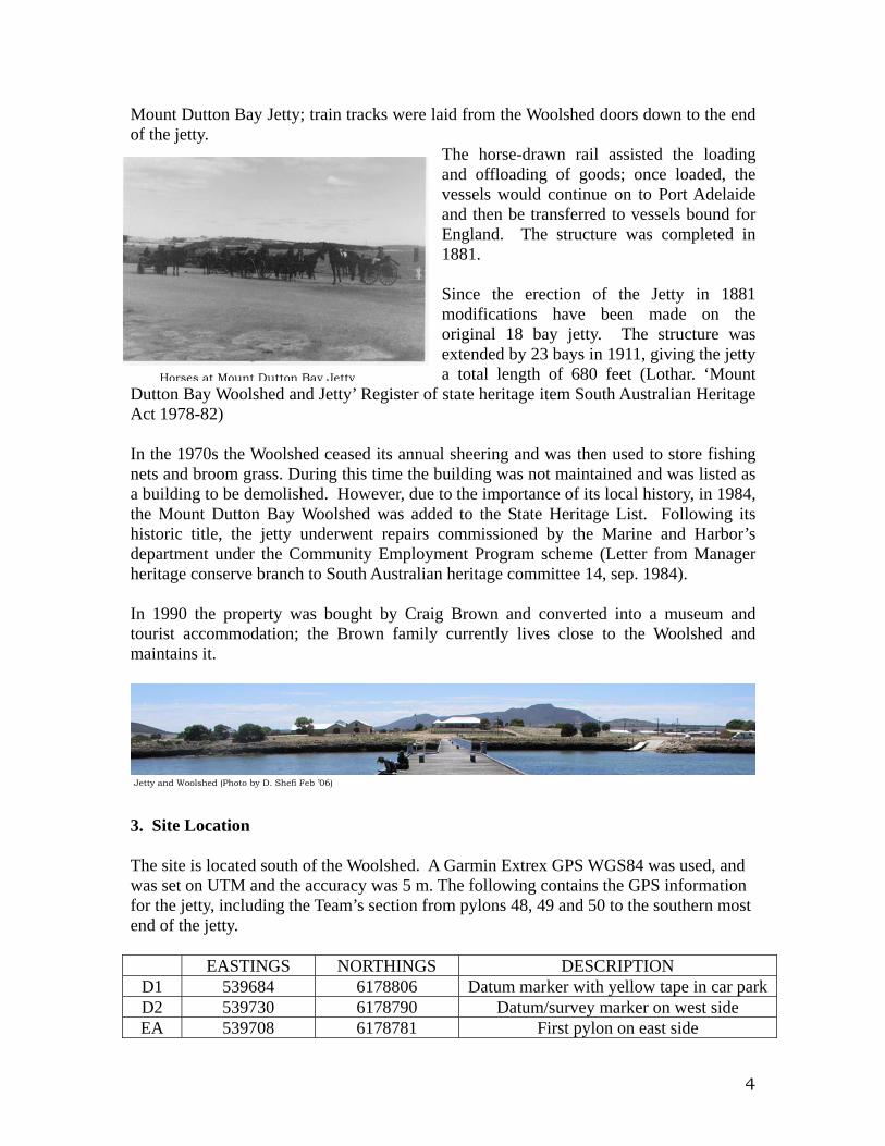
Jetty and Woolshed (Photo by D. Shefi Feb ’06)
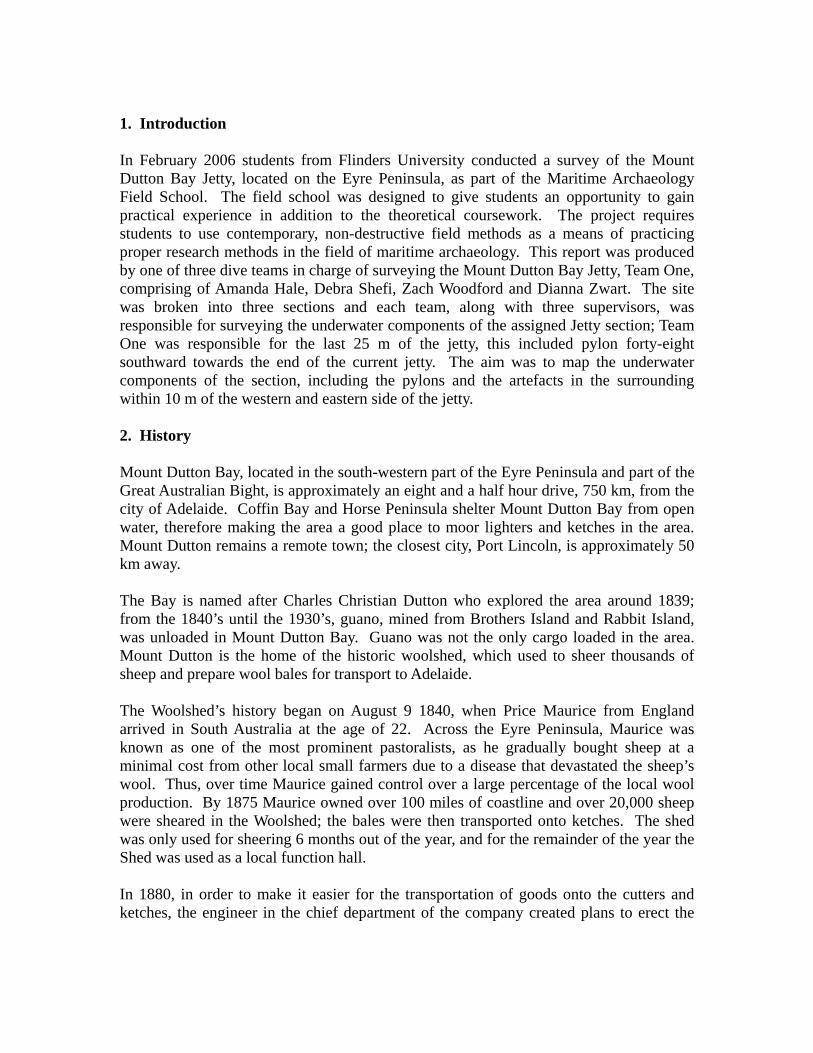
Horses at Mount Dutton Bay Jetty
5
WA 539704 6178784 First pylon on west side W1 539617 6178620 Pylon 50 W2 539607 6178599 Last pylon on west side E1 539622 6178618 Pylon 48
E2 539610 6178598 Last pylon on east side 4. Environmental Survey 4.1 Tidal information Thursday 2 Feb. Saturday 4 Feb. Sunday 5 Feb. Monday 6 Feb.High Tide 6:08 am 7:15 pm 7:44 pm 8:42 pm Low Tide 12:42 pm 12:43 pm 12:44 pm 12:45 pm
4.2 Water conditions: Thursday 2 Feb. Saturday 4 Feb. Friday 5 Feb. Saturday 6 Feb. Temperature 18ºC. and
warmed up till 20ºC
19ºC 19ºC 19ºC
Horizontal visibility
2-4m. Morning dive 5m. and decreasing to 2m. at the afternoon dive.
5m. Poor visibility towards end of the first dive. Afternoon 4-5m.
5-6m. 3m.
Vertical visibility 2-4m. 1.5m. 2m. 2m. Depth 1.5-2m. 1-1.2m 2m. 1.8m.
End of the jetty E2 W2 E1 W1 Ea Wa
Beginning of Jetty
D2 D1

6
Current - Slight westward Very slight westward
Slight westward
4.3 Seabed composition and seafloor condition Seabed composition under and around the jetty consists of a combination of silt, sand and seashells. The sediment, after consulting with the field school geologist, Ian Moffatt, is predominately silt with patches of sand and shell composites. Additionally, various sea grasses and sponges cover a vast percentage of the seabed. Zach Woodford and Debbie Shefi conducted a diving survey of the Jetty on February 5th 2006 where samples were collected from the East and West side and beneath the Jetty along the baseline. The samples were recorded using baseline offsets as shown in Table A below.
Eastside Under the Jetty Westside nr Baseline offset nr Baseline offset nr Baseline offset 1 30.10 3.50 4 9.32 0.85 7 5.00 0.00 2 22.59 1.90 5 19.34 1.84 8 16.33 3.74 3 12.74 3.80 6 28.35 2.22 9 26.88 2.18
Table Table A depicts the percentages of silt sorting, sand texture, roundness/sphericity,
and Munsell colour found in each area. All visual interpretations are based on a Log Sheet made by Mr. Mark Reilly of the Australian School of Petroleum from the University of Adelaide and used by Mr. Ian Moffat to record core samples.
Percentages were taken for the organics and percent of sand based on a 0-30%, 30-60%, and 60-100% visual range. The organic content ranged from low to high, low being little to no organic materials such as shell or sea grass, medium ranging from small shells and sea grass ranging from five to eight cm in length and a high organic content encompassing whole shells and sea grass ranging from thirteen plus cm in length.
Sample Silt
Sorting % of Sand Sand Texture Roundness/Sphericity Munsell
Organic Content
1 poorly 20% medium to coarse angular sand 10YR 4/2 Medium 2 poorly 15% medium to coarse angular sand 2.5YR 4/1 Medium 3 moderately 10% medium very angular sand 10YR 4/1 High 4 well 30% coarse to very coarse angular sand Gley 1 3/ 10Y Medium 5 poorly 30% medium to coarse semi angular sand Gley 1 3/N Low 6 well 10% medium rounded sand Gley 1 3/ 10Y High 7 moderately 30% coarse rounded sand Gley 1 4/ 10Y Medium 8 well 15% fine to medium rounded sand 2.5Y 4/1 Low 9 well 20% fine to medium rounded sand 2.5Y 4/2 Low
Table B
7
It is apparent there are various environmental factors such as tidal changes, flora and fauna, which affect the jetty and its surroundings. There are varying degrees of energy movement across the site, shown by the analysis of the sediment samples indicating tidal and wave trends on the Eastern side and only tidal trends on the Western side of the Jetty. A higher intensity of action is occurring on the Eastern side of the Jetty while the Western side appears more sheltered due to the pylons. Beneath the Jetty there are several factors affecting the area causing a numerical difference in the data. The sampling size is small but does indicate a clear trend in scatter patterns across the site area. Thus, more data is needed for a more accurate survey. 4.4 Environmental processes effecting the area During the field school the tidal level did not change drastically however, the shallow depths of the site greatly effects visibility and seabed contours. The underwater features can change drastically overnight depending on weather and tidal conditions. During winter there is a greater change in the tides, therefore effecting the movement of the water and thus the seabed. 4.5 Flora
Marine Species Brown Algae
Red Algae Green Algae
Seagrass (various types including Posidonia)
4.6 Fauna Marine Species
Chit Minnow Barn Molasc Crab Solasc
Urchin Barnacles Colasc Biv Sponge Snail Cowfish Hermit crab Jellyfish Museles
Brit Colasc (Encrusted) Crab Colasc (Attached)
Moonlighter Lace Bluering octopus Sponge (Encrusted)
Tube worm Sponge (Attached) Pipefish
8
4.7 Weather Conditions Thursday 2 Feb. Saturday 4 Feb. Friday 5 Feb. Saturday 6 Feb. Wind Windy, Southern
breeze Slight breeze Slight breeze Fairly Strong
Sky Partly clouded Cloudy Sunny Overcast
5. Equipment (Diving, Surveying and Other) The following equipment was used during on site: Diving Equipment: Mask Buoyancy Control Device Snorkel Regulator Fins Aluminum tanks 5 – 6.5 mm wetsuit Steel tanks Gloves Dive knife Hood Compass Survey Equipment: Underwater A4 Slate Hand Sledge Hammer Mylar Star-pickets
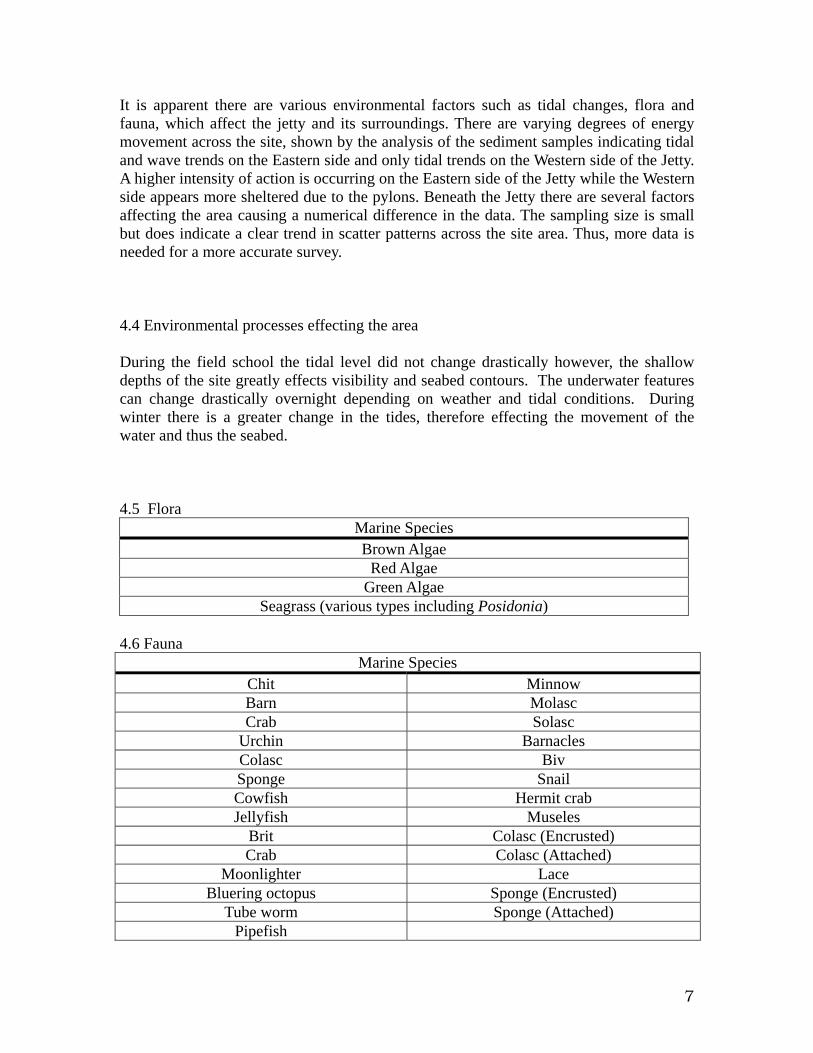
Example of jellyfish from underneath the jetty (Photo by D. Shefi Feb. 06)

9
Lead lines Tent pegs 50 m fiberglass composite measuring tape Dive Flag 30 m fiberglass composite measuring tape Olympus C – 5050 Camera and underwater
housing 10 m fiberglass composite measuring tape 25 cm scale bar 1 m range pole Compass Total Station and prism Blue and Red Pin Flags Green and Pink Flagging Tape GPS Garmin E-trex
6. Methodology 6.1 Preliminary Survey An initial dive check was conducted by Team One, under the supervision of Peta Knott and James Hunter, and followed by a dive around the site for orientation. The team swam to the end of the jetty and once the site was reached, the group broke off into two buddy team. Each team swam in a box pattern away from the jetty on the eastern and western side about 10 fin kick cycles for each side of the box. Both teams noted various brown glass bottles, tins, clear glass jars and bottles, flora and fauna. Following the initial square survey, one buddy team remained on the jetty site in order to draw a preliminary mud map for clarity, while the other buddy team swam to the Caprice along the western side of the jetty for orientation. The initial dive was necessary to provide the team with a basic perception of the site, key features and provide information for the aim of the survey. 6.2 Survey Method 6.2a Trilateration In order to collect as accurate data as possible, trilateration was used to lay the datum points for the baselines on either side of the jetty as well as the perimeter points. Trilateration was conducted using three fiberglass tape measurers; it uses two offset measurements that run from two points on a pre-laid baseline to the measured point. In terms of laying the perimeter points and additional datum points, predetermined distances were calculated prior to the dive and tent pegs were used to mark the location where the two offset tape measurers met. 6.2b Baseline and Offsets On this site, baseline and offsets was used to collect data from the trilaterated datum points; pylons and artefacts around the site were measured using this technique. The initial baseline was laid under the jetty, using arbitrary datum points. A lead-line baseline
Z. Woodford laying western perimeter (Photo by D. Shefi Feb ’06)
10
was laid in between the datum points followed by a 50 m fiberglass tape measure. Once the tape was in place offset measurements were taken on the major underwater structural components of the jetty. Following the measurements of the pylons, the measurements of the artefacts locations were taken using the same technique. In order to properly conduct a baseline – offset survey, the two intersecting tapes must remain perpendicular. The dive teams conducted this survey by having one diver swim out with the dummy-end of the tape to the desired object of measurement and the second diver swinging the offset tape until it reads the smallest reading, which is at a 90 degree angle with the baseline tape. 6.2c Compass Bearing Compass bearings were used to set the initial baseline; the diver swam out 5 m from the end of the jetty maintaining a compass bearing of 20º, parallel to the jetty. Compass bearings were also taken to check that our baselines and perimeter lines were still running straight. 6.3 Underwater Photography The Olympus C-5050 digital camera and underwater housing were used to photograph flora and fauna, underwater and above the waterline structural components, underwater archaeology and artefacts located under and around the jetty. The photographs were recorded on a Flinders University proforma, including a short description of the photograph taken, the date and the person who took the picture. Specific elements of the site were photographed, such as the flora and fauna, without scales to provide a representation of the surrounding conditions; structural elements and artefacts were photographed with either a 25 cm or 1m scale bar in order to provide a visual reference. 6.4 Procedure The following briefly describes Team One’s two and half day survey on the Mount Dutton Bay Jetty. The team initially entered the water after the preliminary survey with a survey plan in place: to produce a plan of the underwater material associated with the jetty, including the artifacts in the surrounding area. The process began by laying the first baseline under the eastern and central pylons; the purpose of this was to first map out the structure of the jetty before including the scattered cultural material. The baseline could not be put in the middle of the Jetty, because in this part the Jetty has middle pylons. It is important to note that every dive on the jetty consisted of two buddy teams, two divers in each team, and a supervisor snorkeling on the surface for safety. Due to the layout of the jetty, one side of the baseline had approximately three times the amount of points to take. Consequently, on the second dive, two tasks were completed: taking baseline-offset measurements of the pylons and laying the eastern baseline and the 10 m x 32.2 m perimeter using trilateration. The following dive consisted of one team laying the western baseline and perimeter and the other team laying pin-flags marking atefacts within the perimeter on either side of the jetty. The remainder of the survey

11
included mapping the artefacts using baseline-offset and photographing the artefacts along with the flora and fauna. The final dive was used to clear the site of any remaining archaeological surveying material. 7. Constraints 7.1 Tide The maximum depth of the southern end of the Jetty is approximately 2 m, and therefore as the tide changes, the visibility becomes poor and makes it difficult to accurately survey the site. Also it is harder to stay down during diving in shallower water.
7.2 Visibility Visibility affected the diver’s accuracy in taking measurements and communication. Poor visibility also prohibited underwater photography and therefore, set the dive schedule back until photographable visibility was present. The site structure and divers in action were not properly photographed due to the poor visibility. 7.3 Flora and Fauna
The time in which field school was run coincides with jellyfish season in the bay and therefore divers were constantly exposed to various species and sizes of jellyfish. This caused some stress during parts of the dive. The site also contains a large blue ringed octopus population, and due to the nature of the survey, placed the divers at great risk of accidentally touching one while measuring material remains within the set parameters. Furthermore, the sea grass was constantly moving throughout the water column, stirring up bottom sediment and further adding to the poor visibility in the water.
7.4 Temperature Inconsistencies in both air and water temperature made it difficult for divers to be comfortable; without a warm core body divers grow more fatigued therefore limiting the dive time and work conducted underwater. 7.5 Underwater Movement
Glass Jar with Octopus inside. Eastside of Jetty .(Photo by D. Shefi Feb. 06)
12
Movement of the water, due to winds, the current and/or tides makes it difficult to obtain accurate measurement; the lead lines move along the seabed, the tape measures bow and it is difficult to accurately measure long distances. 8. Site Description
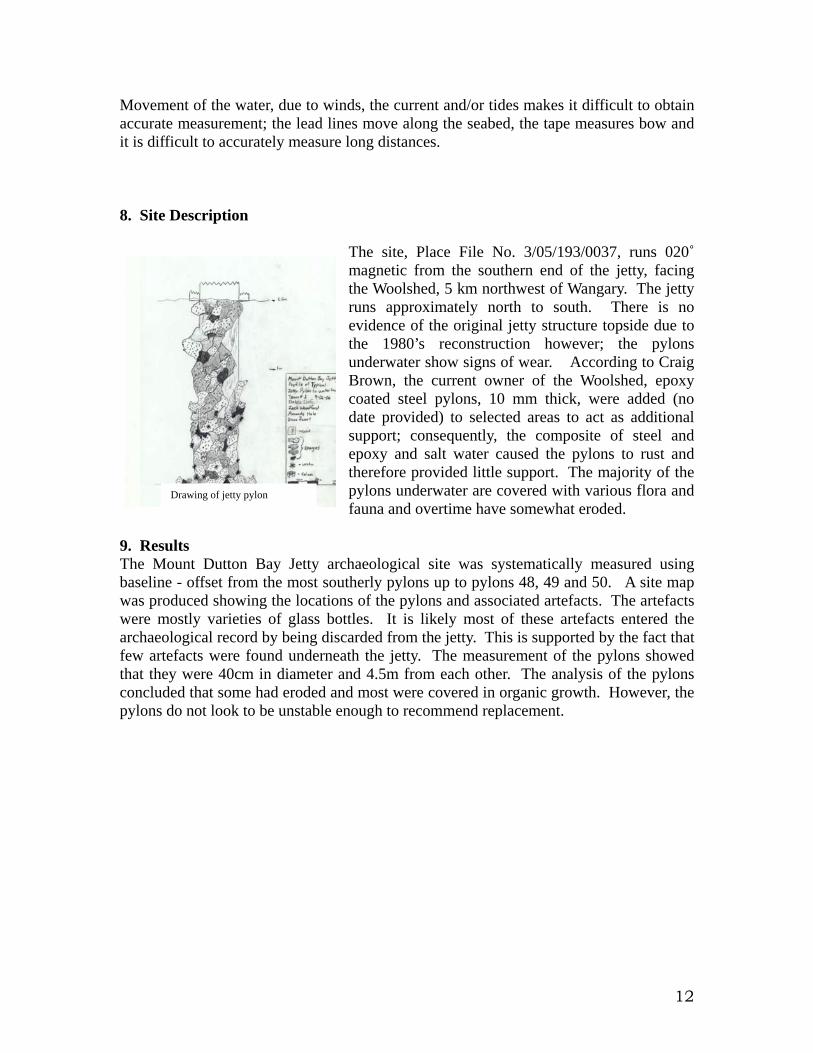
The site, Place File No. 3/05/193/0037, runs 020˚ magnetic from the southern end of the jetty, facing the Woolshed, 5 km northwest of Wangary. The jetty runs approximately north to south. There is no evidence of the original jetty structure topside due to the 1980’s reconstruction however; the pylons underwater show signs of wear. According to Craig Brown, the current owner of the Woolshed, epoxy coated steel pylons, 10 mm thick, were added (no date provided) to selected areas to act as additional support; consequently, the composite of steel and epoxy and salt water caused the pylons to rust and therefore provided little support. The majority of the pylons underwater are covered with various flora and fauna and overtime have somewhat eroded.
9. Results The Mount Dutton Bay Jetty archaeological site was systematically measured using baseline - offset from the most southerly pylons up to pylons 48, 49 and 50. A site map was produced showing the locations of the pylons and associated artefacts. The artefacts were mostly varieties of glass bottles. It is likely most of these artefacts entered the archaeological record by being discarded from the jetty. This is supported by the fact that few artefacts were found underneath the jetty. The measurement of the pylons showed that they were 40cm in diameter and 4.5m from each other. The analysis of the pylons concluded that some had eroded and most were covered in organic growth. However, the pylons do not look to be unstable enough to recommend replacement.
Drawing of jetty pylon
13
9.1 Site Plan
9.2 Artefact locations: See appendix A for artifact locations 9.3 Total Station Survey
Site Plan of the Dutton Bay Jetty

14
A. Hale looking south to the theodolite in the water. (Photo by D. Shefi Feb. 2006)
The following provides the total station data for future reference. The total station accurately measures the slope distance (Distance) from the total station to the theodolite, as well as providing the vertical and horizontal angles to accurately plot the site. Nr Prism Height Vertical Horizontal Distance Description 1a 2m. 358º22’23” 83º30’57” 199.827 Pylon 50 NW jetty (1st take) 2 2m. 358º17’11” 84º43’27” 197.529 NW Baseline 3 2m. 358º17’22” 86º14’03” 197.397 NW Perimeter 4 2m. 358º30’33” 87º01’01” 197.397 SW Perimeter 5 2m. 358º32’04” 85º32’38” 229.971 SW Baseline 6 2m. 358º32’37” 84º23’31” 223.783 Farthest SW jetty pylon 8 2m. 358º35’40” 276º11’17” 199.401 NE Pylon nr.48 9 2m. 358º28’51” 274º16’03” 197.950 NE Baseline 10 2m. 358º31’35” 273º34’54” 199.202 NE Perimeter 11 2m. 358º40’43” 273º09’07” 225.077 SE Perimeter 12 2m. 358º40’43” 274º20’35” 228.949 SE Baseline 13 2m. 358º42’57” 282º47’43” 223.301 Farthest SE jetty pylon 14 1.73m 359º55’04” 275º51’12” 222.823 SW corner on jetty 15 1.73m 359º54’03” 277º00’50” 224.252 Most SW pylon 16 1.73m 359º55’04” 275º51’12” 222.823 SE corner on jetty
15
17 1.73m 359º84’35” 275º46’35” 223.498 Most SE pylon 18 1.73m 359º42’52” 276º19’16” 199.408 Pylon 48 on jetty 19 1.73m 359º42’42” 277º49’41” 200.283 Pylon 50 on jetty 1b 2m. 358º22’44” 83º30’32” 199.846 Pylon 50 NW jetty(2nd take)
11 12 5 4 13 17 15 6 16 14 Jetty 10 9 8 18 19 1 2 3
X Datum 0 point
X Survey Marker

16
9.4 Artefacts The following is a representation of the artefacts located within the teams section of the Jetty:
Artefact Measurements Description
Brown glass bottle L=30cm and D=9cm A lot of these are found around the jetty. They are probably beer bottles.
Brown glass bottle L=36cm and D=9cm Only found one of those. Bottle is more square at the top.
Spoon L=20cm and D=5cm Normal kitchen spoon with decoration on the handle.
Clear glass jar L=10cm and D=13cm Jar used for jam, etc. Sign L=48cm and W=30cm "No camping sign" Pole of the sign L=1,35m and W=4cm Pole of the sign
Block of wood L=20cm and W=6cm and H=6cm Block of dark brown wood
Plastic knob D=6cm Plastic knob broken of pieces Bag L=20cm and W=20cm Bag made of fabric Wood L=1,45 m and W=16cm Large piece of dark brown wood Jar L=17cm and W=8cm Jar used for storing food
Brown glass bottle westsideDrawing of brown glass bottle
Detail. Brown glass bottle. Artefact from western side of jetty (Photo by D. Shefi Feb. 06)

17
10. Conclusion The Mount Dutton Bay Jetty was surveyed by Flinders University maritime archaeology students using a variety of techniques associated with proper archaeological practice. The survey collected data on the current location and condition of the structural material and cultural material around the site. This report records the present state of the southern end of the Mount Dutton Bay Jetty, providing information on the state of the jetty as well as providing a reference to the site formation process of underwater structures. In order to better understand the site formation process of jetties, further surveys should be conducted on the underwater elements of the Mount Dutton Bay Jetty. 11. References Port Lincoln Times, 2006, ‘Port Lincoln tide times’, 2 February. Lothar. 1978-82, ‘Mount Dutton Bay Woolshed and Jetty’ Register of state heritage item South Australian Heritage Act. Letter from Manager Heritage conserve branch to South Australian heritage committee 14, Sep. 1984. 12. Appendix A Artefact Number Description
Artefact Number Description
E1 Brown Bottle W1 Brown Bottle E2 Brown Bottle W2 Wood E3 Brown Bottle W3 Clear Glass Jar
E4 Broken Brown Bottle W4 Plastic Knob
E5 Brown Bottle W5 Brown Bottle
E6 Broken Brown Bottle W6 Clear Glass Jar
E7 White Plastic Bottle W7 Wood
E8 Broken Brown Bottle W8
Broken Brown Bottle
E9 Brown Bottle W9 Brown Bottle E10 Clear Glass Jar W10 Brown Bottle E11 Clear Glass Jar W11 Brown Bottle E12 White Ceramic W12 Clear Glass Jar E13 Brown Bottle W13 Brown Bottle E14 Brown Bottle W14 Clear Glass Bottle E15 Brown Bottle W15 Brown Bottle E16 Broken Metal Can W16 Spoon E17 Clear Glass Jar W17 No Camping Sign E18 Clear Glass Jar W18 Clear Glass Jar E19 Brown Bottle W19 Mesh Bag

18
E20 Clear Glass Jar W20 Brown Bottle E21 Brown Bottle W21 Brown Bottle E22 Brown Bottle W22 Wood E23 Clear Jar W23 Clear Glass Bottle E24 Tin Can W24 Brown Bottle
E25 Brown Bottle W25 Broken Brown Bottle
E26 Blue Cloth E27 Brown Bottle E28 Brown Bottle E29 Wood E30 Brown Bottle E31 Wood E32 Brown Bottle