mount rushmore road corridor development plan · mount rushmore road corridor development plan. ......
TRANSCRIPT

Prepared by
RDG Planning & Design
Kadrmas, Lee & Jackson
Final - June 2010
MOUNT RUSHMORE ROAD CORRIDOR DEVELOPMENT PLAN
2 MOUNT RUSHMORE ROAD CORRIDOR PLAN
CONSULTANT TEAM
RDG PLANNiNG & DESiGNPatrick Dunn, ASLA, LEED AP Principal Landscape ArchitectMartin Shukert, FAICP Principal PlannerDavid DahlquistCory Scott, AICPRyan Peterson, ASLA, LEED APIsha BhattaraiBen IwenTommy ThurstonChristopher StaraPaul HuntSonja Carter
KADRMAS, LEE & JACKSONBob Shannon, PE Principal Engineer & Project ManagerRod Senn, PEDavid Mayer, ASLADirk Jablonski, PEGabe Schell, EIT
MAyORAlan Hanks
CiTy COUNCiLMalcom ChapmanAaron CostelloKaren Gundersen-OlsonDeb HadcockSam KooikerRon KroegerLloyd LaCroixPatti MarinsonBill OkrepkieRon Weifenbach
PLANNiNG COMMiSSiONPeter AndersonJohn BrewerGary BrownBarb CollinsFrank EtterJulie GreggTom HenniesDennis LandguthLinda MarchandSteve RolingerAndy ScullKaren Waltman
RAPiD CiTy STAffMarcia Elkins,
Growth Management Dept DirectorMonica Heller, Community Planning DivisionJohn Less
STEERiNG COMMiTTEEGary BrownMarcia ElkinsRobert EllisKaren Gunderson-OlsonMonica HellerMark HoinesDebra JensenDr. Robin LacyNorman NelsonMike PellyBrad RemmrichSteve RollingerTodd SeamanDaniel StatonSuzanne Wilson
ACK
NO
WLE
DG
EMEN
TS
“This report was funded in part through grant[s] from the Federal Highway Administration [and Federal Transit Administration], U.S. Department of Transportation. The views and opinions of the authors [or agency] expressed herein do not necessarily state or reflect those of the U. S. Department of Transportation.”
3
Table of Contents
Page Chapter
7 Planning Process
11 Existing Conditions
25 The Vision
97 Implementing the Vision
4 MOUNT RUSHMORE ROAD CORRIDOR PLAN
The Mt. Rushmore Road Corridor Development Plan: An Introduction Mt. Rushmore Road (US Highway 16) is the traditional
route connecting Rapid City to Mt. Rushmore National
Memorial. Combined with the Interstate 190 spur, this
corridor leads travelers directly from Interstate 90 to
the Black Hills region via Downtown Rapid City, and re-
mains a key business and service district for both resi-
dents and tourists. Maintaining Mt. Rushmore Road as
a strong and viable economic district is clearly impor-
tant to businesses, adjacent neighborhoods, and the
entire Rapid City community. Yet changes in the devel-
opment, transportation, and economic environments
require careful consideration of the image, function,
and potential of this important streets and its setting.
Some of these changes include:
Completion of the Elk Vale Road/Catron Boulevard •
loop, providing an alternative, limited access con-
nection between I-90 and US Highway 16 South
around the southeast edge of the city.
Intensive new commercial development along the •
I-90 corridor.
Increased awareness of street design issues by us-•
ers and expectations by visitors that the regional
experience should begin with gateway corridors.
Continuing evolution in the commercial environ-•
ment that places local businesses and indepen-
dent motels at a competitive disadvantage rela-
tive to motel/hotel chains and nationally-branded
retailers.
Land use pressures on residential properties along •
the street, resulting in conversion or redevelop-
ment to other uses and deterioration of housing
conditions in some places.
Emerging new opportunities such as medical and •
health related development related to Rapid City
Regional Hospital.
Functional obsolescence or conflicts created by •
aspects of current street configuration, including
pedestrian access, friction between through and
local traffic, and conflicting turning movements.
The Mt. Rushmore Road Corridor Development Plan
presents a community-based program, initiated by the
city and stakeholders, to re-imagine this important en-
vironment and consider its potential as an important
asset well into the future.
Why ThiS PLAN?
Streets have multiple, complex functions. They are
fundamentally transportation facilities that should help
their diverse users reach their destinations safely and
efficiently. But they are also major public spaces that
affect the visual and experiential quality of a city, and
economic lifelines for adjacent businesses. Streets also
can have unintended negative consequences, such as
becoming barriers that reduce access for some users
or generating noise and traffic impacts that lower sur-
rounding property values.
In the past, Mt. Rushmore Road, as the major arterial
between the city and its unique countryside, has been
an opportunity corridor. Its future can be equally com-
pelling if it provides a high quality urban environment
that integrates the transportation, development, visu-
al, and neighborhood contexts. This plan is a guide to
realizing that potential.

5THE PLANNING PROCESS
ThE STUDy AREA
Map 1.1 identifies the project study area within the
context of the Rapid City. The study area recognizes
the relationship between Mt. Rushmore Road and its
surrounding neighborhoods by extending four blocks
on either side of the corridor from Omaha Street to
Tower Road, incorporating most of the West Boulevard
Historic District. The plan considers both the function
and character of the main corridor and its effects on
the health and quality its environs.
ThE STRUCTURE Of ThE PLAN
The Mt. Rushmore Road Corridor Development Plan is
divided into four parts:
Part One• presents the plan’s overall approach and
describes a process that invited the involvement
of community members.
Part Two• describes the existing conditions and
contexts of Mt. Rushmore Road, fundamental to
developing an appropriate plan for the corridor’s
future.
Part Three• presents a unifying vision and devel-
opment framework for the corridor and surround-
ing areas.
Part Four• describes techniques for implementing
the plan’s concepts and recommendations.
Sour
ce: R
apid
City
, RD
G P
lann
ing
& D
esign
, 200
8
Map 1.2: Study Area Detail
Rapid City Mt.
Rus
hmor
e Ro
ad
Wes
t B
oule
vard
Omaha StreetMain StreetSt. Joseph Street
St. Patrick Street
Cathedral Drive

6 MOUNT RUSHMORE ROAD CORRIDOR PLAN
This page was intentionally left blank.
7THE PLANNING PROCESS
CH
APT
ER 1
The Mt. Rushmore Road Corridor Development Plan involved stakeholders in framing the goals and directions of the Plan. This chapter includes a discussion of the plan’s approach and a review of the planning process.
The Planning Process

8 MOUNT RUSHMORE ROAD CORRIDOR PLAN
tions between higher and lower intensity uses can help
the busy commercial corridor co-exist with its distinc-
tive, adjacent historic district. Finally, the relationship
of buildings to the street helps determine the quality of
the corridor’s environment.
Roadway Improvement Alternatives. Mt. Rushmore
Road as a transportation facility should serve all modes
effectively, and the plan takes a “complete street” ap-
proach for the overall study area. This approach as-
sumes that movement throughout the study area and
to its destinations be safe and comfortable for all trans-
portation user groups – motorists, transit riders, bicy-
clists, and pedestrians. The process begins with a
detailed traffic analysis that considers existing
patterns and defines future needs, and then
integrates transportation system design at
both large and small scales into the
visual and development
environment.
Planning ApproachThe Mt. Rushmore Road Corridor Development Plan is
based on the premise that an economically healthy, ef-
ficient, and visually appealing corridor will benefit the
entire Rapid City community. Within the last five years,
this major community street has experienced both new
investment and deterioration, and its tourist-orient-
ed businesses are experiencing growing competition
from other districts. This plan recommends develop-
ment concepts and public actions that, over time, will
create more attractive commercial and residential en-
vironments for current and prospective residents and
businesses. This is achieved by integrating three ma-
jor components of the study area environment: Land
Use, Roadway Improvements, and Streetscape and
Landscape.
Future Land Use. Mt. Rushmore Road serves a vari-
ety of adjacent land uses and reflects varied character
through its length. Land uses along the street and in
the surrounding study area were evaluated based on
markets and established City goals. Future land uses
will probably not change dramatically from past pat-
terns – commercial and mixed use development along
most of the street and residential uses in surrounding
areas. However, change will be most controversial and
critical at the boundaries where these uses meet. Issues
such as lot depth, buffering, and building form and sit-
ing determine both the quality of a development and
its ability to fit into its neighborhood environment. For
example, shallow lots along Mt. Rushmore Road may
discourage desirable uses and limits landscaping and
site enhancements. Successfully managing the transi-
Streetscape & Landscape Improvements. Mt. Rush-
more Road passes through a variety of urban contexts,
including the downtown setting to the north; a mix of
small-scale residential, office, and commercial uses in
the center; and auto-oriented “strip” development to
the south. The role and age of each context produces
a specific street character. This plan views streetscape
as a way to unify the corridor, improve its image, ex-
pand its market, and enhance human scale and pedes-
trian accommodations. Recommendations are based
on public input and a realistic assessment of the pos-
sibilities.
This planning approach, relating
development potential, trans-
portation function, and vi-
sual streetscape produc-
es a realistic vision. It
understands the power
of a vision for the Mt.
Rushmore Road corridor
that is grounded in func-
tion, realism, context, and
economics.
9THE PLANNING PROCESS
Planning ProcessThis plan’s concepts are informed by the opinions and
perceptions of residents and people who work or in-
vest in Rapid City. While business and property owners
are typically the primary participants in a corridor plan-
ning process, every community resident has a stake in
this area. The planning process invited extensive pub-
lic participation in defining a future for Mt. Rushmore
Road and its environs.
The public participation process included:
Steering Committee. ▪ A project steering commit-tee, composed of key stakeholders in the corridor, was central to the planning process. The committee included economic development agencies, proper-ty owners, real estate and development interests, government agencies, and others, and engaged ac-tively throughout the process.
Kick-off Meeting. ▪ The actual planning process be-gan with a kick-off meeting in 2007. This meeting reviewed the planning process and considered the experience of other communities with active corri-dor development plans.
Stakeholder Interviews. ▪ Residents, business and property owners, financial institutions, and public officials participated in discussions to share their opinions of the corridor and its future opportuni-ties.
Field Investigation. ▪ Consultants did a thorough in-ventory of existing conditions, documenting street
design and configuration, land use, pedestrian fa-cilities, and streetscape elements.
Analysis. ▪ The consultant team developed a li-brary of images of the corridor and the surrounding
neighborhood
Design Studio. ▪ A three-day design workshops in
Rapid City engaged citizens, residents, business
owners, and other stakeholders in the planning pro-
cess. Participants shared their ideas, issues and
concerns informally and interactively with the plan-
ning team.
Plan Refinement. ▪ The concepts developed during
the studio were evaluated, tested, and modified, re-
sulting in a refined concept.
Open House. ▪ The open house provided the pub-
lic an opportunity to review and provide comments
to the development concept prior to the approval
process.
10 MOUNT RUSHMORE ROAD CORRIDOR PLAN
This page was intentionally left blank.
11EXISTING CONDITIONS
CH
APT
ER 2
Rapid City’s Mt. Rushmore Road and surrounding areas include a lively downtown, major road-related commercial, housing that is gradually converting to other uses, the unique West Boulevard Historic District, and other adjacent residential areas. This chapter examines existing conditions in this study area and discusses some of its opportunities.
Existing Conditions

12 MOUNT RUSHMORE ROAD CORRIDOR PLAN
Existing ConditionsThis analysis of existing conditions addresses:
Land Uses (page 12) ▪Transportation System (page 19) ▪Utilities (page 21) ▪Stormwater Management (page 22) ▪
It provides:
A detailed inventory of the corridor’s uses and busi- ▪nesses throughout the project area.
An assessment of existing conditions, including ▪identification of issues and deficiencies.
Identification of major development opportunities, ▪including vacant or underused sites.
Examination of stormwater management and other ▪infrastructure systems.
Land UsesExiSTiNG LAND USE
Table 2.1 quantifies land uses adjacent to Mt. Rushmore
Road by measuring their proportion of street frontage.
Map 2.1 locates these uses and identifies surrounding
land uses in the study area.
Commercial uses occupy about 65% of Mt. Rushmore
Road’s linear frontage. Of these, retail uses make up
31% of the street length, while services and hospitality
constitute 24% and 10% respectively. Offices and
medical services are also significant, accounting for
another 20% of street frontage. Vacant lots or parking
lots use about 825 linear feet along the street, the
equivalent of about two blocks.
Table 2.1 Land Use along Mt. Rushmore Road, Linear Distance
Land Use Street Frontage (Feet) Percent
Residential 955 6.0%
Retail 4,925 31.2%
Service 3,815 24.2%
Office 1,810 11.5%
Medical Service 1,525 9.7%
Civic 150 0.9%
Parks and Open Space 300 1.9%
Hospitality 1,490 9.4%
Vacant or Parking Lot 825 5.2%
Total 15,795 100.0%Source: Rapid City, RDG Planning & Design, 2008
13EXISTING CONDITIONS
Mt Rushmore Road
9th Street
West Boulevard
7th Street
6th Street
Om
aha
Stre
et
Mai
n St
reet
St.
Jose
ph S
tree
t
Kans
as C
ity S
tree
t
Qui
ncy
Stre
et
Colu
mbu
s St
reet
Sout
h St
reet
Fair
view
Str
eet
St. J
ames
Str
eet
St. A
ndre
w S
tree
t
St. P
atric
k S
tree
t
St. F
ranc
is S
tree
t
Mt Rushmore Road
5th Street
St. A
nne
Stre
et
Flor
man
n St
reet
Mea
de S
tree
t
Indi
ana
Stre
et
Cle
vela
nd S
tree
t
Oak
land
Str
eet
Cat
hedr
al D
rive
Tower Road
5th Street
Existing Land Use Map
Single-Family ResidentialMulti-Family ResidentialRestaurant/EntertainmentRetailServiceCivicSchoolsParks & RecParkingOfficesUnclassified
Map 2.1: Existing Land Use Map
Sour
ce: R
apid
City
, RD
G P
lann
ing
& D
esign
, 200
8
North
14 MOUNT RUSHMORE ROAD CORRIDOR PLAN
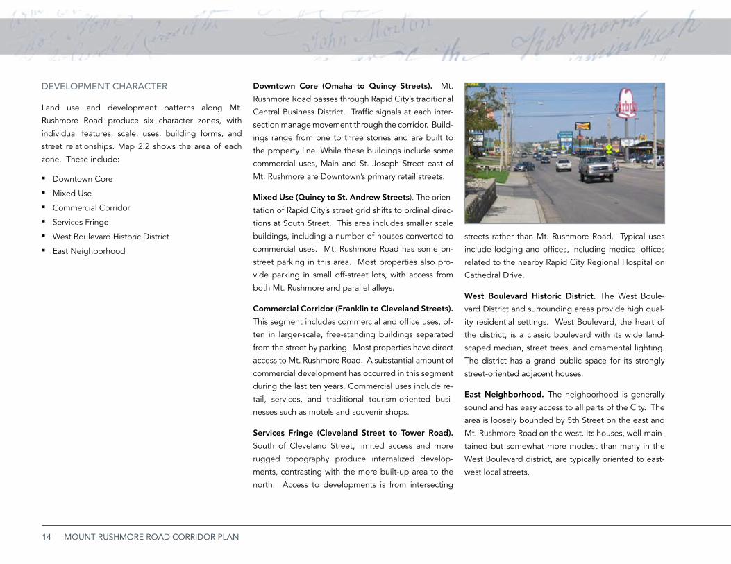
streets rather than Mt. Rushmore Road. Typical uses
include lodging and offices, including medical offices
related to the nearby Rapid City Regional Hospital on
Cathedral Drive.
West Boulevard Historic District. The West Boule-
vard District and surrounding areas provide high qual-
ity residential settings. West Boulevard, the heart of
the district, is a classic boulevard with its wide land-
scaped median, street trees, and ornamental lighting.
The district has a grand public space for its strongly
street-oriented adjacent houses.
East Neighborhood. The neighborhood is generally
sound and has easy access to all parts of the City. The
area is loosely bounded by 5th Street on the east and
Mt. Rushmore Road on the west. Its houses, well-main-
tained but somewhat more modest than many in the
West Boulevard district, are typically oriented to east-
west local streets.
DEvELOPMENT ChARACTER
Land use and development patterns along Mt.
Rushmore Road produce six character zones, with
individual features, scale, uses, building forms, and
street relationships. Map 2.2 shows the area of each
zone. These include:
Downtown Core ▪Mixed Use ▪Commercial Corridor ▪Services Fringe ▪West Boulevard Historic District ▪East Neig ▪ hborhood
Downtown Core (Omaha to Quincy Streets). Mt.
Rushmore Road passes through Rapid City’s traditional
Central Business District. Traffic signals at each inter-
section manage movement through the corridor. Build-
ings range from one to three stories and are built to
the property line. While these buildings include some
commercial uses, Main and St. Joseph Street east of
Mt. Rushmore are Downtown’s primary retail streets.
Mixed Use (Quincy to St. Andrew Streets). The orien-
tation of Rapid City’s street grid shifts to ordinal direc-
tions at South Street. This area includes smaller scale
buildings, including a number of houses converted to
commercial uses. Mt. Rushmore Road has some on-
street parking in this area. Most properties also pro-
vide parking in small off-street lots, with access from
both Mt. Rushmore and parallel alleys.
Commercial Corridor (Franklin to Cleveland Streets).
This segment includes commercial and office uses, of-
ten in larger-scale, free-standing buildings separated
from the street by parking. Most properties have direct
access to Mt. Rushmore Road. A substantial amount of
commercial development has occurred in this segment
during the last ten years. Commercial uses include re-
tail, services, and traditional tourism-oriented busi-
nesses such as motels and souvenir shops.
Services Fringe (Cleveland Street to Tower Road).
South of Cleveland Street, limited access and more
rugged topography produce internalized develop-
ments, contrasting with the more built-up area to the
north. Access to developments is from intersecting
15EXISTING CONDITIONS
EMERGiNG iSSUES
Residential uses along Mt. Rushmore Road. The few
houses that directly face the arterial are located in the
Mixed Use segment. Because of traffic effects, some
of these houses display signs of deterioration and de-
ferred maintenance. Trends suggest that these build-
ings may convert to other uses or continue to decline
without significant action.
East Neighborhood. New medical facilities and ser-
vices continue to grow in Rapid City. These services
cluster in the southeast portion of the study area, put-
ting pressure on residential blocks. Parking lots and
non-residential uses can erode residential quality, un-
less transitions are carefully managed.
Hospitality Services. Independent motels developed
along this traditional tourist corridor to the Black Hills
and the National Memorial. As they age, these motels
must compete with newer chain establishments. How-
ever, some of them can offer distinctive accommoda-
tions along a thematic corridor. Others may present
attractive redevelopment sites.
Westward Encroachments into Residential Areas.
Some residential properties along Mt. Rushmore Road
have been redeveloped with new commercial uses,
moving non-residential uses toward the West Boule-
vard District. A poorly defined edge invites further en-
croachments, affecting the character and quality of the
adjacent neighborhood.
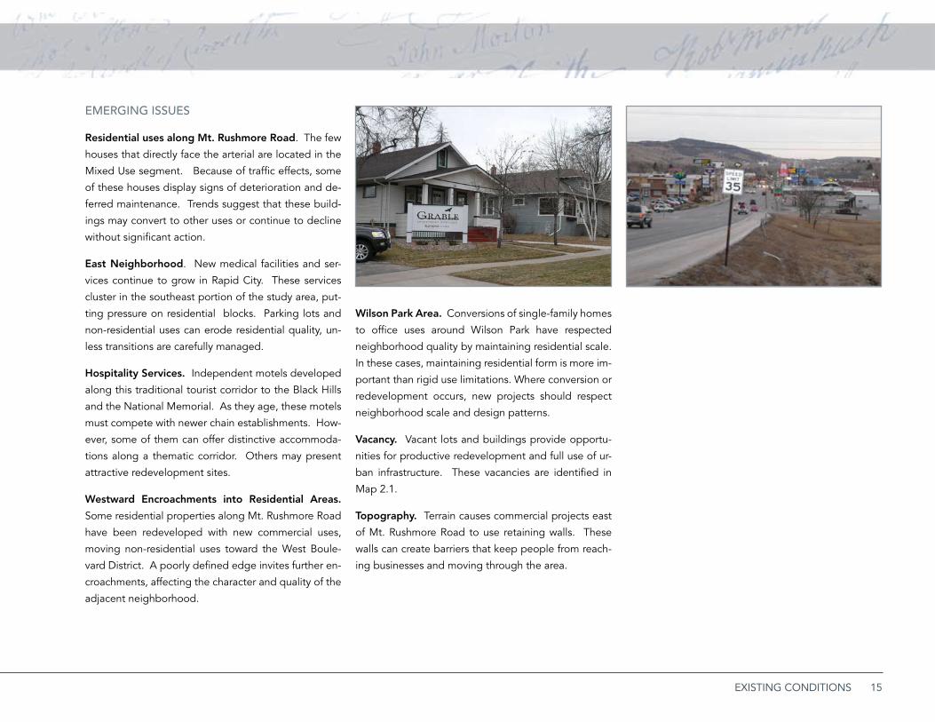
Wilson Park Area. Conversions of single-family homes
to office uses around Wilson Park have respected
neighborhood quality by maintaining residential scale.
In these cases, maintaining residential form is more im-
portant than rigid use limitations. Where conversion or
redevelopment occurs, new projects should respect
neighborhood scale and design patterns.
Vacancy. Vacant lots and buildings provide opportu-
nities for productive redevelopment and full use of ur-
ban infrastructure. These vacancies are identified in
Map 2.1.
Topography. Terrain causes commercial projects east
of Mt. Rushmore Road to use retaining walls. These
walls can create barriers that keep people from reach-
ing businesses and moving through the area.

16 MOUNT RUSHMORE ROAD CORRIDOR PLAN
Map 2.2a: Character Map
Downtown Core
Mixed Use
West Boulevard Historic Distr ict

17EXISTING CONDITIONS
Map 2.2b: Character Map
Mixed Use Commercial Corridor
East Neighborhood
West Boulevard Historic Distr ict

18 MOUNT RUSHMORE ROAD CORRIDOR PLAN
Map 2.2c: Character Map
Commercial Corridor Services Fringe
East Neighborhood
19EXISTING CONDITIONS
Transportation SystemThis section summarizes key conclusions and recom-
mendations from the companion Mt. Rushmore Road
Traffic Operations Study, completed in coordination
with this study. These findings are integrated as basic
assumptions of this corridor development plan.
TRAffiC PATTERNS AND OPERATiONS
Traffic to Mt. Rushmore National Memorial is fun-•
neled to Mt. Rushmore Road by way of Interstate
190 and US Highway 16.
The Elk Vale Road/Caltron Boulevard truck route •
provides an alternative way to the Mt. Rushmore
Memorial that diverts travelers away from the city
and its commercial services. This route intersects
US Highway 16 south of the study area.
While speed limits are marked at 35 miles per •
hour, traffic tends to exceed that limit at the south
end of the corridor.
Right-of-way width of Mt. Rushmore Road between •
Omaha Street and St. Patrick Street is 95 feet, de-
creasing to 66 feet south of St. Patrick Street.
TRAffiC OPERATiONS
The Traffic Operations Study (Appendix B) evaluates the
need to change geometric and operational functions of
Mt. Rushmore Road to accommodate traffic projected
for 2030. It considers peak flows during mornings and
evenings throughout the year, and also considered
tourism traffic. The study evaluates the Level of
Service (LOS) projected in 2030 for intersections and
roadways.
Intersections. The current roadway geometry will pro-
vide a LOS C or better at most intersections in this cor-
ridor. Map 2.2 identifies existing signalized intersec-
tions; the study considers additional signalizations, but
concludes that they are not warranted by current op-
erations. Larger storage lengths and additional lanes
will be required to accommodate additional traffic at
the following intersections:
Omaha Street. ▪ Modify northbound left turn lane from 180’ to 200’ of storage.
Main Street. ▪ Modify northbound left turn lane from 100’ feet to 365’ of storage. Also, construct west-bound left turn lane with 200’ of storage.
St. ▪ Joseph Street. Construct westbound left turn lane with 200’ of storage.
St. ▪ Patrick Street. Modify southbound left turn lane from 100’ to 230’ of storage. Also, modify west-bound left turn lane from 100’ to 150’ of storage.
Cathedral Drive. ▪ Modify southbound left turn lane from 400’ to 650’ of storage.
Roadways. During morning peak hours projected by
a 2030 model, the Central Business District portion of
the arterial could expect to receive a LOS D for north-
bound and southbound traffic. The remaining por-
tion of the arterial could expect to receive a LOS C for
northbound traffic and LOS B for southbound traffic.
During evening peak hours, The Central Business Dis-
trict portion of the arterial could expect to receive a
LOS D for northbound and southbound traffic. The re-
maining portion of the arterial could expect to receive
a LOS C for northbound traffic and LOS B for south-
bound traffic.
Summary. Based on these geometric and operational
findings, Mt. Rushmore Road should continue to op-
erate as a four-lane roadway with left turn lanes at in-
tersections. A raised median should be considered at
feasible locations to minimize vehicular conflicts and
potential crashes with vehicles using adjacent private
driveways.
20 MOUNT RUSHMORE ROAD CORRIDOR PLAN
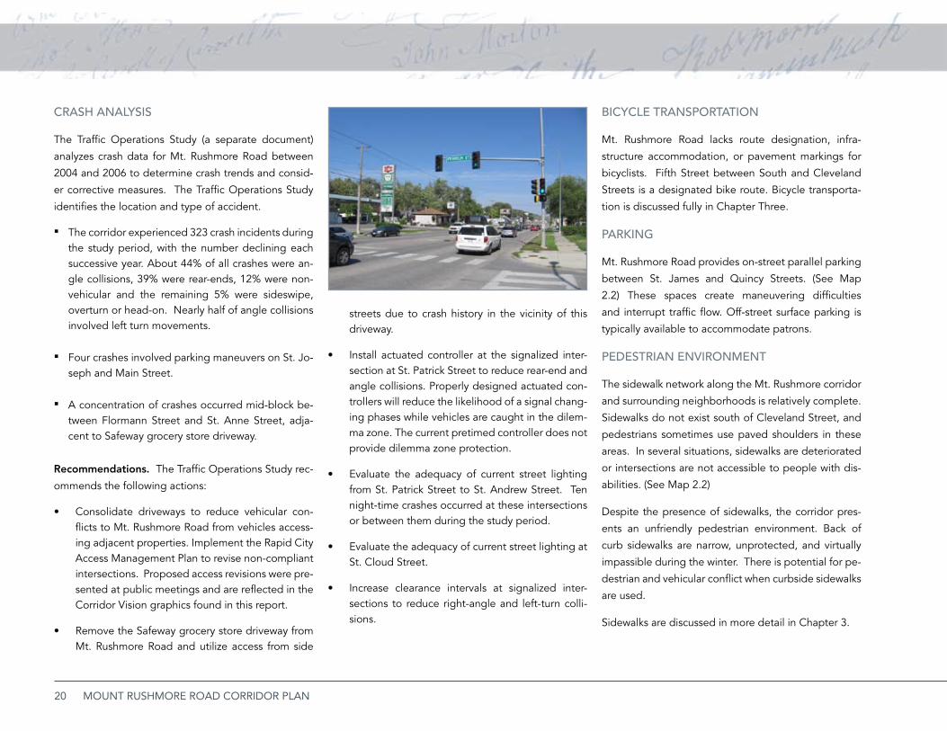
CRASh ANALySiS
The Traffic Operations Study (a separate document)
analyzes crash data for Mt. Rushmore Road between
2004 and 2006 to determine crash trends and consid-
er corrective measures. The Traffic Operations Study
identifies the location and type of accident.
The corridor experienced 323 crash incidents during ▪the study period, with the number declining each successive year. About 44% of all crashes were an-gle collisions, 39% were rear-ends, 12% were non-vehicular and the remaining 5% were sideswipe, overturn or head-on. Nearly half of angle collisions involved left turn movements.
Four crashes involved parking maneuvers on St. Jo- ▪seph and Main Street.
A concentration of crashes occurred mid-block be- ▪tween Flormann Street and St. Anne Street, adja-cent to Safeway grocery store driveway.
Recommendations. The Traffic Operations Study rec-
ommends the following actions:
Consolidate driveways to reduce vehicular con-•flicts to Mt. Rushmore Road from vehicles access-ing adjacent properties. Implement the Rapid City Access Management Plan to revise non-compliant intersections. Proposed access revisions were pre-sented at public meetings and are reflected in the Corridor Vision graphics found in this report.
Remove the Safeway grocery store driveway from •Mt. Rushmore Road and utilize access from side
streets due to crash history in the vicinity of this driveway.
Install actuated controller at the signalized inter-•section at St. Patrick Street to reduce rear-end and angle collisions. Properly designed actuated con-trollers will reduce the likelihood of a signal chang-ing phases while vehicles are caught in the dilem-ma zone. The current pretimed controller does not provide dilemma zone protection.
Evaluate the adequacy of current street lighting •from St. Patrick Street to St. Andrew Street. Ten night-time crashes occurred at these intersections or between them during the study period.
Evaluate the adequacy of current street lighting at •St. Cloud Street.
Increase clearance intervals at signalized inter-•sections to reduce right-angle and left-turn colli-sions.
biCyCLE TRANSPORTATiON
Mt. Rushmore Road lacks route designation, infra-
structure accommodation, or pavement markings for
bicyclists. Fifth Street between South and Cleveland
Streets is a designated bike route. Bicycle transporta-
tion is discussed fully in Chapter Three.
PARKiNG
Mt. Rushmore Road provides on-street parallel parking
between St. James and Quincy Streets. (See Map
2.2) These spaces create maneuvering difficulties
and interrupt traffic flow. Off-street surface parking is
typically available to accommodate patrons.
PEDESTRiAN ENviRONMENT
The sidewalk network along the Mt. Rushmore corridor
and surrounding neighborhoods is relatively complete.
Sidewalks do not exist south of Cleveland Street, and
pedestrians sometimes use paved shoulders in these
areas. In several situations, sidewalks are deteriorated
or intersections are not accessible to people with dis-
abilities. (See Map 2.2)
Despite the presence of sidewalks, the corridor pres-
ents an unfriendly pedestrian environment. Back of
curb sidewalks are narrow, unprotected, and virtually
impassible during the winter. There is potential for pe-
destrian and vehicular conflict when curbside sidewalks
are used.
Sidewalks are discussed in more detail in Chapter 3.
21EXISTING CONDITIONS
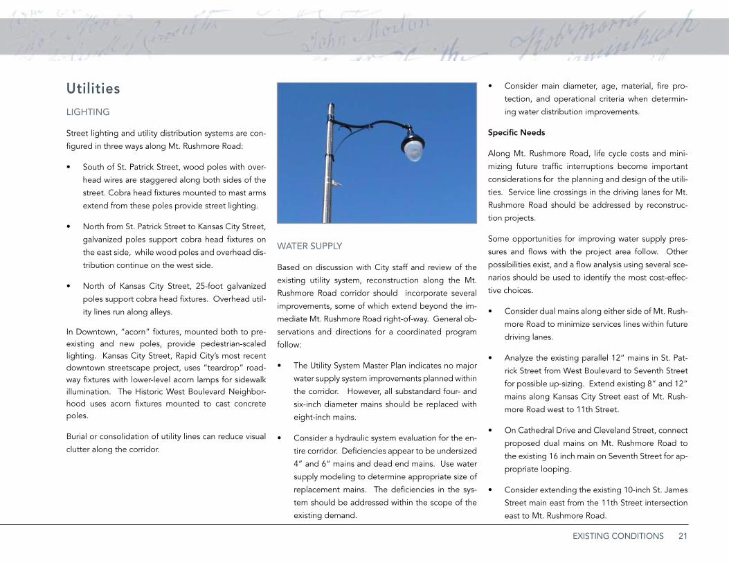
UtilitiesLiGhTiNG
Street lighting and utility distribution systems are con-
figured in three ways along Mt. Rushmore Road:
South of St. Patrick Street, wood poles with over-•
head wires are staggered along both sides of the
street. Cobra head fixtures mounted to mast arms
extend from these poles provide street lighting.
North from St. Patrick Street to Kansas City Street, •
galvanized poles support cobra head fixtures on
the east side, while wood poles and overhead dis-
tribution continue on the west side.
North of Kansas City Street, 25-foot galvanized •
poles support cobra head fixtures. Overhead util-
ity lines run along alleys.
In Downtown, “acorn” fixtures, mounted both to pre-existing and new poles, provide pedestrian-scaled lighting. Kansas City Street, Rapid City’s most recent downtown streetscape project, uses “teardrop” road-way fixtures with lower-level acorn lamps for sidewalk illumination. The Historic West Boulevard Neighbor-hood uses acorn fixtures mounted to cast concrete poles.
Burial or consolidation of utility lines can reduce visual
clutter along the corridor.
WATER SUPPLy
Based on discussion with City staff and review of the
existing utility system, reconstruction along the Mt.
Rushmore Road corridor should incorporate several
improvements, some of which extend beyond the im-
mediate Mt. Rushmore Road right-of-way. General ob-
servations and directions for a coordinated program
follow:
The Utility System Master Plan indicates no major •
water supply system improvements planned within
the corridor. However, all substandard four- and
six-inch diameter mains should be replaced with
eight-inch mains.
Consider a hydraulic system evaluation for the en-•
tire corridor. Deficiencies appear to be undersized
4” and 6“ mains and dead end mains. Use water
supply modeling to determine appropriate size of
replacement mains. The deficiencies in the sys-
tem should be addressed within the scope of the
existing demand.
Consider main diameter, age, material, fire pro-•
tection, and operational criteria when determin-
ing water distribution improvements.
Specific Needs
Along Mt. Rushmore Road, life cycle costs and mini-
mizing future traffic interruptions become important
considerations for the planning and design of the utili-
ties. Service line crossings in the driving lanes for Mt.
Rushmore Road should be addressed by reconstruc-
tion projects.
Some opportunities for improving water supply pres-
sures and flows with the project area follow. Other
possibilities exist, and a flow analysis using several sce-
narios should be used to identify the most cost-effec-
tive choices.
Consider dual mains along either side of Mt. Rush-•
more Road to minimize services lines within future
driving lanes.
Analyze the existing parallel 12” mains in St. Pat-•
rick Street from West Boulevard to Seventh Street
for possible up-sizing. Extend existing 8” and 12”
mains along Kansas City Street east of Mt. Rush-
more Road west to 11th Street.
On Cathedral Drive and Cleveland Street, connect •
proposed dual mains on Mt. Rushmore Road to
the existing 16 inch main on Seventh Street for ap-
propriate looping.
Consider extending the existing 10-inch St. James •
Street main east from the 11th Street intersection
east to Mt. Rushmore Road.

22 MOUNT RUSHMORE ROAD CORRIDOR PLAN
SANiTARy SEWER
The sanitary sewer mains within Mt. Rushmore Road
are approaching or have exceeded their design life, as-
suming that they are about as old as surrounding de-
velopment. Mains along the corridor should be vid-
eotaped to determine their structural integrity. Non-
compliant services should be identified to the greatest
degree possible. City Utility Maintenance personnel
should also identify maintenance and backup histories
that require further investigation during design. Re-
placement of cross-street mains within the Mt. Rush-
more Road right-of-way should be considered.
Specific Needs
While the Rapid City Utility System Master Plan does
not propose other improvements, several opportuni-
ties for specific system improvements follow:
Consider sizing changes for mains in alleys cross-•
ing Mt. Rushmore Road north of Columbus Street
and north of Quincy Street. These mains act as col-
lectors that re-direct flow from the south.
With reconstruction, consider replacing mains in •
the alley across Mt. Rushmore Road north of Main
Street. These mains drain a large service area.
The Utility System Master Plan notes sewer capac-
ity issues.
Replace the alley mains crossing Mt. Rushmore •
Road north of both Kansas City and St. Joseph
Streets with any reconstruction project.
Evaluate the condition of the main on Mt. Rush-•
more Road from Omaha Street south to the alley
north of Main Street.
Consider replacing main crossings at St. Francis •
Street and Indiana Street with any reconstruction.
Evaluate the water main capacity along these
streets.
Evaluate the main crossing at Cathedral Drive for •
capacity and condition. Development activity in
the service area upstream of Mt. Rushmore Road
has increased since installation of the original main
crossing, and future westward extension of Cathe-
dral Drive will exacerbate the problem.
Stormwater ManagementMt. Rushmore Road is an urban section street with
curbs and gutters north of Cleveland Street. Stormwa-
ter runoff accumulates primarily in two drainage basins.
The Downtown Basin receives runoff north of St. Patrick
Street, while the Meade/Hawthorne Basin receives run-
off south of St. Patrick Street. Another detention cell
is located at the southeast corner of Cleveland Street
and Mt. Rushmore Road.
Limited space is available along the corridor to
implement stormwater management facilities, such as
bioretention, infiltration basins, filter and buffer strips.
In general:
Downtown Area Drainage Basin provides limited ▪opportunities for stormwater management because of dense development. Best management practic-es with the right-of-way should be considered.
The Meade-Hawthorne Basin has undeveloped par- ▪cels that could be used as detention and retention basins along the drainage channels. These parcels are located east of Meade and 3rd Streets, east of Oak Avenue and Tallent Street, south of Montana Street west of Wisconsin Avenue, southeast of E. Fairlane Drive and east of Ivy Avenue south of E. Oakland Street.
West Boulevard could intercept high velocity run- ▪off from the west slopes. Further study is needed, however the existing conveyance system could be upgraded.
Flooding might be managed with regional infra- ▪structure at the upper portions of the drainage ba-sins, and possible retrofits at lower portions. Im-proving the detention pond with an emergency spillway at the southwest corner of Fairmont Bou-levard and Mt. Rushmore Road could help manage runoff.
Low-impact stormwater design along the corridor ▪should include Best Management Practices in new development and redevelopment of private prop-erty adjacent to the street.
A detailed analysis of the two basins, based on the
Drainage Basin Design Plans, follows.
23EXISTING CONDITIONS
MEADE/hAWThORNE DRAiNAGE bASiN DE-SiGN PLAN (TOWER ROAD NORTh TO ST. PAT-RiCK STREET)
Infrastructure
According to the Drainage Basin Design Plan, the ma-
jor improvements recommended for managing area
runoff are referenced as Element #47. The detail in-
cluded in the Drainage Basin Design Plan contains
multiple facets for consideration.
In general, the existing storm sewer identified in Ele-
ment #47 is inadequate and improvements are recom-
mended. At Mt. Rushmore Road and St. Francis Street
the existing 30-36 inch storm sewer should be replaced
with a 42 inch storm sewer. Inlets should be installed
to capture flow to meet street drainage criteria. Ex-
tension of the storm sewer upstream of Mt. Rushmore
Road is recommended to intercept flows prior to im-
pacting this arterial street.
Mt. Rushmore Road generally lacks inlets and storm
sewer for on-street flows and capturing upstream
(westerly) flows before they enter the street. Any road-
way design should include a hydrology and hydraulics
study to detail the local area, expected flows, and in-
frastructure needed to mitigate the runoff to meet cur-
rent City criteria.
Stormwater Quality
The Drainage Basin Design Plan does not identify
storm water quality improvements other than mitiga-
tion by detention ponds identified in the plan. Runoff
controls have not been built along Mt. Rushmore, de-
spite its heavy commercial development and high per-
centage of impermeable surfaces. Contaminants from
the streets and parking lots should be a primary con-
sideration for storm water quality enhancements.
According to the Drainage Basin Design Plan, sub-ba-
sins 25, 45, 47 and 48 affect the corridor. Basins 25 and
47 west of the commercial development are the only
basins with existing available detention. Development
upstream is limited currently to very low density resi-
dential. Subbasins 45 and 48 flow uncontrolled into
the existing storm sewer system. Some options exist
near the west terminus of Hyland Park Drive for deten-
tion and storm water quality enhancements.
At the downstream end of subbasin 48, with consid-
erable commercial development along Mt. Rushmore
Road, options for storm water quality enhancements
are probably limited to on-site controls that coincide
with private site redevelopment. In the southwest
quadrant of Highland Park Drive and Mt. Rushmore
Road, an existing storm water inlet and a detention
pond exist. This pond has some potential for future
storm water quality enhancement.
Basin 45 lacks existing facilities for limiting runoff above
Mt. Rushmore Road and feasible possibilities may also
be limited. Because limited right-of way limits the pos-
sibility of medians adequate to drain runoff, all rede-
velopment along the corridor should include some on-
site detention/retention/landscaping areas. This will re-
duce runoff quantities affecting downstream facilities.
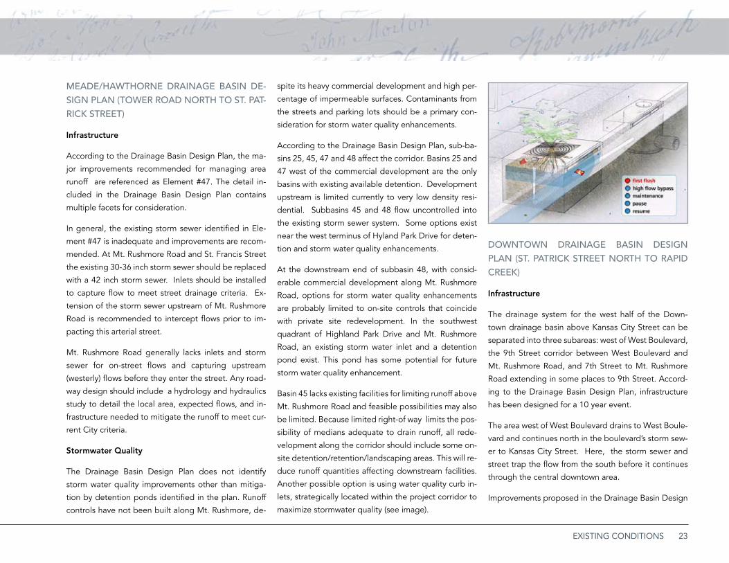
Another possible option is using water quality curb in-
lets, strategically located within the project corridor to
maximize stormwater quality (see image).
DOWNTOWN DRAiNAGE bASiN DESiGN PLAN (ST. PATRiCK STREET NORTh TO RAPiD CREEK)
Infrastructure
The drainage system for the west half of the Down-
town drainage basin above Kansas City Street can be
separated into three subareas: west of West Boulevard,
the 9th Street corridor between West Boulevard and
Mt. Rushmore Road, and 7th Street to Mt. Rushmore
Road extending in some places to 9th Street. Accord-
ing to the Drainage Basin Design Plan, infrastructure
has been designed for a 10 year event.
The area west of West Boulevard drains to West Boule-
vard and continues north in the boulevard’s storm sew-
er to Kansas City Street. Here, the storm sewer and
street trap the flow from the south before it continues
through the central downtown area.
Improvements proposed in the Drainage Basin Design
24 MOUNT RUSHMORE ROAD CORRIDOR PLAN
Plan for 9th Street have not been built and should be
developed with Mt. Rushmore Road corridor improve-
ments. A new storm sewer from St. Charles Street to
Kansas City Street will help capture the runoff before
reaching Mt. Rushmore Road. The profile of 9th Street
paving will need to be lowered.
In the Mt. Rushmore Road corridor, the storm sewer
north of Fairview Street accommodates a 10 year event,
but the plan does not address the stormwater manage-
ment south of Fairview Street. A drainage study should
be initiated to define needed improvements.
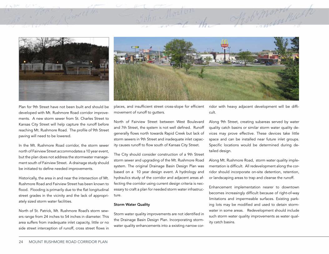
Historically, the area in and near the intersection of Mt.
Rushmore Road and Fairview Street has been known to
flood. Flooding is primarily due to the flat longitudinal
street grades in the vicinity and the lack of appropri-
ately sized storm water facilities.
North of St. Patrick, Mt. Rushmore Road’s storm sew-
ers range from 24 inches to 54 inches in diameter. This
area suffers from inadequate inlet capacity, little or no
side street interception of runoff, cross street flows in
places, and insufficient street cross-slope for efficient
movement of runoff to gutters.
North of Fairview Street between West Boulevard
and 7th Street, the system is not well defined. Runoff
generally flows north towards Rapid Creek but lack of
storm sewers in 9th Street and inadequate inlet capac-
ity causes runoff to flow south of Kansas City Street.
The City should consider construction of a 9th Street
storm sewer and upgrading of the Mt. Rushmore Road
system. The original Drainage Basin Design Plan was
based on a 10 year design event. A hydrology and
hydraulics study of the corridor and adjacent areas af-
fecting the corridor using current design criteria is nec-
essary to craft a plan for needed storm water infrastruc-
ture.
Storm Water Quality
Storm water quality improvements are not identified in
the Drainage Basin Design Plan. Incorporating storm-
water quality enhancements into a existing narrow cor-
ridor with heavy adjacent development will be diffi-
cult.
Along 9th Street, creating subareas served by water
quality catch basins or similar storm water quality de-
vices may prove effective. These devices take little
space and can be installed near future inlet groups.
Specific locations would be determined during de-
tailed design.
Along Mt. Rushmore Road, storm water quality imple-
mentation is difficult. All redevelopment along the cor-
ridor should incorporate on-site detention, retention,
or landscaping areas to trap and cleanse the runoff.
Enhancement implementation nearer to downtown
becomes increasingly difficult because of right-of-way
limitations and impermeable surfaces. Existing park-
ing lots may be modified and used to detain storm-
water in some areas. Redevelopment should include
such storm water quality improvements as water qual-
ity catch basins.
25EXISTING CONDITIONS
CH
APT
ER 3
Mt. Rushmore Road is a major retail and service district, but many believe that the Southeast Truck Route, emerging competition, and obsolescence threaten this status. However, a community vision, shared by residents and businesses, can lead to a distinctive environment that can encourage investment, expand business, and restore the corridor’s competitive advantage.
Mt. Rushmore Road Corridor Vision
26 MOUNT RUSHMORE ROAD CORRIDOR PLAN
DEvELOPMENT OPPORTUNiTiES
While most of the corridor is built up, opportunities for
redevelopment still exist. These opportunities include
vacant or underused sites, obsolete commercial uses,
unnecessarily large parking lots, and declining residen-
tial structures. A thoughtful development concept can
guide the reuse of these sites, and can help ensure that
reinvestment produces results that are both rewarding
and advance the interests of the entire district.
COMPLETE TRANSPORTATiON
Complete streets are corridors that safely and effi-
ciently accommodate all transportation modes, includ-
ing motor vehicles, transit, and pedestrian and bicycle
transportation. The ideal complete street should in-
clude:
A trafficway that moves motorized traffic smoothly •
at desired speeds.
Barrier-free sidewalks or pedestrian paths that are •
accessible during all seasons and provides a com-
fortable separation from moving traffic.
Safe and convenient crossings that prevent the •
street from becoming a barrier to pedestrian
movement.
Bicycle lanes, a safe bicycle track, or other accom-•
modation that makes bicycle transportation part
of normal and predictable traffic movement.
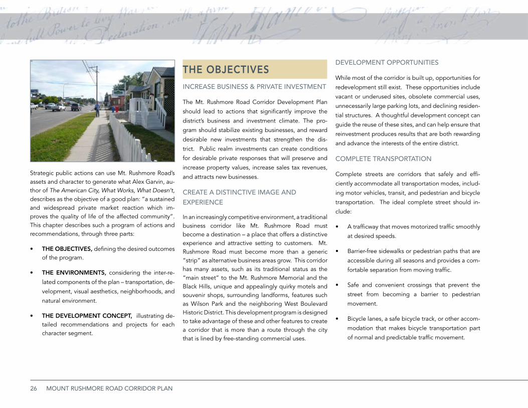
Strategic public actions can use Mt. Rushmore Road’s assets and character to generate what Alex Garvin, au-thor of The American City, What Works, What Doesn’t, describes as the objective of a good plan: “a sustained and widespread private market reaction which im-proves the quality of life of the affected community”. This chapter describes such a program of actions and recommendations, through three parts:
THE OBJECTIVES, • defining the desired outcomes of the program.
THE ENVIRONMENTS, • considering the inter-re-
lated components of the plan – transportation, de-
velopment, visual aesthetics, neighborhoods, and
natural environment.
THE DEVELOPMENT CONCEPT, • illustrating de-tailed recommendations and projects for each character segment.
THE OBJECTIVESiNCREASE bUSiNESS & PRivATE iNvESTMENT
The Mt. Rushmore Road Corridor Development Plan
should lead to actions that significantly improve the
district’s business and investment climate. The pro-
gram should stabilize existing businesses, and reward
desirable new investments that strengthen the dis-
trict. Public realm investments can create conditions
for desirable private responses that will preserve and
increase property values, increase sales tax revenues,
and attracts new businesses.
CREATE A DiSTiNCTivE iMAGE AND ExPERiENCE
In an increasingly competitive environment, a traditional business corridor like Mt. Rushmore Road must become a destination – a place that offers a distinctive experience and attractive setting to customers. Mt. Rushmore Road must become more than a generic “strip” as alternative business areas grow. This corridor has many assets, such as its traditional status as the “main street” to the Mt. Rushmore Memorial and the Black Hills, unique and appealingly quirky motels and souvenir shops, surrounding landforms, features such as Wilson Park and the neighboring West Boulevard Historic District. This development program is designed to take advantage of these and other features to create a corridor that is more than a route through the city that is lined by free-standing commercial uses.
27CORRIDOR VISION
Accommodations for public transportation that •
may include informational graphics, waiting areas,
weather protection, farside bus turnouts, and oth-
er features.
Complete corridors address transportation equity by
serving the individual needs of groups such as se-
niors, children, and people with disabilities. Increas-
ing concerns about community wellness, greenhouse
gas emissions, and unstable fuel costs have expanded
interest in alternative transportation modes.
Traffic calming devices are also a part of complete
transportation design, and help streets operate more
comfortably and appropriately in their urban contexts.
Calming devices such as landscaped islands, speed ta-
bles, crosswalks, street landscaping, curb extensions,
and changes in paving surfaces, discourage speeding,
improve motorist attentiveness, and enhance the street
environment. They can also mark transitions from com-
mercial to residential environments, particularly impor-
tant in this study area.
Mt. Rushmore Road itself may not be able to incor-
porate all of these features, but the study area, taken
together, should accommodate all modes of transpor-
tation. For example, the arterial street does not pres-
ent a comfortable shared use environment and lacks
adequate right-of-way to accommodate bicycle lanes.
However, parallel streets with light to moderate traffic
promotes the same level of access with a much safer
and lower-cost facility.
The National Complete Streets Coalition (www.com-
pletestreets.org), an association of organizations such
as the Institute of Transportation Engineers, the Amer-
ican Planning Association, AARP, and the League of
American Bicyclists is an excellent source of informa-
tion on street design and status of policy in the United
States.
iMPROvED fUNCTiONAL SAfETy
Mt. Rushmore Road should present a safer transporta-
tion environment for all users. Current problems in-
clude friction between local and through traffic, fre-
quent and conflicting driveway cuts, conflicting left
turn movements, poor pedestrian access, and, in some
places, a substandard street section. Complete trans-
portation concepts improve safety, but other tech-
niques are needed to reduce the possibility of crashes.
These include rationalizing access points, controlling
left turn movements, and reducing conflicts between
different traffic streams. Access and left-turn manage-
ment programs should not reduce access or impede
the operation of individual businesses. In fact, they
can provide greater customer comfort and, in many
cases, more parking.
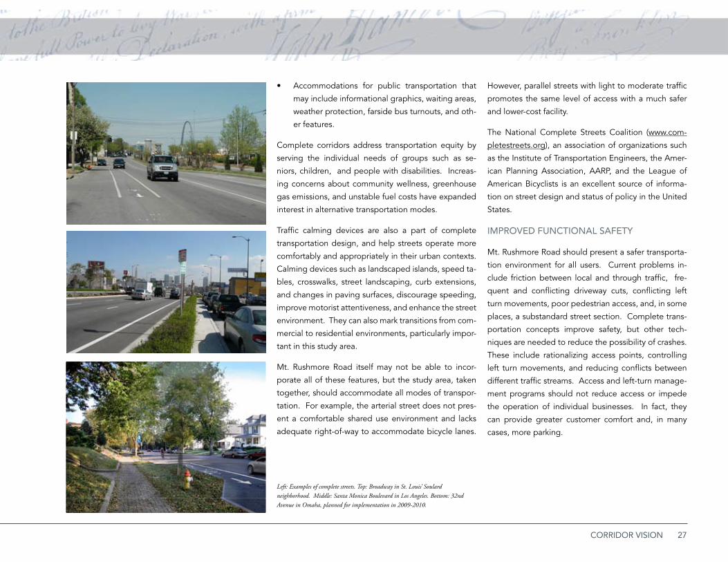
Left: Examples of complete streets. Top: Broadway in St. Louis’ Soulard neighborhood. Middle: Santa Monica Boulevard in Los Angeles. Bottom: 32nd Avenue in Omaha, planned for implementation in 2009-2010.
Conceptsd32nd Avenue
Former Streetcar Street

28 MOUNT RUSHMORE ROAD CORRIDOR PLAN
ENviRONMENTAL SUSTAiNAbiLiTy
Major commercial corridors like Mt. Rushmore Road
have a high percentage of impervious surface, compli-
cating stormwater management, creating heat islands,
and generating other negative environmental impacts.
The overall corridor should evolve toward greater sus-
tainability by minimizing these effects and incorporat-
ing best management practices into street and devel-
opment design. Mixed uses on development sites and
facilities that encourage use of non-motorized trans-
portation modes for short trips also creates a more sus-
tainable corridor.
Offset pedestrian crossings in Las Vegas, Nevada.
Upper right: Portland, Oregon
MUTUALLy REiNfORCiNG NEiGhbORhOOD CONNECTiONS
Mt. Rushmore Road is not an isolated corridor, but ex-
ists in a neighborhood context. Residents of these
neighborhoods are customers for businesses along the
corridor, and good physical and circulation linkages,
free of obstacles, encourages this desirable interac-
tion. But good connections between a multi-use corri-
dor and surrounding neighborhoods involve managing
the edges – filtering out undesirable commercial traffic,
minimizing visual and functional incompatibilities, pre-
venting operational effects such as lighting and noise,
and others. Unmanaged edges can produce deterio-
ration at the boundaries that can easily spread into the
heart of the neighborhood. Commercial areas benefit
from healthy surrounding neighborhoods, and residen-
tial areas also benefit when nearby retail and service
centers thrive.
29CORRIDOR VISION

30 MOUNT RUSHMORE ROAD CORRIDOR PLAN
THE ENVIRONMENTSThis section considers four “environments” that
describe the unifying assumptions and principles that
the plan applies to individual character segments of
Mt. Rushmore Road. The discussion of each of these
key areas identifies desirable outcomes and presents
strategies to achieve them. The four environments
include:
Transportation Environment: • Access and mobility to and within the district.
Development and Neighborhood Environment: •Future land use and development opportunities, and
Urban Design Environment:• The design elements of the district and its overall physical appearance between the Mt. Rushmore Road corridor and its surrounding neighborhoods.
Natural Environment and Sustainability.• The environmental performance of the district and its ability to manage factors such as stormwater, emissions, extraneous lighting, and other effects.
Transportation EnvironmentfUNCTiONAL OUTCOMES
Provide a clearer route directing traffic from •I-190 to Mt. Rushmore Road to improve visitor wayfinding and reduce the amount of through and commercial traffic that mistakenly continues south on West Boulevard.
Safely and comfortably accommodate all modes •of transportation, including motor traffic, bicycle and pedestrian transportation, and transit in the corridor and surrounding area.
Produce smoother, safer traffic operations by •minimizing crash points and reducing friction between local and through traffic.
Maintain good local access to businesses along •Mt. Rushmore Road.
Improve the travel experience, calm traffic, and •encourage compliance with safe speed limits by providing a more attractive and pleasant roadscape environment.
STRATEGiES: MOTOR vEhiCLE TRANSPORTATiON
Improve directional information and adjust •
roadway geometrics to cue inbound traffic from
southbound I-190 traffic to Mt. Rushmore Road
via Omaha Street.
Implement a typical street section along Mt. •
Rushmore Road that provides:
Two standard 11-foot drive lanes in both direc- »tions.A raised and landscaped median, 12- to 16- »feet in width, along segments where left-turns between intersecting streets are not required for acceptable business and parking access. An 11-foot center left-turn lane in areas where »continuous left-turn movements are necessary to provide business access.A landscaped sidewalk setback, typically 6- to »8-feet wide but wider where possible, to pro-vide comfortable and functional separation be-tween the vehicular and pedestrian domains.Continuous 5-foot minimum sidewalks with »barrier-free intersections.
Provide specific intersection design modifications ▪where necessary and access management mea-sures, consistent with the recommendations of the Traffic Operations Study. These recommendation include:
Increasing the depth of certain turning lanes to »accommodate future traffic loads.Consolidating driveways, controlling left-turn »movements, and increasing lighting at high-volume locations to improve safety.Modifying some intersections to provide an ad- »ditional turning lane for future traffic loads.
Encouraging connectedness between parking »lots and drives as part of the access manage-
ment program.
Develop convenient off-street parking areas di- »rectly accessible from cross streets.
31CORRIDOR VISION
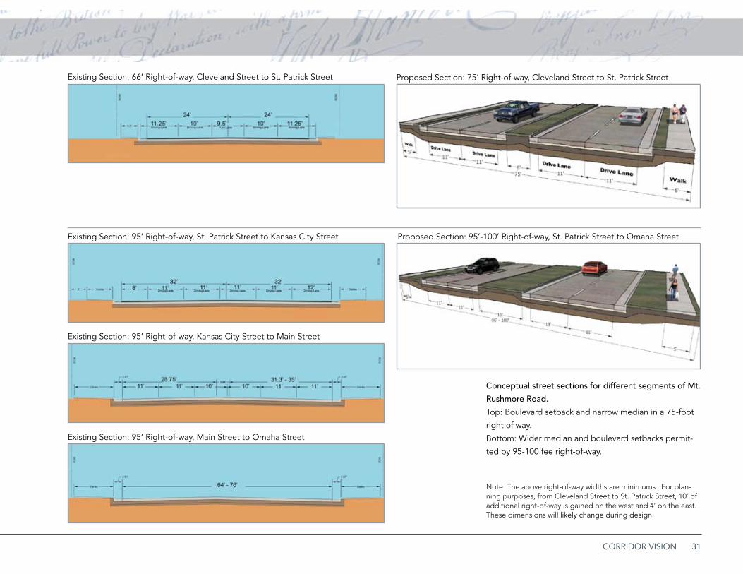
Conceptual street sections for different segments of Mt.
Rushmore Road.
Top: Boulevard setback and narrow median in a 75-foot
right of way.
Bottom: Wider median and boulevard setbacks permit-
ted by 95-100 fee right-of-way.
Note: The above right-of-way widths are minimums. For plan-ning purposes, from Cleveland Street to St. Patrick Street, 10’ of additional right-of-way is gained on the west and 4’ on the east. These dimensions will likely change during design.
Existing Section: 66’ Right-of-way, Cleveland Street to St. Patrick Street
Existing Section: 95’ Right-of-way, St. Patrick Street to Kansas City Street Proposed Section: 95’-100’ Right-of-way, St. Patrick Street to Omaha Street
Existing Section: 95’ Right-of-way, Kansas City Street to Main Street
Existing Section: 95’ Right-of-way, Main Street to Omaha Street
Proposed Section: 75’ Right-of-way, Cleveland Street to St. Patrick Street
32 MOUNT RUSHMORE ROAD CORRIDOR PLAN
Replace on-street parking with parking streets •
on local cross streets on half-blocks between Mt.
Rushmore Road and the parallel west alley. This
concept, discussed in detail below, maintains local
circulation while providing perpendicular head-in
parking. The design increases parking now pro-
vided along the street in the northern reaches of
the study area. A curb extension and surface treat-
ment will also define an edge between the com-
mercial street and the adjacent residential neigh-
borhood, discouraging unwanted traffic.
STRATEGiES: biCyCLE TRANSPORTATiON
Use parallel routes for bicycle transportation, rath-•
er than trying to accommodate bicycles on Mt.
Rushmore Road itself. Traffic and driveway condi-
tions on Mt. Rushmore Road create a difficult bi-
cycling environment at best, and parallel streets
both provide more safer and less stressful routes
and serve most Mt. Rushmore Road destinations.
Using quieter, parallel routes also reduces right-of-
way acquisition needs and allows space for land-
scaping and sidewalk improvements.
Develop 9th Street as a bicycle boulevard between •
Kansas City Street and Flormann Street. The bi-cycle boulevard concept adapts local, low-volume streets that parallel arterials to shared motor vehi-cle-bicycle use. These adaptations include:
Pavement markings, such as bike lanes or shar- »rows.
Traffic calming devices. »Signage for share-the-road and directional in- »formation.Sewer grates with intakes that do not trap »wheels.Removal of other hazards and obstacles to cy- »clists.
While West Boulevard is also an attractive bicycling environment, 9th Street provides closer parallel ac-cess to Mt. Rushmore Road.
Connect the 9th Street bicycle boulevard to the •
Rapid Creek Trail. This connection would utilize
the Kansas City Street connection to 6th Street,
and proceed north to Omaha Street. The signal-
ized intersection at 6th Street provides a protect-
ed connection to the Rapid Creek Trail. In the fu-
ture, a pedestrian bridge over Omaha Street may
be warranted, providing an unobstructed path to
the trail corridor.
Establish Flormann Street as an east-west bicycle •
and pedestrian connection across Mt. Rushmore
Road and south to Tower Road. Recommended
improvements include realigning and signalizing
the Flormann and Mt. Rushmore intersection, and
providing bicycle lanes with capital improvements.
The Flormann route would extend to 7th Street,
continuing south as a bicycle boulevard along 7th
to Cleveland, and using a new path on easements
to the Cathedral Drive and Tower Road intersec-
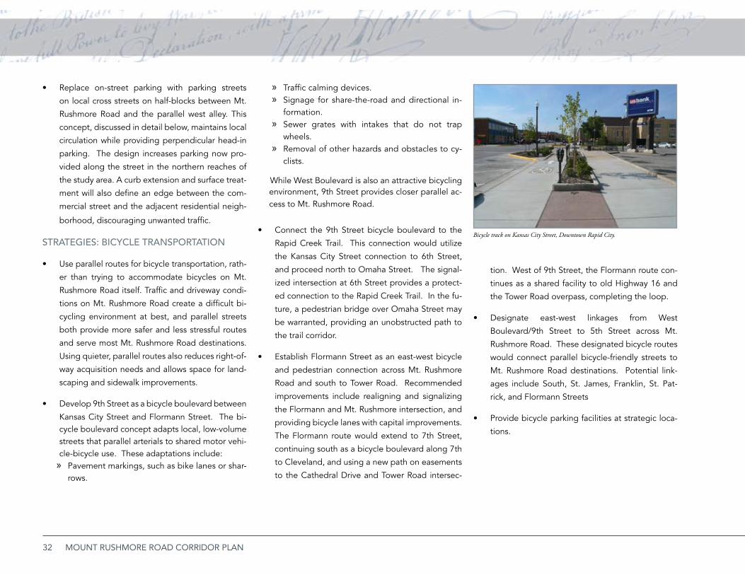
Bicycle track on Kansas City Street, Downtown Rapid City.
tion. West of 9th Street, the Flormann route con-
tinues as a shared facility to old Highway 16 and
the Tower Road overpass, completing the loop.
Designate east-west linkages from West •
Boulevard/9th Street to 5th Street across Mt.
Rushmore Road. These designated bicycle routes
would connect parallel bicycle-friendly streets to
Mt. Rushmore Road destinations. Potential link-
ages include South, St. James, Franklin, St. Pat-
rick, and Flormann Streets
Provide bicycle parking facilities at strategic loca-•
tions.

33CORRIDOR VISION
Bicycle Transportation
Bicycle Boulevard
East-West links
True Boulevard
Shared Route
Pedestrian Overpass
K.C. Street “Bike track”
Pedestrian Crossing
Multi-Use Trail
Sidepath
§̈¦90
£¤16
UV79
Omaha St
Main St
StJoseph St
Kansas City St
Quincy St
Columbus St
South St
Mt.
Rushmore
Mt. R
ushmore R
oadM
t. Rushm
ore M
t. Rushm
ore Road
Clark St
Fairview St
St. James St
St. Cloud St
Franklin St
St. Charles St
9th Street
9th Street
West B
oulevard
St. Andrew St
St. Patrick St
Florman St
Meade St
Indiana St
Cleveland St
Cathedral Dr
Highland Pk Dr
Tower Rd
St. Anne St
St. Francis St
Bicycle TransportationBicycle Boulevard (proposed)
East-West links (proposed)
True Boulevard (existing/proposed)
Share the Road Route (proposed)
Enhanced Ped. Crossing (proposed)
Kansas City St. “Bike track” (existing)
Pedestrian Crossing (proposed)
Multi-Use Trail (existing)
Sidepath (proposed)
Map 3.1: Bicycle Transportation
Bicycle boulevards in Berkeley (top) and Saint Louis (above). These streets parallel arterials and provide priority environments for bicycle transportation. Primary investments include removing hazards and providing pavement markings and signage. Bicycle boulevards may use sharrow (shared lane) pavement markings or bike lanes.
Mt.
Rus
hmor
e Ro
ad
Wes
t B
oule
vard
9th
Stre
et
South St
St. Patrick St
Cathedral Drive
Kansas City St
Omaha St
St. James St
Franklin St
St. Anne St
Flemming St
34 MOUNT RUSHMORE ROAD CORRIDOR PLAN
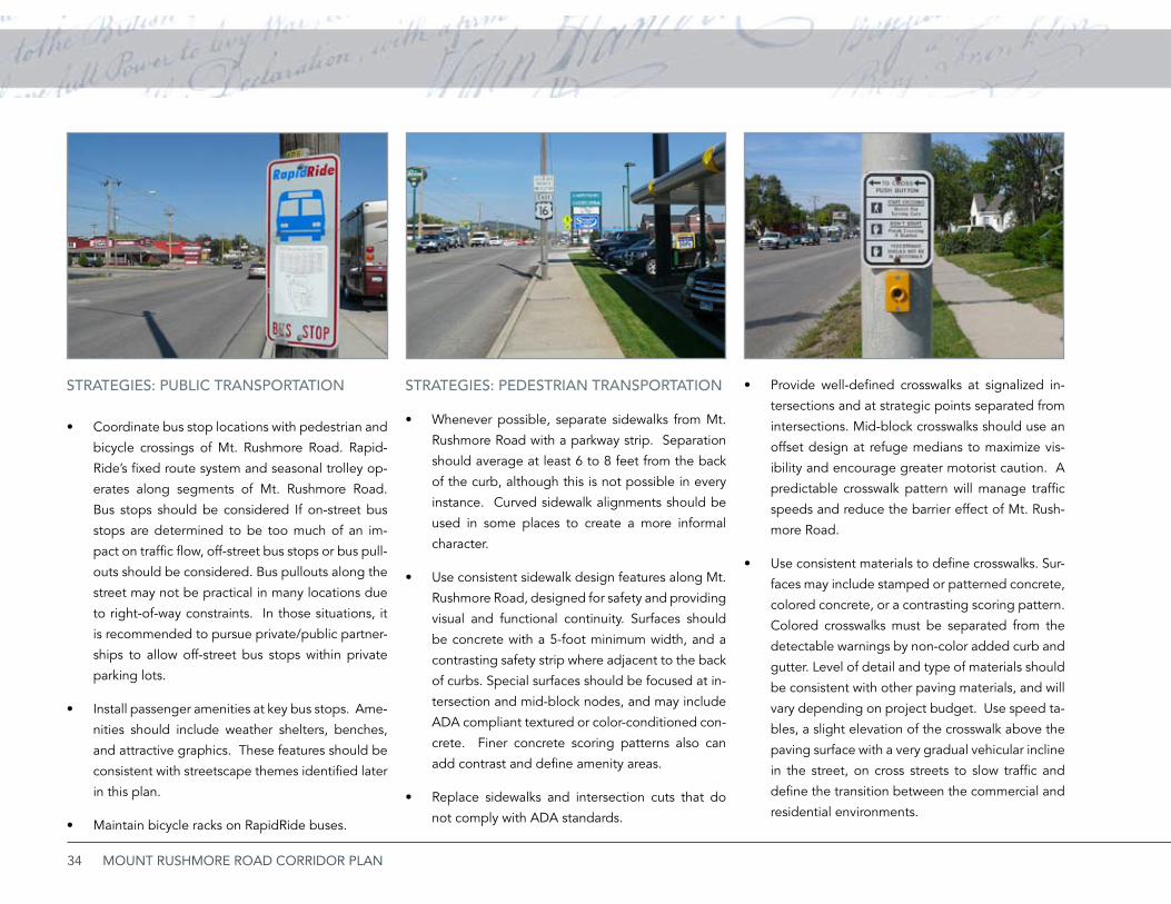
STRATEGiES: PUbLiC TRANSPORTATiON
Coordinate bus stop locations with pedestrian and •
bicycle crossings of Mt. Rushmore Road. Rapid-
Ride’s fixed route system and seasonal trolley op-
erates along segments of Mt. Rushmore Road.
Bus stops should be considered If on-street bus
stops are determined to be too much of an im-
pact on traffic flow, off-street bus stops or bus pull-
outs should be considered. Bus pullouts along the
street may not be practical in many locations due
to right-of-way constraints. In those situations, it
is recommended to pursue private/public partner-
ships to allow off-street bus stops within private
parking lots.
Install passenger amenities at key bus stops. Ame-•
nities should include weather shelters, benches,
and attractive graphics. These features should be
consistent with streetscape themes identified later
in this plan.
Maintain bicycle racks on RapidRide buses.•
STRATEGiES: PEDESTRiAN TRANSPORTATiON
Whenever possible, separate sidewalks from Mt. •
Rushmore Road with a parkway strip. Separation
should average at least 6 to 8 feet from the back
of the curb, although this is not possible in every
instance. Curved sidewalk alignments should be
used in some places to create a more informal
character.
Use consistent sidewalk design features along Mt. •
Rushmore Road, designed for safety and providing
visual and functional continuity. Surfaces should
be concrete with a 5-foot minimum width, and a
contrasting safety strip where adjacent to the back
of curbs. Special surfaces should be focused at in-
tersection and mid-block nodes, and may include
ADA compliant textured or color-conditioned con-
crete. Finer concrete scoring patterns also can
add contrast and define amenity areas.
Replace sidewalks and intersection cuts that do •
not comply with ADA standards.
Provide well-defined crosswalks at signalized in-•
tersections and at strategic points separated from
intersections. Mid-block crosswalks should use an
offset design at refuge medians to maximize vis-
ibility and encourage greater motorist caution. A
predictable crosswalk pattern will manage traffic
speeds and reduce the barrier effect of Mt. Rush-
more Road.
Use consistent materials to define crosswalks. Sur-•
faces may include stamped or patterned concrete,
colored concrete, or a contrasting scoring pattern.
Colored crosswalks must be separated from the
detectable warnings by non-color added curb and
gutter. Level of detail and type of materials should
be consistent with other paving materials, and will
vary depending on project budget. Use speed ta-
bles, a slight elevation of the crosswalk above the
paving surface with a very gradual vehicular incline
in the street, on cross streets to slow traffic and
define the transition between the commercial and
residential environments.
35CORRIDOR VISION
Development and Neighborhood EnvironmentfUNCTiONAL OUTCOMES
Provide development parcels with adequate depth •
to permit quality development.
Define the streetscape with landscaping and •
buildings rather than parking lots.
Use development opportunities, including •
excessively large parking lots, vacant lots, and
redevelopment of obsolete uses, effectively to
create a healthy mixed use development pattern
along Mt. Rushmore Road.
Provide convenient parking to serve existing and •
future corridor development, while reducing the
dominance of parking on the street environment.
Protect the integrity of surrounding neighborhoods •
by preventing unmanaged encroachment of non-
residential uses into residential areas and limiting
negative environmental and operational effects.
STRATEGiES: LAND USE MANAGEMENT
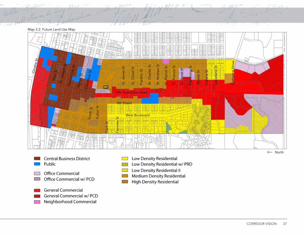
Establish and implement a land use plan for the
Mt. Rushmore Road corridor and surrounding
neighborhoods. Map 3.2 illustrates a basic Future Land
Use Plan while Map 3.3 presents a framework for land
use decisions in the study area. Land use categories in
Map 3.2 include the following:Central Business District: The high density core »of Rapid City, with permitted uses that include and encourage a mix of retail and service com-mercial, offices, and residential development. Urban form in this area should encourage a strong street orientation, multi-story construc-tion, and vertical use mixing when feasible.Public: Sites used exclusively for major pub- »lic buildings or other public facilities such as parks.Office Commercial: Areas principally used for »professional, service, or financial offices. Re-tail or service commercial into these areas, but should not be located in free-standing build-ings and should not exceed 20% of the gross floor area of any single unified development. High density residential uses may also be in-cluded within an office commercial use area. Areas indicated as office commercial with a PCD require approval of a specific develop-ment plan for new projects. General Commercial: Areas permitting single »purpose retail and service commercial land use, office uses, and mixed use developments. Most existing development is in free-standing build-ings with individual parking. However, this plan proposes creating a Mt. Rushmore Road
special development district, including design guidelines, outlined below, that reinforce the goals of this plan. Areas indicated as commer-cial with a PCD require approval of a specific development plan for new projects. Except for larger scale existing projects, the Future Land Use Plan limits the general commercial catego-ry to a corridor defined on the west by the alley between Mt. Rushmore and 9th Street and on the east by a line approximately 200 feet east of Mt. Rushmore. Any expansion of commercial use to the east or west must have full frontage along Mt. Rushmore Road.Residential: These land use categories, reflect- »ing different densities, are devoted to single-use residential development. Low-density resi-dential includes single-family detached devel-opment at urban densities, while low-density residential II provides for large-lot detached
houses. Medium-density residential provides for
small-lot single-family detached, attached, and

36 MOUNT RUSHMORE ROAD CORRIDOR PLAN
townhome residential. High-density residential
permits multi-family development and other
housing forms. Areas indicated as residential
with a PRD designation require approval of a
specific development plan for new projects.
STRATEGy: MT. RUShMORE ROAD SPECiAL DEvELOPMENT DiSTRiCT
Adopt a Mt. Rushmore Road Special Development •
District as a zoning overlay that provides special
regulations used in combination with base districts
along the corridor. The overlay district should apply
to the area between 7th Street and 9th Street,
as indicated in Map 3.3. The district concept
is designed to reinforce the urban character of
the corridor itself, and provide strict controls for
expansion of non-residential uses to the east and
west of Mt. Rushmore Road.
STRATEGy: DESiGN STANDARDS
To maintain and strengthen the urban character •
of the Mt. Rushmore corridor, the overlay district
should include specific design standards for non-
residential uses. These standards should:Encourage building locations that are closer to »the street and are not separated from the street or sidewalk by large parking areas.Encourage parking locations and parking lot »design that limit the amount of parking direct-ly fronting along public streets, including Mt. Rushmore Road.
Require a clear, safe, and defined path from »public sidewalks to the primary entrance of ad-jacent buildings.Provide new urban landscaping requirements »that require internal parking lot landscaping, ceilings on the permitted percentage of imper-vious surfaces, and establish a minimum per-centage of land immediately adjacent to public right-of-way lines that must be landscaped.
Establish sign and street graphic standards for »the Mt. Rushmore Road corridor that emphasiz-es business identification signage at or near the ground plane, and provides an optimum bal-ance between the need to communicate and
urban design considerations.
37CORRIDOR VISION
Map 3.2: Future Land Use Map
Mt. Rushmore Road
West Boulevard
9th Street
Fulto
n St
Sout
h St
St. J
ames
St
St. C
loud
St
Fran
klin
St
St. C
harle
s St
St. A
ndre
w S
t
St. P
atric
k St
St. F
ranc
is S
t
St. A
nne
St
Flem
min
g S
t
Mea
de
St
Ind
iana
St
Cle
vela
nd S
t
Cat
hed
ral D
rive
Mai
n St
St. J
osep
h St
Kan
sas
City
St
Qui
ncy
StC
olum
bus
StOm
aha
St
North
Cla
rk S
t
Fairv
iew
St

38 MOUNT RUSHMORE ROAD CORRIDOR PLAN
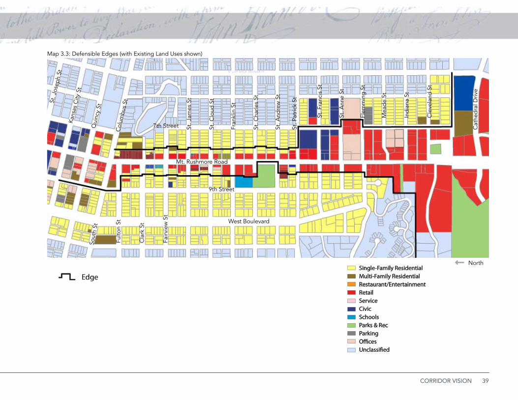
STRATEGy: DEfENSibLE EDGES
The future land use plan and the overlay district should
provide strict controls over the expansion of non-
residential uses into neighboring residential areas
and limit incompatibilities and conflicts between
adjacent land uses. Plan implementation should
establish defensible edges and transitions between
the commercial character of the arterial corridor and
neighboring residential neighborhoods.
On the west side of Mt. Rushmore Road:
Commercial uses should generally be limited to the •
area between Mt. Rushmore Road and the parallel
alley to the immediate west. On blocks without a
parallel alley, this potential limit extends to a line
approximately 200 feet west of the property line.
All development in this area must have full, direct
frontage along Mt. Rushmore. Map 3.3 illustrates
the limit of commercial development on the west
side of Mt. Rushmore.
High-impact elements such as loading and service •
areas must be screened to prevent visibility from
adjacent residential areas. On blocks without
a parallel alley, all commercial development
that expands beyond its current extent to the
commercial development limit must provide
a minimum of 20 feet depth of continuous
landscaping along its residential edge.
On the east side of Mt. Rushmore Road:
Commercial uses between Fairview and Saint •
Patrick should generally be limited to the area
between Mt. Rushmore Road and 200 feet east
of the right-of-way line. All development in this
area must have full, direct frontage along Mt.
Rushmore South of Saint Patrick, the limit of
commercial development generally extends east
to 7th Street. Map 3.3 illustrates the limit of
commercial development on the east side of Mt.
Rushmore Road.
High-impact elements such as loading and service •
areas must be screened to prevent visibility
from adjacent residential areas. All commercial
development that expands beyond its current
extent to the commercial development limit must
provide a minimum of 20 feet depth of continuous
landscaping along its residential edge.
STRATEGy: COMPLiANCE WiTh hiSTORiC DiSTRiCT REQUiREMENTS
Any new development within designated historic •
districts must comply with all design and building
preservation requirements of the district. Elements
of the historic district should be incorporated into
projects that are directly adjacent to and have a
visual effect on historic districts.
39CORRIDOR VISION
Map 3.3: Defensible Edges (with Existing Land Uses shown)
North
Mt Rushmore Road
9th Street
West Boulevard
7th Street
6th Street
Om
aha
Stre
et
Mai
n St
reet
St.
Jose
ph S
tree
t
Kans
as C
ity S
tree
t
Qui
ncy
Stre
et
Colu
mbu
s St
reet
Sout
h St
reet
Fair
view
Str
eet
St. J
ames
Str
eet
St. A
ndre
w S
tree
t
St. P
atric
k S
tree
t
St. F
ranc
is S
tree
t
Mt Rushmore Road
5th Street
St. A
nne
Stre
et
Flor
man
n St
reet
Mea
de S
tree
t
Indi
ana
Stre
et
Cle
vela
nd S
tree
t
Oak
land
Str
eet
Cat
hedr
al D
rive
Tower Road
5th Street
Existing Land Use Map
Single-Family ResidentialMulti-Family ResidentialRestaurant/EntertainmentRetailServiceCivicSchoolsParks & RecParkingOfficesUnclassified
Mt. Rushmore Road
West Boulevard
9th Street
7th StreetFu
lton
St
Cla
rk S
t
Fairv
iew
St
Sout
h St
St. J
ames
St
St. C
loud
St
Fran
klin
St
St. C
harle
s St
St. A
ndre
w S
t
St. P
atric
k St
St. F
ranc
is S
t
St. A
nne
St
Flem
min
g S
t
Mea
de
St
Ind
iana
St
Cle
vela
nd S
t
Cat
hed
ral D
rive
St. J
osep
h St
Kan
sas
City
St
Qui
ncy
St
Col
umbu
s St
40 MOUNT RUSHMORE ROAD CORRIDOR PLAN
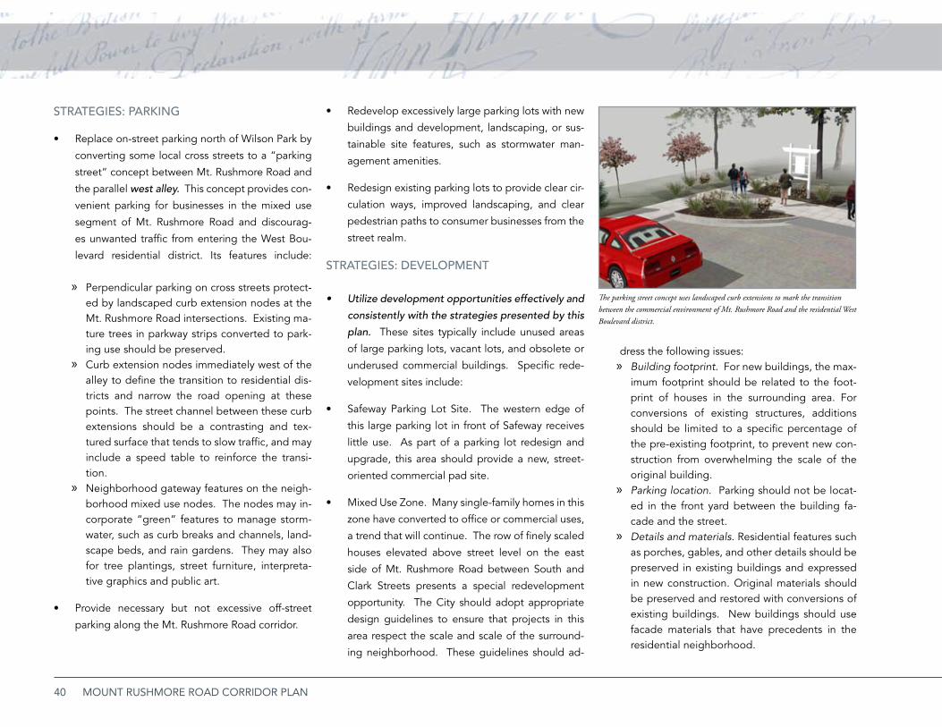
Redevelop excessively large parking lots with new •
buildings and development, landscaping, or sus-
tainable site features, such as stormwater man-
agement amenities.
Redesign existing parking lots to provide clear cir-•
culation ways, improved landscaping, and clear
pedestrian paths to consumer businesses from the
street realm.
STRATEGiES: DEvELOPMENT
Utilize development opportunities effectively and •
consistently with the strategies presented by this
plan. These sites typically include unused areas
of large parking lots, vacant lots, and obsolete or
underused commercial buildings. Specific rede-
velopment sites include:
Safeway Parking Lot Site. The western edge of •
this large parking lot in front of Safeway receives
little use. As part of a parking lot redesign and
upgrade, this area should provide a new, street-
oriented commercial pad site.
Mixed Use Zone. Many single-family homes in this •
zone have converted to office or commercial uses,
a trend that will continue. The row of finely scaled
houses elevated above street level on the east
side of Mt. Rushmore Road between South and
Clark Streets presents a special redevelopment
opportunity. The City should adopt appropriate
design guidelines to ensure that projects in this
area respect the scale and scale of the surround-
ing neighborhood. These guidelines should ad-
The parking street concept uses landscaped curb extensions to mark the transition between the commercial environment of Mt. Rushmore Road and the residential West Boulevard district.
STRATEGiES: PARKiNG
Replace on-street parking north of Wilson Park by •
converting some local cross streets to a “parking
street” concept between Mt. Rushmore Road and
the parallel west alley. This concept provides con-
venient parking for businesses in the mixed use
segment of Mt. Rushmore Road and discourag-
es unwanted traffic from entering the West Bou-
levard residential district. Its features include:
Perpendicular parking on cross streets protect- »ed by landscaped curb extension nodes at the Mt. Rushmore Road intersections. Existing ma-ture trees in parkway strips converted to park-ing use should be preserved. Curb extension nodes immediately west of the »alley to define the transition to residential dis-tricts and narrow the road opening at these points. The street channel between these curb extensions should be a contrasting and tex-tured surface that tends to slow traffic, and may include a speed table to reinforce the transi-tion.Neighborhood gateway features on the neigh- »borhood mixed use nodes. The nodes may in-corporate “green” features to manage storm-water, such as curb breaks and channels, land-scape beds, and rain gardens. They may also for tree plantings, street furniture, interpreta-tive graphics and public art.
Provide necessary but not excessive off-street •
parking along the Mt. Rushmore Road corridor.
dress the following issues:Building footprint. » For new buildings, the max-imum footprint should be related to the foot-print of houses in the surrounding area. For conversions of existing structures, additions should be limited to a specific percentage of the pre-existing footprint, to prevent new con-struction from overwhelming the scale of the original building.Parking location » . Parking should not be locat-ed in the front yard between the building fa-cade and the street. Details and materials » . Residential features such as porches, gables, and other details should be preserved in existing buildings and expressed in new construction. Original materials should be preserved and restored with conversions of existing buildings. New buildings should use facade materials that have precedents in the residential neighborhood.
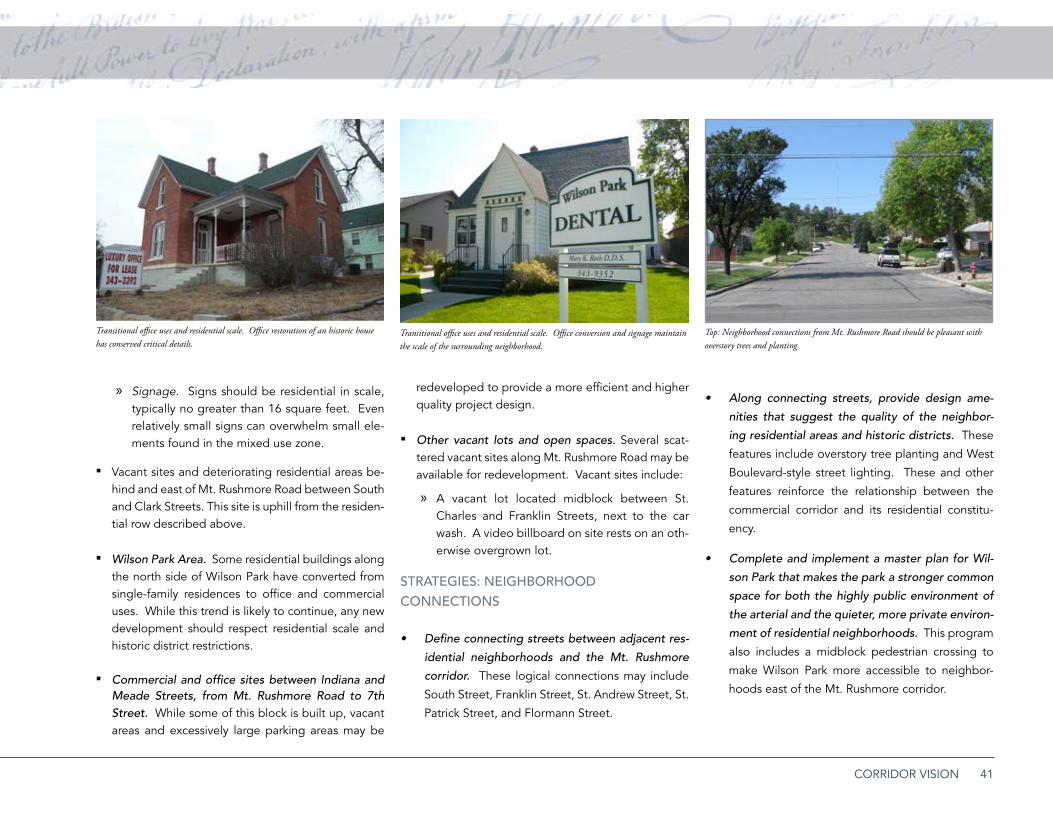
41CORRIDOR VISION
Signage » . Signs should be residential in scale, typically no greater than 16 square feet. Even relatively small signs can overwhelm small ele-ments found in the mixed use zone.
Vacant sites and deteriorating residential areas be- ▪hind and east of Mt. Rushmore Road between South and Clark Streets. This site is uphill from the residen-tial row described above.
Wilson Park Area. ▪ Some residential buildings along the north side of Wilson Park have converted from single-family residences to office and commercial uses. While this trend is likely to continue, any new development should respect residential scale and historic district restrictions.
Commercial and office sites between Indiana and ▪Meade Streets, from Mt. Rushmore Road to 7th Street. While some of this block is built up, vacant areas and excessively large parking areas may be
redeveloped to provide a more efficient and higher quality project design.
Other vacant lots and open spaces. ▪ Several scat-tered vacant sites along Mt. Rushmore Road may be available for redevelopment. Vacant sites include:
A vacant lot located midblock between St. »Charles and Franklin Streets, next to the car wash. A video billboard on site rests on an oth-erwise overgrown lot.
STRATEGiES: NEiGhbORhOOD CONNECTiONS
Define connecting streets between adjacent res-•
idential neighborhoods and the Mt. Rushmore
corridor. These logical connections may include
South Street, Franklin Street, St. Andrew Street, St.
Patrick Street, and Flormann Street.
Top: Neighborhood connections from Mt. Rushmore Road should be pleasant with overstory trees and planting.
Along connecting streets, provide design ame-•
nities that suggest the quality of the neighbor-
ing residential areas and historic districts. These
features include overstory tree planting and West
Boulevard-style street lighting. These and other
features reinforce the relationship between the
commercial corridor and its residential constitu-
ency.
Complete and implement a master plan for Wil-•
son Park that makes the park a stronger common
space for both the highly public environment of
the arterial and the quieter, more private environ-
ment of residential neighborhoods. This program
also includes a midblock pedestrian crossing to
make Wilson Park more accessible to neighbor-
hoods east of the Mt. Rushmore corridor.
Transitional office uses and residential scale. Office conversion and signage maintain the scale of the surrounding neighborhood.
Transitional office uses and residential scale. Office restoration of an historic house has conserved critical details.
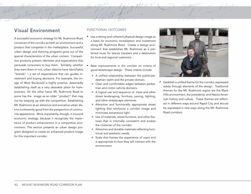
42 MOUNT RUSHMORE ROAD CORRIDOR PLAN
Visual EnvironmentA successful economic strategy for Mt. Rushmore Road
conceives of the corridor as both an environment and a
product that competes in the marketplace. Successful
urban design and theming programs grow out of the
special characteristics of the urban context. Competi-
tive products present identities and expectations that
persuade consumers to buy them. Similarly, whether
they want them or not, urban districts have identifiable
“brands” – a set of expectations that can guides in-
vestment and buying decisions. For example, the im-
age of West Boulevard is highly positive, deservedly
establishing itself as a very desirable place for hom-
eowners. On the other hand, Mt. Rushmore Road to
some has the image as an older “product” that may
not be keeping up with the competition. Establishing
Mt. Rushmore as an attractive and evocative urban dis-
trict is inherently good from the perspective of commu-
nity appearance. More importantly, though, it is sound
economic strategy, because it recognizes the impor-
tance of product enhancement in a competitive envi-
ronment. This section presents an urban design pro-
gram designed to create an enhanced product image
for this important corridor.
fUNCTiONAL OUTCOMES
Use a strong and coherent physical design image as ▪a basis for economic revitalization and investment along Mt. Rushmore Road. Create a design envi-ronment that establishes Mt. Rushmore as a pre-ferred route for leisure travelers and a destination for local and regional customers.
Base improvements in the corridor on criteria of ▪good streetscape design. These criteria include:
A unified relationship between the public/pe- »destrian realm and the private domain. Clear and comfortable edges between pedes- »trian and motor vehicle domains. A logical use and sequence of » trees and other street landscaping, furniture, paving, lighting, and other streetscape elements. Attractive and functionally appropriate street »lighting that reinforces a corridor image and minimizes extraneous light.Use of materials, street furniture, and other fea- »tures that is internally consistent and evokes the character of the corridor. Attractive and durable materials reflecting func- »tional and aesthetic needs.Scale that frames the experience of users and »is appropriate to how they will interact with the environment.
Establish a unified theme for the corridor, expressed ▪subtly through elements of the design. Traditional themes for the Mt. Rushmore region are the Black Hills environment, the presidents, and Native Amer-
ican history and culture. These themes are reflect-
ed in different ways around Rapid City and should
be expressed in new ways along the Mt. Rushmore
Road corridors.
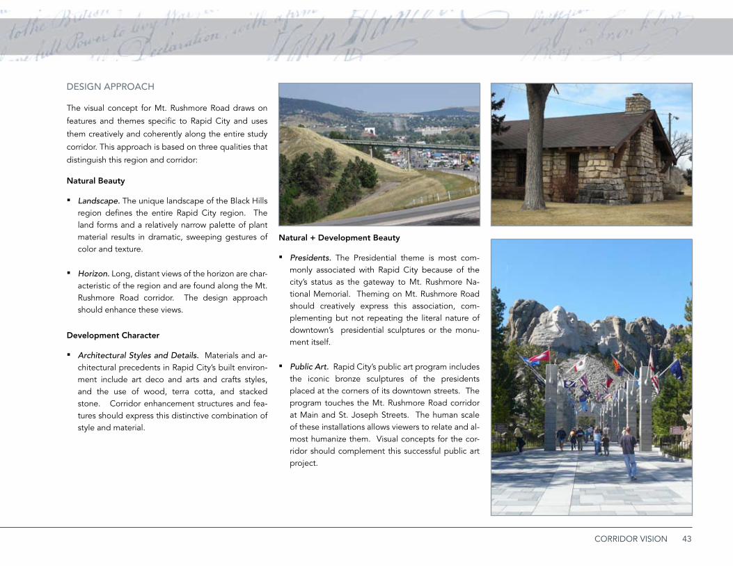
43CORRIDOR VISION
DESiGN APPROACh
The visual concept for Mt. Rushmore Road draws on
features and themes specific to Rapid City and uses
them creatively and coherently along the entire study
corridor. This approach is based on three qualities that
distinguish this region and corridor:
Natural Beauty
Landscape. ▪ The unique landscape of the Black Hills region defines the entire Rapid City region. The land forms and a relatively narrow palette of plant material results in dramatic, sweeping gestures of color and texture.
Horizon. ▪ Long, distant views of the horizon are char-acteristic of the region and are found along the Mt. Rushmore Road corridor. The design approach should enhance these views.
Development Character
Architectural Styles and Details. ▪ Materials and ar-chitectural precedents in Rapid City’s built environ-ment include art deco and arts and crafts styles, and the use of wood, terra cotta, and stacked stone. Corridor enhancement structures and fea-tures should express this distinctive combination of style and material.
Natural + Development Beauty
Presidents. ▪ The Presidential theme is most com-monly associated with Rapid City because of the city’s status as the gateway to Mt. Rushmore Na-tional Memorial. Theming on Mt. Rushmore Road should creatively express this association, com-plementing but not repeating the literal nature of downtown’s presidential sculptures or the monu-ment itself.
Public Art. ▪ Rapid City’s public art program includes the iconic bronze sculptures of the presidents placed at the corners of its downtown streets. The program touches the Mt. Rushmore Road corridor at Main and St. Joseph Streets. The human scale of these installations allows viewers to relate and al-most humanize them. Visual concepts for the cor-ridor should complement this successful public art project.
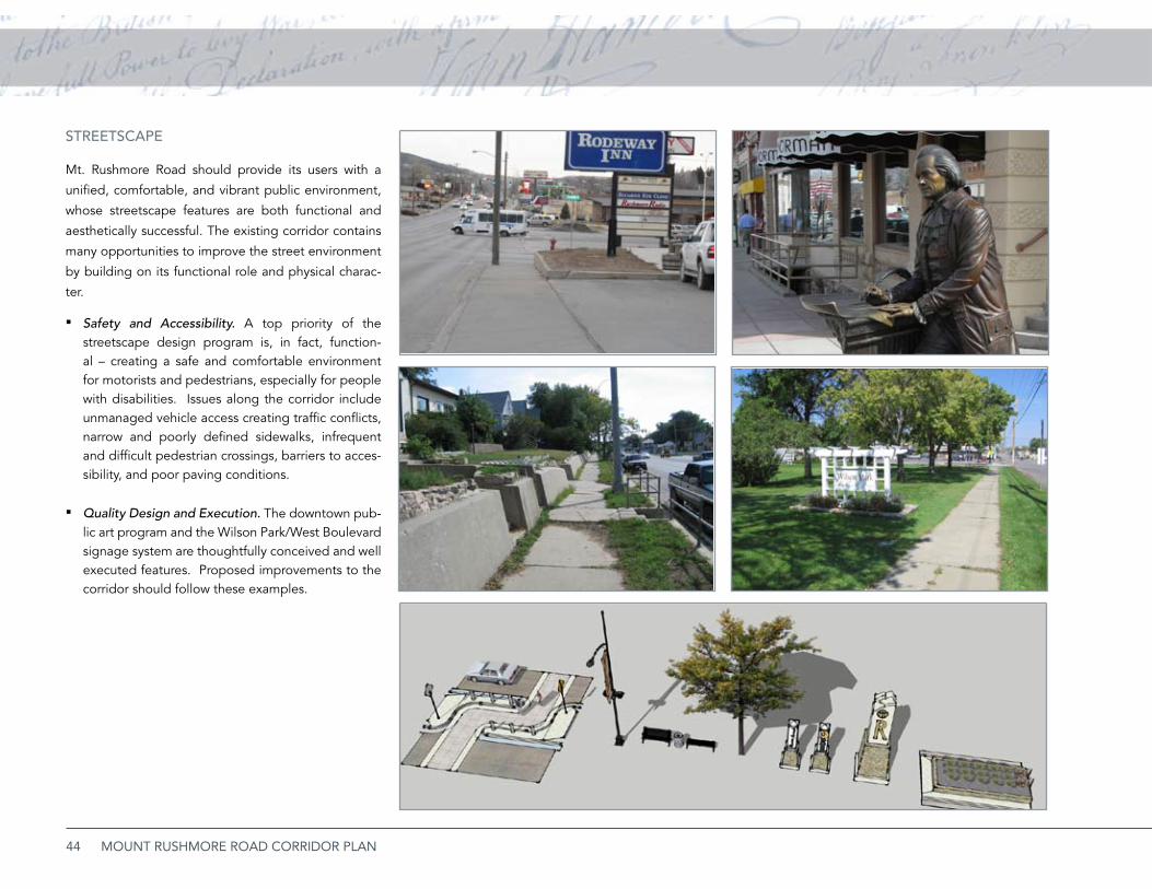
44 MOUNT RUSHMORE ROAD CORRIDOR PLAN
STREETSCAPE
Mt. Rushmore Road should provide its users with a
unified, comfortable, and vibrant public environment,
whose streetscape features are both functional and
aesthetically successful. The existing corridor contains
many opportunities to improve the street environment
by building on its functional role and physical charac-
ter.
Safety and Accessibility. ▪ A top priority of the streetscape design program is, in fact, function-al – creating a safe and comfortable environment for motorists and pedestrians, especially for people with disabilities. Issues along the corridor include unmanaged vehicle access creating traffic conflicts, narrow and poorly defined sidewalks, infrequent and difficult pedestrian crossings, barriers to acces-sibility, and poor paving conditions.
Quality Design and Execution. ▪ The downtown pub-lic art program and the Wilson Park/West Boulevard signage system are thoughtfully conceived and well executed features. Proposed improvements to the corridor should follow these examples.
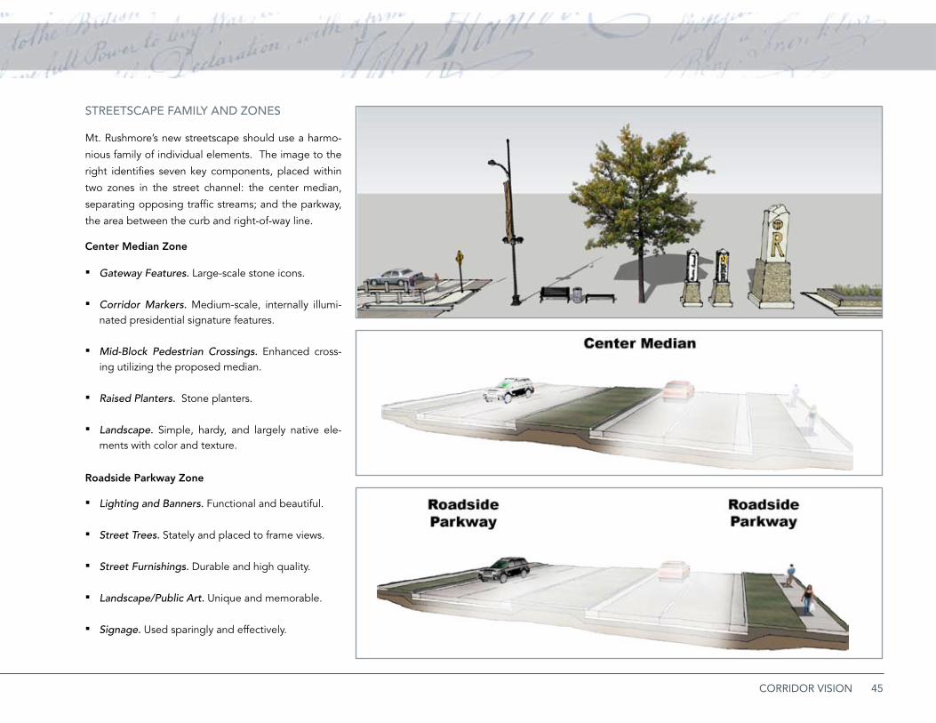
45CORRIDOR VISION
STREETSCAPE fAMiLy AND ZONES
Mt. Rushmore’s new streetscape should use a harmo-
nious family of individual elements. The image to the
right identifies seven key components, placed within
two zones in the street channel: the center median,
separating opposing traffic streams; and the parkway,
the area between the curb and right-of-way line.
Center Median Zone
Gateway Features. ▪ Large-scale stone icons.
Corridor Markers. ▪ Medium-scale, internally illumi-nated presidential signature features.
Mid-Block Pedestrian Crossings. ▪ Enhanced cross-ing utilizing the proposed median.
Raised Planters. ▪ Stone planters.
Landscape. ▪ Simple, hardy, and largely native ele-ments with color and texture.
Roadside Parkway Zone
Lighting and Banners. ▪ Functional and beautiful.
Street Trees. ▪ Stately and placed to frame views.
Street Furnishings. ▪ Durable and high quality.
Landscape/Public Art. ▪ Unique and memorable.
Signage. ▪ Used sparingly and effectively.
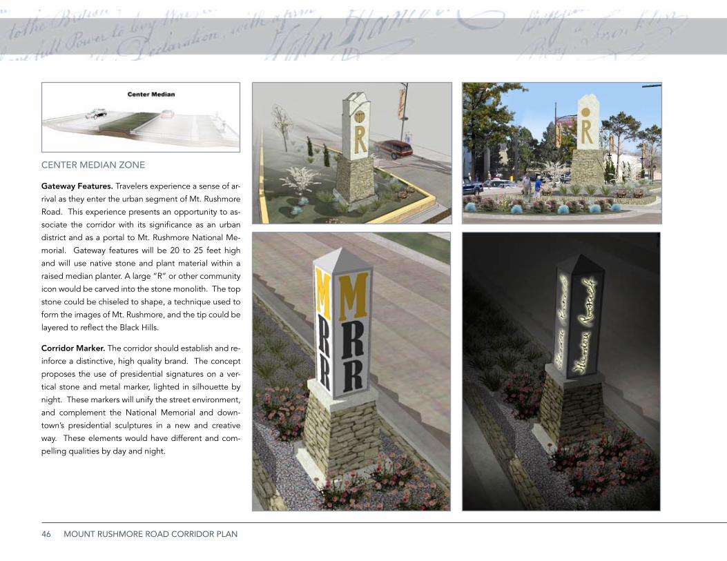
46 MOUNT RUSHMORE ROAD CORRIDOR PLAN
CENTER MEDiAN ZONE
Gateway Features. Travelers experience a sense of ar-
rival as they enter the urban segment of Mt. Rushmore
Road. This experience presents an opportunity to as-
sociate the corridor with its significance as an urban
district and as a portal to Mt. Rushmore National Me-
morial. Gateway features will be 20 to 25 feet high
and will use native stone and plant material within a
raised median planter. A large “R” or other community
icon would be carved into the stone monolith. The top
stone could be chiseled to shape, a technique used to
form the images of Mt. Rushmore, and the tip could be
layered to reflect the Black Hills.
Corridor Marker. The corridor should establish and re-
inforce a distinctive, high quality brand. The concept
proposes the use of presidential signatures on a ver-
tical stone and metal marker, lighted in silhouette by
night. These markers will unify the street environment,
and complement the National Memorial and down-
town’s presidential sculptures in a new and creative
way. These elements would have different and com-
pelling qualities by day and night.
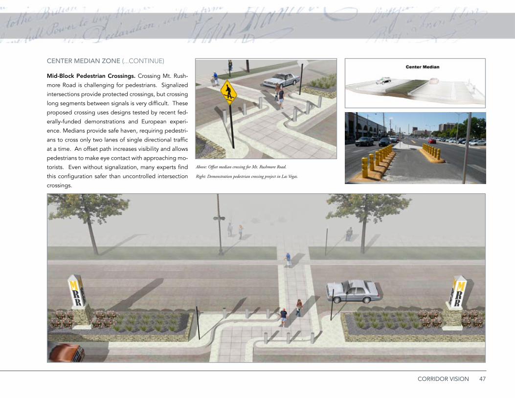
47CORRIDOR VISION
CENTER MEDiAN ZONE (...CoNTiNue)
Mid-Block Pedestrian Crossings. Crossing Mt. Rush-
more Road is challenging for pedestrians. Signalized
intersections provide protected crossings, but crossing
long segments between signals is very difficult. These
proposed crossing uses designs tested by recent fed-
erally-funded demonstrations and European experi-
ence. Medians provide safe haven, requiring pedestri-
ans to cross only two lanes of single directional traffic
at a time. An offset path increases visibility and allows
pedestrians to make eye contact with approaching mo-
torists. Even without signalization, many experts find
this configuration safer than uncontrolled intersection
crossings.
Above: Offset median crossing for Mt. Rushmore Road.
Right: Demonstration pedestrian crossing project in Las Vegas.
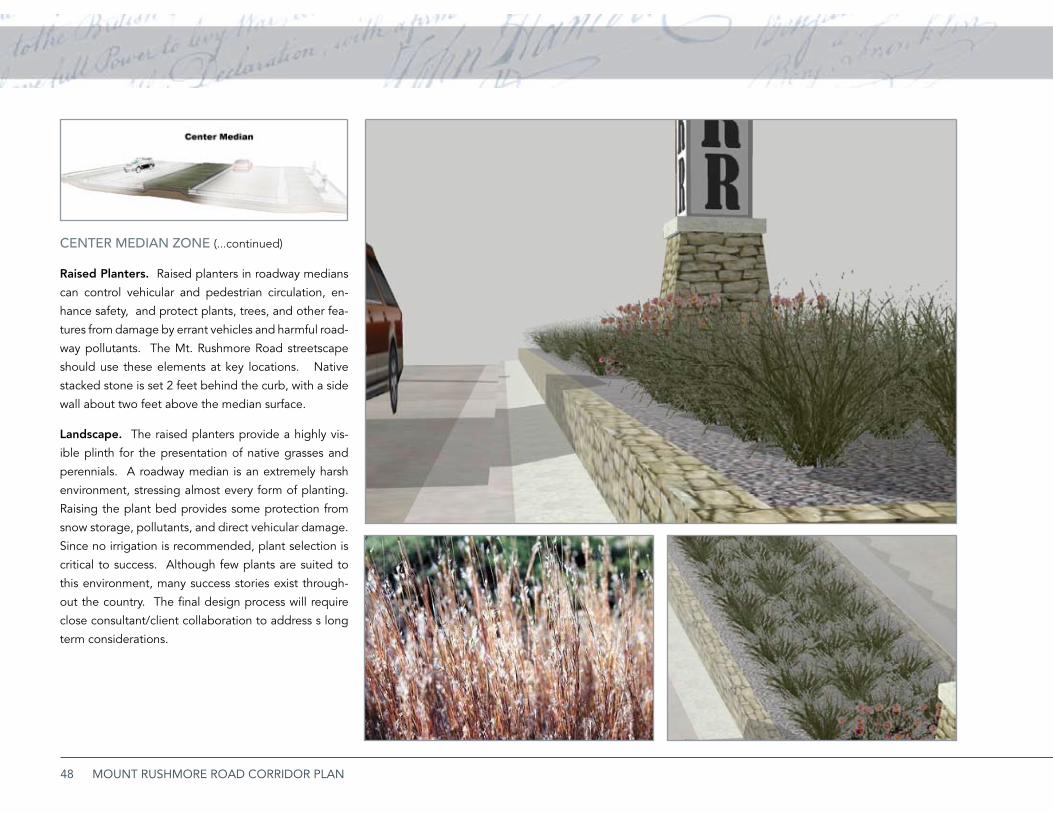
48 MOUNT RUSHMORE ROAD CORRIDOR PLAN
CENTER MEDiAN ZONE (...continued)
Raised Planters. Raised planters in roadway medians
can control vehicular and pedestrian circulation, en-
hance safety, and protect plants, trees, and other fea-
tures from damage by errant vehicles and harmful road-
way pollutants. The Mt. Rushmore Road streetscape
should use these elements at key locations. Native
stacked stone is set 2 feet behind the curb, with a side
wall about two feet above the median surface.
Landscape. The raised planters provide a highly vis-
ible plinth for the presentation of native grasses and
perennials. A roadway median is an extremely harsh
environment, stressing almost every form of planting.
Raising the plant bed provides some protection from
snow storage, pollutants, and direct vehicular damage.
Since no irrigation is recommended, plant selection is
critical to success. Although few plants are suited to
this environment, many success stories exist through-
out the country. The final design process will require
close consultant/client collaboration to address s long
term considerations.

49CORRIDOR VISION
ROADSiDE PARKWAy ZONE
Lighting. High efficiency LED roadway and pedestri-
an lighting is rapidly becoming feasible and cost effec-
tive and should be considered for installation. Poles
and fixtures should be simple and functional, and poles
should accommodate pedestrian-scaled, sidewalk side
fixtures. Detailed lighting calculations and studies will
determine the exact spacing of roadway standards and
the need for supplemental pedestrian light poles and
fixtures between the roadway lamps.
Presidential Banners. Presidents literally left their
“mark” on the office with their signatures. The sig-
natures provide both literal associations and an ab-
stract pattern that expresses the presidential theme
and celebrates all 42 signatures in a new and colorful
way. Banners or panels would be designed as unrolled
parchments, mounted to streetlights or poles.
Many communities and districts use banners as a cost
effective way to reinforce a brand or message. Banners
may be either permanent or change with new arrange-
ments or special messages. Advances in materials and
fabrication are leading to greater use of permanent
panels.

50 MOUNT RUSHMORE ROAD CORRIDOR PLAN
ROADSiDE PARKWAy ZONE (...continued)
Street Trees. Mt. Rushmore Road today lacks a signifi-
cant street tree canopy. Studies indicate many bene-
fits of street trees, including traffic calming. Currently,
overhead utilities limit the placement of trees on the
west side. If lines were relocated, large canopy spe-
cies should be integrated into the roadside parkway
between lighting and curb cuts.
Signage. Signs on Mt. Rushmore Road include flashing
lights, electronic marquees, and backlit panels. Com-
puterized electronic billboards are receiving greater
use, but present significant problems, including neigh-
borhood impacts, conflicts with traffic signals, and the
ability to distract motorists and hold their attention lon-
ger than conventional signs. New sign regulations for
the corridor should be developed that:
Provide a maximum sign budget for each property •
based on the amount of frontage along Mt. Rush-
more Road.
Encourage low-level, ground or monument signs •
over high pole signs.
Restrict placement of conventional and electron-•
ic billboards. Future use of billboards, especially
video billboards, should be prohibited.
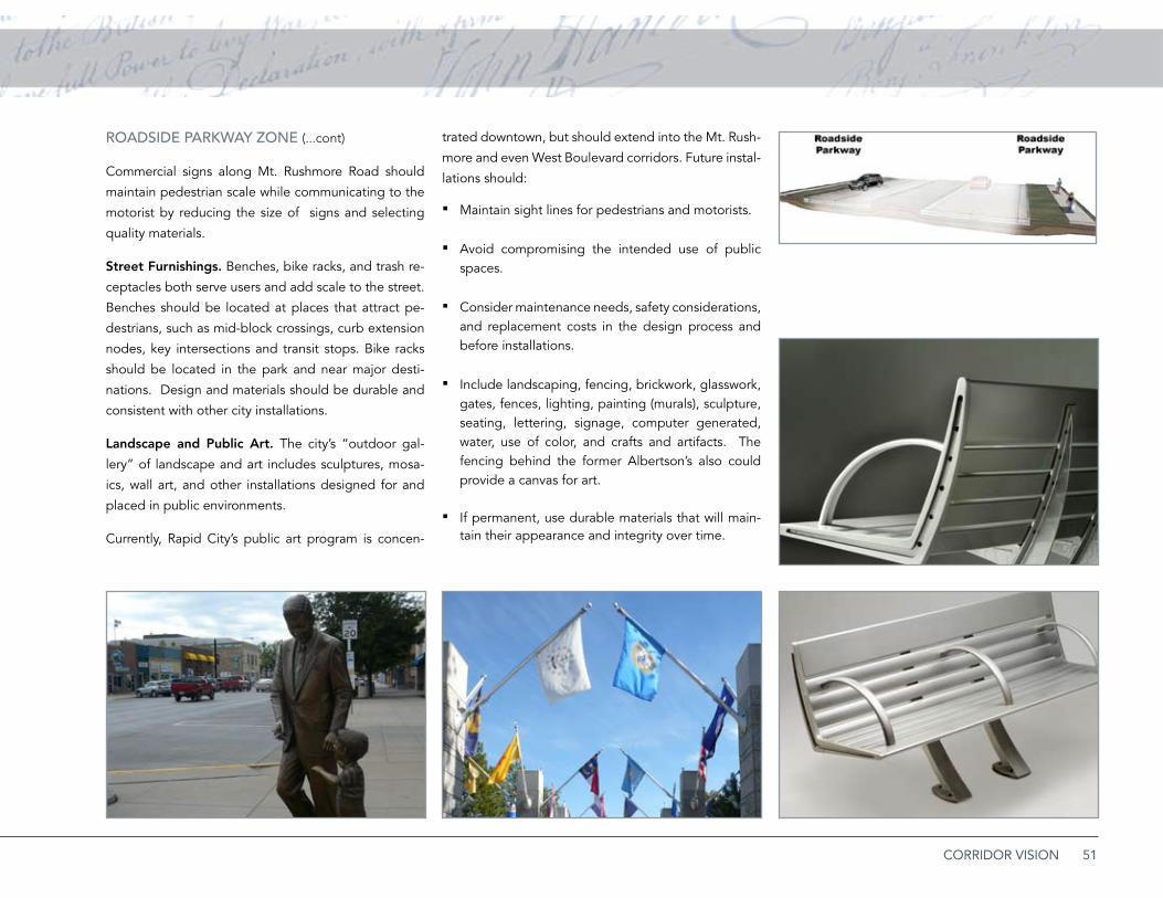
51CORRIDOR VISION
ROADSiDE PARKWAy ZONE (...cont)
Commercial signs along Mt. Rushmore Road should
maintain pedestrian scale while communicating to the
motorist by reducing the size of signs and selecting
quality materials.
Street Furnishings. Benches, bike racks, and trash re-
ceptacles both serve users and add scale to the street.
Benches should be located at places that attract pe-
destrians, such as mid-block crossings, curb extension
nodes, key intersections and transit stops. Bike racks
should be located in the park and near major desti-
nations. Design and materials should be durable and
consistent with other city installations.
Landscape and Public Art. The city’s “outdoor gal-
lery” of landscape and art includes sculptures, mosa-
ics, wall art, and other installations designed for and
placed in public environments.
Currently, Rapid City’s public art program is concen-
trated downtown, but should extend into the Mt. Rush-
more and even West Boulevard corridors. Future instal-
lations should:
Maintain sight lines for pedestrians and motorists. ▪
Avoid compromising the intended use of public ▪spaces.
Consider maintenance needs, ▪ safety considerations, and replacement costs in the design process and before installations.
Include ▪ landscaping, fencing, brickwork, glasswork, gates, fences, lighting, painting (murals), sculpture, seating, lettering, signage, computer generated, water, use of color, and crafts and artifacts. The fencing behind the former Albertson’s also could provide a canvas for art.
If permanent, use durable materials that will main- ▪tain their appearance and integrity over time.
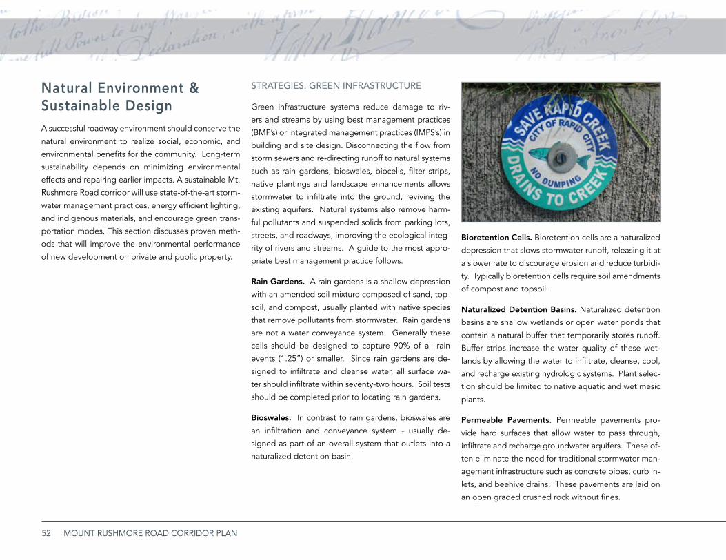
52 MOUNT RUSHMORE ROAD CORRIDOR PLAN
Natural Environment & Sustainable DesignA successful roadway environment should conserve the
natural environment to realize social, economic, and
environmental benefits for the community. Long-term
sustainability depends on minimizing environmental
effects and repairing earlier impacts. A sustainable Mt.
Rushmore Road corridor will use state-of-the-art storm-
water management practices, energy efficient lighting,
and indigenous materials, and encourage green trans-
portation modes. This section discusses proven meth-
ods that will improve the environmental performance
of new development on private and public property.
STRATEGiES: GREEN iNfRASTRUCTURE
Green infrastructure systems reduce damage to riv-
ers and streams by using best management practices
(BMP’s) or integrated management practices (IMPS’s) in
building and site design. Disconnecting the flow from
storm sewers and re-directing runoff to natural systems
such as rain gardens, bioswales, biocells, filter strips,
native plantings and landscape enhancements allows
stormwater to infiltrate into the ground, reviving the
existing aquifers. Natural systems also remove harm-
ful pollutants and suspended solids from parking lots,
streets, and roadways, improving the ecological integ-
rity of rivers and streams. A guide to the most appro-
priate best management practice follows.
Rain Gardens. A rain gardens is a shallow depression
with an amended soil mixture composed of sand, top-
soil, and compost, usually planted with native species
that remove pollutants from stormwater. Rain gardens
are not a water conveyance system. Generally these
cells should be designed to capture 90% of all rain
events (1.25”) or smaller. Since rain gardens are de-
signed to infiltrate and cleanse water, all surface wa-
ter should infiltrate within seventy-two hours. Soil tests
should be completed prior to locating rain gardens.
Bioswales. In contrast to rain gardens, bioswales are
an infiltration and conveyance system - usually de-
signed as part of an overall system that outlets into a
naturalized detention basin.
Bioretention Cells. Bioretention cells are a naturalized
depression that slows stormwater runoff, releasing it at
a slower rate to discourage erosion and reduce turbidi-
ty. Typically bioretention cells require soil amendments
of compost and topsoil.
Naturalized Detention Basins. Naturalized detention
basins are shallow wetlands or open water ponds that
contain a natural buffer that temporarily stores runoff.
Buffer strips increase the water quality of these wet-
lands by allowing the water to infiltrate, cleanse, cool,
and recharge existing hydrologic systems. Plant selec-
tion should be limited to native aquatic and wet mesic
plants.
Permeable Pavements. Permeable pavements pro-
vide hard surfaces that allow water to pass through,
infiltrate and recharge groundwater aquifers. These of-
ten eliminate the need for traditional stormwater man-
agement infrastructure such as concrete pipes, curb in-
lets, and beehive drains. These pavements are laid on
an open graded crushed rock without fines.
53CORRIDOR VISION
Specific types of porous pavements include:
Porous asphalt and porous concrete, open-graded ▪surfaces with a reduced quantity of fines. They al-low water to flow through the surface texture into the sub-base where it is stored, conveyed and in-filtrated.
Permeable pavers, pre-cast concrete unit pavers ▪that typically have a joint filled with crushed clean rock chips, allowing water to flow through into the sub base.
Green Roofs. Green roofs (also known as roof top gar-
dens, and vegetated roof systems) are on-site systems
designed to retain, slow, cool, and cleanse rainwater
falling on the roof of a building. Green roofs can be
retrofitted for existing buildings and should be encour-
aged in new developments. Typically the roof tops are
planted with drought tolerant plant species in an engi-
neered soil. Rooftop soil is lightweight, containing a
large quantity of pumice (or similar material) and com-
post that holds water in the medium and drains slowly.
This allows water to evaporate into the atmosphere,
reducing peak flows in urban streams and mitigating
the urban heat island effect. Different types of green
roof systems include:
Extensive green roofs, typically designed with 2-4” ▪of engineered soil, and planted with only the hardi-est vegetation.
Semi-intensive green roofs, usually with 4-8” of en- ▪gineered soil. When an engineered soil medium of
six inches or more is used, choice of plants dramati-cally increases. Ornamental grasses and many her-baceous perennials may be included in the planting palette.
Intensive green roofs usually have more than 8” of ▪engineered soil. These are often plazas and other areas carrying a heavy design load.
Green roofs also protect the roof, insulate, and en-
hance HVAC (Heating Ventilation and Air Conditioning)
systems. Green roofs have been proven to triple the
lifetime of the roofing system, cutting down on long
term building costs while adding an ecological benefit.
The insulating capabilities reduce heat loss and cool air
before it enters the HVAC systems.
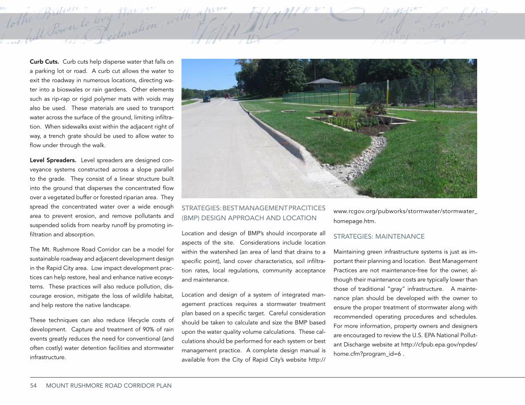
54 MOUNT RUSHMORE ROAD CORRIDOR PLAN
Curb Cuts. Curb cuts help disperse water that falls on
a parking lot or road. A curb cut allows the water to
exit the roadway in numerous locations, directing wa-
ter into a bioswales or rain gardens. Other elements
such as rip-rap or rigid polymer mats with voids may
also be used. These materials are used to transport
water across the surface of the ground, limiting infiltra-
tion. When sidewalks exist within the adjacent right of
way, a trench grate should be used to allow water to
flow under through the walk.
Level Spreaders. Level spreaders are designed con-
veyance systems constructed across a slope parallel
to the grade. They consist of a linear structure built
into the ground that disperses the concentrated flow
over a vegetated buffer or forested riparian area. They
spread the concentrated water over a wide enough
area to prevent erosion, and remove pollutants and
suspended solids from nearby runoff by promoting in-
filtration and absorption.
The Mt. Rushmore Road Corridor can be a model for
sustainable roadway and adjacent development design
in the Rapid City area. Low impact development prac-
tices can help restore, heal and enhance native ecosys-
tems. These practices will also reduce pollution, dis-
courage erosion, mitigate the loss of wildlife habitat,
and help restore the native landscape.
These techniques can also reduce lifecycle costs of
development. Capture and treatment of 90% of rain
events greatly reduces the need for conventional (and
often costly) water detention facilities and stormwater
infrastructure.
STRATEGiES: bEST MANAGEMENT PRACiTiCES (bMP) DESiGN APPROACh AND LOCATiON
Location and design of BMP’s should incorporate all
aspects of the site. Considerations include location
within the watershed (an area of land that drains to a
specific point), land cover characteristics, soil infiltra-
tion rates, local regulations, community acceptance
and maintenance.
Location and design of a system of integrated man-
agement practices requires a stormwater treatment
plan based on a specific target. Careful consideration
should be taken to calculate and size the BMP based
upon the water quality volume calculations. These cal-
culations should be performed for each system or best
management practice. A complete design manual is
available from the City of Rapid City’s website http://
www.rcgov.org/pubworks/stormwater/stormwater_
homepage.htm.
STRATEGiES: MAiNTENANCE
Maintaining green infrastructure systems is just as im-
portant their planning and location. Best Management
Practices are not maintenance-free for the owner, al-
though their maintenance costs are typically lower than
those of traditional “gray” infrastructure. A mainte-
nance plan should be developed with the owner to
ensure the proper treatment of stormwater along with
recommended operating procedures and schedules.
For more information, property owners and designers
are encouraged to review the U.S. EPA National Pollut-
ant Discharge website at http://cfpub.epa.gov/npdes/
home.cfm?program_id=6 .
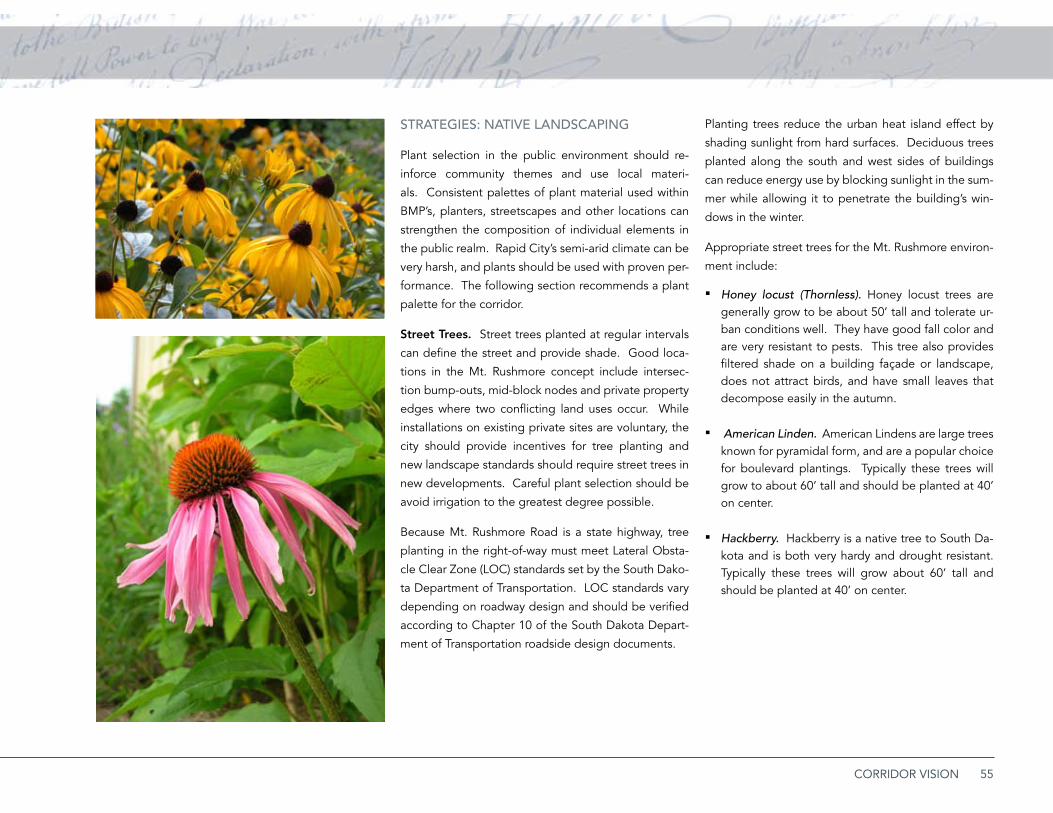
55CORRIDOR VISION
STRATEGiES: NATivE LANDSCAPiNG
Plant selection in the public environment should re-
inforce community themes and use local materi-
als. Consistent palettes of plant material used within
BMP’s, planters, streetscapes and other locations can
strengthen the composition of individual elements in
the public realm. Rapid City’s semi-arid climate can be
very harsh, and plants should be used with proven per-
formance. The following section recommends a plant
palette for the corridor.
Street Trees. Street trees planted at regular intervals
can define the street and provide shade. Good loca-
tions in the Mt. Rushmore concept include intersec-
tion bump-outs, mid-block nodes and private property
edges where two conflicting land uses occur. While
installations on existing private sites are voluntary, the
city should provide incentives for tree planting and
new landscape standards should require street trees in
new developments. Careful plant selection should be
avoid irrigation to the greatest degree possible.
Because Mt. Rushmore Road is a state highway, tree
planting in the right-of-way must meet Lateral Obsta-
cle Clear Zone (LOC) standards set by the South Dako-
ta Department of Transportation. LOC standards vary
depending on roadway design and should be verified
according to Chapter 10 of the South Dakota Depart-
ment of Transportation roadside design documents.
Planting trees reduce the urban heat island effect by
shading sunlight from hard surfaces. Deciduous trees
planted along the south and west sides of buildings
can reduce energy use by blocking sunlight in the sum-
mer while allowing it to penetrate the building’s win-
dows in the winter.
Appropriate street trees for the Mt. Rushmore environ-
ment include:
Honey locust (Thornless). ▪ Honey locust trees are generally grow to be about 50’ tall and tolerate ur-ban conditions well. They have good fall color and are very resistant to pests. This tree also provides filtered shade on a building façade or landscape, does not attract birds, and have small leaves that decompose easily in the autumn.
American Linden. ▪ American Lindens are large trees known for pyramidal form, and are a popular choice for boulevard plantings. Typically these trees will grow to about 60’ tall and should be planted at 40’ on center.
Hackberry. ▪ Hackberry is a native tree to South Da-kota and is both very hardy and drought resistant. Typically these trees will grow about 60’ tall and should be planted at 40’ on center.
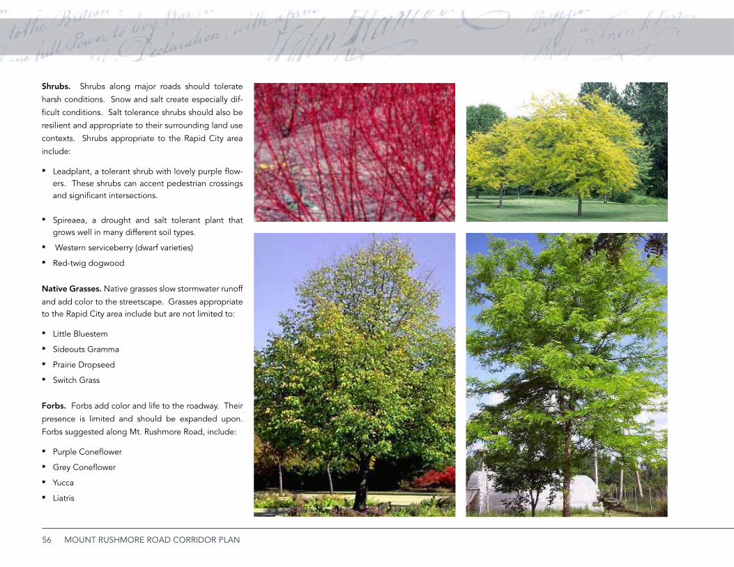
56 MOUNT RUSHMORE ROAD CORRIDOR PLAN
Shrubs. Shrubs along major roads should tolerate
harsh conditions. Snow and salt create especially dif-
ficult conditions. Salt tolerance shrubs should also be
resilient and appropriate to their surrounding land use
contexts. Shrubs appropriate to the Rapid City area
include:
Leadplant, a tolerant shrub with lovely purple flow- ▪ers. These shrubs can accent pedestrian crossings and significant intersections.
Spireaea, a drought and salt tolerant plant that ▪grows well in many different soil types.
Western serviceberry (dwarf varieties) ▪Red-twig dogwood ▪
Native Grasses. Native grasses slow stormwater runoff
and add color to the streetscape. Grasses appropriate to the Rapid City area include but are not limited to:
Little Bluestem ▪Sideouts Gramma ▪Prairie Dropseed ▪Switch Grass ▪
Forbs. Forbs add color and life to the roadway. Their
presence is limited and should be expanded upon.
Forbs suggested along Mt. Rushmore Road, include:
P ▪ urple Coneflower
Grey Coneflower ▪Yucca ▪Liatris ▪
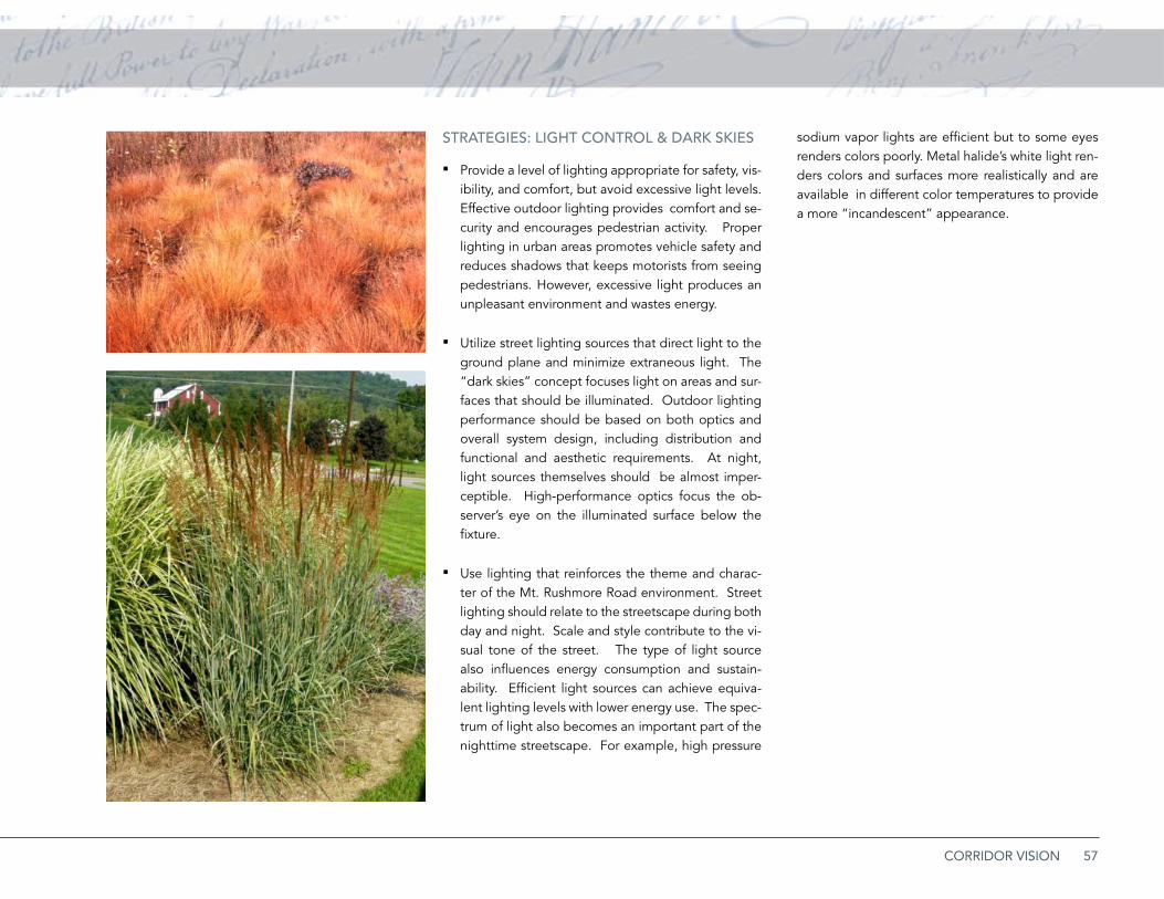
57CORRIDOR VISION
STRATEGiES: LiGhT CONTROL & DARK SKiES
Provide a level of lighting appropriate for safety, vis- ▪ibility, and comfort, but avoid excessive light levels. Effective outdoor lighting provides comfort and se-curity and encourages pedestrian activity. Proper lighting in urban areas promotes vehicle safety and reduces shadows that keeps motorists from seeing pedestrians. However, excessive light produces an unpleasant environment and wastes energy.
Utilize street lighting sources that direct light to the ▪ground plane and minimize extraneous light. The “dark skies” concept focuses light on areas and sur-faces that should be illuminated. Outdoor lighting performance should be based on both optics and overall system design, including distribution and functional and aesthetic requirements. At night, light sources themselves should be almost imper-ceptible. High-performance optics focus the ob-server’s eye on the illuminated surface below the fixture.
Use lighting that reinforces the theme and charac- ▪ter of the Mt. Rushmore Road environment. Street lighting should relate to the streetscape during both day and night. Scale and style contribute to the vi-sual tone of the street. The type of light source also influences energy consumption and sustain-ability. Efficient light sources can achieve equiva-lent lighting levels with lower energy use. The spec-trum of light also becomes an important part of the nighttime streetscape. For example, high pressure
sodium vapor lights are efficient but to some eyes renders colors poorly. Metal halide’s white light ren-ders colors and surfaces more realistically and are available in different color temperatures to provide a more “incandescent” appearance.
58 MOUNT RUSHMORE ROAD CORRIDOR PLAN
Development ConceptThe vision for the Mt. Rushmore Road corridor and
its environs emerges by combining Goals and corri-
dor development with the Environments. Describ-
ing improvements is approached by focusing on six
diverse zones, including:
1. Downtown Core
2. Mixed Use
3. Commercial Corridor
4. Services Fringe
5. Historic West Boulevard
6. East Neighborhood
Components for each zone is described by stating
the goals and issues then identifying specific im-
provement projects by the public and private sec-
tors.
Goals. ▪ A statement of the desirable outcome for the zone.
Issues. ▪ Key issues that present challenges to the segment.
Public Improvements. ▪ Describing in more detail, projects or actions that need to be pursued by the community.
Private Investments. ▪ Projects that could be de-veloped by the private market.
Mixed Use
Downtown Core
59CORRIDOR VISION
Services FringeCommercial Corridor
East Neighborhood
Historic West Boulevard
60 MOUNT RUSHMORE ROAD CORRIDOR PLAN
PUbLiC iMPROvEMENTS
Streetscape. ▪ Streetcsape features presented in the previous section begin along this segment of Mt. Rushmore Road. These features include street-lights, public art, medians, and landscaping.
Presidential Plazas. ▪ Intersections along Mt. Rush-more Road should accommodate future placement of public art.
Alleyway Utilities. ▪ If feasible, bury utility lines as they cross Mt. Rushmore Road. The lines crossing between St. Joseph and Main Streets should be a priority
Screening and Omaha Street Enhancements. ▪ Land-scaped screening should be provided along Omaha Street near ACE Home Center and along the rear of the former Albertson’s site.
Directional Information. ▪ New directional informa-tion and visual cues should clearly direct visitors to US 16 south.
Pedestrian Crossing. ▪ A better pedestrian crossing across Omaha Street and near downtown will con-nect both Downtown and the bicycle boulevard sys-tem proposed for the Mt. Rushmore Road planning area to the primary Rapid Creek trail. This greatly increases bicycle and pedestrian continuity.
1. Downtown CoreThis area includes the area north of Columbus Street
to the beginning of Interstate 190.
GOALS
Establish a gateway to both Downtown and the •
Mt. Rushmore Road corridor.
Increase clarity of traffic movements and reduce •
traveler confusion on arrival to Rapid City.
Extend the downtown streetscape enhancement •
program to Mt. Rushmore Road.
iSSUES
Traffic Movements1. . The southbound I-190 ramp
and US 16 wayfinders align motorists with West
Boulevard. US 16 then shifts east along St. Joseph
Street to Mt. Rushmore Road. Southbound ravel-
ers frequently miss this turn, continuing into the
residential West Boulevard Historic District.
Streetscape2. . The design of the public environ-
ment from block to block is inconsistent and con-
fusing.
Vacant Property/Buildings. 3. A strategic site on
the northeast corner of Columbus Street and Mt.
Rushmore Road is vacant.
Utilities.4. Major power transmission lines run
along alleys between Kansas City Street and Main
Street.
Pedestrian and Trail Access5. . Omaha Street is a
busy corridor that becomes a significant obsta-
cle for pedestrians and cyclists trying to cross be-
tween downtown and the community trail.
Screening. Vacant sites, fences, parking lots, or 6.
back building walls front along Mt. Rushmore
Road without screening.
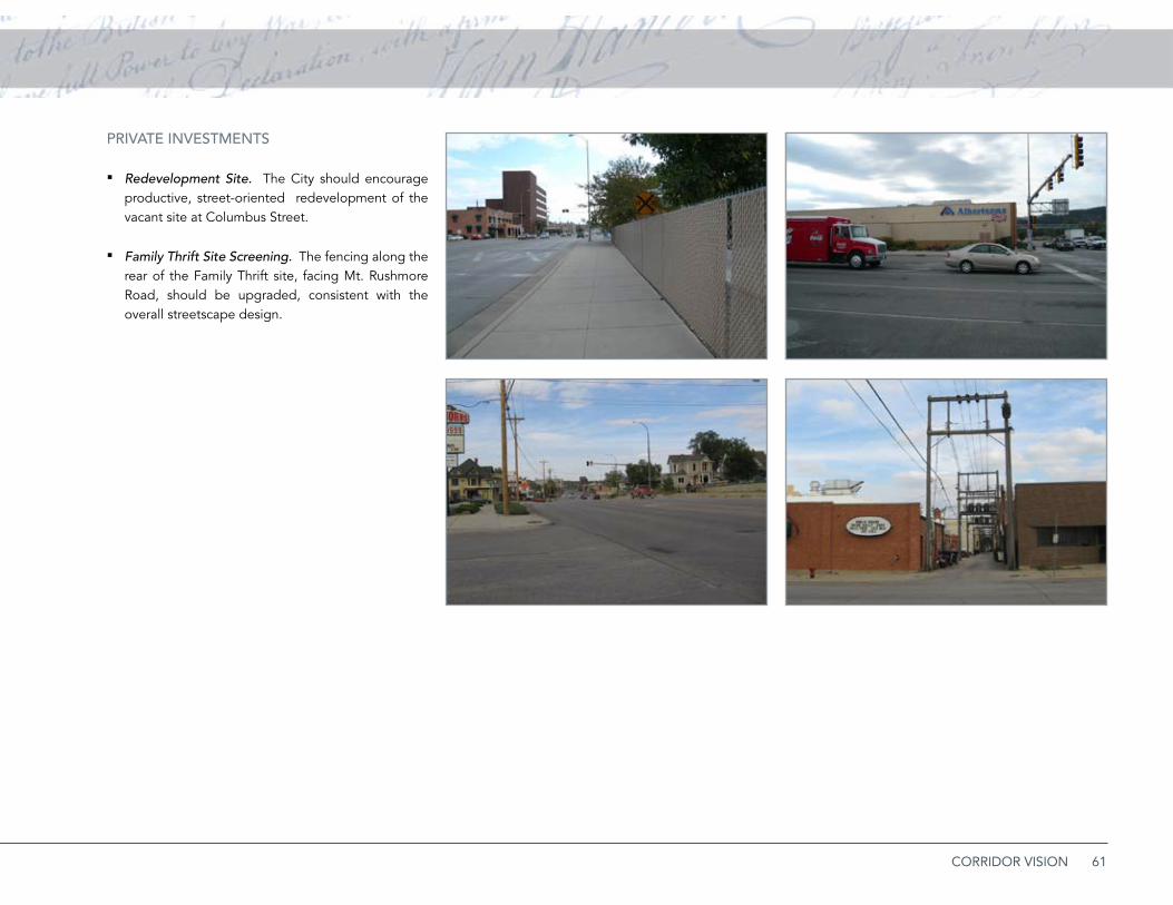
61CORRIDOR VISION
PRivATE iNvESTMENTS
Redevelopment Site. ▪ The City should encourage productive, street-oriented redevelopment of the vacant site at Columbus Street.
Family Thrift Site Screening. ▪ The fencing along the rear of the Family Thrift site, facing Mt. Rushmore Road, should be upgraded, consistent with the overall streetscape design.
PLACEHOLDER
Issues

62 MOUNT RUSHMORE ROAD CORRIDOR PLAN
Roadway Lighting
Signalized Intersection
Gateway Monument Feature
Corridor Marker or Public Art Opportunitiy
Street Tree
Ornamental Tree
Bicycle Blvd or Route
Pedestrian Crossings
Existing Building
Proposed Redevelopment
Speed Table
CORRIDOR LEGEND
Roadway Lighting
Signalized Intersection
Corridor Monument Feature
Gateway/Art/Sculpture Opportunity
Street Tree
CORRIDOR LEGEND LOCATION MAP
Ornamental Tree
Bicycle Blvd or Route
Pedestrian Crossings
Existing Building
Proposed Redevelopment
16
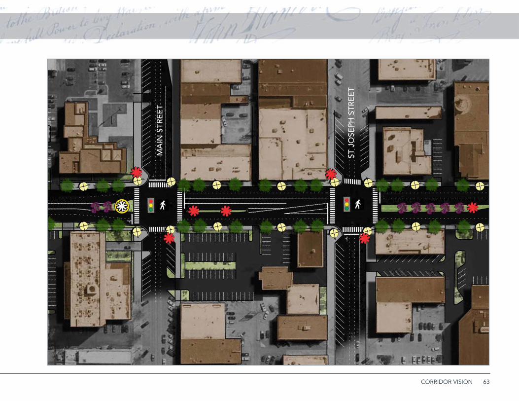
63CORRIDOR VISION

64 MOUNT RUSHMORE ROAD CORRIDOR PLAN
Roadway Lighting
Signalized Intersection
Gateway Monument Feature
Corridor Marker or Public Art Opportunitiy
Street Tree
Ornamental Tree
Bicycle Blvd or Route
Pedestrian Crossings
Existing Building
Proposed Redevelopment
Speed Table
CORRIDOR LEGEND
Roadway Lighting
Signalized Intersection
Corridor Monument Feature
Gateway/Art/Sculpture Opportunity
Street Tree
CORRIDOR LEGEND LOCATION MAP
Ornamental Tree
Bicycle Blvd or Route
Pedestrian Crossings
Existing Building
Proposed Redevelopment
16

65CORRIDOR VISION
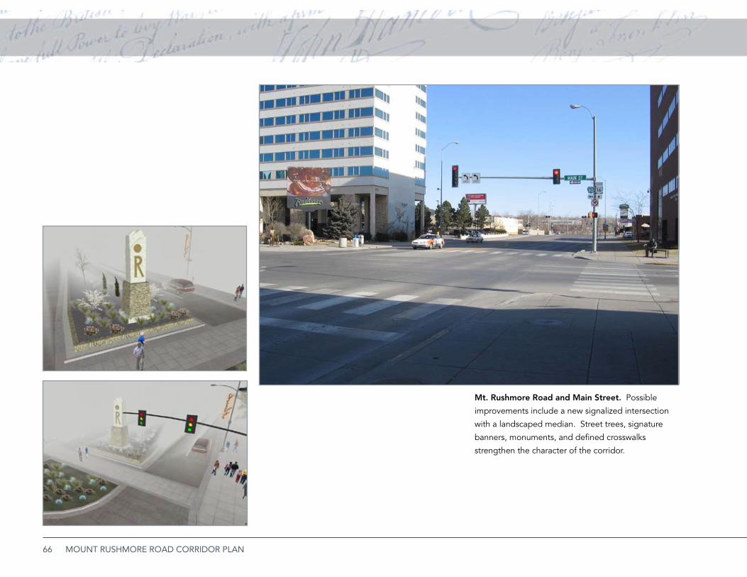
66 MOUNT RUSHMORE ROAD CORRIDOR PLAN
Mt. Rushmore Road and Main Street. Possible
improvements include a new signalized intersection
with a landscaped median. Street trees, signature
banners, monuments, and defined crosswalks
strengthen the character of the corridor.
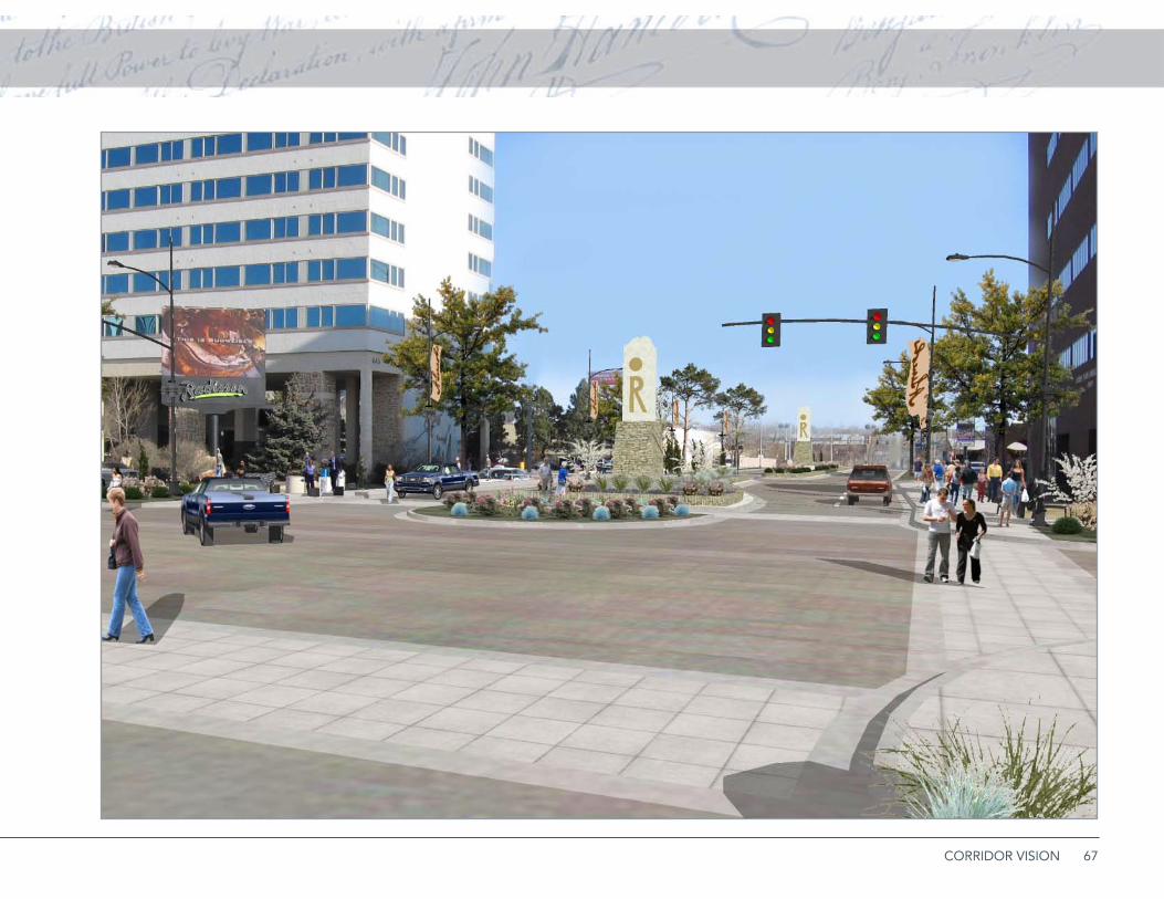
67CORRIDOR VISION
68 MOUNT RUSHMORE ROAD CORRIDOR PLAN
2. Mixed UseThis segment between Quincy and St. Andrew
Streets is the most distinctive part of the Mt. Rushmore
corridor, featuring a mix of residential, commercial, and
office uses; historic buildings; and a pedestrian-scaled
cityscape. This area has some overlap with the Down-
town Core and Commercial Corridor.
GOALS
Encourage adaptive reuse of existing building in •
coordinated, high quality projects.
Provide a green cityscape in the transition be-•
tween Downtown and more automobile-oriented
segments to the south.
Improve traffic management and pedestrian safe-•
ty.
iSSUES
Parking1. . Parking is critical for this urban corridor
segment. Off-street parking is inconvenient and
not immediately visible, and existing on-street
parking increases traffic conflicts.
Deteriorating retaining walls, fencing and railing.2.
Cruising3. . Night-time cruising , once an issue along
Mt. Rushmore Road and in the adjacent West Bou-
levard neighborhood, has apparently been re-
duced when northbound left turns off Mt. Rush-
more were prohibited.
Street clutter4. . Overhead wires and poorly located
poles create visual clutter along the street.
Pedestrian movements. 5. The current sidewalk is
narrow and obstructed. Short retaining walls at
street level force people to walk in the street and
poles mounted in the sidewalk reduce clearance.
PUbLiC iMPROvEMENTS
Raised Landscaped Median with left turn lanes at ▪intersections. These medians control unnecessary and sometimes illegal turns and improve the ap-pearance and function of the street.
Streetlights with signature banners. ▪
New retaining wall and planters and street-level ▪sidewalk between South and Clark Streets. This east side sidewalk is elevated above street level by a low retaining wall and is not accessible. Remov-al of little-used on-street parking allows a generous tree lawn, sidewalk at street level, and new planters. This encourages the mixed use village concept out-lined below and enhances both the streetscape and a row of architecturally distinctive buildings.
Cooperative Parking. ▪ Combining adjacent parking lots increase the supply and efficiency of parking. This will require cooperation among private busi-ness/property owners and the City. Redirecting Ful-ton Street at the Mt. Rushmore intersection discour-ages possible cruising.
Remove No Left-Turn Poles. ▪ Removing these in-stallations will reduce visual clutter and confusing signage.
Parking Streets and Replacement of On-Street ▪Parking. The half-blocks west of Mt. Rushmore along Clark, Fairview, and Franklin Streets should be converted to parking streets, as described in the previous section. This eliminates the need for on-street parking and provides buffers for adjacent
69CORRIDOR VISION
residential areas. Replacement of on-street parking provides space for landscaping and more comfort-able sidewalks.
Clark Street Right-in Right-out. ▪ A new right-in right-out median could be placed at Clark Street to control turning movements.
PRivATE iNvESTMENTS
Mixed-Use Village. 1. The row of historic along the
east side of Mt. Rushmore Road between South
and Clark should be restored for either continued
residential use or new office or commercial uses.
This concept would connect the houses with a
garden path and provide private parking behind
the buildings. Stairways would connect the private
and public paths.
Parking Alley. 2. An improved alley with head-
in parking behind the mixed-use village would
improve accessibility and efficiency of parking. A
slight shift of the alley to the west provides space
for a new development project on the south end
of the block.
Clark Street Redevelopment Project.3. The existing
distressed apartment building off Clark Street
would be replaced by a new residential project,
potentially a new townhouse row with lower-level
garages and upper-level walk-outs with excellent
views to the west.
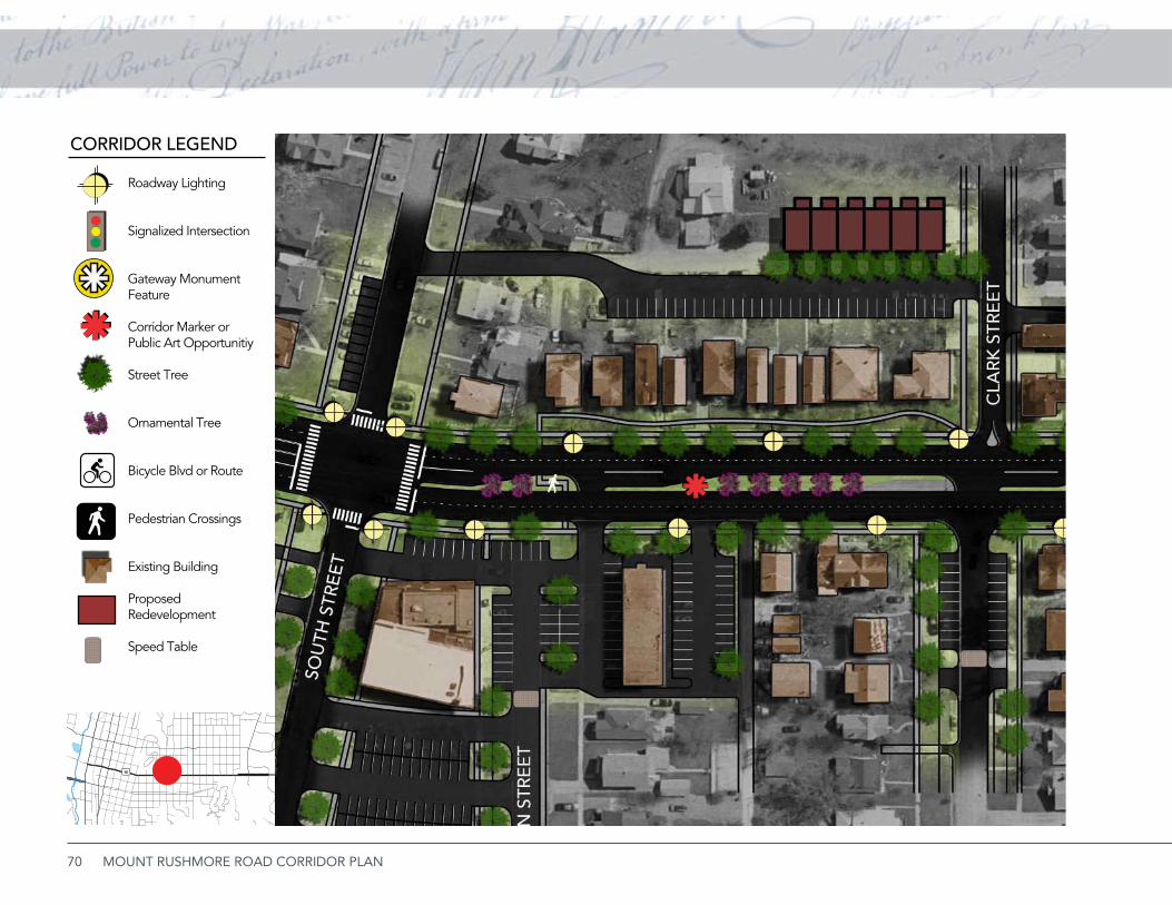
70 MOUNT RUSHMORE ROAD CORRIDOR PLAN
Roadway Lighting
Signalized Intersection
Gateway Monument Feature
Corridor Marker or Public Art Opportunitiy
Street Tree
Ornamental Tree
Bicycle Blvd or Route
Pedestrian Crossings
Existing Building
Proposed Redevelopment
Speed Table
CORRIDOR LEGEND
Roadway Lighting
Signalized Intersection
Corridor Monument Feature
Gateway/Art/Sculpture Opportunity
Street Tree
CORRIDOR LEGEND LOCATION MAP
Ornamental Tree
Bicycle Blvd or Route
Pedestrian Crossings
Existing Building
Proposed Redevelopment
16
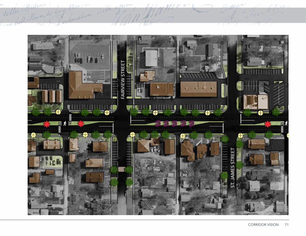
71CORRIDOR VISION
72 MOUNT RUSHMORE ROAD CORRIDOR PLAN
Roadway Lighting
Signalized Intersection
Gateway Monument Feature
Corridor Marker or Public Art Opportunitiy
Street Tree
Ornamental Tree
Bicycle Blvd or Route
Pedestrian Crossings
Existing Building
Proposed Redevelopment
Speed Table
CORRIDOR LEGEND
Roadway Lighting
Signalized Intersection
Corridor Monument Feature
Gateway/Art/Sculpture Opportunity
Street Tree
CORRIDOR LEGEND LOCATION MAP
Ornamental Tree
Bicycle Blvd or Route
Pedestrian Crossings
Existing Building
Proposed Redevelopment
16
73CORRIDOR VISION
74 MOUNT RUSHMORE ROAD CORRIDOR PLAN
Parking street concept. The half-block of Clark
Street west of Mt. Rushmore Road would be
redesigned to include on-street parking for adjacent
properties, improved crosswalks for pedestrians, and
speed tables for the neighborhood.
75CORRIDOR VISION
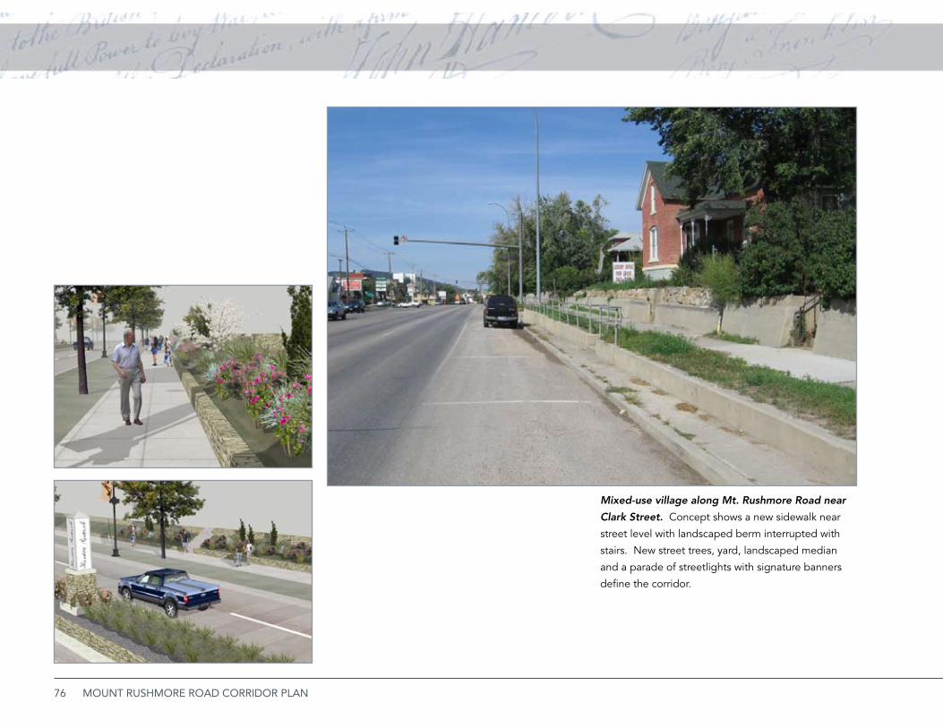
76 MOUNT RUSHMORE ROAD CORRIDOR PLAN
Mixed-use village along Mt. Rushmore Road near
Clark Street. Concept shows a new sidewalk near
street level with landscaped berm interrupted with
stairs. New street trees, yard, landscaped median
and a parade of streetlights with signature banners
define the corridor.
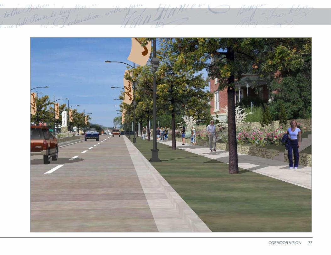
77CORRIDOR VISION
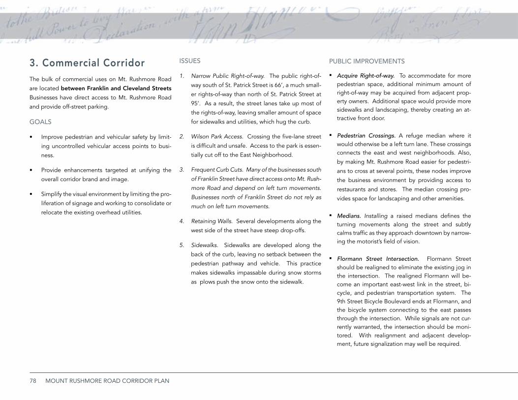
78 MOUNT RUSHMORE ROAD CORRIDOR PLAN
3. Commercial Corridor The bulk of commercial uses on Mt. Rushmore Road
are located between Franklin and Cleveland Streets
Businesses have direct access to Mt. Rushmore Road
and provide off-street parking.
GOALS
Improve pedestrian and vehicular safety by limit-•
ing uncontrolled vehicular access points to busi-
ness.
Provide enhancements targeted at unifying the •
overall corridor brand and image.
Simplify the visual environment by limiting the pro-•
liferation of signage and working to consolidate or
relocate the existing overhead utilities.
iSSUES
Narrow Public Right-of-way.1. The public right-of-
way south of St. Patrick Street is 66’, a much small-
er rights-of-way than north of St. Patrick Street at
95’. As a result, the street lanes take up most of
the rights-of-way, leaving smaller amount of space
for sidewalks and utilities, which hug the curb.
Wilson Park Access2. . Crossing the five-lane street
is difficult and unsafe. Access to the park is essen-
tially cut off to the East Neighborhood.
Frequent Curb Cuts. Many of the businesses south 3.
of Franklin Street have direct access onto Mt. Rush-
more Road and depend on left turn movements.
Businesses north of Franklin Street do not rely as
much on left turn movements.
Retaining Walls. 4. Several developments along the
west side of the street have steep drop-offs.
Sidewalks. 5. Sidewalks are developed along the
back of the curb, leaving no setback between the
pedestrian pathway and vehicle. This practice
makes sidewalks impassable during snow storms
as plows push the snow onto the sidewalk.
PUbLiC iMPROvEMENTS
Acquire Right-of-way. ▪ To accommodate for more pedestrian space, additional minimum amount of right-of-way may be acquired from adjacent prop-erty owners. Additional space would provide more sidewalks and landscaping, thereby creating an at-tractive front door.
Pedestrian Crossings. ▪ A refuge median where it would otherwise be a left turn lane. These crossings connects the east and west neighborhoods. Also,
by making Mt. Rushmore Road easier for pedestri-
ans to cross at several points, these nodes improve
the business environment by providing access to
restaurants and stores. The median crossing pro-
vides space for landscaping and other amenities.
Medians. ▪ Installing a raised medians defines the turning movements along the street and subtly calms traffic as they approach downtown by narrow-ing the motorist’s field of vision.
Flormann Street Intersection. ▪ Flormann Street should be realigned to eliminate the existing jog in the intersection. The realigned Flormann will be-come an important east-west link in the street, bi-cycle, and pedestrian transportation system. The 9th Street Bicycle Boulevard ends at Flormann, and the bicycle system connecting to the east passes through the intersection. While signals are not cur-rently warranted, the intersection should be moni-tored. With realignment and adjacent develop-ment, future signalization may well be required.

79CORRIDOR VISION
PRivATE iNvESTMENTS
Landscaping. ▪ Front yard landscape improvements for many commercial businesses need to be imple-mented. Adding life and color to this harsh environ-ment will help unify existing established open spac-es including Wilson Park.
Redevelopment Near Safeway. ▪ The Safeway park-ing lot appears to be underused and could support additional development. An emerging develop-ment pattern throughout the country is taking out-lying parking areas adjacent to the street and con-verting it to developable property.
Shared Parking. ▪ At several locations throughout this segment of the corridor, parking and access ef-ficiency could be improved by consolidating access points and sharing access across lot lines.
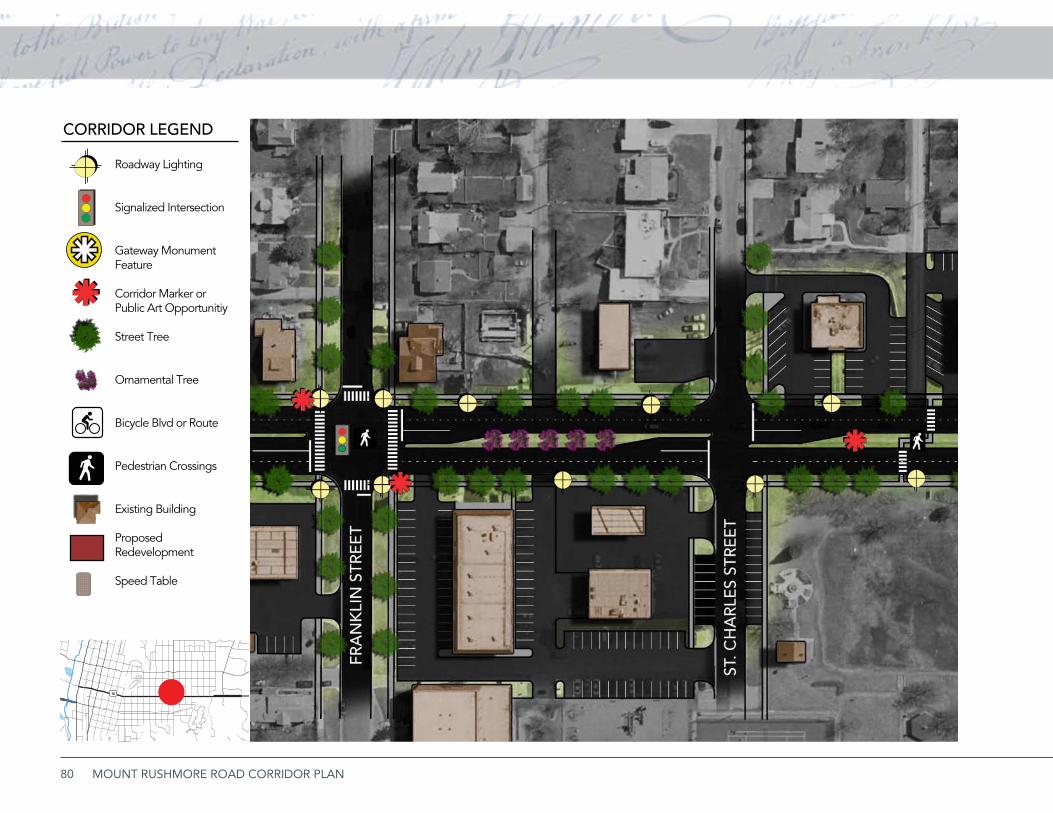
80 MOUNT RUSHMORE ROAD CORRIDOR PLAN
Roadway Lighting
Signalized Intersection
Gateway Monument Feature
Corridor Marker or Public Art Opportunitiy
Street Tree
Ornamental Tree
Bicycle Blvd or Route
Pedestrian Crossings
Existing Building
Proposed Redevelopment
Speed Table
CORRIDOR LEGEND
Roadway Lighting
Signalized Intersection
Corridor Monument Feature
Gateway/Art/Sculpture Opportunity
Street Tree
CORRIDOR LEGEND LOCATION MAP
Ornamental Tree
Bicycle Blvd or Route
Pedestrian Crossings
Existing Building
Proposed Redevelopment
16

81CORRIDOR VISION
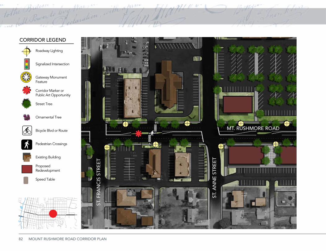
82 MOUNT RUSHMORE ROAD CORRIDOR PLAN
Roadway Lighting
Signalized Intersection
Gateway Monument Feature
Corridor Marker or Public Art Opportunitiy
Street Tree
Ornamental Tree
Bicycle Blvd or Route
Pedestrian Crossings
Existing Building
Proposed Redevelopment
Speed Table
CORRIDOR LEGEND
Roadway Lighting
Signalized Intersection
Corridor Monument Feature
Gateway/Art/Sculpture Opportunity
Street Tree
CORRIDOR LEGEND LOCATION MAP
Ornamental Tree
Bicycle Blvd or Route
Pedestrian Crossings
Existing Building
Proposed Redevelopment
16

83CORRIDOR VISION
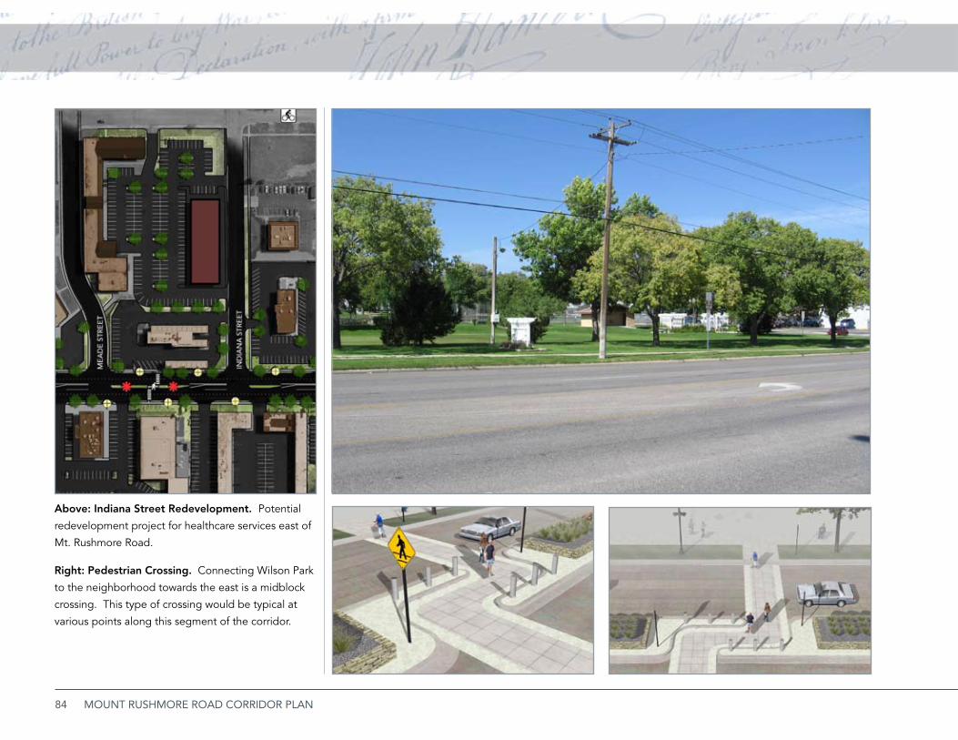
84 MOUNT RUSHMORE ROAD CORRIDOR PLAN
Right: Pedestrian Crossing. Connecting Wilson Park
to the neighborhood towards the east is a midblock
crossing. This type of crossing would be typical at
various points along this segment of the corridor.
Above: Indiana Street Redevelopment. Potential
redevelopment project for healthcare services east of
Mt. Rushmore Road.
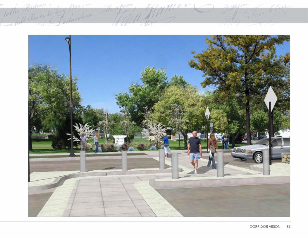
85CORRIDOR VISION
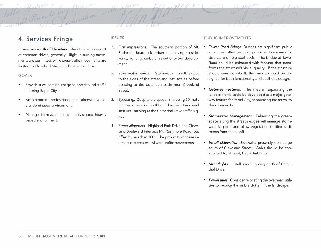
86 MOUNT RUSHMORE ROAD CORRIDOR PLAN
4. Services FringeBusinesses south of Cleveland Street share access off
of common drives, generally. Right-in turning move-
ments are permitted, while cross-traffic movements are
limited to Cleveland Street and Cathedral Drive.
GOALS
Provide a welcoming image to northbound traffic •
entering Rapid City.
Accommodate pedestrians in an otherwise vehic-•
ular dominated environment.
Manage storm water in this steeply sloped, heavily •
paved environment.
iSSUES
First impressions1. . The southern portion of Mt.
Rushmore Road lacks urban feel, having no side-
walks, lighting, curbs or street-oriented develop-
ment.
Stormwater runoff.2. Stormwater runoff slopes
to the sides of the street and into swales before
ponding at the detention basin near Cleveland
Street.
Speeding3. . Despite the speed limit being 35 mph,
motorists traveling northbound exceed the speed
limit until arriving at the Cathedral Drive traffic sig-
nal.
Street alignment.4. Highland Park Drive and Cleve-
land Boulevard intersect Mt. Rushmore Road, but
offset by less than 100’. The proximity of these in-
tersections creates awkward traffic movements.
PUbLiC iMPROvEMENTS
Tower Road Bridge. ▪ Bridges are significant public structures, often becoming icons and gateways for districts and neighborhoods. The bridge at Tower Road could be enhanced with features that trans-forms the structure’s visual quality. If the structure should ever be rebuilt, the bridge should be de-signed for both functionality and aesthetic design.
Gateway Features. ▪ The median separating the lanes of traffic could be developed as a major gate-way feature for Rapid City, announcing the arrival to the community.
Stormwater Management. ▪ Enhancing the green-space along the street’s edges will manage storm-water’s speed and allow vegetation to filter sedi-ments from the runoff.
Install sidewalks. ▪ Sidewalks presently do not go south of Cleveland Street. Walks should be con-structed to, at least, Cathedral Drive.
Streetlights. ▪ Install street lighting north of Cathe-dral Drive.
Power lines. ▪ Consider relocating the overhead utili-ties to reduce the visible clutter in the landscape.
87CORRIDOR VISION
PRivATE iNvESTMENTS
Shared Parking. ▪ At several locations throughout this segment of the corridor, parking and access ef-ficiency could be improved by consolidating access points and sharing access across lot lines.
Landscaping. ▪ Overstory tree placed along this seg-ment of the corridor both in the R.O.W. and the pri-vate property will frame views of the distant hori-zons both to the south and to the north.
88 MOUNT RUSHMORE ROAD CORRIDOR PLAN
Roadway Lighting
Signalized Intersection
Gateway Monument Feature
Corridor Marker or Public Art Opportunitiy
Street Tree
Ornamental Tree
Bicycle Blvd or Route
Pedestrian Crossings
Existing Building
Proposed Redevelopment
Speed Table
CORRIDOR LEGEND
Roadway Lighting
Signalized Intersection
Corridor Monument Feature
Gateway/Art/Sculpture Opportunity
Street Tree
CORRIDOR LEGEND LOCATION MAP
Ornamental Tree
Bicycle Blvd or Route
Pedestrian Crossings
Existing Building
Proposed Redevelopment
16
89CORRIDOR VISION
90 MOUNT RUSHMORE ROAD CORRIDOR PLAN
Roadway Lighting
Signalized Intersection
Gateway Monument Feature
Corridor Marker or Public Art Opportunitiy
Street Tree
Ornamental Tree
Bicycle Blvd or Route
Pedestrian Crossings
Existing Building
Proposed Redevelopment
Speed Table
CORRIDOR LEGEND
Roadway Lighting
Signalized Intersection
Corridor Monument Feature
Gateway/Art/Sculpture Opportunity
Street Tree
CORRIDOR LEGEND LOCATION MAP
Ornamental Tree
Bicycle Blvd or Route
Pedestrian Crossings
Existing Building
Proposed Redevelopment
16
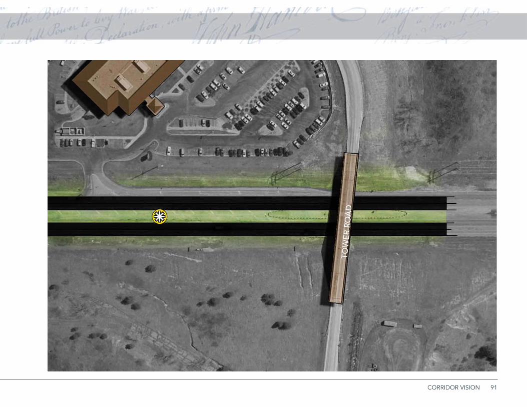
91CORRIDOR VISION
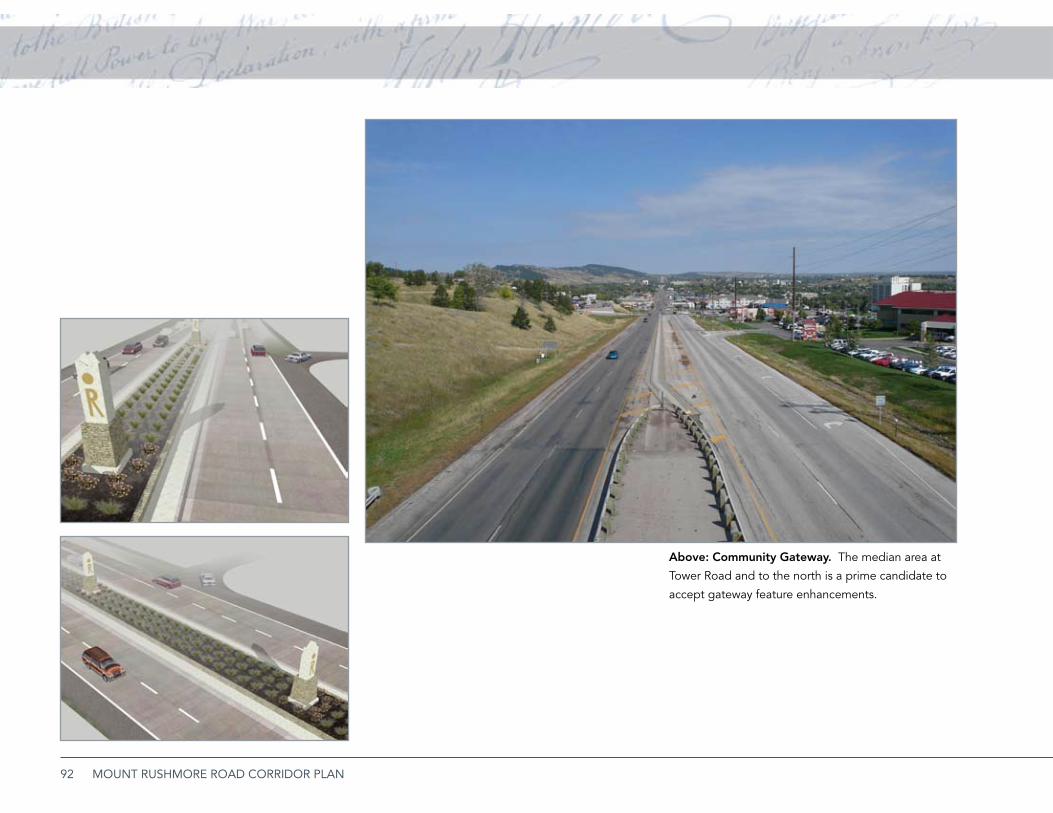
92 MOUNT RUSHMORE ROAD CORRIDOR PLAN
Above: Community Gateway. The median area at
Tower Road and to the north is a prime candidate to
accept gateway feature enhancements.
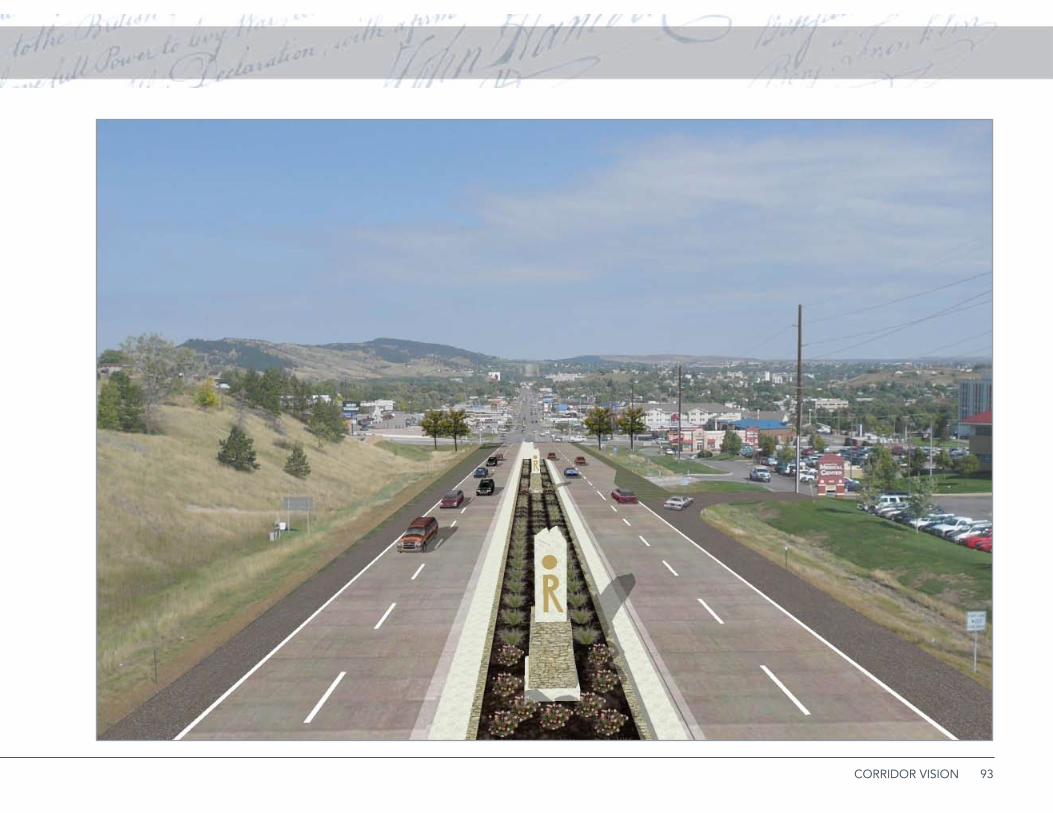
93CORRIDOR VISION
94 MOUNT RUSHMORE ROAD CORRIDOR PLAN
5. Historic West BoulevardObJECTivE
Maintain the integrity of the West Boulevard •
neighborhood and its historic district.
Establish a defensible edge between the commer-•
cial and mixed use environment of Mt. Rushmore
Road and the quiet residential environment of the
West Boulevard neighborhood. This may involve
creating a neighborhood conservation overlay
zone, discussed in more detail in this section.
Prevent unwanted commercial and traveler traffic •
from encroaching into the neighborhood.
Provide walking and bicycle connections between •
the neighborhood and retailers and services along
Mt. Rushmore Road.
iSSUES
Traffic Encroachment. 1. Because the southbound
I-190 ramp aligns with West Boulevard, some
travelers mistakenly continue south of St. Joseph
Street into the residential area. In addition, com-
mercial traffic along Mt. Rushmore sometimes uses
residential streets for parking and circulation.
Land Use Conflicts and Transitions. 2. Residential
buildings along Mt. Rushmore Road have con-
verted to non-residential uses, a logical and sup-
portable transition if managed. However, some
pressure has built to extend office and commercial
uses to the west, and poorly buffered boundaries
between commercial and residential uses threaten
the quality of the eastern edge of the neighbor-
hood.
Connections. 3. East-west streets should provide
desirable connections from neighborhood resi-
dents to commercial services along Mt. Rushmore
Road. These include good accommodations for
pedestrians and cyclists making short trips to Mt.
Rushmore destinations.
PUbLiC ACTiONS
Adopt protective zoning regulations and design ▪guidelines. The Development and Neighborhood Environment section (page 35) recommends adop-tion of a special development overlay district for the Mt. Rushmore Road study area. The provisions of this district will manage the limit of expanding non-residential land uses, establish buffer and screening standards, include design standards and operation-al standards to prevent negative impact on the resi-dential neighborhood.
This zoning concept includes the following key pro-visions:
Flexibility to permit limited mixed uses be- »tween Mt. Rushmore Road and 9th Street. Lim-ited office uses, subject to specific controls, may be developed west to 9th Street. In addi-tion, unified mixed use projects could incorpo-rate the full block between Mt. Rushmore and 9th Street, provided that non-residential uses are capped at a specific percentage (such as 20%) of the land and/or floor area between the east alley and 9th Street.Design guidelines for non-residential conver- »sions or new projects within the mixed use zone, as discussed in the Development and Neigh-borhood Environment section of this plan.Design review and approval requirements for »all projects within the Overlay District, including modifications or widenings to public streets.No direct visibility of parking lots, loading ar- »eas, or other areas with significant visual or en-vironmental impact from residential uses in the
95CORRIDOR VISION
overlay district.Landscaping and buffering requirements be- »tween residential and non-residential uses, ex-cept internally within planned mixed use devel-opments.
Manage traffic encroachments with directional in- ▪formation and visual cues at the St. Joseph and West Boulevard intersection; the use of parking streets and curb extensions at alleys; and traffic calming techniques to discourage commercial traffic from using neighborhood streets.
Develop 9th Street as a “bicycle boulevard.” ▪ The adaptation of 9th Street to provide a bicycle-friend-ly environment between Kansas City and Flormann Streets will provide good north-south connectivity and further calm motor vehicle traffic. Bicycle lanes, where provided, should provide adequate clear-ance to permit cyclists to ride in the lane on a line clear of opening car doors.
Median enhancements. ▪ Landscaping, markers, and monuments along West Boulevard and in its medi-an will sustain the value of this distinctive street.
Stormwater Management. ▪ The City should up-grade storm water management systems to inter-cept runoff from the west.
96 MOUNT RUSHMORE ROAD CORRIDOR PLAN
iSSUES
Parking and commercial encroachment east from 1.
Mt. Rushmore Road. In common with the other
side of the street, commercial uses and their ef-
fects have a tendency to spread out from the ma-
jor commercial corridor. However, the lack of a
defining alley complicates this problem, because
these land use transitions do not have a logical
edge. As a result, unmanaged parking extensions
and service areas have a tendency to blight adja-
cent residential areas.
Housing deterioration. 2. Some housing, including
multifamily buildings adjacent to the commercial
edge are, in fact, deteriorating.
Redevelopment sites and underused properties. 3.
Several areas on the east side of Mt. Rushmore
provide significant opportunities for residential
and office/commercial redevelopment.
PUbLiC ACTiONS
Adopt protective zoning regulations and design ▪guidelines. The Development and Neighborhood Environment section (page 35) recommends adop-tion of a special development overlay district for the Mt. Rushmore Road study area. The provisions of this district will manage the limit of expanding non-residential land uses, establish buffer and screening standards, include design standards and operation-al standards to prevent negative impact on the resi-dential neighborhood.
Housing code enforcement and rehabilitation. ▪Property maintenance code enforcement can help reduce blighting influences, when combined with a program to upgrade the eastern edges of commer-cial properties.
Site redevelopment. ▪ City policy should encourage redevelopment of several key sites in the neighbor-hood east of Mt. Rushmore Road. These sites in-clude the multifamily building north of Clark Street, and enhanced office development along the 7th Street corridor.
Greater ease of crossing Mt. Rushmore Road. ▪ Pe-destrian crossings and improvements proposed by this plan can link neighborhood amenities such as Wilson Park and the elementary school to the east neighborhood, increasing its value and access to services and amenities.
6. East NeighborhoodObJECTivE
Maintain the integrity of the West Boulevard •
neighborhood and its historic district.
Establish a “defensible transition” between the •
commercial and mixed use environment of Mt.
Rushmore Road and the quiet residential environ-
ment of the West Boulevard neighborhood.
Prevent unwanted commercial and traveler traffic •
from encroaching into the neighborhood.
Provide walking and bicycle paths between the •
neighborhood and retailers/services along Mt.
Rushmore Road.
97IMPLEMENTING THE VISION
Implementing the Vision
This plan’s goal and commitment is to provide Rapid City with a real (rather than theoretical or utopian) vision and plan for the Mt. Rushmore Road corridor.
CH
APT
ER 4
98 MOUNT RUSHMORE ROAD CORRIDOR PLAN
Initial PoliciesAMEND ZONiNG ORDiNANCE & ADOPT DESiGN GUiDELiNES
The project area has several issues relating to appro-
priate uses, zoning and design. Zoning establishes
land use controls, while Design Guidelines provides
advisory, or perhaps mandatory, restrictions and re-
quirements on the performance of the property. Both
zoning and design guidelines are discussed in the De-
velopment & Neighborhood Environment beginning
on page 35.
ESTAbLiSh A bUSiNESS iMPROvEMENT DiS-TRiCT (biD)
The plan addresses organizational issues for corridor
management and promotion. Some commercial strips
are envisioning themselves as Business Improvement
Districts, much as traditional neighborhood and town
centers have since the initiation of the tool in the late
1970s. An example of such a district that is analogous
to Mt. Rushmore Road is the South Locust corridor in
Grand Island, Nebraska. Here, as part of a corridor
reconstruction project, the city’s redevelopment
authority created a tax increment district to finance
landscaping, lighting, and corridor enhancements.
Businesses created a Business Improvement District
to finance some of the capital costs and to maintain
the enhanced streetscape. Property owners elected to
participate in a Business Improvement District to share
the cost of maintenance. This unified approach has
paid off in a vastly improved physical and business
construction cost of eligible road construction ac-
tivities. The eligible construction activities typically
include roadway surfacing, traffic signals and asso-
ciated roadway items. Construction activities that
are typically not eligible for federal transportation
funding include city water/sewer utilities and other
items not essential to providing a transportation fa-
cility. To secure funding, the Rapid City Area Met-
ropolitan Planning Organization and South Dako-
ta Department of Transportation must coordinate
with each other to determine South Dakota Depart-
ment of Transportation funding priority, amount of
funding available, eligible costs, and what year that
funding would be available. Federal transportation
funding is typically programmed 3 to 5 years out,
so funding for any new projects is typically available
three or more years in the future. Once the fund-
ing is identified, the project must be included in the
Rapid City Area Metropolitan Planning Organization
Transportation Improvement Program (TIP) and the
State Transportation Improvement Program (STIP).
environment that has generated substantial new
development.
FinancingThis section considers the costs of specific
recommendations and the entire public improvement
program; the benefits quantified by development
value; and a specific financing program. The Private
Utilities column includes burying the power and
telecommunication main line and service lines. A 15%
contingency is considered in the probable cost.
fUNDiNG SOURCES
Federal Transportation Funding. ▪ Mt. Rushmore
Road is functionally classified as a Principal Arterial,
and is therefore may be eligible for federal trans-
portation funding assistance through the South Da-
kota Department of Transportation. The federal
funding assistance may provide up to 80% of the
South Locust corridor in Grand Island, Nebraska used both a TIF district and a BID to develop and maintain right-of-way enhancements.
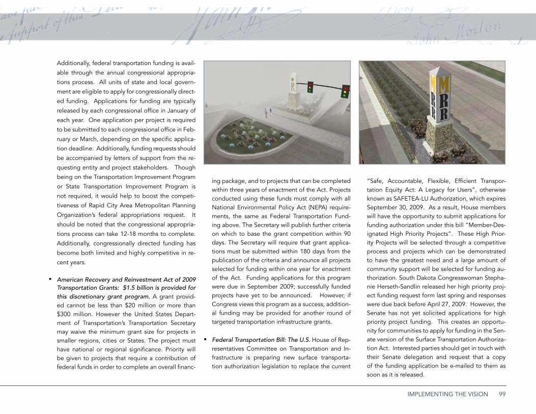
99IMPLEMENTING THE VISION
Additionally, federal transportation funding is avail-
able through the annual congressional appropria-
tions process. All units of state and local govern-
ment are eligible to apply for congressionally direct-
ed funding. Applications for funding are typically
released by each congressional office in January of
each year. One application per project is required
to be submitted to each congressional office in Feb-
ruary or March, depending on the specific applica-
tion deadline. Additionally, funding requests should
be accompanied by letters of support from the re-
questing entity and project stakeholders. Though
being on the Transportation Improvement Program
or State Transportation Improvement Program is
not required, it would help to boost the competi-
tiveness of Rapid City Area Metropolitan Planning
Organization’s federal appropriations request. It
should be noted that the congressional appropria-
tions process can take 12-18 months to complete.
Additionally, congressionally directed funding has
become both limited and highly competitive in re-
cent years.
American Recovery and Reinvestment Act of 2009 ▪Transportation Grants: $1.5 billion is provided for this discretionary grant program. A grant provid-ed cannot be less than $20 million or more than $300 million. However the United States Depart-ment of Transportation’s Transportation Secretary may waive the minimum grant size for projects in smaller regions, cities or States. The project must have national or regional significance. Priority will be given to projects that require a contribution of federal funds in order to complete an overall financ-
ing package, and to projects that can be completed within three years of enactment of the Act. Projects conducted using these funds must comply with all National Environmental Policy Act (NEPA) require-ments, the same as Federal Transportation Fund-ing above. The Secretary will publish further criteria on which to base the grant competition within 90 days. The Secretary will require that grant applica-tions must be submitted within 180 days from the publication of the criteria and announce all projects selected for funding within one year for enactment of the Act. Funding applications for this program were due in September 2009; successfully funded projects have yet to be announced. However, if Congress views this program as a success, addition-al funding may be provided for another round of targeted transportation infrastructure grants.
Federal Transportation Bill: The U.S. ▪ House of Rep-resentatives Committee on Transportation and In-frastructure is preparing new surface transporta-tion authorization legislation to replace the current
“Safe, Accountable, Flexible, Efficient Transpor-tation Equity Act: A Legacy for Users”, otherwise known as SAFETEA-LU Authorization, which expires September 30, 2009. As a result, House members will have the opportunity to submit applications for funding authorization under this bill “Member-Des-ignated High Priority Projects”. These High Prior-ity Projects will be selected through a competitive process and projects which can be demonstrated to have the greatest need and a large amount of community support will be selected for funding au-thorization. South Dakota Congresswoman Stepha-nie Herseth-Sandlin released her high priority proj-ect funding request form last spring and responses were due back before April 27, 2009. However, the Senate has not yet solicited applications for high priority project funding. This creates an opportu-nity for communities to apply for funding in the Sen-ate version of the Surface Transportation Authoriza-tion Act. Interested parties should get in touch with their Senate delegation and request that a copy of the funding application be e-mailed to them as soon as it is released.
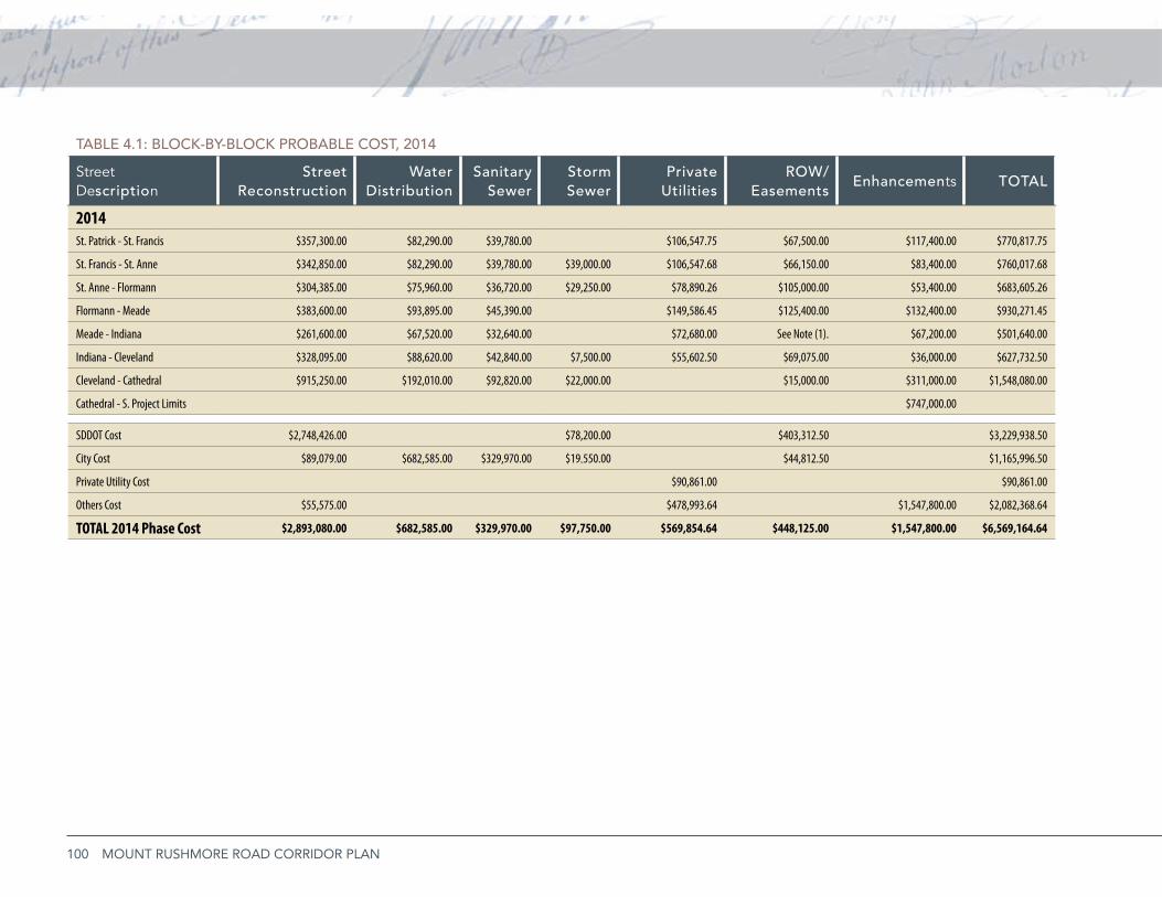
100 MOUNT RUSHMORE ROAD CORRIDOR PLAN
TAbLE 4.1: bLOCK-by-bLOCK PRObAbLE COST, 2014
Street Description
StreetReconstruction
Water Distribution
Sanitary Sewer
Storm Sewer
Private Utilities
ROW/ Easements
Enhancements TOTAL
2014St. Patrick - St. Francis $357,300.00 $82,290.00 $39,780.00 $106,547.75 $67,500.00 $117,400.00 $770,817.75
St. Francis - St. Anne $342,850.00 $82,290.00 $39,780.00 $39,000.00 $106,547.68 $66,150.00 $83,400.00 $760,017.68
St. Anne - Flormann $304,385.00 $75,960.00 $36,720.00 $29,250.00 $78,890.26 $105,000.00 $53,400.00 $683,605.26
Flormann - Meade $383,600.00 $93,895.00 $45,390.00 $149,586.45 $125,400.00 $132,400.00 $930,271.45
Meade - Indiana $261,600.00 $67,520.00 $32,640.00 $72,680.00 See Note (1). $67,200.00 $501,640.00
Indiana - Cleveland $328,095.00 $88,620.00 $42,840.00 $7,500.00 $55,602.50 $69,075.00 $36,000.00 $627,732.50
Cleveland - Cathedral $915,250.00 $192,010.00 $92,820.00 $22,000.00 $15,000.00 $311,000.00 $1,548,080.00
Cathedral - S. Project Limits $747,000.00
SDDOT Cost $2,748,426.00 $78,200.00 $403,312.50 $3,229,938.50
City Cost $89,079.00 $682,585.00 $329,970.00 $19,550.00 $44,812.50 $1,165,996.50
Private Utility Cost $90,861.00 $90,861.00
Others Cost $55,575.00 $478,993.64 $1,547,800.00 $2,082,368.64
TOTAL 2014 Phase Cost $2,893,080.00 $682,585.00 $329,970.00 $97,750.00 $569,854.64 $448,125.00 $1,547,800.00 $6,569,164.64
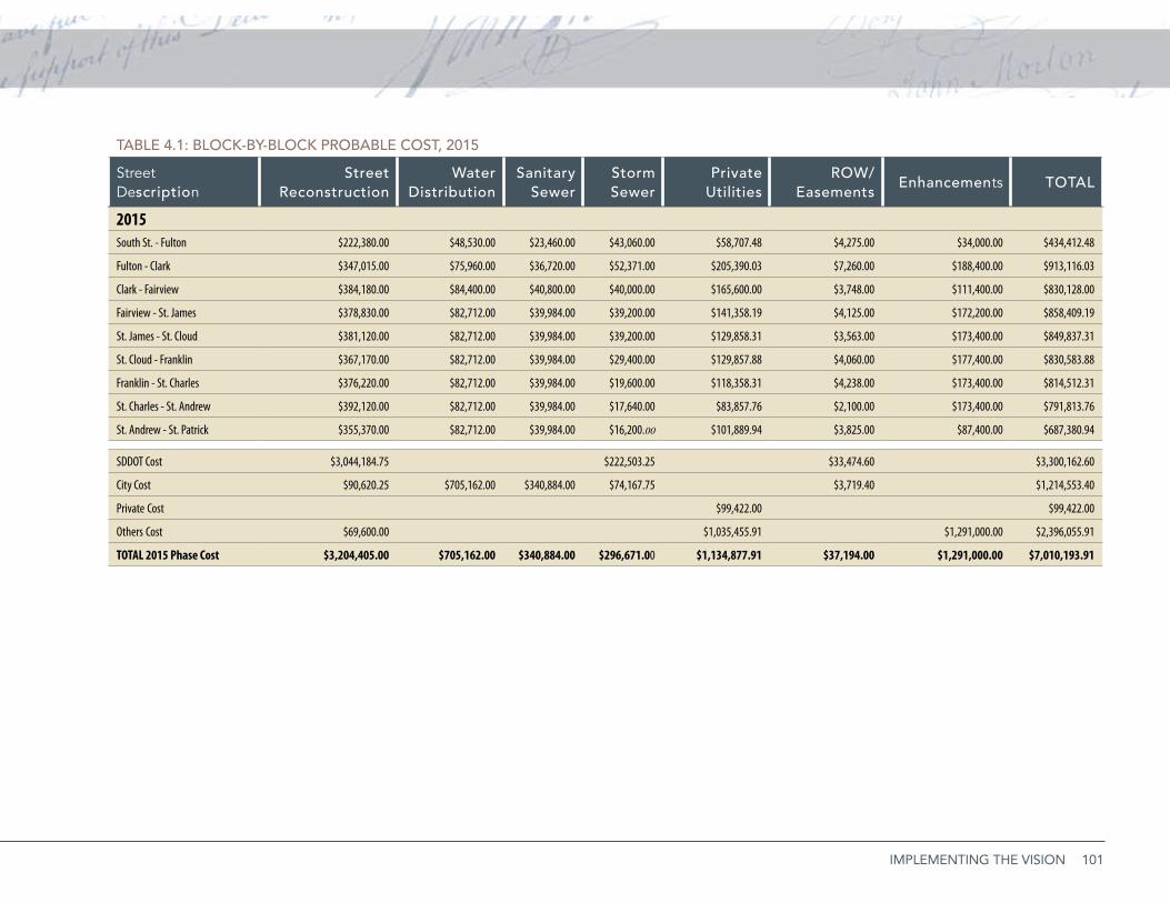
101IMPLEMENTING THE VISION
TAbLE 4.1: bLOCK-by-bLOCK PRObAbLE COST, 2015
Street Description
StreetReconstruction
Water Distribution
Sanitary Sewer
Storm Sewer
Private Utilities
ROW/ Easements
Enhancements TOTAL
2015South St. - Fulton $222,380.00 $48,530.00 $23,460.00 $43,060.00 $58,707.48 $4,275.00 $34,000.00 $434,412.48
Fulton - Clark $347,015.00 $75,960.00 $36,720.00 $52,371.00 $205,390.03 $7,260.00 $188,400.00 $913,116.03
Clark - Fairview $384,180.00 $84,400.00 $40,800.00 $40,000.00 $165,600.00 $3,748.00 $111,400.00 $830,128.00
Fairview - St. James $378,830.00 $82,712.00 $39,984.00 $39,200.00 $141,358.19 $4,125.00 $172,200.00 $858,409.19
St. James - St. Cloud $381,120.00 $82,712.00 $39,984.00 $39,200.00 $129,858.31 $3,563.00 $173,400.00 $849,837.31
St. Cloud - Franklin $367,170.00 $82,712.00 $39,984.00 $29,400.00 $129,857.88 $4,060.00 $177,400.00 $830,583.88
Franklin - St. Charles $376,220.00 $82,712.00 $39,984.00 $19,600.00 $118,358.31 $4,238.00 $173,400.00 $814,512.31
St. Charles - St. Andrew $392,120.00 $82,712.00 $39,984.00 $17,640.00 $83,857.76 $2,100.00 $173,400.00 $791,813.76
St. Andrew - St. Patrick $355,370.00 $82,712.00 $39,984.00 $16,200.00 $101,889.94 $3,825.00 $87,400.00 $687,380.94
SDDOT Cost $3,044,184.75 $222,503.25 $33,474.60 $3,300,162.60
City Cost $90,620.25 $705,162.00 $340,884.00 $74,167.75 $3,719.40 $1,214,553.40
Private Cost $99,422.00 $99,422.00
Others Cost $69,600.00 $1,035,455.91 $1,291,000.00 $2,396,055.91
TOTAL 2015 Phase Cost $3,204,405.00 $705,162.00 $340,884.00 $296,671.00 $1,134,877.91 $37,194.00 $1,291,000.00 $7,010,193.91
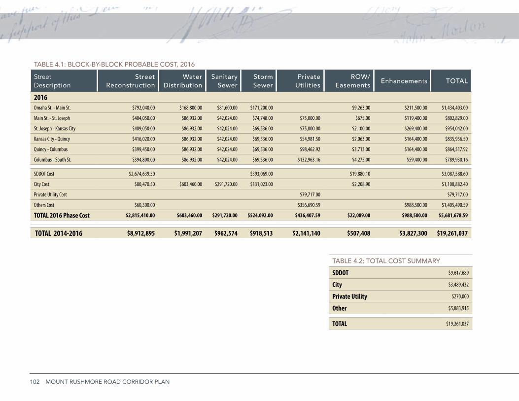
102 MOUNT RUSHMORE ROAD CORRIDOR PLAN
TAbLE 4.1: bLOCK-by-bLOCK PRObAbLE COST, 2016
Street Description
StreetReconstruction
Water Distribution
Sanitary Sewer
Storm Sewer
Private Utilities
ROW/ Easements
Enhancements TOTAL
2016Omaha St. - Main St. $792,040.00 $168,800.00 $81,600.00 $171,200.00 $9,263.00 $211,500.00 $1,434,403.00
Main St. - St. Joseph $404,050.00 $86,932.00 $42,024.00 $74,748.00 $75,000.00 $675.00 $119,400.00 $802,829.00
St. Joseph - Kansas City $409,050.00 $86,932.00 $42,024.00 $69,536.00 $75,000.00 $2,100.00 $269,400.00 $954,042.00
Kansas City - Quincy $416,020.00 $86,932.00 $42,024.00 $69,536.00 $54,981.50 $2,063.00 $164,400.00 $835,956.50
Quincy - Columbus $399,450.00 $86,932.00 $42,024.00 $69,536.00 $98,462.92 $3,713.00 $164,400.00 $864,517.92
Columbus - South St. $394,800.00 $86,932.00 $42,024.00 $69,536.00 $132,963.16 $4,275.00 $59,400.00 $789,930.16
SDDOT Cost $2,674,639.50 $393,069.00 $19,880.10 $3,087,588.60
City Cost $80,470.50 $603,460.00 $291,720.00 $131,023.00 $2,208.90 $1,108,882.40
Private Utility Cost $79,717.00 $79,717.00
Others Cost $60,300.00 $356,690.59 $988,500.00 $1,405,490.59
TOTAL 2016 Phase Cost $2,815,410.00 $603,460.00 $291,720.00 $524,092.00 $436,407.59 $22,089.00 $988,500.00 $5,681,678.59
TOTAL 2014-2016 $8,912,895 $1,991,207 $962,574 $918,513 $2,141,140 $507,408 $3,827,300 $19,261,037
TAbLE 4.2: TOTAL COST SUMMARy
SDDOT $9,617,689
City $3,489,432
Private Utility $270,000
Other $5,883,915
TOTAL $19,261,037
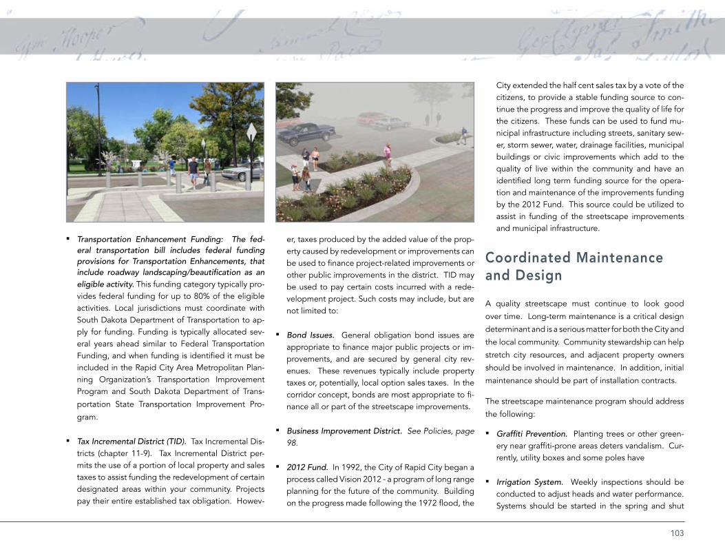
103
Transportation Enhancement Funding: The fed- ▪eral transportation bill includes federal funding provisions for Transportation Enhancements, that include roadway landscaping/beautification as an eligible activity. This funding category typically pro-vides federal funding for up to 80% of the eligible activities. Local jurisdictions must coordinate with South Dakota Department of Transportation to ap-ply for funding. Funding is typically allocated sev-eral years ahead similar to Federal Transportation Funding, and when funding is identified it must be included in the Rapid City Area Metropolitan Plan-ning Organization’s Transportation Improvement Program and South Dakota Department of Trans-
portation State Transportation Improvement Pro-
gram.
Tax Incremental District (TID). ▪ Tax Incremental Dis-tricts (chapter 11-9). Tax Incremental District per-mits the use of a portion of local property and sales taxes to assist funding the redevelopment of certain designated areas within your community. Projects pay their entire established tax obligation. Howev-
er, taxes produced by the added value of the prop-erty caused by redevelopment or improvements can be used to finance project-related improvements or other public improvements in the district. TID may be used to pay certain costs incurred with a rede-velopment project. Such costs may include, but are not limited to:
Bond Issues. ▪ General obligation bond issues are appropriate to finance major public projects or im-provements, and are secured by general city rev-enues. These revenues typically include property taxes or, potentially, local option sales taxes. In the corridor concept, bonds are most appropriate to fi-nance all or part of the streetscape improvements.
Business Improvement District. ▪ See Policies, page 98.
2012 Fund. ▪ In 1992, the City of Rapid City began a process called Vision 2012 - a program of long range planning for the future of the community. Building on the progress made following the 1972 flood, the
City extended the half cent sales tax by a vote of the citizens, to provide a stable funding source to con-tinue the progress and improve the quality of life for the citizens. These funds can be used to fund mu-nicipal infrastructure including streets, sanitary sew-er, storm sewer, water, drainage facilities, municipal buildings or civic improvements which add to the quality of live within the community and have an identified long term funding source for the opera-tion and maintenance of the improvements funding by the 2012 Fund. This source could be utilized to assist in funding of the streetscape improvements and municipal infrastructure.
Coordinated Maintenance and Design
A quality streetscape must continue to look good
over time. Long-term maintenance is a critical design
determinant and is a serious matter for both the City and
the local community. Community stewardship can help
stretch city resources, and adjacent property owners
should be involved in maintenance. In addition, initial
maintenance should be part of installation contracts.
The streetscape maintenance program should address
the following:
Graffiti Prevention. ▪ Planting trees or other green-ery near graffiti-prone areas deters vandalism. Cur-rently, utility boxes and some poles have
Irrigation System. ▪ Weekly inspections should be conducted to adjust heads and water performance. Systems should be started in the spring and shut

104 MOUNT RUSHMORE ROAD CORRIDOR PLAN
down in the fall.
Landscape. ▪ Trees and shrubs should be pruned to remove dead or damaged wood annually. Mulch depth should be maintained at 3”. All landscape beds should be weeded regularly. Perennials should be cut back in March/April and divided and fertilized as required.
▪ Lighting. All light outages should be repaired. Metal elements should be reviewed yearly and re-finished as required.
Sidewalks. ▪ Sidewalks should be regularly power washed and joints should be sealed every 5 years. Gum removal should occur regularly.
Street Furniture. ▪ All damaged stone, metal and concrete elements should be replaced immediately. All graffiti should be removed. Using durable mate-rials will ensure the longevity of the project and will help to reduce maintenance costs.
Street Sweeping. ▪ Streets should be routinely cleaned to remove sand and debris.
Trash Pick-up. ▪ Trash should be picked up daily or weekly depending on the use of the street. Trash should be removed from the street
Tree Trimming. ▪ Appropriate tree species should be planted along streets and near power lines. Trees requiring trimming should be done or overseen by a certified arborist, carefully pruning to not adversely deform the shape of the trees.
Phasing ScheduleProgress can be gradual and incremental. Each phase
provides a finished product that adds value, and builds
on the focus established by earlier phases.
The Mt. Rushmore Road Corridor improvements may
be completed in phases due to funding limitation
by the involved parties. Once one phase is funded
and completed it is anticipated that the momentum
created by that phase will carry over into subsequent
phases. Outstanding issues such as flooding, pavement
deterioration, public demand, or pedestrian and traffic
safety are factors that are considered when establishing
a priority phasing schedule for this type of project.
None of these factors provide a greater degree of
concern over another when comparing one section of
the corridor to another.
The concepts in this plan require storm sewer
improvements from St. Patrick Street to Main Street
to be reconstructed, redirecting the runoff flow of the
Downtown Core to an upstream direction. Also, the
sanitary sewer at the intersection of Main Street and
Mt. Rushmore Road needs improving. This sewer
crosses the intersection from west to east and should
not have a major impact on phasing plans.
This plan recommends reconstructing Mt. Rushmore
Road from south to north, based on the South Dakota
Department of Transportation’s potential improvement
schedule. The size and extent of each phase will be
determined by City and South Dakota Department of
Transportation policy and budget constraints.
ConclusionThe Mt. Rushmore Corridor Study brought together a
diverse group of people into a participatory process
to identify the vision for Mt. Rushmore Road’s future.
That vision will not be realized in one fell swoop; the
consensus building effort must be maintained by the
City, area businesses and the public. Recommendations
for public investment should start being implemented
by beginning the process to identify funding and
obtain any needed environmental clearances.
In addition to the traditional funding sources for
transportation projects, two significant federal
opportunities are on the horizon: the Surface
Transportation Authorization Bill and the FY 2011
Transportation-Housing & Urban Development
Appropriations Bill. Both of these funding vehicles
create a unique opportunity for communities to
apply for federal dollars to advance their priority
transportation initiatives.
The recommendations regarding land redevelopment
strategies, access management, overhead utility
relocations, and side street parking improvements
could all begin before a major roadway reconstruction
project. Community policies and codes could be
updated to begin the realization of the Mt. Rushmore
Road Corridor vision plan. The business community
should continue their dialogue together and with the
City to begin implementation strategies on and off the
public right-of-way. The completion of the corridor
study should be celebrated with a public event along
the corridor, but not as an end …but as a beginning.
105
APP
END
ICES
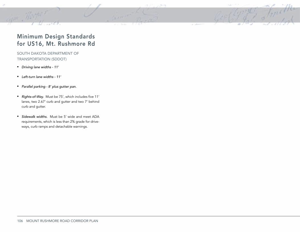
106 MOUNT RUSHMORE ROAD CORRIDOR PLAN
Minimum Design Standards for US16, Mt. Rushmore RdSOUTh DAKOTA DEPARTMENT Of TRANSPORTATiON (SDDOT)
Driving lane widths - 11’ ▪
Left-turn lane widths - 11’ ▪
Parallel parking - 8’ plus gutter pan. ▪
Rights-of-Way. ▪ Must be 75’, which includes five 11’ lanes, two 2.67’ curb and gutter and two 7’ behind curb and gutter.
Sidewalk widths. ▪ Must be 5’ wide and meet ADA requirements, which is less than 2% grade for drive-ways, curb ramps and detachable warnings.
107