mpe editor - nws.noaa.gov€¦ · web view2.10 run the start_mpe_editor start ... download the...
TRANSCRIPT
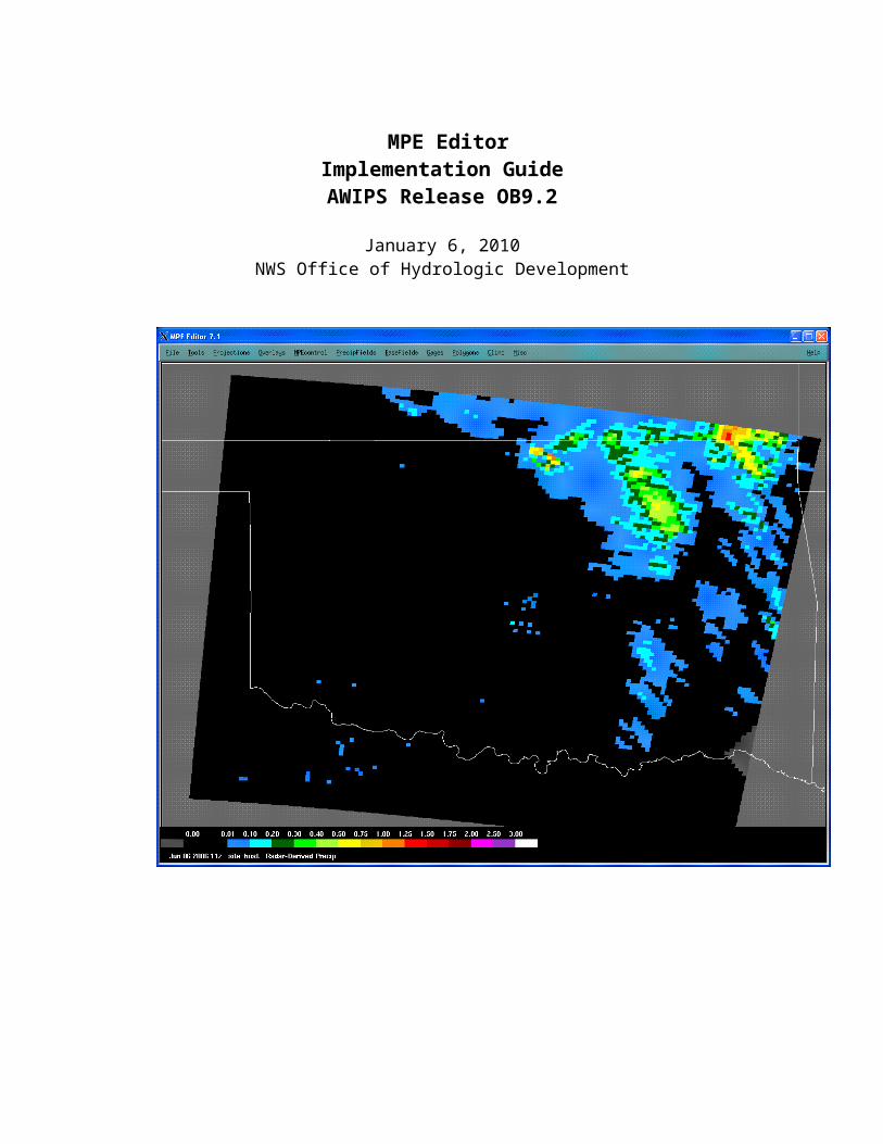
MPE EditorImplementation GuideAWIPS Release OB9.2
January 6, 2010NWS Office of Hydrologic Development

Table of Contents1.0 Introduction...................................................................................................................... 12.0 Implementation Instructions............................................................................................. 62.1 Define MPE Tokens......................................................................................................... 62.2 Setup the MPE Geographic Tokens..................................................................................72.3 Create the Coordinate File................................................................................................ 72.3.1 PRISM and MISBIN Site Data.....................................................................................82.4 Create the MPE Gage Locations File................................................................................92.5 Create the MPE Beam Height File...................................................................................92.6 Create the P3 Triangulated HRAP Grid File and Radar Config Files..............................102.7 Generate the WHFS Overlays and MPE Locator Files...................................................102.8 Setup DailyQC Tokens and Files.................................................................................... 112.8.1 Define the DailyQC Tokens.......................................................................................112.8.2 Create the DailyQC Station List.................................................................................122.8.3 Create the Disagg 6-Hour Station List........................................................................132.8.4 Create the DailyQC Climo File..................................................................................132.8.5 Basin to HRAP Mapping File.....................................................................................142.8.6 Create the Topography File........................................................................................142.8.7 Install AGRID Perl Module........................................................................................ 142.8.8 Enable the DailyQC Preprocessor Cron Entries..........................................................152.9 Verify Scheduling of run_mpe_whfs Script...................................................................152.10 Run the start_mpe_editor Start Script.............................................................................153.0 Additional MPE Options................................................................................................ 16
Appendix A. The Overlay Configuration File............................................................................171.0 Overlay Identifiers......................................................................................................... 172.0 Initial Overlay State....................................................................................................... 183.0 Memory Storage Flag..................................................................................................... 184.0 Fill Polygon Flag............................................................................................................ 185.0 Overlay Color................................................................................................................. 186.0 Line Width..................................................................................................................... 197.0 Number of Files............................................................................................................. 198.0 Overlay File Paths.......................................................................................................... 199.0 Overlay File Name......................................................................................................... 1910.0 Type of Overlay............................................................................................................. 1911.0 M_CALCULATE or M_EXTERNAL...........................................................................2012.0 User-defined Overlays.................................................................................................... 22
Appendix B. RFC Bias Transfer Setup..................................................................................... 231.0 Introduction.................................................................................................................... 232.0 RFC Enabling Bias Message Transmission....................................................................233.0 WFO Receipt and Processing of RFC Bias Message......................................................244.0 Trouble Shooting............................................................................................................ 25

Appendix C. Reducing Disk Space Usage by MPE Files.........................................................261.0 Reducing Amount of Ingested MPE Data.......................................................................262.0 Reducing Amount of Retained MPE Data......................................................................272.1 db_purge........................................................................................................................ 282.2 purge_mpe_files............................................................................................................. 28
Appendix D: Tokens Used By MPE Editor................................................................................291.0 General Tokens.............................................................................................................. 302.0 Precip_proc Tokens........................................................................................................ 303.0 MPE Input Data Set Tokens...........................................................................................304.0 MPE Output Data Set Tokens........................................................................................315.0 MPE Control Tokens...................................................................................................... 326.0 DailyQC Input Data Set Tokens.....................................................................................347.0 DailyQC Output Data Set Tokens..................................................................................348.0 DailyQC Control Tokens................................................................................................ 359.0 FFG tokens..................................................................................................................... 3610.0 WHFS Tokens................................................................................................................ 3611.0 Hydroview and MPE Tokens........................................................................................36
Appendix E. File Locations...................................................................................................... 38
Appendix F. Setting the Colors of Displayed MPE Data...........................................................61
Appendix G. MPE Editor/DailyQC File Formats......................................................................621.0 Coordinate File............................................................................................................... 622.0 XMRG........................................................................................................................... 623.0 MPE Gage List............................................................................................................... 634.0 MPE Beam Height File.................................................................................................. 635.0 MPE Misbin Files.......................................................................................................... 646.0 PRISM........................................................................................................................... 647.0 DailyQC Station List File............................................................................................... 648.0 DailyQC Climo Files...................................................................................................... 659.0 DailyQC Basin File........................................................................................................ 6610.0 DailyQC Neighbor List File...........................................................................................6711.0 DailyQC Level 1 and Level 2 Point Data Files...............................................................6712.0 DailyQC Basin Averaged Files....................................................................................... 6913.0 Disagg 1hr Station List................................................................................................... 7014.0 Disagg 6hr Station List................................................................................................... 7115.0 MPE State Variable Files...............................................................................................71
Appendix H. Disaggregation Processing Algorithms...........................................................731.0 Input Data...................................................................................................................... 732.0 Output Data.................................................................................................................... 743.0 Algorithm Descriptions.................................................................................................. 743.1 Grid-Based Algorithm.................................................................................................... 74

3.2 Point-Based Algorithm................................................................................................... 753.3 Other Algorithm Information.........................................................................................774.0 MPE Fieldgen................................................................................................................ 785.0 Data Display................................................................................................................... 786.0 Log................................................................................................................................. 78
Figures
Figure 1 MPE 1 Hour Precipitation Processing Files.............2Figure 2 MPE Editor Static Control Datasets....................3Figure 3 The IHFS Database tables used by MPE Editor...........4Figure 4 Files used by the DailyQC Portion of MPE Editor.......5

1.0 Introduction
This document describes the setup and configuration of the MPE Editor application. For a description of the MPE Editor application and the features it offers, see the MPE Editor User’s Guide. Information about the MPE FieldGen application can be found in the Multisensor Precipitation Estimator Field Generation System Document.
The MPE Editor program draws upon a large number of system resources during the course of its execution. It utilizes many tables in the Integrated Hydrologic Forecast System (IHFS) database, reads from and writes to a large number of disk files, and integrates the flexibility of Apps defaults tokens to provide user-configurable behavior.
MPE Editor uses the files shown in Figure 1 and Figure 2. MPE Editor uses the IHFS tables shown in the Figure 3. The DailyQC portion of MPE Editor uses the files shown in Figure 4.
Hydroview users need to make sure that steps in Sections 2.1 through 2.7 are complete. This will allow MPE data to be viewed in Hydroview. For users of DailyQC functions, the steps described in Section 2.8 must be completed.
OB9.0 introduced two options which are coded in Java. These are the Gage Table and the Color Manager. Because the code for these options is in Java, it is not stored in the mpe_editor.LX file. Instead, code for these options is stored in a “.jar” file with the name “mpe.jar”.

Figure 1 MPE 1 Hour Precipitation Processing Files

Figure 2 MPE Editor Static Control Datasets
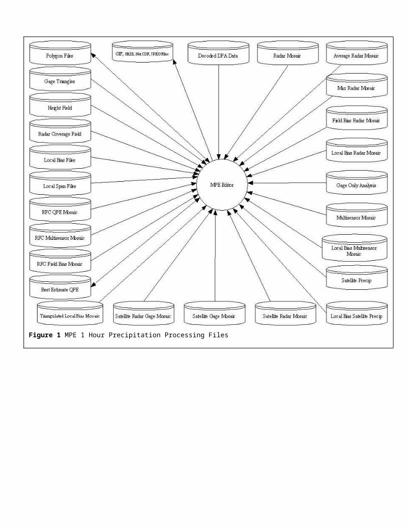
Figure 3 The IHFS Database tables used by MPE Editor.

Figure 4 Files used by the DailyQC Portion of MPE Editor
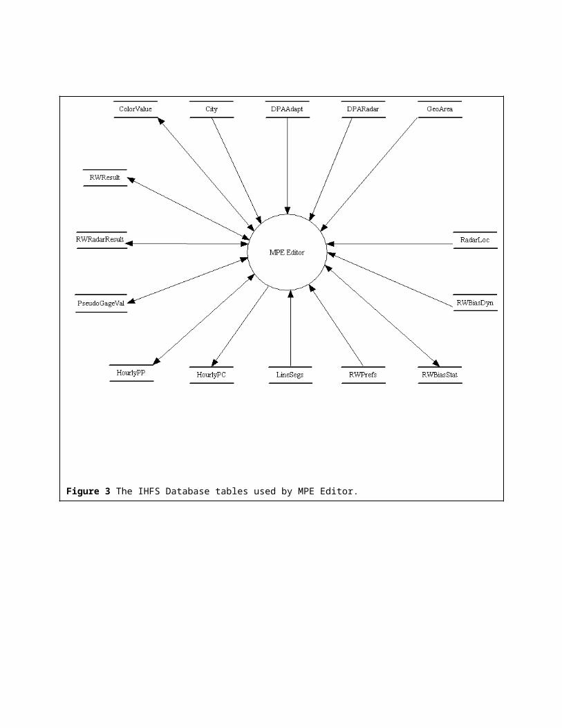
Table 1. MPE Precipitation Fields and Dependencies
Symbolic Name Descriptive Name Fields It Depends OnRMOSAIC Radar Mosaic No DependenciesAVGRMOSAIC Average Radar Mosaic No DependenciesMAXRMOSAIC Maximum Radar Mosaic No Dependencies BMOSAIC Mean Field Bias Corrected Radar
MosaicRMOSAIC
LMOSAIC Local Field Bias Corrected Mosaic RMOSAICGAGEONLY Gage-only Analysis No DependenciesMMOSAIC Multi-sensor Mosaic BMOSAICMLMOSAIC Local Bias Multi-sensor Field LMOSAICSATPRE Satellite Precipitation Field No DependenciesLSATPRE Local Bias Satellite Precipitation
FieldSATPRE
SRMOSAIC Satellite Radar Mosaic LMOSAIC, LSATPRESGMOSAIC Satellite Gage Mosaic LSATPRESRGMOSAIC Satellite Radar Gage Mosaic SRMOSAICQMOSAIC Q2 Field No DependenciesLQMOSAIC Local Bias Corrected Q2 Field QMOSAICMLQMOSAIC Local Bias Multi-sensor Field LQMOSAICP3LMOSAIC Triangulated Radar Mosaic RMOSAICRFCBMOSAIC RFC Field Bias Corrected Radar
MosaicRMOSAIC
RFCMMOSAIC RFC Multi-sensor Mosaic RFCBMOSAIC
2.0 Implementation Instructions
The steps to set up MPE Editor are as follows:
2.1 Define MPE TokensIn the /awips/hydroapps/.Apps_defaults_site file, add or modify the following entries. Default token values are given in Appendix D.
mpe_site_id : Set to the lower case three letter office identifier.
db_name :The database name. It will take the form hd_ob#xxx, where xxx represents the three character site identifier in lower case characters and # is the AWIPS build number. For build OB9.2, the database name did not change from OB9.0.

mpe_base_radar_mosaic :The radar mosaic to use as the base for the radar-derived MPE precipitation fields. This may be the RMOSAIC (radar mosaic), AVGRMOSAIC (average radar mosaic) or MAXRMOSAIC (max radar mosaic). By default it is set to RMOSAIC.
mpe_qpe_fieldtype :This token specifies which of the fields MPE Fieldgen will choose as the Best Estimate QPE Field. It must be set to one of the MPE products listed in Table 1. If it is set to a product which is not in the mpe_generate_list token, then the generate list token will be automatically modified at run time to include this field or mosaic.
mpe_generate_list :Contains the list of precipitation fields and mosaics that MPE Fieldgen will generate. Note that some MPE products have dependencies on other MPE products. For example, the MLMOSAIC is dependent on LMOSAIC. Table 1 lists the MPE product dependencies. The mpe_generate_list is automatically updated at runtime to include all product dependencies. This will cause the dependent fields to be generated in addition to those listed in the original mpe_generate_list.
st3_rfc :The site identifier expressed as a string of lower case characters. At WFOs, this variable is set to “host". At RFCs, it is set to the RFC identifier (e.g. marfc, wgrfc, etc.).
mpe_locbias_1hr_rerun :If set to ‘ON’, then the local bias will be recomputed and all fields which rely on a local bias field (LMOSAIC, LSATPRE, MLMOSAIC, SRMOSAIC, SGMOSAIC, SRGMOSAIC) will be regenerated when MPE Fieldgen is rerun from MPE Editor. If set to ‘OFF’, then the local bias will not be recomputed and all fields which rely on a local bias field will not be regenerated or written out to a file when MPE Fieldgen is rerun from MPE Editor.
2.2 Setup the MPE Geographic Tokens In the /awips/hydroapps/.Apps_defaults_site file, add or modify the following entries. These control such attributes as the center latitude, longitude and width of the application viewing area Default token values are given in Appendix D.
a) hv_center_lat : center latitude of the office’s MPE forecast area
b) hv_center_lon : center longitude of the office’s MPE forecast area> (Note that Western Hemisphere longitude values are negative)
c) hv_map_width : width in nautical miles of the displayed MPE Editor map

d) hv_width_in_pixels : width of the MPE Editor viewer in pixels
e) hv_height_in_pixels : height of the MPE Editor viewer in pixels
2.3 Create the Coordinate File
The coordinate file serves a critical role in MPE processing by controlling the geographic area for which MPE processing is performed.
a) Check if the coordinate file exists. Check if the file /awips/hydroapps/lx/geo_data/XXXX/ascii/coord_XXXX.dat exists, where XXXX is given by the st3_rfc token.
b) If this file exists, continue on to the next section.
c) Determine the latitude/longitude coordinates of each corner of the box for which your offices wants MPE to produce precipitation mosaics.
d) Send this information to the NWS OCWWS/Hydrologic Services Division (HSD).
e) Using this information, HSD will generate the Coordinate File.
f) Place the Coordinate File received from HSD into the directory, /awips/hydroapps/lx/geo_data/XXXX/ascii, where XXXX is given by the st3_rfc token.
2.3.1 PRISM and MISBIN Site Data
HSD will generate the PRISM and MISBIN files. In the PRISM and MISBIN file names, sss is the site id as defined by the mpe_site_id token and mmm is the month abbreviation (jan, feb, mar, apr, may, jun, jul, aug, sep, oct, nov, dec)
PRISM Files
Check if the PRISM files already exist at the site. Check the /awips/hydroapps/precip_proc/local/data/app/mpe/prism directory (mpe_prism_dir token) for the following files:
a) prism_max_temp_sss_mmmb) prism_min_temp_sss_mmmc) prism_mean_precip_sss_mmmd) There should be 12 of each of these files, one for each month.
Note that the units for precip values in the files are mm. Units for the temperature data in the files are deg F * 10.
Misbin Files
a) Perform the following query in the IHFS database:
b) SELECT radid FROM RadarLoc WHERE use_radar = ’T’;
c) Check to determine if the misbin files already exist on this system. For each radar id listed in the above query, check to determine if a corresponding misbin file exists in /awips/hydroapps/precip_proc/local/data/app/mpe/misbin/misbin.RRR, where RRR is the id of the radar. If the files exist, skip to the next step.
d) Place the MISBIN files in /awips/hydroapps/precip_proc/local/data/app/mpe/misbin, the directory specified by the rfcwide_misbin_dir token.
2.4 Create the MPE Gage Locations File
MPE Editor and MPE Fieldgen read the names and locations of the 1 hour gauges from a file. This file is created as follows:
a) Run /awips/hydroapps/precip_proc/bin/run_mpe_gage_file script.
b) Verify that the file /awips/hydroapps/precip_proc/local/data/app/mpe/gage_locations/mpe_gage_locations was created.
2.5 Create the MPE Beam Height File
a) Run /awips/hydroapps/precip_proc/bin/run_create_mpe_beam_height_file.
b) Verify that the file /awips/hydroapps/precip_proc/local/data/app/mpe/beam_height/mpe_radar_beam_height was created.
2.6 Create the P3 Triangulated HRAP Grid File and Radar Config Files
This step can take a large amount of time, especially for offices, such as RFCs, with large forecast areas.

a) Run /awips/hydroapps/precip_proc/bin/run_create_triangles.
b) Verify that the following files have been created:a. /awips/hydroapps/precip_proc/local/data/app/mpe/utiltriangles/radarconfileb. /awips/hydroapps/precip_proc/local/data/app/mpe/utiltriangles/utiltriangles
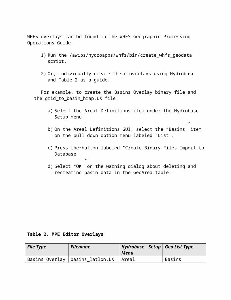
2.7 Generate the WHFS Overlays and MPE Locator Files
There are two ways to generate the WHFS Overlays and MPE Locator Files listed in Table 2. More information about the processing of WHFS overlays can be found in the WHFS Geographic Processing Operations Guide.
1) Run the /awips/hydroapps/whfs/bin/create_whfs_geodata script.
2) Or, individually create these overlays using Hydrobase and Table 2 as a guide.
For example, to create the Basins Overlay binary file and the grid_to_basin_hrap.LX file:
a) Select the Areal Definitions item under the Hydrobase Setup menu.
b) On the Areal Definitions GUI, select the “Basins” item on the pull down option menu labeled “List”.
c) Press the button labeled “Create Binary Files Import to Database”
d) Select “OK” on the warning dialog about deleting and recreating basin data in the GeoArea table.
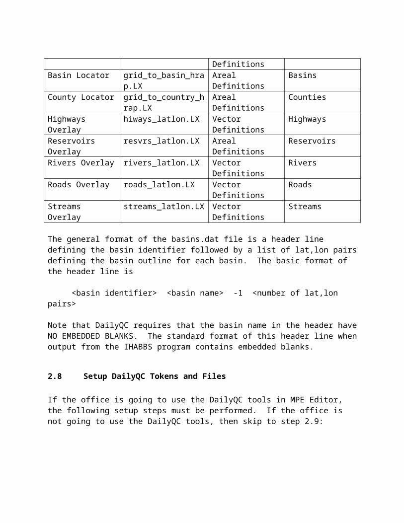
Table 2. MPE Editor Overlays
File Type Filename Hydrobase Setup Menu
Geo List Type
Basins Overlay basins_latlon.LX Areal Definitions BasinsBasin Locator grid_to_basin_hrap.LX Areal Definitions BasinsCounty Locator grid_to_country_hrap.L Areal Definitions Counties

XHighways Overlay hiways_latlon.LX Vector Definitions HighwaysReservoirs Overlay resvrs_latlon.LX Areal Definitions ReservoirsRivers Overlay rivers_latlon.LX Vector Definitions RiversRoads Overlay roads_latlon.LX Vector Definitions RoadsStreams Overlay streams_latlon.LX Vector Definitions Streams
The general format of the basins.dat file is a header line defining the basin identifier followed by a list of lat,lon pairs defining the basin outline for each basin. The basic format of the header line is
<basin identifier> <basin name> -1 <number of lat,lon pairs>
Note that DailyQC requires that the basin name in the header have NO EMBEDDED BLANKS. The standard format of this header line when output from the IHABBS program contains embedded blanks.
2.8 Setup DailyQC Tokens and Files
If the office is going to use the DailyQC tools in MPE Editor, the following setup steps must be performed. If the office is not going to use the DailyQC tools, then skip to step 2.9:
2.8.1 Define the DailyQC Tokens
In the /awips/hydroapps/.Apps_defaults_site file, add or modify the following. Default token values are given in Appendix D:
a) mpe_dqc_options : This must be set to ‘on’ if an office wants to use DailyQC features in MPE Editor. If it is set to ‘off’, none of the DailyQC options will be available.
b) mpe _dqc_num_days :If DailyQC is being used, this is the number of days that will be QC’d. By default it is 10, the maximum value. It can be set to any number of days from 10 or less.
c) mpe_area_names : This is a comma separated list of the ids of the DailyQC subareas. Spaces are not permitted. If there are no DailyQC subareas, then this token should be set to the same value contained in the mpe_site_id token.
Example entry in the .Apps_defaults_site file:mpe_area_names : oun_subarea1,oun_subarea_2,oun_subarea_3

d) mpe_basin_file : The location of the basin definition file. By default, it is set to the basin definition file in the AWIPS baseline:
/awips/hydroapps/whfs/local/data/geo/basins.dat
e) mpe_load_hourlypc :Determines whether or not the dqc preprocessor creates 6 hour precipitation totals using PC reports. If it is set to ‘OFF’, then PC-based 6 hour precipitation totals are not computed. If it is set to ‘ON’, then PC-based 6 hour precipitation totals are computed.
f) mpe_disagg_execute :on/off token to determine if disagg processing should be run when user saves data
g) mpe_disagg_method : token to determine algorithm used for disagg processing current allowable values = “grid”, “point”. “grid” signifies use of the QPE grids for estimating hourly values “point” signifies use of a nearest-neighbor stations for estimating hourly values
h) mpe_disagg_6hreq_0 : token for choice of solution for case of 6hr value = 0.0 with sum of QPE bin values > 0.0. Current allowable values = 1, 2. 1 = Set all 1 hour values to 0. 2 = Generate 1 hour estimates based on QPE bin values.
i) mpe_disagg_6hrgt_0 : token for choice of solution for case of 6hr value > 0.0 with sum of QPE bin values = 0.0. Current allowable values = 1, 2. 1 = Set 1 hour values to 0.; 2 = Generate 1 hour estimates based on nearest neighbors.
j) mpe_disagg_station_distance_limit : 100 token for limiting the distance of the nearest-neighbor stations. units = km
2.8.2 Create the DailyQC Station List
Station list information for precipitation (PPH, PPD), temperature (TAI), and freezing level (FZI) data is required in DailyQC.
If the office does not already use DailyQC and does not have its own DQC station lists, then the DQC station list can be created by:
a) Run the /awips/hydroapps/precip_proc/bin/run_create_mpe_station_lists script
b) Verify that the DailyQC station list is created in

/awips/hydroapps/precip_proc/local/data/app/mpe/station_lists/<site_id>_station_list, where site_id is given by the mpe_site_id token.
c) Verify that the /awips/hydroapps/precip_proc/bin/ruc.pl script has been created.
If the office already has station lists defined for use in DailyQC, then these will need to be converted to the format required by MPE Editor. If the station list format is the same as the format used by CBRFC, then OHD will provide a script to convert it.
The formats of these files are given in Appendix G.
Note that DailyQC automatically generates an HRAP neighbor list file. This file contains a list of the closest stations to each HRAP grid bin. Separate files are generated for precip, temperature and freezing level data. The files are generated as part of the reading of the input data. See the DailyQC System Guide Section 2.4.3 for more details concerning these files.
Note that if a site makes a change to a precip or temperature station in the station list, they MUST recreate the climo file (Section 2.8.4) and they MUST stop and restart MPE/DailyQC. On restart, the HRAP neighbor list file will be recreated automatically. When the file is recreated, the message “Gage to grid recalculation” is written to the log. The recreation of this file can take a few minutes to complete. If the recreation process is stopped prematurely, an incomplete file will be created which will result in bad grids being produced.
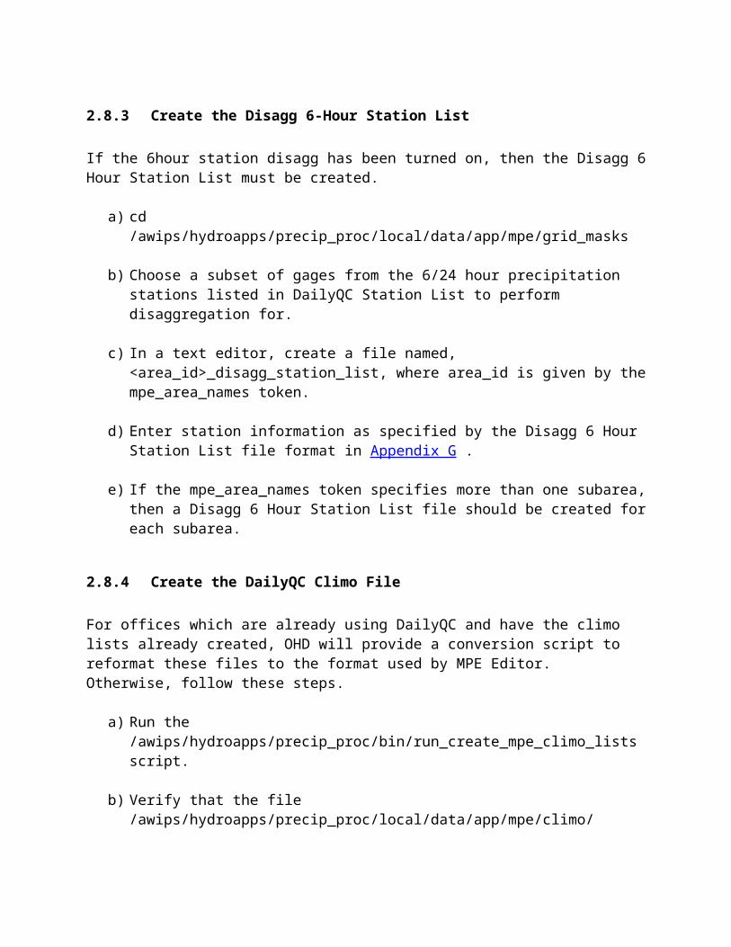
2.8.3 Create the Disagg 6-Hour Station List
If the 6hour station disagg has been turned on, then the Disagg 6 Hour Station List must be created.
a) cd /awips/hydroapps/precip_proc/local/data/app/mpe/grid_masks
b) Choose a subset of gages from the 6/24 hour precipitation stations listed in DailyQC Station List to perform disaggregation for.
c) In a text editor, create a file named, <area_id>_disagg_station_list, where area_id is given by the mpe_area_names token.
d) Enter station information as specified by the Disagg 6 Hour Station List file format in Appendix G .
e) If the mpe_area_names token specifies more than one subarea, then a Disagg 6 Hour Station List file should be created for each subarea.
2.8.4 Create the DailyQC Climo File
For offices which are already using DailyQC and have the climo lists already created, OHD will provide a conversion script to reformat these files to the format used by MPE Editor. Otherwise, follow these steps.
a) Run the /awips/hydroapps/precip_proc/bin/run_create_mpe_climo_lists script.
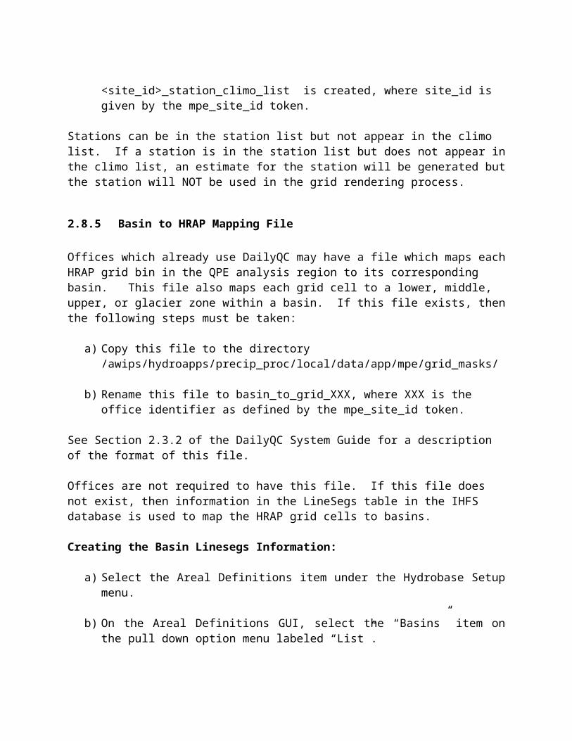
b) Verify that the file /awips/hydroapps/precip_proc/local/data/app/mpe/climo/ <site_id>_station_climo_list is created, where site_id is given by the mpe_site_id token.
Stations can be in the station list but not appear in the climo list. If a station is in the station list but does not appear in the climo list, an estimate for the station will be generated but the station will NOT be used in the grid rendering process.
2.8.5 Basin to HRAP Mapping File
Offices which already use DailyQC may have a file which maps each HRAP grid bin in the QPE analysis region to its corresponding basin. This file also maps each grid cell to a lower, middle, upper, or glacier zone within a basin. If this file exists, then the following steps must be taken:
a) Copy this file to the directory /awips/hydroapps/precip_proc/local/data/app/mpe/grid_masks/
b) Rename this file to basin_to_grid_XXX, where XXX is the office identifier as defined by the mpe_site_id token.
See Section 2.3.2 of the DailyQC System Guide for a description of the format of this file.
Offices are not required to have this file. If this file does not exist, then information in the LineSegs table in the IHFS database is used to map the HRAP grid cells to basins.
Creating the Basin Linesegs Information:
a) Select the Areal Definitions item under the Hydrobase Setup menu.
b) On the Areal Definitions GUI, select the “Basins” item on the pull down option menu labeled “List”.
c) Press the button labeled “Create Binary Files Import to Database”. Select “OK” on the warning dialog about deleting and recreating basin data in the GeoArea table.
2.8.6 Create the Topography File
a) Retrieve the files
topoeatoponwtoposwtopoalaskatopocanada
and place them in the directory
/awips/hydroapps/whfs/local/data/geo
b) Create the topography file by running the script /awips/hydroapps/precip_proc/bin/run_create_topo
c) Delete the topo* files listed in a) to conserve disk space. Be careful not to delete the file named “topography” created in Step b).
The run_create_topo script creates the file
/awips/hydroapps/whfs/local/data/geo/topography
2.8.7 Install AGRID Perl Module
The AGRID Perl module is required by the DailyQC software which retrieves the freezing level data from the RUC80 model. It is part of the Local Application Database (LAD). The AGRID module must be downloaded from the LAD website and installed in the directory /awips/hydroapps/precip_proc/bin.
a) Connect to the LAD website, http://www.mdl.nws.noaa.gov/~applications/LAD/index.php3
b) On the LAD website, select the “search for an application” link. This will display the LAD search page. In the search box, type “AGRID” and press the Submit button. From the search results, select the AGRID module. From the AGRID page, download the file and the installation document. Follow the instructions in the installation document.

2.8.8 Enable the DailyQC Preprocessor cron Entries
By default, the DailyQC preprocessor cron entries are disabled in the PX1 crontab file. These need to be enabled in order for the DailyQC datasets to be produced. This can be done by un-commenting the entries in the crontab file. The following are recommended crontab entries:
a) Precip and Temperature Preprocessor
15 0,6,12,18 * * * oper /awips/hydroapps/precip_proc/bin/run_dqc_preprocessor
b) Freezing Level Data Preprocessor
05 2,8,14,20 * * * oper /awips/hydroapps/precip_proc/run_freezing_level
The number of days and the ending day for processing data are controlled via command line arguments in these scripts.
2.8.9 Update StnClass Entries in the IHFS Database
To update the entries in the StnClass table, the user can run the script
/awips/hydroapps/whfs/bin/set_stnclass.LX -dhd_ob90xxx
from the command line. The user must then wait a few minutes for the pdc_preprocessor to run to process the new station data.
The above is necessary for the “Graph” option in MPE Editor’s “Edit Precipitation Stations” and “Edit Temperature Stations” windows to work properly.
2.9 Verify Scheduling of run_mpe_whfs Script
By default, the run_mpe_whfs job is enabled in the PX1 oper crontab.
a) View the PX1 oper crontab. The following entry should exist:24 * * * * /awips/hydroapps/precip_proc/bin/run_mpe_whfs
This will run mpe_fieldgen automatically once per hour. The minutes can be varied, but should be set to at least 20 minutes past the top of the hour to allow time for gauge data to be decoded and ingested into the IHFS database.
2.10 Run the start_mpe_editor Start Script

This script sets up the environment for MPE Editor. It launches the MPE Editor application in which the gridded data fields generated by MPE_FieldGen are displayed, edited and regenerated.
Alternatively, MPE Editor can be launched from the AWIPS Startup Menu.
3.0 Additional MPE Options
In addition to the setup options outlined above, options also exist to:
Send the RFC Best QPE field over the SBN to WFOs Transfer RFC mean field bias data to collocated WFOs and their RPGs
Information about sending the Best QPE field over the SBN can be found in the document RFC MPE Usage At WFOs Operation Guide.
More information about the transfer of mean field bias data is in Appendix B of this document.

Appendix A. The Overlay Configuration File
The overlay configuration file defines the locations and properties of the MPE Editor overlays. The path and name of this file is: /awips/hydroapps/whfs/local/data/app/hydroview/mpe_editor_overlay_configuration.
Each entry in the overlay configuration file corresponds to an overlay in the MPE Editor application. Each entry contains the following pipe delimited fields:
1) The identifier of the overlay to which the line in the overlay file corresponds2) The initial state of the overlay. This determines whether or not the overlay is
shown when the MPE Editor application is first started.3) The overlay memory flag. This determines whether or not the overlay is to be
stored in memory or if it should be read from a disk file or database table each time it is displayed.
4) The polygon flag. This determines whether or not the overlay contains polygons which should be filled.
5) The overlay color.6) The overlay line thickness.7) The number of files which contribute to the overlay.8) The directory path which contains the overlay file.9) The name of the file which contains the overlay.10) The type of the overlay.11) If applicable, the name of the routine that is used to display the overlay.
Note that fields 8 and 9 above are repeated for each of the files indicated in field 7.
Each of these fields is described in detail below:
Important note - The ‘|’ delimiter at the end of each record of the overlay configuration file is required.
1.0 Overlay Identifiers
The overlay identifiers are:
M_TOPOGRAPHY The topography imageM_STATE State boundariesM_BASINS Basin boundariesM_CITY_TOWN Cities and townsM_COUNTY County boundariesM_CWA County warning area
boundariesM_HIGHWAYS Highways definitionsM_ROADS Road definitionsM_HRAP_GRID The HRAP grid which encloses the
site’s forecast area.M_LAKES Lake and reservoir
definitionsM_RIVERS Major river definitionsM_STREAMS Minor streamsM_LAT_LON_LINES The latitude / longitude linesM_RADAR_LOCATIONS The locations of the radar sitesM_RADAR_RINGS The rings around the radar sites
which indicate their effective rangeM_RFC_BOUNDARY The boundaries of the RFCs.M_TIMEZONE The boundaries delineating the
timezones.M_ZONES The boundaries of the
forecast zones.M_TOPOGRAPHY_CONTOUR The topography contours.
2.0 Initial Overlay State
The initial state of the overlay may be either M_OFF or M_ON which indicates if the overlay is initially off or on, respectively, when the MPE Editor application is started.
3.0 Memory Storage Flag
The memory storage flag indicates whether or not the overlay is stored in memory. When set to M_ON the overlay is stored in memory the first time it is displayed. When set to M_OFF, the overlay is not stored in memory and must be read from the disk or the IHFS database every time it is displayed. For quick displaying overlays choose M_ON. For memory conservation choose M_OFF.
4.0 Fill Polygon Flag
The fill polygon flag indicates whether or not an overlay contains polygons which should be filled. When set to M_ON, the polygons in the overlay will be filled. When set to M_OFF, the polygons in the overlay will not be filled.
5.0 Overlay Color
This is the name of the color to use in the display of the overlay. Valid color names are in the file /usr/lib/X11/rgb.txt (defined by token rgb_file_path). They can also been seen by executing the following query in the IHFS database:
SELECT * FROM ColorName ORDER BY color_name ASC;
6.0 Line Width
This controls the width of the lines used in drawing the overlay. This is a positive whole number. The lower the value, the thinner the displayed line will be. The lowest possible value is 1. The higher the value, the thicker the displayed line will be.
The line width field does not apply to the M_CITY_TOWN overlay. The font size of the city and town labels may be modified through the Set Font option on the MPE Editor Tools menu.
7.0 Number of Files
This number indicates how many files must be read to create the overlay. There may be up to 3 files. The paths and names of these files are specified by items 8 and 9. These fields are repeated for each of the files, meaning that each file may have a unique path. If the number of files is zero, then an overlay drawing routine must be specified in field 10. If the overlay is not read directly from a file, then a routine must be specified that either calculates or reads the overlay from the database or a file format that is not directly supported by MPE Editor.
8.0 Overlay File Paths
This is the path of the overlay file. This may contain tokens or environmental variables. Token and environmental variable names must be preceded by a $.
9.0 Overlay File Name
This is the name of the file containing the overlay.
10.0 Type of Overlay
This is the source of the overlay. The allowable types are:
M_BCD GSD Binary Cartographic Data files.M_SHAPE The shape file format developed by the Environmental
Systems Research Institute (ESRI).M_CALCULATE This means that the overlay is entirely computed by software or
read by software from a file whose format is something other than BCD or SHAPE. As a general rule, overlays of type M_CALCULATE are not stored in memory. The routine performs the drawing directly, and the source of the overlay is read every time the overlay is displayed.
M_EXTERNAL M_EXTERNAL means that the overlay is read by software either from a file whose format is something other than BCD or SHAPE or from the IHFS database. Overlays of type M_EXTERNAL may be stored in memory after being initially read from their file or database source. The M_EXTERNAL routine does not perform the drawing itself. Instead, it returns the overlay data in a format which the mapping routines of MPE Editor can understand and draw.
11.0 M_CALCULATE or M_EXTERNAL
In the case where the file type is either M_CALCULATE or M_EXTERNAL, the last field in the record must contain the name of the software routine that is to be used to display the data.
Available M_CALCULATE routines:
DRAW_RADAR_RINGSDRAW_LAT_LON_LINESDRAW_RADAR_LOCATIONSDRAW_FSL_CITY_LOCATIONSDRAW_MPE_CITY_LOCATIONSDRAW_WHFS_CITY_LOCATIONSDRAW_HRAP_GRIDDRAW_HRAP_BOUNDARY
Available M_EXTERNAL routines:
PLOT_BINFILE_BASINSPLOT_BINFILE_LAKESPLOT_BINFILE_RIVERS_STREAMSPLOT_BINFILE_HIWAYS_ROADS
For drawing city and town locations, there are two different routines which may be chosen from
at a WFO and three routines which may be chosen from at a RFC:
WFO:DRAW_FSL_CITY_LOCATIONSDRAW_WHFS_CITY_LOCATIONS
RFC:DRAW_FSL_CITY_LOCATIONSDRAW_WHFS_CITY_LOCATIONSDRAW_MPE_CITY_LOCATIONS
Each routine represents a different source of town and city data. By changing the name of the routine used to draw the town and city overlay, (field 11of the mpe_editor_overlay_configuration city overlay record) to DRAW_FSL_CITY_LOCATIONS, DRAW_MPE_CITY_LOCATIONS or DRAW_WHFS_CITY_LOCATIONS and providing the proper paths for the FSL and MPE datasets, MPE Editor can be made to display FSL, MPE or WHFS town and city data.
To plot WHFS city and town information the entry in the mpe_editor_overlay_configuration file should be as follows:
M_CITY_TOWN|M_OFF|M_OFF|M_OFF|White|1|0|||M_CALCULATE|DRAW_WHFS_CITY_LOCATIONS|
To plot geo_data town and city data, the entry in the mpe_editor_overlay_configuration file should be as follows (only applicable for RFCs):
M_CITY_TOWN|M_OFF|M_OFF|M_OFF|White|1|2|$geo_data/$st3_rfc/ascii|town.dat|$geo_data/$st3_rfc/ascii|town_zoom.dat|M_CACULATE|DRAW_MPE_CITY_LOCATIONS|
To plot FSL town and city data, the entry in the mpe_editor_overlay_configuration file should be as follows:
M_CITY_TOWN|M_OFF|M_OFF|M_OFF|White|1|1|$FXA_LOCALIZATION_ROOT/$FXA_LOCAL_SITE|cities.lpi|M_CALCULATE|DRAW_FSL_CITY_LOCATIONS|
In these three examples, any valid color may be used. Also, the line width is not used for the cities overlay. The size of the city labels may be changed from the Set Font submenu which can be accessed from the Overlays menu on the MPE Editor main menubar.
The basins, reservoirs, rivers, and streams overlays can be read in from the overlay binary files in the /awips/hydroapps/whfs/local/data/geo directory. The following are examples of how to setup the overlay configuration to retrieve the basins, reservoirs, rivers, and streams overlays from the binary overlay files.

Basins:
M_BASINS|M_OFF|M_ON|M_OFF|Green|1|1|$WHFS_GEODATA_DIR|basins_latlon$OS_SUFFIX|M_EXTERNAL|PLOT_BINFILE_BASINS|
Reservoirs:
M_LAKES|M_OFF|M_ON|M_OFF|Blue|1|1|$WHFS_GEODATA_DIR|resvrs_latlon$OS_SUFFIX|M_EXTERNAL|PLOT_BINFILE_LAKES|
Rivers:
M_RIVERS|M_OFF|M_ON|M_OFF|Blue|1|1|$WHFS_GEODATA_DIR|rivers_latlon$OS_SUFFIX|M_EXTERNAL|PLOT_BINFILE_RIVERS_STREAMS|
Streams:
M_STREAMS|M_OFF|M_ON|M_OFF|Blue|1|2|$WHFS_GEODATA_DIR|rivers_latlon$OS_SUFFIX|$WHFS_GEODATA_DIR|streams_latlon$OS_SUFFIX|M_EXTERNAL|PLOT_BINFILE_RIVERS_STREAMS|
12.0 User-defined Overlays
Up to 20 user-defined overlays may be added to the overlay configuration file. These overlays can be either shapefiles or bcd files. The user-defined overlay records must be appended to the bottom of the overlay configuration file after the standard overlay records. They contain the same fields as the standard overlay definitions. The identifier of each user-defined overlay can be no more than one word long. The identifiers of these overlays will appear at the bottom of the Overlays menu in MPE Editor.
Appendix B. RFC Bias Transfer Setup
1.0 Introduction
In OB82, software was installed which allowed River Forecast Centers (RFCs) to send their MPE generated mean field bias information across the Wide Area Network (WAN) to Weather Forecast Offices (WFOs). WFOs can apply this information to their MPE precipitation mosaics and send it to their Open Radar Product Generator (ORPG) to apply the bias to the NEXRAD precipitation estimates.
The steps to setup this software differ at RFCs and WFOs. Section 2.0 outlines the procedure to enable an RFC to send mean field bias information to WFOs. Section 3.0 outlines the procedure to enable a WFO to receive, process, and store the RFC mean field bias information.
In addition, the setup requires coordination between the RFCs and WFOs. WFOs must contact the RFCs they want to receive mean field bias information from. The RFCs must then update their transmit_rfc_bias script to send their mean field bias to these offices.
2.0 RFC Enabling Bias Message Transmission
At the RFC, the following steps must be taken to enable the transmission of the mean field bias information across the Wide Area Network (WAN) to WFOs:
1) In the /awips/hydroapps/.Apps_defaults_site file add the following line:mpe_transmit_bias : ON (by default, this token is set to “OFF”.)
2) Edit the script /awips/hydroapps/precip_proc/bin/transmit_rfc_bias as follows:
Define the RFC sending the bias. In the line:
export PRODUCT_ID=”CCCCRRMXXX
change the CCCC and XXX to the RFC’s three letter site id. For the CCCC, the preceding ‘K’ must be present. For example, for the Middle Atlantic River Forecast Center (MARFC), the site id is RHA, and the product id line would be:
export PRODUCT_ID=”KRHARRMRHA”
Define the list of WFOs the bias message should be sent to. In the line:

export RECIPIENTS=””
between the quotes, add the site ids of the WFOs the bias message is being sent to. WFO site ids should be separated by a comma, and there should be no spaces. For example, if RHA wants to send its bias data to WFO Sterling (LWX), WFO State College (CTP), and WFO Binghamton (BGM), the recipients line would look like this:
export RECIPIENTS=”LWX,CTP,BGM”
3) Determine the conditions when the RFC mean field bias message should be automatically sent. The mean field bias message for a given hour can be sent by manually selecting the Transmit RFC Bias option on the MPE Editor MPEcontrol menu. In addition, the bias message can be sent automatically when the Best Estimate QPE is manually saved in MPE Editor and when MPE Fieldgen is rerun from MPE Editor.
To enable the bias message to be sent automatically when the Best Estimate QPE is manually saved in MPE Editor, add the following line to the /awips/hydroapps/.Apps_defaults_site file:
export transmit_bias_on_save : YES (by default this token is set to “NO”.)
To enable the bias message to be sent automatically when MPE Fieldgen is rerun from MPE Editor, add the following line to the /awips/hydroapps/.Apps_defaults_site file:
export transmit_bias_on_rerun : YES (by default, this token is set to “NO”.)
3.0 WFO Receipt and Processing of RFC Bias Message
At the WFO, the following steps must be taken to receive and process RFC mean field bias messages:
Indicate which radars are to use RFC mean field biases:
Start the Hydrobase application. This is shown as the “Hydro Database Manager” on the D2D AWIPS Hydroapps startup menu.
From the Hydrobase Setup menu, select “Radar Locations …”. For each radar which the WFO wants to use RFC mean field bias data:
a) Select the radar from the list in the top half of the Radar Locations window.
b) In the Bias Source text box, enter the three letter identifier of the RFC to receive

the bias information from.
c) Press the Update button
Contact the RFC(s) entered as bias sources in the RadarLoc table so that they can add your office to their transmit_rfc_bias script.
Define whether or not the WFO generated mean field bias data should be used in the case that the RFC generated mean field bias data are not available:
In the /awips/hydroapps/.Apps_defaults_site file add the following line:export send_local_bias_when_rfc_bias_missing : YESBy default, this token is set to “NO”.
4.0 Trouble Shooting
1) Logs produced at the RFC:
At the RFC, log files are written to the directory:
/awips/hydroapps/precip_proc/local/data/log/process_bias_message
The log files are named transmit_rfc_bias_MMDD, where MM is the month and DD is the day. The log files are purged after 3 days by the purge_mpe_files script.
2) Logs produced at the WFO:
At the WFO, log files are written to the directory:
/awips/hydroapps/precip_proc/local/data/log/process_bias_message
The log files are named process_rfc_bias_MMDD, where MM is the month and DD is the day. The log files are purged after 3 days by the purge_mpe_files script.

Appendix C. Reducing Disk Space Usage by MPE Files
The Multi-sensor Precipitation Estimator (MPE) application uses flat file disk storage as the basis for most of its data storage. The amount of accumulated storage of these files is directly related to the size of the geographic area for which MPE is analyzing. For WFOs with large forecast areas of consideration, and for which available disk space is minimal, there may be a need to reduce the disk space requirements of MPE.
There are two basic ways to reduce disk space usage, ingest less data and/or keep less data. Each of these two aspects of disk use is discussed below.
1.0 Reducing Amount of Ingested MPE Data
The primary data set ingested by the MPE application is the DPA radar products (a.k.a. Stage 1 grids). These are processed by the decodedpa application. This program recognizes tokens that allow the filtering and archiving of DPA products based on whether or not they were created near the top-of-the-hour. MPE Editor only uses top-of-the-hour or near top-of-the-hour DPA products.
More information about decodedpa and the application control tokens used to control its operation can be found in the DPA Decoder Operations Guide. The following decodedpa token settings will minimize the disk storage space at a WFO:
dpa_filter_window : 5 # number of minutes around top# of hour for filtering products# allowable values = 0 - 30
dpa_archive : OFF # on/off flag for archiving DPA products
dpa_filter_decode : ON # on/off flag for non-top-of-hour filter # for decoding products. “ON” means to filter out# non-top-of-hour products using the # dpa_filter_window token.
The above values will cause only the DPA products within 5 minutes around the top of the hour to be decoded/saved. These products will not be archived.
An office may want to archive DPA products. In this case, the following decodedpa token settings will minimize disk storage space:
dpa_filter_window : 5 # number of minutes around top

# of hour for filtering products# allowable values = 0 - 30
dpa_archive : ON # on/off flag for archiving DPA products
dpa_filter_decode : ON # on/off flag for non-top-of-hour filter # for decoding products. “ON” means to filter out# non-top-of-hour products using the # dpa_filter_window token.
dpa_archive_window : 5 # Number of minutes around top of hour for filtering products
# to be archived.
The above values will cause only the DPA products within 5 minutes around the top of the hour to be decoded/saved and archived.
Note: Decoded files are created in the /awips/hydroapps/precip_proc/local/data/stage1_decoded dir directory only in the case where > 0.0 precip is detected in the product when it is decoded. The maxvald field in the DPARadar table records contains the maximum precip value under the radar umbrella. When precipitation is occurring, this directory will quickly fill with files. For this reason, this directory should be scrutinized for saving space.
The size of the /awips/hydroapps/ disk partition can easily be checked by running the following command at a shell command prompt:
df -H /awips/hydroapps
The output from this command will indicate how much disk space is available to the /awips/hydroapps partition, how much of this space is used and the percentage of this space that is used.
2.0 Reducing Amount of Retained MPE Data
The files created by MPE are purged in two different ways. First, the Stage 1 Decoded files are associated with a record in the DPARadar database table. When the records are deleted, the associated file (which is specified as a field in the record) is also deleted. Note that there is not always an associated file. As mentioned above, if the radar product indicates no rain, then a file is not created, since it would only contain an array of all zeroes. The db_purge job (submitted via the cron) deletes these data records and associated files.
Second, other files are deleted via the purge_mpe_files script. Both of these purge methods are described below, with instructions on how to configure them to reduce the amount of retained

data.
2.1 db_purge
In db_purge, the removal of old decoded DPA files in the /awips/hydroapps/precip_proc/local/data/stage1_decoded directory (given by the dpa_grid_dir token) is tied to the deletion of records from the DPARadar table. Each decoded DPA file in the stage1_deocoded directory is 68652 bytes (131 rows x 131 columns x 4 bytes), so regularly cleaning out old DPA files will conserve disk space.
The number of hours to retain decoded DPA products is controlled by the dparadar entry in the PurgeDynData table. Currently, the default value for the number of hours to hold data files for the dpa_grid_dir is 36 hours for products from the responsible WFO. This could be scaled back to 24 hours for offices with large areas. This change can be accomplished using the HydroBase application, which has an interface to the PurgeDynData table.
More information about the db_purge application is provided in the Database Purger Operations Guide.
2.2 purge_mpe_files
The main script for purging MPE related flat files is the purge_mpe_files script. This script is run from the cron, typically once per day at 1201Z. It is located in the directory /awips/hydroapps/precip_proc/bin.
This script executes a Linux find command with a “-mtime + 1” option to locate and delete files older than one day. Since the script is run only once per day, two days worth of files build up before the purge occurs. Changing this parameter to “-mtime +0" will allow half as many files to build up in the directory. Another suggestion is to run the current purge_mpe_files script multiple times throughout the day, thereby minimizing the buildup of files.

Appendix D: Tokens Used By MPE Editor
The Apps defaults token is a configurable value used throughout the MPE Editor application. Tokens may be easily changed and directly affect the performance and appearance of MPE Editor. If a token is changed, MPE Editor must be restarted to read in the new value. Tokens are defined in one or more of four different locations:
national apps defaults file (/awips/hydroapps/.Apps_defaults) APPS_DEFAULTS site apps defaults file (/awips/hydroapps/.Apps_defaults_site) APPS_DEFAULTS_SITE user apps defaults file (~/.Apps_defaults_user)
APPS_DEFAULTS_USER the shell environment ( export token_name=token_value)
A token defined in the shell environment takes precedence over the value of a token defined in a user’s apps defaults file which takes precedence over a token defined in the site’s apps defaults file which takes precedence over a token defined in the national apps defaults file. The default values of the tokens used by MPE Editor are defined in the national apps defaults file. The national apps defaults file gets updated every time there is a new software build installed and therefore MUST NOT BE EDITED. Token values are overridden by adding the modified token definition to the site apps defaults file, the user apps defaults file or by setting it in the shell environment.
The paths and filenames of the national, site and user apps defaults files are defined by the environmental variables APPS_DEFAULTS, APPS_DEFAULTS_SITE, and APPS_DEFAULTS_USER, respectively. The APPS_DEFAULTS and APPS_DEFAULTS_SITE variables are set in the /awips/hydroapps/set_hydro_env file which is sourced by the start scripts of all WHFS applications. For MPE Editor, the national apps defaults file is defined as /awips/hydroapps/.Apps_defaults while the site file is set as /awips/hydroapps/.Apps_defaults_site. This means that when MPE Editor looks up a token’s value, it will look in these files (unless the token is defined in the environment).
In order to change the location of the .App_defaults, .App_defaults_site, or .Apps_defaults_user files used by MPE Editor, the user must modify the set_hydro_env file where the APPS_DEFAULTS and APPS_DEFAULTS_SITE definitions are specified. If desired, the APPS_DEFAULTS_USER variable must be defined after the line in set_hydro_env where the file /awips/fxa/readenv.sh file is sourced.
The default values of the tokens (as defined in the national apps defaults file) are shown along with the token definitions below:

1.0 General Tokens
apps_dir: /awips/hydroapps # The base directory of hydro apps
whfs_base_dir: $(apps_dir)/whfs # The base directory of WHFS apps
whfs_local_dir: $(whfs_base_dir)/local # The WHFS local dirwhfs_local_data_dir: $(whfs_local_dir)/data # The WHFS local data dirwhfs_image_dir $(whfs_local_data_dir)/image #where GIF images
are# saved from Save GIF # option on File menu
pghost : dx1f # The machine running the Postgres Server
pguser : pguser # The user to access the Postgres database as
db_name : hd_ob90empty # IHFS database namegeo_data : $(apps_dir)/geo_data # location of office
coord filehydro_publicbin : /awips/hydroapps/public/bin # Contains get apps
defaults# for use in
scripts
ppp_ppd_local_7am_window : 3 # Number of +/- hours around 7AM local to # treat PPP/PPD reports as
24 hour summaries
2.0 Precip_proc Tokens
pproc_dir: $(apps_dir)/precip_proc # The precip processing base
# directorypproc_bin: $(pproc_dir)/bin # Used for locating FieldGen
for # reruns.pproc_local: $(pproc_dir)/local # precip processing local dirpproc_local_data: $(pproc_local)/data # precip processing local data
dir mpe_dir: $(pproc_local_data)/mpe # base directory of MPE
1 hour# products and
DailyQC products.
3.0 MPE Input Data Set Tokens
dpa_grid_dir: $(pproc_local_data)/stage1_decoded #DPA Products.geo_st3_ascii: $(geo_data)/$(st3_rfc)/ascii #Location of the coordinate file.
geo_st3_bin: $(geo_data)/$(st3_rfc)/binary #Location of RFC overlaysmpe_app_dir: $(pproc_local_data)/app/mpe #Location of static MPE datasets.mpe_bad_gages_dir: $(rfcwide_output_dir)/bad_gages # Location of gages set to badmpe_prism_dir: $(mpe_app_dir)/prism # Location of MPE PRISM
filesrfcwide_beamheight_dir: $(rfcwide_input_dir)/beam_height # Location of the MPE beam
# height file
rfc_bias_input_dir: $(mpe_dir)/bias_message_input # The directory the RFC bias# message is received in
rfcwide_gageloc_dir: $(rfcwide_input_dir)/gage_locations # Contains the list of 1 hour# MPE gages.
rfcwide_input_dir: $(pproc_local_data)/app/mpe # MPE reads files from here.rfcwide_misbin_dir: $(rfcwide_input_dir)/misbin # Location of the radar
# climatology filesrfcwide_prism_dir: $(rfcwide_input_dir)/prism # Location of the
# PRISM filesrfcwide_satpre_dir: /data/fxa/img/SBN/netCDF/HRAP/SPE/AE/CONUS
# D2D Auto SPE directoryrfcwide_utiltriangles_dir: $(rfcwide_input_dir)/utiltriangles # Contains the radar triangles
# for the P3 LMosiac
4.0 MPE Output Data Set Tokens
mpe_editor_logs_dir: $(pproc_log)/mpe_editor # MPE Editor logs directorympe_fieldgen_product_dir $(mpe_dir) # Base directory for MPE hourly products.mpe_gif_dir: $(rfcwide_output_dir)/qpe_gif # Directory
MPE gifs are #
stored.mpe_gif_id: <BLANK> # Optional identification string which can be
prepended to the# image date information.
mpe_grib_dir: $(rfcwide_output_dir)/qpe_grib # Directory of QPE GRIB
mpe_grib_id: <BLANK> # The optional prefix for the output MPE grib filename.
mpe_jpeg_dir: $(rfcwide_output_dir)/qpe_jpeg # Directory of QPE JPEG
mpe_jpeg_id: <BLANK> # The optional prefix for the output MPE jpeg filename
mpe_netcdf_dir: $(rfcwide_output_dir)/qpe_netcdf # Directory of QPE

NetCDFmpe_netcdf_id: <BLANK> # The optional prefix for the output MPE netcdf filempe_qpe_grib_sbn_dir $(mpe_fieldgen_product_dir)/qpe_grib_sbn #Best QPE to SBN
Transmissionmpe_qpe_netcdf_dir $(mpe_fieldgen_product_dir)/qpe_netcdf # NetCDF
output directory.
mpe_rfcmmosaic_dir $(mpe_fieldgen_product_dir)/rfcmmosaic # RFC Multisensor
# Mosaic
mpe_rfcbmosaic_dir $(mpe_fieldgen_product_dir)/rfcbmosaic # RFC Mean Field
# Bias Corrected Mosaic
mpe_srmosaic_dir $(mpe_fieldgen_product_dir)/srmosaic # Satellite Radar Mosaicmpe_sgmosaic_dir $(mpe_fieldgen_product_dir)/sgmosaic # Satellite Gage Mosaicmpe_srgmosaic_dir $(mpe_fieldgen_product_dir)/srgmosaic # Satellite Radar
Gage # Mosaic
mpe_qmosaic_dir # Raw Q2 grid dirmpe_lqmosaic_dir # Local bias corrected Q2
# grid dirmpe_mlqmosaic_dir # Multisensor field using
# LQMOSAIC dir
rfc_bias_output_dir: $(mpe_dir)/bias_message_output # Directory RFC bias# is written to before# transmission
rfcwide_drawpre_dir: $(rfcwide_output_dir)/draw_precip #Edit Polygon File Directoryrfcwide_output_dir: $(pproc_local_data)/mpe # MPE/DailyQC base
output# dir.
rfcwide_avg_rmosaic_dir: $(pproc_output_dir)/avgrmosaic # Average Radar Mosaicrfcwide_bmosaic_dir: $(rfcwide_output_dir)/bmosaic # Mean Field Bias
Mosaic
rfcwide_gageonly_dir: $(rfcwide_output_dir)/gageonly # Gage Only Mosaicrfcwide_gagetriangles_dir: $(rfcwide_output_dir)/gagetriangles # Gage Triangles filesrfcwide_height_dir: $(rfcwide_output_dir)/height # Radar Height Fieldrfcwide_index_dir: $(rfcwide_output_dir)/index # Radar Coverage
Field

rfcwide_lmosaic_dir $(rfcwide_output_dir)/lmosaic # Local Bias Mosaicrfcwide_locbias_dir $(rfcwide_output_dir)/locbias # Local Bias Fieldrfcwide_locspan_dir $(rfcwide_output_dir)/locspan # Local Span Fieldrfcwide_logs_dir: $(pproc_log)/mpe_fieldgen # MPE Fieldgen log
dirrfcwide_lsatpre_dir: $(rfcwide_output_dir)/lsatpre # Local Bias Satellite
# Precip Field
rfcwide_max_rmosaic_dir $(rfcwide_output_dir)/maxrmosaic # Max Radar Mosaic
rfcwide_mmosaic_dir: $(rfcwide_output_dir)/mmosaic # Multisensor Mosaicrfcwide_mlmosaic_dir: $(rfcwide_output_dir)/mlmosaic # Local Bias Multisensor
# Mosaic
rfcwide_p3lmosaic_dir: $(rfcwide_output_dir)/p3lmosaic # P3 Local Bias Mosaic
rfcwide_rmosaic_dir: $(rfcwide_output_dir)/rmosaicrfcwidde # Radar Mosaic
rfcwide_statevar_dir: $(rfcwide_output_dir)/state_var # Local Bias state variables
rfcwide_sat_statevar_dir: $(rfcwide_output_dir)/sat_state_var # Satellite Local Bias state#
variablesmpe_q2_statevar_dir # State variables for
Q2 local # bias
rfcwide_xmrg_dir: $(rfcwide_output_dir)/qpe # Best Estimate QPE fields
st3_date_form: mdY #Can either be Ymd or mdY. Specifies how the datetime#information appears in the name of the Best Estimate QPE#xmrg file.
5.0 MPE Control Tokens
mpe_d2d_display_grib: ON # Send the Best Estimate QPE to D2D for display.mpe_gage_qc: OFF # Specifies whether or not the SCC and MSC gage
# checks are performed in MPE Fieldgen
mpe_send_grib: OFF #Indicates whether or not to send the GRIB file to

mpe_send_qpe_to_sbn: OFF # Indicates whether to transmit RFC QPE over SBN.mpe_transmit_bias: OFF # Indicates whether to transmit RFC Bias to WFOs.mpe_generate_areal_qpe: OFF # Indicates whether GAQ process will produce
# RFC mosaics.mpe_generate_list:
BMOSAIC,GAGEONLY,LMOSAIC,LSATPRE,MLMOSAIC,MMOSAIC,RMOSAC,SATPRE # The
fields MPE Fieldgen is #
generating.mpe_qpe_fieldtype: MMOSAIC # The type of MPE field that is, by default, used as the
# best estimate qpe precipitation field.
mpe_ selected_grid_gagediff: BESTQPE #MPE Field that is used in the difference # calculation in the Gage
Table.mpe_save_gif: save #Indicates whether or not a GIF image is created
when the Save#Data option is selected.
mpe_save_grib: nosave #Indicates whether or not a GRIB message is created when the
#when the Save Data option is selected.mpe_save_jpeg: nosave #Indicates whether or not a JPEG image is created when the
#Save Data option is selected.mpe_save_netcdf: nosave #Indicates whether or not a NetCDF file is created when the
#Save Data option is selected.mpe_show_missing_gage: None # Indicates whether or not to show missing gages in MPE
#Editor. Can be None, All, or Reported.mpe_site_id ounx # The id of the office MPE Editor is being run at.
mpe_base_radar_mosaic: RMOSAIC # The radar mosaic to use in the creation of the MPE # radar-derived precipitation mosaics and fields
mpe_split_screen: OFF # When MPE data are first displayed, should the MPE# Editor Viewer enter split screen mode? ON = split# screen, OFF = full screen.
mpe_sccqc_threshold: 2.0 # Threshold used in the SCC algorithm. Default value# is 2.0. The value should be between 0.5 and 4.0. If not,# the default value is used.
mpe_scc_boxes_failed: 4 # The number of grid boxes which must fail the SCC check# in order to flag a gage as questionable. Value should be# from 1 to 4.
mpe_msc_precip_limit: 1.0 # The lowest amount of precipitation (in mm) the msc# is performed on.

mpe_locbias_1hr_rerun: OFF # Indicates whether or not local bias calculations are# are performed and fields which depend on the local bias
# fields are regenerated on a rerun of MPE Fieldgen.st3_auto_graphic_scale: 2.4 # Controls the size of the GIFs and JPEGs saved
# by MPE Fieldgenst3_mkimage: /awips/hydroapps/public/bin #Directory containing
executables# for creating image files.
st3_rfc: ABRFC # RFC’s or WFO’s id. At WFOs this is usually set to ‘host’.
st3_netcdf_loc arkansas_red_basin_river_forecast_center_tulsa_ok # The name of the
# office creating the netcdf file. Underscores are needed between
# words.st3_netcdf_swlat : 33.603 # The southwest latitude of the QPE data stored in NetCDFst3_netcdf_swlon : 106.456 # The southwest longitude of the QPE data stored in NetCDFst3_netcdf_selat : 32.433 # The southeast latitude of the QPE data stored in NetCDFst3_netcdf_selon : 92.322 # The southeast longitude of the QPE data stored in NetCDFst3_netcdf_nelat : 38.027 # The northeast latitude of the QPE data stored in NetCDFst3_netcdf_nelon : 90.678 # The northeast longitude of the QPE data stored in NetCDFst3_netcdf_nwlat : 39.420 # The northwest latitude of the QPE data stored in NetCDFst3_netcdf_nwlon : 106.652 # The northwest longitude of the QPE data stored in NetCDFtransmit_bias_on_rerun: NO # Indicates whether or not to transmit the RFC mean field
# bias on a manual rerun of MPE Fieldgen.transmit_bias_on_save: NO # Indicates whether or not to transmit the RFC mean field
# bias on a manual save of the Best Estimate QPE
6.0 DailyQC Input Data Set Tokens
mpe_basin_file : $(whfs_geodata_dir)/basins.dat # WHFS Basin definition filempe_climo_dir : $(mpe_app_dir)/climo # location of the climo files.mpe_gageqc_dir : $(mpe_dir)/dailyQC # DailyQC output files are stored here.mpe_gridmask_dir : $(mpe_app_dir)/grid_masks# Files mapping DQC gages to
# the HRAP grid bin are stored here.mpe_scratch_dir : $(mpe_gageqc_dir)/scratch # DailyQC work files are stored here.mpe_station_list_dir : $(mpe_app_dir)/station_lists # DailyQC station lists are stored here.ruc_model_data_dir : /data/fxa/Grid/SBN/netCDF/CONUS211/RUC
# Location of the RUC80 model data, the source of# DailyQC freezing level data.

7.0 DailyQC Output Data Set Tokens mpe_bad_precip_dir : $(mpe_precip_data_dir)/bad # DQC bad precip gage
# files.mpe_bad_temperature_dir: $(mpe_temperature_data_dir)/bad # DQC bad temperature
# gage files.mpe_dev_precip_dir : $(mpe_precip_data_dir)/dev # DQC precip standard
# deviation filesmpe_dev_temperature_dir: $(mpe_temperature_data_dir)/dev # DQC temperature
# standard deviation filesmpe_freezing_data_dir: $(mpe_gageqc_dir)/freezing_level # DQC freezing level
# data filesmpe_grid_freezing_dir: $(mpe_freezing_data_dir)/grid # Gridded freezing level
# fieldsmpe_grid_precip_dir : $(mpe_precip_data_dir)/grid # Gridded precip fieldsmpe_grid_temperature_dir: $(mpe_temperature_data_dir)/grid # Gridded temperature
# fieldsmpe_map_dir : $(mpe_precip_data_dir)/MAP # Basin averaged precip
# filesmpe_mat_dir: $(mpe_temperature_data_dir)/MAT # Basin average temperature
# filesmpe_maz_dir: $(mpe_freezing_data_dir)/MAZ # Basin averaged freezing
# level filesmpe_point_freezing_dir: $(mpe_freezing_data_dir)/point # Point freezing level filesmpe_point_precip_dir : $(mpe_precip_data_dir)/point # Point precip filesmpe_point_temperature_dir: $(mpe_temperature_data_dir)/point # Point temperature filesmpe_precip_data_dir : $(mpe_gageqc_dir)/precip # Precip data directorympe_temperature_data_dir : $(mpe_gageqc_dir)/temperature # Temperature data directory
8.0 DailyQC Control Tokens
mpe_area_names $(mpe_site_id) # The ids of the areas to run DailyQCmpe_dqc_max_precip_neighbors 30 # The number of neighboring precip stations
# to look for when gridding or performing QC.mpe_dqc_max_temp_neighbors 20 # The number of neighboring temperature stations
# to search for when gridding or performing QC.mpe_dqc_min_good_stations 5 # The minimum number of neighboring stations
# needed to produce grid estimate or perform QC.mpe_dqc_num_days : 10 # The number of days to perform DQC operationsmpe_dqc_options : off # Turns on or off the DQC tools in MPE Editor mpe_dqc_precip_deviation : 3.0 # The default standard deviation used when

# performing neighbor checks on a precip gage.mpe_dqc_temperature_deviation : 10.0 # The default standard deviation used when
# performing neighbor checks on temperature gages.mpe_maxminT_hour_temperature : 2 #Window around 12z for defining day of max/min
#temperature. Units = hours. Default = 2.mpe_disagg_execute : OFF # on/off token to determine if disagg
# processing should be run
mpe_disagg_method : POINT # token to determine algorithm used for disagg processing# current allowable values = “grid”, “point”; grid”=# use the QPE grids for estimating hrly values; “point”= # use nearest-neighbor stations for estimating hrly values.
mpe_disagg_6hreq_0 : 1 # token for GRID method for choice of solution for case of
# 6hr gage value = 0.0 with sum of QPE bin values > 0.0.# current allowable values = 1,2; 1 = Set all 1 hr values to 0.# 2 = Generate 1 hour estimates based on QPE bin values.
mpe_disagg_6hrgt_0 : 1 # token for GRID method for choice of solution for case of # 6hr gage value > 0.0 with sum of QPE bin values = 0.0.
# current allowable values = 1,2. 1 = Set 1 hour values to 0.
# 2 = Generate 1 hour estimates based on nearest neighbors.
mpe_disagg_station_distance_limit : 100 # token for limiting the distance of# the nearest-neighbor stations; units = km
mpe_gif_location: 34.0,-97.0,34.0,-94.0,33.0,-94.0mpe_load_hourlypc: ON # Indicates whether or not to produce 6 hour totals from
# PC datampe_type_source: RG:GOES,RR:ALERT,RM:SNOTEL,RP:LARC,RZ:COOP
# The type/sources of the data displayed in the Point Type# filter in the QC Precip window.
# Note that data for type/sources not in this list are not # displayed but are still read, output to Level2
# and used to render the grids.# Note that this token is not used by the preprocessor.
9.0 FFG tokens
gaff_mosaic_dir: $(whfs_misc_grid_dir)

10.0 WHFS Tokens
whfs_base_dir: $(apps_dir)/whfs # WHFS tree root directory
whfs_local_dir: $(whfs_base_dir)/local # WHFS local directorywhfs_local_data_dir: $(whfs_local_dir)/data # WHFS local data directorywhfs_local_grid_dir: $(whfs_local_data_dir)/grid # WHFS grid directorywhfs_misc_grid_dir: $(whfs_local_grid_dir)/misc # WHFS misc directorywhfs_bin_dir: $(whfs_base_dir)/bin # WHFS bin directorywhfs_config_dir: $(whfs_local_data_dir)/app # WHFS app directorywhfs_geodata_dir: $(whfs_local_data_dir)/geo # WHFS geo data direcorywhfs_min_area_covered: 0.80 # WHFS min fractional area needed to compute maps.
11.0 Hydroview and MPE Tokens
hmap_mpe_timelapse: 150 # The time, in tenths of a second, between consecutively# displayed images in a time lapse.
hv_center_lat : 35.0 # The latitude of the center point of the forecast area.hv_center_lon : -97.8 # The longitude of the center point of the forecast area.hv_config_dir : $(whfs_config_dir)/hydroviewhv_disclosure_limit: 60 # The zoom in threshold at which more detail in the cities
# overlay is displayed.hv_help_dir : $(hv_congif_dir)/help/hv_height_in_pixels: 900 # Hydroview map height in pixelshv_map_projection: FLAT # Default map projection to use in MPE
Editorhv_map_width : 320 # The width in nautical miles of the map
viewing area.hv_pointdata_display : YES # Specifies whether or not to show point data upon
# startup of MPE Editor.hv_width_in_pixels : 1200 # Hydroview map width in pixelshv_zoom_out_limit: 20 # Limits how far the map can be zoomed out. (km/pixel)hv_zoom_threshold : 150 # Nautical mile; detail level for cities/towns
Appendix E. File Locations
The files used by MPE Editor and DailyQC contain setup data, gridded precipitation fields and mosaics and precipitation and temperature and freezing level point data.
In the following file and directory definitions:
CCC : The forecast office identifier in upper case lettersaaa: The forecast area id as given by the mpe_area_names tokenccc : At RFCs, the office identifier in lower case. At WFOs, this is “host”. DD : The two digit dayHH : The two digit hourHHHH : The four digit hourII : The two digit number of hoursMM : The two digit monthmmm: The three character month abbreviation: ( jan, …, dec)RRR : The RADAR identifier in uppercase lettersYYYY: The four digit year###: Three numerical digitspid: A Linux process id
Average Radar Mosaic FilesFilename: AVGRMOSAICYYYYMMDDHHzLocation: /awips/hydroapps/precip_proc/local/data/mpe/avgrmosaicPath token: rfcwide_avgrmosaic_dirFormat: XMRG; may be either big or little endianThis data grid represents the rainfall estimates as computed from the Z-R relationships at the individual radar sites providing radar coverage across the forecast area. No bias correction factors are applied to these precipitation estimates, so this field may be thought of as the raw radar estimated precipitation mosaic. Depending on the value of the mpe_base_radar_mosaic token, this product can serve as the base for the field bias radar mosaic, the local bias radar mosaic and the P3 local bias corrected mosaic. For HRAP grid bins which receive precipitation estimates from multiple radars, the average precipitation estimate of all the radars is taken.
Basin LocatorFilename: grid_to_basin_hrap.LX Location: /awips/hydroapps/whfs/local/data/geoPath Token: whfs_geodata_dirEndian: Binary; little endian.Contains information which allows MPE Editor to determine which basin the mouse pointer is currently over. This basin name is displayed in the MPE Info Legend.

Basin OverlayFilename: basins_latlon.LX Location: /awips/hydroapps/whfs/local/data/geoPath token: whfs_geodata_dirFormat: Binary; little endian.This file contains basin data. It is created from the basin data in the basins.dat file in the /awips/hydroapps/whfs/local/data/geo directory.
Best Estimate QPE File (formerly xmrg):Filename: xmrgMMDDYYYYHHz (for st3_date_form = mdY)
xmrgYYYYMMDDHHz (for st3_date_form = Ymd)
Location: /awips/hydroapps/precip_proc/local/data/mpe/qpePath token: rfcwide_xmrg_dirFormat: XMRG. May be either big endian or little endian. These files contain the best estimated quantitative precipitation product. They are initially created by the MPE FieldGen process and represent the field specified by the token mpe_qpe_fieldtype. So, for example, if token mpe_qpe_fieldtype is set to MMOSAIC, then the best estimate QPE field will be the multi-sensor mosaic generated by FieldGen. The best estimate QPE field is ultimately used in the MAPX model. One of the main goals of the MPE portion of the MPE Editor application is to produce this best estimate precipitation field so that it may be used in hydrologic models.
Best Estimate QPE GRIB File:Filename: [mpe grib id]YYYYMMDDHHz.grib Location: /awips/hydroapps/precip_proc/local/data/mpe/qpe_gribPath token: mpe_grib_dirFormat: GRIB 1. Little Endian.When the mpe_save_grib token is set to save, then the Best Estimate QPE data are saved in GRIB format. When the mpe_save_grid token is set to nosave no action is taken. The mpe grib id is an optional identification string based on the value of the mpe_grib_id apps defaults token.
Best Estimate QPE NetCDF File:Filename: [mpe netcdf id]YYYYMMDDHHz.ncLocation: /awips/hydroapps/precip_proc/local/data/mpe/qpe_netcdfPath token: mpe_netcdf_dirFormat: NetCDFWhen the mpe_save_netcdf token is set to save, then the Best Estimate QPE data are saved in NetCDF format. If the mpe_save_netcdf token is set to nosave, then no action is taken. The mpe netcdf id is an optional identification string based on the value of the mpe_netcdf_id apps defaults token.

Best Estimate QPE Screen-captured GIF File:Filename: [mpe gif id]YYYYMMDDHH.gifLocation: /awips/hydroapps/precip_proc/local/data/mpe/qpe_gifPath token: mpe_gif_dirFormat: GIFWhen the mpe_save_gif token is set to save, then the Best Estimate QPE data are saved in GIF format. Otherwise, setting the mpe_save_gif token to nosave will prevent the GIF from being generated. This option is not available from MPE Editor. The mpe gif id is an optional identification string based on the value of the mpe_gif_id apps defaults token
Best Estimate QPE Screen-captured JPEG FileFilename: [mpe jpeg id]YYYYMMDDHH.jpegLocation: /awips/hydroapps/precip_proc/local/data/mpe/qpe_jpegPath token: mpe_jpeg_dirFormat: JPEGWhen the mpe_save_jpeg token is set to save, then the Best Estimate QPE data are saved in JPEG format. If the mpe_save_jpeg token is set to “nosave”, then no action is taken. This option is only available on the Linux operating system. The mpe jpeg id is an optional identification string based on the value of the mpe_jpeg_id apps defaults token.
Center Image Button Pixmap FileFilename: center.xpmLocation: /awips/hydroapps/whfs/local/data/app/hydroviewPath token: hv_config_dirFormat: PixmapThis is the image on the drop-down toolbar button which allows the MPE Editor image to be recentered.
City / Town Overlay (at RFCs Only)Filename: town.datLocation: /awips/hydroapps/lx/geo_data/[ccc]/ascii (LINUX)Path token: [geo_data]/ccc/asciiFormat: ASCIIThis text file contains city and town location and name information which is plotted on the MPE Editor viewing area. This data is available at RFCs only.
City / Town Overlay (GSD)Filename: cities.lpiLocation: /awips/fxa/data/localizationDataSets/CCC Path Token:
$FXA_LOCALIZATION_ROOT/$FXA_LOCAL_SITEFormat: ASCII
This text file contains city and town location and name information which is plotted on

the MPE Editor viewing area. It is provided as a part of D2D. These data are available at both WFOs and RFCs.
Coordinate FileFilename: coord_host.datLocation: /awips/hydroapps/lx/geo_data/[ccc]/ascii/Path Token: [geo_data]/ccc/asciiFormat: ASCIIThis file supplies the HRAP coordinates and size of the forecast site’s MPE analysis area. The name of the Coordinate File will be coord_ccc.dat. Ccc is given by token st3_rfc. At WFOs, st3_rfc will usually be set to ‘host’. At RFCs, st3_rfc will be set to the office identifier.
County LocatorFilename: grid_to_county_hrap.LXLocation: /awips/hydroapps/whfs/local/data/geoPath Token: whfs_geodata_dirFormat: Binary. Little EndianContains information which allows MPE Editor to determine which county the mouse pointer is currently over. This county name is displayed in the MPE Info Legend.
County OverlayFilename: reg_county.bcdLocation: /awips/fxa/data/localizationDataSets/CCCPath env variable: $FXA_LOCALIZATION_ROOT/$FXA_LOCAL_SITEFormat: Binary. Little Endian.This file contains county overlay binary cartographic data which is used to plot the counties on the MPE Editor viewing area.
County Warning Area (CWA) OverlayFilename: cwaDefault.bcdLocation: /awips/fxa/data/localizationDataSets/CCCPath env variable: $FXA_LOCALIZATION_ROOT/$FXA_LOCAL_SITEFormat: Binary. Little EndianThis file contains the County Warning Area overlay. It is in binary data cartographic (BCD) format.
DailyQC Climatology FilesFilename: aaa_station_climo_listLocation: /awips/hydroapps/precip_proc/local/data/app/mpe/climoPath token: mpe_climo_dirFormat: ASCIIContains the climatological data for each of the stations in the DailyQC station list. This includes monthly mean precipitation, monthly average high temperature and monthly

average low temperature. These data are derived from the PRISM datasets. Offices can replace these with data from other climatology sources, but the file format must remain the same. User-supplied climatology should have a type-source of RZ.
DailyQC Label Position FileFilename: aaa_station_list_label_positionLocation: /awips/hydroapps/precip_proc/local/data/app/mpe/station_listsPath token: mpe_station_list_dirFormat: ASCIIFor each DailyQC station, this file defines within which quadrant the station labels will appear relative to the station location. The quadrants are NE, SE, SW, and NW. MPE Editor provides tools which allow the user to change the label position of a station. This information is recorded in this file for use in future MPE Editor sessions.
DailyQC Station ListFilename: ccc_station_listLocation: /awips/hydroapps/precip_proc/local/data/app/mpe/station_listsPath token: mpe_station_list_dirFormat: ASCIIContains the precipitation, temperature and freezing level station lists used by the MPE Editor DailyQC tools.
Disagg 1 Hour Station ListFilename: aaa_disagg_1hr_neighborsLocation: /awips/hydroapps/precip_proc/local/data/app/mpe/grid_masksPath token: mpe_gridmask_dirFormat: ASCIIContains the list of closest precipitation stations reporting (or expected to report) 1 hour values surrounding each 6 hour precipitation station. This file is generated when the POINT disaggregation method is used. The token mpe_disagg_station_distance_limit is used in determining which 1 hour stations are closest to the 6 hour station.
Disagg 6 Hour Station ListFilename: aaa_disagg_station_listLocation: /awips/hydroapps/precip_proc/local/data/app/mpe/station_listsPath token: mpe_station_list_dir
Format: ASCIIContains the list of 6 hour precipitation stations to disaggregate to six 1 hour gage values.
Disagg Log FileFilename: disagg_yyyymmddhhmmZLocation: /awips/hydroapps/precip_proc/local/data/log/mpe_editorPath token: mpe_editor_logs_dir
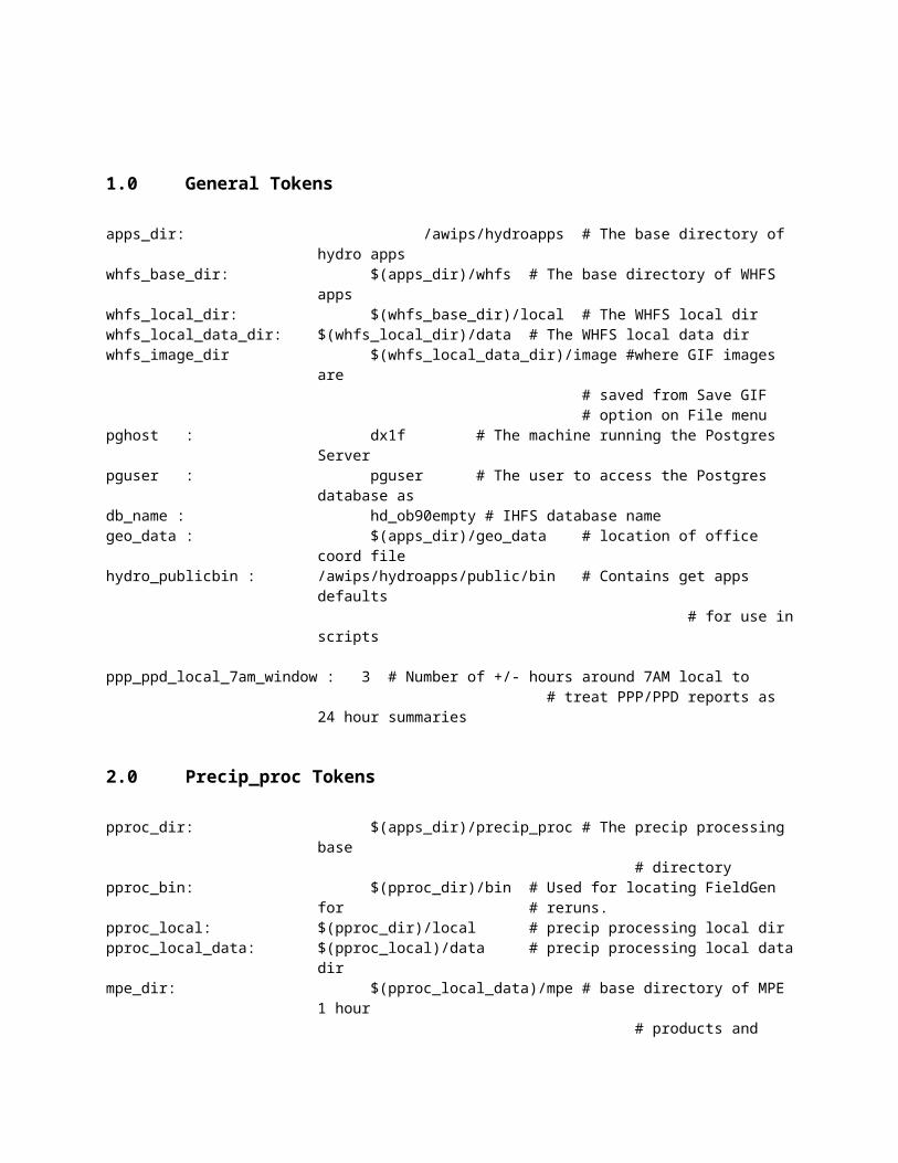
Format: ASCIIContains the DailyQC Disagg log files.
Draw Polygon Data Mosaic FilesFilename: MMOSAICYYYYMMDDHHzLocation: /awips/hydroapps/precip_proc/local/data/mpe/draw_precipPath token: rfcwide_drawpre_dirFormat: ASCIIPolygons drawn to the screen while in MPE draw polygon mode are saved to this file. This file is a simple text file containing the value of the drawn precipitation area, the number of points used to define the border of the polygon, and the HRAP coordinates of these points.
FieldGen Log FilesFilename: mpe_IIhrYYYYMMDDHHZLocation: /awips/hydroapps/precip_proc/local/data/log/mpe_fieldgenPath token: rfcwide_logs_dirFormat: ASCIIThese are text log files containing useful diagnostic information for each run of the MPE_FieldGen application.
Freezing Level Basin Averaged Value File
Filename: maz_ccc_YYYYMMDDLocation:
/awips/hydroapps/precip_proc/local/data/mpe/dailyQC/freezing_level/MAZPath token: mpe_maz_dirFormat: ASCII
This file contains basin averaged freezing level data. The averages are created from RUC80 point data. For each basin and sub-basin in the forecast area, the file contains four SHEF-encoded freezing level values with each corresponding to one 6 hour synoptic period: 00z, 06z, 12z, 18z.
Freezing Level Grid:Filename: freezing_ccc_grid_HH_YYYYMMDDLocation:/awips/hydroapps/precip_proc/local/data/mpe/dailyQC/freezing_level/gridPath token: mpe_grid_freezing_dirFormat: ASCIIThis file contains gridded freezing level data created from the level 2 RUC80 freezing level data points. This file is created when Level 2 data are saved in DailyQC. Four grid files are created for each DailyQC day, one for each synoptic 6 hour period.
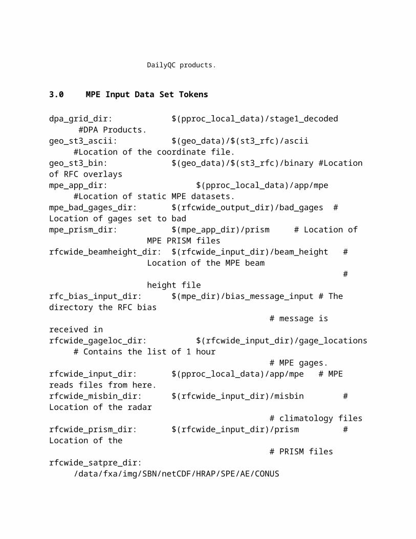
Freezing Level Neighbor List FileFilename: freezing_neighbor_list_cccLocation: /awips/hydroapps/precip_proc/local/data/app/mpe/grid_masksPath token: mpe_gridmask_dir
Format: ASCIIContains a mapping of each HRAP grid cell in the MPE analysis area to the 5 closest freezing level points. This file is automatically updated each time the DailyQC station list is updated.
Gage Only Analysis Field FilesFilename: GAGEONLYYYYMMDDHHzLocation:
/awips/hydroapps/precip_proc/local/data/mpe/gageonly
Path token: rfcwide_gageonly_dirFormat: XMRG. May be either big endian or little endian.These files are an analysis of all of the precipitation gages in the forecast area. The gage values are transposed onto the local HRAP grid of the forecast site. An attempt is made to spatially average the gage values which can result in a bull’s eye or “crop circle” appearance around precipitation gage locations. This product does not include any radar-based precipitation estimates.
Gridded Radar Data:Filename: RRRMMDDYYYYHHMMZLocation: /awips/hydroapps/precip_proc/local/data/stage1_decodedPath token: dpa_grid_dirFormat: Binary. Big endian.Gridded radar data represents the raw digital precipitation array (DPA) product generated at a radar site. The precipitation values do not have any bias factors applied to them and so reflect the precipitation amounts as directly computed using the Z-R relationship. This field is used by FieldGen to create the radar mosaic product. This product can be displayed on a site by site basis through the use of the single site radar window.
Height Field FilesFilename: HEIGHTYYYYMMDDHHz

Location: /awips/hydroapps/precip_proc/local/data/mpe/heightPath token: rfcwide_height_dirFormat: XMRG. May be big or little endian.This data field portrays the height in meters of the radar beam above each of the HRAP bins that fall under that radar’s umbrella. This field is dynamically defined for each hour, based on the radar data availability for the hour. The height of the radar together with the beam height information is used to determine the actual height. Displaying this field shows which radar is used for a given grid bin.
Highway OverlaysFilename: us_inter.shpLocation: /awips/fxa/data/localization/nationalDataPath env variable: $FXA_HOME/data/localization/nationalDataFormat: Shapefile. May be big endian or little endian.This binary file contains data for the highway overlay.
Filename: hiways_latlon.LXLocation: /awips/hydroapps/whfs/local/data/geoPath token: whfs_geodata_dirFormat: Binary; Little EndianThis file contains highway data. It is created from the highway data in the hiways.dat and roads.dat files in the /awips/hydroapps/whfs/local/data/geo directory.
Hydoview ImagesLocation: /awips/hydroapps/whfs/local/data/imagePath token: whfs_image_dirFormat: Does not apply.In the case of saving the gif from the File menu, a popup window allows the user to specify the directory and filename to save the screen-captured gif in. If the user does not choose a directory, then by default it is stored in the directory /awips/hydroapps/whfs/local/data/image, which is specified by token whfs_image_dir.
Lakes OverlayFilename: resvrs_latlon.LXLocation: /awips/hydroapps/whfs/local/data/geoPath token: whfs_geodata_dirFormat: Binary; Little EndianThis file contains reservoir data. It is created from the reservoir data in the resvrs.dat file in the /awips/hydroapps/whfs/local/data/geo directory.
Level 1 Freezing Level Point DataFilename: freezing_1_ccc_point_YYYYMMDDLocation: /awips/hydroapps/precip_proc/local/data/mpe/dailyQC/freezing_level/
point

Path Token: mpe_point_freezing_data_dirFormat: ASCIIContains 6 hour freezing level data derived from the RUC80 model. The data are for the RUC80 model points in the office’s MPE forecast area. The data are SHEF encoded for each point. A file contains four 6 hour freezing level values for each freezing level point. This file is produced by the run_freezing_level cron job.
Level 2 Freezing Level Point DataFilename: freezing_2_ccc_point_YYYYMMDDLocation: /awips/hydroapps/precip_proc/local/data/mpe/dailyQC/freezing_level/
pointPath Token: mpe_point_freezing_data_dirFormat: ASCII
Contains 6 hour freezing level data which have been edited and saved in DailyQC.
Level 1 Precipitation Point DataFilename: precip_1_ccc_point_YYYYMMDDLocation: /awips/hydroapps/precip_proc/local/data/mpe/dailyQC/precip/pointPath Token: mpe_point_precip_dirFormat: ASCIIContains 6 hour and 24 hour precipitation data for selected gages in the office’s forecast area. The data are SHEF encoded for each point. This file is produced by the DailyQC preprocessor.
Level 2 Precipitation Point DataFilename: precip_2_ccc_point_YYYYMMDDLocation: /awips/hydroapps/precip_proc/local/data/mpe/dailyQC/precip/pointPath Token: mpe_point_precip_dirFormat: ASCIIContains 6 hour and 24 hour precipitation data for selected gages in the office’s forecast area. The data are SHEF encoded for each point. These data have been quality controlled and output from DailyQC.
Level 1 Temperature Point DataFilename: temperature_1_ccc_point_YYYYMMDDLocation: /awips/hydroapps/precip_proc/local/data/mpe/dailyQC/temperature/pointPath Token: mpe_point_temperature_dirFormat: ASCIIContains 6 hour temperature and 24 hour maximum and minimum temperature data for selected gages in the office’s forecast area. The data are SHEF encoded for each point. This file is produced by the DailyQC preprocessor.
Level 2 Temperature Point Data

Filename: temperature_2_ccc_point_YYYYMMDDLocation: /awips/hydroapps/precip_proc/local/data/mpe/dailyQC/temperature/pointPath Token: mpe_point_temperature_dirFormat: ASCIIContains 6 hour temperature and 24 hour maximum and minimum temperature data for selected gages in the office’s forecast area. The data are SHEF encoded for each point. The data in this file have been QC’d and output from DailyQC.
Local Bias FilesFilename: LOCBIASYYYYMMDDHHzLocation: /awips/hydroapps/precip_proc/local/data/mpe/locbiasPath token: rfcwide_locbias_dirFormat: XMRG. Little EndianEach HRAP bin in this grid contains a local bias value. FieldGen applies these values to the radar mosaic field to create the local bias radar mosaic product. The local bias is an attempt to minimize orographic and other local influences on rainfall estimates that can not be addressed using a general field bias value.
Local Bias Multi-sensor Mosaic FilesFilename: MLMOSAICYYYYMMDDHHzLocation: /awips/hydroapps/precip_proc/local/data/mpe/mlmosaicPath token: rfcwide_mlmosaic_dirFormat: XMRG. Little EndianThis mosaic is a variation of the Multi-sensor mosaic. Whereas the Multi-sensor mosaic uses the Mean Field Bias Radar Mosaic, the Local Bias Multi-sensor Mosaic is a merging of the Local Bias Radar Mosaic field and the gage analysis
Local Bias Radar Mosaic FilesFilename: LMOSAICYYYYMMDDHHzLocation: /awips/hydroapps/precip_proc/local/data/mpe/lmosaicPath token: rfcwide_lmosaic_dirFormat: XMRG. Little EndianFormerly called LMOSIAC in the original MPE, this data field represents the radar mosaic product with the local bias values applied to it. The local bias values are specified on a HRAP grid basis and these individual values are displayable through the Local Bias grid.
Local Bias Satellite Precipitation Estimate (SPE)Filename: LSATPREYYYYMMDDHHzLocation: /awips/hydroapps/precip_proc/local/data/mpe/lsatprePath Token: rfcwide_lsatpre_dirCreation Token: mpe_lsatpre_calcFormat: XMRG. Little EndianThis file contains local biased corrected satellite precipitation estimates. These estimates

are projected on a HRAP basis.
Local Span FilesFilename: LOCSPANYYYYMMDDHHzLocation: /awips/hydroapps/precip_proc/local/data/mpe/locspanPath token: rfcwide_locspan_dirFormat: XMRG. Little EndianEach HRAP bin in this data grid contains a memory span value which corresponds to the HRAP bin’s local bias value as specified in the Local Bias field. The local span demonstrates the period of time over which gage and radar data was compared in order to arrive at the local bias value. Generally, areas in which there are few rain gages will have longer memory spans in order to arrive at a reliable bias value. Data rich regions with many rain gages can feature shorter memory spans since a much smaller time span is required to find a reliable bias value.
Maximum Radar Mosaic FilesFilename: MAXRMOSAICYYYYMMDDHHzLocation: /awips/hydroapps/precip_proc/local/data/mpe/maxrmosaicPath token: rfcwide_maxrmosaic_dirFormat: XMRG. Little EndianThis data grid represents the rainfall estimates as computed from the Z-R relationships at the individual radar sites providing radar coverage across the forecast area. There are no bias values applied to these precipitation estimates, so this field may be thought of as the raw radar estimated precipitation mosaic. Depending on the value of the mpe_base_radar_mosaic token, this product can serve as the base for the field bias radar mosaic, the local bias radar mosaic and the P3 local bias corrected mosaic. For HRAP grid bins which are covered by multiple radars, the maximum radar-based precipitation estimate is chosen.
Maximum Temperature PRISM FilesFilename: prism_max_temp_ccc_mmmLocation: /awips/hydroapps/precip_proc/local/data/app/mpe/prismPath token: rfcwide_prism_dirFormat: XMRG. Big or little EndianThis data grid provides a map of climatological max temperatures across the MPE analysis area. These data represent monthly max temperature values. They are used in the production of the DailyQC temperature grids and MATs. They are also used in the estimation of missing temperature values.
Mean Field Bias Radar Mosaic FilesFilename: BMOSAICYYYYMMDDHHzLocation: /awips/hydroapps/precip_proc/local/data/mpe/bmosaicPath token: rfcwide_bmosaic_dirFormat: XMRG. Little Endian
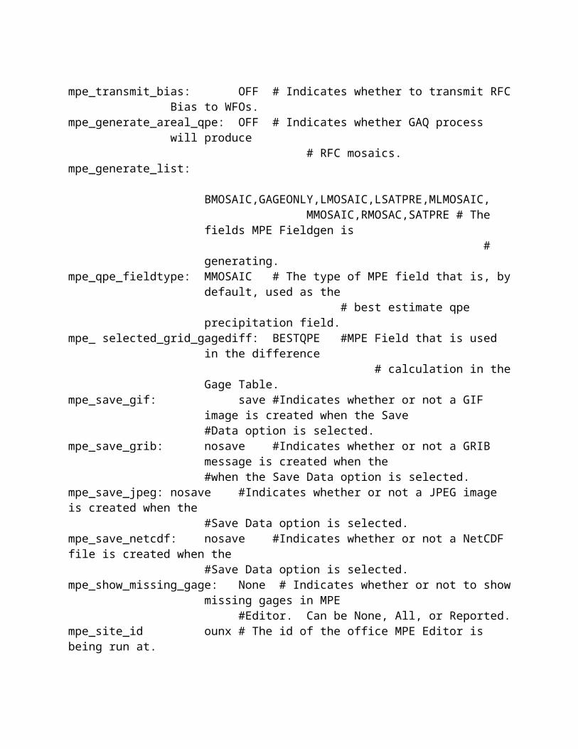
These files are created by MPE FieldGen by applying the individual mean field radar biases to the raw radar mosaic. Exactly which radar bias is applied to a portion of the radar mosaic is dictated by the radar coverage field which indicates which radar site provides the best coverage for each of the HRAP bins in the grid covering the forecast area.
Minimum Temperature PRISM FilesFilename: prism_min_temp_ccc_mmmLocation: /awips/hydroapps/precip_proc/local/data/app/mpe/prismPath token: rfcwide_prism_dirFormat: XMRG. Big or little EndianThis data grid provides a map of climatological min temperatures across the MPE analysis area. These data represent monthly minimum temperature values. They are used in the production of the DailyQC temperature grids and MATs. They are also used in the estimation of missing temperature values.
Misbin FilesFilename: misbin.RRRLocation: /awips/hydroapps/precip_proc/local/data/app/mpe/misbinPath token: rfcwide_misbin_dirFormat: Binary. Big or little Endian.The misbin file is provided on a radar by radar basis. It represents which HRAP bins, within the radar’s umbrella, are blocked due to ground features. FieldGen takes the misbin file into consideration when generating radar-based mosaics.
Mosaicked FFG Grid FilesFilename: CCCYYYYMMDD_HHHH_II.ffgLocation: /awips/hydroapps/whfs/local/data/grid/miscPath token: whfs_misc_grid_dirFormat: NetCDFMosaicked FFG files are tailored to fit a WFO’s MPE area. Since the forecast area of a WFO can straddle two or more RFCs, it is sometimes necessary to mosaic the individual RFC FFG data grids to provide full coverage for the WFO’s MPE area. The mosaicking of the RFC FFG files is performed by the gen_areal_ffg program which is run from the process_dpa_files cron-driven script.
MPE Beam Height FileFilename: mpe_radar_beam_heightLocation: /awips/hydroapps/whfs/local/data/app/mpe/beam_heightPath token: rfcwide_beamheight_dirFormat: Binary; Little EndianContains the height of the 0.5 degree tilt radar beam for each HRAP grid bin contained within the 230 km range of a radar transceiver. This information is then combined with a radar elevation value to determine the actual value of the beam height. This file is

created by running the run_create_mpe_beam_height_file script.
MPE Editor ExecutableFilename: mpe_editor.LXLocation: /awips/hydroapps/precip_proc/binFormat: Binary executable This is the executable for the MPE Editor program.
MPE Editor Log FilesFilename: mpe_editorMMDDHHMM.pidLocation: /awips/hydroapps/precip_proc/local/data/log/mpe_editorPath token: mpe_editor_logs_dirFormat: ASCIIThese are text log files containing useful diagnostic information for each run of the MPE Editor application.
MPE Editor Start ScriptFilename: start_mpe_editorLocation: /awips/hydroapps/precip_proc/binFormat: ASCIIThis is the start script for the MPE Editor application. It ensures that the environment is set up properly for running the program.
MPE Gage Location FileFilename: mpe_gage_locationsLocation: /awips/hydroapps/precip_proc/local/data/app/mpe/gage_locationsPath token: rfcwide_gageloc_dir Format: ASCIIThe first record contains the number of gauge records in the file. The subsequent records contain the lid, latitude and longitude of the gauges used by MPE Fieldgen to create the precipitation fields and mosaics. This file is created by running the run_create_mpe_gage_file script. It should be updated whenever the stg2_input flag is set on or off in the IngestFilter table.
MPE_FieldGen ExecutableFilename: mpe_fieldgen.LXLocation: /awips/hydroapps/precip_proc/binFormat: Binary executableThis program generates the radar and rain gauge-based precipitation mosaics which can then be viewed using MPE Editor. MPE FieldGen is the program responsible for producing the MPE data grids and performing all of the necessary science and number crunching that must go into doing this task. MPE FieldGen may be manually rerun from MPE Editor to incorporate edited gage values, pseudo gages, ignored radars, and modified bias values into an updated set of MPE data grids.
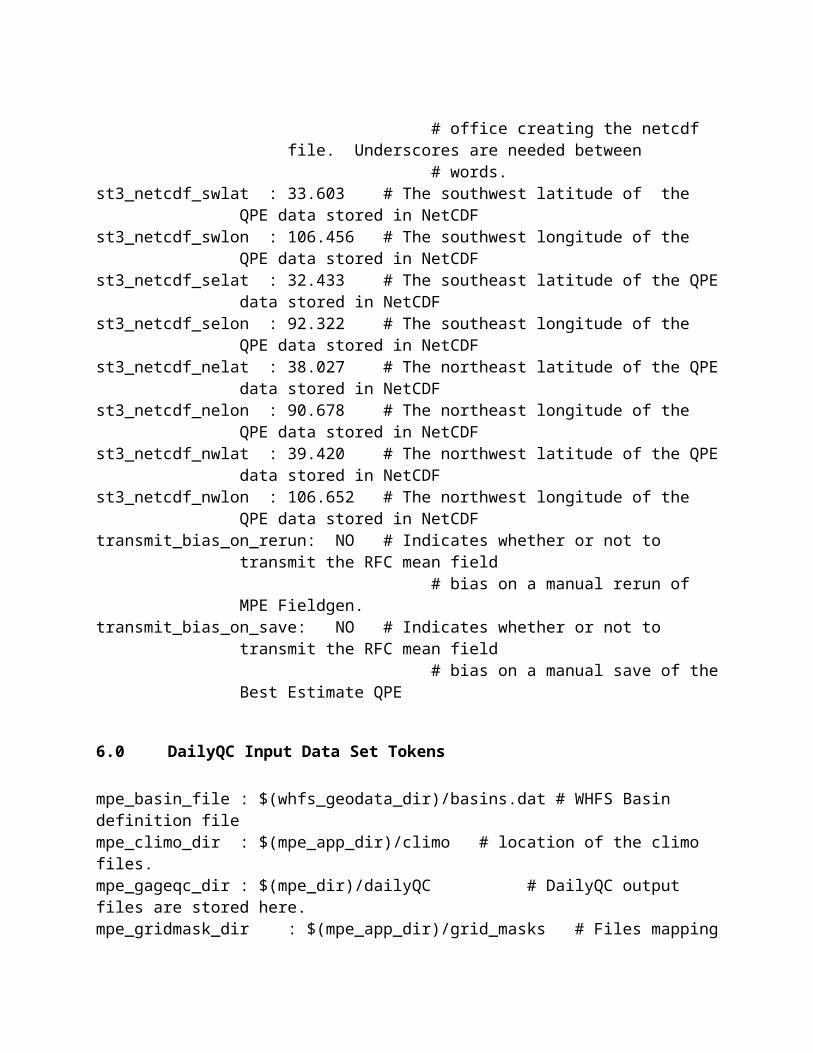
Multi-sensor Mosaic FilesFilename: MMOSAICYYYYMMDDHHzLocation: /awips/hydroapps/precip_proc/local/data/mpe/mmosaicPath token: rfcwide_mmosaic_dirFormat: XMRG; Little EndianThis data mosaic is a powerful tool for estimating rainfall amounts. It is a merging of the field biased radar mosaic rainfall estimates and the gage analysis field. It is important because it provides a mixture of remote sensed (radar) and ground truth (rain gage) rainfall amounts which can complement each other in order to produce a more accurate rainfall map. The merging of these products is performed by MPE FieldGen.
National Apps Defaults FileFilename: .Apps_defaultsLocation: /awips/hydroappsPath token: APPS_DEFAULTS (environmental variable)Format: ASCIIContains the default values of tokens used by MPE and other applications. This file must not be edited.
Overlay Configuration FileFilename: mpe_editor_overlay_configurationLocation: /awips/hydroapps/whfs/local/data/app/hydroviewPath token: hv_config_dirFormat: ASCIIThe Overlay Configuration file specifies which overlays are available in MPE Editor. It defines each overlay, specifying characteristics such as the color of the overlay, the line thickness of the overlay and whether or not the overlay is visible when MPE Editor is started. The format of the Overlay Configuration file is described in Appendix X.
Pan Image East, North, South, West Button Pixmap FileFilename: east.xpm; north.xpm; south.xpm, west.xpmLocation: /awips/hydroapps/whfs/local/data/app/hydroviewPath token: hv_config_dirFormat: X-Window PixmapThis file contains the graphic which is displayed on the drop-down toolbar button to pan on the MPE Editor map.
Precipitation Bad Data FileFilename: precip_ccc_bad_YYYYMMDDLocation:
/awips/hydroapps/precip_proc/local/data/mpe/dailyQC/precip/badPath token: mpe_bad_precip_dirFormat: ASCII

Contains a list of the precipitation stations which have been set to bad by the DailyQC user. These stations will not be used in the DailyQC processing for the date indicated in the filename.
Precipitation Basin Average Value FileFilename: map_ccc_YYYYMMDDLocation:/awips/hydroapps/precip_proc/local/data/mpe/dailyQC/precip/MAPPath token: mpe_map_dirFormat: ASCIIContains basin averaged precipitation data generated from precipitation point data. For each basin and sub-basin in the forecast area, the file contains four 6 hour basin averaged precipitation values. These four values are computed over the following synoptic intervals: 00-06, 06-12, 12-18, 18-00.
Precipitation 6 Hour GridsFilename: precip_ccc_grid_HH_HH_YYYYMMDDLocation: /awips/hydroapps/precip_proc/local/data/mpe/dailyQC/precip/gridPath token: mpe_grid_precip_dirFormat: ASCIIContains gridded 6 hour precipitation data created from 6 hour point precipitation data. This file is created when level 2 data are saved in DailyQC. The files are created for four durations represented by HH_HH in the grid’s filename: 00_06, 06_12, 12_18, and 18_00.
Precipitation 24 Hour Grids
Filename: precip_ccc_grid_HH_HH_YYYYMMDDLocation: /awips/hydroapps/precip_proc/local/data/mpe/dailyQC/precip/gridPath token: mpe_grid_precip_dirFormat: ASCIIContains gridded 24 hour precipitation data created from 24 hour point precipitation data. This file is created when level 2 data are saved in DailyQC. The files are created for one duration represented by HH_HH in the grid’s filename: 12_12 (12z-12z).
Precipitation Neighbor List FileFilename: precipitation_neighbor_list_cccLocation: /awips/hydroapps/precip_proc/local/data/app/mpe/grid_masksPath token: mpe_gridmask_dirFormat: ASCIIContains a mapping of each HRAP grid cell in the MPE analysis area to the 30 closest precipitation gages. This file is automatically updated by DailyQC when it detects that the DailyQC station list has been updated. The number of neighbors processed is controlled by the mpe_dqc_max_precip_neighbors token.

Precipitation PRISM FilesFilename: prism_mean_precip_ccc_mmmLocation: /awips/hydroapps/precip_proc/local/data/app/mpe/prismPath token: rfcwide_prism_dirFormat: XMRG. Big or little EndianThis data grid provides a map of climatological precipitation across the MPE analysis area. This product is especially useful in mountainous regions where the effectiveness of radar is reduced due to terrain features blocking the beam and precipitation gages may be few and far between. Grid points with no radar coverage or rain gage data are estimated from nearby grid points that have good coverage. These estimated values are then scaled by the PRISM data. PRISM data represents monthly mean precipitation values.
Radar Coverage Field FilesFilename: INDEXYYYYMMDDHHzLocation: /awips/hydroapps/precip_proc/local/data/mpe/indexPath token: rfcwide_index_dirFormat: XMRG. May
be either big or little endian
This data grid displays over which portions of a forecast area a radar site provides coverage. The driving factor which determines which radar site shall provide coverage for a specific grid point is the altitude of the radar beam. The radar which can provide coverage for a grid point at the lowest altitude will be chosen. This field is used in determining which radar bias is applied when generating the Field Bias radar mosaic.
Radar Location OverlayFilename: 88D.lpiLocation: /awips/fxa/data/localizationDataSets/CCCPath env variable: $FXA_LOCALIZATION_ROOT/$FXA_LOCAL_SITEFormat: ASCIIThis text file contains the coordinates and identifiers of the WSR-88D radar sites across the United States and its territories.
Radar Mosaic FilesFilename: RMOSAICYYYYMMDDHHzLocation: /awips/hydroapps/precip_proc/local/data/mpe/rmosaicPath token: rfcwide_rmosaic_dirFormat: XMRG; Little EndianThis data grid represents the rainfall estimates as computed from the Z-R relationships at the individual radar sites providing radar coverage across the forecast area. There are no bias values applied to these precipitation estimates, so this field may be thought of as the raw radar estimated precipitation mosaic. It serves as the base for the field bias radar mosaic and the local bias radar mosaic.
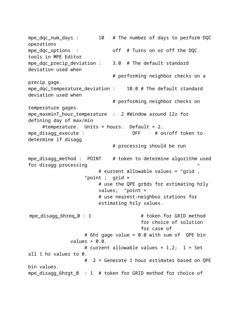
Raw FFG Files (Unmosaicked)Filename: YYYYMMDD_HHHH.multiLocation: /data/fxa/img/SBN/netCDF/HRAP/FFG/[XX]RFC/[D]hrFormat: NetCDFComments: “XX” represents “AB”, “AK”, “CB”, “CN”, “LM”, “MA”,
“MB”, “NC”, “NE”, “NW”, “OH”, “SE”, or “WG”. “D” represents the FFG product duration value “1”, “3”, “6”, “12”, or “24”
The raw FFG files are produced at RFCs. These files contain flash flood guidance for a specific duration of time, which may be 1, 3, 6, 12, or 24 hours. The product indicates how much rainfall over the duration is required to initiate flash flooding over a specific HRAP grid box. The ability to display this data has been provided for RFCs using MPE Editor. WFOs will generally use the Mosaicked FFG product for their flash flood monitoring needs.
RFC Field Bias MosaicFilename: RFCBMOSAICYYYYMMDDHHzLocation: /awips/hydroapps/precip_proc/local/data/mpe/rfcbmosaicFormat: XMRG; Little EndianPath token: mpe_rfcbmosaic_dirThis file contains the RFC mean field bias corrected mosaic. It is produced by applying RFC mean field bias corrections to the radar mosaic. If an RFC mean field bias has not been received for a radar in the mosaic for the given hour, then the WFO mean field bias value will be used for that radar. If no RFC mean field bias values have been received, then WFO mean field bias values will be used for all of the radars and the RFC Field Bias Mosaic will be identical to the Field Bias Mosaic.
RFC OverlayFilename: usa_rfc.bcdLocation: /awips/fxa/data/localization/nationalDataFormat: BCD binary. Must be little endian for use in MPE Editor
on Linux workstations.Path env variable: $FXA_HOME/data/localization/nationalDataThis file contains the binary cartographic data for the RFC boundary overlay. The boundaries of all RFCs are included in this file. Likewise, the boundaries of all RFCs are displayed when this overlay is chosen.
RFC Multi-sensor MosaicFilename: RFCMMOSAICYYYYMMDDHHzLocation: /awips/hydroapps/precip_proc/local/data/mpe/rfcmmosaicPath token: mpe_rfcmmosaic_dirFormat: XMRG; Little EndianThis field is created by combining the RFC mean field bias corrected mosaic with gage data. If no RFC mean field biases have been received for this hour, then this field will

look the same as the multi-sensor mosaic.
RFC QPE MosaicFilename: RFCMOSAIC01YYYYMMDDHHzLocation: /awips/hydropapps/precip_proc/local/data/mpe/rfcqpe01Path token: gaq_xmrg_1hr_dirFormat: XMRG; Little EndianThis file contains the RFC QPE Mosaic which is produced by the Generate Areal QPE (GAQ) process. This is a mosaic of the Best Estimate QPEs received from each RFC which provides coverage for the office’s MPE forecast area. If QPE data have not been received from one or more RFCs, then missing data will be shown in those RFCs’ basins in the mosaic. In order to receive RFC QPE products, the mpe_generate_areal_qpe token must be set to ON.
Rivers OverlayFilename: rivers_latlon.LXLocation: /awips/hydroapps/whfs/local/data/geoPath token: whfs_geodata_dirFormat: Binary; Little EndianThis file contains river data. It is created from the river data in the GeoLine table by Hydrobase.
Roads OverlayFilename: roads_latlon.LXLocation: /awips/hydroapps/whfs/local/data/geoPath token: whfs_geodata_dirFormat: Binary; Little EndianThis file contains road overlay data. It is created from the roads data in the roads.dat file in the /awips/hydroapps/whfs/local/data/geo directory.
Satellite Gage MosaicFilename: SGMOSAICYYYYMMDDHHzLocation: /awips/hydroapps/precip_proc/local/data/mpe/sgmosaicPath Token: mpe_sgmosaic_dirFormat: XMRG; Little EndianThis file contains the satellite gage mosaic. It is produced through an objective analysis which uses local bias corrected satellite data to fill in between the gage locations in the Gage Only Analysis.
Satellite Precipitation Estimate (SPE)Filename: YYYYMMDD_HH00.multiLocation: /data/fxa/img/SBN/netCDF/HRAP/SPE/AE/CONUSPath Token: rfcwide_satpre_dirFormat: NetCDF
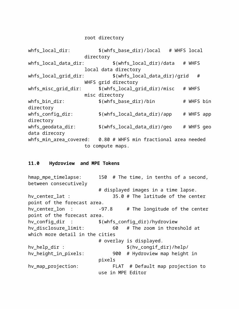
This file contains satellite precipitation estimates for the CONUS. These estimates are projected on a national HRAP. As part of MPE Fieldgen processing, the area is clipped to the forecast site’s MPE forecast area.
Satellite Radar MosaicFilename: SRMOSAICYYYYMMDDHHzLocation: /awips/hydroapps/precip_proc/local/data/mpe/srmosaicPath Token: mpe_srmosaic_dirFormat: XMRG; Little EndianThis file contains the satellite radar mosaic. In this product, local bias corrected satellite data are used to fill in missing areas in the local bias corrected radar mosaic.
Satellite Radar Gage MosaicFilename: SRGMOSAICYYYYMMDDHHzLocation: /awips/hydroapps/precip_proc/local/data/mpe/srgmosaicPath Token: mpe_srgmosaic_dirFormat: XMRG; Little EndianThis file contains the satellite radar gage mosaic. It is a multisensor analysis produced by combining the SRMOSAIC field with the gage data.
Satellite State Variable Files:
Filenames: YYYYMMDDHHz, state_variablesLocation: /awips/hydroapps/precip_proc/local/data/mpe/sat_state_varPath token: rfcwide_sat_statevar_dirFormat: Binary; Little EndianSatellite local bias correction state variable data are passed between subsequent runs of MPE FieldGen through the use of these direct access files.
Scratch FilesFilename: pcp.###.pidLocation: /awips/hydroapps/precip_proc/local/data/mpe/dailyQC/scratchPath token: mpe_scratch_dirFormat: BinaryDailyQC work files. Data are stored here for use in the grid rendering and the computation of basin averages and contouring. Files are deleted at the end of the MPE Editor session.
Site Apps Defaults FileFilename: .Apps_defaults_siteLocation: /awips/hydroappsPath Token: APPS_DEFAULTS_SITE (environment variable)Format: ASCII
The values of tokens defined in the national apps defaults file can be modified in this file.
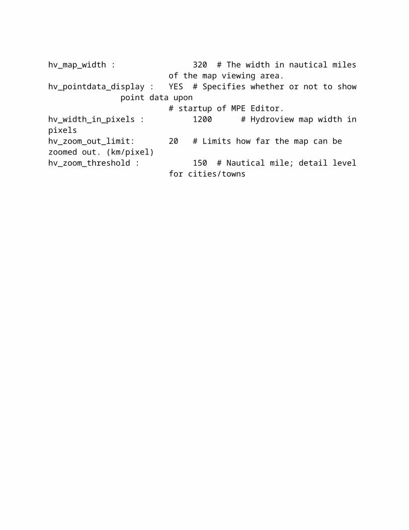
State OverlayFilename: conandsta.bcdLocation: /awips/fxaPath env variable: $FXA_HOMEFormat: Binary; little EndianThis file contains the BCD data defining the U.S. state boundaries, Canadian provinces,
and Mexico state boundaries. This file is maintained by FSL.
State Variable Files:Filenames: YYYYMMDDHHz, state_variablesLocation: /awips/hydroapps/precip_proc/local/data/mpe/state_varPath token: rfcwide_statevar_dirFormat: Direct Access BinaryFile contains information related to the local bias calculations.
Streams OverlayFilename: streams_latlon.LXLocation: /awips/hydroapps/whfs/local/data/geoPath token: whfs_geodata_dirFormat: Binary; little endianThis file contains stream overlay data. It is created from the streams.dat file in the /awips/hydroapps/whfs/local/data/geo directory.
Temperature Bad Data FileFilename: temperature_ccc_bad_YYYYMMDDLocation:
/awips/hydroapps/precip_proc/local/data/mpe/dailyQC/temperature/badPath token: mpe_bad_temperature_dirFormat: ASCII
Contains a list of the temperature stations which have been set to bad by the DailyQC user. These stations will not be used in the DailyQC processing for the date indicated in the filename.
Temperature Basin Average Value FileFilename: mat_ccc_YYYYMMDDLocation:
/awips/hydroapps/precip_proc/local/data/mpe/dailyQC/temperature/MATPath Token: mpe_mat_dirFormat: ASCII
This file contains basin averaged temperature data generated from 6 hour point temperature observations. For each basin and sub-basin in the office’s forecast area, the
file contains four SHEF-encoded 6 hour temperature values corresponding to the four 6 hour synoptic times: 00z, 06z, 12z, 18z. This file is created when level 2 data are saved in DailyQC.
Temperature 6 Hourly Grids:Filename: temperature_ccc_grid_HH_YYYYMMDDLocation:/awips/hydroapps/precip_proc/local/data/mpe/dailyQC/temperature/gridPath token: mpe_grid_temperature_dirFormat: ASCIIThis file contains gridded 6 hourly temperature data created from the level 2 6 hourly temperature data points. This file is created when Level 2 data are saved in DailyQC.
Temperature Max Grid:Filename: temperature_ccc_grid_max_YYYYMMDDLocation:/awips/hydroapps/precip_proc/local/data/mpe/dailyQC/temperature/gridPath token: mpe_grid_temperature_dirFormat: ASCIIThis file contains gridded 24 hour max temperature data created from the level two 24 hour max temperature data points. This file is created when Level 2 data are saved in DailyQC.
Temperature Min Grid:Filename: temperature_ccc_grid_min_YYYYMMDDLocation:/awips/hydroapps/precip_proc/local/data/mpe/dailyQC/temperature/gridPath token: mpe_grid_temperature_dirEndian : Text fileFormat: ASCIIThis file contains gridded 24 hour min temperature data created from the level two 24 hour min temperature data points. This file is created when Level 2 data are saved in DailyQC.
Temperature Neighbor List FileFilename: temperature_neighbor_list_cccLocation: /awips/hydroapps/precip_proc/local/data/app/mpe/grid_masksPath token: mpe_gridmask_dirFormat: ASCIIContains a mapping of each HRAP grid cell in the MPE analysis area to the 20 closest temperature gages. This file is automatically updated each time the DailyQC station list is updated. The number of neighbors processed is controlled by the mpe_dqc_max_temp_neighbors token.
Timezones OverlayFilename: timezones.shp Location: /awips/hydroapps/whfs/local/data/app/hydroviewPath token: hv_config_dirFormat: Shapefile BinaryThis shapefile contains the data used to plot the timezones overlay on the MPE Editor map area.
Triangulated Local Bias HRAP Grid Triangles FileFilename: utiltrianglesLocation:
/awips/hydroapps/precip_proc/local/data/app/mpe/utiltrianglesPath token: rfcwide_utiltriangles_dirFormat: Binary; little Endian
Contains the triangular irregular network (TIN) based on the HRAP grid bins contained within the forecast office’s MPE forecast area. Used in the creation of the triangulated local bias mosaic for P3. This file is created by running the run_create_triangles script.
Triangulated Local Bias Multi-sensor Mosaic FilesFilename: P3LMOSAICYYYYMMDDHHzLocation: /awips/hydroapps/precip_proc/local/data/mpe/lmosaicPath token: rfcwide_p3lmosaic_dirFormat: XMRG; little endian.
This local bias corrected multi-sensor precipitation mosaic uses the local bias correction algorithm from the ABRFC P3 application. On a HRAP grid bin by grid bin basis, mosaiced radar precipitation estimates are unbiased using gage data. A triangular irregular network (TIN) is created based on the gage data and used to interpolate the gage and radar values to individual HRAP grid bins.
Triangulated Local Bias Radar Config FileFilename: radarconfile
Location:/awips/hydroapps/precip_proc/local/data/app/mpe/radarconfile
Path Token: rfcwide_utiltriangles_dirFormat: Binary; little Endian
Contains the triangular irregular network (TIN) based on the HRAP grid bins contained within the forecast office’s MPE forecast area. These are used in the creation of the triangulated local bias mosaic. This file is created by running the run_create_triangles script.
Zones OverlayFilename: reg_zones.bcdLocation: /awips/fxa/data/localizationDataSets/CCC

Path env variable: $FXA_LOCALIZATION_ROOT/$FXA_LOCAL_SITEFormat: Binary; little endianThis BCD file contains the data used to plot the zones overlay.
Zoom In Image Pixmap FileFilename: zoomin.xpmLocation: /awips/hydroapps/whfs/local/data/app/hydroviewPath token: hv_config_dirFormat: X-Window PixmapThis is the image drawn onto the drop-down toolbar button which allows the user to zoom into the MPE Editor map area.
Zoom Out Pixmap FileFilename: zoomout.xpmLocation: /awips/hydroapps/whfs/local/data/app/hydroviewPath token: hv_config_dirFormat: X-Window PixmapThis is the image drawn onto the drop-down toolbar button which allows the MPE Editor map area to be “zoomed out”.
X/Motif Resource FileFilename: RFCWide_res File Location: /awips/hydroapps/whfs/binFormat: ASCIIThis is the X/Motif resource file for the MPE Editor application. It controls the appearance and fonts of the various labels and widgets.

Appendix F. Setting the Colors of Displayed MPE Data
The colors of the displayed MPE gridded datasets can be modified using the MPE Color Manager. This feature is accessed by selecting the MPE Color Manager option on the MPE Editor Tools menu. This launches the Color Scale Manager window. More information about the Color Scale Manager window can be found in the Hydroview Users Guide.
63
Appendix G. MPE Editor/DailyQC File Formats
Below are the formats of some of the files used in MPE Editor/DailyQC. The formats of many of the text files are not given since the formats of these can easily be seen by opening them in an editor.
1.0 Coordinate File
The Coordinate File defines the location and size of the area for which MPE will produce precipitation mosaics. This MPE area is a rectangular grid of HRAP grid bins. At an RFC, this grid should be made large enough to cover the office’s basin. At a WFO, this grid should be made large enough to cover the CWA.
The Coordinate File is an ASCII text file. It contains the following four lines of information:
1) HRAP X Origin Coordinate Value (relative to the national HRAP grid)2) HRAP Y Origin Coordinate Value (relative to the national HRAP grid)3) Number of Columns in the HRAP Grid (MAXX)4) Number of Rows in the HRAP Grid (MAXY)
2.0 XMRG
(Source: http://www.weather.gov/ohd/hrl/misc/xmrg.pdf)
Hourly precip estimates on an HRAP grid generated by MPE Fieldgen XMRG format. The XMRG are files used as input to the NWSRFS Operational Forecast System NEXRAD Mean Areal Precipitation (MAPX) Preprocessor.
XMRG files are written row by row from within a 'do-loop' using a FORTRAN unformatted write statement. The loop is from 1 to MAXY which places the southernmost row as the first row of the file. Each file consists of a two record header followed by the data. The first record of the header contains the following values:
1) HRAP-X coordinate of southwest corner of grid (XOR)2) HRAP-Y coordinate of southwest corner of grid (YOR)3) Number of HRAP grid boxes in X direction (MAXX)4) Number of HRAP grid boxes in Y direction (MAXY)
The values are written in integer*4 format and are in the file../geo_data/ascii/coord_[sitename].dat where sitename is the site name.
64

The second record of the header was added in June 1997 and contains the following fields of information:
1) oper sys char*2 'HP' or 'LX'2) user id char*8 LOGNAME of user that saved the file3) saved date/time char*20 ccyy-mm-dd hh:mm:ss (Z time)4) process flag char*8 see below 5) valid date/time char*20 ccyy-mm-dd hh:mm:ss (Z time)6) maximum value integer*4 in units of millimeters (MM)7) version number real*4 AWIPS Build number
The precip data values are written to the file as integer*2 values in units of hundredths of MM. Data values for bins which have no radar coverage are set to -1. There are MAXY rows of data each with MAXX values.
Because the integer*2 data type can hold values only up to approximately 32,000 the xmrg format is not appropriate for large data values. Precipitation values greater than 12 inches cannot be stored in this format.
FORTRAN unformatted records have a 4 byte integer at the beginning and end of each record that is equal to the number of bytes contained in the record. When reading xmrg files through C using the fread function, the user must account for these extra bytes at the beginning and end of each record.
3.0 MPE Gage List
The format of the MPE Gage List file is as follows:
Line 1: Count of records in the fileLine 2 - N : Each of the remaining records contains 3 fields:
<Station id> <Latitude> <Longitude>
The longitudes are positive.
4.0 MPE Beam Height File
This file contains radar beam height values in meters. There are 131 * 131 or 17161 double values. Double values are 8 bytes, so the total size of the beam height file is 17161 * 8 or 137288 bytes. A 131 by 131 block of HRAP grid cells completely contains a radar volume scan.
65

5.0 MPE Misbin Files
These files define whether a given grid bin is expected to have valid radar data, without beam blockage or other effects which render the grid bin value unusable.
Bytes Description1-4 A count of the number of bytes of Misbin data in this file. This value is 34322.5-34326 131*131 Misbin values each represented by 2 bytes34327-34330 A count of the number of bytes of Misbin data in this file. This value is 34322.
A Misbin value of 1 means to use the radar data for the corresponding HRAP grid bin. A Misbin value of 0 means to not use radar data for the corresponding HRAP grid bin. Each block of 131 values in this file corresponds to one HRAP column of data, scanned from lower to higher HRAP row (south to north).
6.0 PRISM
Prism files use the XMRG format described above. In precipitation prism files, the values are in mm * 10. In the temperature prism files, the values are in Fahrenheit * 10.
7.0 DailyQC Station List File
The DailyQC Station List file consists of 4 sections:
1) PPH – 1 hour precipitation gage stations. 2) PPD – 6 and 24 hour gage stations for use in the DailyQC portion of MPE Editor3) TAI – 6 hour temperature and daily observed maximum/minimum temperature stations4) FZI – Freezing level stations; these are not real stations, they are the RUC80 model grid
points which fall within the office’s forecast area
Each section in the master station list is preceded by a count of the number of records in that section. For example,
275ABRN1 PPHRGZZ 35.00 95.24 503 9 AuburnACDO2 PPHRGZZ 35.65 97.36 0 9 Arcadia LakeACIT2 PPHRZZZ 33.58 98.63 1015 9 Archer City
The 275 indicates that there are 275 PPH station records. The fields in this record are:
<lid> <pedtsep> <latitude> <longitude> <elevation> <gage_type> <station_name>
66

The Gage Type is a flag indicating if the gage is weighing or tipping bucket.
An office may also have sub-area station lists. Sub-area station lists only have the PPD, TAI and HZI subsections. They do not contain a PPH station list. The records have the same format as the master station list. Like the master station list, each subsection is preceded by a record count.
Station identifiers must be in alphabetical order within each subsection. Blank lines at the end of any subsection or at the bottom of the file are not allowed and will cause an error in reading the file.
8.0 DailyQC Climo Files
The climo file is divided into two sections, one for temperature and one for precipitation. Each section is preceded by the number of records it contains.
Precipitation Climo Data
For example, the beginning of the precipitation climo data section may appear as follows:
449ACDO2 PPMRGCM 1.14 1.73 2.80 3.03 5.28 4.21 2.44 2.56 4.17 3.19
2.32 1.46
In the case of the precipitation record, the first number, 449, is the number of precipitation climo records. The precipitation record has the following format:
<lid> <pedtsep> <val1> <val2> <val3> <val4> <val5> <val6> <val7> <val8> <val9><val10> <val11> <val12>
where the values are the mean precipitation, in inches, for each of the twelve months with val1 corresponding to January and val12 corresponding to December.
Temperature Climo Data
The beginning of the temperature climo data section may appear as follows:
129ACDO2 TAIRGNM 31.90 37.60 47.30 57.70 66.10 70.70 69.00 61.30 49.60 37.30
31.90 29.50ACDO2 TAIRGXM 47.10 53.70 62.40 71.70 79.50 87.40 93.30 92.70 84.40 74.30
60.00 50.10
67
In the case of the temperature record, the first number, 129, is the number of max/min temperature climo record pairs. For each station, there is a record containing maximum temperature climo data and a record containing minimum temperature climo data.
The format of each temperature record is as follows:
<lid> <pedtsep> <val1> <val2> <val3> <val4> <val5> <val6> <val7> <val8> <val9> <val10> <val11> <val12>
If the type code is ‘X’, then the values are average max temperature in degrees F where val1 corresponds to January and val12 corresponds to December. If the type code is ‘N’, then the values represent the average min temperature in degrees F.
9.0 DailyQC Basin File
The basin boundaries used in the DailyQC MAP, MAT and MAZ computations are read from an ASCII text basin definition file the location of which is given by the mpe_basin_file token. By default, this file is /awips/hydroapps/whfs/local/data/geo/basins.dat
This basin definition file must use the WHFS basin file format as follows:
<basin id> <basin name> <stream order> <num points> <centroid lat> <centroid lon><lat1> <lon1><lat2><lon2>…<lat n><lon n>
where n = num points and western hemisphere longitudes are positive.
An alternative basin file format may be found at sites which already use DailyQC:
<num points> <stream order> <basin id><lat1> <lon1><lat2><lon2>…<lat n><lon n>END
Where n = num points and western hemisphere longitudes are negative. END marks the terminus of each basin definition block. These sites should convert these CBRFC-formatted basin files to the WHFS-formatted basin files using the run_convert_basin_format script.
68

/awips/hydroapps/precip_proc/bin/run_convert_basin_format <input_file> <output_file> <input_file_path>
where input file is the name of the CBRFC-formatted basin definition file, output file is the name of the WHFS-formatted basin definition file, input file path is the directory the input file resides in.
The output file should be named basins.dat. It will be placed in the directory given by the whfs_geodata_dir token. If basins.dat already exists, the run_convert_basin_format script will prompt the user before overwriting it. It will also create a backup copy of it.
Note that DailyQC requires that the <basin name> in the header have NO EMBEDDED BLANKS. The standard format of this header line when output from the IHABBS program contains embedded blanks.
10.0 DailyQC HRAP Neighbor File
The HRAP neighbor list file contains two records. The format of the first record is:
<Time of last DailyQC station list file modification (ticks)><HRAP-X coordinate of southwest corner of grid (XOR)><HRAP-Y coordinate of southwest corner of grid (YOR)><Number of HRAP grid boxes in X direction (MAXX)><Number of HRAP grid boxes in Y direction (MAXY)>
The second record of the neighbor list file contains the indexes of the closest neighboring stations for each HRAP grid bin, using indices to the stations in the DailyQC station list. These index values are written out as four digit integers.
For precipitation and temperature, the tokens
mpe_dqc_max_precip_neighborsmpe_dqc_max_temp_neighbors
are used to define the number of neighboring stations to track. For freezing level, the limit is set to 5.
11.0 DailyQC Level 1 and Level 2 Point Data Files
The DailyQC point data files contain SHEF encoded values.
69

11.1 Precipitation Point Data Files
In the precipitation point data files, each precipitation station in the DailyQC Station List has at least two SHEF encoded records. For example, a Level1 file looks like
.A AQLT2 20080123 DH12/PPD1G/ 0.01S
.E AQLT2 20080122 DH18/PCQ1G/DIH+6/ 0.01S / 0.00S / 0.00S / 0.00S
The first record is a 24 hour precipitation total ending at 12z.The second record is a collection four 6 hour precipitation values spanning the periods 12-18z, 18z-00z, 00z-06z, and 06z-12z.
The type in the PEDTS group is ‘1’. This means that this is level 1 data. In a level 2 point data file the type would be set to ‘2’. Also in a Level2 file, the message types are “.AR” and “.ER”. The precipitation amounts are in inches. Note that “.AR” and “.ER” cannot be used in Level1 files and will cause the data to be ignored. 11.2 Temperature Point Data Files
In the temperature point data files each temperature station in the DailyQC Station List has at least three SHEF encoded records. For example,
.A AOST2 20080113 DH12/TAI1ZXZ 53S
.A AOST2 20080113 DH12/TAI1ZNZ 19S
.E AOST2 20080112 DH12/TAI1ZZZ/DIH+6/ 34S / 50S / 48S / 29S
The first record is the 24 hour maximum temperature ending at 12z.The second record is the 24 hour minimum temperature ending at 12z.The third record is a collection of four 6 hour observed temperatures valid at 12z, 18z, 00z, and 06z.
The type in the PEDTS group is ‘1’. This means that this is level 1 data. In a level 2 point data file the type would be set to ‘2’. The temperatures are in Fahrenheit.
11.3 Freezing Level Point Data Files
In the freezing level point data files each freezing level station in the DailyQC Station List has one SHEF encoded record. For example,
.E Z0001 20080126 DH12/HZIRZ/DIH+6/ 14.80S/ M/ M/ M
This record contains a collection of four 6 hour freezing level values derived from the RUC80 model. These values are valid at 12z, 18z, 00z, and 06z. The type in the PEDTS group is ‘R’
70

for level 1 data and ‘2’ for level 2 data. The freezing level values are in 1000’s of feet.
11.4 DailyQC Gridded Data Files
DailyQC precipitation, temperature and freezing level gridded data files have two records. The format of the first record is:
<HRAP-X coordinate of southwest corner of grid (XOR)><HRAP-Y coordinate of southwest corner of grid (YOR)><Number of HRAP grid boxes in X direction (MAXX)><Number of HRAP grid boxes in Y direction (MAXY)><Datum size flag.> 0 means there are 4 characters per element. A value of 1 means 6 characters.>
The second record contains MAXX * MAXY data values. If the datum size flag is zero, then the values occupy four character fields. If the datum size flag is 1, then the values occupy six character fields. Currently, the only valid value is 1. The values in the second record start at the southwest corner of the MPE HRAP grid, fill the first row, and then the second row, and so on until the northern most row is filled.
The precipitation gridded values are in mm. The temperature gridded values are in degrees Fahrenheit scaled by 100. The freezing level values are in 1000s of feet scaled by 100.
12.0 DailyQC Basin Averaged Files
The DailyQC Basin Averaged Files contain SHEF encoded data.
DailyQC MAP Files
In the precipitation MAP files, each basin and sub-basin in the MPE analysis area has at least one SHEF encoded record. For example,
.ER AYIT2LH 20080122 DH18/PPQPBZZ/DIH+6/ 0.01 / 0.00 / 0.00 / 0.29
This record is a collection of four 6 hour MAP values for the lower portion of the basin AYIT2. These values span the periods 12-18z, 18z-00z, 00z-06z, and 06z-12z.
DailyQC MAT Files
In the temperature MAT files, each basin and sub-basin in the MPE analysis area has at least one SHEF encoded record. For example,
71
.ER ABAT2LH 20080115 DH12/TAIPBZZ/DIH+6/40.4 /57.3 /56.1 /51.5
This record is a collection of four 6 hour MAT values for the lower portion of the basin ABAT2. These values are for the times 12z, 18z, 00z, and 06z. The temperatures are in degrees Fahrenheit.
DailyQC MAZ Files
In the freezing level MAZ files, each basin and sub-basin in the MPE analysis area has at least one SHEF encoded record. For example,
.ER ABAT2LH 20080117 DH12/HZIPBZZ/DIH+6/ 1.7 / 0.4 / /
This record is a collection of four 6 hour MAZ values for the lower portion of the basin ABAT2. These values are for the times 12z, 18z, 00z, and 06z. The freezing level values are in 1000s of feet.
13.0 Disagg 1hr Station List
If the nearest-neighbor algorithm is to be used for disagg processing, a predetermined list of the closest stations reporting (or expected to report) 1 hour values surrounding each 6 hour station in the disagg station list is required. The 1 hour nearest-neighbor station list is automatically generated by first reading the list of PPH record stations from the DailyQC Station List file. The 1 hour station list is then generated internally in the code and written to the file. The list is generated the first time that the disagg function is called. For all calls after the first, the 1 hour station list is read from the file. Distances between the 1 hour stations and the 6 hour stations are compared to the mpe_disagg_station_distance_limit token and calculated the first time only and stored in an array. The time of creation of the file is compared to the last update time of the disagg station list (Section 1.2.2). If the disagg station list has been updated since the 1hr neighbor list file was created, the 1hr station list is recalculated.
Note that changing the mpe_disagg_station_distance_limit token will not result in a recalculation of the nearest-neighbor stations. A recalculation will occur only if the disagg_station_list is changed or the file is “touched” (execute the Linux “touch” command).
The format of this file is as follows:
Number of neighboring 1 hour gages listed for each six hour gage (N)File modification time in Unix ticks6 hour station LID
72

(1) <Index> <1 Hour Station LID> <Lat> <Lon> <Distance in km> …..(N) <Index> <1 Hour Station LID> <Lat> <Lon> <Distance in km>Next 6 hour station LID
…
The index is the position of the neighboring gage in the master precipitation station list array.
There will be the same number of 6 hour stations in this file as there are in the 6 Hour Disagg Station List.
where (N) is the number of stations in the list, lid is a station identifier, lat is a station latitude, and lon is a station longitude (which must be positive for the Western Hemisphere).
14.0 Disagg 6hr Station List
DailyQC Disagg processing requires a list of gages reporting 6hr values which the site desires to be disagged from 6 hr into 1 hr values. This list is expected to be a subset of the DailyQC Station List File.
The format of this file is as follows:
numberlid1 lat1 lon1lid2 lat2 lon2lid3 lat3 lon3
where number is the number of stations in the list
If this gage list does not exist, disagg processing will print an error message to the log and stop.
This file must be manually created and edited.
Note that the “area_id” is defined by the mpe_area_names token. The default value of this token is set to the value of the mpe_site_id token. Some sites break up their area into sub-areas for DailyQC processing. These sites will need to define separate lists for each sub-area.
15.0 MPE State Variable Files
There are three sets of state variable files. One is used in the local bias correction of the Radar
73

Mosaic. The second is used in the local bias correction of the Satellite Precipitation Field. The third is used in the local bias calculation of the Q2 field. The state variable files store the bias table data used in determining the local bias value for each HRAP grid bin in the MPE analysis area. The bias table data are identical to those used in the computation of the Mean Field Bias. The big difference is that the data associated with the mean field bias apply to the entire radar umbrella while the data associated with the local bias apply only to a single HRAP grid bin.
To save processing time, state variable information is only saved for every fourth HRAP grid cell. The HRAP grid cells are processed by starting at the southwest corner of the MPE analysis area and scanning south to north and west to east, processing every fourth row and column.
Each record in the state variable file contains 132 bytes. The format is as follows:
Bytes Description
1-4 Local HRAP Grid Column Number5-8 Local HRAP Grid Row Number9-12 datetime (ticks)13-16 Number of Gage Radar Pairs in Memory Span 117-20 Mean Gage Value in Memory Span 121-24 Mean Radar Value in Memory Span 1….121-124 Number of Gage Radar Pairs in Memory Span 10125-128 Mean Gage Value in Memory Span 10129-132 Mean Radar Value in Memory Span 10
74

Appendix H.Disaggregation Processing Algorithms
A disaggregation option is available in the DailyQC processing portion of MPEEditor to disaggregate 6 hour precipitation values to 1 hour values. The resulting 1 hour values will be written back to the IHFS database to be made available for hourly MPE processing. The disagg processing is done as part of the DailyQC Level 2 processing. To avoid long processing times and large numbers of records being inserted into the IHFS database, it is recommended that the list of disagg stations be kept to minimum.
1.0 Input Data
a) Disagg 6-hour Station ListDailyQC requires a list of gages which are expected to report 24 hr and/or 6 hr precip values. After completion of the DailyQC Level1 processing, all gages in this list will have a 24 hr value and four 6 hr values.
b) 1-Hour Station ListIf the nearest-neighbor algorithm is to be used for disagg processing, a predetermined list of the closest stations reporting (or expected to report) 1-hour values surrounding each 6-hour station in the disagg station list is required.
c) 6-Hour Point Precip Data6 hour data values for all gages in the site’s area are read in and quality controlled as part of the DailyQC Level-1 processing. The quality controlled (Level2) 6-hour values for all gages in the disagg gage list are extracted from the internal data structure.
d) 1-Hour Point Precip DataFor each station in the 1 hour nearest neighbor list, 1 hour values are read from the HourlyPP table. Each record in the HourlyPP table contains 24 hourly values. The user should review the PurgeDynData table read by db_purge to be certain that a sufficient number of days of data are available in the HourlyPP table for disagg processing.
e) PRISM DataIf the nearest-neighbor (point) algorithm is to be used for disagg processing, the PRISM grid containing the average monthly precip values is required. PRISM values at the location of the 1-hour nearest-neighbor stations are used to scale the estimated 1-hour precip values. The PRISM value at the location of the 6-hour gages and the PRISM grid are both read by the normal DailyQC processing. For disagg processing, these values are extracted from internal data structures.
f) QPE Grids
75

If the grid algorithm is to be used for disagg processing, QPE grids are read from the directory defined by the rfcwide_xmrg_dir token. The user should review the purge_mpe_files script to be certain that the QPE grids are available for the periods over which disagg processing will be done. Units of the QPE grid values are hundredths of mm. An xmrg grid value of 2540 equals one inch. Units of the gage values stored in the HourlyPP table which are also used in the calculations are inches.
2.0 Output Data
1 hour precip gage values resulting from the disagg process are written to HourlyPP table in the IHFS database. Records are assigned a type/source of “PZ” and have the QC flag for all hours set to “D”. The 1hr precip values are also written to the disagg log.
3.0 Algorithm Descriptions
The disagg process employ one of the algorithms described in the following sections. The choice of the algorithm is controlled by the mpe_disagg_method token.
3.1 Grid-Based Algorithm
This algorithm compares a sum of the Best Estimate QPE grid bin values averaged over the bin in which the gage is located and surrounding bins for the 6 hour period with the 6 hour precip value to generate estimates of six 1 hour values. The number of bin values to average over is set to 9 corresponding to the bin containing the gage plus the 8 surrounding bins.
The following cases and choice of solution will be controlled via tokens:
6 hr gage value = 0.0 but some 1hr estimated values within the 6hr period are >0.0Token name: mpe_disagg_6hreq_0Token Value = 1: ignore the grid information and set all 1hr gage values to 0.0Token Value = 2: ignore the 6hr gage value and generate 1hr estimates based on the grids
6 hr gage value > 0.0 but all 1hr estimated values are = 0.0Token name: mpe_disagg_6hrgt_0Token Value = 1: ignore the 6hr gage value and set all 1hr values to 0.0Token Value = 2: ignore the grids and generate 1hr estimates based on nearest neighbors
(this will be a future enhancement)
Algorithm Outline:
76

For each 6 hr period being saved as Level 2 data
Read all 6 QPE grids
If any QPE grid is missing, thenSet all 1hr values for all station = missing Write values to databaseExit disagg processing
End If
For each gage in the disagg list
For each hour in the 6 hr periodDetermine the averaged precip value for the hour Add to total
End For
If 6 hr value = 0.0 AND all QPE grid values = 0.0, thenSet all six 1 hr values for the gage = 0.0Write six 1 hr values to the database
Else If 6hr value = 0.0 and some QPE grid values > 0.0Follow logic defined by mpe_disagg_6hreq_0 token
Else If 6hr value > 0.0 and all QPE bin values = 0.0Follow logic defined by mpe_disagg_6hrgt_0 token
ElseFor each hour in the 6 hr period
Calculate the disaggregated 1 hr precip valueWrite value to database
End For (each hour in 6 hr period)End If
End For (each gage in list)End For
3.2 Point-Based Algorithm
This algorithm uses a distance-weighting scheme based on the neighboring 1-hour gage values to estimate an hourly value.
It requires a predetermined list of the closest 1hour stations to each station in the disagg list. The number of stations to use is controlled by the mpe_dqc_max_precip_neighbors token.
for each station in disagg station list: (index m)
for each 6 hr period of each day being saved as Level 2 data: (index h) 6hrval[m][h] = 6hr value for station m
if 6hrval[m][h] is missing or quality code is “bad/failed” then take
77

next 6hr period (next index h) if 6hrval[m][h] is forced good, then take next 6hr period (next index h)
NOTE: 24 hr stations set to “forced good” are skipped in the24 hr to 6hr disagg in DailyQC
if 6hrval[m][h] = 0.0 then
for six 1hr periods in the 6 hr period (loop on index k)
1hrdisvalue[k] = 0.0
end for
take next value of h
end if for six 1hr periods in the 6 hr period (loop on index k): fdist = 0.0 fdata = 0.0 fvalue[k] = -999.
for surrounding 1hr stations (loop on index ii):
if the station’s value is missing or “not reported”, then take next station
1hrval[k][ii] = 1hr value for station ii dist[h][ii] = distance from 1hr station ii to 6hr station h
padj = 1hrval[k][ii] * (PRISM val of 6hr disagg station/PRISM val of 1hr station)
fdist = fdist + (1/(dist[h][ii]**2)) fdata = fdata + (padj/(dist[h][ii]**2)) end for loop on surrounding stations (loop on index ii)
if > 15 stations from surrounding stations are missing or not reporting, then
take next 1hr period (increment index k) end if
fvalue[k] = fdata / fdist -- 1hr distance weighted estimated value
end for six 1hr periods (loop of index k) stotal = 0.0 num_missing_per = 0
for six 1hr periods (loop on index k):
78

if (fvalue[k] != -999. AND qual code is not set to ‘bad’) then stotal = stotal + fvalue[k] else num_missing_per++ end if
end for six 1hr periods (index on k)
if(num_missing_per > 0) then
/* cannot disagg – set all 1hr values to missing */ /* 1hrdisvalue[k] = 1hr disaggregated value written to the database*/
for six 1hr periods (loop on index k)
1hrdisvalue[k] = -999.
end for (index k)
else
scale = 6hrval[m][h]/stotal
for six 1hr periods (loop on index of k)
if (fvalue[k] != -999. AND quql code not set to “bad”) then 1hrdisvalue[k] = fvalue[k] * scale end for six 1hr periods (index k)
end if
end for all 6hr periods (index h)
end for all stations in disagg list (index m)
3.3 Other Algorithm Information
Do not disagg 6-hour gage values flagged as bad. If a gage in the disagg list has a 6-hour value flagged as bad, then all resulting 1hr values for this gage are set to missing and written to the database.
If the grid-based algorithm is requested but one or more of the QPE grids for the 6-hour period to be disagged is not available, then all 1hr values are set to missing and written to the database.
If the point-based algorithm is requested, what should be done in the case where for more than one hour, there are not enough nearest-neighbor gages available for disagg? Should the algorithm compare the sum of the estimated 1hr values with the 6 hour value, divide the difference by the number of missing periods and set each missing period to an equal portion of
79
the difference? This could lead to “bulls-eyes” in the hourly MPE fields.
4.0 MPE Fieldgen
The previous disagg implementation included an automatic rerun for multiple hours of MPE Fieldgen to guarantee the incorporation of the newly generated 1hr gage values. The current implementation does not include a rerun for multiple hours. Instead, the user must rely on the current combination of cron job runs (number of hours configured locally but normally set to 3 hours) and manual 1-hour reruns from MPE Editor to include the newly generated 1- hour gage values in the grids.
mpe_fieldgen reads a list of 1-hour gages from the mpe_gage_locations file located in the directory defined by the rfcwide_gageloc_dir token (see Section 2.7 of the mpe_fieldgen System Guide). The 6hr stations with disagged values must be added to this list for mpe_fieldgen to pick up the 1-hour values. This list is generated by executing the run_create_mpe_gage_file script. This script generates the gage list by looking at records in the IngestFilter table. To make certain that the 6hr stations are added to the list if/when it is regenerated, a record needs to be added to the IngestFilter table which has the lid of the 6hr station with duration of 1001.
5.0 Data Display
1-hour precipitation gage values generated by the disagg process will be displayed through the hourly mode of MPEEditor with a “d” appended to the value.
6.0 Log
If the mpe_disagg_execute token is set to ON, log files will be written to the directory defined by the token mpe_editor_logs_dir.
The following information is written to the log: token values 6hr values for all gages in disagg list for the period being processed by DailyQC all resulting 1hr values number of records written to the database elapsed time for disagg processing
The log files are purged via the purge_mpe_files script.
80