mrkonjić grad - mrkonjićka... · turistički vodiči 10 naša sela 12 ... ovaj vodič će te...
TRANSCRIPT

Mrkonjić Grad Turistički vodič / Tourist guide


Udruženje za razvoj i unapređenje turizma opštine Mrkonjić Grad
‘Jačanje lokalne demokratije – LOD’
ОПШТИНА МРКОЊИЋ ГРАДProjekat finansira Evropska unija

CONTENT
INTRODUCTION 3 Municipality Description 4
MRKONJIĆKA KORPA 10 Mrkonjićka Korpa Offer 10Travel Guides 10Our Villages 12
NATURE 18Our Heights 18Our Waters 22Caves and Pits 26
TRADITION 30Museums 31Folklore 31Home Cuisine 32Old Crafts 36Events 38
THEMATIC ROUTES 40Bicycling 40Mountaineering and Hiking 42Paragliding 44Mushroom Collecting 44
ACCOMMODATION 47Surroundings 52
INFO 56
SADRŽAJ
UVOD 3 Opis opštine 4
MRKONJIĆKA KORPA 10Ponuda Mrkonjićke korpe 10Turistički vodiči 10 Naša sela 12
PRIRODA 18Naše visine 18Naše vode 22Pećine i jame 26
TRADICIJA 30Muzeji 31Folklor 31Domaća kuhinja 32Stari zanati 36Manifestacije 38
TEMATSKE STAZE 40Biciklizam 40Planinarenje i pješačenje 42Paraglajding 44Gljivarenje 44
SMJEŠTAJ 47Bliže okruženje 52
INFO 56
Naslovna strana / Cover, Kuća - House, Anđelko Ćoćkalo, Šibovi

INTRODUCTION
Dear friend,
Welcome to Mrkonjić Grad. This guide will take you through our little town and its beauty. It will introduce the people and traditions of this mountainous and culturally rich region. It suggests you to rely on the hospitality of the people and savour the true beauty of nature in our region. The guide is the result of joint work of the peo-ple of Mrkonjić to make it a pleasant and safe destination, still unknown to many. We tried to collect valuable and useful information that will enhance and facilitate your stay, while the Association ‘Mrkonjićka korpa’ and our hosts and hostesses will give their best to always be at your service and help.Enjoy Mrkonjić, and we look forward to seeing you at some of our wonderful destinations. The Association ‘Mrkonjićka korpa’
UVOD
Dragi prijatelju,
Dobro došao u Mrkonjić Grad. Ovaj vodič će te provesti kroz naše malo mjesto i njegove ljepote. Upoznaćete sa ljudima i tradicijom ovog brdovitog i kulturom bogatog kraja. Predlaže ti da se osloniš na gostoprimstvo ovih ljudi i uživaš u istinskoj ljepoti prirode našeg kraja.Vodič je rezultat zajedničkog rada ljudi koji Mrkonjić čine ugodnom i sigurnom desti-nacijom, još uvijek nepoznatom za mnoge. Trudili smo se da prikupimo vrijedne i ko-risne informacije koje će obogatiti i olakšati tvoj boravak, a Udruženje ‘Mrkonjićka kor-pa’ i naše domaćice i domaćini daće sve od sebe da uvijek budu na usluzi i pomoći. Uživaj u Mrkonjiću, a mi ćemo se radovati skorom susretu na nekoj od naših destinacija.
Udruženje ‘Mrkonjićka korpa’
Lilium martagon (R.Gašić) 3
At the crossroads of ancient roads in an unusual basin, protected by wooded hills and Lisina mountain grew Kolobara, the first name of Mrkonjić Grad. The geogra-phy and natural resources of this munici-pality have always been attractive to vari-ous nations and visitors. The remains of slag from the time of the Illyrians testify to the centuries old tradition and continuity of the production and processing of met-als, which is still ongoing. The first major road was built by the Romans, and parts of this famous highway that linked Dalma-tia and Pannonia are still preserved. Along this Roman road milestone, a Roman well-water Jovana, and monuments dedicated to Jupiter can still be seen. After the 476, when the Western Roman Empire col-lapsed, the Slavs and Avars arrived in this area. As in ancient, as well as, later periods they built roads, brought many cultural in-fluences through trade links with Dalmatia that were used to bring salt, salted fish and olive oil while in exchange domestic prod-ucts that were traded were: wool, wax, cheese and meat. The people still vividly remember the ‘turmanski road’, a turma means chasing livestock for fair trade.
KAKO JE NASTAO I KAKO SE RAZVIJAO MRKONJIĆ GRAD
Nastao je na raskrsnici drevnih puteva u neobičnoj kotlini, na Kolobari, zaštićen šumovitim brdima i planinom Lisinom. Geografski položaj i prirodna bogatstva opštine Mrkonjić Grad oduvijek su bili atraktivni raznim narodima. Ostaci troske iz doba Ilira svjedoče o viševijekovnom kontinuitetu proizvodnje i obrade met-ala koji još uvijek traje. Prve značajnije saobraćajnice izgradili su Rimljani, a još uvijek su sačuvani dijelovi čuvene mag-istrale koja je povezivala Dalmaciju i Panoniju. Uz rimski put mogu se vidjeti miljokazi, rimski bunar-voda Jovana, ali i spomenici posvećeni Jupiteru. Nakon što je 476. godine palo Zapadno rimsko carstvo na ove prostore su došli Sloveni i Avari. Kako u antičkom, tako i u kasnijim periodima izgrađenim putevima stizali su brojni kulturni uticaji, a kroz trgovačke veze sa Dalmacijom donošeni su so, usoljena riba i maslinovo ulje dok su domaći proizvodi u ponudi bili vuna, vosak, sir i meso. U narodu je još živo sjećanje na ‘turmanski put’, a turma znači gonjenje stoke na udaljene vašare radi trgovine. Više od 500 stećaka i gradovi-tvrđave: Soko, Prizren i Bočac svjedoče o burnom
More than 500 tombstones and a num-ber of city-fortresses - Soko, Prizren and Bočac testify to the turbulent medieval life of the Mrkonjić municipality. Through this area, the last Bosnian king Stjepan Tomašević, fled from the Ottomans to
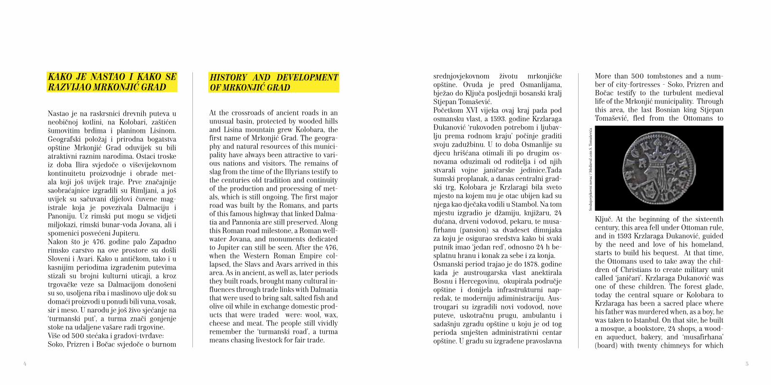
Ključ. At the beginning of the sixteenth century, this area fell under Ottoman rule, and in 1593 Krzlaraga Đukanović, guided by the need and love of his homeland, starts to build his bequest. At that time, the Ottomans used to take away the chil-dren of Christians to create military unit called ‘janičari’. Krzlaraga Đukanović was one of these children. The forest glade, today the central square or Kolobara to Krzlaraga has been a sacred place where his father was murdered when, as a boy, he was taken to Istanbul. On that site, he built a mosque, a bookstore, 24 shops, a wood-en aqueduct, bakery, and ‘musafirhana’ (board) with twenty chimneys for which
srednjovjekovnom životu mrkonjićke opštine. Ovuda je pred Osmanlijama, bježao do Ključa posljednji bosanski kralj Stjepan Tomašević.Početkom XVI vijeka ovaj kraj pada pod osmansku vlast, a 1593. godine Krzlaraga Đukanović ‘rukovođen potrebom i ljubav-lju prema rodnom kraju’ počinje graditi svoju zadužbinu. U to doba Osmanlije su djecu hrišćana otimali ili po drugim os-novama oduzimali od roditelja i od njih stvarali vojne janičarske jedinice.Tada šumski proplanak, a danas centralni grad-ski trg, Kolobara je Krzlaragi bila sveto mjesto na kojem mu je otac ubijen kad su njega kao dječaka vodili u Stambol. Na tom mjestu izgradio je džamiju, knjižaru, 24 dućana, drveni vodovod, pekaru, te musa-firhanu (pansion) sa dvadeset dimnjaka za koju je osigurao sredstva kako bi svaki putnik imao ‘jedan red’, odnosno 24 h be-splatnu hranu i konak za sebe i za konja. Osmanski period trajao je do 1878. godine kada je austrougarska vlast anektirala Bosnu i Hercegovinu, okupirala područje opštine i donijela infrastrukturni nap-redak, te moderniju adiministraciju. Aus-trougari su izgradili novi vodovod, nove puteve, uskotračnu prugu, ambulantu i sadašnju zgradu opštine u koju je od tog perioda smješten administrativni centar opštine. U gradu su izgrađene pravoslavna
Sred
njov
jeko
vni n
ovac
/ M
edie
val c
oin
S. T
omaš
ević
a
HISTORY AND DEVELOPMENT OF MRKONJIĆ GRAD
4 5
he provided funds so that each passenger had a ‘one line’, or 24 hours of free food and lodgings for themselves and for their horses. The Ottoman period lasted until 1878 when the Austria-Hungary government annexed Bosnia and Herzegovina, occupy-ing the area of the municipality, brought infrastructure improvements and mod-ern administration. They built new water lines, new roads, a narrow gauge railway, an ambulance service, and the current municipal building which remained the administrative centre of the municipal-ity. Orthodox and Catholic churches were built in the town. Trade was highly devel-oped, with craftsmen producing annually ten to twenty thousand scythes, knives, blankets and clay pots. However, it was still a typical colonial policy and the social an-tagonisms sharpened quickly.The Company commander, named Petar Mrkonjić, fought as a rebel, fighting against Austria-Hungary forces in this region, later to be crowned as King Peter the First King of Yugoslavia. The town was named after him in 1924. So, after names Leusaba, Gornji Klok, Jenidži Jajce or Novo Jajce and Varcar Vakuf, Varcar Vakuf became Mrkonjić Grad. The most signifi-cant event of World War II, which affected Mrkonjić Grad, was The First Session of ZAVNOBiH on the 25th November 1943,
i katolička crkva. Trgovina je bila vrlo raz-vijena pa su zanatlije proizvodile godišnje po desetak do dvadeset hiljada kosa, noževa, prekrivača i zemljanih lonaca. Ipak, to je bila tipična kolonijalna politika pa su se društveni antagonizmi ubrzano zaoštravali.
U ustaničkim borbama protiv Austrouga-ra na ovim prostorima borio se četovođa pod imenom Petar Mrkonjić, malo kasnije krunisan kao jugoslovenski kralj Petar I Karađorđević po kojem je 1924. godine grad dobio današnje ime. Tako je nakon imena Leusaba, Gornje Kloke, Novo Jajce ili Jenidži Jajce, Varcarev Vakuf, Varcar Vakuf postao Mrkonjić Grad. Najznačajniji događaj iz II Svjetskog rata koji se veže za Mrkonjić Grad je prvo zasjedanje ZAVNOBiH-a, 25. novembra
when the people’s deputies decided that Bosnia and Herzegovina would become the sixth federal unit of a socialist Yugo-slavia. From this period until the last war in 1992, Mrkonjić Grad was urbanised and developed economically and culturally. A modern cultural centre was opened, a ho-tel, numerous factories and health centres were built as well as sports and accommo-dation facilities, roads, and the well known tourist centre Balkana. The last war brought unheard destruc-tion, displacement, destruction and deg-radation to this area. However, thanks to the hard working residents the town and most of the villages are recovering, but the biggest challenge today is to develop a sus-tainable economy as well as protecting the environment.
General information
Geographical location / Mrkonjić Grad municipality is lo-cated in the north-western part of Bosnia and Herzegovina Municipal Area / 675 km2
Altitude / 591 mPopulation / 21.160 (estimation)Climate / moderate continental, average annual tempera-ture 10 °CNeighbouring municipalities / Banja Luka, Kneževo, Jajce, Jezero, Šipovo, Glamoč and RibnikVoltage / Electrical supply is 220V with 50Hz frequencyThe water / all tap water is drinkable and safeCurrency / convertible mark (KM), international code-BAM, Conversation rate - KM (1.95 KM = 1 Euro)
1943. godine, kada su narodni poslanici odlučili da BiH postane šesta federalna jedinica socijalističke Jugoslavije. Od tog perioda do posljednjeg rata Mrkonjić Grad se urbanizovao i razvijao privredno i kulturno. Otvoren je moderan dom kul-ture, hotel, brojne fabrike, dom zdravlja, izgrađeni su sportski i ugostiteljski objekti, saobraćajnice, turistički centar Balkana.Posljednji rat je donio nezapamćeno razaranje, raseljavanje, uništavanje i degradaciju u svakom pogledu. Ipak, zahvaljujući vrijednim stanovnicima, grad i većina sela se oporavljaju, a najveći izazov danas je razvoj održive privrede i očuvanje životne sredine.
Osnovne informacije
Geografski položaj / opština Mrkonjić Grad se nalazi u sje-verozapadnom dijelu BiHPovršina opštine / 675 km2
Nadmorska visina grada / 591 mBroj stanovnika opštine / 21.160 (procjena)Klima / umjerenokontinentalna, prosječna godišnja tem-peratura 10 °CSusjedne opštine / Banja Luka, Kneževo, Jajce, Jezero, Šipovo, Glamoč i RibnikNapon / napon električne energije je 220V, sa 50Hz frekvencijomVoda / voda iz česme je pitkaValuta / konvertibilna marka; međunarodna oznaka -BAM , lokalna - KM (1,95 KM = 1 Euro)
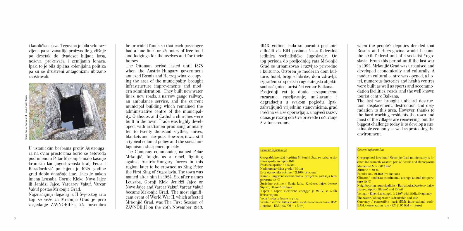
Rim
ski b
unar
/ Rom
an w
ell –
vod
a / w
ater
Jova
na
6 7
Mrkonjić Grad
The Association for the development and promotion of tourism in Mrkonjić Grad, ‘Mrkonjićka korpa’, was established as a result of a group of enthusiasts who rec-ognized the need for convergence between legal bodies and individuals from the ter-ritory of the municipality that are engaged in tourism, thus contributing to the devel-opment and promotion of their town.Today, ‘Mrkonjićka korpa’ includes about 30 active members and represents the economic entity that works on further development and promotion of Mrkonjić Grad as a tourist destination. The activists of the Association are working on improv-ing all aspects of tourism in this area and invest a lot of effort to make tourists stay in Mrkonjić even more enjoyable.
Travel Guides‘Mrkonjićka korpa’ has assembled 15, pro-fessionally trained and authorized, tour guides who will with their professional-ism, knowledge of the history and nature very kindly present the value of natural, cultural and historical monuments and ethnographic heritage of Mrkonjić Grad.
Udruženje za razvoj i unapređenje tu-rizma opštine Mrkonjić Grad ‘Mrkonjićka korpa’ nastalo je kao rezultat rada grupe entuzijasta koji su prepoznali potrebu za udruživanjem pravnih i fizičkih lica sa prostora ove opštine koji se bave turizmom i na taj način doprinose razvoju i promociji svog grada.Danas, ‘Mrkonjićka korpa’ okuplja oko 30 aktivnih članova i predstavlja privredni subjekt koji radi na daljem razvoju i pro-mociji opštine Mrkonjić Grad kao turističke destinacije. Aktivisti Udruženja rade na svim segmentima unapređenja turističke ponude ovoga kraja i ulažu mnogo truda kako bi boravak turista u Mrkonjić Gradu učinili što ugodnijim.
PONUDA MRKONJIĆKE KORPE
Turistički vodiči‘Mrkonjićka korpa’ je okupila, stručno obučila i ovlastila 15 turističkih vodiča koji svojom profesionalnošću, poznavanjem is-torije i prirode vrlo ljubazno predstavljaju turistima prirodne vrijednosti, kulturno-istorijske spomenike i etnografske zname-
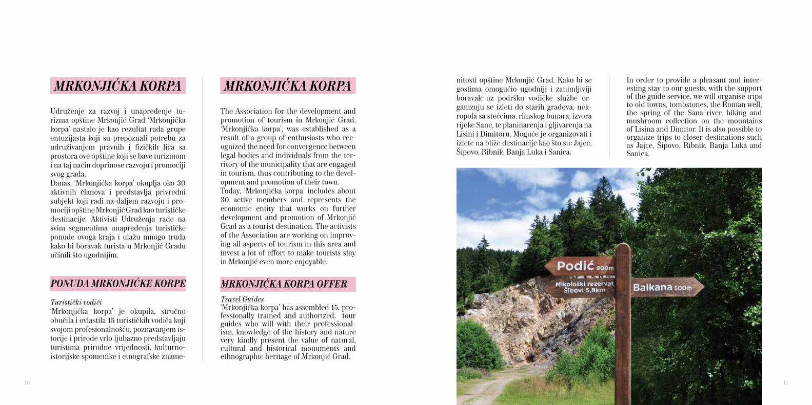
In order to provide a pleasant and inter-esting stay to our guests, with the support of the guide service, we will organise trips to old towns, tombstones, the Roman well, the spring of the Sana river, hiking and mushroom collection on the mountains of Lisina and Dimitor. It is also possible to organize trips to closer destinations such as Jajce, Šipovo, Ribnik, Banja Luka and Sanica.
nitosti opštine Mrkonjić Grad. Kako bi se gostima omogućio ugodniji i zanimljiviji boravak uz podršku vodičke službe or-ganizuju se izleti do starih gradova, nek-ropola sa stećcima, rimskog bunara, izvora rijeke Sane, te planinarenja i gljivarenja na Lisini i Dimitoru. Moguće je organizovati i izlete na bliže destinacije kao što su: Jajce, Šipovo, Ribnik, Banja Luka i Sanica.
MRKONJIĆKA KORPA OFFER
MRKONJIĆKA KORPAMRKONJIĆKA KORPA
10 11

OUR VILLAGES
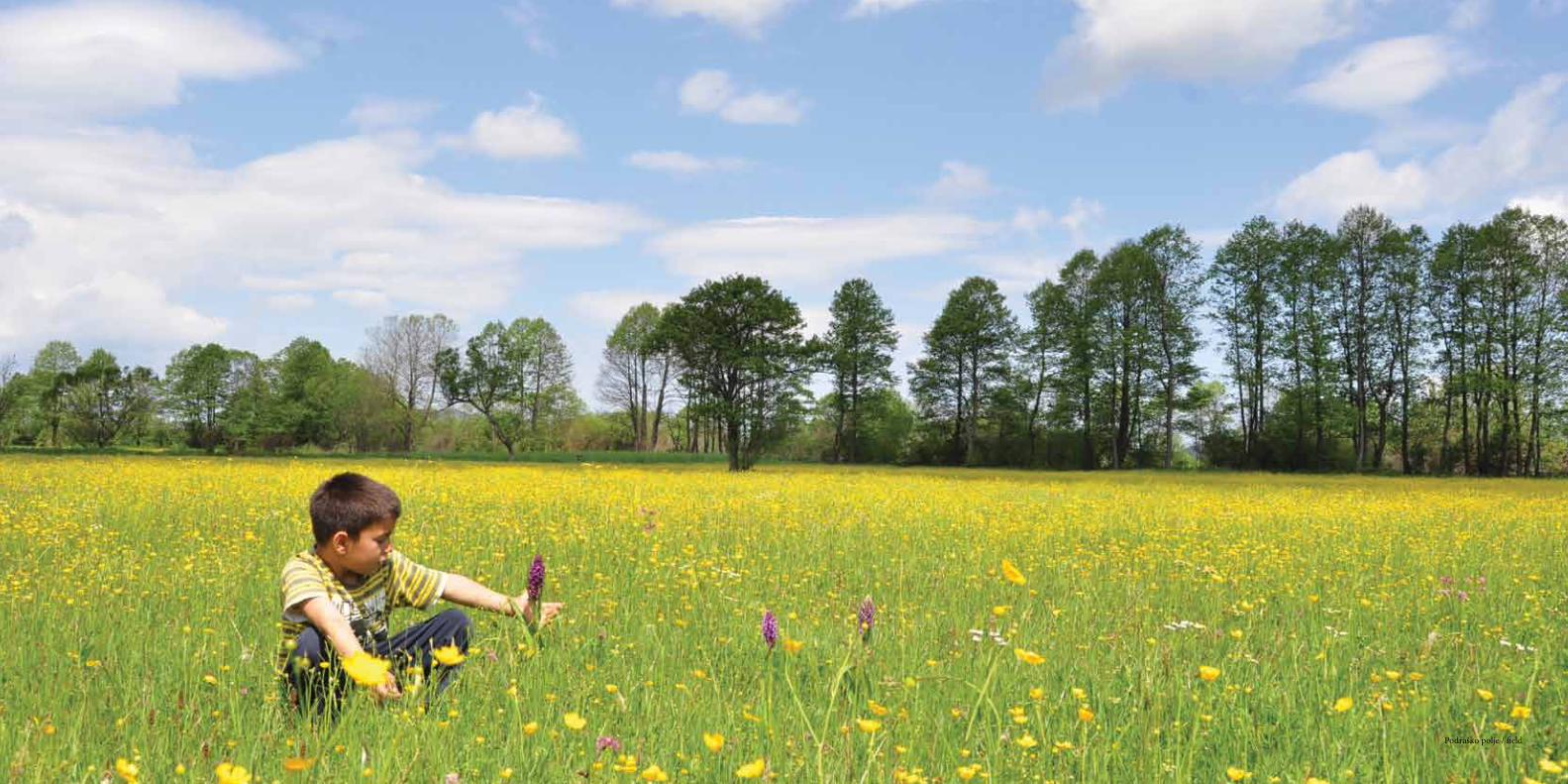
Mrkonjić Grad is made up of 37 settle-ments. Since the first settlements to the present day importance of certain sites has changed, and thus, so has the number of inhabitants in these places. The villages are quite jagged, but mainly relate to each other. Some villages are, unfortunately, displaced but others are developing and flourishing in their life. Tourists are par-ticularly attracted to the villages of Šibovi, Medna and Podrašnica. Šibovi village is situated near the top of the Lisina Mountain, at an altitude of about 1200 meters, which has a land-scape that was shaped by tertiary glaciers. A Mountain type of village with only a dozen homes, and about as many people, who occupy its magnificent architecture, a modest but perfectly embedded in the landscape. Around the wooden houses grows a centennial forest of spruce, fir, pine and beech intersected with high and steep mountain meadows, through which streams flow. There is in the village, the house of Anđelko Ćoćkalo, declared as the most valuable object of national architec-ture in the municipality. People are cordial and hospitable, and most of the house-holds have their own mill to grind grain. Near the village there is a huge mountain maple protected as a natural botanical monument. Šibovi is often visited by hik-
NAŠA SELA
Mrkonjić Grad čini 37 naseljenih mjesta. Od prvih naselja pa do današnjih dana značaj pojedinih mjesta se mijenjao, a time i broj stanovnika u ovim mjestima. Sela su prilično razuđena, ali se uglavnom nadovezuju jedno na drugo. Neka sela su, nažalost, raseljena ali se druga razvijaju i u njima život buja. Turistima su posebno privlačna sela Šibovi, Medna i Podrašnica.Selo Šibovi se nalazi blizu samog vrha Lisine na nadmorskoj visini od oko 1200 metara u reljefu koji su oblikovali terci-jarski glečeri. Planinsko selo razbijenog tipa sa samo desetak kuća i otprilike toliko stanovnika plijeni svojom skromnom ali veličanstvenom arhitekturom savršeno uk-lopljenom u pejzaž. Oko drvenih kuća rastu stogodišnje šume smrče, jele, bora i bukve ispresijecane velikim i strmim planinskim livadama kroz koje teku potoci. U selu se nalazi kuća Anđelka Ćoćkala proglašena za najvrijedniji objekat narodnog graditeljst-va na području opštine. Ljudi su srdačni i gostoljubivi, a skoro svako domaćinstvo ima vlastitu vodenicu za mljevenje žita. U blizini sela nalazi se ogroman gorski javor zaštićen kao botanički spomenik prirode. Šibove često posjećuju i u njima rado bo-rave planinari, gljivari i izletnici.
12 Kuća - House, Novak Terzija, Pecka

ers, mushroom lovers and excursionists. Medna is placed in a warm and fertile val-ley at the foothills of Lisina and Dimitor mountains, it got its name by the honey that was pouring down the honey stone. According to legend, once upon a time the bees made their hives in travertine cavities from which the honey poured. In Medna, they say, there are as many water sources as days of the year. They all flow into the Medljanska river, a gentle river that flows through the entire village and hamlet of Okandžije and then a little faster through the canyon to the river Sana. Because of its high aesthetic value, richness of the flora and fauna, and several water mills, the river Medljanka with its banks represents a rich oasis of preserved nature, and the village itself, a unique architectural unit. Although constructed in the recent period, houses built of travertine are very attrac-tive, and can be seen in this area. Near the village there is a medieval city of Prizren, which sitting on a 400 m high cliff, is looking out to the canyon of Sana. There is also a very attractive large sessile oak, which is located in the hamlet of Božići, protected as a botanical monument. In the village there is an Orthodox Church dating from the XIX century in which the monks kept relics recently found at the site of Crkvišta for which a large number of be-lievers visit Medna every day. A hamlet of a few households called Okandžije offers accommodation and food
Medna je smještena u plodnoj i toploj do-lini u podnožju planina Lisine i Dimitora, a dobila je ime po medu kojeg je bilo toliko da se slijevao niz medni kamen. Po legendi, nekada su pčele u sedrinim šupljinama pravile košnice iz kojih je curio med. U Mednoj, kažu, ima izvora koliko i u godini dana. Svi se slijevaju u Medljansku rijeku koja pitomo protiče kroz cijelo selo i zaseok Okandžije pa potom malo brže kroz klisu-ru do rijeke Sane u koju se ulijeva. Zbog svoje visoke estetske vrijednosti, bogatstva biljnog i životinjskog svijeta, te nekoliko vodenica, rijeka Medljanka sa priobaljem predstavlja bogatu oazu očuvane prirode, a samo selo jedinstvenu graditeljsku cje-linu. Iako je gradnja nešto novijeg datuma, vrlo su zanimljive kuće građene od sedre. U blizini sela nalazi se srednjovjekovni grad Prizren koji sa litice visoke 400 m gleda na kanjon Sane. Jako je atraktivan i veliki hrast kitnjak koji se nalazi u zaseoku Božići, a zaštićen je kao botanički spomenik pri-rode. U selu se nalazi pravoslavna crkva iz XIX vijeka u kojoj se čuvaju mošti monaha nedavno pronađenih na lokalitetu Crkvišta zbog čega veliki broj vjernika svakodnevno posjećuje Mednu. U zaseoku Okandžije nekoliko domaćinstava nudi smještaj i hranu za posjetioce pa to predstavlja do-bru osnovu za istraživanje čudesne Medne i njenog okruženja. U Mednoj su aktivna
14
Zele
nkov
ac
Med
na -
Oka
ndži
je

for visitors and it is a good base to explore the wonderful Medna and its entire envi-ronment. There are two active associations in Med-na, the Association Medljanci from Medna, and the Association of Medna residents and Medna friends from Futog, who have contributed a lot in the post-war rural de-velopment. Podrašnica, due to its location on the Podraško field, by the highway Mrkonjić Grad to Glamoč and the proximity to the city, makes it one of the richest and most popular villages. It is located on the edge of field and the foothill of Lisina and Dimi-tor Mountains, abundant in water and fer-tile land, it is the first tourist village in the municipality. There is also one of the ma-jor springs - Zelenkovac, which supplies Mrkonjić Grad with drinking water. The village is progressive, and has managed to keep most of its residents and build an en-vironment conducive to healthy living. The village has a school, nursery, health clinic, church, shops, cafe-bars, gas stations and private craft shops. The two associations that are very active in Podrašnica are: Ecological Movement Zelenkovac and as-sociation Naša žena. In addition to ‘Eco zone Zelenkovac‘, a few households in the village offer accommodation, while Naša žena prepares traditional dishes from Podrašnica for small and large groups of visitors.
dva udruženja, i to udruženje Medljanci iz Medne i Udruženje Medljanaca i prijatelja Medne iz Futoga koji su puno doprinijeli poslijeratnom razvoju sela. Podrašnica je zbog svoje lokacije na Podraškom polju, uz magistralni put Mrkonjić Grad - Glamoč i blizine grada, jedno od najbogatijih i najmnogoljudn-ijih sela. Smješteno na rubu polja i samom podnožju Lisine i Dimitora, obiluje vodom i plodnom zemljom, a predstavlja prvo turističko selo u opštini. U Podrašnici se nalazi jedan od najznačajnijih izvora – Ze-lenkovac, koji snabdijeva pitkom vodom Mrkonjić Grad. Vrlo je progresivno, te je uspjelo sačuvati većinu mještana i izgraditi okruženje pogodno za zdrav život. Selo ima školu, vrtić, ambulantu, crkvu, prodavnice, kafe-barove, benzinsku pumpu i privatne zanatske radnje. Dva su udruženja vrlo ak-tivna u Podrašnici: Ekološki pokret Zelen-kovac i udruženje Naša žena. Pored ‘Eko zone Zelenkovac’, nekoliko domaćinstava u selu nudi prenoćište, a Udruženje žena za manje i veće grupe priprema tradicion-alna jela iz Podrašnice.
VAZDUH JE OVDE PLANINSKI ŽITAK, ŠUME SU VISOKE, VODE LEDENE A ŠPILJE I PEĆINE BEZDANE
THE AIR HERE IS MOUNTAIN BREEZY, FORESTS HIGH, WATERS COLD, CAVES AND PITS DEEP
16 Jezero Bočac / Lake Bočac

NAŠE VISINE
Mrkonjić Grad spada u brdsko-plan-inska područja, a planine koje opštinu čine takvom su: Lisina (1467 mnv), Dimi-tor (1483 mnv), Čemernica (1338 mnv), Manjača (1239 mnv) i najviša Ovčara (1576 mnv).Planina Lisina je omanji planinski ma-siv; najviša tačka Bandira nalazi se na 1467 mnv, a zbog svoje geološke građe veoma je bogata vodom, raznovrsnim biljnim i životinjskim svijetom. Ovakva raznovrsnost vegetacijskog pokrivača omogućila je razvoj izvanredno bogate mikoflore, kao i veoma bogate faune koja uključuje i neke kod nas veoma rijetke vrste ptica i drugih životinja. Treba reći da su se na Lisini donedavno gnijezdili suri orlovi, sove buljine i troprsti djetlići koji se nalaze na ‘crvenim listama’ Evrope. Tu se takođe gnijezde i vrlo rijetki planin-ski djetlići i crne žune. Lisina je dom i sada već sasvim rijetkoj šumskoj kornjači.U dosadašnjim istraživanjima Lisine zabilježeno je preko 1000 biljnih vrsta, 1300 vrsta gljiva, pet vrsta riba, devet vrsta vodozemaca, devet vrsta gmizavaca i 29 vrsta sisara. Dobro su proučene i ptice sa 107 zabilježenih vrsta. Ovako bogat biljni pokrivač, uz vrlo dobre
OUR HEIGHTS
Mrkonjić Grad is one of the hilly-moun-tainous areas in Bosnia and Hercegovina, and major mountains that make up the municipality are: Lisina (1467 meters), Dimitor (1483 meters), Čemernica (1338 meters), Manjača (1239 meters) and the highest Ovčara (1576 meters).Lisina is a small mountain range, the high-est point, Bandira, 1467 meters, due to its geological structure is very rich in water, diverse plant and wildlife. This diversity of vegetation cover allows the development of extraordinarily rich mycoflora, as well as rich fauna that in-cludes some of our very rare species of birds and other animals. It must be said that, the up until recently, golden eagles, owls, eagle owls and three-toed woodpeck-ers were all nesting on Lisina, all these be-ing on the European ‘red list’ of threatened spices. There are also nesting sites of the very rare mountain woodpecker and black woodpecker. Lisina is home to the forest turtle, now also quite rare.In previous recorded research Lisina has over 1000 plant species, 1300 species of fungi, five species of fish, nine species of amphibians, nine species of reptiles and 29 species of mammals. Well studied are also birds with 107 species on record. With such a rich source of vegetation, a very good climatic condition and favour-
klimatske prilike i povoljan geološki sastav Lisine takođe je uticao da ona postane jedno od najbogatijih izvorišta pitke vode u BiH. Smatra se da na Lisini postoji oko 360 što manjih što većih izvora, koji vrlo rijetko presušuju. Mnoga veća vrela su već iskorištena za napajanje velikog broja naseljenih mjesta u bližoj i daljoj okolini Lisine, tako da je ona već sad veoma važno vodozahvatno područje.Zbog svog značaja, Lisina je uvrštena u Prostorni plan Republike Srpske kao pri-oritetno područje za zaštitu. Njen najdragocjeniji dio za mikologe stav-ljen je pod strogu zaštitu. Na Lisini je označen ‘Put gljiva’, mreža staza za istraživanje i upoznavanje gljiva, kao i nekoliko planinarskih staza, a na samom vrhu se nalaze paraglajding start i planinarski dom. Dimitor se prostire između rijeke Sane na zapadu i Podraškog polja na istoku, na granici opština Mrkonjić Grad i Ribnik. Planina je duga 13 kilometara. Najviši vrh je Dimitor (1483 mnv) u jugoistočnom di-jelu koji pripada opštini Mrkonjić Grad. Planinari i mještani okolnih sela mnogo vole ovu planinu. Izazovnija je i zahtje-vnija za penjanje od Lisine, a planinari su obilježili dvije staze do vrha sa kojeg se pruža nezaboravan pogled na brojne okolne planine i sela u kotlinama.
able geological composition determined Lisina to become one of the richest sources of drinking water in BiH. It is believed that the Lisina has about 360 small and major water springs, which rarely dry up. Many more springs are already used to supply a large number of settlements in the near and distant surroundings, so Lisina has become very important water intake area. Due to its importance, Lisina is included in the Spatial Plan of the Republic of Srpska as a priority area for protection. Its pre-cious part of mycology has been placed under strict protection.On Lisina, there is marked the ‘Mushroom Path’, a network of paths for research and education about mushrooms, as well as several hiking trails, and at the top are ar-eas for paragliding and mountain lodge.Dimitor Mountain is situated between the Sana river to the west and Podraško field in the east, on the border of Mrkonjić Grad and the town of Ribnik. The mountain is 13 kilometres long. Dimitor is also called the highest peak (1483 m) in the south-eastern area of the municipality of Mrkonjić Grad. Hikers and residents of nearby villages like this mountain very much. It is more challenging and demanding than Lisina for climbing, and hikers have two marked trails that lead to the peak from which one can enjoy unforgettable views of many surrounding mountains and villages in the valleys..
18 19
Podraško polje / field

NAŠE VODE
Sana i Vrbas su rijeke kojima pripadaju svi vodotoci na području Mrkonjić Grada. Crna rijeka, Sokočnica i Ponor pripadaju slivu Vrbasa, a Korana i rijeka Medljan-ka slivu Sane. Niko nije izbrojao sve iz-vore, ali sa sigurnošću se može govoriti o više od hiljadu izvora sa pitkom vodom. Najznačajniji su izvori rijeke Sane koji se nalaze u blizini sela Pecka, a predstavl-jaju iskonsku oazu sa ugodnom svježinom i hladovinom koja ljeti godi više od bilo čega. Voda iz dva snažna vrela već nakon stotinjak metara formira rijeku Sanu koja prvih desetak kilometara toka protiče kroz opštinu Mrkonjić Grad. U blizini je i periodični izvor Mračaj koji se nalazi u im-presivnoj pećini, a malo dalje u Carevcu i izvor rijeke Korane, koja predstavlja prvu pritoku rijeke Sane. Druga i značajnija pri-toka Sane je rijeka Medljanka sa izvorištem u selu Medna. Na planini Lisini nalazi se veliki broj izvora izuzetno kvalitetne vode.
OUR WATERS
The Sana and Vrbas are rivers that all wa-tercourses in the area of Mrkonjić Grad belong to. Crna rijeka, Sokočnica and Ponor rivers all flow in to the basin of Vr-bas, while Korana and Medljanka flow in to river basin of Sana. No one has counted all springs, but we believe that we are talk-ing about more than a thousand sources of drinking water. The most important sourc-es of the Sana river, located near the vil-lage Pecka, represent an ancient oasis with a pleasant freshness and shade which, in the summer, is priceless. Water from two larger springs, that are a hundred meters long, form the river Sana which for its first ten kilometres flows through Mrkonjić Grad. Nearby, there is the periodic spring called Mračaj located in an impressive cave and little further into that is Carevac, the source of the river Korana, which is the first tributary of the river Sana. The sec-ond and more important tributary of the river Sana is the Medljanka river, with its spring in village of Medna.
Izvor Sane/ Spring of Sana

On Lisina, there are a large number of very good quality water sources. One of the most famous is the Orlov kamen, from which the water factory ‘Kruna’ is sup-plied. There are also the sources of the Cjepalo and Skakavac that form Balkana Lake. The Zelenkovac source is also part of the mountain massif Lisina. At the foot-hill of the village Zagorići, at an altitude of about 1000 meters, is located the spring of river Sokočnica.Crna rijeka is formed by the outflow of wa-ter from Balkana lake, flows through part of the town, and village Bjelajce and, after twenty kilometres, flows onwards into the Vrbas.The Ponor river is formed by a few small rivers whose springs are mainly on Lisina, they are intertwined through the edge of Podraško field, and at Čađavica it disap-pears in to a large pit and again flows as the river Krupa in Krupa na Vrbasu. The Vrbas, in the part that flows through the municipality of Mrkonjić Grad, it is mostly peaceful and deep as the building of power plant ‘Bočac’ turned it into Bočačko Lake. Downstream from the lake, the Vr-bas becomes the ideal river for adrenalin water sports. In all the major rivers brook trout and grayling can be found, a spices known to like clean and fast water rich in oxygen. Also, freshwater crustaceans are not rare here. The Association of sport fishermen of Mrkonjić Grad take care of the fish and the protection of rivers.
Jedan od najpoznatijih je Orlov kamen, iz kojeg se snabdijeva fabrika vode ‘Kruna’. Poznati su i izvori Cjepalo i Skakavac koji formiraju jezero Balkana. Izvorište Ze-lenkovac je takođe dio planinskog masiva Lisine. U podnožju sela Zagorići, na nad-morskoj visini od oko 1.000 m, izvire ri-jeka Sokočnica. Crna rijeka nastaje izlijevanjem vode iz jezera Balkana, protiče kroz dio grada, za-tim selo Bjelajce i ulijeva se u Vrbas nakon dvadesetak kilometara toka. Rijeku Ponor čini više rječica koje izviru uglavnom na Lisini pa se prepliću kroz Podraško polje da bi na rubu polja, u mjestu Čađavica, nestala u velikoj jami i opet protekla kao rijeka Krupa u Krupi na Vrbasu.Vrbas je u dijelu koji protiče kroz opštinu uglavnom miran i dubok jer je izgradn-jom hidroelektarane ‘Bočac’ pretvoren u Bočačko jezero. Nizvodno od jezera Vr-bas postaje idealna rijeka za adrenalinske sportove na vodi. U svim značajnijim vo-dotocima žive potočne pastrmke i lipljen poznate po tome što vole čiste i brze vode bogate kiseonikom, a nisu rijetki ni slat-kovodni rakovi. O ribljem fondu i zaštiti vodotoka brine se Udruženje sportskih ri-bolovaca Mrkonjić Grad.Jezero Bočac nastalo je 1981. godine. Brza rijeka Vrbas je ukroćena, nivo vode se
Bočac lake was created in 1981. The Fast flowing river Vrbas was tamed, the water level was increased significantly so the av-erage depth is over 20 m and the length of the lake is over 17 km. The lake is ideal for boating and fishing through the canyon. There are lake perch, catfish, tench, trout, carp, sneep, shoot and silver carp. At the beginning of the lake, near the mouth of the river Ugar where it flows in to the Vr-bas, there is the Eco Centre ‘Bočac’.Balkana lake is located 4 km north-west of Mrkonjić Grad, and made up of a Little and a Grand Lake. The Grand Lake was built back in 1954 by the voluntary work of resi-dents, with by the expansion of the former riverbed used by cattle, while the little lake was constructed later. Balkana is the most visited resort in the region. Along the lake there are restaurants and sports facilities.
povećao značajno pa je prosječna dubina preko 20 m, a dužina jezera preko 17 km. Jezero je idealno za vožnju čamcem kroz kanjon i ribolov. U jezeru žive smuđ, som, linjak, pastrmka, šaran, škobalj, mladica i tostolobik. Na samom početku jezera kod ušća rijeke Ugar u Vrbas nalazi se Eko Centar ‘Bočac’. Jezero Balkana nalazi se 4 km sjevero-za-padno od Mrkonjić Grada, a čine je Malo i Veliko jezero. Veliko jezero je izgrađeno daleke 1954. godine dobrovoljnim ra-dom mještana, širenjem nekadašnjeg korita za napajanje stoke, dok je Malo jezero dograđeno naknadno. Balkana je najposjećenije izletište i kupalište u regiji. Uz jezera se nalaze ugostiteljski objekti i sportski tereni.
24
Vrba
s - je
zero
Boč
ac/B
očac
ke
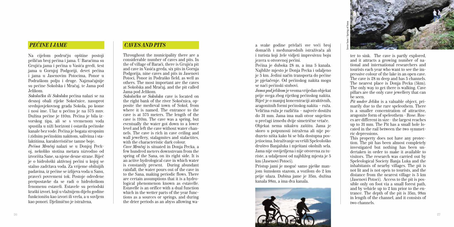
CAVES AND PITS
Throughout the municipality there are a considerable number of caves and pits. In the of village of Baraći, there is Grujića pit and cave in Vasića greda, six pits in Gornja Podgorija, nine caves and pits in Jasenovi Potoci, Ponor in Podraško field, as well as others. The most important are the caves at Sokolska and Mračaj, and the pit called Jama pod Jelikom. Sokolačka or Sokolska cave is located on the right bank of the river Sokočnica, op-posite the medieval town of Sokol, from where it is named. The entrance to the cave is at 575 meters. The length of the cave is 110m. The cave was a spring, but eventually the water got down to a lower level and left the cave without water chan-nels. The cave is rich in cave ceiling and wall jewellery, stalagmites and stalactites, with the characteristic dark colour. Cave Mračaj is situated in Donja Pecka, a few hundred meters downstream from the spring of the Sana, on its right side. It is an active hydrological cave in which water is constantly present. During abundant rainfall, the water pours out of the cave in to the Sana, making periodic flows. There are certain assumptions that it is a hydro-logical phenomenon known as estavelle. Estavelle is an orifice with a dual function which in the wetter parts of the year func-tions as a sources or springs, and during the drier periods as an abyss allowing wa-
PEĆINE I JAME
Na cijelom području opštine postoji priličan broj pećina i jama. U Baraćima su Grujića jama i pećina u Vasića gredi, šest jama u Gornjoj Podgoriji, devet pećina i jama u Jasenovim Potocima, Ponor u Podraškom polju i druge. Najznačajnije su pećine Sokolska i Mračaj, te Jama pod Jelikom.Sokolačka ili Sokolska pećina nalazi se na desnoj obali rijeke Sokočnice, nasuprot srednjovjekovnog grada Sokola, po kome i nosi ime. Ulaz u pećinu je na 575 mnv. Dužina pećine je 110m. Pećina je bila iz-vorskog tipa, ali se s vremenom voda spustila u niži horizont i ostavila pećinske kanale bez vode. Pećina je bogata stropnim i zidnim pećinskim nakitom, salivima i sta-laktitima, karakteristične tamne boje.Pećina Mračaj nalazi se u Donjoj Peck-oj, nekoliko stotina metara nizvodno od izvorišta Sane, sa njene desne strane. Riječ je o hidrološki aktivnoj pećini u kojoj se stalno zadržava voda. Za vrijeme obilnijih padavina, iz pećine se izlijeva voda u Sanu, praveći povremeni tok. Postoje određene pretpostavke da se radi o hidrološkom fenomenu estaveli. Estavele su periodski kraški izvori, koji u vlažnijem dijelu godine funkcionišu kao izvori ili vrela, a u suvljem kao ponori. Djelimično je istražena,
ter to sink. The cave is partly explored, and it attracts a growing number of na-tional and international researchers and tourists each year who want to see the im-pressive colour of the lake in an open cave. The cave is 28 m deep and has 5 channels. The nearest place is Donja Pecka (5km). The only way to get there is walking. Cave pillars are the only cave jewellery that can be seen. Pit under Jelika is a valuable object, pri-marily due to the rare speleothem. There is a smaller concentration of attractive, aragonite form of speleothem - Rose. Ros-es are different in size - the largest reaches up to 31 mm. The Pit has a small hole lo-cated in the rail between the two symmet-ric depressions. This property does not have any protec-tion. The pit has been almost completely investigated but nothing has been un-dertaken in order to make it available to visitors. The research was carried out by Speleological Society Banja Luka and the inhabitants of nearby villages. The pit is not lit and is not open to tourists, and the distance from the nearest village is 5 km (Jasenovi Potoci). Access to the pit is pos-sible only on foot via a small forest path, and by vehicle up to 2 km prior to the en-trance. The depth of the pit is 35m, 98m in length of the channel, and it consists of two channels.
a svake godine privlači sve veći broj domaćih i međunarodnih istraživača ali i turista koji žele vidjeti impresivnu boju jezera u otvorenoj pećini. Pećina je duboka 28 m, a ima 5 kanala. Najbliže mjesto je Donja Pecka i udaljeno je 5 km. Jedini način transporta do pećine je pješačenje. Od pećinskog nakita mogu se naći pećinski stubovi.Jama pod jelikom je veoma vrijedan objekat prije svega zbog rijetkog pećinskog nakita. Riječ je o manjoj koncentraciji atraktivnih, aragonitnih formi pećinskog nakita – ruža. Veličina ruža je različita – najveće dostižu do 31 mm. Jama ima mali otvor smješten u prečagi između dvije simetrične vrtače.Objekat nema nikakvu zaštitu. Jama je skoro u potpunosti istražena ali nije po-duzeto ništa kako bi se bila dostupna pos-jetiocima. Istraživanje su vršili Speleološko društvo Banjaluka i mještani okolnih sela. Jama nije osvijetljena i nije otvorena za tu-riste, a udaljenost od najbližeg mjesta je 5 km (Jasenovi Potoci).Pristup jami je moguć samo pješke man-jom šumskom stazom, a vozilom do 2 km prije ulaza. Dubina jame je 35m, dužina kanala 98m, a ima dva kanala.
26 27
I Izv
or S
ane
/ Spr
ing
of S
ana

Izvor Sane / Spring of Sana

TRADITION
Town Museum situated in the Culture Cen-tre “Petar Kočić” has a valuable ethnologi-cal collection of folk creativity and pho-tography. It is open every day from 7am to 3pm and entrance is free of charge. Ethno Museum in Eco Zone Zelenko-vac, Podrašnica, is located in two wooden houses typical of the architecture of the area with objects and tools that were once in use in the area. Part of the exhibit is lo-cated in and around the central area of the Eco Zone. There are no specific working hours or entrance charge. Podrašnica can also be interesting place to see ethnologi-cal exhibitions in the premises of the As-sociation of women ‘Naša žena ‘.
Ethno house ‘Roljić’ in the village of Gus-tovara is a place where, thanks to the great enthusiasm of the Roljić family, you can
TRADICIJA
Gradski muzej u Kulturom centru ‘Petar Kočić’ posjeduje vrijednu etnološku zbirku narodnog stvaralaštva i fotografija. Otvor-en je svakog radnog dana od 7.00 do 15.00 časova, a ulaz se ne naplaćuje. Etno muzej u Eko zoni Zelenkovac, Podrašnica, smješten je u dvije drvene kuće arhitektonski tipične za ovo područje sa predmetima i oruđima koji su nekad bili u upotrebi. Dio eksponata se nalazi u i oko centralnog objekta Eko zone. Nema određeno radno vrijeme niti se naplaćuje ulaz. U Podrašnici se takođe može vidjeti zanimljiva etnološka postavka u prostori-jama Udruženja žena ‘Naša žena’.
Etno kuća ‘Roljić’ u selu Gustovara je mjesto gdje se, zahvaljujući velikom en-tuzijazmu porodice Roljić, može vidjeti
see more than 700 ancient artefacts, and a very rich collection of traditional cos-tumes, jewellery, home textiles, old coins and items from a homes of the time. In the centre of town is situated memorial museum of the first session of ZAVNOBiH (Terrestrial Antifascist Council of National Liberation of Bosnia and Herzegovina), which together with the permanent exhi-bition and interior equipment is declared as national monument of Bosnia and Her-zegovina. The museum is the most valu-able monument from the Second World War in Mrkonjić Grad but in the last war the interior was devastated and is not cur-rently open for visitors.Folklore The Cultural and artistic society ‘Peter I Karađorđević Mrkonjić’ works in the most important way on promotion of folk tra-ditions in all manifestations. It brings to-gether all those who love dance, song and the customs of the people of Mrkonjić area and beyond, and The Association “Našažena” from Podrašnica foster polyphonic
preko 700 starih eksponata, te vrlo bogata zbirka narodnih nošnji, nakita, kućnog tekstila, starog novca i predmeta iz kućnog inventara. U centru grada nalazi se spomen-muzej prvog zasjedanja ZAVNOBiH-a (Zemaljsko antifašističko vijeće narodnog oslobođenja BiH), koji je zajedno sa stalnom muzejskom postavkom i enterijerskom opremom proglašen nacionalnim spomenikom BiH. Muzej predstavlja najvrijedniji spomenik iz II svjetskog rata u Mrkonjić Gradu ali je u posljednjem ratu enterijer devastiran pa nije otvoren za posjetioce.FolklorKulturno-umjetničko društvo ‘’Petar I Karađorđević Mrkonjić’’ najznačajnije radi na promociji folklorne tradicije u svim pojavnim oblicima. Okuplja sve koji vole igru, pjesmu i običaje naroda mrkonjićkog kraja i šire, a udruženje žena ‘Naša žena’ iz Podrašnice njeguje višeglasne ženske pjesme iz Krajine.
30 31
I Etn
o ku
ća R
oljić
/ Et
no-h
ouse

DOMAĆA KUHINJA
Stanovnici mrkonjićkog kraja nikad se nisu bavili intenzivnom poljoprivredom već su uzgajali koliko je bilo potrebno za vlastito domaćinstvo. Većina proizvoda koji se i danas mogu naći na selima uzgaja se na tradicionalan način bez upotrebe hemijskih preparata, a zasadi se gnoje sta-jskim đubrivom.Kod hrane treba izdvojiti jela od heljde i kukuruznog brašna, kajmak, sir i kiselo mlijeko, potočnu pastrmku, domaće suho-mesnate proizvode, teletinu ispod sača sa krompirom i rakiju šljivovicu od 43 stepena. Pečena jagnjetina i jaretina su vrlo cijenjene, i to ne samo kod domaćeg stanovništva. Od domaćih vina pravi se jedino kupinovo, ali zato je u ponudi ve-liki izbor domaćih rakija, likera, sokova i
HOME CUISINE
Residents of Mrkonjić have never been in-volved in intensive agriculture, but grow what is needed for their household. Most of the products that are still found in the villages are grown in the traditional way without using chemical products, with plants and crops being fertilized with dung fertilizer.The food that is offered is usually dishes made from buckwheat and corn flour,
cream, cheese and sour milk, stream trout, domestic meat products such as veal meat with potatoes and strong plum brandy. Roasted lamb and kid are highly respect-ed, not only by the local population. The only local wine that is made is blackberry wine, but a great selection of local brandy, liqueurs, juices and teas are offered. The
Vodenica / Watermill
Hel
jdin
a lje
uša
/ Buc
kwhe
at p
ie
Pura
/ C
orn
mas
h
Zelenkovac
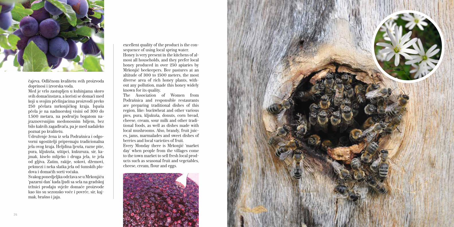
excellent quality of the product is the con-sequence of using local spring water. Honey is very present in the kitchens of al-most all households, and they prefer local honey produced in over 250 apiaries by Mrkonjić beekeepers. Bee pastures at an altitude of 300 to 1500 meters, the most diverse area of rich honey plants, with-out any pollution, made this honey widely known for its quality. The Association of Women from Podrašnica and responsible restaurants are preparing traditional dishes of this region, like: buckwheat and other various pies, pura, kljukuša, donuts, corn bread, cheese, cream, sour milk and other tradi-tional foods, as well as dishes made with local mushrooms. Also, brandy, fruit juic-es, jams, marmalades and sweet dishes of berries and local varieties of fruit. Every Monday there is Mrkonjić ‘market day’ when people from the villages come to the town market to sell fresh local prod-ucts such as seasonal fruit and vegetables, cheese, cream, flour and eggs.
čajeva. Odličnom kvalitetu svih proizvoda doprinosi i izvorska voda.Med je vrlo zastupljen u kuhinjama skoro svih domaćinstava, a koristi se domaći med koji u svojim pčelinjacima proizvodi preko 250 pčelara mrkonjićkog kraja. Ispaša pčela je na nadmorskoj visini od 300 do 1.500 metara, na području bogatom na-jraznovrsnijim medonosnim biljem, bez bilo kakvih zagađivača, pa je med nadaleko poznat po kvalitetu.Udruženje žena iz sela Podrašnica i odgo-vorni ugostitelji pripremaju tradicionalna jela ovog kraja. Heljdina ljeuša, razne pite, pura, kljukuša, uštipci, kukuruza, sir, ka-jmak, kiselo mlijeko i druga jela, te jela od gljiva. Zatim, rakije, sokovi, džemovi, pekmezi i neka slatka jela od šumskih plo-dova i domaćih sorti voćaka. Svakog ponedjeljka održava se u Mrkonjiću ‘pazarni dan’ kada ljudi sa sela na gradskoj tržnici prodaju svježe domaće proizvode kao što su sezonsko voće i povrće, sir, kaj-mak, brašno i jaja.
34

in a few blacksmith shops in the town and the village of Majdan. Also, a few carpenters are still making wooden brandy bottles called ‘ploska’, bar-rels and jugs. A self-taught Vlado Jovanović makes items from many different types of wood from around the world whose struc-ture and the natural colours are used in the design and creation of icons and sou-venirs. Home crafts are very much cherished as well, particularly in villages where house-wives during the long winter days knit socks, vests, sweaters, gloves, hats and decorative tablecloths. The Association ‘Naša žena’ from Podrašnice has a loom machine which still weaves colourful sheets, blankets and bags, in their prem-ises you can see and buy various knitted and woven products.
OLD CRAFTS
In the area of Mrkonjić City the most fa-mous trade over the last few hundred years is forging tools and tableware made of metal. The most famous being, is a scythe for cutting grass by hand, which are made by celebrated Mrkonjić blacksmiths and mowers, and then various agricultural tools, hoes, axes, knives, cooking utensils (pans, pots, etc.). Today, there are still a few blacksmith shops where you can see or buy these products that are still very use-ful and of high quality.Scythe, the famous ‘varcarka’, as well as the act of mowing, are strongly associated with Mrkonjić Grad. Every year in the Bal-kana a mowing memorial in honour of La-keta Lazar, former first mower of Europe, is held. Mrkonjić mowers are still winning many competitions, and ‘varcarka’ is still the symbol of tradition and stability.The respected ‘varcarka’ scythe was writ-ten about by the noble prize winning author, Ivo Andrić, in his novel ‘Scythe’ where he describes a peasant who came down from high mountains to a small town to buy scythe. He negotiates with the scythe, observes, listen it and exploits, as he cannot go home without a good scythe. And then someone shouts to him that ‘there is no more varcarka scythes, it does not matter which one you buy’. Are ‘varcarka’s’ still equally as good as before, should be checked as they are still praised
STARI ZANATI
U području Mrkonjić Grada najpoznatiji zanat u zadnjih nekoliko stotina godina je kovanje oruđa i posuđa od metala. Na pr-vom mjestu je kosa za ručno košenje trave koja je proslavila mrkonjićke kovače i ko-sce, a potom poljoprivredne alatke, motike, sjekire, noževi, posuđe (sač, tepsije, lonci i sl.). I danas radi nekoliko kovačkih radnji u kojima se mogu vidjeti ili kupiti proizvodi vrlo korisni i kvalitetni.
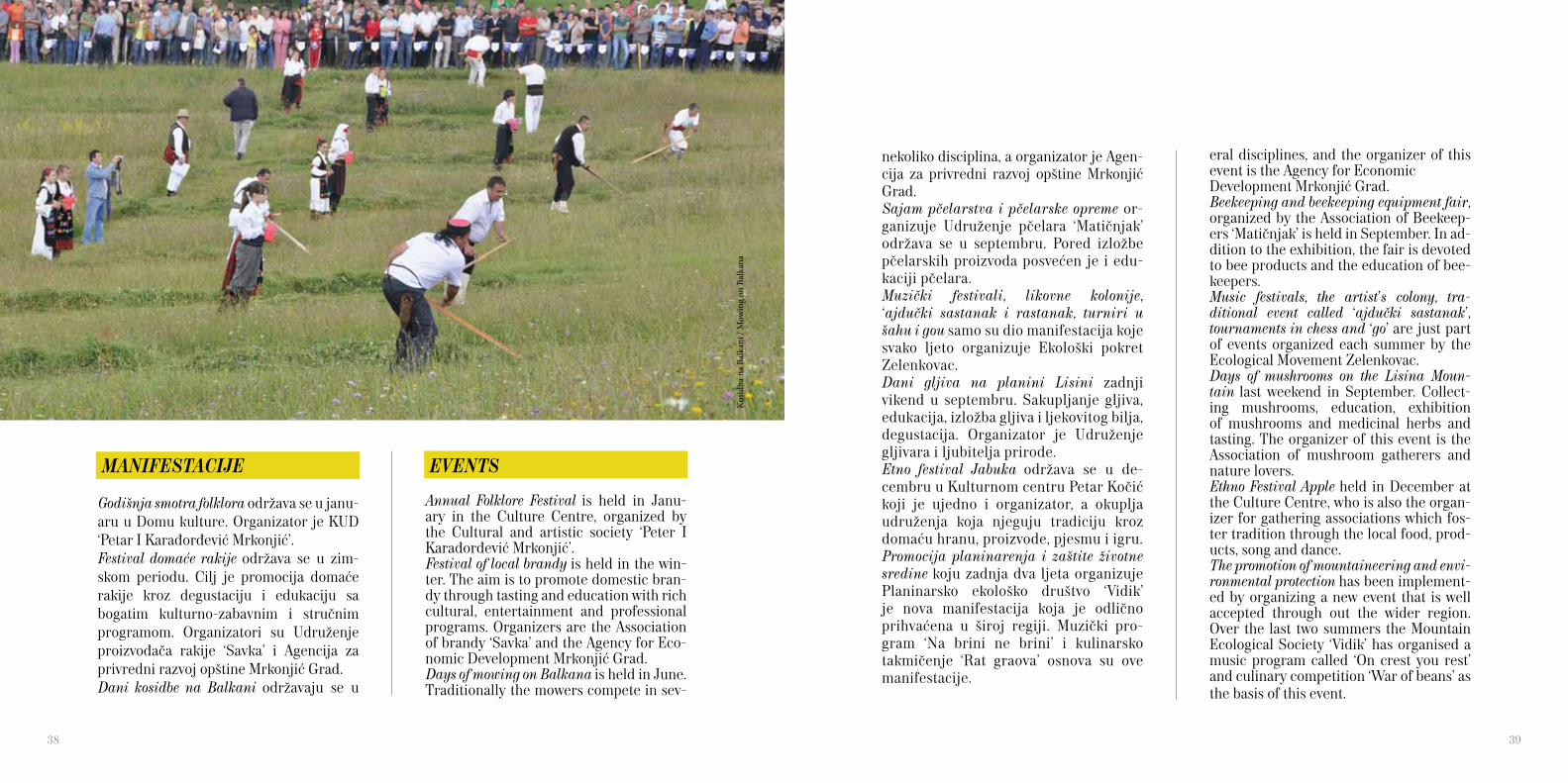
Kose kovanice, čuvene ‘varcarke’, kao i sam čin košenja, predstavljaju snažno obilježje Mrkonjić Grada. Svake godine na Balkani se održava kosidba posvećena Lazaru La-keti, nekadašnjem prvom koscu Evrope.
Mrkonjićki kosci često pobjeđuju na bro-jnim takmičenjima, a ‘varcarke’ su i danas simbol tradicije i postojanosti.Koliko su nekada bile cijenjene kose ‘var-carke’ navodi u pripovijetci ‘Kosa’ Ivo Andrić gdje opisuje seljaka koji je sa visoke planine sišao u neku kasabu da kupi kosu. Nadmudruje se seljak sa njom, ispituje, osluškuje i istražuje jer ne smije kući bez dobre kose. A onda mu neko dovikne da ‘nema više kosa varcarki, svejedno je koju ćeš kupiti’. Da li su ipak još uvijek ‘var-carke’ jednako dobre treba provjeriti jer se i danas kuju u nekoliko kovačnica u samom gradu i selu Majdan. Takođe, nekoliko stolara još uvijek izrađuje drvene ploske za rakiju, burad i bardake. A samouki Vlado Jovanović izrađuje pred-mete od velikog broja različitih vrsta drveta iz cijelog svijeta čije strukture i prirodne boje koristi u oblikovanju i stvaranju ikona i suvenira.Vrlo se njeguje i kućna radinost, naročito po selima u kojima domaćice tokom dugih zimskih dana pletu priglavke, pr-sluke, džempere, rukavice, kape i heklaju ukrasne stolnjake. Udruženje ‘Naša žena’ iz Podrašnice posjeduje tkalački stroj na kojem i danas tkaju šarene ponjave, prekrivače i torbe, a u njihovim prostori-jama se mogu vidjeti i kupiti razni pleteni i tkani proizvodi.
36 37
eral disciplines, and the organizer of this event is the Agency for Economic Development Mrkonjić Grad.Beekeeping and beekeeping equipment fair, organized by the Association of Beekeep-ers ‘Matičnjak’ is held in September. In ad-dition to the exhibition, the fair is devoted to bee products and the education of bee-keepers.Music festivals, the artist’s colony, tra-ditional event called ‘ajdučki sastanak’, tournaments in chess and ‘go’ are just part of events organized each summer by the Ecological Movement Zelenkovac.Days of mushrooms on the Lisina Moun-tain last weekend in September. Collect-ing mushrooms, education, exhibition of mushrooms and medicinal herbs and tasting. The organizer of this event is the Association of mushroom gatherers and nature lovers.Ethno Festival Apple held in December at the Culture Centre, who is also the organ-izer for gathering associations which fos-ter tradition through the local food, prod-ucts, song and dance.The promotion of mountaineering and envi-ronmental protection has been implement-ed by organizing a new event that is well accepted through out the wider region. Over the last two summers the Mountain Ecological Society ‘Vidik’ has organised a music program called ‘On crest you rest’ and culinary competition ‘War of beans’ as the basis of this event.
nekoliko disciplina, a organizator je Agen-cija za privredni razvoj opštine Mrkonjić Grad.Sajam pčelarstva i pčelarske opreme or-ganizuje Udruženje pčelara ‘Matičnjak’ održava se u septembru. Pored izložbe pčelarskih proizvoda posvećen je i edu-kaciji pčelara.Muzički festivali, likovne kolonije, ‘ajdučki sastanak i rastanak, turniri u šahu i gou samo su dio manifestacija koje svako ljeto organizuje Ekološki pokret Zelenkovac.Dani gljiva na planini Lisini zadnji vikend u septembru. Sakupljanje gljiva, edukacija, izložba gljiva i ljekovitog bilja, degustacija. Organizator je Udruženje gljivara i ljubitelja prirode.Etno festival Jabuka održava se u de-cembru u Kulturnom centru Petar Kočić koji je ujedno i organizator, a okuplja udruženja koja njeguju tradiciju kroz domaću hranu, proizvode, pjesmu i igru.Promocija planinarenja i zaštite životne sredine koju zadnja dva ljeta organizuje Planinarsko ekološko društvo ‘Vidik’ je nova manifestacija koja je odlično prihvaćena u široj regiji. Muzički pro-gram ‘Na brini ne brini’ i kulinarsko takmičenje ‘Rat graova’ osnova su ove manifestacije.
EVENTS
Annual Folklore Festival is held in Janu-ary in the Culture Centre, organized by the Cultural and artistic society ‘Peter I Karađorđević Mrkonjić’.Festival of local brandy is held in the win-ter. The aim is to promote domestic bran-dy through tasting and education with rich cultural, entertainment and professional programs. Organizers are the Association of brandy ‘Savka’ and the Agency for Eco-nomic Development Mrkonjić Grad. Days of mowing on Balkana is held in June. Traditionally the mowers compete in sev-
MANIFESTACIJE
Godišnja smotra folklora održava se u janu-aru u Domu kulture. Organizator je KUD ‘Petar I Karađorđević Mrkonjić’. Festival domaće rakije održava se u zim-skom periodu. Cilj je promocija domaće rakije kroz degustaciju i edukaciju sa bogatim kulturno-zabavnim i stručnim programom. Organizatori su Udruženje proizvođača rakije ‘Savka’ i Agencija za privredni razvoj opštine Mrkonjić Grad.Dani kosidbe na Balkani održavaju se u
38 39Ko
sidba
na
Balk
ani /
Mow
ing
on B
alka
na
THEMATIC ROUTES
The Association ‘Green Tour’, in collabo-ration with the Association of mushroom and nature lovers, has in the 2008 and 2009 began a pioneering project - the construction of thematic trails in the area of Mrkonjić Grad. Priority was given to the local bicycle trails that will become part of a regional network of bicycle routes in the Krajina. In addition to these trails, there are trails used for mushroom picking and paragliding, as well as hiking trails which were marked and mapped by the Moun-tain Ecological Society ‘Vidik’. The devel-opment of this infrastructure is the basis for an active vacation and learning about the wider area of the municipality.
Bicycling TrailsA large number of local and gravel roads, many sources of drinking water and the beautiful hilly landscapes are a real chal-lenge for the MTB ride. The paths are not yet marked by sign posts and it is best to ride accompanied by a guide or with the help of a GPS updated file, which can be downloaded from the web site www.mrkonjickakorpa.com.
Circular path The starting point: Mrkonjić Grad Direction: Kotor, Gustovara, Trijebo-vo, Luka, Čađavica, Orahovljani, Grace, Podrašnica, Balkana
TEMATSKE STAZE
Udruženje ‘Green Tour’ je u saradnji sa Udruženjem gljivara i ljubitelja prirode u toku 2008. i 2009. godine započelo pi-onirski poduhvat - izgradnju tematskih staza na području opštine Mrkonjić Grad. Prioritet je dat lokalnim biciklističkim stazama koje će biti dio mreže region-alnih biciklističkih ruta u Krajini. Pored ovih staza, u upotrebi su gljivarske i par-aglajding staze, te planinarske staze čije je obilježavanje izvršilo Planinarsko ekološko društvo ‘Vidik’. Razvijena infrastruktura osnova je za aktivan odmor i upoznavanje šireg područja opštine.
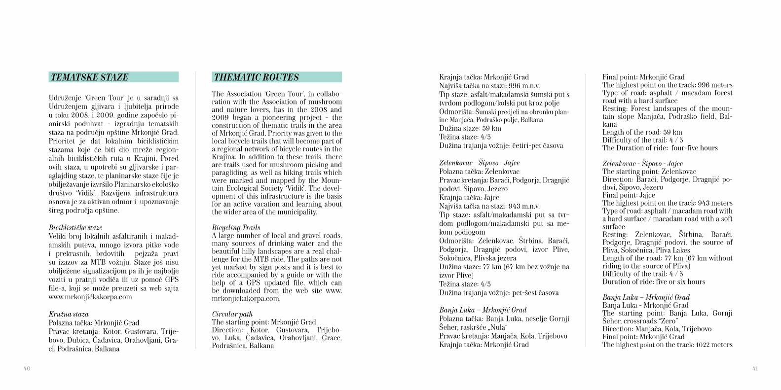
Biciklističke stazeVeliki broj lokalnih asfaltiranih i makad-amskih puteva, mnogo izvora pitke vode i prekrasnih, brdovitih pejzaža pravi su izazov za MTB vožnju. Staze još nisu obilježene signalizacijom pa ih je najbolje voziti u pratnji vodiča ili uz pomoć GPS file-a, koji se može preuzeti sa web sajta www.mrkonjićkakorpa.com
Kružna stazaPolazna tačka: Mrkonjić GradPravac kretanja: Kotor, Gustovara, Trije-bovo, Dubica, Čađavica, Orahovljani, Gra-ci, Podrašnica, Balkana
Final point: Mrkonjić Grad The highest point on the track: 996 meters Type of road: asphalt / macadam forest road with a hard surface Resting: Forest landscapes of the moun-tain slope Manjača, Podraško field, Bal-kana Length of the road: 59 km Difficulty of the trail: 4 / 5 The Duration of ride: four-five hours
Zelenkovac - Šipovo - JajceThe starting point: Zelenkovac Direction: Baraći, Podgorje, Dragnjić po-dovi, Šipovo, Jezero Final point: Jajce The highest point on the track: 943 metersType of road: asphalt / macadam road with a hard surface / macadam road with a soft surface Resting: Zelenkovac, Štrbina, Baraći, Podgorje, Dragnjić podovi, the source of Pliva, Sokočnica, Pliva Lakes Length of the road: 77 km (67 km without riding to the source of Pliva) Difficulty of the trail: 4 / 5 Duration of ride: five or six hours
Banja Luka – Mrkonjić GradBanja Luka - Mrkonjić Grad The starting point: Banja Luka, Gornji Šeher, crossroads “Zero” Direction: Manjača, Kola, Trijebovo Final point: Mrkonjić Grad The highest point on the track: 1022 meters
Krajnja tačka: Mrkonjić GradNajviša tačka na stazi: 996 m.n.v.Tip staze: asfalt/makadamski šumski put s tvrdom podlogom/kolski put kroz polje Odmorišta: Šumski predjeli na obronku plan-ine Manjača, Podraško polje, BalkanaDužina staze: 59 km Težina staze: 4/5Dužina trajanja vožnje: četiri-pet časova
Zelenkovac - Šipovo - JajcePolazna tačka: ZelenkovacPravac kretanja: Baraći, Podgorja, Dragnjić podovi, Šipovo, JezeroKrajnja tačka: JajceNajviša tačka na stazi: 943 m.n.v.Tip staze: asfalt/makadamski put sa tvr-dom podlogom/makadamski put sa me-kom podlogom Odmorišta: Zelenkovac, Štrbina, Baraći, Podgorja, Dragnjić podovi, izvor Plive, Sokočnica, Plivska jezeraDužina staze: 77 km (67 km bez vožnje na izvor Plive)Težina staze: 4/5Dužina trajanja vožnje: pet-šest časova
Banja Luka – Mrkonjić GradPolazna tačka: Banja Luka, neselje Gornji Šeher, raskršće „Nula“Pravac kretanja: Manjača, Kola, TrijebovoKrajnja tačka: Mrkonjić Grad
40 41
Najviša tačka na stazi: 1.022 m.n.v.Tip staze: asfalt/makadam/šumski kolski putOdmorišta: plato Velike ManjačeDužina staze: 58 km Težina staze: 4/5Dužina trajanja vožnje: pet-šest časova
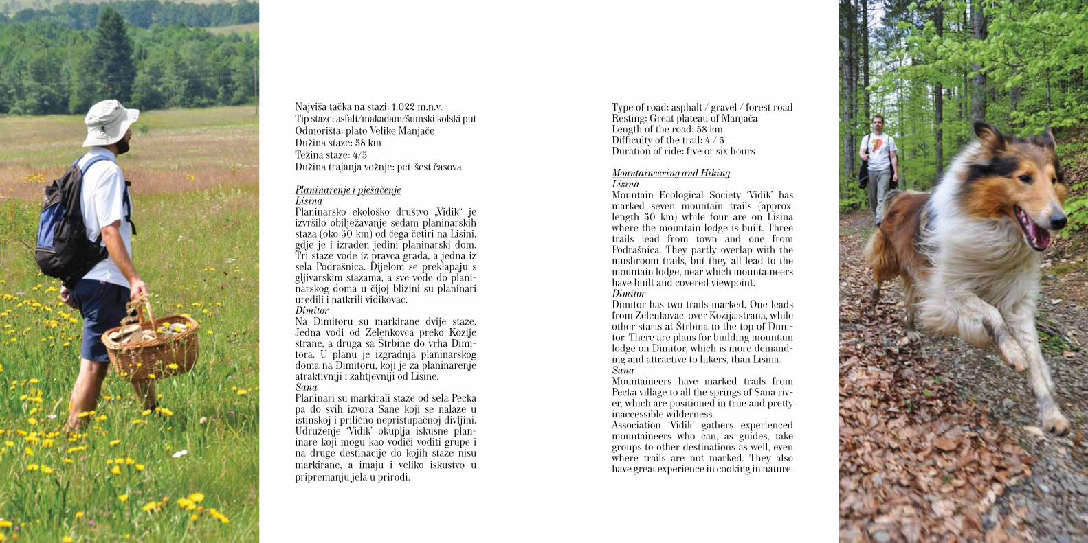
Planinarenje i pješačenjeLisinaPlaninarsko ekološko društvo „Vidik“ je izvršilo obilježavanje sedam planinarskih staza (oko 50 km) od čega četiri na Lisini, gdje je i izrađen jedini planinarski dom. Tri staze vode iz pravca grada, a jedna iz sela Podrašnica. Dijelom se preklapaju s gljivarskim stazama, a sve vode do plani-narskog doma u čijoj blizini su planinari uredili i natkrili vidikovac. DimitorNa Dimitoru su markirane dvije staze. Jedna vodi od Zelenkovca preko Kozije strane, a druga sa Štrbine do vrha Dimi-tora. U planu je izgradnja planinarskog doma na Dimitoru, koji je za planinarenje atraktivniji i zahtjevniji od Lisine.Sana Planinari su markirali staze od sela Pecka pa do svih izvora Sane koji se nalaze u istinskoj i prilično nepristupačnoj divljini. Udruženje ‘Vidik’ okuplja iskusne plan-inare koji mogu kao vodiči voditi grupe i na druge destinacije do kojih staze nisu markirane, a imaju i veliko iskustvo u pripremanju jela u prirodi.
Type of road: asphalt / gravel / forest roadResting: Great plateau of Manjača Length of the road: 58 km Difficulty of the trail: 4 / 5 Duration of ride: five or six hours
Mountaineering and HikingLisinaMountain Ecological Society ‘Vidik’ has marked seven mountain trails (approx. length 50 km) while four are on Lisina where the mountain lodge is built. Three trails lead from town and one from Podrašnica. They partly overlap with the mushroom trails, but they all lead to the mountain lodge, near which mountaineers have built and covered viewpoint. DimitorDimitor has two trails marked. One leads from Zelenkovac, over Kozija strana, while other starts at Štrbina to the top of Dimi-tor. There are plans for building mountain lodge on Dimitor, which is more demand-ing and attractive to hikers, than Lisina. SanaMountaineers have marked trails from Pecka village to all the springs of Sana riv-er, which are positioned in true and pretty inaccessible wilderness. Association ‘Vidik’ gathers experienced mountaineers who can, as guides, take groups to other destinations as well, even where trails are not marked. They also have great experience in cooking in nature.
The Association of mushroom gatherers and nature lovers has from 2003 until now implemented a number of activities dedi-cated to promotion of the world of mush-rooms, research, natural environment and education. Activists and researchers of the Association, brothers Gašić have explored the living world of Lisina for the last 30 years. One of the major projects of the As-sociation is mapping the habitats of fun-gi, production of maps and trail marking signs. Mushroom trails in Lisina, using the
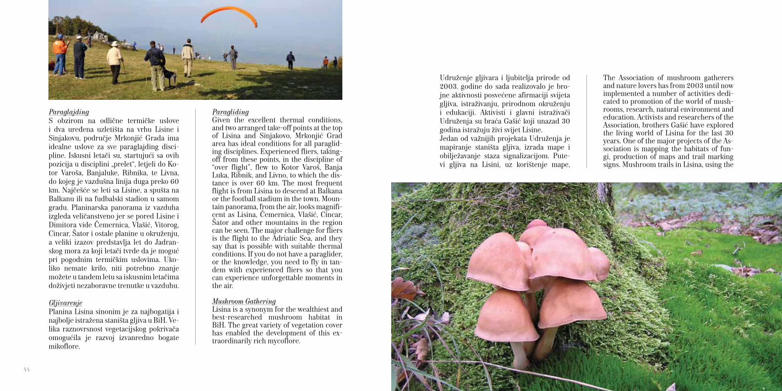
ParaglidingGiven the excellent thermal conditions, and two arranged take-off points at the top of Lisina and Sinjakovo, Mrkonjić Grad area has ideal conditions for all paraglid-ing disciplines. Experienced fliers, taking-off from these points, in the discipline of “over flight”, flew to Kotor Varoš, Banja Luka, Ribnik, and Livno, to which the dis-tance is over 60 km. The most frequent flight is from Lisina to descend at Balkana or the football stadium in the town. Moun-tain panorama, from the air, looks magnifi-cent as Lisina, Čemernica, Vlašić, Cincar, Šator and other mountains in the region can be seen. The major challenge for fliers is the flight to the Adriatic Sea, and they say that is possible with suitable thermal conditions. If you do not have a paraglider, or the knowledge, you need to fly in tan-dem with experienced fliers so that you can experience unforgettable moments in the air.
Mushroom GatheringLisina is a synonym for the wealthiest and best-researched mushroom habitat in BiH. The great variety of vegetation cover has enabled the development of this ex-traordinarily rich mycoflore.
ParaglajdingS obzirom na odlične termičke uslove i dva uređena uzletišta na vrhu Lisine i Sinjakovu, područje Mrkonjić Grada ima idealne uslove za sve paraglajding disci-pline. Iskusni letači su, startujući sa ovih pozicija u disciplini „prelet“, letjeli do Ko-tor Varoša, Banjaluke, Ribnika, te Livna, do kojeg je vazdušna linija duga preko 60 km. Najčešće se leti sa Lisine, a spušta na Balkanu ili na fudbalski stadion u samom gradu. Planinarska panorama iz vazduha izgleda veličanstveno jer se pored Lisine i Dimitora vide Čemernica, Vlašić, Vitorog, Cincar, Šator i ostale planine u okruženju, a veliki izazov predstavlja let do Jadran-skog mora za koji letači tvrde da je moguć pri pogodnim termičkim uslovima. Uko-liko nemate krilo, niti potrebno znanje možete u tandem letu sa iskusnim letačima doživjeti nezaboravne trenutke u vazduhu.
GljivarenjePlanina Lisina sinonim je za najbogatija i najbolje istražena staništa gljiva u BiH. Ve-lika raznovrsnost vegetacijskog pokrivača omogućila je razvoj izvanredno bogate mikoflore.
Udruženje gljivara i ljubitelja prirode od 2003. godine do sada realizovalo je bro-jne aktivnosti posvećene afirmaciji svijeta gljiva, istraživanju, prirodnom okruženju i edukaciji. Aktivisti i glavni istraživači Udruženja su braća Gašić koji unazad 30 godina istražuju živi svijet Lisine.Jedan od važnijih projekata Udruženja je mapiranje staništa gljiva, izrada mape i obilježavanje staza signalizacijom. Pute-vi gljiva na Lisini, uz korištenje mape,
44
maps, will help each mushroom-research-er or gastronome to find desired mash-room. Lisina represents the ideal habitat of almost all typical mushrooms, thanks to the rich variety of forest communities. In the last twenty years on Lisina more than 1300 species of mushrooms have been found. It is a very important nursery site, and is the richest habitat under protec-tion as part of the Mycological reservation Šibovi, the only of such kind in BiH. A Two-day study trip of about 30km to the Lisina Mushroom Trail, with four marked trails, will delight any mushroom and na-ture lover in almost all seasons. Along these mushroom trails there are a number of water sources and rivers so it is not nec-essary to carry much water with you.The longest path starts from the town cen-tre via Previle and Pirovače to Šibovi. The shortest and most challenging trail leads from the Balkana, via the mountain lodge at the top of Lisina to Šibovi. Two other trails ranging from Podrašnica (Mračaj and Zelenkovac) also lead to Mycological Reserve Šibovi. These paths are most vis-ited in the last week of September when the Mushroom days are organised. In good rainy season, it is possible to find almost all the best kinds of mushrooms from the genera Boletus, Cantharellus, Macrolepiota, Russula, Agaricus, Morchel-la, and others. In the wider area surround-ing Lisina there are no pollutants so the mushrooms, edible plants, wild fruits and
pomoći će svakom gljivaru-istraživaču ili gastronomu da pronađe željenu gljivu. Na Lisini su zastupljena skoro sva tipična staništa gljiva, jer obiluje različitim šumskim zajednicama. U zadnjih dvadeset godina je na Lisini pronađeno preko 1.300 vrsta gljiva. Ona predstavlja vrlo važan rasadnik spora, te je najbogatije stanište stavljeno pod zaštitu kao Mikološki rezer-vat Šibovi, jedino takvog tipa u BiH. Dvodnevno istraživanje oko 30 km dugog Puta gljiva na Lisini, sa četiri označene staze, oduševiće gljivare i ljubitelje pri-rode u skoro svim godišnjim dobima. Uz Put gljiva nailazi se na brojne izvore i vodotoke tako da nije neophodno nositi mnogo vode sa sobom. Najduža staza kreće iz centra grada preko Previla i Pirovača do Šibova. Najkraća, ali i najzahtjevnija staza vodi od Balkane pa pored planinarskog doma na vrhu Li-sine do Šibova. Ostale dvije staze kreću iz Podrašnice (Mračaj i Zelenkovac) i takođe vode do mikološkog rezervata Šibovi. Zadn-jeg vikenda u septembru održavaju se Dani gljiva, kada su i ove staze najposjećenije. U dobroj i kišnoj sezoni, moguće je naći skoro sve najkvalitetnije vrste gljiva iz ro-dova Boletus, Cantharellus, Macrolepiota, Russula, Agaricus, Morchella i druge. U širem području oko Lisine nema zagađivača pa su gljive, jestivo bilje, šumsko voće i lje-
kovite trave izvornog kvaliteta. Najiskusniji vodič kroz prirodu ovog kraja je Radoslav Gašić, koji ima višedecenijsko iskustvo i odlično poznaje cijelu planinu i širu regiju. Izuzetan je poznavalac gljiva ali posjeduje i veliko znanje o bilju, pticama i geološkoj građi same planine.
SMJEŠTAJ
Tajna dobrog odmora je u kvalitetnom spa-vanju! Planinsko okruženje i čist vazduh doprinose ugodnom snu u Mrkonjiću. Ponuda smještaja je vrlo raznovrsna.
Hotel ‘Krajina’ Hotel se nalazi u strogom centru grada i jedini je hotel u opštini Mrkonjić Grad.Kompletan kapacitet hotela je 20 soba i dva apartmana.
Motel ‘San’Na magistralnom putnom pravcu Bihać - Mrkonjić Grad – Jajce smješten je mo-tel ‘San’. Pored ugodnog ambijenta koji pruža restoran i kafe bar, motel raspolaže sa sedam komfornih soba, jednim apart-manom, te salom za sastanke kapaciteta 50 osoba. Sa terase se pruža pogled na Mrkonjić Grad. Uz pristupačne cijene i ugodan ambijent, motel ‘San’ predstavlja idealno mjesto za ručak i odmor.
medicinal herbs are of authentic quality. The most experienced guide of the na-ture of this area is Radoslav Gasić, who has decades of experience and excellent knowledge of the whole mountain and the wider region. He has exceptional knowl-edge of local mashrooms, but also has a great knowledge of plants, birds and geo-logical materials of the mountain itself.
ACCOMMODATION
The secret of good rest is in quality sleep! The Mountain environment and clean air contribute to pleasant dreams in Mrkonjić. The offer of accommodation is very versa-tile.
Hotel ‘Krajina’ The hotel is located in the centre of town and is the only hotel in the municipality of Mrkonjić Grad. The full capacity of this hotel is 20 rooms and two suites.
Motel ‘San’On the main road from Bihać - Mrkonjić Grad - Jajce you will find located motel ‘San’. In addition to a pleasant environ-ment that provides a restaurant and coffee bar the guesthouse has seven comfortable rooms, one suite and a conference room with a capacity of 50 persons. There is a
46 47

lake Bočac and the top of Čemernica’s mountain.
Apartments ‘Milić’The apartments are located in the clearing above Lake Balkana, which offers a mag-nificent view of the lake and surrounding mountains. Apartments ‘Milić’’ is an ideal place to enjoy and rest in peace and green-ery. Current accommodation capacity is sufficient for a comfortable and pleasant stay for up to 20 people. There is also a pool and barbecue areas are available.
Tourist centre ‘Balkana’Situated next to lake Balkana there are five bungalows. Each bungalow has a terrace overlooking the lake, living room with TV-SAT, comfortable rooms and comfortable beds. In the ‘Balkana’ can be accommo-dated 20 guests in the bungalows and 15 in guest rooms that are part of restaurants ‘Balkana’.
Picnic area ZelenkovacZelenkovac is located in the village Podrašnica, 12 km from Mrkonjić Grad, heading towards Glamoč on the main road Banja Luka - Split. Zelenkovac is situated in some of the most beautiful picnic ar-eas in the region, and is situated among century-old spruce forests and mountain streams. It is an ideal place for rest and
full view of Mrkonjić Grad from the ter-race of the motel. With affordable prices and a pleasant environment, motel ‘San’ is an ideal place for lunch and a rest.
Motel ‘Mandiko’The Motel is located on the main road from Jajce to Banja Luka at the position of Crna rijeka, which is also the intersection of roads for Mrkonjić Grad, Jajce and Ban-ja Luka. The Hotel has a beach by the river, parking space and places for fishing. The full capacity of the motel is eight rooms with 20 beds. The Motel is located on the bank of the Vrbas river, and terrace offers a view of the lake Bočac which is very rich in fish.
Motel ‘Lav’On the main road from Banja Luka to Ja-jce, in Dabrac, is located motel ‘Lav’. The Motel has six comfortable rooms with 12 beds. A sunny balcony offers a view of the
Motel ‘Mandiko’Motel se nalazi na magistralnom putu Jajce - Banja Luka na poziciji Crna Ri-jeka, što je ujedno raskrsnica puteva za Mrkonjić Grad, Jajce i Banja Luku. Motel raspolaže sa plažom, parking prostorom i mjestom za ribolov. Kompletan kapacitet motela je osam soba sa 20 kreveta. Motel je smješten na samoj obali rijeke Vrbas, a sa terase pruža se pogled na jezero Bočac koje je jako bogato ribom.
Motel ‘Lav’Na magistralnom putnom pravcu Banja Luka - Jajce, u mjestu Dabrac, smješten je motel ‘Lav’. Motel raspolaže sa šest kom-fornih soba sa ukupo 12 udobnih ležajeva. Sa sunčane terase pruža se pogled na jeze-ro Bočac i vertikalno uzdignut vrh planine Čemernice.
Apartmani ‘Milić’Apartmani se nalaze na proplanku iznad jezera Balkana sa kojeg se pruža veličanstven pogled na jezera i okolne pla-nine. Apartmani ‘Milić’ su idealno mjesto za uživanje i odmor u miru i zelenilu. Trenutni smještajni kapacitet je dovol-jan za komotan i udoban boravak do 20 osoba kojima su na raspolaganju bazen i roštiljska mjesta.
Turistički centar ‘Balkana’Pored jezera Balkana izgrađeno je pet bungalova. Svaki bungalov ima terasu sa pogledom na jezero, dnevni boravak sa TV-SAT, komfornim sobama i udobnim ležajevima. Na ‘Balkani’ se može smjes-
48 49
Apar
tman
i / A
part
men
ts M
ilić
TC
Bal
kana
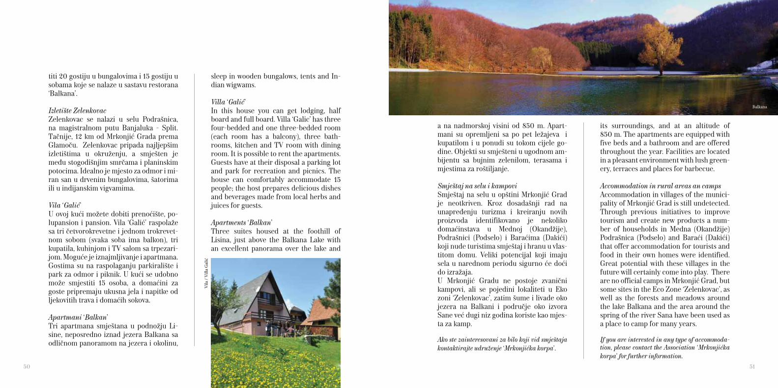
its surroundings, and at an altitude of 850 m. The apartments are equipped with five beds and a bathroom and are offered throughout the year. Facilities are located in a pleasant environment with lush green-ery, terraces and places for barbecue.
Accommodation in rural areas an campsAccommodation in villages of the munici-pality of Mrkonjić Grad is still undetected. Through previous initiatives to improve tourism and create new products a num-ber of households in Medna (Okandžije) Podrašnica (Podselo) and Baraći (Dakići) that offer accommodation for tourists and food in their own homes were identified. Great potential with these villages in the future will certainly come into play. There are no official camps in Mrkonjić Grad, but some sites in the Eco Zone ‘Zelenkovac’, as well as the forests and meadows around the lake Balkana and the area around the spring of the river Sana have been used as a place to camp for many years.
If you are interested in any type of accommoda-tion, please contact the Association ‘Mrkonjićka korpa’ for further information.
sleep in wooden bungalows, tents and In-dian wigwams.
Villa ‘Galić’In this house you can get lodging, half board and full board. Villa ‘Galic’ has three four-bedded and one three-bedded room (each room has a balcony), three bath-rooms, kitchen and TV room with dining room. It is possible to rent the apartments. Guests have at their disposal a parking lot and park for recreation and picnics. The house can comfortably accommodate 15 people; the host prepares delicious dishes and beverages made from local herbs and juices for guests.
Apartments ‘Balkan’Three suites housed at the foothill of Lisina, just above the Balkana Lake with an excellent panorama over the lake and
titi 20 gostiju u bungalovima i 15 gostiju u sobama koje se nalaze u sastavu restorana ‘Balkana’.
Izletište ZelenkovacZelenkovac se nalazi u selu Podrašnica, na magistralnom putu Banjaluka - Split. Tačnije, 12 km od Mrkonjić Grada prema Glamoču. Zelenkovac pripada najljepšim izletištima u okruženju, a smješten je među stogodišnjim smrčama i planinskim potocima. Idealno je mjesto za odmor i mi-ran san u drvenim bungalovima, šatorima ili u indijanskim vigvamima.
Vila ‘Galić’U ovoj kući možete dobiti prenoćište, po-lupansion i pansion. Vila ‘Galić’ raspolaže sa tri četvorokrevetne i jednom trokrevet-nom sobom (svaka soba ima balkon), tri kupatila, kuhinjom i TV salom sa trpezari-jom. Moguće je iznajmljivanje i apartmana. Gostima su na raspolaganju parkiralište i park za odmor i piknik. U kući se udobno može smjestiti 15 osoba, a domaćini za goste pripremaju ukusna jela i napitke od ljekovitih trava i domaćih sokova.
Apartmani ‘Balkan’Tri apartmana smještana u podnožju Li-sine, neposredno iznad jezera Balkana sa odličnom panoramom na jezera i okolinu,
a na nadmorskoj visini od 850 m. Apart-mani su opremljeni sa po pet ležajeva i kupatilom i u ponudi su tokom cijele go-dine. Objekti su smješteni u ugodnom am-bijentu sa bujnim zelenilom, terasama i mjestima za roštiljanje.
Smještaj na selu i kampoviSmještaj na selu u opštini Mrkonjić Grad je neotkriven. Kroz dosadašnji rad na unapređenju turizma i kreiranju novih proizvoda identifikovano je nekoliko domaćinstava u Mednoj (Okandžije), Podrašnici (Podselo) i Baraćima (Dakići) koji nude turistima smještaj i hranu u vlas-titom domu. Veliki potencijal koji imaju sela u narednom periodu sigurno će doći do izražaja. U Mrkonjić Gradu ne postoje zvanični kampovi, ali se pojedini lokaliteti u Eko zoni ‘Zelenkovac’, zatim šume i livade oko jezera na Balkani i područje oko izvora Sane već dugi niz godina koriste kao mjes-ta za kamp.
Ako ste zainteresovani za bilo koji vid smještaja kontaktirajte udruženje ‘Mrkonjićka korpa’.
50 51
Vila
/ V
illa
Gal
ić
Balkana
mountains with rich forests, which cover 64% of the entire municipality. It also has a cave known as ‘Ledena’ by speleologists and it’s often visited by hikers. Sanica, the first tourist village in the for-mer Yugoslavia, which is located 50 kilo-metres from Mrkonjić Grad, was named after the eponymous river, which springs from the rock, and is located in the gen-tle valley at the foot of the mountain Grmeč. Numerous archaeological sites, Hrustovačka cave, remains of narrow track line, its bridges and tunnels and the alley Stara Mijačica and ‘Oaza mira’ certainly deserve a visit.
Distances from Mrkonjić GradBanja Luka 56 kmBihać 127 kmSarajevo 186 kmSplit 220 kmZagreb 242 kmBeograd 387 km
Mrkonjić Grad can be reached only by main roads. Plan your time well, and then relax and enjoy the magnificent nature and the local cuisine of the Mrkonjić area!Take a vacation by setting off on the right foot! Certainly try to avoid stressful situ-ations because they can badly affect the benefits of your vacation.
SURROUNDING
The towns of Jajce and Šipovo are about 20-odd kilometres far from Mrkonjić Grad, separated by the large and small Pli-va lakes. Jajce has a very rich history, the fortress and the catacombs and a unique waterfall in the town from which Pliva flows into Vrbas. Šipovo was abundantly rewarded by na-ture. Primeval forest Janj, canyon of riv-er Janj, seven rivers of which Pliva is the largest, the island on river Janj, caves, colonies of beavers and other delights that are shame not to see. Sport fishing is well developed in the town where you can eat very tasty brook trout and other dishes of this region.Banja Luka, the largest city, the economic and cultural centre of the region, is locat-ed 50 km north of Mrkonjić Grad. Ribnik, located 39 km from Mrkonjić Grad, as its name suggests, known for its rich fish stocks, in other words clean riv-ers where the fish stay happy. Very short (5 km), but the immaculate river Ribnik in the upper part of the municipality flows into the river Sana which itself has only launched from its source (15 km). Sport fishing and fly fishing are well-developed so very significant competitions are or-ganised there. Around the river rise a few
BLIŽE OKRUŽENJE
Na samo 20-ak kilometara od Mrkonjića nalaze se Jajce i Šipovo između kojih su Veliko i Malo plivsko jezero. Jajce ima izuzetno bogatu istoriju, tvrđavu i kata-kombe ali i jedinstven vodopad u samom gradu sa kojeg se Pliva ulijeva u Vrbas. Šipovo je priroda obilno nagradila. Prašuma Janj, kanjon Janja, sedam rijeka od koji je Pliva najveća, Janjske otoke, pećine, kolonije dabrova i druge vrijed-nosti šteta je ne vidjeti jer je od Mrkonjića udaljeno samo 25 km. Sportski ribolov je dobro razvijen, a u gradu se može pojesti vrlo ukusna potočna pastrmka ali i druga jela ovog kraja. Banja Luka, najveći grad, privredni i kul-turni centar regije, nalazi se 50 km sjev-erno od Mrkonjić Grada. Ribnik je, kako mu ime kaže, poznat po bogatom ribljem fondu, odnosno čistim rijekama u kojima ribe rado borave. Vrlo kratka (5 km) ali prečista rijeka Ribnik se u gornjem dijelu opštine ulijeva u rijeku Sanu koja je i sama tek krenula od svog izvorišta (15 km). Sportski ribolov, fly fishing, je vrlo razvijen pa se redovno održavaju značajna takmičenja. Oko rijeka se uzdiže nekoliko planina bogatih šumom koja pokriva 64% cijele opštine. Poznata je i pećina ‘Ledena’ koju speleolozi i planinari često posjećuju.
Ribnik je od Mrkonjića udaljen 39 km.Sanica, prvo turističko selo u bivšoj Ju-goslaviji nalazi se 50-ak kilometara od Mrkonjić Grada. Ime je dobila po istoi-menoj rijeci koja izvire iz stijene, a smjes-tila se u pitomu dolinu u podnožju plan-ine Grmeč. Brojna arheološka nalazišta, Hrustovačka pećina, ostaci uskotračne pruge, njeni mostovi i tuneli, drvored u Staroj Mijačici i ‘Oaza mira’ svakako zaslužuju posjetu.
Udaljenosti od Mrkonjić GradaBanja Luka 56 kmBihać 127 kmSarajevo 186 kmSplit 220 kmZagreb 242 kmBeograd 387 km
Do Mrkonjić Grada moguće je doći jedino magistralnim putevima. Dobro planirajte vrijeme za put, a nakon toga opustite se i uživajte u veličanstvenoj prirodi i domaćoj kuhinji mrkonjićkog kraja!Krenite na odmor ustajući na desnu nogu! Svakako pokušajte izbjeći stresne situaci-je jer mogu loše uticati na blagotvornost odmora.
52 53

Vodenice na Plivi / Watermills on Pliva

AUTHOR, EDITOR AND PHOTOBoro Marić
PROJECT MANAGER AND TRANSLATIONDanijela Marković
PROJECT AUTHOREmir Dervišević
PROOFREADINGAleksandra Marić, Mark J. Dakin
DESIGNMiodrag Manojlović
PRINTA-Ray Ltd. Mrkonjić Grad
PRINT RUN2000
AUGUST 2010
This publication is free of charge
The publication is produced through the pro-ject ‘Mrkonjićka Korpa – A Cluster of sustain-able product development in tourism’, imple-mented by Green Tour as part of UNDP LOD project and cofinanced by Mrkonjić Grad Mu-nicipality.
This document does not necessarily reflect the views of the European Union or United Na-tions Development Programme in BiH, and it is sole responsibility of Green Tour.
Data used for this publication were collected during the project activities, from Mrkonjic Grad monograph (1973) and the document “Valorisation of cultural, historical and natu-ral heritage of Mrkonjić Grad municipality” (2009) published by the Institute for protec-tion of cultural, historical and natural heritage of Republic of Srpska.
We would like to thank researchers Slobodan Ćoćkalo and Radoslav Gasić for their sincere and professional contributions, we support them in their efforts to preserve cultural heritage and natural environment of Mrkonjić Grad.
MRKONJIĆKA KORPAContact telephone: + 387 50 214 257Contact email: [email protected]
Publikacija je izrađena kroz projekat ‘Mrkonjićka Korpa - Klaster za održivi razvoj proizvoda u turizmu’ koji je proveo Green Tour u okviru UNDP - LOD projekta uz sufinansir-anje opštine Mrkonjić Grad.
Ovaj tekst ne odražava nužno stavove Evrop-ske unije niti Razvojnog programa Ujedin-jenih nacija u BiH i isključiva je odgovornost udruženja Green Tour.
Za potrebe ove publikacije korišteni su podaci iz projektnog istraživanja o ponudi opštine Mrkonjić Grad, te monografije ‘Mrkonjić Grad’ iz 1973. godine i dokumenta pod nazivom ‘Valorizacija kulturno-istorijskog i prirodnog nasljeđa opštine Mrkonjić Grad’ iz 2009. go-dine u izdanju Republičkog zavoda za zaštitu kulturno-istorijskog i prirodnog nasljeđa Re-publike Srpske.
Zahvaljujemo se istraživačima Radoslavu Gašiću i Slobodanu Ćoćkalu na iskrenim i stručnim doprinosima i podržavamo ih u njiho-vom naporu za očuvanjem kulturnog nasljeđa i zaštite prirodnog okoliša Mrkonjić Grada.
MRKONJIĆKA KORPAKontakt telefon: + 387 50 214 257Kontakt email: [email protected]
AUTOR, UREDNIK i FOTOGRAFIJEBoro Marić
VODITELJ PROJEKTA I PREVODDanijela Marković
AUTOR PROJEKTAEmir Dervišević
LEKTURAAleksandra Marić, Mark J. Dakin
DIZAJNMiodrag Manojlović
PRINTA-Ray d.o.o. Mrkonjić Grad
TIRAŽ2000
AVGUST 2010
Ova publikacija je besplatna
56 57
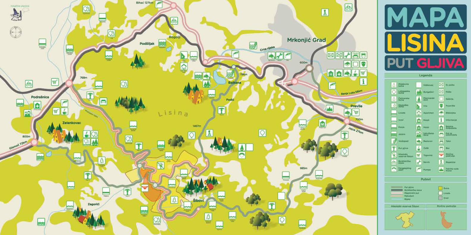

www.mrkonjickakorpa.com