multifunction bydesign - telemar · multifunction bydesign ... the ecdis will display the outline...
TRANSCRIPT
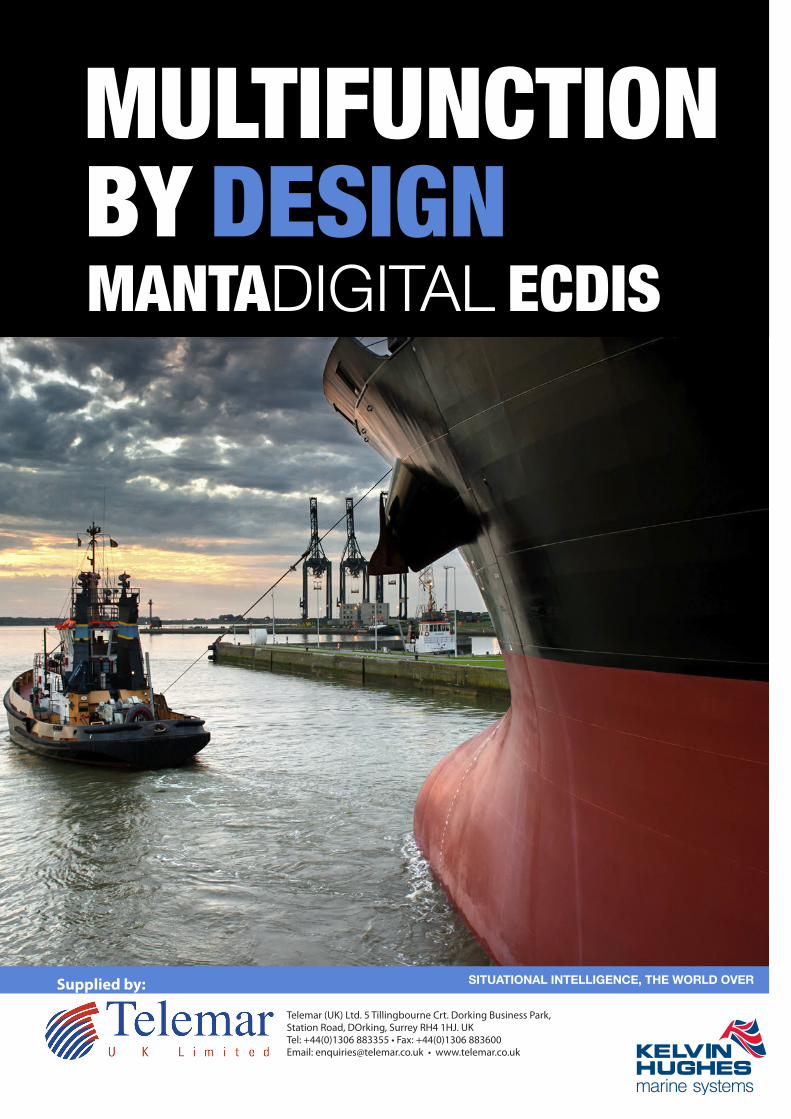
MULTIFUNCTIONBY DESIGN
SITUATIONAL INTELLIGENCE, THE WORLD OVER
MANTADIGITAL ECDIS
Supplied by:
Telemar (UK) Ltd. 5 Tillingbourne Crt. Dorking Business Park,Station Road, DOrking, Surrey RH4 1HJ. UKTel: +44(0)1306 883355 • Fax: +44(0)1306 883600 Email: [email protected] • www.telemar.co.uk

Designed for ease of operation MantaDigitalTM ECDIS is the latest product from Kelvin Hughes' Manta development
programme. Intuitive operation and a clear display of relevant information provides the operator with a decision making tool
which enhances safety and efficiency. Simplicity and ease of operation is at the heart of Kelvin Hughes' design philosophy.
MantaDigitalTM ECDIS is available in a variety of mounting
configurations to meet the needs of different vessel
types and operational scenarios. It can be supplied in
options ranging from a single 20" desktop retrofit
system through to a fully integrated navigation system.
Display options include 20" and 26" high-definition
screens for pedestal, desktop and mounting
into consoles.
TM
From the outset, MantaDigitalTM ECDIS has been designed
for true multi-functionality, providing a platform for Radar,
Chart Radar, ECDIS and Conning Display options.
MantaDigitalTM is driven by Kelvin Hughes' "common-core"
processor system which is now in use throughout the
Radar, ECDIS and VDR product ranges providing
enhanced functionality, reliability and low cost of
ownership.
Employing the latest state-of-the-art technology the
MantaDigitalTM ECDIS offers a vast array of advantages to
the navigator, from immediate situation awareness,
through to sophisticated alarm management. The
MantaDigitalTM ECDIS uses the same three button and
trackerball interface concept that has been used
successfully in Kelvin Hughes' products for over 10 years.
MantaDigital TM 26" Pedestal ECDIS
The user interface has been
designed to be intuitive to
operate and provide all the
tools that the navigator needs for
efficient and safe navigation without the
need to explore multiple levels on each menu.
A high-speed LAN connection provides distribution of route
data and interfacing with the ChartCo update service.
Introduction
Kelvin Hughes - A History of Innovation
ECDIS is an acronym for Electronic Chart Display and
Information System. At its simplest, an ECDIS consists of a
database of electronic charts, together with the hardware
and software needed to display simultaneously the charts
and the ship’s own position (obtained from a GPS or
another positioning sensor), and to perform navigational
tasks such as route planning, route monitoring,
measurement of distances on the chart, etc. One of the
most important features of ECDIS that makes it a unique
aid to navigation is the capability of generating alarms (anti-
grounding, off route, etc.), based on input from sensors
and analysis of chart information.
Kelvin Hughes was one of the first Companies to receive
Type Approval for its ECDIS back in 1994. Since then many
advances have been made in technology and data
availability. World-wide ENC (vector) chart data is now
available from a variety of sources.
SOLAS regulation V/19 requires ships engaged oninternational voyages to be fitted with ECDIS as follows:
Passenger ships over 500 GRT constructed on or after1 July 2012;
Tankers over 3,000 GRT constructed on or after 1 July2013;
Cargo ships, other than tankers, over 10,000 GRTconstructed on or after 1 July 2013;
Cargo ships, other than tankers, over 3,000 GRT butless than 10,000 GRT constructed on or after 1 July2014;
Passenger ships over 500 GRT constructed before 1July 2012, not later than the first survey on or after 1July 2014;
Tankers over 3,000 GRT constructed before 1 July2012, not later than the first survey on or after 1 July2015;
Cargo ships, other than tankers, over 50,000 GRTconstructed before 1 July 2013, not later than the firstsurvey on or after 1 July 2016;
Cargo ships, other than tankers, over 20,000 GRT butless than 50,000 GRT constructed before 1 July 2013,not later than the first survey on or after 1 July 2017;
Cargo ships, other than tankers, over 10,000 GRT butless than 20,000 GRT constructed before 1 July 2013,not later than the first survey on or after 1 July 2018.
Questions KELVIN HUGHES can answer for you
What ECDIS hardware do I need ?
What’s the most cost-effective chart data solution formy ships ?
How can I keep my chart data up-to-date ?
Where can I get officially recognised and approvedtraining for my crews ?
If I still need paper charts, which must I carry ?
Chart coverage keeps changing - who can manage thisfor me ?
Managing my chart outfit is a real burden who can Itrust to do it for me ?
What do I need as an ECDIS backup ?
Who can provide global installation and support for myvessels ?

TM
MantaDigitalTM ECDIS provides a range of tools to ease the task of electronic navigation. These include range and bearing cursors,
an enlarged "spyscope" together with traditional tools for route planning. Included in these tools is manual fixing which can be used
both as a training tool and operationally in the event of a sensor failure. This enables the navigator to fix the vessel's position on the
electronic chart using traditional radar or visual plots and fixes. These manual fixes can be used to derive dead reckoned or
estimated positions for ongoing navigation.
MantaDigitalTM 26" Desktop ECDIS
MantaDigitalTM ECDIS provides continuous monitoring of vessel's position against its
planned track. In addition, a look ahead is performed on the underlying chart data and
a warning is generated if the intended vessel's track will violate pre-set safety
parameters.
MantaDigitalTM ECDIS provides a continuous display of ownship's navigation
parameters together with a display of ownship graphic with heading, track, and route
on the chart.
ECDIS Features ECDIS FeaturesTM
A single toggle action provides a maximised chart display enabling
more of the chart to be displayed. A simple menu system allows the
user to select the functional panels.
Routes can be planned using drag-and-drop to define the waypoints on the
chart screen. Channel widths, turn radius and planned speeds for each leg
can be defined. After planning, the route can be checked to see whether it
violates the ships safery parameters, this must be done before the route can
be activated. Both rhumb line and great circle legs can be constructed.
Tools for traditional planning are also provided enabling the navigator to setup
clearing ranges and bearings for each leg of a route. These are transferred to
the Radar when on passage.
Extensive tools are provided which simplify the orgainsation and management
of chart data and permits. In conjunction with the ChartCo update service the
MantaDigitalTM ECDIS is the easy solution for chart management and updates
onboard your vessels.
In conjunction with the ChartCo update service, the status of all cells
can be automatically displayed and any required updates applied.
To aid close quarter manoeuvering on large chart scales , the ECDIS
will display the outline of the vessel graphically on the chart based on
preset parameters.
A forward prediction of ownship's position up to 6 minutes advanced
can also be displayed to give the navigator awareness of the vessel's
position during the manoeuvre.
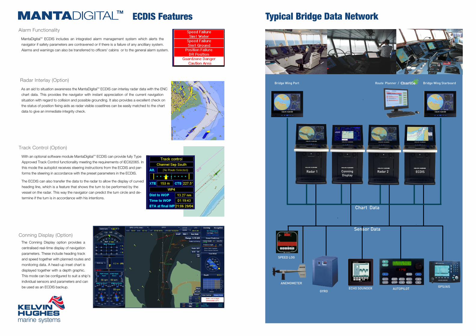
As an aid to situation awareness the MantaDigitalTM ECDIS can interlay radar data with the ENC
chart data. This provides the navigator with instant appreciation of the current navigation
situation with regard to collision and possible grounding. It also provides a excellent check on
the status of position fixing aids as radar visible coastlines can be easily matched to the chart
data to give an immediate integrity check.
TM
The Conning Display option provides a
centralised real-time display of navigation
parameters. These include heading track
and speed together with planned routes and
monitoring data. A head-up inset chart is
displayed together with a depth graphic.
This mode can be configured to suit a ship's
individual sensors and parameters and can
be used as an ECDIS backup.
ECDIS Features
With an optional software module MantaDigitalTM ECDIS can provide fully Type
Approved Track Control functionality meeting the requirements of IEC62065. In
this mode the autopilot receives steering instructions from the ECDIS and per-
forms the steering in accordance with the preset parameters in the ECDIS.
The ECDIS can also transfer the data to the radar to allow the display of curved
heading line, which is a feature that shows the turn to be performed by the
vessel on the radar. This way the navigator can predict the turn circle and de-
termine if the turn is in accordance with his intentions.
MantaDigitalTM ECDIS includes an integrated alarm management system which alerts the
navigator if safety parameters are contravened or if there is a failure of any ancilliary system.
Alarms and warnings can also be transferred to officers' cabins or to the general alarm system.
Bridge Wing Port Bridge Wing Starboard
GYROAUTOPILOTECHO SOUNDER
ANEMOMETERGPS/AIS
Typical Bridge Data Network
SPEED LOG
Sensor Data
Radar 1 ConningDisplay
Chart Data
ECDISRadar 2
Route Planner /

ECDISplusKelvin Hughes' Total ECDIS Solution
ECDISplus is a unique package from Kelvin
Hughes which provides a “turn-key”
ECDIS solution. It includes hardware
supply and installation, initial chart data
supply, licence management, ChartCo
updates and an IMO approved training
package, all backed up with support from Kelvin Hughes’
global service network. ECDISplus can be tailored to
individual customers’ requirements and can range from the
supply of ECDIS hardware through to a complete package.
Paper charts and digital licences can also be managed and
replenished under the Outfit Management Service (OMS)
Chart data is the key component of any ECDIS system. To be
an official ECDIS this has to be vector based ENC issued by a
national hydrographic authority.
ECDISplus can be supplied with any
official ENC chart data such as
OCEANS, AVCS or PRIMAR. In
addition, in ECS mode non-official
chart data can be displayed. The
choice of suppliers will depend very
much on the operating area of the
vessel, Kelvin Hughes can make this
choice for you to give you the most
cost effective and safe coverage.
The wide-screen MantaDigitalTM ECDIS
forms the core of ECDISplus. This is available
as a desktop, pedestal or console mounted
system with screen sizes of 20” or 26”. The
main user interface is the tracker ball and
three buttons which may optionally be mounted remotely.
An optional standard QWERTY keyboard can also be
provided.
Whether for a new-build integrated bridge or a retrofit stand-
alone, Kelvin Hughes is able to offer a complete installation
and commissioning service world-wide.
As part of ECDISplus several standard packages are available,
these can cover anything from commissioning only through to
a complete install with cable laying, physical mounting of the
hardware, commissioning and disposal of any redundant
equipment. These installation packages are available at global
locations and at fixed pre-agreed prices.
Email/Internet
Kelvin Hughes provides a
Flag State approved
course based on the IMO
1.27 model. This course
teaches the navigator to
get the most out of their
equipment and particularly
familiarises the user with using traditional navigational
methods on the ECDIS.
The overall objective is to enhance navigational safety
through safe operation and a thorough understand of
the MantaDigitalTM ECDIS.
Key areas addressed by the course are:
Electronic chart data and its display in an
ECDIS
Proper use of the ECDIS equipment
ECDIS-related limitations
Operation of the Kelvin Hughes ECDIS
The training lasts five days and is available in the UK
(South) , Egypt and Singapore.
Through its service
locations and a large
number of authorised
service partners Kelvin
Hughes can provide global
service and support.
Standard and extended warranties are available for all
equipment sales.
ECDISplusKelvin Hughes' Total ECDIS Solution
Managing changes to the chart database is key to keeping
the chart outfit up-to-date and safe and meeting the Port
State Authority requirements. ChartCo provides an update
via broadcast, email or
Internet technology. This
service provides updates for
paper and electronic charts
and publications and includes additional services such as
weather forecasting and routing and a news service.
Updates can be passed directly to the ECDIS through the
network or via CD.
In addition Kelvin Hughes’ Outfit Management service can
manage paper publications and charts alongside your
digital data ensuring that at all times you are up-to-date,
safe and meet the port state authority requirements.
Managing electronic charts
differs significantly from paper
charts. Chart cells are loaded
onto the ECDIS and activated
using licences. Licences from
different hydrographic offices
may have differing validity
durations, so ensuring that the
appropriate charts remain available is an important task.
Ships whose trading patterns change will need new cells
to be activated. Licences are available for three, six or
twelve month durations. Kelvin Hughes can remotely
manage the licensing process as part of the Outfit
Management Service.
The requirements for ECDIS
backup differ significantly
across Flag States. As part of
ECDISplus Kelvin Hughes will
advise on the requirements
relating to individual vessels
and will provide and manage any “get-you-home” paper
charts that may be required. Whatever the backup
requirements Kelvin Hughes will deliver and manage a
least cost solution ensuring that at all times the vessel’s
data is up to date. "the complete picture..."

Display Type Flat Panel TFT Screen Sizes 26" (660mm) and 22" (560mm) diagonal activesize
Pixel Resolution 1920 x 1200 Aspect Ratio 16:10
Display Variants Pedestal, Desktop, Console and Bridge-Wing (Internal)
OCEANS
OCEANS is the official electronic navigational chart service from ChartCo, providing vessels with extensive,global ENC coverage. With ENC cells from over 50 countries contained within a database that is updated inreal-time, OCEANS provides comprehensive worldwide coverage giving safer navigation for all the major searoutes, approaches, coasts and ports.
AVCSThe Admiralty Vector Chart Service (AVCS) brings together Electronic Navigational Charts (ENCs) from na-tional Hydrographic offices around the world and new ENC coverage produced by UKHO in co-operationwith Foreign Governments to provide comprehensive, official, global coverage.
Jeppesen PrimarENC Service
The Jeppesen Primar ENC Service provides a single data source that ensures that mariners are alwaysnavigating with an approved ENC where available. Unofficial data produced by Jeppesen will be used whereno official coverage is available.
C-MAP Unofficial vector chart data with world-wide coverage
Chart Updates
ChartCoUpdating of charts is a simple point and click process and has been designed to facilitate the input ofupdates from the ChartCo service.
FeaturesWide-screen flat panel TFT display, less weight, less volume,sharper picture and easier to mount
Extensive route planning and monitoring facilities inc alternateroute
ARPA displayDisplays up to 50 ARPA target graphicsand numerical data AIS Interface
The system can interface with any AIS anddisplay up to 50 active targets
Route VerificationPost planning tool to check route beforeactivation
Vessel PredictionGraphical prediction of vessel's futureposition up to 6 minutes ahead
Route MonitoringContinuous monitoring of vessel positionwith respect to planned route
Manual FixingAstro, Radar, Visual and electronic fixingmethods
Track ReplayThe vessel's track is automaticallyrecorded and can be saved externally.
User mappingAllows navigator to add graphicalannotation to the chart
Range & BearingMarkers
Variable range marker. Electronicbearing lines and parallel index markersprovided
Event RecordingUser events such as man overboard, canbe annotated on the chart
Options
Radar InterlayDiplay of radar returns "interlayed" withthe chart data
Track ControlAutomatic control of the autopilot tomaintain the vessel on the planned track
Remote Keyboard/Trackerball
Desktop or built-in options availableChair-mounted"Ergopod"
Left and right-handed control options forchair attachment
InterfacesNMEA-0183 Log, Gyro, GPS, AIS, Autopilot Analogue Gyro, Log, VDR, Rudder Angle
Network CAT5 Ethernet
TM ECDIS Specifications Kelvin Hughes WORLD SERVICE
Installation and After Sales Service
We recognise that delivering a first-time-fix and value for money are fundamental expectations of our customers.
Key to meeting these expectations is a philosophy of working in partnership with our customers and suppliers centred around a
global team of experienced service engineers and support staff who are all passionate about delivering service excellence to the
marine industry.
In applying this approach a shared set of values has emerged that defines the way that we aim to work with our customers, our
service suppliers and within our own organisation, these being to:
Kelvin Hughes' Service/Sales Centres
Kelvin Hughes' Service Agents
These values and capabilities drive the entire customer experience and are at the heart of what we do 24hours every day, 365 days a year.
For further information about any of our services please call us on ,
email us at
or visit
Ensure that the customer is central to everything that we do.
Apply mutual trust, fairness and honesty in all of our business dealings.
Strive to exceed customer expectations, on time and right first time.
Provide value for money, good quality and maintain vessel safety.
Continue to improve the service offerings through process improvements
and innovation.
Adapt quickly to changing customer needs.
What We Offer
Spare Parts Sales
Global Service
Warranty Support
Installation and Commissioning
Services
Management / Maintenance Con-
tracts
VDR Annual Performance Testing
VDR Replay Services
Compass Adjusting and Repair
Operator Equipment Familiarisation
and Training
Equipment Surveys and Inspection
Technical Advice
Major retrofit project management
V-Sat Airtime Contracts

www.kelvinhughes.com
UK (Head Office): Kelvin Hughes LimitedNew North Road, Hainault,Ilford, Essex IG6 2URt: +44 20 8502 6887
Southampton: Kelvin Hughes Ltd,Kilgraston House, Southampton StreetSouthampton SO15 2EDt: +44 23 8063 4911
Scandinavia: A/S Kelvin HughesCopenhagen: t: +45 35 55 8116Århus: t: +45 86 11 2888Norway: t: +47 6490 9988
Benelux: Kelvin Hughes (Nederland) B.VRotterdam: t: +31 10 416 76 22
China: Kelvin Hughes Shanghai Representative OfficeShanghai: t: +86 21 58780313
Far East: Kelvin Hughes (Singapore) Pte LtdSingapore: t: +65 6545 9880Hong Kong: t: +852 2832 2077
USA: Kelvin Hughes LLCWashington: t: +1 703 548 4007New Orleans: t: +1 504 731 2999
This publication is not intended to form the basis of a contract, nor does it take theplace of the specification to which reference should be made for further information.
Kelvin Hughes Limited reserves the right to vary any specification in detail.
Supplied by:
Telemar (UK) Ltd. 5 Tillingbourne Crt. Dorking Business Park,Station Road, DOrking, Surrey RH4 1HJ. UKTel: +44(0)1306 883355 • Fax: +44(0)1306 883600 Email: [email protected] • www.telemar.co.uk