mystic river watershed 2004-2008 water quality assessment
TRANSCRIPT
MYSTIC RIVER WATERSHED AND COASTAL DRAINAGE AREA
2004-2008 WATER QUALITY ASSESSMENT REPORT
COMMONWEALTH OF MASSACHUSETTS EXECUTIVE OFFICE OF ENERGY AND ENVIRONMENTAL AFFAIR S
IAN BOWLES, SECRETARY MASSACHUSETTS DEPARTMENT OF ENVIRONMENTAL PROTECTIO N
LAURIE BURT, COMMISSIONER BUREAU OF RESOURCE PROTECTION
GLENN HAAS, ACTING ASSISTANT COMMISSIONER DIVISION OF WATERSHED MANAGEMENT
GLENN HAAS, DIRECTOR
Mystic River Watershed 2004-2008 Water Quality Assessment Report 71wqar09.doc DWM CN170.2
ii
NOTICE OF AVAILABILITY
LIMITED COPIES OF THIS REPORT ARE AVAILABLE AT NO C OST BY WRITTEN REQUEST TO:
MASSACHUSETTS DEPARTMENT OF ENVIRONMENTAL PROTECTIO N DIVISION OF WATERSHED MANAGEMENT
627 MAIN STREET WORCESTER, MA 01608
This report is also available from the MassDEP’s home page on the World Wide Web at: http://www.mass.gov/dep/water/resources/wqassess.htm Furthermore, at the time of first printing, eight copies of each report published by this office are submitted to the State Library at the State House in Boston; these copies are subsequently distributed as follows: • On shelf; retained at the State Library (two copies); • Microfilmed retained at the State Library; • Delivered to the Boston Public Library at Copley Square; • Delivered to the Worcester Public Library; • Delivered to the Springfield Public Library; • Delivered to the University Library at UMass, Amherst; • Delivered to the Library of Congress in Washington, D.C. Moreover, this wide circulation is augmented by inter-library loans from the above-listed libraries. For example a resident in Needham can apply at their local library for loan of any MA DEP/DWM report from the Worcester Public Library. A complete list of reports published since 1963 is updated annually and printed in July. This report, entitled, “Publications of the Massachusetts Division of Watershed Management – Watershed Planning Program, 1963-(current year)”, is also available by writing to the Division of Watershed Management (DWM) in Worcester. DISCLAIMER References to trade names, commercial products, manufacturers, or distributors in this report constituted neither endorsement nor recommendations by the Division of Watershed Management for use.
Mystic River Watershed 2004-2008 Water Quality Assessment Report 71wqar09.doc DWM CN170.2
iii
MYSTIC RIVER WATERSHED AND COASTAL DRAINAGE AREA
2004-2008 WATER QUALITY ASSESSMENT REPORT
Prepared by:
Jamie W. Carr
Massachusetts Department of Environmental Protection Division of Watershed Management
Report Number:
71-AC-2
DWM Control Number:
CN170.2
Massachusetts Department of Environmental Protection Division of Watershed Management
Worcester, Massachusetts
March 2010

Mystic River Watershed 2004-2008 Water Quality Assessment Report 71wqar09.doc DWM CN170.2
iv
ACKNOWLEDGEMENTS Coordination of local, state and federal agencies and private organizations is fundamental to the success of protecting and restoring water quality in Massachusetts Watersheds. Data and information used in this report was provided in part by the following agencies and organizations: State Department of Environmental Protection (MassDEP): Bureau of Resource Protection (BRP) Division of Watershed Management (DWM) Bureau of Strategic Policy and Technology Wall Experiment Station (WES) Department of Conservation and Recreation (MA DCR)
Division of Water Supply Protection (DWSP) Office of Watershed Protection (OWM) Department of Fish and Game (MA DFG) Division of Fisheries and Wildlife (MDFW) Department of Public Health (MA DPH) Massachusetts Water Resources Authority (MWRA) Federal United States Environmental Protection Agency (EPA) United States Geological Survey (USGS) Water Resources Division (WRS) Local Mystic River Watershed Association (MyRWA) It is impossible to thank everyone who contributed to the assessment report process: field, laboratory, data management, writing, editing, and graphics, as well as meetings, phone calls, and e-mails. All of these contributions are very much appreciated.
Mystic River Watershed 2004-2008 Water Quality Assessment Report 71wqar09.doc DWM CN170.2
v
TABLE OF CONTENTS List of Figures............................................................................................................................................... vi List of Tables ................................................................................................................................................ vi List of Acronyms and Abbreviations.............................................................................................................vii List of Common and Scientific names.........................................................................................................viii Executive Summary ..................................................................................................................................... ix Introduction.................................................................................................................................................... 1 Massachusetts Integrated List Of Waters ..................................................................................................... 1 Mystic River Watershed and Coastal Drainage Area Description ................................................................ 2 Objectives...................................................................................................................................................... 3 Assessment Report Format .......................................................................................................................... 3 Special Notes ................................................................................................................................................ 4 Assessment Tables....................................................................................................................................... 5
Aberjona River (Segment MA71-01) ...................................................................................................... 5 Alewife Brook (Segment MA71-04) ........................................................................................................ 7 Cummings Brook (Segment MA71-10)................................................................................................... 9 Malden River (Segment MA71-05) ....................................................................................................... 10 Mill Brook (Segment MA71-07) ............................................................................................................ 12 Mystic River (Segment MA71-02)......................................................................................................... 13 Shaker Glen Brook (Segment MA71-11).............................................................................................. 15 Unnamed Tributary (Segment MA71-13) ............................................................................................. 16 Winn Brook (Segment MA71-09).......................................................................................................... 17 Bellevue Pond (Segment MA71004) .................................................................................................... 18 Blacks Nook (Segment MA71005) ....................................................................................................... 19 Clay Pit Pond (Segment MA71011)...................................................................................................... 20 Ell Pond (Segment MA71014) .............................................................................................................. 21 Hills Pond (Segment MA71018) ........................................................................................................... 22 Horn Pond (Segment MA71019) .......................................................................................................... 23 Lower Mystic Lake (Segment MA71027) ............................................................................................. 24 Spot Pond (Segment MA71039)........................................................................................................... 25 Spy Pond (Segment MA71040)............................................................................................................ 26 Upper Mystic Lake (Segment MA71043) ............................................................................................. 27 Upper Mystic Lake (Segment MA71043) ............................................................................................. 28 Wedge Pond (Segment MA71045)....................................................................................................... 29 Winter Pond (Segment MA71047)........................................................................................................ 30 Mystic River (Segment MA71-03)......................................................................................................... 31 Chelsea River (Segment MA71-06)...................................................................................................... 33 Mill Creek (Segment MA71-08) ............................................................................................................ 35 Sales Creek (Segment MA71-12)......................................................................................................... 36 Belle Isle Inlet (Segment MA71-14)...................................................................................................... 37
Assessment Data Sources.......................................................................................................................... 38 Literature Cited............................................................................................................................................ 40 Appendix A: Assessment Methodology guidelines for evaluating designated use status of massachusetts surface waters - 2009.................................................................................................................................. 42
Mystic River Watershed 2004-2008 Water Quality Assessment Report 71wqar09.doc DWM CN170.2
vi
LIST OF FIGURES
Figure 1. Aquatic Life Use assessment summary for rivers, estuarine, and lake segments in the Mystic River Watershed and Coastal Drainage Area.............................................................................................. xi Figure 3. Primary Contact Recreational Use assessment summary for rivers, estuarine, and lake segments in the Mystic River Watershed and Coastal Drainage Area. ...................................................... xv Figure 4. Secondary Contact Recreational Use assessment summary for rivers, estuarine, and lake segments in the Mystic River Watershed and Coastal Drainage Area. .....................................................xvii Figure 5. Aesthetics Use assessment summary for rivers, estuarine, and lake segments in the Mystic River Watershed and Coastal Drainage Area.............................................................................................xix Figure 6: . Shellfishing Use assessment summary for estuarine segments in the Mystic River Watershed and Coastal Drainage Area.........................................................................................................................xxi Figure 7. Location of Mystic River Watershed and Coastal Drainage Area in the Boston Harbor Watershed..................................................................................................................................................... 2
LIST OF TABLES
Table 1 . Percentage of total river miles (44.3 miles), lake segment acreage (1474.4 acres), and estuary segment square miles (0.5 sq. miles) in the Mystic River Watershed and Coastal Drainage Area assessed as support, impaired, or not assessed for each use. .................................................................................... x Table 2. An example table format used to present assessment information in the 2004-2008 Mystic River Watershed and Coastal Drainage Area Assessment Report........................................................................ 3 Table A1 . Summary of Massachusetts Surface Water Quality Standards................................................ 44
Mystic River Watershed 2004-2008 Water Quality Assessment Report 71wqar09.doc DWM CN170.2
vii
LIST OF ACRONYMS AND ABBREVIATIONS 7Q10 seven day, ten year low flow
BPJ best professional judgment
Chl a Chlorophyll a
CFU colony forming unit
CMR Code of Massachusetts Regulations
CSO combined sewer overflow
CWA Clean Water Act
DDT dichlorodiphenyltrichloroethane
DMF Division of Marine Fisheries
DO dissolved oxygen
DWM Division of Watershed Management
DWP Drinking Water Program
EPA United States Environmental Protection Agency
E. coli Escherichia coli
EPT Ephemeroptera, Plecoptera, Tricoptera
L-EL low effect level
MA DCR Massachusetts Department of Conservation and Recreation
MA DFG Massachusetts Department of Fish and Game
MA DPH Massachusetts Department of Public Health
MassDEP Massachusetts Department of Environmental Protection
MassGIS Massachusetts Geographic Information System
mg/L milligram per liter
ml Milliliters
MWRA Massachusetts Water Resources Authority
MyRWA Mystic River Watershed Association
NAWQA National Water-Quality Assessment Program
ng nanograms
NPDES National Pollutant Discharge Elimination System
PAH polycyclic aromatic hydrocarbon
PCB polychlorinated biphenyls
ppb parts per billion
ppm parts per million
PWS public water supply
QA/QC quality assurance/ quality control
QAPP quality assurance project plan
RBP Rapid Bioassessment Protocol
S-EL severe effect level
SSO sanitary sewer overflow
SWQS Surface Water Quality Standards
TEQ/kg toxic equivalents per kilogram
TMDL total maximum daily load
TP Total Phosphorus
TSS Total Suspended Solids
USGS United States Geological Survey
WBS Waterbody System database
WMA Water Management Act
Mystic River Watershed 2004-2008 Water Quality Assessment Report 71wqar09.doc DWM CN170.2
viii
LIST OF COMMON AND SCIENTIFIC NAMES
Scientific name Common name
Alosa pseudoharengus Alewife
Anguilla rostrata American Eel
Potamogeton crispus Curly Pondweed
Myriophyllum spicatum Eurasian milfoil
Esox americanus Redfin Pickerel
Trapa natans Water Chestnut

Mystic River Watershed 2004-2008 Water Quality Assessment Report 71wqar09.doc DWM CN170.2
ix
EXECUTIVE SUMMARY MYSTIC RIVER WATERSHED AND COASTAL DRAINAGE AREA 2004-2008 WATER QUALITY
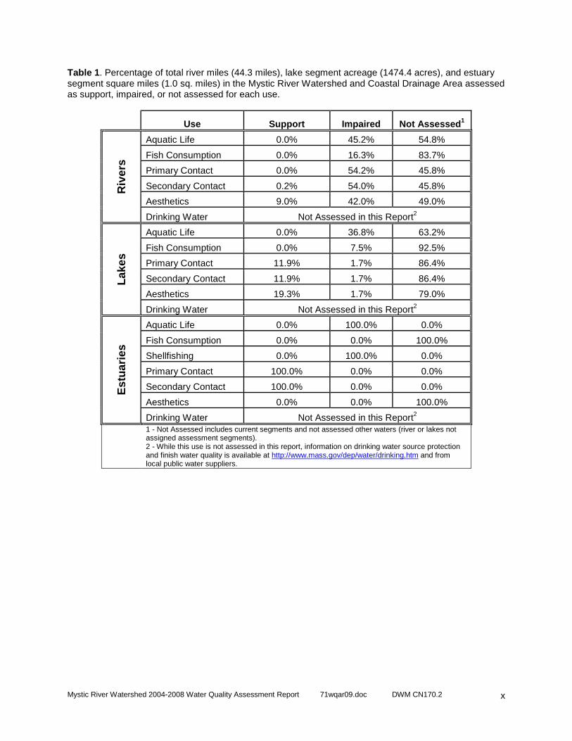
ASSESSMENT REPORT The Massachusetts Surface Water Quality Standards (SWQS) designate the most sensitive uses for which surface waters in the state shall be protected. The assessment of current water quality conditions is a key step in the successful implementation of the Watershed Approach. This critical phase provides an assessment of whether or not the designated uses are supported, impaired, or not assessed, as well as basic information needed to focus resource protection and remediation activities later in the watershed management planning process. This report presents a summary of current water quality data/information in the Mystic River Watershed and Coastal Drainage Area used to assess the status of the designated uses as defined in the SWQS. The designated uses, where applicable, include: Aquatic Life, Fish Consumption, Drinking Water, Shellfishing, Primary and Secondary Contact Recreation and Aesthetics. Each use, within a given assessment segment, is individually assessed as support or impaired . When too little current data/information exists or no reliable data are available for an assessment segment the use is not assessed . However, if there is some indication of water quality impairment, which is not “naturally-occurring”, the use is identified with an “Alert Status.” Many river miles and lakes have not been assigned an assessment segment identification number and the status of their designated uses has never been assessed, investigated, and/or reported to the EPA in the Commonwealth’s Summary of Water Quality Report (305(b) Report) nor is information on these waters maintained in the Waterbody System (WBS) or the new Assessment Database (ADB). In the interest of reporting on all river miles and lake acres in the Mystic River Watershed and Coastal Drainage Area, any waters not currently assigned an assessment segment identification number are classified as not assessed other waters . In Table 1 and all summary figures these waters are included in the not assessed category. The summary of the assessments for the Aquatic Life, Fish Consumption, Primary and Secondary Contact Recreation, Aesthetics, and Shellfish uses in the Mystic River Watershed and Coastal Drainage Area segments are illustrated in Figures 1 through 6, respectively. The percentage of total river miles and lake acreage classified as impaired, support, or not assessed is provided in Table 1. Please see the appropriate figure for each use for the actual number of miles/acres in each category. It should be noted that waters currently designated with segment information comprise 62.3 percent of all river miles and 57.4 percent of all lake acres contained within the watershed. Table 1 presents the current status of all waters in the watershed; it includes current segments as well as not assessed other waters (river or lakes not assigned assessment segments). Total river miles and lake acreage was calculated using the 2002-2005 high resolution National Hydrography Dataset (1:24,000).
Mystic River Watershed 2004-2008 Water Quality Assessment Report 71wqar09.doc DWM CN170.2
x
Table 1 . Percentage of total river miles (44.3 miles), lake segment acreage (1474.4 acres), and estuary segment square miles (1.0 sq. miles) in the Mystic River Watershed and Coastal Drainage Area assessed as support, impaired, or not assessed for each use.
Use Support Impaired Not Assessed 1
Aquatic Life 0.0% 45.2% 54.8%
Fish Consumption 0.0% 16.3% 83.7%
Primary Contact 0.0% 54.2% 45.8%
Secondary Contact 0.2% 54.0% 45.8%
Aesthetics 9.0% 42.0% 49.0%
Riv
ers
Drinking Water Not Assessed in this Report2
Aquatic Life 0.0% 36.8% 63.2%
Fish Consumption 0.0% 7.5% 92.5%
Primary Contact 11.9% 1.7% 86.4%
Secondary Contact 11.9% 1.7% 86.4%
Aesthetics 19.3% 1.7% 79.0%
Lake
s
Drinking Water Not Assessed in this Report2
Aquatic Life 0.0% 100.0% 0.0%
Fish Consumption 0.0% 0.0% 100.0%
Shellfishing 0.0% 100.0% 0.0%
Primary Contact 100.0% 0.0% 0.0%
Secondary Contact 100.0% 0.0% 0.0%
Aesthetics 0.0% 0.0% 100.0%
Est
uarie
s
Drinking Water Not Assessed in this Report2
1 - Not Assessed includes current segments and not assessed other waters (river or lakes not assigned assessment segments). 2 - While this use is not assessed in this report, information on drinking water source protection and finish water quality is available at http://www.mass.gov/dep/water/drinking.htm and from local public water suppliers.
Mystic River Watershed 2004-2008 Water Quality Assessment Report 71wqar09.doc DWM CN170.2
xi
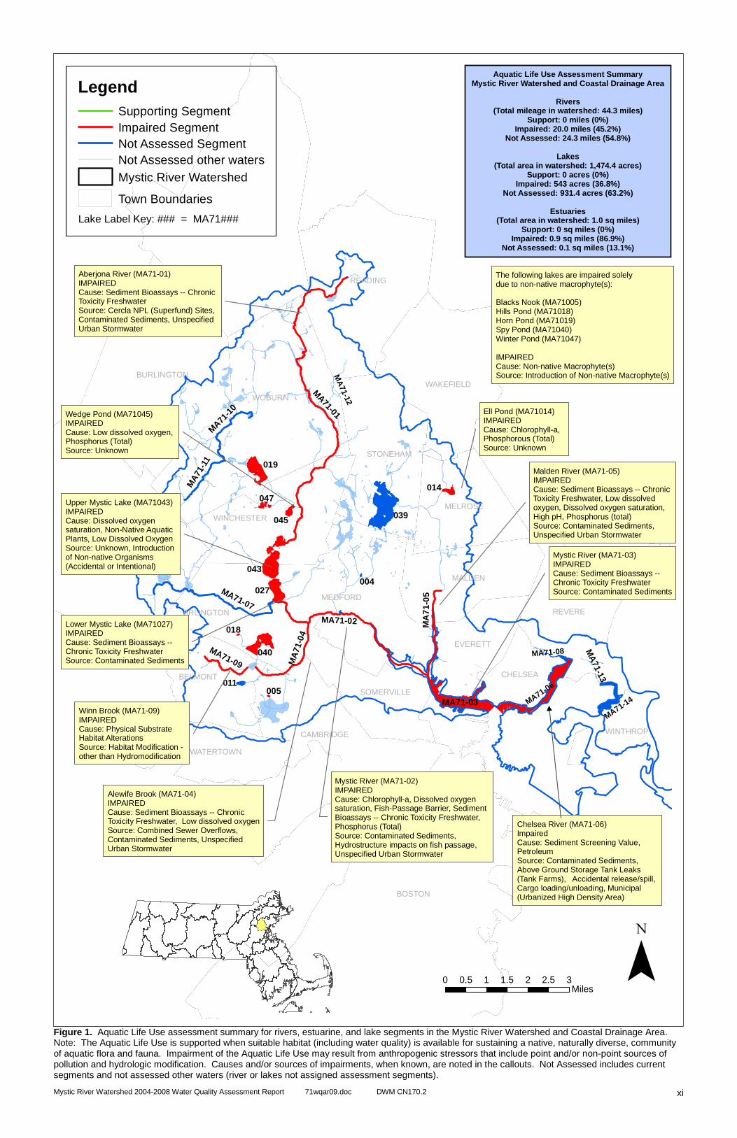
Figure 1. Aquatic Life Use assessment summary for rivers, estuarine, and lake segments in the Mystic River Watershed and Coastal Drainage Area. Note: The Aquatic Life Use is supported when suitable habitat (including water quality) is available for sustaining a native, naturally diverse, community of aquatic flora and fauna. Impairment of the Aquatic Life Use may result from anthropogenic stressors that include point and/or non-point sources of pollution and hydrologic modification. Causes and/or sources of impairments, when known, are noted in the callouts. Not Assessed includes current segments and not assessed other waters (river or lakes not assigned assessment segments).
MA71-14
MA71-01
MA71-02
MA71-07
MA
7 1- 0
5
MA
71-0
4
MA
71-1
1MA71
-10
MA71-09
MA
71-13
043
039
MA71-03
019
040
027
014
045
047
011
018
005
004
BOSTON
WOBURN
LEXINGTON
READING
BURLINGTON
MEDFORD
REVERE
WAKEFIELD
MALDEN
CAMBRIDGE
STONEHAM
BELMONT
MELROSE
WINCHESTER
ARLINGTON
EVERETT
SOMERVILLE
WATERTOWN
CHELSEA
WINTHROP
0 0.5 1 1.5 2 2.5 3Miles
Aquatic Life Use Assessment SummaryMystic River Watershed and Coastal Drainage Area
Rivers(Total mileage in watershed: 44.3 miles)
Support: 0 miles (0%)Impaired: 20.0 miles (45.2%)
Not Assessed: 24.3 miles (54.8%)
Lakes(Total area in watershed: 1,474.4 acres)
Support: 0 acres (0%)Impaired: 543 acres (36.8%)
Not Assessed: 931.4 acres (63.2%)
Estuaries(Total area in watershed: 1.0 sq miles)
Support: 0 sq miles (0%)Impaired: 0.9 sq miles (86.9%)
Not Assessed: 0.1 sq miles (13.1%)
�
LegendSupporting SegmentImpaired SegmentNot Assessed Segment
Mystic River WatershedNot Assessed other waters
Town Boundaries
Lake Label Key: ### = MA71###
The following lakes are impaired solely due to non-native macrophyte(s):
Blacks Nook (MA71005)Hills Pond (MA71018)Horn Pond (MA71019)Spy Pond (MA71040)Winter Pond (MA71047)
IMPAIREDCause: Non-native Macrophyte(s)Source: Introduction of Non-native Macrophyte(s)
Aberjona River (MA71-01)IMPAIREDCause: Sediment Bioassays -- Chronic Toxicity FreshwaterSource: Cercla NPL (Superfund) Sites, Contaminated Sediments, Unspecified Urban Stormwater
Alewife Brook (MA71-04)IMPAIREDCause: Sediment Bioassays -- Chronic Toxicity Freshwater, Low dissolved oxygenSource: Combined Sewer Overflows, Contaminated Sediments, Unspecified Urban Stormwater
Ell Pond (MA71014)IMPAIREDCause: Chlorophyll-a, Phosphorous (Total)Source: Unknown
Lower Mystic Lake (MA71027)IMPAIREDCause: Sediment Bioassays -- Chronic Toxicity FreshwaterSource: Contaminated Sediments
Malden River (MA71-05)IMPAIREDCause: Sediment Bioassays -- Chronic Toxicity Freshwater, Low dissolved oxygen, Dissolved oxygen saturation, High pH, Phosphorus (total)Source: Contaminated Sediments, Unspecified Urban Stormwater
Mystic River (MA71-02)IMPAIREDCause: Chlorophyll-a, Dissolved oxygen saturation, Fish-Passage Barrier, Sediment Bioassays -- Chronic Toxicity Freshwater, Phosphorus (Total)Source: Contaminated Sediments, Hydrostructure impacts on fish passage, Unspecified Urban Stormwater
Mystic River (MA71-03)IMPAIREDCause: Sediment Bioassays -- Chronic Toxicity FreshwaterSource: Contaminated Sediments
Upper Mystic Lake (MA71043)IMPAIREDCause: Dissolved oxygen saturation, Non-Native Aquatic Plants, Low Dissolved OxygenSource: Unknown, Introduction of Non-native Organisms (Accidental or Intentional)
Wedge Pond (MA71045)IMPAIREDCause: Low dissolved oxygen, Phosphorus (Total)Source: Unknown
Winn Brook (MA71-09)IMPAIREDCause: Physical Substrate Habitat AlterationsSource: Habitat Modification - other than Hydromodification
MA71-06
MA71-08
MA
71-12
Chelsea River (MA71-06)ImpairedCause: Sediment Screening Value, PetroleumSource: Contaminated Sediments,Above Ground Storage Tank Leaks (Tank Farms), Accidental release/spill, Cargo loading/unloading, Municipal (Urbanized High Density Area)
Mystic River Watershed 2004-2008 Water Quality Assessment Report 71wqar09.doc DWM CN170.2
xii
Intentionally Left Blank
Mystic River Watershed 2004-2008 Water Quality Assessment Report 71wqar09.doc DWM CN170.2
xiii
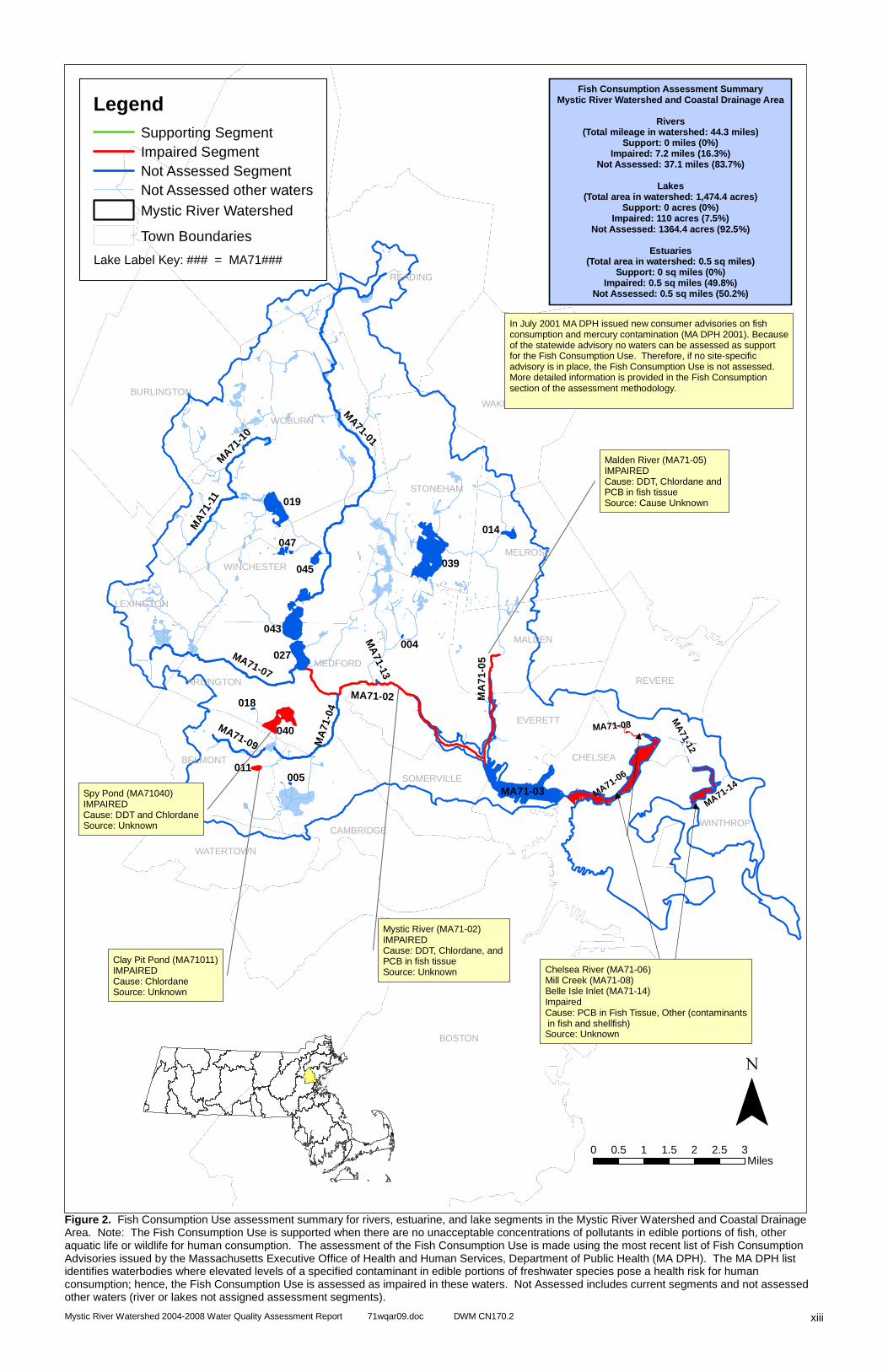
Figure 2. Fish Consumption Use assessment summary for rivers, estuarine, and lake segments in the Mystic River Watershed and Coastal Drainage Area. Note: The Fish Consumption Use is supported when there are no unacceptable concentrations of pollutants in edible portions of fish, other aquatic life or wildlife for human consumption. The assessment of the Fish Consumption Use is made using the most recent list of Fish Consumption Advisories issued by the Massachusetts Executive Office of Health and Human Services, Department of Public Health (MA DPH). The MA DPH list identifies waterbodies where elevated levels of a specified contaminant in edible portions of freshwater species pose a health risk for human consumption; hence, the Fish Consumption Use is assessed as impaired in these waters. Not Assessed includes current segments and not assessed other waters (river or lakes not assigned assessment segments).
MA71-06
MA71-08
MA71-14
MA
71-12
MA71-01
MA71-02
MA71-07
MA
71-0
5
MA
71-0
4
MA
71-1
1M
A71-1
0
MA71-09
MA
71-13
043
039
MA71-03
019
040
027
014
045
047
011
018
005
004
BOSTON
WOBURN
READING
BURLINGTON
MEDFORD
LEXINGTON
REVERE
WAKEFIELD
MALDEN
CAMBRIDGE
STONEHAM
BELMONT
MELROSE
WINCHESTER
ARLINGTON
EVERETT
SOMERVILLE
WATERTOWN
CHELSEA
WINTHROP
0 0.5 1 1.5 2 2.5 3Miles
Fish Consumption Assessment SummaryMystic River Watershed and Coastal Drainage Area
Rivers(Total mileage in watershed: 44.3 miles)
Support: 0 miles (0%)Impaired: 7.2 miles (16.3%)
Not Assessed: 37.1 miles (83.7%)
Lakes(Total area in watershed: 1,474.4 acres)
Support: 0 acres (0%)Impaired: 110 acres (7.5%)
Not Assessed: 1364.4 acres (92.5%)
Estuaries(Total area in watershed: 0.5 sq miles)
Support: 0 sq miles (0%)Impaired: 0.5 sq miles (49.8%)
Not Assessed: 0.5 sq miles (50.2%)
�
LegendSupporting SegmentImpaired SegmentNot Assessed Segment
Mystic River WatershedNot Assessed other waters
Town Boundaries
Lake Label Key: ### = MA71###
Malden River (MA71-05)IMPAIREDCause: DDT, Chlordane and PCB in fish tissueSource: Cause Unknown
Mystic River (MA71-02)IMPAIREDCause: DDT, Chlordane, and PCB in fish tissueSource: Unknown
Clay Pit Pond (MA71011)IMPAIREDCause: ChlordaneSource: Unknown
Spy Pond (MA71040)IMPAIREDCause: DDT and ChlordaneSource: Unknown
In July 2001 MA DPH issued new consumer advisories on fishconsumption and mercury contamination (MA DPH 2001). Becauseof the statewide advisory no waters can be assessed as support for the Fish Consumption Use. Therefore, if no site-specific advisory is in place, the Fish Consumption Use is not assessed.More detailed information is provided in the Fish Consumptionsection of the assessment methodology.
Chelsea River (MA71-06)Mill Creek (MA71-08)Belle Isle Inlet (MA71-14)ImpairedCause: PCB in Fish Tissue, Other (contaminants in fish and shellfish)Source: Unknown
Mystic River Watershed 2004-2008 Water Quality Assessment Report 71wqar09.doc DWM CN170.2
xiv
Intentionally Left Blank
Mystic River Watershed 2004-2008 Water Quality Assessment Report 71wqar09.doc DWM CN170.2
xv
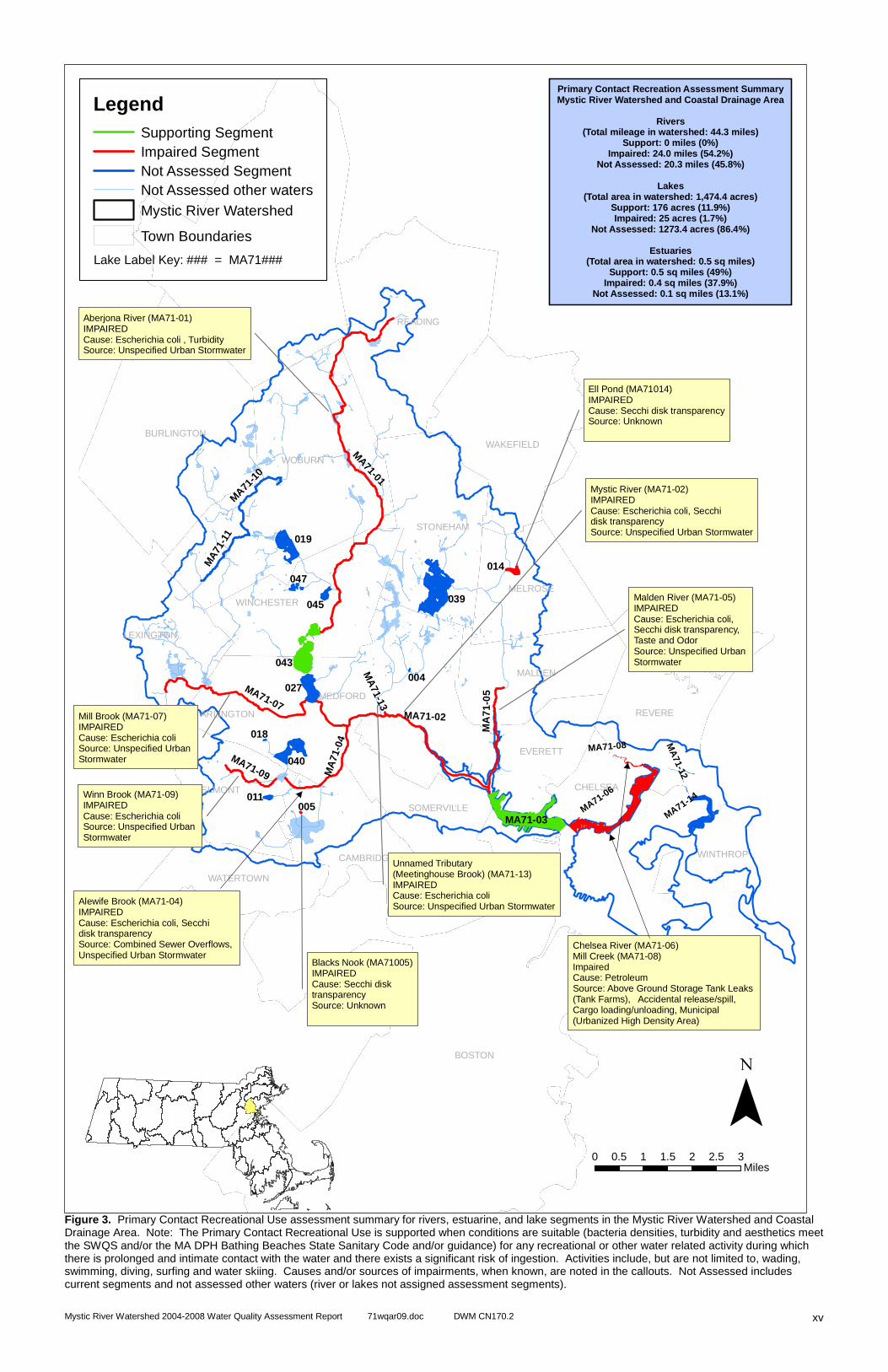
Figure 3. Primary Contact Recreational Use assessment summary for rivers, estuarine, and lake segments in the Mystic River Watershed and Coastal Drainage Area. Note: The Primary Contact Recreational Use is supported when conditions are suitable (bacteria densities, turbidity and aesthetics meet the SWQS and/or the MA DPH Bathing Beaches State Sanitary Code and/or guidance) for any recreational or other water related activity during which there is prolonged and intimate contact with the water and there exists a significant risk of ingestion. Activities include, but are not limited to, wading, swimming, diving, surfing and water skiing. Causes and/or sources of impairments, when known, are noted in the callouts. Not Assessed includes current segments and not assessed other waters (river or lakes not assigned assessment segments).
MA71-01
MA71-02
MA71-07
MA
7 1- 0
5
MA
71-0
4
MA
71-1
1MA71
-10
MA71-09
MA
71-13
043
039
MA71-03
019
040
027
014
045
047
011
018
005
004
BOSTON
WOBURN
READING
LEXINGTON
BURLINGTON
MEDFORD
REVERE
WAKEFIELD
MALDEN
CAMBRIDGE
STONEHAM
BELMONT
MELROSE
WINCHESTER
ARLINGTON
EVERETT
SOMERVILLE
WATERTOWN
CHELSEA
WINTHROP
0 0.5 1 1.5 2 2.5 3Miles
Primary Contact Recreation Assessment SummaryMystic River Watershed and Coastal Drainage Area
Rivers(Total mileage in watershed: 44.3 miles)
Support: 0 miles (0%)Impaired: 24.0 miles (54.2%)
Not Assessed: 20.3 miles (45.8%)
Lakes(Total area in watershed: 1,474.4 acres)
Support: 176 acres (11.9%)Impaired: 25 acres (1.7%)
Not Assessed: 1273.4 acres (86.4%)
Estuaries(Total area in watershed: 0.5 sq miles)
Support: 0.5 sq miles (49%)Impaired: 0.4 sq miles (37.9%)
Not Assessed: 0.1 sq miles (13.1%)
�
LegendSupporting SegmentImpaired SegmentNot Assessed Segment
Mystic River WatershedNot Assessed other waters
Town Boundaries
Lake Label Key: ### = MA71###
Aberjona River (MA71-01)IMPAIREDCause: Escherichia coli , TurbiditySource: Unspecified Urban Stormwater
Alewife Brook (MA71-04)IMPAIREDCause: Escherichia coli, Secchi disk transparencySource: Combined Sewer Overflows, Unspecified Urban Stormwater
Ell Pond (MA71014)IMPAIREDCause: Secchi disk transparencySource: Unknown
Malden River (MA71-05)IMPAIREDCause: Escherichia coli, Secchi disk transparency, Taste and OdorSource: Unspecified Urban Stormwater
Mystic River (MA71-02)IMPAIREDCause: Escherichia coli, Secchi disk transparencySource: Unspecified Urban Stormwater
Winn Brook (MA71-09)IMPAIREDCause: Escherichia coli Source: Unspecified Urban Stormwater
Blacks Nook (MA71005)IMPAIREDCause: Secchi disk transparencySource: Unknown
Unnamed Tributary(Meetinghouse Brook) (MA71-13)IMPAIREDCause: Escherichia coliSource: Unspecified Urban Stormwater
Mill Brook (MA71-07)IMPAIREDCause: Escherichia coli Source: Unspecified Urban Stormwater
MA71-08
MA71-06
MA71-14
MA
71-12
Chelsea River (MA71-06)Mill Creek (MA71-08)ImpairedCause: PetroleumSource: Above Ground Storage Tank Leaks (Tank Farms), Accidental release/spill, Cargo loading/unloading, Municipal (Urbanized High Density Area)

Mystic River Watershed 2004-2008 Water Quality Assessment Report 71wqar09.doc DWM CN170.2
xvi
Intentionally Left Blank
Mystic River Watershed 2004-2008 Water Quality Assessment Report 71wqar09.doc DWM CN170.2
xvii
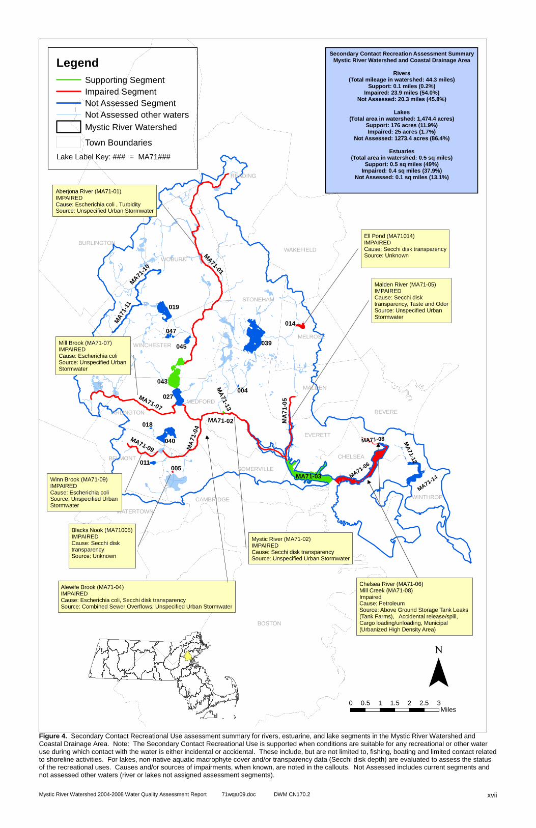
Figure 4. Secondary Contact Recreational Use assessment summary for rivers, estuarine, and lake segments in the Mystic River Watershed and Coastal Drainage Area. Note: The Secondary Contact Recreational Use is supported when conditions are suitable for any recreational or other water use during which contact with the water is either incidental or accidental. These include, but are not limited to, fishing, boating and limited contact related to shoreline activities. For lakes, non-native aquatic macrophyte cover and/or transparency data (Secchi disk depth) are evaluated to assess the status of the recreational uses. Causes and/or sources of impairments, when known, are noted in the callouts. Not Assessed includes current segments and not assessed other waters (river or lakes not assigned assessment segments).
MA71-01
MA71-02
MA71-07
MA
7 1- 0
5
MA
71-0
4
MA
71-1
1M
A71-1
0
MA71-09
MA
71-13
043
039
MA71-03
019
040
027
014
045
047
011
018
005
004
BOSTON
WOBURN
READING
BURLINGTON
LEXINGTON
MEDFORD
REVERE
WAKEFIELD
MALDEN
CAMBRIDGE
STONEHAM
BELMONT
MELROSE
WINCHESTER
ARLINGTON
EVERETT
SOMERVILLE
WATERTOWN
CHELSEA
WINTHROP
0 0.5 1 1.5 2 2.5 3Miles
Secondary Contact Recreation Assessment SummaryMystic River Watershed and Coastal Drainage Area
Rivers(Total mileage in watershed: 44.3 miles)
Support: 0.1 miles (0.2%)Impaired: 23.9 miles (54.0%)
Not Assessed: 20.3 miles (45.8%)
Lakes(Total area in watershed: 1,474.4 acres)
Support: 176 acres (11.9%)Impaired: 25 acres (1.7%)
Not Assessed: 1273.4 acres (86.4%)
Estuaries(Total area in watershed: 0.5 sq miles)
Support: 0.5 sq miles (49%)Impaired: 0.4 sq miles (37.9%)
Not Assessed: 0.1 sq miles (13.1%)
�
LegendSupporting SegmentImpaired SegmentNot Assessed Segment
Mystic River WatershedNot Assessed other waters
Town Boundaries
Lake Label Key: ### = MA71###
Aberjona River (MA71-01)IMPAIREDCause: Escherichia coli , TurbiditySource: Unspecified Urban Stormwater
Alewife Brook (MA71-04)IMPAIREDCause: Escherichia coli, Secchi disk transparencySource: Combined Sewer Overflows, Unspecified Urban Stormwater
Ell Pond (MA71014)IMPAIREDCause: Secchi disk transparencySource: Unknown
Malden River (MA71-05)IMPAIREDCause: Secchi disk transparency, Taste and OdorSource: Unspecified Urban Stormwater
Mystic River (MA71-02)IMPAIREDCause: Secchi disk transparencySource: Unspecified Urban Stormwater
Winn Brook (MA71-09)IMPAIREDCause: Escherichia coli Source: Unspecified Urban Stormwater
Blacks Nook (MA71005)IMPAIREDCause: Secchi disk transparencySource: Unknown
Mill Brook (MA71-07)IMPAIREDCause: Escherichia coli Source: Unspecified Urban Stormwater
MA71-06
MA71-08
MA71-14
MA
71-12
Chelsea River (MA71-06)Mill Creek (MA71-08)ImpairedCause: PetroleumSource: Above Ground Storage Tank Leaks (Tank Farms), Accidental release/spill, Cargo loading/unloading, Municipal (Urbanized High Density Area)

Mystic River Watershed 2004-2008 Water Quality Assessment Report 71wqar09.doc DWM CN170.2
xviii
Intentionally Left Blank

Mystic River Watershed 2004-2008 Water Quality Assessment Report 71wqar09.doc DWM CN170.2
xix
Figure 5. Aesthetics Use assessment summary for rivers, estuarine, and lake segments in the Mystic River Watershed and Coastal Drainage Area. Note: The Aesthetics Use is supported when surface waters are free from pollutants in concentrations or combinations that settle to form objectionable deposits; float as debris, scum or other matter to form nuisances; produce objectionable odor, color, taste or turbidity; or produce undesirable or nuisance species of aquatic life. Causes and/or sources of impairments, when known, are noted in the callouts. Not Assessed includes current segments and not assessed other waters (river or lakes not assigned assessment segments).
MA71-01
MA71-02
MA71-07
MA
7 1- 0
5
MA
71-0
4
MA
71-1
1MA71
-10
MA71-09
MA
71-13
043
039
MA71-03
019
040
027
014
045
047
011
018
005
004
BOSTON
WOBURN
READING
LEXINGTON
BURLINGTON
MEDFORD
REVERE
WAKEFIELD
MALDEN
CAMBRIDGE
STONEHAM
BELMONT
MELROSE
WINCHESTER
ARLINGTON
EVERETT
SOMERVILLE
WATERTOWN
CHELSEA
WINTHROP
0 0.5 1 1.5 2 2.5 3Miles
Aesthetics Use Assessment SummaryMystic River Watershed and Coastal Drainage Area
Rivers(Total mileage in watershed: 44.3 miles)
Support: 4.0 miles (9.0%)Impaired: 18.6 miles (42.0%)
Not Assessed: 21.7 miles (49%)
Lakes(Total area in watershed: 1,474.4 acres)
Support: 284 acres (19.3%)Impaired: 25 acres (1.7%)
Not Assessed: 1165.4 acres (79.0%)
Estuaries(Total area in watershed: 0.5 sq miles)
Support: 0 sq miles (0%)Impaired: 0.4 sq miles (37.9%)
Not Assessed: 0.6 sq miles (62.1%)
�
Aberjona River (MA71-01)IMPAIREDCause: TurbiditySource: Unspecified Urban Stormwater
Mystic River (MA71-02)IMPAIREDCause: Secchi Disk TransparencySource: Unspecified Urban Stormwater
Alewife Brook (MA71-04)IMPAIREDCause: Secchi Disk TransparencySource: Combined Sewer Overflows,Unspecified Urban Stormwater
Malden River (MA71-05)IMPAIREDCause: Secchi disk transparency, Taste and OdorSource: Unspecified Urban Stormwater
Blacks Nook (MA71005)IMPAIREDCause: Secchi Disk TransparencySource: Unknown
Ell Pond (MA71014)IMPAIREDCause: Secchi Disk TransparencySource: Unknown
LegendSupporting SegmentImpaired SegmentNot Assessed Segment
Mystic River WatershedNot Assessed other waters
Town Boundaries
Lake Label Key: ### = MA71###
MA71-06
MA71-08 MA
71-12
MA71-14
Chelsea River (MA71-06)ImpairedCause: PetroleumSource: Above Ground Storage Tank Leaks (Tank Farms), Accidental release/spill, Cargo loading/unloading, Municipal (Urbanized High Density Area)
Mystic River Watershed 2004-2008 Water Quality Assessment Report 71wqar09.doc DWM CN170.2
xx
Intentionally Left Blank.

Mystic River Watershed 2004-2008 Water Quality Assessment Report 71wqar09.doc DWM CN170.2
xxi
Figure 6: . Shellfishing Use assessment summary for estuarine segments in the Mystic River Watershed and Coastal Drainage Area.
MA71-01
MA71-02
MA71-07
MA
7 1- 0
5
MA
71-0
4
MA
71-1
1M
A71-1
0
MA71-09
MA
71-13
043
039
MA71-03
019
040
027
014
045
047
011
018
005
004
BOSTON
WOBURN
READING
BURLINGTON
MEDFORD
REVERE
WAKEFIELD
LEXINGTON
MALDEN
CAMBRIDGE
STONEHAM
BELMONT
MELROSE
WINCHESTER
ARLINGTON
EVERETT
SOMERVILLE
WATERTOWN
CHELSEA
WINTHROP
0 0.5 1 1.5 2 2.5 3Miles
Shellfishing Use SummaryMystic River Watershed and Coastal Drainage Area
Estuaries(Total area in watershed: 1.0 sq miles)
Support: 0 sq miles (0%)Impaired: 1.0 sq miles (100%)
Not Assessed: 0.0 sq miles (0%)
�
Mystic River (MA71-03)IMPAIREDCause: Fecal coliformSource: Unknown
Lake Label Key: ### = MA71###
Legend
Supporting SegmentImpaired Segment
Mystic River Watershed
Town Boundaries
No Shellfishing Use
Mill Creek (MA71-08)Chelsea River (MA71-06)ImpairedCause: Fecal coliformSource: Unknown
MA71-06
MA71-08
MA71-14
MA
71-12
Belle Isle Inlet (MA71-14)ImpairedCause: Fecal coliformSource: Unknown

Mystic River Watershed 2004-2008 Water Quality Assessment Report 71wqar09.doc DWM CN170.2
xxii
Intentionally Left Blank
Mystic River Watershed 2004-2008 Water Quality Assessment Report 71wqar09.doc DWM CN170.2
1
INTRODUCTION The goal of the Clean Water Act (CWA) is to restore and maintain the chemical, physical, and biological integrity of the Nation’s waters (Environmental Law Reporter 1988). To meet this objective, the CWA requires states to develop information on the quality of the Nation's water resources and report this information to the U.S. Environmental Protection Agency (EPA), the U.S. Congress, and the public. Together, these agencies are responsible for implementation of the CWA mandates. Under Section 305(b) of the Federal Clean Water Act, every two years, the Massachusetts Department of Environmental Protection (MassDEP) must submit to EPA a statewide report that describes the status of water quality in the Commonwealth. Until 2002 this was accomplished as a statewide summary of water quality (the 305(b) Report). States are also required to submit, under Section 303(d) of the CWA, a list of impaired waters requiring a total maximum daily load (TMDL) calculation. In 2002, however, EPA gave states the option to combine elements of the statewide 305(b) Report and the Section 303(d) List of Impaired Waters into one “Integrated List of Waters” (Integrated List). This statewide list is based on the compilation of information for the Commonwealth’s 27 watersheds. Massachusetts has opted to write individual watershed surface water quality assessment reports and use them as the supporting documentation for the Integrated List. The assessment reports utilize data compiled from a variety of sources and provide an evaluation of water quality, progress made towards maintaining and restoring water quality, and the extent to which problems remain at the watershed level. Quality-assured in-stream biological, habitat, physical/chemical, toxicity data and other information are evaluated to assess the status of water quality conditions. This analysis follows a standardized process described in the Assessment Methodology Section. This report presents the current assessment of water quality conditions in the Mystic River Watershed and Coastal Drainage Area. The assessments are based on information that has been researched and developed by the MassDEP through the first three years (information gathering, monitoring, and assessment) of the five-year basin cycle in partial fulfillment of MassDEP’s federal mandate to report on the status of the Commonwealth’s waters under the CWA. Due to resource limitations, Division of Watershed Management (DWM) staff did not perform year two monitoring activities in the Mystic watershed in 2004. Water quality data from other sources, particularly the Mystic River Watershed Association (MyRWA) and Massachusetts Water Resources Authority (MWRA) have been acquired, reviewed for data quality, analyzed and used to make use assessment decisions. In general, data from these and other sources collected during the period between 2002 and 2008 was included and summarized for consideration in this report.
MASSACHUSETTS INTEGRATED LIST OF WATERS Section 305(b) of the CWA defines the process whereby states monitor and assess the quality of their surface and groundwater and report on the status of those waters every two years. Section 303(d) of the CWA requires states to periodically identify and list those waterbodies for which existing controls on point and nonpoint sources of pollutants are not stringent enough to attain or maintain compliance with applicable surface water quality standards. Through the year 2000 the MassDEP fulfilled the 305(b) and 303(d) reporting requirements in two completely separate documents. In 2001 the EPA released guidance that provided states with the option of preparing a single Integrated List of Waters to be submitted that would meet the reporting requirements of both sections 305(b) and 303(d) of the CWA. The EPA approved the Massachusetts Year 2008 Integrated List of Waters in May of 2009. In that report each waterbody segment was placed in one of five major categories. Category 1 included those waters that were meeting all designated uses. No Massachusetts waters were listed in Category 1 because a statewide health advisory pertaining to the consumption of fish precludes any waters from being in full support of the fish consumption use. Waters listed in Category 2 were found to support some of the uses for which they were assessed but other uses were unassessed. Category 3 contained those waters for which insufficient or no information was available to assess any uses. Waters exhibiting impairment for one or more uses were placed in either Category 4 (impaired but not requiring a TMDL report) or Category 5 (impaired and requiring one or more TMDLs) according to the EPA guidance. Category 4 was further divided into three sub-categories – 4A, 4B and 4C – depending upon the reason that TMDLs were not needed. Category 4A included waters for which the required TMDL(s) had already been completed and approved by the EPA. However, since segments could only appear in one-category waters that had an approved TMDL for some pollutants, but not others, remained in Category 5. Category 4B was to
Mystic River Watershed 2004-2008 Water Quality Assessment Report 71wqar09.doc DWM CN170.2
2
include waters for which other pollution control requirements were reasonably expected to result in the attainment of the designated use before the next listing cycle (i.e., 2010). Because of the uncertainty related to making predictions about conditions in the future the MassDEP made a decision not to utilize Category 4B in the 2008 Integrated List. Finally, waters impaired by factors such as flow modification or habitat alteration that are not subjected to TMDL calculations because the impairment is not related to one or more pollutants were included in Category 4C. See individual segment assessments for information pertaining to the 2008 Integrated List category and causes of impairment.
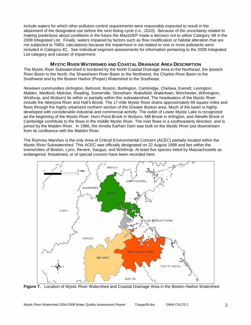
MYSTIC RIVER WATERSHED AND COASTAL DRAINAGE AREA DESCRIPTION The Mystic River Subwatershed is bordered by the North Coastal Drainage Area to the Northeast, the Ipswich River Basin to the North, the Shawsheen River Basin to the Northwest, the Charles River Basin to the Southwest and by the Boston Harbor (Proper) Watershed to the Southeast. Nineteen communities (Arlington, Belmont, Boston, Burlington, Cambridge, Chelsea, Everett, Lexington, Malden, Medford, Melrose, Reading, Somerville, Stoneham, Wakefield, Watertown, Winchester, Wilmington, Winthrop, and Woburn) lie within or partially within this subwatershed. The headwaters of the Mystic River include the Aberjona River and Hall’s Brook. The 17-mile Mystic River drains approximately 69 square miles and flows through the highly urbanized northern section of the Greater Boston area. Much of the basin is highly developed with considerable industrial and commercial activity. The outlet of Lower Mystic Lake is recognized as the beginning of the Mystic River. Horn Pond Brook in Woburn, Mill Brook in Arlington, and Alewife Brook in Cambridge contribute to the flows in the middle Mystic River. The river flows in a southeasterly direction, and is joined by the Malden River. In 1966, the Amelia Earhart Dam was built on the Mystic River just downstream from its confluence with the Malden River. The Rumney Marshes is the only Area of Critical Environmental Concern (ACEC) partially located within the Mystic River Subwatershed. This ACEC was officially designated on 22 August 1988 and lies within the towns/cities of Boston, Lynn, Revere, Saugus, and Winthrop. At least five species listed by Massachusetts as endangered, threatened, or of special concern have been recorded here.
Figure 7. Location of Mystic River Watershed and Coastal Drainage Area in the Boston Harbor Watershed
Mystic River Watershed 2004-2008 Water Quality Assessment Report 71wqar09.doc DWM CN170.2
3
OBJECTIVES
This report is an update to the last water quality assessment report for Boston Harbor Watershed (which included the Mystic River Watershed and Coastal Drainage Area) that was published by DWM in October 2002. The methodology used to assess the status of water quality conditions of rivers and lakes in accordance with EPA’s and MassDEP’s use assessment methods is provided in Appendix A. The objectives of this water quality assessment report are to:
1. evaluate whether or not surface waters in the Mystic River Watershed and Coastal Drainage Area, defined as segments in the MassDEP/EPA databases, currently support their designated uses and
2. identify the stressors impairing designated uses and any confirmed sources of those stressors.
ASSESSMENT REPORT FORMAT In this report the assessment information for waters that are designated as segments is summarized in a table format. The tables summarize the assessment decisions for the Aquatic Life, Fish Consumption, Primary and Secondary Contact Recreation and Aesthetics uses, the data that informed those decisions, the cause(s) of any impairments, and the confirmed source(s) for the impairment (Table 2). Table 2. An example table format used to present assessment information in the 2004-2008 Mystic River Watershed and Coastal Drainage Area Assessment Report. Example Brook (Segment MA81-99) Location: Fake Pond, Groton, to confluence with Cat Brook, Shirley. Segment Length: 4.4 Miles Classification: Class B 2006 Integrated List of Waters: Category 5 - Waters requiring a TMDL - Cause Unknown, Nutrients-Pathogens
Designated Use Use Assessment Alert
Aquatic Life Impaired No
Each Designated Use is displayed in the table for each segment and displayed in the first column. The “Use Assessment” column states the assessment decision (support, impaired, not assessed) for the use. The “Alert” column is used when an issue was identified that is of concern (i.e., an “Alert Status” was noted for the use but the use was not assessed as impaired).
Text is provided in the body of the table to summarize information relevant to the assessment decision for each use. Example text:
MassDEP DWM measured dissolved oxygen, temperature, and pH six times at one site in 2003 and found no violations of the temperature or pH criterion and five violations of the dissolved oxygen criterion. The DO violations ranged from 2.9 mg/L to 3.6 mg/L.
When appropriate, “Cause(s) of Impairment” and “Source(s) of Impairment” identify the stressors leading to the impairment decision and the any confirmed source(s)of the stressor(s). The causes and sources are selected from the list in the EPA Assessment Database Version 2 (ADB). Cause(s) of Impairment: Dissolved oxygen Source(s) of Impairment: Unknown Any data sources that are used to make an assessment decision are cited for each use and displayed in the bottom right corner. The numbers identified as the data sources correspond to the numbered citations in the Assessment Data Sources section following the tables.
Data Sources: 24 The Drinking Water use is not assessed in this report. MassDEP’s Drinking Water Program (DWP) has primacy for implementing the provisions of the federal Safe Drinking Water Act (SDWA) and maintains current drinking supply monitoring data. More information is available on the MassDEP website at http://www.mass.gov/dep/water/drinking.htm.
Mystic River Watershed 2004-2008 Water Quality Assessment Report 71wqar09.doc DWM CN170.2
4
SPECIAL NOTES
The following special note refers to unique assessment situations that apply to several segments and is best described in a separate section rather than repeated for each segment.
1. Use of Mystic River Watershed Association (MyRWA)Da ta – MyRWA water quality monitoring data for the period 2002-2008 was acquired, summarized, and passed an external data review process, allowing that data to be used in making assessment decisions for the following parameters: E. coli and enterococcus bacteria, TP, TSS, conductivity, temperature, observed color, and observed odor. MyRWA Dissolved Oxygen data was determined to be appropriate only for informing assessment decisions and designating an “Alert Status”. MyRWA dissolved Oxygen data is summarized and noted when appropriate in the use assessment decisions, however it was not used to impair any uses.
2. Fish Consumption Advisory for Marine and Fresh Wate r Bodies - In July 2001 Massachusetts
Department of Public Health (MA DPH) issued consumer advisories on fish consumption due to mercury contamination (MA DPH 2001). Their most recent news release on this issue in June 2009 recommends the following (MA DPH 2009):
If you may become pregnant or are pregnant or nursing, you and your children under 12 years old may safely eat 12 ounces (about 2 meals) per week of fish or shellfish not covered in this advisory. This recommendation includes canned tuna, the consumption of which should be limited to 2 cans per week. Very small children, including toddlers, should eat less. Consumers may wish to choose to eat light tuna rather than white or chunk white tuna, the latter of which may have higher levels of mercury. Otherwise, it is important to follow the Safe Eating Guidelines included in this advisory.’ Safe eating guidelines for pregnant women, women wh o may become pregnant, nursing mothers and children under 12 years old (contaminants of concern in parenthetical as noted by MA DPH and MassDEP):
Do Not Eat: Freshwater fish caught in streams, rivers, lakes, and ponds in Massachusetts (Hg) Safe To Eat: Fish that are stocked in streams, rivers, lakes, and ponds in Massachusetts Safe To Eat: Cod, haddock, flounder and pollock in larger amounts Do Not Eat: Lobster from New Bedford Harbor (PCB) Do Not Eat: Swordfish, shark, king mackerel, tilefish, and tuna steak (Hg) Do Not Eat: Bluefish caught off the Massachusetts coast (PCB) Do Not Eat: Lobsters, flounder, soft-shell clams and bivalves from Boston Harbor (PCB and other contaminants) NOTE: For assessment purposes Boston Harbor is broadly defined to include all coastal waters that drain into it.
Safe eating guidelines for everyone: Do Not Eat: Fish and shellfish from the closed areas of New Bedford Harbor (PCB) Do Not Eat: Lobster tomalley (PCB)
3. Northeast Regional Mercury TMDL - On 20 December 2007 the U.S. EPA approved the Northeast Regional Mercury Total Maximum Daily Load (TMDL). This TMDL is a Federal Clean Water Act mandated document that identifies pollutant load reductions necessary for regional waterbodies to meet and maintain compliance with state and federal water quality standards. It was prepared by the New England Interstate Water Pollution Control Commission (NEIWPCC) in cooperation with the states of Connecticut, Maine, Massachusetts, New Hampshire, New York, Rhode Island, and Vermont. The TMDL covers inland waterbodies that are impaired primarily due to atmospheric deposition of mercury (Northeast States 2007). The TMDL target for Massachusetts is 0.3 parts per million (ppm) or less of mercury in fish tissue. The plan calls for a 75% reduction of in-region and out-of-region atmospheric sources by 2010 and a 90% or greater reduction in the future (NEIWPCC 2007). The TMDL will be reassessed in 2010 based on an evaluation of new, on-going monitoring and air deposition data. Final targets will be determined at that time.
Mystic River Watershed 2004-2008 Water Quality Assessment Report 71wqar09.doc DWM CN170.2
5
ASSESSMENT TABLES
ABERJONA RIVER (SEGMENT MA71-01) Segment Description: Source just south of Birch Meadow Drive, Reading to inlet Upper Mystic Lake at Mystic Valley Parkway, Winchester (portion culverted underground). (through former pond segments Judkins Pond MA71021 and Mill Pond MA71031) Segment Length: 9.1 miles Segment Classification: B/WW 2008 Integrated List of Waters: This segment is on the 2008 Integrated List of Waters in Category 5 - Waters Requiring a TMDL (Cause Unknown, Metals, Unionized Ammonia, Nutrients, Organic enrichment/Low DO, (Other habitat alterations*), Pathogens) * denotes a non-pollutant. NPDES Permits: Parkview Condominium Assoc. (MAG250009), Olin Corporation (MAG910074) WMA: None
Designated Use Use Assessment Alert
Aquatic Life Impaired --
Multiple sources indicate sediment contamination and negative impacts to aquatic life sufficient to impair the Aquatic Life Use. MA DFG collected fish at two sites(Station 1102 and Station 1101) in July 2004. At Station 1102 they collected thirteen fish respresenting four species, all classified as moderately tolerant to tolerant of pollution. Macrohabitat generalist comprised seventy-seven percent of the sample while fluvial dependent species made up twenty three percent of the sample. At Station 1101 MA DFG collected sixteen fish representing four species, all classified as moderately tolerant to tolerant of pollution. The sample was dominated by macrohabitat generalists (six-nine percent) with the remainder of the sample classified as fluvial dependent. MyRWA observed dissolved oxgygen levels below standards in summer months each year. Total phosphorous concentrations were slightly elevated. Water quality was demonstrated to be of similarly poor quality as past samples, previously associated with an impaired benthic community.
Cause(s) of Impairment: Sediment Bioassays -- Chronic Toxicity Freshwater Source(s) of Impairment: Cercla NPL (Superfund) Sites, Contaminated Sediments, Unspecified Urban Stormwater
Data Sources: 1,11,12,13,14, 15 Fish Consumption Not Assessed --
This waterbody does not have a site-specific fish consumption advisory. All applicable statewide fish consumption advisories issued by MA DPH due to mercury contamination apply to this waterbody (See Special Note 2).
Primary Contact Impaired --
Yearly Escherichia coli (E. coli) geometric means calculated for the Primary Contact Recreation season from 3 MyRWA baseline monitoring stations sampled monthly from 2002 to 2008 in this segment exceeded 126 cfu/100mL. 21 out of 21 Primary Contact Recreation geomeans exceeded standards, most recently in 2008. The Primary Contact Recreation Use is impaired due to E. coli and the impairment of the Aesthetics Use.
Cause(s) of Impairment: Escherichia coli , Turbidity Source(s) of Impairment: Unspecified Urban Stormwater
Data Sources: 1, 21 Secondary Contact Impaired --
Yearly E. coli geometric means from 3 MyRWA baseline monitoring stations sampled monthly from 2002 to 2008 in this segment exceeded 630 cfu/100mL. 5 out of 21 geomeans exceeded standards, most recently in 2007. In addition, roughly 20% of samples in this segment were >1240 cfu/100mL. The Secondary Contact Recreation Use is impaired due E. coli and the impairment of the Aesthetics Use.
Cause(s) of Impairment: Escherichia coli, Turbidity Source(s) of Impairment: Unspecified Urban Stormwater
Data Sources: 1, 21

Mystic River Watershed 2004-2008 Water Quality Assessment Report 71wqar09.doc DWM CN170.2
6
ABERJONA RIVER (SEGMENT MA71-01) Segment Description: Source just south of Birch Meadow Drive, Reading to inlet Upper Mystic Lake at Mystic Valley Parkway, Winchester (portion culverted underground). (through former pond segments Judkins Pond MA71021 and Mill Pond MA71031). Segment Length: 9.1 miles Segment Classification: B/WW 2008 Integrated List of Waters: This segment is on the 2008 Integrated List of Waters in Category 5 - Waters Requiring a TMDL (Cause Unknown, Metals, Unionized Ammonia, Nutrients, Organic enrichment/Low DO, (Other habitat alterations*), Pathogens) * denotes a non-pollutant. NPDES Permits: Parkview Condominium Assoc. (MAG250009), Olin Corporation (MAG910074) WMA: None Aesthetics Impaired --
The Aesthetics Use is impaired due to moderate turbidity consistently noted by DWM biologists in Judkins Pond and Mill Pond sections of the Aberjona River during surveys conducted in 2004.
Cause(s) of Impairment: Turbidity Source(s) of Impairment: Unspecified Urban Stormwater
Data Sources: 1, 21
Mystic River Watershed 2004-2008 Water Quality Assessment Report 71wqar09.doc DWM CN170.2
7
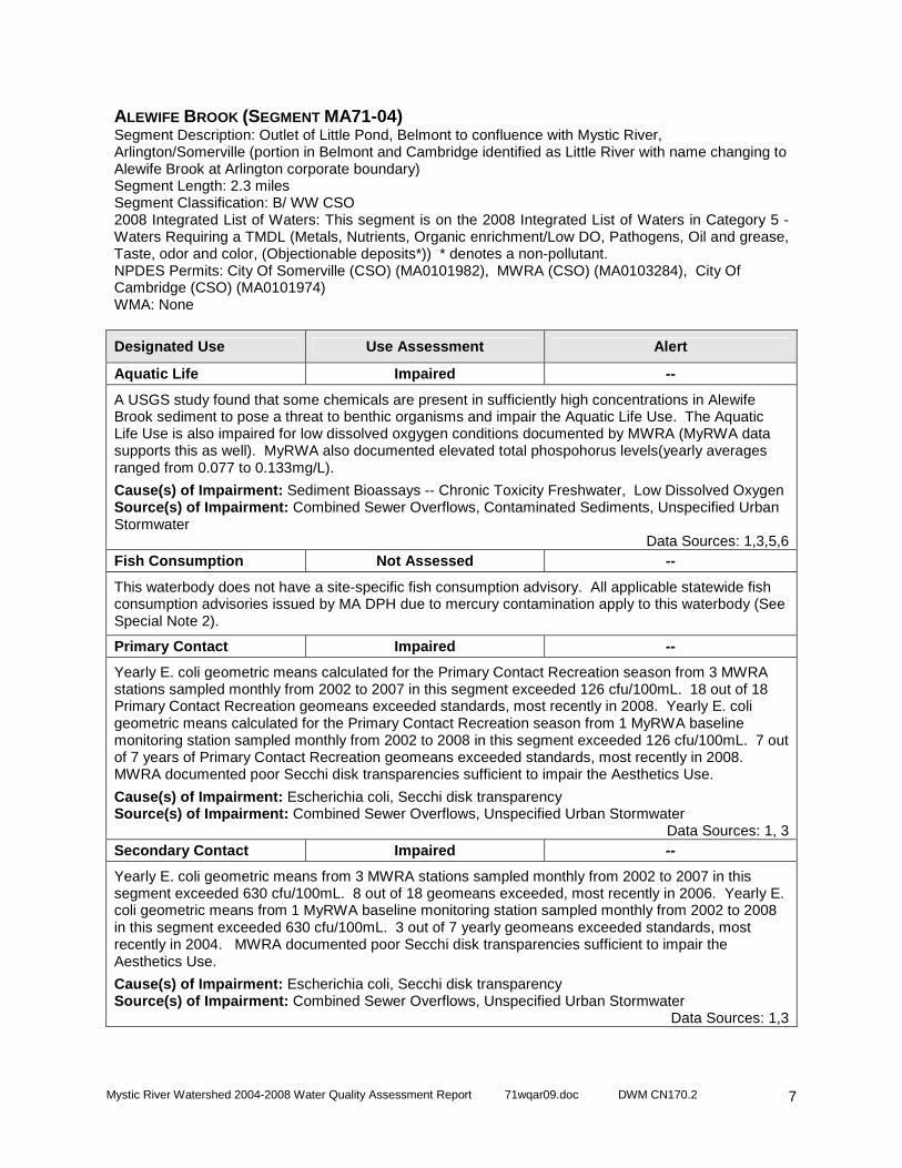
ALEWIFE BROOK (SEGMENT MA71-04) Segment Description: Outlet of Little Pond, Belmont to confluence with Mystic River, Arlington/Somerville (portion in Belmont and Cambridge identified as Little River with name changing to Alewife Brook at Arlington corporate boundary) Segment Length: 2.3 miles Segment Classification: B/ WW CSO 2008 Integrated List of Waters: This segment is on the 2008 Integrated List of Waters in Category 5 - Waters Requiring a TMDL (Metals, Nutrients, Organic enrichment/Low DO, Pathogens, Oil and grease, Taste, odor and color, (Objectionable deposits*)) * denotes a non-pollutant. NPDES Permits: City Of Somerville (CSO) (MA0101982), MWRA (CSO) (MA0103284), City Of Cambridge (CSO) (MA0101974) WMA: None
Designated Use Use Assessment Alert
Aquatic Life Impaired --
A USGS study found that some chemicals are present in sufficiently high concentrations in Alewife Brook sediment to pose a threat to benthic organisms and impair the Aquatic Life Use. The Aquatic Life Use is also impaired for low dissolved oxgygen conditions documented by MWRA (MyRWA data supports this as well). MyRWA also documented elevated total phospohorus levels(yearly averages ranged from 0.077 to 0.133mg/L).
Cause(s) of Impairment: Sediment Bioassays -- Chronic Toxicity Freshwater, Low Dissolved Oxygen Source(s) of Impairment: Combined Sewer Overflows, Contaminated Sediments, Unspecified Urban Stormwater
Data Sources: 1,3,5,6 Fish Consumption Not Assessed --
This waterbody does not have a site-specific fish consumption advisory. All applicable statewide fish consumption advisories issued by MA DPH due to mercury contamination apply to this waterbody (See Special Note 2).
Primary Contact Impaired --
Yearly E. coli geometric means calculated for the Primary Contact Recreation season from 3 MWRA stations sampled monthly from 2002 to 2007 in this segment exceeded 126 cfu/100mL. 18 out of 18 Primary Contact Recreation geomeans exceeded standards, most recently in 2008. Yearly E. coli geometric means calculated for the Primary Contact Recreation season from 1 MyRWA baseline monitoring station sampled monthly from 2002 to 2008 in this segment exceeded 126 cfu/100mL. 7 out of 7 years of Primary Contact Recreation geomeans exceeded standards, most recently in 2008. MWRA documented poor Secchi disk transparencies sufficient to impair the Aesthetics Use.
Cause(s) of Impairment: Escherichia coli, Secchi disk transparency Source(s) of Impairment: Combined Sewer Overflows, Unspecified Urban Stormwater
Data Sources: 1, 3 Secondary Contact Impaired --
Yearly E. coli geometric means from 3 MWRA stations sampled monthly from 2002 to 2007 in this segment exceeded 630 cfu/100mL. 8 out of 18 geomeans exceeded, most recently in 2006. Yearly E. coli geometric means from 1 MyRWA baseline monitoring station sampled monthly from 2002 to 2008 in this segment exceeded 630 cfu/100mL. 3 out of 7 yearly geomeans exceeded standards, most recently in 2004. MWRA documented poor Secchi disk transparencies sufficient to impair the Aesthetics Use.
Cause(s) of Impairment: Escherichia coli, Secchi disk transparency Source(s) of Impairment: Combined Sewer Overflows, Unspecified Urban Stormwater
Data Sources: 1,3
Mystic River Watershed 2004-2008 Water Quality Assessment Report 71wqar09.doc DWM CN170.2
8
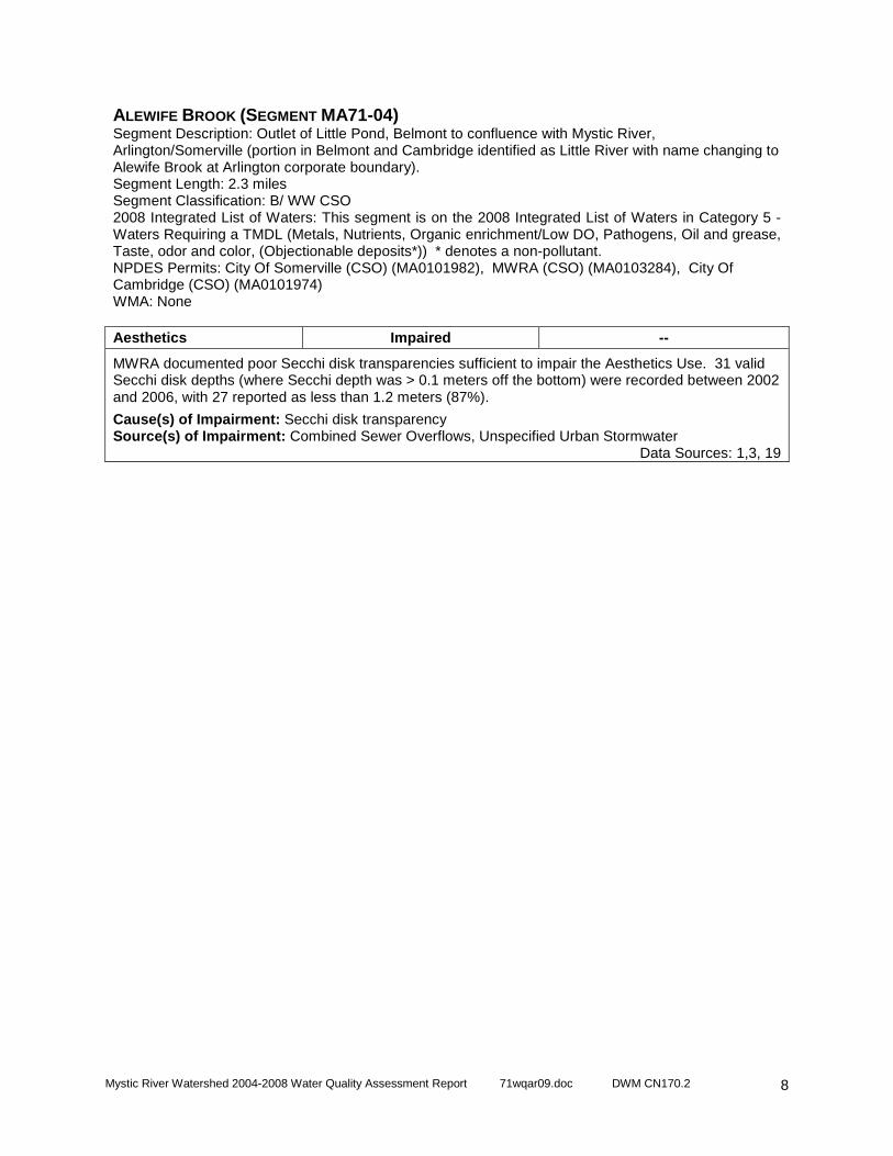
ALEWIFE BROOK (SEGMENT MA71-04) Segment Description: Outlet of Little Pond, Belmont to confluence with Mystic River, Arlington/Somerville (portion in Belmont and Cambridge identified as Little River with name changing to Alewife Brook at Arlington corporate boundary). Segment Length: 2.3 miles Segment Classification: B/ WW CSO 2008 Integrated List of Waters: This segment is on the 2008 Integrated List of Waters in Category 5 - Waters Requiring a TMDL (Metals, Nutrients, Organic enrichment/Low DO, Pathogens, Oil and grease, Taste, odor and color, (Objectionable deposits*)) * denotes a non-pollutant. NPDES Permits: City Of Somerville (CSO) (MA0101982), MWRA (CSO) (MA0103284), City Of Cambridge (CSO) (MA0101974) WMA: None Aesthetics Impaired --
MWRA documented poor Secchi disk transparencies sufficient to impair the Aesthetics Use. 31 valid Secchi disk depths (where Secchi depth was > 0.1 meters off the bottom) were recorded between 2002 and 2006, with 27 reported as less than 1.2 meters (87%).
Cause(s) of Impairment: Secchi disk transparency Source(s) of Impairment: Combined Sewer Overflows, Unspecified Urban Stormwater
Data Sources: 1,3, 19
Mystic River Watershed 2004-2008 Water Quality Assessment Report 71wqar09.doc DWM CN170.2
9
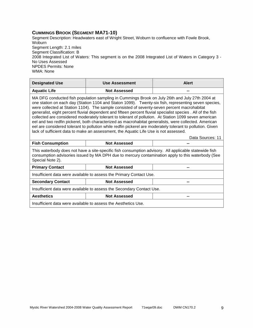
CUMMINGS BROOK (SEGMENT MA71-10) Segment Description: Headwaters east of Wright Street, Woburn to confluence with Fowle Brook, Woburn Segment Length: 2.1 miles Segment Classification: B 2008 Integrated List of Waters: This segment is on the 2008 Integrated List of Waters in Category 3 - No Uses Assessed NPDES Permits: None WMA: None
Designated Use Use Assessment Alert
Aquatic Life Not Assessed --
MA DFG conducted fish population sampling in Cummings Brook on July 26th and July 27th 2004 at one station on each day (Station 1104 and Staton 1099). Twenty-six fish, representing seven species, were collected at Station 1104). The sample consisted of seventy-seven percent macrohabitat generalist, eight percent fluvial dependent and fifteen percent fluvial specialist species . All of the fish collected are considered moderately tolerant to tolerant of pollution. At Station 1099 seven american eel and two redfin pickerel, both characterized as macrohabitat generalists, were collected. American eel are considered tolerant to pollution while redfin pickerel are moderately tolerant to pollution. Given lack of sufficient data to make an assessment, the Aquatic Life Use is not assessed.
Data Sources: 11 Fish Consumption Not Assessed --
This waterbody does not have a site-specific fish consumption advisory. All applicable statewide fish consumption advisories issued by MA DPH due to mercury contamination apply to this waterbody (See Special Note 2).
Primary Contact Not Assessed --
Insufficient data were available to assess the Primary Contact Use.
Secondary Contact Not Assessed --
Insufficient data were available to assess the Secondary Contact Use.
Aesthetics Not Assessed --
Insufficient data were available to assess the Aesthetics Use.

Mystic River Watershed 2004-2008 Water Quality Assessment Report 71wqar09.doc DWM CN170.2
10
MALDEN RIVER (SEGMENT MA71-05) Segment Description: Headwaters south of Exchange Street, Malden to confluence with Mystic River, Everett/Medford Segment Length: 2.3 miles Segment Classification: B/WW 2008 Integrated List of Waters: This segment is on the 2008 Integrated List of Waters in Category 5 - Waters Requiring a TMDL (Pesticides, Priority organics, Organic enrichment/Low DO, Pathogens, Oil and grease, Taste, odor and color, Suspended solids, (Objectionable deposits*)) * denotes a non-pollutant. NPDES Permits: None WMA: None
Designated Use Use Assessment Alert
Aquatic Life Impaired --
A USGS study found that some chemicals are present in sufficiently high concentrations in Malden River sediment to pose a threat to benthic organisms and impair the Aquatic Life Use. MWRA and MyRWA documented highly productive conditions, including: elevated total phosphorus levels, high pH, and frequent supersaturation of dissolved oxygen. The Aquatic Life Use is also impaired for low dissolved oxgygen conditions documented by MWRA. The fish community was dominated by macrohabitat fish species classified as moderately tolerant to pollution, which is consistent with an impaired condition. One andromous fish species (Alewife) was present at both stations sampled.
Cause(s) of Impairment: Sediment Bioassays -- Chronic Toxicity Freshwater, Low Dissolved Oxygen, Dissolved oxygen saturation, High pH, Phosphorus (total) Source(s) of Impairment: Contaminated Sediments, Unspecified Urban Stormwater
Data Sources: 1,3,5, 11 Fish Consumption Impaired --
Due to the presence of PCBs, DDT, and Chlordane, MA DPH has issued the following advisory for the Malden River recommending: “No one should consume any fish from this water body.”
Cause(s) of Impairment: DDT, Chlordane and PCB in fish tissue Source(s) of Impairment: Cause Unknown
Data Sources: 9 Primary Contact Impaired --
Yearly E. coli geometric means calculated for the Primary Contact Recreation season from 1 MWRA station sampled monthly from 2002 to 2007 in this segment did not exceed 126 cfu/100mL. 0 out of 6 years of Primary Contact Recreation geomeans exceeded standards. Yearly E. coli geometric means calculated for the Primary Contact Recreation season from 1 MyRWA baseline monitoring station sampled monthly from 2002 to 2008 in this segment exceeded 126 cfu/100mL. 7 out of 7 years of Primary Contact Recreation geomeans for MyWRA bacteria data exceeded standards, most recently in 2008. The MyRWA station is upstream of the MWRA station, and a seperate MyRWA study indicates that bacteria levels are extremely high in the upper 2/3 of the segment but tend to decrease at the bottom. The chronic high bacteria numbers at the upper station justify impairing this segment. In addition, MWRA documented poor Secchi disk transparencies sufficient to impair the Aesthetics Use and thus the Primary Contact Use.
Cause(s) of Impairment: Escherichia coli, Secchi disk transparency, Taste and Odor Source(s) of Impairment: Unspecified Urban Stormwater
Data Sources: 1,3,4
Mystic River Watershed 2004-2008 Water Quality Assessment Report 71wqar09.doc DWM CN170.2
11
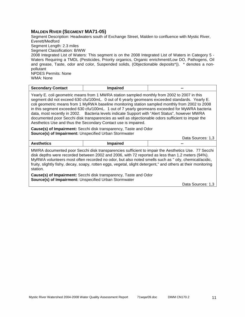
MALDEN RIVER (SEGMENT MA71-05) Segment Description: Headwaters south of Exchange Street, Malden to confluence with Mystic River, Everett/Medford Segment Length: 2.3 miles Segment Classification: B/WW 2008 Integrated List of Waters: This segment is on the 2008 Integrated List of Waters in Category 5 - Waters Requiring a TMDL (Pesticides, Priority organics, Organic enrichment/Low DO, Pathogens, Oil and grease, Taste, odor and color, Suspended solids, (Objectionable deposits*)). * denotes a non-pollutant NPDES Permits: None WMA: None Secondary Contact Impaired --
Yearly E. coli geometric means from 1 MWRA station sampled monthly from 2002 to 2007 in this segment did not exceed 630 cfu/100mL. 0 out of 6 yearly geomeans exceeded standards. Yearly E. coli geometric means from 1 MyRWA baseline monitoring station sampled monthly from 2002 to 2008 in this segment exceeded 630 cfu/100mL. 1 out of 7 yearly geomeans exceeded for MyWRA bacteria data, most recently in 2002. Bacteria levels indicate Support with “Alert Status”, however MWRA documented poor Secchi disk transparencies as well as objectionable odors sufficient to impair the Aesthetics Use and thus the Secondary Contact use is impaired.
Cause(s) of Impairment: Secchi disk transparency, Taste and Odor Source(s) of Impairment: Unspecified Urban Stormwater
Data Sources: 1,3 Aesthetics Impaired --
MWRA documented poor Secchi disk transparencies sufficient to impair the Aesthetics Use. 77 Secchi disk depths were recorded between 2002 and 2006, with 72 reported as less than 1.2 meters (94%). MyRWA volunteers most often recorded no odor, but also noted smells such as " oily, chemical/acidic, fruity, slightly fishy, decay, soapy, rotten eggs, vegetal, slight detergent," and others at their monitoring station.
Cause(s) of Impairment: Secchi disk transparency, Taste and Odor Source(s) of Impairment: Unspecified Urban Stormwater
Data Sources: 1,3

Mystic River Watershed 2004-2008 Water Quality Assessment Report 71wqar09.doc DWM CN170.2
12
MILL BROOK (SEGMENT MA71-07) Segment Description: Headwaters south of Massachusetts Avenue, Lexington to inlet of Lower Mystic Lake, Arlington (portions culverted underground) Segment Length: 3.9 miles Segment Classification: B 2008 Integrated List of Waters: This segment is on the 2008 Integrated List of Waters in Category 5 - Waters Requiring a TMDL ((Other habitat alterations*), Pathogens) * denotes a non-pollutant. NPDES Permits: None WMA: None
Designated Use Use Assessment Alert
Aquatic Life Not Assessed Y
DWM sampled the benthic macroinvertebrate community at station MI01 on Mill Brook in 1999, and the community was determined to be "slightly impacted" (data never used for assessment). However, EPT taxa were absent, and "it is possible that biological integrity at this station is more degraded than is indicated from the RBP analysis." It recieved the poorest habitat score of all the Boston harbor sites in 1999 and it also had the highest (worst) biotic index score (which indicates "water quality degredation relating to organic enrichment"). Given the age of this data, it is used for “Alert Status” only. While MyRWA documented high levels (yearly averages ranged from 0.060 to 0.119mg/L), in the absence of specific nutrient criteria standards, this data alone is not sufficent to assess the Aquatic Life Use as impaired.
Data Sources: 1,11,15 Fish Consumption Not Assessed --
This waterbody does not have a site-specific fish consumption advisory. All applicable statewide fish consumption advisories issued by MA DPH due to mercury contamination apply to this waterbody (See Special Note 2).
Primary Contact Impaired --
Yearly E. coli geometric means calculated for the Primary Contact Recreation season from 1 MyRWA baseline monitoring station sampled monthly from 2002 to 2008 in this segment exceeded 126 cfu/100mL. 7 out of 7 years of Primary Contact Recreation geomeans exceeded standards, most recently in 2008.
Cause(s) of Impairment: Escherichia coli Source(s) of Impairment: Unspecified Urban Stormwater
Data Sources: 1 Secondary Contact Impaired --
Yearly E. coli geometric means from 1 MyRWA baseline monitoring station sampled monthly from 2002 to 2008 in this segment exceeded 630 cfu/100mL. 5 out of 7 yearly geomeans exceeded standards, most recently in 2007.
Cause(s) of Impairment: Escherichia coli Source(s) of Impairment: Unspecified Urban Stormwater
Data Sources: 1 Aesthetics Support --
During monthly monitoring between 2002 and 2008, MyRWA volunteer monitors most frequently reported that the water color was "clear" or "light tea" in color, and water odor was generally recorded as "none." On two occasions an odor of sewage or light sewage was recorded. These observations are sufficient to support the Aesthetics use.
Data Sources: 1

Mystic River Watershed 2004-2008 Water Quality Assessment Report 71wqar09.doc DWM CN170.2
13
MYSTIC RIVER (SEGMENT MA71-02) Segment Description: Outlet Lower Mystic Lake, Arlington/Medford to Amelia Earhart Dam, Somerville/Everett Segment Length: 4.9 miles Segment Classification: B/ WW CSO 2008 Integrated List of Waters: This segment is on the 2008 Integrated List of Waters in Category 5 - Waters Requiring a TMDL (Pesticides, Priority organics, Metals, Nutrients, Pathogens) NPDES Permits: City of Somerville (CSO) (MA0101982 ) WMA: None
Designated Use Use Assessment Alert
Aquatic Life Impaired --
A USGS study found that some chemicals are present in sufficiently high concentrations in Mystic River sediment to pose a threat to benthic organisms and impair the Aquatic Life Use. The Aquatic Life Use is also impaired for the poorly designed and non-functional fishway at the Amelia Earhart dam. A fishway at the dam is non-functional. Presently, alewife migration is dependent on operations of the boat locks. MWRA documented highly productive conditions, including: elevated total phosphorus levels, chlorophyll a (Chl a) levels indicative of eutrophic conditions, and frequent supersaturation of dissolved oxgygen. The fish community was dominated by macrohabitat fish species classified as moderately tolerant to pollution, which is consistent with an impaired condition.
Cause(s) of Impairment: Chlorophyll-a, Dissolved oxygen saturation, Fish-Passage Barrier, Sediment Bioassays -- Chronic Toxicity Freshwater, Phosphorus (Total) Source(s) of Impairment: Contaminated Sediments, Hydrostructure impacts on fish passage, Unspecified Urban Stormwater
Data Sources: 1,3,5,11,16 Fish Consumption Impaired --
Due to the presence of PCBs, DDT, and Chlordane, MA DPH has issued the following advisory for the Mystic River (between outlet of Lower Mystic Lake and Amelia Earhart dam) River recommending: “No one should consume any fish from this water body.”
Cause(s) of Impairment: DDT, Chlordane, and PCB in fish tissue Source(s) of Impairment: Unknown
Data Sources: 9 Primary Contact Impaired --
Yearly E. coli geometric means calculated for the Primary Contact Recreation season from 5 MWRA stations sampled monthly from 2002 to 2007 in this segment exceeded 126 cfu/100mL. 7 out of 29 Primary Contact Recreation geomeans exceeded standards, most recently in 2008. Yearly E. coli geometric means calculated for the Primary Contact Recreation season from 1 MyRWA baseline monitoring station (in the upper reach of this segment) sampled monthly from 2002 to 2008 exceeded 126 cfu/100mL. 3 out of 7 years of Primary Contact Recreation geomeans exceeded standards, most recently in 2007. Several stations have 5 years of Primary Contact Recreation geomeans below standard. However, there are enough recent violations to warrant impairment. Since Aesthetics is impaired due to poor Secchi desk transparency the Primary Contact use is ialso impaired for this cause. .
Cause(s) of Impairment: Escherichia coli, Secchi disk transparency Source(s) of Impairment: Unspecified Urban Stormwater
Data Sources: 1,3

Mystic River Watershed 2004-2008 Water Quality Assessment Report 71wqar09.doc DWM CN170.2
14
MYSTIC RIVER (SEGMENT MA71-02) Segment Description: Outlet Lower Mystic Lake, Arlington/Medford to Amelia Earhart Dam, Somerville/Everett Segment Length: 4.9 miles Segment Classification: B/ WW CSO 2008 Integrated List of Waters: This segment is on the 2008 Integrated List of Waters in Category 5 - Waters Requiring a TMDL (Pesticides, Priority organics, Metals, Nutrients, Pathogens) NPDES Permits: City of Somerville (CSO) (MA0101982 ) WMA: None Secondary Contact Impaired --
Yearly E. coli geometric means from 5 MWRA stations sampled monthly from 2002 to 2007 in this segment did not exceed 630 cfu/100mL. 0 out of 29 geomeans exceeded standards. Yearly E. coli geometric means from 1 MyRWA baseline monitoring station (in the upper reach of this segment) sampled monthly from 2002 to 2008 in this segment did not exceed 126 cfu/100mL. 0 out of 7 yearly geomeans exceeded standards. Bacteria levels indicate Support with “Alert Status”, however since Aesthetics is impaired due to poor Secchi desk transparency the Secondary Contact use is also impaired for this cause.
Cause(s) of Impairment: Secchi disk transparency Source(s) of Impairment: Unspecified Urban Stormwater
Data Sources: 1,3 Aesthetics Impaired --
MyRWA volunteers predominantly recorded odor as "none", but did note a "fishy" odor on two occasions at their monitoring station. MWRA documented poor Secchi disk transparencies sufficient to impair the Aesthetics Use. 131 Secchi disk depths were recorded between 2002 and 2006 within this segment, with 120 reported as less than 1.2 meters (92%).
Cause(s) of Impairment: Secchi disk transparency Source(s) of Impairment: Unspecified Urban Stormwater
Data Sources: 1,3

Mystic River Watershed 2004-2008 Water Quality Assessment Report 71wqar09.doc DWM CN170.2
15
SHAKER GLEN BROOK (SEGMENT MA71-11) Segment Description: Headwaters, west of Dix Road Extention, Woburn to confluence with Fowle Brook, Woburn (portion culverted underground) Segment Length: 1.5 miles Segment Classification: B 2008 Integrated List of Waters: This segment is on the 2008 Integrated List of Waters in Category 3 - No Uses Assessed NPDES Permits: None WMA: None
Designated Use Use Assessment Alert
Aquatic Life Not Assessed --
MA DFG conducted fish population sampling in Shaker Glen Brook on July 26, 2004 (Station 1103). Fifty-three fish, representing six species, were collected. The sample consisted of seventy-five percent macrohabitat generalist species and twenty five percent fluvial dependent species. All of the fish collected are considered moderately tolerant to tolerant of pollution. The Aquatic Life Use is not assessessed due to insufficient information.
Data Sources: 11 Fish Consumption Not Assessed --
This waterbody does not have a site-specific fish consumption advisory. All applicable statewide fish consumption advisories issued by MA DPH due to mercury contamination apply to this waterbody (See Special Note 2).
Primary Contact Not Assessed --
Insufficient data were available to assess the Primary Contact Use.
Secondary Contact Not Assessed --
Insufficient data were available to assess the Secondary Contact Use.
Aesthetics Not Assessed --
Insufficient data were available to assess the Aesthetics Use.

Mystic River Watershed 2004-2008 Water Quality Assessment Report 71wqar09.doc DWM CN170.2
16
UNNAMED TRIBUTARY (SEGMENT MA71-13) Segment Description: Unnamed tributary locally known as 'Meetinghouse Brook', from emergence south of Route 16/east of Winthrop Street, Medford to confluence with the Mystic River, Medford. (brook not apparent on 1985 Boston North USGS quad - 2005 orthophotos used to delineate stream) Segment Length: 0.1 miles Segment Classification: B 2008 Integrated List of Waters: Not Listed NPDES Permits: None WMA: None
Designated Use Use Assessment Alert
Aquatic Life Not Assessed Y
MyRWA documented slightly elevated total phosphorus levels between 2002-2008 sampling (yearly averages ranged from 0.040 to 0.125 mg/L). MyRWA also documented 4 dissolved oxgygen violations. The Aquatic Life Use is not assessed but identified with an “Alert Status” due to elevated total phosphorus and low dissolved oxygen.
Data Sources: 1 Fish Consumption Not Assessed
This waterbody does not have a site-specific fish consumption advisory. All applicable statewide fish consumption advisories issued by MA DPH due to mercury contamination apply to this waterbody (See Special Note 2).
Primary Contact Impaired
Yearly E. coli geometric means calculated for the Primary Contact Recreation season from 1 MyRWA baseline monitoring station sampled monthly from 2003 to 2008 in this segment exceeded 126 cfu/100mL. 6 out of 6 years of Primary Contact Recreation geomeans exceeded standards, most recently in 2008.
Cause(s) of Impairment: Escherichia coli Source(s) of Impairment: Unspecified Urban Stormwater
Data Sources: 1 Secondary Contact Support Y
Yearly E. coli geometric means calculated from 1 MyRWA baseline monitoring station sampled monthly from 2002 to 2008 in this segment generally did not exceed 630 cfu/100mL. 1 out of 7 yearly geomeans exceeded, most recently in 2002. This use is identified with an “Alert Status” because of single sample bacteria exceedances.
Data Sources: 1 Aesthetics Support
During monthly monitoring between 2002 and 2008, MyRWA volunteer monitors most frequently reported that the water color was "clear" or "light tea" in color, and water odor was generally recorded as "none." On a few occasions a musky odor or "rotten egg" smell was recorded. This is sufficient to support the Aesthetics use.
Data Sources: 1
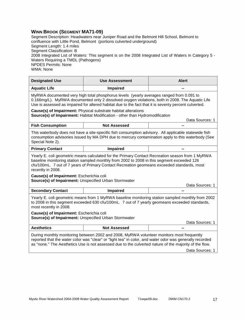
Mystic River Watershed 2004-2008 Water Quality Assessment Report 71wqar09.doc DWM CN170.2
17
WINN BROOK (SEGMENT MA71-09) Segment Description: Headwaters near Juniper Road and the Belmont Hill School, Belmont to confluence with Little Pond, Belmont (portions culverted underground) Segment Length: 1.4 miles Segment Classification: B 2008 Integrated List of Waters: This segment is on the 2008 Integrated List of Waters in Category 5 - Waters Requiring a TMDL (Pathogens) NPDES Permits: None WMA: None
Designated Use Use Assessment Alert
Aquatic Life Impaired --
MyRWA documented very high total phosphorus levels (yearly averages ranged from 0.091 to 0.166mg/L). MyRWA documented only 2 dissolved oxygen violations, both in 2008. The Aquatic Life Use is assessed as impaired for altered habitat due to the fact that it is seventy percent culverted.
Cause(s) of Impairment: Physical substrate habitat alterations Source(s) of Impairment: Habitat Modification - other than Hydromodification
Data Sources: 1 Fish Consumption Not Assessed --
This waterbody does not have a site-specific fish consumption advisory. All applicable statewide fish consumption advisories issued by MA DPH due to mercury contamination apply to this waterbody (See Special Note 2).
Primary Contact Impaired --
Yearly E. coli geometric means calculated for the Primary Contact Recreation season from 1 MyRWA baseline monitoring station sampled monthly from 2002 to 2008 in this segment exceeded 126 cfu/100mL. 7 out of 7 years of Primary Contact Recreation geomeans exceeded standards, most recently in 2008.
Cause(s) of Impairment: Escherichia coli Source(s) of Impairment: Unspecified Urban Stormwater
Data Sources: 1 Secondary Contact Impaired --
Yearly E. coli geometric means from 1 MyRWA baseline monitoring station sampled monthly from 2002 to 2008 in this segment exceeded 630 cfu/100mL. 7 out of 7 yearly geomeans exceeded standards, most recently in 2008.
Cause(s) of Impairment: Escherichia coli Source(s) of Impairment: Unspecified Urban Stormwater
Data Sources: 1 Aesthetics Not Assessed --
During monthly monitoring between 2002 and 2008, MyRWA volunteer monitors most frequently reported that the water color was "clear" or "light tea" in color, and water odor was generally recorded as "none." The Aesthetics Use is not assessed due to the culverted nature of the majority of the flow.
Data Sources: 1
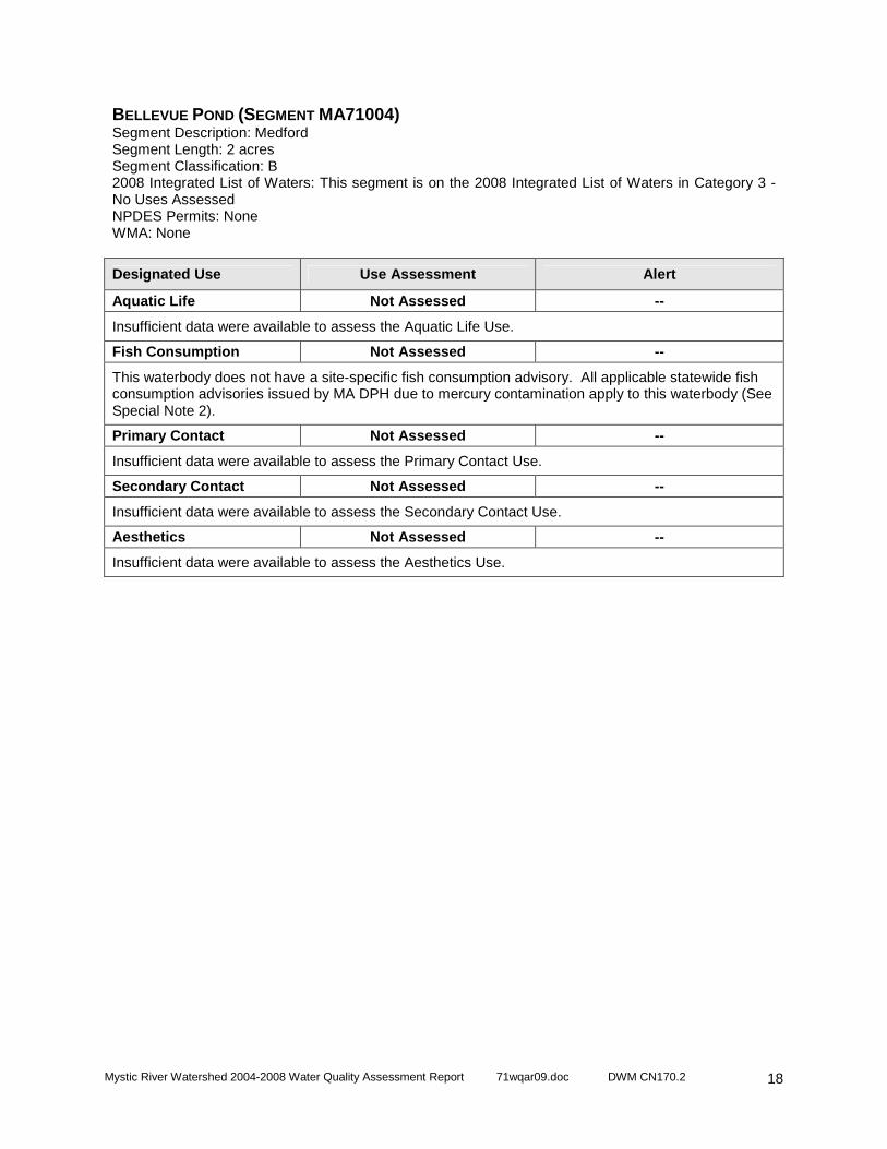
Mystic River Watershed 2004-2008 Water Quality Assessment Report 71wqar09.doc DWM CN170.2
18
BELLEVUE POND (SEGMENT MA71004) Segment Description: Medford Segment Length: 2 acres Segment Classification: B 2008 Integrated List of Waters: This segment is on the 2008 Integrated List of Waters in Category 3 - No Uses Assessed NPDES Permits: None WMA: None
Designated Use Use Assessment Alert
Aquatic Life Not Assessed --
Insufficient data were available to assess the Aquatic Life Use.
Fish Consumption Not Assessed --
This waterbody does not have a site-specific fish consumption advisory. All applicable statewide fish consumption advisories issued by MA DPH due to mercury contamination apply to this waterbody (See Special Note 2).
Primary Contact Not Assessed --
Insufficient data were available to assess the Primary Contact Use.
Secondary Contact Not Assessed --
Insufficient data were available to assess the Secondary Contact Use.
Aesthetics Not Assessed --
Insufficient data were available to assess the Aesthetics Use.
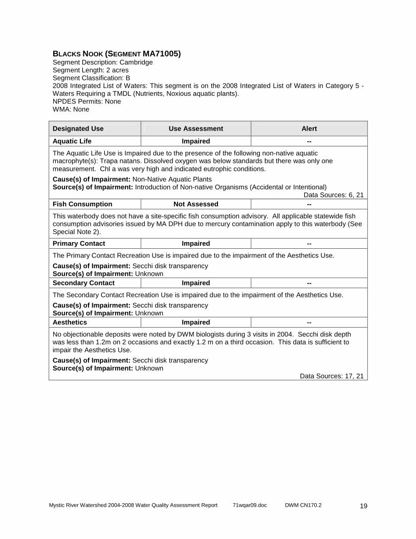
Mystic River Watershed 2004-2008 Water Quality Assessment Report 71wqar09.doc DWM CN170.2
19
BLACKS NOOK (SEGMENT MA71005) Segment Description: Cambridge Segment Length: 2 acres Segment Classification: B 2008 Integrated List of Waters: This segment is on the 2008 Integrated List of Waters in Category 5 - Waters Requiring a TMDL (Nutrients, Noxious aquatic plants). NPDES Permits: None WMA: None
Designated Use Use Assessment Alert
Aquatic Life Impaired --
The Aquatic Life Use is Impaired due to the presence of the following non-native aquatic macrophyte(s): Trapa natans. Dissolved oxygen was below standards but there was only one measurement. Chl a was very high and indicated eutrophic conditions.
Cause(s) of Impairment: Non-Native Aquatic Plants Source(s) of Impairment: Introduction of Non-native Organisms (Accidental or Intentional)
Data Sources: 6, 21 Fish Consumption Not Assessed --
This waterbody does not have a site-specific fish consumption advisory. All applicable statewide fish consumption advisories issued by MA DPH due to mercury contamination apply to this waterbody (See Special Note 2).
Primary Contact Impaired --
The Primary Contact Recreation Use is impaired due to the impairment of the Aesthetics Use.
Cause(s) of Impairment: Secchi disk transparency Source(s) of Impairment: Unknown Secondary Contact Impaired --
The Secondary Contact Recreation Use is impaired due to the impairment of the Aesthetics Use.
Cause(s) of Impairment: Secchi disk transparency Source(s) of Impairment: Unknown Aesthetics Impaired --
No objectionable deposits were noted by DWM biologists during 3 visits in 2004. Secchi disk depth was less than 1.2m on 2 occasions and exactly 1.2 m on a third occasion. This data is sufficient to impair the Aesthetics Use.
Cause(s) of Impairment: Secchi disk transparency Source(s) of Impairment: Unknown
Data Sources: 17, 21
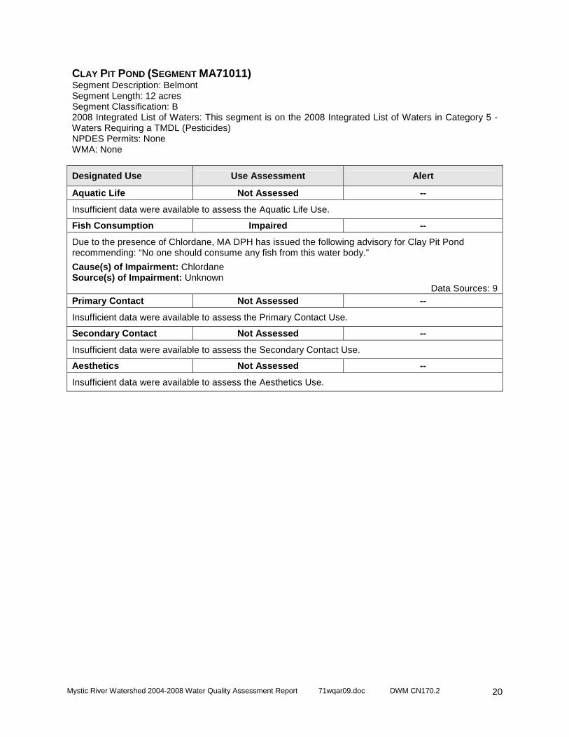
Mystic River Watershed 2004-2008 Water Quality Assessment Report 71wqar09.doc DWM CN170.2
20
CLAY PIT POND (SEGMENT MA71011) Segment Description: Belmont Segment Length: 12 acres Segment Classification: B 2008 Integrated List of Waters: This segment is on the 2008 Integrated List of Waters in Category 5 - Waters Requiring a TMDL (Pesticides) NPDES Permits: None WMA: None
Designated Use Use Assessment Alert
Aquatic Life Not Assessed --
Insufficient data were available to assess the Aquatic Life Use.
Fish Consumption Impaired --
Due to the presence of Chlordane, MA DPH has issued the following advisory for Clay Pit Pond recommending: “No one should consume any fish from this water body.”
Cause(s) of Impairment: Chlordane Source(s) of Impairment: Unknown
Data Sources: 9 Primary Contact Not Assessed --
Insufficient data were available to assess the Primary Contact Use.
Secondary Contact Not Assessed --
Insufficient data were available to assess the Secondary Contact Use.
Aesthetics Not Assessed --
Insufficient data were available to assess the Aesthetics Use.

Mystic River Watershed 2004-2008 Water Quality Assessment Report 71wqar09.doc DWM CN170.2
21
ELL POND (SEGMENT MA71014) Segment Description: Melrose Segment Length: 23 acres Segment Classification: B 2008 Integrated List of Waters: This segment is on the 2008 Integrated List of Waters in Category 5 - Waters Requiring a TMDL (Nutrients, Pathogens, Suspended solids) NPDES Permits: None WMA: None
Designated Use Use Assessment Alert
Aquatic Life Impaired --
DWM documented highly productive conditions, including: elevated total phosphorus levels, very high Chl a levels and frequent supersaturation of dissolved oxgygen, and low Secchi disk transparency. The Aquatic Life Use is impaired due to indicators of eutrophication such as Chlorophyll-a and high total phosphorus.
Cause(s) of Impairment: Chlorophyll-a, Phosphorous (Total) Source(s) of Impairment: Unknown
Data Sources: 21 Fish Consumption Not Assessed --
This waterbody does not have a site-specific fish consumption advisory. All applicable statewide fish consumption advisories issued by MA DPH due to mercury contamination apply to this waterbody (See Special Note 2).
Primary Contact Impaired --
MyRWA began monitoring cyanobacteria and chlorophyl a levels in this pond in 2008 due to concerns over algae blooms. The Primary Contact Recreation Use is impaired due to the impairment of the Aesthetics Use.
Cause(s) of Impairment: Secchi disk transparency Source(s) of Impairment: Unknown
Data Sources: 17,20, 21 Secondary Contact Impaired --
MyRWA began monitoring cyanobacteria and chlorophyl a levels in this pond in 2008 due to concerns over algae blooms. The Secondary Contact Recreation Use is impaired due to the impairment of the Aesthetics Use.
Cause(s) of Impairment: Secchi disk transparency Source(s) of Impairment: Unknown
Data Sources: 17,20, 21 Aesthetics Impaired --
DWM biologists recorded water clarity as highly turbid/brownish on two occasions, and moderately turbid on a third occasion in 2004. Algae was noted as an objectionable deposit on one occasion and scum: "algal mat- clumpy green/brown/blue green" was also noted. Secchi disk depth was less than 1.2 meters on 2 out of three occasions and as a result the Aesthetics Use is impaired. MyRWA began monitoring cyanobacteria and chlorophyl a levels in this pond in 2008 due to concerns over algae blooms.
Cause(s) of Impairment: Secchi disk transparency Source(s) of Impairment: Unknown
Data Sources: 17,20, 21
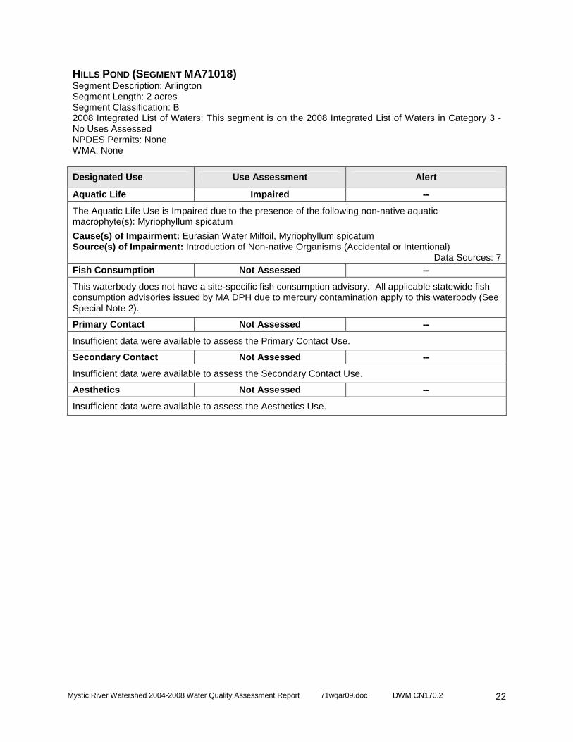
Mystic River Watershed 2004-2008 Water Quality Assessment Report 71wqar09.doc DWM CN170.2
22
HILLS POND (SEGMENT MA71018) Segment Description: Arlington Segment Length: 2 acres Segment Classification: B 2008 Integrated List of Waters: This segment is on the 2008 Integrated List of Waters in Category 3 - No Uses Assessed NPDES Permits: None WMA: None
Designated Use Use Assessment Alert
Aquatic Life Impaired --
The Aquatic Life Use is Impaired due to the presence of the following non-native aquatic macrophyte(s): Myriophyllum spicatum
Cause(s) of Impairment: Eurasian Water Milfoil, Myriophyllum spicatum Source(s) of Impairment: Introduction of Non-native Organisms (Accidental or Intentional)
Data Sources: 7 Fish Consumption Not Assessed --
This waterbody does not have a site-specific fish consumption advisory. All applicable statewide fish consumption advisories issued by MA DPH due to mercury contamination apply to this waterbody (See Special Note 2).
Primary Contact Not Assessed --
Insufficient data were available to assess the Primary Contact Use.
Secondary Contact Not Assessed --
Insufficient data were available to assess the Secondary Contact Use.
Aesthetics Not Assessed --
Insufficient data were available to assess the Aesthetics Use.

Mystic River Watershed 2004-2008 Water Quality Assessment Report 71wqar09.doc DWM CN170.2
23
HORN POND (SEGMENT MA71019) Segment Description: Woburn Segment Length: 108 acres Segment Classification: B/WW 2008 Integrated List of Waters: This segment is on the 2008 Integrated List of Waters in Category 5 - Waters Requiring a TMDL (Nutrients, Organic enrichment/Low DO, Noxious aquatic plants) NPDES Permits: None WMA: None (Note Horn Pond is an emergency water supply for the Woburn Department Public Works)
Designated Use Use Assessment Alert
Aquatic Life Impaired --
The Aquatic Life Use is Impaired due to the presence of the following non-native aquatic macrophyte(s): Potamogeton crispus. It was concerning that total phosphorous levels were elevated, but this does not result in impairment. Chl a levels were not indicative of eutrophic conditions.
Cause(s) of Impairment: Non-Native Aquatic Plants Source(s) of Impairment: Introduction of Non-native Organisms (Accidental or Intentional)
Data Sources: 8, 21 Fish Consumption Not Assessed --
This waterbody does not have a site-specific fish consumption advisory. All applicable statewide fish consumption advisories issued by MA DPH due to mercury contamination apply to this waterbody (See Special Note 2).
Primary Contact Not Assessed Y
MyRWA has anecdotal evidence of algal blooms and began monitoring cyanobacteria and chlorophyl a levels in this pond in 2008, thus the Primary Contact Use is assessed with an “Alert Status”.
Data Sources: 20 Secondary Contact Not Assessed Y
MyRWA has anecdotal evidence of algal blooms and began monitoring cyanobacteria and chlorophyl a levels in this pond in 2008, thus the Secondary Contact Use is assessed with an “Alert Status”.
Data Sources: 20 Aesthetics Support Y
No scums or objectionable deposits were noted by DWM biologists. 3 Secchi disk readings recorded in 2004 ranged from 3.0 to 3.3 meters. The Aesthetics Use is assessed as support with an “Alert Status” based on the acceptable Secchi disk depths. MyRWA has anecdotal evidence of algal blooms and began monitoring cyanobacteria and chlorophyl a levels in this pond in 2008, thus the Aesthetics Use is assessed with an “Alert Status”.
Data Sources: 17,20, 21

Mystic River Watershed 2004-2008 Water Quality Assessment Report 71wqar09.doc DWM CN170.2
24
LOWER MYSTIC LAKE (SEGMENT MA71027) Segment Description: Arlington/Medford Segment Length: 93 acres Segment Classification: B/WW 2008 Integrated List of Waters: This segment is on the 2008 Integrated List of Waters in Category 5 - Waters Requiring a TMDL (Cause Unknown, Organic enrichment/Low DO, Salinity/TDS/chlorides) NPDES Permits: None WMA: None
Designated Use Use Assessment Alert
Aquatic Life Impaired --
A USGS study found that some chemicals are present in sufficiently high concentrations in Lower Mystic Lake sediment to pose a threat to benthic organisms.
Cause(s) of Impairment: Sediment Bioassays -- Chronic Toxicity Freshwater Source(s) of Impairment: Contaminated Sediments
Data Sources: 5 Fish Consumption Not Assessed --
This waterbody does not have a site-specific fish consumption advisory. All applicable statewide fish consumption advisories issued by MA DPH due to mercury contamination apply to this waterbody (See Special Note 2).
Primary Contact Not Assessed --
Insufficient data were available to assess the Primary Contact Use.
Secondary Contact Not Assessed --
Insufficient data were available to assess the Secondary Contact Use.
Aesthetics Not Assessed --
Insufficient data were available to assess the Aesthetics Use.
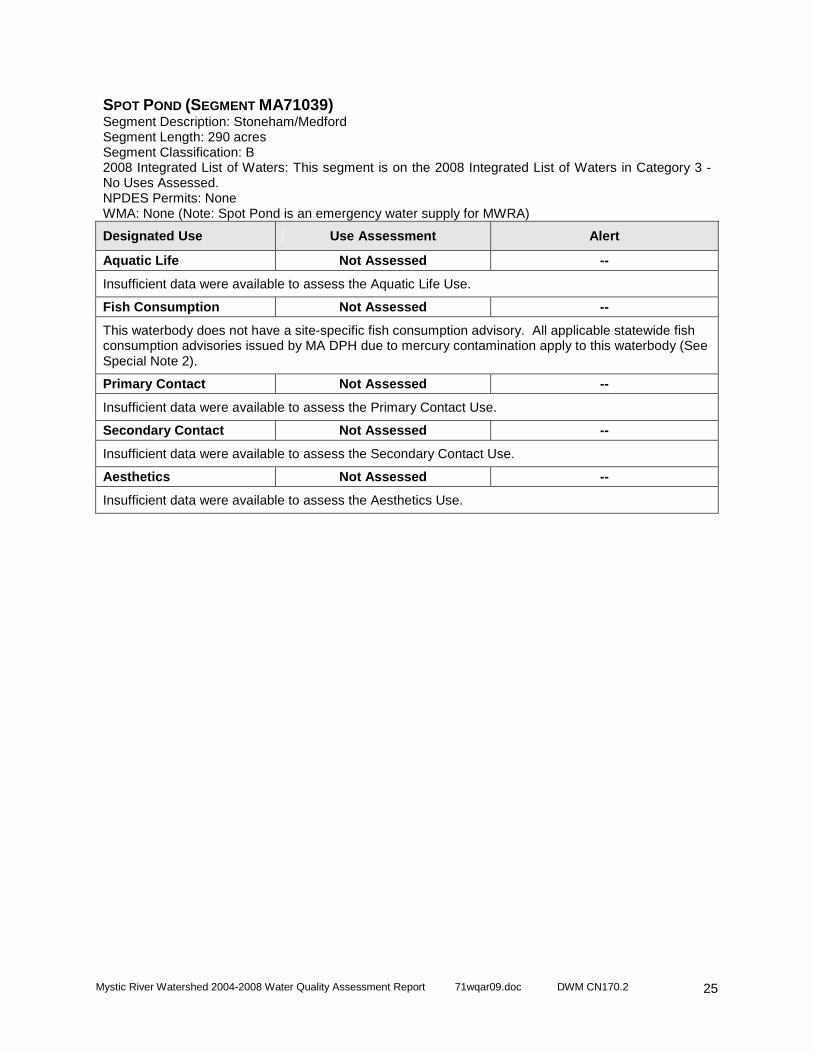
Mystic River Watershed 2004-2008 Water Quality Assessment Report 71wqar09.doc DWM CN170.2
25
SPOT POND (SEGMENT MA71039) Segment Description: Stoneham/Medford Segment Length: 290 acres Segment Classification: B 2008 Integrated List of Waters: This segment is on the 2008 Integrated List of Waters in Category 3 - No Uses Assessed. NPDES Permits: None WMA: None (Note: Spot Pond is an emergency water supply for MWRA)
Designated Use Use Assessment Alert
Aquatic Life Not Assessed --
Insufficient data were available to assess the Aquatic Life Use.
Fish Consumption Not Assessed --
This waterbody does not have a site-specific fish consumption advisory. All applicable statewide fish consumption advisories issued by MA DPH due to mercury contamination apply to this waterbody (See Special Note 2).
Primary Contact Not Assessed --
Insufficient data were available to assess the Primary Contact Use.
Secondary Contact Not Assessed --
Insufficient data were available to assess the Secondary Contact Use.
Aesthetics Not Assessed --
Insufficient data were available to assess the Aesthetics Use.
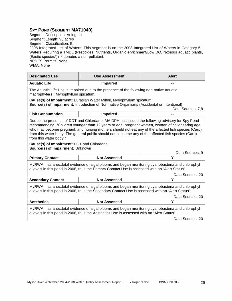
Mystic River Watershed 2004-2008 Water Quality Assessment Report 71wqar09.doc DWM CN170.2
26
SPY POND (SEGMENT MA71040) Segment Description: Arlington Segment Length: 98 acres Segment Classification: B 2008 Integrated List of Waters: This segment is on the 2008 Integrated List of Waters in Category 5 - Waters Requiring a TMDL (Pesticides, Nutrients, Organic enrichment/Low DO, Noxious aquatic plants, (Exotic species*)) * denotes a non-pollutant. NPDES Permits: None WMA: None
Designated Use Use Assessment Alert
Aquatic Life Impaired --
The Aquatic Life Use is Impaired due to the presence of the following non-native aquatic macrophyte(s): Myriophyllum spicatum.
Cause(s) of Impairment: Eurasian Water Milfoil, Myriophyllum spicatum Source(s) of Impairment: Introduction of Non-native Organisms (Accidental or Intentional)
Data Sources: 7,8 Fish Consumption Impaired --
Due to the presence of DDT and Chlordane, MA DPH has issued the following advisory for Spy Pond recommending: “Children younger than 12 years or age, pregnant women, women of childbearing age who may become pregnant, and nursing mothers should not eat any of the affected fish species (Carp) from this water body. The general public should not consume any of the affected fish species (Carp) from this water body.”
Cause(s) of Impairment: DDT and Chlordane Source(s) of Impairment: Unknown
Data Sources: 9 Primary Contact Not Assessed Y
MyRWA has anecdotal evidence of algal blooms and began monitoring cyanobacteria and chlorophyl a levels in this pond in 2008, thus the Primary Contact Use is assessed with an “Alert Status”.
Data Sources: 20 Secondary Contact Not Assessed Y
MyRWA has anecdotal evidence of algal blooms and began monitoring cyanobacteria and chlorophyl a levels in this pond in 2008, thus the Secondary Contact Use is assessed with an “Alert Status”.
Data Sources: 20 Aesthetics Not Assessed Y
MyRWA has anecdotal evidence of algal blooms and began monitoring cyanobacteria and chlorophyl a levels in this pond in 2008, thus the Aesthetics Use is assessed with an “Alert Status”.
Data Sources: 20

Mystic River Watershed 2004-2008 Water Quality Assessment Report 71wqar09.doc DWM CN170.2
27
UPPER MYSTIC LAKE (SEGMENT MA71043) Segment Description: Winchester/Arlington/Medford Segment Length: 176 acres Segment Classification: B/WW 2008 Integrated List of Waters: This segment is on the 2008 Integrated List of Waters in Category 3 - No Uses Assessed NPDES Permits: None WMA: None
Designated Use Use Assessment Alert
Aquatic Life Impaired --
DWM documented dissolved oxygen supersaturation in surface waters during a 46.5 hour continuous span recorded over 3 days in August 2004. MyRWA and DMF conducted a river herring spawning and nursery habitat assessment in the lake during 2007-2008. MyRWA and DMF documented dissolved oxygen levels below standards at depths of greater than 5m at several stations during 4 visits between June and September 2007. During their 2007, MyWRA and DMF noted a dense bloom of algae later identified as Anabaena, a cyanobacteria. DMF also documented dissolved oxygen levels below standards in a significant portion of the lake at multiple stations during 5 visits between May and September 2008. THe presence of Potemegeton crispus, a non-native macrophyte, has been documented in herbicide applications and MA DCR records. Given the low dissolved oxygen conditions in the hypolimnion affecting a large portion of the lake, supersaturated conditions in the hyperlimnion, algal blooms indicative of enriched conditions, and the presence of a non-native macrophyte, the Aquatic Life Use is assessed as impaired.
Cause(s) of Impairment: Dissolved oxygen saturation, Non-Native Aquatic Plants, Low Dissolved Oxygen Source(s) of Impairment: Unknown, Introduction of Non-native Organisms (Accidental or Intentional)
Data Sources: 7,8, 10, 21, 22,26 Fish Consumption Not Assessed --
This waterbody does not have a site-specific fish consumption advisory. All applicable statewide fish consumption advisories issued by MA DPH due to mercury contamination apply to this waterbody (See Special Note 2).
Primary Contact Support Y
Yearly E. coli geometric means calculated for the Primary Contact Recreation season from 1 MyRWA baseline monitoring station sampled monthly from 2002 to 2008 in this segment did not exceed 126 cfu/100mL. 0 out of 7 years of Primary Contact Recreation geomeans exceeded standards. Of note, Secchi disk depths taken by MyRWA and DMF in the lake were all >1.2m. This use is supported but identified with an “Alert Status” because of single sample bacteria exceedances and algae blooms noted in the lake.
Data Sources: 1, 10,21 Secondary Contact Support Y
Yearly E. coli geometric means calculated from 1 MyRWA baseline monitoring station sampled monthly from 2002 to 2008 in this segment did not exceed 630 cfu/100mL. 0 out of 7 yearly geomeans exceeded standards. Of note, Secchi disk depths taken by MyRWA and DMF in the lake were all >1.2m. This use is supported but identified with an “Alert Status” because of single sample bacteria exceedances and algae blooms noted in the lake.
Data Sources: 1, 10, 21

Mystic River Watershed 2004-2008 Water Quality Assessment Report 71wqar09.doc DWM CN170.2
28
UPPER MYSTIC LAKE (SEGMENT MA71043) Segment Description: Winchester/Arlington/Medford Segment Length: 176 acres Segment Classification: B/WW 2008 Integrated List of Waters: This segment is on the 2008 Integrated List of Waters in Category 3 - No Uses Assessed NPDES Permits: None WMA: None Aesthetics Support --
MyRWA and DMF documented Secchi disk depths of >1.2 meters in 2007 and 2008. DWM biologists did not note any objectionable deposits or scums, and water clarity was recorded as "clear", "slightly turbid", and "moderately turbid."
Data Sources: 10, 17, 21, 22

Mystic River Watershed 2004-2008 Water Quality Assessment Report 71wqar09.doc DWM CN170.2
29
WEDGE POND (SEGMENT MA71045) Segment Description: Winchester Segment Length: 23 acres Segment Classification: B 2008 Integrated List of Waters: This segment is on the 2008 Integrated List of Waters in Category 5 - Waters Requiring a TMDL (Nutrients, Noxious aquatic plants). NPDES Permits: None WMA: None
Designated Use Use Assessment Alert
Aquatic Life Impaired --
In 2004, dissolved oxygen levels observed at depths greater than 3 meters were below state standards. DWM documented highly productive conditions, including: elevated total phosphorus levels at depth, high Chl a levels, and a low Secchi disk transparency measurement. Given these conditions the Aquatic Life Use is assessed as impaired.
Cause(s) of Impairment: Low Dissolved Oxygen, Phosphorus (Total) Source(s) of Impairment: Unknown
Data Sources: 21 Fish Consumption Not Assessed --
This waterbody does not have a site-specific fish consumption advisory. All applicable statewide fish consumption advisories issued by MA DPH due to mercury contamination apply to this waterbody (See Special Note 2).
Primary Contact Not Assessed Y
The Primary Contact Recreation Use is given “Alert Status” due to the “Alert Status” of the Aesthetics Use.
Secondary Contact Not Assessed Y
The Secondary Contact Recreation Use is given “Alert Status” due to the “Alert Status” of the Aesthetics Use.
Aesthetics Not Assessed Y
DWM biologists noted water clarity that was slightly, moderately, and highly turbid in 2004. Goose poop was noted as an objectionable deposit on one occasion. One out of 3 Secchi disk measurements was less than 1.2 meters. No other scums or objectionable deposits were noted. This information is not sufficient to impair or support the Aesthetics use, an “Alert Status” is given due to the single Secchi disk measurement below the standard.
Data Sources: 17, 21

Mystic River Watershed 2004-2008 Water Quality Assessment Report 71wqar09.doc DWM CN170.2
30
WINTER POND (SEGMENT MA71047) Segment Description: Winchester Segment Length: 18 acres Segment Classification: B 2008 Integrated List of Waters: This segment is on the 2008 Integrated List of Waters in Category 5 - Waters Requiring a TMDL (Cause Unknown, Nutrients, Noxious aquatic plants, Turbidity). NPDES Permits: None WMA: None
Designated Use Use Assessment Alert
Aquatic Life Impaired --
The Aquatic Life Use is Impaired due to the presence of the following non-native aquatic macrophyte(s): Myrophyllum heterophyllum.
Cause(s) of Impairment: Non-Native Aquatic Plants Source(s) of Impairment: Introduction of Non-native Organisms (Accidental or Intentional)
Data Sources: 8 Fish Consumption Not Assessed --
This waterbody does not have a site-specific fish consumption advisory. All applicable statewide fish consumption advisories issued by MA DPH due to mercury contamination apply to this waterbody (See Special Note 2).
Primary Contact Not Assessed --
Insufficient data were available to assess the Primary Contact Use.
Secondary Contact Not Assessed --
Insufficient data were available to assess the Secondary Contact Use.
Aesthetics Not Assessed --
Insufficient data were available to assess the Aesthetics Use.
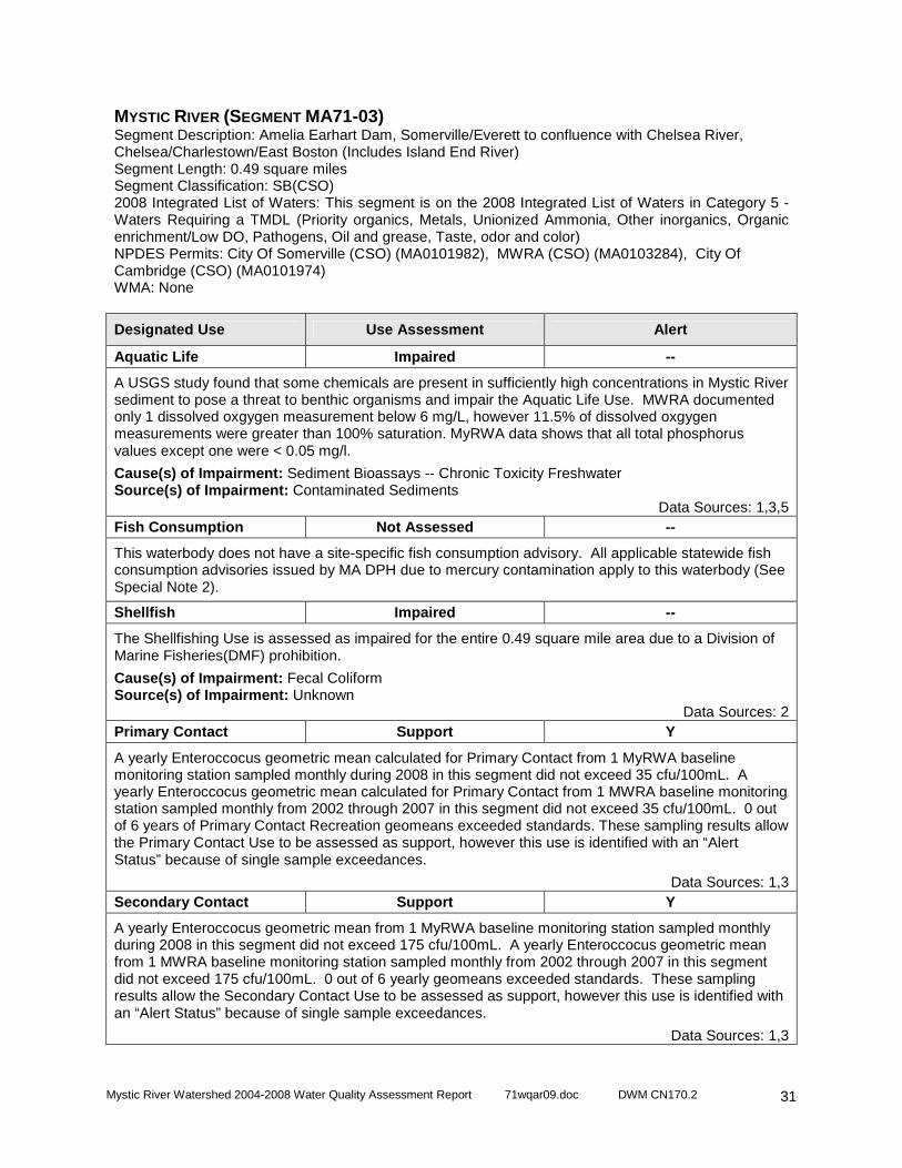
Mystic River Watershed 2004-2008 Water Quality Assessment Report 71wqar09.doc DWM CN170.2
31
MYSTIC RIVER (SEGMENT MA71-03) Segment Description: Amelia Earhart Dam, Somerville/Everett to confluence with Chelsea River, Chelsea/Charlestown/East Boston (Includes Island End River) Segment Length: 0.49 square miles Segment Classification: SB(CSO) 2008 Integrated List of Waters: This segment is on the 2008 Integrated List of Waters in Category 5 - Waters Requiring a TMDL (Priority organics, Metals, Unionized Ammonia, Other inorganics, Organic enrichment/Low DO, Pathogens, Oil and grease, Taste, odor and color) NPDES Permits: City Of Somerville (CSO) (MA0101982), MWRA (CSO) (MA0103284), City Of Cambridge (CSO) (MA0101974) WMA: None
Designated Use Use Assessment Alert
Aquatic Life Impaired --
A USGS study found that some chemicals are present in sufficiently high concentrations in Mystic River sediment to pose a threat to benthic organisms and impair the Aquatic Life Use. MWRA documented only 1 dissolved oxgygen measurement below 6 mg/L, however 11.5% of dissolved oxgygen measurements were greater than 100% saturation. MyRWA data shows that all total phosphorus values except one were < 0.05 mg/l.
Cause(s) of Impairment: Sediment Bioassays -- Chronic Toxicity Freshwater Source(s) of Impairment: Contaminated Sediments
Data Sources: 1,3,5 Fish Consumption Not Assessed --
This waterbody does not have a site-specific fish consumption advisory. All applicable statewide fish consumption advisories issued by MA DPH due to mercury contamination apply to this waterbody (See Special Note 2).
Shellfish Impaired --
The Shellfishing Use is assessed as impaired for the entire 0.49 square mile area due to a Division of Marine Fisheries(DMF) prohibition.
Cause(s) of Impairment: Fecal Coliform Source(s) of Impairment: Unknown
Data Sources: 2 Primary Contact Support Y
A yearly Enteroccocus geometric mean calculated for Primary Contact from 1 MyRWA baseline monitoring station sampled monthly during 2008 in this segment did not exceed 35 cfu/100mL. A yearly Enteroccocus geometric mean calculated for Primary Contact from 1 MWRA baseline monitoring station sampled monthly from 2002 through 2007 in this segment did not exceed 35 cfu/100mL. 0 out of 6 years of Primary Contact Recreation geomeans exceeded standards. These sampling results allow the Primary Contact Use to be assessed as support, however this use is identified with an “Alert Status” because of single sample exceedances.
Data Sources: 1,3 Secondary Contact Support Y
A yearly Enteroccocus geometric mean from 1 MyRWA baseline monitoring station sampled monthly during 2008 in this segment did not exceed 175 cfu/100mL. A yearly Enteroccocus geometric mean from 1 MWRA baseline monitoring station sampled monthly from 2002 through 2007 in this segment did not exceed 175 cfu/100mL. 0 out of 6 yearly geomeans exceeded standards. These sampling results allow the Secondary Contact Use to be assessed as support, however this use is identified with an “Alert Status” because of single sample exceedances.
Data Sources: 1,3
Mystic River Watershed 2004-2008 Water Quality Assessment Report 71wqar09.doc DWM CN170.2
32
MYSTIC RIVER (SEGMENT MA71-03) Segment Description: Amelia Earhart Dam, Somerville/Everett to confluence with Chelsea River, Chelsea/Charlestown/East Boston (Includes Island End River) Segment Length: 0.49 square miles Segment Classification: SB(CSO) 2008 Integrated List of Waters: This segment is on the 2008 Integrated List of Waters in Category 5 - Waters Requiring a TMDL (Priority organics, Metals, Unionized Ammonia, Other inorganics, Organic enrichment/Low DO, Pathogens, Oil and grease, Taste, odor and color) NPDES Permits: City Of Somerville (CSO) (MA0101982), MWRA (CSO) (MA0103284), City Of Cambridge (CSO) (MA0101974) WMA: None Aesthetics Not Assessed --
Limited data is available for this segment and the Aesthetics Use is not assessed.
Data Sources: 1,3

Mystic River Watershed 2004-2008 Water Quality Assessment Report 71wqar09.doc DWM CN170.2
33
CHELSEA RIVER (SEGMENT MA71-06) Segment Description: From confluence with Mill Creek, Chelsea/Revere to confluence with Boston Inner Harbor, Chelsea/East Boston/Charlestown. Segment Length: 0.39 square miles Segment Classification: SB 2008 Integrated List of Waters: This segment is on the 2008 Integrated List of Waters in Category 5 - Waters Requiring a TMDL (Priority organics, Unionized Ammonia, Organic enrichment/Low DO, Pathogens, Oil and grease, Taste, odor and color, Turbidity, (Objectionable deposits*)) * denotes a non-pollutant. NPDES Permits: Tosco East Boston Terminal (MA0004006), Coastal Oil Of New England (MA0004375), Chelsea,City Of (CSO) (MA0101877), Gulf Oil - Chelsea (MA0001091), Irving Oil Terminals, Inc. (MA0001929), Global South Terminal, LLC (MA0000825), Global Petroleum Corp - Revere (MA0003425 ), Global Revco Terminal, LLC (MA0003298), Boston Water And Sewer Commission, (CSO) (MA0101192) WMA: None
Designated Use Use Assessment Alert
Aquatic Life Impaired --
A USGS study found that some chemicals are present in sufficiently high concentrations in Chelsea River sediment to pose a threat to benthic organisms. Since 1974 there have been over 40 recorded spills of petroleum into Chelsea Creek; moreover, it has been estimated that ground water in the area may have been contaminated with over one million gallons of oil. MyRWA monitored one station in 2008 and found acceptable levels of total phosphorus (0.032 to 0.051 mg/L), one dissolved oxygen violation, and temperatures within standards. Given the contaminated sediments and frequent oil spills in the Chelsea River, the Aquatic Life Use is assessed as impaired.
Cause(s) of Impairment: Sediment Screening Value, Petroleum Source(s) of Impairment: Contaminated Sediments, Above Ground Storage Tank Leaks (Tank Farms), Accidental release/spill, Cargo loading/unloading, Municipal (Urbanized High Density Area)
Data Sources: 1,5,24,25 Fish Consumption Impaired --
MA DPH has issued the following advisory for Boston Harbor recommending: "Pregnant women, women who may become pregnant, nursing mothers and children under 12 years of age and people with lowered immunity should not eat lobster, flounder, soft shell clams or bivalves from Boston Harbor." MA DPH also has issued the following advisory for lobster tomalley: "No one should consume lobster tomalley from any source." Since Chelsea River is a coastal water draining into the Boston Harbor area, the Fish Consumption Use is assessed as impaired due to PCBs and other contaminants.
Cause(s) of Impairment: PCB in Fish Tissue, Other (contaminants in fish and shellfish) Source(s) of Impairment: Source Unknown
Data Sources: 23 Shellfish Impaired --
The Shellfishing Use is assessed as impaired for the entire 0.39 mi2 area due to a DMF prohibition.
Cause(s) of Impairment: Fecal Coliform Source(s) of Impairment: Unknown
Data Sources: 2
Mystic River Watershed 2004-2008 Water Quality Assessment Report 71wqar09.doc DWM CN170.2
34
CHELSEA RIVER (SEGMENT MA71-06) Segment Description: From confluence with Mill Creek, Chelsea/Revere to confluence with Boston Inner Harbor, Chelsea/East Boston/Charlestown Segment Length: 0.39 square miles Segment Classification: SB 2008 Integrated List of Waters: This segment is on the 2008 Integrated List of Waters in Category 5 - Waters Requiring a TMDL (Priority organics, Unionized Ammonia, Organic enrichment/Low DO, Pathogens, Oil and grease, Taste, odor and color, Turbidity, (Objectionable deposits*)) * denotes a non-pollutant. NPDES Permits: Tosco East Boston Terminal (MA0004006), Coastal Oil Of New England (MA0004375), Chelsea,City Of (CSO) (MA0101877), Gulf Oil - Chelsea (MA0001091), Irving Oil Terminals, Inc. (MA0001929), Global South Terminal, LLC (MA0000825), Global Petroleum Corp - Revere (MA0003425 ), Global Revco Terminal, LLC (MA0003298), Boston Water And Sewer Commission, (CSO) (MA0101192) WMA: None Primary Contact Impaired --
A yearly Enteroccocus geometric mean calculated for Primary Contact from 1 MyRWA baseline monitoring station sampled monthly during 2008 in this segment did not exceed 35 cfu/100mL. Given chronic problems with oil spills in Chelsea River, the Primary Contact Recreation Use is assessed as impaired.
Cause(s) of Impairment: Petroleum Source(s) of Impairment: Above Ground Storage Tank Leaks (Tank Farms), Accidental release/spill, Cargo loading/unloading, Municipal (Urbanized High Density Area)
Data Sources: 1,5,24,25 Secondary Contact Impaired --
A yearly Enteroccocus geometric mean from 1 MyRWA baseline monitoring station sampled monthly during 2008 in this segment did not exceed 175 cfu/100mL. 0 out of 1 geomeans exceeded in 2008. Given chronic problems with oil spills in Chelsea River, the Secondary Contact Recreation Use is assessed as impaired.
Cause(s) of Impairment: Petroleum Source(s) of Impairment: Above Ground Storage Tank Leaks (Tank Farms), Accidental release/spill, Cargo loading/unloading, Municipal (Urbanized High Density Area)
Data Sources: 1, 5,24,25 Aesthetics Impaired --
Since 1974 there have been over 40 recorded spills of petroleum into Chelsea Creek; moreover, it has been estimated that ground water in the area may have been contaminated with over one million gallons of oil. During 2008 MyRWA volunteers noted odors as rotten eggs, seaweed, and none. Given the frequent oil spills in the Chelsea River, the Aesthetics Use is assessed as impaired.
Cause(s) of Impairment: Petroleum Source(s) of Impairment: Above Ground Storage Tank Leaks (Tank Farms), Accidental release/spill, Cargo loading/unloading, Municipal (Urbanized High Density Area)
Data Sources: 1,5,24,25
Mystic River Watershed 2004-2008 Water Quality Assessment Report 71wqar09.doc DWM CN170.2
35
MILL CREEK (SEGMENT MA71-08) Segment Description: From Route 1, Chelsea/Revere to confluence with Chelsea River, Chelsea/Revere Segment Length: 0.01 square miles Segment Classification: SA 2008 Integrated List of Waters: This segment is on the 2008 Integrated List of Waters in Category 5 - Waters Requiring a TMDL (Pathogens) NPDES Permits: None WMA: None
Designated Use Use Assessment Alert
Aquatic Life Not Assessed Y
MWRA documented two dissolved oxygen measurements during sampling in 2008 which were below the warm water dissolved oxygen standard, resulting in “Alert Status” for the Aquatic life Use.
Data Sources: 1 Fish Consumption Impaired --
MA DPH has issued the following advisory for Boston Harbor recommending: "Pregnant women, women who may become pregnant, nursing mothers and children under 12 years of age and people with lowered immunity should not eat lobster, flounder, soft shell clams or bivalves from Boston Harbor." MA DPH also has issued the following advisory for lobster tomalley: "No one should consume lobster tomalley from any source." Since Mill Creek is a coastal water draining into the Boston Harbor area, the Fish Consumption Use is assessed as impaired due to PCBs and other contaminants.
Cause(s) of Impairment: PCB in Fish Tissue, Other (contaminants in fish and shellfish) Source(s) of Impairment: Source Unknown
Data Sources: 23 ShellfishS Impaired --
The Shellfishing Use is assessed as impaired for the entire 0.01 square mile area due to a DMF prohibition.
Cause(s) of Impairment: Fecal Coliform Source(s) of Impairment: Unknown
Data Sources: 2 Primary Contact Impaired --
A yearly Enteroccocus geometric mean calculated for Primary Contact from 1 MyRWA baseline monitoring station sampled monthly during 2008 in this segment exceeded 35 cfu/100mL. 1 out of 1 Primary Contact Recreation geomeans exceeded in 2008.
Cause(s) of Impairment: Enterococcus Source(s) of Impairment: Unspecified Urban Stormwater
Data Sources: 1 Secondary Contact Impaired --
A yearly Enteroccocus geometric mean from 1 MyRWA baseline monitoring station sampled monthly during 2008 in this segment exceeded 175 cfu/100mL. 1 out of 1 geomeans exceeded in 2008.
Cause(s) of Impairment: Enterococcus Source(s) of Impairment: Unspecified Urban Stormwater
Data Sources: 1 Aesthetics Not Assessed --
During 2008 MyRWA volunteers noted odors as rotten eggs, slightly fishy, and none.
Data Sources: 1

Mystic River Watershed 2004-2008 Water Quality Assessment Report 71wqar09.doc DWM CN170.2
36
SALES CREEK (SEGMENT MA71-12) Segment Description: Headwaters near Route 145, Revere to tidegate/confluence with Belle Isle Inlet, Boston/Revere Segment Length: 0.008 miles Segment Classification: B 2008 Integrated List of Waters: This segment is on the 2008 Integrated List of Waters in Category 3 - No Uses Assessed NPDES Permits: Global Revco Terminal, LLC (MA0003298) WMA: None
Designated Use Use Assessment Alert
Aquatic Life Not Assessed --
Insufficient data were available to assess the Aquatic Life Use.
Fish Consumption Not Assessed --
This waterbody does not have a site-specific fish consumption advisory. All applicable statewide fish consumption advisories issued by MA DPH due to mercury contamination apply to this waterbody (See Special Note 1).
Primary Contact Not Assessed --
Insufficient data were available to assess the Primary Contact Use.
Secondary Contact Not Assessed --
Insufficient data were available to assess the Secondary Contact Use.
Aesthetics Not Assessed --
Insufficient data were available to assess the Aesthetics Use.

Mystic River Watershed 2004-2008 Water Quality Assessment Report 71wqar09.doc DWM CN170.2
37
BELLE ISLE INLET (SEGMENT MA71-14) Segment Description: From tidegate at Bennington Street, Boston/Revere to confluence with Winthrop Bay, Boston/Revere. Segment Length: 0.12 square miles Segment Classification: SA\ORW 2008 Integrated List of Waters: Not Listed. NPDES Permits: None WMA: None
Designated Use Use Assessment Alert
Aquatic Life Not Assessed
Insufficient data were available to assess the Aquatic Life Use.
Fish Consumption Impaired
MA DPH has issued the following advisory for Boston Harbor recommending: "Pregnant women, women who may become pregnant, nursing mothers and children under 12 years of age and people with lowered immunity should not eat lobster, flounder, soft shell clams or bivalves from Boston Harbor." MA DPH also has issued the following advisory for lobster tomalley: "No one should consume lobster tomalley from any source." Since Belle Isle Inlet is a coastal water draining into the Boston Harbor area, the Fish Consumption Use is assessed as impaired due to PCBs and other contaminants.
Cause(s) of Impairment: PCB in Fish Tissue, Other (contaminants in fish and shellfish) Source(s) of Impairment: Source Unknown
Data Sources: 23 Shellfish Impaired
The Shellfishing Use is assessed as impaired for the entire 0.12 square mile area due to a DMF prohibition.
Cause(s) of Impairment: Fecal Coliform Source(s) of Impairment: Unknown
Data Sources: 2 Primary Contact Not Assessed
Insufficient data were available to assess the Primary Contact Use.
Secondary Contact Not Assessed
Insufficient data were available to assess the Secondary Contact Use.
Aesthetics Not Assessed
Insufficient data were available to assess the Aesthetics Use.

Mystic River Watershed 2004-2008 Water Quality Assessment Report 71wqar09.doc DWM CN170.2
38
ASSESSMENT DATA SOURCES
1. MyRWA 2008. Mystic River Watershed Association baseline monitoring data 2002-2008. Data files available online at: http://mysticriver.org/water-quality-data/. See also, Mystic River Watershed Baseline Index Report, 2001-2007 for a written summary of MyRWA baseline monitoring data for the appropriate years available at the same online location. Retrieval date 2/3/2009.
2. Roach 2009. Personal communication with Dave Roach, FWE by Bill Dunn, MA DEP. February 2009 email “DEP Request for update on Boston Harbor classifications.”
3. MWRA 2007. Massachusetts Water Resources Authority monitoring data 2002-2007. Data files available online at: http://www.mwra.state.ma.us/harbor/html/mr_wq.htm. Retrieval date: 2/10/2009.
4. MyRWA 2003. Island End, Mystic, and Malden Rivers Centerline E. coli Concentrations. Mystic River Watershed Association report 2003.
5. Breault, R.F., Durant, J.L., and Robbat, Albert, Jr., 2005, Sediment quality of lakes, rivers, and estuaries in the Mystic River Basin, eastern Massachusetts, 2001–03: U.S. Geological Survey Scientific Investigations Report 2005-5191, 110 p.
6. Frymire, Roger. Seventh Annual Report on Alewife Subwatershed Water Chestnut Eradication Project. May 3, 2007.
7. MA DEP. 2008. Open File. Herbicide license applications. Massachusetts Department of Environmental Protection, Division of Watershed Management. Worcester, MA.
8. MA DCR. 2008. Excel spreadsheet of non-native aquatic and wetland plants in Massachusetts lakes and ponds dated July 2008. Massachusetts Department of Conservation and Recreation, Lakes and Ponds Program. Boston, MA.
9. MA DPH. 2009. Freshwater Fish Consumption Advisory List October 2009. Massachusetts Department of Public Health. Boston, MA.
10. "Dechant 2007. 2007 Report: Project Summary: Water Quality Monitoring in Upper Mystic Lake, Mystic River Watershed, Massachusetts. M.B. Dechant, T. Callaghan, and B. Chase"
11. Richards, T. 2008. MA DFG Fisheries Microsoft Access database. Forwarded to MADEP by Todd Richards, Massachusetts Department of Fish and Game. Received October 2008.
12. EPA 2003. Aberjona River Study Ecological Risk Assessment . Industri-Plex and Wells G & H Superfund Sites, Woburn, MA. June 2003.
13. EPA 2009. US EPA Waste Site Cleanup & Reuse in New England. Wells G&H Site, Woburn MA. Online citation available at: http://yosemite.epa.gov/r1/npl_pad.nsf/8b160ae5c647980585256bba0066f907/25001afe0850c69a8525691f0063f701!OpenDocument. Retrieved 2/26/09
14. Flanagan, S. 2008a. Personal Communication with, and information collaboration from, Sarah Flanagan. U.S. Geological Survey, NAWQA Project Chief. State of New Hampshire, WSC.
15. O’Brien, K. 2002. Katie O’Brien, Mollie Weinstein and Richard McVoy. Boston Harbor Water quality Assessment Report. Massachusetts Department of Environmental Protection, Division of Watershed Management. Worcester, MA.
16. Brady, K.D. Reback, K.E., P.D. McLaughlin, and C. G. Milliken. 2005. A survey of anadromous fish passage in coastal Massachusetts, Part 4. Boston Harbor, North Shore, and Merrimack River. Massachusetts Division of Marine Fisheries, Technical Report No. TR-18. Pocasset, MA.
17. MA DEP. 2009. Open File. Water quality monitoring fieldsheets rivers and lakes. Massachusetts Department of Environmental Protection, Division of Watershed Management. Worcester, MA.
18. MyRWA 2001. The Aberjona River: Shoreline Survey Results, Analysis, and Action Plan. Prepared by volunteers of the Mystic River Watershed Association. Surveyed, Fall 2001.
19. Alewife 2000. Alewife Brook/Little River Shoreline Survey And Action Plan. Alewife Brook/Little River Stream Team. Friends Of Alewife Reservation. October 16, 2000.
20. Dechant. 2009. Personal communication with Jamie Carr regarding cyanobacteria blooms in Mystic watershed ponds. MaryBeth DeChant. Mystic Monitoring Network Director, Mystic River Watershed Association.

Mystic River Watershed 2004-2008 Water Quality Assessment Report 71wqar09.doc DWM CN170.2
39
21. Haque, A., and Mattson, M. 2009. 2004 Baseline lake Survey 2004 Technical Memo CN 209.0 Massachusetts Department Of Environmental Protection, Division of Watershed Management, Worcester MA.
22. Chase, B. 2009. Personal Communication with, and information from, Brad Chase. RE: Upper Mystic Lake DO Data. Massachusetts Division of Marine Fisheries, Marine Fisheries Biologist, New Bedford, MA.
23. MA DPH. 2009b. Massachusetts Department of Public Health Reminds Consumers of State Fish Advisory (Press Release Dated June 3 2009) . Massachusetts Department of Public Health. Boston, MA.
24. MassDEP 2010. MassDEP Waste Site / Reportable Releases Look Up - Searchable Database. Massachusetts Department of Environmental Protection, Bureau of Waste Site Cleanup, Boston MA. Accessed 2/19/10. http://db.state.ma.us/dep/cleanup/sites/search.asp
25. Daley, B. 2006. Crews Collect 12,000 Gallons of Oil in Spill. The Boston Globe, Boston, MA. March 11, 2006.
26. MA DMF. 2009. Quality Assurance Program Plan for Water Quality Measurments Conducted for Diadromous Fish Monitoring. Version 1.0, 2008-2012. Massachusetts Division of Marine Fisheries, Bedford, MA.
Mystic River Watershed 2004-2008 Water Quality Assessment Report 71wqar09.doc DWM CN170.2
40
LITERATURE CITED Coles, J.F. 1998. Organochlorine compounds in fish tissue for the Connecticut, Housatonic, and Thames River Basins study unit, 1992-94. USGS Water-Resources Investigations Report 98-4075. U.S. Geological Survey, National Water Quality Assessment Program, Water Resources Division, Marlborough, MA. Costello, C. 2003. Mapping Eelgrass in Massachusetts, 1993-2003. Massachusetts Department of Environmental Protection, Bureau of Resource Protection, Boston, MA. Environment Canada. 1999. Canadian Environmental Quality Guidelines [Online]. Environment Canada. Retrieved 04 November 1999 from http://www.ec.gc.ca/CEQG-RCQE/English/default.cfm updated 28 September 1998. Environment Canada. 1999. Canadian Environmental Quality Guidelines [Online]. Environment Canada. Retrieved 04 November 1999 from http://www.ec.gc.ca/CEQG-RCQE/English/default.cfm updated 28 September 1998. EPA. 1997. Guidelines for Preparation of the Comprehensive State Water Quality Assessments (305(b) Reports) and Electronic Updates Report Contents. U.S. Environmental Protection Agency, Assessment and Watershed Protection Division (4503F); Office of Wetlands, Oceans, and Watersheds; Office of Water, Washington D.C. EPA. 1999a. Federal Register Document [Online]. U.S. Environmental Protection Agency, Washington, D.C. Retrieved 19 November 1999 from http://www.epa.gov/fedrgstr/EPA-WATER/1998/December/Day-10/w30272.htm. EPA. 1999b. 1999 Update of Ambient Water Quality Criteria for Ammonia. U.S. Environmental Protection Agency, Office of Water and Office of Science and Technology, Washington, D.C. and Office of Research and Development, Duluth, MN. EPA. 2002. Consolidated Assessment and Listing Methodology – toward a compendium of best practices. U.S. Environmental Protection Agency; Office of Wetlands, Oceans and Watersheds; Washington, D.C. FDA. 2003. Guide for the Control of Molluscan Shellfish 2003 Revision. [Online]. Updated 12 November 2004. United States Food and Drug Administration, Department of Health and Human Services, National Shellfish Sanitation Program. http://www.cfsan.fda.gov/~ear/nss2-toc.html. Accessed 2005 December 5. Grubbs, G.H. and R.H. Wayland III. 2000. Letter to Colleague dated 24 October 2000. EPA recommendations on the use of fish and shellfish consumption advisories and certain shellfish growing area classifications in determining attainment of water quality standards and listing impaired waterbodies under section 303(d) of the Clean Water Act. United States Environmental Protection Agency; Office of Wetlands, Oceans and Watersheds; Washington, D.C. Howes, B.L., R. Samimy, and B. Dudley. 2003. Massachusetts Estuaries Project Site-Specific Nitrogen Thresholds for Southeastern Massachusetts Embayments: Critical Indicators Interim Report Revised December 22, 2003. University of Massachusetts Dartmouth, School of Marine Science and Technology (SMAST), Coastal Systems Laboratory. New Bedford, MA and Massachusetts Department of Environmental Protection, Lakeville, MA. Kimball, W. 1998. Draft Mystic River Monitoring Plan. Massachusetts Department of Environmental Protection, Central Regional Office. Worcester, MA. MassDEP. 2006. Massachusetts Surface Water Quality Standards (Revision of 314 CMR 4.00, effective December 29, 2006). Massachusetts Department of Environmental Protection, Boston, MA.

Mystic River Watershed 2004-2008 Water Quality Assessment Report 71wqar09.doc DWM CN170.2
41
MA DFG. 2000. Designated Shellfish Growing Areas Datalayer – July 2000. Published by MassGIS in October 2000. Massachusetts Department of Fish and Game, Division of Marine Fisheries, Boston, MA. MA DPH. 1969. Article 7 Regulation 10.2B of the State Sanitary Code. Massachusetts Department of Public Health. Boston, MA. MA DPH. 2001. MA DPH Issues New Consumer Advisories on Fish Consumption and Mercury Contamination. Massachusetts Department of Public Health, Bureau of Environmental Health Assessment, Boston, MA. MA DPH. 2002. 105 CMR 445.000: Minimum Standards For Bathing Beaches, State Sanitary Code, Chapter VII [Online]. Massachusetts Department of Public Health, Division of Community Sanitation Regulations and Statutes, Boston, MA. Retrieved 19 September 2002 from http://www.state.ma.us/dph/dcs/csanregs.htm. MA DPH. 2009. Freshwater Fish Consumption Advisory List – October 2009. Massachusetts Department of Public Health, Bureau of Environmental Health Assessment, Boston, MA. NEIWPCC. 2007. Northeast Regional Mercury TMDL Fact Sheet October 2007. [Online]. New England Interstate Water Pollution Control Commission, Lowell, MA. Retrieved 23 January 2008 from http://www.neiwpcc.org/mercury Northeast States. 2007. Northeast Regional Mercury Total Maximum Daily Load. Connecticut Department of Environmental Protection, Maine Department of Environmental Protection, Massachusetts Department of Environmental Protection, New Hampshire Department of Environmental Services, New York State Department of Environmental Conservation, Rhode Island Department of Environmental Management, Vermont Department of Environmental Conservation, New England Interstate Water Pollution Control Commission. October 24, 2007. Persaud, D., R. Jaagumagi, and A. Hayton. 1993. Guidelines for the protection and management of aquatic sediment quality in Ontario. Water Resources Branch, Ontario Ministry of the Environment, Ontario, Canada. Wayland III, R.H. 2001. Memorandum to EPA Regional Water Management Directors, EPA Regional Science and Technology Directors, and State, Territory and Authorized Tribe Water Quality Program Directors dated 19 November 2001. Re: 2002 Integrated Water Quality Monitoring and Assessment Report Guidance. U.S. Environmental Protection Agency; Office of Wetlands, Oceans and Watersheds; Washington, D.C.

Mystic River Watershed 2004-2008 Water Quality Assessment Report 71wqar09.doc DWM CN170.2
42
APPENDIX A ASSESSMENT METHODOLOGY GUIDELINES FOR EVALUATING DESIGNATED USE STATUS OF
MASSACHUSETTS SURFACE WATERS - 2009
WATER QUALITY CLASSIFICATION The Massachusetts Surface Water Quality Standards (SWQS) designate the most sensitive uses for which the surface waters of the Commonwealth shall be enhanced, maintained and protected; prescribe minimum water quality criteria required to sustain the designated uses; and include provisions for the prohibition of discharges (MassDEP 2006). These regulations should undergo public review every three years. The surface waters are segmented and each segment is assigned to one of the six classes described below. Each class is identified by the most sensitive and, therefore, governing water uses to be achieved and protected. Surface waters may be suitable for other beneficial uses, but shall be regulated by the Department of Environmental Protection to protect and enhance the designated uses.
INLAND WATER CLASSES • CLASS A - These waters include waters designated as a source of public water supply and their
tributaries. They are designated as excellent habitat for fish, other aquatic life and wildlife, including for their reproduction, migration, growth and other critical functions, and for primary and secondary contact recreation, even if not allowed. These waters shall have excellent aesthetic value. These waters are protected as Outstanding Resource Waters.
• CLASS B - These waters are designated as a habitat for fish, other aquatic life, and wildlife, including for their reproduction, migration, growth and other critical functions, and for primary and secondary contact recreation. Where designated in 314 CMR 4.06, they shall be suitable as a source of public water supply with appropriate treatment (“Treated Water Supply”). Class B waters shall be suitable for irrigation and other agricultural uses and for compatible industrial cooling and process uses. These waters shall have consistently good aesthetic value.
• CLASS C - These waters are designated as a habitat for fish, other aquatic life and wildlife, including for their reproduction, migration, growth and other critical functions, and for secondary contact recreation. These waters shall be suitable for the irrigation of crops used for consumption after cooking and for compatible industrial cooling and process uses. These waters shall have good aesthetic value.
COASTAL AND MARINE CLASSES • CLASS SA - These waters are designated as an excellent habitat for fish, other aquatic life and
wildlife, including for their reproduction, migration, growth and other critical functions, and for primary and secondary contact recreation. In certain waters, excellent habitat for fish, other aquatic life and wildlife may include, but is not limited to, sea grass. Where designated in the tables to 314 CMR 4.00 for shellfishing, these waters shall be suitable for shellfish harvesting without depuration (Approved and Conditionally Approved Shellfish Areas). These waters shall have excellent aesthetic value.
• CLASS SB - These waters are designated as a habitat for fish, other aquatic life and wildlife, including for their reproduction, migration, growth and other critical functions, and for primary and secondary contact recreation. In certain waters, habitat for fish, other aquatic life and wildlife may include, but is not limited to, seagrass. Where designated in the tables to 314 CMR 4.00 for shellfishing, these waters shall be suitable for shellfish harvesting with depuration (Restricted and Conditionally Restricted Shellfish Areas). These waters shall have consistently good aesthetic value.
• CLASS SC - These waters are designated as a habitat for fish, other aquatic life and wildlife, including for their reproduction, migration, growth and other critical functions, and for secondary contact recreation. They shall also be suitable for certain industrial cooling and process uses. These waters shall have good aesthetic value.
The Clean Water Act (CWA), Section 305(b), water quality reporting process is an essential aspect of the Nation's water pollution control effort. It is the principal means by which EPA, Congress, and the public evaluate existing water quality, assess progress made in maintaining and restoring water quality, and determine the extent of remaining problems. By this process, states report on waterbodies within the context of meeting their designated uses. These uses include: Aquatic Life, Fish Consumption, Drinking Water, Primary Contact Recreation, Secondary Contact Recreation, Shellfish Harvesting and Aesthetics.
Mystic River Watershed 2004-2008 Water Quality Assessment Report 71wqar09.doc DWM CN170.2
43
Two subclasses of Aquatic Life are also designated in the Massachusetts Surface Water Quality Standards (SWQS): Cold Water Fishery – waters capable of sustaining a year-round population of cold water aquatic life, such as trout – and Warm Water Fishery – waters that are not capable of sustaining a year-round population of cold water aquatic life (MassDEP 2006). The SWQS, summarized in Table A1, prescribe minimum water quality criteria to sustain the designated uses. Furthermore, these standards describe the hydrological conditions at which water quality criteria must be applied (MassDEP 2006). In rivers the lowest flow conditions at and above which aquatic life criteria must be applied are the lowest mean flow for seven consecutive days to be expected once in ten years (7Q10). In waters where flows are regulated by dams or similar structures the lowest flow conditions at which aquatic life criteria must be applied are the flows equal to or exceeded 99% of the time on a yearly basis or another equivalent flow that has been agreed upon (see Mass DEP 2006 for more detail). In coastal and marine waters and for lakes the Massachusetts Department of Environmental Protection (MassDEP) will determine on a case-by-case basis the most severe hydrological condition for which the aquatic life criteria must be applied. The availability of appropriate and reliable scientific data and technical information is fundamental to the 305(b) reporting process. It is EPA policy (EPA Order 5360.1 CHG 1) that any individual or group performing work for or on behalf of EPA establish a quality system to support the development, review, approval, implementation, and assessment of data collection operations. To this end MassDEP describes its Quality System in an EPA-approved Quality Management Plan to ensure that environmental data collected or compiled by the MassDEP are of known and documented quality and are suitable for their intended use. For external sources of information, MassDEP requires the following: 1) an appropriate Quality Assurance Project Plan (QAPP) including a laboratory Quality Assurance /Quality Control (QA/QC) plan; 2) use of a state certified lab (or as otherwise approved by DEP for a particular analysis); and 3) sample data, QA/QC and other pertinent sample handling information documented in a citable report. This information will be reviewed by MassDEP to determine its validity and usability to assess water use support. Data use could be modified or rejected due to poor or undocumented QAPP implementation, lack of project documentation, incomplete reporting of data or information, and/or project monitoring objectives unsuitable for MassDEP assessment purposes. EPA provides guidelines to states for making their use support determinations (EPA 1997 and 2002, Grubbs and Wayland III 2000 and Wayland III 2001). The determination of whether or not a waterbody supports each of its designated uses is a function of the type(s), quality and quantity of available current information. Although data/information older than five years are usually considered “historical” and used for descriptive purposes they can be utilized in the use support determination provided they are known to reflect the current conditions. While the water quality standards (Table A1) prescribe minimum water quality criteria to sustain the designated uses, numerical criteria are not available for every indicator of pollution. Best available guidance from available literature may be applied in lieu of actual numerical criteria (e.g., freshwater sediment data may be compared to Guidelines for the Protection and Management of Aquatic Sediment Quality in Ontario 1993 by D. Persaud, R. Jaagumagi and A. Hayton). Excursions from criteria due solely to “naturally occurring” conditions (e.g., low pH in some areas) do not constitute violations of the SWQS. Each designated use within a given segment is individually assessed as support or impaired . When too little current data/information exist or no reliable data are available, the use is not assessed . In this report, however, if there is some indication that water quality impairment may exist, and it is not “naturally occurring”, the use is identified with an “Alert Status”. It is important to note that not all waters are assessed. Many small and/or unnamed ponds, rivers, and estuaries have never been assessed; the status of their designated uses has never been reported to EPA in the Commonwealth’s 305(b) Report or the Integrated List of Waters nor is information on these waters maintained in the waterbody system database (WBS) or the new assessment database (ADB). These waterbodies are considered not assessed other waters.

Mystic River Watershed 2004-2008 Water Quality Assessment Report 71wqar09.doc DWM CN170.2
44
Table A1. Summary of Massachusetts Surface Water Quality Standards (MassDEP 2006, MA DPH 2002, FDA 2003). Dissolved Oxygen
Class A Cold Water Fishery (CWF) and Class B Cold Water Fishery (BCWF) and Class SA: ≥6.0 mg/L Class A and Class B Warm Water Fishery (BWWF) and Class SB: ≥5.0 mg/L Class C: Not <5.0 mg/L at least 16 hours of any 24-hour period and not <3.0 mg/L at any time. Class SC: Not <5.0 mg/L at least 16 hours of any 24-hour period and not <4.0 mg/L anytime. For all classes, where natural background conditions are lower than the criteria stated for each class, DO shall not be less than natural background conditions. Natural seasonal and daily variations that are necessary to protect existing and designated uses shall also be maintained.
Temperature Class A CWF: <68°F (20°C) based on the mean of the daily maximum temperature over a seven day period in cold water fisheries, unless naturally occurring and ∆T due to a discharge <1.5°F (0.8°C). Class A WWF: <83°F (28.3°C) and ∆T due to a discharge <1.5°F (0.8°C). Class BCWF: <68°F (20°C) based on the mean of the daily maximum temperature over a seven day period in all cold water fisheries, unless naturally occurring, and ∆T due to a discharge <∆3°F (1.7°C) Class BWWF: <83°F (28.3°C) and ∆T due to a discharge <5°F (2.8°C) in rivers (based on the minimum expected flow for the month) and ∆T due to a discharge <3°F (1.7°C) in the epilimnion (based on the monthly average of maximum daily temperatures) in lakes, Class C and Class SC: <85°F (29.4°C) and ∆T due to a discharge <5°F (2.8°C) Class SA: <85°F (29.4°C) nor a maximum daily mean of 80°F (26. 7°C) and ∆T due to a discharge <1.5°F (0.8°C) Class SB: <85°F (29.4°C) nor a maximum daily mean of 80°F (26. 7°C) and ∆ T due to a discharge <1.5°F (0.8°C) between July and September and < 4.0°F (2.2°C) between October and June. For all classes, natural seasonal and daily variations that are necessary to protect existing and designated uses shall be maintained. There shall be no changes from natural background conditions that would impair any uses assigned to each class, including those conditions necessary to protect normal species diversity, successful migration, reproductive functions or growth of aquatic organisms. For CWF waters, where a reproducing cold water aquatic community exists at a naturally higher temperature, the temperature necessary to protect the community shall not be exceeded and natural daily and seasonal temperature fluctuations necessary to protect the community shall be maintained. Class B, C, SA, SB, and SC: See MassDEP 2006 for language specific to alternative effluent limitations relating to thermal discharges and cooling water intake structures.
pH Class A, Class BCWF and Class BWWF: 6.5 - 8.3 SU and ∆0.5 outside the natural background range. Class C: 6.5 - 9.0 SU and ∆1.0 outside the natural background range. Class SA and Class SB: 6.5 - 8.5 SU and ∆0.2 SU outside the natural background range. Class SC: 6.5 - 9.0 SU and ∆0.5 SU outside the natural background range. There shall be no change from natural background conditions that would impair any use assigned to each class.
Solids All Classes: These waters shall be free from floating, suspended, and settleable solids in concentrations or combinations that would impair any use assigned to each class, that would cause aesthetically objectionable conditions, or that would impair the benthic biota or degrade the chemical composition of the bottom.
Color and Turbidity
All Classes: These waters shall be free from color and turbidity in concentrations or combinations that are aesthetically objectionable or would impair any use.
Oil and Grease Class A and Class SA: Waters shall be free from oil and grease, petrochemicals and other volatile or synthetic organic pollutants. Class SA: Waters shall be free from oil and grease and petrochemicals. Class B, Class C, Class SB and Class SC: Waters shall be free from oil, grease, and petrochemicals that produce a visible film on the surface of the water, impart an oily taste to the water or an oily or other undesirable taste to the edible portions of aquatic life, coat the banks or bottom of the water course, or are deleterious or become toxic to aquatic life.
Taste and Odor Class A and Class SA: None other than of natural origin. Class B, Class C, Class SB and Class SC: None in such concentrations or combinations that are
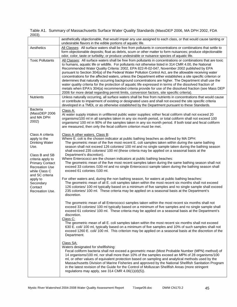
Mystic River Watershed 2004-2008 Water Quality Assessment Report 71wqar09.doc DWM CN170.2
45
Table A1. Summary of Massachusetts Surface Water Quality Standards (MassDEP 2006, MA DPH 2002, FDA 2003).
aesthetically objectionable, that would impair any use assigned to each class, or that would cause tainting or undesirable flavors in the edible portions of aquatic life.
Aesthetics All Classes: All surface waters shall be free from pollutants in concentrations or combinations that settle to form objectionable deposits; float as debris, scum or other matter to form nuisances; produce objectionable odor, color, taste or turbidity; or produce undesirable or nuisance species of aquatic life.
Toxic Pollutants All Classes: All surface waters shall be free from pollutants in concentrations or combinations that are toxic to humans, aquatic life or wildlife. For pollutants not otherwise listed in 314 CMR 4.00, the National Recommended Water Quality Criteria: 2002, EPA 822-R-02-047, November 2002 published by EPA pursuant to Section 304(a) of the Federal Water Pollution Control Act, are the allowable receiving water concentrations for the affected waters, unless the Department either establishes a site specific criterion or determines that naturally occurring background concentrations are higher. The Department shall use the water quality criteria for the protection of aquatic life expressed in terms of the dissolved fraction of metals when EPA’s 304(a) recommended criteria provide for use of the dissolved fraction (see Mass DEP 2006 for more detail regarding permit limits, conversion factors, site specific criteria).
Nutrients Unless naturally occurring, all surface waters shall be free from nutrients in concentrations that would cause or contribute to impairment of existing or designated uses and shall not exceed the site specific criteria developed in a TMDL or as otherwise established by the Department pursuant to these Standards.
Bacteria (MassDEP 2006 and MA DPH 2002)
Class A criteria apply to the Drinking Water Use. Class B and SB criteria apply to Primary Contact Recreation Use while Class C and SC criteria apply to Secondary Contact Recreation Use.
Class A: At water supply intakes in unfiltered public water supplies: either fecal coliform shall not exceed 20 organisms/100 ml in all samples taken in any six month period, or total coliform shall not exceed 100 organisms/ 100 ml in 90% of the samples taken in any six month period. If both total and fecal coliform are measured, then only the fecal coliform criterion must be met. Class A other waters, Class B: Where E. coli is the chosen indicator at public bathing beaches as defined by MA DPH:
The geometric mean of the five most recent E. coli samples taken within during the same bathing season shall not exceed 126 colonies/ 100 ml and no single sample taken during the bathing season shall exceed 235 colonies/ 100 ml (these criteria may be applied on a seasonal basis at the Department’s discretion).
Where Enterococci are the chosen indicators at public bathing beaches: The geometric mean of the five most recent samples taken during the same bathing season shall not exceed 33 colonies /100 ml and no single Enterococci sample taken during the bathing season shall exceed 61 colonies /100 ml.
For other waters and, during the non bathing season, for waters at public bathing beaches: The geometric mean of all E. coli samples taken within the most recent six months shall not exceed 126 colonies/ 100 ml typically based on a minimum of five samples and no single sample shall exceed 235 colonies/ 100 ml. These criteria may be applied on a seasonal basis at the Department’s discretion. The geometric mean of all Enterococci samples taken within the most recent six months shall not exceed 33 colonies/ 100 ml typically based on a minimum of five samples and no single sample shall exceed 61 colonies/ 100 ml. These criteria may be applied on a seasonal basis at the Department’s discretion.
Class C: The geometric mean of all E. coli samples taken within the most recent six months shall not exceed 630 E. coli/ 100 ml, typically based on a minimum of five samples and 10% of such samples shall not exceed 1260 E. coli/ 100 ml. This criterion may be applied on a seasonal basis at the discretion of the Department.
Class SA: Waters designated for shellfishing:
Fecal coliform bacteria shall not exceed a geometric mean (Most Probable Number (MPN) method) of 14 organisms/100 ml, nor shall more than 10% of the samples exceed an MPN of 28 organisms/100 ml, or other values of equivalent protection based on sampling and analytical methods used by the Massachusetts Division of Marine Fisheries and approved by the National Shellfish Sanitation Program in the latest revision of the Guide for the Control of Molluscan Shellfish Areas (more stringent regulations may apply, see 314 CMR 4.06(1)(d)(5)).
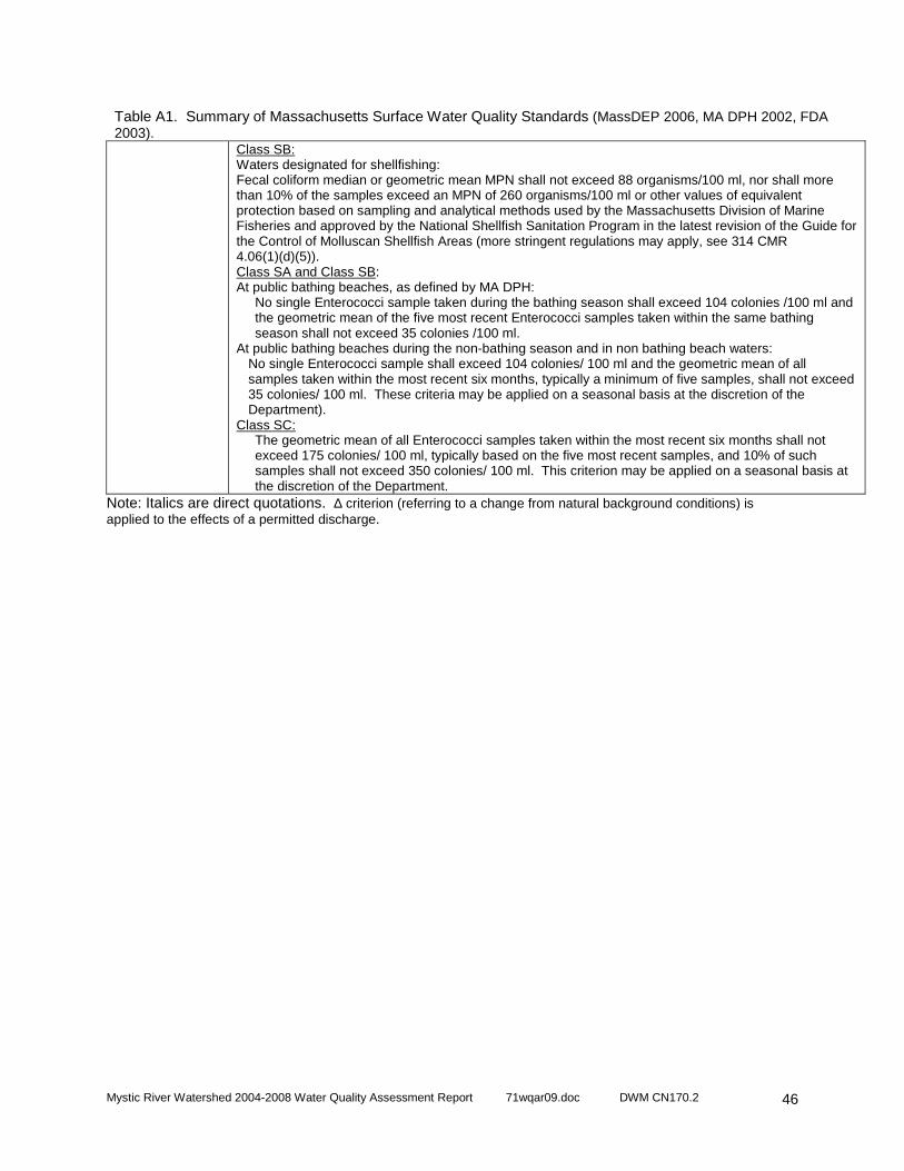
Mystic River Watershed 2004-2008 Water Quality Assessment Report 71wqar09.doc DWM CN170.2
46
Table A1. Summary of Massachusetts Surface Water Quality Standards (MassDEP 2006, MA DPH 2002, FDA 2003).
Class SB: Waters designated for shellfishing: Fecal coliform median or geometric mean MPN shall not exceed 88 organisms/100 ml, nor shall more than 10% of the samples exceed an MPN of 260 organisms/100 ml or other values of equivalent protection based on sampling and analytical methods used by the Massachusetts Division of Marine Fisheries and approved by the National Shellfish Sanitation Program in the latest revision of the Guide for the Control of Molluscan Shellfish Areas (more stringent regulations may apply, see 314 CMR 4.06(1)(d)(5)). Class SA and Class SB: At public bathing beaches, as defined by MA DPH:
No single Enterococci sample taken during the bathing season shall exceed 104 colonies /100 ml and the geometric mean of the five most recent Enterococci samples taken within the same bathing season shall not exceed 35 colonies /100 ml.
At public bathing beaches during the non-bathing season and in non bathing beach waters: No single Enterococci sample shall exceed 104 colonies/ 100 ml and the geometric mean of all samples taken within the most recent six months, typically a minimum of five samples, shall not exceed 35 colonies/ 100 ml. These criteria may be applied on a seasonal basis at the discretion of the Department).
Class SC: The geometric mean of all Enterococci samples taken within the most recent six months shall not exceed 175 colonies/ 100 ml, typically based on the five most recent samples, and 10% of such samples shall not exceed 350 colonies/ 100 ml. This criterion may be applied on a seasonal basis at the discretion of the Department.
Note: Italics are direct quotations. ∆ criterion (referring to a change from natural background conditions) is applied to the effects of a permitted discharge.

Mystic River Watershed 2004-2008 Water Quality Assessment Report 71wqar09.doc DWM CN170.2
47
DESIGNATED USES The Massachusetts Surface Water Quality Standards designate the most sensitive uses for which the surface waters of the Commonwealth shall be enhanced, maintained and protected. Each of these uses is briefly described below (MassDEP 2006): • AQUATIC LIFE - suitable habitat for sustaining a native, naturally diverse, community of aquatic flora
and fauna, including, but not limited to, wildlife and threatened and endangered species and for their reproduction, migration, growth and other critical functions. Two subclasses of aquatic life are also designated in the standards for freshwater bodies: Cold Water Fishery - capable of sustaining a year-round population of cold water aquatic life, such as trout; Warm Water Fishery - waters that are not capable of sustaining a year-round population of cold water aquatic life. In certain waters, excellent habitat for fish, other aquatic life and wildlife may include, but is not limited to, seagrass.
• FISH CONSUMPTION - pollutants shall not result in unacceptable concentrations in edible portions of marketable fish or for the recreational use of fish, other aquatic life or wildlife for human consumption.
• DRINKING WATER - used to denote those waters used as a source of public drinking water. They may be subject to more stringent regulation in accordance with the Massachusetts Drinking Water Regulations (310 CMR 22.00). These waters are designated for protection as Outstanding Resource Waters under 314 CMR 4.04(3).
• SHELLFISH HARVESTING (in SA and SB segments) – Class SA waters where designated shall be suitable for shellfish harvesting without depuration (Approved and Conditionally Approved Shellfish Areas); Class SB waters where designated shall be suitable for shellfish harvesting with depuration (Restricted and Conditionally Restricted Shellfish Areas).
• PRIMARY CONTACT RECREATION - suitable for any recreation or other water use in which there is prolonged and intimate contact with the water with a significant risk of ingestion of water. These include, but are not limited to, wading, swimming, diving, surfing and water skiing.
• SECONDARY CONTACT RECREATION - suitable for any recreation or other water use in which contact with the water is either incidental or accidental. These include, but are not limited to, fishing, including human consumption of fish, boating and limited contact incident to shoreline activities. Where designated, secondary contact recreation also includes shellfishing, including human consumption of shellfish. Human consumption of fish and shellfish are assessed as the Fish Consumption and Shellfish Harvesting uses, respectively.
• AESTHETICS - all surface waters shall be free from pollutants in concentrations or combinations that settle to form objectionable deposits; float as debris, scum or other matter to form nuisances; produce objectionable odor, color, taste or turbidity; or produce undesirable or nuisance species of aquatic life.
• AGRICULTURAL AND INDUSTRIAL - suitable for irrigation or other agricultural process water and for compatible industrial cooling and process water.
The guidance used to assess the Aquatic Life, Fish Consumption, Drinking Water, Shellfish Harvesting, Primary and Secondary Contact Recreation and Aesthetics uses follows. Note: Waterbodies affected by Combined Sewer Overflow (CSO) discharges are qualified in the standards, however, unless a variance has been granted and states otherwise, excursions from criteria are not allowed during storm events (designated uses are still applicable).
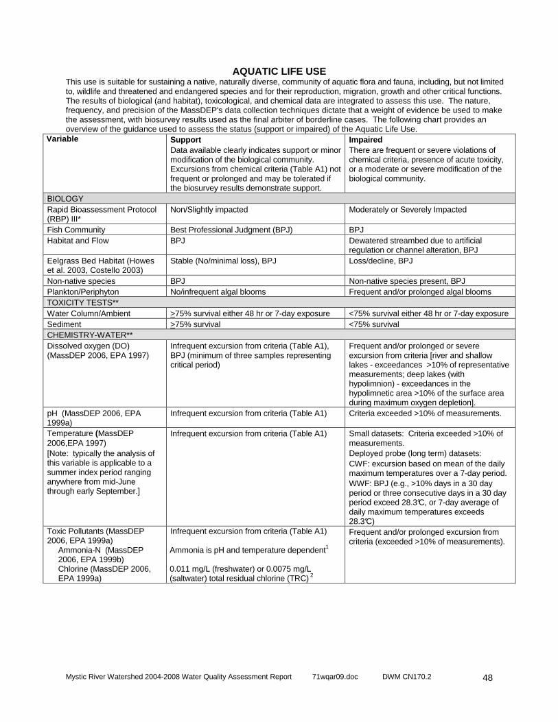
Mystic River Watershed 2004-2008 Water Quality Assessment Report 71wqar09.doc DWM CN170.2
48
AQUATIC LIFE USE This use is suitable for sustaining a native, naturally diverse, community of aquatic flora and fauna, including, but not limited to, wildlife and threatened and endangered species and for their reproduction, migration, growth and other critical functions. The results of biological (and habitat), toxicological, and chemical data are integrated to assess this use. The nature, frequency, and precision of the MassDEP's data collection techniques dictate that a weight of evidence be used to make the assessment, with biosurvey results used as the final arbiter of borderline cases. The following chart provides an overview of the guidance used to assess the status (support or impaired) of the Aquatic Life Use.
Variable
Support Data available clearly indicates support or minor modification of the biological community. Excursions from chemical criteria (Table A1) not frequent or prolonged and may be tolerated if the biosurvey results demonstrate support.
Impaired There are frequent or severe violations of chemical criteria, presence of acute toxicity, or a moderate or severe modification of the biological community.
BIOLOGY Rapid Bioassessment Protocol (RBP) III*
Non/Slightly impacted Moderately or Severely Impacted
Fish Community Best Professional Judgment (BPJ) BPJ Habitat and Flow BPJ Dewatered streambed due to artificial
regulation or channel alteration, BPJ Eelgrass Bed Habitat (Howes et al. 2003, Costello 2003)
Stable (No/minimal loss), BPJ Loss/decline, BPJ
Non-native species BPJ Non-native species present, BPJ Plankton/Periphyton No/infrequent algal blooms Frequent and/or prolonged algal blooms TOXICITY TESTS** Water Column/Ambient >75% survival either 48 hr or 7-day exposure <75% survival either 48 hr or 7-day exposure Sediment >75% survival <75% survival CHEMISTRY-WATER** Dissolved oxygen (DO) (MassDEP 2006, EPA 1997)
Infrequent excursion from criteria (Table A1), BPJ (minimum of three samples representing critical period)
Frequent and/or prolonged or severe excursion from criteria [river and shallow lakes - exceedances >10% of representative measurements; deep lakes (with hypolimnion) - exceedances in the hypolimnetic area >10% of the surface area during maximum oxygen depletion].
pH (MassDEP 2006, EPA 1999a)
Infrequent excursion from criteria (Table A1) Criteria exceeded >10% of measurements.
Temperature (MassDEP 2006,EPA 1997) [Note: typically the analysis of this variable is applicable to a summer index period ranging anywhere from mid-June through early September.]
Infrequent excursion from criteria (Table A1) Small datasets: Criteria exceeded >10% of measurements. Deployed probe (long term) datasets: CWF: excursion based on mean of the daily maximum temperatures over a 7-day period. WWF: BPJ (e.g., >10% days in a 30 day period or three consecutive days in a 30 day period exceed 28.3°C, or 7-day average of daily maximum temperatures exceeds 28.3°C)
Toxic Pollutants (MassDEP 2006, EPA 1999a)
Ammonia-N (MassDEP 2006, EPA 1999b) Chlorine (MassDEP 2006, EPA 1999a)
Infrequent excursion from criteria (Table A1)
Ammonia is pH and temperature dependent1 0.011 mg/L (freshwater) or 0.0075 mg/L (saltwater) total residual chlorine (TRC) 2
Frequent and/or prolonged excursion from criteria (exceeded >10% of measurements).

Mystic River Watershed 2004-2008 Water Quality Assessment Report 71wqar09.doc DWM CN170.2
49
AQUATIC LIFE USE (CONTINUED) CHEMISTRY-SEDIMENT** Toxic Pollutants (Persaud et al. 1993)
Concentrations < Low Effect Level (L-EL), BPJ Concentrations ≥ Severe Effect Level (S-EL) 3, BPJ
CHEMISTRY-TISSUE PCB – whole fish (Coles 1998) <500 µg/kg wet weight BPJ DDT (Environment Canada 1999)
<14.0 µg/kg wet weight BPJ
PCB in aquatic tissue (Environment Canada 1999)
<0.79 ng TEQ/kg wet weight BPJ
*RBP II analysis may be considered for assessment decision on a case-by-case basis, **For identification of impairment, one or more of the following variables may be used to identify possible causes/sources of impairment: NPDES facility compliance with whole effluent toxicity test and other limits, turbidity and suspended solids data, nutrient (nitrogen and phosphorus) data for water column/sediments. 1 Saltwater is temperature dependent only. 2 The minimum quantification level for TRC is 0.05 mg/L. 3For the purpose of this report, the S-EL for total polychlorinated biphenyl compounds (PCB) in sediment (which varies with total organic carbon (TOC) content) with 1% TOC is 5.3 ppm while a sediment sample with 10% TOC is 53 ppm.
Note: National Academy of Sciences/National Academy of Engineering (NAS/NAE) guideline for maximum organochlorine concentrations (i.e., total PCB) in fish tissue for the protection of fish-eating wildlife is 500µg/kg wet weight (ppb, not lipid-normalized). PCB data (tissue)
in this report are presented in µg/kg wet weight (ppb) and are not lipid-normalized to allow for direct comparison to the NAS/NAE guideline.
Mystic River Watershed 2004-2008 Water Quality Assessment Report 71wqar09.doc DWM CN170.2
50
FISH CONSUMPTION USE Pollutants shall not result in unacceptable concentrations in edible portions of marketable fish or for the recreational use of fish, other aquatic life or wildlife for human consumption. The assessment of this use is made using the most recent Fish Consumption Advisories issued by the Massachusetts Executive Office of Health and Human Services, Department of Public Health (MA DPH), Bureau of Environmental Health Assessment (MA DPH 2009a). The MA DPH identifies waterbodies where elevated levels of a specified contaminant in edible portions of freshwater species pose a health risk for human consumption. Hence, the Fish Consumption Use is assessed as impaired in these waters. In July 2001 MA DPH issued consumer advisories on fish consumption due to mercury contamination (MA DPH 2001). Their most recent news release on this issue in June 2009 recommends the following (MA DPH 2009b):
‘Fish Consumption Advisory for Marine and Fresh Wat er Bodies Fish is good for you and your family. It is a good source of protein and it is low in fat. It may also protect you against heart disease. A varied diet, including safe fish, will lead to good nutrition and better health. If you may become pregnant or are pregnant or nursing, you and your children under 12 years old may safely eat 12 ounces (about 2 meals) per week of fish or shellfish not covered in this advisory. This recommendation includes canned tuna, the consumption of which should be limited to 2 cans per week. Very small children, including toddlers, should eat less. Consumers may wish to choose to eat light tuna rather than white or chunk white tuna, the latter of which may have higher levels of mercury. Otherwise, it is important to follow the Safe Eating Guidelines included in this advisory.’ Safe eating guidelines for pregnant women, women wh o may become pregnant, nursing mothers and children under 12 years old: (contaminants of concern in parenthetical as noted by MA DPH and MassDEP) Do Not Eat: Freshwater fish caught in streams, rivers, lakes, and ponds in Massachusetts* (Hg) Safe To Eat: Fish that are stocked in streams, rivers, lakes, and ponds in Massachusetts Safe To Eat: Cod, haddock, flounder and pollock in larger amounts Do Not Eat: Lobster from New Bedford Harbor (PCB) Do Not Eat: Swordfish, shark, king mackerel, tilefish, and tuna steak (Hg) Do Not Eat: Bluefish caught off the Massachusetts coast (PCB) Do Not Eat: Lobsters, flounder, soft-shell clams and bivalves from Boston Harbor (PCB and other contaminants) NOTE: For assessment purposes Boston Harbor is br oadly defined to include all coastal waters that drain into it. Safe eating guidelines for everyone: Do Not Eat: Fish and shellfish from the closed areas of New Bedford Harbor (PCB) Do Not Eat: Lobster tomalley (PCB) *More specific consumption advice is available for certain freshwater bodies that have been tested at: http://www.mass.gov/dph/fishadvisories or by calling the Massachusetts Department of Public Health, Bureau of Environmental Health at 617-624-5757.
The following is an overview of EPA’s guidance used to assess the status (support or impaired) of the Fish Consumption Use. Because of the statewide advisory no waters can be assessed as support for the Fish Consumption Use. Therefore, if no site-specific advisory is in place, the Fish Consumption Use is not assessed.
Variable
Support No restrictions or bans in effect
Impaired There is a "no consumption" advisory or ban in effect for the general population or a sub-population for one or more fish species or there is a commercial fishing ban in effect.
MA DPH Fish Consumption Advisory Not applicable, precluded by statewide advisories(Hg)
Waterbody has site specific MA DPH Fish Consumption Advisory
Northeast Regional Mercury TMDL : On 20 December 2007 the U.S. EPA approved the Northeast Regional Mercury Total Maximum Daily Load (TMDL). This TMDL is a Federal Clean Water Act mandated document that identifies pollutant load reductions necessary for regional waterbodies to meet
Mystic River Watershed 2004-2008 Water Quality Assessment Report 71wqar09.doc DWM CN170.2
51
and maintain compliance with state and federal water quality standards. It was prepared by the New England Interstate Water Pollution Control Commission (NEIWPCC) in cooperation with the states of Connecticut, Maine, Massachusetts, New Hampshire, New York, Rhode Island, and Vermont. The TMDL covers inland waterbodies that are impaired primarily due to atmospheric deposition of mercury (Northeast States 2007). The TMDL target for Massachusetts is 0.3 ppm or less of mercury in fish tissue. The plan calls for a 75% reduction of in-region and out of region atmospheric sources by 2010 and a 90% or greater reduction in the future (NEIWPCC 2007). The TMDL will be reassessed in 2010 based on an evaluation of new on-going monitoring and air deposition data. Final targets will be determined at that time.
Mystic River Watershed 2004-2008 Water Quality Assessment Report 71wqar09.doc DWM CN170.2
52
DRINKING WATER USE The term Drinking Water Use denotes those waters used as a source of public drinking water. These waters may be subject to more stringent regulation in accordance with the Massachusetts Drinking Water Regulations (310 CMR 22.00). They are designated for protection as Outstanding Resource Waters in 314 CMR 4.04(3). MassDEP’s Drinking Water Program (DWP) has primacy for implementing the provisions of the federal Safe Drinking Water Act (SDWA). Except for suppliers with surface water sources for which a waiver from filtration has been granted (these systems also monitor surface water quality) all public drinking water supplies are monitored as finished water (tap water). Monitoring includes the major categories of contaminants established in the SDWA: bacteria, volatile and synthetic organic compounds, inorganic compounds and radionuclides. The DWP maintains current drinking supply monitoring data. The suppliers currently report to MassDEP and EPA the status of the supplies on an annual basis in the form of a consumer confidence report (http://yosemite.epa.gov/ogwdw/ccr.nsf/Massachusetts). Below is EPA’s guidance to assess the status (support or impaired) of the drinking water use.
Variable
Support No closures or advisories (no contaminants with confirmed exceedances of maximum contaminant levels, conventional treatment is adequate to maintain the supply).
Impaired Has one or more advisories or more than conventional treatment is required or has a contamination-based closure of the water supply.
Drinking Water Program (DWP) Evaluation
See note below See note below
Note: While this use is not assessed in this report, information on drinking water source protection and finish water quality is available at http://www.mass.gov/dep/water/drinking.htm and from local public water suppliers.
SHELLFISHING USE This use is assessed using information from the Department of Fish and Game's Division of Marine Fisheries (DMF). A designated shellfish growing area is an area of potential shellfish habitat. Growing areas are managed with respect to shellfish harvest for direct human consumption, and comprise at least one or more classification areas (MA DFG 2009). The classification areas are the management units, and range from being approved to prohibited (described below) with respect to shellfish harvest. Shellfish areas under management closures are not assessed. Not enough testing has been done in these areas to determine whether or not they are fit for shellfish harvest, therefore, they are closed for the harvest of shellfish.
Variable
Support SA Waters: Approved1 SB Waters: Approved1, Conditionally Approved2, or Restricted3
Impaired SA Waters: Conditionally Approved2, Restricted3, Conditionally Restricted4, or Prohibited5 SB Waters: Conditionally Restricted4 or Prohibited5
DMF Shellfish Project Classification Area Information (MA DFG 2000)
Reported by DMF Reported by DMF
NOTE: Designated shellfish growing areas may be viewed using the MassGIS datalayer available from MassGIS at http://www.mass.gov/mgis/dsga.htm. This coverage currently reflects classification areas as of September 30, 2009 (MA DFG 2009).. 1 Approved - "...open for harvest of shellfish for direct human consumption subject to local rules and regulations..." An approved area is open all the time and closes only due to hurricanes or other major coastwide events. 2 Conditionally Approved - "...subject to intermittent microbiological pollution..." During the time the area is open, it is "...for harvest of shellfish for direct human consumption subject to local rules and regulations…" A conditionally approved area is closed some of the time due to runoff from rainfall or seasonally poor water quality. When open, shellfish harvested are treated as from an approved area. 3 Restricted - area contains a "limited degree of pollution." It is open for "harvest of shellfish with depuration subject to local rules and state regulations" or for the relay of shellfish. A restricted area is used by DMF for the relay of shellfish to a less contaminated area. 4 Conditionally Restricted - "...subject to intermittent microbiological pollution..." During the time area is restricted, it is only open for "the harvest of shellfish with depuration subject to local rules and state regulations." A conditionally restricted area is closed some of the time due to runoff from rainfall or seasonally poor water quality. When open,

Mystic River Watershed 2004-2008 Water Quality Assessment Report 71wqar09.doc DWM CN170.2
53
only soft-shell clams may be harvested by specially licensed diggers (Master/Subordinate Diggers) and transported to the DMF Shellfish Purification Plant for depuration (purification). 5 Prohibited - Closed for harvest of shellfish.
Mystic River Watershed 2004-2008 Water Quality Assessment Report 71wqar09.doc DWM CN170.2
54
PRIMARY CONTACT RECREATION USE This use is suitable for any recreational or other water use in which there is prolonged and intimate contact with the water with a significant risk of ingestion of water during the primary contact recreation season (1 April to 15 October). These include, but are not limited to, wading, swimming, diving, surfing and water skiing. The chart below provides an overview of the guidance used to assess the status (support or impaired) of the Primary Contact Recreation Use. Excursions from criteria due to natural conditions are not considered impairment of use. Variable
Support Criteria are met, no aesthetic conditions that preclude the use
Impaired Frequent or prolonged violations of criteria and/or formal bathing area closures, or severe aesthetic conditions that preclude the use
Bacteria (105 CMR 445.000) Minimum Standards for Bathing Beaches State Sanitary Code) (MassDEP 2006)
At “public bathing beach” areas: Formal beach postings/advisories neither frequent nor prolonged during the swimming season (the number of days posted or closed cannot exceed 10% during the locally operated swimming season). Collected samples* meet the geometric mean criteria (Table A1). Shellfish Growing Area classified as “Approved by DMF.
At “public bathing beach” areas: Formal beach closures/postings >10% of time during swimming season (the number of days posted or closed exceeds 10% during the locally operated swimming season). Collected samples* do not meet the geometric mean criteria (Table A1).
Aesthetics (MassDEP 1996) - All surface waters shall be free from pollutants in concentrations or combinations that settle to form objectionable deposits; float as debris, scum or other matter to form nuisances; produce objectionable odor, color, taste or turbidity; or produce undesirable or nuisance [growth or amount] species of aquatic life
Odor, oil and grease, color and turbidity, floating matter Transparency (MA DPH 1969) Nuisance organisms
Narrative “free from” criteria met or excursions neither frequent nor prolonged, BPJ. Public bathing beach and lakes – Secchi disk depth >1.2 meters (> 4’) (minimum of three samples representing critical period). No overabundant growths (i.e., blooms) that render the water aesthetically objectionable or unusable, BPJ.
Narrative “free from” criteria not met - objectionable conditions either frequent and/or prolonged, BPJ. Public bathing beach and lakes - Secchi disk depth <1.2 meters (< 4’) (minimum of three samples representing critical period). Overabundant growths (i.e., blooms and/or non-native macrophyte growth dominating the biovolume) rendering the water aesthetically objectionable and/or unusable, BPJ.
* Data sets to be evaluated for assessment purposes must be representative of a sampling location (at least five samples per station recommended) and the season being analyzed, as described in the SWQS (see Table 1). Samples collected on one date from multiple stations on a river are not considered adequate to assess this designated use. Because of low sample frequency (i.e., less than ten samples per station) an impairment decision will not be based on a single sample exceedance (i.e., the geometric mean of five samples is < 126 E. coli colonies/100 ml but one of the five sample exceeds 235 E. coli colonies/100 ml). The method detection limit (MDL) will be used in the calculation of the geometric mean when data are reported as less than the MDL (e.g., use 20 cfu/100 ml if the result is reported as <20 cfu/100 ml). Those data reported as too numerous to count (TNTC) will not be used in the geometric mean calculation; however frequency of TNTC sample results should be presented.
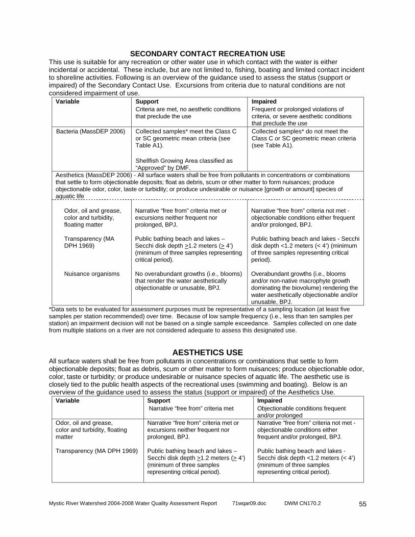
Mystic River Watershed 2004-2008 Water Quality Assessment Report 71wqar09.doc DWM CN170.2
55
SECONDARY CONTACT RECREATION USE This use is suitable for any recreation or other water use in which contact with the water is either incidental or accidental. These include, but are not limited to, fishing, boating and limited contact incident to shoreline activities. Following is an overview of the guidance used to assess the status (support or impaired) of the Secondary Contact Use. Excursions from criteria due to natural conditions are not considered impairment of use.
Variable
Support Criteria are met, no aesthetic conditions that preclude the use
Impaired Frequent or prolonged violations of criteria, or severe aesthetic conditions that preclude the use
Bacteria (MassDEP 2006) Collected samples* meet the Class C or SC geometric mean criteria (see Table A1). Shellfish Growing Area classified as “Approved” by DMF.
Collected samples* do not meet the Class C or SC geometric mean criteria (see Table A1).
Aesthetics (MassDEP 2006) - All surface waters shall be free from pollutants in concentrations or combinations that settle to form objectionable deposits; float as debris, scum or other matter to form nuisances; produce objectionable odor, color, taste or turbidity; or produce undesirable or nuisance [growth or amount] species of aquatic life
Odor, oil and grease, color and turbidity, floating matter Transparency (MA DPH 1969) Nuisance organisms
Narrative “free from” criteria met or excursions neither frequent nor prolonged, BPJ. Public bathing beach and lakes – Secchi disk depth >1.2 meters (> 4’) (minimum of three samples representing critical period). No overabundant growths (i.e., blooms) that render the water aesthetically objectionable or unusable, BPJ.
Narrative “free from” criteria not met - objectionable conditions either frequent and/or prolonged, BPJ. Public bathing beach and lakes - Secchi disk depth <1.2 meters (< 4’) (minimum of three samples representing critical period). Overabundant growths (i.e., blooms and/or non-native macrophyte growth dominating the biovolume) rendering the water aesthetically objectionable and/or unusable, BPJ.
*Data sets to be evaluated for assessment purposes must be representative of a sampling location (at least five samples per station recommended) over time. Because of low sample frequency (i.e., less than ten samples per station) an impairment decision will not be based on a single sample exceedance. Samples collected on one date from multiple stations on a river are not considered adequate to assess this designated use.
AESTHETICS USE All surface waters shall be free from pollutants in concentrations or combinations that settle to form objectionable deposits; float as debris, scum or other matter to form nuisances; produce objectionable odor, color, taste or turbidity; or produce undesirable or nuisance species of aquatic life. The aesthetic use is closely tied to the public health aspects of the recreational uses (swimming and boating). Below is an overview of the guidance used to assess the status (support or impaired) of the Aesthetics Use.
Variable
Support Narrative “free from” criteria met
Impaired Objectionable conditions frequent and/or prolonged
Odor, oil and grease, color and turbidity, floating matter Transparency (MA DPH 1969)
Narrative “free from” criteria met or excursions neither frequent nor prolonged, BPJ. Public bathing beach and lakes – Secchi disk depth >1.2 meters (> 4’) (minimum of three samples representing critical period).
Narrative “free from” criteria not met - objectionable conditions either frequent and/or prolonged, BPJ. Public bathing beach and lakes - Secchi disk depth <1.2 meters (< 4’) (minimum of three samples representing critical period).

Mystic River Watershed 2004-2008 Water Quality Assessment Report 71wqar09.doc DWM CN170.2
56
Nuisance organisms
No overabundant growths (i.e., blooms) that render the water aesthetically objectionable or unusable, BPJ.
Overabundant growths (i.e., blooms and/or non-native macrophyte growth dominating the biovolume) rendering the water aesthetically objectionable and/or unusable, BPJ.
REFERENCES
Coles, J.F. 1998. Organochlorine compounds in fish tissue for the Connecticut, Housatonic, and Thames River Basins study unit, 1992-94. USGS Water-Resources Investigations Report 98-4075. U.S. Geological Survey, National Water Quality Assessment Program, Water Resources Division, Marlborough, MA. Costello, C. 2003. Mapping Eelgrass in Massachusetts, 1993-2003. Massachusetts Department of Environmental Protection, Bureau of Resource Protection, Boston, MA. Environment Canada. 1999. Canadian Environmental Quality Guidelines [Online]. Environment Canada. Retrieved 04 November 1999 from http://www.ec.gc.ca/CEQG-RCQE/English/default.cfm updated 28 September 1998. EPA. 1997. Guidelines for Preparation of the Comprehensive State Water Quality Assessments (305(b) Reports) and Electronic Updates Report Contents. U.S. Environmental Protection Agency, Assessment and Watershed Protection Division (4503F); Office of Wetlands, Oceans, and Watersheds; Office of Water, Washington D.C. EPA. 1999a. Federal Register Document [Online]. U.S. Environmental Protection Agency, Washington, D.C. Retrieved 19 November 1999 from http://www.epa.gov/fedrgstr/EPA-WATER/1998/December/Day-10/w30272.htm. EPA. 1999b. 1999 Update of Ambient Water Quality Criteria for Ammonia. U.S. Environmental Protection Agency, Office of Water and Office of Science and Technology, Washington, D.C. and Office of Research and Development, Duluth, MN. EPA. 2002. Consolidated Assessment and Listing Methodology – toward a compendium of best practices. U.S. Environmental Protection Agency; Office of Wetlands, Oceans and Watersheds; Washington, D.C. FDA. 2003. Guide for the Control of Molluscan Shellfish 2003 Revision. [Online]. Updated 12 November 2004. United States Food and Drug Administration, Department of Health and Human Services, National Shellfish Sanitation Program. http://www.cfsan.fda.gov/~ear/nss2-toc.html. Accessed 2005 December 5. Grubbs, G.H. and R.H. Wayland III. 2000. Letter to Colleague dated 24 October 2000. EPA recommendations on the use of fish and shellfish consumption advisories and certain shellfish growing area classifications in determining attainment of water quality standards and listing impaired waterbodies under section 303(d) of the Clean Water Act. United States Environmental Protection Agency; Office of Wetlands, Oceans and Watersheds; Washington, D.C. Howes, B.L., R. Samimy, and B. Dudley. 2003. Massachusetts Estuaries Project Site-Specific Nitrogen Thresholds for Southeastern Massachusetts Embayments: Critical Indicators Interim Report Revised December 22, 2003. University of Massachusetts Dartmouth, School of Marine Science and Technology (SMAST), Coastal Systems Laboratory. New Bedford, MA and Massachusetts Department of Environmental Protection, Lakeville, MA. MassDEP. 2006. Massachusetts Surface Water Quality Standards (Revision of 314 CMR 4.00, effective December 29, 2006). Massachusetts Department of Environmental Protection, Boston, MA. MA DFG. 2009. Designated Shellfish Growing Areas Datalayer – October 2009. Published by MassGIS in October 2009. Massachusetts Department of Fish and Game, Division of Marine Fisheries, Boston, MA. MA DPH. 1969. Article 7 Regulation 10.2B of the State Sanitary Code. Massachusetts Department of Public Health. Boston, MA. MA DPH. 2001. MA DPH Issues New Consumer Advisories on Fish Consumption and Mercury Contamination. Massachusetts Department of Public Health, Bureau of Environmental Health Assessment, Boston, MA. MA DPH. 2002. 105 CMR 445.000: Minimum Standards For Bathing Beaches, State Sanitary Code, Chapter VII [Online]. Massachusetts Department of Public Health, Division of Community Sanitation Regulations and Statutes, Boston, MA. Retrieved 19 September 2002 from http://www.state.ma.us/dph/dcs/csanregs.htm.
Mystic River Watershed 2004-2008 Water Quality Assessment Report 71wqar09.doc DWM CN170.2
57
MA DPH. 2009a. Freshwater Fish Consumption Advisory List – October 2009. Massachusetts Department of Public Health, Bureau of Environmental Health Assessment, Boston, MA. (List available online @ http://www.mass.gov/Eeohhs2/docs/dph/environmental/exposure/fish_consumption_advisory_list.pdf ) MA DPH. 2009b. Massachusetts Department Of Public Health Reminds Consumers Of State Fish Advisory – June 3, 2009. Massachusetts Department of Public Health, Bureau of Environmental Health Assessment, Boston, MA. (Press release online @ http://www.mass.gov/?pageID=eohhs2pressrelease&L=4&L0=Home&L1=Government&L2=Departments+and+Divisions&L3=Department+of+Public+Health&sid=Eeohhs2&b=pressrelease&f=090603_fish_advisory&csid=Eeohhs2 ) NEIWPCC. 2007. Northeast Regional Mercury TMDL Fact Sheet October 2007. [Online]. New England Interstate Water Pollution Control Commission, Lowell, MA. Retrieved 23 January 2008 from http://www.neiwpcc.org/mercury/mercury-docs/FINAL%20Northeast%20Regional%20Mercury%20TMDL%20Fact%20Sheet.pdf. Northeast States. 2007. Northeast Regional Mercury Total Maximum Daily Load. Connecticut Department of Environmental Protection, Maine Department of Environmental Protection, Massachusetts Department of Environmental Protection, New Hampshire Department of Environmental Services, New York State Department of Environmental Conservation, Rhode Island Department of Environmental Management, Vermont Department of Environmental Conservation, New England Interstate Water Pollution Control Commission. October 24, 2007. Persaud, D., R. Jaagumagi, and A. Hayton. 1993. Guidelines for the protection and management of aquatic sediment quality in Ontario. Water Resources Branch, Ontario Ministry of the Environment, Ontario, Canada. Wayland III, R.H. 2001. Memorandum to EPA Regional Water Management Directors, EPA Regional Science and Technology Directors, and State, Territory and Authorized Tribe Water Quality Program Directors dated 19 November 2001. Re: 2002 Integrated Water Quality Monitoring and Assessment Report Guidance. U.S. Environmental Protection Agency; Office of Wetlands, Oceans and Watersheds; Washington, D.

Mystic River Watershed 2004-2008 Water Quality Assessment Report 71wqar09.doc DWM CN170.2
58
Intentionally Left Blank