national action programme · 2017-09-01 · cipseg - co-operative integrated project on savanna...
TRANSCRIPT
i
NATIONAL ACTION PROGRAMME
TO COMBAT
DROUGHT AND
DESERTIFICATION
Environmental Protection Agency Accra, Ghana
April 2002

ii
Copyright 2003 Environmental Protection Agency (EPA) Accra-Ghana
iii
FOREWORD Desertification has long been recognized as a major environmental hazard with adverse impacts on the livelihoods of people in the affected regions. In many parts of Africa, desertification has contributed to the increasing poverty of the people and the gradual but irreversible degradation of the ecosystem. Ghana has been greatly concerned about the expansion of desert conditions in most parts of the country. She has been working with the global community, international and national organizations in finding a lasting solution to this problem that threatens the livelihoods of many people. In spite of the fact that the preparation of the National Action Programme (NAP) to Combat Drought and Desertification was hampered by inadequate and outmoded data, this document puts together both desktop and field evidence in a coherent way. Evidently the gaps identified in the data sources should spur the country on to improve on data collection. This NAP is intended to highlight the nation’s efforts at achieving sustainable development and re-emphasize the support Ghana requires to fully participate in anti -desertification efforts. The preparation of this document has undoubtedly contributed to the creation of awareness about the dangers of desertification in the country. It is hoped that if the necessary resources are mobilized for the implementation of the programmes and activities identified in this document, then the nation would be strengthened and empowered to pursue sustainable development pathways. The implementation of these programmes will ensure good agricultural practices, food security, poverty alleviation and sustainable exploitation of our natural resources and ultimately lead to the achievement of the goals of the Convention on Drought and Desertification. ……………………………. PROF. KASSIM KASANGA HON. MINISTER OF ENVIRONMENT AND SCIENCE ACCRA
iv
PREFACE
The aim of this programme is to find practical steps in halting desertification in the affected areas of Ghana. This document is produced in line with the provisions of the global desertification convention and other conventions that sought to reduce the impact of drought and desertification. A broad consultative approach was adopted in arriving at the critical issues to be addressed in the Ghanaian context. These include consultative workshops in districts of the affected eight out of the ten regions of Ghana. These helped in identifying the causes of the alarming rate of desertification, which is creeping slowly southwards. Also a critical evaluation was undertaken of the experiences gained so far both in terms of policy initiatives and practical steps taken by previous governments and stakeholders in tackling the problem of desertification. Strategies envisaged could best be handled when there is integration of plans and activities between relevant institutions and stakeholders. There is the need to have active participation of affected communities to ensure the improvement in farming methods and acquisition of new skills for improvement in their economic status. It is believed that the holistic and integrated implementation of the action plans and activities hold the key to the effective management of desertification
v
ACKNOWLEDGEMENTS
The National Action Programme on Desertification is the outcome of a lot of efforts on the part of different groups of individuals and organizations over a period of more than three years. The initial document was prepared by a team of consultants led by Dr. C. Quansah of Crop Science Department, Kwame Nkrumah University of Science and Technology, with funds from the Natural Resource Management Programme (NRMP) under the supervision of the Ministry of Lands and Forestry. A consultative review forum was organized at the instance of the Environmental Protection Agency. This resulted in changes to the initial document. For the document to gain greater acceptability by the large number of stakeholders, consultations were held with Chiefs and District Assemblies in the worst affected regions of Upper East, Upper West and Northern Regions. We are grateful to a number of organisations and individuals including: The World Bank for the funding of the preparation of the National Action Programme (NAP), under the Natural Resource Management Project (NRMP),coordinated by the Ministry of Land and Forestry, the secretariat of the United Nations Convention to Combat Desertification (UNCCD) in Bonn, Germany for financial and technical support and the Permanent Interstate Committee for Drought Control in the Sahel (CILSS) based in Burkina Faso for their technical support. We acknowledge the support of Regional Ministers, District Chief Executives, Traditional Rulers, EPA Regional officers and Civil Society organisations for their input to the NAP during the district and regional sensitization and validation workshops held in forty- nine (49) districts in the eight (8) regions of the country, the National Desertification Committee and the Ministry of Lands and Forestry for facilitating the release of funds. We are also grateful to Dr. E. Dwumfour (World Bank), the Task Team Leader for the NRMP; officers of EPA - Mr. J. A. Allotey, Rev. Kingsley Tetteh, Mr. Carl Fiati, Ms. Zenabu Wasai, Mr. E. M. Telly, Mr. Asher Nkegbe, Mr. S. Osei-Amakye, Mr. E. C. Salu, Mr. S. W. Owusu, Mr. I.C Acquah, Mr. E. Tachie Obeng, Dr. David Millar, coordinator (SRMP) and Dr. G. Agyepong (NAFGIM) for putting together the final document. Secretarial support by Mrs Cynthia Addo is appreciated. To all these people we say thank you. The contributions of all these people were critical in defining the content and structure of this book and their efforts are gratefully acknowledged.
vi
ACRONYMNS ADB - African Development Bank ADRA - Adventist Relief Agency AEA - Agricultural Extension Agent AGDP - Agricultural Gross Domestic Product AGSSIP - Agricultural Sector Services Investment Programme ASIP - Agricultural Sector Improvement Project ASNAPP - Agribusiness in Sustainable Africa Plant Products CBOs - Community Based Organizations CCD - Convention to Combat Desertification CEMC - Community Environment Management Committee CERSGIS - Centre for Remote Sensing and Geographic Information Services CI - Conservation International CIDA - Canadian International Development Agency CILSS - Permanent Interstate Committee for Drought Control in the Sahel CIPSEG - Co-operative Integrated Project on Savanna Ecosystems of Ghana CLW - Community Livestock Worker CSIR - Council for Scientific and Industrial Research CWBPV - Community Water Body Protection Volunteers DA - District Assembly DANIDA - Danish International Development Agency DEMC - District Environment Management Committee DFID - Department for International Development DPZ - Desertification –Prone Zone ECOWAS - Economic Community of West Africa States EIS - Environmental Information Systems EISD - Environmental Information Systems Development EPA - Environmental Protection Agency EPC - Environmental Protection Council EU - European Union FAO - Food and Agriculture Organization FARMP - Fuelwood and Alternative Energy Resources Management Project FRMP - Forest Resources Management Project GCM - General Circulation Models GDP - Gross Domestic Product GPS - Global Positioning System GEF - Global Environmental Facility GERMP - Ghana Environmental Resources Management Project GES - Ghana Education Service GIS - Geographical Information System GLASOD - Global Assessment of Soil Degradation GLSS - Ghana Living Standards Survey GM - Global Mechanism
vii
GNFS - Ghana National Fire Service GoG - Government of Ghana GSS - Ghana Statistical Service GWSC - Ghana Water and Sewerage Corporation IFAD - International Fund for Agricultural Development ILMAD - Institute of Land Management and Development INCD - Inter-governmental Negotiating Committee IRI - Industrial Research Institute IRNR - Institute of Renewable Natural Resources ISSER - Institute of Social Statistical and Economic Research ITO - International Timber Organisation ITTO - International Tropical Timber Organisation IWM - Integrated Watershed Management JSS - Junior Secondary School KNUST - Kwame Nkrumah University of Science and Technology LACOSREP - Land Conservation and Rehabilitation Project LADF - Local Area Development Fund LPG - Liquid Petroleum Gas LPIU - Livestock Planning and Information Unit LWMP - Land and Water Management Project MES - Ministry of Environment and Science MIS - Management Information System MLF - Ministry of Lands and Forestry MOFA - Ministry of Food and Agriculture MOH - Ministry of Health MSLC - Middle School Leaving Certificate MTADP - Medium Term Agricultural Development Programme MW - Mega Watts NADMO - National Disaster Management Organisation NAFGIM - National Framework for Geo-spatial Information Management NAP - National Action Programme NCB - National Co-ordinating Body NCWD - National Council on Women and Development NDF - National Desertification Fund NEAP - National Environmental Action Plan NGOs - Non Governmental Organisations NLSP - National Livestock Services Project NORRIP - Northern Regional Rural Integrated Project NOEP - Non – agricultural and Off-term Enterprises Project NPACD - National Plan of Action to Combat Desertification NRMP - Natural Resources Management Project NSBCP - Northern Savanna Biodiversity Conservation Project NSCB - National Secretariat to Combat Desertification NTPs - Non-Timber Products PACD - United Nations Plan of Action to Combat Desertification PE - Evapotranspiration
viii
P/PE - Precipitation /Potential Evapotranspiration PLEC - People, Land Management and Environmental Change PPMED - Policy Planning, Monitoring and Education Department PNDC - Provisional National Defence Council PTA - Participatory Technology Approach RCA - Replacement Cost Approach RCC - Regional Co-ordinating Council RELC - Research Extension Linkage Committee RSAU - Remote Sensing Applications Unit SDI - Spatial Data Infrastructure SRI - Soil Research Institute SRMP - Savannah Resource Management Project TLU - Tropical Livestock Unit TNS - TechnoServe UNCCD - United Nations Convention to Combat Desertification UNCED - United Nations Conference on Environment and Development UNCOD - United Nations Conference on Desertification UNDP - United Nations Development Programme UNEP - United Nations Environmental Programme UNESCO - United Nations Educational, Scientific and Cultural Organisation UNFCCC - United Nations Framework Convention on Climate Change UNICEF - United Nations Information, Cultural and Educational Fund UNSO - United Nations Sudano-Sahelian Office UWADEP - Upper West Agricultural Development Programme VIP - Village Infrastructure Project VRA - Volta River Authority WATSAN - Water and Sanitation WMO - World Meteorological Organization WRAMUP - Water Resources Assessment, Monitoring and Utilization Project WRC - Water Resources Commission WRI - World Resources Institute WRRI - Water Resources Research Institute
ix
TABLE OF CONTENTS
Page
FOREWORD.. .. .. .. .. .. .. .. iii PREFACE .. .. .. .. .. .. .. .. iv ACKNOWLEDGEMENT .. .. .. .. .. .. v ACRONYMNS .. .. .. .. .. .. .. v LIST OF TABLES .. .. .... .. .. .. .. ix LIST OF MAPS .. .. .... .. .. .. .. x LIST OF ANNEXES .. .. .. .. .. .. .. x EXECUTIVE SUMMARY .... .. .. .. .. .. 1 1.0 INTRODUCTION. ……………………………………………………… ...1 1.1 Genesis of CCD………………………………….……………………..…… ....1 1.2 Definition of Desertification in the UNCCD……………………..…………..…..2 1.3 Convention to Combat Desertification…………………..………………..….…..3 1.4 Objective of the Convention………………………………………………..….....4 1.5 Obligations under the Convention…………………………………………….....4 1.6 CCD Approach for preparation of NAP………………………………………....5 1.7 NAP to Combat Desertification in Ghana……………………………….…. …..6 1.7.1 Background………………………………………………………………..……..6 1.7.2 Objectives of Survey…………………………..………………………………....7 1.7.3 Methodology……………………………………………………………………..8 1.7.4 Structure of the Report…………………..………………………………… …...9 1.8.0 Past Experience in Combating Desertification and Mitigation The Effect of Drought Historical ………………………………………… ….....9 1.8.1 Conservation as an Official Policy and Practice……………………………. ….9 1.8.2 Forest Reservation ………………………………………………………..…....10 1.8.3 The Land Planning Approach ……………………………………………….....10 1.8.4 The Immediate Post-Independence Experience……………………………..….12 1.8.5 The National Environmental Action Plan (NEAP)………………………..… ...12 1.8.6 The Ghana Environmental Resource Management Project (GERMP)…… .….13 1.8.7 The Land and Water Management Project (LWMP)………………….……. 14 1.8.8 Savanna Resource Management Project (SRMP)………………………….….14 1.8.9 The Co-operative Integrated Project on Savanna Ecosystems of Ghana(CIPSEG)………………………………………………..……….......15 1.9.0 Policies, Legislation and Strategies…………………………………….….….16 1.9.1 Policies………………………………………………………………………...16 1.9.2 The Environmental Policy………………………………………………..……17 1.9.3 The Forest and Wildlife Policy………………………………………….…….18 1.9.4 The Land Policy ……………………………………………………….……...19 1.10 Lessons from Previous Efforts to Combat Desertification…………………....20 1.10.1 Elements of Policy…………………………………..…………………….…..20 1.10.2 Elements of Strategy…………..……………………………………………....21 1.10.3 Spatial Unit for Planning………………………...………………………….…21 1.10.4 Continuity of Programmes and Projects……………………………..……….22
x
2.0 BIO-PHYSICAL AND SOCIO-ECONOMIC CONDITIONS…………...23 2.1 Location……………………………………….………………….…..………..23 2.2 Bio-physical Conditions………………………..……………………….……..24 2.2.1 Climate………………………………………………………………….……...24 2.2.1.1 Rainfall Erosivity……………………………………………………….…......25 2.2.2 Vegetation and Agro-ecological zones…………………………………….......25 2.2.2.1 Sudan Savanna zone………………………………… ……………….….…....26 2.2.2.2 Guinean Savanna zone…………………………………………………...….....28 2.2.2.3 The Coastal Savanna zone…………………………………………………......28 2.2.2.4 The Forest –Savanna Transitional Zone (Derived Savanna) ……………….....28 2.2.2.5 The High Rainforest…………………………………………………………...29 2.2.2.6 The Semi-deciduous Forest………………………………………….…..….….29 2.2.2.7 The Rangelands of Ghana……………………………………….…………......30 2.2.3 Topography……………………………………………………....….…….…..30 2.2.4 Geology…………………..………………………………………..…...…..... 30 2.2.5 Soils……...……………...……………………………………..………….…..33 2.2.6 Water Resources………..…………………………………….……………….34 2.2.6.1 Rainfall…………………….…………………………………………..……...34 2.2.6.2 Rivers and Runoff yield……………………………………………..………..34 2.2.6.3 Reservoirs. ………………………………………………………..….….……35 2.2.6.4 Groundwater Resources………………………………………….….…….….35 2.2.6.5 Water Supply for Irrigation…………………………………………….…..…38 2.3 Socio-economic Conditions…………………………………….…………......41 2.3.1 The Agricultural Sector……………………..……………………………....…41 2.3.2 Human Population……………………………………………..……………..42 2.3.3 Livestock Population……………………………………..………………......43 2.4.0 Factors, Processes And Impacts of Desertification……………………….....44 2.4.1 Processes of Desertification……………………………………………….....44 2.4.1.1 Soil Erosion and Physical Degradation……………………………………....44 2.4.1.2 Soil Chemical and Biological Degradation………………………..………....46 2.4.1.3 Salinity……………………………………………………………….……....47 2.4.1.3 Water logging………………………..…………………...………….….……47 2.4.2 Factors leading to desertification and contributing to drought………….…...48 2.4.2.1 Bio-physical Factors………………………………………………….….…..48 2.4.2.1.1 Extremes of Textures. ……………………………………………………….48 2.4.2.1.2 Inherent Low Soil Fertility…………………………………………………...48 2.4.2.1.3 Salt Intrusion……………………………..……………………………….….49 2.4.2.1.4 Relief………………..………………………………………………………..49 2.4.2.1.5 Climate……………………………………………………………….……....49 2.4.2.1.6 Drought………………………………………………………………………50 2.4.2.2 Socio-Economic Factors……………………………………………………..51 2.4.2.2.1 Population………………………………………….….………….……….....51 2.4.2.2.2 Cultivation……………………………………………………………….…..51 2.4.2.2.3 Deforestation………………………………………………………………...52 2.4.2.2.4 Overgrazing…………………………………………………………………..52
xi
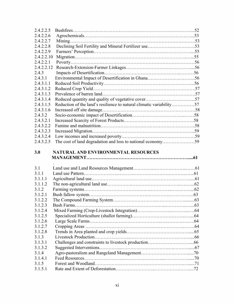
2.4.2.2.5 Bushfires……………………………………………………………………..52 2.4.2.2.6 Agrochemicals………………………………………………………….…...53 2.4.2.2.7 Mining……………………………………………………………………….53 2.4.2.2.8 Declining Soil Fertility and Mineral Fertilizer use………………………….53 2.4.2.2.9 Farmers’ Perception………………………………………………………....55 2.4.2.2.10 Migration……………………………………………………………….…...55 2.4.2.2.1 Poverty………………………………………………………………………56 2.4.2.2.12 Research-Extension-Farmer Linkages……………………………………....56 2.4.3 Impacts of Desertification…………………………………………..………56 2.4.3.1 Environmental Impact of Desertification in Ghana………………………….56 2.4.3.1.1 Reduced Soil Productivity…………………………………………………...56 2.4.3.1.2 Reduced Crop Yield………………………………………………………….57 2.4.3.1.3 Prevalence of barren land…………………………………………………….57 2.4.3.1.4 Reduced quantity and quality of vegetative cover…………………………...57 2.4.3.1.5 Reduction of the land’s resilience to natural climatic variability……………57 2.4.3.1.6 Increased off site damage…………………………………………………….58 2.4.3.2 Socio-economic impact of Desertification……………………………..……58 2.4.3.2.1 Increased Scarcity of Forest Products……………………………………….58 2.4.3.2.2 Famine and malnutrition……………………………………………………..58 2.4.3.2.3 Increased Migration………………………………………………………….59 2.4.3.2.4 Low incomes and increased poverty…………………………………………59 2.4.3.2.5 The cost of land degradation and loss to national economy…………………59 3.0 NATURAL AND ENVIRONMENTAL RESOURCES MANAGEMENT………………………………………………………….....61 . 3.1 Land use and Land Resources Management…………...………………...……61 3.1.1 Land use Pattern…………………..…………………………….………..…...61 3.1.1.1 Agricultural land use……………………………………………….……….....61 3.1.1.2 The non-agricultural land use……………..…………………………..….…...62 3.1.2 Farming systems……………………………….…….…………..…………....62 3.1.2.1 Bush fallow system………………………………….………….…………….63 3.1.2.2 The Compound Farming System………………………..……………….........63 3.1.2.3 Bush Farms……………………………………………….…..…………..…...63 3.1.2.4 Mixed Farming (Crop-Livestock Integration)…………………..………...….64 3.1.2.5 Specialized Horticulture (shallot farming)……………………………..…....64 3.1.2.6 Large Scale Farms………………………………………..…..……….….….64 3.1.2.7 Cropping Areas ………………………………………………………..…….64 3.1.2.8 Trends in Area planted and crop yields……………………………….…......65 3.1.3 Livestock Production…………………...…………………………………....66 3.1.3.1 Challenges and constraints to livestock production………………………....66 3.1.3.2 Suggested Interventions…………...………………………….….………......67 3.1.4 Agro-pastoralism and Rangeland Management…………………………......70 3.1.4.1 Feed Resources……………………...……………………...……………......70 3.1.5 Forest and Woodland………………………………………………….…......71 3.1.5.1 Rate and Extent of Deforestation……………………..…………….…….....72
xii
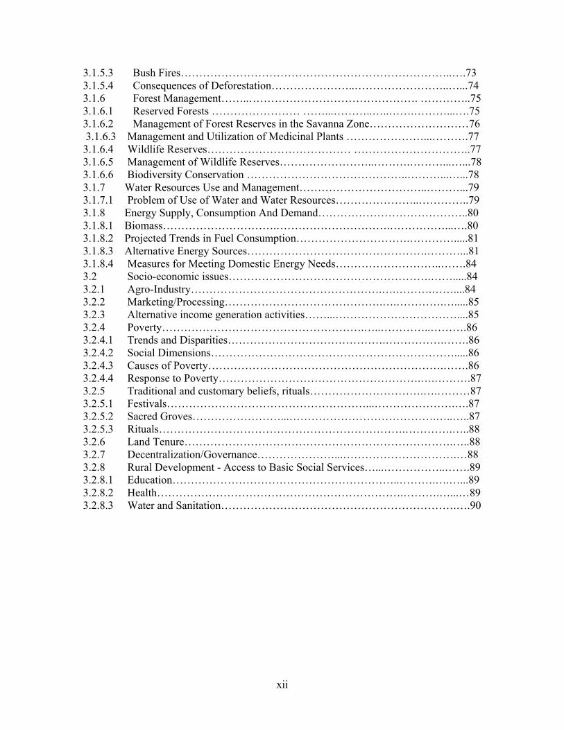
3.1.5.3 Bush Fires………………………………………………………………..….73 3.1.5.4 Consequences of Deforestation…………………..……………………..…...74 3.1.6 Forest Management……..………………………………………. …………..75 3.1.6.1 Reserved Forests …………………… ……...………..…..…….………...….75 3.1.6.2 Management of Forest Reserves in the Savanna Zone………………………76 3.1.6.3 Management and Utilization of Medicinal Plants …………………...……….77 3.1.6.4 Wildlife Reserves………………………………… …………………………..77 3.1.6.5 Management of Wildlife Reserves……………………..……….………...…...78 3.1.6.6 Biodiversity Conservation ……………………………………..………...…...78 3.1.7 Water Resources Use and Management……………………………..………...79 3.1.7.1 Problem of Use of Water and Water Resources…………………..…………..79 3.1.8 Energy Supply, Consumption And Demand…………………………………..80 3.1.8.1 Biomass………………………….………………………….……………...….80 3.1.8.2 Projected Trends in Fuel Consumption………………………….………….....81 3.1.8.3 Alternative Energy Sources………………………………………….………...81 3.1.8.4 Measures for Meeting Domestic Energy Needs………………………..…….84 3.2 Socio-economic issues……………………………………………….…….....84 3.2.1 Agro-Industry…………………………………………….….……….……....84 3.2.2 Marketing/Processing…………………………………….….………….….....85 3.2.3 Alternative income generation activities……...……………………………....85 3.2.4 Poverty……………………………………………….…..…………..……….86 3.2.4.1 Trends and Disparities…………………………………….…………….…….86 3.2.4.2 Social Dimensions………………………………………………………….....86 3.2.4.3 Causes of Poverty……………………………………………………….…….86 3.2.4.4 Response to Poverty……………………………………………….….……….87 3.2.5 Traditional and customary beliefs, rituals………………………….….………87 3.2.5.1 Festivals………………………………………………...………………….….87 3.2.5.2 Sacred Groves……………………...………………………………….…..…..87 3.2.5.3 Rituals………………………………………………………….………….…..88 3.2.6 Land Tenure……………………………………………………………….…..88 3.2.7 Decentralization/Governance…………………...………………………….…88 3.2.8 Rural Development - Access to Basic Social Services…...……………..…….89 3.2.8.1 Education……………………………………………………..……….….…...89 3.2.8.2 Health………………………………………………………….……….…...…89 3.2.8.3 Water and Sanitation……………………………………………………….….90

xiii
4.0 PROPOSED NATIONAL ACTION PROGRAMME TO COMBAT
DESERTIFICATION AND MITIGATE THE EFFECTS OF DROUGHT...…………………………………………….………………..……91
4.1 Rationale for Combating Desertification in Ghana…………..……..………....91 4.2 Sustainable Management and Conservation of Natural Resource ..……...92 4.3 The Watershed as a Spatial Unit for Planning Actions to Combat Desertification.93 4.4 Action Programme for Land use and Soil Management……………….………...94 4.4.1 Action Plan for Land use Planning……………………………………………....94 4.4.2 Action Plan for Soil and Water Conservation………………………….………...96 4.4.3 Soil Fertility Management Action Plan………………………………….…........97 4.4.4 Action Plan for Mining Activities…………………………………………… ….98 4.5 Action Programme for Management of Vegetative Cover…………………… ....99 4.5.1 Action Plan for the Management of Forest and Woodland………………….…..99 4.5.2 Action Plan for Rangeland Management………………………………………..101 4.5.3 Action Plan for Bushfire Management…………………………………….....…101 4.6 Action Programme for Wildlife and Biodiversity……………….……….....….103 4.7 Action Programme for Water Resources Management………………………....104 4.7.1 Water Resources Assessment, Monitoring and Usage Action Plan………….....104 4.7.2 Protection of Water Bodies Action Plan………………………………………...107 4.8 Action Programme for Rural Infrastructure Development ………………..…....107 4.8.1 Action Plan for Provision of Basic Infrastructure…………………….………....107 4.9 Action Programme for Energy Resources Management……………………...…109 4.9.1 Action Plan for Fuel Wood and Alternative Energy Resources Management. ..109 4.10 Action Programme for Improvement for Poverty Reduction…… …………...110 4.10.1 Action Plan for Improvement of Agricultural Production and Yield…………..110 4.10.2 Action Plan for Development of Markets for Agricultural Products…………..112 4.10.3 Action Plan for Creating Financial and Incentive Instruments………………..113 4.10.4 Action Plan for Agricultural Diversification……………………………….….114 4.10.5 Action Plan for Non-agricultural and Off-farm Enterprises………….…..……114 4.10.6 Action Plan for Reduction of Population Pressure on Land………...…………115 4.10.7 Food Security Action Plan……………………………………….…………….116 4.10.8 Action Plan for Promotion of Access to Inputs of Production… …….....…….117 4.10.9 Action Plan for Capacity Building, Training and Public Awareness…….……119 4.10.10 Action plan for Drought Management and Mitigation……………………….120

xiv
5.0 INSTITUTIONAL FRAMEWORK FOR THE IMPLEMENTATION OF NAP AND THE COST ESTIMATES OF PROJECTS 5.1 Decentralized Governance…………………………………………..……….....121 5.2 Institutional Framework at the Local Level………………….………………....121 5.3 National Desertification Committee (NDC)……………..……………………..122 5.4 Stakeholders And Their Involvement In The Nap Process……………..……...124 5.5 Funding Mechanisms…………………..…………………………………..…...125 5.6 Estimated Cost of the Various Project…………………….……………..…..…127 References………………………………………………………………… . …..……...137 Annexes……………………………………………………………………… . ..….…..145

xv
LIST OF TABLES
Table 1: Classification of the Regions on the basis of Aridity Index P 3 Table 2: Runoff yields and their variations in the main River Basins P35 Table 3: Aquifer Horizons and Yield of some Ghanaian rocks P 37 Table 4: Irrigation Potential and Stages of Development of
various projects P 39 Table 5: Population of Ghana by Region, 2000 and 1984 P43 Table 6 Ruminant population distribution (1996) P44 Table 7 Erosion on bare plots within the ecological zones of Ghana P46 Table 8 Land Use (General) P61 Table 9 Area Planted to selected food crops (1990-1992) to (1994 - 1996) P65 Table 10 Yield of Crops (t/ha) P65 Table 11 Estimated Regional Ruminant Feed Resources and
Carrying Capacities in Northern Ghana P71 Table 12 Area covered by Forests, Savanna and Reserves P72 Table 13 Reserved Forests of Ghana by Categories P76 Table 14 Projections of fuel consumption (‘000 tonnes) 1995-2000 P81 Table 15 Solar Photovoltaic Applications in Ghana (March, 1994) P82 Table 16 Inventory of Digesters in Ghana P83 Table 17 Biogas Potential by Region P83
xvi
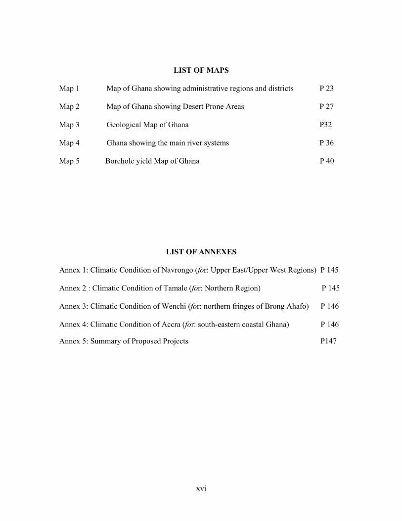
LIST OF MAPS Map 1 Map of Ghana showing administrative regions and districts P 23 Map 2 Map of Ghana showing Desert Prone Areas P 27 Map 3 Geological Map of Ghana P32 Map 4 Ghana showing the main river systems P 36 Map 5 Borehole yield Map of Ghana P 40
LIST OF ANNEXES Annex 1: Climatic Condition of Navrongo (for: Upper East/Upper West Regions) P 145 Annex 2 : Climatic Condition of Tamale (for: Northern Region) P 145 Annex 3: Climatic Condition of Wenchi (for: northern fringes of Brong Ahafo) P 146 Annex 4: Climatic Condition of Accra (for: south-eastern coastal Ghana) P 146 Annex 5: Summary of Proposed Projects P147
1
EXECUTIVE SUMMARY
2
1.0 INTRODUCTION…………………………………….………...…………..……………3 1.1 Objectives …………………………………………………………………...…………….4 1.2 Methodology……………………………………………………………….…….………..5 2.0 BIOPHYSICAL AND SOCIO ECONOMIC CONDITIONS……..……………..6 2.1 Location…………………………...……………………………………………………...6 2.2 Bio physical Conditions ………………………………………...…………….…….….6 2.2.1 Climate……………..………………………………..………………………………..…..6 2.2.2 Vegetation and Agro ecological Zones……………………..……….………..………7 2.2.3 Topography………...…………………………………………………………..………...8 2.2.4 Soils……………………..……………………………………………….…………….. ...8 2.2.5 Water Resources……………………..…………………………………...….…..….…..8 2.3 Socio- Economic Conditions………………………………..….……...……..….…….9 2.3.1 Agricultural Sector……………………………………………………...…….…….…..9 2.3.2 Human Population ……………………………..………………………….…..….…....9 2.3.3 Livestock Population……………………………..…………….…………...…………10 2.3.4 Agro Industry………………………..…………………………..……………………..10 2.3.5 Marketing……………………………………………………..…..…………………….10 2.3.6 Alternative Income Generation Activities……………………………..………..…..11 2.3.7 Poverty………………………………...…………….….…………………….………...11 2.3.8 Rural Infrastructure Development………………………..………………………….12 2.3.9 Access to Inputs of Production…………………………………..……………….…..12 2.3.10 Agricultural Diversification………………..………………….…………….……..…13 2.3.11 Food Security……..………………………………………………………....…….……13 2.3.12 Capacity Building, Training and Awareness Creation……………………..….….13 2.3.13 Drought Management and Mitigation……………..……….………….…….……...14 2.4 Extent, Factors, Processes and Impacts of Desertification……………………….14 2.4.1 Extent of Desertification in Ghana…………………………………………………..14 2.4.2 Processes of Desertification ……………………………………………..……….…..15 2.4.3 Factors leading to Desertification……………………..……………………….…....16 2.5 Impacts of Desertification in Ghana……………………..…………………..….…..16 2.5.1 Environmental Impacts…………………………………………………..…….……...16 2.5.2 Socio Economic Impacts……………………………………………………….……....17 2.6 Desertification Monitoring and Assessment and Drought Early Warning…..…..17 2.6.1 The Need for Assessment and Monitoring of Natural Resources…….….………..17
3
3. PROPOSED NATIONAL ACTION PROGRAMME TO COMBAT
DESERTIFICATION……………………………………………..………..……….…19 3.1 Context……………………………………………………..……………...…………….19 3.2 Approaches and Strategy of the NAP……………………….……………..…..…….19 3.3 National Action Programme to Combat Desertification…………….…………….22 4 PHASING AND ESTIMATED COST OF THE NAP TO COMBAT
DESERTIFICATION……………………………………………………… ….…….30 4.1.1 Phases ………………………………………………...………………….………….….30 4.1.2 Estimated Costs…………………………………..…………….………………………30 4.2 A Structure for the Implementation of the NAP…………..………………………...31 4.3 Partnership Building and Resource Mobilization…………..………………………33 4.4 Funding Mechanisms………………………………..……………………...…….……33
4
1.0 INTRODUCTION Desertification has long been recognized as a major environmental problem with adverse impacts on the livelihoods of people in the affected areas of the world. The global concern about the scourge of desertification led to the organization of a United Nations Conference on Desertification (UNCOD) in 1977 which made a recommendation for a United Nations Plan of Action to Combat Desertification (PACD). In Ghana, the experience of continuous drought conditions in 1982/83 causing wild bush fires throughout most parts of the country causing extensive damage to farms, forest, flora and fauna and the land. . The Environmental Protection Council (EPC) set in motion an action plan to solicit international support to find a lasting solution to the problem. Ghana applied to the UN General Assembly to be included in the list of countries, which benefited from UN Sudano-Sahelian (UNSO) assistance in December 1983 to combat drought and the threat of desertification. The United Nations General Assembly passed resolution 39/68B (1983) accepting Ghana’s application. In 1984, the Governing Council of United Nations Environmental Programme (UNEP) and the United Nations Development Programme (UNDP) added Ghana to the list of countries eligible to receive assistance through the United Nations Sudano-Sahelian office (UNSO) in combating desertification. The EPC was charged with the responsibility of developing a national plan of action to combat effects of drought and desertification in line with the recommendations of the UNEP. With the support of UNSO, Ghana was able to prepare a National Plan of Action to Combat Desertification (NPACD) in 1987. At the Earth Summit of 1992 held in Rio de Janeiro, Brazil, it was recommended that an Inter-governmental Negotiating Committee be established by the UN General Assembly to prepare a convention to combat desertification for countries experiencing serious drought and desertification particularly in Africa. The convention was adopted on 17th June 1994 in Paris and came into force on 26th December 1996. Ghana ratified the convention on 27th December 1996. As a signatory to the Convention, Ghana was obliged to prepare a National Action Programme to Combat Desertification and mitigate the effects of drought. Consequently the first National Plan of Action to Combat Desertification (NPACD) was prepared in 1987. The NPACD made several proposals but the emphasis was on assessment and monitoring of the country's natural resources and the drawing up of a National Environmental Action Plan (NEAP) to tackle the broader environmental issues of Ghana.
5
Although some of the proposals have been implemented, it was felt that between 1987 and 2001, the circumstances have changed to warrant a revision and update of the 1987 NPACD to capture the current situation on the ground. This underscores the commissioning of a team of consultants of the Department of Crop Science, KNUST, to undertake a study to recast the National Action Programme to Combat Desertification in the context of the current circumstances in Ghana. The National Action Programme to Combat Drought and Desertification is for convenience referred to as the National Action Programme to Combat Desertification (NAP) in the text. 1.1 Objectives of the Study The purpose of the study was to develop, in line with the provisions of the global desertification convention, a National Action Programme (NAP) for Ghana through a broader consultative approach by identifying the causes of the alarming rate of desertification and impacts at local, national, international and global levels and recommending possible prevention and remedial actions for implementation to reduce the impact of drought on the country and to halt the rate of desertification in the country. The overall objective of the NAP is to emphasize environmentally sound and sustainable integrated local development programmes for drought prone semi-arid and arid areas, based on participatory mechanisms, an integration of strategies for poverty alleviation and other sector programmes including forestry, agriculture, health, industry and water supply into efforts to combat the effects of drought. 1.2 Methodology The study was in four parts, namely • Desk study • Field study • District and Regional Consultative Workshops on desertification and drought • National stakeholder Workshop to finalize the NAP

6
2.0 BIO-PHYSICAL AND SOCIO ECONOMIC CONDITIONS 2.1 Location Ghana lies between latitudes 4o 44' and 11o 15' N and longitudes 3o 15' W and 1o 12' E with a land area of 238,539 km2. Administratively, the country is divided into ten regions and one hundred and ten Districts with Accra as the capital. 2.2 Bio-physical conditions 2.2.1 Climate The Sudan Savanna zone is characterized by a uni-modal rainfall regime lasting 5-6 months and a long dry period of 6 - 7 months in a year. Average annual rainfall, temperature, relative humidity, wind speed, sunshine hours and solar radiation are 885 mm, 28.6oC, 54%, 81 km/day, 7.9 hours and 20.4 MJ/m2/day respectively. Potential evaporation is 1652 mm per annum and the annual aridity index is 0.60. The Guinea savanna experiences a similar rainfall pattern as in the Sudan Savanna zone. Average annual rainfall, temperature, relative humidity, wind speed, sunshine hours and solar radiation are 1033 mm, 28.1oC, 61%, 138 km/day, 7.3 hours and 19.6 MJ/m2/day respectively. Potential evaporation is 1720 mm per annum and the annual aridity index is 0.60. Rainfall in the Coastal Savanna zone is bimodal with an annual average of about 810 mm. Average annual aridity index, temperature, relative humidity, wind speed, sunshine hours and solar radiation are 0.54, 27.1oC, 81%, 251 km/day, 6.5 hours and 18.6 MJ/m2/day respectively. Annual potential evaporation is about 1504 mm. The Forest-Savanna Transitional zone is characterized by bimodal rainfall regime with an annual total of 1250 mm and a potential evapotranspiration of about 1430 mm. The annual aridity index is 0.87. Average annual temperature, relative humidity, wind speed, sunshine hours and solar radiation are 26oC, 75%, 133 km/day, 6.2 hours and 18.1 MJ/m2/day. In all the ecological zones, rainfall is generally accompanied by high intensities and energy loads. The rains are therefore highly erosive. 2.2.2 Vegetation and Agro-ecological zones Ghana is divided into six agro-ecological zones, namely Sudan, Guinea and Coastal Savanna zones, the Forest-Savanna Transitional zone, the Semi-deciduous Forest and the High Rainforest Zones. The desertification-prone zones cover the first four agro-ecological zones.

7
The Sudan Savanna covers an estimated area of 1,900 km2 and consists of short drought and fire resistant deciduous trees interspersed with open savanna grassland. Grass cover is very sparse and in most areas the land is bare and severely eroded. The Guinea Savanna covers almost the northern two-thirds of the country with an area of 147,900 km2. The vegetation consists typically of a ground cover of grasses of varying heights interspersed with fire resistant, deciduous, broad-leaved trees at the forest margins. This grades into a more open grassland with widely spaced shorter trees towards the north. The Coastal Savanna covers an estimated area of 4500 km2. It consists of mainly grassland interspersed with dense thickets often less than 5m high with a few trees. Short and medium grasses are the dominant species. The Forest-Savanna Transitional Zone (Derived Savanna) covers about 8,300 km2. Most of the trees species, similar to those in the forest zone, occur in association with tall to medium tall grasses. 2.2.3 Topography The topography is gently undulating and low in relief with slopes of 3 to 4 percent dominating. Most of the area lies between 153 and 244 meters above sea level. Under the climax vegetation the slopes are stable. However when the vegetation is cleared conditions become unstable and high rates of erosion are inevitable 2.2.4 Soils The major soils are Lixisols, Acrisols, Nitisols, Luvisols, Lithosols, Plinthosols, Gleysols and Cambisols. Alluvial soils (Fluvisols) and eroded shallow soils (Leptosols) are found in all the ecological zones. Most of the soils are developed on thoroughly weathered parent materials. Their organic matter content, buffering capacity and cation exchange capacity are low. The soils are consequently of low inherent fertility with nitrogen and phosphorus as the most deficient nutrients. Many of the soils have predominantly light textured surface horizons, heavier textured soils being confined to the valley bottoms and the Accra Plains. In the savanna zones there are extensive areas of ironpan and shallow concretionary and rocky soils which have low water holding capacities and limited suitability for agriculture. 2.2.5 Water Resources The major sources of water are natural rainfall, rivers, streams and lakes, and groundwater and artificially impounded water, dams, dug-outs and reservoirs. These are described in detail in the text. Naturally, rainfall is the single source of water that feeds all the other sources. Whenever rainfall is insufficient, recharge of water from the other sources is low.
8
2.3 Socio- Economic Conditions 2.3.1 The Agricultural Sector Ghana's economy is dominated by the agricultural sector in terms of its share of Gross Domestic Product (GDP), employment, foreign exchange earnings and provision of food security. The sector currently employs about 70% of the rural labour force, contributes 45% of the GDP, accounts for over 55% of the foreign exchange earnings and is responsible for meeting over 90% of the food needs of the country. The sector comprises five sub-sectors, namely: crops other than cocoa (63% of GDP), cocoa (14%), forestry (11%), livestock/poultry (9%) and fisheries (5%). The overall growth rate of the agricultural sector, vis-à-vis the current annual population growth rate of 2.6%, is 2.8%. The small margins between these figures have serious implications for the attainment of food security, employment generation and improvement in rural incomes and national economy. While sustainable agricultural production depends primarily on productive soils, the land resources of Ghana, particularly the soil, are being degraded as a result of the interaction of both natural and anthropogenic factors. Soil degradation particularly soil fertility decline, is more acute in the desertification-prone zones. Meeting the future food needs of Ghana, while reducing poverty and protecting the environment would require halting and reversing soil degradation through restorative measures of soil, water, nutrient and crop management. 2.3.2 Human Population The population of Ghana by March 2000, was 18.4 million. The population distribution varies across the ecological zones of the country with the savanna zones, which are the most susceptible to desertification, carrying about 51.0% with a distribution of 33.2%, 13.3% and 4.5% for the Coastal, Guinea and Sudan savanna zones respectively. Within the desertification prone zones represented by the Greater Accra, Central, Upper East, Upper West and Northern Regions the current respective population densities are 897,161, 104, 31 and 21 persons/km2. Agricultural land availability per capita has varied from 1.56ha in 1970 to 1.11 ha in 1984 and 0.74 ha in 2000. This implies an increasing pressure on the natural resource base, particularly the soil. 2.3.3 Livestock Population The savanna areas of Ghana carry most of the livestock population. The Upper West, Upper East and Northern Regions constituting the northern savanna zone hold 74.4, 36.4 and 43.4% of the national cattle, sheep and goat stocks respectively. The livestock (cattle, sheep and goats) population density per km2 in 1996 was 130, 33 and 16 for the Upper East, Upper West and Northern Regions respectively. The Upper East Region, which is the most vulnerable to desertification, has the highest livestock population density
9
2.3.4 Agro-Industry Majority of products for agro-processing are highly perishable agricultural products. Processing enhances the storage life of the perishables, thus serving as a means of securing food for the lean season as well as supporting household incomes. However, the achievement of these goals in constrained by the inadequate agro-processing facilities, particularly at the community level in the desertification prone zone. The development of the requisite infrastructure for community-based agro-industry would therefore contribute significantly to the attainment of food security and enhancement of the incomes and livelihoods of rural households. 2.3.5 Marketing Agricultural marketing in Ghana is private sector dominated. Most producers depend on a complex chain to take their outputs from the farm gate to the urban consumer. The market position of small holder farmers is very weak, in that they mostly sell in small amounts to itinerant traders, usually soon after harvest and at low prices to meet their cash needs, and/or pay off cash loans. The problems in the development of traditional markets include inadequate marketing infrastructure (e.g. storage and processing facilities) which results in high post harvest losses, lack of market information which prevents the market from operating in a competitive manner, and lack of transport infrastructure. Solutions to these problems in the desertification-prone zones would contribute to improved marketing and distribution of agricultural produce and food security. 2.3.6 Alternative Income Generation Activities The economy of Ghana is basically agro-based. Majority of the rural households including those in the desertification-prone zones therefore depend on land resources for their livelihoods. Provision of support for rural communities in the affected areas to engage in non-agricultural and off-farm enterprises could reduce the pressure on the fragile land resources with a consequent reduction in land degradation whilst enhancing the income of rural households. 2.3.7 Poverty Poverty is pervasive in the country. Available figures indicate that in 1999, five out of the ten regions in Ghana have more than 40% of their population living in poverty with the Upper East, Upper West and Northern Regions being the worst affected. In terms of economic activity, poverty is by far highest among food crop subsistence farmers. It is recognized that poverty is the main underlying socio-economic cause of land degradation. It often limits the ability of the poor to adopt sustainable measures although they may be aware of the necessity to do so. A major effect to combat desertification should therefore be directed at interventions for poverty reduction.
10
Among suggested interventions, in line with the government's poverty reduction strategy, is increasing per capita agricultural yields as the start up activity. The objective is to enhance food production and security and rural incomes and livelihoods by increasing crop and livestock production and yield through improved soil and water management practices, crop and livestock husbandry and access to production inputs. 2.3.8 Rural Infrastructure Development Combating desertification cannot be achieved without due regard to the general socio-economic environment of the people. Desertification-prone areas in Ghana are difficult economic environments with the least infrastructural development. For the survival of communities in these affected areas, there is the need to provide certain basic infrastructure for water and sanitation, health, education, markets, storage, agro-processing and accessibility (roads). Improvement in rural access roads leads to reduced transport costs, enhanced access to health and market facilities and consequent reduction in post-harvest losses especially for perishable agricultural produce. Water and sanitation and health infrastructure result in improved health which in turn enables the communities to engage in productive activities, such as farming. Provision of education facilities will equip communities to be better informed and make informed choices. Post-harvest facilities (e.g. storage) afford the producer and the consumer time utility and to even-out supply as against demand. The link between good infrastructure and general economic development is very strong and cannot be over-emphasized as far as the desertification-prone areas are concerned. 2.3.9 Access to Inputs of Production Withdrawal of government subsidy on agricultural inputs, e.g. seeds, fertilizers, agro-chemicals, etc is one of the contributing factors to low agricultural productivity. As inputs become more expensive, farmers tend to use less than recommended rates at the expense of increased yield and improved land resource management. Access to credit for farm activities is often constrained by the high-risk nature of crop production. Possible interventions among others, to overcome these problems include promotion of access to inputs for production and of block farming schemes, development of supervised input- product marketing credit schemes and establishment of special revolving fund for production, promotion of inventory credit, formation of community co-operatives and credit unions and creation of financial incentives (e.g. review of tax policy to accommodate agricultural subsidies). 2.3.10 Agricultural Diversification Agricultural diversification provides opportunity for farmers to accommodate risks in their enterprise, enhance their incomes and security. The current agricultural production base and type in the desertification-prone zones should therefore be expanded to cover non-traditional produce through introduction of small-scale irrigation schemes for dry season farming and vegetable production. Mixed farming needs to be promoted
11
and intensified. Promoting the production of small ruminants and poultry will contribute to the protein needs of households and also enhance income generation for better livelihoods. 2.3.11 Food Security Rainfed agriculture has not been able to sustain year round food production and availability as well as vegetative cover in the desertification-prone zone. Availability of water is therefore central to an effective strategy for ensuring food production and combating desertification. Provision of water through small irrigation schemes, dugouts, water harvesting, soil and water conservation, promotion of integrated dry land farming systems, development of drought tolerant crops and use of improved crop and livestock husbandry practices will, among other factors, contribute to increased food production and food security. 2.3.12 Capacity Building, Training and Awareness Creation Awareness of issues related to desertification is a prerequisite for getting people to participate in programmes for land resource management and environmental protection. In order to achieve this goal, environmental education should be promoted with emphasis on drought and desertification through all available media and both formal and informal education. On the other hand, effective management of drought and desertification requires various identified, stakeholders to be well equipped to effectively play their expected roles. Institutional capacity building should target training of personnel, provision of equipment and logistics and administrative restructuring. 2.3.13. Drought Management and Mitigation Drought is a naturally occurring phenomenon when precipitation falls below normal recorded levels. Human activity can however influence climatic change and accelerate drought and its attendant desertification. The adverse effects of drought and desertification on land resource production systems and water resources lead to poverty and suffering for people in the affected areas. Efforts towards drought management and mitigation should therefore be directed, among others, at the development of early warning systems, contingency plans for drought relief schemes, contingency crop planning and dry season farming. 2.4 Extent, Factors, Processes and Impacts of Desertification 2.4.1 Extent of Desertification in Ghana Globally about 5.2 billion ha constituting 39.7% of the total 13 billion ha terrestrial area of the earth is under threat of desertification.
12
About 46% of the total area of Africa is affected by desertification. The estimated percentage of total land area of Ghana prone to desertification is 35% (about 83,489 km2) with the Upper East and eastern part of Northern Region (78,718 km2) or 33% of the total land area of the country) facing the greatest hazard. A recent assessment indicates that the land area prone to desertification has almost doubled in recent times. The percentage total land area in Ghana vulnerable to low, moderate, high and very high desertification was given as 7.47, 48.78, 15.15 and 1.04 respectively. The corresponding land areas in square kilometers are 17,000, 112,000, 34,000 and 2,000, totalling 165,000 km2. 2.4.2 Processes of Desertification The major processes or types of land degradation in Ghana are physical (erosion, compaction, crusting and ironpan formation), chemical (depletion or nutrients, salinity and acidification) and biological (loss of organic matter). Soil erosion is one of the most potent degradation processes affecting soil productivity. The causative agents are water and wind. Studies on the extent of erosion reveal the land area susceptible to the various forms of erosion as 70,441 km2 to slight to moderate sheet erosion, 103,248 km2 to severe sheet and gully erosion and 54,712 km2 to very severe sheet and gully erosion. The most vulnerable zone is the northern savanna (Guinea and Sudan Savanna zones), which covers nearly 50% of Ghana with the Upper East Region being the most degraded area of the country. Soil chemical degradation ranks second to soil erosion. Loss of nutrients, including organic matter, is the key contributor to chemical soil degradation. In Ghana, projected nutrient depletion rates for the year 2000 were given as 35 kg N, 4kg P and 20 kg K ha-1. The extent of nutrient depletion in Ghana is widespread in all the agro-ecological zones with nitrogen and phosphorus being the most deficient nutrients. These deficiencies are more pronounced in the Sudan and Coastal Savanna zones where soil organic matter content is low. Salinity is a problem with most of the soils along the coast due to salt-intrusion. Acid sulphate clay soils and salt affected soils also occur along the coast in the west where annual rainfall is about 2000 mm. Over 10000 km2 of these degraded soils have been mapped and classified as Arenosols, Solonetz and Solonchaks. In the Guinea and Sudan Savanna zones localized water logging is experienced every rainy season. This is mainly due to shallow soils, high rainfall intensities and poor surface drainage. In the Coastal Savanna zone, the low infiltration of the Vertisols, the subdued relief and high rainfall intensities are responsible for periodic water logging, which causes crop failures.
13
2.4.3 Factors Leading to Desertification The factors leading to land degradation in the desertification-prone zone in Ghana may be bio-physical (natural) and socio-economic (human). The former consists of the natural vulnerability of the zone to degradation due to soil, relief and climate. The latter, which is the major cause of land degradation, consists of land use and management of the natural resources and socio-economic conditions. The bio-physical factors include: extremes of soil textures, inherent low soil fertility, salt intrusion, relief, uneven spatial and temporal distribution of rainfall and drought. The socio-economic factors consist of a population pressure, unsustainable cultivation practices, deforestation, overgrazing, bushfires, improper use of agro-chemicals, mining, soil nutrient depletion without replenishment, lack of security in land tenure, migration and poverty. 2.5.1 Impact of Desertification in Ghana 2.5.1 Environmental Impacts Desertification presents significant adverse impacts on natural resources and the environment. These include: reduced soil productivity, reduced crop yield, prevalence of barren land, reduced quantity and quality of vegetative cover, reduction of the land's resilience to natural climatic variability and increased off-site damage. 2.5.2 Socio-economic Impacts The socio-economic impacts of desertification include: increased scarcity of forest products; famine and malnutrition; increased migration and social cost; low incomes and increased poverty; increased cost to the national economy. 2.6. Desertification Monitoring and Assessment and Drought Early Warning 2.6.1 The Need for Assessment and Monitoring of Natural Resources The development of Ghana is closely dependent on its natural resources, namely: soil, water and forest. The proper management of these resources is of primary importance for the sustainability of the ecosystem and for optimal productivity of the land. However, as indicated in section 5 above, the natural resources of the country are progressively undergoing various degrees of degradation mainly due to misuse and unsustainable methods of exploitation. Optimal use is the major pathway to sustain the benefits and stability of natural resources. A prerequisite for optimal land use is to evaluate the land in terms of the kinds of soil, their extent and distribution, the climate, topography, vegetation cover and existing use and non-use. Lack of adequate information on natural resources particularly soil, and improper land use have resulted in the current problems of land degradation and
14
desertification. Regular monitoring should therefore be an integral part of natural resource management and planning. In addition, long-term monitoring can be used to assess the sustainability of development. These issues have been discussed in detail in the text with emphasis on land resources surveys (soil, water, vegetation), establishment of indicators for monitoring desertification, assessment and monitoring of land degradation, climate and weather forecasting, analysis of drought frequency, prediction of climate change using General Circulation Models (GCMs) and methods for monitoring and assessing the effects of drought. Additionally, monitoring is an essential feature of the implementation of all activities of the NAP at all levels. Appropriate implementation and impact indicators would be developed in a participatory manner with local communities. Indicators would be simple, cost effective and reliable.
15
3 PROPOSED NATIONAL ACTION PROGRAMME TO COMBAT
DESERTIFICATION 3.1 Context As a result of land degradation in Ghana, large tracts of cropland which were once biologically fertile have become unproductive; grassland, woodlands and forests are seriously degraded; natural waters are polluted; surface water and soil water storages are depleted; and streams dry up more rapidly with attendant human survival problems. These problems are more acute in the desertification-prone zone. In order to sustain high agricultural production and ensure food security and enhanced livelihoods whilst combating desertification to maintain the integrity of the ecosystem, the natural resources need to be properly managed and conserved. The achievement of these objectives is the basis for the proposed NAP. 3.2 Approaches and Strategy of the NAP The following are the salient features of the approach and strategy of the NAP as depicted in Fig. 1. • Establishment of year round vegetative cover is a fundamental requirement for
combating desertification. This can be achieved only if water is available. • Water availability is therefore fundamental to all strategies directed at combating
desertification. • Water availability to enhance the whole production system can be ensured through
protection of water bodies (surface), sub-surfaces, water harvesting, irrigation, in-situ moisture conservation and sustainable management and use.
• Production can only be sustained through proper management of land, water, vegetation and crop and livestock husbandry.
• Education and training are required to equip people with appropriate land resources management technologies.
• Awareness of causes and impacts of desertification is required to prompt people to find solutions to the problem.
• Awareness creation, education and training using participatory methods are considered the entry point in combating desertification and enhance livelihoods.
• Once equipped with the tools for sustainable land resources management, implementation should be preceded by planning and followed by monitoring
• The adoption and practice of conservation measures are envisaged as the driving force for achieving sustainable production.
• Diversified land use systems, including agro-forestry, dry land farming and vegetable production would be promoted to reduce risk and increase the capacity of farmers to cope with droughts.
• Mixed farming (crop + livestock) would be promoted as a drought coping strategy and for income generation.
• Regeneration forestry would be promoted to rehabilitate degraded forest sites.
16
• Alternative livelihood systems are proposed to reduce pressure on the land • Rangeland management to sustain fodder production would be promoted. • Community participation in all activities to combat desertification is considered
critical to the achievement of the desired impact. • The NAP proposes full involvement of the communities to ensure that they make
informed choices based on a thorough understanding and implications of each option.
• It is within this context of community participation, taking the lead role in the management of their natural resources and ownership in the long-term that this NAP is proposed for sustaining the management conservation of natural resources in the desertification-prone zone of the country.
• It is envisaged that, the adoption and implementation of the above strategies would contribute significantly to combating desertification which would lead to increased availability and security of water, food, fuel and energy and incomes.
This in-turn would ensure better quality of life, improved environment and empowerment of the people. The approaches are normative and indicative. Actual and specific approaches would be decided by the local communities in relation to their needs expressed during the planning process.

17
APPROACH AND STRATEGY OF THE NATIONAL ACTION PROGRAMME Fig.1: Organogram of the Approach and Strategy of the NAP 3.3 National Action Programme to Combat Desertification Seven Action Programmes are proposed. Although the Action Programmes are conceived to operate in an integrated manner within the context of Integrated Watershed Management (IWM), they have, for convenience, been categorized into the following areas: • Land use and Soil Management • Management of vegetative cover • Wildlife and Biodiversity Management • Water Resources Management • Rural Infrastructure Development • Energy Resources Management
• Improved Environment • Better quality of life • Enhanced capacity building • Empowerment of people
Water
Food
Fuel and Energy Enhanced Income
Increased Availability and Security of
Control of Desertification
Conservation of Land Resources/Rehabilitation of Degraded Lands
Land Vegetation Confidence Crop Livestock Fishery
WATER AVAILABILITY
Monitoring Alternative Livelihood System + Production System Conservation measures + Entry Point Activities (awareness creation, education, training, participatory approaches)
Plan
ning
I im
plem
enta
tion

18
• Improvement of Socio-economic environment for Poverty Reduction Each of these Action Programmes consists of Action Plans which in turn have component activities required to achieve the set goals of the Plan. These are summarized in Table 1.
19
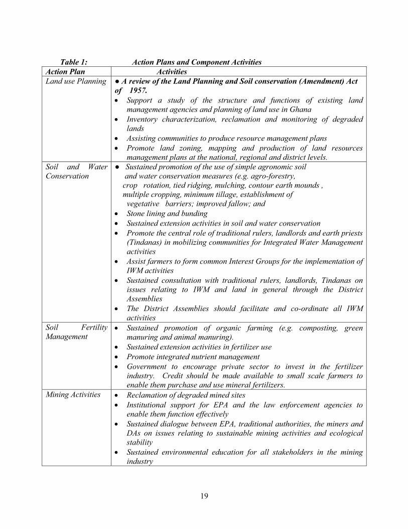
Table 1: Action Plans and Component Activities
Action Plan Activities Land use Planning ● A review of the Land Planning and Soil conservation (Amendment) Act
of 1957. • Support a study of the structure and functions of existing land
management agencies and planning of land use in Ghana • Inventory characterization, reclamation and monitoring of degraded
lands • Assisting communities to produce resource management plans • Promote land zoning, mapping and production of land resources
management plans at the national, regional and district levels. Soil and Water Conservation
● Sustained promotion of the use of simple agronomic soil and water conservation measures (e.g. agro-forestry, crop rotation, tied ridging, mulching, contour earth mounds , multiple cropping, minimum tillage, establishment of vegetative barriers; improved fallow; and • Stone lining and bunding • Sustained extension activities in soil and water conservation • Promote the central role of traditional rulers, landlords and earth priests
(Tindanas) in mobilizing communities for Integrated Water Management activities
• Assist farmers to form common Interest Groups for the implementation of IWM activities
• Sustained consultation with traditional rulers, landlords, Tindanas on issues relating to IWM and land in general through the District Assemblies
• The District Assemblies should facilitate and co-ordinate all IWM activities
Soil Fertility Management
• Sustained promotion of organic farming (e.g. composting, green manuring and animal manuring).
• Sustained extension activities in fertilizer use • Promote integrated nutrient management • Government to encourage private sector to invest in the fertilizer
industry. Credit should be made available to small scale farmers to enable them purchase and use mineral fertilizers.
Mining Activities
• Reclamation of degraded mined sites • Institutional support for EPA and the law enforcement agencies to
enable them function effectively • Sustained dialogue between EPA, traditional authorities, the miners and
DAs on issues relating to sustainable mining activities and ecological stability
• Sustained environmental education for all stakeholders in the mining industry
20
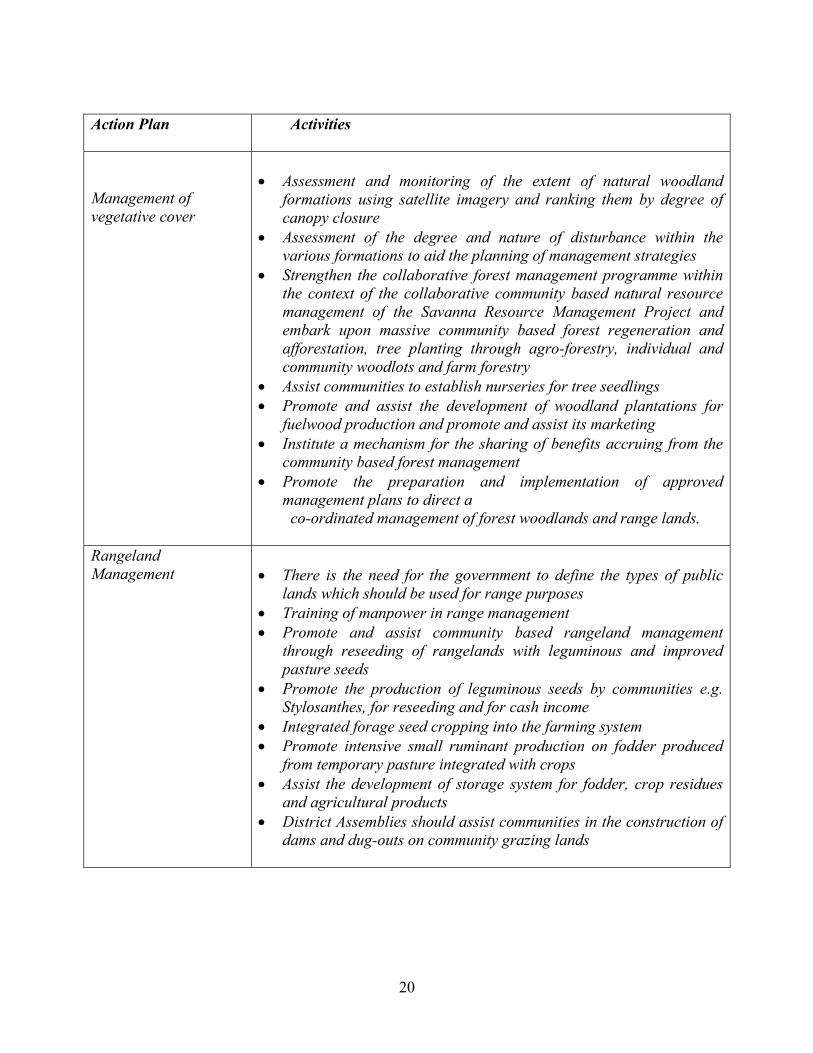
Action Plan
Activities
Management of vegetative cover
• Assessment and monitoring of the extent of natural woodland
formations using satellite imagery and ranking them by degree of canopy closure
• Assessment of the degree and nature of disturbance within the various formations to aid the planning of management strategies
• Strengthen the collaborative forest management programme within the context of the collaborative community based natural resource management of the Savanna Resource Management Project and embark upon massive community based forest regeneration and afforestation, tree planting through agro-forestry, individual and community woodlots and farm forestry
• Assist communities to establish nurseries for tree seedlings • Promote and assist the development of woodland plantations for
fuelwood production and promote and assist its marketing • Institute a mechanism for the sharing of benefits accruing from the
community based forest management • Promote the preparation and implementation of approved
management plans to direct a co-ordinated management of forest woodlands and range lands.
Rangeland Management
• There is the need for the government to define the types of public
lands which should be used for range purposes • Training of manpower in range management • Promote and assist community based rangeland management
through reseeding of rangelands with leguminous and improved pasture seeds
• Promote the production of leguminous seeds by communities e.g. Stylosanthes, for reseeding and for cash income
• Integrated forage seed cropping into the farming system • Promote intensive small ruminant production on fodder produced
from temporary pasture integrated with crops • Assist the development of storage system for fodder, crop residues
and agricultural products • District Assemblies should assist communities in the construction of
dams and dug-outs on community grazing lands

21
Action Plan Activities Bushfire Management
• A massive and sustained educational campaign should be mounted
on all aspects of bushfire, making use of all available communication channels, such as the electronic and print media, educational institutions, etc.
• The Ghana National Fire Service should be adequately equipped to play its training role
• Communities should be fully involved in bushfire control within their watershed areas
• The various anti-bushfire committees should be strengthened to discharge their functions
• Together with legislative action to prevent and deter unnecessary burning, a combination of early burning or early burning alternating with late burning and an effective system of suppression must be considered. Longer periods between burning cycles in the rangelands would be preferred.
• Strict enforcement of byelaws on bushfires and hunting laws should be pursued
• The Ghana National Fire Service personnel should be involved in all fire festivals to prevent and control fire outbreaks
• Training of communities on the domestication of grasscutters and keeping of rabbits can contribute significantly to the reduction of hunting activities
• The central role of traditional rulers in mobilising their subjects for bushfire control in their area of jurisdiction should be recognised and institutionalised
• The PNDC Law 229 should be reviewed to accommodate the deficiencies in the law
• District assemblies should reward communities with success stories of bushfire control, e.g. the provision of boreholes etc.
22
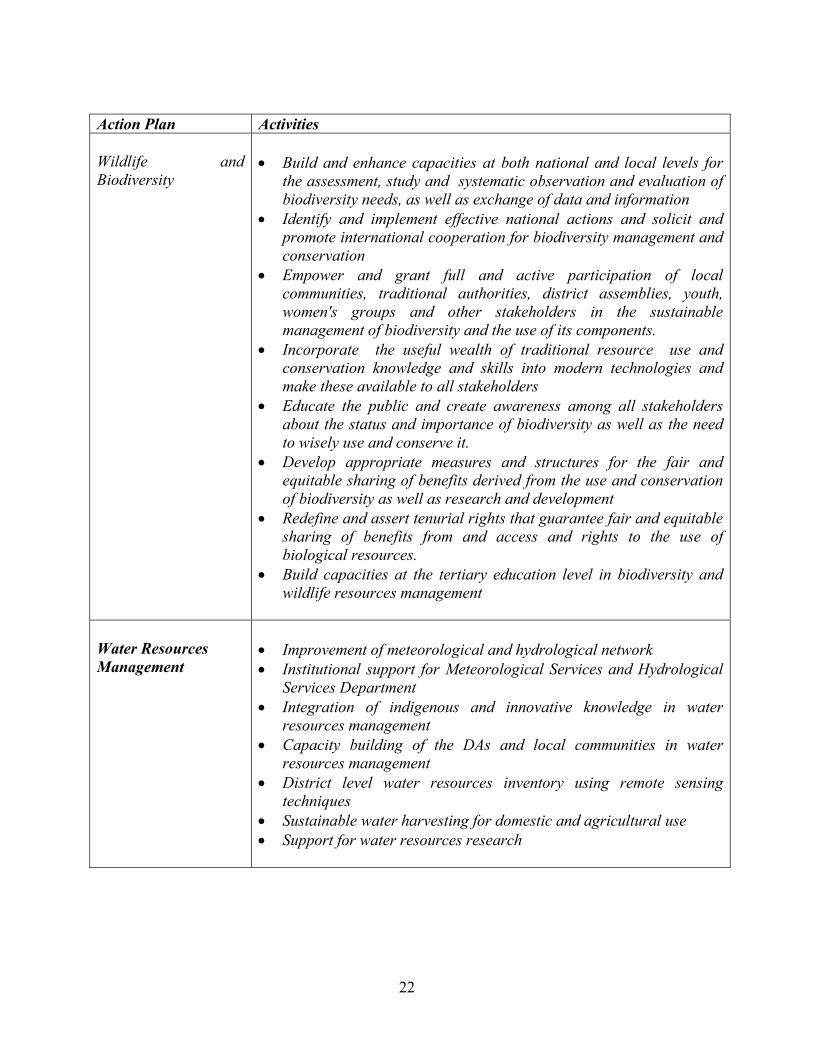
Action Plan Activities Wildlife and Biodiversity
• Build and enhance capacities at both national and local levels for
the assessment, study and systematic observation and evaluation of biodiversity needs, as well as exchange of data and information
• Identify and implement effective national actions and solicit and promote international cooperation for biodiversity management and conservation
• Empower and grant full and active participation of local communities, traditional authorities, district assemblies, youth, women's groups and other stakeholders in the sustainable management of biodiversity and the use of its components.
• Incorporate the useful wealth of traditional resource use and conservation knowledge and skills into modern technologies and make these available to all stakeholders
• Educate the public and create awareness among all stakeholders about the status and importance of biodiversity as well as the need to wisely use and conserve it.
• Develop appropriate measures and structures for the fair and equitable sharing of benefits derived from the use and conservation of biodiversity as well as research and development
• Redefine and assert tenurial rights that guarantee fair and equitable sharing of benefits from and access and rights to the use of biological resources.
• Build capacities at the tertiary education level in biodiversity and wildlife resources management
Water Resources Management
• Improvement of meteorological and hydrological network • Institutional support for Meteorological Services and Hydrological
Services Department • Integration of indigenous and innovative knowledge in water
resources management • Capacity building of the DAs and local communities in water
resources management • District level water resources inventory using remote sensing
techniques • Sustainable water harvesting for domestic and agricultural use • Support for water resources research
23
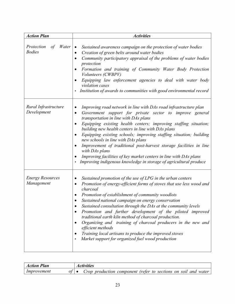
Action Plan Activities Protection of Water Bodies
• Sustained awareness campaign on the protection of water bodies • Creation of green belts around water bodies • Community participatory appraisal of the problems of water bodies
protection • Formation and training of Community Water Body Protection
Volunteers (CWBPV) • Equipping law enforcement agencies to deal with water body
violation cases • Institution of awards to communities with good environmental record
Rural Infrastructure Development
• Improving road network in line with DAs road infrastructure plan • Government support for private sector to improve general
transportation in line with DAs plans • Equipping existing health centers; improving staffing situation;
building new health centers in line with DAs plans • Equipping existing schools; improving staffing situation; building
new schools in line with DAs plans • Improvement of traditional post-harvest storage facilities in line
with DAs plans • Improving facilities of key market centers in line with DAs plans • Improving indigenous knowledge in storage of agricultural produce
Energy Resources Management
• Sustained promotion of the use of LPG in the urban centers • Promotion of energy-efficient forms of stoves that use less wood and
charcoal • Promotion of establishment of community woodlots • Sustained national campaign on energy conservation • Sustained consultation through the DAs at the community levels • Promotion and further development of the piloted improved
traditional earth kiln method of charcoal production. • Organizing and training of charcoal producers in the new and
efficient methods • Training local artisans to produce the improved stoves • Market support for organized fuel wood production
Action Plan Activities Improvement of • Crop production component (refer to sections on soil and water
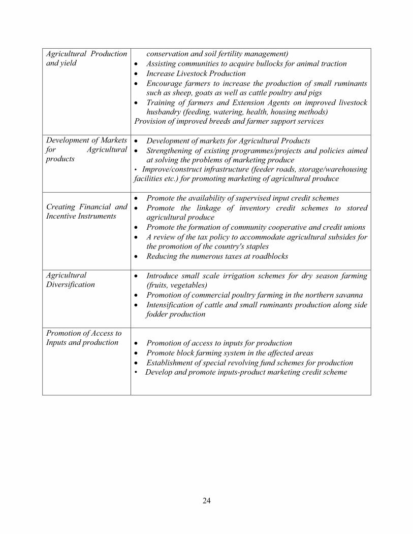
24
Agricultural Production and yield
conservation and soil fertility management) • Assisting communities to acquire bullocks for animal traction • Increase Livestock Production • Encourage farmers to increase the production of small ruminants
such as sheep, goats as well as cattle poultry and pigs • Training of farmers and Extension Agents on improved livestock
husbandry (feeding, watering, health, housing methods) Provision of improved breeds and farmer support services
Development of Markets for Agricultural products
• Development of markets for Agricultural Products • Strengthening of existing programmes/projects and policies aimed
at solving the problems of marketing produce • Improve/construct infrastructure (feeder roads, storage/warehousing facilities etc.) for promoting marketing of agricultural produce
Creating Financial and Incentive Instruments
• Promote the availability of supervised input credit schemes • Promote the linkage of inventory credit schemes to stored
agricultural produce • Promote the formation of community cooperative and credit unions • A review of the tax policy to accommodate agricultural subsides for
the promotion of the country's staples • Reducing the numerous taxes at roadblocks
Agricultural Diversification
• Introduce small scale irrigation schemes for dry season farming (fruits, vegetables)
• Promotion of commercial poultry farming in the northern savanna • Intensification of cattle and small ruminants production along side
fodder production
Promotion of Access to Inputs and production
• Promotion of access to inputs for production • Promote block farming system in the affected areas • Establishment of special revolving fund schemes for production • Develop and promote inputs-product marketing credit scheme
25
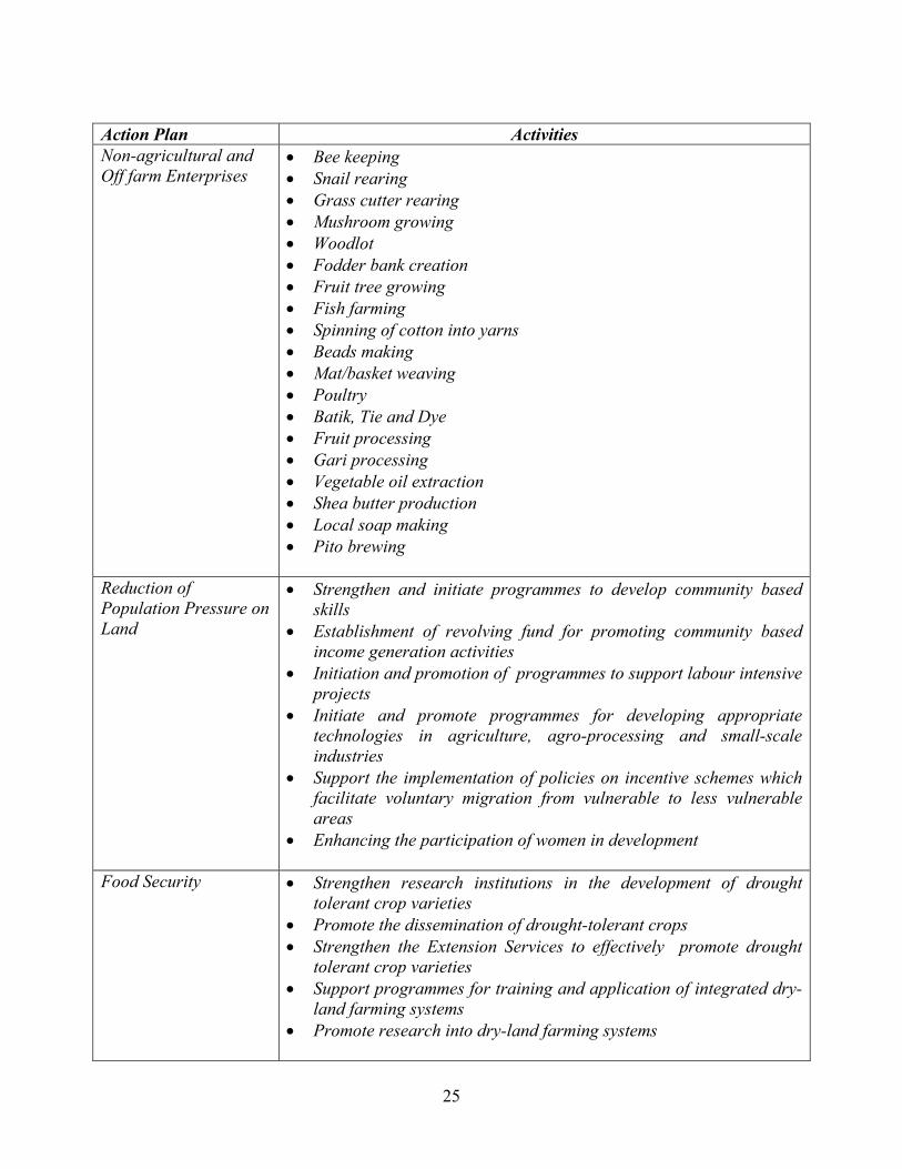
Action Plan Activities Non-agricultural and Off farm Enterprises
• Bee keeping • Snail rearing • Grass cutter rearing • Mushroom growing • Woodlot • Fodder bank creation • Fruit tree growing • Fish farming • Spinning of cotton into yarns • Beads making • Mat/basket weaving • Poultry • Batik, Tie and Dye • Fruit processing • Gari processing • Vegetable oil extraction • Shea butter production • Local soap making • Pito brewing
Reduction of Population Pressure on Land
• Strengthen and initiate programmes to develop community based skills
• Establishment of revolving fund for promoting community based income generation activities
• Initiation and promotion of programmes to support labour intensive projects
• Initiate and promote programmes for developing appropriate technologies in agriculture, agro-processing and small-scale industries
• Support the implementation of policies on incentive schemes which facilitate voluntary migration from vulnerable to less vulnerable areas
• Enhancing the participation of women in development
Food Security • Strengthen research institutions in the development of drought tolerant crop varieties
• Promote the dissemination of drought-tolerant crops • Strengthen the Extension Services to effectively promote drought
tolerant crop varieties • Support programmes for training and application of integrated dry-
land farming systems • Promote research into dry-land farming systems

26
Action Plan Activities Capacity Building Training and Public Awareness
• Promote the continuous and detailed environmental education programmes with emphasis on drought and desertification at all levels
• Strengthen the Information Services Department and the media houses to promote public awareness and education on desertification training
• Training of personnel in line agencies, NGOs and CBOs in all issues related to desertification and drought
• Provision of equipment and logistic support to line agencies, and Research Institutions
• Restructuring of the District Assemblies, Environmental Management Committees to effectively enforce legislation and bye-laws on bushfires control, wildlife and water resources management
• Developing the enforcement aspects of legislations and bye-laws on environmental degradation
Drought Management and Mitigation
• Development of contingency plan for food and water supply • Contingency crop planning • Promote the use of drought tolerant crop varieties • Strengthen national capacity in agro-meteorology • Development of early warning systems and dissemination of the
requisite information • Develop contingency plan for drought relief schemes and
management of environmental refugees • Provision of contingency budgetary allocation for drought relief • Development and expansion of dry season farming • Establishment of national deficiency response schemes during
periods of food production shortfall and create storage facilities to cater for bumper harvests
• Strengthening of Ghana Irrigation Development Authority to provide small-scale irrigation schemes in all affected areas.
• Development and implementation of water harvesting technologies • Training and capacity building of personnel in drought
management. Experts in the management of semi-arid and arid regions should be trained.
27
4. PHASING AND ESTIMATED COST OF THE NAP TO COMBAT DESERTIFICATION 4.1.1 Phases The NAP is proposed to be planned and implemented in a phased manner building upon the experiences gained and lessons learnt. There would be two phases covering a period of 25 years. The Phase I would last 10 years and Phase II, 15 years The first 5 years of Phase I (short-term) would be for entry point activities and piloting. Up scaling and implementation starts from the second half of Phase I through Phase II till withdrawal at the end of Phase II. Monitoring and evaluation at 5-year intervals based on pre-determined indicators are essential features of programme implementation. Community needs assessment and inventory and mapping of land resources to determine the degree and extent of degradation would contribute to prioritization of activities. 4.1.2 Estimated Costs The estimated costs are normative. The actual cost will vary as per the requirement of the site (Table 2).

28
Table 2: Implementation Phase and Estimated Cost of Component Activities of NAP
Cost US$ No. Action Programme Activity Phase I Phase II
Total
50,000 128,000 400,000 400,000 50,000
50,000
- 122,000 204,000
- - -
50,000 250,000 604,000 400,000 50,000
50,000
1. Land use and Soil Management
i. Study the structure and functions of Existing Land Management Agencies ii. Survey, Assessment and monitoring of Environmental change iii. Community Land Planning iv. Education and Training in Land Management v. Update of desertification hazard map and socio-economic Data on
Desertification vi. Review of Policy Documents
Sub-Total
1,078,000 326,000 1,404,000
1,400,000 1,200,000 1,200,000
1,300,000 800,000 5,500,000
2,700,000 2,000,000 6,700,000
2. Management of Vegetative Cover
i. Community-based Forest, Woodland and Alternative Energy Management ii. Community-based Bushfire Management iii. Community-based Rangeland Management Sub-Total
3,800,000
7,600,000
11,400,000
3,574,000 4,020,000
2,426,000 2,980,000
6,000,000 7,000,000
3. Water Resources Management
i. Water Resources Assessment, Monitoring and Utilization ii. Water Bodies Protection Sub-Total
7,594,000
5,406,000
13,000,000
18,015,000 16,985,000 35,000,000 4. Rural Infrastructure Development
i. Rural Infrastructure Development (feeder roads, storage, health, school, water, markets
Sub-Total
18,015,000
16,985,000
35,000,000 750,000 1,250,000
1,450,000 2,050,000
2,200,000 3,300,000
5. Wildlife and Biodiversity Management
i. Wildlife and Biodiversity management and Conservation ii. Development of sustainable utilization and Production Systems for Medicinal
Plants Sub-Total
2,000,000
3,500,000
5,500,000
2,050,000 16,150,000
6,150,000 10,000,000
8,200,000 26,150,000
6. Improvement of Socio-Economic environment and Poverty Reduction
i. Sustainable Crop and Livestock Production for Food Security ii. Non-agricultural and off-farm Enterprises Sub-Total
18,200,000
16,150,000
34,350,000
GRAND TOTAL 50,687,000 49,967,000 100,654,000

29
4.2 A Structure for the Implementation of the NAP The implementation of the NAP recognizes desertification as a national problem and multi-sectoral and the need to co-ordinate its activities through integrated approach with each sector playing specific roles. The integration and active participation of the District Assemblies and the communities would facilitate the ultimate ownership of the NAP activities by local communities. The Ministry of Environment and Science (MES) would be the main responsible Ministry. There shall be a national co-coordinating body (NCB), the National Desertification Committee (NDC) made up of multi-sectoral representatives. The NDC will be responsible for the overall supervision and implementation of the NAP with specific functions. The Focal Point will be the National Secretariat to Combat Desertification (NSCB) based at EPA. The NSCB will act as a Secretariat for the NCB responsible for the day to day running of NAP. Regional, District and Community Environmental Committees would be established with multi-sectoral representatives to oversee the implementation of the NAP at their respective levels. The role of Community-Based Organisations (CBOs), Non-Governmental Organisations (NGOs), Voluntary Organisations, and Chiefs/Traditional Rulers are paramount at the community level. The proposed structure is presented in an Organogram (fig 2).
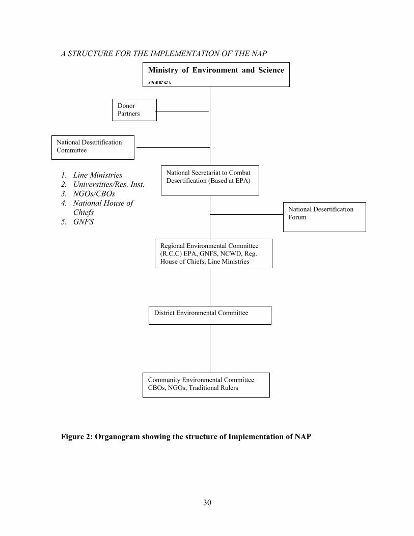
30
A STRUCTURE FOR THE IMPLEMENTATION OF THE NAP oo 1. Line Ministries 2. Universities/Res. Inst. 3. NGOs/CBOs 4. National House of Chiefs 5. GNFS Figure 2: Organogram showing the structure of Implementation of NAP
Ministry of Environment and Science
(MES)
Donor Partners
National Desertification Committee
National Secretariat to Combat Desertification (Based at EPA)
National Desertification Forum
Regional Environmental Committee (R.C.C) EPA, GNFS, NCWD, Reg. House of Chiefs, Line Ministries
District Environmental Committee
Community Environmental Committee CBOs, NGOs, Traditional Rulers

31
4.3 Partnership Building and Resource Mobilization The complex nature of the desertification problem requires solutions involving several programmes of development and research dimensions and several actors at the International, National, Regional, District and Community levels. The resources including funding required for implementing such programmes are enormous. Strategies and actions for partnership building and resource mobilization are therefore essential in achieving effective programme implementation This involves identification or relevant stakeholders at the various levels including donor agencies and non-governmental organisations; resources required; and forming partnerships and spelling out explicitly the roles of each partner. The partnership could be used for many different purposes, such as mobilizing financial resources, reorienting assistance mechanisms to fit the convention's approach, making inventories of funding sources, or developing new models of technological co-operation. The Agreements for partnership should be negotiated through a consultative process involving all stakeholders. 4.4 Funding Mechanisms The funding required to address the problem of desertification is quite enormous. Sources of funding are national and international. The establishment of a National Desertification Fund (NDF) is proposed. The local sources include government budgetary allocations, percentage of royalties from the exploitation of natural resources (timber, mining etc.) penalties from environmental offences and the public sector. The largest external source is bilateral official assistance provided on grant or concessional terms through the Global Mechanism of the UNCCD. Other agencies include the World Bank, UN Agencies and IFAD. The NDF should be run and managed by the National Desertification Committee (NDC). Disbursement of funds should be done directly to participating District Communities through operational modalities to ensure transparency and accountability.

32
MAIN DOCUMENT
33
1.0 INTRODUCTION 1.1 Genesis of Convention to Combat Desertification (CCD) Desertification has long been recognized as a major environmental problem with an adverse impact on the livelihoods of people in the affected areas of the world. The global concern about the scourge of desertification led the United Nations to organise extensive studies and consultations at the global, regional and local levels involving scientists, policy and decision makers and experts from research and development institutions and other organizations from all over the world (UNEP, 1991). These initiatives culminated in the organization of the United Nations Conference on Desertification (UNCOD) in 1977 in Nairobi, Kenya. The objective was to produce an effective, comprehensive and co-ordinated programme for addressing the problem of land degradation. The outcome of the UNCOD was a recommendation for the United Nations Plan of Action to Combat Desertification (PACD) the implementation of which was constrained by limited resources. Later assessments by United Nations Environmental Programme (UNEP), including that of the UN Commission for Sustainable Development (1988), endorsed desertification as the most serious environmental and socio-economic problem of the world resulting from the complex interactions of physical, biological, chemical, socio-economic and political factors of local, national and global dimensions. Out of the various studies, UNEP produced a World Atlas of Desertification (1992). The studies identified deforestation, overgrazing, over-cultivation and poor irrigation practices as major practices causing the degradation of drylands with population (human and livestock) pressures, inappropriate land use and agricultural practices, social conflicts and drought as the main influencing factors. A further indication was that the worsening conditions of degradation has reduced the resilience of drylands to drought incidence and dry periods making sustainable land management a critical issue. It was also recognized that desertification affects over 250 million people directly with over one billion (more than 20% of the world’s population) at risk. The continued advocacy on desertification and other environmental and developmental issues resulted in the UN Conference on Environment and Development (UNCED), i.e. the Earth Summit in 1992, held in Rio de Janeiro, Brazil. The Summit provided a platform for addressing a number of global environmental concerns including climate change, biodiversity and deforestation. On the issue of desertification, the Rio Summit recommended the establishment of Inter-governmental Negotiating Committee (INCD) by the United Nations General Assembly to prepare a Convention to Combat Desertification in those countries experiencing serious drought and/or desertification, particularly in Africa. The Committee established in early 1993, held five preparatory sessions before adopting the Convention on 17th June, 1994 in Paris. The Convention entered into force on 26th

34
December 1996 with Ghana ratifying it on 27th December 1996. Agenda 21, an outcome of the Rio Summit provides a blue print of the line of action on various issues relating to sustainable development in the 21st Century. Out of its 40 chapters, chapter 12 of Agenda 21 addresses the global scope of the desertification problem. 1.2 Definition of Desertification in the UNCCD The formal definition of desertification is “land degradation in arid, semi-arid and dry sub-humid areas resulting from various factors, including climatic variations and human activities” (UNCCD, 1997). Other relevant definitions are presented in Box 1. Aridity index, which is the ratio of the mean annual precipitation (P) to the mean annual evapotranspiration (PE), is used in characterizing the aridity of a region (Table 1). The Convention to Combat Desertification (CCD) considers arid, semi-arid and dry sub-humid regions as dry lands with aridity indices ranging from 0.05-0.65. In Ghana, the agro-ecological zones which fall within this range of aridity are the Sudan, Guinea and Coastal Savanna Zones with their respective aridity index of 0.60, 0.60, and 0.54. The Regions within these agro-ecological zones are the Upper East, Upper West, Northern, Greater Accra, Central and Volta.
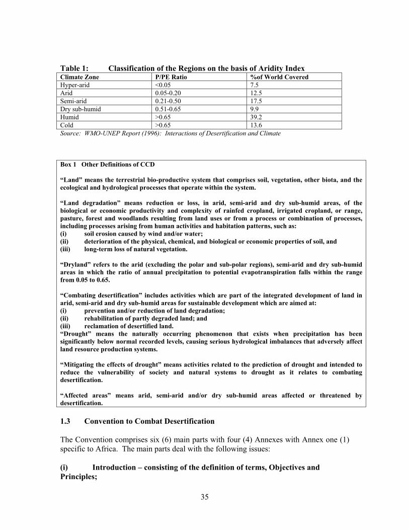
35
Table 1: Classification of the Regions on the basis of Aridity Index Climate Zone P/PE Ratio %of World Covered Hyper-arid <0.05 7.5 Arid 0.05-0.20 12.5 Semi-arid 0.21-0.50 17.5 Dry sub-humid 0.51-0.65 9.9 Humid >0.65 39.2 Cold >0.65 13.6 Source: WMO-UNEP Report (1996): Interactions of Desertification and Climate Box 1 Other Definitions of CCD “Land” means the terrestrial bio-productive system that comprises soil, vegetation, other biota, and the ecological and hydrological processes that operate within the system. “Land degradation” means reduction or loss, in arid, semi-arid and dry sub-humid areas, of the biological or economic productivity and complexity of rainfed cropland, irrigated cropland, or range, pasture, forest and woodlands resulting from land uses or from a process or combination of processes, including processes arising from human activities and habitation patterns, such as: (i) soil erosion caused by wind and/or water; (ii) deterioration of the physical, chemical, and biological or economic properties of soil, and (iii) long-term loss of natural vegetation. “Dryland” refers to the arid (excluding the polar and sub-polar regions), semi-arid and dry sub-humid areas in which the ratio of annual precipitation to potential evapotranspiration falls within the range from 0.05 to 0.65. “Combating desertification” includes activities which are part of the integrated development of land in arid, semi-arid and dry sub-humid areas for sustainable development which are aimed at: (i) prevention and/or reduction of land degradation; (ii) rehabilitation of partly degraded land; and (iii) reclamation of desertified land. “Drought” means the naturally occurring phenomenon that exists when precipitation has been significantly below normal recorded levels, causing serious hydrological imbalances that adversely affect land resource production systems. “Mitigating the effects of drought” means activities related to the prediction of drought and intended to reduce the vulnerability of society and natural systems to drought as it relates to combating desertification. “Affected areas” means arid, semi-arid and/or dry sub-humid areas affected or threatened by desertification. 1.3 Convention to Combat Desertification The Convention comprises six (6) main parts with four (4) Annexes with Annex one (1) specific to Africa. The main parts deal with the following issues: (i) Introduction – consisting of the definition of terms, Objectives and Principles;

36
(ii) General Provisions including obligations and relationship with other conventions; (iii) Action Programmes, Scientific and Technical Co-operation and Supporting
Measures; (iv) Institutions of the CCD; (v) Procedures; and (vi) Final Provisions. The four (4) Regional Annexes cover (i) Africa, (ii) Asia, (iii) Latin America and Caribbean, and (iv) Northern Mediterranean. Each Annex details out the scope, purpose, obligations and procedures for the implementation of the Convention. 1.4 Objective of the Convention The objective of the Convention is to combat desertification and mitigate the effects of drought in countries experiencing serious drought and/or desertification, particularly in Africa, through effective action at all levels, supported by international co-operation and partnership arrangements, in the framework of an integrated approach which is consistent with Agenda 21, with a view to contributing to the achievement of sustainable development in affected areas. The achievement of this objective will involve long-term integrated strategies that focus simultaneously, in affected areas, on improved productivity of land, and the rehabilitation, conservation and sustainable management of land and water resources, leading to improved living conditions in particular at the community level. 1.5 Obligations under the Convention The most important obligation of the affected developing country Parties under the Convention is the preparation of a National Action Programme (NAP) to combat desertification and mitigate the effects of drought. (Box 2).

37
Box 2 Part II – Article 5 of the UNCCD: Obligations of the Affected Developing Country Parties
Give due priority to combating desertification and mitigating the effects of drought.
Establish strategies and priorities within the framework of sustainable development.
Address the underlying causes of desertification with emphasis on the socio-economic factors contributing to the desertification process.
Promote awareness and facilitate the participation of local population, particularly women and
youth, non-governmental organisations, in efforts to combat desertification and mitigate the effects of drought.
Provide an enabling environment by strengthening the relevant existing legislation, enacting new
laws, where they do not exist, and establish long-term policies and action programmes. 1.6 CCD Approach for Preparation of NAP Part III Section 1 – Articles 9 and 10 National Action Programmes. All affected developing country Parties shall prepare a National Action Programme, (NAP) utilizing and building to the extent possible, on existing relevant successful plans and programmes and sub-regional and regional action programmes as the central element of the strategy to combat desertification and mitigate the effects of drought. The NAP, as indicated in Article 10, shall among other provisions, allow for modifications to be made in response to changing circumstances and be sufficiently flexible at the local level to cope with different socio-economic, biological and geo-physical conditions. The obligation of the developed country Parties (Part II Article 6) include: (i) actively supporting the efforts of affected developing country Parties, particularly
those in Africa to combat desertification and mitigate the effects of drought; (ii) providing substantial financial resources and other forms of support to assist
affected developing countries; (iii) promoting the mobilization of new and additional funding; (iv) encouraging the mobilization of funding from the private sector and other non-
governmental sources; and (v) the promotion and facilitating access by affected country Parties to appropriate
technology, knowledge and know-how. 1. 7 NAP to Combat Desertification in Ghana

38
1.7.1 Background The severe drought of 1981/83 in Ghana caused the Government of Ghana (GoG) to apply for assistance to the United Nations Sudano-Sahelian Office (UNSO) to combat desertification, which application was subsequently approved in December 1984. The implication was that parts of Ghana, particularly the semi-arid areas of the northern parts and the south-east, qualified to be classified as desertification-prone and could receive assistance from the UNSO to combat desertification. The sector agency responsible for environmental protection and management Environmental Protection Council (EPC) (now Environmental Protection Agency (EPA)), in collaboration with other relevant government departments, therefore initiated a number of consultations and action plans for combating desertification in 1984. Part of those initiatives included the preparation between 1985 and 1987, of the first National Plan of Action to Combat Desertification (NPACD), which was supported by the UNSO. Later, the Rural Pilot Project in Food and Energy Self-Sufficiency, the Environmental Restoration Component of the Vea and Tono Irrigation Schemes, the Forest Resources Management Project (FRMP), drawing up of the National Environmental Action Plan (NEAP) for Ghana and the Savannah Resources Management Project (SRMP) were also implemented . Between 1987 and 2001, the circumstances have changed and even though some proposals made in the 1987 plan are still relevant, it was felt that the whole issue is looked at again in the context of the current circumstances. It has become necessary for Ghana to revise and update the 1987 NPACD in order to capture the current situation on the ground. The preparation of NAP to combat desertification will be in line with Ghana’s quest for sustainable development and also fulfill the nation’s obligation under the UN Convention to Combat Drought and Desertification The National Action Programme (NAP) to combat desertification is to be formulated and implemented to mitigate the problems of desertification in the potential desertification prone zones of the country. These areas are the Upper East, Upper West, Northern and parts of the Brong Ahafo and Ashanti, Central, Greater Accra and Volta Regions. The NAP would be implemented under the SRMP, a component of the Natural Resources Management Programme (NRMP). Whilst the NAP seeks to address the issue of drought and desertification, the NRMP seeks to, among other things, to restore, protect and conserve natural resources by involving various stakeholder groups. There is over-dependence of populations on natural resources in the desertification prone zones for livelihood. This problem is further compounded by weak technological base, and unsuitable land use practices which have led to serious degradation of land and water resources. Hence the need to undertake a review to re-cast the NAP in the context of the current circumstances in order to combat desertification in Ghana. 1.7.2 Objectives of Study The purpose of the study was to develop, in line with the provisions of the global Desertification Convention, a National Action Programme (NAP) for Ghana through a broader consultative approach by identifying the causes of the alarming rate of

39
desertification and impacts at local, national, international and global levels and recommending possible preventive and remedial actions for implementation to reduce the impact of drought on the country and to halt the rate of desertification in the country. The overall objective of the NAP is to emphasise environmentally sound and sustainable integrated local development programmes for drought prone semi-arid and arid areas, based on participatory mechanisms, and on integration of strategies for poverty alleviation and other sector programmes including forestry, agriculture, health, industry and water supply into efforts to combat the effects of drought. The study shall aim at preparing plans or strategies to strengthen the capacity of local communities and groups, with emphasis on education and training, mobilization of non-governmental organizations (NGOs) to be able to prevent desertification and mitigate the impacts of drought. 1.7.3 Methodology The survey was in four parts, namely: Desk study Field study District and Regional Consultative Workshops on desertification and drought National Stakeholder Workshop to finalize the National Action Programme.
The desk study involved the review of relevant literature on the subject from as many sources as possible, examining the resource base for the desert-prone areas in Ghana, identifying the causes and impact of desertification in Ghana and discussing past experiences in combating desertification in Ghana. Literature sources were sought from relevant institutions, libraries and the worldwide web. The field study consisted of visits to specific sites in the affected areas and the interview of key stakeholders in existing programmes in general environmental protection and management in Ghana. Consultative workshops were organised in all the Districts in the affected areas. The workshops provided the requisite information on District/Community perception of the desertification and drought problem, the extent and causes of desertification and the strategies to deal with the problem. A first draft report was produced and discussed at consultative workshops in all the eight affected regions. This provided a further input for addressing concerns that had received less attention in the report. A second draft report was produced and subjected to a national stakeholder workshop to finalize the National Action Programme. The views expressed at the workshop were used in fine-tuning the final report. The workshops were attended by a wide spectrum of stakeholders. 1.7.4 Structure of the Report As required, this report is structured to deal with the study methods, the natural resource base of the desertification prone areas, the causes and impact of desertification in Ghana, experiences in combating desertification in Ghana, proposed action programmes and their
40
component action plans for combating desertification and for socio-economic development in the affected areas, implementation strategies, partnership building and resources mobilization, monitoring and funding mechanisms and prioritization of activities to combat desertification. 1.8.0 Past Experiences In Combating Desertification And Mitigating The Effects
Of Drought: Historical Perspective 1.8.1 Conservation as an Official Policy and Practice Conservation has always been an official concern in the management of natural resources in Ghana because of the early realization of the threat of the encroachment of Saharian conditions in the southern regions of the West African sub-region. The causes were found partly in the environmental conditions and partly in the human use of the resources. In order to halt desert encroachment, early advocates suggested an east-west forest development across the West Africa region. This was the basis for much of the official thinking and action in forest management in Ghana during the first half of the 20th century. 1.8.2 Forest Reservation The forestry approach to the problem of encroaching desert conditions was the establishment of a system of reserved forest areas as buffers at the northern edges of the forest and to position them in a way that would prevent the drying conditions from the north. Initially protective reservation was made on the high grounds and watersheds within the closed forest areas. Eventually three categories of reserves were established:
• Headwater reserves to protect the stream sources • Shelterbelt reserves created in the path of the prevailing north-south drying
winds • Barrier reserves along the fringes of the forests • Production reserves in accessible areas for timber and wood products demands
not met in the protective reserves. Initial pre-occupation with the high forests gave way to forest reservation in the northern savanna zones in 1937 with similar objectives as in the closed forests but supplemented by plantations and farm woodlots. Few reservations were made in the coastal savanna areas but plantations were made at Kpong, Cape Coast, Winneba and Accra. The target coverage of reserved forests envisaged in the country was 20% of the land surface. 1.8.3 The Land Planning Approach Significant efforts and experiences that were relevant for combating desertification were associated with land planning programmes in the northern savannas in the 1950s. Serious
41
land degradation had occurred in parts of the North as a result of uneven population distribution. Loss of land cover, soil fertility and productivity led to the policy and programme to resettle populations in less degraded lands in order to undertake measures to restore the environment and resource conditions of the degraded areas; a process that became known as land planning. It received legislative backing in the Soil Conservation and Land Planning Ordinance (1953). The measures adopted included:
Movement and resettlement of communities from degraded areas to planned and less degraded ones for the development of sustained use of the land through:
• Watershed protection • Forest reservation • Fuelwood plantations • Demarcation, fencing and reseeding of grazing areas. • Dam construction for seasonal irrigation farming and fish farming. • Soil conservation measures including contour bank construction on arable lands. • Sinking of wells • Construction of roads • Fish farming • Community participation • Introduction of appropriate land preparation methods
By 1959 seven land planning areas had been established in the northern savanna areas and the following had been achieved:
• 12,400acres(4960 ha) of water impounded • 640 km of narrow based contour banks constructed serving 30720 acres (12288
ha) of land • 1976 acres (800 ha) of land unsuited to arable crop cultivation fenced and
partially reseeded as grazing camps • 4130 acres (1,670 ha) re-afforested • 790 acres (320 ha) of bunded rice fields and 300acres(120 ha) of dry seasons
gardens developed • Mixed farms with bullock ploughing increased from 100 in 1949 to 3000 in 1959
(Pitman and Ramsey 1959). If any effort can be described as combating desertification and drought at any time in the development of Ghana, the land planning efforts stood out and deserved such definition. Yet the land planning programme collapsed abruptly with the gaining of political independence in 1957. The shift of rural land policy towards the development of large state-owned farms with the use of heavy machinery and the development of large irrigation schemes was an important factor in the neglect of the conservation measures on
42
the land of the small independent farmer though they managed the bulk of the land in all the ecological zones. 1.8.4 The ImmediatePost-Independence Experience The immediate post-independence experience up to the beginning of the 1970s when the UN Conference on the Environment awakened interest may be considered as a period of lost momentum in environmental actions and experiences in Ghana. The regional programme on onchocerciasis and the Northern Regional Rural Integrated Project (NORRIP), however, concentrated in the desertification prone northern savanna environments. The onchocerciasis programme was international and sought to eradicate the disease of blindness that is caused by the bite of the simulium fly associated with river valley environments. The NORRIP sought to improve rural land use through integrated planning and community participation. 1.8.5 The National Environmental Action Plan (NEAP) One of the results of Ghana’s participation in the UN Conference on the Human Environment in 1972 was the establishment of the Ghana Environmental Protection Council (EPC) now the Environmental Protection Agency (EPA). The combination of a declined national economy and the devastating effects of countrywide bushfires in 1983/84 provided the opportunity to justify the establishment of the EPC. The first effort to develop a comprehensive Plan of Action to Combat Desertification was made in 1987 and National Environmental Action Plan was made and adopted by the government in 1991. The plan was comprehensive and based on the extensive review of large sectors of the country’s economy including land management; forestry and wildlife; water management; marine and coastal ecosystems; mining, manufacturing industries, hazardous chemicals, and human settlements. It brought about a vast amount of information and provided the watershed between the unco-ordinated approach to the management of the environment and the sustained monitoring and reporting approach to problems of the environment involving the development of policies, action programmes and projects at local, regional and national scales and the participation in international collaboration efforts. 1.8.6 The Ghana Environmental Resources Management Project (GERMP) The GERMP was an implementation project for the NEAP. It was a multi-agency project assisted by the World Bank, DANIDA, ODA and Government of Ghana co-ordinated by the EPA. It aimed at institutional development and strengthening and capacity building for administration, information management, plan formulation, environmental monitoring and reporting. The GERMP was implemented between 1993 and 1998. Among the notable achievements was the development of the Environmental Information Systems (EIS). Under the EIS development component of GERMP five institutions were assisted to produce five framework and core digital data sets at the common scale of 1:250,000. These were:
43
• Topographic data by the Survey Department • Soil and land suitability data by the Soil Research Institute • Meteorological data by the Meteorological Services Department • Land cover and land use data by the Remote Sensing Applications Unit
(RSAU); now the Center for Remote Sensing and Geographic Information Services (CERSGIS) of the University of Ghana, Legon.
• Indicative land ownership data by the Lands Commission The ongoing development of the National Framework for the Geo-spatial Information Management (NAFGIM) was derived directly from the objectives and achievements of the EISD. NAFGIM is implemented as a Spatial Data Infrastructure (SDI) that aims at the easy discovery and use of data through the development of an internet-based network of spatial data producers and users with common policies and standards for production and exchange. 1.8.7 The Land and Water Management Project (LWMP) The LWMP is a continuing component of the GERMP with the objective of building capability within the Ministry of Food and Agriculture (MOFA) to carry out the planning and implementation of community based improved land management practice, and to introduce techniques that reduce the constraints to production imposed by soil erosion, degradation of soil physical properties and soil moisture. The Project was to cover 64 village communities throughout Ghana in 5 years. The following land degradation hazards have been identified as common to all rural communities.
• Soil erosion due to poor vegetation cover as a result of bushfires, removal of crop residues for fuel and feed, overgrazing, clean weeding and hill slope cultivation.
• Decline in soil fertility due to reduced fallow length, continuous cropping of farmlands and the export of nutrients without the application of external nutrient inputs. Fertility decline is also due to soil erosion, leaching, volatilization, lack of organic matter, and inadequate soil and water conservation practices.
• Soil moisture deficit due to poor soil cover, rain drop impact, compaction and crusting.
• Deforestation caused by the destruction of vegetation through bushfires and wood fuel removal and clearing for agriculture.
1.8.8 Savanna Resources Management Project (SRMP) The Savanna Resources Management Project is a component of the National Resource Management Programme (NRMP) of the Ministry of Lands and Forestry (MLF). The objective of the SRMP is to alleviate poverty in the three regions of the Upper East, Upper West and the Northern Region through the promotion of community management of natural resources including:
• The rehabilitation of degraded areas
44
• The sustainable management and ownership of the renewable natural resources. • Equitable distribution of the benefits accruing from efficient natural resource use • Enhancing community and individual initiatives and building their capacities
towards self-development. These objectives arise from the following problems in the three regions which also coincide with the areas of moderate to severe desertification hazard in Ghana. The activities to be undertaken under the project include:
• The assessment of the natural resources using remote sensing techniques • Develop community-based forest reserve and wildlife management programmes • Develop community based integrated watershed management and small livestock
programmes. • Initiate traditional and renewable energy programmes. • Develop Action Plan to Combat Desertification • Establish a technology development and demonstration centre. • To develop institutional capacity at all levels. • Develop Geographical Information Systems (GIS) and management information
system (MIS) for the North • Evolve structures, systems and processes that are based on indigenous knowledge
1.8.9 The Co-operative Integrated Project on Savanna Ecosystems of Ghana
(CIPSEG)
The CIPSEG was a multidisciplinary community based project focused on three sacred grove communities: Malshegu, Yiworgu and Tali around Tamale in degraded guinea savanna environments in Ghana. The objective was:
• To use the traditional sacred grove concept to improve conditions through tree planting, agricultural practices and prevention of bushfires
• To alleviate poverty
Project Activities The specific project activities undertaken by the specialist consultant teams included:
• The inventory of the biophysical resources of the project areas. • Design of land use interventions including reforestation, tree nursery
development and tree planting for woodlots and agroforestry • Fodder bank development for the improvement of dry season livestock feeding. • Study of traditional sacred grove management practices. • Construction of the CIPSEG project center. •
1.9.0 Policies, Legislation and Strategies
45
Policy and legislation provide the frames within which programmes and projects are formulated and implemented. Significant legislative acts have been enacted in Ghana over the past two decades that have relevance for the sustainable management of environmental resources and for the combat of desertification. The more relevant ones include: The Land Planning and Soil Conservation Ordinance (1953) and the Land Planning and Soil Conservation (Amendment) Act, 1957. 1.9.1 Policies The important environment and resource management policies in terms of present day realities and relevance to the aspirations of the people include:
• The Environmental Policy • The Forest and Wildlife Policy • The Land Policy
1.9.2 The Environmental Policy The Ghana Environmental Policy was adopted to provide the broad framework for the implementation of the National Environmental Action Plan 1991. The aim of the national environmental policy of Ghana is to improve the surroundings, living conditions and the quality of life of the entire citizenry, both present and future. It seeks to ensure reconciliation between economic development and natural resource conservation, to make a high quality environment a key element supporting the country’s economic and social development. The policy seeks specifically to: • To maintain ecosystems and ecological processes essential for the functioning of
the biosphere. • Ensure sound management of natural resources and the environment • Adequately protect humans, plants and animals, their biological communities
and habitats against harmful impacts and destructive practice, and preserve biological diversity
• Guide development in accordance with quality requirements to prevent, reduce and as far as possible, eliminate pollution and nuisances
• Integrate environmental considerations in sectoral, structural and socio-economic planning at the national, regional district and grassroots levels.
The principles underlying the policy are: • The optimum yield in the use of resources and the environment • Use of the most cost-effective means to achieve environmental objectives • Use of incentives in addition to regulatory measures
• Delegation of decision making and action to the most appropriate level of government
• Public participation in environmental decision making
46
• International co-operation. The policy states that environmental protection in Ghana should be guided by the preventive approach, that is, with the recognition that socio-economic developments must be undertaken in such a way as to avoid the creation of environmental problems. Specifically the government will among other things:
• Commit itself to environmentally sound use of both renewable and non-renewable resources in the process of national development.
• Develop procedures for the utilisation of land resources in a manner that will ensure the maximum degree of economy in the use of land and avoid or minimise conflicts.
• Take appropriate measures to protect critical ecosystems, including the flora and fauna they contain against harmful effects, nuisance, or destructive practices
• To promote and support research programmes aimed at better understanding of the different ecozones and the factors affecting them, as well as health-related environmental problems and the development of appropriate technologies for environmentally sound management and use of local resources, including renewable energy resources.
The Environmental Policy is being implemented and provides the driving force for other policies including those related to desertification. 1.9.3 The Forest and Wildlife Policy The Ghana Forest and Wildlife policy has been developed and adopted in 1994 to guide the development of both forest and wildlife resources of the country with the primary aim of conservation and sustainable development; maintaining environmental quality and perpetual flow of optimum benefits to all segments of the society. The policy seeks to bring the forest and wildlife sectors together for purposes of conservation through sustainable use. They had previously maintained separate policies. The guiding principles of the policy are based on national convictions as embodied in the constitution of the Fourth Republic, the current development policies, the Environmental Action Plan (1991); and on international principles endorsed by Ghana, including those contained in the Guidelines for Tropical Forest Management by the ITO, the Rio Declaration (1992), the African Convention on Wildlife Conservation and the Convention on International Trade in Endangered Species. These principles include the rights of the people to have access to natural resources for maintaining a basic standard of living, the concomitant responsibility to ensure the sustainable use of such resources; and the dependence of the nation’s viability on the wise use of the forest and wildlife resources in view of their contribution to the economy in maintaining vital ecological and life sustaining processes, the conservation of pools of genetic materials that offer development options and opportunities and the need to incorporate traditional methods of resource management in national strategies where appropriate. The strategies envisaged include the maintenance
47
of a permanent forest and wildlife estate. Outside the gazetted 282 reserved forest areas and 15 wildlife protected areas together covering about 16% of the country’s land area, an estimated 4,000km2 forests exist in the country supplying the bulk of the timber. Emphasis is placed on reforestation to restore a significant proportion of the original forest cover. Other strategies include public education and participation and the development of domestic markets. 1.9.4 The Land Policy The principles guiding the development of Ghana’s land policy include: • Guaranteed ownership and rights of inheritance • Equitable and reasonable access to land resources for maintaining a basic standard
of living • Guidance of allocation by market forces without compromising equity and State
interest • Sustainable land use in accordance with the maintenance of environmental quality • Economic and development incentives to stimulate private enterprise related land use. The specific land policy objectives include: • To harmonise and streamline customary practices and enacted legislation to
remove or minimise conflicts of interest within land owning groups and between the state on the one hand and stools, skins, clans, families and individual stakeholders on the other hand.
• To promote effective land use planning consistent with resource capability and sound environmental principles and ensure optimum benefits to beneficiaries.
• Develop geographic information systems to meet tenurial issues, planning, policy formulation, decision making, conflict resolution and other needs of the modern Ghanaian society.
• Create and maintain effective capability at the national, regional, district and community levels for efficient land services delivery.
The strategies for the promotion of effective land use are: • The development and circulation of guidelines, and the collation of current land
use specifications and projections for the preparation of land use map for the country.
• Development of a national land use plan allocating sections of the country’s land to broad land usages.
• Enforcing of requirements for proper spatial planning within approved zones for the publication of development plans.
• Provide support for integrated planning at district and community levels to ensure the participation of stakeholders in natural resource management.
• Establishment and maintenance of geo-spatial framework database
48
1.10 Lessons from Previous Efforts to Combat Desertification 1.10.1 Elements of Policy The selected presentation of the national and sectoral efforts to manage the environment and resources in Ghana indicates a comprehensive range of the elements of policy and strategy that may be incorporated into a national plan of action to combat desertification in the country. The policy has remained consistent in seeking: • Sustainable development of environmental resources • Restoring productive conditions to degraded resources • Protection and enhancement of productive capacity where the integrity of
resources remain unimpaired. • Improved and sustained quality of life for the individual and the community • Government commitment to national and international environment and
sustainable resource development concerns. 1.10.2 Elements of Strategy There is an equally wide range of strategies indicated: • Integrated management involving co-ordinated inter-disciplinary, inter-agency and
inter-sectoral decisions and actions over space and time. • Community ownership and grassroots participation in resource management • The use of multi-level planning and project formulation and implementation • Institutional development and capacity building • Use of incentives and stakeholder enablement • Use of improved traditional concepts and practices • On-farm extension • Use of information technologies and products for management. 1.10.3 Spatial Unit for Planning The spatial unit for planning is not always clearly defined. It may be a jurisdictional area such as the national territory, the region, the district, community land or a landscape unit such as a valley bottom, ecological zone or watershed. Projects/programmes with clearly defined spatial extent make it possible for data to be collected for performance monitoring. The problem of definition of project and programme location and extent arises from the availability of cartographic base maps. For projects in rural environments, the largest scale base maps available are the 1:50,000 topographic maps that are outdated in many ways. They may not be used for planning at scales larger than the 1:50,000 which is not suitable for planning at farm level or for small communities. The available district maps have been derived from gazette descriptions and have not been surveyed. Their
49
boundaries can only be identified on the ground where they follow streams and shores. The regional boundaries have similar deficiencies. The problems posed for project monitoring are considerable. The ideal solution will be a complete revision of the 1:50,000 maps and or re-mapping at the project planning scale of larger than 1:50,000. Fortunately the developments in technology make it possible to determine ground coverage of projects from a spot location to the district using GPS determinations, aerial photography and satellite remote sensing products. Future planning should make the effort to define the spatial location and extent of environmental resource projects and projects and their sub-projects. This will allow databases to be developed for monitoring of project performance. 1.10.4 Continuity of Programmes and Projects Donor funds and loan sources for programmes and projects often have limited life times and unless the availability of national continuation funds and programmes are included in planning programmes, projects fade off quickly. It is considered important that new projects are tailored to old ones in very specific ways that allow for some kind of continuity. This is enhanced if specific area units are involved. It is worth noting that the current NRMP has several elements that indicate continuity with the earlier GERMP.

50
2.0 BIO-PHYSICIAL AND SOCIO-ECONOMIC CONDITIONS 2.1 Location Ghana lies between latitudes 4o 44'N and 11o 15'N and longitudes 3o 15'W and 1o 12'E with a land area of 238,539 km2. It is bordered on the east by the Republic of Togo, in the west by Côte d'Ivoire and in the north by Burkina Faso. Administratively, the country is divided into ten regions and one hundred and ten districts with Accra as the capital (Map 1) Map 1 :Map of Ghana Showing Regions and Districts

51
2.2 Bio-physical Conditions 2.2.1 Climate The climate of Ghana is essentially the monsoon type. Two main air masses, the warm and dry continental air masses emanating from the sub-tropical anticyclone dominant over the Sahara desert during the months of November to March, and the warm and moist maritime air mass which originates from the subtropical anticyclone over the south Atlantic ocean between March and November. The dry continental air mass gives dry and hazy weather conditions over the entire country with little or no clouds. During this period bush and forest fires are frequent due to both the dryness of the atmosphere and availability of combustible materials. This predisposes the forests and woodlands to degradation. The climate of the desertification-prone areas are summarised by conditions in the synoptic stations at Navrongo, Tamale, Wenchi and Accra, representing the Upper East/Upper West Regions, Northern Region, the northern fringes of Brong Ahafo and the south-eastern parts of Ghana respectively. The monthly details are shown in Annexes 1-4 but the annual averages are summarised as follows: Navrongo, representing the Upper East/Upper West Regions of Ghana, experiences a uni-modal rainfall regime lasting 5-6 months and a long period of drought lasting 6-7 months in the year. Average rainfall, temperature, relative humidity, wind speed, sunshine hours and solar radiation are 885 mm, 28.6 0C, 54 %, 81 km/day, 7.9 hours and 20.4 MJ/m2/day respectively. Potential evapotranspiration amounts to 1652 mm per annum, meaning an excess of evapotranspiration over rainfall by about 87 % and an average annual aridity index of 0.54. Average annual effective rainfall is estimated at 685 mm. Representing the Northern Region, Tamale also experiences a uni-modal rainfall regime lasting 5-6 months and a long period of drought lasting 6-7 months in the year. Average rainfall, temperature, relative humidity, wind speed, sunshine hours and solar radiation are 1033 mm, 28.1 0C, 61 %, 138 km/day, 7.3 hours and 19.6 MJ/m2/day respectively. Potential evapotranspiration amounts to 1720 mm per annum. Evapotranspiration is therefore in excess of about 66.4 % over rainfall. The average annual aridity index is 0.60 and average annual effective rainfall is estimated at 782 mm. Wenchi which represents the northern fringes of the Brong Ahafo Region experiences a bi-modal rainfall regime with an average annual rainfall of about 1,250 mm. This is below the total potential evapotranspiration of about 1,430 mm, giving 12.6 % annual water deficit and an average annual aridity index of 0.87. Average annual effective rainfall is estimated at 964 mm. Average temperature, relative humidity, wind speed, sunshine hours and solar radiation are 26 0C, 75 %, 133 km/day, 6.2 hours and 18.1 MJ/m2/day respectively. Accra, representing the south-eastern coastal fringes of Ghana, also experiences a bi-modal rainfall regime peaked in May/June and October, with an average annual rainfall
52
of about 810 mm. This is below the total potential evapotranspiration of about 1,504 mm, meaning a 46.1 % annual water deficit and an average annual aridity index of 0.54. Average temperature, relative humidity, wind speed, sunshine hours and solar radiation are 27.1 0C, 81 %, 251 km/day, 6.5 hours and 18.6 MJ/m2/day respectively. Average annual effective rainfall is estimated at 659 mm. 2.2.1.1 Rainfall Erosivity In all the ecological zones rainfall is generally accompanied by high intensities and energy loads. The rains are therefore highly erosive. Available records for the Guinea Sudan Savanna Zones showed the annual kinetic energy load of rainfall to range from 41,000 to 43,000 Jm-2 with peak values of about 7,500 to 10,300Jm-2 in the months of August and September (Quansah, 1990) About 27 to 33% of the energy load is obtained at the onset of the rains from April to June when the soil is essentially bare and 53-63% from July to September 2.2.2 Vegetation and Agro-ecological Zones The natural vegetation of Ghana is closely related to the ecological zones. Six agro-ecological zones, defined on the basis of climate, reflected by the natural vegetation and influenced by soils are recognized. These consist of the Sudan, Guinea and Coastal Savanna zones, the Forest-Savanna Transitional zone, the Semi-deciduous Forest zone and the High Rain forest. In all the zones, the natural vegetation has undergone a considerable change as a result of human activities. 2.2.2.1 Sudan Savanna Zone The Sudan savanna, which covers an estimated area of 1,900 km2, consists of short drought and fire resistant deciduous trees interspersed with open savanna grassland. Grass cover is very sparse and in most areas the land is bare and severely eroded. Common grasses include Andropogon spp., Heteropogon spp; Hyparrhenia spp; Aristida spp; and Loudetia spp. (Sam et al; 1996). Tree cover is very low. Common trees include Anogeissus leiocarpus, Acacia spp; Terminalia microcarpa and Vitellaria paradoxa. In the densely settled and cultivated areas, important economic trees such as Adansonia digitata, Ceiba pentandra, Butyrospermum parkii, Faidherbia albida and Parkia filicoidea still remain.
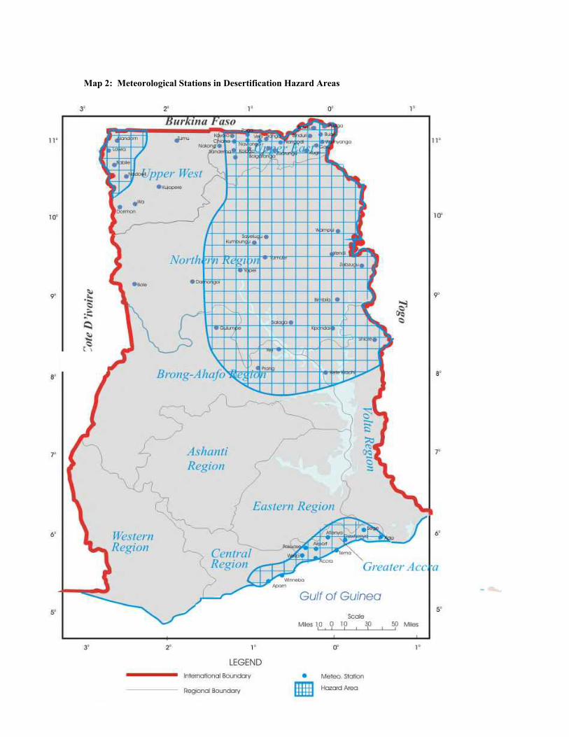
53
Map 2: Meteorological Stations in Desertification Hazard Areas 2.2.2.2 The Guinea Savanna Zone The Guinea Savanna, which covers almost the northern two-thirds of the country, is the largest ecological zone. Its area is about 147,900 km2. The vegetation consists typically of a ground cover of grasses of varying heights interspersed with fire resistant, deciduous, broad-leaved trees at the forest margins in the south (Rose-Innes, 1977). This grades into a more open grassland with widely spaced shorter trees towards the north. Owing to the tussocky nature of the grasses, bare patches of land are common. During the dry season, November to March, the dry grasses are highly inflammable. In the less eroded areas, Andropogon gayanus, the commonest grass may be replaced by Hyparrhenia and Heteropogon spp, while Aristida, sporobulus, Imperata and Cymbopogon gigantus dominate the severely eroded sites and poor soils. Vetiveria nigritana, Seteria anceps and sedges occur in alluvial sites. The common tree species include Lophira lanceolata, Anogeissus leiocarpus, Afzelia africana, Parkia filicoidea, Butyrospermum parkii and Antiaris africana. Fringe forest and woodland may be found along the water courses. 2.2.2.3 The Coastal Savanna Zone The coastal savanna zone covers an estimated area of 4,500 km2. It consists of mainly grassland interspersed with dense thickets often less than 5 m high with a few trees like

54
Antiaris africana, Ceiba pentandra, Albizia zygia and Azadirachta indica. Baphia nitida, Grewia spp, Griffonia simplicifolia and Milletia spp. are among shrubs found in the zone and of importance for browse feeding for livestock. Short and medium grasses are the dominant plant species. These include Andropogon gayanus and Hyparrhenia dissoluta in upland areas and Vetiveria fulbibarbis and Brachiaria falcifera in low lying areas. Panicum maximum often occurs in the moist areas. 2.2.2.4 The Forest-Savanna Transitional Zone (Derived Savanna) This zone, covering about 8,300 km2, occurs as a normal strip about 48 km wide along the north and the north eastern limits of the semi-deciduous forest. Most of the tree species of the forest zone occur in this area in addition to such species as Daniella Oliveri, Terminalia macroptera and Borassus aethiopum. These trees occur in association with tall to medium tall grasses such as Andropogon and Pennisetum spp. 2.2.2.5 The High Rainforest The rainforest covering an area of about 7,500km2 is located in the south-western corner of the country. The vegetation is generally evergreen although some species common to the semi-deciduous forest may be found. Such species tend to shed their leaves during the dry season. The zone is characterized by the Cynometra-Lophira-Tarrietia association with Cynometra ananta, Lophira alata and Tarrietia utilis as indicator trees (Lane, 1962). The topography is undulating to rolling with numerous fresh water swamps potentially suitable for rice cultivation occupying low lying valley bottoms. The swamp vegetation consists of Raphia palms with shrubs such as Alchornea cordifolia, Caropa procera and Macaranga spp. entangled by various climbers. 2.2.2.6 The Semi-deciduous Forest The semi-deciduous forest zone is about 66,300 km2 in extent and forms about 90% of the total forest zone. The characteristic associations are Celtic-Triplochiton and Antiaris-Chlorophora. The indicator trees for the former consist of Celtic milbraedii and Triplochiton scleroxylon whilst the latter is characterized by Antiaris africana and Chlorophora excelsa. It is within this zone that most food crops and cocoa cultivation takes place. Most of the timber for both local needs and export comes from the zone. As a result of these activities the vegetation outside forest reserves consists mainly of forest regrowth, thicket, secondary forest and swamp thicket. 2.2.2.7 The Rangelands of Ghana
55
The Sudan, Guinea and Coastal Savanna constitute the rangelands of Ghana. These cover an area of about 156,000 km2 which is approximately 65.7% of Ghana's land area (World Bank, 1992). The Interior Savanna (Guinea and Sudan) holds about 74.4% of the nation's cattle population of 1.25 million and 40% of the small ruminant population of 4.95 million (LPIU, 1997). The annual forage production of the rangelands was estimated as 10.6 million mt of which some 70% were from grassland herbage (Duku, 1993). The total annual grass dry matter yield (DM) were 1965 and 2170 kg ha-1 for the coastal and interior savanna zones respectively. The grass yield under sheanut trees in Bole, in the Northern Region, over a period of 6 months in the rainy season gave 776 kg DM ha-1. 2.2.3 Topography The topography is gently undulating and low in relief with slopes of 3 to 4 per cent dominating. The highest hills are around 397m and most of the area lies between 153 and 244 m above sea level. Under the climax savanna vegetation, the slopes, which are adapted to overland flow erosion, are stable (Nye and Greenland, 1965). However, when the vegetation is completely cleared and the land is cultivated, the stable equilibrium between relief and vegetation is altered, conditions become unstable and high rates of erosion are inevitable. In cultivating those slopes, the aim should be to maintain as much cover and organic matter as possible in order to be closer to the natural conditions under which the slopes developed. 2.2.4 Geology The geology of Ghana (Map 3) is characterized by the following formations of which pre-cambrian rocks comprising the Dahomeyan and Birrimian systems predominate (Bates, 1962). The rest of the country consists of Palaeozoic and Mesozoic rocks. The Dahomeyan system underlies the Accra Plains and the southern part of the Volta Region. It consists of granulite, gneiss and migmatite with intrusions of quartz schists and other sedimentary remnants. The Birrimian system and associated granites consist of geosynclinal sediments with partly granitized volcanic rocks being predominant in the upper part. Besides being the source of most of the minerals of Ghana, it underlies nearly all the forest zone and the entire compound farming areas in the Northern and Upper Regions. Two main types of granite are distinguished. The Cape Coast and Winneba granite (GI) contains more potassium than sodium and consists of granite or granodiorite with biotite and sometimes muscovite. The Dixcove granite (G2) on the other hand contains more sodium than potassium. The Tarkwaian system derived from the Birrimian, consists of shallow water sediments, sandstone, phyllites and conglomerates. The largest stretch is in the forest zone. The Togo series, consist of indurated sandstone, quartzite, quartz schists and little limestone.
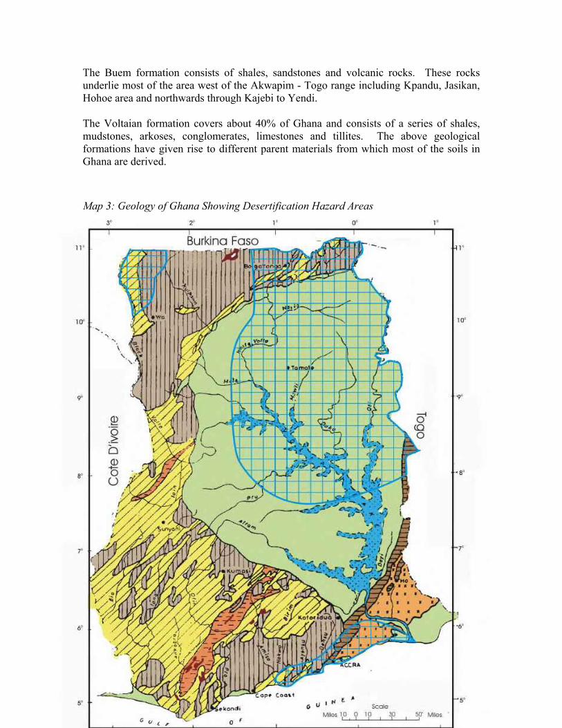
56
The Buem formation consists of shales, sandstones and volcanic rocks. These rocks underlie most of the area west of the Akwapim - Togo range including Kpandu, Jasikan, Hohoe area and northwards through Kajebi to Yendi. The Voltaian formation covers about 40% of Ghana and consists of a series of shales, mudstones, arkoses, conglomerates, limestones and tillites. The above geological formations have given rise to different parent materials from which most of the soils in Ghana are derived. Map 3: Geology of Ghana Showing Desertification Hazard Areas
57
2.2.5 Soils The soils of Ghana are formed as a result of the action of climate and vegetation, including other organisms, on various geological materials modified by local relief or topography over time. At the highest level are the forest and savanna soils grouped mainly by differences in climate and vegetation. These are described in detail in MOFA (1998). The major soils for agricultural production are: Forest-Savanna Transition - Lixisols, Nitisols, Plinthosols and Cambisols Guinea Savanna - Lixisols, Acrisols, Luvisols and Gleysols Sudan Savanna - Lixisols, Acrisols, Luvisols and Lithosols Coastal Savanna - Acrisols, Luvisols, Cambisols, Gleysols, Solonetz and intergrades High Rainforest - Acrisols, Nitisols and Gleysols Semi-deciduous Forest - Acrisols, Nitisols and Gleysols Alluvial soils (Fluvisols) and eroded and shallow soils (Leptosols) are found in all the ecological zones. Most of the soils are developed on thoroughly weathered parent materials. They are old and have been leached over a long period of time. As a result, their organic matter content is generally low. Their buffering capacity as well as cation exchange capacity are also low since their predominant clay mineral is kaolinite. The soils are consequently of low inherent fertility. The two most deficient nutrients are nitrogen and phosphorus particularly because of the very low organic matter content. The build-up of any amount of organic matter is further constrained by the regular burning of crop residues and/or competitive use of these residues for fuel, animal feed or building purposes. The low vegetative cover during the long dry season also renders most of the soils susceptible to erosion during the rainy season. This, in turn, exacerbates the low fertility problem. Many of the soils have predominantly light textured surface horizons, heavier textured soils being confined to valley bottoms and the Accra Plains. In the savanna zones there are also extensive areas of shallow concretionary and rocky soils which have low water holding capacities and limited suitability for agriculture. The sustainability of good crop yields is therefore closely linked with the careful management of the soils with the objective of preventing and controlling erosion, increasing their organic matter content, and replacing and increasing plant nutrients lost through erosion and crop uptake. 2.2.6 Water Resources The major sources of water are: i. natural rainfall ii. rivers, streams and lakes and iii. groundwater and artificially impounded water (dams, dug-outs and reservoirs)

58
2.2.6.1 Rainfall Naturally, rainfall, which is described in section 2.2.1 is the single source of water that feeds all other sources. Whenever rainfall is insufficient, recharge of water from the other sources is low. 2.2.6.2 Rivers and Runoff Yield Rivers constitute another important source of surface water supply in Ghana. The main river basins in the affected areas comprise the White Volta, Black Volta, Oti. Main/Lower Volta, Daka, Coastal and Todzie / Aka drainage basins (Map 4). The yields from runoff in the various river basins generally follow the rainfall pattern. During the months of June, July and October when rainfall is heaviest in the south of the country, flows are high. In northern Ghana, where rainfall is unimodal, high flows occur in August through October. The dry season extends from November to March and low flows are observed during this period throughout the country. The mean annual runoff and their variations in the main river basins are given in Table 2. The runoff values are for flows within the basins in Ghana and exclude flows from upstream outside Ghana. 2.2.6.3 Reservoirs Another important source of surface water supply is from surface impoundments and dugouts. The largest reservoir in the country is the man-made Volta Lake created in 1964 at Akosombo to generate hydro-electric power. It has an area of 8,482.3 km2, a mean annual inflow of 4.05 ha-m and live storage of 6.03 ha - m. Other medium and small-scale impoundments in the country are Vea/Tano dams in the Upper East Region, Bontanga, Libga and Golinga in the Northern Region; Okyereko and Mankesim in the Central Region; Aveyime and Afife in the Volta Region and Ashiaman, Dawhenya and Weija in the Greater Accra Region. 2.2.6.4 Groundwater Resources Groundwater occurs in two main formations in Ghana, namely, sedimentary and non-sedimentary rocks with their respective coverage being 43 and 57 per cent of the land area of Ghana. The sedimentary rocks, belonging to the Voltaian formation, are found mainly in the Volta basin and the central parts of the coastal areas. In the White and Black Volta, Daka and Oti basins the hydrogeology is of the voltaian formation consisting of sandstone, shales, mudstone, limestones and conglomerates. Table 2: Runoff Yields and their Variations in the Main River Basin
Runoff x 106 m3/day River Basin Drainage Area km2 Annual Mean Monthly
maximum Monthly minimum
White Volta 45800 10.28 104.98 0.09 Black Volta 35000 4.92 53.83 0.17 Oti 16200 9.59 73.44 0.17 Main/Lower Volta 68600 12.10 249.70 0.17
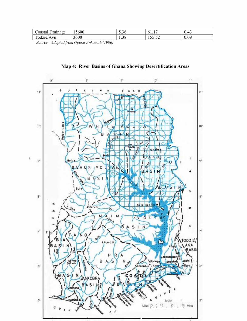
59
Coastal Drainage 15600 5.36 61.17 0.43 Todzie/Avu 3600 1.38 155.52 0.09 Source: Adapted from Opoku-Ankomah (1986)
Map 4: River Basins of Ghana Showing Desertification Areas M
60
Reported yield levels of aquifers range between 1-6 m3/hr, reaching even up to about 8 m3/hr in certain parts but generally, most wells yield less than 3 m3/hr. Yield levels can reach up to 11 m3/hr in a small part of the northern fringes of the Brong Ahafo region where unconsolidated material can be found. Generally, hand-dug wells are shallow (< 5m below ground level (bgl)) due to the difficulty of excavating but most of the successful wells are less than 60 m bgl. It is estimated that the success rate of boreholes is about 50 % or less in the northern regions of the country. In the coastal basin around the Volta estuary and the southern fringes of the Todzie/Aka basin and the Avu-Keta plains, the geological formation is unconsolidated sand, clay and gravel with yield levels over 15 m3/hr in certain places but generally ranging between 8 and 15 m3/hr. Excavation of wells is generally less tedious in the coastal fringes of the Keta lagoon area with water levels less than 1.5 m bgl even during the peak of the dry season. Part of the coastal basin is underlain by the Dahomean formations. Groundwater resources are used mainly for domestic and livestock purposes. Over 8,000 boreholes have been drilled across the country at an average depth of 40 m and 100 - 200 cm diameter (Wiafe 1997). Most of the boreholes occur in the Upper West (1680), Upper East (1,350) and Northern Regions (1,340) followed closely by Volta region (1,140) (Nii Consult, 1996). These areas are predominantly in the savanna zones. An overview of aquifer horizons and yields of an estimated 1000 boreholes and hand-dug wells in the various rock formations in Ghana are given in Table 3 (WRRI, 1990). Table 3: Aquifer Horizons and Yield of some Ghanaian Rocks
Aquifer Horizons Yield Geological Formation M M3 h-1
Paleozoic (Voltaian) 20 - 35 1.0 - 12.0 Upper Precambrian Buem 20 - 35 1.0 - 12.0 Togo 20 - 65 1.5 - 8.0 Middle Precambrian Tarkwain 15 - 25 1.0 - 12 Granites 20 - 65 1.0 – 32.0 Birrimian 25 - 35 1.5 – 17.5 Lower Precambrian Dahomeyan 25 - 50 1.5 - 32.0
Source: Adapted from EPC/WRRI (1988). Recharge to the aquifers, estimated to be 5% of the annual rainfall, is considered low and occurs mainly in the rainy season. Generally aquifers are of low transmissivities (7.5 to 3,000 m2/day). Water level fluctuations are estimated to vary from 1.5m and 3 m between the dry and wet season. From results of chemical analyses carried out by WRRI and GWSC, groundwater in the non-sedimentary rocks is generally soft with low total dissolved solids. The pH is on the average, slightly acid (6.5) in the granitic terrain. However, in some cases, iron and manganese concentrations are excessive and give rise to colouration of the water on exposure to the atmosphere. Generally the chemical

61
quality is acceptable and falls within the drinking water standards of Ghana Water and Sewerage Corporation. The quality of groundwater in the sedimentary formation is also generally good for human use but in the central portion of the basin saline waters with concentrations of 1,000 to 1,500 mg/l have been observed. So far, the agro-chemical and industrial waste pollution of groundwater have not been studied well but there is evidence that it is happening. Some preliminary studies (WRRI, 1990) showed that some boreholes in Upper East and Upper West Regions have increasing concentrations of nitrate due to increased use of fertilizers in these regions. Therefore, the large numbers of boreholes in the country need to be continuously monitored to generate sufficient empirical data for solving present and future problems of groundwater quality.
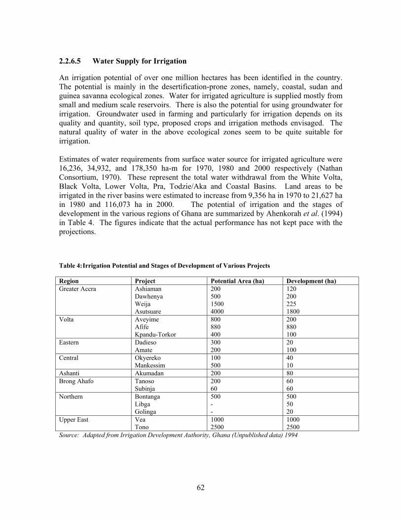
62
2.2.6.5 Water Supply for Irrigation An irrigation potential of over one million hectares has been identified in the country. The potential is mainly in the desertification-prone zones, namely, coastal, sudan and guinea savanna ecological zones. Water for irrigated agriculture is supplied mostly from small and medium scale reservoirs. There is also the potential for using groundwater for irrigation. Groundwater used in farming and particularly for irrigation depends on its quality and quantity, soil type, proposed crops and irrigation methods envisaged. The natural quality of water in the above ecological zones seem to be quite suitable for irrigation. Estimates of water requirements from surface water source for irrigated agriculture were 16,236, 34,932, and 178,350 ha-m for 1970, 1980 and 2000 respectively (Nathan Consortium, 1970). These represent the total water withdrawal from the White Volta, Black Volta, Lower Volta, Pra, Todzie/Aka and Coastal Basins. Land areas to be irrigated in the river basins were estimated to increase from 9,356 ha in 1970 to 21,627 ha in 1980 and 116,073 ha in 2000. The potential of irrigation and the stages of development in the various regions of Ghana are summarized by Ahenkorah et al. (1994) in Table 4. The figures indicate that the actual performance has not kept pace with the projections. Table 4: Irrigation Potential and Stages of Development of Various Projects Region Project Potential Area (ha) Development (ha) Greater Accra Ashiaman
Dawhenya Weija Asutsuare
200 500 1500 4000
120 200 225 1800
Volta Aveyime Afife Kpandu-Torkor
800 880 400
200 880 100
Eastern Dadieso Amate
300 200
20 100
Central Okyereko Mankessim
100 500
40 10
Ashanti Akumadan 200 80 Brong Ahafo Tanoso
Subinja 200 60
60 60
Northern Bontanga Libga Golinga
500 - -
500 50 20
Upper East Vea Tono
1000 2500
1000 2500
Source: Adapted from Irrigation Development Authority, Ghana (Unpublished data) 1994
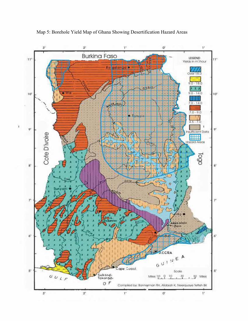
63
Map 5: Borehole Yield Map of Ghana Showing Desertification Hazard Areas 2.3 Socio-economic Conditions

64
2.3 Socio –Economic Conditions 2.3.1 The Agricultural Sector Ghana's economy is dominated by the agricultural sector in terms of its share of Gross Domestic Product (GDP), employment, foreign exchange earnings and provision of food security. Currently the sector employs about 70% of the rural labour force, contributes 45% of the GDP, accounts for over 55% of the foreign exchange earnings and is responsible for meeting over 90% of the food needs of the country. It is also an important source of raw materials for the manufacturing industry. The agricultural sector is made up of five sub-sectors namely; crops other than cocoa (63% of agricultural GDP) cocoa (14%) forestry (11%), livestock/poultry (9%) and fisheries (5%). In spite of increased growth in the production of some major crops as a result of economic reforms adopted by the government, the overall growth rate of 2.8% in the agricultural sector vis a vis the current annual population growth rate of 2.6% (Ghana Statistical Service, 2000) poses serious implications for the attainment of food security, employment generation and improvement in rural incomes and national economy. In an attempt to avert this situation, Ghana's Vision 2020 was launched to transform the country from a poor to a middle income generation by the year 2020 (GOG, 1995). The primary source of this transformation is expected to come from a more efficient agricultural sector with an expected growth rate of 5-6%. While sustainable agricultural production depends primarily on productive soils, the land resources of Ghana, particularly the soil, are being degraded as a result of the interaction of both natural and anthropogenic factors. Soil degradation in its several forms, is evident in all the agro-ecological zones of the country. This is particularly more acute in the desertification prone zones. Amongst the major forms of degradation, soil fertility decline resulting from the inability of farmers to adequately replace nutrients removed through crop harvest and lost through erosion, is recognized as the major constraint to the attainment of the desired growth rate in the agricultural sector (MOFA, 1998). Meeting the future food needs of Ghana while reducing poverty and protecting the environment would require a goal directed at managing the soils for long-term productivity. In order to achieve the latter goal, soil degradation has to be halted and reversed through restorative measures of soil, water, nutrient and crop management (Lal and Stewart, 1992; Quansah, 1996; Syers, 1997). 2.3.2 Human Population The population of Ghana by March 2000 was 18.4 million (Ghana Statistical Service, 2000). About 74% of the population are rural. The population distribution varies across the ecological zones of the country with the savanna zones which are the most susceptible to desertification carrying about 51.4% of the total population compared with a figure of 50% in 1984 (Table 5). The distribution is 33.2%, 13.3% and 45% for the Coastal, Guinea and Sudan savanna zones respectively.

65
The population density of Ghana has increased from 36 persons/km2 in 1970 to 52 in 1984 and to 77 in 2000. The increasing density reflects the increasing pressure of population on the land and its resources. Within the desertification prone zones represented by the Greater Accra, Central, Upper East, Upper West and the Northern Regions the current respective densities are 897, 161, 104, 31 and 21 persons/km2. The Greater Accra Region has the highest population density in the country while the Northern Region is the least densely populated. In 1984 the respective population densities for Greater Accra, Central, Upper East, Upper West and the Northern Regions were 441, 87, 24 and 17 persons/km2. Although these figures imply increases in the population in the regions, the Greater Accra Region more than doubled its population whilst that of the whole country increased by 49.7% Table 5: Population of Ghana by Region, 2000 and 1984
2000 1984 Region Population Density
persons/km2 Population Density
persons/km2 All regions 18,412,247 77 12,296,081 52 Western 1,842,878 77 1,157,807 48 Central 1,580,047 161 1,142,335 116 Greater Accra 2,909,643 897 1,413,099 441 Volta 1,612,299 78 1,211,907 59 Eastern 2,108,852 109 1,680,890 87 Ashanti 3,187.601 131 2,090,100 86 Brong Ahafo 1,824,822 46 1,206,608 31 Northern 1,854,994 21 1,164,583 17 Upper East 917,251 104 772,744 87 Upper West 573,860 31 438,008 24
Source: Ghana Statistical Service (2000) Although agricultural land area (13,638,179 ha representing 57% of the total land area of Ghana) is considerably in excess of the area under cultivation (5,300,000 ha in 1994), cultivation is already taking place on marginal lands in some regions, particularly in the Upper East. Agricultural land availability per capita has varied from 1.56 ha in 1970 to 1.11 in 1984 and 0.74ha in 2000. The implication of these figures is that pressure on the natural resources base, particularly the soil, will increase with increasing population. This situation makes the traditional shifting cultivation with reduced fallows undesirable from both economic and environmental points of view. 2.3.3 Livestock Population The savanna of Ghana carries most of the livestock population. The 1996 estimated figures for the various ruminant livestock species were: cattle - 1.25 million, sheep - 2.4 million and goats - 2.5 million (LPIU, 1997). The percentage distribution by regions is presented in Table 6. The Upper West, Upper East and Northern Regions which constitute the northern savanna hold 74.4, 36.5 and 43.4% of the national livestocks respectively. The livestock
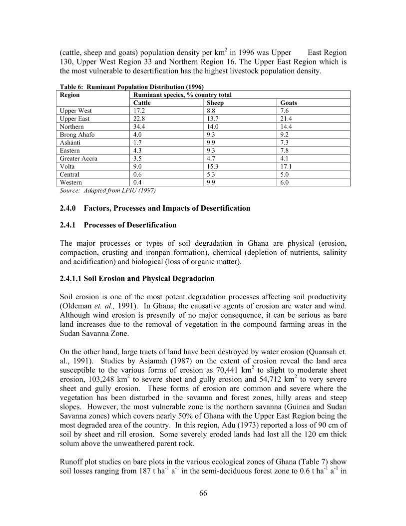
66
(cattle, sheep and goats) population density per km2 in 1996 was Upper East Region 130, Upper West Region 33 and Northern Region 16. The Upper East Region which is the most vulnerable to desertification has the highest livestock population density. Table 6: Ruminant Population Distribution (1996)
Ruminant species, % country total Region Cattle Sheep Goats
Upper West 17.2 8.8 7.6 Upper East 22.8 13.7 21.4 Northern 34.4 14.0 14.4 Brong Ahafo 4.0 9.3 9.2 Ashanti 1.7 9.9 7.3 Eastern 4.3 9.3 7.8 Greater Accra 3.5 4.7 4.1 Volta 9.0 15.3 17.1 Central 0.6 5.3 5.0 Western 0.4 9.9 6.0 Source: Adapted from LPIU (1997)
2.4.0 Factors, Processes and Impacts of Desertification 2.4.1 Processes of Desertification The major processes or types of soil degradation in Ghana are physical (erosion, compaction, crusting and ironpan formation), chemical (depletion of nutrients, salinity and acidification) and biological (loss of organic matter). 2.4.1.1 Soil Erosion and Physical Degradation Soil erosion is one of the most potent degradation processes affecting soil productivity (Oldeman et. al., 1991). In Ghana, the causative agents of erosion are water and wind. Although wind erosion is presently of no major consequence, it can be serious as bare land increases due to the removal of vegetation in the compound farming areas in the Sudan Savanna Zone. On the other hand, large tracts of land have been destroyed by water erosion (Quansah et. al., 1991). Studies by Asiamah (1987) on the extent of erosion reveal the land area susceptible to the various forms of erosion as 70,441 km2 to slight to moderate sheet erosion, 103,248 km2 to severe sheet and gully erosion and 54,712 km2 to very severe sheet and gully erosion. These forms of erosion are common and severe where the vegetation has been disturbed in the savanna and forest zones, hilly areas and steep slopes. However, the most vulnerable zone is the northern savanna (Guinea and Sudan Savanna zones) which covers nearly 50% of Ghana with the Upper East Region being the most degraded area of the country. In this region, Adu (1973) reported a loss of 90 cm of soil by sheet and rill erosion. Some severely eroded lands had lost all the 120 cm thick solum above the unweathered parent rock. Runoff plot studies on bare plots in the various ecological zones of Ghana (Table 7) show soil losses ranging from 187 t ha-1 a-1 in the semi-deciduous forest zone to 0.6 t ha-1 a-1 in

67
the Coastal Savanna Zone (Bonsu, 1979). The corresponding values of runoff as a percentage of rainfall are 47 and 18.
Apart from soil erosion, most of the soils in the Forest-Savanna Transition, Guinea and Sudan Savanna Zones have predominantly high textured surface horizons with clay pans appearing at shallow depths. Inappropriate tractorization in the early 1960s, without proper site selection with regard to soil characteristics resulted in topsoil removal, subsoil compaction and exposure of the clay subsoil thus causing severe soil physical degradation. An additional threat to the productivity of the soil resources of the country is the insidious formation of ironpan (petroplinthite) within the soils. Over 96,000 km2 of land in Ghana have been found to contain ironpan, most of it covering the Guinea and Sudan Savanna and Transition Zones (FAO,1976). Ironpan is the result of an irreversible hardening of plithite which is a soft subsoil material. Currently over 54% of the country’s agricultural land contains plinthite which can harden into ironpan when the soil is mismanaged (Asiamah and Dedzoe, 1999). Table 7: Erosion on Bare Plots within the Ecological Zones of Ghana Ecological Zone Soil Series Slope % Soil Loss Runoff % of
rainfall Semi-deciduous forest Asuansi (Ferric Acrisol 7.5 186.9 47 Forest-Savanna Transition Bediesi (Rhodic Nitisol) 3.0 12.8 38 Guinea Savanna Nyankpala (Ferric Lixisol) 2.0 0.9 11.5 Coastal Savanna Toje (Rhodic Nitisol) 2.5 0.6 18.0
Source: Bonsu (1979) 2.4.1.2 Soil Chemical and Biological Degradation The GLASOD study ranks soil chemical degradation second to soil erosion (Sherr, 1999). Loss of nutrients, including organic matter, is the key contributor to chemical soil degradation. Nutrient depletion occurs primarily through crop removal in harvested products and residues, leaching, erosion and N volatilisation. Stoorvogel and Smaling (1990) showed that nutrient losses through these depletion pathways are only partially compensated for by crop residues left on the field, manure and fertilizer application besides atmospheric inputs. Consequently the annual NPK balance for sub-Saharan Africa were negative with minus 22-26 kg N, 5.73-6.87 kg P205, and 18-23 kg K20 ha-1 from 1983-2000. In Ghana annual depletion rates of 30kg N, 3kg P and 17kg K ha-1 were recorded for the period 1982-84. The projected figures for year 2000 were 35 kg N, 4 kg P and 20 kg K ha-1. The extent of nutrient depletion in Ghana is widespread in all the agro-ecological zones with nitrogen and phosphorus being the most deficient nutrients. These deficiencies are, however, more pronounced in the Coastal, Guinea and Sudan Savanna zones where the organic matter content is low and the annual burning and removal of crop residues further prevent the build-up of organic matter. It has also been generally

68
observed that the eroded sediments contain higher concentrations of organic matter and plant nutrients in available forms than the soil from which these were lost (Quansah et. al., 2000). The high losses of organic matter are of particular concern since nutrients applied to the soil in the form of mineral fertilizers are far less effective on soils with low organic matter content (Swift, 1997). Moreover, organic matter is the main source of nitrogen, phosphorus and sulphur for plants in no-fertilizer peasant agriculture (Acquaye, 1990). The loss of soil organic matter is further implicated in soil physical degradation. The maintenance of soil organic matter and soil fertility replenishment could therefore contribute significantly to marked increases in crop yield, food security and mitigate the effects of water stress. 2.4.1.3 Salinity Salinity is a problem with most of the soils along the coast due to salt-intrusion. These soils occur mostly within the coastal savanna zone. Acid sulphate clay soils and salt affected soils, also occur oddly along the coast in the west where annual rainfall is about 2000 mm. Over 10,000 km2 of these degraded soils have been mapped and classified as Arenosols, Solonetz and Solonchaks (Asiamah, 1984, 1995). Apart from their high salt content and high acidity, most of these soils are heavy-textured, poorly drained with columnar structures (Asiamah, 1999). 2.4.1.4 Water Logging In the Guinea and Sudan Savanna Zones localized water logging is experienced every rainy season. This is mainly due to shallow soils, high rainfall intensities and poor surface drainage resulting from the general low relief of the terrain. Peak season floods are major cause of recurrent crop failures and food shortages especially in the Oncho-freed zone. The floods are caused by silted river and stream channels, high rates of runoff due to high rainfall intensities and poor infiltration rates resulting from soil crusting, compaction by roaming cattle and raindrop impact, shallow upland soils and poor surface drainage of the almost flat terrain. In the Coastal Savanna Zone, the low infiltration of the Vertisols, the subdued relief and high rainfall intensities are responsible for periodic water logging which causes crop failures. 2.4.2 Factors Leading to Desertification and Contributing to Drought The factors leading to land degradation in the desertification - prone zone of Ghana may be classified as bio-physical (natural) and socio-economic (human). The former consists of the natural vulnerability of the zone to degradation due to soil, relief and climate. The latter, which, on the other hand is the major cause of land degradation, consists of unsustainable land use and management of the natural resources and socio-economic conditions.
69
2.4.2.1 Bio-physical Factors 2.4.2.1.1 Extremes of Textures Most of the soils exhibit extremes of textures. The soils of the Sudan and Guinea Savanna and the Forest-Savanna Transitional zones have predominantly sand textured surface horizons and gravelliness and stoniness are a common feature. There are extensive areas of shallow concretionary and rocky soils. As a result of these characteristics, the soils have the problems of poor water retention, dryness, poor structure and limited exploitable volume for root growth and uptake of nutrients and water. A major constraint is the presence of ironpan in most of the soils. These represent the most unproductive soils of the zone. With more land still being subjected to degradation, large tracts of agricultural land will be rendered unproductive and barren. The heavier textured soils of the zone are confined to valley bottoms and the Coastal Savanna Plains. These clayey soils are poor in drainage, aeration and susceptible to waterlogging and anaerobic conditions. All these properties impact adversely on the productive capacity of the soils for sustainable crop production. 2.4.2.1.2 Inherent low soil fertility Most of the soils are developed on thoroughly weathered parent materials. They are old and have been leached materials over a long period of time. The soils are therefore of low inherent fertility. Their organic matter content, buffering capacity as well as cation exchange capacity are low and the predominant clay mineral is the low activity kaolinite. The low level of organic matter has rendered the soils erodible and deficient in nutrients, particularly nitrogen and phosphorus. All these attributes influence the inherent status of the soils and provide a basis for selecting management options that will enhance their productivity. 2.4.2.1.3 Salt Intrusion Along the coast, most of the soils are degraded by salt intrusion thus limiting their suitability for crop production (Asiamah et al., 2000). These soils occur mostly within the coastal savanna zone. The high salt content results from intrusion and inundation by seas, water in creeks, estuaries and silted lagoon sites as well as saline water sprays from lagoons and the sea. 2.4.2.1.4 Relief The major attribute of landform which influences soil degradation, particularly erosion, is relief. The savanna zone is undulating with gentle slopes adapted to overland flow except on definite rock faces and boulder controlled slopes. Practices which degrade the vegetation create large tracts of bare land which become highly susceptible to accelerated erosion. The low relief is also a cause for the poor surface drainage with a consequent flooding which characterize the desertification-prone areas during the rainy season.
70
Considering that most of the soils are underlain by hardpans which impede infiltration and enhance runoff generation, greater care is needed in their management. 2.4.2.1.5 Climate: Uneven Spatial and Temporal Distribution of Rainfall Rainfall in the desertification-prone zone is unimodal in the Guinea and Sudan savanna zones. It is concentrated into about 4 - 6 months of the year with the remaining period being dry. The period of excessive, highly erosive rainfall separated by prolonged dry spell predisposes these areas with erodible and low infiltration soils to a high risk of land degradation particularly erosion. In the Coastal Savanna and the Transitional zones, rainfall is bimodal but the minor wet season is very unreliable. In all these areas considerable variations exist between successive rainy seasons in time of onset, duration, spatial distribution, amount of rainfall and number of rainy days. These conditions have been observed to contribute significantly to reductions in vegetative cover, crop yield and food security in the affected areas (EPA, 2001). 2.2.4.2.1.6 Drought In addition to the seasonal variability in rainfall, wide fluctuations occur over years and decades frequently leading to drought. Drought is a major factor which causes or enhances desertification. It is a natural climatic phenomenon that occurs when rainfall is significantly below normal recorded levels for a long time. When land use systems are not adjusted to these climatic variations desertification is the result. The major droughts of 1968-73, 1982-85 and 1990-92, particularly that of 1983, caused serious hydrological imbalances that adversely affected land resources production systems in Ghana, especially soil quality, fresh water supplies, vegetation and crops. The results were shortages in food production, famine and a general decline in human livelihood. A major problem worth recognizing is that each drought cycle exacerbates the vulnerability of the affected zone to desertification. As yet there is little empirical data to link the occurrence of drought to human activities. It has however been suggested that through its adverse effect on vegetation and surface conditions in the affected areas, drought becomes a self-enhancing phenomenon. The implication, as pointed by Nicholson (1983), is that land use activities that degrade the vegetation may have the same effect. Gyampoh (1986) pointed out that although drought is a climatic event, ecological changes have interacted with the abuse of the land and its vegetation by man and livestock to accelerate drought and its attendant desertification in the Sudan and Guinea savanna zones of Ghana. Bryson (1971) maintains that man's activities that pollute the air (such as extensive bush fires and smoke, or overgrazing that promotes wind storms) can result in the increased dryness of a region by suppressing the movement of moisture-laden winds bringing in the early rains. Although there is no international concensus on the extent of human-induced climatic change, despite numerous global studies (Houghton et al., 1992) there is a general agreement that human activities can change the climate (Liniger, 1995).

71
2.4.2.2 Socio-Economic Factors 2.4.2.2.1 Population Although the relationship between population and desertification is not clear-cut (CCD, 1997), observations (EPA, 2001) indicate that the most important cause of land degradation in the desertification-prone zone of Ghana is the rapidly increasing human and animal population pressure leading to over-exploitation of and intensified stresses on the natural resources. The problem of rapidly increasing population pressures on the fragile and vulnerable ecology translates into over-exploitation of land, water, forest and pasture resources through over-cultivation, overgrazing, mismanagement of irrigated cropland and most importantly deforestation. These activities which are direct causes of desertification lead to loss of natural vegetation, biodiversity, organic matter, soil nutrients and cause soil erosion by water and wind, compaction, crusting and sealing. The key activities leading to the degradation of the land resources are briefly examined in the following sections . 2.4.2.2.2 Cultivation Agriculture in the desertification-prone zone is largely based on smallholder farms characterized by low input technologies and low output. Under these conditions, nutrient mining and exposure of the soil to erosion are common features of the farming system. In some areas, particularly in the Sudan savanna zone, population pressure has caused a reduction in the fallow periods of the shifting cultivation and the cultivation of marginal lands to meet the ever increasing food requirements. Land clearance for agricultural purposes is a major contributor to the degradation of forest and woodlands in the zone. In areas where fallow periods are reduced and in the compound farming areas, over cultivation has become a common practice. Often it is not accompanied by soil conservation and the replenishment of nutrients removed through crop harvest, erosion and leaching, so the soils are depleted of organic matter and nutrients with a consequent reduction in productivity and crop yields. Loss of the productivity of arable lands have led to the extension of cultivation to fragile river banks and forested hill sides. The encroachment of cultivation on these vulnerable lands lead to accelerated erosion. Under such conditions the people become even more vulnerable to future droughts. The introduction of large scale mechanized farming in northern Ghana in the seventies for rice production without any sound ecological principles left in its trail large tracts of treeless plains. 2.4.2.2.3 Deforestation Apart from farming, the demand for fuelwood and other wood products has led to degradation of woodland and forest over extensive areas. This is mainly through harvesting of poles for building purposes, fuelwood, charcoal production, bush fires, road construction, mining, sand and gravel winning.
72
2.4.2.2.4 Overgrazing Just as human numbers have increased over the years so has the population of livestock, especially cattle, sheep and goats. The Guinea and Sudan savanna zones carry most of Ghana's livestock population. Densities of cattle may range from 77 to 103 per km2 in the Bawku and Lawra districts respectively. The population increase has led to overgrazing of marginal lands. During the dry season, there is grazing pressure leaving most of the land bare except for a few withering brown perennial grass cover. The adverse consequences of overgrazing is a general deterioration in the quality and value of the grazing land, soil compaction due to trampling especially at water points, erosion by wind and water and the productive capacity of the range land. 2.4.2.2.5 Bushfires The pervasive use of fire for land clearing in the farming systems of the desertification-prone areas and uncontrolled late annual bush fires destroy forests, woodland and crops over extensive land areas. The litter which contributes organic matter to the soil is burnt and the land is laid bare and predisposed to water and wind erosion. Although the ash produced through burning of the vegetation increases nutrients such as calcium, magnesium, potassium and phosphorus (Nye and Greenland, 1964), the effect is transient. The nutrients are lost through leaching resulting in an increase in soil acidity and high levels of exchangeable aluminium. This limits the range of crops that can be grown. The annual bush fires have contributed to the slow regeneration of the vegetative cover of marginal lands and other un-cropped lands. The late bushfires have also contributed to the development of unpalatable forage which are not useful to the large numbers of livestock. Biodiversity is also lost and the whole habitat which supports wildlife and large numbers of ecologically interdependent species are destroyed. 2.4.2.2.6 Agrochemicals Even though agrochemicals are important in food production, improper use can cause human health problems, water pollution and contamination of soils. Often agrochemicals may adversely affect organisms other than those for which their use is intended, with a resultant negative impact on biodiversity. 2.4.2.2.7 Mining Surface gold mining (illegal mining referred to as "galamsey") is currently taking place in Dakrupe and near Laribanga in the Bole and West Gonja Districts in the Guinea Savanna zone and Nangodi in the Upper East Region. Sand and gravel winning have also become a problem in most parts of the desertification-prone zone along river banks, valley bottoms and arable lands. These activities with their accompanying deforestation and scraping of the fertile topsoil have resulted in severe land degradation, air and water pollution in the affected areas. These have adverse implications for human health and quality livelihood.

73
2.4.2.2.8 Declining Soil Fertility and Mineral Fertilizer Use The major pathways for soil nutrient depletion are removal through crop harvest, erosion and leaching. The most obvious way to replenish the lost nutrients is through the application of mineral fertilizers. However, Ghana ranks amongst countries where fertilizer usage is lowest with figures between 1990 and 1996 indicating a decline from 4.5 to 2.9 kg ha-1. In the latter year the per capita use was 0.73 kg/person. This situation, coupled with the low inherent fertility of the soils and no conservation practices, has resulted in rapid decline in soil fertility and severe land degradation in the desertification prone zone. The following factors which constrain mineral fertilizer use and uptake of soil conservation technologies therefore contribute to the land degradation problem: - Policy The policy factors include high cost of fertilizer due to privatization of the fertilizer trade, the withdrawal of subsidies and the devaluation of the cedi in conformity with the Government's Economic Recovery Programme. At the current fertilizer consumption level, degradation of the soil will accelerate and it may become more expensive to restore and maintain soil fertility in the future. Increase demand for fertilizers would require the government to revisit the issue of fertilizer subsidy. - Marketing and Input Distribution Poorly developed input-output markets and the rapid implementation of privatization of the sector has resulted in the disruption of the input-output supply channels. These have impeded the adoption of technologies for enhancing soil productivity. Marketing of fertilizers is also hampered by inaccessibility, price instability and inadequate storage facilities. - Credit There is very limited access to financial services and credit in the agricultural sector. Small-scale farmers do not have access to institutional credit and therefore cannot afford to buy fertilizers. In view of the risk associated with agriculture, inadequate funds are channelled for lending to farmers. The high interest rates and bank charges due to inflation have drastically increased the prices of fertilizers which serve as disincentive to farmers to invest in soil fertility recapitalization. A strategy which will channel credit to small scale farmers to enable them purchase fertilizers will increase the effective demand and use of fertilizers. - Product specification The type of fertilizers used in the country are few and expensive. A policy that is restrictive in the type of fertilizer imported deprives farmers of more cost effective fertilizers. Gerner et al. (1995) showed that an increase in the price of fertilizers without
74
a corresponding increase in the price of the produce reduces the profitability of using fertilizer and hence the demand for it. - Land tenure Tenant farmers may not adopt soil fertility enhancing measures with long gestation period for fear of ejection from the land. Security of right to use land is essential for adoption of soil management and conservation technologies by farmers. Unregulated access to land resources may lead to over exploitation by some individuals at the expense of the community. Existing land tenure arrangements limit farmer's ability to use land as collateral for loans. Regularization of tenure arrangements may lead to an increase in loanable funds to farmers to enable them purchase and use fertilizers. The separation of land from tree tenure discourages farmers who own the land but not the trees from protecting and replanting trees. 2.4.2.2.9 Farmers' Perception The exploitation of the forest or wood land to obtain firewood and poles for building purposes, without replacement is degradatory and unsustainable. However, to the farmer this behaviour is a rational exploitation of a free good. 2.4.2.2.10 Migration In the Transition zone, rural-rural migration resulting from poor economic opportunities in the migrants' home areas has resulted in extensive exploitation of the forests for charcoal production. Other migrants practice a destructive form of yam cultivation. Rural-urban migration also exerts a considerable pressure on the environmental resources in and around the cities with a resultant degradation. 2.4.2.2.11 Poverty Poverty is the main underlying socio-economic cause of land degradation. It often limits the farmers' ability to invest and adopt sustainable measures although they may be aware of the necessity to do so. Poor people particularly, poor women, often lack access to the best land and therefore depend on the most fragile areas and resources. Their poverty often gives them little alternatives but to extract what they can from the scarce resources available to them even though this degrades the land. 2.4.2.2.12 Research, Extension and Farmer Linkages The Extension Services' ability to effectively transfer agricultural technologies to farmers is essential for sustainable agricultural development. The farmer/extension ratio in Ghana is still high for effective contact. The knowledge base of the extension personnel may also be limiting in the areas of soil fertility management and conservation. Improvement of linkages between research, extension and farmers would ensure effective development and use of technologies for and degradation control

75
2.4.3 Impacts of Desertification 2.4.3.1 Environmental Impact of Desertification in Ghana Desertification presents significant adverse consequences on natural resources and the environment. These include the following: 2.4.3.1.1 Reduced Soil Productivity The depletion of soil nutrients through erosion, leaching, continuous cultivation and crop uptake without complementary replenishment, loss of organic matter, soil compaction, crusting, reduced soil depth due to soil loss and water holding capacity have resulted in the rapid decline of soil fertility and soil productivity. 2.4.3.1.2 Reduced Crop Yield The long-term effect of soil fertility decline and productivity loss have caused a persistent decline in crop yields and recurring crop failures which, in turn, adversely affects food security. 2.4.3.1.3 Prevalence of Barren Land The loss of soil productivity and the occurrence of ironpan and boulders over extensive areas have ultimately resulted in increased abandonment of previously productive lands and the prevalence of barren land comprising eroded landscape (sheet erosion, rill and gullies), river banks and hillsides with exposed boulders. 2.4.3.1.4 Reduced Quantity and Quality of Vegetative Cover Deforestation, overgrazing and bushfires have degraded forests, woodlands and grazing lands. Less palatable plants species have emerged and prevailing grazing lands and forage and browse plants have become scarce. The loss of vegetation cover is both a consequence and a cause of land degradation. 2.4.3.1.5 Reduction of the Land's Resilience to Natural Climatic Variability Natural resources such as soil, vegetation and fresh water supplies tend to be resilient. They have a natural regeneration attribute, which allows them to recover from changes in climatic events, such as drought and human induced impacts, ie. overgrazing. Land degradation processes break down this resilience and render the natural resources more vulnerable to desertification. 2.4.3.1.6 Increased Off-site Damage Degraded lands in the deforestation-prone zone cause downstream flooding, reduced water quality, sedimentation in rivers and lakes and siltation of reservoirs (dams, dugout). It also causes dust storms and air pollution, resulting in reduced visibility, unwanted
76
sediment deposits and mental stress. Wind-blown dust also worsens health problems, including eye infections, respiratory illnesses and allergies. Other impacts of desertification include increased encroachment on forest and game reserves, displacement of game, disappearance or shrinking of sacred groves, persistent seasonal surface water shortages, lowering of groundwater table, presence of dry river valleys and loss of biodiversity. 2.4.3.2 Socio-economic Impact of Desertification 2.4.3.2.1 Increased Scarcity of Forest Products Land degradation has caused deficits in the products of the forest, woodlands and trees. These include fuelwood and charcoal, food, building materials, game, meat and raw materials for income generation, artisanal and domestic needs. Studies in Northern Ghana revealed that one full day is required to gather 3 days worth of fuelwood and women travel about 8 km to collect firewood (Asare, 1985). With the on-going degradation, the situation has worsened. 2.4.3.2.2 Famine and Malnutrition Low crop yield, caused by decreased agricultural productivity due to land degradation, result in seasonal food shortages (hunger-gap), and widespread famine. Apart from these, degradation affects nutritional status and increase nutrition related diseases such as kwashiokor. Children, who are the most vulnerable part of the population, suffer from malnutrition. Stunted growth of children is reported in several degraded parts of the country. According to the studies of DGRD (1992) in Ghana, malnutrition among children between the ages of 0 - 5 years in communities with severely degraded soils increased from about 50% in 1986 to 70% in 1990. Famine also increases the need for relief programmes. 2.4.3.2.3 Increased Migration Migration from rural to urban centres especially of young people from the community causes labour out-migration in the rural areas and unemployment with its attendant social problems in the urban areas. The environmental resources in and around the cities where the migrants settle come under severe pressure. Difficult living conditions and loss of cultural identity undermine social stability. 2.4.3.2.4 Low incomes and Increased Poverty The low crop yields and the general reduced agricultural productivity due to land degradation result in low family and individual incomes and low cash savings opportunity.
77
The low incomes increase the level of poverty, emotional and physical traumas and dissatisfied livelihoods. The loss of livelihood due to desertification, especially in the case of pastoralists, means a life in shanty towns mushrooming around major cities. 2.4.3.2.5 The Cost of Land Degradation and Loss to National Economy Although figures are not available for the desertification-prone zone, estimates of the effect of soil degradation on the broader economy of Ghana show productivity losses of 2.9% per year in all forms of agriculture except cocoa with a loss of 2.1% (Alfsen et al, 1997). The topsoil that is lost through erosion is usually the most fertile part of the soil containing most plant nutrients, organic matter and any fertilizers that the farmer has applied (Bonsu and Quansah, 1992). Where the topsoil is less productive, fertilizers may be needed in large quantities to maintain crop yields. This increases production cost which many small scale farmers cannot afford. While fertilizers alone are incapable of restoring the total loss of soil productivity (Tandon, 1993) the expenditure on fertilizers may run into millions of dollars. Bojo`(1996) estimated that the gross annual economic loss due to erosion ranged from 2 to 5% of the Agricultural Gross Domestic Product (AGDP) in Ghana. In the studies of Alfsen (1997) the reported loss in productivity resulted in an economic growth decline of 1% even with increased fertilizer use. Using the replacement cost approach (RCA), Convery and Tutu (1990) assessed the cost of annual production loss through erosion and nutrient depletion in Ghana to be US$166.4 million. This is about 5% of the Agricultural Gross Domestic Product (AGDP). Drechsel and Gyiele (1999) reported US$ 115.14 million as the cost of productivity loss in Ghana which is about 4-5% of the AGDP. In a recent study, the seasonal cost of N,P and K lost through erosion per hectare under a maize monocrop grown under excessively tilled land was US$7.1 (Quansah et al., 2001). This figure compares with US$5-20 ha-1 quoted by Stocking (1986).
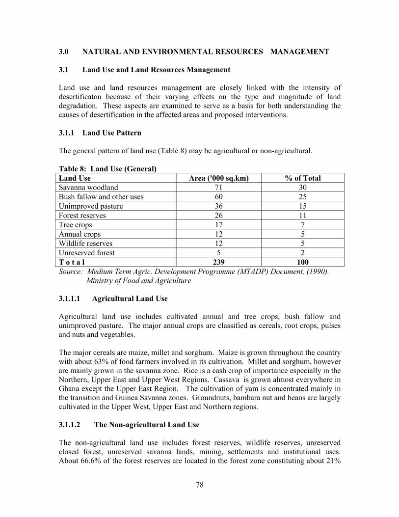
78
3.0 NATURAL AND ENVIRONMENTAL RESOURCES MANAGEMENT 3.1 Land Use and Land Resources Management Land use and land resources management are closely linked with the intensity of desertificaton because of their varying effects on the type and magnitude of land degradation. These aspects are examined to serve as a basis for both understanding the causes of desertification in the affected areas and proposed interventions. 3.1.1 Land Use Pattern The general pattern of land use (Table 8) may be agricultural or non-agricultural. Table 8: Land Use (General) Land Use Area ('000 sq.km) % of Total Savanna woodland 71 30 Bush fallow and other uses 60 25 Unimproved pasture 36 15 Forest reserves 26 11 Tree crops 17 7 Annual crops 12 5 Wildlife reserves 12 5 Unreserved forest 5 2 T o t a l 239 100 Source: Medium Term Agric. Development Programme (MTADP) Document, (1990). Ministry of Food and Agriculture 3.1.1.1 Agricultural Land Use Agricultural land use includes cultivated annual and tree crops, bush fallow and unimproved pasture. The major annual crops are classified as cereals, root crops, pulses and nuts and vegetables. The major cereals are maize, millet and sorghum. Maize is grown throughout the country with about 63% of food farmers involved in its cultivation. Millet and sorghum, however are mainly grown in the savanna zone. Rice is a cash crop of importance especially in the Northern, Upper East and Upper West Regions. Cassava is grown almost everywhere in Ghana except the Upper East Region. The cultivation of yam is concentrated mainly in the transition and Guinea Savanna zones. Groundnuts, bambara nut and beans are largely cultivated in the Upper West, Upper East and Northern regions. 3.1.1.2 The Non-agricultural Land Use The non-agricultural land use includes forest reserves, wildlife reserves, unreserved closed forest, unreserved savanna lands, mining, settlements and institutional uses. About 66.6% of the forest reserves are located in the forest zone constituting about 21%

79
of the total area of the zone. In contrast, 5.6% of the savanna zone is under reserve. However, about 90% of the wildlife reserves are found in the savanna zone. The Northern and Coastal savannas are the main grazing lands in Ghana. Majority of the cattle herds in Ghana are concentrated in the north where there are ample grazing grounds. Sheep and goats are widely distributed in the country but are largely concentrated in the north eastern section of the country particularly in the Upper East. Gathering of forest products such as nuts, fruits, medicinal herbs, barks and roots and cutting of fuelwood is practised in all the desertification-prone zones. These contribute significantly to the degradation of forests and woodlands. Of major relevance to the degradation problems are mining activities and settlements. Poor road construction works, drainage systems and unprotected gravel and soil-excavated sites along the road networks of the country are major contributors to gullying and sedimentation. 3.1.2 Farming Systems The major farming systems prevailing in the desertification-prone zone are bush fallow, compound and bush farms, specialized horticulture and large scale and mixed farming. 3.1.2.1 Bush Fallow System The bush-fallow system is the predominant system of farming. It involves the rotation of fields rather than crops; the use of fire for clearing vegetation; and the use of simple tools (dibble stick, hoe and cutlass for cultivation). Mostly, farm sizes are up to 2 ha and soil fertility is restored by fallow vegetation. The system works satisfactorily only in situations where enough land is available to ensure fallow periods of about 10 years or more. With the current fallow periods reduced in most cases from 6 to 10 years to 2 to 3 years, the system is becoming an inefficient production system. 3.1.2.2 The Compound Farming System It is found in the Northern, Upper East and Upper West regions, from Bolgatanga to Bawku and in the Lawra, Jirapa-Lambussie Districts in the Upper West Region. Farming is done on land around the homestead where the fertility of the soil is maintained by the application of household refuse and livestock droppings. Horticultural crops such as okro, tomato and sweet potato are planted. Sorghum and late millet are also planted. Groundnuts are sometimes planted or interplanted over the whole area except those reserved for horticultural crops. The size of a compound farm may vary from a quarter of a hectare to over 2 hectares slope. 3.1.2.3 Bush Farms
80
Farmers establish bush farms to supplement the produce from the compound farms. . The bush farms are located at about 4 to 9 km away from the village with sizes averaging one hectare or more. The bulk of the cereal needs of the household is produced from these farms. The usual cropping system is to mix sorghum and late millet or planted singly and often intercropped with groundnuts, bambara nuts or cowpea. The bush farms are characterized by the bush fallow system and nutrient mining. With the current population pressure, there is not enough land to go round every household unit and the yields from the compound farms are hardly sufficient to cater for their dietary needs. This situation creates annual food shortages causing an annual hunger gap between April and July in the northern savanna zone. 3.1.2.4 Mixed Farming (Crop-Livestock Integration) Mixed farming combines the cultivation of crops with livestock rearing. The latter provides power and manure on the farm. More than 30% of the total land area of northern Ghana is ploughed by bullocks. The system is mainly found in the Northern and Upper regions. The animals are allowed extensive grazing during the day and kraaled in the night. Feeding is, however, a major problem during the dry season when the grasslands are burnt and watering points dry up. 3.1.2.5 Specialized Horticulture (Shallot Farming) The most advanced traditional soil management system practised in Ghana in the cultivation of annual crops is that seen in the shallot growing systems at Anloga along the coastline of the Volta region (Ofori, 1996). The soils are sandy with low nutrient holding capacity. However, farmers have been able to cultivate the same site for over a century and yields of shallots cultivated three times a year are still averaging 6t/ha. Soil fertility is maintained using bat manure, cowdung, and poultry manure 3.1.2.6 Large Scale Farms Large scale farms are mainly found in the transition and the northern and coastal savanna zones. Their operations involve clearing of large tracts of land for the production of arable crops such as maize, rice, tobacco, yams and pineapples. The use of heavy machines and improper land clearing and cultivation methods have rendered many sites treeless. Sheet erosion is a common feature on such soils. 3.1.2.7 Cropping Areas Available estimates indicate that 425,410 ha of land is put to arable crop cultivation in Northern Region (PPMED, 1994). Rivers, forest and game and wildlife reserves occupy a further 870,000 ha. It is assumed that only 10% of the land is occupied by human settlements and that 70% of the land of the Northern Region is the potential area for livestock rearing (RELC, 1997). About 315,369 ha of land is under crop cultivation in the Upper East Region (MOFA, 1998). The Tono and Vea irrigation dams together cover 1.1% of the cultivable area of the region. About 250,000 ha are cultivated annually in the Upper West Region (UWADEP, 1995).
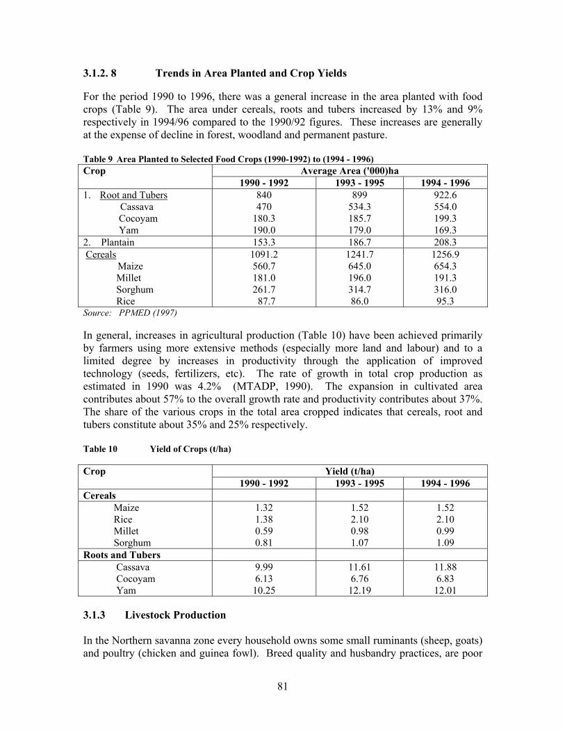
81
3.1.2. 8 Trends in Area Planted and Crop Yields For the period 1990 to 1996, there was a general increase in the area planted with food crops (Table 9). The area under cereals, roots and tubers increased by 13% and 9% respectively in 1994/96 compared to the 1990/92 figures. These increases are generally at the expense of decline in forest, woodland and permanent pasture. Table 9 Area Planted to Selected Food Crops (1990-1992) to (1994 - 1996)
Average Area ('000)ha Crop 1990 - 1992 1993 - 1995 1994 - 1996
1. Root and Tubers Cassava
Cocoyam Yam
840 470
180.3 190.0
899 534.3 185.7 179.0
922.6 554.0 199.3 169.3
2. Plantain 153.3 186.7 208.3 Cereals
Maize Millet Sorghum Rice
1091.2 560.7 181.0 261.7 87.7
1241.7 645.0 196.0 314.7 86.0
1256.9 654.3 191.3 316.0 95.3
Source: PPMED (1997) In general, increases in agricultural production (Table 10) have been achieved primarily by farmers using more extensive methods (especially more land and labour) and to a limited degree by increases in productivity through the application of improved technology (seeds, fertilizers, etc). The rate of growth in total crop production as estimated in 1990 was 4.2% (MTADP, 1990). The expansion in cultivated area contributes about 57% to the overall growth rate and productivity contributes about 37%. The share of the various crops in the total area cropped indicates that cereals, root and tubers constitute about 35% and 25% respectively. Table 10 Yield of Crops (t/ha)
Yield (t/ha) Crop 1990 - 1992 1993 - 1995 1994 - 1996
Cereals Maize Rice Millet Sorghum
1.32 1.38 0.59 0.81
1.52 2.10 0.98 1.07
1.52 2.10 0.99 1.09
Roots and Tubers Cassava Cocoyam Yam
9.99 6.13 10.25
11.61 6.76 12.19
11.88 6.83 12.01
3.1.3 Livestock Production In the Northern savanna zone every household owns some small ruminants (sheep, goats) and poultry (chicken and guinea fowl). Breed quality and husbandry practices, are poor
82
resulting in low fertility and high mortality. The majority of cattle owners are men. Available figures show that small ruminants are more common than cattle. According to Karbo et al., (1998) farmers in the Upper West Region ranked livestock as their primary source of income. Farmers in the Upper East Region depend more on livestock for cash income. Although both sheep and goats are sold, goats are more prolific and therefore more often sold. Milk from cattle is consumed by Fulani herders or sold. Peri-urban dairy could assume importance in terms of cash income for women. On the average 5.8 goats and 4.7 sheep per household are sold annually and 42.6% of farmers' income is from the sale of livestock. Livestock indirectly contribute to improved food security through crop-livestock integration, bullock traction and manure (recycling nutrients). Households with bullocks are averagely able to cultivate 60% more land than those depending on the traditional hoe (Alhassan, et al., 1999). Panin (1988) found bullock cultivation to increase crop yield by 16% over the same area cultivated by the hand hoe. The hiring out of bullocks for ploughing services is another source of income for farm households. 3.1.3.1 Challenges and Constraints to Livestock Production Most livestock species in northern Ghana are indigenous breeds, which are
characterised by relatively small body size and production rates but are however, hardy, prolific and disease resistant.
Poor husbandry practices result in high mortality, slower growth rates and lowered
reproductive and productive capacities. The absence of credit to farmers limits their ability to invest in and expand their livestock farms and this is further exacerbated by a general low business sense among livestock farmers.
The indeterminate agricultural policy leads to most government and donor funded programmes ignoring the role of livestock in the lives of the average farm household.
Livestock farmers associations are few and inactive and therefore lack the necessary clout required to obtain fair prices for their livestock.
The policy on importation of livestock and livestock products undermines farmers efforts as meat of foreign origin costs less than meat produced in Ghana
3.1.3.2 Suggested Interventions The suggested development and research interventions provide options to be picked and used when applicable to a specific district or community. Action researches are meant to generate information to be fed into the main intervention areas. i) Integrated small ruminant, pig and poultry development and production for
food security in Northern Ghana. • Group formation is recommended (Millar et al., 1998). Those groups will manage
their natural resources, share information and be a pressure group to safeguard the interests of livestock farmers.

83
• Genetic improvement of small ruminants, pigs and poultry can be carried out (through selections and introduction of improved males to cross local breeds, etc).
• Improved livestock housing and feeding technologies should be introduced. • Health aspects can be catered for through the training of Community Livestock
Workers (CLWs) and mass vaccination programmes. • The provision and management of water through the use of hand-dug wells and
effective management of dams and dug-outs are necessary. • A gimmer project can be initiated for “livestock-less” people of the Northern Region
by fathers giving breeding animals to their children. • A range improvement component would be necessary to sustain the animals within
different communities. ii) Animal traction in sustainable land use management • Bullock and/or donkey traction can be promoted for ploughing, weeding and haulage. • Livestock rearing and environmental management. • The burning of the range not only robs livestock of feed sources but also poses a
threat to environmental sustainability. • Multi-purpose trees and agroforestry will decrease the stress on the environment as
well as provide additional fodder sources for livestock. • Other fast growing forage trees like Acacia spp; Leucaena and Gliricidia can be
introduced in forage gardens. iii) Nutrition Security • Low meat consumption is widespread throughout northern Ghana and increased
export of legumes makes malnutrition endemic in the area. • The utilization of meat and meat products as well as the channelling of milk through
the school system, would make a difference to the nutritional status of most children in northern Ghana.
• Any attempt to boost fresh water fish production in the region would also support this venture.
Action Research
i) evaluation of rural dairy milk potential for food security and nutrition ii) livestock systems diagnostic and baseline studies in selected areas A survey and analysis of herds and their milk production potential is essential to this option. Milk yield and quality will be monitored as well as income generation from making local cheese (‘wagase’). • Unhygienic methods of handling and marketing milk tend to affect the sale of milk.
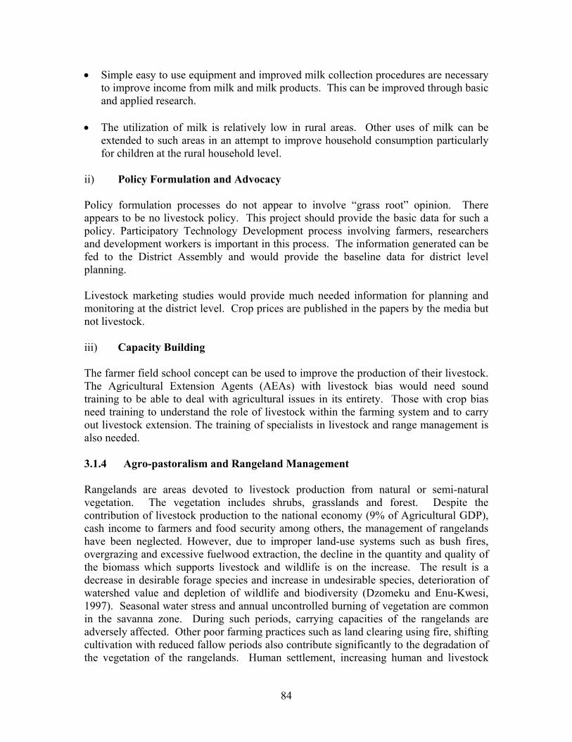
84
• Simple easy to use equipment and improved milk collection procedures are necessary to improve income from milk and milk products. This can be improved through basic and applied research.
• The utilization of milk is relatively low in rural areas. Other uses of milk can be
extended to such areas in an attempt to improve household consumption particularly for children at the rural household level.
ii) Policy Formulation and Advocacy Policy formulation processes do not appear to involve “grass root” opinion. There appears to be no livestock policy. This project should provide the basic data for such a policy. Participatory Technology Development process involving farmers, researchers and development workers is important in this process. The information generated can be fed to the District Assembly and would provide the baseline data for district level planning. Livestock marketing studies would provide much needed information for planning and monitoring at the district level. Crop prices are published in the papers by the media but not livestock. iii) Capacity Building The farmer field school concept can be used to improve the production of their livestock. The Agricultural Extension Agents (AEAs) with livestock bias would need sound training to be able to deal with agricultural issues in its entirety. Those with crop bias need training to understand the role of livestock within the farming system and to carry out livestock extension. The training of specialists in livestock and range management is also needed. 3.1.4 Agro-pastoralism and Rangeland Management Rangelands are areas devoted to livestock production from natural or semi-natural vegetation. The vegetation includes shrubs, grasslands and forest. Despite the contribution of livestock production to the national economy (9% of Agricultural GDP), cash income to farmers and food security among others, the management of rangelands have been neglected. However, due to improper land-use systems such as bush fires, overgrazing and excessive fuelwood extraction, the decline in the quantity and quality of the biomass which supports livestock and wildlife is on the increase. The result is a decrease in desirable forage species and increase in undesirable species, deterioration of watershed value and depletion of wildlife and biodiversity (Dzomeku and Enu-Kwesi, 1997). Seasonal water stress and annual uncontrolled burning of vegetation are common in the savanna zone. During such periods, carrying capacities of the rangelands are adversely affected. Other poor farming practices such as land clearing using fire, shifting cultivation with reduced fallow periods also contribute significantly to the degradation of the vegetation of the rangelands. Human settlement, increasing human and livestock

85
populations leading to over-exploitation of the natural resources, particularly vegetation, result in accelerated erosion, soil fertility decline, decreased soil productivity and low crop and biomass yield. 3.1.4.1 Feed Resources In Ghana, available rangeland is under utilized with an estimated 167,000 km2 of unimproved rangeland supporting less than half its carrying capacity of cattle (Alhassan, 1993). The major feed resource base for ruminants in northern Ghana are the natural rangelands (herbs and browse shrubs), crop residues (cereal and legume) and agro-industrial by products from processing of agricultural products. Between 22,200-24,220 mt of cotton seed is produced in the zone annually. As shown in Table 11, rangeland herbaceous grasses (excluding browse shrubs) and crop residues, together provide for a ruminant carrying capacity of 1.04 ha/Tropical Livestock Unit (*1 TLU). When compared on a rangeland basis, the Northern Region has the highest carrying capacity of 0.86 ha / TLU. Upper West and Upper East regions have the capacity of 1.44 and 1.66 ha/TLU respectively. Table 11 Estimated Regional Ruminant Feed Resources and Carrying
Capacities in Northern Ghana Source Yield
T DM/ha Total Area X 106 ha
Feed Quantity X 106 MT DM
Ruminant Carrying Capacity, ha/TLU*
Upper West Region Crop Residues Natural Rangeland
5.210 2.400
0.27 1.115
1.415 2.676
3.5 2.9
Total 7.610 1.385 4.091 1.44 Upper East Region Crop Residues Natural Rangeland
1.710 2.40
0.297 0.233
0.511 0.559
3.98 2.90
Total 4.12 0.530 1.070 1.66 Northern Region Crop Residues Natural Rangeland
5.21 2.758
0.47 4.69
2.23 12.94
3.5 2.5
Total 7.968 5.16 15.17 0.86 Average for N. Ghana 6.566 7.075 20.331 1.04 Calculation: CIDA Field Study 2000 *1 TLU = One mature cow of 250 kg live weight The situation however, appears critical for the Upper East Region because the carrying capacity will be exceeded if resources from the cropped areas are not included in the feed equation. Other distress spots may exist on a district basis in other parts of northern Ghana depending on population density and inherent low soil fertility of the particular area. In general, the feed resource base in the zone is sufficient to support a much larger livestock population. Environmental damage is possible if the livestock population is allowed to increase beyond certain levels. Currently, the few and poorly distributed
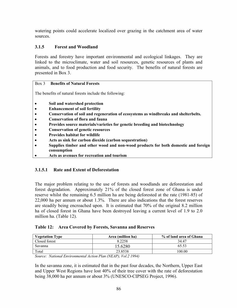
86
watering points could accelerate localized over grazing in the catchment area of water sources. 3.1.5 Forest and Woodland Forests and forestry have important environmental and ecological linkages. They are linked to the microclimate, water and soil resources, genetic resources of plants and animals, and to food production and food security. The benefits of natural forests are presented in Box 3. Box 3 Benefits of Natural Forests The benefits of natural forests include the following: • Soil and watershed protection • Enhancement of soil fertility • Conservation of soil and regeneration of ecosystems as windbreaks and shelterbelts. • Conservation of flora and fauna • Provides source materials/varieties for genetic breeding and biotechnology • Conservation of genetic resources • Provides habitat for wildlife • Acts as sink for carbon dioxide (carbon sequestration) • Supplies timber and other wood and non-wood products for both domestic and foreign
consumption • Acts as avenues for recreation and tourism 3.1.5.1 Rate and Extent of Deforestation The major problem relating to the use of forests and woodlands are deforestation and forest degradation. Approximately 21% of the closed forest zone of Ghana is under reserve whilst the remaining 6.5 million ha are being deforested at the rate (1981-85) of 22,000 ha per annum or about 1.3%. There are also indications that the forest reserves are steadily being encroached upon. It is estimated that 70% of the original 8.2 million ha of closed forest in Ghana have been destroyed leaving a current level of 1.9 to 2.0 million ha. (Table 12). Table 12: Area Covered by Forests, Savanna and Reserves Vegetation Type Area (million ha) % of land area of Ghana Closed forest 8.2258 34.47 Savanna 15.6280 65.53 Total 23.8538 100.00 Source: National Environmental Action Plan (NEAP), Vol.2 1994) In the savanna zone, it is estimated that in the past four decades, the Northern, Upper East and Upper West Regions have lost 40% of their tree cover with the rate of deforestation being 38,000 ha per annum or about 3% (UNESCO-CIPSEG Project, 1996).
87
The area most seriously affected by deforestation in the country, however, is the Upper East Region with its high human and livestock population densities and intensive cultivation. Deforestation in the north-western corner of the Upper West Region around Hamile and Lawra is also seriously increasing as is the case with the Accra Plains in the south. 3.1.5.3 Bush Fires Bushfires occur widely in both forest and savanna environments in Ghana but more extensively in the latter zone between October to April for various parts of the country. The grasslands are burnt annually to prepare the land for farming, to get rid of dried grass, to manage rangelands for grazing purposes, to drive away wild animals from settlements or to control undesirable animals and insects (such as snakes, rodents, tsetse flies, ticks, etc.) Unfortunately, most of these fires are uncontrolled and they assume wild and devastating proportions.
• Effects of Fires on Grasslands Most systematic observations on bushfires have been made in the savannas. Evidence indicates that if fire is eliminated most areas will develop into forest or woodland. In the Guinea and Sudan Savanna Zones the vegetation eventually develops into dry forest or woodland with little or no grass cover. General observations from experimental studies on the effects of bush burning on grasslands in the Guinea and Sudan Savanna Zone of Ghana (Rose-Innes, 1963; Brookman-Amissah et al., 1976) indicate the following: - Widespread areas of savanna in northern Ghana are pro-climax because fire is
responsible for their maintenance in their present state. - Presence of fire affects the delicate ecological balance between the woody and
herbaceous components of the vegetation which is normally affected by forces of competition.
- Complete protection (no burning) of the Guinea savannas ensures rapid development towards a closed woodland or forest type climax which reduces or eliminates the herbaceous cover.
- Early dry season fires retard, but do not stop the development of woody vegetation, by destroying a considerable proportion of the natural regeneration of fire-tender species.
- Late dry season and early wet season fires are particularly destructive to trees and shrubs except the most fire resistant species.
- Both the early and late dry season burning maintain growth of grasses. The early burn encourages the growth of more nutritious Andropogon gayanus while the late burn encourages the dominance of the coarse less palatable Loudetia.
These effects depend on the time, intensity and frequency. Generally the more frequent the burning the faster the rate of tree destruction and invasion by weeds and poor quality forage.
88
It is pointed out that if a policy of early burning is universally adopted, it will favour forestry, limit the destruction of the forest reserves, and help to ensure that trees and shrubs are conserved as a source of fuelwood. It will however contribute to grazing, land degradation and sheet erosion through increased runoff at the start of the rains. It is worthy to note that some communities in the Upper West and Upper East Regions have succeeded in creating a “non-burning” environment. The experience of these communities would be invaluable to the quest for a lasting solution to the scourge of bush fires. 3.1.5.4 Consequences of Deforestation Deforestation induces land degradation and desertification, destruction of biodiversity and the depletion of the natural sink for carbon dioxide. It impacts adversely on forest functions such as watershed protection, provision of habitat for wildlife, stormflow stabilisation, runoff control, soil erosion prevention and environmental amelioration. By disturbing the watershed protection function of forests and woodlands, deforestation causes siltation of dugouts, rivers and their tributaries (Red and White Volta) and increases flooding in their basins. Boreholes also dry up due to lowered water table. The clearing of forests also affects the migratory routes of wildlife, enhances insolation and soil temperature which affects the activities of useful soil microbes. Large scale conversion of forest lands into other land use forms, contributes significantly to local climate change. Reforestation and tree planting constitute one method of regenerating the forest. This should be accompanied by appropriate management of existing forests and woodlands to permit their use without impairing their productive and protective capacities. 3.1.6 Forest Management The management of forests in the country is viewed in relation to the category of forests, namely, Reserved Forest, Unreserved Forest and Wildlife Reserves. 3.1.6.1 Reserved Forests The National Policies on Forest and Wildlife make provision for setting aside Forest and Wildlife Reserves for the permanent preservation of their biotope values and for sustained utilization of their resources (Table13). Sustaining the forest and its productive values requires the physical protection of the forest against biotic agencies and human caused abiotic agencies; and the application of techniques of management to permit utilization of its resources without impairing its ability to continue producing at the required level. These functions have been carried out by the Forestry Department. Although there have been encroachments of illegal farming, this has been kept within manageable limits.
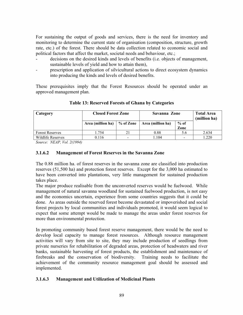
89
For sustaining the output of goods and services, there is the need for inventory and monitoring to determine the current state of organisation (composition, structure, growth rate, etc.) of the forest. There should be data collection related to economic social and political factors that affect the market, societal needs and behaviour, etc.; - decisions on the desired kinds and levels of benefits (i.e. objects of management,
sustainable levels of yield and how to attain them), - prescription and application of silvicultural actions to direct ecosystem dynamics
into producing the kinds and levels of desired benefits. These prerequisites imply that the Forest Resources should be operated under an approved management plan.
Table 13: Reserved Forests of Ghana by Categories
Closed Forest Zone
Savanna Zone Category
Area (million ha) % of Zone Area (million ha) % of Zone
Total Area (million ha)
Forest Reserves 1.754 21 0.88 5.6 2.634 Wildlife Reserves 0.116 - 1.104 - 1.220 Source: NEAP, Vol. 2(1994) 3.1.6.2 Management of Forest Reserves in the Savanna Zone The 0.88 million ha. of forest reserves in the savanna zone are classified into production reserves (51,500 ha) and protection forest reserves. Except for the 3,000 ha estimated to have been converted into plantations, very little management for sustained production takes place. The major produce realisable from the unconverted reserves would be fuelwood. While management of natural savanna woodland for sustained fuelwood production, is not easy and the economics uncertain, experience from some countries suggests that it could be done. As areas outside the reserved forest become devastated or impoverished and social forest projects by local communities and individuals promoted, it would seem logical to expect that some attempt would be made to manage the areas under forest reserves for more than environmental protection. In promoting community based forest reserve management, there would be the need to develop local capacity to manage forest resources. Although resource management activities will vary from site to site, they may include production of seedlings from private nurseries for rehabilitation of degraded areas, protection of headwaters and river banks, sustainable harvesting of forest products, the establishment and maintenance of firebreaks and the conservation of biodiversity. Training needs to facilitate the achievement of the community resource management goal should be assessed and implemented. 3.1.6.3 Management and Utilization of Medicinal Plants
90
The majority of the population in the desertification prone zones depend on herbal medicines for human and animal health care. These medicinal plants and other useful botanicals are undergoing severe degradation by wild bushfires, land clearing for farming and other purposes, overgrazing and unsustainable wildcrafting (harvesting from the wild). There is therefore the need for a major initiative to support the sustainable management and utilization of medicinal plants in the affected areas. Major activities would include an inventory and documentation of selected medicinal plants, evaluation of community dependence on medicinal plants for human and animal health care, inventory of indigenous knowledge, propagation, cultivation and sustainable harvesting of medicinal plants. A major collaborative effort in the sustainable development of medicinal plants has started at the Kwame Nkrumah University of Science and Technology. Some of the activities involve germplasm collection, characterization of the habitats of selected plants, propagation and cultivation, establishment of herbaria and herbal gardens, ethnobotanical studies, handling methods of medicinal plants, and assessment of active principles/ingredients in medicinal plants. 3.1.6.4 Wildlife Reserves The Wildlife Reserves in Ghana occupy a total land area of 1.22 million ha of which 90% is located in the savanna zone. The reserves contain a wide range of animals and are categorised into 5 National Parks, 1 Strict Nature Reserve, 2 Wildlife Sanctuaries and 5 Game Reserves. The respective areas covered by these categories are 1.03, 0.032, 0.024 and 0.146 million ha. The wild animal resources are severely depleted and their habitats continue to be under siege from various economic activities including clearing for agriculture, logging and timber extraction, mining, extension of electricity through transmission lines and construction of roads. Community participation in the protection against encroachment and poaching and monitoring of animals in the conservation areas will contribute to sustained build-up of wildlife stocks. The long term goal is to ensure participation of rural communities in wild life management activities both in protected areas and outside reserved areas. 3.1.6.5 Management of Wildlife Reserves In 1998, building on the Forestry Development Master Plan, the Wildlife Department (WD) published a comprehensive Wildlife Development Plan 1998 - 2003. The goal of the plan is to provide a basis for achieving sustainable use of wildlife resources. The broad strategy for achieving sustainable use of wildlife resources involves six principal elements, which are to develop effective wildlife management capacity, promote popular participation in wildlife management, develop the economic potential of wildlife, maintain and enhance Ghana's permanent wildlife estate. Others are to promote public awareness and support for wildlife conservation and develop technical excellence through
91
research and monitoring. In order to reduce pressure on wildlife resources considerably, it will be highly desirable to introduce programmes for domestication and ranching in which one or other of the larger antelopes, Kob or Bush Buck are bred and made available on a large scale. 3.1.6.6 Biodiversity Conservation Biodiversity conservation is implicit in the above forest and wildlife resources management sections. They also protect soil and water resources. Future efforts at improving crops will need to draw heavily on the gene pool of native/wild crop varieties. Because of these and other benefits, there is an urgent need for assessing the distribution and extent of relict natural communities and vegetation formations and for measures to arrest degradation. In seeking assistance for biodiversity conservation, the aim would be to conserve unique species and habitats, maintain traditional crop varieties, land races and their wild varieties and improve the livelihoods of communities. Priority areas within the desertification prone zones that are of national and global importance for biodiversity conservation should be delineated, mapped and excluded from exploitation and community-based management plans developed for the protection of these areas. There would be the need to finance alternative livelihood schemes for affected communities and provide for continuous monitoring and evaluation of biological and social indicators of programme performance. The alternative livelihood schemes would improve the economic status of the communities living around the protected areas and encourage them to participate in the programme and forgo income previously generated from the newly delineated sites. This, would in addition, relieve pressure on biological resources by supporting alternative development options. It would be beneficial to link this component with the GEF supported conservation priority-setting project for the Upper Guinea Forest Ecosystem in West Africa being implemented by Conservation International (CI) and the United Nations Development Programme (UNDP). 3.1.7 Water Resources Use and Management The water resources are used for domestic, irrigation, industrial and livestock watering. In the rural communities reservoirs, wells, boreholes and dugouts are the major sources of water supply. The use of water for livestock production is directly related to the production techniques adopted by farmers. Livestock have traditionally been supplied with water from dugouts, surface impoundments, rivers and wells. The drying of drinking water sources for both human and livestock results in scarcity of water for consumptive use for most part of the dry season in the affected areas. 3.1.7.1 Problem of Use of Water and Water Resources
92
Conflict: Conflicts between individuals using water from a reservoir for dry season gardening and those using the same source of water for watering of livestock. The latter tends to destroy the crops of the former. Pollution: These come from the use of agro-chemicals such as, mineral fertilizers, insecticides and herbicides. Livestock drinking water from the same dugouts and reservoirs used by humans pollute the water with their droppings. Deforestation of Catchment Areas: Deforestation and other unsustainable farming practices lead to soil erosion, which causes siltation of rivers, dugouts and reservoirs thus reducing their capacity to hold water.. Degradation also causes changes in the water balance components, namely, rainfall, evapotranspiration, runoff and infiltration. Sustainable water resources management can be achieved only when it is linked with watershed management involving year round maintenance of cover and practice of soil and water conservation 3.1.8 Energy Supply, Consumption and Demand Ghana relies mainly on wood, oil and electricity for its energy requirements. Wood is the principal energy source. In 1985, 12 million m3 of fuelwood and charcoal were consumed, accounting for 70% of the country’s total energy usage at a value of US$195 million. Fuelwood is also the backbone of cottage and rural industries and provides nearly all the household energy used for cooking and water heating. Commercial energy (petroleum products and electricity) accounts for less than 30% of total energy consumption. Ghana’s greatest renewable energy potential lies in biomass, hydropower and solar resources. 3.1.8.1 Biomass It has been estimated that Ghana’s growing stock of biomass is about 322 million metric tonnes with an annual incremental growth of about 12.3 million tons. Woodfuels mainly in the form of fuelwood and charcoal make up 75% or more of the national energy consumption. In rural areas fuelwood constitutes by far a greater percentage while charcoal predominates in the urban areas. Agricultural residues in the form of millet stalks, some corn cobs and cowdung and wood residues in the form of sawdust make up a very small percentage of woodfuel consumption. In the rural areas within the closed forest zone, the fuelwood consumed by the household is still derived mainly as deadwood and residues from farm land clearing and preparation The study of Nketia et al. (1989) further indicated that the major production of charcoal is concentrated in the Guinea Savanna woodland and Transition Zones. 3.1.8.2 Projected Trends in Fuel Consumption With increasing urbanization the demand for the mix of fuelwood and charcoal will grow in favour of charcoal. Per capita consumption of charcoal and fuelwood is estimated as 0.43-0.46 and 1.43 kg/person/day respectively. The figures in Table 14 show that fuelwood use will grow at the rate of 2.5%, charcoal 5% and LPG 14% per annum.
93
Table 14: Projections of fuel consumption (‘000 tonnes) 1995-2000 Fuel 1990 1995 2000 Growth Rate % LPG 6 11.55 22.24 14.0 Kerosene 167 168.68 170.37 0.6 Charcoal 637 812.99 1,037.61 5.0 Fuelwood 7,019 7,941.35 6,984.91 2.5
Source: Adapted from Ampadu-Agyei et al. (1994) 3.1.8.3 Alternative Energy Sources - Hydro Power Large scale hydroelectricity generation is by far the major source of electrical power in Ghana. The Akosombo dam provides 912 Mw of firm capacity and the Kpong dam gives an additional 140 Mw electricity. Environmental problems caused by the Akosombo and Kpong dams include the growth of aquatic weeds, destruction of fisheries, coastal erosion, and resettlement and micro-climatic changes which, according to Volta River Authority (VRA) has resulted in lower rainfall in areas up to 8 km from the edge of the lake (NEAP Vol.2, 1994). - Solar Energy Ghana, by virtue of its geographic location, is well endowed with solar resources. The country receives 4.5-5.6 kwh/m2/day of solar radiation and between 1,808-2,819 hours of sunshine per year. (Ampadu-Agyei et al. 1994). The use of solar energy is however not widespread. The potential for developing technologies for the utilization of solar energy would be in the following areas of solar pumps for water supply and small scale irrigation and crop dryers including small solar kilns for drying lumber; As at March, 1994 about 770 units of photovoltaic system had been installed in Ghana (Table 15). Table 15: Solar Photovoltaic Applications in Ghana (March, 1994)
Applications Number Percentage Telecommunication 531 68.9 Lighting 93 12.1 Refrigeration 87 11.3 Computer/office equipment operation 22 2.9 Water Pumping 12 1.5 Ventilation (fan and air condition) 9 1.2 Miscellaneous 10 2.1 Total 770 100.0
Wind Energy
94
Available data suggests that the wind regimes in Ghana are moderate. The most favourable region for the development of wind power is the coastal Accra Plains. Biogas The generation of biogas has been identified as one of the major sources of energy. Successful large scale adoption of biogas will require the availability of large quantities of suitable waste material in concentrated quantities and suitable digesters or plants at moderate costs (Table 16). The potential for biogas production by region and inventory of digesters in Ghana are presented in Table 17. Table 16: Inventory of Digesters in Ghana
Type No Capacity m3 Material used
Year of Construction
Location
Indian Floating (a) 1.15 Steel 1982 (April) Agric Eng., Dept. KNUST. Kumasi
Floating 3 (b) - Steel 1982 (April) KNUST (c) 0.35 Oil drums 1980 IRI (CSIR) Horizontal Cylindrical Digestor
1 2.8 Steel 1982 (Nov.) Agric. Eng. KNUST, Kumasi
Chinese Fixed Dome (a) 6 Burnt Bricks 1986 (Feb.) Univ. of Ghana Agric Farm, Kantamanso
3 (b) 8 “ 1986 Univ. of Cape Coast, Agric Farm, Cape Coast
(c) 10 “ 1986 (June) Bank of Ghana Cattle Branch, Shai Hills
Table 17: Biogas Potential by Region
Region % Cattle % Pigs Potential Northern 3.5 16 *** Upper West 22 23 *** Upper East 19 7.1 *** Greater Accra 8.9 6.2 ** Volta 8.1 8.3 * Brong Ahafo 3.5 17.6 * Eastern 2.2 6.9 * Ashanti 0.01 6.2 * Central 0.005 3.5 * Western 0.004 5.8 *
The above evaluation of biogas potential is based on availability and recoverability (effective availability) of only livestock and piggery waste. *** - very high ** - high * - less important Source: NEAP Vol.2 (1994). - Liquefied Petroleum Gas (LPG)
95
The annual production of LPG from the Tema Oil Refinery is about 5,000 tonnes. The promotion of LPG in Ghana is primarily targeted at substituting it for firewood and charcoal. However, the product became scarce and expensive when vehicles started using it as a substitute for gasoline and diesel. In order to achieve the primary aim of LPG promotion, the conversion of vehicles to LPG has been banned. The widespread use of LPG, is constrained by the cost and availability. 3.1.8.4 Measures for Meeting Domestic Energy Needs, Development and
Conservation - The short-term options include: Adoption of Efficient Charcoal Production Technology Development and Promotion of Energy Efficient Woodfuel Stoves - Medium to Long-term Options • Tree planting through agroforestry, individual and communal woodlots and farm
forestry. • The development and use of biogas on a large scale with feasibility assessment
for family type biogas. • Substitution of other fuel, such as LPG, for fuelwood and charcoal • The development of solar power including photovoltaic systems for generation of
electricity. 3.2 Socio-economic issues 3.2.1 Agro-Industry Agro-industry is widespread. These industries can be categorized into the following: Vegetable oil extraction/milling, fruit and vegetable processing;
Slaughtering, preparations and preservation of meat; fish processing, cotton
ginning, spinning and textile weaving; Leather works, soap making; cassava processing; brewing; wood and straw
weaving; cereal/grain processing and tobacco processing. 3.2.2 Marketing/Processing Agricultural marketing is private sector dominated. Most producers depend on a complex chain to take their outputs from the farm gate to the urban consumer. The market position of small holder farmers is very weak, in that they mostly sell in small amounts to itinerant traders, usually soon after harvest and at low prices to meet their cash needs, and/or pay off loans.

96
Key problems in the development of traditional markets include inadequate marketing infrastructure (such as storage and processing facilities) which result in high post-harvest losses, lack of market information which prevents the market from operating in a competitive manner, and lack of transport infrastructure. 3.2.3 Alternative Income Generation Activities Some of these new income generation activities include: • Bee keeping, snail and grasscutter rearing • Agroforestry, mushroom growing and aquaculture • Woodlot establishment for charcoal making • Beads making, basket and mat weaving, and rattan/cane materials production • Artifacts production from wood and straw-wares production • Fruit tree growing, fruit processing • Vegetable oil extraction, gari processing, and local soap making • Ceramics/Pottery, Batik, Tie and Dye making • Small-scale mining e.g. clay, gravel, salt Poverty alleviation through giving assistance to the rural folk to engage in new alternative income generation activities is one of the surest ways of combating desertification. 3.2.4 Poverty Poverty is defined as an unacceptable physiological and social deprivation; lacking the basic necessities of life or health. The poor is anyone denied adequate health, diet, clothing and shelter because of lack of resources. 3.2.4.1 Trends and Disparities Results from the Ghana Living Standards Survey in 2000 indicated that the incidence of overall poverty reduced from 51.7% in 1991/92 to 39.5% in 1998/99. The incidence of extreme poverty has been concentrated mostly in the Western, Greater Accra, Volta, Ashanti and Brong Ahafo regions whereas the Central, Northern and Upper East regions experienced increases. Five out of the 10 regions in Ghana had more than 40% of their population living in poverty in 1999; the worst affected being the three Northern Savanna regions. 3.2.4.2 Social Dimensions Social indicators point out that infant and under five mortality rates decreased from 66/1000 to 56/1000 and 108/1000 respectively from 1993 to 1998, but with deep geographical disparities. The mortality rate is generally twice or three times higher in the three northern regions than in the south. A contributory cause is the fact that over 30% of children in the north are not fully immunized before their first birthday. There is also
97
evidence of high prevalence compared to the national figure of 18%, a feature that is due to poor sanitation. 3.2.4.3 Causes of Poverty The causes of poverty include lack of access to capital, social assets, land, and market opportunities. Others are low capacities through lack of education, vocational skills, entrepreneurial abilities, poor health and poor quality of life. There is lack of capacity for the poor to influence social processes, public policy choices, and resource allocations 3.2.4.4 Response to Poverty Most of the people in the poverty zones of the country incidentally are farmers or dependent on natural resources i.e. land, vegetation, water and other land based resources. The result is deforestation and degradation of land resources. 3.2.5 Traditional and Customary Beliefs, Rituals Land ownership and allocation is still basically traditional and customary. Allocation and use of land and its resources is still accompanied with the performance of one ritual or the other. In Northern Ghana, which includes the Upper East and West regions, land ownership or custodianship is mainly by the Tindanas. There are however other holdings by the skins, families and individuals. In the south, ownership is mainly by the stools, clans and families. Women however, do not own land in the north. Other systems of ownership, such as the “Abusua” or extended family or group or commercial ownership also prevail over a wide area 3.2.5.1 Festivals Traditional festivals have either direct or indirect impact on the land or water resources. Examples are, Ngmayem, Ohum, Fire Festivals (Bugum in Dagbon; Zunbenti in Upper West Region), Kundum and Kakube among others. Some of the festivals in some parts of the Northern Regions have been blamed for the poor culture of bush fire management. Nevertheless traditional control especially in some parts of the Upper West Region has helped in controlling bushfires. 3.2.5.2 Sacred Groves These are small patches of forest/woodland set aside near human settlements and declared sacred. It was a way of conserving biodiversity. Even though many of the groves have dwindled in size in recent years due to human interference, the relics of these groves could serve as entry points for the promotion of natural resource conservation. 3.2.5.3 Rituals
98
Inherent in Ghanaian culture are rituals which lend importance to natural resources. In the libation prayer, the forests, rivers, lakes etc. are called upon for drink. Certain trees, rivers and lakes are even worshipped and various rituals performed for their conservation. 3.2.6 Land Tenure Land tenure or land holding defines the terms governing access to land. In the patrilineal system as in northern Ghana, land is divided among the male heirs of the family. This system of inheritance often leads to fragmentation gifts. There are also a few cases of rental (cash or share cropping arrangement). Other tenure systems are the "Abunu" (50% share) and "Abusa" (34%/66%). Inherent is the disincentive to maintain tree planting culture or maintaining economic trees on the land. Under the matrilineal inheritance, there may be some disincentive for a man to undertake long-term improvements to his land, because, on his death, his widow and children will not inherit the land. As a result of fragmentation under the patrilineal inheritance system, contiguous plots may not only be held by different persons, but may be under different tenure. Thus where soil conservation measures should for technical reasons extend over a whole micro-catchment area, it may be difficult to get them adopted by all farmers concerned. 3.2.7 Decentralization/Governance Ghana has a five-tier public administration with Central Government at the apex, and Regional Coordinating Councils (RCCs) at the second level occupying a combined position of being both an extension of the central government and co-ordinator of activities of the local government systems. At the third level are the District Assemblies (DAs) occupying the position of highest political authorities in the districts. At the fourth level are sub-district structures comprising a number of Sub-Metropolitan, Sub-District, Urban, Zonal and Town Areas Councils. At the fifth level is a network of Unit Committees. Throughout Ghana, public administration is ensured by two parallel systems: a modern system consisting of DAs and the traditional chieftaincy structure. The geographic boundaries of the latter rarely coincide with those of the regions and districts. Consultation between the two are frequent and respectful, with the modern leadership generally deferring to traditional authorities on land matters and the chiefs referring cases that they cannot solve to the courts and the District Assembly. 3.2.8 Rural Development - Access to Basic Social Services 3.2.8.1 Education Ghana is yet to achieve universal enrolment in basic education. As a result of lack of access to education (formal and informal) and skills, the poor are not able to participate fully in development and improve their living standards. According to Ghana Statistical

99
Service (GSS) (1993), 87% of rural households live in communities where there is a primary school, and 64% live in communities with JSS. The percentages for four most deprived regions, with regard to primary school are Upper East Region – 67%; Northern Region– 75% and Upper West Region – 80%. With regard to JSS, Upper East Region is the most deprived – 33%; Upper West Region– 40%; Western Region – 46% and Eastern Region– 57%. 3.2.8.2 Health It is estimated that 8.36 million people living in 47,000 rural settlements do not have any or ready access to the basic government-provided health facilities which are largely urban-based. The Ministry of Health (MOH) accessibility standard is to provide one health facility within a walking (travel) distance not exceeding 8 km. The primary healthcare coverage was estimated, in 1989, to be 92% for the urban sector and 45% for the rural sector. In 1987 the doctor-population ratio was 1:5764 in Accra; 1:56682 in Central Region; 1:24930 in Western Region; and 1:63095 in Northern Region. While the entire population of the Accra Metropolitan Area had access to health facilities, only 11% of the population in the North had access compared with 77% in the Central Region and 26% in the Western Region (UNICEF, 1990). 3.2.8.3 Water and Sanitation Lack of access to potable water supply in Ghana is of great concern. The problem is closely related to water quality; inadequate supply; lack of maintenance resulting in broken hand pumps and silted dams; the long distances women and children have to walk to fetch water; inability to pay for water because of lack of income-generating activities; and the existence of water-borne diseases. The level of sanitation coverage is very low throughout Ghana and this is reported to be a factor in the high levels of morbidity and environmental pollution. For example, in the Upper West Region only 20% of urban population has access to sanitary facilities. 4.0 PROPOSED NATIONAL ACTION PROGRAMME TO COMBAT
DESERTIFICATION AND MITIGATE THE EFFECTS OF DROUGHT
4.1 Rationale for Combating Desertification in Ghana A major activity in reversing desertification is the establishment of permanent and temporary vegetative cover on the land. This, however, should be done in the context of economic growth, environmental sustainability and enhanced livelihoods. Considering that most economic activities in Ghana are land-based, community participation in all activities designed to combat desertification is critical to the achievement of the desired impact. The Action Plans to Combat Desertification are therefore proposed with the view that the component activities would be planned to accommodate the following principles:

100
• full involvement of the communities to ensure that they make informed choices based on a thorough understanding and implications of each option;
• developing a sense of community ownership of desertification control measures and the required capacity for operation and maintenance of any facility resulting from such a measure;
• gender considerations in issues relating to community-based activities necessary for reducing the effect of desertification,
• providing cost-effective solutions and methodologies that easily lend themselves to community and district level operation and maintenance;
• proposing solutions that are socially acceptable that will permit the use of limited human and financial resources available;
• ensuring a balance between economic desirability of interventions in the low-income community context that will, at the same time, ensure conformity to environmental standards; and
• creating awareness of the environmental issues inherent in reversing desertification.
4.2 Sustainable Management and Conservation of Natural Resources As a result of land degradation in Ghana, large tracts of cropland which were once biologically fertile have become unproductive; grasslands, woodlands and forests are seriously degraded; natural waters are polluted; surface water and soil water storages are depleted; and streams dry up more rapidly with attendant human survival problems. These problems are more acute in the desertification prone zone. In order to sustain high agricultural production and ensure food security and enhanced livelihoods, whilst at the same time maintaining the integrity of the ecosystem, the natural resources need to be properly managed and conserved. It is however recognized that most efforts at improved management of natural resources have centred on government and NGO-led programmes to protect forest reserves and promote tree planting. Most of these programmes have been operating independently at the expense of effective community participation and the needs and priorities of the local people. However, available evidence indicates that a participatory approach to community mobilization in natural resource management and conservation is the only sustainable strategy. It is within this context of community participation, taking the lead role in the management of their natural resources and ownership in the long-term that this National Action Programme is proposed for sustaining the management and conservation of natural resources in the desertification prone zone of the country. The Action Programme, although conceived to operate in an integrated manner, have, for convenience, been categorized into the following areas: • Land use and Soil Management • Management of Vegetative cover • Wildlife and Biodiversity Management • Water Resources Management

101
• Rural Infrastructure Development • Energy Resources Management • Improvement of Socio-economic Environment for Poverty Reduction The above mentioned Action Programme with their component Action Plans/Activities are presented in the sections below: However, before discussing the proposed Action Programme, it is worth presenting the spatial context within which the programmes are envisaged to operate. 4.3 The Watershed as a Spatial Unit for Planning Actions to Combat
Desertification The watershed is proposed as the spatial unit for planning to combat desertification in Ghana. The proposal is based on the following observations: • The watershed is the natural unit for organizing information on water and other
material processes and movements in the landscape. • It allows the aggregation and disaggregation of large areas as a management
unit. However, the watershed as a spatial unit of planning has the following disadvantages which should be addressed in the planning and implementation of actions: • Watershed boundaries normally coincide with drainage basins but not with socio-
political boundaries. The watershed may have communities belonging to different chiefdoms. They may also be characterized by natives, settlers, absentee users, women, youth and the poor. This heterogeneity needs to be taken into account in the planning of activities for the watershed.
• Within the above social setting, problems of land tenure arrangements that may arise and have to be addressed at the planning stage since they could become critical to the achievement of the goal of combating desertification.
In order to overcome these problems, the Integrated Watershed Management (IWM) approach is recommended for the preparation and implementation of plans to combat desertification in Ghana. The IWM allows the:
• integration of activities, institutions and stakeholders; • evolution of integrated action strategies; • participation of the several communities that may be within and along the
fringes of the watershed; • development or improvement of the economically disadvantaged and
ecologically fragile regions of the affected areas; and • preparation of resource management plans for communities who may share
watershed areas.

102
The map of Ghana (Map 4) showing river basins of areas prone to desertification is provided. The major watershed areas in the northern savannas are parts of the White, Black and the Red Volta, the Nasia, the Sisili, Kulpawn, Daka, Oti and their sub-areas. The watershed areas in the south include the Lower Volta, Ayensu-Densu, Ochi-Nakwa, Amisa, Kakum, Todzie and their sub-areas. 4.4 Action Programme for Land Use and Soil Management 4.4.1 Action Plan for Land Use Planning Context The Land Planning and Soil Conservation Ordinance, 1953 amended as the Land Planning and Soil Conservation (Amendment) Act, 1957, which guided land use in Northern Ghana in the 1950s, is still relevant for land use planning in Ghana. A lot could be learned from the amended Act to regulate the management of land in the country. Institutional problems also constrain land management in Ghana. The major problem is the co-ordination of various management functions among agencies, which may consider themselves as autonomous units, each with specific mandate either from different supervising ministries or even from the same ministry. Each agency sees the problems and potentialities of the area from its professional or technical point of view and in terms of its mandate. An effective co-ordinating tool could be a plan based on a comprehensive assessment of the total resource space and the socio-economic conditions of the area. Conceptually, it is the plan that brings about co-ordination, in that, all agencies will work to the plan through fulfilling their particular mandate. There would be the need to place more emphasis on the conservational function of land management and available training programmes. For the purpose of this National Action Programme on Desertification, the following activities are proposed: Activities • A review of the Land Planning and Soil Conservation (Amendment) Act 1957
should be carried out with the view to updating it to encompass current realities and to serve as a basis for establishing guidelines for land use planning in Ghana. Experts in land administration and management should be charged with the review exercise. Relevant institutions should include Ministry of Lands, Forestry and Mines, Ministry of Energy, Ministry of Environment and Science, Chieftaincy Secretariat, Institute of Land Management and Development (ILMAD), KNUST, and Ministry of Food and Agriculture.
• Inventory, characterization, reclamation and monitoring of watersheds. The
development of efficient and sustainable land use plans and interventions to combat desertification at the watershed level requires an inventory and characterization of the component resources. This must be a comprehensive inventory of the bio-physical and socio-cultural resources including potentials and

103
challenges, previous efforts of development, the extent of land degradation and community initiatives.
The inventory may involve the collection and synthesis of existing surveys, use of Geographic Information System (GIS), limited field surveys using appropriate participatory methods, and recording indigenous resource management strategies. The participatory approach is very critical to the involvement of all stakeholders, particularly, the communities envisaged to use the resulting land use plans as the major stakeholders to manage the resources of their watershed.
Interventions Proposed to Deal with Land Use Planning:
Coverage area Activity Guinea
Savanna Sudan
Savanna Coastal Savanna
Transitional Zone
A review of the Land Planning and Soil Conservation (Amendment) Act of 1957. Support a study of the structure and functions of existing land management agencies and planning of land use in Ghana
Inventory characterization, reclamation and monitoring of degraded lands.
Assisting communities to produce resource management plans.
Promote land zoning, mapping and production of land resources management plans at the national, regional and district levels.
4.4.2 Action Plan for Soil and Water Conservation The maintenance of soil productivity involves, among other factors, the prevention and control of land degradation, particularly soil erosion, maximizing the use of rainfall by optimising the infiltration of water into the soil and reducing the non-productive loss of water through evaporation and weeds runoff. These goals can be achieved by promoting the adoption of improved soil and water conservation and good land husbandary practices. In implementing IWM activities, farmers in a given watershed should be assisted to form groups with common objectives. The implementation of the conservation and other soil management activities of these Common Interest Groups in an integrated manner is a prerequisite for achieving the watershed conservation goal. The traditional rulers and land priests (Tindanas) should play the central role of mobilizing their communities for watershed management activities. The active participation of government institutions (e.g. MOFA), extension agents, NGOs and financial institutions is very essential. The District Assemblies should facilitate and coordinate all IWM activities.
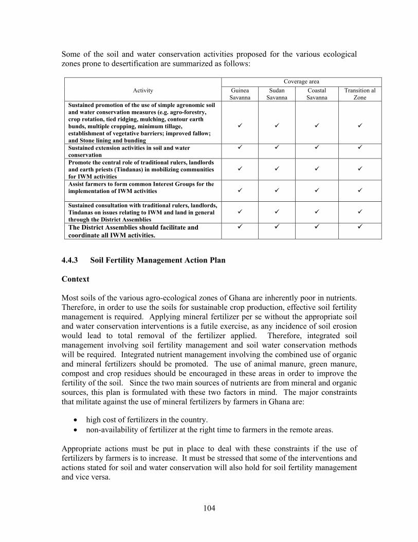
104
Some of the soil and water conservation activities proposed for the various ecological zones prone to desertification are summarized as follows:
Coverage area Activity Guinea
Savanna Sudan
Savanna Coastal Savanna
Transition al Zone
Sustained promotion of the use of simple agronomic soil and water conservation measures (e.g. agro-forestry, crop rotation, tied ridging, mulching, contour earth bunds, multiple cropping, minimum tillage, establishment of vegetative barriers; improved fallow; and Stone lining and bunding
Sustained extension activities in soil and water conservation
Promote the central role of traditional rulers, landlords and earth priests (Tindanas) in mobilizing communities for IWM activities
Assist farmers to form common Interest Groups for the implementation of IWM activities
Sustained consultation with traditional rulers, landlords, Tindanas on issues relating to IWM and land in general through the District Assemblies
The District Assemblies should facilitate and coordinate all IWM activities.
4.4.3 Soil Fertility Management Action Plan Context Most soils of the various agro-ecological zones of Ghana are inherently poor in nutrients. Therefore, in order to use the soils for sustainable crop production, effective soil fertility management is required. Applying mineral fertilizer per se without the appropriate soil and water conservation interventions is a futile exercise, as any incidence of soil erosion would lead to total removal of the fertilizer applied. Therefore, integrated soil management involving soil fertility management and soil water conservation methods will be required. Integrated nutrient management involving the combined use of organic and mineral fertilizers should be promoted. The use of animal manure, green manure, compost and crop residues should be encouraged in these areas in order to improve the fertility of the soil. Since the two main sources of nutrients are from mineral and organic sources, this plan is formulated with these two factors in mind. The major constraints that militate against the use of mineral fertilizers by farmers in Ghana are:
• high cost of fertilizers in the country. • non-availability of fertilizer at the right time to farmers in the remote areas.
Appropriate actions must be put in place to deal with these constraints if the use of fertilizers by farmers is to increase. It must be stressed that some of the interventions and actions stated for soil and water conservation will also hold for soil fertility management and vice versa.
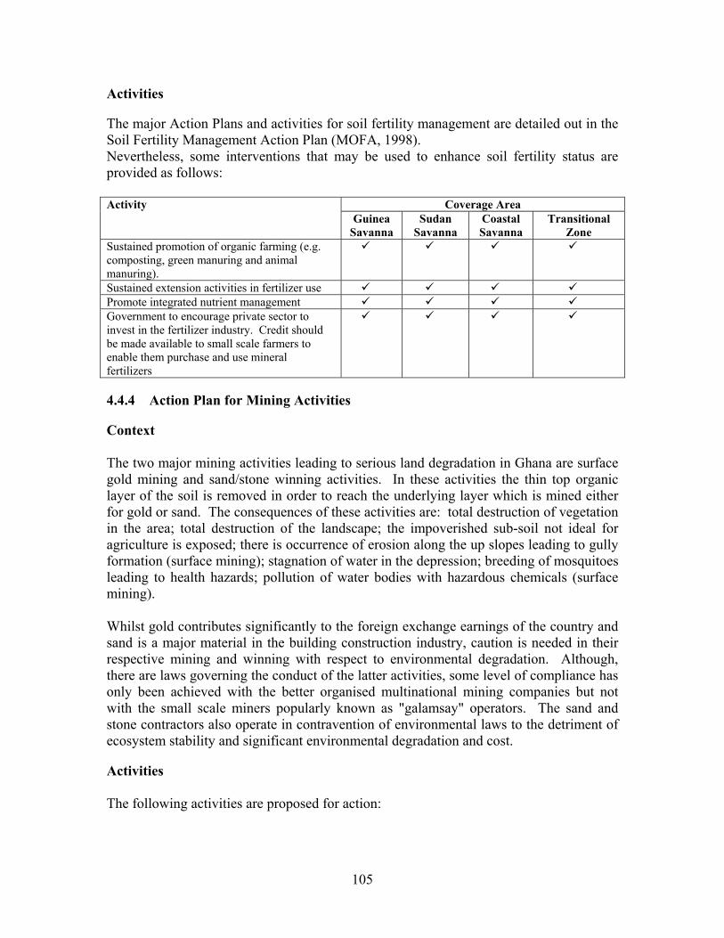
105
Activities The major Action Plans and activities for soil fertility management are detailed out in the Soil Fertility Management Action Plan (MOFA, 1998). Nevertheless, some interventions that may be used to enhance soil fertility status are provided as follows:
Coverage Area Activity Guinea
Savanna Sudan
Savanna Coastal Savanna
Transitional Zone
Sustained promotion of organic farming (e.g. composting, green manuring and animal manuring).
Sustained extension activities in fertilizer use Promote integrated nutrient management Government to encourage private sector to invest in the fertilizer industry. Credit should be made available to small scale farmers to enable them purchase and use mineral fertilizers
4.4.4 Action Plan for Mining Activities Context The two major mining activities leading to serious land degradation in Ghana are surface gold mining and sand/stone winning activities. In these activities the thin top organic layer of the soil is removed in order to reach the underlying layer which is mined either for gold or sand. The consequences of these activities are: total destruction of vegetation in the area; total destruction of the landscape; the impoverished sub-soil not ideal for agriculture is exposed; there is occurrence of erosion along the up slopes leading to gully formation (surface mining); stagnation of water in the depression; breeding of mosquitoes leading to health hazards; pollution of water bodies with hazardous chemicals (surface mining). Whilst gold contributes significantly to the foreign exchange earnings of the country and sand is a major material in the building construction industry, caution is needed in their respective mining and winning with respect to environmental degradation. Although, there are laws governing the conduct of the latter activities, some level of compliance has only been achieved with the better organised multinational mining companies but not with the small scale miners popularly known as "galamsay" operators. The sand and stone contractors also operate in contravention of environmental laws to the detriment of ecosystem stability and significant environmental degradation and cost. Activities The following activities are proposed for action:

106
Coverage Area Activity Guinea
Savanna Sudan
Savanna Coastal Savanna
Transitional Zone
Reclamation of degraded mined sites Institutional support for EPA and the law enforcement agencies to enable them function effectively.
Sustained dialogue between EPA, traditional authorities, the miners and DAs on issues relating to sustainable mining activities and ecological stability
Sustained environmental education for all stakeholders in the mining industry
4.5 Action Programme for Management of Vegetative Cover 4.5.1 Action Plan for the Management of Forest and Woodland Context: The role of forests, woodlands and grasslands on the environment through maintenance of a humid microclimate, reduction of surface run-off, erosion and siltation and regulation of stream flow, among others, afford a means for combating desertification in the affected areas. Proper management of existing natural savanna vegetation, wood and shrub, is necessary for their sustained exploitation for various uses without undue environmental degradation. The desertification prone zones, particularly the Guinea and Sudan Savannas are characterised by low rainfall and higher moisture deficits than what prevails in the southern part of the country and are more prone to drought. Nevertheless, the presence of dense vegetation in protected areas, fetish or sacred groves and forest reserves indicate that the rainfall can support a more luxuriant vegetation than what currently exists in the desertification prone zone. The major problem is the degradation of vegetation through, among other factors, uncontrolled bushfires, shifting cultivation, overgrazing, fuelwood harvesting and charcoal production. In order to derive optimum benefit from the forests and the woodlands, their degradation should be reversed. The following activities are proposed to facilitate the evolution of management techniques to enhance sustained productivity of the forest and woodland formation in the desertification prone zones:
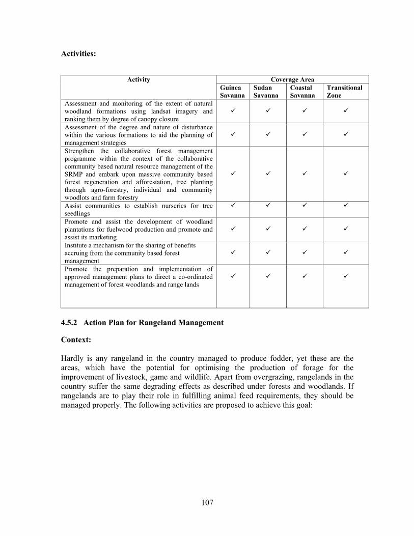
107
Activities:
Coverage Area Activity Guinea Savanna
Sudan Savanna
Coastal Savanna
Transitional Zone
Assessment and monitoring of the extent of natural woodland formations using landsat imagery and ranking them by degree of canopy closure
Assessment of the degree and nature of disturbance within the various formations to aid the planning of management strategies
Strengthen the collaborative forest management programme within the context of the collaborative community based natural resource management of the SRMP and embark upon massive community based forest regeneration and afforestation, tree planting through agro-forestry, individual and community woodlots and farm forestry
Assist communities to establish nurseries for tree seedlings
Promote and assist the development of woodland plantations for fuelwood production and promote and assist its marketing
Institute a mechanism for the sharing of benefits accruing from the community based forest management
Promote the preparation and implementation of approved management plans to direct a co-ordinated management of forest woodlands and range lands
4.5.2 Action Plan for Rangeland Management Context: Hardly is any rangeland in the country managed to produce fodder, yet these are the areas, which have the potential for optimising the production of forage for the improvement of livestock, game and wildlife. Apart from overgrazing, rangelands in the country suffer the same degrading effects as described under forests and woodlands. If rangelands are to play their role in fulfilling animal feed requirements, they should be managed properly. The following activities are proposed to achieve this goal:
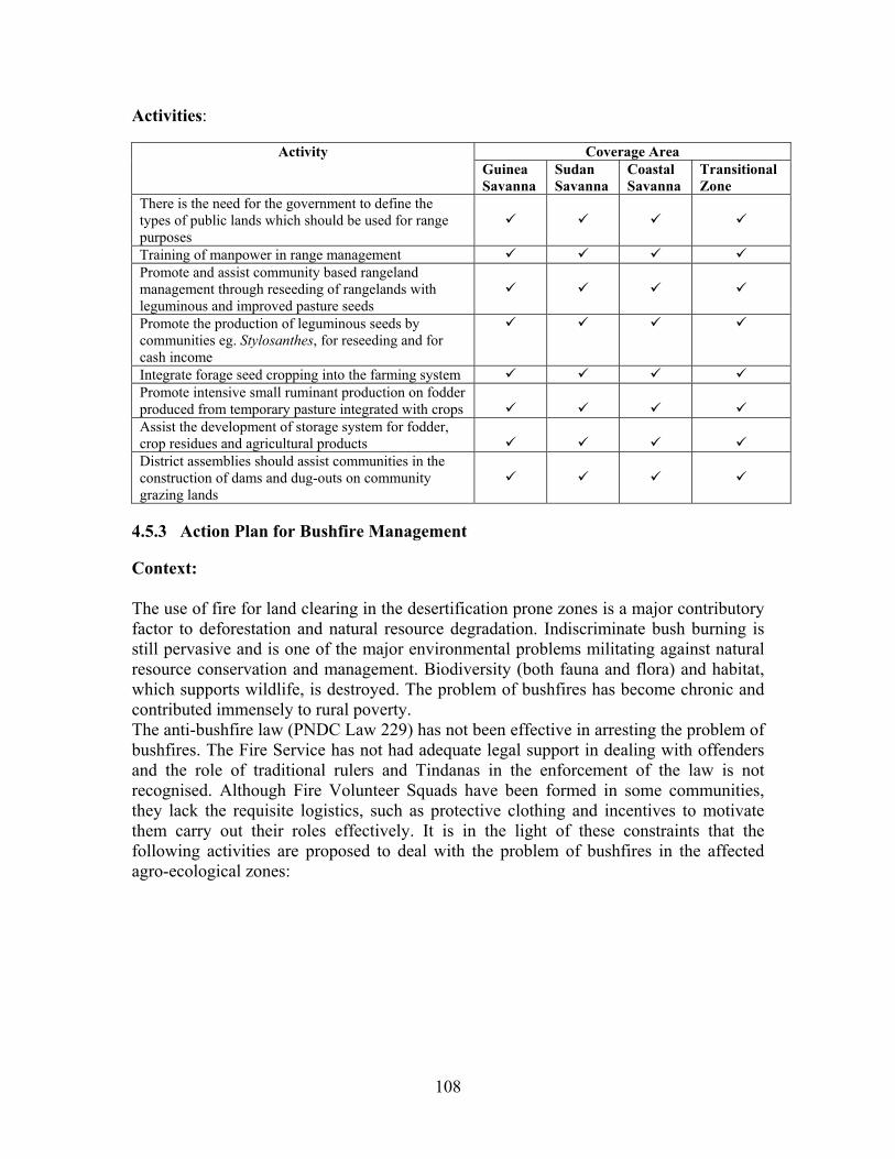
108
Activities:
Coverage Area Activity Guinea Savanna
Sudan Savanna
Coastal Savanna
Transitional Zone
There is the need for the government to define the types of public lands which should be used for range purposes
Training of manpower in range management Promote and assist community based rangeland management through reseeding of rangelands with leguminous and improved pasture seeds
Promote the production of leguminous seeds by communities eg. Stylosanthes, for reseeding and for cash income
Integrate forage seed cropping into the farming system Promote intensive small ruminant production on fodder produced from temporary pasture integrated with crops
Assist the development of storage system for fodder, crop residues and agricultural products
District assemblies should assist communities in the construction of dams and dug-outs on community grazing lands
4.5.3 Action Plan for Bushfire Management Context: The use of fire for land clearing in the desertification prone zones is a major contributory factor to deforestation and natural resource degradation. Indiscriminate bush burning is still pervasive and is one of the major environmental problems militating against natural resource conservation and management. Biodiversity (both fauna and flora) and habitat, which supports wildlife, is destroyed. The problem of bushfires has become chronic and contributed immensely to rural poverty. The anti-bushfire law (PNDC Law 229) has not been effective in arresting the problem of bushfires. The Fire Service has not had adequate legal support in dealing with offenders and the role of traditional rulers and Tindanas in the enforcement of the law is not recognised. Although Fire Volunteer Squads have been formed in some communities, they lack the requisite logistics, such as protective clothing and incentives to motivate them carry out their roles effectively. It is in the light of these constraints that the following activities are proposed to deal with the problem of bushfires in the affected agro-ecological zones:

109
Activities:
Coverage Area Activity Guinea Savanna
Sudan Savanna
Coastal Savanna
Transitional Zone
A massive and sustained educational campaign should be mounted on all aspects of bushfire, making use of all available communication channels, such as the electronic and print media, educational institutions, etc.
The National Fire Service should be adequately equipped to play its training role
Communities should be fully involved in bushfire control within their watershed areas
The various anti-bushfire committees should be strengthened to discharge their functions
Together with legislative action to prevent and deter unnecessary burning, a combination of early burning or early burning alternating with late burning and an effective system of suppression must be considered. Longer periods between burning cycles in the rangelands would be preferred
Strict enforcement of byelaws on bushfires and hunting laws should be pursued
The Ghana National Fire Service personnel should be involved in all fire festivals to prevent and control fire outbreaks
Training of communities on the domestication of grasscutters and keeping of rabbits can contribute significantly to the reduction in hunting activities
The central role of traditional rulers in mobilising their subjects for bushfire control in their area of jurisdiction should be recognised and institutionalised
The PNDC Law 229 should be reviewed to accommodate the deficiencies in the law
District assemblies should reward communities with success stories of bushfire control, eg. the provision of boreholes etc.
4.6 Action Programme for Wildlife and Biodiversity Context The benefits of plant, animal and micro-organism biodiversity to people in the country are enormous. These range from economic (source of rural and urban income, export earnings), social (as source of food and food security, medicine for health maintenance and cure of diseases), religious and cultural (avenues for spiritual inspiration, aesthetic and recreational) to ecological (watershed and catchment area protection, wind break, forest regeneration, soil fertility maintenance) and environmental (maintenance of atmospheric carbon levels, pollution).
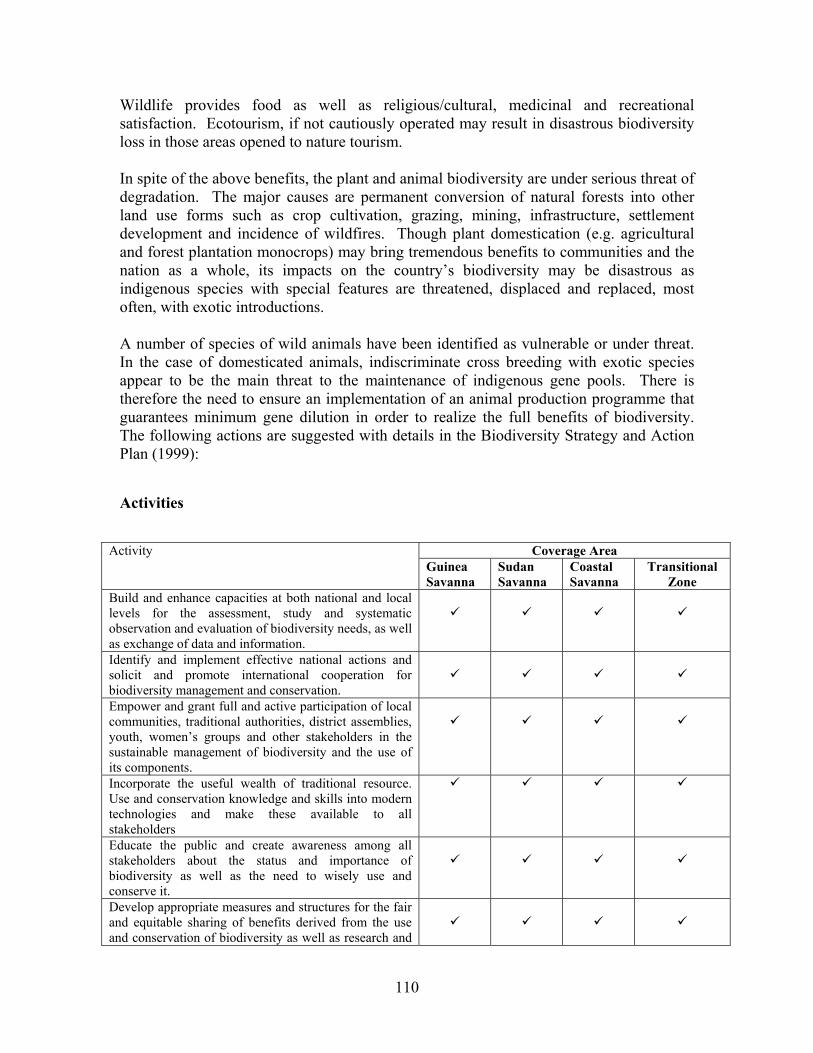
110
Wildlife provides food as well as religious/cultural, medicinal and recreational satisfaction. Ecotourism, if not cautiously operated may result in disastrous biodiversity loss in those areas opened to nature tourism. In spite of the above benefits, the plant and animal biodiversity are under serious threat of degradation. The major causes are permanent conversion of natural forests into other land use forms such as crop cultivation, grazing, mining, infrastructure, settlement development and incidence of wildfires. Though plant domestication (e.g. agricultural and forest plantation monocrops) may bring tremendous benefits to communities and the nation as a whole, its impacts on the country’s biodiversity may be disastrous as indigenous species with special features are threatened, displaced and replaced, most often, with exotic introductions. A number of species of wild animals have been identified as vulnerable or under threat. In the case of domesticated animals, indiscriminate cross breeding with exotic species appear to be the main threat to the maintenance of indigenous gene pools. There is therefore the need to ensure an implementation of an animal production programme that guarantees minimum gene dilution in order to realize the full benefits of biodiversity. The following actions are suggested with details in the Biodiversity Strategy and Action Plan (1999): Activities
Coverage Area Activity Guinea Savanna
Sudan Savanna
Coastal Savanna
Transitional Zone
Build and enhance capacities at both national and local levels for the assessment, study and systematic observation and evaluation of biodiversity needs, as well as exchange of data and information.
Identify and implement effective national actions and solicit and promote international cooperation for biodiversity management and conservation.
Empower and grant full and active participation of local communities, traditional authorities, district assemblies, youth, women’s groups and other stakeholders in the sustainable management of biodiversity and the use of its components.
Incorporate the useful wealth of traditional resource. Use and conservation knowledge and skills into modern technologies and make these available to all stakeholders
Educate the public and create awareness among all stakeholders about the status and importance of biodiversity as well as the need to wisely use and conserve it.
Develop appropriate measures and structures for the fair and equitable sharing of benefits derived from the use and conservation of biodiversity as well as research and
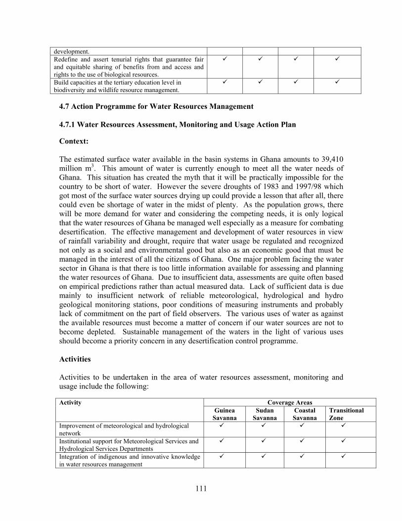
111
development. Redefine and assert tenurial rights that guarantee fair and equitable sharing of benefits from and access and rights to the use of biological resources.
Build capacities at the tertiary education level in biodiversity and wildlife resource management.
4.7 Action Programme for Water Resources Management 4.7.1 Water Resources Assessment, Monitoring and Usage Action Plan Context: The estimated surface water available in the basin systems in Ghana amounts to 39,410 million m3. This amount of water is currently enough to meet all the water needs of Ghana. This situation has created the myth that it will be practically impossible for the country to be short of water. However the severe droughts of 1983 and 1997/98 which got most of the surface water sources drying up could provide a lesson that after all, there could even be shortage of water in the midst of plenty. As the population grows, there will be more demand for water and considering the competing needs, it is only logical that the water resources of Ghana be managed well especially as a measure for combating desertification. The effective management and development of water resources in view of rainfall variability and drought, require that water usage be regulated and recognized not only as a social and environmental good but also as an economic good that must be managed in the interest of all the citizens of Ghana. One major problem facing the water sector in Ghana is that there is too little information available for assessing and planning the water resources of Ghana. Due to insufficient data, assessments are quite often based on empirical predictions rather than actual measured data. Lack of sufficient data is due mainly to insufficient network of reliable meteorological, hydrological and hydro geological monitoring stations, poor conditions of measuring instruments and probably lack of commitment on the part of field observers. The various uses of water as against the available resources must become a matter of concern if our water sources are not to become depleted. Sustainable management of the waters in the light of various uses should become a priority concern in any desertification control programme. Activities Activities to be undertaken in the area of water resources assessment, monitoring and usage include the following:
Coverage Areas Activity Guinea
Savanna Sudan
Savanna Coastal Savanna
Transitional Zone
Improvement of meteorological and hydrological network
Institutional support for Meteorological Services and Hydrological Services Departments
Integration of indigenous and innovative knowledge in water resources management

112
Capacity building of the DAs and local communities in water resources management
District level water resources inventory using remote sensing techniques
Sustainable water harvesting for domestic and agricultural use
Support for water resources research
4.7.2 Protection of Water Bodies Action Plan Context One of the results of the processes leading to the absence of vegetation (desertification) is the drying up of water sources and the consequent shortage of water. Agricultural activity and the harvesting of fuelwood near water bodies, combined with climatic changes, have resulted in their exposure and the consequent drying up of some of them. Not only do the water bodies dry up but soil erosion increases and causes the channels and reservoirs to silt up faster than what is expected under normal sedimentation rates. As the channels and the reservoirs become shallower due to sedimentation, there is increased incidence of floods that destroy life and property. There is a lot of evidence to suggest that streams that used to flow all year round when protected by vegetative cover are no longer doing so as a result of the removal of the vegetative cover. There is the need to embark on a sustained awareness campaign at the community, district, regional and the national levels of the importance of protecting water bodies. Indeed, the direct influence of man on the water cycle is very important. Therefore, water cannot be separated from land use and soil management. Planning is only useful if people are ready to improve resource use. The need for changes or action must be recognized by the people involved and the will to put the plan into action must be present. Water resources management has to be seen as an integral part of land management. Protecting the land cover is not only about trees but also the herbaceous plants. Protection of water bodies has to be clearly related to economic production and environmental impact.
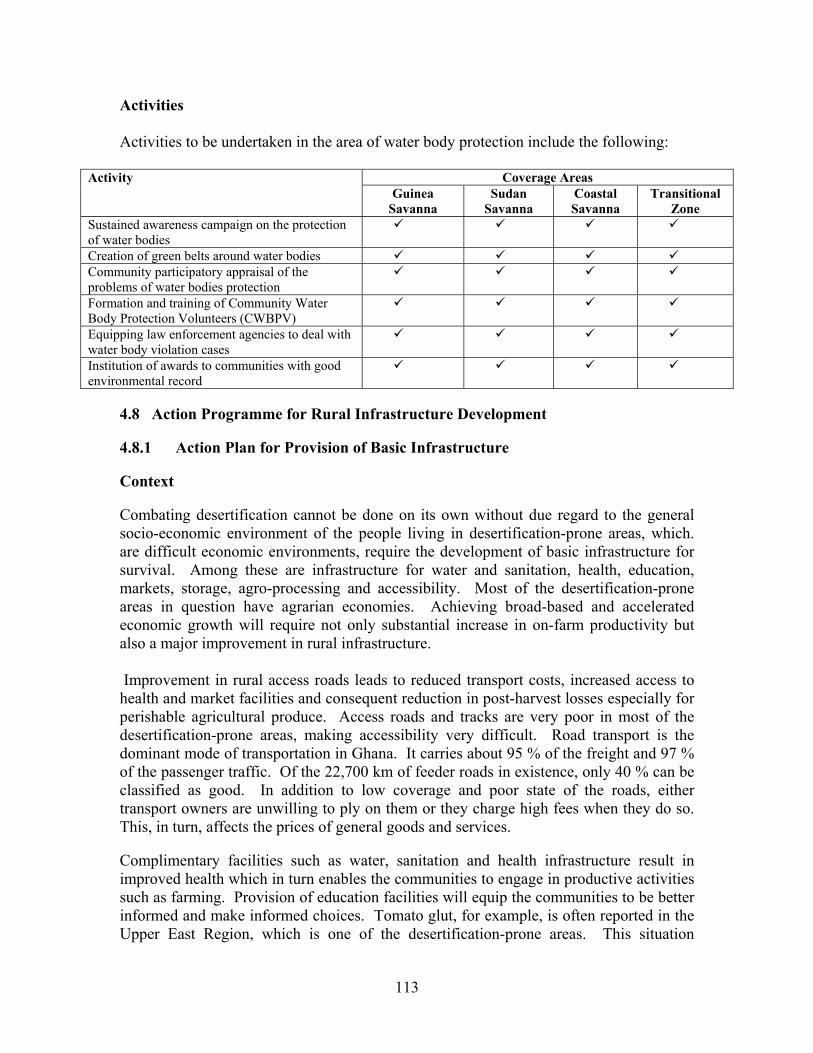
113
Activities Activities to be undertaken in the area of water body protection include the following:
Coverage Areas Activity Guinea
Savanna Sudan
Savanna Coastal Savanna
Transitional Zone
Sustained awareness campaign on the protection of water bodies
Creation of green belts around water bodies Community participatory appraisal of the problems of water bodies protection
Formation and training of Community Water Body Protection Volunteers (CWBPV)
Equipping law enforcement agencies to deal with water body violation cases
Institution of awards to communities with good environmental record
4.8 Action Programme for Rural Infrastructure Development 4.8.1 Action Plan for Provision of Basic Infrastructure Context Combating desertification cannot be done on its own without due regard to the general socio-economic environment of the people living in desertification-prone areas, which. are difficult economic environments, require the development of basic infrastructure for survival. Among these are infrastructure for water and sanitation, health, education, markets, storage, agro-processing and accessibility. Most of the desertification-prone areas in question have agrarian economies. Achieving broad-based and accelerated economic growth will require not only substantial increase in on-farm productivity but also a major improvement in rural infrastructure. Improvement in rural access roads leads to reduced transport costs, increased access to health and market facilities and consequent reduction in post-harvest losses especially for perishable agricultural produce. Access roads and tracks are very poor in most of the desertification-prone areas, making accessibility very difficult. Road transport is the dominant mode of transportation in Ghana. It carries about 95 % of the freight and 97 % of the passenger traffic. Of the 22,700 km of feeder roads in existence, only 40 % can be classified as good. In addition to low coverage and poor state of the roads, either transport owners are unwilling to ply on them or they charge high fees when they do so. This, in turn, affects the prices of general goods and services. Complimentary facilities such as water, sanitation and health infrastructure result in improved health which in turn enables the communities to engage in productive activities such as farming. Provision of education facilities will equip the communities to be better informed and make informed choices. Tomato glut, for example, is often reported in the Upper East Region, which is one of the desertification-prone areas. This situation

114
emphasizes the need for agro-processing facilities in order to extend the shelf life of the agricultural produce in these areas. Storage or rather post-harvest facilities afford the producer and the consumer time utility and to even-out supply as against demand. The link between good infrastructure and general economic development is very strong and critical as far as the desertification-prone areas are concerned.
Activities Activities to be undertaken in the area of rural infrastructure development include the following:
Coverage Areas Activity Guinea
Savanna Sudan
Savanna Coastal Savanna
Transitional Zone
Improving road network in line with DAs road infrastructure plan
Government support for private sector to improve general transportation in line with DAs plans
Equipping existing health centers; improving staffing situation; building new health centers in line with DAs plans
Equipping existing schools; improving staffing situation; building new schools in line with DAs plans
Improvement of traditional post-harvest storage facilities in line with DAs plans
Improving facilities of key market centers in line with DAs plans
Improving indigenous knowledge in storage of agricultural produce
4.9 Action Programme for Energy Resources Management 4.9.1 Action Plan for Fuel Wood and Alternative Energy Resources
Management Forms of energy used in rural Ghana and in the desertification-prone areas include fuel wood, fossil fuel and electricity in some cases. The felling of trees for the production of charcoal is still a very rampant activity nation-wide. The fact is that, for some, it is far better to engage in charcoal production since the returns are quicker (sometimes less than 2 weeks) than to engage in farming, the returns of which take a whole season to come, if one is lucky with the weather. So, for the average person in the rural area, it is more lucrative to depend on the tree resources by producing charcoal than to engage in farming activities. The added advantage is that charcoal is not a perishable commodity and does not have to be transported to the markets immediately after production and therefore provides better security in terms of income than perishable agricultural products which, if not transported in good time and sometimes at great cost, renders the toils of the farmer valueless. It is also equally true that more than 70 % of the charcoal produced ends up in the urban centers of Accra, Kumasi and the like, implying that if the consumers in the cities and towns can use alternative energy sources, then it is likely that the demand for charcoal will reduce and hence could affect the charcoal trade.
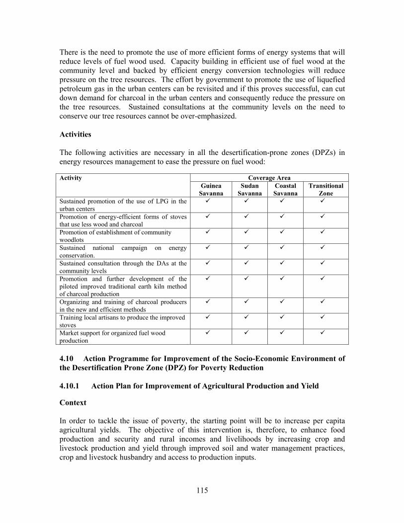
115
There is the need to promote the use of more efficient forms of energy systems that will reduce levels of fuel wood used. Capacity building in efficient use of fuel wood at the community level and backed by efficient energy conversion technologies will reduce pressure on the tree resources. The effort by government to promote the use of liquefied petroleum gas in the urban centers can be revisited and if this proves successful, can cut down demand for charcoal in the urban centers and consequently reduce the pressure on the tree resources. Sustained consultations at the community levels on the need to conserve our tree resources cannot be over-emphasized. Activities The following activities are necessary in all the desertification-prone zones (DPZs) in energy resources management to ease the pressure on fuel wood:
Coverage Area Activity Guinea
Savanna Sudan
Savanna Coastal Savanna
Transitional Zone
Sustained promotion of the use of LPG in the urban centers
Promotion of energy-efficient forms of stoves that use less wood and charcoal
Promotion of establishment of community woodlots
Sustained national campaign on energy conservation.
Sustained consultation through the DAs at the community levels
Promotion and further development of the piloted improved traditional earth kiln method of charcoal production
Organizing and training of charcoal producers in the new and efficient methods
Training local artisans to produce the improved stoves
Market support for organized fuel wood production
4.10 Action Programme for Improvement of the Socio-Economic Environment of the Desertification Prone Zone (DPZ) for Poverty Reduction 4.10.1 Action Plan for Improvement of Agricultural Production and Yield Context In order to tackle the issue of poverty, the starting point will be to increase per capita agricultural yields. The objective of this intervention is, therefore, to enhance food production and security and rural incomes and livelihoods by increasing crop and livestock production and yield through improved soil and water management practices, crop and livestock husbandry and access to production inputs.
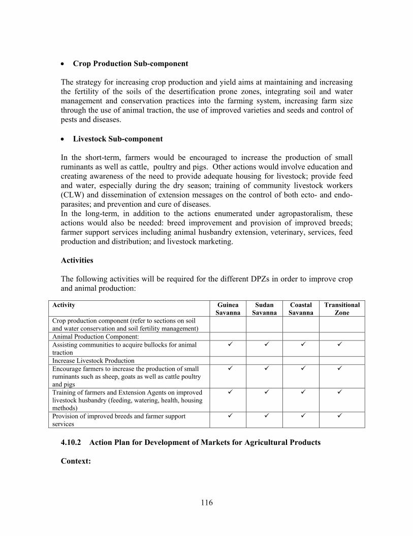
116
• Crop Production Sub-component The strategy for increasing crop production and yield aims at maintaining and increasing the fertility of the soils of the desertification prone zones, integrating soil and water management and conservation practices into the farming system, increasing farm size through the use of animal traction, the use of improved varieties and seeds and control of pests and diseases. • Livestock Sub-component In the short-term, farmers would be encouraged to increase the production of small ruminants as well as cattle, poultry and pigs. Other actions would involve education and creating awareness of the need to provide adequate housing for livestock; provide feed and water, especially during the dry season; training of community livestock workers (CLW) and dissemination of extension messages on the control of both ecto- and endo- parasites; and prevention and cure of diseases. In the long-term, in addition to the actions enumerated under agropastoralism, these actions would also be needed: breed improvement and provision of improved breeds; farmer support services including animal husbandry extension, veterinary, services, feed production and distribution; and livestock marketing. Activities The following activities will be required for the different DPZs in order to improve crop and animal production:
Activity Guinea Savanna
Sudan Savanna
Coastal Savanna
Transitional Zone
Crop production component (refer to sections on soil and water conservation and soil fertility management)
Animal Production Component: Assisting communities to acquire bullocks for animal traction
Increase Livestock Production Encourage farmers to increase the production of small ruminants such as sheep, goats as well as cattle poultry and pigs
Training of farmers and Extension Agents on improved livestock husbandry (feeding, watering, health, housing methods)
Provision of improved breeds and farmer support services
4.10.2 Action Plan for Development of Markets for Agricultural Products Context:
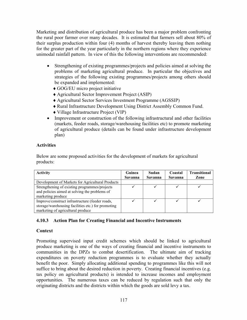
117
Marketing and distribution of agricultural produce has been a major problem confronting the rural poor farmer over many decades. It is estimated that farmers sell about 80% of their surplus production within four (4) months of harvest thereby leaving them nothing for the greater part of the year particularly in the northern regions where they experience unimodal rainfall pattern. In view of this the following interventions are recommended:
• Strengthening of existing programmes/projects and policies aimed at solving the problems of marketing agricultural produce. In particular the objectives and strategies of the following existing programmes/projects among others should be expanded and implemented:
♦GOG/EU micro project initiative ♦Agricultural Sector Improvement Project (ASIP) ♦Agricultural Sector Services Investment Programme (AGSSIP) ♦Rural Infrastructure Development Using District Assembly Common Fund. ♦Village Infrastructure Project (VIP)
• Improvement or construction of the following infrastructural and other facilities (markets, feeder roads, storage/warehousing facilities etc) to promote marketing of agricultural produce (details can be found under infrastructure development plan)
Activities Below are some proposed activities for the development of markets for agricultural products: Activity Guinea
Savanna Sudan
Savanna Coastal Savanna
Transitional Zone
Development of Markets for Agricultural Products Strengthening of existing programmes/projects and policies aimed at solving the problems of marketing produce
Improve/construct infrastructure (feeder roads, storage/warehousing facilities etc.) for promoting marketing of agricultural produce
4.10.3 Action Plan for Creating Financial and Incentive Instruments Context Promoting supervised input credit schemes which should be linked to agricultural produce marketing is one of the ways of creating financial and incentive instruments to communities in the DPZs to combat desertification. The ultimate aim of tracking expenditures on poverty reduction programmes is to evaluate whether they actually benefit the poor. Simply allocating additional spending to programmes like this will not suffice to bring about the desired reduction in poverty. Creating financial incentives (e.g. tax policy on agricultural products) is intended to increase incomes and employment opportunities. The numerous taxes can be reduced by regulation such that only the originating districts and the districts within which the goods are sold levy a tax.
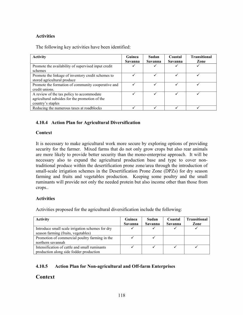
118
Activities The following key activities have been identified:
Activity Guinea Savanna
Sudan Savanna
Coastal Savanna
Transitional Zone
Promote the availability of supervised input credit schemes
Promote the linkage of inventory credit schemes to stored agricultural produce
Promote the formation of community cooperative and credit unions.
A review of the tax policy to accommodate agricultural subsides for the promotion of the country’s staples
Reducing the numerous taxes at roadblocks 4.10.4 Action Plan for Agricultural Diversification Context It is necessary to make agricultural work more secure by exploring options of providing security for the farmer. Mixed farms that do not only grow crops but also rear animals are more likely to provide better security than the mono-enterprise approach. It will be necessary also to expand the agricultural production base and type to cover non-traditional produce within the desertification prone zone/area through the introduction of small-scale irrigation schemes in the Desertification Prone Zone (DPZs) for dry season farming and fruits and vegetables production. Keeping some poultry and the small ruminants will provide not only the needed protein but also income other than those from crops.. Activities Activities proposed for the agricultural diversification include the following: Activity Guinea
Savanna Sudan
Savanna Coastal Savanna
Transitional Zone
Introduce small scale irrigation schemes for dry season farming (fruits, vegetables)
Promotion of commercial poultry farming in the northern savannah
Intensification of cattle and small ruminants production along side fodder production
4.10.5 Action Plan for Non-agricultural and Off-farm Enterprises Context

119
Depending on the cultivation of the land for livelihood support has always been a gamble because of the uncertainties about the weather. For purposes of survival, there have been several other non-agricultural and off-farm activities that people engage in. Some of these activities include bee keeping, snail rearing, shea butter production, grass cutter rearing and the like. It is important to provide support for the DPZs in the off-farm economic activities. This could reduce pressure on the land whilst enhancing the income of households in the rural areas. Activities Interventions in line with non-agricultural and off-farm activities are: Activity Guinea
Savanna Sudan
Savanna Coastal Savanna
Transitional zone
Beekeeping Snail rearing Grass cutter rearing Mushroom growing Woodlot Fodder bank creation Fruit tree growing Fish farming Spinning of cotton into yarns Beads making Mat/basket weaving Poultry Batik, Tie and Dye Fruit processing Gari processing Vegetable oil extraction Shea butter production Local soap making Pito brewing 4.10.6 Action Plan for Reduction of Population Pressure on Land Context The national population policy seeks to enhance the process of improving the quality of life of the population through:
• Promotion of family planning • Lowering the levels of fertility • Mortality and morbidity (increasing life expectancy) • Reducing the country’s rate of population growth • Ensuring a more balance distribution of population • Protecting environmental resources • Confronting new threats to society such as HIV/AIDS.
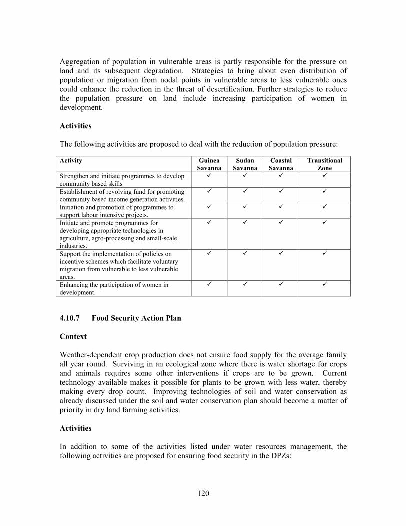
120
Aggregation of population in vulnerable areas is partly responsible for the pressure on land and its subsequent degradation. Strategies to bring about even distribution of population or migration from nodal points in vulnerable areas to less vulnerable ones could enhance the reduction in the threat of desertification. Further strategies to reduce the population pressure on land include increasing participation of women in development. Activities The following activities are proposed to deal with the reduction of population pressure: Activity Guinea
Savanna Sudan
Savanna Coastal Savanna
Transitional Zone
Strengthen and initiate programmes to develop community based skills
Establishment of revolving fund for promoting community based income generation activities.
Initiation and promotion of programmes to support labour intensive projects.
Initiate and promote programmes for developing appropriate technologies in agriculture, agro-processing and small-scale industries.
Support the implementation of policies on incentive schemes which facilitate voluntary migration from vulnerable to less vulnerable areas.
Enhancing the participation of women in development.
4.10.7 Food Security Action Plan Context Weather-dependent crop production does not ensure food supply for the average family all year round. Surviving in an ecological zone where there is water shortage for crops and animals requires some other interventions if crops are to be grown. Current technology available makes it possible for plants to be grown with less water, thereby making every drop count. Improving technologies of soil and water conservation as already discussed under the soil and water conservation plan should become a matter of priority in dry land farming activities. Activities In addition to some of the activities listed under water resources management, the following activities are proposed for ensuring food security in the DPZs:
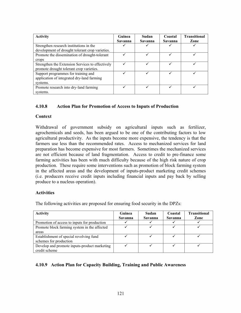
121
Activity Guinea
Savanna Sudan
Savanna Coastal Savanna
Transitional Zone
Strengthen research institutions in the development of drought tolerant crop varieties.
Promote the dissemination of drought-tolerant crops
Strengthen the Extension Services to effectively promote drought tolerant crop varieties.
Support programmes for training and application of integrated dry-land farming systems.
Promote research into dry-land farming systems.
4.10.8 Action Plan for Promotion of Access to Inputs of Production Context Withdrawal of government subsidy on agricultural inputs such as fertilizer, agrochemicals and seeds, has been argued to be one of the contributing factors to low agricultural productivity. As the inputs become more expensive, the tendency is that the farmers use less than the recommended rates. Access to mechanized services for land preparation has become expensive for most farmers. Sometimes the mechanized services are not efficient because of land fragmentation. Access to credit to pre-finance some farming activities has been with much difficulty because of the high risk nature of crop production. These require some interventions such as promotion of block farming system in the affected areas and the development of inputs-product marketing credit schemes (i.e. producers receive credit inputs including financial inputs and pay back by selling produce to a nucleus operation). Activities The following activities are proposed for ensuring food security in the DPZs: Activity Guinea
Savanna Sudan
Savanna Coastal Savanna
Transitional Zone
Promotion of access to inputs for production Promote block farming system in the affected areas
Establishment of special revolving fund schemes for production
Develop and promote inputs-product marketing credit scheme
4.10.9 Action Plan for Capacity Building, Training and Public Awareness

122
Context Successful management of land degradation issues, and desertification and its associated problems can only be achieved on the premise that the people understand the functions of the environment and the problems it presents so that they can contribute meaningfully to its protection, improvement and enhancement. In order to achieve this, action should be directed at promoting the continuous and detailed environmental education programmes with emphasis on drought and desertification at all levels. It is therefore recommended that the implementation of the Ghana Environmental Education Strategy should be vigorously pursued. Two levels of education training and information dissemination are envisaged i.e. formal and non-formal. Under the formal sector, issues of desertification should be incorporated into the school curriculum. With regard to the non-formal, all relevant institutions will be supported to play their respective roles. With respect to desertification the following among many others have been identified as key stakeholders: 1. Parliament and Cabinet 2. Ministries, Departments and Agencies: Ministry of Lands and Forestry, Ministry of
Food and Agriculture, Ministry of Environment and Science, Environmental Protection Agency, Ministry of Interior, Water Resources Commission, Ministry of Finance, Forestry Commission, Ministry of Energy, Research Institutions (CSIR, Universities, CERSGIS), Meteorological Services Department, Hydrological Services Department.
3. Traditional Rulers 4. NGOs 5. CBOs 6. Religious Organisations 7. Women’s Movement 8. The Media 9. Financial Institutions In order to achieve effective management of drought and desertification the various identified stakeholders will have to be well equipped to play their expected roles. Institutional capacity building should target training for personnel, provision of equipment and logistics and administrative restructuring. Activities The following activities are proposed: capacity building, training and awareness campaign for desertification control
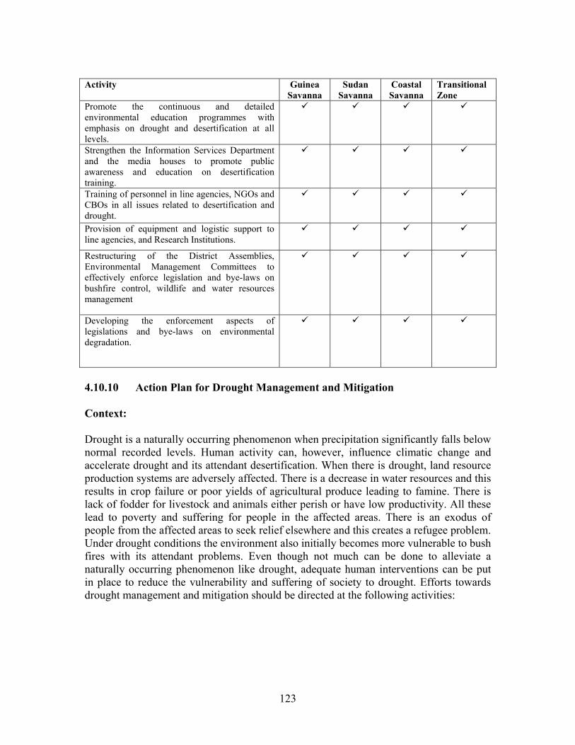
123
Activity Guinea
Savanna Sudan
Savanna Coastal Savanna
Transitional Zone
Promote the continuous and detailed environmental education programmes with emphasis on drought and desertification at all levels.
Strengthen the Information Services Department and the media houses to promote public awareness and education on desertification training.
Training of personnel in line agencies, NGOs and CBOs in all issues related to desertification and drought.
Provision of equipment and logistic support to line agencies, and Research Institutions.
Restructuring of the District Assemblies, Environmental Management Committees to effectively enforce legislation and bye-laws on bushfire control, wildlife and water resources management
Developing the enforcement aspects of legislations and bye-laws on environmental degradation.
4.10.10 Action Plan for Drought Management and Mitigation Context: Drought is a naturally occurring phenomenon when precipitation significantly falls below normal recorded levels. Human activity can, however, influence climatic change and accelerate drought and its attendant desertification. When there is drought, land resource production systems are adversely affected. There is a decrease in water resources and this results in crop failure or poor yields of agricultural produce leading to famine. There is lack of fodder for livestock and animals either perish or have low productivity. All these lead to poverty and suffering for people in the affected areas. There is an exodus of people from the affected areas to seek relief elsewhere and this creates a refugee problem. Under drought conditions the environment also initially becomes more vulnerable to bush fires with its attendant problems. Even though not much can be done to alleviate a naturally occurring phenomenon like drought, adequate human interventions can be put in place to reduce the vulnerability and suffering of society to drought. Efforts towards drought management and mitigation should be directed at the following activities:
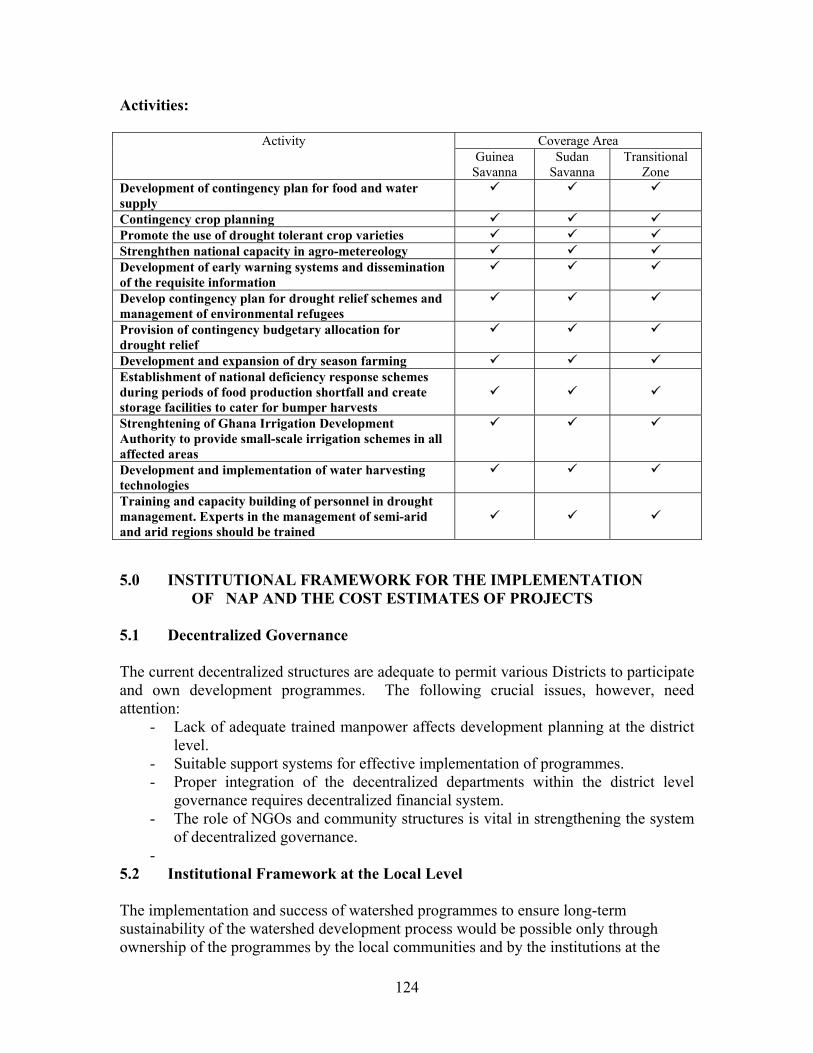
124
Activities:
Activity Coverage Area Guinea
Savanna Sudan
Savanna Transitional
Zone Development of contingency plan for food and water supply
Contingency crop planning Promote the use of drought tolerant crop varieties Strenghthen national capacity in agro-metereology Development of early warning systems and dissemination of the requisite information
Develop contingency plan for drought relief schemes and management of environmental refugees
Provision of contingency budgetary allocation for drought relief
Development and expansion of dry season farming Establishment of national deficiency response schemes during periods of food production shortfall and create storage facilities to cater for bumper harvests
Strenghtening of Ghana Irrigation Development Authority to provide small-scale irrigation schemes in all affected areas
Development and implementation of water harvesting technologies
Training and capacity building of personnel in drought management. Experts in the management of semi-arid and arid regions should be trained
5.0 INSTITUTIONAL FRAMEWORK FOR THE IMPLEMENTATION OF NAP AND THE COST ESTIMATES OF PROJECTS 5.1 Decentralized Governance The current decentralized structures are adequate to permit various Districts to participate and own development programmes. The following crucial issues, however, need attention:
- Lack of adequate trained manpower affects development planning at the district level.
- Suitable support systems for effective implementation of programmes. - Proper integration of the decentralized departments within the district level
governance requires decentralized financial system. - The role of NGOs and community structures is vital in strengthening the system
of decentralized governance. -
5.2 Institutional Framework at the Local Level The implementation and success of watershed programmes to ensure long-term sustainability of the watershed development process would be possible only through ownership of the programmes by the local communities and by the institutions at the

125
district or local level. All available participatory tools should be used to ensure that this is achieved for all programmes under the Action Plan.
- Recognition of the role of NGOs, Community Based Organizations (CBOs), Voluntary Organisations is vital to the success of programme implementation at the local level.
- NGOs can be an effective interface between the government and the communities through: o Awareness creation on environmental issues and desertification; o Accessing appropriate technologies and creating effective information
systems; o Undertaking directly projects of afforestation and land development for
enhanced rural livelihoods; and o Accessing micro-credits for application of improved technologies or start-up
funds for community-driven projects etc. - Promote people’s committees at the local level to support various activities to be
implemented at the local level. 5.3 National Desertification Committee (NDC) There shall be a National Desertification Committee made up of representatives of the following organisations: MOFA, MLF, EPA, Ministry of Finance, Ministry of Local Government, Ministries of Works and Housing, Tourism, Economic Planning, Women and Children's Affairs, GNFS, National House of Chiefs, NGOs/CBOs, Universities / Research Institutions. The National Desertification Committee will be responsible for the overall supervision and implementation of NAP. The main functions of the NDC include: • Decision making and co-ordination of all NAP activities, • Assessment and assigning responsibilities to various stakeholders • Approval of policies and other measures to create an enabling environment, • Monitoring and evaluation of all NAP activities. Focal Point The focal point will be the National Secretariat to Combat Desertification based at EPA and will be responsible for the day to day running of NAP. The main tasks of the National Secretariat would include: • Acting as a Secretariat for the NDC • Co-ordinating and managing the financial resources and keeping records of financial
flows, donor support, etc. • Prepare regular reports on NAP implementation • Provide information to all stakeholders • Co-ordinate and participate in the elaboration and implementation of NAP. • Co-ordinate legal issues and link up with other conventions, policies and development
programmes

126
• Carry out duties assigned by the NDC • Prepare national progress reports and any other reports deemed necessary. Proposed Structure The structure for the implementation of the National Action Plan to combat desertification is presented in the following Organogram. A STRUCTURE FOR THE IMPLEMENTATION OF THE NAP oo 6. Line Ministries 7. Universities/Res. Inst. 8. NGOs/CBOs 9. National House of Chiefs 10. GNFS Organogram showing the structure of Implementation of NAP
Ministry of Environment and Science (MES) (Supervising Ministry)
Donor Partners
National Desertification Committee
National Secretariat to Combat Desertification (Based at EPA)
National Desertification Forum
Regional Environmental Committee (R.E.C) EPA, GNFS, NCWD, Reg. House of Chiefs, Line Ministries,
NGOs
District Environmental Committee Line Ministries, DEMC, CBOs, NGOs
Community Environmental Committee CBOs, NGOs, Traditional Rulers
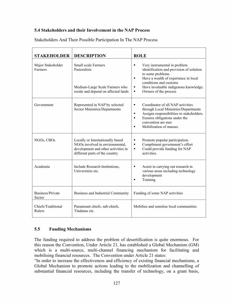
127
5.4 Stakeholders and their Involvement in the NAP Process Stakeholders And Their Possible Participation In The NAP Process STAKEHOLDER
DESCRIPTION
ROLE
Major Stakeholder Farmers
Small scale Farmers Pastoralists Medium-Large Scale Farmers who reside and depend on affected lands
Very instrumental in problem
identification and provision of solution to some problems
Have a wealth of experience in local conditions and customs
Have invaluable indigenous knowledge. Owners of the process
Government
Represented in NAP by selected Sector Ministries/Departments
Coordinator of all NAP activities
through Local Ministries/Departments Assigns responsibilities to stakeholders. Ensures obligations under the
convention are met. Mobilization of masses.
NGOs, CBOs
Locally or Internationally based NGOs involved in environmental, development and other activities in different parts of the country
Promote popular participation. Compliment government’s effort Could provide funding for NAP
activities.
Academia
Include Research Institutions, Universities etc.
Assist in carrying out research in
various areas including technology development
Training
Business/Private Sector
Business and Industrial Community
Funding of some NAP activities
Chiefs/Traditional Rulers
Paramount chiefs, sub-chiefs, Tindanas etc.
Mobilize and sensitise local communities
5.5 Funding Mechanisms The funding required to address the problem of desertification is quite enormous. For this reason the Convention, Under Article 21, has established a Global Mechanism (GM) which is a multi-source, multi-channel financing mechanism for facilitating and mobilising financial resources. The Convention under Article 21 states: “In order to increase the effectiveness and efficiency of existing financial mechanisms, a Global Mechanism to promote actions leading to the mobilization and channelling of substantial financial resources, including the transfer of technology, on a grant basis,
128
and/or on concessional or other terms, to affected developing country Parties, is hereby established”. The Convention also provides for partnerships with International organisations and funding agencies as a source of generating funding. Establishment of National Desertification Fund (NDF) In order to sustain the National Action Programme to combat desertification there is the need to establish a special fund by an Act of Parliament to support the programme. The establishment of a National Desertification Fund is proposed. The Fund is required to carry out recommended activities to combat desertification. In addition, the Fund will help to provide material resources such as meteorological equipment, communication equipment and vehicles needed to implement the programme. It will also cater for technical resources such as: • Training • Information, education and communication • Inter-regional/international co-operation and • Research. The Fund is also needed for Human Resources Development such as: • Expertise and experience sharing • Imparting of skills • Seminars/Workshops and • Community field days. Sources of Funding Funds may be raised from local and international sources. • Local sources - The Government of Ghana should establish a special fund to be called National
Desertification Fund. - Local contributions to this fund should come from Government through annual
budgetary allocations - A determined percentage of royalties from the timber and mining industries
should be paid into the fund. - Fines and penalties from environmental offences should be paid into the fund - Funds may also be raised from local philanthropists and the private sector. Contributions from all these sources should be paid into the fund. • International sources Funding may also be solicited from the following international agencies: - World Bank - UN Agencies (e.g. UNDP, UNEP, UNCCD, UNICEF, FAO, WHO) - Bilateral agencies (e.g. USAID, GTZ, SNV, CIDA, DANIDA, Saudi Fund,
Kuwaiti Fund, Embassies). - International Funding Agencies (e.g. IFAD, ADB) - International Foundations (e.g. Ford Foundation, MacArthur Foundation)
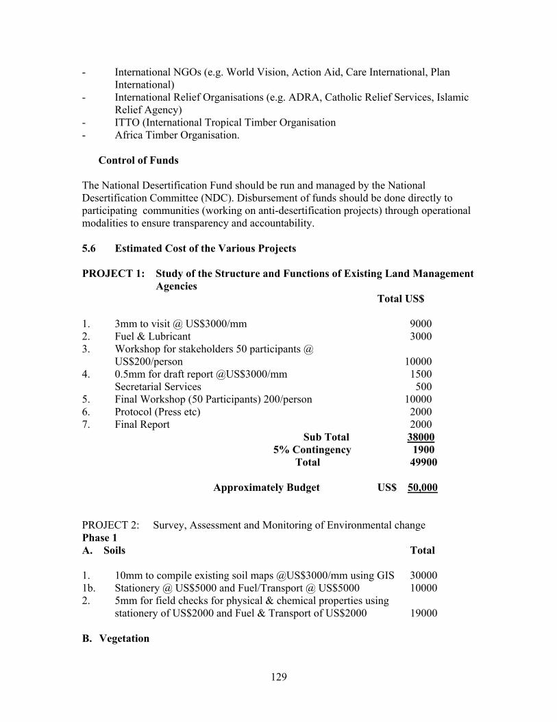
129
- International NGOs (e.g. World Vision, Action Aid, Care International, Plan International)
- International Relief Organisations (e.g. ADRA, Catholic Relief Services, Islamic Relief Agency)
- ITTO (International Tropical Timber Organisation - Africa Timber Organisation. Control of Funds The National Desertification Fund should be run and managed by the National Desertification Committee (NDC). Disbursement of funds should be done directly to participating communities (working on anti-desertification projects) through operational modalities to ensure transparency and accountability. 5.6 Estimated Cost of the Various Projects PROJECT 1: Study of the Structure and Functions of Existing Land Management
Agencies Total US$
1. 3mm to visit @ US$3000/mm 9000 2. Fuel & Lubricant 3000 3. Workshop for stakeholders 50 participants @
US$200/person 10000 4. 0.5mm for draft report @US$3000/mm 1500 Secretarial Services 500 5. Final Workshop (50 Participants) 200/person 10000 6. Protocol (Press etc) 2000 7. Final Report 2000 Sub Total 38000 5% Contingency 1900 Total 49900 Approximately Budget US$ 50,000 PROJECT 2: Survey, Assessment and Monitoring of Environmental change Phase 1 A. Soils Total 1. 10mm to compile existing soil maps @US$3000/mm using GIS 30000 1b. Stationery @ US$5000 and Fuel/Transport @ US$5000 10000 2. 5mm for field checks for physical & chemical properties using
stationery of US$2000 and Fuel & Transport of US$2000 19000
B. Vegetation
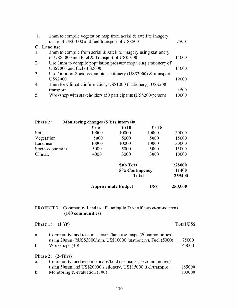
130
1. 2mm to compile vegetation map from aerial & satellite imagery
using of US$1000 and fuel/transport of US$500 7500 C. Land use 1. 3mm to compile from aerial & satellite imagery using stationery
of US$5000 and Fuel & Transport of US$1000 15000 2. Use 3mm to compile population pressure map using stationery of
US$2000 and fuel of S2000 13000 3. Use 5mm for Socio-economic, stationery (US$2000) & transport
US$2000 19000 4. 1mm for Climatic information, US$1000 (stationery), US$500
transport 4500 5. Workshop with stakeholders (50 participants (US$200/person) 10000 Phase 2: Monitoring changes (5 Yrs intervals) Yr 5 Yr10 Yr 15 Soils 10000 10000 10000 30000 Vegetation 5000 5000 5000 15000 Land use 10000 10000 10000 30000 Socio-economics 5000 5000 5000 15000 Climate 4000 3000 3000 10000 Sub Total 228000
5% Contingency 11400 Total 239400 Approximate Budget US$ 250,000 PROJECT 3: Community Land use Planning in Desertification-prone areas (100 communities) Phase 1: (1 Yr) Total US$ a. Community land resources maps/land use maps (20 communities) using 20mm @US$3000/mm, US$10000 (stationery), Fuel (5000) 75000 b. Workshops (40) 40000 Phase 2: (2-4Yrs) a. Community land resource maps/land use maps (50 communities)
using 50mm and US$20000 stationery, US$15000 fuel/transport 185000 b. Monitoring & evaluation (100) 100000
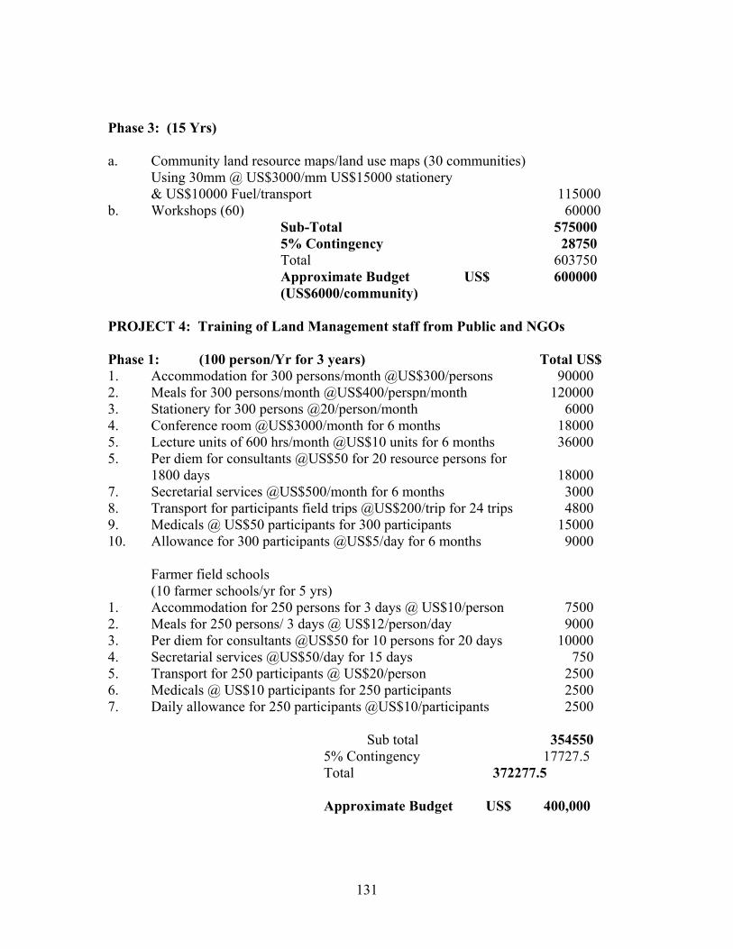
131
Phase 3: (15 Yrs) a. Community land resource maps/land use maps (30 communities)
Using 30mm @ US$3000/mm US$15000 stationery & US$10000 Fuel/transport 115000
b. Workshops (60) 60000 Sub-Total 575000 5% Contingency 28750 Total 603750 Approximate Budget US$ 600000 (US$6000/community) PROJECT 4: Training of Land Management staff from Public and NGOs Phase 1: (100 person/Yr for 3 years) Total US$ 1. Accommodation for 300 persons/month @US$300/persons 90000 2. Meals for 300 persons/month @US$400/perspn/month 120000 3. Stationery for 300 persons @20/person/month 6000 4. Conference room @US$3000/month for 6 months 18000 5. Lecture units of 600 hrs/month @US$10 units for 6 months 36000 5. Per diem for consultants @US$50 for 20 resource persons for
1800 days 18000 7. Secretarial services @US$500/month for 6 months 3000 8. Transport for participants field trips @US$200/trip for 24 trips 4800 9. Medicals @ US$50 participants for 300 participants 15000 10. Allowance for 300 participants @US$5/day for 6 months 9000 Farmer field schools (10 farmer schools/yr for 5 yrs) 1. Accommodation for 250 persons for 3 days @ US$10/person 7500 2. Meals for 250 persons/ 3 days @ US$12/person/day 9000 3. Per diem for consultants @US$50 for 10 persons for 20 days 10000 4. Secretarial services @US$50/day for 15 days 750 5. Transport for 250 participants @ US$20/person 2500 6. Medicals @ US$10 participants for 250 participants 2500 7. Daily allowance for 250 participants @US$10/participants 2500 Sub total 354550 5% Contingency 17727.5 Total 372277.5
Approximate Budget US$ 400,000
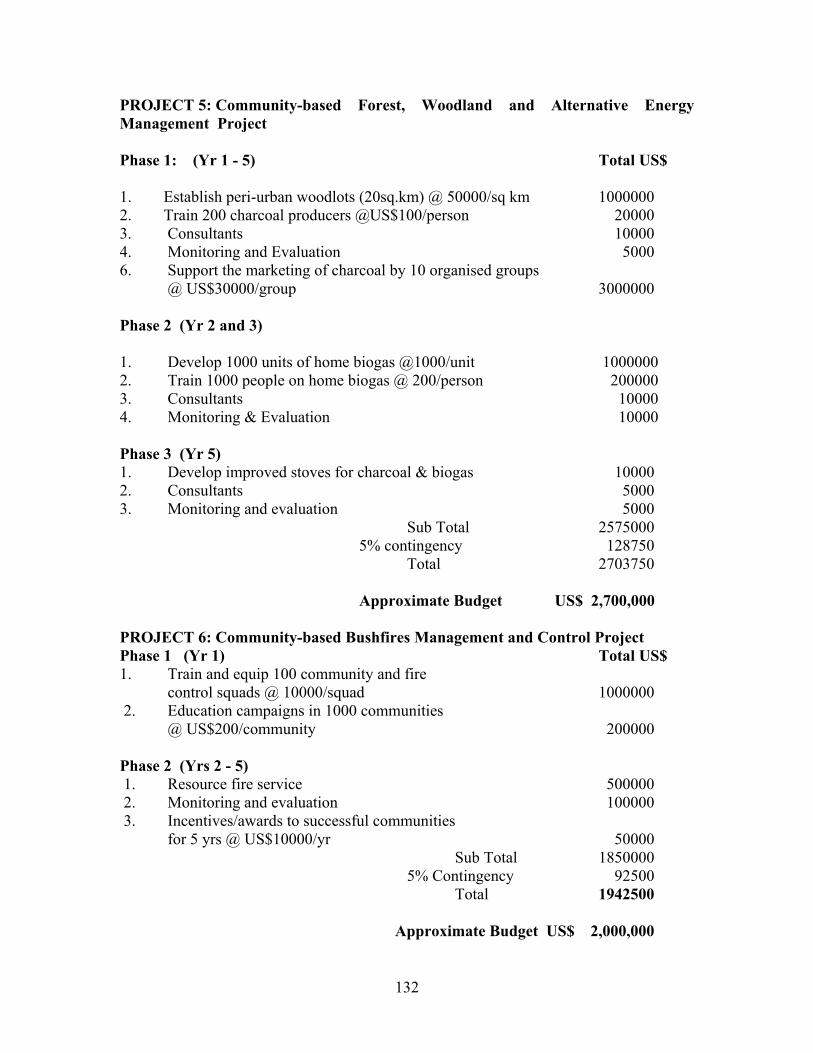
132
PROJECT 5: Community-based Forest, Woodland and Alternative Energy Management Project Phase 1: (Yr 1 - 5) Total US$ 1. Establish peri-urban woodlots (20sq.km) @ 50000/sq km 1000000 2. Train 200 charcoal producers @US$100/person 20000 3. Consultants 10000 4. Monitoring and Evaluation 5000 6. Support the marketing of charcoal by 10 organised groups
@ US$30000/group 3000000 Phase 2 (Yr 2 and 3) 1. Develop 1000 units of home biogas @1000/unit 1000000 2. Train 1000 people on home biogas @ 200/person 200000 3. Consultants 10000 4. Monitoring & Evaluation 10000 Phase 3 (Yr 5) 1. Develop improved stoves for charcoal & biogas 10000 2. Consultants 5000 3. Monitoring and evaluation 5000 Sub Total 2575000 5% contingency 128750 Total 2703750 Approximate Budget US$ 2,700,000 PROJECT 6: Community-based Bushfires Management and Control Project Phase 1 (Yr 1) Total US$ 1. Train and equip 100 community and fire
control squads @ 10000/squad 1000000 2. Education campaigns in 1000 communities
@ US$200/community 200000 Phase 2 (Yrs 2 - 5) 1. Resource fire service 500000 2. Monitoring and evaluation 100000 3. Incentives/awards to successful communities
for 5 yrs @ US$10000/yr 50000 Sub Total 1850000 5% Contingency 92500 Total 1942500 Approximate Budget US$ 2,000,000

133
PROJECT 7: Community-based Rangeland Management Project Phase 1 (Yr 1) Total US$ 1. Train and equip 100Rangeland squads @10000/squad 1000000 2. Education campaigns in 1000 communities
@US$200/community 200000 Phase 2 (Yrs 2 - 5) 1. Rangeland improvement and rehabilitation @ 5000/community 5000000 2. Monitoring and evaluation 100000 3. Incentives/awards to successful communities
for 5 yrs @ 10000/yr 50000 Sub Total 6350000 5% contingency 317500 Total 6667500 Approximate Budget US$ 6,700,000 PROJECT 8: Sustainable Crop and Livestock Production for Food Security Project Phase 1 Total US$ 1. Train 1000 farmers @ 100/farmer on organic manures 100000 2. Train 1000 farmers @ 100/farmer on post-harvest losses 100000 3. Promote soil and water conservation on 1000 farms 50000 4. Provide support for improved seed production for 5 yrs @ 50000/yr 250000 5. Provide credit through Rural Banks for farmers @ US$500/farmer for 1000 farmers 500000 6. Funds for food distribution and marketing 1000000 7. Monitoring and evaluation @ US$10000/yr for 5 yrs 50000 Phase 2 1. Promote small ruminant production in 500 households @US$300/household 150000 2. Support for 100 veterinary centres @US$ 10000/centre for 5 yrs 5000000 3. Support for 5 livestock breeding centres @ US$20000/ centre for 5 yrs 500000 4. Monitoring and evaluation @US$10000/yr for 5 yrs 50000 SubTotal 7750000 5% Contingency 387500 Total 8137500 Approximate Budget US$ 8,200,000
134
PROJECT 9: Water Resources Assessment, Monitoring and Utilization Project (WRAMUP) Phase 1 (1 - 5 yrs) Total US$ 1. Provide data logger equipment for WRAMUP 1000000 2. Train 30 Technicians @ US$500/person 15000 3. Resource persons (3 MM) @ US$3000/MM 9000 4. Construction of 10 small dams & canal systems @ 100000/site 1000000 5. Construct 50 wells @ US$8000/well 400000 6. Construct 500 dugouts @US$300 dugout 150000 7. Data collection @US$100000/yr for 5 yrs 500000 8. Monitoring & Evaluation @ 10000/yr for 5 yrs 50000 Phase 2 (6 - 10 yrs) 1. provide extra equipment for WRAMUP 250000 2. Train 30 technicians @ US$500/person 15000 3. Resource persons (3MM) @ US$3000/MM 9000 4. Construction of 10 small dams & canal systems @ 100000/site 1000000 5. Construct 50 wells @ US$8000/well 400000 6. Construct 500 dugouts @US$300/dugout 150000 7. Data collection @ US$100000/yr for 5 yrs 500000 8. Monitoring & Evaluation @ US$10000/yr for 5 yrs 50000 Sub-Total 5498000 5% Contingency 274900 Total 5772900 Approximate Budget US$ 6,000,000 PROJECT 10: Water Bodies Protection Project (WBPP) Phase 1 Total US$ 1. Three workshops to assemble water protection technologies
@ US$20000/workshop 60000 2. Nursery establishment at 20 locations with irrigation facilities
@ US$50000/site 1000000 3. Labour for regenerating the fringes of river bodies (0.1 x 500 km)
@US$2000/km stretch 1000000 4. Mass educational programmes 400000 5. Fuel and transport 1000000 6. Monitoring and evaluation @ US$10000 for yrs 3 & 5 20000

135
Phase 2 ( 6 - 10 yrs) 1. Three workshops to assemble water protection technologies
@ US$20000/workshop 60000 2. Nursery establishment at 20 locations with irrigation
Facilities @US$50000/site 1000000 3. Labour for regenerating the fringes of river bodies (0.1 x 500 km)
Stretch 1000000 4. Mass education programmes 400000 5. Extra fuel and transport to support phase 2 20000 6. Monitoring and evaluation @US$10000 (yrs 7 & 10)
Sub-Total 6460000 5% Contingency 323000 Total 6783000 Approximate Budget US$7,000,000
PROJECT 12: Rural Infrastructure Development (RIDP) Phase 1 (1 - 3 yrs) Total US$ 1. Develop 10000 km feeder road @US$3000/km 3000000 2. Develop 50 stalls for 100 villages @ US$300/stall 1500000 3. Provide 10 refrigerated storage rooms @ US$100000/site 1000000 4. Provide 100 sanitary points (KVIPs) @ US$10000/site 1000000 5. Improved water delivery system for 10 communities
@US$500000/community 5000000 6. Provide equipment for 10 health centres @US$200000/centre 2000000 7. Provide equipment for 50 schools @US$50000/school 2000000 8. Monitoring and evaluation US$5000/yr for 3 yrs 1 5000 Phase 2 (4 & 5 yrs) 1. Develop 500 km feeder road @US$3000/km 150000 2. Develop 50 stalls for 50 villages @ US$300/stall 750000 3. Provide 10 refrigerated storage rooms @ US$100000/site 1000000 4. Provide 100 sanitary points (KVIPs) @ US$10000/site 1000000 4. Improve water delivery system for 10 communities 5. @ US$500000/community 5000000 6. Provide equipment for 10 health centres @ US$200000/centre 2000000 7. Provide equipment for 50 schools @ US$50000/school 2000000 8. Monitoring and evaluation @ US$5000/yr for 2 yrs 10000
Sub-Total 32425000 5% contingency 1621250 Total 34046250 Approximate Budget US$ 35,000,000
136
PROJECT 13: Wildlife and Biodiversity Management and Conservation Project Phase 1 Total US$ 1. 2 public address vans for rural education @ US100,000/system 200000 2. Human resource development 100000 3. Domestication of 10 wild species @US$2000/yr/species for 5 yrs 100000 4. Conservation of endangered species @US$20000/yr for 5 yrs 100000 5. Strengthening institutional capabilities 100000 6. Monitoring and evaluation @ US$10000/yr for 5 yrs 50000 Phase 2 (5 - 10 yrs) 1. Public address vans for rural education @US$100000/system 100000 2. Human resource development 100000 4. Domestication of 10 wild species @US$20000/yr/species 5. for 5 yrs 100000 4. Conservation of endangered species @US$20000/yr for 5 yrs 100000 5. Strengthening institutional capabilities 100000 6. Monitoring and evaluation @US$10000/yr for 5 yrs 50000 Phase 3 (11 - 15 yrs) 1. 1 public address vans for rural education @US$100000/system 100000 2. Human Resources development 100000 4. Domestication of 10 wild species @US$20000/yr/species 5. for 5 yrs 100000 4. Conservation of endangered species US$20000/yr for 5 yrs 100000 5. Strengthening institutional capabilities 100000 6. Monitoring and evaluation US$10000/yr for 5 yrs 50000
Sub-Total 2050000 5% Contingency 102500
Total 2152500 Approximate Budget US$ 2,200,000
137
PROJECT 14: Development of sustainable Utilization and production systems for Medical Plant Project
Phase 1 (1 - 5 yrs) Total US$ 1. Revise documents on medicinal plants 1000000 2. Establish 5 herbal gardens with irrigation facilities @ US$50000/garden 250000 6. Establish 3 herbal medicine processing plants
@ US$200000 each 600000 4. Promote the use of herbal medicine using 10000/yr for 5 yrs 50000 5. Monitoring and evaluation @ US$5000/yr for 5 yrs 25000 Phase 2 (6 - 10 yrs) 1. Revise documents on medicinal plants 1000000 2. Establish 5 herbal gardens with irrigation facilities @US$50000/garden 250000 3. Establish 3 herbal medicine processing plants @ US$200000 each 600000 4. Promote the use of herbal medicine using 10000/yr for 5 yrs 50000 5. Monitoring and evaluation @US$5000/yr for 5 yrs 25000 Phase 3 (11 - 15 yrs) 1. Revised documents on medicinal plants 100000 2. Establish 5 herbal gardens with irrigation facilities @US$50,000/garden 250000 4. Establish 3 herbal medicine processing plants @US$200000 each 600000 4. Promote the use of herbal medicine using 10000/yr for 5 yrs 50000 5. Monitoring and evaluation @US$50000/yr for 5 yrs 25000 Sub-Total 3075000 5% Contingency 153750 Total 3228750
Approximate Budget US$ 3,300,000

138
PROJECT 15: Non-agricultural and Off-Farm Enterprises Project (NOEP) Phase 1 ( 1-5 yrs) Total US$ 1. Develop 5 local industries in 100 communities @150,000/community 15000000 2. Support training in Agroprocessing & Bee keeping 100000 3. Support credit facilities for local industries through the rural bank system 1000000 4. Monitoring and evaluation @US$10000/yr for 5 yrs 50000 Phase 2 (6 - 10 yrs) 1. Develop 5 local industries in 50 communities @ 150000/community 7500000 2. Support training in Agroprocessing & Bee keeping 100000 3. Support credit facilities for local industries through the rural bank system 1000000 4. Monitoring and evaluation @ US$10000/yr for 5 yrs 50000 Sub-Total 24800000 5%Contingency 1240000 Total 26040000 Approximate Budget US$ 26,100,000 PROJECT 16: Update of Desertification Hazard Map and Socio-economic
Data on Desertification Phase 1: 6 - 8 months Cost Lump Sum US$50,000 PROJECT 17: Review of Policy Documents Phase 1: 8 - 12 months Cost Lump Sum US$50,000
139
REFERENCES Abu, A. (1986). The problem of Desertification in Northern Ghana. Proceedings of Workshop on Combating Drought and Desertification, 24th-25th January, 1986, Accra. Environmental Protection Council. Acquaye, D.K. (1990), Towards Development of Sustainable Agriculture in Africa. Reflections of a Soil Scientist. In: Zobich, M.A. (ed). Proc. 11th Annual General Meeting, Soil Sci. Soc., Ghana 19-28. Adiku, K.S. (1993) COMCIAM Newsletter, No. 5, August, 1993 pp. 11 – 14, Accra. Adu, S.V. (1972). Eroded Savanna Soils Of The Navrongo-Bawku Area, Northern Ghana. Ghana Journal Of Agric. Science 5:3-12. Agyenim-Boateng, S. (1997). Mucuna: Its Importance And Use In Ghanaian Agriculture. In: Sant’ Anna, R., Quansah, C. And Asiamah, R.D. (Eds.). Proceedings Of The Workshop On Erosion-Induced Loss In Soil Productivity. FAO Regional Office For Africa. Alfsen, K.M., Bye, T, Glomsrob, S And Wiig, H. (1997). Soil Degradation And Economic Development In Ghana. Environmental And Development Economics 2:199 – 143. Alhassan, W.S, N. Karbo, P.A.T. Aboe And K.Oppong-Anane (1999). Ghana’s Savanna Rangeland: Agro-Ecology, Current Improvement And Usage Practices, Research Needs And Sustainable Management Criteria. National Agricultural Research Project, CSIR, Accra, Ghana 49pp. Alhassan, W.S. Karbo, N. And Anamoh, B. (1995), Review Of Small Ruminant Projects Of SRDP, LACOSREP And SCIMP, IFAD/MOFA. Tamale, Ghana. Alhassan, W.S. And Barnes, P. (1993). Problems And Prospects For Forage Iimprovement And Utilization In Ghana. Proc. XVII Int. Grassland Congress. New Zealand And Australia. Pp 499-500. Ampadu-Agyei Okyeame, George A. Manful, E. Fleischer, Michael Opam And A. M. Ameyaw (1994). Climate And Africa. Country Report, Ghana. African Conference On Policy Options And Responses To Climate Change Held At UNEP Headquarters, Nairobi, Kenya Dec. 5-8, 1994. Asare, E. O. (1986). Combating The Effects Of Drought And Desertification In Ghana. Proceedings Of A Workshop On Combating The Effects Of Drought And Desertification Held In Accra By The Environmental Protection Council, Accra, 24 –25 January, 1986.
140
Asiamah, R. D. , C. Quansah And C. D. Dedzoe (2000). Soil Degradation: Management And Rehabilitation In Ghana- An Overview Report. Proceedings Of The FAO/ISCW Expert Consultation On: Management Of Degraded Soils In Southern And East Africa (MADS-SEA), 2nd Network Meeting, 18-22 September, 2000, Pretoria South Africa, Pp 89-101. Asiamah, R. D. And Dedzoe, C. D. (1999). Plinthization: A Threat To Agricultural Production. Ghana J. Agric. Sci. 32. Asiamah , R. D. (1995). Soils Of The Ho-Keta Plains, Volta Region, Ghana Tech. Report No. 10, SRI, Kwadaso-Kumasi. Asiamah, R.D. (1987). Soil Resources And Their Agricultural Utilization In Ghana. Proceedings Of The National Conference On Resource Conservation For Ghana’s Sustainable Development. Environmental Protection Council, Accra, 2:99-111. Asiamah, R. D. (1984). Report On The Detailed Soil Survey Of The Angaw Basin Irrigation Project Area, Sogakope, Volta Region. Tech. Report No. 137, SRI, Kumasi. Bates, D.A. (1962). Geology. In: Will, J.B. (Ed.). Agriculture And Land Use In Ghana. Oxford University Press, London, London, 51 - 61. Bojo, J. (1996). The Cost Of Land Degradation In Sub-Saharan Africa. Ecological Economics. 16:161-173. Bonsu, M. And Quansah, C. (1992). The Importance Of Soil Conservation For Agricultural And Economic Development Of Ghana. Proceedings Of The 13th Annual General Meeting Of The Soil Science Society Of Ghana, Pp. 77-80. Bonsu, M. (1991). Effect Of Liming On Maize Production And Erosion On An Acid Soil Of S.W., Ghana. Tropical Agricultural (Trinidad) 68 : 271 - 273. Bonsu, M. (1981) Assessment Of Erosion Under Different Cultural Practices On A Savannah Soil In The Northern Region Of Ghana. In: Morgan, R.P.C. (Ed.), Soil Conservation: Problems And Prospects, Wiley, 247-53. Bonsu, M. (1979). Soil Erosion Studies Under Different Cultural Practices Within The Various Ecological Zones Of Ghana. Lecture Notes, FAO Training Course On Soil Conservation And Management, Kwadaso, Kumasi. Bonsu, M. And Obeng, H.B. (1979b). Effects Of Cultural Practices On Soil Erosion And Maize Production In The Semi Deciduous Forest And Forest-Savanna Transition Zones Of Ghana: In Lal., R. And Greenland, D.J. (Eds.). Soil Physical Properties And Crop Production In The Tropics. John Wiley And Sons, Chichester, U.K. Pp.509-519. Bryson, R.A. (1971). Climatic Modification By Air Pollution. Report 1. Paper Presented At The International Conference On Future. Helsinki, Finland. June 27-July 2, 1971.
141
CCD (1997). United Nations Convention To Combat Desertification. CIDA (2000). Food Security Programme. The Contribution Of Livestock Production To Food Security In Northern Ghana. An Overview. Convery, F. And Tutu, K. (1990). Evaluating The Costs Of Environmental Degradation: Ghana-Applications Of Economics In The Environmental Action Planning Process In Africa. Dubin, Ireland; University College Of Dublin, Environmental Institute. DGRD (1992). A Socio-Economic Survey In The Upper East Region With Reference To Drought And Desertification Control In Ghana. A Report By The Department Of Geography And Resources Development, University Of Ghana, Legon. E.P.C., Accra, Ghana. Drechsel, P And Gyiele, L.A. (1999). The Economic Assessment Of Soil Nutrient Depletion. Analytical Issues For Framework Development. Issues In Sustainable Land Management No. 7, IBSRAM, Bangkok. Duku, S. (1993), Rangeland Herbage Accumulation, Quality And Offtake By Grazing Livestock In Ghana. Range Monitoring Project Pproposal. Animal Research Institute, CSIR, Accra, Ghana. 12pp. Dzomeku, B. M. And L. Enu-Kwesi (1997). Ecological Studies Of A Section Of The Accra Plains. UNDP Desertification Control Bulletin 31, Pp 24-29. Egger, K. And Martens, B. (1987). Theory And Methods Of Eco-Farming And Their Realization In Rwanda, East Africa. In: Glaeser, B. (Ed.). The Green Revolution Revisited: Critique And Alternatives, Allen And Unvin, London, 151 - 175. EPA (2001). Districts Consultative Workshop On Drought And Desertification. Reports, EPA, Accra EPC/WRRI (1988). Environmental Action Plan. Water Management Component. Environmental Protection Council, Accra. FAO (1976). A Framework For Land Evaluation. Soil Bulletin No. 32, Rome. Findlay, J.B.R., Haag, W.L., Boa-Amponsem, K., Descous, M., Rass, G. And Modestus, W. (1998). The Role Of The Private Sector In Enhancing Conservation Tillage Practices In Africa. Proceedings Of The International Workshop On Conservation. Tillage For Sustainable Agriculture, Harare, Zimbabwe, 129 - 137. Gerner, H., Asante, E. O., Owusu-Benoah, E. And Marfo K. (1995). Ghana Fertilizer Privatisation Scheme: Private Sector Roles And Public Sector Responsibilities In Meeting Needs Of Farmers. Ghana Grains Development Project (GGDP) 992. 14th Annual Report Part 2. Research Results. Crops Research Institute, Kumasi, Ghana. Ghana Grains Development Project.
142
GGDP (1993). 15th Annual Report, Part 2. Research Results, Crops Research Institute, Kumasi, Ghana. Ghana Statistical Service (2000). 2000 Population And Housing Census. Provisional Results. 23 Pp. GLSS (1991/92). Cited In: Policy Focus For Poverty Reduction. Technical Committee On Poverty (TCOP), Technical Report, September 1996. Government Of Ghana – Vision 2020 (1995). The First Step: 1996-2000. Presidential Report On Co-Ordinated Programme Of Economic And Social Development Policies. (Policies For The Preparation Of 1996-2000 Development Plan). GSS (1993/95) Cited In: Policy Focus For Poverty Reduction. Technical Committee On Poverty (TCOP), Technical Report, September, 1996. Gyampo, A.A. (1986). A URADEP Report On Drought And Desertification In Ghana. Proceedings Of Workshop On Combating Drought And Desertification. Environmental Protection Council, Accra. Hudson, N.W. (1995). Soil Conservation, Batsford, London. Karbo, N., J. Bruce And E. Otchere (1998). Role Of Livestock In Soil Fertility Management In The Northern Guinea Savanna Zone Of Ghana. Technical Report. KEIA/NGLWG Collaborative Research, Tamale. Kasei, C. N. (2000). Climatic Considerations In Preparing For Drought And Desertification. Cited In: Report On The District Workshops Towards The Formulation Of A National Action Programme To Combat Desertification And Drought: Northern Region. Environmental Protection Agency, Northern Region, 15th December, 2000. Lane, D.A. (1962). The Forest And Vegetation. In: Wills, J.B. (Ed). Agriculture And Land Use In Ghana. Oxford University Press, London, 160 - 169. Lal, R. And Stewart, B.A. (1992). Need For Land Restoration Adv. Soil Sci. 17: 1-11. Lal, R. (1984), Soil Erosion In Tropical Arable Lands And Its Control. Advances In Agronomy 37: 183-248. Lawes, D.A. (1966). Rainfall Conservation And Yields Of Sorghum And Groundnuts In Northern Nigeria. Samaru, Research Bulletin No 70. LPIU [Livestock Planning And Information Unit] (1997). 1996 Livestock Census. Ministry Of Food And Agriculture, Accra 5pp.
143
Millar, D., Karbo,N. Bruce, J. And Otchere, E.O. (1998) Group Formation And West African Shorthorn Cattle Development Among The Konkombas And Chokosi Of The Saboba-Chereponi District Of The Northern Region Technical Report. Animal Research Institute, March 1988; 28pp. Ministry Of Agriculture (1990), Medium Term Agricultural Development Programme (MTADP). An Agenda For Sustained Agricultural Growth And Development (1991-2000). Ministry Of Agriculture, Accra, Ghana. MLF [Ministry Of Lands And Forestry] (1994). Forest And Wildlife Policy. Ghana Publishing Corporation, Accra. 11pp. MOFA (1998). National Soil Fertility Management Action Plan. Ministry Of Food And Agriculture, Accra. Nathan Associates (1970). Ghana Sector Studies. Water Resources General Report. Ministry Of Finance And Economic Planning Accra, Ghana. Nicholson, S. (1983). Climatology Of Sub-Saharan Africa. In: Environmental Changes In The West Africa Sahel. National Academy Press, Washington, D.C. 1983, Pp. 71 - 92. Nii Consult (1996). Ghana Water Resources Management Study. Inception Report. Royal Danish Embassy, Accra. Nketia, K.S., Hagan, E.B. And Addo, S.T. (1989). The Charcoal Cycle In Ghana. Technical Report. Forestry Research Institute, Ghana. NPACD (1987). National Plan Of Action To Combat Desertification, Prepared For The Government Of Ghana By The Environmental Protection Council. Nye, P.H. And Greenland, D.J. (1965). The Soil Under Shifting Cultivation. Technical Communications No.51, Commonwealth Bureau Of Soils, Harpenden, Herts. Nye, P.H. And D.J. Greenland (1964). Changes In The Soil After Clearing Tropical Forest. Plant And Soil 101 –112. Obeng, H.B. (1963). Soils Of The Seilo-Tuni Land Planning Area, Wala District, Upper Region. Agric. Res. Inst. (G.A.S) Tech. Memo. No 62, Kumasi Ghana. Ofori, C.S. (1996). A Case Study On Sustainable Indigenous Land Management In Shallot Farming, In The Anloga District Of Ghana. A Report To The FAO Regional Office For Africa, Accra, Ghana. Ofori, C.S. And Fianu, F. (1996), Sustaining Soil Fertility In Ghana. An Integrated Nutrient Management Approach. In: Ofori, F. And Safo, E.Y. (Eds.) Proceedings Of
144
The National Workshop On Soil Fertility Management Action Plan For Ghana. Ministry Of Food And Agriculture, Accra, Ghana. Ofori, F. (1999). Soil Fertility Management And Ghana Vision 2020. Action Plan For Ghana. MOFA, Accra, Ghana. Proc. 16th Annual General Meeting Soil Sci. Soc., Accra, Ghana. Oldeman, L.R., Harkkeling, R.T.A And Sombroek, W.G. (1991) World Map Of The Status Of Human Induced Soil Degradation: An Explanatory Note. Nairobi, United Nations Environmental Programme. Opoku-Ankoma, Y. (1986). Annual Streamflow Characteristics Of Major Ghanaian Rivers. Water Resources Research Institute, Accra, Ghana. Osei-Bonsu, P. And Buckles, D. (1993). Controlling Weeds And Improving Soil Fertility Through The Use Of Cover Crops: Experience With Mucuna Spp. In Benin And Ghana. West Africa Farming Systems Research Network Bulletin. No.14. Panin, A (1988). Hoe And Bullock Farming Systems In Northern Ghana. A Comparative Socio-Economic Analysis. Nyankpala Agricultural Research Reports, Tamale, Ghana. Pitman, J. And Ramsay, J.M. (1959). Land Planning, Soil And Water Conservation In Northern Ghana. A Review Of Progress In The Past Ten Years (1949 - 1959). Third Inter African Soils Conference, Dalaba, 797 - 804. PPMED, (1994), Estimates Of Cropped Area For Major Crops In Northern Region. Quansah, C., Safo, E.Y., Ampontuah, E.O. And Amankwah, A.S. (2000). Soil Fertility Erosion And The Associated Cost Of N,P And K Removal Under Different Soil And Residue Management In Ghana. Ghana Journal Of Agricultural Science Vol. 33. Quansah, C., Asare, E., Safo, E.Y., Ampontuah, E.O., Kyei Baffour, N., And Bakang, J.A. (1998). The Effect Of Poultry Manure And Mineral Fertilizer On Maize/Cassava Intercrop In Peri-Urban Kumasi, Ghana. In: Drechsel, P. And Gyiele, L. (Eds). On- Farm Research On Sustainable Land Management In Sub-Saharan Africa: Approaches, Experiences And Lessons. IBSRAM Proceedings 19:73-90. Quansah, C. (1997). Approaches To Replenishing Soil Fertility Depletion In Ghana. Poster Abstracts For The International Seminar On Approaches To Replenishing Soil Fertility In Africa: NGO Perspectives, ICRAF, Nairobi, Kenya. Quansah, C., Kyei-Baffour, N. And Sapari, H. (1997). The Effect Of Land Clearing By Bulldozing On Some Physical Properties Of A Forest Soil. Journal Of The University Of Science And Technology (1&2): 18-22.

145
Quansah, C. (1996). Soil, Water And Nutrient Management Needs For Sustainable Crop Production. Proceedings Of DSE International Seminar On Tools For Analysis And Evaluation For Sustainable Landuse In Rural Development DES, Zschortau, Germany, 38-46. Quansah, C., Baffoe-Bonnie, E. And Asiamah, R.D. (1991). Soil Erosion In Ghana And Strategies For Conservation. In: Asiamah, R.D. (Ed.). Proc. Workshop On Soil Conservation Strategies For Africa. UNEP Regional Co-Ordination Unit Of The Soils And Fertilizer Network For Africa, Accra, Ghana. Quansah, C. (1990). Soil Erosion And Conservation In The Northern And Upper Regions Of Ghana. Topics In Applied Resources Management 2: 135-157. Quansah, C., Baffoe-Bonnie, E. And Agyei, F. (1988). Runoff And Soil Loss Under Four Legumes. Proceedings Of The 11th Annual General Meeting Of The Soil Science Society Of Ghana, University Of Ghana, Legon. Quansah, C. And Baffoe Bonnie, E. (1981). The Effect Of Soil Management Systems On Soil Loss, Runoff And Fertility Erosion In Ghana. In: Tingsanchali, T. And Egger, H. (Eds). South East Asian Regional Symposium On Problems Of Soil Erosion And Sedimentation, Asian Institute Of Technology, Bangkok, 207-217. Reich, P.F., Numbem, S.T., Almaraz, R.A. And Eswaran, H. (2001). Land Resource Stresses And Desertification In Ghana. In: Bridges, E.M., Hannam, I.D., Oldeman, L.R., Penning Devries, F.W.T., Scherr, S.J. And Sompatpanit, S. (Eds.). Responses To Land Degradation. Proc. 2nd International Conference On Land Degradation And Desertification Khon Kaen, Thailand, Oxford Press, New Delhi, India. RELC [ Research – Extension Linkage Committee] Zone 2 (1997) Calendar Of Planned Activities, Northern Zone. Roose, E.J. (1975). Natural Mulch On Chemical Condition For Reducing Erosion In Humid Tropical Areas. Special Publication Of Soil Science Society Of America, Proceedings 7:131-138. Rose-Innes, R (1977). A Manual Of Ghana Grasses. Land Resources Division, Ministry Of Overseas Development. Tolworth Tower, Surbiton, Surrey, England. 265pp. Runge – Metzger, A. (1988). Variability In Agronomic Practices And Allocative Efficiency Among Farm Households In Northern Ghana. Nyankpala Agricultural Research Report, Vol.2. Sam, M. K., O. Ketchikp And R. F. Barnes (1976). A Preliminary Survey Of The Elephants Of North-Eastern Ghana And Northern Togo. Unpublished Report. Wildlife Department, Accra.
146
Schmidt, G. And Frey, E. (1988). Crop Rotation Effects In Savannah Soils. Nyankpala Agricultural Research Report, Vol.4. Shaxton, T.T. (1981) Reconciling Social And Technical Needs In Conservation Work On Village Farm Lands: In: Morgan, R.P.C. (Ed.) Soil Conservation: Problems And Prospects, Wiley, 385-97. Sherr, S.J. (1999). Soil Degradation: A Threat To Developing Country Food Security By 2020? Food Agriculture And The Environmental Discussion Paper 27. International Food Policy Research Institute, Washington, D.C. USA. SRI (1971) Erosion Hazard Map Of Ghana. Survey Department, Accra. Stocking, M. (1986). The Cost Of Soil Erosion In Zimbabwe In Terms Of The Loss Of Three Major Nutrients. Consultant Working Paper No. 3 Rome, Italy. Soil Conservation Programme, Land And Water Development Division, AGLS, FAO. Stoorvogel, J.J. And Smaling, E.M.A. (1990). Assessment Of Nutrient Depletion In Sub-Saharan Africa, 1983 – 2000. Report No. 28, Wageningen: Winard Staring Centre For Integrated Land, Soil And Water Research. Swift, M. (1997) Biological Management Of Soil Fertility: An Integrated Approach To Soil Nutrient Replenishment. Proceedings Of International Seminar On Approaches To Replenishing Soil Fertility In Africa – NGO Perspectives ICRAF, Nairobi, Kenya. Syers, J.K. (1997). Managing Soils For Long-Term Productivity. Phil. Trans. R. Soc. Land B. (1997) 352: 1011-1021. Tandon, H.L.S. (1993). Soil Fertility And Fertilizer Use: An Overview Of Research For Increasing Crop Productivity. Paper Presented At The International Commission On The Application Of Science To Agriculture. International Society Of Soil Science. (ISSS), New Delhi, India. September 13-16. UWADEP [Upper West Agricultural Development Project] (1995). Appraisal Report. Working Papers. International Fund for Agricultural Development (IFAD) Report No. 0613-GH. Wiafe, K. (1997). Information binding block. Volume 1. Volta Basin System. Irrigation Annex 2. Ghana water resources management study. 10pp. Wilson, G.F. (1979). The Potential of Legume Covers in No-tillage-Cropping in the Tropics. In: Lal., R. (ed.) Soil tillage and Crop Production, IITA Proceedings series No.2. Woomer, P.L., Martin, A., Albrecht, A., Resck, D.V.S. and Sharpensed, H. (1994). The Importance and Management of Soil Organic Matter in the Tropics : in Woomer, P.L.
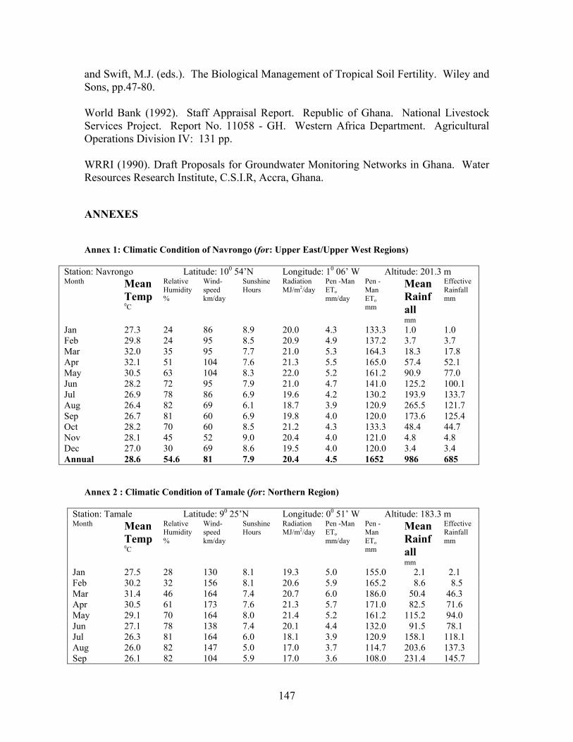
147
and Swift, M.J. (eds.). The Biological Management of Tropical Soil Fertility. Wiley and Sons, pp.47-80. World Bank (1992). Staff Appraisal Report. Republic of Ghana. National Livestock Services Project. Report No. 11058 - GH. Western Africa Department. Agricultural Operations Division IV: 131 pp. WRRI (1990). Draft Proposals for Groundwater Monitoring Networks in Ghana. Water Resources Research Institute, C.S.I.R, Accra, Ghana. ANNEXES Annex 1: Climatic Condition of Navrongo (for: Upper East/Upper West Regions)
Station: Navrongo Latitude: 100 54’N Longitude: 10 06’ W Altitude: 201.3 m Month Mean
Temp 0C
Relative Humidity %
Wind-speed km/day
Sunshine Hours
Radiation MJ/m2/day
Pen -Man ETo mm/day
Pen -Man ETo mm
Mean Rainfall mm
Effective Rainfall mm
Jan 27.3 24 86 8.9 20.0 4.3 133.3 1.0 1.0 Feb 29.8 24 95 8.5 20.9 4.9 137.2 3.7 3.7 Mar 32.0 35 95 7.7 21.0 5.3 164.3 18.3 17.8 Apr 32.1 51 104 7.6 21.3 5.5 165.0 57.4 52.1 May 30.5 63 104 8.3 22.0 5.2 161.2 90.9 77.0 Jun 28.2 72 95 7.9 21.0 4.7 141.0 125.2 100.1 Jul 26.9 78 86 6.9 19.6 4.2 130.2 193.9 133.7 Aug 26.4 82 69 6.1 18.7 3.9 120.9 265.5 121.7 Sep 26.7 81 60 6.9 19.8 4.0 120.0 173.6 125.4 Oct 28.2 70 60 8.5 21.2 4.3 133.3 48.4 44.7 Nov 28.1 45 52 9.0 20.4 4.0 121.0 4.8 4.8 Dec 27.0 30 69 8.6 19.5 4.0 120.0 3.4 3.4 Annual 28.6 54.6 81 7.9 20.4 4.5 1652 986 685
Annex 2 : Climatic Condition of Tamale (for: Northern Region)
Station: Tamale Latitude: 90 25’N Longitude: 00 51’ W Altitude: 183.3 m Month Mean
Temp 0C
Relative Humidity %
Wind-speed km/day
Sunshine Hours
Radiation MJ/m2/day
Pen -Man ETo mm/day
Pen -Man ETo mm
Mean Rainfall mm
Effective Rainfall mm
Jan 27.5 28 130 8.1 19.3 5.0 155.0 2.1 2.1 Feb 30.2 32 156 8.1 20.6 5.9 165.2 8.6 8.5 Mar 31.4 46 164 7.4 20.7 6.0 186.0 50.4 46.3 Apr 30.5 61 173 7.6 21.3 5.7 171.0 82.5 71.6 May 29.1 70 164 8.0 21.4 5.2 161.2 115.2 94.0 Jun 27.1 78 138 7.4 20.1 4.4 132.0 91.5 78.1 Jul 26.3 81 164 6.0 18.1 3.9 120.9 158.1 118.1 Aug 26.0 82 147 5.0 17.0 3.7 114.7 203.6 137.3 Sep 26.1 82 104 5.9 17.0 3.6 108.0 231.4 145.7

148
Oct 27.6 75 95 8.2 21.0 4.4 136.4 75.7 66.5 Nov 28.1 59 95 8.9 20.7 4.5 135.0 11.5 11.3 Dec 26.9 41 121 7.7 18.3 4.5 139.5 2.8 2.8 Annual 28.1 61.3 138 7.4 19.6 4.7 1720 1033 782
Annex 3: Climatic Condition of Wenchi (for: northern fringes of Brong Ahafo) Station: Wenchi Latitude: 70 45’N Longitude: 20 06’ W Altitude: 338.9 m Month Mea
n Temp 0C
Relative Humidity %
Wind-speed km/day
Sunshine Hours
Radiation MJ/m2/day
Pen -Man ETo mm/day
Pen -Man ETo mm
Mean Rainfall mm
Effective Rainfall mm
Jan 26.1 54 112 7.3 18.6 4.3 133.3 4.5 4.0 Feb 28.1 58 147 7.3 19.7 4.8 134.4 28.6 27.3 Mar 27.9 67 156 6.9 20.1 4.8 148.8 102.1 85.4 Apr 27.4 76 147 7.1 20.4 4.6 138.0 137.9 107.5 May 26.6 79 138 7.3 20.2 4.3 133.3 161.4 119.7 Jun 25.5 83 138 6.1 17.9 3.7 111.0 164.7 121.3 Jul 24.6 84 156 4.5 15.7 3.3 102.3 130.1 103.0 Aug 24.4 84 164 3.8 15.1 3.2 99.2 96.7 81.7 Sep 24.8 85 121 4.3 15.9 3.3 99.0 177.9 127.3 Oct 25.3 84 112 5.9 17.8 3.6 111.6 193.1 133.4 Nov 25.8 78 112 7.1 18.5 3.8 114.0 41.2 38.5 Dec 25.3 69 95 6.9 17.6 3.7 114.7 14.7 14.4 Annual 26.0 75.1 133 6.2 18.1 3.9 1434 253 964 Annex 4: Climatic Condition of Accra (for: south-eastern coastal Ghana) Station: Accra Latitude: 50 365’N Longitude: 00 10’ W Altitude: 67.7 m Month Mea
n Temp 0C
Relative Humidity %
Wind-speed km/day
Sunshine Hours
Radiation MJ/m2/day
Pen -Man ETo mm/day
Pen -Man ETo mm
Mean Rainfall mm
Effective Rainfall mm
Jan 27.7 77 207 6.8 18.2 4.2 130.2 10.9 10.7 Feb 28.4 78 259 6.9 19.4 4.6 128.8 21.8 21.0 Mar 28.4 79 268 6.9 20.2 4.7 145.7 57.1 51.9 Apr 28.3 80 251 7.0 20.2 4.7 141.0 96.8 81.8 May 27.6 82 216 6.9 19.4 4.3 133.3 131.2 103.7 Jun 26.4 86 242 5.1 16.3 3.5 105.0 221.8 143.1 Jul 25.3 85 294 4.7 15.8 3.4 105.4 66.0 59.0 Aug 25.1 84 328 4.9 16.7 3.6 111.6 28.2 26.9 Sep 25.8 83 311 5.9 18.4 3.9 117.0 67.8 60.4 Oct 26.7 83 259 7.5 20.4 4.2 130.2 62.4 56.2 Nov 27.6 81 199 7.9 20.2 4.3 129.0 27.7 26.5 Dec 27.5 79 181 6.9 18.0 4.0 124.0 18.1 17.6 Annual 27.1 81 251 6.5 18.6 4.1 1504 810 659 *Data was compiled from the Ghana Meteorological Services Department for the period 1961-1990. The Penman-Monteith et. and the USDA method effective rainfall were computed using CROPWAT.
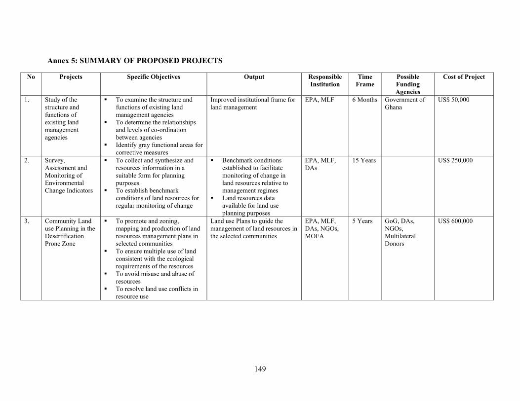
149
Annex 5: SUMMARY OF PROPOSED PROJECTS
No Projects Specific Objectives Output Responsible Institution
Time Frame
Possible Funding Agencies
Cost of Project
1. Study of the structure and functions of existing land management agencies
To examine the structure and functions of existing land management agencies
To determine the relationships and levels of co-ordination between agencies
Identify gray functional areas for corrective measures
Improved institutional frame for land management
EPA, MLF 6 Months Government of Ghana
US$ 50,000
2. Survey, Assessment and Monitoring of Environmental Change Indicators
To collect and synthesize and resources information in a suitable form for planning purposes
To establish benchmark conditions of land resources for regular monitoring of change
Benchmark conditions established to facilitate monitoring of change in land resources relative to management regimes
Land resources data available for land use planning purposes
EPA, MLF, DAs
15 Years US$ 250,000
3. Community Land use Planning in the Desertification Prone Zone
To promote and zoning, mapping and production of land resources management plans in selected communities
To ensure multiple use of land consistent with the ecological requirements of the resources
To avoid misuse and abuse of resources
To resolve land use conflicts in resource use
Land use Plans to guide the management of land resources in the selected communities
EPA, MLF, DAs, NGOs, MOFA
5 Years GoG, DAs, NGOs, Multilateral Donors
US$ 600,000

150
No Projects Specific Objectives Output Responsible
Institution Time
Frame Possible Funding Agencies
Cost of Project
4. Education and Training in Land Management
To impart knowledge and make people more aware of the environment, the human activities and practices that degrade it, the consequences of such degradation and what measures can be taken to control the degradation
To produce a multidisciplinary range of experts needed for effective management of land resources
Create public awareness on environmental issues in general aimed at various target groups both within and outside the formal educational system
Train Extension Agents, farmers and NGOs in land and water management and conservation technologies
Requisite awareness on environmental issues created at the community level
Trained personnel for effective management of land resources available
EPA, MOFA, Universities, CSIR, NGOs
5 Years GoG, Donor and Multilateral Agencies, DAs, NGOs
US$400,000
5. Community based Forest and Woodland Management Project
Assess and monitor the extent of natural woodland formations
Assess the degree and nature of disturbance within the various formations to aid the planning of management strategies
Assess communities to establish nurseries for tree seedlings
Embark upon broad-based community forest regeneration and afforestation, tree planting for green belts, agro-forestry, individual and community woodlots and farm forestry.
Promote and assist the development of woodland plantations for fuelwood production and its marketing
Map showing extent of natural woodland formation and degree of disturbance in selected communities available
Network of community tree nurseries established
Community based forest and woodland management plans produced for implementation
EPA, MLF, MOFA, NGOs, DAs, AND CBOs
5 Years GoG, NGOs, DAs, Donor and Multilateral Agencies
US$ 2,700,000
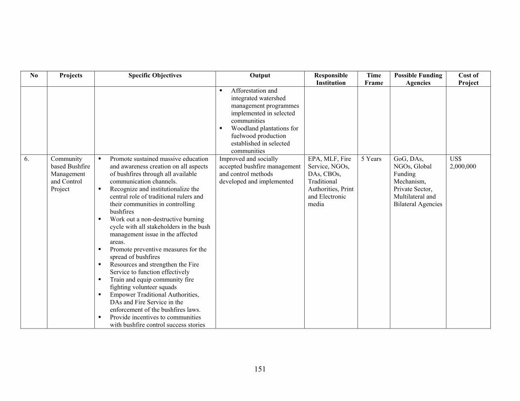
151
No Projects Specific Objectives Output Responsible Institution
Time Frame
Possible Funding Agencies
Cost of Project
Afforestation and integrated watershed management programmes implemented in selected communities
Woodland plantations for fuelwood production established in selected communities
6. Community based Bushfire Management and Control Project
Promote sustained massive education and awareness creation on all aspects of bushfires through all available communication channels.
Recognize and institutionalize the central role of traditional rulers and their communities in controlling bushfires
Work out a non-destructive burning cycle with all stakeholders in the bush management issue in the affected areas.
Promote preventive measures for the spread of bushfires
Resources and strengthen the Fire Service to function effectively
Train and equip community fire fighting volunteer squads
Empower Traditional Authorities, DAs and Fire Service in the enforcement of the bushfires laws.
Provide incentives to communities with bushfire control success stories
Improved and socially accepted bushfire management and control methods developed and implemented
EPA, MLF, Fire Service, NGOs, DAs, CBOs, Traditional Authorities, Print and Electronic media
5 Years GoG, DAs, NGOs, Global Funding Mechanism, Private Sector, Multilateral and Bilateral Agencies
US$ 2,000,000
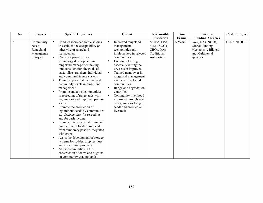
152
No Projects Specific Objectives Output Responsible
Institution Time
Frame Possible
Funding Agencies Cost of Project
7 Community based Rangeland Management Project
Conduct socio-economic studies to establish the acceptability or otherwise of rangeland management
Carry out participatory technology development in rangeland management taking into consideration the goals of pastoralists, ranchers, individual and communal tenure systems
Train manpower at national and community levels in range land management
Promote and assist communities in reseeding of rangelands with leguminous and improved pasture seeds
Promote the production of leguminous seeds by communities e.g. Stylosanthes for reseeding and for cash income
Promote intensive small ruminant production on fodder produced from temporary pasture integrated with crops
Assist the development of storage systems for fodder, crop residues and agricultural products
Assist communities in the construction of dams and dugouts on community grazing lands
Improved rangeland management technologies and implemented in selected communities
Livestock feeding, especially during the dry season improved
Trained manpower in rangeland management available in selected communities
Rangeland degradation controlled
Community livelihood improved through sale of leguminous forage seeds and productive livestock
MOFA, EPA, MLF, NGOs, CBOs, DAs, Traditional Authorities
5 Years GoG, DAs, NGOs, Global Funding, Mechanism, Bilateral and Multilateral agencies
US$ 6,700,000
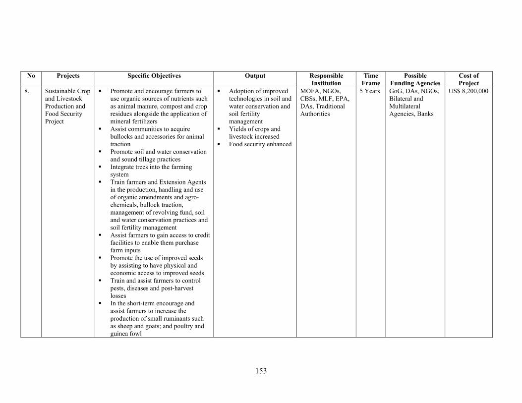
153
No Projects Specific Objectives Output Responsible Institution
Time Frame
Possible Funding Agencies
Cost of Project
8. Sustainable Crop and Livestock Production and Food Security Project
Promote and encourage farmers to use organic sources of nutrients such as animal manure, compost and crop residues alongside the application of mineral fertilizers
Assist communities to acquire bullocks and accessories for animal traction
Promote soil and water conservation and sound tillage practices
Integrate trees into the farming system
Train farmers and Extension Agents in the production, handling and use of organic amendments and agro-chemicals, bullock traction, management of revolving fund, soil and water conservation practices and soil fertility management
Assist farmers to gain access to credit facilities to enable them purchase farm inputs
Promote the use of improved seeds by assisting to have physical and economic access to improved seeds
Train and assist farmers to control pests, diseases and post-harvest losses
In the short-term encourage and assist farmers to increase the production of small ruminants such as sheep and goats; and poultry and guinea fowl
Adoption of improved technologies in soil and water conservation and soil fertility management
Yields of crops and livestock increased
Food security enhanced
MOFA, NGOs, CBSs, MLF, EPA, DAs, Traditional Authorities
5 Years GoG, DAs, NGOs, Bilateral and Multilateral Agencies, Banks
US$ 8,200,000

154
No Projects Specific Objectives Output Responsible Institution
Time Frame
Possible Funding Agencies
Cost of Project
In the long-term, promote breed improvement and provision of improved livestock, farmer support services; including animal husbandry extension, veterinary services, feed production and livestock marketing
Promote and support communities to create a community Land Management Development Fund and assist them to work out an institutional framework and mechanisms for its administration.
Strengthen appropriate institutions that could be used as front line agencies to assist communities in the implementation of the project (MOFA, NGOs, CBOs etc.)
9. Water Resources Assessment, Monitoring and Utilization Project (WRAMUP)
Improve the meteorological and hydrological network
Build the capacity of the District Assemblies (DAs) and local communities in water resources management
Provide institutional support for Meteorological and Hydrological Services Department
Promote sustainable water harvesting for domestic and agricultural use (e.g. dams, dugouts, wells)
Inventorize district level water resources using remote sensing techniques
Support water resources research
The capacities of institutions responsible for generating basic water data strengthened (e.g. Meteorological Services Department, Hydrological Services Department, Water Research Institute
District Assemblies and communities taken control in the management of water resources
Water resources data updated Increased number of small
dams, dugouts and wells
Hydrological Services Department
10 Years GoG, Donors (e.g. CIDA, DANIDA)
US$ 6,000,000

155
No Projects Specific Objectives Output Responsible
Institution Time
Frame Possible
Funding Agencies Cost of Project
10. Water Bodies protection Project (WBPP)
• Promote sustained awareness campaign on the protection of water bodies
• Create a fringe of thick woodland along the banks of rivers, streams, main water courses and other water bodies
• Promote and support community based catchment area protection through planting of trees, fodder grasses and soil and water conservation practices
• Assist the formation and training of Community Water Body Protection Volunteers (CWBPV)
• Institute awards for communities with good environmental records
• Local capacity strengthened and supported in establishing and protecting vegetative cover around rivers, streams and other water bodies and in catchment areas.
• Most catchment areas protected
Environmental Protection Agency
10 years GoG, Donors (e.g. CIDA, DANIDA, USAID)
US$ 7,000,000
11. Fuelwood and Alternative Resources Management Project (FARMP)
• Promote and support the establishment of community and individual woodlots as sources of domestic energy supplies
• Promote and popularize the use of energy-efficient stoves and more efficient forms of energy (e.g. LPG)
• Support a national campaign on energy conservation
• Organise and train charcoal producers in the new and efficient methods of charcoal production
• Train local artisans to produce improved stoves
• Use of more energy-efficient stoves and efficient forms of energy popular among urban dwellers communities
• Increased number of woodlots established for fuelwood production
• Charcoal producers organised and using improved methods of production
Forestry Commission/ Energy Commission
10 Years GoG, Donor (e.g. DFID, Oil Companies)
US$2,700,000 (Linked with Project 5)
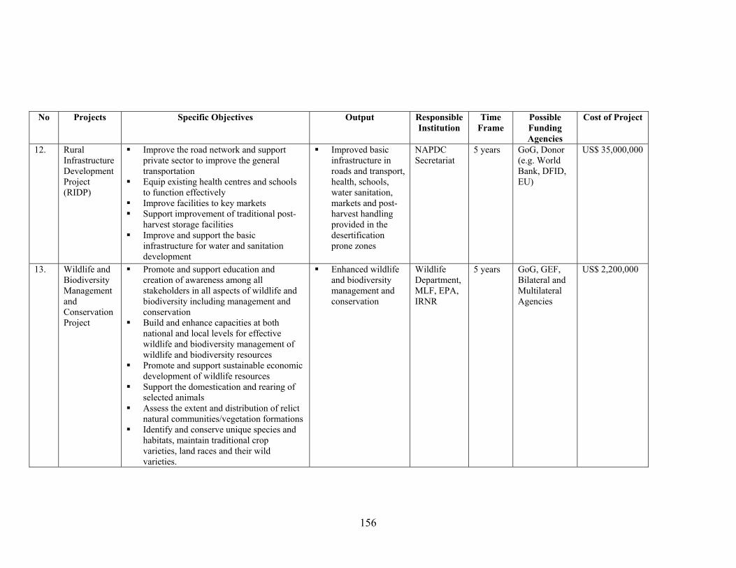
156
No Projects Specific Objectives Output Responsible Institution
Time Frame
Possible Funding Agencies
Cost of Project
12. Rural Infrastructure Development Project (RIDP)
Improve the road network and support private sector to improve the general transportation
Equip existing health centres and schools to function effectively
Improve facilities to key markets Support improvement of traditional post-
harvest storage facilities Improve and support the basic
infrastructure for water and sanitation development
Improved basic infrastructure in roads and transport, health, schools, water sanitation, markets and post-harvest handling provided in the desertification prone zones
NAPDC Secretariat
5 years GoG, Donor (e.g. World Bank, DFID, EU)
US$ 35,000,000
13. Wildlife and Biodiversity Management and Conservation Project
Promote and support education and creation of awareness among all stakeholders in all aspects of wildlife and biodiversity including management and conservation
Build and enhance capacities at both national and local levels for effective wildlife and biodiversity management of wildlife and biodiversity resources
Promote and support sustainable economic development of wildlife resources
Support the domestication and rearing of selected animals
Assess the extent and distribution of relict natural communities/vegetation formations
Identify and conserve unique species and habitats, maintain traditional crop varieties, land races and their wild varieties.
Enhanced wildlife and biodiversity management and conservation
Wildlife Department, MLF, EPA, IRNR
5 years GoG, GEF, Bilateral and Multilateral Agencies
US$ 2,200,000
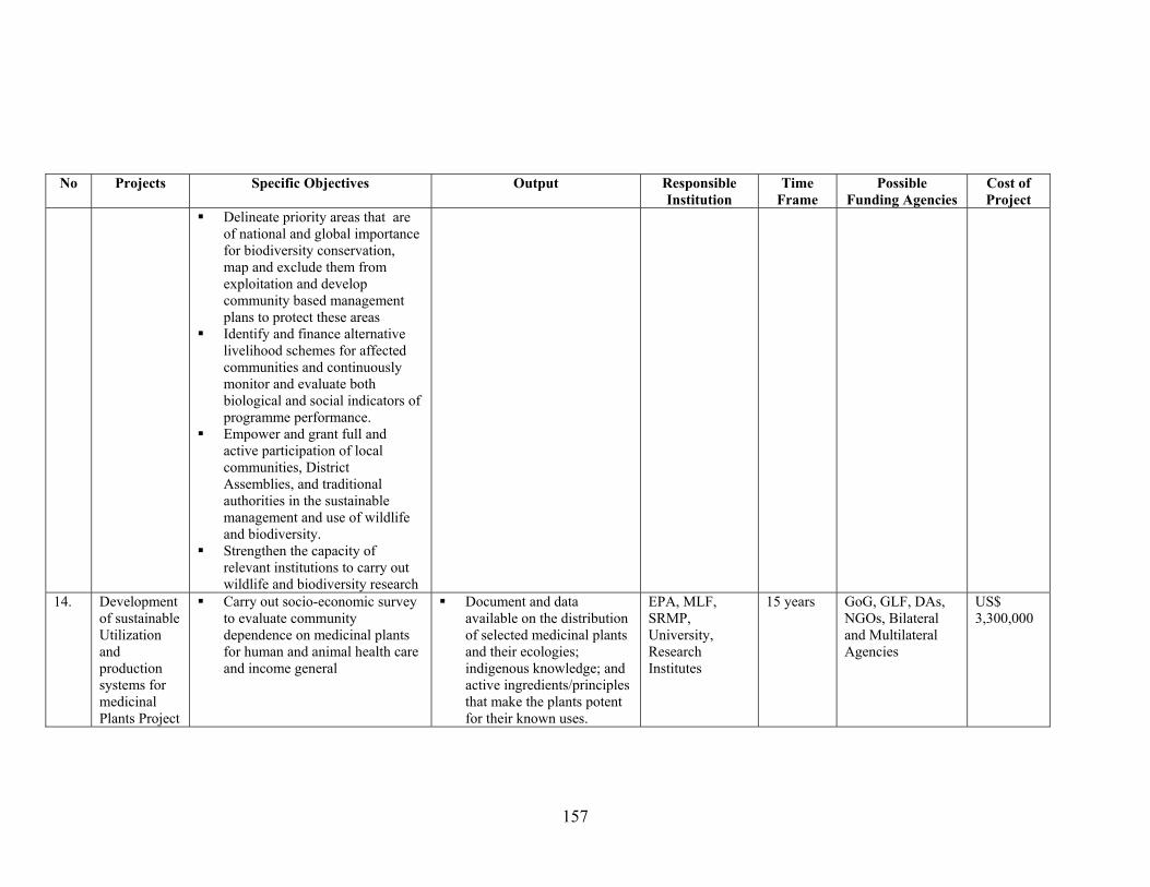
157
No Projects Specific Objectives Output Responsible Institution
Time Frame
Possible Funding Agencies
Cost of Project
Delineate priority areas that are of national and global importance for biodiversity conservation, map and exclude them from exploitation and develop community based management plans to protect these areas
Identify and finance alternative livelihood schemes for affected communities and continuously monitor and evaluate both biological and social indicators of programme performance.
Empower and grant full and active participation of local communities, District Assemblies, and traditional authorities in the sustainable management and use of wildlife and biodiversity.
Strengthen the capacity of relevant institutions to carry out wildlife and biodiversity research
14. Development of sustainable Utilization and production systems for medicinal Plants Project
Carry out socio-economic survey to evaluate community dependence on medicinal plants for human and animal health care and income general
Document and data available on the distribution of selected medicinal plants and their ecologies; indigenous knowledge; and active ingredients/principles that make the plants potent for their known uses.
EPA, MLF, SRMP, University, Research Institutes
15 years GoG, GLF, DAs, NGOs, Bilateral and Multilateral Agencies
US$ 3,300,000
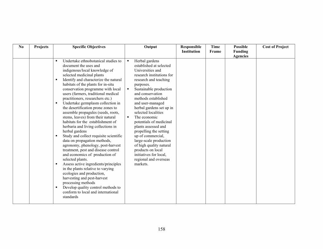
158
No Projects Specific Objectives Output Responsible Institution
Time Frame
Possible Funding Agencies
Cost of Project
Undertake ethnobotanical studies to document the uses and indigenous/local knowledge of selected medicinal plants
Identify and characterize the natural habitats of the plants for in-situ conservation programme with local users (farmers, traditional medical practitioners, researchers etc.)
Undertake germplasm collection in the desertification prone zones to assemble propagules (seeds, roots, stems, leaves) from their natural habitats for the establishment of herbaria and living collections in herbal gardens
Study and collect requisite scientific data on propagation methods, agronomy, phenology, post-harvest treatment, pest and disease control and economics of production of selected plants.
Assess active ingredients/principles in the plants relative to varying ecologies and production, harvesting and pest-harvest processing methods
Develop quality control methods to conform to local and international standards
Herbal gardens established at selected Universities and research institutions for research and teaching purposes.
Sustainable production and conservation methods established and user-managed herbal gardens set up in selected localities
The economic potentials of medicinal plants assessed and propelling the setting up of commercial, large-scale production of high quality natural products on local initiatives for local, regional and overseas markets.
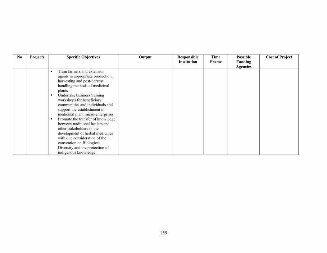
159
No Projects Specific Objectives Output Responsible Institution
Time Frame
Possible Funding Agencies
Cost of Project
Train farmers and extension agents in appropriate production, harvesting and post-harvest handling methods of medicinal plants
Undertake business training workshops for beneficiary communities and individuals and support the establishment of medicinal plant micro-enterprises
Promote the transfer of knowledge between traditional healers and other stakeholders in the development of herbal medicines with due consideration of the convention on Biological Diversity and the protection of indigenous knowledge
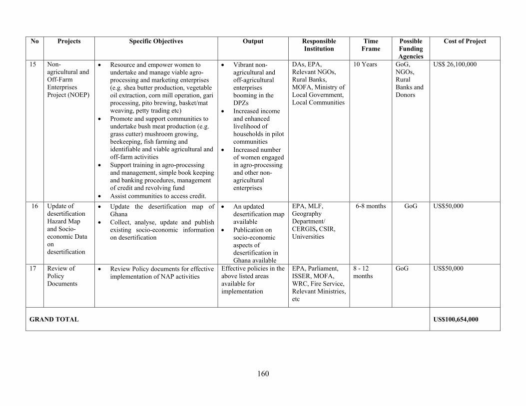
160
No Projects Specific Objectives Output Responsible Institution
Time Frame
Possible Funding Agencies
Cost of Project
15 Non-agricultural and Off-Farm Enterprises Project (NOEP)
• Resource and empower women to undertake and manage viable agro-processing and marketing enterprises (e.g. shea butter production, vegetable oil extraction, corn mill operation, gari processing, pito brewing, basket/mat weaving, petty trading etc)
• Promote and support communities to undertake bush meat production (e.g. grass cutter) mushroom growing, beekeeping, fish farming and identifiable and viable agricultural and off-farm activities
• Support training in agro-processing and management, simple book keeping and banking procedures, management of credit and revolving fund
• Assist communities to access credit.
• Vibrant non-agricultural and off-agricultural enterprises booming in the DPZs
• Increased income and enhanced livelihood of households in pilot communities
• Increased number of women engaged in agro-processing and other non-agricultural enterprises
DAs, EPA, Relevant NGOs, Rural Banks, MOFA, Ministry of Local Government, Local Communities
10 Years GoG, NGOs, Rural Banks and Donors
US$ 26,100,000
16 Update of desertification Hazard Map and Socio-economic Data on desertification
• Update the desertification map of Ghana
• Collect, analyse, update and publish existing socio-economic information on desertification
• An updated desertification map available
• Publication on socio-economic aspects of desertification in Ghana available
EPA, MLF, Geography Department/ CERGIS, CSIR, Universities
6-8 months GoG US$50,000
17 Review of Policy Documents
• Review Policy documents for effective implementation of NAP activities
Effective policies in the above listed areas available for implementation
EPA, Parliament, ISSER, MOFA, WRC, Fire Service, Relevant Ministries, etc
8 - 12 months
GoG US$50,000
GRAND TOTAL
US$100,654,000