national housing authority geographic information system...
TRANSCRIPT

NATIONAL HOUSING AUTHORITY
GEOGRAPHIC INFORMATION SYSTEM
(NHA-GIS)
NHA-GIS Web Map Application User’s Manual
Version 1.0
Submitted to:
National Housing Authority Quezon Memorial, Elliptical Road
Diliman, 1101 Quezon City Metro Manila, Philippines
Prepared By:
18 Mother Ignacia Avenue Paligsahan, 1103 Quezon City
Metro Manila, Philippines Tel. Nos. (632) 332-1209, -1220, -1330
Fax No. (632) 332-1266
19/F Strata 100 Building, F. Ortigas Jr. Road, Ortigas Center, 1605 Pasig City
Metro Manila, Philippines Tel. Nos. (632) 637-4449 Fax No. (632) 633-6873

NHA-GIS User’s Manual National Housing Authority Table of Contents
(Joint Venture) Superserve Corporation - Geodata Systems Technologies, Inc. Version 1.0 Page 2 of 14
TABLE OF CONTENTS
1 INTRODUCTION ................................................................................................................ 3
2 GETTING STARTED .......................................................................................................... 4
2.1 LAUNCH THE NHA-GIS WEB MAP .................................................................................. 4 2.2 CHANGE THE BASEMAP LAYER ........................................................................................ 4 2.3 NAVIGATE TO PREDEFINED MAP EXTENTS ........................................................................ 5 2.4 INTERACTIVELY NAVIGATE THE MAP ................................................................................. 5 2.5 DISPLAY THE LOT POLYGON AND PROJECT LOCATION LAYERS ............................................ 6
3 QUERYING AND SEARCHING ON THE MAP ................................................................... 8
3.1 MAKE AREA AND DISTANCE MEASUREMENTS .................................................................... 8 3.2 DETERMINE COORDINATE LOCATIONS .............................................................................. 9 3.3 DISPLAY PROJECT OR LOT INFORMATION ....................................................................... 10 3.4 FIND A PROJECT LOCATION .......................................................................................... 10 3.5 FIND LOTS .................................................................................................................. 11 3.6 QUERY LOTS .............................................................................................................. 12
4 GENERATING A REPORT ............................................................................................... 14
4.1 PRINT QUERY RESULTS INTO A PDF DOCUMENT ............................................................. 14

NHA-GIS User’s Manual National Housing Authority Introduction
(Joint Venture) Superserve Corporation - Geodata Systems Technologies, Inc. Sec 1 Version 1.0 Page 3 of 14
1 Introduction
This is the User’s Manual for the National Housing Authority-Geographic Information System (NHA-GIS) Web Map application. The NHA-GIS Web Map application is a browser-based GIS app that allows authorized users of NHA to navigate and access information on project locations and lot properties on a GIS map-based interface. Although the application can be accessed using any web browser, the application works best when using any of the following:
Internet Explorer 10 or higher
Microsoft Edge
Google Chrome
Mozilla Firefox
Safari 3 or later It is important that users have reliable network and Internet connection to be able to use the application. Furthermore, users of the app will be required to input a username and password in order to successfully get into the application and access its various functionalities. For any concerns or questions regarding the NHA-GIS Web Map application, you may contact the Corporate Systems and Operations Office (COSO) of NHA.

NHA-GIS User’s Manual National Housing Authority Getting Started
(Joint Venture) Superserve Corporation - Geodata Systems Technologies, Inc. Sec 2 Version 1.0 Page 4 of 14
2 Getting Started
2.1 Launch the NHA-GIS Web Map
Prior to launching the application, user must have access to reliable Internet connection and a valid login account to the application.
1. Open a web browser in your computer or mobile device.
2. Type in the application’s URL, which gis.nha.gov.ph/webmap.
3. Type in a valid username and password*.
*You may contact the NHA Corporate Operations and System Office (COSO) to request for a username and password.
4. Click OK or press Enter on the keyboard.
The application launches, initially showing the map display centered at the Philippines and displaying the location of NHA’s housing projects.
2.2 Change the basemap layer
There are four readily available basemaps included in the application. Users can choose and change which basemap to use anytime while using the application.
1. Click the button found at the upper left corner of the application’s webpage.
2. Select Basemaps.
The Basemaps panel appears on the upper right corner of the application’s webpage.
NHA-GIS User’s Manual National Housing Authority Getting Started
(Joint Venture) Superserve Corporation - Geodata Systems Technologies, Inc. Sec 2 Version 1.0 Page 5 of 14
3. Click the dropdown list and select from any of the available basemaps that you prefer.
A progress wheel will appear as the map redraws with the newly selected basemap.
2.3 Navigate to predefined map extents
This application has predefined map extents called bookmarks which allow for a
faster and more dynamic map viewing and navigation. To go to a specific predefined extent:
1. Click the button found at the upper left corner of the application’s webpage.
2. Select Bookmarks.
The Bookmarks panel appears on the upper right corner of the
application’s webpage.
4. Click the dropdown list and select from any of the predefined bookmarks from the list.
A progress wheel will appear as the map redraws to the map extent of the selected bookmark.
2.4 Interactively navigate the map
Users can interactively navigate the map to view more details within the map display by using the map navigation buttons found at the upper left corner of the application’s webpage.

NHA-GIS User’s Manual National Housing Authority Getting Started
(Joint Venture) Superserve Corporation - Geodata Systems Technologies, Inc. Sec 2 Version 1.0 Page 6 of 14
a) Click the button to zoom in to the center of the map.
b) Click the button to zoom out from the center of the map.
c) To pan within the map display, click (tap for touch screen) and hold any point on the map display, then drag to any direction.
d) Click the button to go back to the map display’s default extent i.e. the area of the Philippines.
2.5 Display the lot polygon and project location layers
Aside from the basemap, there are two map layers specific to NHA that can be accessed in the application; project locations, and lot polygons. The display of these map layers can be toggled and controlled depending on user’s preference.
1. Click the button found at the upper left corner of the application’s webpage.
2. Select Tasks.
3. Click the Map Layers tab.
a) To turn on/off a map layer in the map display, click the checkbox to
tick/untick it.

NHA-GIS User’s Manual National Housing Authority Getting Started
(Joint Venture) Superserve Corporation - Geodata Systems Technologies, Inc. Sec 2 Version 1.0 Page 7 of 14
b) To adjust a map layer’s transparency of a layer (while it is turned on), click (tap for touch screen) and hold the horizontal scroll bar below the map layer’s name and scroll to the left or right.

NHA-GIS User’s Manual National Housing Authority Querying and Searching on the Map
(Joint Venture) Superserve Corporation - Geodata Systems Technologies, Inc. Sec 3 Version 1.0 Page 8 of 14
3 Querying and Searching on the Map
3.1 Make area and distance measurements
Aside from map viewing and navigation, the user can also make ground area and distance measurements on the map.
1. Click the button found at the upper left corner of the application’s webpage.
2. Select Measurer.
The Measurer panel will appear on the upper right side of the application’s webpage.
3. To make area measurements, click the leftmost button having the icon .
a) Click the dropdown list and select a preferred unit of measure.
b) Draw a polygon on the map display by clicking once for every polygon corner to be drawn, then double-click to finish drawing.
4. To make distance measurements on the map, click the button and select Measurer. Just the same with the first step, the Measurer panel
opens. In the Measurer panel, click the middle button having the icon .
a) Click the dropdown list and select a preferred unit of measure.
NHA-GIS User’s Manual National Housing Authority Querying and Searching on the Map
(Joint Venture) Superserve Corporation - Geodata Systems Technologies, Inc. Sec 3 Version 1.0 Page 9 of 14
b) Draw a line on the map display by clicking once for every line corner, then double-click to finish drawing.
When measuring distance, a icon is produced once you click on the map.
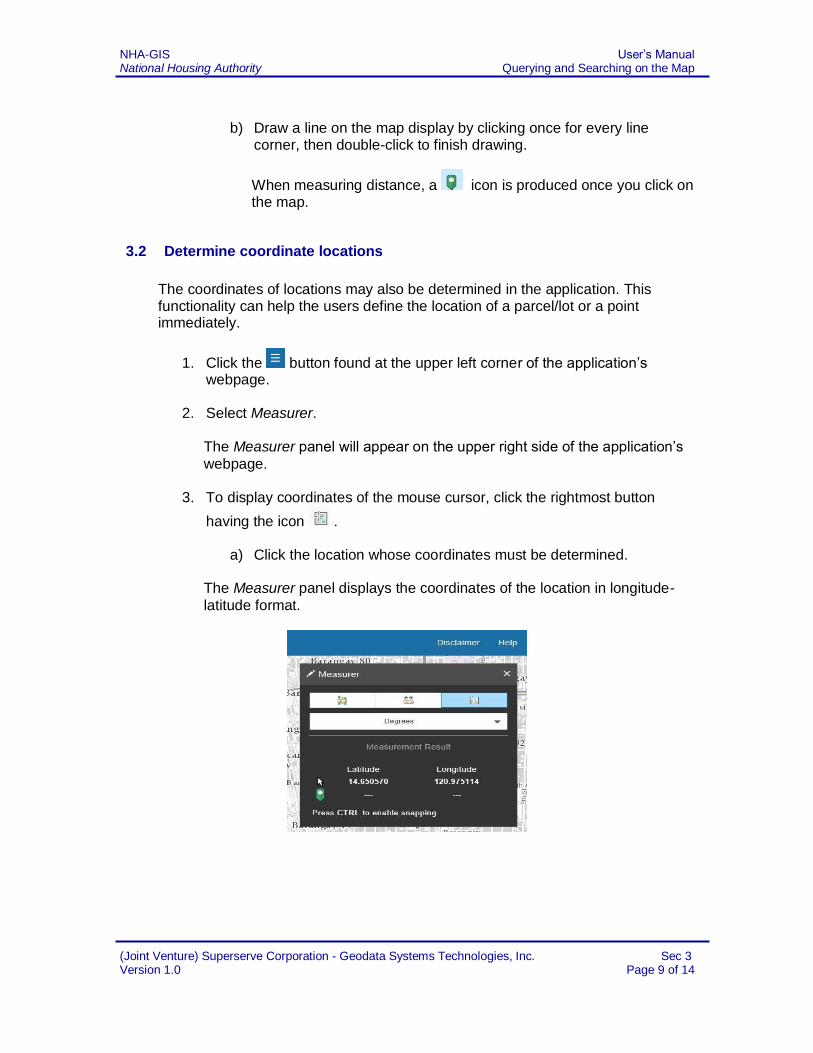
3.2 Determine coordinate locations
The coordinates of locations may also be determined in the application. This functionality can help the users define the location of a parcel/lot or a point immediately.
1. Click the button found at the upper left corner of the application’s webpage.
2. Select Measurer. The Measurer panel will appear on the upper right side of the application’s
webpage. 3. To display coordinates of the mouse cursor, click the rightmost button
having the icon .
a) Click the location whose coordinates must be determined.
The Measurer panel displays the coordinates of the location in longitude-
latitude format.

NHA-GIS User’s Manual National Housing Authority Querying and Searching on the Map
(Joint Venture) Superserve Corporation - Geodata Systems Technologies, Inc. Sec 3 Version 1.0 Page 10 of 14
3.3 Display project or lot information
Essential information about a project location or lot polygon of interest can be accessed readily from the map. To know the information about a specific project location or lot polygon:
1. Place your cursor over a project location or a lot polygon.
2. Click the selected project location or lot polygon to show its attributes in a pop-up window.
3.4 Find a project location
Aside from displaying information about a project location on the map, the application also allows for finding a project’s location based on its name.
1. Click the button found at the upper left corner of the application’s webpage.
2. Select Tasks. The Tasks panel will appear on the upper right side of the application’s
webpage.
3. Click the Find a Project tab.
4. Type in the name of a project in the text box.
The text box is designed to be predictive, such that suggested values
dynamically show up every time a character is typed in.
5. Click to select any of the values suggested, then click the icon or press Enter on the keyboard to start searching.

NHA-GIS User’s Manual National Housing Authority Querying and Searching on the Map
(Joint Venture) Superserve Corporation - Geodata Systems Technologies, Inc. Sec 3 Version 1.0 Page 11 of 14
The map display zooms in to the location and highlights the lot polygon related to the encoded value. A pop-up window also displays, showing the common code and phase-block-lot number of the selected lot polygon.
3.5 Find lots
Aside from finding project locations, the application also allows finding lot polygons based on known identifiers: common code, beneficiary ID, or phase-block-lot number.
1. Click the button found at the upper left corner of the application’s webpage.
2. Select Tasks.
The Tasks panel will appear on the upper right side of the application’s
webpage.
3. Click the Find a Lot tab.
4. Click a radio box button depending on what information to provide for the lot to be searched i.e. beneficiary ID, common code, or project-phase-lot-block number.
6. Type in the value in the text box (if searching based on beneficiary ID or
common code); or choose values from the dropdown list (if searching based on project-phase-lot-block number).
Similar to the Find a Project tab, the text boxes in the Find a Lot tab are also designed to be predictive, such that suggested values dynamically
show up every time a digit is typed in.
7. Click to select any of the values suggested, then click the icon or press Enter on the keyboard to start searching.
The map display zooms in to the location and highlights the lot polygon related to the encoded value. A pop-up window also displays, showing the common code and phase-block-lot number of the selected lot polygon.

NHA-GIS User’s Manual National Housing Authority Querying and Searching on the Map
(Joint Venture) Superserve Corporation - Geodata Systems Technologies, Inc. Sec 3 Version 1.0 Page 12 of 14
If the value that the user has entered is not yet assigned to a lot polygon in the NHA-GIS database, the application prompts “No result(s) found”.
3.6 Query lots
Finding lot polygons that satisfies a particular query is also possible in the application.
1. Click the button found at the upper left corner of the application’s webpage.
2. Select Tasks.
The Tasks panel will appear on the upper right side of the application’s
webpage.
3. Click the Query Lots tab.
4. Click the first dropdown list labelled Find lots whose and select from any of
the following attributes in the list, depending on the query to be run: o Landuse o Property Classification o Development Status o Disposition Status o Transaction Status
5. Click the second dropdown list labelled is and select a value, depending on
the query to be run.
6. Click the third dropdown list labelled in this housing project and select a
housing project to be queried.
7. Click OK to run the query.
NHA-GIS User’s Manual National Housing Authority Querying and Searching on the Map
(Joint Venture) Superserve Corporation - Geodata Systems Technologies, Inc. Sec 3 Version 1.0 Page 13 of 14
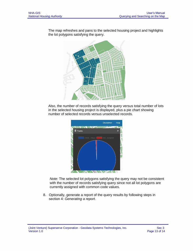
The map refreshes and pans to the selected housing project and highlights the lot polygons satisfying the query.
Also, the number of records satisfying the query versus total number of lots in the selected housing project is displayed, plus a pie chart showing number of selected records versus unselected records.
Note: The selected lot polygons satisfying the query may not be consistent
with the number of records satisfying query since not all lot polygons are currently assigned with common code values.
8. Optionally, generate a report of the query results by following steps in
section 4: Generating a report.

NHA-GIS User’s Manual National Housing Authority Generating a Report
(Joint Venture) Superserve Corporation - Geodata Systems Technologies, Inc. Sec. 4 Version 1.0 Page 14 of 14
4 Generating a report
4.1 Print query results into a PDF document
When a query is successfully run, users can optionally generate a report in PDF format containing the query results.
0. Make sure that a query has been successfully run by following steps described in subsection 3.6. Querying lots based on landuse, property classification, or status of development, disposition, and transaction.
1. Scroll down the Tasks panel and click the Generate button found right
below the pie chart.
Another window appears where the user can optionally choose to include the map of selected lots as part of the report.
2. Click Generate Map button and wait for the map to be captured.
3. Once the map displays in the window, click the Export button.
4. Click Open, Save, or Download (options vary depending on browser) and
wait for PDF document to be produced.