natura 2000 management plan (sac) tar-ramla tat-torri u tal... · l-inħawi tar-ramla tat-torri u...
TRANSCRIPT
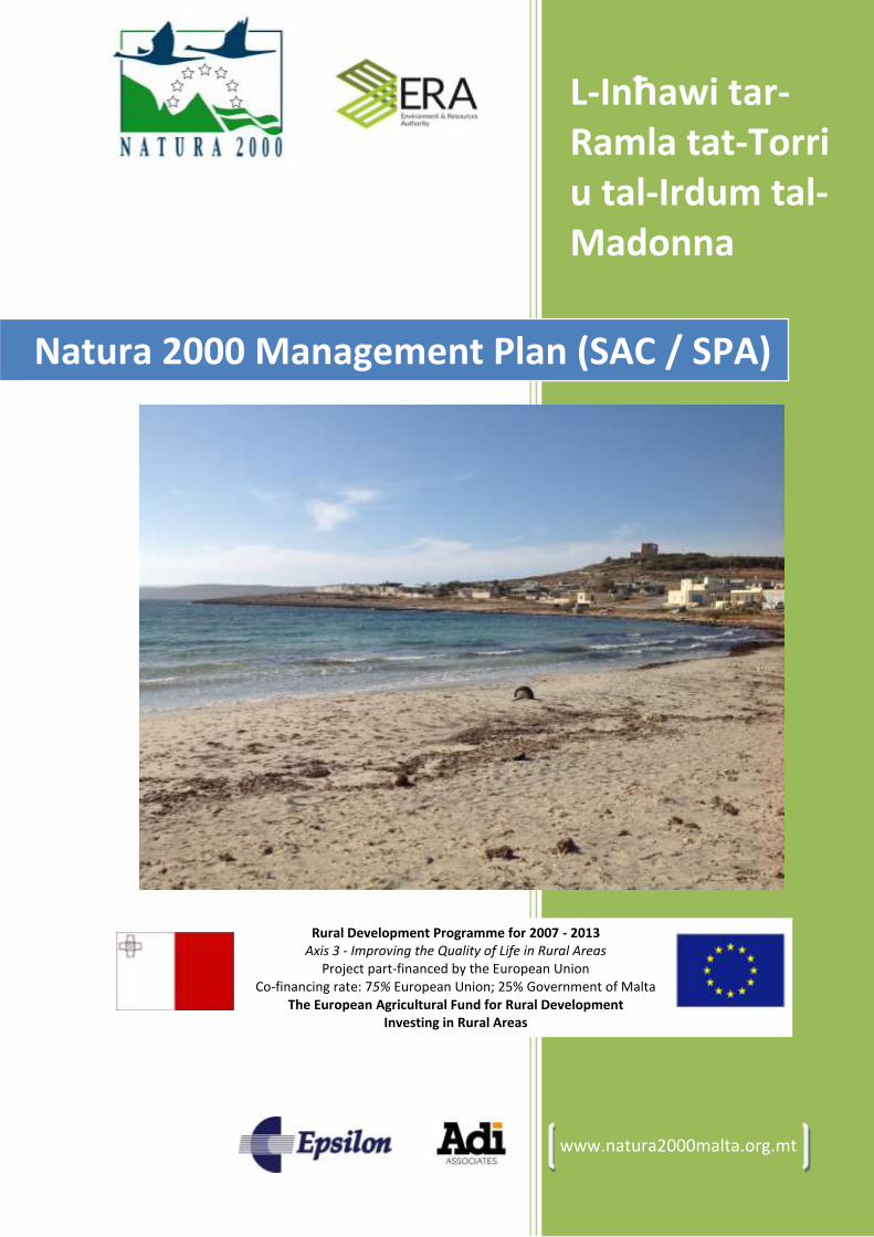
L-Inħawi tar-Ramla tat-Torri u tal-Irdum tal-Madonna
www.natura2000malta.org.mt
Natura 2000 Management Plan (SAC / SPA)
Rural Development Programme for 2007 - 2013 Axis 3 - Improving the Quality of Life in Rural Areas
Project part-financed by the European Union Co-financing rate: 75% European Union; 25% Government of Malta
The European Agricultural Fund for Rural Development Investing in Rural Areas

Natura 2000 Management Plan
page 2 Epsilon-Adi
Project description The Project "Management Planning and Implementation of Communication measures for Terrestrial Natura 2000 Sites in the Maltese Islands" was funded by the EAFRD and pioneered by MEPA. It aims to establish management plans or legal provisions for the management of all terrestrial Natura 2000 sites in the Maltese Islands, and to increase awareness of the Natura 2000 network amongst the general public and stakeholders. The Project started in October 2012 and ended in March 2014. It is considered a milestone in the protection of Malta’s rural environment and undertakes necessary actions required in management planning for the 34 terrestrial Natura 2000 sites: 27 terrestrial Special Areas of Conservation (SAC) and 7 Special Protection Areas (SPAs). The Project involved gathering information, carrying out surveys, defining Conservation Objectives and identifying management measures with intensive stakeholder involvement. These management plans are not intended to restrain recreational or other economic activities within the sites, but rather to support sustainability of Malta’s natural resources with the involvement of stakeholders. A Vision has been formulated for the ideal condition of each Natura 2000 site, to be achieved after a period of management. The Project delivered awareness campaigns on Natura 2000 sites amongst public and specific target groups such as farmers and land managers. It set the ground and has equipped key stakeholders with knowledge and skills necessary to effectively participate in the management planning process. In that respect, the Project will help Malta fulfil its EU and international commitments by informing, educating, encouraging ownership, and building momentum for the implementation of the EU Natura 2000 network of protected areas whist improving quality of life in rural communities.
Produced by Epsilon International SA - Adi Associates Environmental Consultants Ltd Consortium, Malta www.epsilon.gr // www.adi-associates.com // www.natura2000malta.org.mt
Management team Epsilon International SA Adi Associates Environmental Consultants Ltd Despina Kallidromitou Adrian Mallia Marc Bonazountas Rachel Xuereb
Key experts Despina Kallidromitou, Thomas Arapis, Eman Calleja, Perit Philip B. Grech, Marlene Borg, Michael Parlato Trigona, Adrian Mallia
Team experts Niki Kardakari, Krista Farrugia, Rachel Xuereb, Andrea Pace, Eilis McCullough, Edwin Lanfranco, John Borg, Athanasia Kassela , Dimitris Skarlatos, Fay Nakou, Elli Chourdaki
Contract Νο. CT3101/2011, Malta Environmental Planning Authority (MEPA) St. Francis Ravelin, Floriana, Malta, www.mepa.org.mt Project leader: Mr Darrin T. Stevens
Disclaimer This is a public document provided by the ERA, and as such information contained in this document can be used by any interested party by referencing this publication. Produced maps: © Mapping Unit, MEPA. Maltese Islands maps with site location: © 2012 Nokia © 2013 Microsoft Corporation
For Information Environment and Resources Authority +3562292 3500 [email protected] Site Designation & Management Team (ERA) +35622923665 [email protected] Adi Associates Environmental Consultants Ltd +35621378172 [email protected] Epsilon International S.A. +302106898610 [email protected]

L-Inħawi tar-Ramla tat-Torri u tal-Irdum tal-Madonna
Epsilon-Adi page 3
VISION STATEMENT FOR L-INĦAWI TAR-RAMLA TAT-TORRI U TAL-IRDUM TAL-MADONNA (SAC / SPA)
The vision for L-Inħawi tar-Ramla tat-Torri u tal-Irdum tal-Madonna presents the desired result once this protected area has been managed for some time. The vision for the site is:
The Ramla tat‐Torri/Rdum tal‐Madonna area is an integral part of the Marfa Ridge Peninsula, an area protected and managed effectively, sustainably and in harmony for the benefit of wildlife, the environment and people.
All natural habitats, native flora and wildlife present at the SAC are sustained
Those using and visiting the area gain inspiration and an awareness of the uniqueness and importance of the site and the Maltese natural heritage
The site is receiving full legal protection implemented according to national
legislation and local policies.

Natura 2000 Management Plan
page 4 Epsilon-Adi
EXECUTIVE SUMMARY
Introduction The management plan area of L-Inħawi tar-Ramla tat-Torri u tal-Irdum tal-Madonna is found within the Mellieħa locality boundary in the northern-most part of Malta and essentially consists of the eastern edge of the l-Ahrax tal-Mellieħa peninsula. The area is close to L-Inħawi tal-Għadira SAC and SPA. Its location is such that the site overlooks Mellieħa Bay to the south, and il-Bajja tar-Ramla tat-Torri/ Comino Channel to the North. The SAC incorporates a variety of landscapes, each of which is under considerable anthropogenic influence, consisting of a rocky promontory, two bays and boulder screes. Three sets of sand dune communities, at ir-Ramla tat-Torri, Daħlet ix-Xilep and Daħlet ix-Xmajjar are also included within this SAC. The site also borders a Marine Protected Area (Il-Baħar fil-Grigal ta’ Malta).
The Site’s Biodiversity and the Factors Affecting It
The habitats of importance in this SAC (listed in the Habitats Directive under Annex I) include:
Annual vegetation of drift lines, found at the foredune or embryo dunes and close to the sea with input of organic matter such as the Posidonia sea grass (Habitat 12101);
Vegetated sea cliffs of the Mediterranean coasts with endemic Sea Lavender species (Habitat 1240);
Embryonic shifting sand dunes, the youngest dunes in the dune system (Habitat 2110); Fixed beach dunes (Habitat 2210); Dunes supporting the dune species Euphorbia terracina (Coast Spurge) (Habitat 2220); Spiny spurge garrigues dominated by Mediterranean shrubby species such as Wild
Thyme, Maltese Spurge and/or Wolfbane (Habitat 5330); Garrigue/phrygana dominated by the Shrubby Kidney Vetch and Wild Thyme (Habitat
5410); and Cliff-like/maritime communities characterised by a number of Maltese endemic
species (Habitat 8210).
Field surveys, desk studies and expert knowledge were applied to evaluate the conservation status all Annex I habitats. In addition to the above Annex I habitats, the site includes a manmade woodland that, if well managed, could sustain (or better sustain) a number of migratory bird species. The site hosts a variety of species of conservation significance including plants, invertebrates, reptiles, mammals and birds. Notwithstanding, parts of the site represent some of the most disturbed natural ecosystems in the Maltese Islands. The conservation status for species listed in Annex II of the Habitats Directive was evaluated based on reference to desk studies and expert knowledge.
1 The Habitats Directive assigns codes to the habitat types of conservation interest, these should be
referred to for the full technical habitat description.
L-Inħawi tar-Ramla tat-Torri u tal-Irdum tal-Madonna
Epsilon-Adi page 5
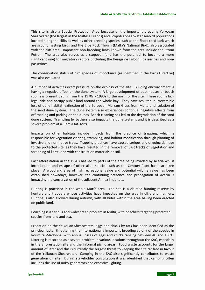
This site is also a Special Protection Area because of the important breeding Yelkouan Shearwater (the largest in the Maltese Islands) and Scopoli’s Shearwater seabird populations located along the cliffs as well as other breeding species such as the Short-toed Lark which are ground nesting birds and the Blue Rock Thrush (Malta’s National Bird), also associated with the cliff area. Important non-breeding birds known from the area include the Strom Petrel. The area also serves as a stopover (and has the potential to become a more significant one) for migratory raptors (including the Peregrine Falcon), passerines and non-passerines. The conservation status of bird species of importance (as identified in the Birds Directive) was also evaluated. A number of activities exert pressure on the ecology of the site. Building encroachment is having a negative effect on the dune system. A large development of boat houses or beach rooms is present dating from the 1970s - 1990s to the north of the site. These rooms lack legal title and occupy public land around the whole bay. They have resulted in irreversible loss of dune habitat, extinction of the European Marram Grass from Malta and isolation of the sand dune system. The dune system also experiences continual negative effects from off roading and parking on the dunes. Beach cleaning has led to the degradation of the sand dune system. Trampling by bathers also impacts the dune systems and it is described as a severe problem at ir-Ramla tat-Torri. Impacts on other habitats include impacts from the practice of trapping, which is responsible for vegetation clearing, trampling, and habitat modification through planting of invasive and non-native trees. Trapping practices have caused serious and ongoing damage to the protected site, as they have resulted in the removal of vast tracks of vegetation and screeding of karst‐land with construction materials or soil. Past afforestation in the 1970s has led to parts of the area being invaded by Acacia whilst introduction and escape of other alien species such as the Century Plant has also taken place. A woodland area of high recreational value and potential wildlife value has been established nowadays, however, the continuing presence and propagation of Acacia is impacting the conservation of the adjacent Annex I habitats. Hunting is practiced in the whole Marfa area. The site is a claimed hunting reserve by hunters and trappers whose activities have impacted on the area in different manners. Hunting is also allowed during autumn, with all hides within the area having been erected on public land. Poaching is a serious and widespread problem in Malta, with poachers targeting protected species from land and sea. Predation on the Yelkouan Shearwaters’ eggs and chicks by rats has been identified as the principal factor threatening the internationally important breeding colony of the species in Rdum tal-Madonna, with annual losses of eggs and chicks ranging between 40 and 100%. Littering is recorded as a severe problem in various locations throughout the SAC, especially in the afforestation site and the informal picnic areas. Food waste accounts for the larger amount of litter and this is currently the biggest threat to keeping the site rat free in favour of the Yelkouan Shearwater. Camping in the SAC also significantly contributes to waste generation on site. During stakeholder consultation it was identified that camping often includes the use of noisy generators and excessive lighting.

Natura 2000 Management Plan
page 6 Epsilon-Adi
Light pollution, mainly from the settlements to the south of the site, also has a significant impact on the breeding seabird colonies and on the general ecological quality of the site. Of less significance, seabird by-catch is another threat to the seabirds, more so to Scopoli’s Shearwater than to Yelkouan’s Shearwater. Access to climbing and abseiling sites are another source of disturbance to the Yelkouan Shearwater breeding colony.
Management Plan Objectives & Actions Following the evaluation of the features of conservation importance on the site, as well as the factors, a vision was established for the site. This vision was developed together with local stakeholders. Management Objectives were then identified that seek to help achieve the vision. One of the most important objectives is to ensure that each of the habitats and species of importance are conserved and improved as necessary. To this end, the Management Plan seeks to manage the identified factors to reduce negative impacts and eventually improve the overall conservation status of each Annex I habitat type and Annex II species as well as species listed in the Red Data Book. The Management Plan specifies the need for a Site Manager and to implement the Visitor Management Strategy proposed in the EU LIFE Project. Another important Management Objective, particularly in light of the number and source of factors negatively affecting the site is to raise public awareness of the site’s conservation importance and requirements coupled with an additional Management Objective to ensure that no illegal activities take place within the site and to monitor the impacts of allowable activities for any future controls that may be required. The full list of Management Objectives can be viewed in Chapter 3. In order to achieve the Management Objectives, the Management Plan sets out a number of Operational Objectives and subsequent Actions, these are summarised in Chapter 4 of the Management Plan and are discussed briefly hereunder. In order to achieve a number of Management Objectives related to habitat and species conservation, opportunities for the expansion and improvement of habitats coupled with the development and implementation of a monitoring programme are the subject of various Operational Objectives, and this involves directly targeting the factors affecting them. These objectives include dune restoration and protection of the dunes through restricting trampling and vehicular access. Access to the maritime communities is also specified as well as allowing the expansion of garrigue habitats into adjacent derelict land. Alien species will also be eradicated from these habitats and replaced with typical species. Moreover, Species Actions Plans will be drawn up for Red Data Book Species. The Management Plan provides direction to facilitate the natural establishment of a breeding pair of the Peregrine Falcon and also to provide suitable roosting habitat for migratory raptors and passerines in the woodland and derelict areas.

L-Inħawi tar-Ramla tat-Torri u tal-Irdum tal-Madonna
Epsilon-Adi page 7
Finally, it is considered important to set up a Site Management Scheme that will implement the After Life Continuation Plan and fully manage the entire site. The actions developed to fulfil the objectives are summarised below:
Monitoring plans to study habitats and species of importance (listed in the Habitats
Directive and the Birds Directive); Assess and evaluate alternative options to restore dune habitats at Ramla tat-Torri; Access control measures to maritime and garrigue communities; Development and implementation of an Invasive Alien Species control / eradication
programme; Active measures in favour of birds: Preparatory actions for the establishment of one
breeding pair of Falco peregrinus within the site- creation of roosting locations for migratory raptors and passerines within the woodland and the derelict land;
Implementation of the After Life Contiuation programme that include measures for rat eradication, the maintainance of the site - clean and free of litter so as not to attract rats,monitoring of the Yelkouan Shearwaters, enforcement of Notice to Mariners 2 of 2010 to ensure that disturbance to Yelkouan Shearwaters from boats is reduced opposite the cliffs of Rdum tal-Madonna during the breeding season, improvement in fisheries to avoid catch of non target species such as Yelkouan Shearwaters and regular patrolling of the site to prevent poaching;
Preparation and implementation of Action Plans for selected Red Data Book species; and
Establish a Site Manager.
Stakeholder Consultation
An important component of the Management Plan is stakeholder engagement. Stakeholders working together will be a crucial element in ascertaining long term successful management of the SAC/SPA. A public event was also held in the locality of Mellieha were an exhibition was organised covering all the Natura2000 sites in Mellieha. During this event the general public commented that amongst the threats identified was that of the rat infestation problem. It was suggested that an alternative to the use of poison during rat eradication should be considered. Hunting and trapping was another issue raised. There was disagreement on the presence of hunting in the area. Whilst certain stakeholders were in favour of limiting the hunting time, others wanted no time limits. Others complained that the Local Council does not notify people to stop camping during the hunting season. It was suggested that FKNK could manage the site and that hunters should be educated in order to plant native trees, remove alien species and help the management of any afforestation programme. Education should also be provided to farmers in order to make better use of water resources. The other issue raised was related to camping particularly to the problem of littering, signage and enforcement in order to ensure environmental protection. Off-roading is another activity that is resulting in adverse conditions on site. Reference was made to the White Tower and possible restoration and conversion into a nature museum. Other cultural features that can be preserved are the rubble walls and the Knights’ entrenchments. The removal of illegally built structures was also called for. During a stakeholder workshop, the main issue raised was the management of the Local

Natura 2000 Management Plan
page 8 Epsilon-Adi
Council camping site. This site generates a large amount of litter. Damage to the trees happens regularly and disturbance to the surrounding area occurs mainly through loud noise and light at night time. Fires and off-roading are related to this activity and pose a hazard to the integrity of the site. The Local Council site also poses unfair competition with the organised campsite nearby. It was questioned whether the Local Council campsite is compatible with the International Bird Area (IBA) and SPA status of the site. It was proposed that the Acacia trees present in the area should be replaced with native ones, traffic calming measures should be introduced and walking trails set up. .
Conclusion
This Management Plan is the first of its kind for the site with a timeframe of 5 years. During implementation, progress must be reported back to the Competent Authority at least on an annual basis. The Plan is a dynamic one whereby changes will be made as and if required based on the progress report findings and in discussion with the site manager, stakeholders, and the Competent Authority.

L-Inħawi tar-Ramla tat-Torri u tal-Irdum tal-Madonna
Epsilon-Adi page 9
VISION STATEMENT FOR L-INĦAWI TAR-RAMLA TAT-TORRI U TAL-IRDUM TAL-MADONNA (SAC / SPA) 3
EXECUTIVE SUMMARY 4
1 INTRODUCTION 16
2 SITE DESCRIPTION 18
2.1 Location and Boundaries 18 2.2 Legal Status and Rights 18
2.2.1 Ownership 18 2.2.2 Legal Rights 18 2.2.3 Site Status 22 2.2.4 Applicable Planning Policies 31 2.2.5 Other Plans 39
2.3 Management Infrastructure 41 2.3.1 Facilities and Services 42 2.3.2 Health and Safety 47
2.4 Climate 50 2.5 Geology 52
2.5.1 Lithology 52 2.5.2 Structural Geology 53
2.6 Geomorphology 53 2.7 Soils and Substrates 57 2.8 Hydrology 58 2.9 Ecosystems/Habitats, Vegetation and Ecological Processes 60
2.9.1 Description of SAC 60 2.9.2 Site Management 60 2.9.3 Methods 60 2.9.4 Assessment of Conservation Status 61 2.9.5 Vegetation Assemblages 61 2.9.6 Conservation Status 61
2.10 Species 78 2.10.1 Annex II Plant Species 78 2.10.2 Other Plant Species 81 2.10.3 Fauna 83 2.10.4 Assessment of Conservation Status for Species 94 2.10.5 Agricultural Land 103 2.10.6 On-Site Observations 103
2.11 Anthropogenic Activities Within the Site 105 2.11.1 Nature Conservation 105 2.11.2 Agriculture 105 2.11.3 Afforestation 105 2.11.4 Tourism and Recreation 105 2.11.5 Hunting and Fishing 107 2.11.6 Extraction 107 2.11.7 Water Use 107 2.11.8 Education, Demonstrations and Research 108 2.11.9 Other Uses 108 2.11.10 Past Human Land Uses 108
2.12 Anthropogenic Activities Outside The site 108 2.12.1 Nature Conservation 108

Natura 2000 Management Plan
page 10 Epsilon-Adi
2.12.2 Agriculture 108 2.12.3 Afforestation 109 2.12.4 Tourism and Recreation 109 2.12.5 Hunting and Fishing 109 2.12.6 Extraction 109 2.12.7 Water Use 109 2.12.8 Education, Demonstrations and Research 109 2.12.9 Other Uses 109 2.12.10 Past Human Land Uses 109
2.13 Economic Aspects and Population 110 2.14 Stakeholder Consultation 110
2.14.1 Organizations / Authorities and their Responsibilities 110 2.14.2 Stakeholder Engagement 115
2.15 Cultural Heritage 115 2.15.1 Archaeological Artefacts 115 2.15.2 National Historical Monuments 116 2.15.3 Cultural Events 118
2.16 Landscape Features Evaluation 118 2.17 Visitor Access 120 2.18 Socio-Economic Evaluation 122
3 EVALUATION & CONSERVATION OBJECTIVES 123
3.1 Evaluation of Features 123 3.1.1 Annex I Habitats 123 3.1.2 Annex II Flora Species 124 3.1.3 Annex II Fauna Species 125 3.1.4 Annex I Bird Species 125 3.1.5 Annex IV and/or Red Data Book Species 127 3.1.6 The Manmade Woodland Habitat 129 3.1.7 Natural Landscape 129
3.2 Evaluation of Factors 129 3.2.1 Legislation, Policies & Plans 129 3.2.2 Previous Conservation Efforts and Current Management Status 132 3.2.3 Agriculture 133 3.2.4 Education, Research, Awareness Potential & Infrastructure 133 3.2.5 Tourism and Recreation 134 3.2.6 The EU LIFE Nature Project Visitor Management Strategy 136 3.2.7 Point Factors Impacting the Site 136 3.2.8 Non Point Factors Impacting the Site 137
3.3 Evaluation of Key Features and Definition of Conservation Objectives 143 3.4 SWOT Analysis 151 3.5 Vision Statement 152 3.6 Management and Operational Objectives for the Site 153
4 MANAGEMENT ACTIONS 158
4.1 Formulation of Management Actions 158 4.2 Description of Management Actions 163 A. Measures 163
4.2.1 Code and Title of Action: M1. Establishment of a Site Manager 163 B. Duties 164
4.2.2 Code and Title of Action: D1. Implementation of patrolling 164 C. Projects 164
4.2.3 Code and Title of Action: P1. Elaboration of detailed monitoring programmes for the Annex I habitats 5330 and 5410, the Annex II flora species Anacamptis urvilleana and Orobanche densiflora, the Annex II fauna species Brachytrupes megacephalus and Pseudoseriscius cameroni,

L-Inħawi tar-Ramla tat-Torri u tal-Irdum tal-Madonna
Epsilon-Adi page 11
Zamenis situla, the breeding bird species Puffinus yelkouan, Calonectris diomedea, Calandrella brachydactyla, Falco peregrinus, Monticola solitarius and Sylvia conspicillata and the migratory raptors and passerines 165 4.2.4 Code and Title of Action: P2. Elaboration of Action Plans for selected RDB species 166 4.2.5 Code / Title of Action: P3: Assess and evaluate alternative options to restore the dunes 167 4.2.6 Code and Title of Action: P4. Implementation of the monitoring plans for the Annex I habitats 5330 and 5410, the Annex II flora species Anacamptis urvilleana and Orobanche densiflora, the Annex II fauna species Brachytrupes megacephalus and Pseudoseriscius cameroni, Zamenis situla, the breeding bird species Puffinus yelkouan, Calonectris diomedea, Calandrella brachydactyla, Falco peregrinus, Monticola solitarius and Sylvia conspicillata and the migratory raptors and passerines - determination of favourable conservation status of habitats 5330 and 5410 and species Anacamptis urvilleana 167 4.2.7 Code and Title of Action: P5. Implementation of actions and recommendations prescribed by the Action Plans 167 4.2.8 Code and Title of Action: P6. Application of access control measures at habitats 1240, 5330 and 5410 168 4.2.9 Code and Title of Action: P7. Planning and implementation of an IAS control and/or eradication programme. 169 4.2.10 Code and Title of Action: P8. Active measures in favour of birds: Establishment of one breeding pair of Falco peregrinus within the site- Creation of roosting locations for migratory raptors and passerines within the woodland and the derelict land 169 4.2.11 Code and Title of Action: P9. Implementation of the After Life Continuation Plan –Implementation of the actions foreseen in development permit PA 02812/09-Recurring habitat conservation and public awareness actions 171 4.2.12 Code and Title of Action: P10. Elaboration of a study for the design and technical specifications for warning / information / interpretation signposting and promotion material 172 4.2.13 Code and Title of Action: P11. Construction and installation of warning / information / interpretation signposting and production of promotion material 173 4.2.14 Code and Title of Action: P12. Prescription of a patrolling schedule 173
5 WORK PLAN STRUCTURE 174
6 REPORTING AND REVIEW PLAN 181
6.1 Annual Reporting and Review 181 6.2 The Five Year Reporting and Review 184
BIBLIOGRAPHY 188
Tables Table 1: Official leases at Rdum tal-Madonna (EU LIFE Yelkouan Shearwater Project 2010) .... 18 Table 2: Statutory & planning designations ................................................................................ 22 Table 3: Marfa Action Plan policies; L-Inħawi tar-Ramla tat-Torri u tal-Irdum tal-Madonna Policy ........................................................................................................................................... 32 Table 4: Infrastructure present at Rdum tal-Madonna (EU LIFE Yelkouan Shearwater Project 2010) ........................................................................................................................................... 45 Table 5: Site and surveying visits ................................................................................................ 61 Table 6: Conservation Status ....................................................................................................... 62 Table 7: Conservation Status of Annex II species ........................................................................ 79 Table 8: Other plant species of conservation significance .......................................................... 81 Table 9: Brachytrupes megacephalus at Ramla tat-Torri/Rdum tal-Madonna SAC .................... 84 Table 10: Assessment of Zamenis situla ..................................................................................... 90 Table 11: Birds ............................................................................................................................. 91 Table 12: Conservation Status of Annex I species (Birds Directive) ............................................ 95 Table 13: Conservation Status of non-Annex I Article 4 breeding birds ..................................... 99

Natura 2000 Management Plan
page 12 Epsilon-Adi
Table 14: Conservation Status of non-Annex I Article 4 migratory birds .................................. 101 Table 15: On-site observations ................................................................................................. 103 Table 16: Summary of stakeholders and their responsibilities ................................................. 111 Table 17: Protected structures .................................................................................................. 116 Table 18: Overview of relevant acts and policies per topic addressed .................................... 129 Table 19: Site Attributes ............................................................................................................ 134 Table 20: Factors impacting the site ......................................................................................... 142 Table 21: KEY FEATURES: Annual vegetation of drift lines (1210), Embryonic shifting dunes (2110), Crucianellion maritimae fixed beach dunes (2210), Dunes with Euphorbia terracina (2220) ........................................................................................................................................ 143 Table 22: KEY FEATURE: Vegetated sea cliffs of the Mediterranean coasts with endemic Limonium spp. (1240) ................................................................................................................ 144 Table 23: KEY FEATURE: Thermo-Mediterranean and pre-desert scrub (5330) ....................... 144 Table 24: KEY FEATURE: West Mediterranean clifftop phryganas (5410) ............................... 145 Table 25: KEY FEATURE: Calcareous rocky slopes with chasmopytic vegetation (8210).......... 145 Table 26: KEY FEATURE: Anacamptis urvilleana....................................................................... 145 Table 27: KEY FEATURE: Orobanche densiflora ........................................................................ 146 Table 28: KEY FEATURE: Brachytrupes megacephalus .............................................................. 146 Table 29: KEY FEATURE: Pseudoseriscius cameroni .................................................................. 147 Table 30: KEY FEATURE: Zamenis situla .................................................................................... 147 Table 31: KEY FEATURE: Puffinus yelkouan ............................................................................... 147 Table 32: KEY FEATURE: Calonectris diomedea ......................................................................... 148 Table 33: KEY FEATURE: Calandrella brachydactyla ................................................................. 148 Table 34: KEY FEATURE: Falco peregrinus ................................................................................. 149 Table 35: KEY FEATURE: Migratory Annex I Raptors ................................................................. 149 Table 36: KEY FEATURE: Migratory Annex I Passerines ............................................................ 150 Table 37: KEY FEATURE: Monticola solitarius ........................................................................... 150 Table 38: KEY FEATURE: Sylvia conspicillata ............................................................................. 150 Table 39: SWOT Matrix ............................................................................................................. 151 Table 40: Prospect Matrix ......................................................................................................... 152 Table 41: Vision Statement ....................................................................................................... 152 Table 42: Management Objectives and Operational Objectives for Site .................................. 154 Table 43: Operational Objectives and related priority rating, performance indicators, actions, category of actions and monitoring requirement ..................................................................... 159 Table 44: Financial Plan ............................................................................................................. 175 Table 45: List of actions, timeframe, deliverables and year of delivery, action total budget estimate and entities involved in the delivery of the actions ................................................... 177 Table 46: Annual Reporting and Review summary ................................................................... 181 Table 47: Table template for recording new developments or trends affecting the site ......... 183 Table 48: Table template for recording management plans updates during the annual reviews ................................................................................................................................................... 183 Table 49: Five year reporting process questions ...................................................................... 184 Table 50: List of proposed (initial) Performance Indicators for the assessment of the Operational Objectives .............................................................................................................. 185 Table 51: Table template for proposed changes in Site Management Plan ............................. 187
Figures
Figure 1: Map of the Special Area of Conservation of L-Inħawi tar-Ramla tat-Torri u tal-Irdum tal-Madonna (see ANNEX 6: Maps for A3 version) ..................................................................... 19

L-Inħawi tar-Ramla tat-Torri u tal-Irdum tal-Madonna
Epsilon-Adi page 13
Figure 2: L-Inħawi tar-Ramla tat-Torri u tal-Irdum tal-Madonna Land Ownership Map (see ANNEX 6: Maps for A3 version)................................................................................................... 20 Figure 3: Official leases at Rdum tal‐Madonna/Ramla tat‐ Torri marked in blue. The map includes applications for leases marked in pink, which have subsequently been turned down (Source: Estate Management Department as cited in EU LIFE Yelkouan Shearwater Project (2010)) ......................................................................................................................................... 21 Figure 4: L-Inħawi tar-Ramla tat-Torri u tal-Irdum tal-Madonna Special Area of Conservation – International Importance ............................................................................................................ 23 Figure 5: L-Inħawi tar-Ramla tat-Torri u tal-Irdum tal-Madonna Special Protection Area ......... 24 Figure 6: Area of Ecological Importance – Sand Dunes Torri l-Abjad (Mellieħa) (Orange border added to show the limits of the Natura 2000 management plan area) ..................................... 25 Figure 7: Area of Ecological Importance – Sand Dunes Daħlet ix-Xilep (Mellieħa) (Orange border added to show the limits of the Natura 2000 management plan area) ..................................... 26 Figure 8: Area of Ecological Importance and Area of High Landscape Value ............................. 27 Figure 9: Scheduled Property – Entrenchment (l-Armier) (Orange border added to show the limits of the Natura 2000 management plan area) ..................................................................... 28 Figure 10: Scheduled Property – Battery and Tower (Orange border added to show the limits of the Natura 2000 management plan area)................................................................................... 29 Figure 11: Scheduled Property – Ta’ Qassisu Entrenchment (Taħt is-Sur) (Orange border added to show the limits of the Natura 2000 management plan area) ................................................ 30 Figure 12: Signage on site as part of the EU Life Yelkouan Shearwater Project ......................... 42 Figure 13: Location of key infrastructure at Rdum tal-Madonna (EU LIFE Yelkouan Shearwater Project 2010) ............................................................................................................................... 44 Figure 14: L-Inħawi tar-Ramla tat-Torri u tal-Irdum tal-Madonna Land Use Map (see ANNEX 6: Maps for A3 version) ................................................................................................................... 46 Figure 15: Dragunara and the fence close to the cliff edge ........................................................ 47 Figure 16: Rusted iron pieces ...................................................................................................... 48 Figure 17: L-Inħawi tar-Ramla tat-Torri u tal-Irdum tal-Madonna Geology and Geomorphology Map (see ANNEX 6: Maps for A3 version) ................................................................................... 49 Figure 18: Precipitation; dry/wet yrs compared 1930–2010 averages (NSO 2011) ................... 50 Figure 19: Mean monthly temperature (NSO 2011) ................................................................... 51 Figure 20: Mean minimum and maximum air temperature [Based on the 30-year climate period] (NSO 2011) ...................................................................................................................... 51 Figure 21: Wind rose for the period 1997-2006 (NSO 2011) ...................................................... 52 Figure 22: Ir-Ramla tat-Torri ........................................................................................................ 54 Figure 23: Sand dune formation at Ir-Ramla tat-Torri ................................................................ 54 Figure 24: Vertical / Near-Vertical Cliffs close to Il-Ponta tal- Aħrax .......................................... 55 Figure 25: Bolders and scree at Rdum tal-Madonna .................................................................. 56 Figure 26: The Dragunara subsidence structure ......................................................................... 56 Figure 27: Rocky coast at Il-Pont tal-Aħrax ................................................................................. 57 Figure 28: L-Inħawi tar-Ramla tat-Torri u tal-Irdum tal-Madonna Hydrology Map (see ANNEX 6: Maps for A3 version) ................................................................................................................... 59 Figure 29: Habitats map for L-Inħawi tar-Ramla tat-Torri u tal-Irdum tal-Madonna (see ANNEX 6: Maps for A3 version) ............................................................................................................... 73 Figure 30: Habitats 1210/2110 at Daħlet ix-Xmajjar ................................................................... 74 Figure 31: Habitats 1240/8210 at Rdum il-Ħmar ........................................................................ 74 Figure 32: Habitat 1240 at Rdum l-Aħmar .................................................................................. 75 Figure 33: Habitats 1240/5410 at Rdum l-Aħmar ....................................................................... 75 Figure 34: Agave americana growing amongst Habitat 5410 at Rdum l- Aħmar ....................... 76 Figure 35: Habitats 5330/5410 growing at it-Torri l-Abjad ......................................................... 76 Figure 36: Habitat 2210: Crucianellion maritimae fixed beach dunes at Ramla tat-Torri .......... 77
Natura 2000 Management Plan
page 14 Epsilon-Adi
Figure 37: The Annex II species Orobanche densiflora, at ir-Ramla tat-Torri ............................. 77 Figure 38: The three locations in which Brachytrupes megacephalus has been recorded within the Ramla tat-Torri/Rdum tal-Madonna SAC. ............................................................................. 88 Figure 39: Annex II plant species map for l-Inhawi tar-Ramla tat-Torri u tal-Irdum tal-Madonna (see ANNEX 6: Maps for A3 version) ......................................................................................... 104 Figure 40: Boathouses at Ir-Ramla tat-Torri .............................................................................. 106 Figure 41: Daħlet ix-Xmajjar that has been designated as a dog-friendly beach...................... 106 Figure 42: Trapping sites at Rdum tal-Madonna – the blue dot indicates the active trapping site in 2009: red dots indicate non-active sites (EU LIFE Yelkouan Shearwater Project 2010) ....... 107 Figure 43: L-Inħawi tar-Ramla tat-Torri u tal-Irdum tal-Madonna Cultural Heritage Map (see ANNEX 6: Maps for A3 version) ................................................................................................. 117 Figure 44: Panoramic view from the northern part of the site ................................................. 118 Figure 45: Panoramic view from the southern part of the site ................................................ 119 Figure 46: L-Inħawi tar-Ramla tat-Torri u tal-Irdum tal-Madonna Visitor Access Map (see ANNEX 6: Maps for A3 version)................................................................................................. 121
Acronyms
ADI Adi Associates Environmental Consultants Ltd AEI BBQ
Area of Ecological Importance Barbecue
AHLV Area of High Landscape Value CAP EAFRD
Common Agricultural Policy European Agricultural Fund for Rural Development
EC European Commission EEA European Environmental Agency EIA EIONET
Environmental Impact Assessment European Environment Information and Observation Network
EPA Environment Protection Act ERA Environment and Resources Authority EPSILON Epsilon International SA, Environmental Consultants EU European Union FCS Favourable Conservation Status FRV Favourable Reference Values GBR GIS
General Binding Rules Geographic Information System
GN Government Notice HNVF High Nature Value Farmland IBA Important Bird Area IRENA IUCN
Indicator on Integration of Environmental Concerns into Agricultural Policy International Union for Conservation of Nature
LCA Local Councils Act LN Legal Notice MA MAP
Management Agreement Mediterranean Action Plan
MEPA Malta Environment & Planning Authority MO Management Objective MP MRA
Management Plan Malta Resources Authority
MRRA (former) Ministry for Resources & Rural Affairs NGO Non-Governmental Organization

L-Inħawi tar-Ramla tat-Torri u tal-Irdum tal-Madonna
Epsilon-Adi page 15
NSO National Statistics Office NTM Nature Trust (Malta) OO Operational Objective PA Policy Agreement PA Planning Authority RDB Red Data Book SAC Special Area of Conservation SDF Standard Data Form SEA Strategic Environmental Assessment SPA Special Protection Area SSI Site of Scientific Importance SWOT UNEP
Strengths Weaknesses Opportunities & Threats analysis United Nations Environment Programme

Natura 2000 Management Plan
page 16 Epsilon-Adi
1 INTRODUCTION Europe has a wealth of biodiversity and Malta ought to protect it for the benefit of its People and of the Country. European and national legislation place a collective obligation on Malta and its citizens to maintain habitats and species in the Natura 2000 network at favourable
conservation conditions. The Government, the Environment and Resources Authority (ERA) and other government agencies are responsible for the implementation and enforcement of regulations that will ensure the ecological integrity of these sites. Sites of the Natura 2000 network are designated as Special Areas of Conservation (SAC) and Special Protection Areas (SPA) according to the Habitats and Birds Directives, where habitats & species are listed. The Directives are designated to afford protection to the most vulnerable of the species listed. Managing a protected area is a continuous iterative process that requires sound planning based on knowledge of the site and its features, as well as factors that affect the site. Based on the previous knowledge conservation objectives are set which require a line of measures and actions in order to be achieved. A management plan aims to describe how the objectives can be reached and how the vision for the protected site can be realized. Typically, a management plan covers a five year period after which it is updated. These plans pave the way for subsequent investment in the rehabilitation and management of the protected areas and provide further commitment and guidance. The present report contains the development of the Management Plan for <site name> 2000 site (SAC) and is structured as follows:
Chapter 1 provides an introduction Chapter 2 outlines information on the site from the designations set out in planning
policies and legislations and provides current knowledge on physical and cultural characteristics, including the habitats and species and their conservation status
Chapter 3 provides the evaluation of features and of factors impacting the site, followed by the SWOT analysis, Vision Statement, Management Objectives and Operational Objectives for the site
Chapter 4 describes the management actions, i.e. the measures, duties and projects, to be accomplished in the course of the implementation of the Management Plan
Chapter 5 indicates an annual Work Plan that needs to be prepared in advance of implementing the Management Plan to detail the timing of actions and the allocation of resources
Chapter 6 provides guidance on the annual reporting and the five year reporting and review of the Management Plan.
The main text is followed by Bibliography, listing sources utilized for the preparation of the Management Plan, and six Annexes. The content of the Annexes is described below:
Annex 1 describes the methodology adopted for the formulation of the Management Plan
Annex 2 offers supplementary information in terms of Maltese Planning Policies that are relevant to the management plan site
Annex 3 supplies a description of the methodology for assessing the Conservation Status of habitats and species

L-Inħawi tar-Ramla tat-Torri u tal-Irdum tal-Madonna
Epsilon-Adi page 17
Annex 4 includes supplementary information regarding several of the proposed management actions and their implementation
Annex 5 contains revenue generation and self-financing opportunities Annex 6 contains the maps of the site in A3 format.

Natura 2000 Management Plan
page 18 Epsilon-Adi
2 SITE DESCRIPTION
2.1 LOCATION AND BOUNDARIES The management plan area of L-Inħawi tar-Ramla tat-Torri u tal-Irdum tal-Madonna is found within the Mellieħa locality boundary in the northern-most part of Malta (see Figure 1). It is approximately 1.5km from the Mellieħa settlement as the crow flies. The area is close to L-Inħawi tal-Għadira SAC and SPA. The site includes different coastal habitats. The southern part of the site is characterised by Upper Coralline Limestone cliff / boulder scree becoming a rocky coast with maritime garrigue towards the north of the site. In the northern part of the site there is also a relatively small sand dune community. The site also borders a Marine Protected Area (Il-Baħar fil-Grigal ta’ Malta – GN 851/10).
2.2 LEGAL STATUS AND RIGHTS
2.2.1 Ownership L-Inħawi tar-Ramla tat-Torri u tal-Irdum tal-Madonna is entirely government owned (see Figure 2).
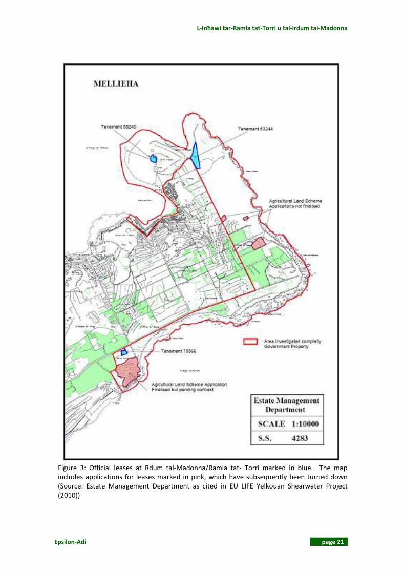
2.2.2 Legal Rights According to the EU LIFE Yelkouan Shearwater Project (2010) there are three official leases within the site (see Table 1 and Figure 3). There are also a number of structures including a large boat house development, agricultural rooms and a number of hunting and trapping hides. Table 1: Official leases at Rdum tal-Madonna (EU LIFE Yelkouan Shearwater Project 2010)
GPD Tenement Number
Location Area (ha)
Term and expiry date
Rent review dates and break-clauses
50240 White Tower 0.17 Leased half yearly
Nil
53244 Land opposite Adventure Campsite
0.56 Leased half yearly
Nil
75596 Small house on outskirts of site 0.10 Leased half yearly
Nil

L-Inħawi tar-Ramla tat-Torri u tal-Irdum tal-Madonna
Epsilon-Adi page 19
Figure 1: Map of the Special Area of Conservation of L-Inħawi tar-Ramla tat-Torri u tal-Irdum tal-Madonna (see ANNEX 6: Maps for A3 version)

Natura 2000 Management Plan
page 20 Epsilon-Adi
Figure 2: L-Inħawi tar-Ramla tat-Torri u tal-Irdum tal-Madonna Land Ownership Map (see ANNEX 6: Maps for A3 version)
L-Inħawi tar-Ramla tat-Torri u tal-Irdum tal-Madonna
Epsilon-Adi page 21
Figure 3: Official leases at Rdum tal‐Madonna/Ramla tat‐ Torri marked in blue. The map includes applications for leases marked in pink, which have subsequently been turned down (Source: Estate Management Department as cited in EU LIFE Yelkouan Shearwater Project (2010))
Natura 2000 Management Plan
page 22 Epsilon-Adi
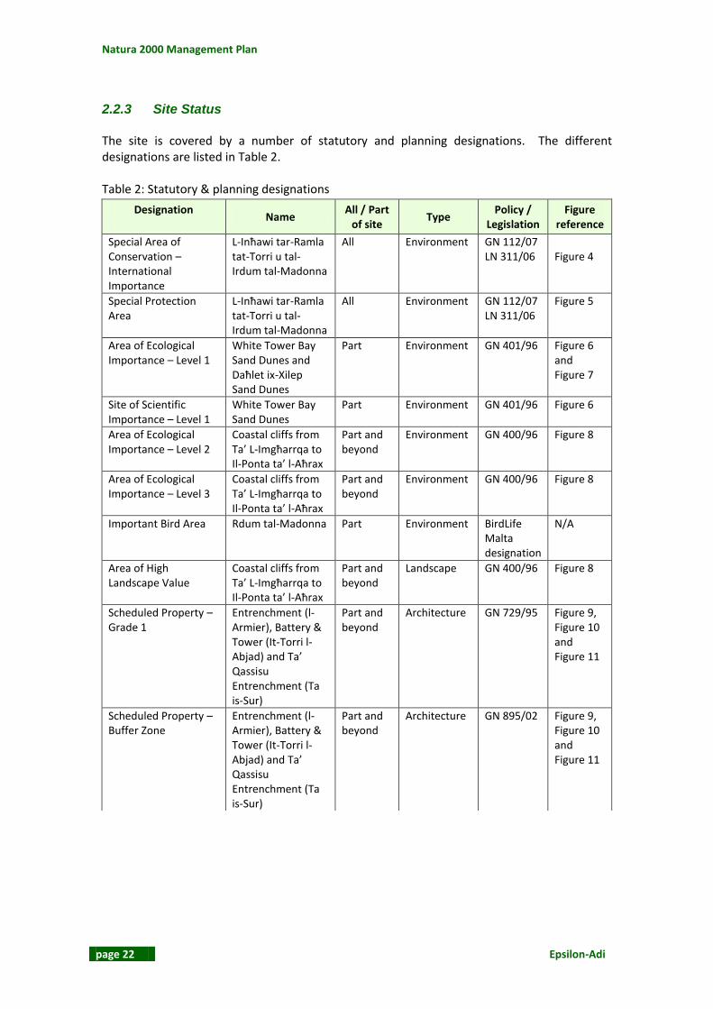
2.2.3 Site Status The site is covered by a number of statutory and planning designations. The different designations are listed in Table 2. Table 2: Statutory & planning designations
Designation
Name All / Part
of site Type
Policy / Legislation
Figure reference
Special Area of Conservation – International Importance
L-Inħawi tar-Ramla tat-Torri u tal-Irdum tal-Madonna
All Environment GN 112/07 LN 311/06
Figure 4
Special Protection Area
L-Inħawi tar-Ramla tat-Torri u tal-Irdum tal-Madonna
All Environment GN 112/07 LN 311/06
Figure 5
Area of Ecological Importance – Level 1
White Tower Bay Sand Dunes and Daħlet ix-Xilep Sand Dunes
Part Environment GN 401/96 Figure 6 and Figure 7
Site of Scientific Importance – Level 1
White Tower Bay Sand Dunes
Part Environment GN 401/96 Figure 6
Area of Ecological Importance – Level 2
Coastal cliffs from Ta’ L-Imgħarrqa to Il-Ponta ta’ l-Aħrax
Part and beyond
Environment GN 400/96 Figure 8
Area of Ecological Importance – Level 3
Coastal cliffs from Ta’ L-Imgħarrqa to Il-Ponta ta’ l-Aħrax
Part and beyond
Environment GN 400/96 Figure 8
Important Bird Area Rdum tal-Madonna Part Environment BirdLife Malta designation
N/A
Area of High Landscape Value
Coastal cliffs from Ta’ L-Imgħarrqa to Il-Ponta ta’ l-Aħrax
Part and beyond
Landscape GN 400/96 Figure 8
Scheduled Property – Grade 1
Entrenchment (l-Armier), Battery & Tower (It-Torri l-Abjad) and Ta’ Qassisu Entrenchment (Ta is-Sur)
Part and beyond
Architecture GN 729/95 Figure 9, Figure 10 and Figure 11
Scheduled Property – Buffer Zone
Entrenchment (l-Armier), Battery & Tower (It-Torri l-Abjad) and Ta’ Qassisu Entrenchment (Ta is-Sur)
Part and beyond
Architecture GN 895/02 Figure 9, Figure 10 and Figure 11
L-Inħawi tar-Ramla tat-Torri u tal-Irdum tal-Madonna
Epsilon-Adi page 23
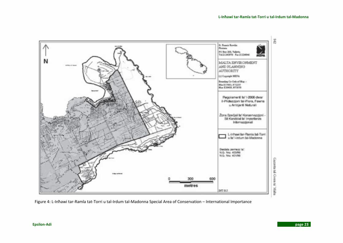
Figure 4: L-Inħawi tar-Ramla tat-Torri u tal-Irdum tal-Madonna Special Area of Conservation – International Importance

Natura 2000 Management Plan
page 24 Epsilon-Adi
Figure 5: L-Inħawi tar-Ramla tat-Torri u tal-Irdum tal-Madonna Special Protection Area

L-Inħawi tar-Ramla tat-Torri u tal-Irdum tal-Madonna
Epsilon-Adi page 25
Figure 6: Area of Ecological Importance – Sand Dunes Torri l-Abjad (Mellieħa) (Orange border added to show the limits of the Natura 2000 management plan area)

Natura 2000 Management Plan
page 26 Epsilon-Adi
Figure 7: Area of Ecological Importance – Sand Dunes Daħlet ix-Xilep (Mellieħa) (Orange border added to show the limits of the Natura 2000 management plan area)
L-Inħawi tar-Ramla tat-Torri u tal-Irdum tal-Madonna
Epsilon-Adi page 27
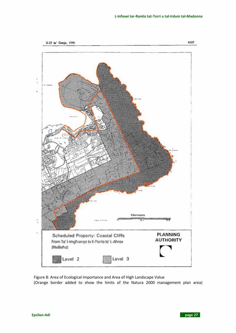
Figure 8: Area of Ecological Importance and Area of High Landscape Value (Orange border added to show the limits of the Natura 2000 management plan area)

Natura 2000 Management Plan
page 28 Epsilon-Adi
Figure 9: Scheduled Property – Entrenchment (l-Armier) (Orange border added to show the limits of the Natura 2000 management plan area)

L-Inħawi tar-Ramla tat-Torri u tal-Irdum tal-Madonna
Epsilon-Adi page 29
Figure 10: Scheduled Property – Battery and Tower (Orange border added to show the limits of the Natura 2000 management plan area)

Natura 2000 Management Plan
page 30 Epsilon-Adi
Figure 11: Scheduled Property – Ta’ Qassisu Entrenchment (Taħt is-Sur) (Orange border added to show the limits of the Natura 2000 management plan area)

L-Inħawi tar-Ramla tat-Torri u tal-Irdum tal-Madonna
Epsilon-Adi page 31
2.2.4 Applicable Planning Policies
2.2.4.1 Structure Plan The Structure Plan for the Maltese Islands (1990)2 has three main goals:
“To encourage the further social and economic development of the Maltese Islands, and to ensure as far as possible that sufficient land and support infrastructure are available to accommodate it.”
“To use land and buildings efficiently, and consequently, to channel urban development
activity into existing and planned development areas, particularly through rehabilitation and upgrading of the existing fabric and infrastructure thus constraining further inroads into undeveloped land, and generally resulting in higher density development than at present.”
“To radically improve the quality of all aspects of the environment of both urban and rural
areas.” The Structure Plan policies were reviewed and assessed in order to determine those policies that are relevant to the management planning process. The identified policies are summarised in ANNEX 2: Relevant Planning Policies. Most of the rural conservation policies are relevant to the SAC due to the different protection levels assigned to the area. The area also sustains different habitats such as sand dunes and coastal cliffs. Since the SAC is a coastal site, Policy CZM 3 that deals with public access to the coast is another policy that has to be taken into account through the management planning process.
2.2.4.2 Local Plan The relevant local plan for L-Inħawi tar-Ramla tat-Torri u tal-Irdum tal-Madonna management plan area is the North West Local Plan (2006). The Local Plan presents a planning framework that highlights the land use issues to be adopted and implemented at a local level. Relevant policies are summarised in ANNEX 2: Relevant Planning Policies.
The Local Plan has a number of conservation policies that aim at protecting both the human and natural features of the site (Policies NWCO 3, 6, 7, 10 and 13-15).
2.2.4.3 Action Plan L-Inħawi tar-Ramla tat-Torri u tal-Irdum tal-Madonna SAC/SPA falls within the Marfa Action Plan Area (see Table 3).
2 The Structure Plan is currently under review and will be replaced by the Strategic Plan for the
Environment and Development

Natura 2000 Management Plan
page 32 Epsilon-Adi
Table 3: Marfa Action Plan policies; L-Inħawi tar-Ramla tat-Torri u tal-Irdum tal-Madonna Policy
Policy Description Relevance to management
plan process
MLA 1 The Malta Environment and Planning Authority will not permit the development of any structure or activity which, in the view of the Authority, would adversely affect Areas of High Landscape Value, (scheduled in accordance with Section 46 of the Development Planning Act 1992 and Scheduling of Coastal Cliffs (Government Notice 400) in the Action Plan area), as illustrated on Map 9.3 (Protected Areas) because it would:- i. Break a presently undisturbed skyline; or ii. visually dominate or disrupt its surroundings because of its mass, location or design; or iii. obstruct a pleasant or particularly a panoramic view of the cliffs; or iv. adversely affect any element of the visual composition, or distinctive character of the area, or adversely affect existing trees or shrubs; or v. introduce alien forms, materials, textures or colours to the natural landscape.
A large part of L-Inħawi tar-Ramla tat-Torri u tal-Irdum tal-Madonna is an Area of High Landscape Value.
MAG 1 The Malta Environment and Planning Authority supports a sustainable policy of protecting agricultural land that may be irrigated throughout the year from ground water sources (illustrated on Map 5) from all forms of development. Within areas of irrigated agricultural land (as illustrated on Map 5) only buildings, structures and uses essential to the needs of agriculture will be permitted and then only if it can be demonstrated to the satisfac tion of the Malta Environment and Planning Authority that they will not adversely affect water supplies, soil and landscape and are in accordance with all other policies within the Local Plan and this Action Plan.
A small part of the SAC/SPA is used as agricultural land.
MTO 2 The Malta Environment and Planning Authority will seek the co-operation of the Museums Department, Lands Department, Department of Education, the Local Councils, NGOs and private sector agencies, in accordance with Structure Plan policy, to ensure the implementation of a Heritage Trail in the Marfa Action Plan area, as illustrated on Map 7.
The proposed Heritage Trail includes the scheduled structures within the SAC/SPA. The management plan will take note of this policy.
MRE 1 The development of camping sites will be permitted at L-Ahrax tal-Madonna and L-Ahrax tar-Ramel as illustrated on Map 8. 2 subject to the following criteria:- i. No new buildings other than reception office, toilet and washing facilities of one storey in height will be permitted, subject to appropriate scale, design and siting and use of sympathetic materials; ii. no static or touring caravans or any other temporary accommodation other than tents, will be permitted on site; iii. an adequate access and off road parking is provided; iv. the proposal makes adequate provision for water supply, washing, toilet facilities, waste disposal, drainage and sewage disposal;
The designated camping site at L-Ahrax tal-Madonna is partially located within the SAC / SPA boundaries. L-Aħrax tar-Ramel has been developed as a camping site by the private sector and borders the site’s boundary.

L-Inħawi tar-Ramla tat-Torri u tal-Irdum tal-Madonna
Epsilon-Adi page 33
Policy Description Relevance to management
plan process
v. details of provisions of fire prevention, fire fighting and first aid facilities shall be submitted and approved; and vi. a landscaping scheme is submitted and approved with any permit application and which shall be implemented in its entirety within the first planting season and thereafter maintained.
MRE 3 The Malta Environment and Planning Authority will support the promotion and implementation of cycle routes within the Action Plan area, as illustrated on Map 8.5 together with support facilities such as toilets and appropriately located car parks.
L-Inħawi tar-Ramla tat-Torri u tal-Irdum tal-Madonna includes a number of cycle routes particularly along the SAC / SPA boundary.
MRE 4 Existing and proposed long distance footpaths and other access ways are identified and illustrated on Map 8.5 and will be protected from development that would adversely affect their route or character. Emphasis will be given to the provision of circular routes with access to picnic areas, carparks and toilet facilities. The Malta Environment and Planning Authority in conjunction with the Mellieha Local Council and other appropriate agencies, will initiate a system of “Way Marking” of footpaths and access ways in order to protect rights of access for the public.
L-Inħawi tar-Ramla tat-Torri u tal-Irdum tal-Madonna includes a number of footpaths.
MRE 5 The development of picnic areas will be permitted in designated areas as illustrated on Map 8.1. The development of additional picnic areas may be permitted provided the following criteria are met:- i. The picnic area has no adverse effect on the character of the landscape; ii. the siting has no significant adverse impact on any scheduled, designated or protected area of ecological, scientific, visual, historic, archaeological or agricultural value; iii. preference will be given to areas that are currently in a dilapidated state. Picnic areas will not be permitted within 10 metres of the coastline. iv. the site is well related to an existing highway/access and does not cause a traffic hazard and off-road parking is provided; v. details of washing and toilet facilities sh all be submitted and approved together with the details of drainage and sewage disposal arrangements; vi. no static or touring caravans, tents or other temporary accommodation will be permitted; and vii. a landscape scheme is submitted and approved with any permit application, which shall be implemented in its entirety within the first planting season and thereafter maintained.
The SAC / SPA include two proposed picnic areas.
MRE 6 The development of new equestrian establishments may be permitted, subject to all of the following criteria:- i. The development has no significant adverse effect on any adjacent land uses;
The management plan will take note of this policy.

Natura 2000 Management Plan
page 34 Epsilon-Adi
Policy Description Relevance to management
plan process
ii. the location is not within a scheduled, designated or protected area; iii. where the activity will involve significantly increased use by riders of footpaths in the area, they should be adequate and suitable for both riders and walkers, and iv. a landscape scheme is submitted and approved with any permit application, which shall be implemented in its entirety with in the first planting season and thereafter maintained.
MRE 7 The Malta Environment and Planning Authority will safeguard areas identified in the Action Plan for the purposes of informal recreation/open space, at l-Ahrax ta’ Gewwa, an area of land adjacent to the eastern boundary of the Ramla Bay Hotel, and l-Ahrax tal-Madonna, as illustrated on Maps 8.1 and 8.5; and the designated Buffer Z ones adjacent to Scheduled Buildings at Vendome Battery and Is-Sur ta' L-Ahrax, as illustrated on Map 9.2.
The management plan will take note of this policy.
MRE 10
The Malta Environment and Planning Authority will protect areas identified for scuba diving at L-Iskoll tal-Marfa, Dahlet ix-Xmajjar and L-Ghar ta’ Zamzam as illustrated on Map 8.1, reconciling the conflicting interest of diving, other underwater activities and marine conservation. Prior to the preparation of Management Plans for each location to be prepared by the Malta Environment and Planning Authority, NGO and Diving Organisations, no development will be permitted that would obstruct their possible future implementation.
The management plan will take note of this policy.
MRE 11
The Malta Environment and Planning Authority will encourage the Malta Maritime Authority to designate the following locations as illustrated on Map 8.4 as Swimming Zones at: Paradise Bay (Existing designation) Cirkewwa Bay Raml a Bay Ramlet il-Qortin Armier Bay Raml a tat-Torri Bay Within these areas, and any future areas so designated, motorised water sports and the use of power craft will be prohibited, except in designated buoyed access channels.
The management plan will take note of this policy.
MCO 1 The Action Plan supports the protection of the scheduled buildings as illustrated on Map 9.1, in accordance with Structure Pan Polices and the Development Planning Act. The buildings shall be preserved in their entirety. The Action Plan identifies and designates Buffer Zones (Historic Spheres of Influence) for official scheduling under Section 46 of the Development Planning Act, in order to protect the
L-Inħawi tar-Ramla tat-Torri u tal-Irdum tal-Madonna includes Il-Batterija tal-Mellieha u t-torri l-Abjad and parts of Is-Sur ta' l-

L-Inħawi tar-Ramla tat-Torri u tal-Irdum tal-Madonna
Epsilon-Adi page 35
Policy Description Relevance to management
plan process
settings of the scheduled buildings. In the interim period prior to scheduling, the Buffer Zones shall be protected and afforded Grade 1 status. These Buffer Zo nes are to be enhanced, and where required, all illegal structures/buildings or accretions will be removed, original structures made good and the sites restored, as illustrated on Map 9.2 at: It Torri l-Ahmar, Il-Batterija ta' Wied Musa, Ir-Ridott tar-Ramla tal-Bir, Il-Batterija ta' Eskalar Ramlet Il-Qortin, Vendome Battery, Crevelli Redoubt, Is-Sur ta' l-Ahrax Entrenchments, Il-Batterija tal-Mellieha u t-torri l-Abjad, Ta' Qassisu Entrenchments. No further development in the form of structures or buildings will be permitted within the designated Buffer Z o nes. Public Access will be encouraged wherever possible and appropriate, and uses such as informal recreation activities including walking, bathing and shoreline fishing will be permitted provided that the settings of the scheduled Buildings are not impaired. The erection of any buildings or structures will not be permitted.
Ahrax Entrenchments and Ta' Qassisu Entrenchments.
MCO 2 Areas of Ecological Importance (Level 2 and 3) at Marfa are scheduled to regulate their conservation in accordance with Structure Plan Policy, Section 46 of the Development Planning Act 1992, Scheduling of Coastal Cliffs (Government Notice 400), as illustrated on Map 9.3 (Protected Areas).
L-Inħawi tar-Ramla tat-Torri u tal-Irdum tal-Madonna SAC/SPA has Areas of Ecological Importance.
MCO 3 Sites of Scientific Importance are scheduled to regulate conservation in accordance with Structure Plan Policy and Section 46 of Development Planning Act 1992, as illustrated on Map 9.3.
L-Inħawi tar-Ramla tat-Torri u tal-Irdum tal-Madonna SAC/SPA has Sites of Scientific Importance.
MCO 4 The Malta Environment and Planning Authority in conjunction with the Environment Protection Department will continue to take appropriate enforcement measures against the illegal dumping of waste material. The Malta Environment and Planning Authority will encourage, in conjunction with the Roads Department, a policy of restricting access from the public highway by the construction of suitable barriers using appropriate natural materials.
The management plan will take note of this policy.
MCO 5 Wherever possible, the Malta Environment and Planning Authority will protect areas of garrigue. The illegal deposit of The management plan will take

Natura 2000 Management Plan
page 36 Epsilon-Adi
Policy Description Relevance to management
plan process
soil, or the use for off-roading on such areas will not be permitted. A change of use of land from garrigue to beachroom and caravan site purposes will only be permitted on land for such purpose as illustrated on Map 10.1 and Policy MCZ 3 refers.
note of this policy.
MCO 6 All Giren (Corbelled Stone Huts) within the Action Plan area are protected pending their official scheduling under Section 46 of the Development Planning Act. In the interim period prior to scheduling, the buildings shall be preserved in their entirety and afforded a Grade 1 status. Demolition or alterations that impair the setting or change the external or internal appearance, including anything contained within the curtilage of the building will not be allowed)
The management plan will take note of this policy.
MCO 7 Woodland Conservation Areas are designated at Is-Sdieri, Ix-Xewkija and L-Ahrax tal-Madonna, as illustrated on Map 9.4, and the additional planting of appropriate species of trees will be encouraged where they will enhance the landscape of the area.
The management plan will take note of this policy.
MCZ 1 The Malta Environment and Planning Authority will continue with the removal of illegal structures on or adjacent to the coastline between Vendome Battery and White Tower. (Refer to Map 10.1)
The management plan will take note of this policy.
MCZ 2 The Malta Environment and Planning Authority will seek to further secure public access to the foreshore/ coastline of the Marfa Action Plan, as illustrated on Map 8.1. The Malta Environment and Planning Authority, in conjunction with all interested parties, will investigate possibilities to re-instate public access to that part of the foreshore immediately adjacent to the Ramla Bay Hotel.
The management plan will take note of this policy.
MCZ 3 Areas of Land 1, 2, 3, 4 and 5, as illustrated on Map 10.1, are allocated for the provision of Beachroom Holiday Accom mo dation subject to all of the following criteria:- i. The siting of the beachrooms may be in the vicinity of the foreshore but not on designated public access areas. Comprehensi ve layouts will be required to consist of linked terraces or clusters of accommodation with adequate provision for car parking and refuse disposal. The construction of new individual beachrooms will not be permitted; ii. the design of development should be sympathetic with the scale, character and appearance of the area and protect ad jacent uses of ecological or scientific importance; iii. the external footprint of each unit shall be a maximum of 12m x 5m with provision for living and sleeping accommodation, to ilet/shower (separate or communal) and kitchenette facilities; iv. adequate provision is made for vehicle parking and servicing in designated communal areas which does not cause or increase danger to pedestrians; v. the storage of boats may be permitted in specific identified areas of the beachroom development at basement level, but in no instance will direct access onto the foreshore be permitted. Additional areas for boat storage may also be provided to the rear of development, subject to satisfactory access to launching slipways that do
The management plan will take note of this policy.
L-Inħawi tar-Ramla tat-Torri u tal-Irdum tal-Madonna
Epsilon-Adi page 37
Policy Description Relevance to management
plan process
not physically restrict public access to the foreshore; vi. the construction of jetties, pontoons, s lipways or storage of boats that physically restricts public access to the foresh ore, will not be permitted; vii. the Malta Environment and Planning Au thority, in consultation with the Water Services Corporation and Enemalta, is satisfied that adequate infrastructure (water supply and electricity) is available or can be provided; viii. the Malta Environment and Planning Authority in consultation with the Drainage Department, is satisfied that the drainage and sewage disposal arrangements are adequate. Sewage overflows will not be permitted; ix. provision is m a de in appropriate locations for people with special needs including wheelchair users; x. the use of colours and materials are compatible with the local setting and that local stone is used for the façade; xi. a landscaping scheme is submitted and approved which shall be implemented in its entirety within the first planting season and thereafter maintained; xii. the preparation on development briefs for each of the Areas 1, 2, 3, 4 and 5, illustrated on Map 10.1, are to be submitted together with any planning application for development permission. Any development permit will be subject to the above criteria, and change of use from holiday accommodation to permanent reside ntial or commercial use will not be permitted. The Malta Environment and Planning Authority will impose a condition on any permission granted, that would remove permitted development rights under the Development Notification Order 2001, in order to protect the character of the development. A Management Organisation will be appointed by Government to advise, administer and implement the development proposals in a holistic manner. (Refer also to Chapter 13 Implementation).
MCZ 4 The Scheduled Beaches at Ramla tac-Cirkewwa (Paradise Bay), Raml a tal-Bir, Ramla tal-Qortin, Armier Bay and Ramla tat-Torri, as illustrated on Map 9.3 will be protected and no form of permanent structure will be permitted, and existing structures will be removed whenever practicable. The removal of sand, overnight camping, vehicle access and removal of vegetation from sand dunes is prohibited. The Malta Environment and Planning Authority in conjunction with the appropriate agencies will seek the removal of any illegally erected fences or access controls which prohibit the general public from using public beaches.
The management plan will take note of this policy.

Natura 2000 Management Plan
page 38 Epsilon-Adi
Policy Description Relevance to management
plan process
Without prejudice to the above, the Malta Environment and Planning Authority will consider nourishment or the extension of existing sandy beaches for recreational use. All such projects will be the subject of the submission of the appropriate studies and of a satisfactory Environmental Impact Assessment.
MTR 2 Public vehicular access to L-Ahrax tal-Madonna will be prohibited. Areas are identified for parking at suitable locations adjacent to the open space area.
The management plan will take note of this policy.
MTR 4 An access road will be provided by the Roads Department through Area 4 designated for the development of beachrooms at Ramla tat-Torri, in accordance with a comprehensive layout for Beachroom development (Policy MCZ 3); and an indicative alignment is illustrated on Map 11.3. The existing access route along the beach will then be closed and the area restored in order to allow for accretion of the sand dune.
The management plan will take note of this policy.
L-Inħawi tar-Ramla tat-Torri u tal-Irdum tal-Madonna
Epsilon-Adi page 39
2.2.5 Other Plans Other plans include topic papers that were compiled as part of the Structure Plan Review. The aim of these plans is to recognise the important issues and to recommend a strategic direction. In the case of this management plan, the most relevant topic papers are the Leisure and Recreation Topic Paper, the Coastal Strategy Topic Paper, the Rural Strategy Topic Paper and the Landscape Assessment Study of the Maltese Islands.
2.2.5.1 Leisure and Recreation Topic Paper The sections of this topic paper which are most relevant to this SAC are the ones dealing with rural tourism and sports activities. This Topic Paper points out that parties are organised in some sandy beaches. The 1999 Public Attitudes Survey showed that only 15% of the respondents think that the Maltese beaches have adequate facilities. The Topic Paper also identifies various key issues that should be tackled in the Structure Plan Review. These are the relevant key issues for this management plan:
Protection and upgrading of the overall rural recreational provision Impacts of hunting and trapping Avoiding conflicting watersport activities and restricting the use of private areas (for
kiosks and the hiring of seacraft, umbrellas and deckchairs) on the foreshore Channelling the demand for the provision of coastal facilities and premises (re- the
development of watersport activities such as sailing or boardsailing) towards coastal areas that are already developed/committed with such facilities
Avoiding overprovision of coastal facilities by ensuring that demand for every sport/facility is well established prior to committing additional land on the foreshore
No additional permits for beach concessions, restrictions regarding the construction of boathouses and/or beachrooms
Importance of the natural marine environment in the overall diving provision The possibility of finding appropriate sites for artificial reefs and/or the submersion of
vessels, to serve as diving wrecks. The topic paper acknowledges that L-Aħrax tal-Mellieħa area is sought after for informal recreational purposes.
2.2.5.2 Coastal Strategy Topic Paper This topic paper provides a coastal boundary for Malta by taking into account ecological, physical and administrative factors. All of the management plan area falls within the Coastal Zone as defined by the topic paper. The topic paper describes how coastal ecosystems have a very delicate natural equilibrium and are thus sensitive to both natural and anthropogenic disturbances. L-Inħawi tar-Ramla tat-Torri u tal-Irdum tal-Madonna support sand dune and rupestral (coastal cliffs) communities.

Natura 2000 Management Plan
page 40 Epsilon-Adi
Sand dune formations are important both for the unique species they support and also for their geomorphological value. Sand dunes are a scarce habitat in the Maltese Islands and there are only five remaining complete sand dune ecosystems. Ir-Ramla tat-Torri is one of these remaining dune formations. Rupestral communities are found along the south, south-west and west Malta and the south and south west Gozo. This habitat is the most common one in this management plan. The inaccessible and sheltering boulder screes support many species of flora and fauna, a large number of which are endemic. The inaccessibility of these habitats makes them important for their ornithological value. The topic paper identifies most of the management plan’s coastal boundary as an Important Ornithological site. The topic paper identifies various sectors that can have implications on the national coastal strategy. These sectors which are relevant include tourism and recreation, agriculture and infrastructure. The coastal strategy emphasises that the tourism and recreation industry should be safeguarded and access within the coastal area is protected as long as this does not cause unnecessary negative impacts. Coastal agriculture should also be protected as land abandonment could lead to land degradation and a change in the coastal landscape. The proposed coastal strategy identifies the following objectives:
Protect coastal and marine habitats and biodiversity Protect cultural heritage Protect coastal uses that necessitate a coastal location Promote and protect public access and use Minimise existing and potential user conflicts.
The topic paper describes the Coastal Zone partially covered by the management plan boundary as Predominantly Rural Coast. The strategy for this specific type of coast is “is to safeguard the natural and cultural heritage, including landscape. The type and level of new development acceptable within these areas should be minimal. Only development that is directed towards improving degraded areas and enhancing informal recreation, in conformity with the objective of safeguarding the coastal characteristic and heritage of such areas, will be acceptable. Existing legally approved uses and development within protected areas should be allowed to continue, provided that the value of the protected coast is not affected negatively.”
2.2.5.3 Rural Strategy Topic Paper This topic paper addresses three main aspects related to the management plan area, namely, agriculture, country side recreation and conservation. Agriculture is considered a multifaceted practice which contributes “towards food production, landscape enhancement, protection of the environmental and countryside recreation. In this regard, Government’s emerging policy on agriculture follows the concept of ‘integrated rural development’, as outlined in the EU’s Rural Development Programme”. The topic paper also points out that land in L-Aħrax tal-Mellieħa area was reclaimed for agriculture even though natural habitats were present. This was in contradiction of policies RCO 8 and RCO 9 of the Structure Plan. The topic paper discusses countryside recreation which it defines as “any pursuit or activity engaged upon during leisure time, or as part of provision for education and training, which

L-Inħawi tar-Ramla tat-Torri u tal-Irdum tal-Madonna
Epsilon-Adi page 41
makes use of the natural resources of the countryside”. The topic paper identifies the countryside recreational activities in Malta and their compatibility with other countryside recreational activities. The topic paper touches upon the issue of visitor management and its importance in safeguarding sensitive areas. Visitor management is an essential tool for striking the right balance between rural conservation and countryside recreation. The topic paper calls for the management of rural areas and suggests the use of the IUCN Protected Area Management Categories (IUCN 1994)3. The Public Attitude Survey (PAS) published in 2000, identified those areas in the countryside that the public wants to see protected from development. L-Aħrax tal-Mellieħa received 113 mentions (from 3,000 persons) as a place that deserved protection.
2.2.5.4 Landscape Assessment Study of the Maltese Islands This Study prescribes and describes the main character areas of the Maltese Islands. The management plan area includes the following Landscape Character Areas: Marfa Ridge (M1), the Northern Malta Coastal Strip (M54) and the South-Eastern Marfa Coastal Strip (M55). The area includes different military structures, a chapel and an afforested area. “The south-eastern and eastern coastlines [of the Marfa Ridge] are also dominated by boulder screes and are practically inaccessible. These stretches form a pleasant rugged foreground against the backdrop of the aquamarine colours of the sea. The composition is further enhanced through the presence of tiny sandy or pebble beaches as well as the growth of natural vegetation (esp. maquis vegetation) in pockets along the cliff edges and boulder screes. The ridge edges along this stretch of coastline rise to around 45 m above sea level and command extensive views. The north-eastern tip of the peninsula is particularly rugged and there are a number of caves and subsidence structures which are best appreciated from the seaward side. The top of the escarpment dips gradually towards the north-west and in parts of this area the rock surf ace is indeed very jagged”. Marfa Ridge’s detracting features include “littering, barbeques and lack of attention to the building and maintenance of structures contribute to overall deterioration of its quality. Hunting and trapping hides, farm buildings, disused quarries, illegal land reclamation, cloches and greenhouses contribute to additional dereliction. The string of high-tension power line lattice towers, which transects the area, presents additional marring to the landscape”.
2.3 MANAGEMENT INFRASTRUCTURE L-Inħawi tar-Ramla tat-Torri u tal-Irdum tal-Madonna already has a site manager. One of the main initiatives in the area was the EU LIFE Yelkouan Shearwater Project carried out by BirdLife Malta. MEPA and HSBC gave additional financial support for this project. A rat eradication process was undertaken and a management plan for the years 2010 to 2015 was also written.
3 It is to be noted that the Topic Paper was written prior to EU accession and the promotion of
international management categories at the time was geared more towards the IUCN concept of protected areas.

Natura 2000 Management Plan
page 42 Epsilon-Adi
Other management measures undertaken in the area were linked to the conservation of the sand dunes at Ir-Ramla tat-Torri. The Mellieħa Local Council has also issued a Bye-Law (LCBL 37/2/2009) to regulate and permit camping activities in the area.
Figure 12: Signage on site as part of the EU Life Yelkouan Shearwater Project
2.3.1 Facilities and Services A large part of the management plan area is a natural habitat with limited human uses and facilities. The site borders and partially includes two main roads, one running west to east and another south to north. The former has been newly asphalted and ends in front of the chapel where there is ample parking space. The latter road leads to Daħlet ix-Xmajjar where there is the Adventure Camp site. The road then bends westwards to Ir-Ramla tat-Torri area. The facilities identified on site are the following (see Figure 14):
Agriculture: Agriculture is concentrated in the south-western corner of the site. An
agricultural land scheme application for the area is finalised however there is a pending contract (see Figure 3).
Conservation: The southern half of the site is characterised by an afforested area. Recreation and leisure: The southern half includes areas dedicated to camping. In the
northern part of the site there are also scheduled structures that are a cultural heritage attraction.
Transport: One of the camping sites includes an area dedicated to parking. The area in front of the chapel is also used for parking.
Residential: The north-western parts include a number of boat houses. Community services: In the south-eastern corner one can find a small chapel.

L-Inħawi tar-Ramla tat-Torri u tal-Irdum tal-Madonna
Epsilon-Adi page 43
Utilities and infrastructure: The north-eastern part includes a wind mast that has been temporarily installed to measure wind speeds and directions at different heights, with the aim of finding the most efficient height for potential wind turbines at Is-Sikka l-Bajda.
The EU LIFE Yelkouan Shearwater Project (2010) identified the following infrastructure present at Rdum tal-Madonna (see Figure 13 and
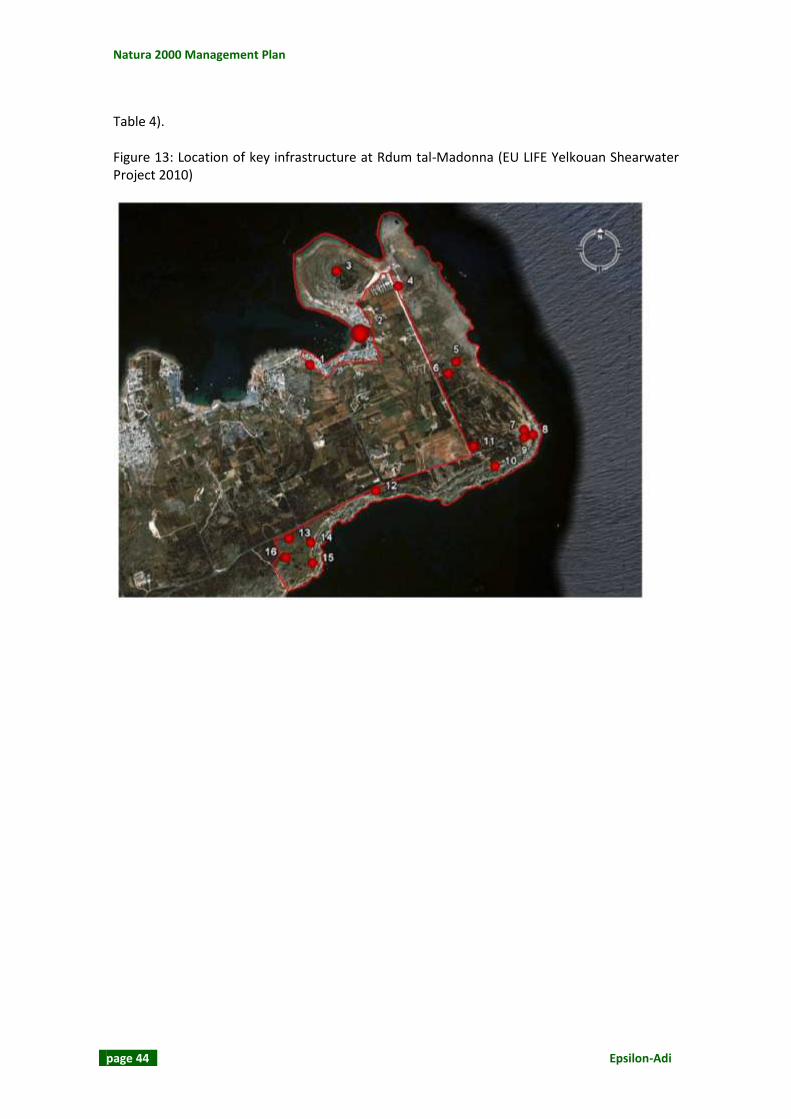
Natura 2000 Management Plan
page 44 Epsilon-Adi
Table 4). Figure 13: Location of key infrastructure at Rdum tal-Madonna (EU LIFE Yelkouan Shearwater Project 2010)

L-Inħawi tar-Ramla tat-Torri u tal-Irdum tal-Madonna
Epsilon-Adi page 45
Table 4: Infrastructure present at Rdum tal-Madonna (EU LIFE Yelkouan Shearwater Project 2010)
Figure 13 Reference
Description No. of
Structures Comment
Historic structures / permitted structures
1 Ahrax Entrenchments, Beach Post and Beach Defence Post
1 Scheduled Historical Building
3 White Tower and Battery 1 Scheduled Historical Building
6 Girna (hut which served as a shelter for the farmer)
1 Scheduled Historical Building – in need of restoration
7 Chapel of Rdum tal-Madonna 1
8 Statue of Our Lady 1
9 Project Sign 1 EU LIFE Yelkouan Shearwater Project
10 Pillbox 1
13 House 1 Officially leased
Illegal / Irregular structures
2 Boathouses C240
4 Several buildings and a camping area
5, 12, 14, 15, 16
rooms, thought to be agricultural
5
11 An additional informal, unsurfaced car park on the turn off to the Adventure Campsite
1
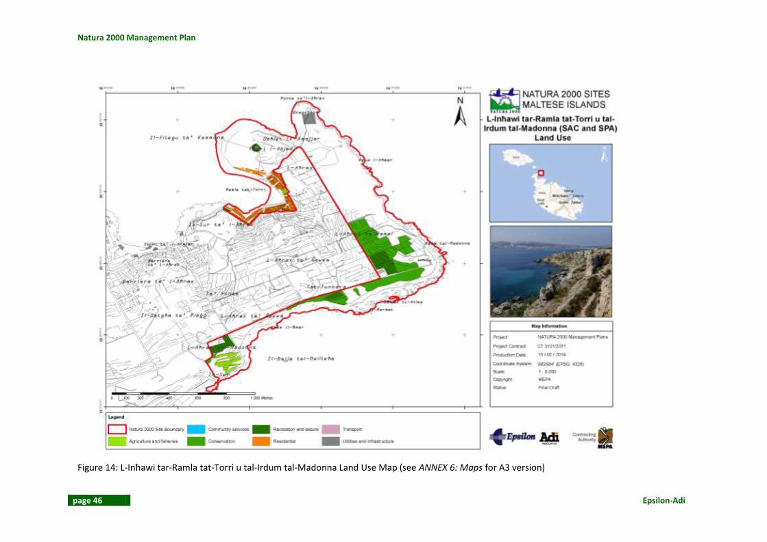
Natura 2000 Management Plan
page 46 Epsilon-Adi
Figure 14: L-Inħawi tar-Ramla tat-Torri u tal-Irdum tal-Madonna Land Use Map (see ANNEX 6: Maps for A3 version)

L-Inħawi tar-Ramla tat-Torri u tal-Irdum tal-Madonna
Epsilon-Adi page 47
2.3.2 Health and Safety This section is not intended to replace a Health and Safety Audit, it is a review of any records of past accidents or problems in the site and surrounding area and a summary of observations made during the site visits carried out during May 2013. A potential hazard is linked to the area of Dragunara at Il-Ponta tal-Aħrax. The subsidence structure might not be visible from all directions and thus can be a hazard to off-the-path walkers. There is also a narrow area between the enclosed wind mast area and the cliff edge that might also be dangerous to walk (see Figure 15). The area also has rusted iron pieces in the rock (see Figure 16).
Figure 15: Dragunara and the fence close to the cliff edge

Natura 2000 Management Plan
page 48 Epsilon-Adi
Figure 16: Rusted iron pieces A Rockfall Hazard Survey within the Maltese Islands (January 2013) was commissioned by the MRRA. The study aimed at identifying the rockfall risks through field surveys. The report included a brief description of the geological and geographical contexts and the main mechanisms responsible for rockfalls. The Geology and Geomorphology map shows the different levels of hazards on site as presented in the Rockfall Report (see Figure 17). In the area close to the Dragunara there are a few overhanging wedges. Close to Rdum l-Aħmar there have been some collapses due to maritime erosion. In general however the rock is stable and erosion is limited to limestone erosion at sea level and sub-vertical faults. On the seaward side of l-Aħrax ta’ Ramal the cliffs are fractured and jointed. This can possibly result in rock collapses and failures. Scree slopes were also noted in the area. In the area behind the chapel there were some overhanging wedges. Lateral spreading was noted in the southern part of the SAC / SPA. To the south of the chapel there is a vertical fracture which is the result of undermining. The area above Daħlet ix-Xilep is characterised by undermining and overhanging wedges. A natural bench in the cliffs, collecting rock fall material, was observed in the area. The foot paths are endangered due to the overhangs present. Above Il-Ħarbat there is undermining, overhangs and scree slopes. Between Il-Ħarbat and Rdum il-Ħmar scaling was also noted. At Rdum il-Ħmar there were the same erosional phenomena. Possible rockfalls threaten both the footpaths on top and below the cliff.

L-Inħawi tar-Ramla tat-Torri u tal-Irdum tal-Madonna
Epsilon-Adi page 49
Figure 17: L-Inħawi tar-Ramla tat-Torri u tal-Irdum tal-Madonna Geology and Geomorphology Map (see ANNEX 6: Maps for A3 version)

Natura 2000 Management Plan
page 50 Epsilon-Adi
2.4 CLIMATE The Maltese Islands’ climate is a typical Mediterranean one with mild wet winters and hot, dry summers. Precipitation is in the form of rain, hail, dew and soft rime. The average precipitation rate calculated over 30 years (1961-2010) is that of 553.12mm with a standard deviation of 156.99 mm (28.38 co-efficient of variation) (see Figure 18).
Figure 18: Precipitation; dry/wet yrs compared 1930–2010 averages (NSO 2011) The average annual temperature is 18.62°C with a standard deviation of 0.40. The annual mean temperature varies from a minimum of 17.9 to a maximum of 19.7. The monthly temperature means vary from 12.4°C in winter to 26.3°C in summer. This variation is the result of the regional weather trends and the moderating influence of the sea (see Figure 19 and Figure 20). Grass-height minimum temperature is also recorded by the Meteorological Office and in this case temperatures less than 0°C were also recorded. The lowest minimum grass-height temperature was recorded in February 1983 when the temperature dropped to -5.1°C (NSO 2011). Relative humidity during 1961 to 1990 varied from the monthly mean of 87% in January and 61% in June. The highest monthly relative humidity recorded was 89% in December 1993. The lowest monthly level was that of 54%, recorded in June 2006. The Maltese Islands receive a considerable amount of sunshine throughout the year with the most variable month being August due to the changes in weather that start during this month.

L-Inħawi tar-Ramla tat-Torri u tal-Irdum tal-Madonna
Epsilon-Adi page 51
Figure 19: Mean monthly temperature (NSO 2011)
Figure 20: Mean minimum and maximum air temperature [Based on the 30-year climate period] (NSO 2011)

Natura 2000 Management Plan
page 52 Epsilon-Adi
The mean annual wind speed over the 1961-1990 period is that of 16.3km/hr. The monthly means show that there is considerable variability. April had the highest mean monthly speed (19.km/hr) over the same 30 year period. The most dominant wind is the North-westerly wind known as Il-Majjistral and blows on an average of 20.7% of days per year (see Figure 21).
Figure 21: Wind rose for the period 1997-2006 (NSO 2011)
2.5 GEOLOGY
2.5.1 Lithology The Maltese Islands were formed from marine sediments deposited on the Pelagian Spur during the Oligo-Miocene Age. The detaching of the Sicilian-Tunisian platform from the African Continent and the colliding movement between the African and Eurasian plates resulted in the creation of the Pantelleria Rift Systems. Faulting resulted in the subsiding of rifts and the uplifting of ridges like the Maltese Islands. Once these uplifted sections emerged from below the sea they were exposed to the elements and agents of erosion which sculptured the current landscapes. The Maltese Islands are made up of following five limestone formations:
Upper Coralline Limestone Formation Greensands Formation Blue Clay Formation Globigerina Limestone Formation

L-Inħawi tar-Ramla tat-Torri u tal-Irdum tal-Madonna
Epsilon-Adi page 53
Lower Coralline Limestone Formation. The area is characterised by Upper Coralline Limestone. The basal layer is Mtarfa Member whilst at the surface at the south-eastern, eastern and north-western parts is the Tal-Pitkal Member (see Figure 17). Towards the south of the site there are also some Blue Clay outcrops.
2.5.2 Structural Geology The Maltese Islands have two main faulting systems. The Magħlaq Fault runs along the North-West – South-East Coast and has resulted in the North East tilt of the Maltese Islands. The Great Fault runs from Pembroke to Fomm ir-Riħ, dividing Malta into two main blocks. The north of the Great Fault is characterised by horst and grabens (i.e. ridges and rifts) whilst to the south of the Great Fault is flat land with the exception of the Rabat-Dingli Uplands. In the southern part of Malta, the Upper Coralline Limestone and Greensands formation have been eroded away and what remain are the Globigerina Limestone and the Lower Coralline Limestone formations. The predominant rock type is the Lower Globigerina Member. L-Inħawi tar-Ramla tat-Torri u tal-Irdum tal-Madonna is located in the northernmost part of Malta. The site is found on the east end of the Marfa Ridge and is at located to the north Mellieħa Bay’s mouth.
2.6 GEOMORPHOLOGY The area has a number of geomorphological features that include:
Sandy beach and dune system: Ir-Ramla tat-Torri is 0.15km in length and covers an area of 6,000m2. The dune system covers another 4,000m2. During the winter season the dunes can reach a height of 3m as a result of strong onshore winds and a 12-18° angle of slope. Another sand dune formation is found to the southern side of the site at Daħlet ix-Xilep. This sand dune formation is much smaller than the previous one.
“The beach at White Tower Bay is relatively sheltered, due to low exposure to wave action (having a Thomas wave exposure index of 4.86). The beach slope is 0.207°, a low value when compared to the slope of other beaches in the Maltese Islands (Deidun, 2006). Sand in the dry zone of the beach (that closest to the dune area) is classified as fine sand according to the Wentworth Scale, with a median grain size of 2.36; sediment in the wet zone has a median grain size of 2.56. Sediment is moderately sorted (Brown and Machlachlan, 1990) with a sorting coefficient of 0.78 and 0.80 in the wet and dry zones respectively.
The percentage organic content of beach sediment is relatively low, compared to that of other beaches (Gauci et al., 2005) despite having an anoxic layer at shallow depth due to the fine particle size of the sediment (EU LIFE Yelkouan Shearwater Project 2010)” (see Figure 22 and Figure 23).

Natura 2000 Management Plan
page 54 Epsilon-Adi
Figure 22: Ir-Ramla tat-Torri
Figure 23: Sand dune formation at Ir-Ramla tat-Torri

L-Inħawi tar-Ramla tat-Torri u tal-Irdum tal-Madonna
Epsilon-Adi page 55
Vertical / Near-Vertical Cliffs: The vertical and near-vertical rock faces dominate the eastern part of the site and can reach a height of over 56m above sea level (see Figure 24).
Lateral spreading and scree slopes: The southern part of the site is dominated by scree slopes and boulders from the eroding cliff face present (see Figure 25). The presence of Upper Coralline Limestone on Blue Clay is the result of lateral spreading. Lateral spreading can be defined as ‘the lateral extension of cohesive rock or soil mass over a deforming mass of softer underlying material where the controlling basal shear surface is often not well defined’ (Magri et al. 2008 citing Pasuto & Soldati 1996).
Subsidence structure: A subsidence structure, called Dragunara, is found at Il-Ponta tal-Aħrax. These structures are created as a result of the corrosive action of rainwater with limestone which enlarges a cave to an extent where the cave’s roof becomes unstable and collapses (see Figure 26).
Rocky coast: The area is inclined northwards. Il-Pont tal-Aħrax slopes gently towards the sea creating a rocky shoreline (see Figure 27).
Figure 24: Vertical / Near-Vertical Cliffs close to Il-Ponta tal- Aħrax

Natura 2000 Management Plan
page 56 Epsilon-Adi
Figure 25: Boulders and scree at Rdum tal-Madonna
Figure 26: The Dragunara subsidence structure

L-Inħawi tar-Ramla tat-Torri u tal-Irdum tal-Madonna
Epsilon-Adi page 57
Figure 27: Rocky coast at Il-Pont tal-Aħrax
2.7 SOILS AND SUBSTRATES The main sources of information about soils in the Maltese Islands are the study conducted by Lang in 1960 and the Soil Information System for the Maltese Islands (MALSIS) developed between 2002 and 2004 by the National Soil Unit (Agricultural Services and Rural Development Division, Ministry for Rural Affairs and the Environment) with the technical assistants of specialists from the National Soil Resources Institute (NSRI) of Cranfield University in the UK. Prior to the MALSIS project, the Lang (1960) study remained the sole authoritative source of soil information. There are various factors that have been crucial in understanding the nature of Maltese soil. These include the young age of the Maltese rocks, which has resulted in close similarities of the soil to the parent material, the climate that has hindered the creation of soil horizons, and anthropogenic activities that have resulted in modifications. Lang (1960) used the Kubiena classification system to categorise the different soils of the Maltese Islands. He identified four main categories of soils, namely, the Carbonate Raw Soils, the Terra Soils, the Xerorendzinas and the Soil Complexes and Rdum Sequence. Carbonate Raw Soil is associated with the Blue Clay formation, Terra Rossa with Upper Coralline Limestone and Xerorendzinas with Globigerina Limestone.

Natura 2000 Management Plan
page 58 Epsilon-Adi
According to Lang’s 1960 survey map the dominant soil within the SAC is Terra Soil (Xaghra Series). This soil type is very fertile and is also found in karstic environments. At L-Aħrax ta’ Ramal and in the area south of Tat-Tunnara there is the Armier Complex. This Complex is similar to the Xagħra Series but has ‘a mere thin sandy overlay’ which is windborne, calcareous and partly incorporated in the soil. The MALSIS project resulted in numerous soil surveys between 2002 and 2004 around the Maltese Islands whereby many soil properties and characteristics were recorded. The soil landscape of the management plan area was identified as a moderate terrace on Coralline Limestone. The area is characterised mainly by Leptosols. Leptosols can be found “on the vertical cliff faces where a very thin weathered layer of soil overlies rock at less than 10 cm depth. These are the most common form of Leptosols, found on relatively undisturbed garigue (both on level and very steep slopes), where rock occurs at 10 to25 cm depth” (MEPA 2005). The soil in the area has an overall medium organic carbon levels (20 – 60 g/kg) whilst the north-western and southern parts of the site that have low organic carbon levels (10 – 20 g/kg). The soil in the area has low electrical conductivity which is less than 500 uS/cm. The limitation to productivity is overall medium whilst it is high in western and southern parts of the site. The probability that zinc exceed its limits is low.
2.8 HYDROLOGY L-Inħawi tar-Ramla tat-Torri u tal-Irdum tal-Madonna’s hydrological catchment has an area of 1.31 km2. The habitats are partially crossed by a watercourse. Hydrology has a medium significance. The ground water body in the area is the Marfa Coastal. This aquifer is found between the South Comino Channel and the Għar Baqrat Fault. The aquifer is bound by the impermeable Blue Clay formation to the south and by the freshwater-seawater interface to the north. This aquifer covers an area of 5.5km2. The maximum length is 2.2km and the maximum width is that of 5.0km. This aquifer has a mean thickness of 26.5m whilst the mean annual recharge is that of 0.9hm3 (MRA 2005). The MAP CAMP Project “Malta” calculated water balances in surface water sheds in the North-Western Region. This included a calculation of the hydrological balance at Armier. The Armier surface water shed has a surface area of 2.99km2. The precipitation input is estimated at 1,704,300m3 whilst the evapotranspiration losses and run-off are 1,073,709m3 and 102,258m3
respectively. The recharge amounts to 528,333m3 (UNEP/MAP 2003).

L-Inħawi tar-Ramla tat-Torri u tal-Irdum tal-Madonna
Epsilon-Adi page 59
Figure 28: L-Inħawi tar-Ramla tat-Torri u tal-Irdum tal-Madonna Hydrology Map (see ANNEX 6: Maps for A3 version)

Natura 2000 Management Plan
page 60 Epsilon-Adi
2.9 ECOSYSTEMS/HABITATS, VEGETATION AND ECOLOGICAL PROCESSES
2.9.1 Description of SAC The Inhawi tar-Ramla tat-Torri u tal-Irdum tal-Madonna SAC covers an area of 0.75km2 and essentially consists of the eastern edge of the l-Ahrax tal-Mellieha peninsula, see Figure 1. Its location is such that the site overlooks Mellieha bay to the south, and il-Bajja tar-Ramla tat-Torri/ Comino Channel to the North. The SAC incorporates a variety of landscapes, each of which is under considerable anthropogenic influence, consisting of a rocky promontory, two bays and boulder screes. The SAC also incorporates three sets of sand dune communities, at ir-Ramla tat-Torri, Dahlet ix-Xilep and Dahlet ix-Xmajjar, the first two of which are also scheduled as Areas of Ecological importance through Government Notice 401 of 1996.
2.9.2 Site Management
The SAC is one of a handful of Natura 2000 sites that is under active management by an NGO, and has been managed since 2006. Before this, some parts, such as the beach, were the focus of emergency conservation measures by MEPA to protect the sand dunes at Ramla tat-Torri. Prior to that, the area had been under various negative anthropogenic influences for decades that have led to the ecological degradation of various habitats throughout the SAC. These factors include: the planting of alien species in the 1970s; the introduction and escape of other alien species such as Agave americana; the illegal construction of boathouses since the 1970s resulting in the isolation of the sand dune; construction work at Ramla tat-Torri in the 1980s, which has led to the extinction of Ammophila arenaria from Malta; illegal camping and caravanning; and illegal construction of trapping sites. Since 2006, following the launch of the EU LIFE Yelkouan Shearwater project, the site has been under the active management of Birdlife Malta, and is one of the few Natura 2000 sites for which a management plan has already been prepared.
2.9.3 Methods The Standard Data Form (SDF, last updated in 2012-09) was used as a reference document prior to site visits and field survey work. The SDF was used to obtain an initial understanding of Annex I habitats and Annex II species that have been noted within the site. Annex I species listed under the Birds Directive and regularly occurring migrant species have also been included in the SDF. Verification of the information presented in the Standard Data Form and accompanying habitats map was carried out through a site visit and field survey during which, vegetation assemblages and habitats were identified and indicative maps were produced using GIS. It should be noted that the focus of the field surveys was to verify habitat mapping. No attempt was made to carry out an exhaustive survey of species present within the site. For a detailed list of species of interest previously recorded in the site, reference should be made to the Standard Data Form (2012).

L-Inħawi tar-Ramla tat-Torri u tal-Irdum tal-Madonna
Epsilon-Adi page 61
The following site visit was carried out: Table 5: Site and surveying visits
Date of site visit / field survey Expert
22 May 2013 Dr Eman Calleja
2.9.4 Assessment of Conservation Status The methodology is described in detail in ANNEX 3: Assessment Methodology of Conservation Status and is based on the methodology as provided by MEPA. It evaluates area, structure and function, and future prospects for each habitat type within the SAC.
2.9.5 Vegetation Assemblages Figure 29 illustrates the habitats map for the SAC that was produced following the field surveys carried out as indicated above. Annex I habitats noted include:
1210 – Annual vegetation of drift lines 1240 – Vegetated sea cliffs of the Mediterranean coasts with endemic Limonium spp. 2110 – Embryonic shifting dunes 2210 – Crucianellion maritimae fixed beach dunes 2220 – Dunes with Euphorbia terracina 5330 – Thermo-Mediterranean and pre-desert scrub. 5410 – West Mediterranean clifftop phryganas 8210 – Calcareous rocky slopes with chasmopytic vegetation
2.9.6 Conservation Status The methodology is described in detail in ANNEX 3: Assessment Methodology of Conservation Status and is based on the methodology as provided by MEPA. It evaluates area, structure and function, and future prospects for each habitat type within the SAC. Table 6 illustrates the conservation status assessment.

Natura 2000 Management Plan
page 62 Epsilon-Adi
Table 6: Conservation Status
Annex I habitat
Code Area Structure & Function (including
typical species) Future Prospects (as regards area,
structure & function) Current
condition
Annual vegetation of drift lines
1210 B2 Area occupied: 0.8 ha (together with habitats 2110, 2210 & 2220). The EIONET classification factsheet for this habitat states that “this community is usually found along drift lines and embryo dunes or foredunes close to the sea, often with considerable input of organic matter, particularly from sea-grasses.” Within this SAC it is found in three areas, at Dahlet ix-Xmajjar, at Ramla tat-Torri itself and Daħlet ix-Xilep, each of which have the potential of accumulating organic matter from sea-grasses that are washed ashore. The dune at Daħlet ix-Xmajjar has only recently developed, and has not been recorded by Cassar and Stevens (2002). The dune at Ramla tat-Torri is subjected to the greatest pressure in terms of coverage and has undergone a considerable decline in area since the early 1990s (Cassar and Stevens, 2002).In each case this habitat is found at the front of the dune, where dune building is taking place in combination with habitat 2110. Habitats 1210 and 2110 were difficult to separate as they grow interspersed with each other, thus
B2 This habitat is found in three areas, at Ramla tat-Torri, Dahlet ix-Xmajjar, and Dahlet ix-Xilep. Each of these three communities has a partially degraded structure and faces a series of threats mostly from trampling by bathers. In spite of the disturbance, these habitats support a considerable number of rare and endangered species, making them the most important plant communities in the SAC. This habitat is dominated by a Salsolo-Cakiletum association with Cakile maritima and Salsola kali dominating the dune. Amongst the species encountered, in these three dunes were species that are typical of habitat 1210 (bold), including: Cakile maritima, Salsola kali, Mesembryanthemum nodiflorum, Mesembryanthemum crystallinum, Sporobolus pungens (= S. arenarius), Beta maritima, Plantago coronopus s.l. (most probably P. weldenii subsp. commutata), Plantago lagopus, Lavatera arborea, Hyoscyamus albus, Avena barbata, Glebionis coronaria, Elytrigia juncea, Eryngium maritimum, Lotus cytisoides, Scabiosa maritima, Pancratium maritimum, Elymus farctus, Orobanche densiflora,
C2 This habitat is found in three areas, at Ramla tat-Torri, Daħlet ix-Xmajjar, and Dahlet ix-Xilep. Each of these three communities has a partially degraded structure and faces a series of threats mostly from trampling by bathers. Of the three, the one at Daħlet ix-Xmajjar probably has the most favourable prospects, in spite of the fact that it is not as well conserved as the dune at Ramla tat-Torri. The dune here is not surrounded by buildings, and there is scope for it to develop beyond the area marked on the map. Moreover, the dune at Ramla tat-Torri is enclosed by a road, and the beach upon which it is found is much more popular with bathers, exposing it to more disturbances from trampling, littering and clearance of vegetation. In view of these factors, and the series of anthropogenic threats facing this site now and in the past, the future prospects for this habitat are bad but stable.
C

L-Inħawi tar-Ramla tat-Torri u tal-Irdum tal-Madonna
Epsilon-Adi page 63
Annex I habitat
Code Area Structure & Function (including
typical species) Future Prospects (as regards area,
structure & function) Current
condition
they have been mapped together. These and the other two sand dune habitats (2210 & 2220) occupy a combined area amounting to 1.1% of the total area of the SAC. According to Cassar & Stevens (2002) the dune at Ramla tat-Torri was more extensive in the past. Nevertheless, it is the most important and best developed example of this habitat (1210) in Malta. It is however under severe anthropogenic pressure from trampling by bathers, littering in summer, illegal construction, and parking of vehicles, and although their conservation and legal protection has allowed the area to remain stable, the habitat is extremely vulnerable and restricted. With proper protection the dune at Daħlet ix-Xmajjar has good prospects to conserve the area of this habitat, while that at Ramla tat-Torri has the potential to expand if the road behind the beach is returned to form part of the dune system. In view of the anthropogenic threats facing the sand dunes, activities taking place on and around the dune such as bathing, the overall area for this habitat is considered to be inadequate.
Euphorbia paralias, Euphobia terracina and Scolymus hispanicus. Cassar & Stevens (2002) describe the sand dune at ir-Ramla tat-Torri as being the best example of its type in Malta. Nevertheless the structure of this habitat throughout the SAC was average with average to good prospects for the conservation of the functions due to the impacts of anthropogenic factors that include trampling and driving across the dune. In view of this, and the good prospects for the functions of the habitat at Daħlet ix-Xmajjar (due to recent development of this dune system here, the overall prospects for this habitat are considered as being inadequate and stable.
Vegetated sea cliffs of the
1240 A Area occupied: 29 ha
B2 This habitat is one of the best
B2 In view of the large area covered
B

Natura 2000 Management Plan
page 64 Epsilon-Adi
Annex I habitat
Code Area Structure & Function (including
typical species) Future Prospects (as regards area,
structure & function) Current
condition
Mediterranean coasts with endemic Limonium spp.
Habitat type 1240 is the largest habitat occupying around 38% of the total surface area of the SAC (Figure 32: Habitat 1240 at Rdum l-Aħmar ). It is also the best preserved of the habitats. This habitat is found in two areas at Rdum l-Aħmar and at Rdum il-Ħmar. It is either found growing alone, or in conjunction with two other habitats, habitat 8210 and 5410. It occupies a variety of landscapes including: karstic coralline limestone plateaux in the North-eastern part of the SAC and coastal boulder screes along the south and eastern part of the SAC. This amounts to the full extent to which habitat 1240 can occupy within the SAC, without encroaching onto other Annex I habitats. In view of the fact that this habitat covers a large area, and that it is also the best preserved within the SAC, the prospects for the area are considered to be favourable.
preserved Annex I habitats in this SAC. The best section is that growing on its own at Rdum l-Ahmar. The habitat It is either found growing alone or in combination with habitats 5410, 5430 and 8210. It was characterised by the presence of a variety of species that included species characteristic of habitat 1240 (bold) but also species characteristic of habitats 5410 and 8210, including: Anthyllis hermanniae, Asparagus aphyllus, Asphodelus aestivus, Atriplex halimus, Capparis orientalis, Darniella melitensis, Daucus carota, Hyparrhenia hirta, Inula crithmoides, Opuntia ficus-indica, Pinus halepensis, Punica granatum, Rhamnus oleoides, Jacobaea maritima, Tamarix africana, Teucrium fruticans, Thymus capitatus, Vitis vinifera. Orobanche densiflora (Rare, Rest in MI) was found growing throughout this habitat, where it was parasitic on Lotus cytisoides. The habitat feature that was found along the boulder scree, was partly degraded and dominated by ruderals, including Acacia cyanophylla and Opuntia ficus-indica. In spite of the fact that the habitat at Rdum l-Ahmar has a well conserved structure, the habitat along the
by this habitat, its favourable prospects for the area, inadequate prospects for the structure and functions of the habitat, and threats from the spread of alien species of trees along the boulder scree, the future prospects for this habitat are considered to be inadequate but stable. Restoration should include the removal of all alien species of shrubs, trees and cacti from along this habitat since they are having a negative impact on the structure of habitats 1240 and 8210.

L-Inħawi tar-Ramla tat-Torri u tal-Irdum tal-Madonna
Epsilon-Adi page 65
Annex I habitat
Code Area Structure & Function (including
typical species) Future Prospects (as regards area,
structure & function) Current
condition
boulder scree has a poor conservation status, bringing the overall prospects for the structure and function of this habitat to inadequate but stable.
Embryonic shifting dunes
2110 B2 Area occupied: 0.8 ha (together with habitats 1210, 2210 & 2220). The EIONET classification factsheet for this habitat states that “this community is usually found along foredunes and the initial zones of the more “inland” yellow dunes, and persists in almost all extant dunes.” Within this SAC it is found in three areas, at Daħlet ix-Xmajjar, at Ramla tat-Torri itself and Dahlet ix-Xilep. The first case is younger in terms dune development, whilst the dune at Ramla tat-Torri is more stable. In both cases this habitat is found at the front of the dune, where dune building is taking place in combination with habitat 1210. These habitats were difficult to separate as they grow interspersed with each other, thus they have been mapped together. These and the other two sand dune habitats (2210 & 2220) occupy a combined area amounting to 1.1% of the total area of the SAC. According to Cassar & Stevens (2002) the dune at Ramla
B2 This habitat is found in three areas, at Ramla tat-Torri, Daħlet ix-Xmajjar, and Daħlet ix-Xilep. Each of these three communities has a partially degraded structure and faces a series of threats mostly from trampling by bathers. In spite of the disturbance, these habitats support a considerable number of rare and endangered species, making them the most important plant communities in the SAC. Amongst the species encountered, in these three dunes were species that are typical of habitat 2110 (bold), including: Cakile maritima, Salsola kali, Mesembryanthemum nodiflorum, Mesembryanthemum crystallinum, Sporobolus pungens (= S. arenarius), Beta maritima, Plantago coronopus s.l. (most probably P. weldenii subsp. commutata), Plantago lagopus, Lavatera arborea, Hyoscyamus albus, Avena barbata, Glebionis coronaria, Elytrigia juncea, Eryngium maritimum, Lotus cytisoides, Scabiosa maritima, Pancratium maritimum,
C2 This habitat is found in three areas, at Ramla tat-Torri, Daħlet ix-Xmajjar, and Daħlet ix-Xilep. Each of these three communities has a partially degraded structure and faces a series of threats mostly from trampling by bathers. Of the three, the one at Dahlet ix-Xmajjar probably has the most favourable prospects, in spite of the fact that it is not as well conserved as the dune at Ramla tat-Torri. Nevertheless, the latter is enclosed by a road, and the beach upon which it is found is much more popular with bathers, exposing it to more disturbances. In view of these factors, and the series of anthropogenic threats facing this site now and in the past, the future prospects for this habitat are bad and stable.
C
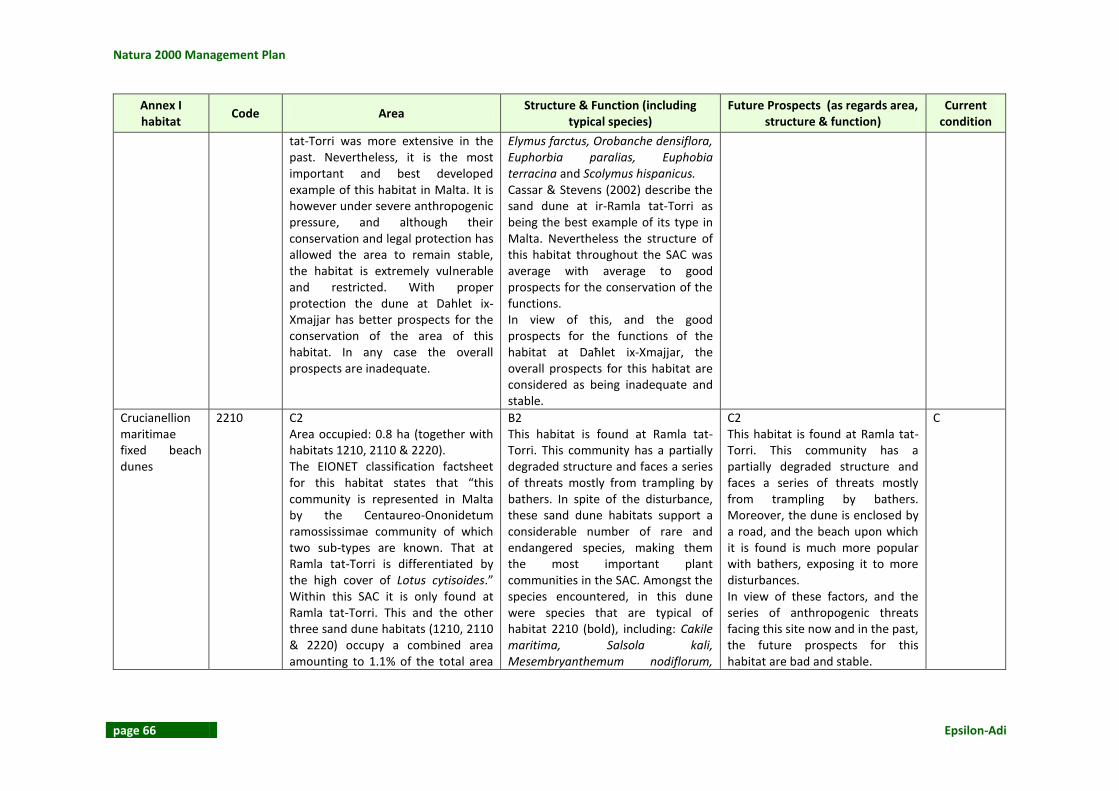
Natura 2000 Management Plan
page 66 Epsilon-Adi
Annex I habitat
Code Area Structure & Function (including
typical species) Future Prospects (as regards area,
structure & function) Current
condition
tat-Torri was more extensive in the past. Nevertheless, it is the most important and best developed example of this habitat in Malta. It is however under severe anthropogenic pressure, and although their conservation and legal protection has allowed the area to remain stable, the habitat is extremely vulnerable and restricted. With proper protection the dune at Dahlet ix-Xmajjar has better prospects for the conservation of the area of this habitat. In any case the overall prospects are inadequate.
Elymus farctus, Orobanche densiflora, Euphorbia paralias, Euphobia terracina and Scolymus hispanicus. Cassar & Stevens (2002) describe the sand dune at ir-Ramla tat-Torri as being the best example of its type in Malta. Nevertheless the structure of this habitat throughout the SAC was average with average to good prospects for the conservation of the functions. In view of this, and the good prospects for the functions of the habitat at Daħlet ix-Xmajjar, the overall prospects for this habitat are considered as being inadequate and stable.
Crucianellion maritimae fixed beach dunes
2210 C2 Area occupied: 0.8 ha (together with habitats 1210, 2110 & 2220). The EIONET classification factsheet for this habitat states that “this community is represented in Malta by the Centaureo-Ononidetum ramossissimae community of which two sub-types are known. That at Ramla tat-Torri is differentiated by the high cover of Lotus cytisoides.” Within this SAC it is only found at Ramla tat-Torri. This and the other three sand dune habitats (1210, 2110 & 2220) occupy a combined area amounting to 1.1% of the total area
B2 This habitat is found at Ramla tat-Torri. This community has a partially degraded structure and faces a series of threats mostly from trampling by bathers. In spite of the disturbance, these sand dune habitats support a considerable number of rare and endangered species, making them the most important plant communities in the SAC. Amongst the species encountered, in this dune were species that are typical of habitat 2210 (bold), including: Cakile maritima, Salsola kali, Mesembryanthemum nodiflorum,
C2 This habitat is found at Ramla tat-Torri. This community has a partially degraded structure and faces a series of threats mostly from trampling by bathers. Moreover, the dune is enclosed by a road, and the beach upon which it is found is much more popular with bathers, exposing it to more disturbances. In view of these factors, and the series of anthropogenic threats facing this site now and in the past, the future prospects for this habitat are bad and stable.
C

L-Inħawi tar-Ramla tat-Torri u tal-Irdum tal-Madonna
Epsilon-Adi page 67
Annex I habitat
Code Area Structure & Function (including
typical species) Future Prospects (as regards area,
structure & function) Current
condition
of the SAC. According to Cassar & Stevens (2002) the dune at Ramla tat-Torri was more extensive in the past. Nevertheless, it is the most important and best developed example of this habitat in Malta. It is however under severe anthropogenic pressure, and although their conservation and legal protection has allowed the area to remain stable, the habitat is extremely vulnerable and restricted, having bad overall prospects for the area.
Mesembryanthemum crystallinum, Sporobolus pungens (= S. arenarius), Beta maritima, Plantago coronopus s.l. (most probably P. weldenii subsp. commutata), Plantago lagopus, Lavatera arborea, Hyoscyamus albus, Avena barbata, Glebionis coronaria, Elytrigia juncea, Eryngium maritimum, Lotus cytisoides, Scabiosa maritima, Pancratium maritimum, Elymus farctus, Orobanche densiflora, Euphorbia paralias, Euphobia terracina and Scolymus hispanicus. Cassar & Stevens (2002) describe the sand dune at ir-Ramla tat-Torri as being the best example of its type in Malta. In view of this, and the poor prospects for the functions of this habitat, the overall prospects for this habitat are considered as being inadequate and stable.
Dunes with Euphorbia terracina
2220 C2 Area occupied: 0.8 ha (together with habitats 1210, 2110 & 2210). The EIONET classification factsheet for this habitat states that “This community is typical of semi-consolidated sands, and is still thriving at Għadira, Ramla tat-Torri and Ramla ta’ l-Armier. The only seemingly steady populations present are at Ramla in Gozo.”
B2 This habitat is found at Ramla tat-Torri. This community has a partially degraded structure and faces a series of threats mostly from trampling by bathers. In spite of the disturbance, these sand dune habitats support a considerable number of rare and endangered species, making them the most important plant communities in the SAC. Amongst the
C2 This habitat is found at Ramla tat-Torri. This community has a partially degraded structure and faces a series of threats mostly from trampling by bathers. Moreover, the dune is enclosed by a road, and the beach upon which it is found is much more popular with bathers, exposing it to more disturbances.
B

Natura 2000 Management Plan
page 68 Epsilon-Adi
Annex I habitat
Code Area Structure & Function (including
typical species) Future Prospects (as regards area,
structure & function) Current
condition
Within this SAC it is only found at Ramla tat-Torri. This and the other three sand dune habitats (1210, 2110 & 2210) occupy a combined area amounting to 1.1% of the total area of the SAC. According to Cassar & Stevens (2002) the dune at Ramla tat-Torri was more extensive in the past. Nevertheless, it is the most important and best developed example of this habitat in Malta. It is however under severe anthropogenic pressure, and although their conservation and legal protection has allowed the area to remain stable, the habitat is extremely vulnerable and restricted, having bad overall prospects for the area.
species encountered, in this dune were species that are typical of habitat 2220 (bold), including: Cakile maritima, Salsola kali, Mesembryanthemum nodiflorum, Mesembryanthemum crystallinum, Sporobolus pungens (= S. arenarius), Beta maritima, Plantago coronopus s.l. (most probably P. weldenii subsp. commutata), Plantago lagopus, Lavatera arborea, Hyoscyamus albus, Avena barbata, Glebionis coronaria, Elytrigia juncea, Eryngium maritimum, Lotus cytisoides, Scabiosa maritima, Pancratium maritimum, Elymus farctus, Orobanche densiflora, Euphorbia paralias, Euphobia terracina and Scolymus hispanicus. Cassar & Stevens (2002) describe the sand dune at ir-Ramla tat-Torri as being the best example of its type in Malta. In view of this, and the poor prospects for the functions of this habitat, the overall prospects for this habitat are considered as being inadequate and stable.
In view of these factors, and the series of anthropogenic threats facing this site now and in the past, the future prospects for this habitat are bad and stable.
Thermo-Mediterranean and pre-desert scrub.
5330 B2 Area occupied: 13 ha This habitat occupies almost 17.3% of the SAC (see Figure 35). It is found in two separate areas at l-Ahrax tal-Madonna where it grows alone, and
C2 This habitat is either found growing alone or in combination with habitat 5410. It was characterised by the presence of a variety of species that included species characteristic of
C2 In view of the area covered by this habitat, its inadequate prospects for the area, bad prospects for the structure and functions of the habitat, threats from the existance
C
L-Inħawi tar-Ramla tat-Torri u tal-Irdum tal-Madonna
Epsilon-Adi page 69
Annex I habitat
Code Area Structure & Function (including
typical species) Future Prospects (as regards area,
structure & function) Current
condition
on the peninsula at it-Torri l-Abjad, where it grows in conjunction with habitat 5410. It occupies one landscape type within this SAC: karstic coralline limestine plateaux. Notwithstanding the fact that this habitat covers a large area, the prospects for the area are not favourable. The habitat has the potential of expanding even further into derelict land. With this in mind, the prospects for the area are considered as being inadequate and stable.
habitat 5330 (bold) but also species characteristic of habitat 5410(£) including: Thymus capitatus, Daucus carota, Hyparrhenia hirta£, Euphorbia meitensis£, Phagnalon graecum ssp. ginzbergii, Convolvulus oleifolius£, Asparagus aphyllus, Asphodelus aestivus, Bromus spp., Anacamptis urvilleana, Anacamptis pyramidalis, Senecio bicolor, Cuscuta epitymum, Carthamus lanatus, Anthyllis hermanniae and Prasium majus. The structure of both patches covered by this habitat were partially degraded to average. This habitat was particularly vulnerable to anthropogenic factors that included the widespread planting of alien species of trees (Acacia), and the frequent use of this site as a popular picnic area. In view of the above, the prospects for the structure and functions of this habitat were considered to be bad and stable.
of alien species of trees, and popular use of this area as a picnic area, the future prospects for this habitat are considered to be bad but stable. Restoration would include the control of visitors to the area, and the removal of alien species of trees and shrubs from the habitat.
West Mediterranean clifftop phryganas
5410 B2 Area occupied: 16.6 ha This habitat occupies 22% of the SAC (Figure 32- Figure 35). It is found growing between it-Torri l-Abjad and Rdum il-Madonna, either alone, or in conjunction with two other habitats.
B2 This habitat was characterised by the dominance of species typical of habitat 5410 (refer to EIONET factsheet for Malta). It is either found growing alone or in combination with habitats 1240 and 5330. It was
B2 In view of the inadequate prospects for the area, structure and functions of this habitat, the threat of trampling to some of the habitat features of this habitat, and the spread of alien species, the
B

Natura 2000 Management Plan
page 70 Epsilon-Adi
Annex I habitat
Code Area Structure & Function (including
typical species) Future Prospects (as regards area,
structure & function) Current
condition
These include habitat 1240 at Rdum l-Ahmar, and habitat 5330 at it-Torri l-Abjad. It has a patchy distribution being located in 4 isolated sections within the SAC. It occupies one landscape type: karstic coralline limestine plateaux. Notwithstanding the fact that this habitat covers a large area, the prospects for the area are not favourable. The habitat has the potential of expanding even further into derelict land. On the other hand, the prevalent disturbance on their preferred landscape type from footfall caused by hunting, illegal camping and picnicing activities, and spread of alien species, is impinging on the ability of this habitat to expand. With this in mind, the prospects for the area are considered as being inadequate and stable.
characterised by the presence of a variety of species that included species characteristic of habitat 5410 (bold) but also species characteristic of habitats 1240(*) and 5330(&), including: Acacia cyanophylla, Agave Americana, Anacamptis pyramidalis, Anthirrinum tortuosum, Anthyllis hermanniae, Asparagus aphyllus, Asphodelus aestivus, Capparis orientalis*, Carthamus lanatus, Convolvulus oleifolius, Cuscuta epitymum, Euphorbia melitensis&, Ficus carica, Hyparrhenia hirta, Inula crithmoides*, Pinus halepensis, Prasium majus, Senecio bicolor*, Teucrium fruticans and Thymus capitatus. A number of these species are aliens, and are having a negative effect on the structure of the habitat. The vegetation cover was on average around 50% due to excessive trampling, whilst the average height varied from 20-40cm. In terms of structure, this was in general average or partially degraded, except for the habitat found at Rdum l-Ahmar, particularly the sections that are at a distance from the secondary road. The habitat here was well conserved, and growing in combination with habitat 1240.
future prospects for this habitat are considered to be inadequate but stable. Restoration is relatively easy as it would only involve raising a 2 foot wall beside the road to discourage people from walking and driving onto the garrigue. A concerted effort to remove all alien species will also need to be done to limit the effect these are having on the structure of this Annex I habitat.

L-Inħawi tar-Ramla tat-Torri u tal-Irdum tal-Madonna
Epsilon-Adi page 71
Annex I habitat
Code Area Structure & Function (including
typical species) Future Prospects (as regards area,
structure & function) Current
condition
The garrigue in the least conserved areas was under severe anthropological disturbance from trampling, and the spread of alien species including Acacia cyanophyll and Agave Americana, which is particularly severe in this SAC. In view of the disturbance prevalent in the site, average structure of the habitat in three of the four patches of this habitat, and encroachment of alien species onto this habitat, the prospects for the structure and functions of this habitat were considered to be inadequate but stable.
Calcareous rocky slopes with chasmopytic vegetation
8210 A Area occupied: 11.1 ha This habitat occupies almost 14.9% of the SAC (see Figure 30). It is found growing along the scree from Rdum il-Ħmar to Rdum tal-Madonna in conjunction with habitat 1240. It occupies one landscape types: the boulder scree. The area of the habitat occupies its maximum extent within this SAC, and is unlikely to expand further in light of the landscape types available and presence of competing habitats. In view of this, the prospects for the area for this habitat are considered to be favourable.
B2 This habitat is characterised by the dominance of species typical of habitat 8210, in particular Darniella melitensis (refer to EIONET factsheet for Malta). It is found growing in combination with habitat 1240. A variety of species were encountered including species characteristic of habitat 8210 (bold) but also species characteristic of habitat 1240(*) including: Tamarix africana, Pinus halepensis, Opuntia ficus-indica, Thymus capitatus, Asparagus aphyllus, Inula crithmoides*, Punica granatum, Hyparrhenia hirta, Teucrium fruticans, Asphodelus
B2 In view of the favourable prospects for the area, the inadequate prospects for the structure and functions of this habitat, and the threat from anthropogenic forces affecting some of the habitat features of this habitat, including littering, dumping, and spillover of alien species from the neighbouring afforestation project, the future prospects for this habitat are considered to be inadequate and stable. Restoration would involve a number of factors such as stopping the planting of alien trees within
B

Natura 2000 Management Plan
page 72 Epsilon-Adi
Annex I habitat
Code Area Structure & Function (including
typical species) Future Prospects (as regards area,
structure & function) Current
condition
aestivus, Capparis orientalis*, Daucus carota*, Rhamnus oleoides, Atriplex halimus, Darniella melitensis*, Anthyllis hermanniae, Senecio bicolor* and Vitis vinifera. The structure of this habitat is partially degraded due to the colonisation of the boulder scree by Acacia cyanophylla from seeds falling from the man-made woodland on the plateau above. Moreover, sections of this habitat are dominated by species which are not typical of habitat 8210 or 1240, such as Tamarix africana, Opuntia ficus-indica and Vitis vinifera. In addition to this, the habitat faces a series of threats which are affecting the prospects for its structure and functions, including encroachment of alien species from the 1970s’ afforestation project. In view of this, the prospects for the structure and function of this habitat are inadequate and stable.
this SAC, uprooting alien trees from this habitat, and more surveillance to halt any illegal clearance of vegetation from these habitats.

L-Inħawi tar-Ramla tat-Torri u tal-Irdum tal-Madonna
Epsilon-Adi page 73
Figure 29: Habitats map for L-Inħawi tar-Ramla tat-Torri u tal-Irdum tal-Madonna (see ANNEX 6: Maps for A3 version)

Natura 2000 Management Plan
page 74 Epsilon-Adi
Figure 30: Habitats 1210/2110 at Daħlet ix-Xmajjar
Figure 31: Habitats 1240/8210 at Rdum il-Ħmar

L-Inħawi tar-Ramla tat-Torri u tal-Irdum tal-Madonna
Epsilon-Adi page 75
Figure 32: Habitat 1240 at Rdum l-Aħmar
Figure 33: Habitats 1240/5410 at Rdum l-Aħmar

Natura 2000 Management Plan
page 76 Epsilon-Adi
Figure 34: Agave americana growing amongst Habitat 5410 at Rdum l- Aħmar
Figure 35: Habitats 5330/5410 growing at it-Torri l-Abjad
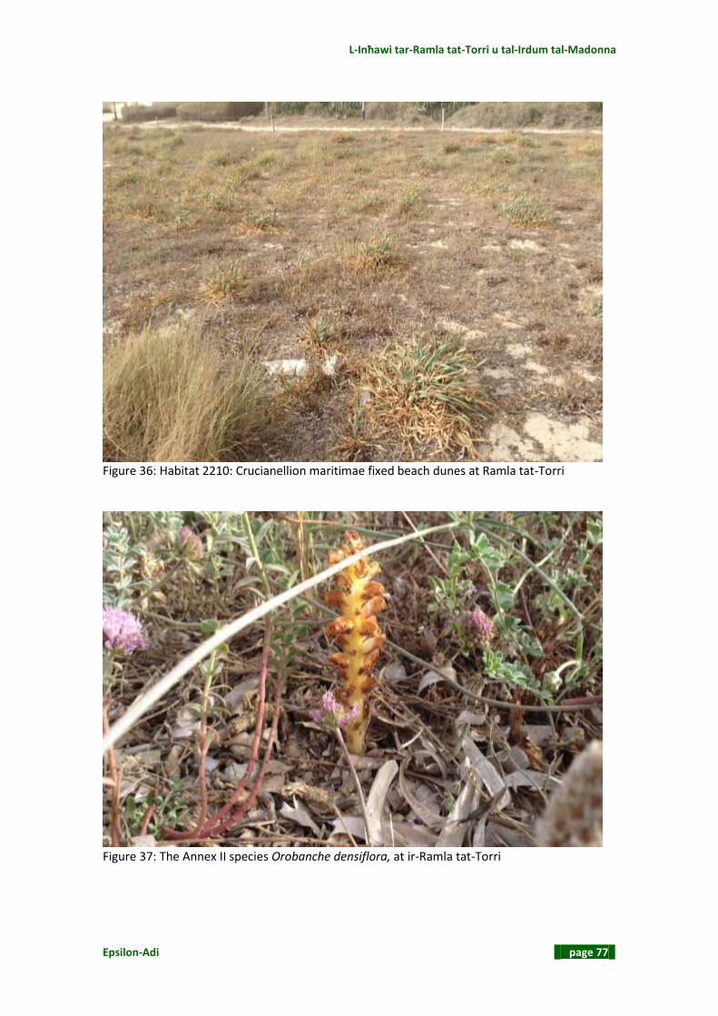
L-Inħawi tar-Ramla tat-Torri u tal-Irdum tal-Madonna
Epsilon-Adi page 77
Figure 36: Habitat 2210: Crucianellion maritimae fixed beach dunes at Ramla tat-Torri
Figure 37: The Annex II species Orobanche densiflora, at ir-Ramla tat-Torri

Natura 2000 Management Plan
page 78 Epsilon-Adi
2.10 SPECIES
2.10.1 Annex II Plant Species Both of the two Annex II plant species recorded in the last standard data form (SDF, 2012), were encountered in the field survey, see Figure 39, Anacamptis urvilleana was observed through the presence of dried up flower stalks in habitat 5330 at Rdum il-Ħmar. Orobanche densiflora (Rare, Rest in MI) was more common, being encountered both as fresh flower stalks at ir-Ramla tat-Torri, and as dried up stalks growing on Lotus cytisoides all along habitat 1240 at Rdum l-Ahmar.

L-Inħawi tar-Ramla tat-Torri u tal-Irdum tal-Madonna
Epsilon-Adi page 79
Table 7: Conservation Status of Annex II species
Annex II Species
Code Range Size of population Habitat for the species Future prospects Current
condition
Anacamptis urvilleana
4102 B This species was observed from dried up plants during the site surveys carried out in the third week of May. This is beyond the flowering season for this species, however it is also recorded in the SDF of 2012. No other observations were made throughout the rest of the SAC. In view of the lack of precise knowledge of the range of this species from the Article 11 range maps provided by MEPA, the lack of confirmed sightings of this species during the site surveys, and the absence of any sizeable populations of importance belonging to this species from the area (Personal communication, Lanfranco Edwin, 2013), a precise scoring for the range of this species cannot be assigned. There is sufficient expert knowledge however to safely assume that the range is neither favourable nor bad. In view of this, it is thus being assumed that the range of this species within the SAC is Inadequate.
Indeterminate No data is available on the size of the population at site level. However from the lack of sightings of fresh specimens during the surveys carried out for this project, the absence of knowledge of any sizeable populations in the area (Personal communication, Lanfranco Edwin, 2013), and the restricted range observed during the surveys, it is assumed that the size of the population is not favourable. In the absence of more data, there is insufficient expert knowledge to safely assume whether the size of the population is inadequate or bad, and is thus being left unassigned.
B2 The species is found in karstic habitats including phrygana and xeric grasslands, often subjected to human-induced pressures. In general, the habitat is large and common but suffering from considerable anthropogenic pressure on a national level including trampling, vandalism, leisure activities and other human impacts. This pressure is limited in area but due to the creation of ecological islands (e.g. clay slopes), populations in such habitats may be relatively isolated in some areas. The dried up plants observed in the garrigue coincided with habitat 5330. No other specimens were observed in other locations. This habitat was found to have an average or partially degraded structure. In view of this, the prospects for the structure and functions of this habitat are considered
C In view of the existing information, assumptions based on the distribution map prepared following the site survey, and the state of conservation of the habitat supporting this species, it is being assumed that the future prospects for this species are bad. However, there is not enough information to assign a scoring that describes whether the future prospects are improving, stable or deteriorating.
C

Natura 2000 Management Plan
page 80 Epsilon-Adi
Annex II Species
Code Range Size of population Habitat for the species Future prospects Current
condition
to be inadequate but stable.
Orobanche densiflora
4106 A This species was found to be relatively common, and found throughout habitat 1240 in the north-western part of this SAC, and in the sand dunes at ir-Ramla tat-Torri. According to the report for surveillance under Article 11 for Annex II species, this species was previously thought to be confined to sand dunes, but has in the past 15 years been observed in coastal maritime phrygana communities within Mellieha and eastern Malta. This species was noted to be common in the site, particularly on garrigue belonging to habitat 1240. The main host of O. densiflora is Lotus cytisoides. which was recorded as being frequent at Ramla (Vella, 2003). In view of this, the prospects for the range for this species are considered to be favourable.
A The species was seen to be common throughout habitat 1240 in the north-eastern part of the site. Moreover it was also found in more than one habitat type, suggesting that its conservation is ensured through its distribution in more than one habitat within this SAC. In view of this, the prospects for the size of the population are favourable.
B The habitat supporting this species was habitat 1240 and the sand dune habitats. The structure of both habitats was considered to be average to well conserved with poor prospects for the sand dune habitat, in lieu of the prevalent disturbance. In view of this, the prospects for this habitat are thought to be inadequate and stable.
B1 In view of the existing information, and the state of conservation of the habitat supporting this species, it is being assumed that the future prospects for this species are Inadequate but improving. If the size of the population of its host (Lotus cytisoides) is stable or continues increasing, then the future prospects should also improve.
B

L-Inħawi tar-Ramla tat-Torri u tal-Irdum tal-Madonna
Epsilon-Adi page 81
2.10.2 Other Plant Species Apart from the two Annex II species noted on site, Barbara & Raine (2010)4, as well as the SDF, identify a list of floral species of conservation significance. These are presented in Table 8. Table 8: Other plant species of conservation significance
Species Red data book
status Notes from published literature
Allium amethyistinum
Rare, Rest in Maltese Islands
Noted in the SDF.
Allium lojaconoi Endemic Noted in the SDF
Ammophila littoralis
Extinct? The RDB notes that this species used to exist on a number of sand dunes. All populations have, however, been eradicated. The last to disappear was the population at Ramla tat-Torri. Barbara & Raine (2010) note the importance of this species as a dune builder and sand binder, thus encouraging the establishment of other dune flora. Barbara & Raine (2010) make reference to the possibility of a remaining seed bank at Ramla tat-Torri.
Anthemis urvilleana
Endemic Frequent in coastal habitats. Noted in the SDF.
Bupleurum semicompositum
Endangered, Rest in Maltese Islands
The RDB lists this species as being confined to the Rdum tal-Madonna area. Barbara & Raine (2010) make reference to Lanfranco’s discovery of this species at White Tower Bay specifically. However, it may now also be extinct in this area.
Calystegia soldanellus
Extinct (?) Mentioned in Barbara & Raine (2010) because its presence was last noted from White Tower Bay. The RDB considers that this species is long extinct, however, it was last recorded from White Tower Bay in 2001 (Conrad et al, 2007)
5.
Carlina involucrata Rest Med Noted in the SDF
Convolvulus oleifolius
Noted in the SDF and in the 2013 survey.
Crucianella rupestris
Rest in Med Noted in the SDF
Cutandia maritima Rare, Rest in the Maltese Islands
Confined to sand dunes; noted in the SDF.
Cyperus capitatus Rare, Rest in the Maltese Islands
Confined to sand dunes, the RDB notes this species’ decline; noted in the SDF.
Darniella melitensis
Endemic Key species of the rdum communities, palaeoendemic, noted in the SDF.
Daucus rupestris Rest in Med & MI
Sub-endemic noted in the SDF.
Daucus lopadusanus
Unknown status, Rest in Med
A Pelago-Maltese endemic; noted in the SDF.
Echinophora spinosa
Endangered, Rest in Maltese
Recorded as having disappeared from Ramla tat-Torri in the RDB, Conrad et al (2007) recorded it in 2001.
4 Barbara N. & Raine H. (eds) (2010). Management Plan for the Ramla tat-Torri/Rdum tal-Madonna Area
Natura 2000 site MT0000009. Ta’ Xbiex, Malta: EU LIFE Yelkouan Shearwater Project. 5 Conrad, E., Cassar, L., Deidun, A. 2007. White Tower Bay Management Plan (Ir-Ramla tat-Torri), ERA.

Natura 2000 Management Plan
page 82 Epsilon-Adi
Species Red data book
status Notes from published literature
Islands
Erodium lacinatum Vulnerable Confined to sandy habitats, the RDB notes that populations have been declining. Conrad et al (2007) consider that the population at White Tower Bay could be a unique variant.
Eryngium maritimum
Vulnerable, Rest in Maltese Islands
Confined to sand dune habitats; in decline (RDB, 1989). Conrad et al (2007) consider that the population at White Tower Bay could be a unique variant.
Euphorbia exigua var. pycnophylla
Rest in Med Considered as potentially a Pelago-Maltese endemic. Fairly frequent on exposed rocky ground close to the sea (RDB, 1989).
Euphorbia melitensis
Endemic Very similar to Euphorbia exigua var. pycnophylla, the RDB notes that these species could be identical or geographical races.
Euphorbia peplis Endangered, Rest in Maltese Islands
Sand dune species in decline. Pioneer species for colonisation of sediment. Cassar & Stevens (2002) consider that White Tower Bay is likely to be the only remaining location for this species. Pioneer species for colonisation of sediment.
Euphorbia terracina
Vulnerable, Rest in Maltese Islands
Sand dune species in decline (RDB, 1989).
Limonium melitensis
Endemic Important component of coastal communities; noted in the SDF.
Limonium zeraphae
Endemic, Rare, Rest in Maltese Islands
Seems confined to low-lying coastal rocks in the north (RDB, 1989).
Pancratium maritimum
Vulnerable, Rest in Maltese Islands
Sand dune species; noted in SDF.
Plantago bellardi Very rare, Rest in Maltese Islands
Noted in the SDF.
Plantago crypsoides
Unknown status, Rest in Med
Noted in the SDF.
Polygonum maritimum
Endangered, Rest in the Maltese Islands
Sand dune species, in decline; noted in SDF.
Pseudolarya pumila
Endangered, Rest in the Maltese Islands
Important component of dune grasslands, became extinct from this area following the development of boathouses Barbara & Raine, 2010).
Putoria calabrica Vulnerable, Rest in Med and Maltese Islands
Noted in the SDF.
Schoenus nigricans Very rare, Rest in Maltese Islands
A garrigue species, Rdum tal-Madonna listed as the only place where this species occurs (Barbara & Raine, 2010)
Sedum litoreum Rare, Rest in Maltese Islands
Restricted to a few coastal areas.
Thymus capitatus A dominant garrigue component noted during the 2013 surveys. The RDB mentions this species given its importance in the Maltese flora, noting that it is often the dominant shrub of Maltese garrigues.

L-Inħawi tar-Ramla tat-Torri u tal-Irdum tal-Madonna
Epsilon-Adi page 83
Species Red data book
status Notes from published literature
Tamarix africana Rare, Rest in Med and Maltese Islands
White Tower Bay hosts some old specimens (Barbara and Raine, 2010)
Urginea pancration
Rest in Med Dominant ermes species noted throughout the site in 2013 surveys (also see Cassar et al (2004) and Fava et al (1996)
2.10.3 Fauna Invertebrates Endemic invertebrates noted by Barbara & Raine (2010) include Trochoidea spratti, Papilio machaon melitensis and Hyles sammuti. Other species of conservation importance recorded from White Tower Bay include Prionyx kirbii (only known from this site), Prionyx viduatus, Pseudoseriscius cameroni, Anthicus fenestratus, Anthicus tristis tristis, Achenium striatum and Philanthus traingulum. Cassar and Conrad (2008) found the Annex II Brachytrupes megacephalus in at least three separate locations of this SAC. The Annex II psammophilic tenebrionid beetle, Pseudoseriscius cameroni was recorded from White Tower Bay. Neither species are noted in the SDF

Natura 2000 Management Plan
page 84 Epsilon-Adi
Table 9: Brachytrupes megacephalus at Ramla tat-Torri/Rdum tal-Madonna SAC
Annex II Species
Code Range Size of population Habitat for the species Future prospects Current
Condition
Brachytrupes megacephalus
4047 A B. megacephalus has been recorded recently by L.F.Cassar and E. Conrad from three localities within the Ramla tat-Torri/Rdum tal-Madonna SAC, namely Rdum il-Griewi/Daħlet tax-Xilep, L-Ahrax tar-Ramel and Dahlet ix-Xmajjar (Cassar & Conrad 2008) (see map below). The range of the species within this SAC appears to be Favourable and possibly increasing.
Indeterminate The species was first recorded in three localities within the Ramla tat-Torri/Rdum tal-Madonna SAC by L.F. Cassar and E. Conrad in 2008. Although the authors did not give any quantitative data on population size, L.F.Cassar has stated that in 2011 the population in each of the three localities was in the range of 10 – 20 individuals (L.F. Cassar, personal communication). Given the absence of consistent trend data, and an understanding of the minimum viable population, it is considered that the adequacy of the recorded size of the population cannot be evaluated at this stage and is assigned indeterminate.
A The typical habitat of B. megacephalus in Sicily and other localities Malta is coastal sandy localities. At the three localities in the Ramla tat-Torri/Rdum tal-Madonna SAC, however, it has become apparent that B. megacephalus is capable of inhabiting other habitat types. The locality designated as Dahlet ix-Xmajjar is typified by “consolidated sandy soil, representing a complex derived from beach sand, valley sediment and imported soils” (Cassar & Conrad, 2008). Of the three localities, this habitat is the closest to the typical sand dune habitat of the species. Ahrax tar-Ramel is a karstic site adjacent to agricultural land, providing a substrate of naturally occurring terra rossa soil mixed with traces of fine aeolian sand particles. At this site some specimens were noted near to and within intensively
A Based on existing information and the status of the habitat supporting the species the future prospects for the species at the Ramla tat-Torri/Rdum il-Madonna SAC are being recorded as being favourable.
B

L-Inħawi tar-Ramla tat-Torri u tal-Irdum tal-Madonna
Epsilon-Adi page 85
Annex II Species
Code Range Size of population Habitat for the species Future prospects Current
Condition
cultivated land indicating that the species can successfully live in such habitat. This observation is supported by the presence of another population at Tad-Damma (which lies outside the SAC) living almost entirely on agricultural land. The habitat at the third site (Rdum il-Griewi/Daħlet ix-Xilep) differs considerably from the typical sand dune habitat to which the species was previously thought to be restricted. Cassar & Conrad describe it as “a geological conglomerate…. Which has been rendered friable through boulder scree dynamics and mass movement, intermittently pocketed with Quaternary age and modern soil deposits”. They observed that at this site the species displayed an ability to burrow in a considerably harder substrate (Cassar & Conrad, 2008). No information is available on predators.

Natura 2000 Management Plan
page 86 Epsilon-Adi
Annex II Species
Code Range Size of population Habitat for the species Future prospects Current
Condition
In view of the information available, and the fact that the species has colonised habitats with differing characteristics, the habitat for the species has been assigned favourable status.
Pseudoseriscius cameroni
4025 B3 Within the Ramla tat-torri/Rdum tal-Madonna SAC the species is restricted to the coastal sand dunes at the rear of the sandy beach of White Tower Bay (Ramla tat-Torri). The range is restricted to a habitat that is exposed to some disturbance from potential trampling, it is considered that the range of this species is inadequate and deteriorating in view of the considerable anthropomorphic pressure on the dunes (which are really dune remnants) resulting from beach users.
A This endemic species was first recorded in the Maltese Islands in 1902 at Mellieha in Malta by Edmund Reitter. (Reitter, 1902). It has not been seen again in that locality but in 1998 D. Mifsud and A. Scupola found the species in Ramla l-Ħamra in Gozo (Mifsud & Scupola, 1998). In 2004 Lillig et al. recorded the species from Ramla tat-Torri, (White Tower Bay within the Ramla tat-Torri/Rdum il-Madonna SAC) and from Armier Bay which lies outside this SAC. The population there was quite sizeable and has remained so to date. (David Mifsud, personal communication). However, it is debatable whether the population represents original stock or
C P. Cameroni is restricted to coastal sand dunes, including embryonic dunes and semi-consolidated to fixed dunes with Euphorbia terracina and the Centaureo-Ononidetum ramosissimae communities. It is found under large stones embedded in the sand or associated with the root systems of dune vegetation such as Pancratium maritimum. Such habitats are very rare in the Maltese Islands and locally threatened, as they are subjected to a number of anthropomorphic and abiotic pressures. In view of the information available, the state of conservation of the sand dune habitat supporting this species and the
B2 Based on existing information on population size and the status of the habitat supporting the species, the future prospects for the species are being recorded as Inadequate and stable.
B

L-Inħawi tar-Ramla tat-Torri u tal-Irdum tal-Madonna
Epsilon-Adi page 87
Annex II Species
Code Range Size of population Habitat for the species Future prospects Current
Condition
whether the species was introduced deliberately or accidentally from the Ramla l-Hamra population. One possibility is that sand samples from Ramla l-Ħamra brought over to Malta for analyses were disposed of at Ramla Tat-Torri. (David Mifsud, personal communication). In view of information currently available, the size of population is being categorised as Favorable and stable.
anthropomorphic pressures to which the site is subject, prospects for the habitat for this species are considered to be inadequate and deteriorating.

Natura 2000 Management Plan
page 88 Epsilon-Adi
Figure 38: The three locations in which Brachytrupes megacephalus has been recorded within the Ramla tat-Torri/Rdum tal-Madonna SAC.

L-Inħawi tar-Ramla tat-Torri u tal-Irdum tal-Madonna
Epsilon-Adi page 89
Reptiles The boulder scree supports Tarentola mauritanica, Hemidactylus turcicus turcicus, Chalcides ocellatus tiligugu, Coluber viridiflavus carbonarius and Zamenis situla (Annex II Habitats Directive). This latter species was noted by Barbara & Raine (2010) to mainly occupy garrigue habitat and field verges within this site where it feeds on small animals. The assessment of zamenis situla is presented in Table 10. Mammals Mammals recorded at the site include Pipistrellus sp., Rhinolophus hipposideros, Oryctolagus cuniculus, and Atelerix algirus. Plecotus austriacus and P. pipistrellus and P. kuhlii roost in the crevices of the cliff-face. Birds Table 11 presents breeding bird numbers at Rdum tal-Madonna as presented by Barbara et al (2010). This data was gathered during a survey carried out in 2008.

Natura 2000 Management Plan
page 90 Epsilon-Adi
Table 10: Assessment of Zamenis situla
Annex II Species
Code Range Size of population Habitat for the species Future prospects Current
condition
Zamenis situla 1293 Indeterminate The species occurs in a variety of habitat types. Barbara & Raine (2010) make reference to it feeding maintly in garrigue habitat and field verges in general. In the absence of more detailed, site specific information, the range is therefore indeterminate. Targeted condition: Zamenis situla occupies its full range within the site.
Indeterminate There is no data on the population size of this species at this site. The population size is therefore indeterminate. Targeted condition: Population size of Zamenis situla is at least maintained.
A As reported in the EIONET fact sheet, local habitats for this species include garrigue, rocky steppes, valleys, field edges, gardens, dry stone walls, boulder and stone piles. Micro habitats include crevices and cavities in walls and rocks, and among stones. The Rdum tal-Madonna SAC provides ample suitable habitat for this species, which is considered to be favourable in the absence of significant disturbance. Targeted condition: The habitat for Zamenis situla is maintained.
Indeterminate In the absence of sufficient data of range and population within the site, the future prospects for this species are indeterminate. However, threats to the species include the use of pesticides, restructuring of agricultural land holds, removal of specimens, and interventions to/within habitats and to habitat features that could result in disturbance. Targeted condition: Future prospects for Zamenis situla are favourable.
Indeterminate

L-Inħawi tar-Ramla tat-Torri u tal-Irdum tal-Madonna
Epsilon-Adi page 91
Table 11: Birds
Species Population size
in breeding pairs
Description
Puffinus yelkouan
366-544 An Annex I seabird belonging to the family Procellariidae, which characteristic feature is a pair of tube-like nostrils on the end of their beak to filter out salt. Feeds mainly on small fish, crustaceans and cephalopods. L-Irdum tal-Madonna supports the largest colony of breeding Yelkouan Shearwaters in the Maltese Islands. The birds start to arrive at the colony to breed in October, flying in at night. Eggs are laid at the end of Feb-beginning March. The egg is laid on bare ground in a burrow or crevice. Nesting sites are located from 2-120m above sea level, although some nests are closer to the top of the cliffs. Incubation is carried out for about 50-52 days, and both partners take part. Chicks hatch in third week of April. The birds leave the colony at the end of July. Birds reach breeding maturity in their third or fourth year, although some juveniles may return to the colony in the meantime. This species breeds alongside Calonectris diomedea and also Hydrobates pelagicus. Direct competition is avoided because breeding seasons are slightly out of synch. P. yelkouan begin breeding earlier than C. diomedea. Each species is then undertaking different aspects of this phase and in this way competition for food is minimised e.g. when P. yelkouan are feeding the young, C. diomedea are incubating. However, cases of nest eviction of P. yelkouan by C. diomedea have been recorded (Sultana et al, 2011). In the past, it has been known that fishermen take these birds at sea to use as bait. Between 2000-2006 the main cause of Yelkouan mortality was rat predation. Other causes included predation by domestic ferrets Mustela putorius furo and/or possibly wild Weasels. Increased human disturbance result in reduced numbers returning to the breeding colony in following years. Another threat to this species is light sources on the mainland. Attracted by the light fledglings have been recovered inland where they were found to be disoriented (Sultana et al, 2011). In 2008, IUCN and Birdlife International revised this species status from Secure to Near Threatened.
Calonectris diomedea
8-10 An Annex I seabird. Feeds mainly on pelagic fish and crustaceans. This species makes its first landfall just prior to breeding in late February. By the second week of March, many of the birds have reached the colony, paired up, set up nest and mating begins. A single egg is then usually laid at the end of May. The egg is laid on bare ground, although this is often surrounded by material such as dry twigs, feathers and pebbles. All females lay their eggs within a few days of each other. Both parents incubate, with the male taking the first incubation sitting, which on average lasts 4.5 days (Sultana et al, 2011). Incubation lasts up to 52 days. The main fledging period is the first half of October, and the colony is generally deserted by the end of October. Males start to breed aged 4-6, whilst females reach maturity in their 5
th or 6
th year. This species exhibits strong site tenacity,
with pairs using the same nests year after year. Lifespan can exceed 25 years. C. diomedea prefers nesting sites with extensive vegetation cover (Sultana et al, 2011). Breeding success in the Maltese Islands is deemed to be relatively low and is attributed to direct human persecution and predation by rats, cats, and dogs. This species has been provisionally rated as Vulnerable by Birdlife International.
Calandrella brachydactyla
3-6 Annex I. Common migrant and summer breeding visitor. Feeds on insects and seeds. Suitable breeding habitat is open, dry, treeless countryside including agricultural land, garrigue, steppe and airfields (Sultana et al, 2011). Territory is established by late March and nest-building starts in April, by the female. The nest is made by digging a small hole in the soil, this is then line

Natura 2000 Management Plan
page 92 Epsilon-Adi
Species Population size
in breeding pairs
Description
with rocks and vegetative material. Eggs are laid in mid-April with an average clutch size of 3-5 eggs. The female incubates the eggs for approximately 13 days. The hatchlings are fed by both parents. The young leave the nest even before they can fly, they are fully fledged in May (earliest broods) until July (later broods). Adults generally raise 2 broods. Sultana et al (2011) analyse previous records on breeding bird distribution, of this species. Overall, there appears to have been a reduction in its distribution, having disappeared from large areas of eastern Malta. This species has been negatively affected by the spread of intensive agriculture, and it is in fact noted as a relevant species in the Farmland Bird Report (Birdlife Malta, 2008). Moreover, urban sprawl, taking up agricultural land has resulted in loss of this species’ breeding habitat. In the past, trapping was an important threat to this species. This has been reduced, however, some birds are still caught illegally by trappers using clapnets (Sultana et al, 2011). A 10% reduction in population of this species also occurred over Europe between 1970 and 1990. Birdlife International has declared this species a European Species of Conservation Concern and its status is considered to be Declining.
Monticola solitarius
4-6 Resident. Breeds predominantly in cliff areas but also recorded inland along hills, rocky valleys, quarries and fortifications (Sultana et al, 2011). Diet includes insects and reptiles. Considered to be a farmland bird species relevant to Malta (Birdlife Malta, 2008). Eggs are laid in March, incubation lasts approximately 15 days, mainly by the female. The young fledge between end of April and June. Two broods are usually reared in a season. Sultana et al (2011) make reference to the fact that human disturbance has led to this species having to nest in relatively inaccessible places, e.g. the cliffs. Threats to the species included urbanisation, direct nest disturbance and egg stealing. Birdlife International has evaluated the status of this species as Depleted overall and it is a European Species of Conservation Concern.
Sylvia conspicillata
1-2 Frequent breeding resident and farmland bird species (Birdlife Malta, 2008). Feeds mainly on invertebrates and also eats berries. Preferred habitat is dry open countryside and garrigue along the coast. The population in the Maltese Islands has declined. This species is vulnerable to extreme environmental conditions such as relatively cold winters. Other impacts have been as a result of mechanisation of agricultural practices, unregulated use of pesticides and increased human presence in the countryside (Sultana et al, 2011).
Passer hispaniolensis
20-25 Abundant breeding resident with widespread distribution in the Maltese Islands. Feeds on plant material and invertebrates but will also scavenge for food such as bread crumbs in urban environments. Nest building starts in February and the breeding season lasts until August. Birdlife International describes the European population as Secure.
Sylvia melanocephala
5-15 Four races are recognized, the nominate melanocephala, inhabits the Mediterranean including the Maltese Islands. Feeds mainly on invertebrates and fruit, also known to make use of bird tables, and drink nectar. Dispersal agent for several species of shrub. Breeding distribution for this species covers most of the larger islands of the Maltese Islands. Breeding occurs between mid-February and mid-July. Clutches of 4 eggs are most commonly recorded. Incubation takes about 13 days and the young fledge at 12-13 days old. Both male and female are involved in incubation and brooding. This species sometimes carries ectoparasites including Hippoboscidae flies and Penenirmus sp. lice. The success of this species is attributed to its high adaptability. Threats to this species may include use of pesticides and insecticides, nest predation by snakes and rats, and urban

L-Inħawi tar-Ramla tat-Torri u tal-Irdum tal-Madonna
Epsilon-Adi page 93
Species Population size
in breeding pairs
Description
development.
Cisticola juncidis
2-4 Three races occur in the Western Palearctic. Feeds mainly on insects and arachnids. This is a common, widespread, and largely sedentary species. It breeds in a wide range of habitats, grasses and rushes provide most suitable habitat so wetlands and watercourses offer preferred breeding grounds. It also breeds in cereal fields and abandoned agricultural land. Breeding season ranges between mid-February to August. A clutch normally consists of 4-5 eggs. Incubation (about 12-13 days) and brooding (about 13-15 days) is carried out solely by the female. A female tends to raise about 3 broods a year. Aggressively defend their young. Polygynous. Following the breeding season, individuals often roost together in rushes and other grasses. Threat from nest/egg predation by snakes and rats, may be vulnerable to insecticides and pesticides, and urban development.

Natura 2000 Management Plan
page 94 Epsilon-Adi
The SDF includes Falco peregrinus at this site. This Annex I species is an irregular breeding resident and a scarce visitor (Sultana et al, 2011) and it has not been recorded as breeding at the site either by Barbara & Raine (2010) or Sultana et al (2011). This bird passes over Malta in March and September. Barbara & Raine (2010) make reference to the fact that this species no longer breeds in Malta due to persecution from poaching. Management of this activity may allow breeding pairs to become re-established (Barbara & Raine, 2010). Before the rat eradication programme carried out by Birdlife Malta as part of the LIFE+ Hydrobates pelagicus had not been recorded from this site between 1969 and 2006. Since the programme began, H. pelagicus sightings began to be recorded, however, breeding of this species at Rdum tal-Madonna has not been confirmed (Borg et al, 2010)6.
2.10.4 Assessment of Conservation Status for Species The conservation status was determined in accordance with MEPA’s 2012 draft Guidelines on Management Planning for Protected Areas in the Maltese Islands. The methodology is described in ANNEX 3: Assessment Methodology of Conservation Status.
6 Borg, J.J., Raine, H., Raine, A. 2010. Records in Malta of European Storm-petrels Hydrobates pelagicus
melitensis during the breeding season away from known breeding sites. (32)Il-Merill.

L-Inħawi tar-Ramla tat-Torri u tal-Irdum tal-Madonna
Epsilon-Adi page 95
Table 12: Conservation Status of Annex I species (Birds Directive)
Annex II Species
Code Range Size of population Habitat for the species Future prospects Current
condition
Puffinus yelkouan
A464 A
The Upper Coralline Limestone cliff and boulder scree community at l-iRdum tal-Madonna provides breeding for the P. yelkouan breeding population. This site supports the largest breeding population in the Maltese Islands (Raine et al, 2012)
7. The
range/distribution within the site is considered to be favourable.
A
The breeding population at l-irdum tal-Madonna is approximately 500 pairs. This is the largest breeding bird population in the Maltese Islands. Following recent conservation efforts by Birdlife Malta, including rat eradication, an education campaign, and reduction in taking and killing of birds (e.g. as a result of ferreting), the breeding success rate of this species has increased at this site (Raine et al, 2012). The size of the population (and increasing trend) is considered to be favourable.
A
This species is a seabird and therefore, apart from its terrestrial breeding habitat, it is also highly dependent on the marine environment, where it forages and spends much of its time, coming to land only at night (Sultana et al, 2011). The marine area opposite the colony is an important rafting area (Raine et al, 2010
8; Sultana
et al, 2011). However, relatively little is known about this species’ behaviour in the marine environment (Raine et al, Marine Protection Areas)
9.
In terms of breeding habitat (i.e. in the terrestrial environment), this species nests in cavities and screes at l-irdum tal-Madonna. This habitat type (cliffs and screes) was described as
A
Although l-irdum tal-Madonna support the best breeding population of this species in the Maltese Islands, nonetheless, the population continues and will continue to face a number of threats. Some of these continue to be managed (including the rat eradication programme), however, others have yet to be adequately addressed. One such issue relates to light pollution. Raine et al (2007) considered the effect of light pollution on the P. yelkouan colony. They identified a number of sources of light pollution that pose a threat to the colony due to disorientation both of birds returning to nests and to fledgings. Light pollution sources in the area
A
7 Raine, A.F., Borg, J.J., Raine, H., Philips, R.A. 2012. Migration strategies of the Yelkouan Shearwater Puffinus yelkouan. J Ornithol
8 Raine, A., Raine, H., Meirinho, A., Borg J.J. 2010. Rafting behaviour of Yelkouan Shearwater Puffinus yelkouan breeding at Rdum tal-Madonna, Malta. (32). Il-Merill.
9 Raine, H., Borg, J.J., Raine, A. Marine Special Protection Areas: A report outlining national mechanisms being used to develop the Marine IBA/SPA programmes
across Europe with recommendations for Malta. Birdlife Malta, Heritage Malta.

Natura 2000 Management Plan
page 96 Epsilon-Adi
Annex II Species
Code Range Size of population Habitat for the species Future prospects Current
condition
having a good degree of conservation when considering terrestrial habitat (see Table X).
Therefore the nesting sites themselves can be considered to be favourable habitat for these breeding birds remains in a favourable condition.
include Cirkewwa, White Tower Bay, Ghadira, Mellieha, Bugibba, and Rdum tal-Madonna.
Threats at sea should also be considered. Light pollution from boats are also known to have negative effects (Raine et al, 2007).
Other threats at sea include threats to bird mortality from bycatch. The greatest threat to shearwaters, is from long lines (Dimech et al, 2008)
10.
Monitoring of the significance of such impacts on the population is required in order to obtain a better understanding of the risk to the population. In the context of the five-year plan and the existing status of the other parameters for this species, assuming no major impacts are introduced to the site in the meantime and assuming that existing management
10
Dimech, M., Darmanin, M., Caruana, R., Raine, H. 2008. Preliminary data on seabird by-catch from the Maltese long line fishery (Central Mediterranean). SCRS.

L-Inħawi tar-Ramla tat-Torri u tal-Irdum tal-Madonna
Epsilon-Adi page 97
Annex II Species
Code Range Size of population Habitat for the species Future prospects Current
condition
measures (such as rat population control) continue to be implemented, the future prospects of this species are, for the time-being considered to be favourable.
Calandrella brachydactyla
Unknown
Although this species is known to breed in agricultural land, garrigue and steppe and breeding pairs have been recorded from this SAC, its distribution within the site is not known.
C
A small breeding population of 3-6 pairs has been recorded in this area. Breeding success of this species has been noted to be at just over 50% by Sultana et al (2011). John J Borg (personal communication, 2013) notes that this breeding population size is considered to be bad in the context of the extent of suitable habitat that is present at this SAC/SPA. In the absence of further data it is not clear whether the status is improving, stable or worsening.
C3
As noted in Table X above, an extent of the garrigue within the site, such as that at Rdim l-Hmar and it-Torri l-Abjad that could provide breeding habitat is degraded and continues to be impacted from human disturbance due to the fact that the site is popular for a number of recreational activities, such picnicking, which often is carried out directly on the garrigue. Damage to the garrigue as a result of trapping has also been noted by Barbara & Raine (2010). Habitat for the species is considered to be in a bad state that is declining as a result of consistent disturbance with little to no mitigation.
C3
Poor quality habitat and poor breeding pair numbers suggest that future prospects for the breeding population of this species at this site are bad. In the absence of interventions to manage threats, it is considered likely that the population will continue to decline. Threats to this species noted by Barbara & Raine (2010) include inappropriate access, fires, trampling, offroading, and inappropriate agriculture.
Unassigned
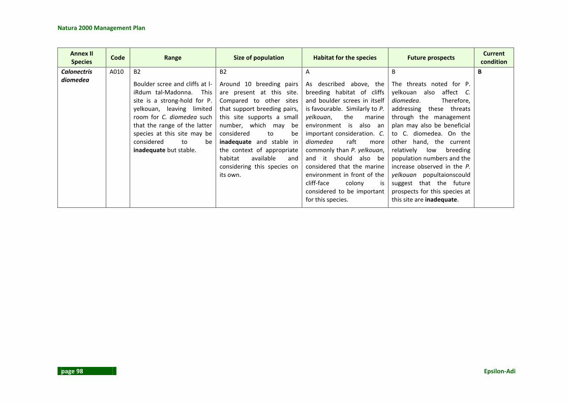
Natura 2000 Management Plan
page 98 Epsilon-Adi
Annex II Species
Code Range Size of population Habitat for the species Future prospects Current
condition
Calonectris diomedea
A010 B2
Boulder scree and cliffs at l-iRdum tal-Madonna. This site is a strong-hold for P. yelkouan, leaving limited room for C. diomedea such that the range of the latter species at this site may be considered to be inadequate but stable.
B2
Around 10 breeding pairs are present at this site. Compared to other sites that support breeding pairs, this site supports a small number, which may be considered to be inadequate and stable in the context of appropriate habitat available and considering this species on its own.
A
As described above, the breeding habitat of cliffs and boulder screes in itself is favourable. Similarly to P. yelkouan, the marine environment is also an important consideration. C. diomedea raft more commonly than P. yelkouan, and it should also be considered that the marine environment in front of the cliff-face colony is considered to be important for this species.
B
The threats noted for P. yelkouan also affect C. diomedea. Therefore, addressing these threats through the management plan may also be beneficial to C. diomedea. On the other hand, the current relatively low breeding population numbers and the increase observed in the P. yelkouan popultaionscould suggest that the future prospects for this species at this site are inadequate.
B

L-Inħawi tar-Ramla tat-Torri u tal-Irdum tal-Madonna
Epsilon-Adi page 99
Table 13: Conservation Status of non-Annex I Article 4 breeding birds Non-Annex I,
Article 4 breeding birds
Code Range Size of population Habitat for the species Future prospects Current
condition
Monticola solitarius
A281 A This species is known to breed in the cliff area at Rdum tal-Madonna (Barbara & Raine, 2010). This species is thus exploiting its full range within the site which is judged to be favourable.
A The site supports a stable population of breeding pairs; 4-6 pairs (Barbara & Raine, 2010). The established breeding pairs and favourable habitat for both breeding and feeding suggest that the site supports a favourable population.
A This species nests in crevices in the seacliffs, of which Rdum tal-Madonna offers ideal habitat. During the breeding season, the adult birds frequently forage for small reptiles, snails, grasshoppers, and other insects in the hinterland, often frequenting rubble walls and outcrops (Borg, 2005)
11. In view of its
ecological requirements, Rdum tal-Madonna is considered to offer favourable habitat for this resident species.
A The range, population size and habitat for this species are judged to be favourable. This species future prospects are also considered to be favourable in the absence of any high, negative, impact resulting from one or more factors.
A
Sylvia conspicilliata
A303 A This species is located within the site in the areas that are suitable to its ecological needs and therefore range is considered to be favourable despite the low number of breeding
C This species used to be a common breeder, however, the population experienced a drastic decline in the 1980s. The population has not yet fully recovered. At least 2 breeding pairs have been confirmed breeding at
C3 Barbara & Raine (2010) report that this species nests in low scrub, preferring Inula crithmoides and Carlina corymbosa and small saplings of Cupressus sempervirens. The habitat quality at Rdum tal-
C3 In view of the findings with respect to range and population numbers, the future prospects for this species at this site are considered to be bad and declining in the absence of active management to
C
11
Borg, J.,J. 2005. Technical Appendix 3: Avifauna Baseline Survey. Supporting document fo

Natura 2000 Management Plan
page 100 Epsilon-Adi
Non-Annex I, Article 4
breeding birds Code Range Size of population Habitat for the species Future prospects
Current condition
pairs that occur and the relatively poor structure and function of available habitat.
Rdum tal-Madonna (Barbara & Raine, 2010). Given the indication that the species has not yet recovered, population numbers are considered to be bad.
Madonna is considered to be bad and declining largely as a result of anthropogenic impacts.
safeguard breeding habitat. Factors affecting this species include predation mainly by the Western Whip Snake, and loss of nests as a result of grazing, human disturbance and bad weather.
Sylvia melancocephala
A305 A This species occupies the woodland habitat at Rdum tal-Madonna. The species is thus occupying its favoured habitat within the site and therefore the range is considered to be favourable.
A 5-15 breeding pairs are noted by Barbara & Raine (2010) at Rdum tal-Madonna. The population appears to be stable, and as long as it is not disturbed by poaching and trapping the population size at the size can be considered to be favourable.
A This species occupies a variety of habitats ranging from urban gardens to cultivated fields to maquis and woodland edges, importantly, with the presence of high vegetation. At Rdum tal-Madonna, this species breeds in the woodland habitat.
A Based on the range, population and habitat for this species, future prospects for this species are considered to be favourable. Threats to this species include bad weather, predation by snakes and rats, pesticides, insecticides, urban development and human disturbance.
A

L-Inħawi tar-Ramla tat-Torri u tal-Irdum tal-Madonna
Epsilon-Adi page 101
Table 14: Conservation Status of non-Annex I Article 4 migratory birds Annex I &
non-Annex I migratory
birds
Code Range Size of population Habitat for the species Future prospects Current
condition
Raptors A Migratory raptors include Circus aeruginosus, Pernis apivorus, Milvus migrans, Falco eleonorae and Circus pygargus are known to migrate over and exploit the site as necessary. The woodland area is particularly important for roosting raptors. Use of suitable habitat for these birds suggests a favourable range within the site.
A The site is of importance for migratory raptors.
C According to Barbara & Raine, 2010, the SPA does not provide adequate roosting places for these species due to excessive disturbance. The woodland habitat at Rdum tal-Madonna needs to be maintained in such a way that roosting migrants can make consistent use of this habitat. The current degree of disturbance and lack of management of the area taking migratory raptors into consideration results in an evaluation that the habitat for these migratory birds is at present bad.
C The woodland should experience minimal anthropogenic disturbance and as far as possible, increase in density to provide adequate roosting habitat. However, factors that threaten migrants include poaching, trapping and other forms of disturbance and therefore until these threats are managed, future prospects are considered to be bad.
C
Passerines A Migrant passerines resting and foraging at the garrigue and arboreal habitats within the site include Lullula arborea, Anthus campestris and Bucanetes githaginea. Given that all suitable
A Rdum tal-Madonna is important for migratory passerines.
C Due to the extent of anthropogenic influences at this site, the quality of the habitat available to migrant passerines, even in so far as the species would be undisturbed is considered to
C Suitable habitat in the form of open ground including garrigue and agricultural land should be improved and threats from poaching and illegal trapping should be removed.
C

Natura 2000 Management Plan
page 102 Epsilon-Adi
Annex I & non-Annex I
migratory birds
Code Range Size of population Habitat for the species Future prospects Current
condition
habitats are utilised, range is considered to be favourable.
be bad. Trapping and poaching practices carried out within this site and referred to by Barbara & Raine (2010) result in negative effects on migratory passerines.

L-Inħawi tar-Ramla tat-Torri u tal-Irdum tal-Madonna
Epsilon-Adi page 103
2.10.5 Agricultural Land The agricultural land along this SAC is negligible, existing solely as a few plots of land that were used extensively.
2.10.6 On-Site Observations There are a number of severe impacts that face this SAC, whose existence has led to the disturbance of the Annex I habitats, and consequently the scoring of poor conservation status for these habitats throughout most of the SAC. Compared to the other SACs in Malta, it is one of the most disturbed in the country. Table 15: On-site observations
Impact Degree Spread of
impact Background info
Littering within the Natura 2000 site
Mild/Severe Throughout This can be a severe problem in certain areas. Litter was evident in various locations throughout the SAC especially in the afforestation site and informal picnic areas.
Alien species Mild Widespread The presence of a number of alien species in Annex I habitats was an extensive problem that extends throughout the area. Though the alien species concerned were originally planted by man, these have naturalised in a number of locations. Their presence is impacting the conservation of the structure of the Annex I habitats.
Clearing of vegetation
Severe Localised This is particularly severe along the sand dunes, especially at Dahlet ix-Xmajjar, where a section of the sand dune was recently bulldozed.
Building encroachment
Severe Localised The spread of the illegal boathouses is a severe threat to the future prospects for the conservation of functions of the sand dune habitats.
Trampling by bathers
Severe Localised This is a severe problem at ir-Ramla tat-Torri, where the dune species compete with thousands of bathers each year for space on a relatively small stretch of sandy beach.
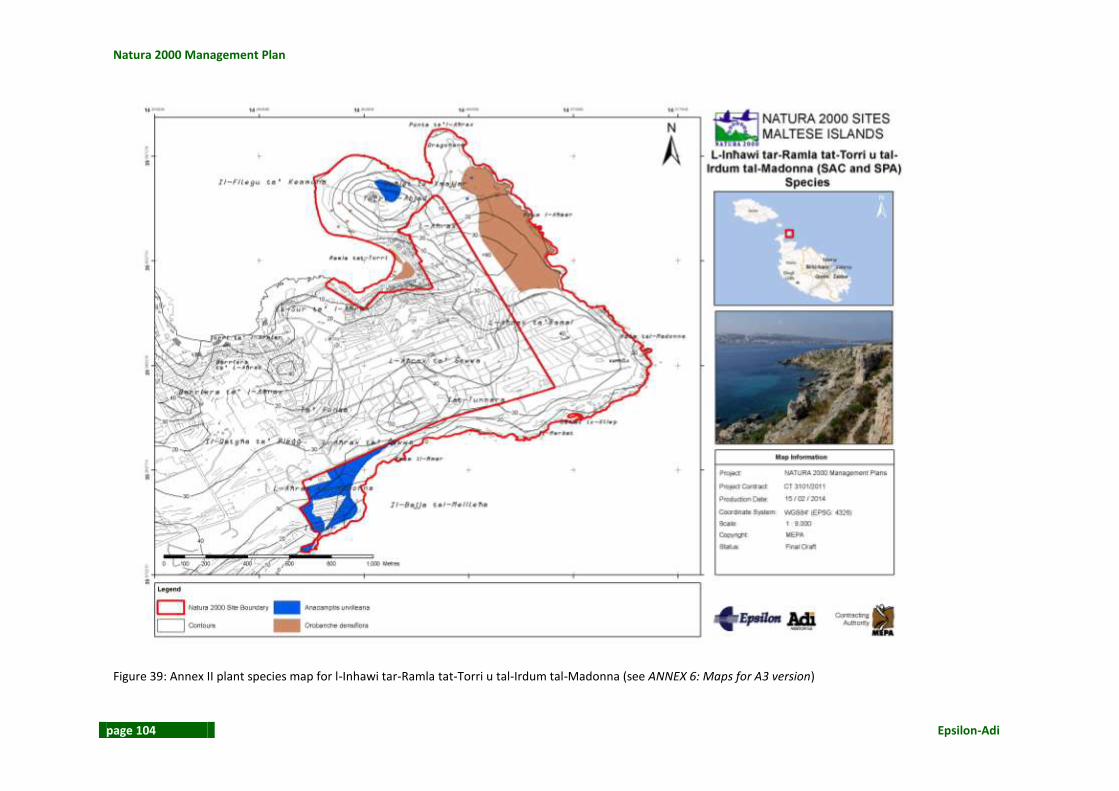
Natura 2000 Management Plan
page 104 Epsilon-Adi
Figure 39: Annex II plant species map for l-Inhawi tar-Ramla tat-Torri u tal-Irdum tal-Madonna (see ANNEX 6: Maps for A3 version)

L-Inħawi tar-Ramla tat-Torri u tal-Irdum tal-Madonna
Epsilon-Adi page 105
2.11 ANTHROPOGENIC ACTIVITIES WITHIN THE SITE The human impacts and threats inside the management plan area were evaluated since these two could have a direct or indirect impact on the site. The following land uses / activities were observed.
2.11.1 Nature Conservation As discussed above l-Inħawi tar-Ramla tat-Torri u tal-Irdum tal-Madonna is managed by Birdlife Malta through a number of projects. Interventions from MEPA and the Local Council have also been undertaken See Section on Management Infrastructure.
2.11.2 Agriculture Agricultural land is limited to the south-western part. It covers 1.3 % of the total area (9,960m2 from a total area of 749,152 m2). Agricultural activity in the area has greatly contributed in the modification of the landscape of the area.
2.11.3 Afforestation Past afforestation has led to the establishment of non-native species. This has also contributed to the changing the area’s landscape.
2.11.4 Tourism and Recreation The area is sought after both for formal and informal forms of recreation. Recreational users have been identified as having the highest impact on the area. To the north of the site there are the boathouses. These caravan / boathouses lack legal title since there is no binding contract and are found on publically-owned land and have pending enforcement notices too. These structures occupy the transitional land between agricultural land and the beach and have thus blocked sediment replenishment. It is thus unlikely that the status of the sand dunes will ameliorate unless there is some form of intervention.
The management plan area is also used by informal campers. The Mellieħa Local Council passed a bye-law to regulate the situation and limiting permits to designated areas. Notwithstanding the permitting in place the system is being abused and has resulted in the following problems: littering which deteriorates the landscape and increases the rat population, noise and light pollution which are a nuisance to bird communities breeding in the cliffs below and trampling and off-road driving which accelerate soil erosion.
The site includes a dog-friendly beach at Daħlet ix-Xmajjar.
The site is also important for diving. There is one shore dive from the area: Tunnel and Reef - L-Aħrax. This dive site is accessed from Il-Ponta tal-Aħrax. Another shore dive site which is

Natura 2000 Management Plan
page 106 Epsilon-Adi
close to the site is found at Slugs Bay. A boat dive is located to the east of the area and diver use this location for visiting the HMS Stubborn wreck.
Figure 40: Boathouses at Ir-Ramla tat-Torri
Figure 41: Daħlet ix-Xmajjar that has been designated as a dog-friendly beach

L-Inħawi tar-Ramla tat-Torri u tal-Irdum tal-Madonna
Epsilon-Adi page 107
2.11.5 Hunting and Fishing Hunting and trapping is also practised on site. The EU LIFE Yelkouan Shearwater Project (2010) identified 5 hunting hides and 29 illegal trapping sites. Trapping activities have had a negative impact on the area due to vegetation clearance and ‘screeding of karstic-land with construction material and soil’. The trapping sites noted have been mapped on site, see Figure 42. A number of enforcement notices were issued in 2010 but the occupiers were unknown.
Figure 42: Trapping sites at Rdum tal-Madonna – the blue dot indicates the active trapping site in 2009: red dots indicate non-active sites (EU LIFE Yelkouan Shearwater Project 2010)
2.11.6 Extraction None identified.
2.11.7 Water Use None identified.

Natura 2000 Management Plan
page 108 Epsilon-Adi
2.11.8 Education, Demonstrations and Research The most important education initiatives in the area have been undertaken as part of the EU LIFE Yelkouan Shearwater Project (2010). The initiatives consisted of installing on-site signage, publication of leaflets and newsletters, guided walks and talks, participation in school activities, clean-up campaigns and a communications campaign.
2.11.9 Other Uses The site also has a wind mast that has been temporarily installed to measure wind speeds and directions at different heights, with the aim of finding the most efficient height for potential wind turbines at Is-Sikka l-Bajda. The wind mast is located a few metres away from the Dragunara. The wind monitoring mast is fenced off and includes roundel bird diverters. The latter are used to limit the risk of birds colliding in the mast.
Another anthropogenic activity in the area is off-roading. This has a negative impact and there have already been attempts to curb this problem. This year it has been reported that parking in the sand dune area has been observed notwithstanding the chains and posts placed around the site. This can result in the destruction of this rare habitat.
2.11.10 Past Human Land Uses In the past the agricultural land was not limited to L-Aħrax tal-Madonna only but extended to Rdum il-Ħmar and L-Aħrax tar-Ramal. In 1957 parts of these areas were already being abandoned. The site included an older chapel which had structural problems since it was located closer to the cliff edge. The chapel was demolished and rebuilt landwards.
2.12 ANTHROPOGENIC ACTIVITIES OUTSIDE THE SITE The human impacts and threats outside the management plan area were also evaluated since these two could have a direct or indirect impact on the site. The following land uses / activities were observed.
2.12.1 Nature Conservation The site is 1.2km away from L-Inħawi tal-Għadira, 1.6km from Kemmuna u l-Gżejjer ta’ Madwarha, 1.7km from L-Inħawi tal-Imġiebaħ u Tal-Miġnuna and 2.2km from Rdumijiet ta’ Malta: Ir-Ramla taċ-Ċirkewwa sa’ r-Ramla tal-Mixquqa.
2.12.2 Agriculture Agriculture is one of the main land uses across the Marfa Ridge. Agriculture has contributed in modifying the landscape of the area.

L-Inħawi tar-Ramla tat-Torri u tal-Irdum tal-Madonna
Epsilon-Adi page 109
2.12.3 Afforestation The area has undergone an afforestation process. Invasive non-native species have been used in the past at the detriment of native habitats.
2.12.4 Tourism and Recreation The north-eastern part of Marfa Ridge is characterised by a hotel, boathouses, and beaches and related facilities. The area is also sought after by campers. Immediately outside the SAC and SPA at Daħlet ix-Xmajjar, one can find formal facilities for campers and caravanners.
2.12.5 Hunting and Fishing Hunting is practiced in the area. Aquaculture activity is found in the vicinity of the SAC at Mellieħa Bay. The operator is P2M and the site is used for the cultivation of sea bass and sea bream.
2.12.6 Extraction None identified.
2.12.7 Water Use None identified.
2.12.8 Education, Demonstrations and Research None identified.
2.12.9 Other Uses Artificial night light, mainly from the settlements to the south of the site, has a considerable impact on the area. Light pollution has a negative impact specifically on the bird colonies present. In 2007, a report called ‘Light pollution and its effect on Yelkouan Shearwaters in Malta; causes and solutions’ was written in preparation of the EU LIFE Project Management Plan.
2.12.10 Past Human Land Uses In the past the area was used for agricultural activities. In the early nineteenth century, the northern part of the management plan was used as a rabbit hunting reserve. Eventually the reserve was closed because of the negative impacts the large rabbit population was having on the area’s cultivated fields.

Natura 2000 Management Plan
page 110 Epsilon-Adi
Another past land use was a military one. The area has a number of Knights and British World military structures such as batteries and pill boxes respectively.
2.13 ECONOMIC ASPECTS AND POPULATION Financial support for the management of the area came through a LIFE project which lasted up to June 2010. BirdLife Malta also received funding from MEPA and HSBC. Currently the area does not generate any revenue apart from a limited number of camping permits for groups larger than 15. It is not known how many people live within the management plan area. In summer months, the boathouses have a population of more than 300 persons (R. Abela personal communication as cited in the EU LIFE Yelkouan Shearwater Project 2010).
2.14 STAKEHOLDER CONSULTATION
2.14.1 Organizations / Authorities and their Responsibilities The key entities that have either a direct or indirect role in the management of the site are described in Table 16. The table also includes relevant responsibilities.

L-Inħawi tar-Ramla tat-Torri u tal-Irdum tal-Madonna
Epsilon-Adi page 111
Table 16: Summary of stakeholders and their responsibilities
Group Stakeholder Responsibility of stakeholder
Government entities
Office of the Prime Minister Responsible for MEPA.
Ministry for Sustainable Development, the Environment and Climate Change
The management plan area is found outside the development zone in an area. The SAC includes natural habitats and an afforested area.
Ministry for Tourism
Important in relation to natural and cultural heritage expertise and role in the promotion of heritage assets and tourism Specific interest in ensuring that natural and cultural heritage is safeguarded, enhanced and positively promoted.
Department of Agriculture
Important in relation to agricultural portfolio and expertise. Specific interest in ensuring that agricultural land / activities are safeguarded and that the livelihood of farmers is not compromised.
Paying Agency
Important in relation to agricultural portfolio and expertise. Specific interest in ensuring that agricultural land / activities are safeguarded and that the livelihood of farmers is not compromised.
Heritage Malta
Important in relation to cultural heritage role and expertise. Specific interest in ensuring that cultural heritage is safeguarded, enhanced and positively promoted.
Malta Environment and Planning Authority
Regulatory body for planning and environmental protection issues. Contractor for the Natura 2000 Management Plan Project.
Malta Tourism Authority
Important in relation to role in the promotion of heritage as tourism assets. Specific interest in ensuring that tourism assets, including cultural and natural heritage, are safeguarded, enhanced and positively promoted, and that access to tourist sites is not compromised.
Superintendence of Cultural Heritage Important in relation to cultural heritage role and expertise. Specific interest in ensuring that cultural heritage is safeguarded, enhanced and positively

Natura 2000 Management Plan
page 112 Epsilon-Adi
Group Stakeholder Responsibility of stakeholder
promoted.
Tourism and Sustainable Development Unit
Important in relation to natural and cultural heritage expertise and role in the promotion of heritage assets and tourism. Specific interest in ensuring that natural and cultural heritage is safeguarded, enhanced and positively promoted.
National entities Curia (Archdiocese of Malta)
Important in relation to religious visitors to the site. Specific interest and expectation that management plan will not restrict access to / use of the site.
Malta Hotels and Restaurants Association
Important as representing businesses operating in the vicinity of the site. Specific interest and expectation that management plan will not compromise business interests.
Professional Diving Schools Association – Malta
Important as representing businesses operating in the vicinity of the site. Specific interest and expectation that management plan will not compromise business interests
Local Councils Mellieħa Local Council
The site falls within Mellieħa locality boundary. Responsible for embellishment works, road surfacing, cleansing and maintenance and promotion of local cultural and natural heritage.
NGOs
Birdlife Malta
Have the expertise on bird species and their habitats. They are also responsible for the area. Specific interest in ensuring that birds species and habitats are safeguarded and enhanced.
Din l-Art Helwa
Important in relation to cultural heritage expertise, promotion management. Specific interest in ensuring that cultural heritage is safeguarded, enhanced and positively promoted.
Hunters Association (FKNK) Important in relation to expertise on game bird species and their habitats.

L-Inħawi tar-Ramla tat-Torri u tal-Irdum tal-Madonna
Epsilon-Adi page 113
Group Stakeholder Responsibility of stakeholder
Specific interest in ensuring that birds species and habitats are safeguarded and enhanced.
Malta Marine Foundation
Important in relation to expertise on marine habitat. Specific interest in ensuring that marine heritage is safeguarded, enhanced and appropriately managed.
Nature Trust Malta Nature Trust might be interested in this site. Promote nature conservation and environmental protection.
Ramblers Association
Represent hikers and ramblers. The activities within and outside the site may have an impact on the SAC/SPA. Specific interest in ensuring that use of / access to the site by ramblers is not compromised.
Land owners Lands Department Specific interest and expectation that management plan does not compromise rights as land owner.
Land managers Birdlife Malta
Have the expertise on bird species and their habitats. They are also responsible for the area. Specific interest in ensuring that birds species and habitats are safeguarded and enhanced.
Public and private operators
Adventure Campsite
Important as businesses operating in the vicinity of the site. Specific interest and expectation that management plan will not compromise current use of sea / activities, access rights, etc.).
Mellieha Bay Hotel
Important as businesses operating in the vicinity of the site. Specific interest and expectation that management plan will not compromise current use of sea / activities, access rights, etc.).
MLC Campsite
Important as businesses operating in the vicinity of the site. Specific interest and expectation that management plan will not compromise current use of sea / activities, access rights, etc.).
Residents Local residents Important as residents living in the vicinity of the site.

Natura 2000 Management Plan
page 114 Epsilon-Adi
Group Stakeholder Responsibility of stakeholder
Specific interest and expectation that management plan will not compromise current lifestyle (use of land / activities, access rights, etc.).
Farmers Local farmers
Important as persons working / carrying out activities on land in the vicinity of the site. Expectation that management plan will not compromise current use of land / activities, access rights, livelihood, etc.).
Site visitors / other land users
Bathers Important as recreational visitors to / users of the site and areas in the vicinity of the site.
Boathouse owners Important as recreational visitors to / users of the site and areas in the vicinity of the site.
Campers Important as recreational visitors to / users of the site and areas in the vicinity of the site.
Diving schools / divers Important as recreational visitors to / users of the site and areas in the vicinity of the site.
Hunters Important as recreational visitors to / users of the site and areas in the vicinity of the site.
Owners of the wind mast Important as users of the site.
Ramblers Important as recreational visitors to / users of the site and areas in the vicinity of the site.
L-Inħawi tar-Ramla tat-Torri u tal-Irdum tal-Madonna
Epsilon-Adi page 115
2.14.2 Stakeholder Engagement An important component of the Management Plan is stakeholder engagement. A number of stakeholder meetings have been undertaken in the drafting of the plan. A complete list of stakeholders and meeting notes / minutes are found in Appendix 1. Amongst the stakeholders that were consulted, the Mellieha Local Council provided an understanding of the main issues related to the site and the interested stakeholders. A public event was also held in the locality of Mellieha were an exhibition was organised covering all the Natura2000 sites in Mellieha. During this event the general public had the opportunity to write comments with regards to this management plan area. Amongst the threats identified was that of the rat infestation problem. It was suggested that an alternative to the use of poison during rat eradication should be considered. Hunting and trapping was another issue raised. There was disagreement on the presence of hunting in the area. Whilst someone wanted to limit the hunting time, another person wanted no time limits. Another person complained that the local council does not notify people to stop camping during the hunting season. It was suggested that FKNK could manage the site and that hunters should be educated in order to plant native trees, remove alien species and help the management of any afforestation programme. Education should also be provided to farmers in order to make better use of water resources. The other issue raised was related to camping particularly to the problem of littering, signage and enforcement in order to ensure environmental protection. Off-roading is another activity which is having adverse conditions on the site. Reference was made to the White Tower and possible restoration and conversion into a nature and wildlife museum. Other cultural features that can be preserved are the rubble walls and the Knights’ entrenchments. Another person called for the removal of illegally built structures. During a stakeholder workshop, wherein stakeholders were given information on the benefits of Natura 2000 and information on the site, a ‘visioning’ exercise was carried out where stakeholders were asked to envision the area in 2018, if the site were ideally managed. The exercise was facilitated by the Consultants who are drafted the Management Plan. The main issue raised was the management of the local council camping site. This site generates a huge amount of litter. A lot of damage is made to the trees and the surrounding area mainly through loud noise and light at night time. Fires and off-roading are related to this activity and pose a hazard to the integrity of the site. The local council site also poses unfair competition with the organised campsite nearby. It was questioned whether the local council campsite is compatible with the IBA status of the site. It was proposed that the acacia trees present in the area to be replaced with native ones, that traffic calming measures be introduced and that walking and diving trail is set up. This site has great potential for diving as evidences from the inland sea attraction present and Is-Sikka l-Bajda.
2.15 CULTURAL HERITAGE
2.15.1 Archaeological Artefacts On the cliff overlooking Daħlet ix-Xilep is a prehistoric site. On the northern side, at Tat-Tunnara is a complex of Punic tombs.

Natura 2000 Management Plan
page 116 Epsilon-Adi
2.15.2 National Historical Monuments The White Tower gives the name to the sandy beach known as Ir-Ramla tat-Torri. It is one of the thirteen coastal watch towers built by Grand Master De Redin in 1658/9. This tower communicated with the Għajn Ħadid Tower (which is also found in a Natura 2000 site). A rock-cut channel dug between the Torri l-Abjad and the sandy beach dates to World War I. This was dug by the Royal Engineers to pass a submarine cable, to locate any nearby enemy submarines. Up to 2008 the tower was rented to a private individual but it has now passed on to the Mellieħa Local Council. A chapel dedicated to the Immaculate Conception is located in the south-eastern part of the site. In front of the chapel there is a statue of Our Lady which marks the spot of an earlier chapel that had structural problems due to cliff collapses. There is no record of the chapel in the Knights’ Period or the nineteenth century, so most probably the chapel was constructed in the early twentieth century. The relocated chapel was built in 1961. Table 17: Protected structures
Designation Name All / part
of site Type
Policy / Legislation
Figure reference
Scheduled Property – Grade 1
Entrenchment (l-Armier), Battery & Tower (It-Torri l-Abjad) and Ta’ Qassisu Entrenchment (Ta is-Sur)
Part and beyond
Architecture GN 729/95 Figure 9, Figure 10 and Figure 11
Scheduled Property – Buffer Zone
Entrenchment (l-Armier), Battery & Tower (It-Torri l-Abjad) and Ta’ Qassisu Entrenchment (Ta is-Sur)
Part and beyond
Architecture GN 895/02 Figure 9, Figure 10 and Figure 11

L-Inħawi tar-Ramla tat-Torri u tal-Irdum tal-Madonna
Epsilon-Adi page 117
Figure 43: L-Inħawi tar-Ramla tat-Torri u tal-Irdum tal-Madonna Cultural Heritage Map (see ANNEX 6: Maps for A3 version)

Natura 2000 Management Plan
page 118 Epsilon-Adi
2.15.3 Cultural Events None identified.
2.16 LANDSCAPE FEATURES EVALUATION The area includes different landscapes the north-western area is characterised by a sandy beach and dune formations whilst the north-eastern area is characterised by a rocky coast dipping gently into the sea. The eastern coast is dominated by vertical and near-vertical cliffs that plunge into the sea. The south-eastern and southern cliffs are composed of cliffs with underlying boulders and scree. This is the result of undermining and lateral spreading. The management plan areas include good panoramic views of Comino and Gozo to the north and Buġibba, St. Paul’s Bay, Imġiebaħ, Santa Marija Estate, Mellieħa and Mellieħa Bay to the south.
Figure 44: Panoramic view from the northern part of the site

L-Inħawi tar-Ramla tat-Torri u tal-Irdum tal-Madonna
Epsilon-Adi page 119
Figure 45: Panoramic view from the southern part of the site

Natura 2000 Management Plan
page 120 Epsilon-Adi
2.17 VISITOR ACCESS Access to the management plan area is from the road right to the Għadira-Ċirkewwa roundabout (coming from Għadira). Along this long road that runs parallel to the northern side of Mellieħa Bay there are a number of perpendicular roads. The last two roads, Triq ir-Ramla tat-Torri l-Abjad and Triq Daħlet ix-Xemxija lead to the management plan area. The former leads to the boathouse area whilst the latter borders the SAC / SPA boundary and leads to the Adventure Camp. The road to Ir-Ramla tat-Torri also leads to the Adventure Camp. Vehicles should remain to the tarmaced roads however there are a number of unofficial tracks. Off-roading has a negative impact and there have already been attempts to curb this problem. This year it has been reported that parking in the sand dune area has been observed notwithstanding the chains and posts placed around the site.

L-Inħawi tar-Ramla tat-Torri u tal-Irdum tal-Madonna
Epsilon-Adi page 121
Figure 46: L-Inħawi tar-Ramla tat-Torri u tal-Irdum tal-Madonna Visitor Access Map (see ANNEX 6: Maps for A3 version)

Natura 2000 Management Plan
page 122 Epsilon-Adi
2.18 SOCIO-ECONOMIC EVALUATION The previous sections have highlighted the relevant aspects of the L-inħawi tar-Ramla tat-Torri u tal-Irdum tal-Madonna SAC and SPA. In addition to the important habitats and species found in the SAC/SPA, Ir-Ramla tat-Torri u L-Irdum tal-Madonna is also important from a tourism and recreation point of view as well as for its cultural heritage features. The landscape and land uses have been discussed above. Better management of these uses can boost the socio-economic value of the area. Even though the area is found in a peripheral part of the island it is still well connected to the road network. It is also close to the Mellieħa settlement which includes a number of hotels and restaurants. It is also close to Ċirkewwa which is the link between Malta and Gozo. One of the mains issues of concern for the management of the SAC is the management of the camping site for which permits are issued by the Local Council. This camping site is a managed site however a more stringent permitting system is required to ensure site cleanliness and better control on the number of campers that would make use of the site. A revamped system would increase the status of the camping site and mitigate or eliminate any negative impacts. More enforcement is also required and a code of conduct for those using the site. As a result of such changes, litter would be reduced, the rat infestation problem mitigated and the surrounding area improved. A formal camp site also borders the management plan area and offers a camp site with full facilities. Another activity present is diving. Around 4.5% of tourists coming to Malta participate in diving activities12. These visitors are generally self-employed or professionals between the age of 25 and 45 years. They also tend to have larger incomes disposable when compared to other visitors13. The spending of these niche tourists thus creates a ripple effect in the local economy. Tourists within this niche tend to stay longer (an average stay of 10 nights14). There are 34 licensed dive schools in Malta. The Dragunara subsidence structure is one of the main attractions for divers in the area. The site is also used by eco-tourists and locals for trekking and bird watching (since the site hosts the largest community of Puffinus yelkouan in the Maltese Islands). Daħlet ix-Xmajjar might also increase in popularity as it has been designated as a dog-friendly beach. The legal status of the boat houses at Ir-Ramla tat-Torri is also an issue that needs to be addressed.
12
Source: A Profile of the Diving Tourist in 2009. MTA 2009. 13
Net average monthly wage of €2,300. Source: A Profile of the Diving Tourist in 2009. MTA 2009. 14
MTA Workshops - Marketing Plan 2008-2010, 9th – 11th July 2007.

L-Inħawi tar-Ramla tat-Torri u tal-Irdum tal-Madonna
Epsilon-Adi page 123
3 EVALUATION & CONSERVATION OBJECTIVES As described in ANNEX 1: Management Plan Development the first phase of evaluation is an important step for diagnosing important issues for the management of the site and identifying needs for further input. A provisional list of features and factors was derived from the Standard Data Forms and the management plan produced by Birdlife Malta as part of a LIFE project and the data collected and presented in Chapter 2 of this MP. The second phase of evaluation is a conclusive step regarding the issues previously identified, this phase consolidates known information, allowing the application of a SWOT analysis that supports a proposed vision and site management (conservation) objectives.
3.1 EVALUATION OF FEATURES The feature that was identified as the primary key component of the SAC/SPA is the internationally important breeding colony of the Annex I bird species Puffinus yelkouan. Additional key features are the eight Annex I habitats, three of which are rare dune habitats, two Annex II plant species and five Annex II species representing the invertebrate, reptilian and mammalian fauna. The SPA supports 15 Annex I bird species in various periods of the yearly lifecycle and a total of 92 species. The site hosts a significant number of Annex IV endemics and rare species and a rich biodiversity owed to the diverse habitats present.
3.1.1 Annex I Habitats The following eight Annex I habitat types were identified and mapped during the field survey carried out in the context of this study:
1210 – Annual vegetation of drift lines 1240 – Vegetated sea cliffs of the Mediterranean coasts with endemic Limonium spp. 2110 – Embryonic shifting dunes 2210 – Crucianellion maritimae fixed beach dunes 2220 – Dunes with Euphorbia terracina 5330 – Thermo-Mediterranean and pre-desert scrub. 5410 – West Mediterranean clifftop phryganas 8210 – Calcareous rocky slopes with chasmopytic vegetation
The dune habitats (1210, 2110, 2210 & 2220*), occupy around 8,000m2, or 1.1% of the total surface area of the SAC. They are found in three areas, at Ramla tat-Torri, Daħlet ix-Xmajjar, and Daħlet ix-Xilep. All communities are disturbed due to overuse, with the Ramla tat-Torri dunes being the most popular with bathers and confined between the coast, a road and built up surroundings. It is cited that the habitat has lost a number of flora species that were known to grow there, whilst the prospects for the conservation of the structure are unfavourable as restoration is considered to be difficult. Vegetated sea cliffs of the Mediterranean coasts with endemic Limonium spp. (1240) is the
largest (occupying 29 Ha) and the best conserved of the habitats in this SAC.
Natura 2000 Management Plan
page 124 Epsilon-Adi
The mixed community 1240/8210 at Rdum il-Ħmar is partially degraded due to the
colonisation of the boulder scree by Acacia cyanophylla. The mixed community 1240/5410 at
Rdum l-Aħmar to Daħlet ix-Xmajjar has a well conserved structure and a vegetation cover just
over 50%. The proximity of these communities to the Acacia cyanophylla present within the
manmade woodland do not offer good prospects for the habitat conservation unless active
management of the woodland is undertaken.
Thermo-Mediterranean and pre-desert scrub (5330) habitat type occupies an area of 13 Ha in two patches. In both cases the habitat is partially degraded being under the influence of negative factors such as the planting of Acacia cyanophylla and trampling.
The patch at l-Aħrax tal-Madonna has a partially degraded structure and average future
prospects due to site overuse for recreation. The mixed community 5330/5410 at It-Torri l-
Abjad is heavily degraded since it has been partially occupied by “boat houses” and an access
road at parts and has an average structure.
West Mediterranean clifftop phryganas (5410) habitat type occupies an area of 16.6 Ha in two patches, a small section along Rdum il-Ħmar and a larger area along Rdum tal-Madonna to Rdum l-Aħmar. The structure of the habitat is considered to be partially degraded throughout its extent and it was assigned an overall conservation value of C. The ground cover around the chapel was less than 50% due to excessive trampling whereas it is also invaded by Acacia cyanophylla, Agave americana and Pinus halepensis. Calcareous rocky slopes with chasmopytic vegetation (8210) habitat type occupies an area of 11.1 Ha along the scree from Rdum il-Ħmar to Rdum tal-Madonna. The structure of this habitat is partially degraded due to the colonisation of the boulder scree by Acacia cyanophylla, from seeds falling from the man-made woodland on the plateau above.
3.1.2 Annex II Flora Species The following two Annex II plant species are recorded from the site’s SDF:
Anacamptis urvilleana Orobanche densiflora
Anacamptis urvilleana was observed through the presence of dried up flower stalks in habitat 5330 at Rdum il-Ħmar. It is an endemic species, listed in the Red Data Book as Rare with a restricted distribution in the Maltese Islands. It grows mainly in garigues and rocky steppes. It is a species highly sensitive to disturbance and damage, including littering, transplanting and other interventions. The species was recorded in the Standard Data Form of 2012 as having a conservation status classification of C. Orobanche densiflora is more common, being encountered both as fresh flower stalks at ir-Ramla tat-Torri, and as dried up stalks all along habitat 1240 at Rdum l-Aħmar. The form of Orobanche densiflora found in Malta is presumed to be endemic in the Red Data Book and it is described as rare with a restricted distribution in the Maltese Islands. It is described from and restricted to sand dune habitats and it is a parasite of Lotus cytisoides.
L-Inħawi tar-Ramla tat-Torri u tal-Irdum tal-Madonna
Epsilon-Adi page 125
3.1.3 Annex II Fauna Species
Invertebrates The following species have been recorded at the site, though not listed in the site’s SDF:
Brachytrupes megacephalus Pseudoseriscius cameroni
Brachytrupes megacephalus is a large nocturnal cricket inhabiting sand dunes and listed in the Red Data Book as vulnerable with a restricted distribution in the Maltese Islands. In fact, the Red Data Book specifies that this species is restricted to Għadira in Malta and Ramla in Gozo. However, subsequently other populations have been found in other coastal areas in the Maltese Islands. Given its dependence of the species on dunes, its conservation relies on the restoration of the dune habitat. Reptiles One Annex II reptilian species is present on site, namely the Leopard Snake:
Zamenis situla This species was noted by Barbara & Raine (2010) to mainly occupy garrigue habitat and field verges within this site. The subspecies Zamenis situla leopardina is listed in the Red Data Book as vulnerable and considered of restricted distribution in the Mediterranean Region. It is an eastern Mediterranean subspecies which in the central Mediterranean is found in southern Italy, eastern Sicily and the Maltese Islands. It is often found in scrubland, field edges, marshes, stream edges, vineyards, olive groves, on stone walls, and in rural gardens and buildings. It can be very common in small villages or other modified rural areas. Threats in its range include: pet trade - which is a major threat in some areas and reported also from this site. It is threatened in some parts of its range by habitat loss through the intensification of agriculture (IUCN factsheet).
3.1.4 Annex I Bird Species Rdum tal-Madonna is a site with high ornithological importance. The SPA is internationally important as it is home to the largest breeding population of Yelkouan Shearwaters Puffinus yelkouan in Malta. In total 92 bird species have been recorded from the site, with eight species being regular breeders and 84 species occurring as non‐breeding species or migrants. Three of the breeding species, are listed in Annex I of the Birds Directive, with a further two Annex I species listed as “regularly occurring migratory species” in the SPA citation.

Natura 2000 Management Plan
page 126 Epsilon-Adi
The following Annex I species maintain breeding populations within the SPA:
Puffinus yelkouan Calonectris diomedea Calandrella brachydactyla
Malta has approximately 10% of the world's breeding population of the Yelkouan Shearwater Puffinus yelkouan and Rdum tal‐Madonna has the largest colony with around 366 ‐ 544 breeding pairs. The burrows and crevices within the calcareous rocky slopes are the characteristic nesting habitat of the species. The population was on the decline in recent years and became the focus of an EU LIFE Nature Project which included the following mitigation actions:
i) Eradication of predators; ii) Measures against sound and light pollution; iii) Prevention of inappropriate access; iv) Prevention of inappropriate development in the vicinity of the SPA; v) Identification of Marine SPAs; and vi) Extensive monitoring.
The Scopoli’s Shearwater Calonectris diomedea maintains a breeding population of 8-10 pairs. Low breeding success in the Maltese Islands is attributed to direct human persecution and predation by rats, cats, and dogs. The Short-toed Lark Calandrella brachydactyla has a breeding population of 3-5 pairs at the garrigue patch situated in the western end of the site. Nests have also been found in fields, but are often destroyed by cultivation. Overall, the species is nationally declining and there appears to have been a reduction in its distribution, having disappeared from large areas of eastern Malta. This species has been negatively affected by the spread of intensive agriculture, and urban sprawl at a national scale and also inappropriate access, fires, trampling, off‐roading and inappropriate agriculture within the SPA. Although reduced nowadays, trapping remains a threat to the species as birds get inadvertently caught and killed in nets left out unattended by trappers. Non-breeding Annex I species include:
Hydrobates pelagicus Falco peregrinus
The European Storm‐petrel Hydrobates pelagicus was first recorded from the site during the LIFE Nature project. The rat eradication programme seems to have benefited the species and it is considered as having good prospects of future breeding at the site. The Peregrine Falcon Falco peregrinus is locally extinct as a breeding species in Malta, presumably due to intensive persecution from poaching. The last known breeding pair was shot at Ta' Cenc in 1982 (Sultana et al, 1982‐1983). Rdum tal-Madonna hosts Peregrine Falcons during the migration season and the site can support a breeding pair of the species as the cliffs contain the necessary nesting habitat. The target of re-establishment of a breeding pair should be set as a priority for the conservation management of the site, and a strong effort should be made so that persecution of the species is stopped once and for all.

L-Inħawi tar-Ramla tat-Torri u tal-Irdum tal-Madonna
Epsilon-Adi page 127
Migratory Annex I raptors include Circus aeruginosus, Pernis apivorus, Milvus migrans, Falco eleonorae and Circus pygargus. According to Barbara & Raine, 2010, the SPA does not provide adequate roosting places for these species due to excessive disturbance. As discussed below, the existing artificial woodland cannot feature as a proper roosting site due to excessive disturbance. Migratory non passerines recorded at the rocky shorelines and offshore include Ardea purpurea, Ardeola ralloides, Egretta garzetta, Ardea alba, Crex crex and Sterna sandvicensis. Migrant passerines, resting and foraging at the garrigue and arboreal habitats within the site include Lullula arborea, Anthus campestris and Bucanetes githaginea.
3.1.5 Annex IV and/or Red Data Book Species Plants The following significant flora species are recorded in the site’s SDF: Species confined to sand dunes include: Ammophila littoralis, Cutandia maritima, Cyperus capitatus, Erodium lacinatum, Eryngium maritimum, Euphorbia peplis, Euphorbia terracina, Pancratium maritimum, Polygonum maritimum, and Pseudolarya pumila. Garrigue species include: Thymbra capitata, Schoenus nigricans. Coastal habitats species include: Anthemis urvilleana, Darniella melitensis, Euphorbia exigua var. pycnophylla, Euphorbia melitensis, Limonium melitensis, Limonium zeraphae, and Sedum litoreum. The following species are also recorded in the site’s SDF: Allium amethyistinum, Allium lojaconoi, Carlina involucrata, Crucianella rupestris, Daucus rupestris, Plantago bellardi, Plantago crypsoides, Putoria calabrica, Convolvulus oleifolius, Daucus lopadusanus, Bupleurum semicompositum, Calystegia soldanellus, Echinophora spinosa, Tamarix africana, Urginea pancration. Invertebrates The following RDB invertebrates have been recorded by Barbara & Raine (2010): Trochoidea spratti, Papilio machaon melitensis and Hyles sammuti. Other species of conservation importance recorded from White Tower Bay include Prionyx kirbii (only known from this site), Prionyx viduatus, Pseudoseriscius cameroni, Anthicus fenestratus, Anthicus tristis tristis, Achenium striatum and Philanthus traingulum.
Reptiles The following eight species have been recorded in the site’s SDF and/or though the LIFE nature project surveys:
Tarentola mauritanica

Natura 2000 Management Plan
page 128 Epsilon-Adi
Hemidactylus turcicus turcicus Chalcides ocellatus tiligugu Coluber viridiflavus carbonarius Telescopus fallax Podarcis filfolensis maltensis Chamaleo chamaleon
Mammals The following 12 mammal species have been recorded in the site’s SDF and/or though the LIFE nature project surveys:
Plecotus austriacus Pipistrellus pipistrellus Pipistrellus kuhlii Pipistrellus pygmaeus Atelerix algirus Apodemus sylvaticus Suncus etruscus Mustela nivalis boccamelas Oryctolagus cuniculus Rattus rattus Rattus norvegicus Mus domesticus
Other important bird species Important breeding species include:
Monticola solitarius Sylvia conspicillata
The Blue Rock Thrush Monticola solitarius is Malta’s National Bird and 5 pairs are known to breed at Rdum tal‐Madonna, predominantly in the cliff areas, but also recorded inland along hills, rocky valleys, quarries and fortifications. Threats to the species include urbanisation, direct nest disturbance and egg stealing.
The Spectacled Warbler Sylvia conspicillata maintains at least 2 breeding pairs in the SPA nesting in low scrub, preferring Inula crithmoides and Carlina corymbosa and small sapling cypress trees. The species is declining across Malta as a result of agriculture intensification, unregulated use of pesticides and increased human presence in the countryside. Other breeding species include Passer hispaniolensis, Sylvia melanocephala and Cisticola juncidis. Other important migratory species include Nycticorax nycticorax, Ardea cinerea, Falco tinnunculus, Falco subbuteo, Numenius arquata, Tringa ochropus, Actitis hypoleucos, Burhinus oedicnemus, Caprimulgus europaeus, Apus melba, Apus apus, Apus pallidus, Merops apiaster, Upupa epops and Jynx torquilla.

L-Inħawi tar-Ramla tat-Torri u tal-Irdum tal-Madonna
Epsilon-Adi page 129
3.1.6 The Manmade Woodland Habitat This woodland has been planted at the expense of a large stretch of rocky garrigue and is composed mostly of Acacia spp and Aleppo Pine. As noted in Barbara & Raine, 2010, currently only Sardinian Warbler breeds there. However, if well managed it could provide nesting habitat for a number of bird species such as the Turtle Dove Streptopelia turtur, Collared Dove Streptopelia decaocto, Woodchat Shrike Lanius senator, Spotted Flycatcher Muscicapa striata, Goldfinch Carduelis carduelis, Serin Serinus serinus, Greenfinch Carduelis chloris, Chaffinch Fringilla coelebs, some of which are species of conservation concern in Europe, and generally assist in the general increase of the site's biodiversity. Currently, its poor biodiversity value is accounted on the presence of alien tree species, trapping, spring hunting and poaching during the breeding season.
3.1.7 Natural Landscape The SAC/SPA is a remote yet accessible part of Malta with a variety of landscapes, a rocky promontory, two bays and boulder screes and different coastal habitats. The most prominent features are the dunes and sandy beaches in the north-western area and the vertical and near-vertical cliffs that plunge into the sea in the east. The site offers panoramic views of Comino and Gozo to the north and a large part of the Maltese coast to the south. Caves and the Dragunara and the rugged rocks of the north eastern tip of the peninsula add to the sense of wilderness much appreciated and sought by the city dweller.
3.2 EVALUATION OF FACTORS The factors identified as affecting the site features are all connected with the long term and excessive recreational use of the area. Countering factors are the opportunities to mitigate the disturbing effect of the human presence through recent conservation actions and strategies undertaken within the site.
3.2.1 Legislation, Policies & Plans A series of legislative measures and policies applying to the site are relevant to its conservation management: Table 18: Overview of relevant acts and policies per topic addressed
Topic Act / Policy
Landscape
The draft Landscape Assessment Study of The Maltese Islands
North West Local Plan (2006): Policy NWCO3 Marfa Action Plan: Policy MLA 1
Natural resources protection
Rural Strategy Topic Paper Structure Plan for the Maltese Islands (1990): Policies SET 11,
SET 12, BEN 5, RCO 2, RCO 4, RCO 17. RCO 18, RCO 20, RCO 23, RCO 24, RC0 30, RCO 31
North West Local Plan (2006): Policies NWCO 3, NWCO 6, NWCO 7, NWCO 10, NWCO 13, NWCO 14, NWCO 15

Natura 2000 Management Plan
page 130 Epsilon-Adi
Topic Act / Policy
Marfa Action Plan: Policies MCO 4, MCO 5, MCZ 4
Agricultural policies
Structure Plan for the Maltese Islands (1990): Policies AHF 1, AHF 4, AHF 8, RCO 1
Marfa Action Plan: Policy MAG 1
Tourism, Recreation, education, research, awareness potential & infrastructure
Leisure and Recreation Topic Paper North West Local Plan (2006): Policies NWRE 2, NWRE 6,
NWRE 7, NWRE 16, NWRE 18, NWCO 7 Marfa Action Plan: Policies MTO 2, MRE 1, MRE 3, MRE 4,
MRE 5, Structure Plan for the Maltese Islands (1990): Policies RCO
16, RCO 39, MCO 1
Access Structure Plan for the Maltese Islands (1990): Policy CZM 3 North West Local Plan (2006): Policy NWRE 6
L-Inħawi tar-Ramla tat-Torri u tal-Irdum tal-Madonna SAC/SPA falls within the area of the Marfa Action Plan where the following policies concerning tourism and recreation apply: MTO2 ERA will seek the co-operation of the Museums Department, Lands Department, Department of Education, the Local Councils, NGOs and private sector agencies, in accordance with Structure Plan policy, to ensure the implementation of a Heritage Trail in the Marfa Action Plan area, as illustrated on Map 7. MRE3 & MRE4 ERA will support the promotion and implementation of cycle routes within the Action Plan area, as illustrated on Map 8.5 together with support facilities such as toilets and appropriately located car parks. Existing and proposed long distance footpaths and other access ways are identified and illustrated on Map 8.5 and will be protected from development that would adversely affect their route or character. Emphasis will be given to the provision of circular routes with access to picnic areas, car parks and toilet facilities. MRE5 The development of picnic areas will be permitted in designated areas as illustrated on Map 8.1. The development of additional picnic areas may be permitted provided the following criteria are met:
i. The picnic area has no adverse effect on the character of the landscape; ii. The sitting has no significant adverse impact on any scheduled, designated or protected area of ecological, scientific, visual, historic, archaeological or agricultural value; iii. Preference will be given to areas that are currently in a dilapidated state. Picnic areas will not be permitted within 10 metres of the coastline. iv. The site is well related to an existing highway/access and does not cause a traffic hazard and off-road parking is provided; v. details of washing and toilet facilities shall be submitted and approved together with the details of drainage and sewage disposal arrangements; vi. No static or touring caravans, tents or other temporary accommodation will be permitted; and vii. A landscaping scheme is submitted and approved with any permit application, which shall be implemented in its entirety within the first planting season and thereafter maintained.

L-Inħawi tar-Ramla tat-Torri u tal-Irdum tal-Madonna
Epsilon-Adi page 131
MRE6 The development of new equestrian establishments may be permitted, subject to all of the following criteria:- i. the development has no significant adverse effect on any adjacent land uses; ii. the location is not within a scheduled, designated or protected area; iii. where the activity will involve significantly increased use by riders of footpaths in the area, they should be adequate and suitable for both riders and walkers; and iv. a landscape scheme is submitted and approved with any permit application, which shall be implemented in its entirety within the first planting season and thereafter maintained. MRE7 ERA will safeguard areas identified in the Action Plan for the purposes of informal recreation/open space, at l-Ahrax tal-Madonna, as illustrated on Maps 8.1 and 8.5 MRE10 ERA will protect areas identified for scuba diving at L-Iskoll tal-Marfa, Daħlet ix-Xmajjar and L-Għar ta’ Żamżam as illustrated on Map 8.1, reconciling the conflicting interest of diving, other underwater activities and marine conservation. Prior to the preparation of Management Plans for each location to be prepared by the Malta Environment and Planning Authority, NGO and Diving Organisations, no development will be permitted that would obstruct their possible future implementation. MRE11 ERA will encourage the Malta Maritime Authority to designate the following locations as illustrated on Map 8.4 as swimming Zones at: Ir-Ramla tat-Torri Bay. Within these areas, and any future areas so designated, motorised water sports and the use of power craft will be prohibited, except in designated buoyed access channels. MCO7 Woodland Conservation Areas are designated at L-Ahrax tal-Madonna, as illustrated on Map 9.4, and the additional planting of appropriate species of trees will be encouraged where they will enhance the landscape of the area. NWCO10 Woodland Conservation Areas are designated, as illustrated on Map 20, for protection and no development will be permitted, which in the opinion of ERA, will be detrimental to the ecosystem of these areas. ERA in conjunction with the relevant government agencies, NGOs and land owners, will encourage the planting and maintenance of indigenous trees in Woodland Conservation Areas unless this is deemed to be detrimental to the forest remnants or established maquis and woodland areas or other natural habitats. The use of woodland for passive recreation activities will be encouraged. Planting shall aim at an ecological approach to the sites and shall be in accordance with the Supplementary Planning Guidance on “Trees, Shrubs and Plants for Planting and Landscaping in the Maltese Islands”. ERA will support and protect potential sites identified by PARKS Department for development and management as Areas of Afforestation, in order to safeguard future options and prevent inappropriate allocation and use of the land. NWCO14 In accordance with Structure Plan Policy AHF 8, ERA will encourage the appropriate Government agencies including the Department of Agriculture and Local Councils, to promote a Grant Scheme to assist farmers and landowners to reinstate and maintain random rubble walls throughout the countryside with priority given to walls alongside rural roads and tracks, and the removal of visual intrusions, provided that the alignment of existing rubble walls is retained. There will be a strong presumption against widening of countryside roads, carriageways or footpaths. All Giren (Corbelled Stone Huts) within the Local Plan area, are protected pending their official scheduling under Section 46 of the Development Planning Act. In the interim, all such

Natura 2000 Management Plan
page 132 Epsilon-Adi
structures shall be afforded the same protection as Grade 1 scheduled property under Structure Plan Policy UCO 7. NWCO15 MEPA will establish, in conjunction with the appropriate agencies, those areas of land suitable for a Countryside Management approach and introduce, wherever possible, a programme to reconcile land use, enhance environmental conservation and provide improved accessibility for public enjoyment.
3.2.2 Previous Conservation Efforts and Current Management Status The colony of the Yelkouan Shearwaters at Rdum tal-Madonna was discovered in 1969 and monitored ever since by BirdLife Malta. In 2006 the European Commission approved a LIFE Nature project “SPA site and sea actions saving Puffinus Yelkouan in Malta (LIFE 06/NAT/MT/000097), co-funded by MEPA and HSBC. Beneficiary was BLM and partners the Armed Forces of Malta, the Capture Fisheries Branch within the MRRA, Transport Malta, RSPB and BirdLife Portugal. The aim of the project was to reverse Yelkouan Shearwater’s decline by minimizing the main threats affecting its population, i.e. predation by rats, loss of breeding habitat, human disturbance, accidental by-catch in long-line fisheries, light and noise pollution and lack of designated marine protected sites for Yelkouan Shearwaters. It is also intended to improve the project site by limiting inappropriate access, raising awareness of the importance of the protected area and encouraging positive behaviour from visitors. The project came to end in June 2010, having collected and processed a large amount of field data that made possible the finalization of a detailed Management Plan for the SAC/SPA. This MP was approved by MEPA in December 2010 but its implementation did not start and accordingly BLM continued some emergency conservation actions from its own resources, notably:
On site vigilance by BLM volunteers against illegal activities such as poaching; Rat eradication for the period of 2011; Provision of feedback in public consultations, development application proposals, and
environment assessments affecting the area; and Monitoring of the breeding colony.
As it is the formal obligation of LIFE Nature projects, an after Life Continuation Plan has been developed to ensure that the Yelkouan Shearwaters at Rdum tal-Madonna will continue to be protected. This plan foresees the following:
The Management Plan is approved so that the site can continue to be a stronghold for the species in Malta, as well as providing a refuge for other important flora and fauna;
The rat eradication programme continues in order to ensure that the Yelkouan Shearwaters successfully fledge;
The project site is maintained clean and free of litter so as not to attract rats; Transport Malta continues to enforce Notice to Mariners 2 of 2010 to ensure that
disturbance to Yelkouan Shearwaters from boats is reduced opposite the cliffs of Rdum tal-Madonna during the breeding season;
The Armed Forces of Malta continue to patrol the Rdum tal-Madonna area and the seas around the Maltese Islands to prevent illegal hunting of protected species at sea;
L-Inħawi tar-Ramla tat-Torri u tal-Irdum tal-Madonna
Epsilon-Adi page 133
Camping, picnics and other recreational activities are continued in a sustainable manner such that these are controlled and located away from the colony site, minimizing disturbance;
BLM continues to monitor the Yelkouan Shearwaters colony on an annual basis in order to assess the well-being of the colony and ensure that any threats are identified and immediately dealt with;
MEPA declares as Marine SPAs those areas at sea that have been identified as being critical for the Yelkouan Shearwaters; and
The Capture Fisheries Branch within the MRRA continues to work hand in hand with fishermen to find innovative ways of improving local fisheries and avoiding the catch of non target species such as Yelkouan Shearwaters.
In this regard, an agreement was signed in August 2011 between BLM and MEPA for the funding of part of the After-LIFE Plan, valid for the period from September 2011 to August 2012 which has been renewed for the 2013 period. This management agreement is limited to the continuation of the rat eradication and the employment of one warden. It is also mentioned that prior to the LIFE project, urgent conservation measures were undertaken in favour of the dunes at Ir-Ramla tat-Torri. The dune patch was cordoned off by MEPA back in the early 2000 as part of the Environmental Initiatives in Partnership Programme. Bollards and a chain were installed to stop cars from driving onto the dunes. The chain was vandalised and eventually removed and replaced with a steel cable and signs were also put up by Nature Trust (Malta). As mentioned below, this protective structure stayed in place until the summer of 2013.
3.2.3 Agriculture
Agriculture is one of the main land uses across the Marfa Ridge. In the past the SAC/SPA was also used for cultivation but nowadays agricultural land along the site is negligible, with only a few extensively cultivated plots concentrated in the south-western corner of the site. The Lands Department received a number of applications for parcels within the SAC under the agricultural land scheme. Most applications remain pending at the time of writing. However, the Rural Strategy Topic Paper points out that land in L-Aħrax tal-Mellieħa area was reclaimed for agriculture even though natural habitats were present. This was in contradiction of policies RCO 8 and RCO 9 of the Structure Plan.
3.2.4 Education, Research, Awareness Potential & Infrastructure The most important education initiatives in the area have been undertaken as part of the EU LIFE Yelkouan Shearwater Project. The initiatives consisted of installing on-site signage and publication of leaflets and newsletters. Lectures and talks were also given together with free guided walks and high school projects. A variety of on‐site clean up campaigns were organised and project partners and volunteers spent time talking to campers about the site and the problems created by rubbish. The project also demonstrated good practice for targeted species enhancement techniques, rat eradication on seabird colonies and enforcement at sea. The project received a

Natura 2000 Management Plan
page 134 Epsilon-Adi
lot of interest from both local and international media with a large number of press articles appearing in newspapers and a range of magazines. As regards its educational value, there is limited use due to lack of facilities or services, however, several schools visited the site and student sessions and postgraduate research projects have been conducted during the Life project. The site is at present regularly visited by German university students for fieldwork sessions. Birdwatchers: The site is a good spot for seabird watching and/or migration watching, however, previously, the presence of large number of hunters and trappers, coupled with the lack of facilities, may have deterred bird watchers.
3.2.5 Tourism and Recreation As roughly estimated by the LIFE project the site attracts approximately 10,000 recreational visitors annually. As cited by the BLM Management Plan: “A combination of exceptional scenery, historical and religious features combined with free cliff‐top parking and access for walking and camping has established Rdum tal‐Madonna as a stop‐off point on the tourist circuit for the more adventurous tourist around the north of Malta. The woodland areas provide a cool, shaded environment within which Maltese families enjoy camping and there is a high level of local recreation on site. The intense use of the site at times by these groups combined with minimal and poor quality infrastructure, lack of routine site management, minimal and insufficient waste management, unclear and poorly enforced regulations and little signage or interpretation presents, in the short to medium term, a suite of conservation and political challenges for the management of the site”. The site and its surroundings present the following attributes Table 19: Site Attributes
Site Attribute Description
Landscape
Part of the site, i.e. the Coastal cliffs, is a designated Area of High Landscape Value
Cultural heritage
Prehistoric site on the cliff overlooking Daħlet ix-Xilep Battery & Tower (It-Torri l-Abjad) and Ta’ Qassisu Entrenchment
(Taħt is-Sur) Beach Post and Beach Defence Post Chapel of Rdum tal-Madonna Statue of Our Lady Girna WWII Pillboxes Rubble walls throughout the site
Visitor attraction Sandy beaches Afforested area. Free camping opportunity
Outdoor activities
The area is used by locals for recreational activities such as hiking, rambling, trekking, mountain bike and angling.

L-Inħawi tar-Ramla tat-Torri u tal-Irdum tal-Madonna
Epsilon-Adi page 135
Site Attribute Description
The southern half includes areas dedicated to camping. The site is important for diving. There is one shore dive from the
area: Tunnel and Reef - L-Aħrax. This dive site is accessed from Il-Ponta tal-Aħrax. Another shore dive site which is close to the site is found at Slugs Bay. A boat dive is located to the east of the area and divers use this location for visiting the wreck of the HMS Stubborn.
Tourism infrastructure
A designated camping site at L-Aħrax tal-Madonna is partially located within the SAC/SPA boundaries.
L-Aħrax tar-Ramel has also been developed as a camping site by the private sector and borders the site’s boundary.
Access
The main access to the management plan area is from the road to the right (second exit) off the Għadira-Ċirkewwa roundabout (coming from Għadira).
One of the camping sites includes a parking lot. The area in front of the chapel is also used for informal parking.
It is generally acknowledged that L-Aħrax tal-Mellieħa area is well sought after for both formal and informal forms of recreation. On the other hand, the Public Attitude Survey of 2000 identified L-Aħrax tal-Mellieħa as a countryside area that the public wants to see protected from development. Recreational use, as currently practiced, has been identified by the BLM Management Plan as the factor having the highest impact on the SAC/SPA. The Ramla tat‐Torri/Rdum tal‐Madonna area is widely utilised all year round. Visitors to the area value mostly the Ramla tat‐Torri beach and Slugs Bay area for summer bathing and recreation, whereas the other sites are more popular during the winter months for picnicking and camping. The White Tower at Ir-Ramla tat-Torri is a prominent cultural heritage feature lying at the end of a route that crosses the currently most heavily disturbed and derelict part of the protected site. It is suggested that habitat restoration of the derelict surroundings, including the rehabilitation of the dune system and the boathouse area, should reach adequate levels before plans for the restoration and subsequent public use of the White Tower are realised. The proposed uses of the White Tower must then be in full compliance with the limitations imposed by the particularly sensitive coastal dune system and the seabird colony present in close proximity. Through the EU LIFE project, there was an attempt to rationalise recreation and access to the site.
Planning permission was sought to manage vehicle access to the area by means of completion of rubble walls and the setting up of a barrier to control vehicle access at different times to the cliff areas.
Permission was sought to formalise a car park area close to the cliffs so that the general public can leave their car and proceed by foot.
One camp site already recognised by the Mellieha Local Council was provided with adequate signage and information promoting good conduct and instructing visitors of the site on the ongoing management activities.

Natura 2000 Management Plan
page 136 Epsilon-Adi
3.2.6 The EU LIFE Nature Project Visitor Management Strategy A Visitor Management Strategy Plan has been prepared by the LIFE project as part of the Management Plan finalized for the SAC/SPA. A synopsis of the proposed interventions and measures is given below:
a. Seasonal or temporal limit to the use of the site Visitor facilities are being planned in liaison with the PARKS Department within the MRRA subject to PA2812/09 filed with MEPA in June 2009. A number of trail markers delineating a designated camp site area and information panels educating the public on permitted and prohibited activities are foreseen. The chosen location of the car park is an already committed area at a safe distance away from the colony site. Camping is to be permitted all year round, within the designated area. The construction of rubble walls in the area foresees that vehicular access shall remain restricted to the existing roads in the area.
b. Area closures Permanent or temporary vehicle access restrictions are proposed at key habitat sites such as the Rdum tal‐Madonna cliffs. Pedestrian access along designated footpaths are proposed on dune habitats.
c. Restrictions on use of fire Proposed restrictions on the use of fire at the allocated camping site and the installation of BBQ pits in appropriate areas.
d. Installation of barriers Proposed interventions include:
- Barrier for temporary restricted vehicle access to Rdum tal‐Madonna cliffs - Rubble walls, bollards and boulders to restrict off‐roading throughout the whole area - Trail markers to delineate the camping site - Guide ropes for Daħlet ix‐Xmajjar and Daħlet ix‐Xilep areas - Maintenance of existing access control infrastructure
e. Communications, increased awareness and education
Continuation of the communication, education and awareness actions around 3 key objectives: a. To continue to increase visitor awareness of the site through direct contact with visitors and stakeholders b. To improve/increase communications achieved during the LIFE project c. To increase the educational aspect and value of the Ramla tat‐Torri/Rdum tal‐Madonna SPA/SAC
f. Stakeholder engagement and support Maintenance of the EU LIFE Yelkouan Shearwater project partnership between government and non‐governmental organisations and stakeholder organisations/entities/individuals communications
3.2.7 Point Factors Impacting the Site Building encroachment: A large "boat houses / beach rooms" development is present from the 1970s - 1990s to the north of the site. These illegal rooms occupy public land around the whole bay and have resulted in irreversible loss of dune habitat, extinction of Ammophila

L-Inħawi tar-Ramla tat-Torri u tal-Irdum tal-Madonna
Epsilon-Adi page 137
arenaria from Malta and isolation of the sand dune system. These buildings lack legal title since there is no binding contract and they have pending enforcement notices. The buildings are used as summer houses for a population of more than 300 persons. Various administrative policies are trying to address this issue, notably the following policies from the Marfa Action Plan: MCZ1 The Malta Environment and Planning Authority will continue with the removal of illegal structures on or adjacent to the coastline between Vendome Battery and White Tower. (Refer to Map 10.1) MTR2 Public vehicular access to L-Ahrax tal-Madonna will be prohibited. Areas are identified for parking at suitable locations adjacent to the open space area. MTR4 An access road will be provided by the Roads Department through Area 4 designated for the development of beachrooms at Ramla tat-Torri, in accordance with a comprehensive layout for Beachroom development (Policy MCZ 3. The existing access route along the beach will then be closed and the area restored in order to allow for accretion of the sand dune.
3.2.8 Non Point Factors Impacting the Site Parts of this SAC/SPA are considered as probably the most disturbed natural ecosystem in the country. There are a number of severe impacts caused by the long term exposure of the area to various anthropogenic influences described below, most of which are associated with recreation. Some of these issues were and are being addressed by the EU LIFE Yelkouan Shearwater Project, but most subjects – principally the ones associated with recreation - require a considerable amount of support and appropriate decision making on behalf of the Administration. The following have been recorded from the SAC’s SDF, identified by the Birdlife Malta Management Plan, noted during the field surveys, or reported by the stakeholders: Interspecific relations / predation: Predation on the Yelkouan Shearwaters’ eggs and chicks by rats has been identified as the principal factor threatening the internationally important breeding colony of the species in Rdum tal-Madonna, with annual losses of eggs and chicks ranging between 40 and 100%. Rat eradication at the Rdum tal-Madonna was carried out as part of the EU LIFE project for the Yelkouan shearwater during the period 2007-2010 and has continued ever since under the responsibility of BirdLife Malta and with funding provided by the Administration. This is a permanent recurrent action that has to be carried out indefinitely as the first measure for the conservation of the internationally important colony of the Yelkouan Shearwater in the SPA. Rats are commensal species attracted by the food waste left at the site, which can be abundant in certain areas and periods. This is discussed below. The rat eradication project carried out by BLM has also to deal with the natural food sources (e.g. fruit from fig trees) that provide abundant food for rats, and may temporarily be taken in preference to the bait. Littering / recreational facility waste / disposal of inert materials: Littering is recorded as a severe problem in various locations throughout the SAC, especially in the afforestation site and the informal picnic areas. Food waste accounts for the larger amount of litter and this is currently the biggest threat to keeping the site rat free in favour of the Yelkouan Shearwater

Natura 2000 Management Plan
page 138 Epsilon-Adi
reproductive success. Limiting access to vehicles and visitors' prolonged stay and picnicking near the cliff face is an effective measure that has to be established and thoroughly adhered to. In the course of the LIFE project and the follow-up rat eradication program this problem is further tackled at two levels:
Firstly, site users need to be strongly discouraged from leaving food waste at the site. This is done through information signs and the personal intervention of the site warden as he interacts with site users.
Secondly, any food waste still left at the site is searched for, collected, and disposed of away from the site, as quickly as possible after it is left.
At the administration level, the Local Council is responsible for the provision and maintenance of a limited number of rubbish bins in appropriate places and the organization of regular clean-ups and campaigns. Seabird by-catch: The LIFE project engaged in the issue of seabird mortality induced by accidental captures in fisheries, a problem that has been identified as one of the main sources of seabird mortality globally. Studies conducted in the context of the project showed that by-catch of the Yelkouan Shearwater is not as large a problem in Malta as originally thought and the species does not seem to be affected by the activity of the Maltese fishing fleet. The Scopoli’sShearwater seems to be more affected but not to a significant level. The studies point out that the minimal amount of by-catch is probably due to a number of mitigating factors already in use. These include night setting, side setting, weight on snood and bait that has been defrosted. The studies recommend that a follow-up assessment is undertaken in the future years in order to monitor the situation and, if needed, to determine new mitigation measures. It is further recommended that studies are carried out in the following years to investigate the effects of trawlers on the seabird populations either by alterations in the food supply by discards and/or direct mortality by the trawling nets. Light pollution, mainly from the settlements to the south of the site, has a considerable impact on the Yelkouan Shearwater colony and on the general ecological quality of the site, but it is rather impossible to deal with. The LIFE project produced a report on light pollution from marine sources and its impacts on seabirds suggesting ways of control and reduction. As a result, official support was granted through the publication, by Transport Malta, of Notice to Mariners No 06 of 2008 (later NTM 2 of 2010). According to this legal order: A buffer zone to the SPA is defined between “Ponta tal-Ahrax” and “Dahlet ix-Xilep” about 1.1
nautical miles from shore where the following regulations apply:
Masters of all vessels and crafts are to adhere to the following conduct while transiting the area between Friday 1st February 2008 and Wednesday 30 July 2008, applicable 2 hours before sunset until 2 hours after sunrise. During the above mentioned period:
Lights, other than lights prescribed in the COLREGs have to be switched off and no loud noise, other than sound signals prescribed in the COLREGs, from vessels is allowed whilst moving along this stretch of coast.
Pleasure cruises operating as “floating discos” are obliged to follow the above guideline and switch all light and music while passing in the indicated area or otherwise keep clear from the buffer zone to the SPA

L-Inħawi tar-Ramla tat-Torri u tal-Irdum tal-Madonna
Epsilon-Adi page 139
The letting off of petards and other fireworks from sea is not allowed in the buffer zone to the SPA during the above mentioned dates at any time
The buffer zone to the SPA is a “no stopping zone” for all vessels other than vessels licensed to carry out fishing activities
Fishing activities in the area using strong lights (lampara etc) are prohibited
The area has been charted on BA Charts 2538, 2537, 211 A and 194 and therefore this notice
remains in force.
Access to climbing and abseiling sites causing disturbance to the Yelkouan Shearwater breeding colony. This is an issue that has been dealt with through the LIFE project with communication and awareness raising work with rock climbers. It is important that this on-going task is continued and support of these stakeholders is ensured in the long term. Free camping and caravans: Free camping is a common recreational activity widespread throughout the site. It is considered as a very significant problem in natural areas as it results in huge amounts of litter accumulation, this in turn resulting in rat infestation identified as the principal factor of Yelkouan Shearwater nesting failures. Other resulting problems are: subsequent off-road driving, trampling of vegetation, noise and light pollution and landscape degradation. The problem was also identified as a principal threat by the stakeholder consultation session conducted in the context of the elaboration of this Management Plan. The use of generators and strong lights was identified as a major problem, which is also resulting in the abandonment of nesting areas by the shearwaters, which are moving further to the north of the peninsula. Suggestions and requests by the stakeholders ranged from clear delineation of camping areas to abolishing of free camping in the site as incompatible with the protected character of the area. The Mellieħa Local Council has attempted to deal with the situation by issuing in 2009 a Bye-Law (LCBL 37/2/2009) to regulate and limit camping permits to designated areas. The Bye-Law foresees the following:
No person may erect a camp or place a caravan or undertake catering activities in any place within the locality including in any designated beach, without the prior written authorisation of the Council given in terms of these bye-laws:
o Provided that no written authorisation from the Council in terms of these bye-laws shall be required for a catering activity in any part of the locality, except in a designated beach, insofar as such activity would be limited to fifteen persons.
o Provided further that no written authorisation from the Council in terms of these bye-laws shall be required for the erection of a camp in a camping area insofar as such camp would be intended for not more than fifteen persons.
The Council may erect signs to indicate that an area is a designated beach or a
camping area for the purposes of these bye-laws.
The Council may, on an application made by any person, grant a permit for an activity to be held in any part of the locality, subject to such conditions which the Council may deem fit to impose.

Natura 2000 Management Plan
page 140 Epsilon-Adi
- When submitting an application for a permit, the applicant shall indicate the number of participants for whom the activity would be intended and in default, it shall be presumed that the activity is intended for more than fifty persons.
- The applicant shall be held responsible for the cleaning of the site following such
activity.
- No permit shall be issued unless the applicant pays a fee to the Council of twenty-five euro (€25) for each day during which an activity would be held:
o Provided that the fee shall be of ten euro (€10) for each day during which an activity would be held when it would be foreseen that the activity will be attended by more than fifteen persons but less than fifty persons:
o Provided further that the fee payable on an application made by an applicant to place a caravan within the locality shall be of ten euro (€10) for each day.
During the stakeholder consultation on this SAC/SPA, the Mellieha Local Council representatives indicated that the Council was considering amending this Bye-law so that all camping in the area would require a permit (i.e. not only for parties >15 persons) as this system was being abused. The possibility of prohibiting this camp site altogether was also being considered, especially if the littering problem continues and the impacts on the SPA are found to be unacceptable. The following Marfa Action Plan policies are relevant in addressing this issue:
MRE 1 The development of camping sites will be permitted at L-Ahrax tal-Madonna and L-Ahrax tar-Ramel as illustrated on Map 8.2 subject to the following criteria:
i. No new buildings other than reception office, toilet and washing facilities of one storey in height will be permitted, subject to appropriate scale, design and siting and use of sympathetic materials; ii. no static or touring caravans or any other temporary accommodation other than tents, will be permitted on site; iii. an adequate access and off road parking is provided; iv. the proposal makes adequate provision for water supply, washing, toilet facilities, waste disposal, drainage and sewage disposal; v. details of provisions of fire prevention, fire fighting and first aid facilities shall be submitted and approved; and vi. a landscaping scheme is submitted and approved with any permit application and which shall be implemented in its entirety within the first planting season and thereafter maintained.
Off roading and off road car parking: Officially, vehicular access is allowed on tarmac roads only but numerous unofficial tracks are used for off‐roading and access for camping, trapping and hunting throughout the site. Off-roading is described as a medium impact threat in the site’s SDF but it can be detrimental in cases such as on the coastal dunes. Attributed to the limited car parking space and low awareness, this is a persistent problem on the coastal dunes leading also to vandalism of protective structures, as shown in the 2013 incident in Ir-Ramla tat-Torri, where the protective steel cable and some of the bollards (placed there by MEPA in the early 2000) were removed and cars parked on the dunes. Garrigue destruction from off-roading activities is also reported especially close to camp sites.

L-Inħawi tar-Ramla tat-Torri u tal-Irdum tal-Madonna
Epsilon-Adi page 141
Clearing of vegetation described as a locally severe threat, particularly and it is a common practice within trapping sites as seen below. Beach cleaning is practiced aiming at enhancing the visual appearance of the beach. This has led to the degradation of the sand dune system through the removal of important dune flora and further destabilisation of the dune structure. Trampling by bathers is also associated with the dune systems and it is described as a severe problem at ir-Ramla tat-Torri. Hunting is practiced in the whole Marfa area. The site is a claimed hunting reserve by hunters and trappers whose activities have impacted on the area in different manners. Hunting is also allowed during autumn, with all hides within the area having been erected on public land. Poaching is a serious and widespread problem in Malta, with poachers targeting protected species from land and sea. As reported in the Life Project Management Plan “… Poachers in speedboats often target rafting groups of shearwaters for “fun” and have even been recorded spotlighting the birds at night from the cliffs. Nesting birds are also taken during the breeding season and killed to be stuffed for private collections. During the project the Armed Forces of Malta were undertaking regular patrols close to the colony and out at sea to deter illegal hunting of shearwaters and other protected species.” Poaching of game species is practiced during the breeding season and once the rabbit hunting season begins in June. Illegal methods of hunting the rabbit include ferreting, a practice that can put at risk the colony of the Yelkouan Shearwater. This practice has been diminished thanks to the interventions of the LIFE project. Finally, poaching and persecution is considered to be the main reason for the extinction of Falco peregrinus as a breeding species also from this SPA. Trapping derogation as related to impacts on Annex I habitats. The practice of trapping is responsible for vegetation clearing, trampling, and habitat modification through planting of invasive and non-native trees. Trapping practices have caused serious and ongoing damage to the protected site, as they have resulted in the removal of vast tracks of vegetation and screeding of karst‐land with construction materials or soil. As cited in the BLM Management Plan the trappers have occupied land illegally in the area without any formal lease or tenure. As reported by the Life project a total of 28 trapping hides were present in 2009 following the demolition of 5 hides situated in the vicinity of the White Tower and by November 2009, one was still operational. A number of enforcement notices were issued in 2010 but the occupiers were unknown. Forest planting on open ground / invasive non-native species: Past afforestation in the 1970s has led to parts of the area being invaded by Acacia sp. whilst introduction and escape of other alien species such as Agave americana has also taken place. A woodland area of high recreational value and potential wildlife value has been established nowadays but the continuing presence and propagation of Acacia sp. is impacting the conservation of the structure of the adjacent Annex I habitats. Discontinuous urbanisation: All land within the site is government owned, however, illegal occupation and development of land has been a recurring aspect in this area. The EU LIFE Yelkouan Shearwater Project (2010) identified a number of illegal/irregular structures present at Rdum tal-Madonna, notably, several buildings, agricultural rooms, an informal unsurfaced

Natura 2000 Management Plan
page 142 Epsilon-Adi
car park, a number of hunting and trapping hides and some unofficial gates with no planning permissions. Table 20 summarises the above identified factors and identifies potential and current impacts that are affecting the site’s habitats and species of conservation importance (Annex I habitats and Annex II species). These impacts are described in terms of the intensity of the impact, i.e. whether it is mild, medium or high, whereby:
Mild impact describes those impacts that are currently not resulting in or are expected to result in significant negative effects within the next 5 years (this programming period). Factors resulting in mild impacts are not considered to be of high priority for the first programming period;
Medium impact describes those impacts that could result in or are resulting in impacts that are or are likely to, in the short to medium term result in certain significant negative effects. Factors resulting in medium impacts may require monitoring to better qualify the degree of impact over time and whether the viability of habitats and species are being significantly negatively affected.
High impact describes those impacts that are resulting in or could result in significant negative effects such that the integrity of the habitat or species population is at risk. The management of factors resulting in high impacts will be given priority for this programming period (next 5 years).
Unknown - In cases where too little information or evidence is currently available, impacts are described as unknown. The management of the site for the first programming period would require surveillance or other monitoring measures to determine the extent of this impact.
Impacts also have a spatial context and their extent can be defined as being Localised or Widespread, whereby:
A Localised impact is one that has a limited spatial effect that is confined to one or a
number of areas. A Widespread impact is one that has an extensive spatial effect and is affecting much
of the site Table 20: Factors impacting the site
Factor Resulting effect / impact Intensity / Extent
Building encroachment Habitat loss and modification High / Localised
Interspecific relations/predation Reproductive failure of Annex I species Puffinus yelkouan
High / Widespread
Littering / recreational facility waste / disposal of inert materials
Rat population explosions, general site degradation
High / Localised
Seabird by-catch Seabird mortality Mild/ Widespread
Noise and light pollution Seabird colony disturbance Medium / Localised
Climbing, abseiling Seabird colony disturbance Mild / Localised
Free camping and caravans Litter creation, trampling on Annex I habitats, general disturbance
High / Widespread
Off-roading, vegetation clearing, removal of beach materials,
Soil erosion, trampling on habitats and Annex II flora
Medium / Widespread

L-Inħawi tar-Ramla tat-Torri u tal-Irdum tal-Madonna
Epsilon-Adi page 143
Factor Resulting effect / impact Intensity / Extent
trampling, overuse species, disturbance of Annex II and Annex IV species
Poaching Poaching and persecution, threats to Yelkouan Shearwater breeding colony, direct persecution of Annex I species
Medium to HIgh / Widespread
Trapping derogation Habitat modification and vegetation degradation
Medium to High / Localised
Forest planting on open ground / invasive non-native species
Habitat modification and loss of representativity, competition with indigenous species
Medium / Localised
Discontinuous urbanisation Habitat loss and landscape modification
Medium / Localised
3.3 EVALUATION OF KEY FEATURES AND DEFINITION OF
CONSERVATION OBJECTIVES Key features in the SAC are the Annex I habitats and Annex II species of the Habitats Directive and the Annex I of the Birds Directive and breeding bird species present within the SPA boundaries. Based on the assessment of the conservation status given in Chapter 2, the Targeted Condition for each key feature to be achieved within the next 20 years is given. The factors influencing the key features and respective targeted conditions are also identified. This is followed by the definition of respective Management Objectives through which the targeted condition will be achieved. The operational objectives and actions addressing the management objectives associated with each key feature are presented in subsequent sections of the Management Plan. In the evaluation tables presented below, it should be noted that the targeted condition for future prospects will be addressed by operational objectives and actions controlling the factors identified for each feature.
Table 21: KEY FEATURES: Annual vegetation of drift lines (1210), Embryonic shifting dunes (2110), Crucianellion maritimae fixed beach dunes (2210), Dunes with Euphorbia terracina (2220)15
Parameter Current Condition Targeted Condition Management Objectives
Area
B2, B2, C2, C2 respectively
The area for the dune habitats is increased to its maximum natural extent
MO1. To expand the dune habitats to their maximum natural extent and thereafter maintain them
Structure & Function
B2 (all) The structure and function for the habitats have improved
MO2. To ensure that the structure and functions
15
These habitats are evaluated together as they represent the dune system that exists in the SAC. This is in line with the evaluation carried out in Chapter 2.
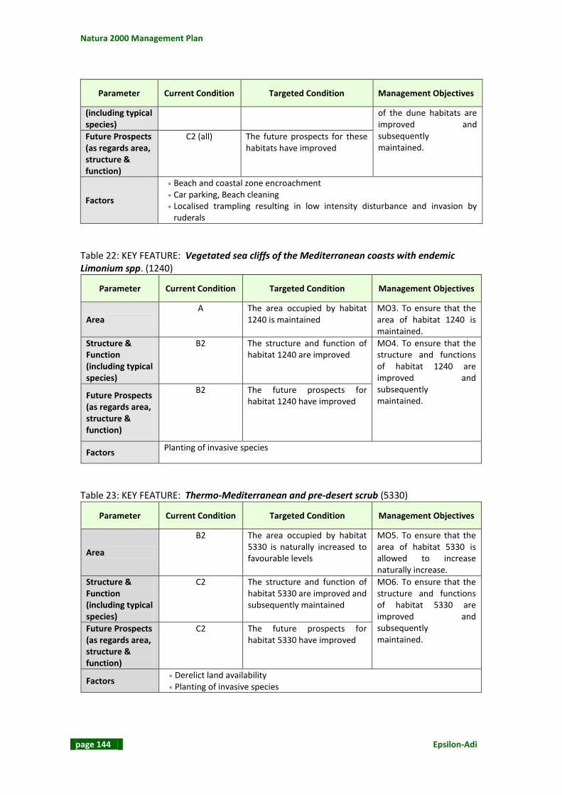
Natura 2000 Management Plan
page 144 Epsilon-Adi
Parameter Current Condition Targeted Condition Management Objectives
(including typical species)
of the dune habitats are improved and subsequently maintained.
Future Prospects (as regards area, structure & function)
C2 (all) The future prospects for these habitats have improved
Factors
Beach and coastal zone encroachment Car parking, Beach cleaning Localised trampling resulting in low intensity disturbance and invasion by
ruderals
Table 22: KEY FEATURE: Vegetated sea cliffs of the Mediterranean coasts with endemic Limonium spp. (1240)
Parameter Current Condition Targeted Condition Management Objectives
Area A The area occupied by habitat
1240 is maintained MO3. To ensure that the area of habitat 1240 is maintained.
Structure & Function (including typical species)
B2 The structure and function of habitat 1240 are improved
MO4. To ensure that the structure and functions of habitat 1240 are improved and subsequently maintained.
Future Prospects (as regards area, structure & function)
B2 The future prospects for habitat 1240 have improved
Factors Planting of invasive species
Table 23: KEY FEATURE: Thermo-Mediterranean and pre-desert scrub (5330)
Parameter Current Condition Targeted Condition Management Objectives
Area
B2 The area occupied by habitat 5330 is naturally increased to favourable levels
MO5. To ensure that the area of habitat 5330 is allowed to increase naturally increase.
Structure & Function (including typical species)
C2 The structure and function of habitat 5330 are improved and subsequently maintained
MO6. To ensure that the structure and functions of habitat 5330 are improved and subsequently maintained.
Future Prospects (as regards area, structure & function)
C2 The future prospects for habitat 5330 have improved
Factors Derelict land availability Planting of invasive species

L-Inħawi tar-Ramla tat-Torri u tal-Irdum tal-Madonna
Epsilon-Adi page 145
Table 24: KEY FEATURE: West Mediterranean clifftop phryganas (5410)
Parameter Current Condition Targeted Condition Management Objectives
Area
B2 The area occupied by habitat 5410 is naturally increased to favourable levels
MO7. To ensure that the area of habitat 5410 is allowed to increase naturally.
Structure & Function (including typical species)
B2 The structure and function of habitat 5410 have improved and are subsequently maintained.
MO8. To ensure that the structure and functions of habitat 5410 are improved and subsequently maintained.
Future Prospects (as regards area, structure & function)
B2 The future prospects for habitat 5410 have improved.
Factors Derelict land availability Planting of invasive species
Table 25: KEY FEATURE: Calcareous rocky slopes with chasmopytic vegetation (8210)
Parameter Current Condition Targeted Condition Management Objectives
Area A The area occupied by habitat
8210 is maintained MO9. To ensure that the area of habitat 8210 is maintained
Structure & Function (including typical species)
B2 The structure and function for habitat 8210 are improved and subsequently maintained.
MO10. To ensure that the structure and function of habitat 8210 are improved and subsequently maintained.
Future Prospects (as regards area, structure & function)
B2 The future prospects for habitat 8210 have improved and subsequently maintained.
Factors Planting of invasive species
Table 26: KEY FEATURE: Anacamptis urvilleana
Parameter Current Condition Targeted Condition Management Objective
Range
B The range of Anacamptis urvilleana is at least maintained
MO11. To maintain or extend the range of Anacamptis urvilleana at this site.
Size of population
Indeterminate The size of the population is at least maintained until its extent is determined, following which it may be increased or maintained.
MO12. To ensure that the population size of Anacamptis urvilleana achieves a favourable status.
Habitat B2 The structure and function of
the habitat for Anacamptis urvilleana has improved
MO13. To improve the structure and function of the habitat for Anacamptis urvilleana
Future prospects C The future prospects for

Natura 2000 Management Plan
page 146 Epsilon-Adi
Parameter Current Condition Targeted Condition Management Objective
Anacamptis urvilleana have improved
and subsequently maintain it.
Factors Trampling
Table 27: KEY FEATURE: Orobanche densiflora
Parameter Current Condition Targeted Condition Management Objective
Range A The range of Orobanche
densiflora is maintained. MO14. To ensure that the range and the population size of Orobanche densiflora are maintained
Size of population
A The population size of Orobanche densiflora is maintained
Habitat
B The structure and function of the habitat for Orobanche densiflora has improved and subsequently maintained.
MO15. To ensure that the structure and function of the habitat for Orobanche densiflora are improved and subsequently maintained.
Future prospects B1 The future prospects for
Orobanche densiflora have improved and subsequently maintained.
Factors Beach and coastal zone encroachment Car parking, trespassing, beach cleaning
Table 28: KEY FEATURE: Brachytrupes megacephalus
Parameter Current Condition Targeted Condition Management Objective
Range A The range of Brachytrupes
megacephalus is maintained. MO16. To ensure that the range of Brachytrupes megacephalus is maintained and its population size is increased
Size of population
B2 The population size of Brachytrupes megacephalus is increased.
Habitat
B2 The structure and function of the habitat supporting Brachytrupes megacephalus has improved.
MO17. To ensure that the structure and function of the habitat for Brachytrupes megacephalus is improved and subsequently maintained.
Future prospects
C The future prospects for Brachytrupes megacephalus have improved
Factors Beach and coastal zone encroachment Car parking, trespassing, beach cleaning
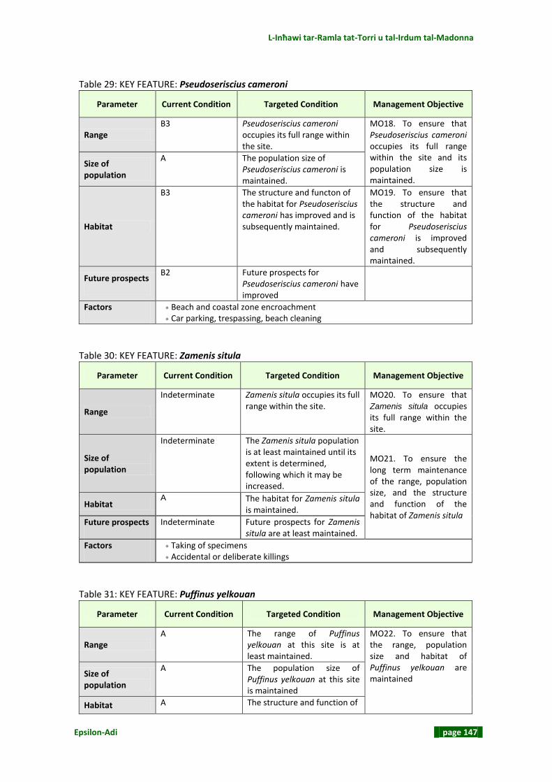
L-Inħawi tar-Ramla tat-Torri u tal-Irdum tal-Madonna
Epsilon-Adi page 147
Table 29: KEY FEATURE: Pseudoseriscius cameroni
Parameter Current Condition Targeted Condition Management Objective
Range B3 Pseudoseriscius cameroni
occupies its full range within the site.
MO18. To ensure that Pseudoseriscius cameroni occupies its full range within the site and its population size is maintained.
Size of population
A The population size of Pseudoseriscius cameroni is maintained.
Habitat
B3 The structure and functon of the habitat for Pseudoseriscius cameroni has improved and is subsequently maintained.
MO19. To ensure that the structure and function of the habitat for Pseudoseriscius cameroni is improved and subsequently maintained.
Future prospects B2 Future prospects for
Pseudoseriscius cameroni have improved
Factors Beach and coastal zone encroachment Car parking, trespassing, beach cleaning
Table 30: KEY FEATURE: Zamenis situla
Parameter Current Condition Targeted Condition Management Objective
Range
Indeterminate Zamenis situla occupies its full range within the site.
MO20. To ensure that Zamenis situla occupies its full range within the site.
Size of population
Indeterminate
The Zamenis situla population is at least maintained until its extent is determined, following which it may be increased.
MO21. To ensure the long term maintenance of the range, population size, and the structure and function of the habitat of Zamenis situla
Habitat A The habitat for Zamenis situla
is maintained.
Future prospects Indeterminate Future prospects for Zamenis situla are at least maintained.
Factors Taking of specimens Accidental or deliberate killings
Table 31: KEY FEATURE: Puffinus yelkouan
Parameter Current Condition Targeted Condition Management Objective
Range A The range of Puffinus
yelkouan at this site is at least maintained.
MO22. To ensure that the range, population size and habitat of Puffinus yelkouan are maintained
Size of population
A
The population size of Puffinus yelkouan at this site is maintained
Habitat A The structure and function of
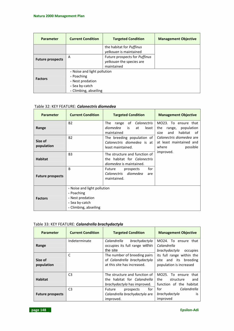
Natura 2000 Management Plan
page 148 Epsilon-Adi
Parameter Current Condition Targeted Condition Management Objective
the habitat for Puffinus yelkouan is maintained
Future prospects A
Future prospects for Puffinus yelkouan the species are maintained
Factors
Noise and light pollution Poaching Nest predation Sea by-catch Climbing, abseiling
Table 32: KEY FEATURE: Calonectris diomedea
Parameter Current Condition Targeted Condition Management Objective
Range B2 The range of Calonectris
diomedea is at least maintained
MO23. To ensure that the range, population size and habitat of Calonectris diomedea are at least maintained and where possible improved.
Size of population
B2 The breeding population of Calonectris diomedea is at least maintained.
Habitat B3
The structure and function of the habitat for Calonectris diomedea is maintained.
Future prospects
B
Future prospects for Calonectris diomedea are maintained.
Factors
Noise and light pollution Poaching Nest predation Sea by-catch Climbing, abseiling
Table 33: KEY FEATURE: Calandrella brachydactyla
Parameter Current Condition Targeted Condition Management Objective
Range Indeterminate
Calandrella brachydactyla occupies its full range within
the site
MO24. To ensure that Calandrella brachydactyla occupies its full range within the site and its breeding population is increased
Size of population
C
The number of breeding pairs of Calandrella brachydactyla at this site has increased.
Habitat C3 The structure and function of
the habitat for Calandrella brachydactyla has improved.
MO25. To ensure that the structure and function of the habitat for Calandrella brachydactyla is improved
Future prospects C3 Future prospects for
Calandrella brachydactyla are improved.

L-Inħawi tar-Ramla tat-Torri u tal-Irdum tal-Madonna
Epsilon-Adi page 149
Parameter Current Condition Targeted Condition Management Objective
Factors Nest disturbance Habitat disturbance
Table 34: KEY FEATURE: Falco peregrinus
Parameter Current Condition Targeted Condition Management Objective
Range Indeterminate
Falco peregrinus occupies its optimal range within the site.
MO26. To re-establish one breeding pair of Falco peregrinus within the SPA
Size of population
C One breeding pair of Falco peregrinus is established.
Habitat
A The structure and function of the habitat for Falco peregrinus species is maintained.
Future prospects
C3 Future prospects for Falco peregrinus species are improved
MO27. To ensure the long term maintenance of the range, population and habitat of Falco peregrinus
Factors Poaching, persecution
Table 35: KEY FEATURE: Migratory Annex I Raptors
Parameter Current Condition Targeted Condition Management Objective
Range A
The range used by migratory raptors in this SAC is maintained
MO28. To ensure that the range and population size of migratory raptors at this site are maintained
Size of population
A
The site remains important for migratory raptors.
Habitat C3 Suitable roosting habitat for
migratory raptors is created at this site.
MO29. To provide roosting habitat for migratory raptors
Future prospects C2 Future prospects for
migratory raptors are improved.
Factors Poaching, Persecution Habitat disturbance

Natura 2000 Management Plan
page 150 Epsilon-Adi
Table 36: KEY FEATURE: Migratory Annex I Passerines
Parameter Current Condition Targeted Condition Management Objective
Range A
The range used by migratory passerines at this site is maintained
MO30. To ensure that the range and population size of migratory passerines at this site are maintained
Size of population
A
The site remains important for migratory passerines.
Habitat C3 Suitable habitat for migratory
passerines at this site has improved.
MO31. To improve the habitat for migratory passerines Future prospects
C3 Future prospects for migratory passerines are improved.
Factors Trapping Habitat disturbance
Table 37: KEY FEATURE: Monticola solitarius
Parameter Current Condition Targeted Condition Management Objective
Range A
The range of Monticola solitarius at this site is maintained
MO32. To ensure that the range, breeding population and habitat for Monticola solitarius at this site are maintained.
Size of population
A The breeding population of Monticola solitarius at this site is maintained.
Habitat A The structure and function of
the habitat for Monticola solitarius is maintained.
Future prospects A Future prospects for
Monticola solitarius are maintained.
Factors Poaching, persecution Egg stealing Nest disturbance Habitat disturbance
Table 38: KEY FEATURE: Sylvia conspicillata
Parameter Current Condition Targeted Condition Management Objective
Range A
The range of Sylvia conspicillata at this site is maintained
MO33. To ensure that the range of Sylvia conspicillata is maintained and its breeding population at this site is increased
Size of population
C The number of breeding pairs of Sylvia conspicillata at this site has increased.
Habitat C3 The structure and function of
the habitat for Sylvia conspicillata has improved.
MO34. To improve the habitat for Sylvia conspicillata

L-Inħawi tar-Ramla tat-Torri u tal-Irdum tal-Madonna
Epsilon-Adi page 151
Parameter Current Condition Targeted Condition Management Objective
Future prospects C3 Future prospects for Sylvia conspicillata have improved
Factors Poaching, persecution Disturbance
3.4 SWOT ANALYSIS In this step the site features are summarized and assigned a positive (strengths) or a negative (weaknesses) value. Similarly, the factors influencing the site are summarized and assigned a positive (opportunities) or a negative (threats) value.
Table 39: SWOT Matrix
FEATURES FACTORS
Strengths (S) Opportunities (O)
S1. Eight Annex I habitats present
S2. Two Annex II flora species present
S3. Five Annex II fauna species present
S4. Important ornithological site
S4. RDB and Annex IV species present
S5. Landscape of high natural value
O1. Legislation and policies
O2. Conservation Management Strategies
present
Weaknesses (W) Threats (T)
W1. Poor conservation status and future
prospects of dune habitats
W2. Some garrigue habitats partially degraded
due to planting of invasive/alien trees, trampling
and clearance of vegetation
W3. Lack of Favourable Reference Values for
some Annex I habitats
W4. Insufficient knowledge on conservation
status and lack of Favourable Reference Values
for some Annex II flora species
W5. Insufficient knowledge on conservation
status of some Annex II fauna species
W6. Insufficient knowledge on the conservation
status of some Annex I bird species
W7. Insufficient knowledge on the conservation
requirements of some RDB and Annex IV flora
and fauna species
T1. Planting of invasive and non native species
T2. Unregulated visitor access and site use
T3. Threats to internationally important sea bird
colony from land and sea activities
T4. Low public awareness of site's and species'
importance
T5. Insufficient wardening and law enforcement

Natura 2000 Management Plan
page 152 Epsilon-Adi
3.5 VISION STATEMENT The Prospect Matrix for the site is depicted in Table 40. Table 40: Prospect Matrix
Table 41: Vision Statement
The Ramla tat‐Torri/Rdum tal‐Madonna area is an integral part of the Marfa Ridge Peninsula, an area protected and managed effectively, sustainably and in harmony for the benefit of wildlife, the environment and people.
All natural habitats, native flora and wildlife present at the SAC are sustained Those using and visiting the area gain inspiration and an awareness of the
uniqueness and importance of the site and the Maltese natural heritage The site is receiving full legal protection implemented according to national
legislation and local policies.
Principal objectives of conservation
Prospects Annex I habitats
Annex II flora
Annex II fauna
Annex I avifauna
Annex IV species
Whole site
Inst
itu
tio
nal
pro
spe
cts
Existing legal framework and
policies
T1. T2. T3. T5. O1.
Eco
logi
cal p
rosp
ect
s Conservation status
W3. T1.
W4. T1.
W5. W6. T2. T3.
W7.
T1. T2. T4. T5. O2.
Size & Integrity W1. W2.
T1. T2. T4. T5. O1. O2.
Soci
al p
rosp
ect
s
Education, recreation,
research and nature
enjoyment
T1. T2. T4. T5. O2
Maintenance of site’s natural
and visual landscape
T1. T2. T4. T5 O1. O2.

L-Inħawi tar-Ramla tat-Torri u tal-Irdum tal-Madonna
Epsilon-Adi page 153
3.6 MANAGEMENT AND OPERATIONAL OBJECTIVES FOR THE SITE The Management Objectives define the policies through which the vision will be achieved and they can also be viewed as the Mission through which the Vision will be reached. Each Management Objective corresponds to a vision statement and it is derived by addressing the issue present in each cell of the particular line. Management Objectives for the key features identified for the site are derived from Section 3.3. For every Management Objective (MO) defined, a number of Operational Objectives (OO) are assigned. These are the objectives to which all the management work is directly related and lay the groundwork for management actions. The operational objectives for the key features are partially derived from the factors identified as affecting them. The Management Objectives arising from the Vision Statement and the respective Operational Objectives are depicted in Table 42.
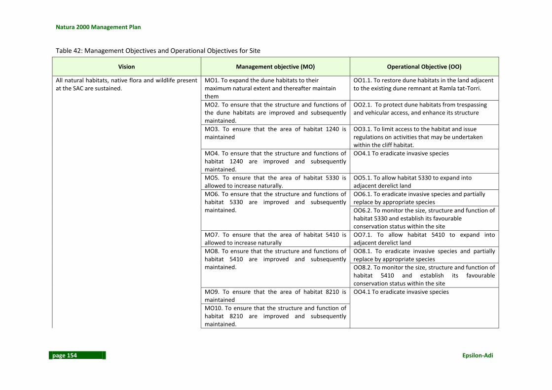
Natura 2000 Management Plan
page 154 Epsilon-Adi
Table 42: Management Objectives and Operational Objectives for Site
Vision Management objective (MO) Operational Objective (OO)
All natural habitats, native flora and wildlife present at the SAC are sustained.
MO1. To expand the dune habitats to their maximum natural extent and thereafter maintain them
OO1.1. To restore dune habitats in the land adjacent to the existing dune remnant at Ramla tat-Torri.
MO2. To ensure that the structure and functions of the dune habitats are improved and subsequently maintained.
OO2.1. To protect dune habitats from trespassing and vehicular access, and enhance its structure
MO3. To ensure that the area of habitat 1240 is maintained
OO3.1. To limit access to the habitat and issue regulations on activities that may be undertaken within the cliff habitat.
MO4. To ensure that the structure and functions of habitat 1240 are improved and subsequently maintained.
OO4.1 To eradicate invasive species
MO5. To ensure that the area of habitat 5330 is allowed to increase naturally.
OO5.1. To allow habitat 5330 to expand into adjacent derelict land
MO6. To ensure that the structure and functions of habitat 5330 are improved and subsequently maintained.
OO6.1. To eradicate invasive species and partially replace by appropriate species
OO6.2. To monitor the size, structure and function of habitat 5330 and establish its favourable conservation status within the site
MO7. To ensure that the area of habitat 5410 is allowed to increase naturally
OO7.1. To allow habitat 5410 to expand into adjacent derelict land
MO8. To ensure that the structure and functions of habitat 5410 are improved and subsequently maintained.
OO8.1. To eradicate invasive species and partially replace by appropriate species
OO8.2. To monitor the size, structure and function of habitat 5410 and establish its favourable conservation status within the site
MO9. To ensure that the area of habitat 8210 is maintained
OO4.1 To eradicate invasive species
MO10. To ensure that the structure and function of habitat 8210 are improved and subsequently maintained.

L-Inħawi tar-Ramla tat-Torri u tal-Irdum tal-Madonna
Epsilon-Adi page 155
Vision Management objective (MO) Operational Objective (OO)
MO11. To maintain or extend the range of Anacamptis urvilleana at this site
OO11.1. To monitor the range, assess and monitor the population size of Anacamptis urvilleana and establish its favourable conservation status within the site
MO12. To ensure that the population size of Anacamptis urvilleana achieves a favourable status.
MO13. To improve the structure and function of the habitat for Anacamptis urvilleana and subsequently maintain it
OO5.1. To allow habitat 5330 to expand into adjacent derelict land
MO14. To ensure that the range and the population size of Orobanche densiflora are maintained
OO14.1. To monitor the range and population size of Orobanche densiflora.
MO15. To ensure that the structure and function of the habitat for Orobanche densiflora are improved and subsequently maintained.
OO2.1. To protect dune habitats from trespassing and vehicular access, and enhance its structure
MO16. To ensure that the range of Brachytrupes megacephalus is maintained and its population size is increased
OO1.1. To restore dune habitats in the land adjacent to the existing dune remnant at Ramla tat-Torri
OO16.1. To monitor the range and population size of Brachytrupes megacephalus
MO17. To ensure that the structure and function of the habitat for Brachytrupes megacephalus is improved and subsequently maintained.
OO2.1. To protect dune habitats from trespassing and vehicular access, and enhance its structure
MO18. To ensure that Pseudoseriscius cameroni occupies its full range within the site and its population size is increased
OO18.1. To identify possible factors affecting Pseudoseriscius cameroni population
MO19. To ensure that the structure and function of the habitat for Pseudoseriscius cameroni is improved and subsequently maintained.
OO19.1. To monitor the range and population size of Pseudoseriscius cameroni
MO20. To ensure that Zamenis situla occupies its full range within the site.
OO20.1. To determine the range and population of Zamenis situla within the site and the possible factors affecting its population
MO21. To ensure the long term maintenance of the range, population size, and the structure and function of the habitat of Zamenis situla
OO21.1. To undertake seasonal surveillance of the species to monitor trends in the range and population size of Zamenis situla
MO22. To ensure that the range, population size and habitat of Puffinus yelkouan are maintained
OO22.1. To monitor the range and population size of Puffinus yelkouan on an annual basis

Natura 2000 Management Plan
page 156 Epsilon-Adi
Vision Management objective (MO) Operational Objective (OO)
OO22.2. To continue the active habitat conservation management practices introduced by the LIFE project
MO23. To ensure that the range, population size and habitat of Calonectris diomedea are at least maintained and where posisble improved
OO23.1. To monitor the range and population size of Calonectris diomedea on an annual basis.
MO24. To ensure that Calandrella brachydactyla occupies its full range within the site and its breeding population is increased
OO24.1. To monitor the range and population size of Calandrella brachydactyla
MO25. To ensure that the structure and function of the habitat for Calandrella brachydactyla is improved
OO25.1. To implement the actions foreseen in development permit PA 02821/09"
OO25.2. To continue the active habitat conservation management practices introduced by the LIFE project
MO26. To re-establish one breeding pair of Falco peregrinus within the SPA
OO26.1. To undertake a project for the re-establishment of one breeding pair of Falco peregrinus within the site
MO27. To ensure the long term maintenance of the range, population and habitat of Falco peregrinus
OO27.1. To monitor the range and population size of Falco peregrinus on an annual basis
MO28. To ensure that the range and population size of migratory raptors at this site are maintained.
OO28.1 To collect annual data on raptor migration over and use of the site.
MO29. To provide roosting habitat for migratory raptors
OO29.1. To create roosting locations for migratory raptors within the woodland and the derelict land
MO30. To ensure that the range and population size of migratory passerines at this site are maintained.
OO30.1. To collect annual data on the use of the site by Annex I migratory passerines.
OO30.2. To implement the actions foreseen in development permit PA 02821/09"
MO31. To improve habitat for migratory passerines OO31.1. To create roosting locations for migratory passerines within the woodland and the derelict land
MO32. To ensure that the range, breeding population and habitat for Monticola solitarius at this site are maintained.
OO32.1. To monitor the range and population size of Monticola solitarius on an annual basis

L-Inħawi tar-Ramla tat-Torri u tal-Irdum tal-Madonna
Epsilon-Adi page 157
Vision Management objective (MO) Operational Objective (OO)
MO33. To ensure that the range of Sylvia conspicillata is maintained and its breeding population at this site is increased
OO33.1. To monitor the range and population size of Sylvia conspicillata
MO34. To improve habitat for Sylvia conspicillata OO34.1. To implement the actions foreseen in development permit PA 02821/09
MO35. To maintain healthy populations of the RDB and Annex IV species present in the site
OO35.1. To elaborate Action Plans for RDB species and apply the actions and the recommendations prescribed
The Ramla tat‐Torri/Rdum tal‐Madonna area is an integral part of the Marfa Ridge Peninsula, an area protected and managed effectively, sustainably and in harmony for the benefit of wildlife, the environment and people.
MO36. To establish a Site Manager for the SAC/SPA OO36.1. To set up a Site Management Scheme that will implement the After Life Continuation Plan and fully manage the entire site
MO37. To implement the Visitor Management Strategy proposed by the EU LIFE project
OO37.1. To implement the actions foreseen in development permit PA 02821/09"
Those using and visiting the area gain inspiration and an awareness of the uniqueness and importance of the site and the Maltese natural heritage
MO38. To raise public awareness of the site’s conservation importance and requirements
OO38.1. To continue awareness and education about the site and manage it as a visitors’ attraction
OO38.2. To design, construct & install warning interpretation / information / awareness sign-posting and produce promotion material for visitors
The site is receiving full legal protection implemented according to national legislation and local policies.
MO39. To ensure that no illegal activities take place within the site and to monitor the impacts of allowable activities for any future controls that may be required
OO39.1 To patrol/warden the site according to an established roster throughout the year, with increased frequency during the hunting season, during weekends, public holidays and during planned activities.
OO39.2. To lobby with users of the site (campers, hunters, ramblers, bird watchers, farmers, general public) for the better protection of the site.

Natura 2000 Management Plan
page 158 Epsilon-Adi
4 MANAGEMENT ACTIONS Following the establishment of Management Objectives and Operational Objectives, the following section of the Management Plan describes the Management Actions. One or more management actions are defined for each operational objective and the fulfilment of operational objectives is achieved through the implementation of these actions.
4.1 FORMULATION OF MANAGEMENT ACTIONS The first step in the formulation of Management Actions is the setting of a priority rating for the operational objectives identified above. The priority rating is defined as follows: Critical: The fulfilment of this objective is a prerequisite for the implementation of the
Management Plan as a whole. It must be dealt with within the first two years of the implementation period.
High: The objective is of main importance and its fulfilment is a prerequisite for the
implementation of a major part of the Management Plan. To be accomplished within the first three years of the implementation period.
Medium: The objective is of main importance but it either follows the accomplishment of
another objective or it can be accomplished at any time within the five year period of the implementation period.
Low: The objective is of complementary importance. To be accomplished within the
last two years of the Management Plan, it may also be transferred to the next management period.
For each operational objective one or more titles of actions are defined. Each action is directly linked to the delivery of a specific operational objective and it requires a single procedure for its accomplishment. The management actions are described in further detail in subsequent sections. The proposed actions are categorised as follows:
Measures: Regulations and restrictions imposed by the central or local administration. Duties: Routine or recurring management activities, assigned by the administration to
some competent entity
Projects: Planned activities of a definite time range to accomplish particular targets Appropriate performance indicators are given to enable measurement of the effectiveness of each action and the monitoring requirements of each action are also defined. For the Operational Objectives identified for the site, the priority ratings, the actions and respective performance indicators and monitoring requirements are shown in Table 43.

L-Inħawi tar-Ramla tat-Torri u tal-Irdum tal-Madonna
Epsilon-Adi page 159
Table 43: Operational Objectives and related priority rating, performance indicators, actions, category of actions and monitoring requirement
Operational Objective (OO) Priority rating
Title of Action Code of action
Category of action
Performance Indicators
Monitoring requirements /
Means of Verification
OO6.2. / OO8.2. To monitor the size, structure and function of habitats 5330 and 5410 and establish their favourable conservation status within the site OO11.1. / OO14.1. To monitor the range, assess and monitor the population size of Anacamptis urvilleana and Orobanche densiflora and establish the favourable conservation status of Anacamptis urvilleana within the site OO16.1. / OO19.1. / OO18.1. To monitor the range and population size of Brachytrupes megacephalus and Pseudoseriscius cameroni and identify possible factors affecting Pseudoseriscius cameroni population within the site OO20.1. / OO21.1. / To undertake seasonal surveillance of the species to determine and monitor trends in the range, population size and possible factors affecting the population of Zamenis situla within the site. OO22.1. / OO23.1. / OO24.1. / OO27.1. / OO32.1. / OO33.1. To monitor the range and population size of Puffinus yelkouan, Calonectris diomedea, Calandrella brachydactyla, Falco peregrinus, Monticola
High
Elaboration of detailed monitoring programmes for the Annex I habitats 5330 and 5410, the Annex II flora species Anacamptis urvilleana and Orobanche densiflora, the Annex II fauna species Brachytrupes megacephalus and Pseudoseriscius cameroni, Zamenis situla, the breeding bird species Puffinus yelkouan, Calonectris diomedea, Calandrella brachydactyla, Falco peregrinus, Monticola solitarius and Sylvia conspicillata and the migratory raptors and passerines
P1. Project
Number of monitoring plans for the Annex I habitats, the Annex II species and the bird species present in the site
Progress reports
Implementation of the monitoring plans for the Annex I habitats 5330 and 5410, the Annex II flora species Anacamptis urvilleana and Orobanche densiflora, the Annex II fauna species Brachytrupes megacephalus and Pseudoseriscius cameroni,
P4. Project Number of reports for the Annex I habitats, the Annex II species and the birds present in the site
Progress reports

Natura 2000 Management Plan
page 160 Epsilon-Adi
Operational Objective (OO) Priority rating
Title of Action Code of action
Category of action
Performance Indicators
Monitoring requirements /
Means of Verification
solitarius and Sylvia conspicillata OO28.1 / OO30.1. To collect annual data on raptor migration and use of the site by Annex I migratory passerines
Zamenis situla, the breeding bird species Puffinus yelkouan, Calonectris diomedea, Calandrella brachydactyla, Falco peregrinus, Monticola solitarius and Sylvia conspicillata and the migratory raptors and passerines - determination of favourable conservation status of habitats 5330 and 5410 and species Anacamptis urvilleana
OO1.1. To restore dune habitats in the land adjacent to the existing dune remnant at Ramla tat-Torri OO2.1. To protect dune habitats from trespassing and vehicular access, and enhance their structure
Medium Assess and evaluate alternative options to restore the dunes
P3. Project Percentage area of dune habitats protected from human activity Improvement in structure and function of dune habitats recorded
Progress reports Patrolling reports Habitat monitoring reports (Action P4)
OO3.1. To limit access to habitat 1240 and issue regulations on activities that may be undertaken within the cliff habitat. OO5.1. / OO7.1 To allow habitats 5330 and 5410 to expand into adjacent derelict land
High
Application of access control measures at habitats 1240, 5330 and 5410
P6.
Project
Percentage area of habitats 1240, 5330 and 5410 relieved from trampling
Progress reports Patrolling reports Habitat monitoring reports
OO4.1 / OO6.1. / OO8.1. To eradicate invasive species and partially replace by appropriate species at habitats 1240,5330 and 5410
Medium Planning and implementation of an IAS control and/or eradication programme.
P7. Project
Percentage decrease in cover by alien tree species at the end of the five year period of MP
Progress reports Habitat monitoring reports (Action P4)
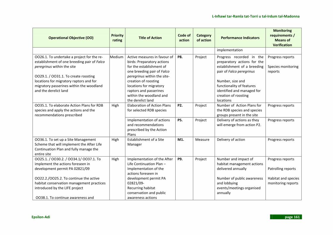
L-Inħawi tar-Ramla tat-Torri u tal-Irdum tal-Madonna
Epsilon-Adi page 161
Operational Objective (OO) Priority rating
Title of Action Code of action
Category of action
Performance Indicators
Monitoring requirements /
Means of Verification
implementation
OO26.1. To undertake a project for the re-establishment of one breeding pair of Falco peregrinus within the site OO29.1. / OO31.1. To create roosting locations for migratory raptors and for migratory passerines within the woodland and the derelict land
Medium
Active measures in favour of birds: Preparatory actions for the establishment of one breeding pair of Falco peregrinus within the site- creation of roosting locations for migratory raptors and passerines within the woodland and the derelict land
P8. Project
Progress recorded in the preparatory actions for the establishment of a breeding pair of Falco peregrinus Number, size and functionality of features identified and managed for creation of roosting locations
Progress reports Species monitoring reports
OO35.1. To elaborate Action Plans for RDB species and apply the actions and the recommendations prescribed
High
Elaboration of Action Plans for selected RDB species
P2. Project Number of Action Plans for the RDB species and species groups present in the site
Progress reports
Implementation of actions and recommendations prescribed by the Action Plans
P5. Project Delivery of actions as they will emerge from action P2.
Progress reports
OO36.1. To set up a Site Management Scheme that will implement the After Life Continuation Plan and fully manage the entire site
High Establishment of a Site Manager
M1. Measure Delivery of action Progress reports
OO25.1. / OO30.2. / OO34.1/ OO37.1. To implement the actions foreseen in development permit PA 02821/09 OO22.2./OO25.2. To continue the active habitat conservation management practices introduced by the LIFE project OO38.1. To continue awareness and
High
Implementation of the After Life Continuation Plan – Implementation of the actions foreseen in development permit PA 02821/09- Recurring habitat conservation and public awareness actions
P9. Project Number and impact of habitat management actions delivered annually Number of public awareness and lobbying events/meetings organised annually
Progress reports Patrolling reports Habitat and species monitoring reports

Natura 2000 Management Plan
page 162 Epsilon-Adi
Operational Objective (OO) Priority rating
Title of Action Code of action
Category of action
Performance Indicators
Monitoring requirements /
Means of Verification
education about the site and manage it as a visitors’ attraction OO39.2. To lobby with users of the site (campers, hunters, ramblers, bird watchers, farmers, general public) for the better protection of the site
Number and status of attendants Percentage compliance of site stakeholders/users to site regulations and restrictions
OO38.2. To design, construct & install warning interpretation / information / awareness sign-posting and produce promotion material for visitors
High Elaboration of a study for the design and technical specifications for information / interpretation / warning signposting and promotion material
P10. Project Timely delivery of the technical study
Progress reports
Construction and installation of information / interpretation / warning signposting and production of promotion material
P11. Project Timely installation of signposting and production of promotion material
Progress reports
OO39.1 To patrol/warden the site according to an established roster throughout the year, with increased frequency during the hunting season, during weekends, public holidays anda during planned activities.
High Prescription of a patrolling schedule
P12. Project Timely delivery of action Progress reports
Implementation of the patrolling schedule
D1. Duty Percentage annual decrease of incidents
Ordered reporting and annual review

L-Inħawi tar-Ramla tat-Torri u tal-Irdum tal-Madonna
Epsilon-Adi page 163
4.2 DESCRIPTION OF MANAGEMENT ACTIONS For each action the following details are given: Code/Title Each action is given a code number with an initial M, P or D
corresponding to Measures, Projects, Duties and a serial number. Description A description of the action to be delivered is given. Expected results A brief description of the output (deliverable) is given. Priority rating Priority in accordance to the prioritisation given in Table 16 and a time
span for the completion of each action is given. Constraints Any foreseen constraints to the delivery of the action are stated and
alternatives are suggested. It is noted that reference is made mainly to technical or institutional constraints and drawbacks foreseen. Constraints such as conflicting interests, social disputes or the funding requirements, which should have been resolved by the time of implementation, are not included.
A. MEASURES
4.2.1 Code and Title of Action: M1. Establishment of a Site Manager Description This measure requires MEPA to undertake the procedures normally
undertaken for the establishment of a Site Manager for Rdum tal-Madonna. The necessity of appointment of a Site Manager at this site is advocated by the following facts:
The SPA is internationally important as it is home to the largest breeding population of Yelkouan Shearwaters Puffinus yelkouan in Malta. This implies increased national obligations for the conservation management of the site.
The breeding colony is vulnerable to rat predation and constant effort is required for the mitigation of this factor. This requires the presence of an appointed experts’ team at a regular basis.
The site is highly accessible and very popular for recreation purposes and pressures for access ways and visitor infrastructure

Natura 2000 Management Plan
page 164 Epsilon-Adi
are increasing. Human induced disturbance is identified as the factor having the highest impact on the SAC/SPA. Constant in situ surveillance and systematic attendance of developments in the field is required.
Several habitat/ species management actions and visitor management works have been proposed for the site. These are recurring, long term projects requiring everyday management and maintenance
The site provides excellent grounds for organised educational and public awareness work. An appointed team of educational experts is required to support this task on a frequent basis.
Expected results The Management Scheme has been established and the Site Manager
has settled in site.
Priority rating High. To be accomplished prior to the start of the MP implementation Constraints No major constraints foreseen.
B. DUTIES
4.2.2 Code and Title of Action: D1. Implementation of patrolling Description MEPA will provide for the engagement of the proper staff to carry out
the scheduled tasks specified by Action P12. The progress and success of this action will be monitored through monthly and annual reports as specified by Action P12.
Expected results The prevention of illegal activities and reporting on the site’s status and
emergency issues. Priority rating High. To start in the first year of the implementation of the Management
Plan implementation period and continue throughout. Constraints Coordination among different administrative authorities is the
prerequisite for the accomplishment of this action
C. PROJECTS

L-Inħawi tar-Ramla tat-Torri u tal-Irdum tal-Madonna
Epsilon-Adi page 165
4.2.3 Code and Title of Action: P1. Elaboration of detailed monitoring programmes for the Annex I habitats 5330 and 5410, the Annex II flora species Anacamptis urvilleana and Orobanche densiflora, the Annex II fauna species Brachytrupes megacephalus and Pseudoseriscius cameroni, Zamenis situla, the breeding bird species Puffinus yelkouan, Calonectris diomedea, Calandrella brachydactyla, Falco peregrinus, Monticola solitarius and Sylvia conspicillata and the migratory raptors and passerines
Description In the course of the preparation of the present Management Plan, a
method for the evaluation of the conservation status of Annex I habitats and Annex II species of the Habitats Directive and of the Annex I species of the Birds Directive at the site scale was developed in accordance with the methodology provided by MEPA (See chapter 2). This methodology was applied to give the assessment of the conservation status of the foretold habitats and species per N2K site in year 2013. This work has set the basis for the formulation of national Standard Monitoring Protocols (plans) for the foretold habitats and species. This is a task to be accomplished within the first period of implementation of the Management Plans. The Standard Monitoring plans will also deal with the determination of the Favourable Reference Values which will then inform the Favourable Conservation Status to be assessed for habitats and species. During the first period of implementation of the MP, Favourable Reference Values will be determined for the following habitats and species: Annex I habitats:
5330 – Thermo-Mediterranean and pre-desert scrub 5410 – West Mediterranean clifftop phryganas
Annex II flora species:
Anacamptis pyramidalis The Standard Monitoring plans will be applied to the sites through Action P4 in order to:
Assess the conservation status of habitats and species within 5 years from the 2013 assessment
Determine the Favourable Reference Values and the Favourable of Conservation Status for the above listed Annex I habitats and Annex II species
Enable the five year revision of the Management Plan, i.e. the review of Operational Objectives and subsequent management actions.
Guidelines for the elaboration of the standard monitoring plans are given

Natura 2000 Management Plan
page 166 Epsilon-Adi
in ANNEX 4: Specifications of Management Actions. Expected results Seven standard monitoring plans for the Annex I habitats and Annex II
species and eight standard monitoring plans for the bird species and species groups present in the site
Priority rating High. Monitoring Plans to be delivered within the first two years from
the start of the MP implementation period Constraints No major constraints foreseen
4.2.4 Code and Title of Action: P2. Elaboration of Action Plans for selected RDB species
Description The Competent Authority will prepare guidelines for the elaboration of
National Species Action Plans for endemic and threatened species and prepare a priority list based on the national and international status of the species and on the species’ presence within the Natura 2000 sites. For these species, Action Plans should be prepared on a national level as part of the Management Plans implemented in each Natura 2000 site. The Action Plans can be either single species Action Plans or tackle groups of species and should justify and propose tailored conservation measures for every species or group. These plans will guide the implementation of Action P5. General Guidelines for the elaboration of the Action Plans are given in ANNEX 4: Specifications of Management Actions. For this site Action Plans are recommended for the following species/species groups: Invertebrates
Reptiles: Podarcis filfolensis maltensis, Coluber viridiflavus carbonarius, Telescopus fallax
Mammals: Plecotus austriacus, Pipistrellus pipistrellus, Pipistrellus kuhlii, Pipistrellus pygmaeus, Suncus etruscus
Expected results Nine National Action Plans for the conservation of threatened Red Data Book species present in the site
Priority rating Medium. Action Plans to be delivered within the first three years from
the start of MP implementation period Constraints No major constraints foreseen

L-Inħawi tar-Ramla tat-Torri u tal-Irdum tal-Madonna
Epsilon-Adi page 167
4.2.5 Code / Title of Action: P3: Assess and evaluate alternative options to restore the dunes
Description This action foresees the undertaking of a systematic and intensive
project for the protection and restoration of dunes to Ramla tat- Torri. Map of the proposed interventions and guidelines for the implementation of this action are given in ANNEX 4: Specifications of Management Actions.
Expected results Dune habitats secured against further degradation and in the long term restored in a favourable conservation status
Priority rating High. To start in the first year of the Management Plan implementation
period Constraints No major constraints foreseen.
4.2.6 Code and Title of Action: P4. Implementation of the monitoring plans for the Annex I habitats 5330 and 5410, the Annex II flora species Anacamptis urvilleana and Orobanche densiflora, the Annex II fauna species Brachytrupes megacephalus and Pseudoseriscius cameroni, Zamenis situla, the breeding bird species Puffinus yelkouan, Calonectris diomedea, Calandrella brachydactyla, Falco peregrinus, Monticola solitarius and Sylvia conspicillata and the migratory raptors and passerines - determination of favourable conservation status of habitats 5330 and 5410 and species Anacamptis urvilleana
Description ERA will provide for the implementation of the monitoring plans
according to the specifications provided for in the respective studies (Action P1).
Expected results Seven reports on the conservation status of the Annex I habitats and
Annex II species and eight reports on bird species and species groups present in the site. Favourable Reference Values for two Annex I habitats and one Annex II species.
Priority rating Implementation will follow the delivery of the relevant monitoring plans
(Action P1), therefore it may start from the second year of the MP implementation period. In any case it cannot exceed a 5 years period from the previous first assessment, i.e. the 2013 year assessment undertaken in the context of the MP preparation.
Constraints No major constraints foreseen
4.2.7 Code and Title of Action: P5. Implementation of actions and recommendations prescribed by the Action Plans
Description Following the prescriptions of the species specific Action Plans (Action

Natura 2000 Management Plan
page 168 Epsilon-Adi
P2) ERA or the Site Manager will have to judge which of them are applicable to the site and decide on the urgency for their implementation.
Expected results A series of actions that will mitigate possible adverse effects on RDB
species and lead to an overall improvement of the site quality for them. Priority rating Medium. To start after the delivery of the relevant Action Plans (Action
P2). Constraints Although these are usually low cost, small scale/microhabitat
management actions, their exact nature and extent cannot be foretold and possible constraints cannot be foreseen at this point.
4.2.8 Code and Title of Action: P6. Application of access control measures at habitats 1240, 5330 and 5410
Description This action aims at the improvement of the structure and function of
garrigue patches severely degraded by trampling and at the same time at limiting disturbance of vulnerable parts of the Puffinus yelkouan cliff colony. Spot mapping of the intervention areas and guidelines for the implementation of the actions are given in ANNEX 4: Specifications of Management Actions. Properly placed warning and information signage in which the scope and significance of the intervention will be clearly stated is a necessary accompanying action. The public awareness activities foreseen by action P9 will also contribute to the success of the action. The results of the action will be also monitored through the patrolling duty (Action D1) and the habitat monitoring reports (Action P4). It is noted that part of the actions maybe complementary to and implemented through action M2.
Expected results The improvement of the conservation status of habitats 1240, 5330 and 5410 and the maintenance of the conservation status of Puffinus yelkouan within the site.
Priority rating High. To start at the first year of the MP implementation period Constraints Access restriction measures are sometimes inconvenient to specific users
and usually unfavourable to casual visitors and parts of the general public. Means to mitigate undesirable effects have been suggested but the Site Manager must in any case consider this to be a recurring action

L-Inħawi tar-Ramla tat-Torri u tal-Irdum tal-Madonna
Epsilon-Adi page 169
as regular repairs and replacements are expected especially in the first period of application. This will be done in the context of action P9.
4.2.9 Code and Title of Action: P7. Planning and implementation of an IAS control and/or eradication programme.
Description Based on the “Guidelines on managing non-native plant invaders and
restoring native plant communities in terrestrial settings in the Maltese Islands” (MEPA 2013) and the site specific guidelines given in ANNEX 4: Specifications of Management Actions, the competent authority or the Site Manager will proceed with a site specific schedule for the gradual eradication of the IAS species and restoration of native communities present within the first management plan implementation period.
Expected results A technical plan that will guide the gradual eradication of alien and invasive plant species from the Annex I habitats and other sensitive areas within the Natura 2000 sites. Delivery of the eradication and rehabilitation actions foreseen for the first management implementation period.
Priority rating Medium. Study to start at the second year of the MP implementation
period Constraints As the site is an SPA, Ornithologists are to be consulted during the
planning of the eradication programme. The maintenance of certain mature alien (non-invasive) trees and tree clumps will take precedence if these are of significant value for breeding and migratory avifauna.
4.2.10 Code and Title of Action: P8. Active measures in favour of birds: Establishment of one breeding pair of Falco peregrinus within the site- Creation of roosting locations for migratory raptors and passerines within the woodland and the derelict land
Description This is a recurring action that requires a deep knowledge of the site’s
historical trends, current status and future ornithological potential and some progress in the management status of the site to guarantee that certain human induced limiting factors have been eliminated.
As such, the following conditions must apply before the actions can be fully implemented:
1. Establishment of one breeding pair of Falco peregrinus
Confirmation of past Peregrine Falcon within the site must be
provided as this information has not been available during the elaboration of the Management Plan.

Natura 2000 Management Plan
page 170 Epsilon-Adi
If recent breeding records of the species do exist within the site, all efforts for the re-establishment of one breeding pair have to be made in order to be in line with the conservation objectives for the species and the concepts of the Birds Directive. The Site Manager will make a detailed plan of the re-introduction project according to the international standards relevant for the species. If no such records exist, the species might or might not have bred within the site. In such a case, the final decision has to be taken by the Site Manager taking into account all relevant ecological and social parameters, among which the main questions to be answered are:
Have the original factors that led to the species extermination eliminated or can be eliminated with reasonable effort?
Is the reintroduction of this predator species possible to cause ecological unbalance within the site, mainly due to unaccepted rates of predation on protected (Puffinus yelkouan juveniles) species or other species of conservation interest?
2. Creation of roosting locations for migratory raptors and passerines within the woodland and the derelict land
Consistence with the IAS eradication action (Action P7) must have been secured. As already stated Ornithologists are to be consulted during the planning of the eradication programme. The maintenance of certain mature alien (non-invasive) trees and tree clumps will take precedence if these are of significant value for breeding and migratory avifauna.
Conditions that safeguard the safe roosting of raptors and
breeding of passerines must have been achieved at the woodland and the derelict areas selected for the action. This implies elimination of any disturbances caused by poaching and acceptable levels of human presence and activity.
Expected results The long term upgrading of certain Annex I and migratory birds’
conservation status – the general upgrading of the site’s ornithological value
Priority rating Medium/Low. To be implemented gradually and at the last years of MP
implementation period Constraints Main ecological constraints have been discussed in the description of
action. No other major constraints foreseen.
L-Inħawi tar-Ramla tat-Torri u tal-Irdum tal-Madonna
Epsilon-Adi page 171
4.2.11 Code and Title of Action: P9. Implementation of the After Life Continuation Plan –Implementation of the actions foreseen in development permit PA 02812/09-Recurring habitat conservation and public awareness actions
Description This action foresees the implementation of the obligations arising from
the After Life Continuation Plan in order to ensure that the Yelkouan Shearwaters at Rdum tal-Madonna will continue to be protected. The following are foreseen:
The rat eradication programme continues in order to ensure that the Yelkouan Shearwaters successfully fledge and the site is maintained clean and free of litter so as not to attract rats
BLM continues to monitor the Yelkouan Shearwaters colony on an annual basis in order to assess the well-being of the colony and ensure that any threats are identified and immediately dealt with
Transport Malta continues to enforce Notice to Mariners 2 of 2010 to ensure that disturbance to Yelkouan Shearwaters from boats is reduced opposite the cliffs of Rdum tal-Madonna during the breeding season
The Armed Forces of Malta continue to patrol the Rdum tal-Madonna area and the seas around the Maltese Islands to prevent poaching of protected species at sea
The Capture Fisheries Branch within the former MRRA16 continues to work hand in hand with fishermen to find innovative ways of improving local fisheries and avoiding the catch of non target species such as Yelkouan Shearwaters.
The action also foresees the implementation of the EU LIFE Nature Project Visitor management strategy according to the development permit PA2812/09. The following are foreseen:
Seasonal or temporal limit to the use of the site
Location of the car park in a committed area at a safe distance away from the colony site. Camping permitted within the designated area.
Area closures
Permanent or temporary vehicle access restrictions at key habitat sites such as the Rdum tal‐Madonna cliffs.
Restrictions on use of fire
Restrictions on the use of fire at the allocated camping site and installation of BBQ pits in appropriate areas.
Installation of barriers
Barrier for temporary restricted vehicle access to Rdum tal‐Madonna cliffs
16
Now Ministry for Sustainable Development, Environment and Climate Change
Natura 2000 Management Plan
page 172 Epsilon-Adi
Rubble walls, bollards and boulders to restrict off‐roading throughout the whole area Trail markers to delineate the camping site Guide ropes for Daħlet ix‐Xmajjar and Daħlet ix‐Xilep areas Maintenance of existing access control infrastructure
Communications, increased awareness and education
Continuation of the communication, education and awareness actions around 3 key objectives:
To continue to increase visitor awareness of the site through direct contact with visitors and stakeholders
To improve/increase communications achieved during the LIFE project
To increase the educational aspect and value of the Ramla tat‐Torri/Rdum tal‐Madonna SPA/SAC
Stakeholder engagement and support
Maintenance of the EU LIFE Yelkouan Shearwater project partnership between government and non‐governmental organisations and stakeholder organisations/entities/individuals communications
Expected results The continuation of the conservation management practices introduced
by the LIFE project Priority rating High. To start at the first year of the MP implementation period Constraints No major constraints foreseen
4.2.12 Code and Title of Action: P10. Elaboration of a study for the design and technical specifications for warning / information / interpretation signposting and promotion material
Description A technical study will be elaborated which will:
Define the contents and design layouts of the signposting and the
promotion material based on the features identified in the current MP and following consultations with ERA
Prescribe technical specifications for the implementation of the respective technical works
The study will include the analytical budget for the implementation of the required technical works.
The study will check the existing signage within the Ghadira Reserve and suggest any replacements needed so that uniformity and branding are ensured. General guidelines as regards contents of signposting/promotion material and indicative posting places are given in ANNEX 4:

L-Inħawi tar-Ramla tat-Torri u tal-Irdum tal-Madonna
Epsilon-Adi page 173
Specifications of Management Actions.
Expected results A study and accompanying technical specifications that will guide the
implementation of the relevant action (Action P8). Priority rating High. To be completed within the first two years from the start of the MP
implementation period Constraints No major constraints foreseen
4.2.13 Code and Title of Action: P11. Construction and installation of warning / information / interpretation signposting and production of promotion material
Description ERA will provide for the implementation of the technical works according
to the specifications provided for in the respective study (Action P7). Expected results The installation of infrastructure and facilities prerequisite for visitor
attraction and raising of awareness and appreciation for the site Priority rating High. To start after the completion of the respective study (Action P7). Constraints No major constraints foreseen
4.2.14 Code and Title of Action: P12. Prescription of a patrolling schedule Description A document prescribing the patrolling requirements and annual
schedules will be prepared. Illegal activities already identified by the Management Plan should be set as priorities for control and prevention. This schedule will be also based on the annual Work plan (see below) and will be revised according to the requirements arising from the progress of the management actions. An initial set of patrolling and reporting requirements and proposed routines, staff and equipment needed is given in ANNEX 4: Specifications of Management Actions.
Expected results The annual schedule of patrolling the site as it will be implemented through the relevant action (Action D1)
Priority rating High. To be delivered within the first year from the start of the MP
implementation period Constraints No major constraints foreseen

Natura 2000 Management Plan
page 174 Epsilon-Adi
5 WORK PLAN STRUCTURE Prior to the Management Plan implementation, a detailed work plan must be prepared by MEPA. This is made on an annual basis and reviewed at the end of each year. In order to prepare a functional work plan the management scheme, the overall management strategy, the methods of implementation/operation and the available financial and human resources must have been defined by the Administration / Government. Revenue generating and funding opportunities have been identified in ANNEX 5: Cost Recovery Mechanisms. The preparation of the work plan will be based on:
The preceding description of the Management actions An indication of the financial resources needed annually for the implementation of
each action as given in Table 44. It must be noted that, for a number of actions, costs cannot be estimated at this stage; therefore this exercise provides only a basis for the allocation of resources.
The annual time schedule for the implementation of each action, checklist of the expected deliverables and year of delivery of each action and the entity proposed as responsible to deliver the actions, as shown in Table 45.
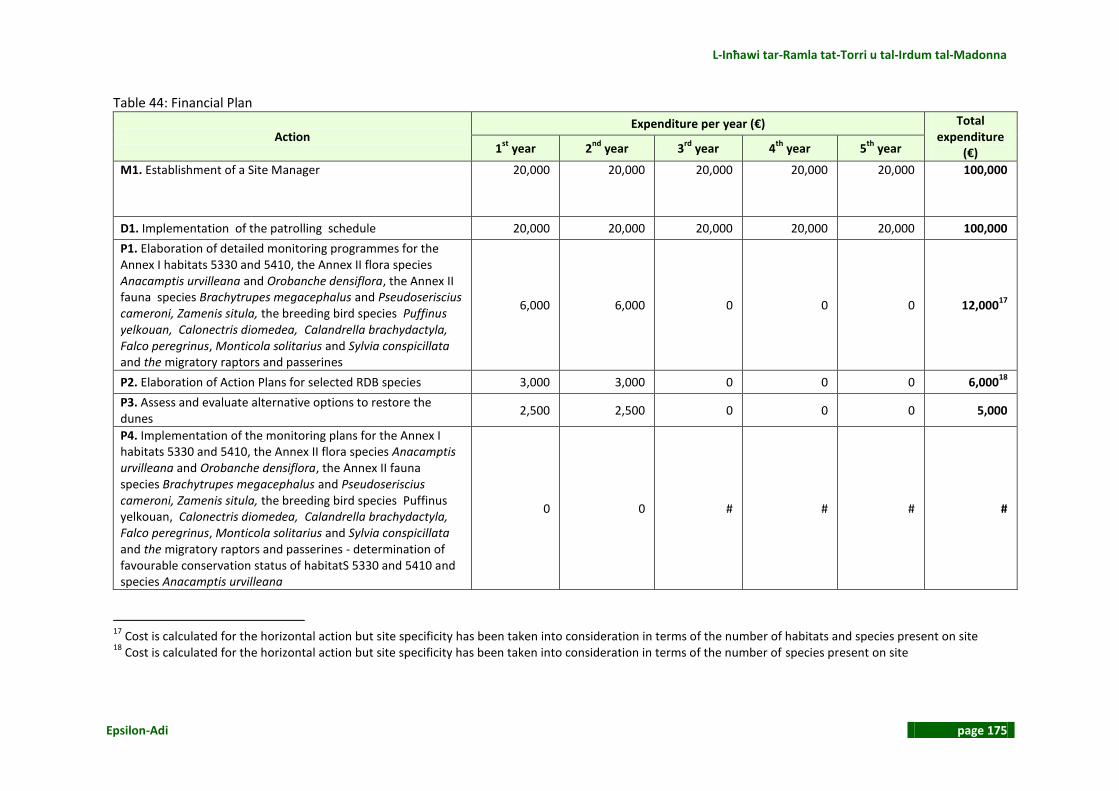
L-Inħawi tar-Ramla tat-Torri u tal-Irdum tal-Madonna
Epsilon-Adi page 175
Table 44: Financial Plan
Action Expenditure per year (€) Total
expenditure (€) 1
st year 2
nd year 3
rd year 4
th year 5
th year
M1. Establishment of a Site Manager 20,000 20,000 20,000 20,000 20,000 100,000
D1. Implementation of the patrolling schedule 20,000 20,000 20,000 20,000 20,000 100,000
P1. Elaboration of detailed monitoring programmes for the Annex I habitats 5330 and 5410, the Annex II flora species Anacamptis urvilleana and Orobanche densiflora, the Annex II fauna species Brachytrupes megacephalus and Pseudoseriscius cameroni, Zamenis situla, the breeding bird species Puffinus yelkouan, Calonectris diomedea, Calandrella brachydactyla, Falco peregrinus, Monticola solitarius and Sylvia conspicillata and the migratory raptors and passerines
6,000 6,000 0 0 0 12,00017
P2. Elaboration of Action Plans for selected RDB species 3,000 3,000 0 0 0 6,00018
P3. Assess and evaluate alternative options to restore the dunes
2,500 2,500 0 0 0 5,000
P4. Implementation of the monitoring plans for the Annex I habitats 5330 and 5410, the Annex II flora species Anacamptis urvilleana and Orobanche densiflora, the Annex II fauna species Brachytrupes megacephalus and Pseudoseriscius cameroni, Zamenis situla, the breeding bird species Puffinus yelkouan, Calonectris diomedea, Calandrella brachydactyla, Falco peregrinus, Monticola solitarius and Sylvia conspicillata and the migratory raptors and passerines - determination of favourable conservation status of habitatS 5330 and 5410 and species Anacamptis urvilleana
0 0 # # # #
17
Cost is calculated for the horizontal action but site specificity has been taken into consideration in terms of the number of habitats and species present on site 18
Cost is calculated for the horizontal action but site specificity has been taken into consideration in terms of the number of species present on site

Natura 2000 Management Plan
page 176 Epsilon-Adi
Action Expenditure per year (€) Total
expenditure (€) 1
st year 2
nd year 3
rd year 4
th year 5
th year
P5. Implementation of actions and recommendations prescribed by the Action Plans
0 0 # # # #
P6. Application of access control measures at habitats 1240, 5330 and 5410
0 0 0 0 0 019
P7. Planning and implementation of an IAS control and/or eradication programme.
0 5,000 5,000 5,000 5,000 20,000
P8. Active measures in favour of birds: Establishment of one breeding pair of Falco peregrinus within the site- Creation of roosting locations for migratory raptors and passerines within the woodland and the derelict land
0 0 # # # #20
P9. Implementation of the After Life Continuation Plan –Implementation of the actions foreseen in development permit PA 02821/09-Recurring habitat conservation and public awareness actions
0 0 0 0 0 021
P10. Elaboration of a study for the design and technical specifications for warning / information / interpretation signposting and promotion material
1,000 0 0 0 0 1,00022
P11. Construction and installation of / information / interpretation / warning signposting and production of promotion material
0 # # 0 0 #
P12. Prescription of a patrolling schedule 0 0 0 0 0 0
ANNUAL EXPENDITURE 52,500 56,500 45,000+ 45,000+ 45,000+ 244,000+
GRAND TOTAL 244,000+
# = To be derived by the respective studies/plans/schedules
19
Cost included in M1 budget 20
Cost included in M1 budget 21
Cost included in M1 budget 22
Cost is calculated for the horizontal action and is not assigned a per site cost

L-Inħawi tar-Ramla tat-Torri u tal-Irdum tal-Madonna
Epsilon-Adi page 177
Table 45: List of actions, timeframe, deliverables and year of delivery, action total budget estimate and entities involved in the delivery of the actions
Action Timeframe(Years)
Deliverable Year of
Delivery
Budget (€) (derived from financial plan)
Involvement 1 2 3 4 5
M1. Establishment of a Site Manager A Management Agreement
Continuous 100,000 ERA
D1. Implementation of the patrolling schedule
Monthly and annual patrolling reports
From 1st
year on
100,000 ERA / ENTITY WITH EXECUTIVE POWERS
P1. Elaboration of detailed monitoring programmes for the Annex I habitats 5330 and 5410, the Annex II flora species Anacamptis urvilleana and Orobanche densiflora, the Annex II fauna species Brachytrupes megacephalus and Pseudoseriscius cameroni, Zamenis situla, the breeding bird species Puffinus yelkouan, Calonectris diomedea, Calandrella brachydactyla, Falco peregrinus, Monticola solitarius and Sylvia conspicillata and the migratory raptors and passerines
Seven standard monitoring plans for the Annex I habitats and Annex II species and eight standard monitoring plans for the bird species and species groups present in the site
2nd
year 12,000 ERA
P2. Elaboration of Action Plans for selected RDB species
Nine National Action Plans for the conservation of threatened Red Data Book species present in the site
2nd
year 6,000 ERA
P3. Assess and evaluate alternative options to restore the dunes
Delivery of actions related to passive protection of habitat – habitat restoration activities established
2nd
year 20,000 BIRDLIFE MALTA
P4. Implementation of the monitoring plans for the Annex I habitats 5330 and 5410, the Annex II flora species Anacamptis
Seven reports on the conservation status of the Annex I habitats and
From 3rd
year on
# ERA

Natura 2000 Management Plan
page 178 Epsilon-Adi
Action Timeframe(Years)
Deliverable Year of
Delivery
Budget (€) (derived from financial plan)
Involvement 1 2 3 4 5
urvilleana and Orobanche densiflora, the Annex II fauna species Brachytrupes megacephalus and Pseudoseriscius cameroni, Zamenis situla, the breeding bird species Puffinus yelkouan, Calonectris diomedea, Calandrella brachydactyla, Falco peregrinus, Monticola solitarius and Sylvia conspicillata and the migratory raptors and passerines - determination of favourable conservation status of habitatS 5330 and 5410 and species Anacamptis urvilleana
Annex II species and eight reports on bird species and species groups present in the site. Favourable Reference Values for two Annex I habitats and one Annex II species.
P5. Implementation of actions and recommendations prescribed by the Action Plans
Delivery of the conservation actions prescribed by the Action Plans
From 3rd year on
# BIRDLIFE MALTA
P6. Application of access control measures at habitats 1240, 5330 and 5410
Installation of access control means
2nd
year 0 BIRDLIFE MALTA
P7. Planning and implementation of an IAS control and/or eradication programme.
A plan for IAS species eradication plan and resulting works
From 2nd
year on
4,000 ERA / BIRDLIFE MALTA
P8. Active measures in favour of birds: Establishment of one breeding pair of Falco peregrinus within the site- Creation of roosting locations for migratory raptors and passerines within the woodland and the derelict land
Delivery of conservation actions for birds
From 3rd
year on
0 BIRDLIFE MALTA
P9. Implementation of the After Life Continuation Plan –Implementation of the actions foreseen in development permit PA 02821/09-Recurring habitat conservation
Actions foreseen in the After Life continuation Plan and the Development permit and recurring
Continuous 0 BIRDLIFE MALTA

L-Inħawi tar-Ramla tat-Torri u tal-Irdum tal-Madonna
Epsilon-Adi page 179
Action Timeframe(Years)
Deliverable Year of
Delivery
Budget (€) (derived from financial plan)
Involvement 1 2 3 4 5
and public awareness actions habitat management actions implemented A public awareness and visitor education plan Public awareness activities and campaigns launched
P10. Elaboration of a study for the design and technical specifications for warning / information / interpretation signposting and promotion material
A technical study for N2K signposting and production of promotion material
1st
year 1,000 ERA
P11. Construction and installation of / information / interpretation / warning signposting and production of promotion material
Delivery of works prescribed by the technical study (Action P7)
2nd
year # ERA
P12. Prescription of a patrolling schedule
One patrolling schedule note
1st
year 0 ERA /ENTITY WITH EXECUTIVE POWERS
# = To be derived by the respective studies/plans/schedules

Natura 2000 Management Plan
page 180 Epsilon-Adi
PROPOSED MANAGEMENT STRUCTURE FOR THE SITE As already discussed above (Action M1) the Management Plan proposes the establishment of a Site Manager for Rdum tal Madonna and considers BIRDLIFE MALTA as being the most suitable entity to undertake this position, both as the competent ornithological NGO in Malta and due to its former overall management experience in the site. In accordance with Table 3 the following authorities/entities are involved in the site management: ERA : Competent authority BIRDLIFE MALTA : Proposed Site Manager – competence granted by MEPA ENTITY WITH EXECUTIVE POWERS : Competent authority TRANSPORT MALTA : Competent authority ARMED FORCES OF MALTA : Competent authority CAPTURE FISHERIES BRANCH : Competent authority
ERA is the leading authority and responsible for the overall management of the site. ERA is responsible for the implementation of actions M1, P1, P2, P4, P7, P10 and P11 BIRDLIFE MALTA as the Site Manager is responsible for the implementation of actions
P3, P5, P6, P8 and P9 and any other actions that will appointed to it by MEPA. BIRDLIFE MALTA is involved in action M1 and will collaborate and facilitate ERA for the
implementation of action P7. MEPA, BIRDLFE MALTA and the patrolling entity will collaborate and join forces for the
implementation of action D1 and P12. Transport Malta, the Armed Forces of Malta and the Capture Fisheries Branch, former
MRRA will collaborate and join forces for the implementation of Action P9, according to their competence.
ERA will receive and approve the scheduled/annual reports delivered by the patrolling entity for action P12. BIRDLIFE MALTA is responsible for the compilation of the annual reports and reviews and for the five year revision of the Management Plan (see next chapter).

L-Inħawi tar-Ramla tat-Torri u tal-Irdum tal-Madonna
6 REPORTING AND REVIEW PLAN Review is an evaluation of the effectiveness of all or part of a management plan in achieving the stated objectives. Reporting on what has been achieved is a prerequisite for the preparation of a review.
6.1 ANNUAL REPORTING AND REVIEW The section provides guidance on how to keep record of the basic annual reporting obligations and of the assessments and decisions made during the reviewing. Table 46 summarizes the basic annual recording and reporting obligations. Table 46: Annual Reporting and Review summary
Action Start of imple-
mentation
End of 1
st year
End of 2
nd year
End of 3
rd year
End of 4
th year
End of 5th year
Detailed Work plan Delivery of Work plan
M1. Establishment of a Site Manager
Progress record
Progress record
Progress record
Progress record
Progress record
D1. Implementation of the patrolling schedule
Progress record
Progress record
Progress record
Progress record
Progress record
P1. Elaboration of detailed monitoring programmes for the Annex I habitats 5330 and 5410, the Annex II flora species Anacamptis urvilleana and Orobanche densiflora, the Annex II fauna species Brachytrupes megacephalus and Pseudoseriscius cameroni, Zamenis situla, the breeding bird species Puffinus yelkouan, Calonectris diomedea, Calandrella brachydactyla, Falco peregrinus, Monticola solitarius and Sylvia conspicillata and the migratory raptors and passerines
Progress record
Date of delivery
P2. Elaboration of Action Plans for selected RDB species
Progress record
Date of delivery
P3. Assess and evaluate alternative options to restore the dunes
Progress record
Date of delivery
P4. Implementation of the monitoring plans for the Annex I habitats 5330 and
Progress record
Progress record
Date of delivery

Natura 2000 Management Plan
page 182 Epsilon-Adi
Action Start of imple-
mentation
End of 1
st year
End of 2
nd year
End of 3
rd year
End of 4
th year
End of 5th year
5410, the Annex II flora species Anacamptis urvilleana and Orobanche densiflora, the Annex II fauna species Brachytrupes megacephalus and Pseudoseriscius cameroni, Zamenis situla, the breeding bird species Puffinus yelkouan, Calonectris diomedea, Calandrella brachydactyla, Falco peregrinus, Monticola solitarius and Sylvia conspicillata and the migratory raptors and passerines - determination of favourable conservation status of habitatS 5330 and 5410 and species Anacamptis urvilleana
P5. Implementation of actions and recommendations prescribed by the Action Plans
Progress record
Progress record
Date of delivery
P6. Application of access control measures at habitats 1240, 5330 and 5410
Progress record
Date of delivery
P7. Planning and implementation of an IAS control and/or eradication programme.
Progress record
Progress record
Progress record
Date of delivery
P8. Active measures in favour of birds: Establishment of one breeding pair of Falco peregrinus within the site- Creation of roosting locations for migratory raptors and passerines within the woodland and the derelict land
Progress record
Progress record
Date of delivery
P9. Implementation of the After Life Continuation Plan –Implementation of the actions foreseen in development permit PA 02821/09-Recurring habitat conservation and public awareness actions
Progress record
Progress record
Progress record
Progress record
Progress record
P10. Elaboration of a study for the design and technical specifications for warning /
Date of delivery

L-Inħawi tar-Ramla tat-Torri u tal-Irdum tal-Madonna
Action Start of imple-
mentation
End of 1
st year
End of 2
nd year
End of 3
rd year
End of 4
th year
End of 5th year
information / interpretation signposting and promotion material
P11. Construction and installation of / information / interpretation / warning signposting and production of promotion material
Progress record
Date of delivery
P12. Prescription of a patrolling schedule
Date of delivery
For each management action the following questions should be answered:
Was each the management action implemented within the planned time period, was it achieved completely or significantly altered?
Were the steps towards implementation being recorded? Were the effects being monitored?
Table 47: Table template for recording new developments or trends affecting the site
New Developments or Trends
Within the Site Outside the Site Impact
Positive Developments
Negative Developments
The following format can be used to keep a record of any changes made to the Management Plan document during the annual reviews: Table 48: Table template for recording management plans updates during the annual reviews
Management Plan Updates
Chapter Sections Principal author Date
1. Background
2. Site description
3. Evaluation and Objectives
4. Management Actions
5. Work Plan Structure
6. Reporting and Review Plan

Natura 2000 Management Plan
page 184 Epsilon-Adi
6.2 THE FIVE YEAR REPORTING AND REVIEW The five year report (Table 49) is largely the compilation of the deeds and results recorded in the annual reports together with an in depth evaluation of the five year management of the site. This section provides some guidance for the site assessment and the reviewing process. The following set of questions should be asked by the reviewer. Table 49: Five year reporting process questions
Contents Questions
Site Description
Has the site been described in detail, adequate for its management? Were changes in the biological /physical systems of the site, including both
the impacts of management and natural processes being systematically recorded?
Definition of Boundaries
Is the site big enough to conserve the special features? Are the site boundaries relevant in that they permit effective conservation
of the resource on site? Are the site boundaries identifiable on the ground?
Legal Powers
Was there an adequate body of national conservation law, local bye-laws or regulations to implement the objectives?
Were there sufficient legal powers to implement the measures? Comment on the level and significance of law-enforcement.
Has there been adequate patrol staff?
Operational Objectives
For each OO the following questions should be answered: Was the operational objective S.M.A.R.T.? Was it fulfilled through the implementation of the relevant action or
alternatively? Was there any significant deviation from the Operational Objective?
Changes in the Planned Management
Has the planned management had to change within the plan period? Was the change significant? What caused the change? Has the management plan been reviewed to take this change into account?
Changes Proposed
A list of performance indicators must be derived to assess the appropriateness of the Operational Objectives defined of the first Management Plan implementation period. The final list of indicators will evolve gradually as management progresses, but an initial list, derived directly from the expected results of the respective to each Operational Objective action (s) is given in Table 50.

L-Inħawi tar-Ramla tat-Torri u tal-Irdum tal-Madonna
Table 50: List of proposed (initial) Performance Indicators for the assessment of the Operational Objectives
Operational Objective (OO) Performance Indicators
OO6.2. / OO8.2. To monitor the size, structure and function of habitats 5330 and 5410 and establish their favourable conservation status within the site OO11.1. / OO14.1. To monitor the range, assess and monitor the population size of Anacamptis urvilleana and Orobanche densiflora and establish the favourable conservation status of Anacamptis urvilleana within the site OO16.1. / OO19.1. / OO18.1. To monitor the range and population size of Brachytrupes megacephalus and Pseudoseriscius cameroni and identify possible factors affecting Pseudoseriscius cameroni population within the site OO20.1. / OO21.1. / To undertake seasonal surveillance of the species to determine and monitor trends in the range, population size and possible factors affecting the population of Zamenis situla within the site. OO22.1. / OO23.1. / OO24.1. / OO27.1. / OO32.1. / OO33.1. To monitor the range and population size of Puffinus yelkouan, Calonectris diomedea, Calandrella brachydactyla, Falco peregrinus, Monticola solitarius and Sylvia conspicillata OO28.1 / OO30.1. To collect annual data on raptor migration and use of the site by Annex I migratory passerines
Standard monitoring plans for habitats and species, valid for the next 20 years, have been finalised and tested in the field.
Reports assessing the conservation status of
habitats and species under standard methodology, valid for 5 years, have been finalised
Favourable conservation Status for the
appointed habitats and species, valid for the next 20 years, have been determined
OO1.1. To restore dune habitats in the land adjacent to the existing dune remnant at Ramla tat-Torri OO2.1. To protect dune habitats from trespassing and vehicular access, and enhance their structure
The dune habitats at Ramla tat-Torri have been secured against human access and a restoration project is under way
OO3.1. To limit access to habitat 1240 and issue regulations on activities that may be undertaken within the cliff habitat. OO5.1. / OO9.1 To allow habitats 5330 and 5410 to expand into adjacent derelict land
An access control system has been established and is being respected b the majority of sites users and visitors.
OO3.2. / OO6.1. / OO10. To eradicate invasive species and partially replace by appropriate species at habitats 1240,5330 and 5410
A national plan for the consistent eradication of IAS from the Natura 2000 sites has been produced
A significant area of Annex I habitats has been
cleared from IAS species and/or further interventions programmed for the next

Natura 2000 Management Plan
page 186 Epsilon-Adi
Operational Objective (OO) Performance Indicators
management period
OO26.1. To undertake a project for the re-establishment of one breeding pair of Falco peregrinus within the site OO29.1. / OO31.1. To create roosting locations for migratory raptors and for migratory passerines within the woodland and the derelict land
The long term upgrading of certain Annex I and migratory birds’ conservation status – the general upgrading of the site’s ornithological value
OO35.1. To elaborate Action Plans for RDB species and apply the actions and the recommendations prescribed
National Species Action Plans, valid for at least 5 years have been produced
A number of concrete conservation actions
emerging from the Action Plans have been implemented or else programmed for the next management period
OO36.1. To set up a Site Management Scheme that will implement the After Life Continuation Plan and fully manage the entire site OO25.1. / OO30.2. / OO34.1/ OO37.1. To implement the actions foreseen in development permit PA 02821/09 OO22.2./OO25.2. To continue the active habitat conservation management practices introduced by the LIFE project OO38.1. To continue awareness and education about the site and manage it as a visitors’ attraction
The Management Scheme has been established and the Site Manager has settled in site.
Actions foreseen in the After Life continuation
Plan and the Development permit and recurring habitat management actions have progressed
A public awareness and visitor education plan
has been elaborated and implemented
OO39.2. To lobby with users of the site (campers, hunters, ramblers, bird watchers, farmers, general public) for the better protection of the site
Lobbying with local farmers, hunters and other stakeholders has been functional and has facilitated the implementation of certain actions and the overall site management.
OO38.2. To design, construct & install warning interpretation / information / awareness sign-posting and produce promotion material for visitors
A study introducing a brand system of signage and promotion of the Maltese Natura 2000 network has been produced
OO39.1 To patrol/warden the site according to an established roster throughout the year, with increased frequency during the hunting season, during weekends, public holidays and during planned activities.
A standard patrolling system covering the whole national N2k network has been established and functional
Significant percentage decrease in illegal
incidents has been recorded and/or trends for the next management period are encouraging (positive)
Table 51 should be used to record of any changes that are proposed to the under review Management Plan document.

L-Inħawi tar-Ramla tat-Torri u tal-Irdum tal-Madonna
Table 51: Table template for proposed changes in Site Management Plan
Type of Recommended Change(s)
Details
Information (research needed)
Management Objectives
Operational Objectives
Strategies
Management Policy
Management practices
Resourcing – Staff
Finances

Natura 2000 Management Plan
page 188 Epsilon-Adi
BIBLIOGRAPHY EU LIFE Yelkouan Shearwater Project (2010) Management Plan (2010-2015) for Ramla tat-Torri/Rdum tal-Madonna Area Natura 2000 Site – MT0000009
Lang, D M (1960) Soils of Malta and Gozo, Colonial Office: Colonial Research Studies No 29 [including accompanying Soils Map]
MEPA (1990) Structure Plan for the Maltese Islands
MEPA (2006) North West Local Plan
MEPA (2002a) Leisure and Recreation Topic Paper
MEPA (2002b) Coastal Strategy Topic Paper
MEPA (2003) Rural Strategy Topic Paper
MEPA (2004) Landscape Assessment Study of the Maltese Islands
MEPA (2012) Working hand in hand with Nature - Malta’s National Biodiversity Strategy and Action Plan 2012-2020, Draft Consultation Document
MEPA (2012) Guidelines on Management Planning for Protected Areas in the Maltese Islands
NSO (2011) The Climate of Malta: statistics, trends and analysis 1951-2010
Oil Exploration Directorate, Office of the Prime Minister – Malta (1955) Geological Map of the Maltese Islands (1993 revision)
Pedley , M, Hughes Clarke, M and Galea, P (2002) Limestone Isles in a Crystal Sea: The Geology of the Maltese Islands, San Gwann: PEG Ltd
Sammut, S. (2005) State of the Environment Report 2005 – Background Report – Soils
Schembri, PJ (1993) ‘Physical Geography and Ecology of the Maltese Islands: A Brief Overview’ in Options Méditerranéennes, Sér B / n°7
Vella, SJ (n/a) Soil Survey and Soil Mapping in the Maltese Islands: the 2003 Position, European Soil Bureau – Research Report No 9