ramla walk · ramla walk xlendi walk Ħondoq ir-rummien walk ... two neolithic stone temples built...
TRANSCRIPT

1
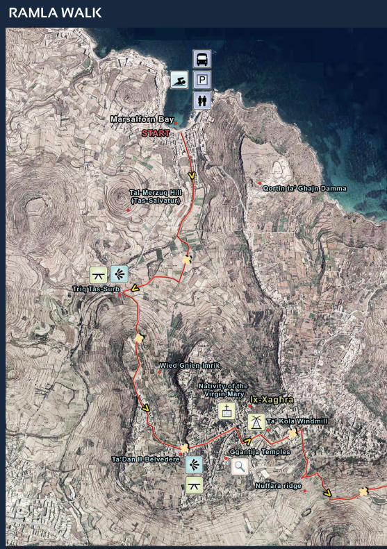
MARSALFORN TO RAMLA - 8KM
Ramla Walk

2
Ramla Walk
Xlendi Walk
Ħondoq Ir-Rummien Walk
Dwejra Walk
Comino Walk
Daħlet Qorrot Walk
Saltpans Walk
Ta’ Ġurdan Walk
Starting: Marsalforn Bay
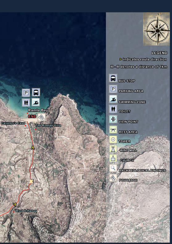
Ending: Ramla Bay
Length: 8km
Grading: Moderate, difficulty with some steep inclines and a few rocky areas
Landscape: Urban, coastal, countryside roads and paths
Trail markings
Getting there and back: Gozo Channel operates regular ferries to L-Imġarr Harbour leaving from iċ-Ċirkewwa in Malta. Buses leave from Mġarr to Marsalforn and then a return bus can be taken from Ramla to the harbour.
Recommended Walking season: October to May
3
OverviewThis walk starts from Marsalforn Bay, passing through the village of ix-Xagħra, and ends in Ramla Bay. Taking the walker through a typical Gozitan valley behind Marsalforn Bay where traditional agricultural methods may be observed, the route leads through the picturesque village of ix-Xagħra where you can admire Marsalforn Bay on one side and Ramla Bay on the other.
Ix-Xagħra has a particularly rich historical heritage and here you can visit the Ta’ Kola Windmill, one of the few surviving windmills on the Maltese Islands dating back to the Knights’ Period, and the Ġgantija Temples, an extraordinary UNESCO World Heritage site consisting of two Neolithic stone temples built as early as 3600 B.C., putting them amongst the oldest freestanding stone structures in the world.
The walk proceeds by means of an old, quiet road which will lead you around the base of ‘Nuffara Ridge’. On arriving at Ramla Bay, you will discover a treasure in its own right, with remarkable ecological, geological, historical and archaeological features.
With its beautiful red sands, Ramla Bay, classified as a Natura 2000 protected site, has the island’s best beach and an ecologically important rare sand-dune habitat, as well as features of interest from the times of the Romans and the Knights.
The map shown in the centre pages of this booklet, together with several stone plinths located along the route, will help you follow the route. It offers a fascinating cross-section of Gozitan countryside, folklore and traditions.

4
NotesCOUNTRYSIDE CODE
• The route is suitable for pedestrians, horse rides and pedal bikes.• Most of the route is accessible to small vehicles servicing persons with disabilities.• Before setting out, check the local bus schedule to avoid being stranded.• Since most of the walk is in open countryside, check the local weather forecast and carry
a raincoat when the weather is not stable.• After heavy downpours, allow a few hours to pass as crossing valleys might be unsafe
because some roads are strictly near watercourses. • The use of adequate hiking shoes is recommended. Tread carefully when route takes you
over clay footpaths.• As most of the route is in the open countryside it is advisable to carry a packed lunch.• It is possible to buy food at Marsalforn, ix-Xagħra and Ramla Bay where public
convenience places are also available.
HEALTH AND SAFETY
• Walk only along the set route.• Fields are privately owned so please do not take any short cuts.• Do not climb over rubble walls, they are easily damaged.• Do not leave any litter. Dispose of all litter appropriately.• Respect the privacy of people living along the route.• Do not pick any flowers and plants, take only photographs.• Do not widen any trails by trampling.• Do not throw any stones or other objects into the valleys or freshwater bodies.• It is advisable to tackle the route in broad daylight allowing stops, for resting, viewing,
photographing, etc.• Avoid walking or cycling close to the cliff edges. Beware of sudden guests of wind.• Bird trapping and hunting are practiced in the countryside. There are, however, strict
regulations determining areas where such activities are permitted and times of the year where no such activities are allowed.
Before undertaking any part of this walk, it is strongly recommended to ensure that one’s physical and medical conditions permit the undertaking of these activities. Particular attention is to be made to the often irregular terrain and to refrain from undertaking these walks in prohibitive weather conditions. All walks are undertaken at one’s own risk.
Whilst every effort has been made to ensure the accuracy of information contained in this brochure as at time of publication, the Ministry for Gozo accepts no liability for any inaccuracies or omissions whatsoever. Moreover, the Ministry for Gozo accepts no liability for accidents or any type of losses while following these walks.
WALK HIGHLIGHTS
While hiking along this route, you will explore several of Gozo’s natural, geological, historical and traditional features especially in the area of ix-Xagħra. However, particularly distinctive of this walk are the Ġgantija Temples a UNESCO World Heritage site, Ta’ Kola Windmill, one of the few surviving windmills on the Maltese Islands, Marsalforn Bay and Ramla Bay which is a large red sandy beach included in the list of Natura 2000 protected sites.

5
Il-Wied ta Marsalforn
This walk starts from Marsalforn Bay on the North West coast of Gozo. With the bay at your back
and the small sandy beach to your left take the street called Triq Il-Wied ta’ Marsalforn.
Along this road you will see the watercourse that runs alongside it on your right. Just outside the town, to the left, you can feast your eyes on the splendid panoramic views of the plateau called Qortin ta’ Għajn Damma. You will also notice a conical hill, on the right, with a 12 meter high statue of Christ on top.
As you walk up the road you can admire typical river bank vegetation including Oleanders and Eucalyptus trees.
Arriving at a spot with a cherry tree, from which three narrow streets radiate, take the central road.
On both sides of this minor country road are dry-stone walls (1), which represent examples of “ecological corridors”.
Tas-Salvatur Hill

6
When you come to the Y-junction, take the right fork; this country road runs along the Wied Ġnien Imrik Valley and for this reason during rainfall events of a certain intensity the road becomes the preferential path for the flow of water.
When you get to a junction, as indicated by an arrow sculpted in a profiled block of rock, take the road on the right that leads to Għajn Damma; along this road, again bounded by dry-stone walls, you will see the abbreviation V.R. carved in a block of rock; it stands for “Victoria Regina” and was added to the coat of arms of Victoria after Queen Victoria visited the island.
After about 350 metres turn left along the road named Triq Sruġ, and keeping to the right continue along Triq Sruġ, an uphill country road leading to the village of ix-Xagħra.
On the right-hand side of this road you can see outcrops of rocks belonging to the Upper Coralline Limestone geological
Dry-Stone Walks
Olive tree

7
formation, the youngest Tertiary formation of the Maltese Islands, which in this area displays a wide range of lateral and vertical variations.
At the edge of the road you will notice the Sea Squill (Urginea pancration), a species typical of garrigues, cliff tops, valley-sides and rocky environments, all of which are common on the island of Gozo.
At the end of the climb, to your right you can see a plateau called Ta’ Kuljat, with a beautiful view of Victoria with its medieval Citadel, and the Ta’ Marsalforn Valley below. On the cliffs you will see the typical Mediterranean maquis habitat which hosts species including small
plants such as Mediterranean Asparagus, (Asparagus aphyllus) and large bushes and trees such as the wild Olive tree (Olea europaea subsp. Oleaster), Carob
V.R. Abbreviation
Sea Squill

8
Church of the Nativity of Our Lady
(Ceratonia siliqua) and Lentisk (Pistacia lentiscus).
When you arrive at the entrance to ix-Xagħra village, take the road named Triq Il-Kortoll to the left; along this road you will see ancient windmills, also known as windpumps. Years ago when no electricity was available, these windmills were a very important tool for farmers, who used them to draw water from underground to irrigate their fields. The wind turns the mill which makes a shaft go up and down, bringing water up to the surface.
When the road converges with Triq Il-Knisja you see a viewing point with
benches where you can stop to admire from afar the view of Marsalforn Bay.
Continuing towards the centre of ix-Xagħra you arrive in the square outside the parish church of this important Gozitan village. Dedicated to the Nativity of the Virgin Mary, it is known locally as ‘Il-Bambina’ (2). In the square there are restaurants and bars where you can take a break.
Take the road to the right of the church named Triq It-8 ta’ Settembru and after about 100 metres turn left into Triq Marija Bambina, following the signs to the Ġgantija Temples.
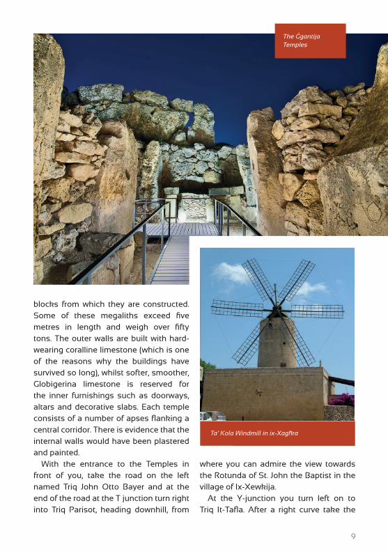
As soon as you take the road you cannot avoid seeing in front of you the Ta’ Kola windmill (3), built and financed by the Order of Saint John in 1725 and named after the original owner.
The building incorporates a circular tower about 15 metres high. There are six fabric-covered wood-framed wings, each 8.5 metres long. Though perfectly preserved the mill no longer operates as such but serves as a folklore museum with many traditional tools on display.
After a visit to the windmill you continue along Triq Il-Mitħna, which leads towards the Ġgantija Temples (4).
The two temples making up this remarkable UNESCO World Heritage site have an extraordinary history. Built between 3600 and 3200 B.C., they fell into disuse around 2500 B.C. and were not fully revealed to the modern eye until the nineteenth century.
The name Ġgantija derives from the word ‘ġgant’, Maltese for giant, as Gozitans used to believe the temples were built by a race of giants. This is not so surprising when you see the size of the limestone
9
The Ġgantija Temples
blocks from which they are constructed. Some of these megaliths exceed five metres in length and weigh over fifty tons. The outer walls are built with hard-wearing coralline limestone (which is one of the reasons why the buildings have survived so long), whilst softer, smoother, Globigerina limestone is reserved for the inner furnishings such as doorways, altars and decorative slabs. Each temple consists of a number of apses flanking a central corridor. There is evidence that the internal walls would have been plastered and painted.
With the entrance to the Temples in front of you, take the road on the left named Triq John Otto Bayer and at the end of the road at the T junction turn right into Triq Parisot, heading downhill, from
where you can admire the view towards the Rotunda of St. John the Baptist in the village of Ix-Xewkija.
At the Y-junction you turn left on to Triq It-Tafla. After a right curve take the
Ta’ Kola Windmill in ix-Xagħra

10
Nuffara Hill
The Painted Frog
narrow concrete road to the left that leads down towards the Wied tal-Għejjun Valley. While you walk along this narrow street, notice ahead of you Nuffara Hill, a typical Gozitan flat-topped hill with its lower slopes dedicated to agriculture. This hill once supported a large Neolithic village although its huts have all been swept away by weather and agriculture. Archaeological investigations have
revealed a number of round holes with large bell-shaped recesses below. These served as silos or cisterns during the Bronze Age period (1450 - 300 B.C.).
A number of grain storage pits can still be seen on site, one of which was examined in 1961, with large numbers of pottery shards being recovered.
Continue walking along this road until it ends at a T-junction and turn into a narrow side-road to your left. This side road is called ‘Old Ramla Road’, since it was the only road that led to Ramla from the village of ix-Xagħra. This road will take you around the base of ‘Nuffara Ridge’ which is situated between the slopes of in-Nadur and ix-Xagħra. Along this path you can notice dry-stone walls, farmland and the valley of Wied Il-Ħanaq, which intersects the path making it impassable during intense rainfall. You see lots of Prickly Pear trees (Opuntia Ficus-India), a plant introduced from the US around

11
Ramla Bay
the end of the 19th century which thrives in the Maltese islands. Crops in the area include potatoes, courgettes, artichokes and vines.
When the path ends at a T-junction, turn right into Triq Ta’ Għajn Ħosna, the road that leads to Ramla Bay.
Along this road you see extensive beds of the Great Reed (Arundo Domax), which characterizes the Ramla Valley. Local inhabitants use the dried cane of this plant for various purposes. Rows of canes are tied together to produce the familiar windbreaks that are used to shield the crops from the northern wind in winter. The reed curtains that can be seen covering the front doors and windows of Gozitan houses are also made of these
reeds, which are cut and tied together with lengths of cord.
As you ramble along the valley road you will see a number of small dams used by local farmers for gathering rainwater. This is then used to irrigate their crops and fruit trees during the dry summer months. These orchards consist mainly of citrus, pomegranate and apple trees as well as vines.
Furthermore, virtually all year round, tadpoles of the Painted Frog, the only amphibian of the Maltese islands, can be seen swimming in the watercourses. The Ramla Valley was involved in the “Alter Acqua” project, the Non-Conventional Water Resources Programme in Malta, which is co-funded by The Coca-Cola
12
RAMLA WALK
13

14
Foundation, through which dry-stone walls were built in order to improve water availability and facilitate sustainable development.
On arriving at Ramla Bay a large parking area, telephone box and public toilets are available. Ramla boasts unique historical, geographical, and natural features just waiting to be discovered.
The first thing that will probably capture your attention, other than the beach itself, is a small slope located along the side of the parking area. Here you can see the heavily eroded remains of an old building. These are the remains of the ‘Ramla Left Balincourt Battery’. In all there were three batteries located at Ramla Bay. The second battery is the ‘Ramla Vendome Redoubt’,
formerly located in the centre of Ramla Bay. However, in 1881 it was replaced by a votive statue of the Madonna. Behind this statue you can still see stone slabs which once formed part of the redoubt. The third battery, the ‘Ramla Right Balincourt Battery’, was built in a cave on the cliffs of in-Nadur. The cave can still be seen from the bay. Some elderly people from in-Nadur maintain that a staircase used to connect this battery to the bay. These batteries were built around Gozo between 1715 and 1716. The three batteries at Ramla Bay were also protected by an entrenchment wall, which was built in the sea. On the eastern side of Ramla Bay, lying on the edge of the seashore, is a large rock with a big circular hole in it. This
The Sandy Beach of Ramla Bay

15
hole used to form part of the defensive system and is known as a fougasse (5).
During the Winter months, a large amount of rainwater flows from the valley into the sea. This forms a pond of brackish water and Great Reeds grow by its banks. In Summer, this pond does not dry out completely and the Killifish, an endemic brackish water fish, can be seen in it.
The sandy beach of Ramla Bay is about 400 metres long and about 100 metres wide in the middle. The fine, red-brown,
well-sorted calcareous sand is derived mostly from the disintegration of blocks of Għajn Melel that lie at sea level along the rocky coast at the foot of the in-Nadur promontory. These blocks detach from the scarp of the Coralline plateau and slide down the Blue Clay slopes to the shore below. The sand produced by their physical disintegration is transported by longshore drift to the cove of the bay where it accumulates to form the sandy beach. At the back of this beach are the best examples of contemporary and fossil Quaternary sand dunes on the Maltese Islands. These dunes attain a maximum height of several metres and cover most of the eastern parts of the low lying valley floor up to a distance of about 400 metres inland. The outer dunes are fixed by vegetation and are generally well preserved. Like the sandy beach itself, these dunes are composed of red-brown, calcareous, loose sand derived from the erosion of the Għajn Melel.
Statue of the Madona in Ramla Bay
Pond of brackish water
16
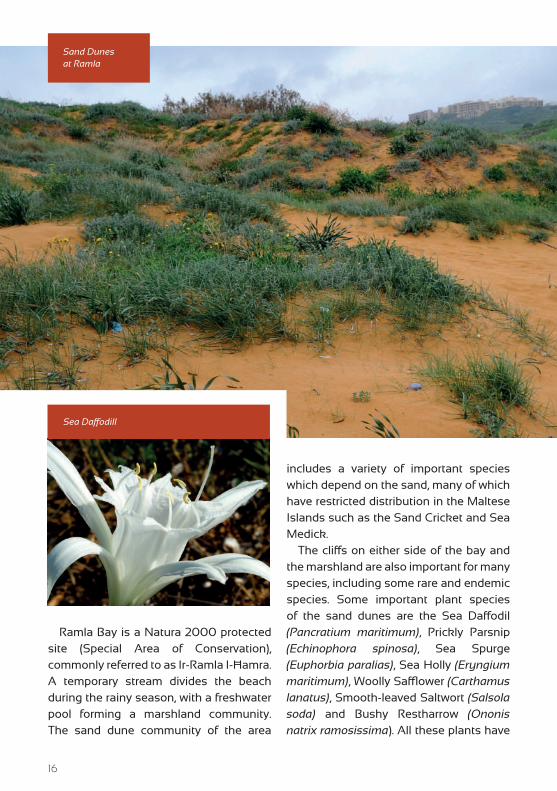
Ramla Bay is a Natura 2000 protected site (Special Area of Conservation), commonly referred to as Ir-Ramla I-Ħamra. A temporary stream divides the beach during the rainy season, with a freshwater pool forming a marshland community. The sand dune community of the area
includes a variety of important species which depend on the sand, many of which have restricted distribution in the Maltese Islands such as the Sand Cricket and Sea Medick.
The cliffs on either side of the bay and the marshland are also important for many species, including some rare and endemic species. Some important plant species of the sand dunes are the Sea Daffodil (Pancratium maritimum), Prickly Parsnip (Echinophora spinosa), Sea Spurge (Euphorbia paralias), Sea Holly (Eryngium maritimum), Woolly Safflower (Carthamus lanatus), Smooth-leaved Saltwort (Salsola soda) and Bushy Restharrow (Ononis natrix ramosissima). All these plants have
Sand Dunes at Ramla
Sea Daffodill

17
developed adaptations that help them survive in these harsh, dry and highly saline conditions.
Since the sand dunes are not static and their shape changes at a relatively fast rate, these plants have also managed to cope with surviving in a disturbed environment. They can even survive when they are buried under the sand. This habitat also harbours a variety of insect species. They live on plants or else are found burrowing in the sand. Many species of spider are found here but they are usually very well camouflaged and hard to spot.
The sand dunes also provide an appropriate habitat for numerous African Tamarisk trees. These trees harbour a
variety of birds and reptiles. Since their roots are firmly anchored in the sand, they reduce sand dune erosion considerably.
On the shoreline, a whole new ecosystem exists. You may spot small worms called ‘swat’ burrowing in the wet sand near the sea. Additionally, several other organisms live in the Posidonia seaweed that is washed ashore.
Loggerhead turtles, now extinct on Gozo and Malta, used to breed in Ramla up until the 1930s.
Sand dunes and their fragile ecosystems have become quite rare in the Maltese islands, as most other sandy beaches have suffered significant impacts owing to intensive development.
Walking in Ramla Bay
18
DRY-STONE WALLS
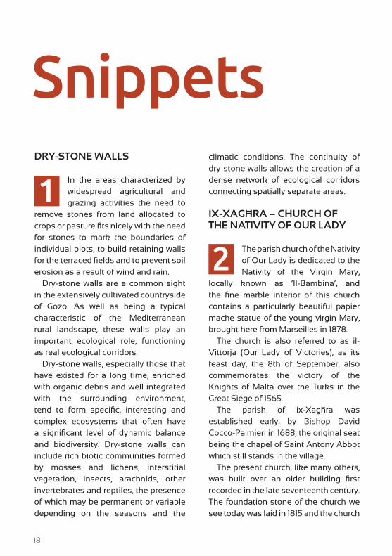
In the areas characterized by widespread agricultural and grazing activities the need to
remove stones from land allocated to crops or pasture fits nicely with the need for stones to mark the boundaries of individual plots, to build retaining walls for the terraced fields and to prevent soil erosion as a result of wind and rain.
Dry-stone walls are a common sight in the extensively cultivated countryside of Gozo. As well as being a typical characteristic of the Mediterranean rural landscape, these walls play an important ecological role, functioning as real ecological corridors.
Dry-stone walls, especially those that have existed for a long time, enriched with organic debris and well integrated with the surrounding environment, tend to form specific, interesting and complex ecosystems that often have a significant level of dynamic balance and biodiversity. Dry-stone walls can include rich biotic communities formed by mosses and lichens, interstitial vegetation, insects, arachnids, other invertebrates and reptiles, the presence of which may be permanent or variable depending on the seasons and the
climatic conditions. The continuity of dry-stone walls allows the creation of a dense network of ecological corridors connecting spatially separate areas.
IX-XAGĦRA – CHURCH OF THE NATIVITY OF OUR LADY
The parish church of the Nativity of Our Lady is dedicated to the Nativity of the Virgin Mary,
locally known as ‘Il-Bambina’, and the fine marble interior of this church contains a particularly beautiful papier mache statue of the young virgin Mary, brought here from Marseilles in 1878.
The church is also referred to as il-Vittorja (Our Lady of Victories), as its feast day, the 8th of September, also commemorates the victory of the Knights of Malta over the Turks in the Great Siege of 1565.
The parish of ix-Xagħra was established early, by Bishop David Cocco-Palmieri in 1688, the original seat being the chapel of Saint Antony Abbot which still stands in the village.
The present church, like many others, was built over an older building first recorded in the late seventeenth century. The foundation stone of the church we see today was laid in 1815 and the church
Snippets
1
2

19
was consecrated in 1878. The fourth Collegiate of Gozo was established at ix-Xagħra in 1900 and the title of Basilica was conferred on the parish in 1967.
TA’ KOLA WINDMILL
Ta’ Kola Windmill in ix-Xagħra, Gozo, is one of the few surviving windmills on
the Maltese Islands dating back to the Knights’ Period. Its origins go back to 1725 during the magistracy of Grand Master Manoel de Vilhena (1722-36). As its construction seems to have incorporated bad quality stones and mortar, it had to be dismantled and reconstructed during the 1780s.
The windmill’s name Ta’ Kola is connected with the last miller, Ġuzeppi Grech who was popularly known as Żeppu ta’ Kola (Joseph the son of Nikola).
Apart from operating the windmill, the miller would likely have performed several secondary jobs to keep himself employed when weather conditions made it impossible to operate the mill. When the wind was favourable for the mill to be operated, the miller would let the locals know by blowing through a triton-shell (Maltese bronja) and villagers would then bring their cereals to be ground into flour.
Its construction follows a plan which is echoed in most Maltese windmills of the period and consists of a number of rooms on two floors surrounding the centrally-placed cylindrical stone tower. The latter houses the milling
mechanism which consists of two circular hard-wearing stones placed on top of each other to crush the grain forced between the two rotating surfaces.
On the ground floor of the windmill one can observe the workshop premises containing a vast array of tools, some of which were originally manufactured by the owners of the mill. On the first floor, the living quarters of the miller including the kitchen, dining room and bedrooms, have been recreated using traditional furniture and items related to Gozitan crafts. In the kitchen one may find traditional utensils and cooking ware which are today hard to come across. The building incorporates a circular tower about 15 meters high and there are six fabric-covered wood-framed wings, each 8.5 meters long.
In August 2013, the windmill mechanism was dismantled in order to carry out repair and restoration work on the parts to be retained and to install the newly produced sections. In addition, general maintenance work will be carried out on the tower’s internal stonework to return the windmill to its original operational condition.
ĠGANTIJA TEMPLES
The Ġgantija Temples in ix-Xagħra are one of the most important archaeological sites
in the Maltese Islands and are listed on the UNESCO World Heritage List. The site consists of two temples dating back to between 3600 and 3200 B.C.
3
4

20
The name Ġgantija derives from the word ġgant, the Maltese word for giant as the site was commonly associated with a race of giants. Notwithstanding its age, the monument survives in a considerably good state of preservation. This is evident in the boundary wall which encloses the two temples, and which is built in rough coralline limestone blocks. Some of the megaliths exceed five meters in length and weigh over fifty tons.
The hard-wearing coralline limestone is used extensively at Ġgantija, and is one of the reasons behind the preservation of the monument. The softer Globigerina limestone is reserved for inner furnishings such as doorways, altars and decorative slabs. Each temple consists of a number of apses flanking a
central corridor. There is evidence of the internal walls having been plastered and painted over, as proven by two plaster fragments with red ochre, now preserved at the Ġgantija Visitors Centre.
Remains of animal bone suggest some sort of ritual involving animal sacrifice. The use of fire is evidenced by the presence of stone hearths. A number of libation holes in the floor may have been used for the pouring of liquid offerings. It is probable that during ceremonial activities, the congregation would have assembled outside the temple complex, since the large forecourt in front of the two temples was purposely raised by the same temple builders.
A small number of prehistoric objects found at Ġgantija are today preserved
Ġgantija Temples
21
at the Ġgantija Visitors Centre and include two stone heads, a large stone block with a snake relief, and a phallic symbol.
BATTERIES AND REDOUBTS
These batteries and redoubts
were armed with the necessary
weapons, usually between four
to ten 12-pounder cannons, to prevent
enemy forces from landing on the island.
The military architects D’Arginy, Fontete
and Bachelius devised the plan of these
redoubts and presented it in the Report of
January 10, 1715. These plans were further
developed by the French military architect
Vendsome.
UNDERWATER DEFENCES. A complex series of fortifications were devised for Ramla Bay, including the building of an underwater entrenchment wall. The latter spans the whole bay and although invisible from the sea, is very effective in preventing vessels from reaching the beach. The wall is best seen from Calypso’s Cave (6), where you will be able to see a dark jagged line across the bay.
FOUGASSES. Fougasses were excavated as close as possible to the shore with their axles pointing towards the most probable route that the enemy would take. The defenders would charge the fougasses with a barrel of gunpowder and then load them with rocks, keeping the largest rocks at the bottom.
Fougasses were meant to discharge a shower of stones that would cause a great deal of damage to the enemy galleys. If they missed however, the fougasses needed about one hour to be reloaded, but the Knight’s optimism was inexhaustible. This is shown by a quote from Boisgelin’s Ancient and Modern Malta, Appendix IV: ‘‘even if they miss their aim they inspire great terror, from the apprehension that a second attempt may be more successful. ”
THE ROMAN VILLA. Remains of this villa were discovered in 1910 by some local farmers who were digging in the sand near the remains of the old battery. While they were digging they unearthed some pieces of fine marble. That evening these farmers went to the local wine shop and talked about what they had found. A school headmaster, Mr Farrugia, happened to be in the same shop and overheard the story and immediately phoned Sir Temi Zammit, who at the time was the Museums Director. Sir Temi Zammit showed up at Ramla Bay the following morning. The excavations revealed the remains of a Roman villa complete with baths. The villa had about 19 rooms some of which were decorated with mosaic and marble; the villa was also found to be fitted with a heating and drainage system. The artefacts that were found are now preserved at the National Museum in Valletta. Following excavations and proper recording, the remains of this villa have once again been buried under sand for the sake of protection.
5

22
CALYPSO’S CAVE
From the parking area of Ramla
Bay, to the west you can see a
viewing platform near which is
Calypso’s Cave. According to tradition,
this is the cave referred to by Homer in
the Odyssey, the epic Greek poem of
the ninth century BC. When Ulysses was
returning from Troy to Ithaca after the
Trojan War, he was shipwrecked and
together with his companions, drifted
southwards from the Straits of Messina
towards the island closest to Sicily, which
has been identified as Gozo. The nymph
Calypso reputedly lived in this cave and
this is where she entertained Ulysses
for seven years before he resumed his
journey. Calypso’s Cave is actually a
series of caves and, according to legend,
extends right down to the sea. From the
viewing platform near the Cave you have
a panoramic view of the coastline and
Ramla Bay. From here you can see, about
50 metres offshore, the remains of the
Underwater Defences constructed by
the Knights to deter invasion across this
open bay.
You can reach Calypso’s Cave by taking
the narrow beaten-earth path uphill behind
the buildings located to the West of Ramla
Bay (taking extra care in case of rain).
6
Calypso’s Cave

23
Info Pages
WEBSITES:
www.gozo.gov.mtwww.visitgozo.comwww.ecogozo.com
www.gozochannel.com
TOURIST INFORMATION OFFICE IN GOZO:
No. 17, Independence Square, Victoria, Gozo, VCT 1021Tel: (+356) 22915452
OPENING HOURS:Mondays to Saturdays: 09:00 to 17:30 (Last admission 17:15)
Sundays and public holidays*: 09:00 to 13:00 (Last admission 12:45)
Note: *except on Christmas Day, New Year, Good Friday & Easter Sunday
BUS TIMETABLES:
www.transport.gov.mt
All rights reserved. No part of this publication may be reproduced, stored in retrieval system or transmitted, in any form or by any means, electronic, mechanical, photocopying,
recording or otherwise, without the prior written consent of the copyright holder. Direct enquiries may be forwarded to the Ministry for Gozo.

Photography by:
ARON TANTIETIENNE MICALLEFDANIEL CILIAGEORGE SCERRI
HERITAGE MALTAJOSEPH FARRUGIARENO RAPATHERESE DEBONO
Xlendi Walk Ħondoq Ir-Rummien Walk
Dwejra Walk
Comino Walk
Daħlet Qorrot WalkSaltpans Walk Ta’ Ġurdan Walk
O T H E R W A L K S IN THE SERIES
Rural Development Programme for Malta 2007-2013
Axis 3 – Improving the Quality of Life in Rural AreasProject Part-financed by the European Union
The European Agricultural Fund for Rural DevelopmentCo-financing Rate: 75% European Union: 25% Government of Malta
Europe Investing in Rural Areas
MINISTRY FOR GOZO