natural resources endowment of...
TRANSCRIPT
12
Chapter-2
NATURAL RESOURCES ENDOWMENT OF MEGHALAYA
Meghalaya is one of the seven States in North-
Eastern India. Meghalaya ranks third, in terms of ^area
among all the seven States, Meghalaya was first formed
into an autonomous State with the State of Assam in 1971
comprising the two erstwhile Districts of the United
Khasi-Jaintia Hills and Garo Hills of the- then composite
State of Assam. But within two years of existence as
autonomous State, it became necessary to give her the
status of full statehood on 21 January 1972.
Immediately after the- birth of the State of
Meghalaya, a new District was formed on 22 February 1972
by upgrading: the Jaintia Hills Sub-Division of the
13
then district of United Khaei and Jaintia Hills. In
October 1976, two more districts namely the West Khasi
Hills District and the East Garo Hills District were
created. In 1992 again two more districts, namely, the
Ri-Bhoi District and the South Garo Hills District were
created. Thus the number of districts in Meghalaya now is
seven.
Locationally, the State of Meghalaya has some
significance in that it serves as an important link
between the Brahmaputra Valley in the north and the Barak
Valley of Assam, the State of Mizoram and the State of
Tripura in the South. A National Highway (NH) runs
through the State from Guwahati to Silchar and Badarpur
and on to Aizawl, the capital of Mizoram, and to Agartala,
the capital of Tripura. Further, it has common
international borders with Bangladesh (formerly East
Pakistan). As a result oi the partition of 1947, there
has been great economic disruption in and along the
southern border of the State.
THE MEGHALAYA PLATEAU
The State of Meghalaya occupies almost the whole of I
the "main" plateau of the same name. The Meghalaya
plateau, popularly known before as the Shillong Plateau,
14
forms part of what is usually termed "the Central Assam
Range" and consists of the Garo-Khasi-Jaintia-North Cachar
Hills (constituting the 'main' plateau) and the truncated
Mikir Hills. The new name Meghalaya (meaning 'the Abode
of the Clouds') was given later on to the plateau on
account of its high pluviousity. Indeed, many parts of
Meghalaya receive heavy rainfalls every year. Cherrapunjee
and Mawsynram situated In the southern part of Khasi Hills
are two rainiest centres of the world.
The western part of the Meghalaya plateau, the Garo
Hills, is an extensively dissected tract and is lower in
elevation and rises more gently eastwards. This has
enabled the river Brahmaputra to change its course from
west to south along the western edge of the plateau.
Towards the east , the plateau forms part of the North-
Cachar Hills and thence joins the Naga Hills.
Geologically, the two portions are quite distinct - the
plateau being an area which has undergone very little
tertiary folding while the eastern hills belonging to the
area of very intricate faulted and folded structure. Near
Haflong- the junction of the plateau country and the hill
1. "Meghalaya-Mikir Region", in R.L. Singh (ed.), India -A Regional Geography (National Geographical Society of India, Varanasi, January, 1971), p.676 and p.682, see also D.N.D. Goswami, Geology of Assam (Gauhati, 1960), p. 1 .
15
country is very sharply marked, coinciding with the
Haflong-Disang overthrust fault. In the words of Goswami,
the plateau abuts upon the mountain ranges of the extra
peninsular of the eastern Himalayas along the Haflong-
Disang fault. But administratively, the eastern and the
north-eastern sections of the 'main' plateau do not form
parts of the state of Meghalaya. The former section
covering the Diyung Bapin, was cut off from the Jaintia
Hills Sub-Division, way back during the British rule of
India on th® formation ©f the North Cachar Hills Sub-
Division. Prior to the formation of the latter Sub
division, the erstwhile district of the Khasi and Jaintia
Hills used ts? have a coniroon border on the east with the
then Naga Hilli District,^
The north-eastern section of the plateau, on the
other hand, comprising an area of about 1543 sq. km. and
falling under the Mynser Region, was carved out of the
then Jaintia Hills Sub-division on the formation of the
new district QS th© United Mlkir and North Cachar Hills in
the post'-I ndependence period.
2. D.N.D, Goswami, GggloKy of Assam (Gauhati, I960), p.K
3. W.W. Hunter, A Statistical Account of Assam (London, 1879, Reprinted New Delhi, 1975), p.173 and"~pp.203-4.

16
The Mikir Hills proper, though Included under the
material division of the Meghalaya plateau, are lying
outside the 'main' plateau. They extend from the west-
flowing Jamuna river almost upto the Brahmaputra river and
stand as a dividing factor between the Upper Assam Valley
and the Lower Assam Valley in the south bank of the
Brahmaputra. They are a peninsula almost isolated from
the Meghalaya plateau and surrounded by the plains on
three sides. Their link with the 'main' plateau is
towards the south through a patch of highly denuded and 4
subdued senile terrain.
The Geology of the Plateau
The Meghalaya plateau, though it now forms part of
the north-eastern region, is really an eastward extension
of the massive block of peninsular India. There is
enough reason to believe that the Meghalaya plateau was
once part and parcel of the peninsular shield.
StratIgraphically, the Meghalaya plateau Is occupuled by
(a) Archaein gnelslc complex with acid and basic
intrusives, (b) Shillong group of rocks, (c) Lower
Gondwana rocks, (d) Sylhet Traps, and (e) Cretaceous -
4. "Meghalaya-Mikir Region",' 0£. cit . , p,682; S.P. Chatterjee, "Physiography^ in The Gazetteer of India, Vol.1 (1975), p.29; N.C.A.E.R., Techno-Economic Survey of Aseam (New Delhi, 1962), p.2; Report of the Commission on the Hill Areas of Assam, 19o5-66 (1965) , p.8.
17
Tertiary sediments.
The Archaean gneissi' t complex ig exposed in the
central and northern parts of thi Meghalaya plateau. The
presenes of these roeks proves bgyond doubt that Meghalaya
is the north-eastern sxtension of the Indian Peningular
Block which hoH baen eeparatsd by the Garo-Rajmahal fault
of the Malda gap as a result of denudational and tectonic
for-esg* The Archaean basemsnt ©f Meghalaya remained a
landmass Gxperlencing earth niovg?n@fst@ leading to complete
folding and fraetuj'ing sf the- ancient i-ssks till the pre-
cambri&n times when paptg el th© plateau developed into a
trough 0Y@r which the sedimentg of the Shilleng group of
rocKa W9.r6 laid. These pogks are exposed in the egntral
and eastepn p&rta QI Mtghalaya. The granite intFualve
alertg the &s?ial rsiion ef the Shillong Gr§up of rocks
araund Myllisro is tepfflid as Mylliem Granite. This flams as
glv^n tey HsBs N4@dlic§tt (1869) was subsequently shanged
int© Shilleng QyanitQ by H.G. Dass Gupta (1930) e
Lowes' Oondwana pseks are recognised, in the western
part ©I the platgau* Th§y consist of psbfelg bed.
3, Geologieal Supvgy of India* Misce 11 anepus Ftjbligalion NQ.30, Geology and_jv1itieyal Resources of tfae'StaTei of
foul t a, ,1^74) , pp. 7 2-7 3. Tndia ?art
6, S.Pe ehatterjss, ©£. Mi'» P'2?S G.S.I«? ©g,. lii* • pp,74»79i and 0,N ,57 Ooawami, 0£. cjU., p.68,
18
sandstones and carbonaceous shale with streaks and lenses
of coal and impressions of Verte-braria indica. The
sandstone dips westwards and is intruded by dykes of
doles ite .
The post precambrian landmass experienced
peneplanatIon till Jurassic times resulting into the
formation of a flat levelled surface preserved over the
plateau till today. By the end of the Jurassic period,
the southern border of the plateau experienced eruption of
basalts, the Sylhet Trap, through eastward fissures termed
the Raibah fault. The Cretaceous-Tertiary Sediments are
also found in the Meghalaya Plateau. The sediments occupy
the southern part of the plateau and are considered to be
physically continuous with the Cretaceous-Tertiary
sediments of the Bengal Basin. Isolated patches of older
Alluvium also overlie the tertiary rocks along the
southern and western borders of the plateau. Such patches
are also found along the north-western fringes of the
Meghalaya plateau. Recent Alluvium is found in the river
valleys on the northern foothill region, along the western
border and along the southern foothill region of the
plateau .
7. G.S.I., o£. cit . , p.74
8. Ibid., pp.75-79.
19
PHYSIOGRAPHIC DIVISIONS
Meghalaya covers an area of 22,643.6 sq. km.
extending between 25°9' and 26°10' North parallels of
Latitude and between 89'" 47' and 92°47' East meridians of 9
Longitude. It is bounded on the northwest, north, east and
southeast by the State of Assam and on the south and
southeast by Bangladesh (formerly East Pakistan). The
State has its opening to other parts of I,ndia through
Assam which, in turn, is connected with the rest of the
country by a narrow strip of land corridor of 30 km. wide
lying below the foothills of Bhutan and Sikkim.
The physiographic characteristics of the Meghalaya
region are remarkable due to the highly dissected and
irregular terrain in the northern faces in contrast to the
regular and steep fall of the southern face, down to the
Barak-Surma plain through a faulted face.
Physiographically, Meghalaya can be divided into three
distinct divisions, viz. (i) The Central Upland, (ii) The
Northern Submontane Region and (111) The Southern Belt of
Hills. . , ' '
9. S.P. Chatterjee, o£. cit., p.28* See also Statistical Handbook, Meghalaya 1971 and the , District Census Handbooks; of Garo and United Khasl-Jaintia Hills, 1961. 1
20
i) The Central Upland
The Central Upland ^one running east-west consists
of the plateau proper which* at its western end, attains a
height of 1,515 metres In th^ peak of Nokrek situated 13 km
south-east of Tura and, at its eastern end, attains 1961
metres in the Shillong peak located just south of
Shillong. In the west, the upland zone begins as the
Tura Range and the Arbella Hills running parallel to each
other; eastward across a c eep gorge it continues in the
Kylas Range and the ,Ba]paki'am Hills which merge into the
Khasi Hills and thence joins the Jowai upland in Jaintia
Hills. The Tura Range is a typical horst bounded by two
fault lines and it is along the northern fault that the
Simsang, the biggest river in Garo Hills, flows eastwards
for about 45 km. before turning south through the gorge
separating the Tura Range from the Kylas Range.
In the Khasi Hills, the outer limit of the Central
Upland Zone is defined roughly by 1500 m contour line and
the upland contains remnants oi seven peneplaned surface '>
in its middle region ranging in height from 1500 metres to
2080 metres. The Shillong Hills towering above Shillong
contains the highest peneplaned surface over which streams
10. N.C.A.E.R., o£. cit . , p.2. I
11. "Meghalaya-Mikir Region", 0£. £it_. , p.681.

21
meander before plunging into the deep valleys of the Utniam
and Mynkhen rivers. The presence of many rapids and
waterfalls in the neighbourhood of ShiUong indicates that
this region has a youthful topography due perhaps to a
1 2 recent uplift.
In the Jowai Upland, the plateau character is not
well-developed. The Jowai Upland is relatively lower than
the other parts of the Central Plateau Upland zone having
1 3
a general elevation of a little over 1200 metre. 'Ri-
Lum' is the local geographical term given in Khasi Hills
to the Central Upland Zone of the plateau.
ii) The Northern-Submontane Region
The northern hills with accordant submits (170
metres to 820 metres) gradually slope down towards the
Brahmaputra Valley and form, therefore, the submontane
14 region of the plateau. This region has an undulating
topography. It consists of an extensive plateau with
contiguous flat lands and open valleys particularly in'its,
western portion where the hills ' are low and
. ^ .. 15 uninteresting .
12. S.P. Chatterjee, o£. cit ., pp.28-29.''
13. "Meghalaya-Mikir Region",' o£. cit . , p.682.
14. Ibid., p.Mi
ls. W.W. Hunter, o£. cit. , p.137*
22
In the middle part of this region the surrmlt oi
these hills vary between 170 metres and 820 metres. Most
of the hillocks are conspicuous by their flat-top
character. In the east, the Jaintia Hills are rather
irregular in form and broken in many places. Many
embayments projects into the hills along the head stream
of the Kupli river. The interesting physiographic
feature in this region is that the limit of the plateau is
not very well-defined, there being broken ranges of low
irregular hills stretching across lower and central Assam
to the foothills of the Himalayas.^^. "Ri-Bhoi" is the
local geographical term applied to this region in Khasi
and Jaintia Hills.
iii) The Southern Belt of Hills
This region begins where the Central Upland ends at
about 900 metres elevation and stretches downward towards
1 8 the plains of Bangladesh. This is the region where the
highest rainfall occurs. "Ri-War" is the local
geographical name given to this region in Khasi and
Jaintia Hills. In the west, the southern belt consists of
16. M.C. Bhuyan, "Geographical Individuality of Meghalaya" in The Assam Tribune Supplement (April- 2, 1970), p.m.
17. "Meghalaya-Mikir Region", o£. cit . , p.680.
18. In the Draft Fifth Five-Year Plan, Government of Meghalaya i (Vol.I) p.2 , this division is called "Border Areas".
23
low hills. But as we go eastwards, it consists of the
steepest parts of the region. The low hills and valleys
slope very abruptly and in many places there are deep
gorges and precipices. The face of the escarpment has
been attached by the fluvial erosion due to extremely
heavy rainfall, and as a result, many structural platforms
were formed like the Cherrapunjee, the Lyngkyrdem, and the
Mawsynram platforms. But in Its eastern part, the
southern belt rises into a range of hills which attain a
height of 1625 metres in the peak of Marangksih, the
19 highest peak in Jaintia Hills.
THE DRAINAGE PATTERN
The Meghalaya plateau standing as a watershed
between the Surma valley of Bangladesh on the south and
the Brahmaputra valley on the north, is dissected by
several rivers and a network of their tributaries and
lateral streams. Thus the rivers of Meghalaya make two
distinct systems separated by the Central Upland 2one -
one system flowing to the north towards'the Brahmaputra
and another to the south towards the Surma.
The important rivers of the northern system from
west to east are the Kalu, Rlnggl, Chagua, Ajagar, Didrare
Krishnai, Dudnki in Garo Hills, Tyrsung, 'Khri,'- LJmtrew,'
19. M.C. Bhuyan, o£. cit
24
Um-iam-Khwan, Umsiang, Mynkhen in Khasi Hills and Myntang,
Umiurem, Waikhyrwi, Mynriang, and Kupll In Jaintia Hills.
Of these rivers, only the Krishnai and the Kalu in Garo
Hills are navigable within Meghalaya for a short distance.
The important rivers of the southern system from
west to east are the Darong, Sanda, Bandra, Bhogai, Nitai,
Simsang, Mahes"kholi in Garo Wills, Xynshi , Ummawpa, Umiam-
Mawphlang, Rew in Khasi Hills; Mynngot, Myntdu, Prang and
Lukha in Jaintia Hills. Of these, only the Simsang river
in Garo Hills is navigable up to Siju, about 32 kilometres
within Meghalaya. None of the rivers in Meghalaya form
islands, nor do they anywhere expand into lakes. The
20 Maheskholi river in Garo Hills and the Myntang river in
Jaintia Hills, each flows a subterraneous course for many
miles under the limestone rocks which form their beds.
Most of the rivers in Meghalaya are unsuitable for
navigation even by country boats. But these rivers
provide excellent facility for generating hydro-
electricity. - ' . ' ' '.' S
t
THE NATURAL REGIONS
1
The physiographic characteristics of Meghalaya are
remarkable du4 to the hilly and dissected terrain in the
20. W.W. Hunter, o£. cit . , p.l39i

25
northern faces in contrast to the regular and steep fall
of most of the southern faces. Thus, taking the ridge of
the plateau as a demarcating line between the slopes
facing to the north and the slopes facing to the south,
the Meghalaya region may be divided into two 'first
order', five 'second order', and ten 'third order' regions
as follows:
1. Meghalaya Northern Region
1) Garo Region North ;
1) Rongmachokgiri - Rongchugiri Region
ii) Krishnai-Dudhnal Basin.
2) Khasi Region North :
i) Patharkhmah-Rambrai Region
ii) Loharghat-Nongpoh Region.
2 . Meghalaya Southern Region
3) Garo Region South f
i) Tura-Dalu Region
ii) Someswari Basin.
4) Khasi Region South :
i) Kynshi-Rilang Region
ii) Shi]long-Cherrapunjee Region.
5) JaintlaRegion s
i) Jaintia Region West
I ii) Jaintia Region East.
21. "Meghalaya-Mikir Region", o£. cit. , p.695.''

26
MINERAL RESOURCES
Meghalaya is endowed with some of the important
non-metallic minerals of economic importance like
limestone, coal, clay, glass, sand and eillimanite.
Meghalaya has the largest single limestone deposit in the
country and the world's largest depoait of sillimanite .^^
The limestone occurring along a belt over the southern
scarp of the plateau, from the western end of the Garo
HiU^ eastwards upto psrth-east Jaintia Hills, aeeounts
for "an unsurpassable deposit of high grade limegtone" .^^
In this section, our discussion on the occurrence
of minerals in the State both of known economic Importance
and of little or unknown economic importance, is based on
both the published and unpublished reperts of the
Geological Survey sf India (Q.S.I.) and of the Directorate
of Mineral Resources (D.M.R,), Government of Meghalaya.
The egtimates of both these organisations on_the available
deposits of any miner^il have been taken.
22. B.K. Barua, "Foreword" in D.N.D. Goswami, £g# cJA,
23* G.S.I. , 0£. cijt >
24. The published Report of the G.S.I., on Meghalaya is contained in Miscellaneous Publication No.30, Geology
ajnd_^^^J£i£er£2_.IZl!£^!iS5^ZZiXI^^ TCalcutta, 5th November 1974) and that of the D.M.R., Government of Meghalaya in Minerals for ..Jt 4"g' -yi i Use (December, 1973) and Technical Data . o", A^^ Various Mineral Deposits o^ Meghalaya (Lat est" Report Hit'ed Nil).
27
Limestone Deposits
The southern slopes of the State abound in
limestone deposits of various grades and extents A fairly-
continuous belt occurs right fr-om the western end of the
State in Garo Hills to the eastern end in Jaintia Hills,
continuing further north-east into the Mikir Hills of
Assam. The developed sections are found in Therriaghat
and Mawlong'-Isbamati areas of Khaai Hills where four beds
of limestone occur.. In the Lakadong and Lumshnong areas
of Jaintia Hills enly thpg© beds of limegtetie h&ve been
seen, whereas in the Siju area of Garo Hills ©nly one bed
is found to hpive developed. The total reserve of
limestone deposits ©^ Mighalaya is of the orde? of more
than B.OOO million tennes according to the D.M,R, report.
The D-M.R. has gititnated the f©serve in the 'Mawlofg Ishnmatj
area In Khssi Hills alsn© at 2,166 tonnes e^fcluding the
pegepves of th?5 be>tt©Pi=ff»08t band of the deposits.
In Khaei Hills, the various limestone deposits are
given below :
(i) Therriaghat-Langrin Area
Large deposits of the limestone of the Sheila
Formation of the Jaintia Group (Eocene) oegur in a belt
following the southern, border of the Khasi Hills through
Therriaghat westward t© Lansrin. Between Therriaghat and

28
Sheila river' three beds of limestone with over 200 metre
average thickness occur with two interbedded sandstone
partings. A total inferred reserve for these occurrences
is of the order of 900 million tonnes as estimated by the
G.S.,I. The Mawlong-Ishamat i-Shel la deposit covering 13.75
sq. kms. and falling under this area, has been
investigated by the D.M.R. which has estimated the reserve
of 2,166 million tonnes of limestone excluding the
reserves of the bottoni-most band of the deposit.
According to the D.M.R. , the deposit has five bands of
limestones with the thickness of 60 m (with a maximum of
93 m at places), 12 m, 9 m , 21 m and 71 m, respectively.
ii) Shella-Bholaganj Area
The limestone deposit between Sheila and Bholaganj
includes three thick beds of Sylhet limestone proposed
along an E-W running monoclical flexure plunging steeply
against Dawki fault. The upper band is about 30 to 60 m
and is overlain by the steeply dipping beds of the Kupli
Formation along the southern margin, -The upper band,
being equally accessible, is being extensively quarried at
Komorrah and exported to Bangladesh for cement manufacture
although it is of superior grade. The G.S.I. has
estimated the reserve at Komorrah only for the upper band /
I
to be 3.5 million tonnes approximately in a strike length
29
of 720 metres and a depth of 50 metres, while the D.M.R.
has estimated a reserve of 180 million tonnes for the
upper two bands in the same site covering 2.76 sq. km.
iii) Mawmluh-Mawsmai Hills Deposit
This corresponds with the Cherrapunjee Deposit of
the D.M.R. report. The lower Sylhet (Lakadong) Limestone
with 9.0 metre thick basal dolomite and an 18.0 metre
thick upper limestone occurs in the Mawmluh-Mawsmai Hills.
The Limestone is of cement grade and its inferred workable
reserve has been placed at 40 million tonnes. The
inferred reserves for the dolomite has been found to be 20
million tonnes. The limestone in the area is being
extensively used for cement manufacture by the Mawmluh-
Cherra Cement Company.
iv) Mawlong-Ishamati Area
Five limestone bands with varied thickness are seen
in an area of 13.75 kms . An inferred reserve of 2,166
million tonnes was reported by the Directorate of Geology
and Mining, Assam (D.G.M.) but only a reserve of 395
million tonnes i has been proved by the G.S.I.
v) Komorrah Deposit
Two limestone bands were surveyed in an area of
0.36 sq. kms.' Bedded deposits of limestone with sandstone
30
alternation occur in this deposit. The indicated reserve
is 14.2 million tonnes as reported by the Directorate of
Mineral Resources (D.M.R.).
vi) Borsora Deposit
The area li es around Borsora village and the
limestone bearing area is about 1.00 sq. kms. The
indicated reserve found here is 37 million tonnes as
reported by the D.M.R.
Several scattered patches of Sylhet limestone occur
in the Lyngkyrdem-Pynursla area. Isolated out-crops of
high grade limestone are also found in the Laitryngew area
with a 7.5 metre thick band and are traceable for about
150 metres with an overburden of sandstone and thick
shale .
In Jaintia Hills, according to the G.S.I., the
Sylhet limestone shows the thickest development within a
200 sq. km. area between Prang and Lukha* rivers covering
the Lakadong plateau, Lumshnong, Mynkre and Khaddum areas.
These areas contain' considerably large reserves of high-
grade limestone. But the G.S.I, has not indicated any
estimatedreserve for all these occurrences. The following
are the important deposits in Jaintia Hills:

31
i) Lumshnong-Mynkre Deposit
Three beds of limestone inter-bedded with sandstone
belonging to Sylhet limestone stage of Jaintia series
(Eocene) are found in the different localities of this
area. A reserve of about 652 million tonnes of limestone
has been estimated over an area of 480 sq. kms. with an
average thickness of 80 metres. An area of 1.5 sq. km.
has already been mapped in detail, where the reserve is
estimated at 60 million tonnes.
ii) Sutnga Deposit
A narrow elongated outlier of the limestone resting
over Therria sandetone is> found exposed at Sutnga. The
limestone extends about 1.6 km. with an estimated reserves
of about 2 million tonnes and an average thickness of 15
metres .
ii i) Nongkhlieh Deposit
Three beds of limestone are found in the area. The
reserve of the lowest part with a thickness of 30 metres
of high grade limestone has been estimated at 12 million
tonnes. The middle part with a thickness of 30 metres is
of blast-furnace and good cement quality and its reserve
is estimated at 3.5 million tonnes. The topmost part of
the limestone' bed is 20 metres thick and is of cement
32
grade quality and has reserve of 0.5 million tonnes.
iv) Syndai Deposit
The deposit in the area forms a continuous narrow
belt. The reserve is estimated at about one million
tonne.
A huge deposit of limestone is found in the
Lakadong area as an outlier. The deposit covers an area
of 26 sq. km. but the reserve has not yet been estimated.
An outlier of Sylhet limestone also occurs around
Nongtalang covering an area of about 10 sq. kms . Here
also the reserve has not yet been estimated.
In the Garo Hills, limestone deposits occur in the
following areas where the reserves have been estimated only
by D.M.R.:
i) Siju-Artheka Deposit
The upper Sylhet limestone of the Sheila Formation
(Jaintia Group) occurs in both banks.of the Simsang river
near Siju-Artheka. The limestone is generally of very
good quality and some bands are of chemical grade. The
total estimated reserve of limestone in the area is placed
at 165 million tonnes over an area of 1.6 sq. km* with an
average thickness of 60 metres thoUBh the maximum
33
thickness is found to be as much as 90 metres in some
places .
ii) Darrang-Era-Aning Deposit
This deposit of limestone extends from Darrang-Era-
Aning in the east to Pathargithin in the west and covers
an area of 1.94 sq. km. There are two beds of limestone
intervened by a sandstone bed. In the Pathargithin area,
the average - thickness of the upper band of limestone is 15
m and that of the lower band is 3 metres, and the reserves
of both the beds have been estimated at 38.3 million
tonnes in an area of 1.4 sq. km. In Darrang-Era-Aning,
the limestone covers an area of 0.54 sq. km. and the
reserve for both the beds is estimated at 8.8 million
tonnes. The average thickness of the upper and lower beds
is 10 metres and 2 metres, respectively.
The other deposits of limestone in Garo Hills occur
in an area of 100 sq. kms. near Tura, in Rongrengiri,
Dapri, Garugiri and east of Andogiri. The reserves in all
these areas have not yet been estimated. The data on the
available reserves of limestone in the State in various
deposits are summarised in a tabular form as shown in
Table 2.1.
34
tn (1) > u to 0)
XI («
U o
0 ••J <1) u
• H
a
o
13 i)
a
• H
m +> •i-t
(A o a. 4)
Q
V c O
•4-> m V E
• H
o o
o o
o 0 0
o o
o o a-
o o
o
o o o O
O i-H O O ( M O O
in 00
( M
sO iri
o i n
o i n
I—1 (M
o o
o
o u n)
O
c^
1-" t ^
(M
o o
• r j i n vO
a - t j
rt B
• H
+J 0)
<u o z
o o
• o o r»<
1) •»J
n) B
• H
+J 10 0)
o z
0) •»J
rt B
•r* ••-> to V
o z
d) •» ->
R)
a •t- t
• t - '
to 4)
O Z
to
a) TJ 3
p-H
o X V
0) - M
(tf E
• H
+ J ^ ^
to -M a) -H
to • 0
Di Pu • <u
S Q
Q <u - ' J 3
+-» tfl 4) >*-( V O ni
T ! c c
•r-4 rtl
u x> be C +J
n) tn J O
1 E + j 1
rt E j : 0 tm •t-' rt •(->
• H O ^1 X I U 4) <U
x : X I H +^
.
4) A! • H
>H
>^ - M
o tn 4 H
(tj tn
• H C • H
4) 4-> 73 nj C
E <t) •H X I +^ to >w 4) 4)
41 X! +-"
4)
• H
4) X ! • M
c • H
to X! T ) ^ •• •
E
o i n
>4-<
a o • a H-l 3
• 10 4)
• X ! O - i ^
»^- ' u
<t) O 0 ) >4H
u n) >•,
f—(
r-i C
C O nJ liO n) rt (U
r-t >H O (fl
x: CQ £ 1 a
XJ • f j
c n)
X I
O
^ 4->
y - ^
>-. • (U (/I
& ! 3
• o. 4) cr 4J
T>
R)
Tl C
nJ
• E
o fM
r-m 0
nl V< X! r - l f< .-H O 4) B
X! O t/3 bd
.
-!-> tlO c 4)
1—4
x : to *-»
N O
^1 r -O •
i n (M
in br, •-1 C
•rH
4) ^ •w (1)
rt >
B 0 • H O
•»-> tn (tf 4> 4;
U • nJ
OS • 4)
S B • nl
Q tn
T ) 4)
»H O
0 (fl m 1—1
a tn 0) C > 4) h 4) 4) X) (0 4) to ^ tt)
x: T3 4) x ; 4 tJ
}~< - H
. s
• t—(
• 4) X ! trt
t4-l ^
c •rt X )
4)
• o 4)
4) 13 J3 X ! 3 4-t 1—1
• - ' O
c tn ••-I
I — (
r—i +-> • H O
X n
• H tn rt -rt B tn 4) [* -M <tJ - H
S E 1 O
x : --H 3 O
, - ( TJ B ^ 4; ctJ X !
S -M
.
• • - '
t>^ X I
tn 4) c c o +->
B O
• H 1—1
1—1
•M
B o f M
4 J
nl
a 4) T ) > c
• H n) bc
4) bO V< O 4) r-H
& O C
to O 4)
••-> <4H
nl O B
• H « )
- M •»->
to n) 4) f
O t ) -M
x : o •*-> «) ^ ^1
• H
n) a 41 V< E nJ Rj
tn • H to -M < nl B t ) nl C
X I R> tn
1—1 •
1 i - i bc • C W5 O •
r H O
^ nl > ,
^-^ ho C H B
• H
S X I S .
+ J
• H
to
o P-4)
Q
X! nl U >H
O B o «
4 J
• H
tn O
a 4)
Q
nl U O tn u o
( 0
+-» • H
tn O a 4)
Q
4> ^
J«! B
t>> s 1 bo B
o B
X ! to B 3
J
• •J
• H
to 0 p. 4) P nl bO B
•»->
3 l O
* J
• H
to o a 4)
Q
Xi 4}
• iH
t - l
X I J<i b£ B
o z
• • J
• H
w 0
a 4) D • H
^ nl
T ) B > s
t/3
+J • H
to o Pu 4)
Q
rt AJ 4)
ji + j
^ < 1 3
•r—i
• H
t n
+ j • I - *
to o a 4)
Q
bO B
• H
B
< 1 nl U
W 1 hc B nl U U nl P
35
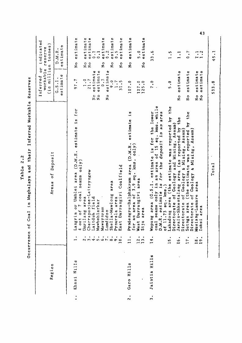
Coal Fields
The next important mineral is coal. The earliest
reference on the coalfields of Meghalaya was made by H.B.
Medlicott (1869), F.R. Mallet (1975), T.H.D. La Touch
(1882) and H.H. Hayden (1897). The coal deposits are
confined to the Tertiary Formation of the Eocene Age and
are to be found mostly on the southern slopes of the
State. The main characteristics of coal are its low ash
content, high volatile matter and also high calorific
value. It, however, suffers badly from its comparatively
high sulphur content. The coal is mostly sub-bitutVii nous
in character. The inferred workable reserve of coal In
the State has been estimated by the G.S.I. at 512.5
million tonnes for a depth range between 100 and 300
metres. The reserves as estimated by the D.M.R. are also
being indicated in this sub-section.
In the Khasi Hills, occurrences have been recorded
from the Lower Sylhet, Middle Sylhet, and undifferentiated
Sylhet sandstone members of the Sheila Formation of the
Jaintla Group (Eocene). The various coal-fields in the
region with their estimated reserves are given below from
west to east .
i) Langrin or Umblel Area
The eastward extension of the Pyndengru coal seams
in the Garo Hills borders has been marked in the Langrin
36
field between the Maheshkhola . stream and the Kynshi river.
The inferred reserve in this field is of the order of 81
million tonnes to a depth of 150 metres in an area of 51.7
sq. kms . The D.M.R. has estimated the reserves at 60.1
million tonnes for four out of the seven seams.
ii ) Um-Rilang Area
The area exposes a small outlier of the Sylhet
sandstones (undifferentiated) including two seams of
resinous coal manufacturing upto 3 metres in aggregate
thickness near Umsohphie river. About one million tonnes
of coal have been inferred for the lower 1.5 m thick seam
within the area. A part of this reserve has already been
exploited. The D.M.R. did not mention about the coal
fields .
i i i) Cherrapunjee-Laitryngew Area
The middle Sylhet-Lakadong sandstone yields several
coal seams varying from 0.3 to 1.0 metre. The top and the
bottom seams are now being worked around ..Lai tryngew. The
probable reserve of coal in the entire area is about 18
million tonnes. The D.M.R. has investigated the
Laitryngew coal-fields, the Cherrapunjee coal-fields, the i
Laitduh area' and the Mawbehlarkar coal-fields separately
and estimated the total reserve in the four fields at 2.7
37
million tonnes, 19 million tonnes, 0.1 million tonne and
0.1 million tonne respectively.
iv) Laitduh Coal Field
The area ir, west of Laitryngew. Coal is found in
an area of 0.12 sq. km. The proved reserve le 0.12
million tonne as reported by D.M.R.
v) Mawbehlarkar Coal Field
The field covers an area of 0.1 sq. km. The
indicated reserve is 0.12 million tonnes as reported by
Directorate of Geology and Mining, Assam.
vi) Mawsynram Coal Field
Two coal seams occur in this field and the
indicated reserve is 0.30 million tonnes as reported by
the G.S.I .
vi i) Lumdidom Coal Field
Coal occurs in an area of 0.2 sq. km. having only
one coal seam. The indicated reserve in this field is 0.2
million tonnes as reported by the D.M.R.
viii) Shella-Mawlong Area
. _ The Lakadong sandstone bed extending from Sheila to
Bairong exposes a 0.3 to 2.1 metre seams. The estimated
38
inferred reserve given by the G.S.I, is 3 million tonnes
to a depth of 150 metres within the area covering 15 sq.
kms. The D.M.R. has separately investigated the Mawlong
Coal field and Bairong coal field and estimated the
reserves for the two fields at 9 million tonnes and 0.8
million tonne of coal respectively.
ix) Pynursla Area
Two coal seams varying from 0.75 to 0.9 metre in
thickness occur over the Pynursla plateau and produce good
Quality coal. Towards the south three coal seams of 1.0 m,
1.5 m and 2.5 m thick are exposed. The total inferred
workable reserve is 1.7 million tonne. The D.M.R. did not
report any available reserve of coal in the area.
x) East Darrangiri Coal Fields
This area lies on the Khasi-Garo border. Two coal
seams of 1.0 m and 1.8 m thick extend consistently in the
Asilgoan hill. The seams have an inferred reserve of 4
million tonnes around Balione. But according to the
D.M.R., the total reserve of various patches having a
total area of 2.1 sq. kms. is estimated at 31.5 million
tonnes.
The occurrence of thin coal seams have been 1
reported in the Mawsynram-Mawdon area which reauire
39
further investigation. One of the seams of this area was
earlier worked locally for lime burning. The coal seams
also occur near Tenglah but are crushed along the Raibah
fault and hence they are not economically promising.
We will now give below the different coal fields in
Garo Hills with their inferred workable reserves :
xi) Pyndengru-Balphakram Area
The area lies on the Garo-Khasi Hills border In the
south-western Garo Hills. A few miles south of the area,
a road parallel to the coal field runs from Baghmara in
Garo Hills to Maheskhola and Balat in Khasi Hills. Eight
coal seams are recorded, one of which, is up to 3.0 m
thick. The recent investigation by the G.S.I, have
revealed an inferred reserve of 166 million tonnes to a
depth of 100 metres. But the D.M.R. has estimated the
area of the coal field at 3.7 sq. kms. with the reserve of
9.1 million tonnes of coal.
xii) West Darrangiri Area
The area lies In the west of east Darrangiri coal
field already mentioned above. This is the most Important
and easily accessible and exploitable coal deposit in Garo
Hills. Of the' three coal seams, the middle seam with 2.5
to 3.3 m thickness has been found consistently throughout
40
the area. The inferred reserve of coal for this seam to a
depth of 300 metres is l27 million tonnes in an area of 50
sq. kms. of the field. Although the D.M.R. is still doing
its investigation in the area, it has already indicated the
G.S.I, estimate at 125 million tonnes of coal in its
report. The coal from this field is now being mined for
use by the Nangwalbibra Thermal Plant of the Meghalaya
State Electricity Board.
xiii) Siju Coal Field
This field covers about 67.8 sq. kms. from Table
nala towards south-east of Tura to Siju Songmong over the
southern slope of the Tura Range. Along this extent,
atleast two steep dippihg seams of good quality coal are
traceable along an anticlinal structure. The lower seams
is up to 2.4 m thick. The latest inferred reserve of coal
in this area is about 1 5 million tonnes. The D.M.R. has
indicated the G.S.I, estimate in its report :and mentioned
C.S. Fox's estimate of lOOO million tonnes of the possible
reserve of coal in this field.
Several other thin seams of coal occur in the Tura
and Rongrenglri area but these are not of any economic
value .

41
The various coal fields of Jaintla Hills with their
estimated reserves are enumerated below ;
xiv) Wapung Area
Two coal seams producing good quality coal occur
within the undifferentiated Sylhet sandstone in and around
Bapung. The lower seams varies from 0.3 to 1.0 metre in
thickness and the probable reserve for it is about 6
million tonnes within an area of 15 sq. kms. But
according to the D.M.R. the coal bearing area is 11.73 sq.
kms. and the probable reserve of coal is estimated at 7.6
mi llion tonnes.
XV) Lakadong Area
The Lakadong coal fields covering the Umlatdoh
plateau between the Myntdu and Prang rivers in the
southern part of Jaintia Hills exposes a very Irregular
and inconsistent coal seams varying from 0.3 to 3.0 metres
in thickness. The reserve has been estimated by the
G.S.I, at 5 million tonnes. The D.M.R. has located two
coal fields in the area ! (i) Umlatdoh coal fields and (2)
Pamsaru coal field. While estimating the possible reserve
of coal in this first field at 0.5 million tonnes no
estimate was given by th6 D.M.R. for the second field.

42
XVi) Jarain-Shkentalang Area
A thin coal seam of 10 cms. to 45 cms. occur in the
Jarain-Shkentalang area which has been investigated by the
D.M.R. and which gives the probable reserve of coal at about
1.7 million tonnes in an area of 2.8 sq. kms. In Sutnga area
also two coal seams occur which have been investigated by the
D.M.R. The total reserve of coal has been estimated at 0.7
million tonne in the area.
An outlier of the Sylhet sandstone (undifferentiated)
covering the Shyrmang area exposes two thin coal seams. The
coal is similar to those in the Bapung area but the reserve
is not yet fully assessed. A thin inconsistent coal seam,
extremely variable in thickness from 0.3 to 1.6 metre occurs
in the Lumshnong and Musiang-Lamare areas.
xvii) Musiang-Lamare Coal Area
The area is near Lumshnong and coal field covers an
area of 2.31 sq. kms. The inferred reserve of coal is 1.1
million tonne as reported by the D.M.R.
xix) loksl Coal Area
The area is located in East Jalntia Hills. The
inferred reserve is 1.24 million tonne as estimated by the
D.M.R.
A summary of the reserve of coal in the State in
various coalfields is given in Table 2.2.
43
o
C
^ 1 ^ E
4)
0)
H H
• to
• o
rt
a • H
-!-> V)
4)
to o a
Q
tn nj
B o bo 0)
K
r-H 1—t
•i-l
a: • H
Ul Vi
Si Wi
4) (U
rt B
• H
-(-> 10
<u
o Z
rt nJ f6 Vf^ ^ E B E B B
- H ' H •?-* -f-t ' H + j + j r H r - H ^ { \ ) . ^ l i ^ ^
10 to * " i n * to ' t o a) ^ O O 4 ) 0 4 ) 0 4)
O 0 O 0 O Z Z; z a z
rt B
• H
• J
to 4)
0
z
n) B
• H
O + J
• m i n 4)
0 Z
^ •
4) V 4]
U o
S
xn
oc;
rt rJ (X) o i - B E f - ' E o t -
t—t I—^ + ^ -•-> O 4 - i
ro u) Ul tn 4) 4) 4J
O O O
z z z
o
s — • >< Q '-< v ^ C
o n) 0} to u B rt rt
4) • t - i t n
v r H t—1
XI (i E o
D o
V< t^ o
«*H
c o • H
»M - M
t lO 3
C 0 n
v j M '
nj 4) ^ « bO c «
t—i
• H
^
^ 4) bt C
t>^ 1
• M
• H
rt J 1 T3 4 ) . - 1 t l
4> 4) nt • r r H ^
C <+H ^
3 nJ P<J3 --H a! 3 J3 V. t ) 4) >H •»-> X I 4 ) - H ^
jQ rt 0) 3 O J S
« 4J U n)
bo C5 O
I—t
^ rt
T3
I—I ti O
U
4) bc tl C n) 01
R) V< O I ^ rt c 73 «l to O > > - H 1-4 U U) "W ^ 3 -M & B 4) D tn l4 3 m] ^ Rl
S J t/3 Ol W
r j c o ' l ' u n v o t ^ o o o ^ o
t^ o
n) B
•i-i •(J to
• i - <
• o -p
tn
4)i3
B tn rt rt 4} t . O >H
4<; • rt
1—1 O T H
rt bo CQ rt C I 4) rt 3 V< Vf » rt t , br C C Q rt V rt
•»-> 3
t* tn •>-. O 4) "P"!
>« ^ V
• • •
o in
rt B
in 4)
o z
J
« 4) t . « n « q
o IM
cr
in «J • - Q a •M 4) O T3
(i 4) 4) J5 t i ••-> rt
U C O rt MH
i-( c tn.
o
rt 4}
rt
be R 3 a rt
to > , 41 a
•-< *^ M 13 nt O 0 . tn +» to B tfi rt 41 CO 0) I -to • .
r - l • r - l
O « m « Q o
4) J3
4) rt •)-> to U to O •<
4) . M be
C to -H rt c , ^
4> ••-> tJ BJ C B rt
to bc 4) O
r-t • 4) O j 3 a>
4)
rt B
•H
tn 4)
o z
4) J3
J3
41 4) - t J •»-<
fi rt B B
•H -H +» -M tn to 41 41
o o z z
XI B -0 rt
•T3 tn 41 10 +» <
o -O. bo 41 B ^^ -H
(3
4)
rt f>^B
O +>
be B
(« O 41 >^ 41 rt +•
« bO U B O O •*->
73 O rt 41 >! ^ rt -H
H J Q
bc O n 41 rt O
>—1
n) 1-1
4) O 41
41 O
• t J <*-<
>- ' O
+» rt ••-> u bo u 41 B 4) tc ••-• I-.
•H D -H Q t o Q
rt 41
41
rt 6 ri rt
^J 41 I U bo ti a rt -H
•H » to 4«! B O 2 - ^
oo O
o u rt
o
B • H
rt •-)

44
Sillimanite
The next important mineral of the State is
sillimanite. It occurs in two places ;
i) Sillimanite Deposits of Sonapahar
The sillimanite deposit of Sonapahar in the
Nongstoin area of Khasi Hills is well-known and is reputed
to contain the best quality Sillimanite in the world.
This deposit is also regarded as the World's biggest
occurrence of massive sillimanite deposits. It is
scattered in 27 major and minor deposits. It occurs at
places in association with corundum. In fact the corundum
deposit in the area was first examined by F.R. Mallet in
1879 and the associated sillimanite deposit was
subsequently investigated by J.A. Dunn in 1922. There are
seven lease-hold areas covering most of the deposits. The
Hindustan Steel Ltd. has taken over all the leases from
the Assam Sillimanite Ltd. in January 1973.
The high alumi na and silica contents of this
deposit makes this mineral a natural refractory mineral of
great commercial value. Its accidental discovery in a
London Warehouse in 1992 was, when the corundum mined in
45
this area was found to be of not quite the hardness
expected in an abrasive of that type. Although the
sillimanite mines in Sonapahar have been worked for a long
time by various companies and agencies, the actual
potentiality of the known deposits has not yet been
confirmed. Liberal estimates of these deposits put them
at about 2 million tonnes, whereas conservative assessment
has estimated at 10 per cent of this figure. The
exploitation of the deposits for several decades has
reduced the, total reserve of about 0.05 million tonnes as
estimated by the G.S.I.
ii) Sillimanite Deposit at Daprl-Tholegiri
Some minor occurrence of sillimanite have been
detected at Dapri-Tholegiri area of Garo Hills. The
strike extension of si 11imanite-Quartschist is limited to
within a few metres, with a maximum of 18 metres. No
strike-wise extension or any new occurrence has been found
in the vicinity. The reserve of the deposit is negligible
as reported by the G.S.I.
Both the G.S.I, and the D.M.R. have Reported the
occurrence of Sillimanite at a place 5 kms. south-west of
Nongstoin with an average strike length of 800 metres.
But the amount of the deposit has not been calculated.
46
The D.M.R. has also reported the erratic occurrence of
sillimanite at Mawpomblang and the reserve has been
estimated at 1000 tonnes.
Clay and Koalin
The State of Meghalaya is endowed with a number of
deposits of white clay, fire-clay, and koalin or china-
clay. The total reserve of such clays all over the state
amounts to a few hundred million tonnes. Various white
clay deposits are known to occur all over the State but
the deposits have not yet been examined in detail. The
various deposits of clay and koalin and their inferred
reserves as estimated by the D.M.R. are shown In this sub
division. The G.S.I, have given their estimates for the
four fields only.
In the Khasi Hills, the various deposits with their
estimated reserves are as follows :
i) Cherrapunjee Deposit
This clay deposit is found on a small ridge at a
distance of half a Km east of the Circuit House at
Cherrapunjee. The clay is sandy and 'plastic* Three
colours of clay are found, narhely, white, brownish-red and
greyish-white. As reported by the Directorate of Geology
and Mining, Assam the proved reserve of this deposit

47
taking an area of 146,667 eq. metres and an average
thickness of 8.12 metres, comes to 0.2 million tonnes. It
has been found that the clay Is quite suitable for use in
manufacture of cement. Another deposit Is reported by
D.M.R. at Kut Madan within an area of 0.37 sq. km. The
indicated reserve of the deposit is estimated at 0.5 million
tonnes.
i i) Mahadek Deposit
The deposit lies near Mahadek on the Cherrapunjee-
Shella road. The clay beds belongs to Langpar stage of
cretaceous age. The deposit is divided into two parts -
the North Block and the South Block. The total reserves
of both the Blocks covering a total area of 65,446 sq.
metres with an average thickness of 3 metres, have been
estimated at 0.3 million tonnes.
iii) Sohrarim Deposit
At several places in the vicinity of Sohrarim along
the Shillong-Cherrapunjee road white clay Is found as
pockets and patches in the sandstone. Three deposits of
clay are found. The total probable reservfe In all the
three deposits have been estimated by the D.M.R. at 7.1
million tonnes. The G.Sil. estimate is 6.5 million
tonnes .
48
iv) Mawkriah-Mawphlang Deposit
The koalin rocks of this deposit occur as isolated
outcrops in an area extending for nearly 6 kms. in length
from Mawngap in the south to Laitjem in the north and
about one kilometre in width from Mawreng in the east to
Kreit in the West. The deposits are found as small as
patches, scattered all over the area, individual outcrops
varying from 175 sq. metres to 1,550 sq» metres in area.
The proved reserve of this deposit has been estimated at
1.2 million tonnes. The koalin of this deposit compares
favourably with the Cornwall koalin of Great Britain.
A clay bed of 1 metre thick is found inter-bedded
with sandstone at Umstew on the Shi 1long-Cherrapunjee
road. The clay deposit occupies an area of 37,625 sq.
metres and the reserve is estimated at 61*722 tonnes.
Some patches of clay deposits are also found around
Laitlyngkot, Laitkseh, Nongryngkoh, Myntriang and Kharkor
river sec t ion.
Koalin rocks occur as isolated patches over an area
of 0.15 sq . kms. at Smit 14 kms from Shillong. The
inferred reserve is estimated by the D.M.R. at 0*1 million
tonne. The koalin deposit has also been reported by
D.M.R. at Laitlyngkot with an indicated reserve of 0.5
million tonnes.
49
The Garo Hills contain the most extensive and
enormous deposits of white clay which are of economic
value. A very conservative estimate reveals that the
probable reserves of crude clay from the deposits of Garo
Hills are about 74 million tonnes. The various deposits
with their inferred reserves are mentioned as follows t
i ) Deposits around Tura
The Tura town rests on koalinised granite and
gneisses and on the basal clayey Tura sandstones.
Deposits of good clay occur in the northern part of the
town. There are altogether a deposit in and around Tura
with the total indicated reserves amounting to 0.8 million
tonnes. Since many of the deposits are located within the
limits of the town, mining and quarrying of the clay could
be rendered difficult.
i i) Rongrengir1-Khera Deposit
This is an extensive deposit and perhaps the
largest exposed deposit of clay in Garo Hills. An area of
about 40 sq. kms. around Rongrengiri is occupied by the
Tura sandstone. At the base of the Tura sandstone occurs
a very thick bed of hard, white lithomergic clay ranging
in thickness from 4 metres to 9 metres. The inferred
reserve of clay taking an area of 24 sq. kms. and an
50
average thickness of 4 metres as reported by G.S.I. Is 68
million tonnes while D.M.R. reported only 1.5 million
tonnes .
i i i ) Nangwalbibra Deposit
Around Nangwalbibra, a thick sequence of the Tura
sandstones has been observed over the weathered platform
of older gneissic rock. The area reveals the presence of
four beds of lithomergic clay ranging in thickness from
1.8 to 3.7 metres at the base of the Tura sandstone. All
the four beds are present uniformly throughout the area.
The three main bottom beds of good quality clay have an
aggregate thickness of about 7.6 metres. The indicated
reserve of the Nangwalbibra deposit was estimated by the
Directorate of Geology and Mining, Assam, at 0.5 million
tonnes. D.M.R. reported two more deposits at Mining Hills
and Rongkhandi Hills with an indicated reserves of 3.7
million tonnes and 2.4 million tonnes respectively. Hence
the total reserve in the three deposits comes to 6.6
mill ion tonnes.
The grand total reserves of all the above first
three deposits in Garo Hills thus come to 73.3 million
tonnes as estimated by the D.M.R. while the G.S.I, gives
an inferred total reserve of only 35 million tonnes for
the three fields.

51
iv) Rongchugiri-Ra3abala Road
Only one isolated deposit of good quality white
clay has been located in this area, about 2 kms. from the
Rongchugiri-Phulbari main road junction on the Rajabala
road. Taking an area of (425x300) sq. metres and the
average thickness of clay at 4 metres the probable reserve
of clay would be 0.7 million tonnes.
v) Songsak Deposit
A detached deposit of lithomargic clay associated
with small outliers of the Tura sandstone occurs within
the Songsak Government Reserve Forest. The clay is white,
hard well-bedded and has external ferruginous stains. The
estimate reserve of clay taking an area of 410,850 sq.
^ metres and an average thickness of 2 metres would be 0.9
million tonnes. The ceramic test of this clay gave
promising results.
vi) Khobal Deposit
The deposit of clay lies on the east of Khobal
village on the Darugiri-Nangwalbibra road. The
lithomargic clay has an average thickness of about 3
metres. The indicated reserve taking an area of 50,000
sq. metres was reported'by G.S.I, at 0.3 million tonne.
52
"i i ) Nengkhra and Dobu Deposit
The clay that occur around these two villages are
massive, hard and white. The indicated reserve of clay in
both areas as reported by D.M.R. is 2 million tonnes. But
the inferred reserve of 0.1 million tonnes in Nengkhra and
0.3 million tonnes in Dobu was reported by the G.S.I.
viii) Jengrangiri Rewak and Damukgithim Deposit
D.M.R. reported the occurrence of clay in these
three villages with the indicated reserves of 3.1 million
tonnes, 1.8 million tonne and 1.2 million tonne
respect ively.
ix) Koalin Deposit of Darugiri
A deposit of koalin is found under Darugiri on the
Darugiri-Nangwalbibra Road. Five blocks of koalinised
granite were delineated. The proved reserve reported by
D.M.R. in an area of 0.06 sq. kms. was 1.2 million tonnes.
In the Jaintia Hills there are two important
deposits of clay and four deposits of koalin. These
deposits with their estimated reserves are as follows i
i) Larnai Deposit
Larnai is situated at Sung Valley in Jaintia Hills.
The deposits of clay covers an area of 3.88 sq* kms« The
53
indicated reserve as reported by the D.M.R. is 0.5 million
tonne .
i i ) Tongseng Deposit
Tongseng is 136 kms . from Jowal on the National
Highway-44 . Two bands of shade clay were noticed in an
area of 100 sq. kms. The indicated reserve for both bands
is 5.15 million tonnes as reported by the D.M.R.
iii) Thad-1 a-skei_n Koali n Deposit
Thad-la-skein is situated at 56 kms. from Shillong on
Shi 1long-Jowai Road and Koalin deposits occur in the East
Bank of the Myntang river at 4 kms. away. The deposit
covers an area of 4.0 sq. kms. with the indicated reserve
estimated at 0.3 million tonnes as reported by the D.M.R.
1V) Shangpung Koalin Deposit
Shangpung is 21 kms. from Jowai on the Jowai-
Garampani Road. Several small outcrops of Koalin rocks
occur in an area of 2.4 sq. kms. The inferred reserve as
reported by the D.M.R. is 0.5 million tonne.
v) Mulieh Koalin Deposit
Near Raliang at 28 kms. from Jowai on the Jowai-
Garampani Road, Mulieh is at 10 kms. away from Raliang. A
54
good deposit of Koalin rock occurs around Mulleh village,
having 10-12 metres thickness. The inferred reserve as
reported by the D.M.R. is 0.8 million tonne.
vi) Mynsngat Koalin Deposit
Mynsngat is 22 km. from Ummulong on the Jowai-
Khanduli Road and is 51 km. on Shillong-Jowai Road from
Shlllong. Several small outcrops of Koalin rock occur in
an area of 1.7 sq. kms . The inferred reserve as reported
by the D.M.R. is 0.3 million tonnes.
The data on the available reserve of clay in the
State in various deposits are summarised in the tabular
form (Table 2.3).
MINERALS OF LITTLE OR UNKNOWN ECONOMIC IMPORTANCE
A number of occurrences of varied minerals in the
State are recorded by the G.S.I, and the D.M.R,, most of
which are either of little economic importance or yet to
be assessed. We give below an account of such minerals :
1. Glass Sand
The glass sand is found to occur at Umstew near
Cherrapunjee. The deposits'cover an area of 0.62 sq. kms.
with an average thickness of 2 metres. These deposits
contain an inferred reserve of 2.3 million tonnes of glass

<n
u V m 4)
J3 It
M o 3:
«) o
•H
'S »4 o
u 0)
1
O rt
u
« •1-1
W 0
a 0)
Q
TJ t . - ^ CI
<u g c
r^
o
0) - M
n) E
- r^
in 4 )
O
z
f O
o
1) + j
rt B
• H
01
4 )
0 Z
r—»
r -
i . n
^ O
f M
r-*
4) -t-"
n) B
•f-i
4 )
o Z
r~-
o
4; +->
« B .»-(
4 )
O
z
01
E • iH
4->
to
41
O
0 0
o
i n
• r-^
o
C O
s O
• v O
(1)
*-• n) E
•rH
*-* Ul
4)
O Z
E • H
•»J
w 41
O Z
f ^
o
o
• o
V 4->
n) B
•tH
tn 4)
o 2
r H
• s O
(U + j
« B
• H
• • J
<n 4)
0 Z
E • iH
+-> to
4J
O
ro
O
o
« (NJ
^ o
f S I
• I—I
0) •4->
rt B
• H
to 4 )
O
z
i n
• o
4) • M
rt E
- i - (
tn 4)
O
ro
• i n
4) -t-j
R)
B • H
4 )
O
z z
(V>
« O
4) 4 J
n> B
• H
4)
O
z
i n
• o
D • M
rt E
• H
«0
4 )
o z
oo ro « •
o o
4> 4) + J * J
rt ti B B
• H . M
01 U l
4> 4)
O O
z z
in • • ->
•H
m O
a 4J
Q
c rt
TJ rt S
+ j
3
t»s
t 3 c rt
4) 4)
• r - i C
3
+ j
-rH
in O
a 4) Q
a j ^ fi 4) y, XI u rt
- M
• H
tn o O, <u
in
-*-» • H
to o a 4)
Q
c -»-> H
• tH r H
tn O
o a 4)
Q -M o
MJ<5
n j C
•—1 > s
^ r - (
^•:: rt rt
Q S J 1
B X ! t J • i - i
»-i
PS
u (i> J: jc
x: rt
u s
i - < I M
o 1 0
ro
rt c •H rt h
M •>->
^ -^i cs E 2 ^
T T i n
m
3
H
+-" • H
in
o a 4 ) 4 J
Q -r^ tn
w o U a. (U 4 ) - M
T) 43 Q -H c D
O V i
rt
-»-> • H
to o
a 4)
« tn 1 W 0
•»->
• H
tn o
•H IH (X a ^. X I 4) 4)
—1 -H Q P h c ^ C r-J e J(J 4) rt rt I. B ^ tin bo etc c n c O rt O
rt in bo B O
tn o CU 4)
Q
B •H
J3 •»-»
• H
ho
3
B « Q
«
& 4) OS
• •
• » - (
v< • H
+ J
• H
10
• H
•H to m o O O. CU 4) 4) Q
Q B
3 - H X I r-l O O
O Q rt
a a;
h o d B
« • H
p-H
« rt 1-1 - H rt »H
X! - n rt "i! be
«a)j3 c o 4J J3
be 3 C JH 4) rt
Qpi i zo iv5^ - ) t ! ^za
v O N - 0 0 O^ o r H ( M m T*i
+ j
• H
in O
*-> • t - i
t f l
o
a 4) a Q «> Q
• H
rt B V. rt
• • - >
• H
to •»-> O ••-1 ••- '
Cu to -H 4J O •<-' to
Q O J - H O 0) tn (X
B Q O 4) •H P u Q i -H B 0 )
O - H Q C
rt 1—t - H
« O E r H
rt -rt O E hrf —1 rt
•H 0 W 4; bo rt
bBJ<5 C W -t-" B
4) tn
10 3 It ca O i X ! M
i -H b o 4 ) B
b c a c -H 0) B rt rt >-H B O X ! X ! 3 >^
,si fr^ ^ m •S'S
i n v O r - 00 o^ o
•H X
to
x: o rt u
a:
rt
55
in CO
O
H

56
as estimated by D.G.M., Assam. Another deposit of glass
sand in Khasi Hills occurs at Kreit 17 kms. from ShiUong
on the Shillong-Mawphlang Road. The indicated reserve has
been assessed at 0.1 million tonnes. Deposit is also
found in Garo Hills near Tura with an indicated reserve of
0.14 million tonnes over an area of 0.1 sq. km.
2. Iron-Ore
In the Aradanga area of Khasi Hills, a small
deposit of magnetite ore is found. The total reserve of
iron ore has been estimated by the D.M.R. at 0.2 million
tonnes in an area of 2,769 sq. metres and an average
thickness of 16 metres. Two important occurrence of iron
ore are found in Garo Hills at Nishangram and at
Athiabari. The indicated reserves of magnetite quartz
rock in the two deposits have been estimated by the D.M.R.
at 2.85 million tonnes and 0.5 million tonnes
respectively. Occurrences of magnetite ore have also been
found near Dobu in Garo Hills.
3. Base Metal
A multi-metal mineralised zone is found at Umpyrtha
on the northern fringe of Khasi Hills. A tentative
inferred reserve of 0.2 million tonnes of zinc, copper and
lead ores with their respective percentages at 2.85, 1.33
57
and 0.40, has been estimated by the G.S.I. But the
economic importance of these indications is still being
assessed. A similar mineralised zones along Tyrsad-
Barapani in Khasi Hills and in and around Sung Valley in
Jaintia Hills have been detected by the G.S.I. and
drilling is done to prove the deposits.
4, Quartz-Pelsper
In Garo Hills quarta-felspar bearing pegmatite
veins are found to occur in and around Tura. The
indicated reserves of the two minerals in this deposit are
907 tonnes quartz and 1714 tonnes felspar as estimated by
the D.M.R. The D.M.R. also reported the occurrence of
the minerals at three other places in Garo Hills namely,
Bonsomgiri, Rombhagiri and Nengkhra. The total reserves
of the three deposits are 56j463 tonnes Quartz and 66,267
tonnes Felspar .
Another deposit is loeatsd in Khasi Hills at Hahlm
and its adjacent area. In this deposit the estimated
reserve of the two minerals are 19,570 tonnes quartz and
21,730 tonnes felspar as indicated by the D,M,R. The
G.S.I, estimate is 22,000 tonnes of felspar' and 20,000
tonnes of quartz in this area, G.S.I, also reported the
occurrence of these minerals in the Mairang-Nongkhlaw area
but the reserve has not been estimated.

58
5. Building Stones
Various types of building stones of good quality
are found all over the State. Quartzites, granite
gneisses and basic rock found in parts of the Shillong
plateau can yield good building stones. The coarse
granite are found around a number of places along the
northern scarp of the plateau. The hard greenish to black
Khasi greenstones found in the southern parts of the
Shillong plateau as well as the Sylhet trap rocks are
useful as high-grade metals. A ferruginous and friable
stone referred to as laterite has also proved suitable for
road dressing. Coloured sandstones of various quality
and shade are found in plenty all over the State. They
are used for masonry in the form of bricks, slabs and
po st s .
6. Gold
An occurrence of gold is found at Tyrsad near
Mawphlang in the Khasi Hills. The reserve has not yet
been estimated. Mor^ investigation by drilling is
required to prove the economic significance of this
depos it.
7. Gypsum
Some crystals of gypsum occur in lenticular veins
or in small scattered patches in the south western corner
59
of Garo Hills particularly at Harigoan and near
Mahendraganj in Tarapara , Garobadha, Messinglpara and
Mogopara. They do not appear to be of any economic
signif icance .
8. Phosphate
Phosphate are found in the basal part of the Koplll
Shale Format ionaround Sonapur in Jaintia Hills and around
Siju in Garo Hills. No reserve has been estimated so far.
9. Corundum
Corundum is found as locally segregated bodies in
the sillimanite bearing rocks at Sonapahar in the
Nongstoin area of the Khasi Hills. It makes up about 20
to 50 per cent of the sillimanite ore.
10. Dumortierite
Two bands of quartz dumortierite-tourmaline schist
were located by the G.S.I. near Mawshynrut south of
Sonapahar. One of the bands is up to 60 metres in
thickness and extends for a length of 0.8 kms . and the
other is comparatively smaller. The reserve has not been
estimated.
60
11. Uranium
Encouraging occurrences of uranium had been located
in the State. An estimated amount of 9.22 million tonnes
of this precious metal has been discovered at Domiasiat in
West Khasi Hills within an area of about 4 sq. kms.
Traces of this metal have also been located at Anek in
Garo Hills, Wah Kaliar near Cherrapunjee in Khasi Hills
and in the Tarangblang-Satpator area of Jaintia Hills.
The extent of grades of these occurrences has not yet been
determined.
The economic significance of the above eleven
minerals are yet to be studied. Presently, the
potentiality of initiation or expansion of mineral-based
industries in the State mainly depends on the four
principal mineral deposit, viz., Limestone, Coal,
Sillimanite and Clay. But the reserves of these deposits
cannot be properly exploited so far due to lack of
transport. The Mining industry of the State is currently
facing two difficulties, first, the transport of minerals
from the mine-heads to the plains is uneconomic due to
inadequate motorable roads and the absence of railways,
and secondly, the heavy raine during June-September cause
frequent landslide and higher continuous mining operation.
61
Water and Wind Power
Because of the topography of the State, Meghalaya
poRsessog vast potenMality for the establishment of
hydro-electric project of different capacities. The
Umtrew and the Umiam-Khwan rivers have already been
harnessed for power with a generating capacity of 11.2
megawatt and 54 megawatt respectively. The third project
of Kyrdemkulai with an estimated generating capacity of 60
megawatt is under construction. Rs.38 crores project is
being implemented to harness the Kupli river for hydro
electric power for the joint benefits of Meghalaya and
other North-Eastern States.
The terrains through which most of the rivers and
streams are flowing provide excellent facilities for the
establishment of small dams at various places in the
State. Hence, instead of going in for big dams it will
prove economically profitable if many hydro-electric
projects are scattered all over the State for the benefit
of rural areas. This would not only save the huge
expenditure required to be incurred in the implementation
of big projects, but it would also facilitate the
establishment of small scale and cottage industries all
over the State. Local people will also be benefited
because of employment potential arising out of such mini-
pro j ec 18 .
62
Meghalaya being the mountainous state where the
wind velocity is high has also the potentiality of
generating power by exploiting the wind resources.
Soil Characteristics
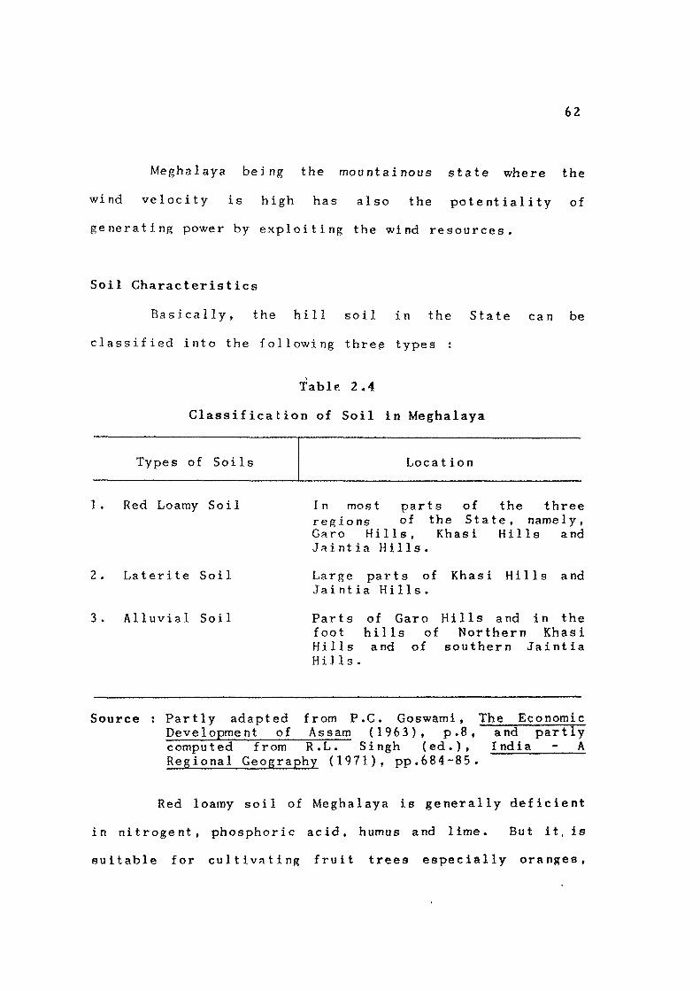
Basically, the hill soil in the State can be
classified into the following thre^ types :
TablF. 2.4
Classification of Soil in Meghalaya
Types of Soils Locat ion
1. Red Loamy Soil
2 . Laterite Soil
3 . Alluvial Soil
In most parts of the three regions of the State, namely, Garo Hills, Khasi Hills and Jaintia Hills.
Large parts of Khasi Hills and Jaintia Hills.
Parts of Garo Hills and in the foot hills of Northern Khasi Hills and of southern Jaintia Hi]Is.
Source ; Partly adapted from P.C. Goswami, The Economic Development of Assam (1963), p.8, and partly computed from R.L. Singh (ed.), India - A Regional Geography (1971), pp.684-85.
Red loamy soil of Meghalaya is generally deficient
in nitrogent, phosphoric acid, humus and lime. But it, is
suitable for cultivating fruit trees especially oranges,
63
grapes and mangoes. Other crops can also be grown if
irrigation facilities are provided. Laterite soil is
deficient in potash, phosphoric acid and lime. At lower
levels, it has heavy loams and clays and food crops
particularly rice is grown. Potatoes and sub-tropical
fruits also grow well in such soil and thus these items
become the important commercial products of the State.
But at higher level of the hill slopes, the soils are thin
and practically gravelly and stony.
Alluvial soil is the most fertile and is found in
the north-western part of Garo Hills and in the foothills
of Khasi Hills and Jaintia Hills. Wide varieties of crops
like rice, sugarcane, cotton, bananas and jute are grown
in the region.
AGRICULTURAL REGIONS
For lack of data, it is not possible to
regionalise Meghalaya into agricultural regions
satisfactorily. The following five regions have been
recognised in a generalised manner ;
i) The Northern and the Western Peripheral Areas of Garo Hills Producing Predominantly Wet and Low Lying Crops Mainly Rice and Jute t
The region lies below the 150 m contour and covers
the major portion of old alluvial soil belt of Garo Hills.
64
It also produces cotton along the margin touching the
forest region.
ii) The Northern Region lying along the Northern Slopes of Khasi Hills - Extending North of Khasi and Umtrew Rivers :
The region covers the old alluvial soil belt of
Khasi Hills roughly following the 150 m contour. Wet but
upland crops like rice and maize predominate. Rice is
cultivated mainly in the inter-montane valleys and in the
foothills. Double cropping of rice has been practised in
limited areas in the foothills because of the warm climate
throughout the year.
i i i ) The Southern Region which forms a Narrow Strip of the Khasi Hills and Jaintia Hills running along the Indo-Bangladesh Border :
It also roughly follows the 150 m contour.
Adequate rainfall in summer, warm condition, fertile and
hill slopes are the main physical conditions. Fruits
predominate in the region from where more than half of the
total output of average jack fruit, and betel leaf in the
Khasi and in the Jaintia Hills are obtained. The Lakroh
valley of Jaintia Hills falls in this region. Because of
the warm climate in the region throughout the year, double
cropping of rice in the valley is practicable.

65
iv) The Central Part of the Eastern Khasi Hills including the Shillong Area in the South and Nongpoh Area in the North :
A triangular belt with lose vegetation cover
moderate climatic condition in the greater part of the
year, and somewhat rocky soil - may be considered as
predominantly livestock and miscellaneous crops region.
Among the livestock animals, Ayrshire and Friesian cross
breeds predominate. Fish culture is also equally
important in the region. Potatoes, sweet potatoes and
fruits like pear, plum, etc. are important miscellaneous
crops .
V) The Upland Region of Jaintia Hills which has more Flat Lands and Fairly Extensive River Valleys than Khasi Hills :
The important river valleys are the Sung Valley,
the Jowai-North Valley, the Jowai South Valley, the Litang
Valley, the Letein Valley, the Myntang Valley and the Um-
iurem Valley. Rice is the main crop grown in these
valleys and other flat lands in the region.
CLIMATE AND RAINFALL
The climate of the State in general is very
salubrious due to its high relief. Of course, the climate
of western Meghalaya becomes oppressive from March to
October as a result of high temperature which is slightly

66
moderated by a copious rainfall. A relatively low
elevation of the western Meghalaya is responsible for
fairly high temperature for most parts of the year. April
is the warmest month of the year having the mean maximum
and mean minimum as 34.9°C and 22.1°C respectively. The
temperature of the coldest month of December and January
records a mean maximum of 24.9°C and 24.8°C respectively
with their mean minimum as low as 11.6°C and 11 . 1°C
respec t ively .
The climate of the moddle part of the eastern
Meghalaya is bracing due to the high altitude and
consequent moderate t eiripcr a t ur e particularly in the
central upland zone. But at the foothill of the southern
slopes and the sub-montane region of the north, the
climate is slightly humid and warm. During deep winter
the plateau usually experiences frost although snowfall is
unknown in the region.
The State receives the highest amount of rainfall
in the world. But the heaviest rainfall occurs in the
southern region of the plateau especially above cliffs and
precipice like the Cherrapunjee area and Mawsynram about
16 kms. west of Cherrapunjee.
More than 90 per cent of rain occur during the
monsoon and the rain water is immediately drained by the

67
deep piorRes and quickly carried down. During the winter,
there is practically no rain and drought manifests itself
in many areas. Hence, there is need for conservation of
rain water by way of constructing water reservoir or by
means of weirs or check dams or by the use of techniques
that would prevent evnporation and percolation.
Different parts of the State receives different
quantities of rainfall. Mawsynram and Cherrapunjee
records the highest rainfall in the world with 13,923 mm
and 12,033 mm respectively. On the leeward side of the
plateau over the crest, the rainfall decreases greatly.
Shillong, though located only 52 kms . from Cherrapunjee
and 57 kms. from Mawsynram gets only 2,296 mm of rainfall
per annum. The average annual rainfall in western
Meghalaya is 2,689 mm while Jowai in the eastern part of
Meghalaya receives a greater amount of rainfall with 3,077
mm. The north sub-montane region lying on the leeward
side of the plateau receives less rainfall with an average
of 1,270 mm to 2,073 mm. - The average annual rainfall at
different centres in Meghalaya is given in Table 2.5.

68
Table 2.5
Rainfall in Selected Centres
{in milli metres)
District/Centres 1987
Jain
East
West
East
West
tia Hills :
Jowai
Khasi Hills :
Shi 11ong
Cherrapunj
Mawsynram
Khasi Hills :
Nongstoi n
Garo Hills :
Wi]1iamnag
Garo Hills :
Tura
ee
ar
6,075
1 ,530
11,590
14 ,220
2,783
1 ,780
4,047
6,118
1,936
7,882
8,699
2,817
-
4,196
8,746
2,954
13,137
-
3,644
-
4,421
Source : Statistical Handbook, (Directorate of Economics Meghalaya, Shillong).
Meghalaya , 1989 and Statistics,
FORESTS
The areas under different categories of forests
are given in Table 2.6.
It will be seen from the table that in Meghalaya,
the area under forests extends to more than 7,898 sq . kms .
or about 34.88 per cent of the geographic area of the
State as against an all-India average of 22,7 per cent.
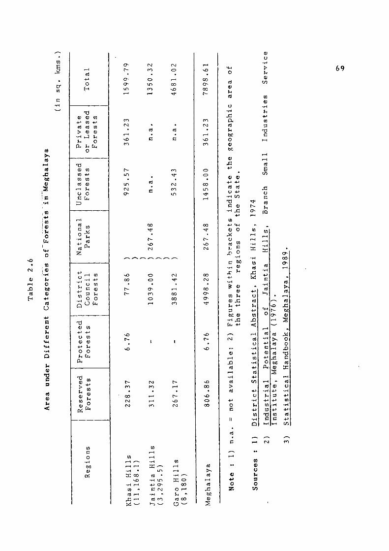
0) +-> (fl
> • H
U PU
T3 <U W W nJ
1—(
o c 3
t—(
c o
•f~t
2;
o
u
D
T3 (U
• f j
u (U
•<->
o ^
PL(
T3
> (-1
<u w (1)
I— !
+-> o
H
T ) 0) w OJ (U
J
o
(n + j
U) 0) V* o
[ l4
rt P H
t—(
• t H
o c
to +-> tn (U U O
Dtj
OT +-> W d)
O O
in - M
w (U v< O
(j^
tn
(0
o to
to c o
•i-i
bo 0)
O^
r~ •
a-o un f - H
fVJ
ro •
o i n
m 1 — 1
OJ
o •
T — '
CO sO • ^
r—t
^O
• oo o 0 0
r-
(NO
i n
i n
o
c
c
00
(0
c
i n
oo
t -
o
<T-
o
(XI
00 00
Nf5
cn
oo (NO (N3
vD (V)
.—1 1—<
• r ^ •
X 00 v O
• i H I—<
0) •>
nJ >—'
X - ' W ^^
E -— i n
<fl • •H i n + j O C (NJ
• H -
<T) f O
t—3 ^—^
t—I
r—1
• r - ( y —
a: o 0 0
O '-' U -(ti 00
a -^
ro CM
o o •
00 i n
00
(NJ
oo (NJ
00
v O
00
o 00
t—<
(0 Xi
(U
2
ID
U rt
o •I-I x. a rt
bC
o (U bC
(U
c
o
V •I-I
>
V) (U
•H
u • t - '
tn
C
69
j : : -t->
• 4 ) (U
•(-> -t-"
(d (d ( J •<->
•H t o T ) C 0)
•H 43 • • J
(n -i-> m 4) O
X o « "
• H
C M • r H <U
j r ^ ••->
• H
(U m VH
<u X u + 3 bC <U
•-< 4 3 [ i j •!->
^ (NJ
• •. (U
I—1
JD (0
r—1
• H
<fl
> PS
• » J
o c
M
• ^
r-o f—I
•V
tn i - H
r - l • H
K
• H
to ftf
-C « .
••->
u IT) >H
-l->
m .£)
< r-H
(ti o
• H
-l->
tn • H
-t->
(tf -t->
t o
+ J
tJ • M
U +> to
• H
D
(fl
E t/5
j : : o c (ti ) H
CO
^ tn
i - H
i - H
•I-I
td •H
c •I-I
(d >-)
M-l
o
1—1
(d • H • M
c (U
•*->
o p
I - H
rt • H
^ 1
-»-> tn 3
t J
• ^ v O f -o r-*
^-^ td t>> (d
I - H
(d X ! bC (U
S
•• V
- M
D
-»-> • H
• * J
tn
c c • - ^ | H H
a -0 0 ON
r—1
» (d
(d I - H
(tf JC be (U
s
Ji<J
o o
X I TS c (d
tE
i - H
(d tJ
• w
- t J
tn • i H
• * J
(d • M
t / i
« u u s o

70
But the area under Reserved Forests is only 806.86 sq. kms.
The remaining forest area including the unclassed forests
has no proper system of management. Jaintia Hills has got
the biggest area under reserve forests among the three
districts of Mcghalaya. But the area under private forests
in the district has not been assessed. Assuming that
forests occupy two-third of Jaintia Hills where the sense
of the people for preservation of forest resources is quite
high, the proportion of the forest area to the total area
of the State would increase by another 3.5 per cent. Thus
the national minimum of 38.38 per cent prescribed by the
Forest Policy of the Government of India, 1952 has been
fulfilled in Meghalaya. But it has been stressed that
forest cover in the hilly areas like Meghalaya should not
be less than 60 per cent of the land surface.
The most important trees in Meghalaya are sal (Shorea
robusta) and pine (Pi nus kes iya). Extensive sal forest
occur in western Meghalaya in former years, but the jhum
system of agriculture has been the cause of a great
destruction to this timber species. Sal grows well in the
sub-montane region of Khasi Hills also. Rongrengiri
reserve in Garo Hills has been considered to be the best
sal reserve in India with numerous sal trees of ripe age
and good girth. But owing to transport difficulties, it has
not been possible to extract these trees. Again the loss

71
of market in Bangladesh has dwindled the demand for sal
for railway sleepers. But sal being a very slow-growing
tree, introduction of fast growing species is necessary.
Pine forests occur extensively in the higher
elevation beyond 800 metres in the Khasi Hills as well as
in Jaintia Hills. Shifting cultivation has brought about
the secondary growth of abundant bamboo forests in Garo
Hills and in the western parts of Khasi Hills.
There are many valuable medicinal plants and herbs
growing wild in the State. The tezpat (Ci nnamomum tamala)
are extensively grown in the southern part of Khasi Hills
and Jaintia Hills. Honey is another important forest
product, particularly in Khasi Hills.
The out-turn of the forest products in the State
is very negligible as can be seen from Table 2.7. From this
table, it can be worked out that during the three years
from 1988-89 to 1990-91, the average gross revenue per
hectare from the State forests was Rs. 19.92, Rs . 169.73
and Rs. 26.63 respectively. Of course, even the revenue
from India's forests h?.s been also very negligible so far.
The national average gross revenue per hectare from
India's productive forests as calculated by the National • " i • -
Commission on Agriculture is only Rs. 21.50. This income
when contrasted with that in other countries of the world

•-o •
ro t—1
m
m •
• ^
i n fs]
00 •
o vO (T-
ro
OO o d
00
o CO
00
o 00 ro
CO cr-r-H
CM t ^ i n
o
00 00
o I - <
o » •*
o o CO
•" 00 r-<
o 1—1
en * ro
CO
IT) •* i n
» 0 0 cr-
o o 0 0
•> c r-<
i n • *
r-•
i n I—"
o o ro
« t
m a-
o o N D
* t - <
o o 00
^ •* a-
I—<
00
i n
ro o (VI
00
u c a o O •» -> i
ol • H
•t->
tn •H
o o &
C O
(0
C
O O
F — I
^ rt 0) 3
[14 O H
rt !>^ rt
r-4 rt
tn (1) »-. o
[14
• < H O H
en o •i->
in
in
73 c rt
<n o
•H
B o c o o td
M-l
o (1)
••-> rt ^1 o o 0)
72
u o <D > ^ 4
0) U)
c o (J MH
0) • H
^ u r-<
rt P.
•rH
o c
>-. a. 0) M •»->
I M
o 0) o
• H M-l M-l
o
U ^ l
ool o l 1—"I
1 "1 <D
J>J rtl
1—(1 n) • bq 0)
S 1
»l 1 •
2 Uc
'Bb I"—•
^ U: l t /5
rHJ n\ ' o\ (4 •H >> 4->l rt «nl>-<
•H n)
+ Ul rt bC •M 0) t / i l S
m 4) u U O • o t/5

73
will appear to be dismally low. The statistics in the
above table do not, of course, depict the real picture.
The out-turn of forest produce under the three District
Councils does not appear to have been taken into
account. In fact, forests are the main source of revenue
of all the three District Councils since the bulk of the
forests in the State is under their control. But these
council authorities have not been maintaining any
scientific records to readily show the annual out-turn of
the forests under their control as well as the amount of
their annual revenue derived therefrom. Charcoal, round
wood and bamboos are important items of supply to the
urban areas of Shillong and Jowai . But since the items
are taxi-free their annual out-turn has not been accounted
for by the District Councils.
FAUNA
Wild animals in Meghalaya comprises elephants,
bison, deer, tiger, wild cats, hoolock or gibbon, wild
goats, hog, bears and monkeys. Wild elephants roam about
in herds of varying strength in the tropical forest of the
State. Elephants are fond of bamboos and hence they are
more plentiful in Garo Hills where bamboos occur in
abundant throughout the district which is regarded as the
natural home of Indian Elephants. An elephant^ census is

74
being undertaken by the State Forest Department in
collaboration with the Zoological Survey of India.
Presently, a rough estimate has put the number of
elephants in Meghalaya at about 3,500.
The deer population of Meghalaya consist of two
varieties, namely, sambhar and barking deer. Spotted deer
also occur In limited number. The population of all the
three types of deer has suffered decimation due to
uncontrolled shooting. Hence the State Government has
prohibited the killing of deer during ten months in the
year, that is, from February to November under the
Meghalaya Wild Animals and Birds Protection Act, 1971.
Tiger population has also come down considerably
in Meghalaya. An all-India census conducted on tiger
population in 1972 put the figure at 1,872 against which,
Meghalaya has only 32 tigers. The world at large is now
very greatly concerned about the future of the tiger. The
Government of India, in association with the World Wild
Life Fund, established a Tiger Task Force and reconrrmended
all measures needed to ensure that this animal is securely
rehabilitated. The State Government of Meghalaya has also
declared tiger and panther as protected species in co
operation with the Task Force of the Government of India
to save this magnificent animal from extinction.
75
The forests of Meghalaya are also the home of
various types of wild cats like the leopard, civet cat,
golden cat and clouded leopard. Wild cats are very much
prized as zoological exhibits.
The other interesting small animal of Meghalaya's
forests is the hoolock or gibbon. It is the smallest ape
found in the hill forests of North-East India and the
South-East Asia. Serows or wild goats are found
throughout the State. Monkeys found in Meghalaya are of
various types such as common langur, capped langur, golded
langur and stamptail monkey.
The bird life or Meghalaya is also various. The
wild birds commonly found are hill mynah, jungle fowl,
black pheasant, peacock pheasant, hornbills, wild ducks,
partridges, green pigeons, imperial pigeons, parrot and
parakeet. Mynah of Meghalaya is well-known for its easy
immitation of human voice and is in great demand in the
market. So also is the peacock pheasant which is a rare
bird of exquisite beauty. But the number of all these
birds has considerably dwindled due to indiscriminate
shooting. The State is also well known for the variety
of rare orchids and rare species of butterflies attracting
research scholars from different countries of the world.

76
There is a tremendous scope for the promotion of
tourism in the State through wild life preservation. A
200-square kilometre wild life sanctuary surrounded by
rivers on all sides has been selected at Balphakram on the
Garo-Khasi Hills border. This will be the home for wild
elephants and other interesting and rare animals of
Meghalaya's forests 1J ke clouded leopard, hoolock, tiger
bison and other animals. Wild life tourism is a source of
potential revenue for the State which has not yet been
properly tapped.
CONCLUSION
The foregoing has clearly shown that the State is
endowed by nature with copious rainfall, rich deposits of
minerals, valuable forest resources, abundant water power
potential and scenic spots. But the uneven topography and
difficult terrains are the great inhabiting factors that
stand in the way of proper exploitation of these resources
thus resulting in the present under-development of the
State .
The gxploitation of the rich resources of the
State and their proper utilization in the development of
agro-based, forest-based, and mineral-based industries as
well as tourism, would greatly accelerate the tempo of

77
economic development of the State. Similarly, the
development of hydro-electricity in selected sites would
also facilitate industrialisation. For this purpose
adequate attention needs to be first given to the need to
overcome the inhabiting factors through the proper
development of infrastructure in the State.
4c 4 : * * * *