nature trails of bunbury and surrounds - south west · bunbury is situated in the south west of...
TRANSCRIPT

Nature Trails of Bunbury and Surrounds


Bunbury is situated in the South West of Western Australia, an area recognised
as one of 25 global biodiversity ‘hotspots’.
This area has the greatest native plant diversity anywhere in Australia and 80%
of the plant species found here occur nowhere else in the world.
Western Australia has a considerable diversity of fauna with many of its frogs,
reptiles and mammals only found in this State.
The State has the highest concentration of rare and endangered species anywhere
in Australia, and several of these species can be seen in and around Bunbury.
Nature lovers can enjoy encounters with animals including the western
ringtail possum, the carnivorous marsupial – the chuditch - and two species of
white-tailed black cockatoos.
The walk trails described in this brochure provide visitors and locals the chance
to interact with nature while also keeping fit.
When visiting these areas please keep in mind they are fragile and must be
respected to ensure future generations can enjoy the same opportunities as
we have today.
Experience Bunbury and its unique environment

Bushwalking TipsBe well prepared before setting out on a walk.
• Takeplentyofwaterandwearcomfortablewalkingshoes,
a wide-brimmed hat, and sunscreen.
• Onasharedpathkeeplefttoletcyclistspass.
• Inthebush,rememberinsectrepellentandevenafirstaidkit
for emergencies.
• Tellsomeonewhereyouaregoingandhowlongyou
expect to be.
• Don’tforgettotakeyourrubbishhomewithyou
• Leavetheenvironmentasyoufoundit.Itisillegalin
Western Australia to remove any native flora and fauna.
• Keeptodesignatedtrackstohelpavoidanydamagetothe
natural environment.
This booklet contains maps and information about nature walks and
trails around the City of Bunbury and surrounding areas. The trails are
brokenintothreesections:GreaterBunbury,LeschenaultPeninsulaand
Crooked Brook.
Greater Bunbury includes trails within 10 kilometres of the Bunbury City
Centre. These are generally shorter walks and although they are close to
the city’s urban landscapes they allow users to experience some of the
region’s flora and fauna.
TheLeschenaultPeninsulatrailsarelocatedabout18kilometresnorthof
Bunbury and vary in length from a 1 kilometre boardwalk experience to
the 18 kilometre return Harris Track which stretches along the peninsula.
The four walks of the Crooked Brook Forest are located in the beautiful
Ferguson Valley about 25 kilometres east of Bunbury. This bushland area
provides an excellent experience for nature lovers wishing to get away
from it all.
How to use this booklet

Greater Bunbury RegionBunbury is a highly urbanised regional centre, yet has a considerable
number of significant natural areas within 10 kilometres of the city
centre. Here you can experience an abundance of bird and animal
life in some attractive, well-preserved conservation areas.

Old Coast Rd
Australind B
ypass
Estuary Dr
Sandridge Rd
Picton Rd
Robertson Dr
Ro
bertso
n Dr
Blair St
Ham
ilton Rd
Australind
Byp
ass
Inner H
arbo
ur
Pelican P
oint
Blair StBlair St
Ocean DrOcean Dr
Ocean Dr
Forest Ave
Parade RdSpencer St
Minninup Rd
Westw
ood St
Washing
ton Ave
Bussell Hwy
Timp
erley Rd
Hastie St
Knig
ht St
South Western Hwy
BU
NB
URY
Symm
ons St
Victoria StTuart StTuart St
Hayw
ard
Prince Philip D
r
Ko
om
bana D
r
EA
TON
Ko
om
bana B
ay
Vitto
ria Bay
Mang
les St
Centenary R
d
Mosedale A
ve
DA
LYE
LLUP
Maidm
ent Pde
Dalyellup Bvd
Norton Pde
CO
LLEG
EG
RO
VE
Som
erville Dve
Pratt Rd Old Coast Rd
Winthro
p A
ve
Tuart Walk
The Maid
ens Walk
Manea P
ark
Mang
rove W
alk, Ko
om
bana B
ay
Big
Swam
p W
alk
Eato
n Foresho
re
To Perth
To Busselton
Greater B
unbury Region

This is a picturesque walk meandering through the tuart forest between Usher (South Bunbury) and Dalyellup (Capel). The highlight of this walk are the majestic tuart trees which grow up to 40 metres high and occur in the 420 kilometre strip between Busselton in the south to Jurien Bay in the north. The understorey includes a myriad of banksia trees -- including the candle and bull banksias – which bear unusual cylindrical seeding cones. The area’s early inhabitants, the Noongar people, used the banksia flowers to make sweet drinks. You will also find some rare and beautiful species of wild orchids such as the king spider orchid in this park.
Tuart WalkGreater Bunbury Region
LENGTH 1.2km
SURFACE Bitumen
DIFFICULTY Easy
USERS Walkers, Push Bikes, Prams,
Wheelchairs
FACILITIES Shelter, Seating
DalyellupBeach
Oce
an D
ve
Maidment Pde
Mosedale Ave
Usher

The Maidens Walk, located in South Bunbury, comprises a series of limestone-based walk trails that meander through the Maidens Reserve. The Maidens is characterised by a series of high sand dunes offering extensive views of the city from several lookouts. The area is of high conservation value as it supports a diverse range of species including numerous native orchids. The Maidens is also home to a healthy population of tuart trees which have suffered declining numbers in recent years on other parts of the Swan Coastal Plain.
The Maidens WalkGreater Bunbury Region
LENGTH 1.8km
SURFACE Crushed Limestone
DIFFICULTY Moderate with some steep sections
USERS Walkers, Cyclists, Dogs on Leash
FACILITIES Toilets, Benches, Barbecues
Hastie Street
MaidensReserve
Car
Park
Kalari Drive
Ocean Drive
Part of the walk-it bunbury trail network

Located in College Grove, the Manea Park Walk takes in a range of habitat types. Manea Park is Bunbury’s premier bush reserve and supports several threatened species including the forest red-tailed black cockatoo and both the species of white-tailed black cockatoo found within the South West.During Spring, it is an excellent location to view a magnificent variety of Western Australian wildflowers.The bush is highly susceptible to disturbance so it is requested that horse-riding, four-wheel driving and motorbike riding not take place at Manea Park.
Manea ParkGreater Bunbury Region
LENGTH 2.2 km
SURFACE Compacted Limestone
DIFFICULTY Easy
USERS Walkers, Cyclists, Prams, Wheelchairs
FACILITIES SeatingCollegeGrove
Winthrop Ave
Somerville Dve
Trinity
Rise
Som
er
ville
Dve
Bus
sell
Hw
y

This walk meanders around the Big Swamp, a conservation wetland, located one kilometre south of the Bunbury city centre. It is home to over 60 species of birdlife, including the Australasian grebe, white-faced heron, dusky moorhen and purple swamphen. The wetland is a popular place for bird enthusiasts. The path has a number of lookouts including a wooden boardwalk through paperbarks and a bird hide in the middle of the wetland – which is an excellent place to observed native birds in their natural environment.
Big Swamp WalkGreater Bunbury Region
LENGTH 2km
SURFACE Boardwalk and Bitumen
DIFFICULTY Easy
USERS Multi-use, Walkers, Cyclists,
Prams, Wheelchairs, Dogs on Leash
FACILITIES Water Fountains, Toilets, Seating
Spencer St
Min
ninu
p Rd
Prin
ce Philip Drive
Prince Philip Drive
Big Swamp
City Centre
Jarv
is R
dBeach Rd
Part of the walk-it bunbury trail network

The Mangrove Walk is a circuit around the Leschenalut Inlet waterway in East Bunbury. This waterway contains a mangrove community which represents the southern-most occurrence of the white mangrove in Western Australia. As the white mangrove usually occurs north of Shark Bay, 800 kilometres north of Bunbury, this community is considered unusual in its isolation and is a conservation priority.The Leschenault estuarine system is internationally significant with a high diversity of microfauna, surrounding vegetation in good condition and large numbers of migratory water birds protected under international agreements.
Mangrove Walk, Koombana BayGreater Bunbury RegionLENGTH 5km
SURFACE Bitumen, Boardwalk, Grass
DIFFICULTY Easy
USERS Walkers, Cyclists, Prams, Wheelchairs
FACILITIES Shelter, Seating, Toilets, Car Park, Picnic Area, Playground
Koombana Drive
Inner Harbour
Koombana Bay
Leschenault InletVic
tori
a St
Stirling StQueensGarden
Dolphin Discovery CentreBunbury
RegionalEntertainment
Centre
Hayes St
Part of the walk-it bunbury trail network

The Eaton Foreshore Walk is a circuit following the Collie River bank in Eaton through attractive natural salt marsh vegetation. The southern side of the walk takes in bushland with paperbarks, peppermint trees and sheoaks and follows the flow of the river. Birdlife frequenting the area includes pelicans, kingfishers and musk ducks and there are often bottlenose dolphins in the river. Areas of interest include the Eaton Foreshore Park and the Watson Street Reserve where gazebo shelters, tables and toilets are provided. There are several elevated lookouts along the way and designated dog exercise areas where pets can be let off the lead for exercise.
Eaton Foreshore WalkGreater Bunbury Region
LENGTH 5km
SURFACE Crushed Limestone and Boardwalks
DIFFICULTY Easy
USERS Walkers, Cyclists, Dogs on
and off Leash
FACILITIES Toilets, Boardwalks
Collie RiverEaton Foreshore
Pratt RdWatso
n St
Reserve

Leschenault Peninsula Conservation ParkTheLeschenaultPeninsulaConservationParkisanarrow
peninsulaseparatingtheIndianOceanfromtheLeschenault
Estuary and is located 18 kilometres drive north of Bunbury.
Coastal heath, tuart and peppermint woodland, saltmarsh and
mangroves provide a rich mosaic of habitats for a range of
birdsandanimals.Itisanideallocationforbirdwatchingwith
waterbirds including the black-winged stilt and greenshank.
You will also often see kangaroos and emus grazing there.

Australind Bypass
Koombana Bay
Leschenault Estuary
Old
Coa
st R
oad
South Western HwyBUNBURY
AUSTRALIND
EATON
PICTON
To Perth
To Busselton
John Boyle O’Reilly Wetland Trail
Belvidere lnterpretive Walk
Harris Track
Old
Coa
st R
d
Old
Co
ast Rd
Old C
oast Rd
Estuary Dr
Australind
Byp
ass
Cathed
ral Ave
Buffalo Rd
Montefiore St
The Cut
Leschenault Estuary
Geographe Bay
AUSTRALIND
Australind Bypass
Leschenault Peninsula Conservation Park

Learn more about the plants and animals of this park as you meander through tuart, peppermint and paperbark trees. At the information shelter, discover how the Irish convict John Boyle O’Reilly made his daring escape from a road gang by hiding on the peninsula and boarding an American ship, the Gazelle, in 1869.
John Boyle O’Reilly Wetland Trail Leschenault Peninsula Conservation Park
LENGTH 1 km return
SURFACE Concrete and Boardwalk
DIFFICULTY Easy
USERS Walkers, Prams, Wheelchairs
FACILITIES Information Shelter, Tables, Toilets
Perth - Bunbury Hw
y
To
Bunbury
Buffalo Road
Cathedral A
ve
LeschenaultEstuary
Buf
falo
Bea
ch
Car Park

Belvidere Interpretive WalkLeschenault Peninsula Conservation Park
This walk documents the rich cultural history of Belvidere and is a perfect place for a picnic or barbecue. The trail provides an excellent location for birdwatching with a
vast array of waterbirds frequenting the shallows of the Leschenault Estuary.
LENGTH 1.5 km return
SURFACE Loose Limestone
DIFFICULTY Easy
USERS Walkers
FACILITIES Information Shelter, Tables,
Barbecues, Campground
Start ofwalktrail
CampGround
Old jetty remains
To the Cut
To Belvidere Beachand Buffalo Beach
LeschenaultEstuary

The Harris Track stretches south 9 kilometres from Belvidere to ‘The Cut’, a channel joining the Leschenault Estuary and the Indian Ocean. The path winds through tuart and peppermint woodland along the coastal dune ridge. Walkers can enjoy panoramic views across the Leschenault Estuary to the Darling Scarp and across the Indian Ocean.Along the path you may see kangaroos, lizards and many birds including Carnaby’s black cockatoo, pelicans and the black shouldered kite. Bunbury’s bottlenose dolphins are regular visitors to waters at ‘The Cut’.At the start of the track, western ringtail and brushtail possums are often seen in the campground at night.
Harris Track Leschenault Peninsula Conservation Park
LENGTH 9 km one way.
SURFACE Loose Limestone
DIFFICULTY Easy – Moderate
USERS Walkers, Cyclists
FACILITIES Tables and Toilets Available at The Cut.
To Buffalo Beach Rd
LeschenaultEstuary
IndianOcean
BUNBURY
Australind
Cathed
ral Ave
Perth B
unbury H
wy
The Cut

Crooked Brook Forest
The Crooked Brook Forest is located 25
kilometres east of Bunbury in the beautiful
FergusonValley.Itisanexcellentlocation
for a relaxing picnic or bushwalk on one of
the four designated trails.
Intheforestyoumayseethewesternbrush
wallaby, Gould’s monitor, grey fantail and
the rare red-tailed black cockatoo.

Buss
ell H
wy
STRATHAM
Australind Bypass
Crooked Brook Rd
Ferguson Rd
Koombana Bay
Boyanup State Forest
Boyanup Road West
South Western Hwy
Boya
nup
Pict
on R
d
Boyanup State Forest
PrestonBridge Joshua Creek Rd
BUNBURY
CROOKEDBROOKFOREST
EATON
DARDANUP
GELORUP
BOYANUP
PICTON
Fore
st Rd
To Perth
To Busselton
South Western Hw
y
Forest Path
Wildflower Walk
Marri Walk
Jarrah Walk
Crooked Brook Forest Walk Trails

Enjoy a short walk around the Crooked Brook where close to the billabong you may hear a chorus of frogs including the motorbike frog, banjo frog and quaking frog. The path is sealed and provides easy access for elderly and disabled visitors. Interpretive signage about the flora, fauna and history of the forest is located at the picnic area.
Forest PathCrooked Brook Forest
LENGTH 600 m
SURFACE Bitumen
DIFFICULTY Easy
USERS Walkers, Wheelchairs, Prams
FACILITIES Disabled Toilets, Gas Barbecues, Tables, InformationForest Rd
Car Park
Dam
Crooked Brook Rd
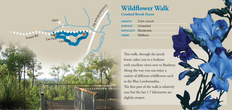
This walk, through the jarrah forest, takes you to a lookout with excellent views over to Bunbury. Along the way you can enjoy a variety of different wildflowers such as the Blue Leschenaultia. The first part of the walk is relatively easy but the last 1.7 kilometres are slightly steeper.
Wildflower WalkCrooked Brook Forest
LENGTH 3 km circuit
SURFACE Unsealed
DIFFICULTY Moderate
USERS WalkersForest Rd
Car Park Car ParkLookout
Dam
Crooked Brook Rd
Fore
st R
d
Car Park
Car Park
Lookout
Dam
Crooked Brook Rd
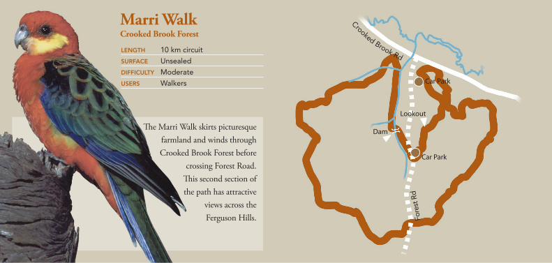
The Marri Walk skirts picturesque farmland and winds through Crooked Brook Forest before
crossing Forest Road. This second section of the path has attractive
views across the Ferguson Hills.
Marri WalkCrooked Brook Forest
LENGTH 10 km circuit
SURFACE Unsealed
DIFFICULTY Moderate
USERS Walkers

This circuit meanders though jarrah forest and features clusters of the uniquely shaped pineapple bushes along the way.The walk begins at the sealed Forest Path and extends through bushland with various species of grass trees along the way.
Jarrah WalkCrooked Brook Forest
LENGTH 1.5 km circuit
SURFACE Unsealed
DIFFICULTY Easy
USERS Walkers of moderate fitness
Forest Rd Car Park
Dam
Crooked
Broo
k Rd

For further information contact:
Bunbury Visitor Centre Tel: 08 9792 7205
walk-it bunbury is a network of 15 walks within the City of Bunbury.
Contact the City of Bunbury 08 9792 7000 or the Heart Foundation on 08 9795 8730
for a copy of the map.
This brochure is an initiative of the South West Development Commission,
jointly funded by the City of Bunbury, the Shire of Harvey and the Department
Environment and Conservation.
PhotoCreditsPhotosprovidedbyDavidAddy,DavidDeeley,BenDeeley,JonBirch,JodieWood, BabsandBertWells,Australia’sSouthWest,JeffHenderson,PaulWebsterand LochmanTransparencies.
Front Cover: New Holland Honeyeater
Experience Bunbury: Lechenault Inlet
Greater Bunbury Region: White Tailed Black Cockatoos, MapPage: Blue Lady Orchid
Tuart Walk: Tuart Tree, Bicycle Path
The Maidens Walk: Sun Orchid, Barbeque Facilities
ManeaPark:White Cheeked Honeyeater, Tiger Orchid
Big Swamp Walk: Australia Grebe, Long Necked Tortoise
Mangrove Walk: Leschenault Inlet Mangroves
Eaton Foreshore Walk: White Faced Heron
LeschenaultPeninsulaConservationPark:Aerial Photo, MapPage: Chuditch
JohnBoyleO’ReillyWetlandTrail:Motorbike Frog, Banksia
BelvidereInterpretiveWalk:Great Egret, Pelican
Harris Track: Bearded Dragon
Crooked Brook Forest: Black Cockatoo,MapPage:Motorbike Frog
ForestPath:Disability Access and Facilities
Wildflower Walk: Blue Leschenaultia, Lookout Platform
Marri Walk: Western Rosella
JarrahWalk:Western Bearded Dragon, Jarrah Tree
Acknowledgements: Majestic Tree
Back Cover: Black Winged Stilt
WE STE R N A U S T R ALI A
TH
E
GO V E R N MENTO
F
Department ofEnvironment and Conservation
Our environment, our future
More walks around Bunbury

