new wypdes permit application rawhide oil …deq.state.wy.us/wqd/wypdes_permitting/wypdes_pn… ·...
TRANSCRIPT

NEW WYPDES PERMIT APPLICATION RAWHIDE OIL FIELD
BIGHORN RIVER BASIN,
OPTION 2 Park County, Wyoming
SECTION 5, T48N, R101W
Prepared for: WESTERN INTERIOR OIL & GAS CORP.
Casper, WY
Prepared by:
P.O. Box 2775, Casper, WY 82602
Tel. 307-265-9199
January 30, 2008

1 1 1 West Second Street, Suite #400 Phone: 307-265-9199 P.O. Box 2775 Fax: 307-473-7138 Casper, WY 82602 www.gga-inc.com January 30, 2008 Mr. Roland Peterson, Environmental Analyst WYPDES Permits Section Water Quality Division / Wyoming Dept. of Environmental Quality 122 West 25th Street, Herschler Building 4W Cheyenne, WY 82002 RE: Rawhide Oil Field Project New WYPDES Permit Application (1/30/08)
Bighorn River Basin: Option 2 Western Interior Oil & Gas Corp. Dear Mr. Peterson: On behalf of Western Interior Oil & Gas Corp., we are enclosing one (1) paper copy and one CD containing the electronic files of the Rawhide Oil Field Project WYPDES permit application for your review and approval. This application includes a table of contents, the WYPDES Application for Permit to Surface Discharge Produced Water…New Discharges form (4/25/07 version), and attached supporting maps, tables, and appendices. Please contact me at the above address or telephone number, or at e-mail address [email protected] if you have questions concerning this permit application. Sincerely, Gene R. George & Associates, Inc. Jean F. Lawlor, PG Hydrogeologist Enclosures cc: T. McCutcheon/WIOGC file JFL;jfl jean C:\GGA Projects\Western Interior\xmt applic cover ltr.doc
OVER 35 YEARS OF PROFESSIONAL INTEGRITY

Rawhide Oil Field New WYPDES Applic Western Interior O&G Corp.
TABLE OF CONTENTS
WYPDES APPLICATION FOR PERMIT TO SURFACE DISCHARGE PRODUCED WATER FROM…NEW DISCHARGES, RENEWALS, OR MAJOR MODIFICATIONS [4/25/07 vers] ............................................................................................................................ 1
EXHIBITS (following application form) EXHIBIT A Topographic Map (scale 1 :24,000) EXHIBIT B Water Management Facilities (scale 1:2,000) TABLES (following Exhibits) TABLE 1 Outfalls and Water Quality, Containment Unit, & Flow Monitoring Stations TABLE 2 Contributing Well Information TABLE 3 Produced Water Quality APPENDICES (following tables) APPENDIX A Statement of Beneficial Use APPENDIX B Effluent Water Analysis Laboratory Reports
i vers: 1/30/08 Jean C:\GGA Projects\Western Interior\Rawhide oil field new WYPDES Tbl Contents.doc

For Agency Use Only
Application Number WY00_______________
Date Received:
__________________
(mo/day/yr)
SUBMIT ONE HARD COPY AND ONE ELECTRONIC COPY
WYOMING POLLUTANT DISCHARGE ELIMINATION SYSTEM
APPLICATION FOR PERMIT TO SURFACE DISCHARGE PRODUCED
WATER FROM COAL BED METHANE NEW DISCHARGES, RENEWALS, OR MAJOR MODIFICATIONS
Revised: 06-22-06 Revised form last updated: 04-25-07 PLEASE PRINT OR TYPE (Submission of illegible materials will result in return of the application to the applicant) 1. Check the box corresponding to the type of application being applied for:
New non-CBM permit
CBM permit renewal Permit number ____________ Expiration Date: ________ CBM permit major modification Permit number _____________ Expiration Date: ________________ 2. Identify the river basin in which the discharge will occur:
Belle Fourche Cheyenne Powder Little Powder Tongue
Other (identify) __Bighorn River_______________________________________
3. Select permit option(s): if more than one option is selected, the applicant must describe which option applies to which outfall.
Option 1A – Discharge is contained within a class 4 water body: Containment within an off-channel pit (class 4C) OR containment within a headwater reservoir situated within a class 4 channel and capable of containing all effluent plus up to a 50-year / 24-hour storm event.
Option 1B – Discharge is contained within a class 3 water body: Containment within a natural closed basin or playa lake (class 3A) OR containment within a headwater reservoir situated within a class 3 channel and capable of containing all effluent plus up to a 50-year / 24-hour storm event.
Option 2 – This option includes any on-channel discharge (including discharge into an on-channel reservoir) that does not meet the impoundment requirements specified in options 1A or 1B above.
If applying for outfalls under Option 2, will discharges from the facility proposed in this application require the use of assimilative capacity credits for salt and sodium in the Powder River? Not applicable
□ Yes □ No
4. General Facility Location: Township(s)__T48N_______________ Range(s) R101W_______________
Immediate Receiving Stream(s) dry draw > ephemeral Spring Creek > Greybull River___________
5. Name of the facility producing the discharge (this is the facility name that will appear on the WYPDES permit)
Rawhide Oil Field ______________________________________________________________
WYPDES 04-25-07
Application for Permit to Discharge Produced Water: Application for Coal Bed Methane New Discharges, Renewals, or Major Modifications, revised
WESTERN INTERIOR OIL & GAS CORP: 2008-01-30 / 10080009 / NEW NON-CBM: RAWHIDE OIL FIELDPage 1 of 8
(06-554.DOC)
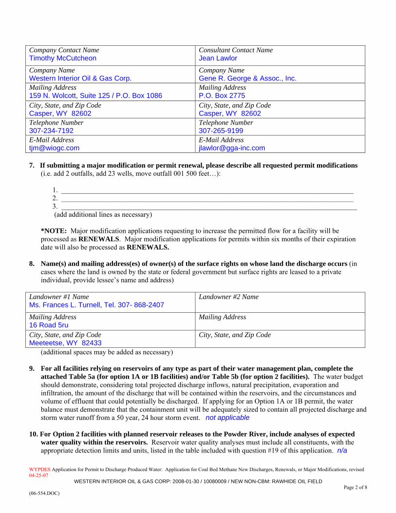
6. Company, Contact Name, mailing address, e-mail address, and telephone number of the individual or company which owns the facility producing the discharge, and the person (consultant) responsible for permit submission.
WYPDES 04-25-07
Application for Permit to Discharge Produced Water: Application for Coal Bed Methane New Discharges, Renewals, or Major Modifications, revised
WESTERN INTERIOR OIL & GAS CORP: 2008-01-30 / 10080009 / NEW NON-CBM: RAWHIDE OIL FIELDPage 2 of 8
(06-554.DOC)
Company Contact Name Timothy McCutcheon
Consultant Contact Name Jean Lawlor
Company Name Western Interior Oil & Gas Corp.
Company Name Gene R. George & Assoc., Inc.
Mailing Address 159 N. Wolcott, Suite 125 / P.O. Box 1086
Mailing Address P.O. Box 2775
City, State, and Zip Code Casper, WY 82602
City, State, and Zip Code Casper, WY 82602
Telephone Number 307-234-7192
Telephone Number 307-265-9199
E-Mail Address [email protected]
E-Mail Address [email protected]
7. If submitting a major modification or permit renewal, please describe all requested permit modifications
(i.e. add 2 outfalls, add 23 wells, move outfall 001 500 feet…):
1. __________________________________________________________________________________ 2. __________________________________________________________________________________ 3. ___________________________________________________________________________________ (add additional lines as necessary)
*NOTE: Major modification applications requesting to increase the permitted flow for a facility will be processed as RENEWALS. Major modification applications for permits within six months of their expiration date will also be processed as RENEWALS.
8. Name(s) and mailing address(es) of owner(s) of the surface rights on whose land the discharge occurs (in
cases where the land is owned by the state or federal government but surface rights are leased to a private individual, provide lessee’s name and address)
Landowner #1 Name Ms. Frances L. Turnell, Tel. 307- 868-2407
Landowner #2 Name
Mailing Address 16 Road 5ru
Mailing Address
City, State, and Zip Code Meeteetse, WY 82433
City, State, and Zip Code
(additional spaces may be added as necessary) 9. For all facilities relying on reservoirs of any type as part of their water management plan, complete the
attached Table 5a (for option 1A or 1B facilities) and/or Table 5b (for option 2 facilities). The water budget should demonstrate, considering total projected discharge inflows, natural precipitation, evaporation and infiltration, the amount of the discharge that will be contained within the reservoirs, and the circumstances and volume of effluent that could potentially be discharged. If applying for an Option 1A or 1B permit, the water balance must demonstrate that the containment unit will be adequately sized to contain all projected discharge and storm water runoff from a 50 year, 24 hour storm event. not applicable
10. For Option 2 facilities with planned reservoir releases to the Powder River, include analyses of expected
water quality within the reservoirs. Reservoir water quality analyses must include all constituents, with the appropriate detection limits and units, listed in the table included with question #19 of this application. n/a

WYPDES 04-25-07
Application for Permit to Discharge Produced Water: Application for Coal Bed Methane New Discharges, Renewals, or Major Modifications, revised
WESTERN INTERIOR OIL & GAS CORP: 2008-01-30 / 10080009 / NEW NON-CBM: RAWHIDE OIL FIELDPage 3 of 8
(06-554.DOC)
11. Attach a description and a clear, legible, detailed topographic map of the discharging facility. Include the following: see attached Exhibits A & B a. A legend Exhibits A & B b. Well locations Exhibit A c. Ponds Exhibit B: skim pit & evaporation pond d. Reservoirs n/a e. Stock tanks n/a f. Discharge points (outfalls) Exhibits A & B g. Immediate receiving streams Exhibits A & B h. Water quality monitoring stations n/a i. Irrigation compliance points n/a j. Location of nearest downstream irrigator. nearest recorded downstream irrigation right sourced from
Spring Creek: Sect.SWNW4-T48-R101 (Buffalo Basin Land & Water Co., priority date 1910) k. Section, Township, and Range information all maps l. If proposing to use class 4C off-channel pits, include footprint outline of the proposed pits. To denote
setback distance, include a distance marker from closest side of pit to the nearest water feature, floodplain, or stream alluvium. Identify latitude and longitude in decimal degrees (using a minimum of 6 decimal places) for each end point of the setback distance marker. n/a
If any of the above are not applicable please indicate in the description and include a brief explanation as to
why the item is not applicable)
12. Describe the control measures that will be implemented to prevent significant damage to or erosion of the receiving water channel at the point of discharge. The ground surface beneath the proposed outfall from the evaporation pond will be lined with rock rip-rap in an open channel to reduce discharge flow velocity and erosive energy.
_____________________________________________________________________________________________ 13. Describe the control measures that will be implemented to achieve water quality standards and effluent
limits. If proposing to utilize a treatment process, provide a description of the treatment process. The raw fluid stream from the oil production wells consists of 95% water plus an emuslfied oil/water mixture that undergoes typical treatment onsite. No chemicals are used in treating produced water and oil at Rawhide Field. A biological treatment method, using indigenous oil-field bacteria cultured on site, is used to pre-treat the raw fluid stream to reduce hydrogen sulfide, break-down emulsions, and improve crude oil quality. Following biological treatment, fluid is then piped to a free-water knockout (FWKO) vessel where water, oil, and gas undergo gravity separation. Wet oil is transferred from the FWKO vessel to a heater treater vessel to further separate remaining water. The separated water from both the FWKO and heater treater vessels is transferred to a 400-barrel water polishing vessel to extract remaining oil. Water is piped from the polishing vessel to an existing, restricted access emergency skim pit, and from there is piped into an existing evaporation pond where it is stored for and accessible to livestock and wildlife prior to proposed surface discharge (Exhibit 2).
_______________________________________________________________________________________ 14. Outfall locations must be established as part of a preliminary field reconnaissance survey using GPS or
conventional survey equipment and documented in Table 1. Please document the type of equipment used, the expected accuracy of your measurements, and a brief rationale for locating the outfalls at the requested sites below. The outfall listed on Table 1 and shown on Exhibits 1 and 2 was located in the field using a Garmin brand eTrex model GPS unit with an approximate horizontal accuracy of 50 feet.

WYPDES 04-25-07
Application for Permit to Discharge Produced Water: Application for Coal Bed Methane New Discharges, Renewals, or Major Modifications, revised
WESTERN INTERIOR OIL & GAS CORP: 2008-01-30 / 10080009 / NEW NON-CBM: RAWHIDE OIL FIELDPage 4 of 8
(06-554.DOC)
The outfall location was located in consultation with and by permission of the surface owner to accommodate livestock and wildlife watering. The surface owner’s signed statement of Beneficial Use is attached in Appendix A.
______________________________________________________________________________________________ 15. Complete the attached Table 1. Provide all the information requested in the table for each proposed discharge
point or monitoring point. If proposing changes (a major modification) to an existing facility, clearly indicate the desired changes on the table. Additional tables may be attached. Use the format provided. Option 2 permits, except those located in the Belle Fourche or Cheyenne River Basins, must include water quality monitoring station locations. Option 1B headwater reservoir discharges (reservoirs other than playa lakes capable of 50 year, 24 hour stormwater runoff containment) must include flow monitoring station locations. Option 1A and 1B permits must include containment unit monitoring station locations. Information related to reservoirs is only required if the facility’s water management plan includes reservoir containment. See attached Table 1 – “Outfalls and Water Quality , Containment Unit, and Flow Monitoring Stations”
16. Complete the attached Table 2. Provide all the information requested in the table for each well associated with
this proposed discharge authorization. If proposing changes (a major modification) to an existing facility, clearly indicate the desired changes on the table. Additional tables may be attached. Use the format provided. See attached Table 2 – “Contributing Well Information”
17. Complete the attached Table 3. Provide all the information requested in the table for each reservoir proposed
for containment of CBM produced water. Specified locations refer to the approximate center of the reservoir. If proposing changes (a major modification) to an existing facility, clearly indicate the desired changes on the table. Additional tables may be attached. Use the format provided. Information related to reservoirs is only required if the facility’s water management plan includes reservoir containment. n/a
18. Complete the attached Table 4. Provide all information requested in the table related to reservoir bonding
requirements for each reservoir proposed for the containment of CBM produced water. If proposing any changes (a major modification) to an existing facility, clearly indicate the desired changes on the table. Additional tables may be attached. Use the format provided. Information related to reservoirs is only required if the facility’s water management plan includes reservoir containment. n/a
19. Provide the results of water analyses for a sample collected from a location representative of the quality of
the water being proposed for discharge for all of the chemical parameters listed in the table below. The sample must be collected from well(s) or outfall(s) within a twenty mile radius of the proposed facility’s location, and from the same coal formation(s) and the same approximate depth(s) as proposed in this application. If filing an application for a permit renewal or modification, the representative sample must be collected from the facility being proposed for renewal or modification. Explain why this sample is representative of the produced water to be discharged. See attached summary Table 3 and corresponding detailed analytical laboratory reports in Appendix B. The effluent water quality samples presented were collected from the existing evaporation pond containing commingled produced oilfield water and from individual wells producing from Rawhide Field.
Samples from co-mingled coal seams are acceptable as long as the sample(s) meet the following criteria:
A. all of the coal seams being proposed for development are represented in the co-mingled sample, with no contribution from coal seams not being proposed for development at the new facility.
B. the ratio of each coal seam’s contribution is approximately the same in the sample and the proposed development,
C. documentation is provided to verify the criteria listed in A. and B.
WYPDES 04-25-07
Application for Permit to Discharge Produced Water: Application for Coal Bed Methane New Discharges, Renewals, or Major Modifications, revised
WESTERN INTERIOR OIL & GAS CORP: 2008-01-30 / 10080009 / NEW NON-CBM: RAWHIDE OIL FIELDPage 5 of 8
(06-554.DOC)
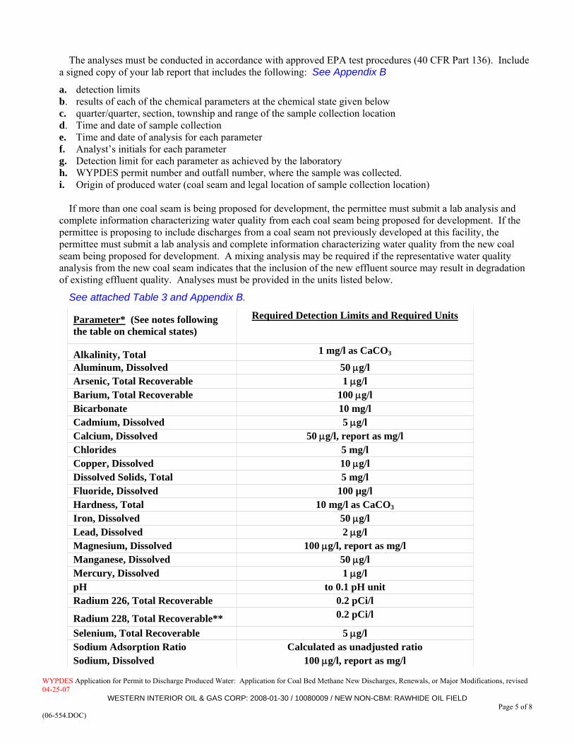
The analyses must be conducted in accordance with approved EPA test procedures (40 CFR Part 136). Include a signed copy of your lab report that includes the following: See Appendix B
a. detection limits b. results of each of the chemical parameters at the chemical state given below c. quarter/quarter, section, township and range of the sample collection location d. Time and date of sample collection e. Time and date of analysis for each parameter f. Analyst’s initials for each parameter g. Detection limit for each parameter as achieved by the laboratory h. WYPDES permit number and outfall number, where the sample was collected. i. Origin of produced water (coal seam and legal location of sample collection location)
If more than one coal seam is being proposed for development, the permittee must submit a lab analysis and complete information characterizing water quality from each coal seam being proposed for development. If the permittee is proposing to include discharges from a coal seam not previously developed at this facility, the permittee must submit a lab analysis and complete information characterizing water quality from the new coal seam being proposed for development. A mixing analysis may be required if the representative water quality analysis from the new coal seam indicates that the inclusion of the new effluent source may result in degradation of existing effluent quality. Analyses must be provided in the units listed below.
See attached Table 3 and Appendix B.
Parameter* (See notes following the table on chemical states)
Required Detection Limits and Required Units
Alkalinity, Total 1 mg/l as CaCO3 Aluminum, Dissolved 50 μg/l Arsenic, Total Recoverable 1 μg/l Barium, Total Recoverable 100 μg/l Bicarbonate 10 mg/l Cadmium, Dissolved 5 μg/l Calcium, Dissolved 50 μg/l, report as mg/l Chlorides 5 mg/l Copper, Dissolved 10 μg/l Dissolved Solids, Total 5 mg/l Fluoride, Dissolved 100 µg/l Hardness, Total 10 mg/l as CaCO3
Iron, Dissolved 50 μg/l Lead, Dissolved 2 μg/l Magnesium, Dissolved 100 μg/l, report as mg/l Manganese, Dissolved 50 μg/l Mercury, Dissolved 1 μg/l pH to 0.1 pH unit Radium 226, Total Recoverable 0.2 pCi/l
Radium 228, Total Recoverable** 0.2 pCi/l
Selenium, Total Recoverable 5 μg/l Sodium Adsorption Ratio Calculated as unadjusted ratio Sodium, Dissolved 100 μg/l, report as mg/l

WYPDES 04-25-07
Application for Permit to Discharge Produced Water: Application for Coal Bed Methane New Discharges, Renewals, or Major Modifications, revised
WESTERN INTERIOR OIL & GAS CORP: 2008-01-30 / 10080009 / NEW NON-CBM: RAWHIDE OIL FIELDPage 6 of 8
(06-554.DOC)
Parameter* (See notes following the table on chemical states)
Required Detection Limits and Required Units
Specific Conductance 5 micromhos/cm Sulfates 10 mg/l Zinc, Dissolved 50 μg/l
*Discharges into drainages other than the Powder River geologic basin may require analysis of additional parameters, please contact the WDEQ for a separate list.
**This parameter is only required for those discharges located within one stream mile of a class 2 water.
20. For new facilities, provide the expected (estimated) flow volume from each well in gallons per day, and provide the rationale behind the flow volume estimate. For existing facilities, provide actual flow data from all wells within the last six months.
Based on Western Interior’s contributing oil wells recent production and planned future development, total (all wells) maximum daily flow is estimated at 2,900 barrels per day = 121,800 gallons per day = 84.6 gpm = 0.122 MGD.
___________________________________________________________________________________________ 21. For applications for new facilities, are any of the required chemical constituents in the laboratory analysis
present in concentrations above Wyoming Water Quality Standards?
YES NO
If the answer to question # 21 is yes, answer 21.a. – 21.b below. If no, proceed to question 23.
a. Which constituents?
b. Has this constituent been addressed in the response to question 13? 22. For applications for existing facilities, has the facility ever exceeded permit limits or water quality
standards? n/a
YES NO
If the answer to question 22 is yes, answer 22.a. – 22.c. If no, proceed to question 23.
a. Which constituents? b. Has the exceedance been addressed? c. Describe how the exceedance was addressed.
23. Is there active irrigation in the drainage downstream of the discharge? (Please note that this response includes both artificially and naturally irrigated bottomlands as defined in the Draft Agricultural Use Protection Policy for the interpretation and implementation of Chapter 1, Section 20 of the Wyoming Water Quality Rules and Regulations ).
YES NO
Irrigation rights to use Spring Creek water downstream of the proposed outfall have been identified from a search of the WSEO water rights database and are available upon request. However, Western Interior is aware of active irrigation use of Spring Creek water only much farther downstream near the Spring Creek confluence with the Greybull River, 9+ miles downstream of the proposed discharge.
If yes, at a minimum, the WYPDES Program requires submission of the following information:
WYPDES 04-25-07
Application for Permit to Discharge Produced Water: Application for Coal Bed Methane New Discharges, Renewals, or Major Modifications, revised
WESTERN INTERIOR OIL & GAS CORP: 2008-01-30 / 10080009 / NEW NON-CBM: RAWHIDE OIL FIELDPage 7 of 8
(06-554.DOC)
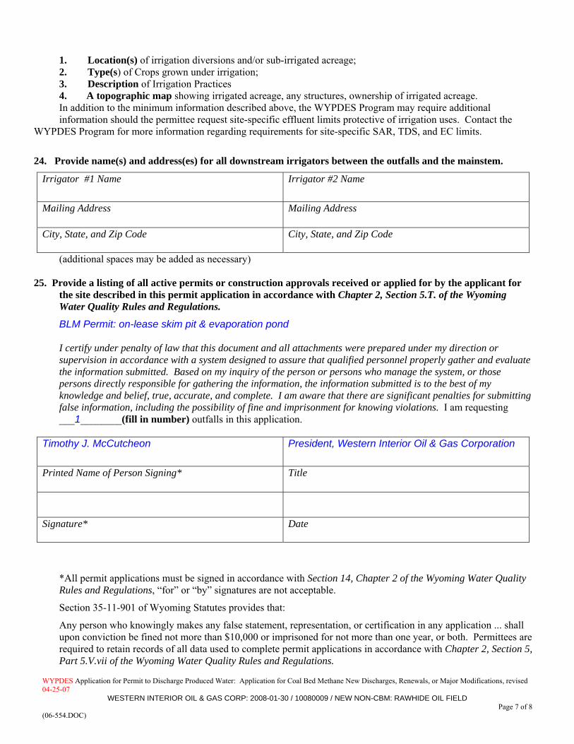
1. Location(s) of irrigation diversions and/or sub-irrigated acreage; 2. Type(s) of Crops grown under irrigation; 3. Description of Irrigation Practices 4. A topographic map showing irrigated acreage, any structures, ownership of irrigated acreage. In addition to the minimum information described above, the WYPDES Program may require additional information should the permittee request site-specific effluent limits protective of irrigation uses. Contact the
WYPDES Program for more information regarding requirements for site-specific SAR, TDS, and EC limits.
24. Provide name(s) and address(es) for all downstream irrigators between the outfalls and the mainstem.
Irrigator #1 Name
Irrigator #2 Name
Mailing Address
Mailing Address
City, State, and Zip Code
City, State, and Zip Code
(additional spaces may be added as necessary)
25. Provide a listing of all active permits or construction approvals received or applied for by the applicant for the site described in this permit application in accordance with Chapter 2, Section 5.T. of the Wyoming Water Quality Rules and Regulations. BLM Permit: on-lease skim pit & evaporation pond
I certify under penalty of law that this document and all attachments were prepared under my direction or supervision in accordance with a system designed to assure that qualified personnel properly gather and evaluate the information submitted. Based on my inquiry of the person or persons who manage the system, or those persons directly responsible for gathering the information, the information submitted is to the best of my knowledge and belief, true, accurate, and complete. I am aware that there are significant penalties for submitting false information, including the possibility of fine and imprisonment for knowing violations. I am requesting ___1________(fill in number) outfalls in this application.
Timothy J. McCutcheon President, Western Interior Oil & Gas Corporation
Printed Name of Person Signing* Title
Signature* Date
*All permit applications must be signed in accordance with Section 14, Chapter 2 of the Wyoming Water Quality Rules and Regulations, “for” or “by” signatures are not acceptable.
Section 35-11-901 of Wyoming Statutes provides that:
Any person who knowingly makes any false statement, representation, or certification in any application ... shall upon conviction be fined not more than $10,000 or imprisoned for not more than one year, or both. Permittees are required to retain records of all data used to complete permit applications in accordance with Chapter 2, Section 5, Part 5.V.vii of the Wyoming Water Quality Rules and Regulations.


Rawhide Oil Field New WYPDES Applic Western Interior O&G Corp.
EXHIBITS


Rawhide Oil Field New WYPDES Applic Western Interior O&G Corp.
TABLES

TABLE 1
OUTFALLS and WATER QUALITY, CONTAINMENT UNIT, & FLOW MONITORING STATIONS
Rawhide Oil Field New WYPDES Permit Application
Western Interior Oil & Gas Corp.
LOCATION
Discharge (Outfall) Point
#
Immediate Receiving
Stream
Main-stem (closest
perennial water)
Dist. fr. Outfall to [perennial]
Mainstem,Stream Miles Q Q SECT TWNSP N RNG W
LAT N,degrees(NAD27)
LONG W,degrees(NAD27) County
Receiving Containment Unit
Name001 dry draw >
UET > Spring Ck
Spring Ck near confl w. Greybull R
~9 SENE 5 48 101 44.161233 -108.99733 Park n/a
STATION DESCRIPTION NOTESUWQMS na -- -- --
DWQMS na -- -- --
TRIB na --
CU1 na
FM1 na
IMP na
ck - creek R - riverconfl - confluence UET - unnamed ephemeral tributary
vers: 1/18/2008C:\GGA Projects\Western Interior\Rawhide Field New WYPDES Data Tbls\1 -OUTFALL pts Page 1 of 1
Gene R. George + Assoc., Inc.

TABLE 2 CONTRIBUTING WELL INFORMATIONRawhide Oil Field New WYPDES Permit Application
Western Interior Oil & Gas Corp.
WELL LOCATIONS
Well I.D. API No.(Proposed)
Producing FmWell Depth
feet bgs Q Q SECT TWNSP N RNG W
Discharges to Outfall #
(see Table 1)
FED W-48153 No. 1 2920592 Phosphoria Fm 6327 NWSW 4 48 101 001
FEDERAL No. 3-5 2920633 Phosphoria Fm 5225 NWNE 5 48 101 001
FEDERAL No. 2 2905277 Phosphoria Fm 5280 SWNE 5 48 101 001
FEDERAL W-48153 No. 5 2921043 Phosphoria Fm 5306 SWNW 5 48 101 001
Proposed well n/a Tensleep Ss n/a NESW 4 48 101 001
Proposed well n/a Tensleep Ss n/a SWNW 4 48 101 001
Proposed well n/a Tensleep Ss n/a SWSE 4 48 101 001
Proposed well n/a Tensleep Ss n/a NENW 5 48 101 001
QTY = 8
vers: 1/18/2008C:\GGA Projects\Western Interior\Rawhide Field New WYPDES Data Tbls\2 - Wells Page 1 of 1 Gene R. George + Assoc., Inc.

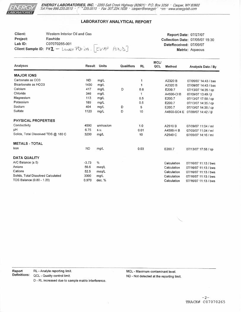
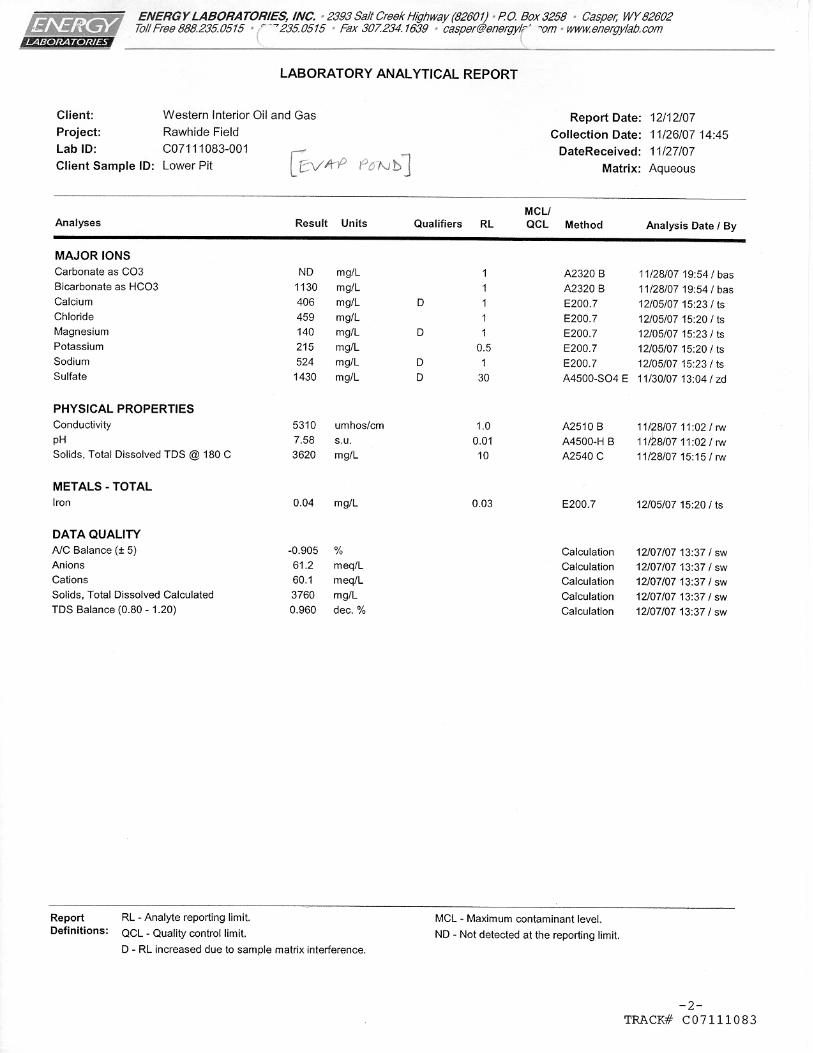
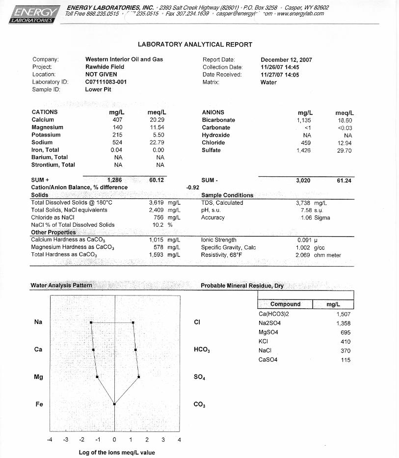
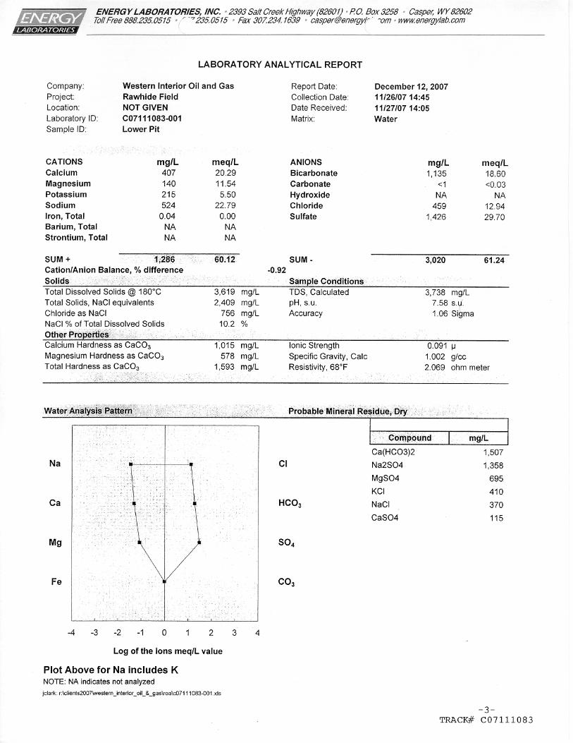
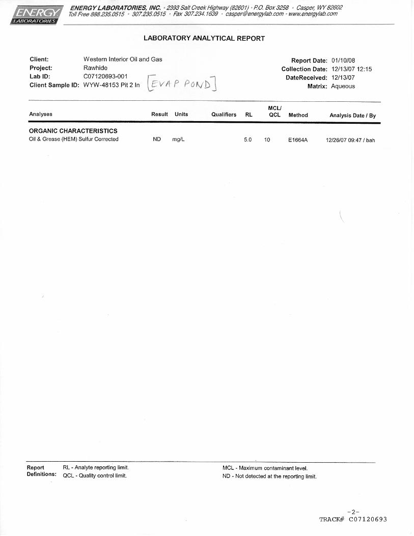
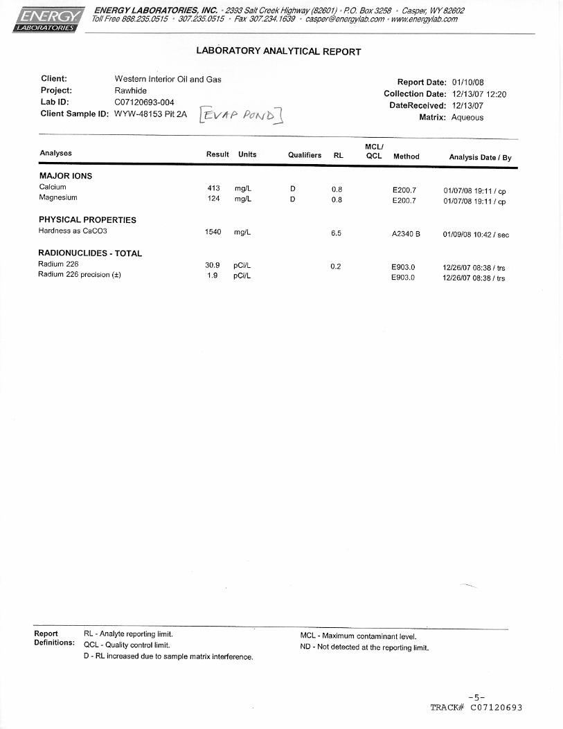
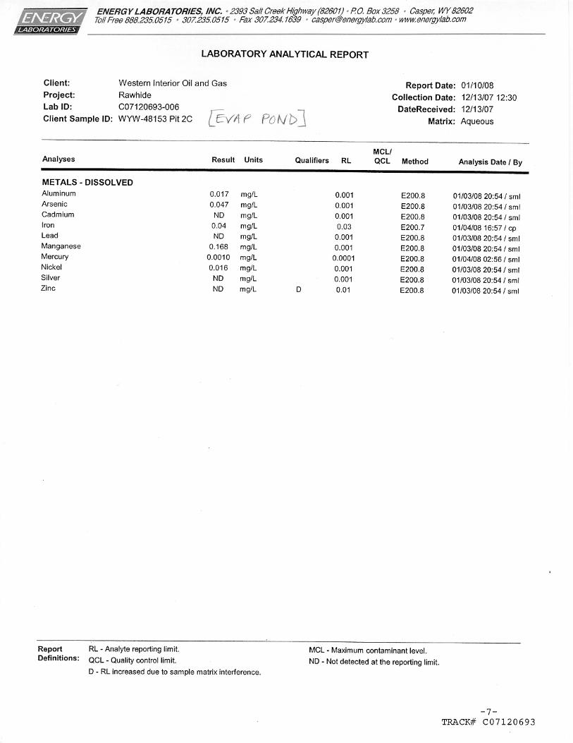
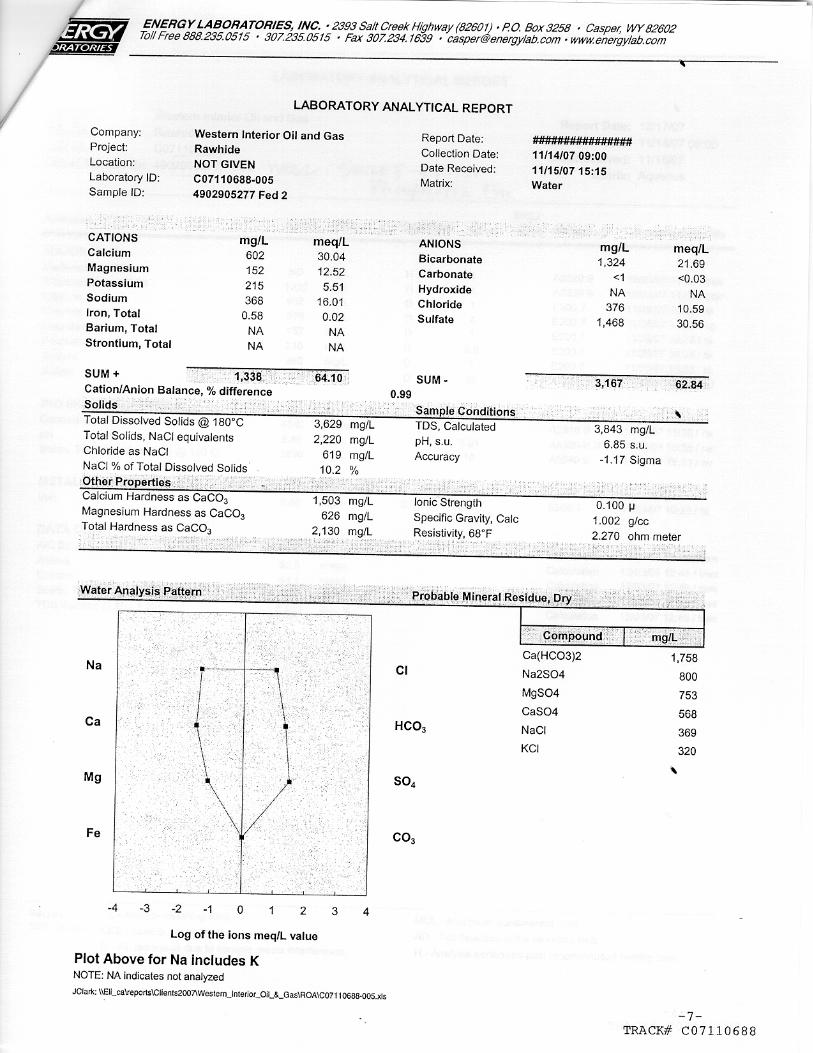
TABLE 3PRODUCED WATER QUALITY SUMMARYRawhide Oil Field New WYPDES Permit ApplicationWestern Interior Oil & Gas Corp.
EFFLUENT LIMITS1 commingled commingled commingled Phosphoria Fm Phosphoria Fm Phosphoria Fm
PARAMETER UNITSREQUIRED
DETECTION LIMIT
AT E.O.P., NO MIXING
post discharge Evap Pond Evap Pond Evap Pond Fed #1 Well Fed #2 Well Fed #5 WellSample Location Section-Township-Range -- 5-T48-R101 5-T48-R101 5-T48-R101 NWSW4-T48-R101 SWNE5-T48-R101 SWNW5-T48-R101Date Sampled -- -- 7/5/07 11/26/07 12/13/07 11/14/07 11/14/07 11/14/07Alkalinity, Total mg/L as CaCO3 1Aluminum, dissolved ug/L 50 17Arsenic, dissolved ug/L 1 47Barium, total recoverable ug/L 100Bicarbonate mg/L 1 1,430 1,130 1,670 1,320 1,620Cadmium, Dissolved ug/L 0.1 <1Calcium, Dissolved mg/L 50 ug/L, as mg/L 417 406 413 275 602 197Chlorides mg/L 5 2000 346 459 298 376 368Chromium VI (hexavalent) ug/L <10Copper, Dissolved ug/L 1Dissolved Solids, Total mg/L 5 5000 3,300 3,620 3,630 2,740Fluoride, Dissolved ug/L 100Hardness, Total mg/L as CaCO3 10 1,508 1,593 1,540 1,073 2,130 744Iron, Dissolved ug/L 50 40Lead, Dissolved ug/L 2 <1Magnesium, Dissolved mg/L 100 ug/L as mg/L 113 140 124 94 152 62Manganese, Dissolved ug/L 50 168Mercury, Dissolved ug/L 1 1.0Nickel, dissolved ug/L 16Oil & Grease mg/L 10 <5.0pH Standard Units 0.1 6.5 - 8.5 6.75 7.58 6.96 6.85 6.89Radium 226, Total Recoverable pCi/L 0.2 60 30.9Radium 228, Total Recoverable** pCi/L 0.2Selenium, Total recoverable ug/L 5Silver, dissolved ug/L <1Sodium Adsorption Ratio unitless -- 4.5 5.7 9.2 3.5 11.2Sodium, Dissolved mg/L 100 ug/L as mg/L 404 524 692 368 706Specific Conductance umhos/cm 5 7500 4,590 5,310 4,580 4,840 4,350Sulfates mg/L 10 3000 1,120 1,430 1,110 1,470 609Zinc, Dissolved ug/L 50 <10
** required only for dishcharges located within one stream mile of Class 2 water< - concentration less than laboratory reporting limit indicated, i.e. not detected above reporting limit[1] Wyoming Water Quality Rules & Regulations Chapter 7, Section 4: Effluent Limitations [for Surface Discharge of Water assoc. with the Production of Oil and Gas]
vers: 1/18/2008C:\GGA Projects\Western Interior\Rawhide Field New WYPDES Data Tbls\3-Water Quality analy Page 1 of 1 Gene R. George + Assoc., Inc.
Rawhide Oil Field New WYPDES Applic Western Interior O&G Corp.
APPENDIX A
Statement of Beneficial Use

Rawhide Oil Field New WYPDES Applic Western Interior O&G Corp.
APPENDIX B
Effluent Water Analysis Laboratory Reports