nile basin regional hydro-meteorological network · 2019-10-23 · nile basin regional....
TRANSCRIPT
NILE BASIN REGIONALHYDRO-METEOROLOGICAL NETWORK
Compiled by Milly Mbuliro, GIS/Remote Sensing Specialist (Nile – SEC, Entebbe)*Source: UN Population Division World Population Prospects 2012
Facts about the Nile Basin
What’s on? January - March 2013
Quiz
Basin Area 3,176 X 103 Km2
Location -4 0S to 310N and 24 0E to 40 0E
Main Tributaries Victoria Nile/Albert Nile, Bahr El Jabel, White Nile, Baro Pibor-Sobat, Blue Nile, Atbara, Bahr El Ghazal
River Length 6,695 Km (one of the world’s longest River)
Estimated Navigable Length 4,149 Km
Countries
Burundi DR Congo
Rwanda
Egypt
South Sudan
Ethiopia
The Sudan
Kenya
Tanzania Uganda Eritrea
Major Lakes within the Basin Lake Victoria, Lake Tana, Lake Kyoga, Lake Albert
Population (Total in all the Nile Countries)* 437 Million
% Population within the Nile Basin* 54% (238 Million)
Temperature Night Minimum -100c and daily Maximum in June 470c
Precipitation Max Annual 2,098 mm/yr in Ethiopia Min Annual 0 mm/yr in Egypt
Mean Annual �ow (Discharge) (m 3/yr) at Aswan 84 X 10 9 m3/yr
Discharge/Unit area 28 X 10 3 m3/Km 2
Main Consumptive Water use Agriculture
Date Activity Venue
Jan NCoRe Project E�ectiveness All Centers
Jan NELTAC/NELCOM Meeting Kigali
11 – 12th Feb Regional Meeting for National NBI Desk O�cers Entebbe
22nd Feb Nile Day celebrations (Regional and National) Bahr Dar, Ethiopia (for regional celebrations)
April 38th Nile-TAC Meeting Entebbe
Compiled by Tom Waako, Projects O�cer, Nile-SEC -Entebbe
Member states
What is the major determinant of population distribution in the Nile Basin?Send your answer to: [email protected]
Answer to the previous quiz question The single most important intra basin agricultural trade commodity by volume among the Nile Basin riparian states is maize.
Burundi DR Congo RwandaEgypt South SudanEthiopia The SudanKenya Tanzania Uganda
Disclaimer: The views expressed in this newsletter do not necessarily represent those of NBI, its Member States or Partners
Editorial CommitteeChair Dorothy KaggwaEditor Jane K. BaitwaMembers Tom Waako John Ogwang
Send us your comments and views
Nile Basin Initiative SecretariatP.O. Box 192 Entebbe – UgandaTel +256 414 321 424 +256 414 321 329 +256 417 705 000Fax +256 414 320 971Email [email protected] http://www.nilebasin.org
2STRONGER TOGETHER
Y E ARS
NBI Member States
"
"
"
"
"
"
"
"
"
"
Main Nile
Bahr el Ghazal
Blue Nile
White Nile
Lake Victoria
Tekeze Atbara
Baro Akobbo Sobat
Victoria Nile
Bahr el Jebel
Lake Albert
Sudan
Libya
Chad
Egypt
Ethiopia
Saudi Arabia
Angola
Kenya
Iraq
Democratic Republic of the Congo
Niger
South Sudan
Congo
Somalia
Yemen
United Republic of Tanzania
Zambia
Uganda
Cameroon Central African Republic
Eritrea
Somalia
Jordan
Gabon
Nigeria
Zambia Mozambique
Malawi
Israel
Burundi
Rwanda
Djibouti
Abyei
Syrian Arab Republic
Kuwait
Hala'ib triangle
Iran (Islamic Republic of)
West Bank
Ilemi triangle
Ma'tan al-Sarra
Comoros
MayotteComorosComoros
Seychelles
Kinshasa
Juba
Cairo
Kampala
Khartoum
Addis Ababa
Nairobi
Tanj
Suo
LolBaro
Aswa
Rahad
Mai
n N
ile
Mara
Bahr el Arab
Kuru
Sobat
White N
ile
Pibor
Bahr El Jebel
Blue Nile
Pong
o
Tekeze Atbara
Dinder
Jur
Simiyu
Ruwana
Albe
rt N
ile
Semilik
i
Migori
Gurumeti
Victoria
Kagera
Moame
Bahr
el Z
eraf
Mara
Main N
ile
20
20
30
30
40
40
-10
-10
0 0
10 10
20 20
30 30³
0 590 1,180295
Kilometers
THIS MAP IS NOT AN AUTHORITY ON INTERNATIONAL BOUNDARIES
Data Source:The Global Administrative Unit Layers (GAUL) dataset, FAO - 2014
The designations employed and the presentationof material in the maps do not imply the expressionof any opinion whatsoever on the part of FAO andNBI concerning the legal or constitutional status of any country, territory or sea area, or concerning the delimitation of frontiers
THE NILE BASIN COUNTRIES
Compiled by Milly Mbuliro, GIS/Remote Sensing Specialist (Nile – SEC, Entebbe)*Source: UN Population Division World Population Prospects 2012
Facts about the Nile Basin
What’s on? January - March 2013
Quiz
Basin Area 3,176 X 103 Km2
Location -4 0S to 310N and 24 0E to 40 0E
Main Tributaries Victoria Nile/Albert Nile, Bahr El Jabel, White Nile, Baro Pibor-Sobat, Blue Nile, Atbara, Bahr El Ghazal
River Length 6,695 Km (one of the world’s longest River)
Estimated Navigable Length 4,149 Km
Countries
Burundi DR Congo
Rwanda
Egypt
South Sudan
Ethiopia
The Sudan
Kenya
Tanzania Uganda Eritrea
Major Lakes within the Basin Lake Victoria, Lake Tana, Lake Kyoga, Lake Albert
Population (Total in all the Nile Countries)* 437 Million
% Population within the Nile Basin* 54% (238 Million)
Temperature Night Minimum -100c and daily Maximum in June 470c
Precipitation Max Annual 2,098 mm/yr in Ethiopia Min Annual 0 mm/yr in Egypt
Mean Annual �ow (Discharge) (m 3/yr) at Aswan 84 X 10 9 m3/yr
Discharge/Unit area 28 X 10 3 m3/Km 2
Main Consumptive Water use Agriculture
Date Activity Venue
Jan NCoRe Project E�ectiveness All Centers
Jan NELTAC/NELCOM Meeting Kigali
11 – 12th Feb Regional Meeting for National NBI Desk O�cers Entebbe
22nd Feb Nile Day celebrations (Regional and National) Bahr Dar, Ethiopia (for regional celebrations)
April 38th Nile-TAC Meeting Entebbe
Compiled by Tom Waako, Projects O�cer, Nile-SEC -Entebbe
Member states
What is the major determinant of population distribution in the Nile Basin?Send your answer to: [email protected]
Answer to the previous quiz question The single most important intra basin agricultural trade commodity by volume among the Nile Basin riparian states is maize.
Burundi DR Congo RwandaEgypt South SudanEthiopia The SudanKenya Tanzania Uganda
Disclaimer: The views expressed in this newsletter do not necessarily represent those of NBI, its Member States or Partners
Editorial CommitteeChair Dorothy KaggwaEditor Jane K. BaitwaMembers Tom Waako John Ogwang
Send us your comments and views
Nile Basin Initiative SecretariatP.O. Box 192 Entebbe – UgandaTel +256 414 321 424 +256 414 321 329 +256 417 705 000Fax +256 414 320 971Email [email protected] http://www.nilebasin.org
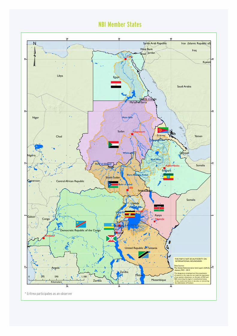
* Eritrea participates as an observer
3NILE BASIN REGIONAL HYDROMET
Table of Contents
Nile Basin Regional HydroMet to promote efficient utilisation of water resources 4
How the Hydromet functions 5
The HydroMet System context in relation to the Nile Basin 6
Benefits of the HydroMet system to Nile Basin countries 8
Implementation of the HydroMet System in the Nile Basin 9
The likely challenges in implementing the HydroMet 10
What countries need to do during implementation 10

A HydroMet System, whose full name
is hydro-meteorological monitoring
system, comprises the infrastructure
– both software and hardware –
and associated institutional setup for monitoring
meteorological and hydrological parameters of a
geographical area, such as a river basin.
The system typically comprises ground observation
networks, such as those measuring river/lake
levels, rainfall, temperature, atmospheric pressure,
wind speed, solar radiation or other parameters,
data transmission systems – to relay data from
terrestrial observation stations to data centres – data
management systems (databases and associated data
management tools), system of procedures for data
quality control and processing.
It is common in literature to distinguish between
hydrological monitoring, also called hydrometric
monitoring, systems as those concerned with
monitoring the hydrology of a watershed and
meteorological monitoring systems as those
dealing with monitoring of weather and climatic
variables. HydroMet Systems provide data needed
for agricultural planning and monitoring; regulating
hydraulic structures such as storage dams for
hydropower generation; early warning for disaster
preparedness such as f loods and drought, navigation,
water resources management and planning; air
quality monitoring, aviation operations, navigation
and many other human activities.
Nile Basin Regional HydroMet to promote efficient utilisation of water resources

5NILE BASIN REGIONAL HYDROMET
There are five important factors that determine
how a HydroMet System functions:
First, a working and appropriately
designed data collection system needs to
be in place: At the heart of any HydroMet System is
the infrastructure for collection of decision relevant
data – be it using ground observation network or via
non-conventional means, such as satellite remote
sensing. With advancement of satellite remote sensing,
increasingly, more and more variables of the bio-
physical environment are monitored remotely.
Precipitation, solar radiation, lake levels, many water
quality parameters, among others, are ‘observed’
through Earth Observation satellites. The accuracy
and diversity of types of parameters observed through
remote sensing is on the rise, which makes it increasingly
attractive for river basin monitoring.
Second is timely data transmission. Data can only be of
use if it is delivered where it is needed and when it is
needed. For example, data on impending flooding can
only aide in saving lives if it is received by those who
need it in order to act before it is too late. Traditionally,
most data collection networks are operated manually
by on-site observers, who take measurements at pre-
defined times, record measurements in their log books
and send the log books to central office at regular
intervals. Nowadays, many monitoring stations are
fully or semi-automated where measurements are
automatically recorded by the instruments and, in
many cases, relayed to the central officer with little or
no involvement of humans.
Third, data management: Collected data needs to be
quality controlled, processed into decision relevant
information before it can be put to use. This requires
an appropriate database management system, together
with a system of tools for data processing and generation
of information for specific purposes. Decision relevant
information is then disseminated to those who need it
using diverse communication channels, such as emails,
over the web, or other means depending on the urgency
for transmitting the information and the intended uses
or users.
Fourth, data sharing protocols: Data and processed
information can only serve its purpose if it is made
available to those who need it and to those purposes
for which it is needed. In a transboundary river system,
appropriate data sharing arrangements are key to a
successful regional HydroMet System.
Fifth, human and institutional capacity: Human and
institutional capacities are needed for continuous
operation, maintenance of observation networks and
support practical use of the data collected. Therefore,
putting in place the necessary human and institutional
capacities are at the core of a sustainable and functioning
hydro-meteorological monitoring system.
In the case of the Nile Basin Regional HydroMet
System, all above factors have been taken into account
in the design. Further, The NBI Member States have
put in place a process and procedure for sharing of
information.
How the Hydromet functions
<< Precipitation, solar radiation, lake levels,
many water quality parameters, among
others, are ‘observed’ through Earth
Observation satellites. The accuracy and
diversity of types of parameters observed
through remote sensing is on the rise, which
makes it increasingly attractive for river basin
monitoring. >>
5NILE BASIN REGIONAL HYDROMET
The Nile Basin is a shared river basin that
stretches over 11 riparian countries. It covers
contrasting hydro-climatic, ecological and
socio-economic systems that span from
tropical regions (the Nile Equatorial Lakes region) to
desert/semi desert downstream parts. Each Nile Basin
country has its own national hydro-meteorological
monitoring system designed to serve a variety of
purposes in the respective countries.
Studies conducted by the Nile Basin Initiative indicate
substantial gaps in the current HydroMet monitoring
infrastructure. There are hydrologically important
areas of the basin that are poorly monitored due to
inadequate monitoring network; many monitoring
stations are poorly equipped – some not operational
for quite substantial periods of their history since
establishment; many stations are not equipped with
modern instruments that ensure more precise data
collection and continuous and timely transmission of
data.
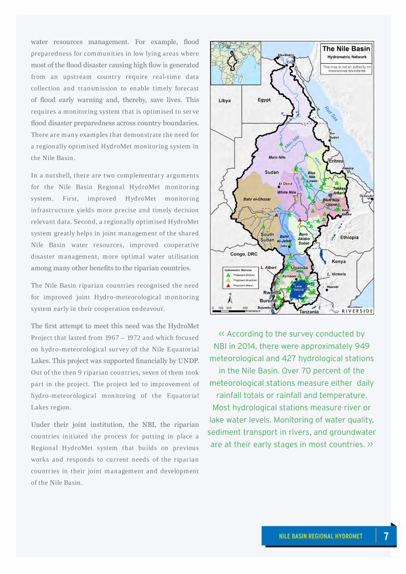
According to the survey conducted by NBI in 2014,
there were approximately 949 meteorological and
427 hydrological stations in the Nile Basin. Over 70
percent of the meteorological stations measure either
daily rainfall totals or rainfall and temperature. Most
hydrological stations measure river or lake water
levels. Monitoring of water quality, sediment transport
in rivers, and groundwater are at their early stages in
most countries. Data transmission from the stations to
central data repository in most countries is manual.
Further, being designed to serve purposes within
the country where they are installed, many stations
needed substantial upgrading to serve transboundary
The HydroMet System context in relation to the Nile Basin
7NILE BASIN REGIONAL HYDROMET
water resources management. For example, flood
preparedness for communities in low lying areas where
most of the flood disaster causing high flow is generated
from an upstream country require real-time data
collection and transmission to enable timely forecast
of flood early warning and, thereby, save lives. This
requires a monitoring system that is optimised to serve
flood disaster preparedness across country boundaries.
There are many examples that demonstrate the need for
a regionally optimised HydroMet monitoring system in
the Nile Basin.
In a nutshell, there are two complementary arguments
for the Nile Basin Regional HydroMet monitoring
system. First, improved HydroMet monitoring
infrastructure yields more precise and timely decision
relevant data. Second, a regionally optimised HydroMet
system greatly helps in joint management of the shared
Nile Basin water resources, improved cooperative
disaster management, more optimal water utilisation
among many other benefits to the riparian countries.
The Nile Basin riparian countries recognised the need
for improved joint Hydro-meteorological monitoring
system early in their cooperation endeavour.
The first attempt to meet this need was the HydroMet
Project that lasted from 1967 – 1972 and which focused
on hydro-meteorological survey of the Nile Equatorial
Lakes. This project was supported financially by UNDP.
Out of the then 9 riparian countries, seven of them took
part in the project. The project led to improvement of
hydro-meteorological monitoring of the Equatorial
Lakes region.
Under their joint institution, the NBI, the riparian
countries initiated the process for putting in place a
Regional HydroMet system that builds on previous
works and responds to current needs of the riparian
countries in their joint management and development
of the Nile Basin.
<< According to the survey conducted by
NBI in 2014, there were approximately 949
meteorological and 427 hydrological stations
in the Nile Basin. Over 70 percent of the
meteorological stations measure either daily
rainfall totals or rainfall and temperature.
Most hydrological stations measure river or
lake water levels. Monitoring of water quality,
sediment transport in rivers, and groundwater
are at their early stages in most countries. >>

The Nile Basin Regional HydroMet System is
comprised of approximately 80 hydrological
and 323 meteorological monitoring stations
equipped with state of the art observation and
with data transmission instruments. Further, the system
also includes upgraded water quality laboratories in the NBI
Member States; infrastructure for use of Earth Observation
information and limited groundwater monitoring stations.
The regional HydroMet system will be built on existing
national monitoring networks with additional stations
installed where none exist.
The regional HydroMet System is designed to provide more
reliable data and information for water resources management.
The design was aimed at providing transboundary benefits
in a number of areas, including: flood disaster preparedness;
coordinated management of water storage dams; navigation;
improved adaptation to climate change.
The NBI Member States will benefit from state of the art
monitoring infrastructure, including support to increasing
use of Earth Observation for the management of water and
related natural resources.
With increasing availability of credible and continuously
observed data, the countries will be able to improve the
water resources planning and management, as well as utilise
their water resources more efficiently – both at regional and
national levels; be better prepared against natural hazards,
such as floods and droughts; monitor changes in the Nile
Basin climate and, hence, improve their climate change
adaptation plans, among others.
The implementation of the HydroMet System will be
accompanied by trainings of national technicians to ensure
Member States have the necessary skilled staff to install,
operate and maintain modern hydro-meteorological
monitoring systems.
Member States will also benefit from joint monitoring
information products.
Benefits of the HydroMet system to Nile Basin countries
<< The regional HydroMet System is
designed to provide more reliable data
and information for water resources
management. The design was aimed
at providing transboundary benefits
in a number of areas, including: flood
disaster preparedness; coordinated
management of water storage dams;
navigation; improved adaptation to
climate change. >>
9NILE BASIN REGIONAL HYDROMET
From the onset, the work on the Nile Basin
Regional HydroMet system has been a joint
activity of all riparian states. Joint task force
was formed way back in 2010 to formulate
the Nile River Basin Monitoring Strategy, which was
approved by the Council of Ministers in 2011. The
Strategy was the first step in articulating common
objective strategy for realising a Nile Basin regional, at
the time, river basin monitoring system.
Once the strategy was approved, through the support
from the Nile Basin Trust Fund administered by the
World Bank, the detailed design of the monitoring
system, named as the ‘Nile Basin Regional HydroMet’
system, was developed. The NBI task force oversaw the
needs assessment and detailed design together with NBI
centres. The final design of the system was endorsed
by the Nile-TAC in 2015 and subsequently by the Nile-
COM.
In approving the final design and, hence, endorsing
the implementation, the NBI Member States agreed
to a statement of purpose for the Nile Basin Regional
HydroMet System (see Box 1).
The member countries further re-iterated to use and
maintain the system to ensure its long-term operation.
The NBI has received funding from the 10th European
Development Fund under the EU – German
‘Transboundary Water Management in the Nile River
Basin’ programme that will be used to implement the
first phase of the HydroMet System.
Implementation of the system will be collaboration
between the Secretariat and its investment arms, NBI
Member States national hydrological services offices
supported by consultants and contractors. The NBI
task force will oversee the overall implementation of the
system while technical task teams in each NBI Member
State will deal with the on-the-ground implementation.
Implementation of the first phase is planned to take
approximately 3 years, i.e. from July 2018 to June 2021.
Implementation of the HydroMet System in the Nile Basin
BOX 1: THE COMMON STATEMENT OF PURPOSE FOR THE NILE BASIN REGIONAL HYDROMET SYSTEM
We, Member States of the Nile Basin Initiative, are united and dedicated to establish and share an ever growing understanding of the water resources of the Nile Basin and to engage that understanding in wise stewardship and sustainable socioeconomic development.
<< Once the strategy was approved, through
the support from the Nile Basin Trust Fund
administered by the World Bank, the detailed
design of the monitoring system, named as
the ‘Nile Basin Regional HydroMet’ system,
was developed. The NBI task force oversaw
the needs assessment and detailed design
together with NBI centres. The final design of
the system was endorsed by the Nile-TAC in
2015 and subsequently by the Nile-COM. >>
9NILE BASIN REGIONAL HYDROMET
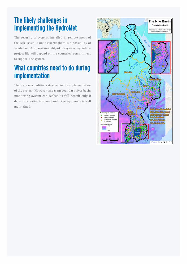
The likely challenges in implementing the HydroMetThe security of systems installed in remote areas of
the Nile Basin is not assured; there is a possibility of
vandalism. Also, sustainability of the system beyond the
project life will depend on the countries’ commitment
to support the system.
What countries need to do during implementationThere are no conditions attached to the implementation
of the system. However, any transboundary river basin
monitoring system can realise its full benefit only if
data/information is shared and if the equipment is well
maintained.


Nile Basin Initiative SecretariatP.O. Box 192Entebbe – UgandaTel: +256 417 705 000 +256 417 705 117Email: [email protected]: http://www.nilebasin.orgFacebook: /Nile Basin InitiativeTwitter: @nbiweb
Eastern Nile Technical Regional OfficeDessie RoadP.O. Box 27173-1000Addis Ababa – EthiopiaTel: +251 116 461 130/32Fax: +251 116 459 407Email: [email protected]: http://entro.nilebasin.org
Nile Equatorial Lakes Subsidiary ActionProgramme Coordination UnitKigali City Tower KCT, KN 2 St, KigaliP.O. Box 6759, Kigali RwandaTel: +250 788 307 334Fax: +250 252 580 100Email: [email protected]: http://nelsap.nilebasin.org
@nbiweb/Nile Basin Initiative
#NileCooperation; #NileBasin; #OneNile
ONE RIVER ONE PEOPLE ONE VISION
This publication was produced with the financial support of the European Union and Federal German Government. Its contents are the sole
responsibility of the Nile Basin Initiative and do not necessarily reflect the views of the European Union or the Federal German Government.
Compiled by Milly Mbuliro, GIS/Remote Sensing Specialist (Nile – SEC, Entebbe)*Source: UN Population Division World Population Prospects 2012
Facts about the Nile Basin
What’s on? January - March 2013
Quiz
Basin Area 3,176 X 103 Km2
Location -4 0S to 310N and 24 0E to 40 0E
Main Tributaries Victoria Nile/Albert Nile, Bahr El Jabel, White Nile, Baro Pibor-Sobat, Blue Nile, Atbara, Bahr El Ghazal
River Length 6,695 Km (one of the world’s longest River)
Estimated Navigable Length 4,149 Km
Countries
Burundi DR Congo
Rwanda
Egypt
South Sudan
Ethiopia
The Sudan
Kenya
Tanzania Uganda Eritrea
Major Lakes within the Basin Lake Victoria, Lake Tana, Lake Kyoga, Lake Albert
Population (Total in all the Nile Countries)* 437 Million
% Population within the Nile Basin* 54% (238 Million)
Temperature Night Minimum -100c and daily Maximum in June 470c
Precipitation Max Annual 2,098 mm/yr in Ethiopia Min Annual 0 mm/yr in Egypt
Mean Annual �ow (Discharge) (m 3/yr) at Aswan 84 X 10 9 m3/yr
Discharge/Unit area 28 X 10 3 m3/Km 2
Main Consumptive Water use Agriculture
Date Activity Venue
Jan NCoRe Project E�ectiveness All Centers
Jan NELTAC/NELCOM Meeting Kigali
11 – 12th Feb Regional Meeting for National NBI Desk O�cers Entebbe
22nd Feb Nile Day celebrations (Regional and National) Bahr Dar, Ethiopia (for regional celebrations)
April 38th Nile-TAC Meeting Entebbe
Compiled by Tom Waako, Projects O�cer, Nile-SEC -Entebbe
Member states
What is the major determinant of population distribution in the Nile Basin?Send your answer to: [email protected]
Answer to the previous quiz question The single most important intra basin agricultural trade commodity by volume among the Nile Basin riparian states is maize.
Burundi DR Congo RwandaEgypt South SudanEthiopia The SudanKenya Tanzania Uganda
Disclaimer: The views expressed in this newsletter do not necessarily represent those of NBI, its Member States or Partners
Editorial CommitteeChair Dorothy KaggwaEditor Jane K. BaitwaMembers Tom Waako John Ogwang
Send us your comments and views
Nile Basin Initiative SecretariatP.O. Box 192 Entebbe – UgandaTel +256 414 321 424 +256 414 321 329 +256 417 705 000Fax +256 414 320 971Email [email protected] http://www.nilebasin.org
NBI MEMBER STATES
Three versions of the logo are used:
1_For bilateral projects abroad (> page 8)
2_For multilateral projects abroad (> page 17)
3_For unilateral projects abroad (> page 23)
The three options described on the following pages prescribe the usage of the logo in precise detail.
Please address any questions or concerns to: Federal Foreign Office Division 600 [email protected] tel. +49 (0)30 5000-2634 (administrative office)
Federal Foreign Office Division 608 [email protected] tel. +49 (0)30 5000-2858 (administrative office) or
Federal Ministry for Economic Cooperation and Development (BMZ) [email protected] [email protected]
IntroductionThe cooperation logo
Version 1: Usage in bilateral projects abroad Example: Fiji; Official language: English
Guidelines for design and usage – Introduction | 5
germancooperationDEUTsChE ZUsAMMENARBEIT
Version 2: Usage in multilateral projects abroad (and in excep-tional cases in bilateral projects) Example: Official language: English
Version 3: Usage in unilateral projects abroad single version in English and German
germancooperationDEUTsChE ZUsAMMENARBEIT
examPles of PosITIonInG in bilateral projects
Guidelines for design and usage – for bilateral projects abroad | 13
example: banner, roll-up (image size greatly reduced)
germancooperationDEUTsChE ZUsAMMENARBEIT
LOGO1Unterzeile Logo
Implemented by:
These examples show possible ways to use the logo when no relevant guidelines for the situation are provided in the German Government style Guide.
(scale: Cooperation logo 100%, implementing organization logos and other logos 80%)
germancooperationDEUTsChE ZUsAMMENARBEIT
SUPPORTED BY