no whisky ea4-14 - bark-out.org · united states department of agriculture forest service 2006...
TRANSCRIPT

United States Department of Agriculture Forest Service 2006
Environmental Assessment No Whisky Plantation Thinning Clackamas River Ranger District, Mt. Hood National Forest Clackamas County, Oregon The project is located in T.4S., R.5E.; T.4S., R.6E.; Willamette Meridian.
For Information Contact: James Rice
595 NW Industrial Way, Estacada, OR 97023 503.630.6861 [email protected]
The U.S. Department of Agriculture (USDA) prohibits discrimination in all its programs and activities on the basis of race, color, national origin, age, disability, and where applicable, sex, marital status, familial status, parental status, religion, sexual orientation, genetic information, political beliefs, reprisal, or because all or part of an individual’s income is derived from any public assistance program. (Not all prohibited bases apply to all programs.) Persons with disabilities who require alternative means for communication of program information (Braille, large print, audiotape, etc.) should contact USDA’s TARGET Center at (202) 720-2600 (voice and TDD). To file a complaint of discrimination, write to USDA, Director, Office of Civil Rights, 1400 Independence Avenue, S.W., Washington, D.C. 20250-9410, or call (800) 795-3272 (voice) or (202) 720-6382 (TDD). USDA is an equal opportunity provider and employer.

Environmental Assessment No Whisky Thinning
2
Table of Contents
1.0 Summary...................................................................................................................3 2.0 Introduction ..............................................................................................................3
2.1 Document Structure...........................................................................................................3 2.1.1 Background ....................................................................................................................4 2.2 Purpose and Need for Action ............................................................................................5 2.3 Proposed Action ................................................................................................................9 2.4 Public Involvement ...........................................................................................................9 2.5 Issues .................................................................................................................................9
3.0 Alternatives.............................................................................................................10 3.1 Alternative A - No Action.................................................................................. 10 3.2 Action Alternatives ............................................................................................ 10 3.3 Alternative B...................................................................................................... 15 3.4 Alternative C...................................................................................................... 16 3.5 Alternative D...................................................................................................... 17 3.6 Best Management Practices (BMPs) and Design Criteria Common to All Action Alternatives ............................................................................................................................19 3.7 Alternatives Considered But Not Fully Developed ........................................... 25 3.8 Comparison of Alternatives ............................................................................................27
4.0 Environmental Consequences..............................................................................27 4.1 Cumulative Effects............................................................................................. 27 4.2 WATER QUALITY AND FISHERIES ............................................................ 28 4.3 STAND GROWTH AND PRODUCTIVITY ................................................... 44 4.4 LANDSCAPE HEALTH AND DIVERSITY ................................................... 46 4.5 WILDLIFE......................................................................................................... 49 4.6 SOILS ................................................................................................................ 69 4.7 SCENERY ......................................................................................................... 75 4.8 BOTANY........................................................................................................... 76 4.9 MANAGEMENT OF COMPETING AND UNWANTED VEGETATION.... 77 4.10 AIR QUALITY................................................................................................. 79 4.11 ECONOMICS – FINANCIAL ANALYSIS..................................................... 81 4.12 TRANSPORTATION....................................................................................... 82 4.13 HERITAGE RESOURCES .............................................................................. 84 4.14 ENVIRONMENTAL JUSTICE – CIVIL RIGHTS ......................................... 84 4.15 RECREATION ................................................................................................. 84 4.16 OTHER ............................................................................................................. 86
5.0 Consultation and Coordination.............................................................................87 Appendix A – Response to Substantive Comments ...................................................... A-1 Appendix B – Wildlife Biological Evaluation ................................................................B-1 Appendix C – Fish Biological Evaluation ......................................................................C-1 Appendix D – Botany Biological Evaluation ................................................................ D-1 Appendix E – Other Documents .....................................................................................E-1
Environmental Assessment No Whisky Plantation Thinning
3
1.0 SUMMARY The Mt. Hood National Forest proposes a commercial thinning project in plantations ranging in age from 40 to 70 years old. The project is located in the western portion of the Clackamas River Ranger District, Mt. Hood National Forest, Oregon. The purpose of this project is to thin second-growth forest stands to achieve multiple objectives. The proposed action is to thin and harvest wood fiber from approximately 1678 acres of matrix land and riparian reserves. Refer to s. 3.2 for greater detail. The Forest Service evaluated the no-action alternative and action alternatives that vary by logging method and road construction.
2.0 INTRODUCTION
2.1 Document Structure ______________________________ The Forest Service has prepared this document in compliance with the National Environmental Policy Act (NEPA) and other relevant Federal and State laws and regulations. This document discloses the direct, indirect, and cumulative environmental impacts that would result from the proposed action and alternatives. The document is organized into the following parts: • Summary • Introduction: This section includes the purpose of and need for the project, and the
agency’s proposal for achieving that purpose and need. This section also details how the Forest Service informed the public of the proposal and how the public responded.
• Alternatives: This section provides a more detailed description of the agency’s proposed action as well as alternative methods for achieving the stated purpose. These alternatives were developed based on issues raised by the public and other agencies. This discussion also includes design criteria and Best Management Practices. Finally, this section provides a comparison of the environmental consequences associated with each alternative.
• Environmental Consequences: This section describes the environmental effects of implementing the proposed action and other alternatives. This analysis is organized by resource. Within each section, the existing situation is described first, followed by the effects of the alternatives. The No-action Alternative provides a baseline for evaluation and comparison of the other alternatives.
• Consultation and Coordination: This section provides a list of preparers and agencies consulted during the development of the environmental assessment.
• References and Appendices: The appendices provide more detailed information to support the analyses presented in the environmental assessment.

Environmental Assessment No Whisky Plantation Thinning
4
Additional documentation, including more detailed analyses of project-area resources, may be found in the project planning record located at the Estacada Ranger Station in Estacada, Oregon.
2.1.1 Background _____________________________________ The No Whisky project area has had a history of logging and wildfire. The area was privately owned and logging began in 1923 using a railroad and steam donkey system. On September 11, 1929 a fire started from overheated railroad brakes and rapidly burned approximately 15,000 acres pushed by an east wind. Much of the burned area was salvage logged and there was another smaller fire that reburned portions of the area. Some of the land was transferred to the Forest Service as part of a settlement for fire damages. The area was eventually replanted and reseeded and the trees are now approximately 55 to 70 years old. The photo above shows a logging operation that had recently been burned over (smoke obscures the middleground area). The project also includes one unburned stand that is a 40-year old plantation.
The photo below is part of a panorama taken from the Bedford Point lookout (near unit 37) on 10/26/33. The left edge is looking south and the right edge is looking east. Units 37 through 40 would be in the foreground on the right side of the photo and units 1 through 13 would be in the middleground area across the North Fork Clackamas River.
Environmental Assessment No Whisky Plantation Thinning
5
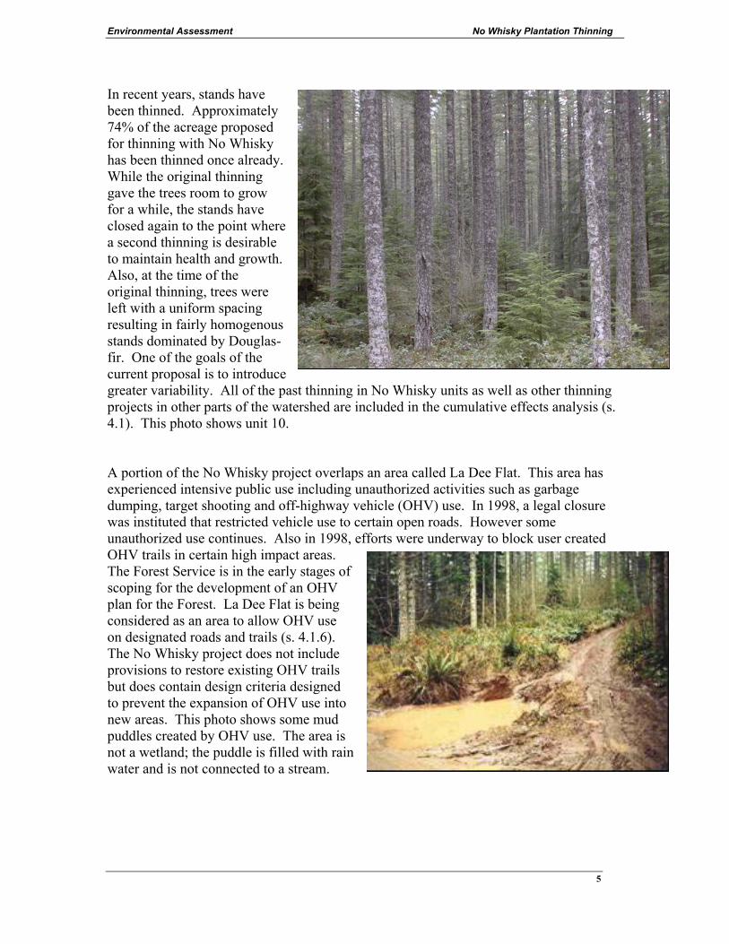
In recent years, stands have been thinned. Approximately 74% of the acreage proposed for thinning with No Whisky has been thinned once already. While the original thinning gave the trees room to grow for a while, the stands have closed again to the point where a second thinning is desirable to maintain health and growth. Also, at the time of the original thinning, trees were left with a uniform spacing resulting in fairly homogenous stands dominated by Douglas-fir. One of the goals of the current proposal is to introduce greater variability. All of the past thinning in No Whisky units as well as other thinning projects in other parts of the watershed are included in the cumulative effects analysis (s. 4.1). This photo shows unit 10. A portion of the No Whisky project overlaps an area called La Dee Flat. This area has experienced intensive public use including unauthorized activities such as garbage dumping, target shooting and off-highway vehicle (OHV) use. In 1998, a legal closure was instituted that restricted vehicle use to certain open roads. However some unauthorized use continues. Also in 1998, efforts were underway to block user created OHV trails in certain high impact areas. The Forest Service is in the early stages of scoping for the development of an OHV plan for the Forest. La Dee Flat is being considered as an area to allow OHV use on designated roads and trails (s. 4.1.6). The No Whisky project does not include provisions to restore existing OHV trails but does contain design criteria designed to prevent the expansion of OHV use into new areas. This photo shows some mud puddles created by OHV use. The area is not a wetland; the puddle is filled with rain water and is not connected to a stream.
Environmental Assessment No Whisky Plantation Thinning
6
2.2 Purpose and Need for Action_______________________
2.2.1 The following four purposes of this project are derived from the Mt. Hood Forest Plan as amended. Each purpose statement has page references from various Forest Plan documents and has section references where greater detail can be found elsewhere in this document.
The purpose of this project is to:
• Provide forest products
Action is needed to supply forest products consistent with the Northwest Forest Plan goal of maintaining the stability of local and regional economies (s. 4.11). There is a need to keep forests healthy and productive to sustainably provide forest products in the matrix in the future. Not only are forest products needed by society, but also the employment created is important to local and regional economies. (Northwest Forest Plan ROD p. 26, Mt. Hood Forest Plan p. Four-26)
• Maintain health, vigor and growth that results in larger trees on 1633 acres of matrix in the project area
This action is needed because these second-growth plantations are experiencing a slowing of growth due to overcrowding and some are experiencing suppression caused mortality (The Mt. Hood Forest Plan describes this need on p. Four-91 FW-372 & Four-292). If no action is taken, this overstocked condition would result in stands with reduced vigor and increased mortality. There is a need for forest stands in the matrix that are healthy and vigorous with low levels of mortality. (s. 4.3)
• Enhance diversity on 1678 acres in the project area
This action is needed because these plantations lack certain elements of diversity (s. 3.2.1, 4.3, & 4.4.3). They do not have the mix of tree species that were present in the original stand and they are relatively uniform in terms of tree size and spacing. There is a need for greater variability of vertical and horizontal stand structure. There is a need for more sunlight on the forest floor to create greater diversity of ground vegetation. (The Mt. Hood Forest Plan describes this need on p. Four-67). If no action is taken, over time the stands would become increasingly dense resulting in a period of low structural diversity that could last more than 100 years (s. 4.4.3).
• Enhance riparian reserves on 45 acres in the project area
This action is needed because these plantations occur in riparian reserves and because the current vegetation does not meet the needs of associated aquatic and riparian resources (The Mt. Hood Forest Plan describes this need on p. Four-17 to 20, Northwest Forest Plan Standards and Guidelines p. C-32). If no action is taken in these riparian reserves, stands would have reduced capability to produce the size

Environmental Assessment No Whisky Plantation Thinning
7
and quantity of coarse woody debris sufficient to sustain physical complexity and stability of the riparian reserves and associated streams. Plantations can be enhanced by thinning to accelerate the development of mature and late-successional stand conditions (s. 3.3.2, 4.2.5 & 4.3.2).
2.2.2 Management Direction – The proposed action has been designed to meet the goals and
objectives of the documents listed below. This assessment is tiered to the Environmental Impact Statements and the listed plans are incorporated by reference. • The Mt. Hood National Forest Land and Resource Management Plan as amended
(USDA 1990b) (referred to as the Forest Plan) • The Mt. Hood National Forest Land and Resource Management Plan Final
Environmental Impact Statement (USDA 1990a) • The Forest Plan was amended by the Record of Decision and Standards and
Guidelines for Management of Habitat for Late-Successional and Old-Growth Forest Related Species Within the Range of the Northern Spotted Owl. (USDA, USDI 1994b) (hereafter referred to as the Northwest Forest Plan or NFP)
• The Northwest Forest Plan Final Supplemental Environmental Impact Statement (USDA, USDI 1994a)
• The Forest Plan was amended by the 2001 Record of Decision and Standards and Guidelines for Amendments to the Survey and Manage, Protection Buffer, and other Mitigation Measures Standards and Guidelines. (USDA, USDI 2001)
• The Forest Plan was amended by the 2004 Record of Decision to Clarify Provisions Relating to the Aquatic Conservation Strategy. (USDA, USDI 2004a)
• The Forest Plan was amended by the 2005 Record of Decision for Preventing and Managing Invasive Plants (USDA 2005)
2.2.3 The No Whisky Plantation Thinning project is located within the following land
allocations: C1 Timber Emphasis and Riparian Reserves. Refer to Map in section 3.2.8. See Appendix E for documentation of riparian reserve standards. Watershed Analysis - Most of the project is covered by the North Fork Clackamas River Watershed Analysis (1996). A portion of the project is covered by the Lower Clackamas River Watershed Analysis (1996). Since then, these two watersheds and several others have been combined into one fifth-field watershed called Middle Clackamas.
Environmental Assessment No Whisky Plantation Thinning
8
2.2.4 DESIRED FUTURE CONDITION The following desired future conditions are derived from the Mt. Hood Forest Plan as amended. The desired future conditions from the Forest Plan that are relevant to this proposal are summarized below.
Health Forest stands have low levels of disease, damaging insect populations and storm damage. Four-92, FW-382; and Four-292, C1-22.
Growth Forest stands are healthy and vigorous, and have growth rates commensurate with the sites potential (at a rate at which the mean annual increment has not culminated). Four-5, #44; and Four-86, FW-306; and Four-91, FW-372; and Four-90, FW-361.
Riparian & Aquatic
Riparian reserves contain the level of vegetative and structural diversity associated with mature and late-successional stand conditions. They supply coarse woody debris sufficient to sustain physical complexity and stability. They provide connectivity within and between watersheds. The riparian reserves connections provide unobstructed routes to areas critical to fulfilling life history requirements of aquatic and riparian-dependent species. NFP page B-11.
Snags & Down Logs
Snags, down logs, and recruitment trees are well distributed across the landscape in sufficient quantity and quality to support species dependent upon these habitats. NFP page C-40.
Deer & Elk The forest contains a mix of habitats including forage, thermal cover and optimal cover. Four-72, FW-202 to 207.
Landscape Health
Landscapes are healthy and productive and provide a mix of forest and non-forest habitats to support diverse populations of desired plant and animal species. Watersheds provide long-term sustained production of high quality water for fish and for on-Forest and off-Forest water users. Landscapes are actively managed. Four-2 to 5. The project is not within a wildland-urban interface and is not in a high fire hazard landscape.
Timber Harvest Levels
Provide forest products consistent with the Northwest Forest Plan goal of maintaining the stability of local and regional economies now and in the future. Timber outputs come primarily from the Timber Emphasis (C-1) portion of the Matrix lands, with lesser amounts coming from the "B" land allocations of the Matrix. Minor amounts of timber may also come from Riparian Reserves where harvesting would be used as a tool to enhance resources and move the landscape toward the desired future conditions. Four-86 & Four-289 & NFP ROD pages 2 & 3.
Environmental Assessment No Whisky Plantation Thinning
9
2.3 Proposed Action _________________________________ The action proposed by the Forest Service to meet the purpose and need is a timber sale that would thin and harvest wood fiber from approximately 1678 acres (1633 acres of matrix land and 45 acres of the dry upland portion of riparian reserves). Thinning would be designed to enhance diversity by applying variable density prescriptions. (See Alternatives section for greater detail.) The proposal would begin as soon as possible.
2.4 Public Involvement _______________________________
A scoping process to request public input for this project began in 2000. A letter was sent in November 2005 with updates on the proposed project and requesting comments. The Forest publishes a schedule of proposed actions (SOPA) quarterly. The project first appeared in 2000, and in subsequent issues. Comments have been received periodically since then. On February 17, 2006 a preliminary analysis was made available for a 30-day public comment period. Several letters and e-mails were received. This Environmental Assessment (EA) includes a response to the substantive comments (Appendix A).
2.5 Issues __________________________________________ Many comments were received during the scoping process. Using the comments from the public, other agencies, local water providers and local environmental organizations, the interdisciplinary team developed the following list of issues. Many of the comments relate to water quality and fish. Refer to the Response to Substantive Comments in Appendix A.
2.5.1 Key Issue #1: Water Quality and Fisheries - Roads Based on the comments received, water quality and fish habitats are concerns for many people. Issue statement: Temporary road construction may pose a risk to water quality and fish by contributing sediment to streams. Indicators for this issue include sediment from road construction (s. 4.2.3.1), effects to fish stocks of concern (4.2.7) and effects to hydrologic stability (4.2.11).
Other Issues: 2.5.2 Riparian Reserve Management
The proposed action involves thinning in the dry upland portions of riparian reserves. There are some that are concerned that the alteration of riparian reserves may cause erosion that may harm water quality and fish. Issue statement: Riparian Reserve thinning may pose a risk to water quality and fish by contributing sediment to streams. Indicators for this issue include sediment from harvest activities (s. 4.2.3.2), effects to fish stocks of concern (4.2.7) and effects to hydrologic stability (4.2.11). Other related indicators for this issue include water temperature (s.
Environmental Assessment No Whisky Plantation Thinning
10
4.2.4), riparian stand structure (s. 4.2.5) and diversity (s. 4.4.3).
2.5.3 Off-Highway Vehicles (OHV) Within the project area, unauthorized OHV use is occurring. There are concerns that commercial thinning activities could make new areas available for OHV use. Issue statement: Thinning may cause an expansion of unauthorized OHV use and pose a risk to water quality, soils and other resources. Indicators for this issue include sediment (s. 4.2.11), wildlife disturbance (s. 4.5.16) and soil impacts (s. 4.6.7).
3.0 ALTERNATIVES This chapter describes and compares the alternatives considered for this project. It includes a description of each alternative considered and a map. This section also presents the alternatives in comparative form, sharply defining the differences between each alternative and providing a clear basis for choice among options by the decision maker and the public.
3.1 Alternative A - No Action Under the No-action Alternative, current management plans would continue to guide management of the area. No timber harvest or other associated actions would be implemented to accomplish project goals.
3.2 Action Alternatives The action proposed by the Forest Service to meet the purpose and need is a timber sale that would thin and harvest wood fiber. A silvicultural diagnosis has been developed including variable density thinning designed to enhance diversity. Thinning would generally leave a relative density (RD) of 20 to 35, which is approximately 120 to 150 square feet of basal area per acre. Refer to section 4.3.1 for a discussion of relative density. Fuels treatment would be minimal: where a mechanical harvester is used, branches would be crushed under the equipment. Elsewhere there would be no fuels treatment except the piling and burning of incidental quantities of slash and debris at landings.
Environmental Assessment No Whisky Plantation Thinning
11
3.2.1 Variability – Thinning would generally remove the smaller trees, but the objective is to introduce structural and biological diversity through variable spaced thinning. Diversity and variability would be introduced in several ways. This list is a summary of practices that are described in the design criteria.
o Leave tree spacing would vary with relative densities ranging from 25 to 35 in the
matrix and 20 to 35 in riparian reserves. o Leave trees would include minor species. o Small skips and gaps would be created. o Leave trees would include trees with the elements of wood decay. o Leave trees would include some live trees where their crowns touch certain key snags. o All non-hazardous snags would be retained. o All existing down logs would be retained and key concentrations of woody debris in the
older decay classes would be protected. o Some snags and down logs would be created.
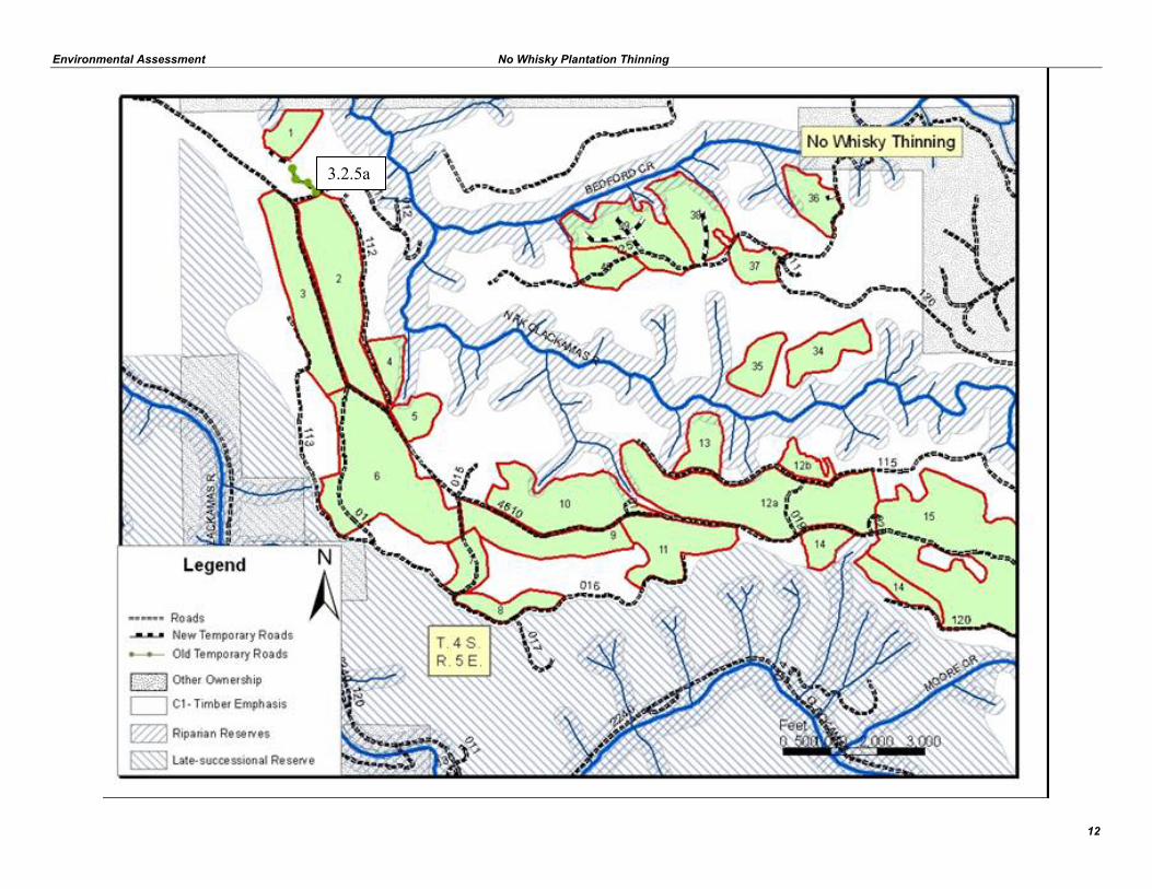
3.2.3 Roads - Approximately 4 miles of bermed system roads would be temporarily opened and reclosed upon completion. Bermed system roads include 4610014, 4610019, 4610026, 4610120, 4613012, 4613013, 4613200 and 4614125. Also, gates would be temporarily opened to access roads 4610113, 4610016 and 4614120. Approximately ½ mile of old existing temporary roads would be reopened to access several of the units. Refer to the map in section 3.2.8 and maps and details found in Appendix E. The above discussion applies to all of the action alternatives. Additional road information that varies by alternative can be found in s. 3.3.3, s. 3.4 and s. 3.5.
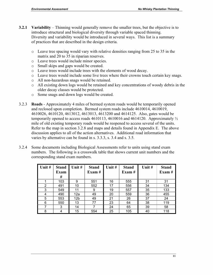
3.2.4 Some documents including Biological Assessments refer to units using stand exam numbers. The following is a crosswalk table that shows current unit numbers and the corresponding stand exam numbers.
Unit # Stand Exam
#
Unit # Stand Exam #
Unit # Stand Exam #
Unit # Stand Exam #
1 103 9 551 16 555 31 31 2 491 10 552 17 556 34 134 3 549 11 9 19 557 35 133 4 490 12a 49 20 559 36 455 5 553 12b 49 21 26 37 24 6 550 13 77 23 64 38 119 7 3 14 7 24 65 39 58 8 4 15 554 25 105 40 118
Environmental Assessment No Whisky Plantation Thinning
12
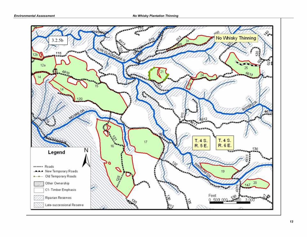
3.2.5a
Environmental Assessment No Whisky Plantation Thinning
13
3.2.5b

Environmental Assessment No Whisky Plantation Thinning
15
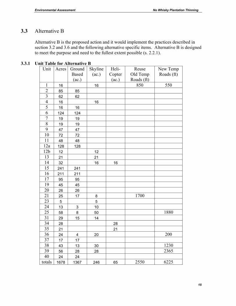
3.3 Alternative B
Alternative B is the proposed action and it would implement the practices described in section 3.2 and 3.6 and the following alternative specific items. Alternative B is designed to meet the purpose and need to the fullest extent possible (s. 2.2.1).
3.3.1 Unit Table for Alternative B
Unit Acres Ground Based (ac.)
Skyline (ac.)
Heli- Copter (ac.)
Reuse Old Temp Roads (ft)
New Temp Roads (ft)
1 16 16 850 550 2 85 85 3 62 62 4 16 16 5 16 16 6 124 124 7 19 19 8 19 19 9 47 47 10 72 72 11 48 48 12a 128 128 12b 12 12 13 21 21 14 32 16 16 15 241 241 16 211 211 17 95 95 19 45 45 20 26 26 21 25 17 8 1700 23 5 5 24 13 3 10 25 58 8 50 1880 31 29 15 14 34 28 28 35 21 21 36 24 4 20 200 37 17 17 38 43 13 30 1230 39 56 28 28 2365 40 24 24
totals 1678 1367 246 65 2550 6225
Environmental Assessment No Whisky Plantation Thinning
16
3.3.2 Riparian - On areas proposed for riparian reserve thinning (approximately 45 acres), the prescription would be adjusted to create conditions suitable for maximum diameter growth and enhance the potential for large wood recruitment. The intention is to enhance riparian reserves by accelerating the development of mature and late-successional stand conditions. Wider spacing would also mean that one thinning entry would create the desired conditions (compared to the matrix thinning spacing where multiple thinning entries would likely occur). Riparian thinning would generally remove the smaller trees, leaving a relative density (RD) of 20 to 35, which is approximately 110 to 150 square feet of basal area per acre. For this project, riparian reserve widths are 180 feet for non-fish-bearing streams and 360 feet for fish-bearing streams. Design criteria discuss no-harvest buffers of approximately 30 to 50 feet along streams. There are some small seeps and wet areas that are too small to show on the maps below. These areas would be excluded from harvest.
3.3.3 Roads - New temporary roads (1.2 miles) are needed to access the landings. These roads
would be obliterated and revegetated after completion of the project. 3.3.5 Mitigation – Alternative B would be implemented with the list of Best Management
Practices and Design Criteria found in section 3.6. These are standard practices that implement Forest Plan standards and guidelines. No resource impacts were found that would require mitigation for Alternative B.
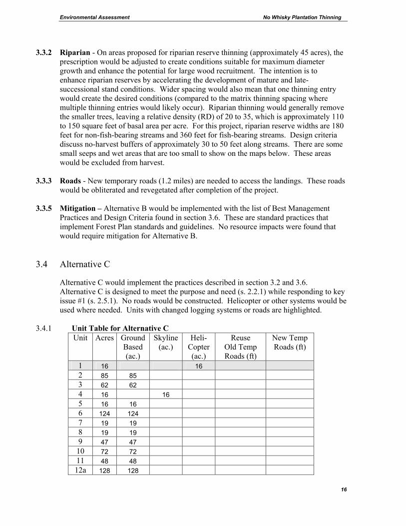
3.4 Alternative C
Alternative C would implement the practices described in section 3.2 and 3.6. Alternative C is designed to meet the purpose and need (s. 2.2.1) while responding to key issue #1 (s. 2.5.1). No roads would be constructed. Helicopter or other systems would be used where needed. Units with changed logging systems or roads are highlighted.
3.4.1 Unit Table for Alternative C Unit Acres Ground
Based (ac.)
Skyline (ac.)
Heli- Copter (ac.)
Reuse Old Temp Roads (ft)
New Temp Roads (ft)
1 16 16 2 85 85 3 62 62 4 16 16 5 16 16 6 124 124 7 19 19 8 19 19 9 47 47 10 72 72 11 48 48 12a 128 128
Environmental Assessment No Whisky Plantation Thinning
17
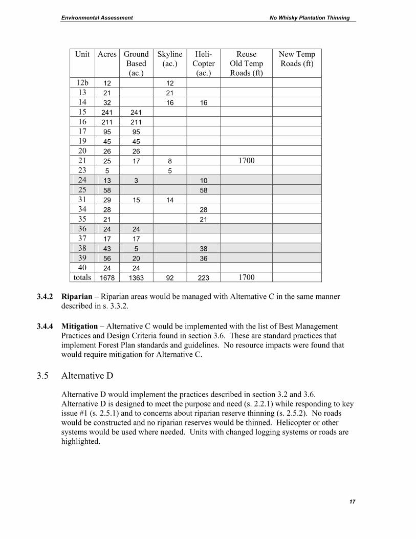
Unit Acres Ground Based (ac.)
Skyline (ac.)
Heli- Copter (ac.)
Reuse Old Temp Roads (ft)
New Temp Roads (ft)
12b 12 12 13 21 21 14 32 16 16 15 241 241 16 211 211 17 95 95 19 45 45 20 26 26 21 25 17 8 1700 23 5 5 24 13 3 10 25 58 58 31 29 15 14 34 28 28 35 21 21 36 24 24 37 17 17 38 43 5 38 39 56 20 36 40 24 24
totals 1678 1363 92 223 1700 3.4.2 Riparian – Riparian areas would be managed with Alternative C in the same manner
described in s. 3.3.2. 3.4.4 Mitigation – Alternative C would be implemented with the list of Best Management
Practices and Design Criteria found in section 3.6. These are standard practices that implement Forest Plan standards and guidelines. No resource impacts were found that would require mitigation for Alternative C.
3.5 Alternative D
Alternative D would implement the practices described in section 3.2 and 3.6. Alternative D is designed to meet the purpose and need (s. 2.2.1) while responding to key issue #1 (s. 2.5.1) and to concerns about riparian reserve thinning (s. 2.5.2). No roads would be constructed and no riparian reserves would be thinned. Helicopter or other systems would be used where needed. Units with changed logging systems or roads are highlighted.

Environmental Assessment No Whisky Plantation Thinning
18
3.5.1 Unit Table for Alternative D Unit Acres Ground
Based (ac.)
Skyline (ac.)
Heli- Copter (ac.)
Reuse Old Temp Roads (ft)
New Temp Roads (ft)
1 16 16 2 85 85 3 62 62 4 12 12 5 11 11 6 124 124 7 19 19 8 19 19 9 47 47 10 72 72 11 48 48 12a 126 126 12b 12 12 13 18 18 14 32 16 16 15 241 241 16 211 211 17 90 90 19 45 45 20 26 26 21 25 17 8 1700 23 3 3 24 13 3 10 25 58 58 31 29 15 14 34 28 28 35 21 21 36 21 21 37 17 17 38 33 5 28 39 45 20 25 40 24 24
totals 1633 1348 83 202 1700
3.5.3 Mitigation – Alternative D would be implemented with the list of Best Management
Practices and Design Criteria found in section 3.6. These are standard practices that implement Forest Plan standards and guidelines. No resource impacts were found that would require mitigation for Alternative D.
Environmental Assessment No Whisky Plantation Thinning
19
3.6 Best Management Practices (BMPs) and Design Criteria Common to All Action Alternatives__________________ These are practices that are part of each action alternative. The effects and benefits of these practices are included in the analyses of effects in s. 4. In some cases they are standard practices that are used in all similar projects and in other cases they are specifically tailored to this project based on site-specific factors such as the underlying land allocation and associated standards and guidelines.
1. Seasonal restrictions 1.1 Soils: No operation of off-road ground-based equipment would be permitted
between November 1 and May 31. This restriction applies to the ground-based portions of harvest units. It also applies to ground-based equipment such as harvesters or equipment used for fuels treatment, road construction, road reconstruction or landing construction. This restriction may be waived if soils are dry or frozen or if operators switch to skyline or other non-ground based systems. This is a BMP and it implements Forest Plan standards and guidelines FW-022 and FW-024.
1.2 Peregrine Falcon: No mechanized slash piling, site preparation, road
building, log loading, yarding or other management activities that produce sound above the ambient noise level of the area would be permitted in units 6, 7, 8 and 9 from January 15th to July 31st. In addition, helicopter use is also restricted below 1500 feet Above Ground Level anywhere in the vicinity of units #1, 2, 3, 4, 5, 6, 7, 8, 9, 10, 11, 12a, 12b, 13, 14, 34, 35, 36, 37, 38, 39 and 40. These restrictions may be waived if the nest site is unoccupied or if nesting efforts fail and there is not possibility of re-nesting. Documentation of nesting failures can be finalized no earlier than June 30th due to the possibility of re-nesting.
1.3 Deer and Elk Winter Range: No harvest operations, road construction, use
of motorized equipment or blasting would be permitted in Crucial and High Value winter range areas between December 1 and March 31. The restriction would be waived in the high value zone if snow accumulation levels are less than 12 inches or if it is determined that the area is not being used by elk. Units 1 to 15 and 34 to 40 are in the crucial zone and unit 23 is in the high value zone.
No log haul or snow plowing would be permitted on roads in Crucial and High Value Winter Range between December 1 and March 31 except on roads 4610 and 4613. This restriction may be waived in the high value zone as described above. This implements Forest Plan standard and guideline FW-211 and a memorandum of understanding with Oregon Department of Fish and Wildlife.

Environmental Assessment No Whisky Plantation Thinning
20
2. Snags, wildlife trees, skips and gaps: To enhance diversity, variable density
thinning would include the retention of snags and wildlife trees and the creation of skips and gaps. o Snags would be retained in all units where safety permits. o To increase the likelihood that snags would be retained, green trees would be
marked as leave trees where their live crowns touch certain key snags. o Certain live trees would also be selected as leave trees that have the
“elements of wood decay” as described in the DecAid advisor. This may include trees with features such as dead tops, broken tops and heart rot. Six to twelve live trees per acre with “elements of wood decay” would be retained where available. They should be in the largest size class available.
o If funding becomes available, some live trees would be treated to provide future snags and future cavities. Techniques would vary and may include but would not be limited to topping and inoculation with fungus.
o Gaps would be created by skyline corridors. Some natural root rot gaps are present.
o Skips would be created by leaving small portions of the units un-thinned. They would be centered around special microhabitat sites where available such as snags, wildlife trees, concentrations of large down wood, patches of deciduous shrubs, small seeps and springs, or uncommon tree species. Skips would be up to 1/5 acre in size and would occur on up to 10% of the area in riparian reserves.
3. Down Woody Debris: Old down logs currently on the forest floor would be
retained. Prior to harvest, contract administrators would approve skid trail and skyline locations in areas that would avoid disturbing key concentrations of down logs or large individual down logs where possible. Additional down woody debris would be generated by the timber sale. This would include the retention of cull logs, tree tops, broken logs and any snags that would be felled for safety reasons. If funding becomes available, some trees would be felled or girdled to provide future habitat. This implements Forest Plan standards and guidelines as amended.
4. Erosion: To reduce erosion from timber sale activities, bare soils would be
revegetated or covered with slash or other debris. Grass seed and fertilizer would be evenly distributed at appropriate rates to ensure successful establishment. Mulch may be used on slopes greater than 20%. Effective ground cover would be installed prior to October 1 of each year. This is a BMP and it implements Forest Plan standard and guideline FW-025.
Native plant materials are the first choice in revegetation of bare soils. Non-native,
non-invasive plant species may be used if native plant materials are not available or as an interim measure designed to aid in the re-establishment of native plants. Non-native invasive plant species would not be used. This implements Forest Plan standard and guideline FW-148 and standard 13 of the Invasive Plants Record of Decision.
Environmental Assessment No Whisky Plantation Thinning
21
Grass seed would preferably be certified by the states of Oregon or Washington or
grown under government-supervised contracts to assure noxious weed free status. In certain cases non-certified seed may be used if it is deemed to be free of State of Oregon listed noxious weeds. This implements Forest Plan standard and guideline FW-148.
When straw is utilized, it would originate from the state of Oregon or Washington fields which grow state certified seed, or grown under government-supervised contracts to assure noxious weed free status, or originate in annual ryegrass fields in the Willamette Valley. In certain cases, straw or hay from non-certified grass seed fields may be used if is deemed to be free of State of Oregon listed noxious weeds. This implements Forest Plan standard and guideline FW-148, and standard 3 of the Invasive Plants Record of Decision.
5. Thinning in Riparian Reserves – These are BMPs and implement NFP standards and guidelines, pages C-30-32. They also implement the guidance of the Northwest Forest Plan Temperature TMDL Implementation Strategies (9/9/05).
5.1 Perennial streams - Establish a minimum 50 ft. no-harvest buffer along the
active channel of all perennial streams. Larger buffer widths may be needed on a site-specific basis to prevent any increase in sediment delivery rates or a decrease in stream shading. Buffer width design would take into account the stream influence zone, steepness of slope, size and location of trees, orientation of the site to the sun (aspect), slope stability, and stream bank stability. Falling trees for skyline corridors would be avoided, but where necessary the material would be left as woody debris. Falling any trees within the no-harvest buffer would only be allowed if it would cause no increase to sediment or decrease in stream shading.
The no-harvest buffer would be designed to meet stream temperature goals by
avoiding harvest in the primary shade zone and by retaining 50% canopy closure in the secondary shade zone.
5.2 Intermittent streams (as defined in NWP) – Establish a minimum 30 ft. no-
harvest buffer along the active channel of all intermittent streams. Smaller buffer widths would be allowed if it is determined on a site specific basis that there would be no increase in sediment delivery rates or a decrease in stream shading which would alter stream temperatures. Buffer width design would take into account the stream influence zone, steepness of slope, size and location of trees, orientation of the site to the sun (aspect), slope stability, and stream bank stability. Falling trees or any equipment use within the no-harvest buffer would only be allowed if it would cause no increase to sediment or decrease in stream shading.
Environmental Assessment No Whisky Plantation Thinning
22
5.3 Within 50 feet of perennial or intermittent stream no-harvest buffers, only low impact harvesting equipment such as, but not limited to, mechanical harvesters or skyline systems, which have minimal ground disturbance would be allowed. Mechanical harvesting equipment would be required to operate on slash-covered paths. Trees in this zone would be directionally felled away from the no-harvest buffer to minimize the disturbance to the forest floor. These requirements would maintain the indicators for sediment, stream temperature, stream bank condition, and large woody material indicators.
5.4 Thinning in riparian reserves would emphasize the development of vegetative
and structural diversity associated with mature and old-growth stand conditions. Thinning would leave approximately 70 to 80 trees per acre. While thinning in the riparian reserve may have short-term effects, the thinning would contribute to maintaining or restoring the fifth-field watershed over the long term. Thinning in riparian reserves would increase tree size, adequately protect the zone of shade influence along streams, and minimize the potential for sediment delivery to streams. This prescription would maintain water temperature, large woody debris, disturbance regime, and riparian reserve indicators.
5.5 Other Riparian Areas – Other riparian features that are not perennial or
intermittent streams such as seeps, springs, ponds or wetlands would be protected by the establishment of no harvest buffers that incorporate the riparian vegetation. Certain perennially wet features that are habitat for the aquatic mollusk Lyogyrus n. sp. 1 would be protected by the establishment of a 50 ft. no-harvest buffer.
6. Logging Systems – These are BMPs and implement Forest Plan standard and
guideline FW-022.
6.1 Avoid the use of ground based tractors or skidders on slopes generally greater than 30% and mechanical harvesters on slopes greater than 40% because of the risk of damage to soil and water resources.
6.2 Mechanical harvesters and forwarders would be required to work on a layer of
residual slash and the operator would place slash in the harvester path prior to advancing the equipment.
6.3 In some units, ground-based logging is proposed for areas that have been
previously harvested with ground-based systems. Existing temporary roads, landings and skid trails would generally be reused where feasible. There may be instances where it is not desirable to use an existing skid trail and in such cases, if a skid trail is needed in the area, a new skid trail would be located that minimizes the alteration of surface hydrology.
Environmental Assessment No Whisky Plantation Thinning
23
6.4 In some units, ground-based logging at the time of the original harvest has resulted in detrimental soil conditions that exceed Forest Plan standards. In these areas there is a greater urgency to reuse existing temporary roads, landings and skid trails. Some new skid trails might be needed as described above, but where detrimental soil conditions exceed 20%, only existing skid trails would be used and only those existing skid trails that do not alter surface hydrology.
6.5 Where existing detrimental soil conditions exceed Forest Plan standards,
existing temporary roads and landings that are reused, would be obliterated and revegetated.
6.6 There are areas of concern for OHV access in units 1 through 17. This design
criteria is applicable in these units and is designed to prevent the expansion of OHVs onto temporary roads, landings and skid trails that are used by the operator. This project would not restore or alter existing OHV routes unless they coincide with existing temporary roads, landings or skid trails that are used by the operator and subsequently treated. The term ‘areas of concern for OHV’ is basically La Dee Flat – the area addressed by the legal closure. Elsewhere in this EA the term ‘high impact areas’ is used to describe the actual existing trails where OHVs have impacted resources. Maps are in Appendix E.
• Within units 1 through 17, slash, tree tops, root wads, boulders, logs and other
debris would be placed on temporary roads, landings and skid trails that are used by the operator to discourage OHV use. In other timber sales, similar prevention measures have successfully deterred use.
• To protect brush and other vegetation that may deter OHV mobility, no off-road equipment would be operated within 25 feet of roads 4610 and 4611 within units 1 through 17 except on designated skid trails.
• OHV use patterns would be monitored. If OHV use expands to new temporary roads, landings or skid trails that are used by the operator in spite of the above measures, corrective actions would be taken that may include but would not be limited to bringing in additional debris from off-site. KV funds would be collected as a contingency to fund corrective measures if needed.
7. Roads – These are BMPs.
7.1 During the wet season, log haul would only be permitted on asphalt and
rocked roads when conditions would prevent sediment delivery to streams.
7.2 If landings are needed in riparian reserves, they would be located on existing roadways that do not require expansion of the road prism or on existing landings that may require only minimum reconstruction (clearing vegetation, sloping for drainage, or surfacing for erosion control purposes) to be made suitable for use.

Environmental Assessment No Whisky Plantation Thinning
24
7.3 The re-opening of old temporary roads is encouraged over the construction of
new roads if they are located in areas that would prevent sediment delivery to streams.
7.4 Newly constructed roads would not cross or be constructed parallel to stream channels. They would be built on ridge tops, benches, or gentle slopes and only where conditions would prevent sediment delivery to streams.
7.5 No road construction is proposed within riparian reserves.
7.6 Temporary roads would normally be constructed, used and obliterated in the same operating season. If this is not possible, due to fire season restrictions or other unforeseen delays, the road would be winterized prior to the end of the normal operating season by out-sloping, water-barring, effectively blocking the entrance, seeding, mulching and fertilizing.
8. Invasive species: All off-road equipment is required to be free of soil, seeds,
vegetative matter, or other debris that could contain or hold seeds prior to coming onto National Forest lands. Timber sale contracts and service contracts would include provisions to minimize the introduction and spread of invasive plants. These provisions contain specific requirements for the cleaning of off-road equipment. This implements Executive Order 13112 dated February 3, 1999, and standard 2 of the Invasive Plants Record of Decision.
9. Firewood would be made available to the public at landings where feasible. This is
an opportunity to contribute to Forest Plan - Forest Management Goal #19, and provide forest products consistent with the NFP goal of maintaining the stability of local and regional economies.
10. Monitoring: This Implements Forest Plan and NFP monitoring requirements.
Prior to advertisement of a timber sale, a crosswalk table would be prepared to check the provisions of the Timber Sale Contract and other implementation plans with this document to insure that required elements are properly accounted for. During implementation, Timber Sale Administrators monitor compliance with the Timber Sale Contract which contains provisions for resource protection including but not limited to: seasonal restrictions, snag and coarse woody debris retention, stream protection, erosion prevention, soil protection, road closure and protection of historical sites. Post harvest reviews would be conducted where needed prior to post harvest activities such as slash treatment and firewood removal. Based on these reviews, post harvest activities would be adjusted where needed to achieve project and resource objectives.
Environmental Assessment No Whisky Plantation Thinning
25
OHV use patterns would be monitored. If OHV use expands to new temporary roads, landings or skid trails that are used by the operator in spite of the above measures, corrective actions would be taken that may include but would not be limited to bringing in additional debris from off-site. Monitoring of noxious weeds and invasive plants would be conducted where appropriate to track changes in populations over time and corrective action would be prescribed where needed. Monitoring is also conducted at the Forest level. For example, water quality is monitored for both temperature and turbidity at several locations across the Forest. Monitoring reports can be found on the Forest’s web site at http://www.fs.fed.us/r6/mthood under Forest Publications.
3.7 Other Alternatives Considered
3.7.1 Restoration: An alternative was submitted by the public that would delete the timber sale aspect of this project and reformat it into a restoration only EA that would decommission roads. This alternative was not developed because it would not meet the objectives outlined in the purpose and need. The current network of system roads are needed to access the matrix land allocation for stand management now and in the future. Previous Forest-wide restoration EAs (2001 and 2003) included an analysis of priorities for road decommissioning across the Forest and no roads in this area were identified for decommissioning. Some have also advocated that instead of a focus on thinning, the EA should plan the restoration of areas damaged by OHV use. This was not developed. The analysis conducted by resource specialists found that the impacts created by unauthorized OHV use were not significant and that past attempts to restore high use areas resulted in the impact shifting to new areas. The Forest is in the early stages of developing a Forest-wide plan for OHV (s. 4.1.6). That plan is the proper arena for discussion of OHV restoration. This project contains measures designed to prevent the expansion of OHV use onto new temporary roads landings and skid trails (s. 3.6.6.6).
3.7.2 Thin Without Logging: An alternative was submitted by the public that would thin dense
stands by cutting trees and leaving them on the ground and chipping the limbs. It was not developed because it would not meet the objective of providing forest products consistent with the Northwest Forest Plan goal of maintaining the stability of local and regional economies now and in the future. Since there is no source of funding for this type of operation it would be similar to the no-action alternative.
3.7.3 OHV: Alternatives were considered to address concerns about unauthorized OHV use.
Along the main open roads where the ground is flat, there is a concern that landings and skid trails would exacerbate OHV impacts. Refer to the strategy outlined in design criteria 6.6 in s. 3.6. Other options were discussed. One option involves switching to skyline or helicopter logging systems on the flat ground to eliminate access points for OHV traffic. This alternative was not fully developed because other strategies such as those discussed in
Environmental Assessment No Whisky Plantation Thinning
26
s. 3.6.6.6 or s. 3.7.7, are likely to be effective at much less cost. Another option involves the creation of no-cut buffers along existing roads to keep dense trees and brush to discourage OHV access. This alternative was not fully developed because other strategies are likely to be effective.
3.7.4 Delete units commercially thinned before: An alternative was submitted by the public
that would delete the units already thinned. They have a relative density less than 55 and would be left to grow on their own. This would remove 74% of the acreage (s. 4.3.1). This alternative was not developed because it would not meet the objectives outlined in the purpose and need. If the stands are not thinned they would continue to grow and become more crowded reaching the mortality zone of 55 relative density. Deleting units thinned before would amount to waiting until it is too late. (Appendix E, p. 4 has a discussion of relative density). This strategy would also result in future stands with very little diversity because the previous commercial thinning prescriptions emphasized leaving the dominant and codominant Douglas-fir trees with little variability in spacing or density. These stands are currently in a condition to respond to a harvest prescription that emphasizes enhancing both vertical and horizontal diversity, tree species diversity and promoting understory development.
3.7.5 Delete helicopter units: An alternative was submitted by the public that would eliminate
road construction and riparian reserves like alternatives already considered but would also delete the helicopter units due to concerns about costs. This alternative was not developed because it would not meet the objectives outlined in the purpose and need. The analysis shows that helicopter is an expensive logging system but that the helicopter units are viable (s. 4.11).
3.7.6 Fertilization: An alternative was considered that would include aerial fertilization of some
of the thinned units. This option was not developed because further analysis for these particular stands showed that the increased growth that would occur would not be sufficient to warrant the cost.
3.7.7 Supplemental OHV design criteria: In addition to the design criteria described in section
3.6.6.6, an additional option was considered to further reduce the likelihood of expansion of OHVs onto temporary roads, landings and skid trails that are used by the operator. In this option, none of the existing landings along roads 4610 or 4611 would be used. To access the units, new temporary roads would be constructed where needed and new landings would be placed in the interior of the units. Where possible, the new roads would be located on top of existing skid trails. The new temporary roads and landings would be obliterated and covered with debris upon completion. This technique would create fewer potential entry points for OHVs and would result in greater ability to control OHV use. These new temporary roads would total approximately two miles and would be constructed on relatively gentle ground that would not cross streams. The environmental effects of this option have been considered and would be similar to the effects described for Alternative B. This option was considered in response to the issue raised about OHV impacts (s. 2.5.3).
Environmental Assessment No Whisky Plantation Thinning
27
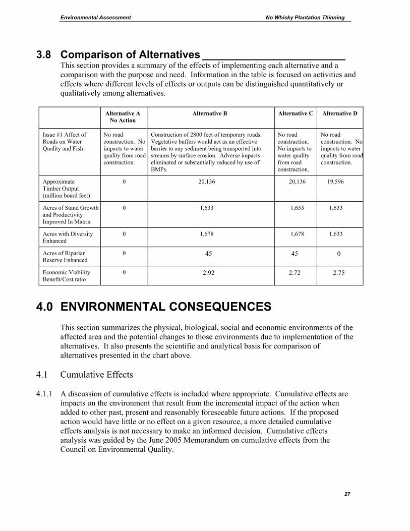
3.8 Comparison of Alternatives ________________________ This section provides a summary of the effects of implementing each alternative and a comparison with the purpose and need. Information in the table is focused on activities and effects where different levels of effects or outputs can be distinguished quantitatively or qualitatively among alternatives.
Alternative A
No Action Alternative B
Alternative C Alternative D
Issue #1 Affect of Roads on Water Quality and Fish
No road construction. No impacts to water quality from road construction.
Construction of 2800 feet of temporary roads. Vegetative buffers would act as an effective barrier to any sediment being transported into streams by surface erosion. Adverse impacts eliminated or substantially reduced by use of BMPs.
No road construction. No impacts to water quality from road construction.
No road construction. No impacts to water quality from roadconstruction.
Approximate Timber Output (million board feet)
0 20,136 20,136 19,596
Acres of Stand Growth and Productivity Improved In Matrix
0 1,633 1,633 1,633
Acres with Diversity Enhanced
0 1,678 1,678 1,633
Acres of Riparian Reserve Enhanced
0 45 45 0
Economic Viability Benefit/Cost ratio
0 2.92 2.72 2.75
4.0 ENVIRONMENTAL CONSEQUENCES
This section summarizes the physical, biological, social and economic environments of the affected area and the potential changes to those environments due to implementation of the alternatives. It also presents the scientific and analytical basis for comparison of alternatives presented in the chart above.
4.1 Cumulative Effects
4.1.1 A discussion of cumulative effects is included where appropriate. Cumulative effects are impacts on the environment that result from the incremental impact of the action when added to other past, present and reasonably foreseeable future actions. If the proposed action would have little or no effect on a given resource, a more detailed cumulative effects analysis is not necessary to make an informed decision. Cumulative effects analysis was guided by the June 2005 Memorandum on cumulative effects from the Council on Environmental Quality.

Environmental Assessment No Whisky Plantation Thinning
28
4.1.2 The land area and the time scale used for a cumulative effects analysis varies by resource. The analysis for each affected resource looks at the condition of the resource considering effects from past timber sales, road construction, fires and other disturbances.
4.1.3 The time scale includes the effects of all past activities beginning in approximately 1920
when the first timber harvest and road construction projects occurred. These past actions are included in the baseline for the cumulative effects analysis and a list of past actions is contained in the analysis file. The analysis includes the effect of roads and permanent openings such as rock quarries. The analysis also includes other recent timber sales that overlap the analysis area including Austin, Fat Bat, Thrasher, Jag, Boyer, Morgan, Healey, Yoda, Sunbeam, Upper, Guard, Unguard and Clear. It also includes the effects of activities such as OHV use and shooting (s. 4.15). It includes the 1998 restoration projects intended to curb OHV use and restore wetlands and riparian areas.
4.1.4 The analysis considers the impact of activities on other ownerships. In this area the
Bureau Of Land Management (BLM) manages several interspersed checkerboard sections. There are also adjacent private timber company lands.
4.1.5 Section 4.4.1 describes the likely future scenario for thinning on National Forest lands.
Similarly, the management of BLM lands and private lands is likely to continue in the future using current strategies. Young stands on BLM lands are likely to be thinned when their age and condition warrant thinning and stands on private forest lands are likely to be regeneration harvested. This anticipated harvest pattern would continue to provide a wide variety of habitat and resource conditions. These activities are discussed in general terms since they lack sufficient site specificity to be included in a numerical analysis.
4.1.6 The Forest Service is in the early stages of developing an OHV plan for the Forest. At
this time there is no proposed action for the OHV plan. La Dee Flat, which overlaps a portion of the No Whisky project, is being considered as an area to allow OHV use on designated roads and trails. Currently, OHV use is unauthorized in the La Dee Flat area except on open roads. The Forest is currently seeking public input through a posting on the Forest’s web site, (http://www.fs.fed.us/r6/mthood/ under Projects and Plans). It is not possible to consider site-specific effects of what may or may not be proposed, in a cumulative effects analysis in this EA. In the future, if firm OHV proposals are assembled with public input, it would be appropriate at that time to examine the cumulative effects of OHV use combined with No Whisky. At this point in time, the current OHV legal closure is in effect, and future potential changes to that closure are too tenuous to consider as a foreseeable future action for the purpose of cumulative effects analysis.
4.2 WATER QUALITY AND FISHERIES
This section addresses Issue #1 and the riparian purpose and need. This section also addresses effects to water quality and fisheries from all components of the alternatives including roads and logging. It also includes an assessment of the Aquatic Conservation

Environmental Assessment No Whisky Plantation Thinning
29
Strategy and a discussion of Best Management Practices. The Fisheries Biological Evaluation (found in Appendix C) is incorporated by reference and summarized below. Mt. Hood Forest Plan References Forestwide Riparian Standards and Guidelines - FW-80 to FW-136, page Four-59 Forestwide Water Standards and Guidelines - FW-54 to FW-79, page Four-53 Forestwide Fisheries Standards and Guidelines - FW-137 to FW-147, page Four-64 General Riparian Standards and Guidelines - B7-28 to B7-39, page Four-257 Mt. Hood FEIS pages IV-22, IV-47, IV-155 to IV-167 Northwest Forest Plan - Riparian Reserve Standards and Guidelines – pages C-31 to 38 Aquatic Conservation Strategy – Record of Decision to Clarify Provisions Relating to the Aquatic Conservation Strategy pages 6-10
4.2.0.1 Issue #1: There is a concern about the effects of temporary road construction on water quality and fisheries. The effects to water quality and fisheries can be found in section 4.2. Also refer to design criteria #1.1, 5, 6 and 7. Section 4.2 summarizes the Biological Evaluation found in Appendix C. The analysis shows that the impact, if any, would be short-term and undetectable at the watershed scale. The chance that measurable amounts of fine sediment would enter any stream as a direct result of logging activity is negligible. This is because the proposed roads are located on stable landforms, do not cross steams and would be obliterated. Alternatives A, C and D do not include any road construction. The rationale for proposed road construction can be found in section 3.3.2. Alternative B would construct approximately 1.2 miles of new temporary roads. The Biological Evaluation found that there would be No Effect on threatened fish species. Other related comments:
4.2.0.2 The roads themselves and the effects of these roads are not temporary. Temporary roads still cause serious adverse impacts. Obliterating such roads is not entirely successful and the soil compaction effects can last for decades. The proposed roads are called temporary roads because it is a contractual term and refers to roads that experience temporary use, only for timber harvesting, and are obliterated by the operator when harvesting is completed. The obliteration of a temporary road is done to prevent use and to improve infiltration rates. The Forest has considerable successful experience with obliterating temporary roads on similar terrain. Since the temporary roads are located where they serve the long-term transportation needs of the area, it is likely that they would be reopened and used again in the future.
4.2.0.3 Other Issues: There is a concern about the effects of thinning in riparian reserves on water quality and fisheries. Support for active management of riparian reserves to restore them to a condition where they can grow into maturity is growing among a wide range of agencies, scientists, and environmental groups. The effects to water quality and fisheries can be
Environmental Assessment No Whisky Plantation Thinning
30
found in section 4.2. Also refer to design criteria #5 & 7. Section 4.2 summarizes the Biological Evaluation found in the analysis file. The no-harvest buffers would act as an effective barrier to any sediment being transported into stream channels by surface erosion or run-off and would minimize the risk of any water quality impacts. Seasonal restrictions would further reduce the risk of soil disturbance and run-off. The chance that measurable amounts of fine sediment would enter any stream as a direct result of logging activity is negligible. Thinning in riparian reserves would result in long-term benefits because thinning would develop the type of mature forest that is desired in riparian reserves. It would result in larger healthy trees with the increased capability to produce large coarse woody debris that would eventually fall into streams creating desirable diversity. Alternative A does not include any riparian thinning.
4.2.0.4 Purpose and need discussion
One of the aspects of the purpose and need (s. 2.2.1) is to enhance riparian reserves. Alternatives B and C would equally meet this objective while Alternatives A and D would not. A discussion of riparian resources is in section 4.2.5. A general discussion of stand health and growth in section 4.3.1 and 4.3.2 are also relevant to trees growing in riparian area.
4.2.1 Water Quality and Fisheries Existing Situation This project proposes to thin and commercially harvest wood fiber in second growth plantations that range in age from 40 to 70 years on approximately 1,678 acres within the Middle Clackamas River (formally known as the Lower Clackamas River) fifth-field watershed. The project area is located within the North Fork Clackamas and Lower Clackamas River drainages in the western portion of the Clackamas River Ranger District. The objective of this action is to provide forest products, maintain health, vigor, and growth, enhance stand diversity, enhance riparian reserves by accelerating the development of mature and late-successional stand conditions, and to accelerate future large woody debris recruitment potential and snag habitat production. The proposed treatment area is located within five subwatersheds of the North Fork Clackamas River and one subwatershed of the Middle Clackamas River. The total area of the six subwatersheds associated with the project is 32,537 acres. The area of the five subwatersheds within the North Fork Clackamas drainage is 16,293 acres and includes: Lower North Fork Clackamas, Upper North Fork Clackamas, Bedford Creek, Boyer Creek, and Winslow Creek. The area that the Lower Clackamas Tribs. subwatershed encompasses is 16,24 acres. There are no 303(d) listed water bodies in the project area. Portions of the Middle Clackamas River are a designated Tier I, Key Watershed under the Northwest Forest Plan. In the vicinity of the No Whisky project, the Key Watershed extends ¼ mile from the Clackamas River. The North Fork of the Clackamas River is

Environmental Assessment No Whisky Plantation Thinning
31
designated a non-Key Watershed. None of the units of No Whisky are in the Key Watershed designation. These watersheds support populations of spring chinook salmon, winter steelhead, and coho salmon. These anadromous species all occur downstream of the project area. Resident cutthroat and rainbow trout occur within the mainstem Clackamas River, North Fork Clackamas River, Bedford Creek, Boyer Creek, and Winslow Creek. All of the smaller first order perennial streams that flow through the project area are non fish-bearing streams. The North Fork Clackamas River watershed contains 5.4 miles of anadromous streams, 32 miles of resident fish bearing streams, and 77 miles of non-fish bearing streams. A 50-foot falls at RM 2.4 of the North Fork Clackamas River, is a migration barrier for anadromous fish. All 5.4 miles of anadromous habitat are located on private and BLM land adjacent to the Forest Service boundary. Fish species that occur in the mainstem of North Fork up to the barrier falls include late and early run coho salmon, winter steelhead, spring chinook salmon, resident rainbow trout, and resident cutthroat trout. Above the barrier falls, native populations of resident rainbow and cutthroat trout occupy the mainstem of North Fork and its major tributaries Bedford, Boyer, and Winslow Creeks. Other fish occupying the watershed include large-scale suckers, sculpin, longnose dace, and pacific lamprey. The Lower Clackamas Tributaries watershed covers 16,243 acres and is made up of a number of small, high-gradient first and second order tributaries that flow into the mainstem Clackamas River. All of the small streams associated with the project are non fish bearing streams that flow into the Clackamas River between RM 38.5 and 38.1. All of these streams are located along the north side of the mainstem Clackamas. There are no fish species listed under the Endangered Species Act (ESA) in the vicinity of proposed thinning units. There would be no entry into a streamside Riparian Reserve that is less than 1.5 mile from the occurrence of an ESA listed fish species or designated critical habitat. Resident cutthroat and rainbow trout occur within the perennial fish bearing streams that flow through the project area. ESA listed fish species that occur downstream of the project area include Lower Columbia River (LCR) steelhead, Upper Willamette River (UWR) chinook salmon, and Lower Columbia River (LCR) coho salmon. These species occur in the mainstem Clackamas River and the lower 2.4 miles of the North Fork of the Clackamas River. Project elements of the action alternatives that could potentially impact aquatic species or their habitats include timber felling, road construction, yarding, log haul and road obliteration. Potential effects to listed, proposed, candidate, or sensitive fish species and their habitat from the proposed project include direct, indirect and cumulative effects. Potential direct effects associated with actions similar to the proposed action include: increased levels of fine sediment in local streams generated during road building, road obliteration, logging, and hauling, an increase in stream temperature caused by loss of streamside vegetative cover by thinning within Riparian Reserves, and an increase in peak flows caused by removal of vegetative cover. The project has been designed to
Environmental Assessment No Whisky Plantation Thinning
32
avoid these effects. These issues are important because if there are increased levels of sediment in streams it would reduce feeding efficiency during times of increased turbidity. Fish rely on sight to feed so feeding success could be hampered during those times turbidity is increased. If there were increased sediment loads, there would be increased stress or mortality to fish by abrasion of the gills during episodes of high turbidity. If shade producing vegetation were removed, solar radiation may increase stream temperatures. An increase in stream temperature may influence the metabolism, behavior, and mortality of fish and other organisms in their environment which could potentially affect juvenile rearing, adult migration, and spawning success. Potential indirect effects associated with actions similar to the proposed action include: increased amounts of fine sediment downstream in rivers or at the intake of municipal water providers. Potential impacts from increased amount of fine sediments are degradation of spawning habitat and a reduction in rearing habitat caused by sediments filling in pools. The project has been designed to avoid these effects. Cumulative effects analysis focuses on changes in the timing and/or magnitude of flow events based on forest conditions that are affected by past, present and future actions. Cumulative effects have been evaluated at more than one scale. For example, watershed analysis was conducted to take a watershed scale look at resources. During the consultation process, the regulatory agencies considered the entire range of a species of concern. At the local scale, subwatersheds are used to evaluate risks of rain on snow events. Effects
4.2.2 Alternative A In terms of sediment, water quality and temperature, there would be no short-term effects to water quality or fisheries resources from road construction or harvest. If no action were taken in riparian reserves, there could be negative long-term effects because stands would have reduced capability to produce the size and quantity of coarse woody debris sufficient to sustain physical complexity and stability of the riparian reserves and associated streams. Alternatives B, C and D
4.2.3 Sediment
4.2.3.1 Sediment from Road Construction - Included is potential sediment from temporary road construction with Alternative B and from the reopening of old temporary roads and road work along the haul route with all of the action alternatives. Refer to issue statement in s. 2.5.1 and detailed maps in Appendix E. Road related ground disturbing activities have been designed to minimize the risk of erosion and the potential for sediment to be transported to streams. Road work would be restricted to the dry season between June 1 and October 31. This restriction would reduce the risk of any surface erosion due to

Environmental Assessment No Whisky Plantation Thinning
33
ground disturbance. The proposed temporary roads are located on dry ground, would not cross any stream channels, and would have no hydrologic link to any water source. The closest any proposed temporary road is to a stream is over 325 feet from an intermittent channel and over 550 feet from a perennial channel. These roads would be constructed on relatively flat terrain along ridgetops, which would not cause an increase in the drainage network. Because of the distance of any proposed new temporary roads or any old road that would be reopened to any water source and the fact that these roads do not cross any perennial or intermittent streams, vegetative buffers would act as an effective barrier to any sediment being transported into stream channels by surface erosion or runoff. All new temporary roads and reopened temporary roads would be obliterated and revegetated directly following completion of harvest operations to help reduce compaction and increase infiltration rates. Some road work is needed along the haul route to make the roads serviceable for log haul. This includes blading the road surface, cleaning the ditches, removing berms, and removing encroaching brush. Of the action alternatives, the risk of sediment from road sources would be least with Alternatives C and D and greatest with Alternative B. Impacts to water quality or fisheries resources caused by sedimentation due to road construction, reconstruction, maintenance or road obliteration, if any, would be short-term and undetectable at a watershed scale.
4.2.3.2 Sediment from harvest activities – Thinning, particularly within riparian reserves, is a ground disturbing activity that has the potential to cause a temporary reduction in water quality by allowing sediment to enter the stream channel from surface erosion or run-off. Refer to issue statement in s. 2.5.2 and detailed maps in Appendix E. No-cut buffers, a minimum of 50 ft. wide, along perennial streams and a minimum buffer width of 30 ft. along intermittent channels, have been established for the project. Buffer width design would take into account the stream influence zone, steepness of slope, size and location of trees, orientation of the site to the sun (aspect), slope stability, and stream bank stability. No-cut areas would include any buffer of hardwood vegetation occurring along the stream bank. No-cut buffers would generally be at the top of slope breaks on steeper ground and would circumvent all wet areas to maintain canopy cover along riparian areas. These vegetative buffers would act as an effective barrier to any sediment being transported into stream channels by surface erosion or run-off and would minimize the risk of any channel or water quality impacts. The risk of overland flow in thinned harvest units is expected to be low. Skid trails and skyline corridors would be water barred to divert any surface water runoff onto vegetated or rocky areas. The minimum 30-50 foot protection buffers on either side of the streams would likely retain any displaced and eroded soil before it is transported to the stream channel. These buffer widths would allow soil infiltration between the unit and any water source. The use of skyline or helicopter yarding systems on steeper ground within riparian reserves would minimize ground disturbance. Seasonal restrictions on ground-based operations would further reduce the risk of soil disturbance and run-off. Even if some soil movement occurred, the vegetated buffer strips along every perennial or intermittent channel would act as an effective barrier. The probability that measurable amounts of fine sediment would enter any stream within the project area as a direct result of logging activity is low.
Environmental Assessment No Whisky Plantation Thinning
34
Of the action alternatives, the risk of sediment from logging system sources would be least with Alternative D and greatest with Alternative B. There would be slightly less risk of erosion from harvest operations under Alternative C than Alternative B since helicopter logging would be used instead of ground based or skyline yarding systems on parts of some units. Because of less ground disturbance, the chance of sediment reaching the stream channel is even less likely than Alternative B. There would be even less risk of erosion or sediment entering streams from harvest operations under alternative D since there would be no entry into the Riparian Reserves. The probability that measurable amounts of fine sediment would enter any stream within the project area as a direct result of logging activity is low under all the proposed action alternatives.
4.2.3.3 Sediment from log haul – (similar effect for all action alternatives). Log hauling would not measurably increase the amount of fine sediment in streams. The roads along the haul route are rocked or paved at stream crossings, and road ditches are well vegetated. Sediment input into streams along the haul routes would be minimized by permitting haul only when conditions would prevent sediment delivery to streams (s. 3.6.7.1). Any sediment that would enter a stream during haul activities would be at crossings along aggregate surfaced roads. The majority of these crossings are at small streams that would not be flowing, or would have very little flow, during the normal season of operation (June 1 to October 31). Any sediment that leaves the road surface due to run-off is expected to disperse over land or be stored within these small channels. It is very unlikely that any measurable amount of sediment produced during log haul would be transported to stream channels where fish species occur. There are no listed fish species that occur immediately downstream of any aggregate surfaced stream crossing along the haul route. If any sediment did enter stream courses from hauling activities, it would be in very small amounts and for a short-term duration. No adverse effect to fish or their habitat would occur from hauling logs.
4.2.4 Water Temperature The no-cut buffers along perennial and intermittent streams would insure that the majority of shade producing vegetation would remain. These protection buffers would allow for the retention of the primary shade trees. The no-harvest buffer would be designed to meet stream temperature goals by avoiding harvest in the primary shade zone and by retaining 50% canopy closure in the secondary shade zone. Since the majority of the streams that flow within proposed units are relatively small, and have very little flow during the hottest time of the year, the designated no-cut buffers would provide adequate canopy cover to maintain existing shade components thus, maintaining stream temperatures. These streams contribute very little to the stream temperature of the larger fish-bearing streams such as North Fork Clackamas, Bedford Creek, Boyer Creek, and Winslow Creeks because of the very small amount of water they supply to these tributaries. No proposed units have boundaries that border directly on these larger tributaries. These streams all have hardwood buffers along their channels that would provide adequate buffer width to maintain stream shading. Thinning would only take place within the upland portions of the Riparian Reserves and in most cases outside of the stream influence zone of one site potential tree height (180 ft.). Intermittent streams
Environmental Assessment No Whisky Plantation Thinning
35
within the project area only carry water during wet times of the year (winter and spring) when temperatures are cooler, and no significant increase in stream temperature is expected downstream. No water quality effects are foreseen, and the low probability of effects would decrease, as the canopy and ground cover are re-established to pre-harvest conditions. All of the existing shade components would be maintained. Any effect to stream temperatures realized at the site scale would have to be transmitted downstream one mile or more before it could affect any fish species of concern or their habitat. However, there is a very low probability that any of the alternatives would increase solar radiation. No measurable change in stream temperatures is expected as the result of implementing this project. Current stream temperatures in all streams within and downstream of the project area are expected to be maintained.
4.2.5 Riparian Reserve Stand Structure Alternatives B and C would result in long-term benefits because thinning would develop increased capability of stands to produce the size and quantity of coarse woody debris sufficient to sustain physical complexity and stability of the riparian reserves and associated streams. Refer to section 4.3.1 for a discussion of health and growth of plantations and a discussion of relative density. The current stand structure within the upland portions of the riparian reserves has an average stand diameter of 13 to 23 inches, and stocking is at levels where growth suppression and mortality is occurring or would occur within the next 10 to 15 years. (With relative densities (RD) exceeding 55 in most stands). Alternatives A and D - Without thinning, the live crowns of trees would be reduced because of shading. Growth would decline, mortality would increase and crown size and density would decline. Stands would also maintain their mid-seral structure for many decades. Stands under this condition would be denser, less diverse (structurally), have smaller diameter trees with few larger diameter trees, shorter crowns positioned higher on the stem, and less understory development compared to the action alternatives. Without thinning, the average stand diameters in 40 years would range from 14 to 26 inches, with stocking at levels where growth suppression and mortality continues to occur (with RD exceeding 55). The understory vegetation would continue to be suppressed. Alternatives B and C would result in long-term benefits because thinning would develop increased capability of stands to produce the size and quantity of coarse woody debris sufficient to sustain physical complexity and stability of the riparian reserves and associated streams. Average stand diameters in 40 years would range from 18 to 37 inches. At that time, tree size and stocking levels again begin to approach the stocking levels where growth suppression and mortality would occur (with RD of 50 to 55). Understory vegetation would have developed for 40 years without suppression from the overstory conifers.
Environmental Assessment No Whisky Plantation Thinning
36
4.2.6 Comparison of Alternatives The potential effects to water quality and fisheries for Alternative C and D would be less than that of Alternative B. These alternatives do not include any new temporary road construction; therefore there would be no risk of erosion or sediment entering streams due to the construction of temporary roads. There would be slightly less risk of erosion from harvest operations under alternative C since helicopter logging would be used instead of ground based or skyline yarding systems on parts of some units. Because of less ground disturbance, the chance of sediment reaching the stream channel is even less likely than Alternative B. There would be even less risk of erosion or sediment entering streams from harvest operations under alternative D since there would be no entry into the Riparian Reserves.
4.2.7 Fish Stocks of Concern The effects of the implementation of the project on fish stocks of concern would be based on local populations of resident cutthroat and rainbow trout which are classified as management indicator species in the Mount Hood Land and Resource Management Plan (LRMP) and populations of listed fish species downstream of the project area in the Clackamas River and North Fork of the Clackamas River. There are no threatened, proposed, candidate, or sensitive fish species that occur within any of the proposed units of the project area. ESA listed species that occur downstream of the project area are Lower Columbia River steelhead, Upper Willamette River chinook salmon, Lower Columbia River chinook, and Lower Columbia River coho salmon. The no-action alternative would have ratings of “No Effect” for fish stocks of concern. The following effects determinations apply to the action alternatives. This is a summary of the information in the Biological Evaluation that is found in Appendix C. Columbia River Bull Trout (Salvelinus confluentus) - (Threatened) Bull trout were once prolific in the Clackamas River system. At present, they are believed to be extinct. Adult bull trout that occurred in the Clackamas River exhibited a fluvial life history character, maintaining residence in the main river and larger tributaries. It is quite likely that adult bull trout in the Clackamas River migrated to the Willamette and Columbia Rivers prior to construction of River Mill Dam. Adult bull trout would reside in the mainstem and larger tributaries until their spawning period during mid-August through September, at which time they would migrate upstream to smaller tributaries to spawn. U.S. Forest Service fisheries biologists conduct fisheries sampling on an annual basis on many streams throughout the Clackamas River watershed upstream of North Fork Reservoir. To date, these sampling efforts have never yielded capture of bull trout. After several years of intensive sampling, U.S. Forest Service fisheries biologists believe that bull trout in the Clackamas River are considered to be "functionally extinct." Since bull trout are not present in the Clackamas River system the effects determination for this

Environmental Assessment No Whisky Plantation Thinning
37
species is “No Effect” (NE) for all alternatives of the No Whisky Plantation Thinning Project. Lower Columbia River Steelhead (Oncorhynchus mykiss) - (Threatened) Adult steelhead migrate into the waters of the Clackamas River drainage above North Fork Dam primarily during April through June with peak migration occurring in May. Spawning occurs during the months of April through June in the Upper Clackamas River and during the months of March through June in the Oak Grove Fork. Steelhead use the majority of the mainstem Clackamas and major tributaries such as the South Fork of the Clackamas River, Fish Creek, Roaring River, Oak Grove Fork, Collawash River, and the Hot Springs Fork of the Collawash as spawning and rearing habitat. Winter steelhead fry emerge between late June and late July and rear in freshwater habitat for one to three years. Smolt emigration takes place March through June during spring freshets. LCR steelhead occur up to RM 2.4 in the North Fork and within the mainstem Clackamas River. LCR steelhead do not occur in any of the stream reaches that flow within proposed units of the project. The nearest occurrence of LCR steelhead is over 1.5 miles downstream of any unit where there would be an entry into the Riparian Reserve. Because of the distance of the project area to any occurrence of Lower Columbia River steelhead or its designated critical habitat the effects determination for this species is “No Effect” (NE). Upper Willamette River Spring Chinook (Oncorhynchus tshawytscha) - (Threatened) Upper Willamette River spring chinook salmon occur in the Clackamas River. The ESU consists of both naturally spawning and hatchery produced fish. These spring chinook enter the Clackamas basin from April through August and spawn from September through early October with peak spawning occurring the 3rd week in September. These fish primarily spawn and rear in the mainstem Clackamas River and larger tributaries. Adults in the lower Clackamas drainage spawn in lower Clear Creek, Deep Creek, and Eagle Creek, below River Mill Dam and between River Mill and Faraday diversion dams. Spawning in the upper Clackamas drainage has been observed in the mainstem Clackamas from the head of North Fork Reservoir upstream to Big Bottom, the Collawash River, Hot Springs Fork of the Collawash River, lower Fish Creek, Roaring River, and the first 0.4-mile of the South Fork Clackamas River. Upper Willamette River chinook occur up to RM 2.4 of the North Fork of the Clackamas River and within the mainstem Clackamas River. UWR chinook do not occur within any of the stream reaches that flow through No Whisky units. The nearest occurrence of UWR chinook to any proposed unit within the Clackamas River or North Fork watershed where there would be an entry into a streamside Riparian Reserve is over 1.5 miles. Because of the distance of the project area to any occurrence of Upper Willamette River chinook or its designated critical habitat the effects determination for this species is “No Effect” (NE).

Environmental Assessment No Whisky Plantation Thinning
38
Lower Columbia River Fall Chinook (Oncorhynchus tshawytscha) (Threatened) The fall chinook within the Clackamas Subbasin are thought to originate from "tule" stock which was first released into the subbasin in 1952 and continued until 1981. Since 1981 no fall chinook have been released into the Clackamas River. However some adult fall chinook released as juveniles above Willamette Falls may have strayed into the Clackamas River. Historically fall chinook spawned in the mainstem Clackamas River above the present site of the North Fork Dam before its construction. Currently the "tule" stock of fall chinook spawn in the mainstem Clackamas River below River Mill Dam and in the lower reaches of Clear Creek. Fall Chinook spawn late August through September. These fish primarily spawn and rear in the mainstem Clackamas River and larger tributaries and are not found above River Mill Dam. The nearest occurrence of LCR chinook to the project area is below River Mill Dam on the mainstem Clackamas River over 10 miles downstream of the project area. Because of the distance of the nearest occurrence of fall chinook or its designated critical habitat from the project area the effects determination for this species is “No Effect” (NE). Lower Columbia River Coho Salmon (Oncorhynchus kisutch) (Threatened) The Clackamas River contains the last important run of wild late-run winter coho in the Columbia Basin. Coho salmon occupy the Clackamas River and the lower reaches of streams in the Upper Clackamas watershed including the lower two miles of the Oak Grove Fork. Adult late-run winter coho enter the Clackamas River from November through February. Spawning occurs mid-January to the end of April with the peak in mid-February. Peak smolt migration takes place in April and May. Coho salmon occur within the North Fork Clackamas River up to RM 2.4 and in the mainstem Clackamas River. The nearest occurrence of LCR coho salmon to the project area is over one mile downstream of any proposed thinning unit that has an entry into a streamside Riparian Reserve. Because of the distance of the project area to any occurrence of Lower Columbia River coho salmon or its habitat, the effects determination for this species is “No Effect” (NE). Southwestern Washington/Columbia River Cutthroat Trout (Oncorhynchus clarki). (Management Indicator Species, Mount Hood LRMP) Searun cutthroat have historically existed in the Clackamas River below River Mill Dam. Cutthroat have been observed going downstream over the dam complex by PGE biologists, but never observed migrating upstream. It is not known whether the Clackamas River above the hydro-complex was part of their historic range. Coastal cutthroat trout exhibit diverse patterns in life history and migration behaviors. Populations of coastal cutthroat trout show marked differences in their preferred rearing environments (river, lake, estuary, or ocean); size and age at migration; timing of migrations; age at maturity; and frequency of repeat spawning. Resident coastal cutthroat trout inhabit the Clackamas and Molalla Rivers and their tributaries including the South Fork of the Clackamas, Clear Creek, and Canyon Creek.

Environmental Assessment No Whisky Plantation Thinning
39
Because of the presence of resident coastal cutthrout trout in the streams within and downstream of the project area the effects determination for Southwestern Washington/Columbia River cutthroat trout is “May impact individuals or habitat but would not likely contribute to a trend towards federal listing” (MIIH) for all of the action alternatives. The no-action alternative would have a rating of “No Impact.” (NI).
4.2.8 Designated Critical Habitat Critical habitat for twelve Evolutionary Significant Units (ESUs) of West Coast salmon and steelhead listed under the Endangered Species Act of 1973 (ESA) was designated on September 2. 2005. Critical habitat includes the stream channels within the designated stream reaches, and includes a lateral extent as defined by the ordinary high-water line or bankfull elevation. Within these areas, the primary constituent elements essential for the conservation of these ESUs are those sites and habitat components that support one or more life stages, including: freshwater spawning sites, freshwater rearing sites, freshwater migration corridors, estuarine areas, near-shore marine areas, and off-shore marine areas that support growth and maturation. Designated critical habitat for Upper Willamette River chinook, Lower Columbia River steelhead, and Lower Columbia River chinook occur downstream of the No Whisky Project in the mainstem Clackamas River and the North Fork Clackamas River. There is no critical habitat that occurs within the project area. Because of the distance of the No Whisky Project to designated critical habitat the effects determination is “No Effect” (NE) for all of the project alternatives.
4.2.9 Essential Fish Habitat Essential Fish Habitat (EFH) established under the Magnuson-Stevens Fishery Conservation and Management Act (MSA) includes those waters and substrate necessary to ensure the production needed to support a long-term sustainable fishery (i.e., properly functioning habitat conditions necessary for the long-term survival of the species through the full range of environmental variation). EFH includes all streams, lakes, ponds, wetlands, and other water bodies currently, or historically, accessible to salmon in Washington, Oregon, Idaho, and California. Three salmonid species are identified under the MSA, chinook salmon, coho salmon and Puget Sound pink salmon. Chinook and coho salmon occur on the Mt. Hood National Forest in the Clackamas River, Hood River, and Sandy River basins. Chinook and coho salmon utilize the mainstem Clackamas River and North Fork of the Clackamas River up to RM 2.4 for rearing and spawning habitat. The proposed project is located above any habitat that could be utilized by chinook or coho. Implementation of the project would have No Effect on essential fish habitat for chinook or coho salmon. The proposed project would not have any effect on water or substrate essential to the life history of coho, chinook, or chum salmon that occur within any basin on the Mt. Hood National Forest.
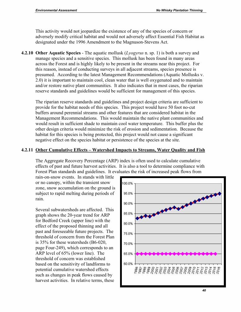
Environmental Assessment No Whisky Plantation Thinning
40
This activity would not jeopardize the existence of any of the species of concern or adversely modify critical habitat and would not adversely affect Essential Fish Habitat as designated under the 1996 Amendment to the Magnuson-Stevens Act.
4.2.10 Other Aquatic Species - The aquatic mollusk (Lyogyrus n. sp. 1) is both a survey and manage species and a sensitive species. This mollusk has been found in many areas across the Forest and is highly likely to be present in the streams near this project. For this reason, instead of conducting surveys in all adjacent streams, species presence is presumed. According to the latest Management Recommendations (Aquatic Mollusks v. 2.0) it is important to maintain cool, clean water that is well oxygenated and to maintain and/or restore native plant communities. It also indicates that in most cases, the riparian reserve standards and guidelines would be sufficient for management of this species. The riparian reserve standards and guidelines and project design criteria are sufficient to provide for the habitat needs of this species. This project would have 50 foot no-cut buffers around perennial streams and other features that are considered habitat in the Management Recommendations. This would maintain the native plant communities and would result in sufficient shade to maintain cool water temperature. This buffer plus the other design criteria would minimize the risk of erosion and sedimentation. Because the habitat for this species is being protected, this project would not cause a significant negative effect on the species habitat or persistence of the species at the site.
4.2.11 Other Cumulative Effects – Watershed Impacts to Streams, Water Quality and Fish The Aggregate Recovery Percentage (ARP) index is often used to calculate cumulative effects of past and future harvest activities. It is also a tool to determine compliance with Forest Plan standards and guidelines. It evaluates the risk of increased peak flows from rain-on-snow events. In stands with little or no canopy, within the transient snow zone, snow accumulation on the ground is subject to rapid melting during periods of rain. Several subwatersheds are affected. This graph shows the 20-year trend for ARP for Bedford Creek (upper line) with the effect of the proposed thinning and all past and foreseeable future projects. The threshold of concern from the Forest Plan is 35% for these watersheds (B6-020, page Four-249), which corresponds to an ARP level of 65% (lower line). The threshold of concern was established based on the sensitivity of landforms to potential cumulative watershed effects such as changes in peak flows caused by harvest activities. In relative terms, these
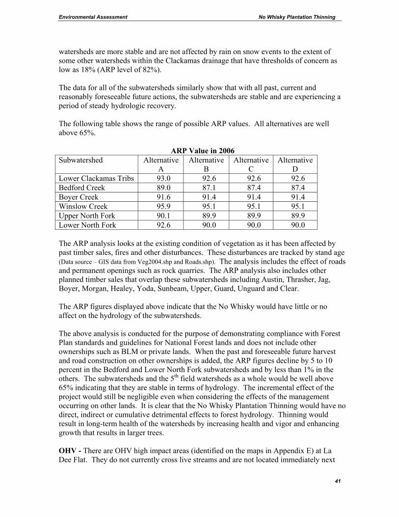
Environmental Assessment No Whisky Plantation Thinning
41
watersheds are more stable and are not affected by rain on snow events to the extent of some other watersheds within the Clackamas drainage that have thresholds of concern as low as 18% (ARP level of 82%). The data for all of the subwatersheds similarly show that with all past, current and reasonably foreseeable future actions, the subwatersheds are stable and are experiencing a period of steady hydrologic recovery. The following table shows the range of possible ARP values. All alternatives are well above 65%.
ARP Value in 2006 Subwatershed Alternative
A Alternative
B Alternative
C Alternative
D Lower Clackamas Tribs 93.0 92.6 92.6 92.6 Bedford Creek 89.0 87.1 87.4 87.4 Boyer Creek 91.6 91.4 91.4 91.4 Winslow Creek 95.9 95.1 95.1 95.1 Upper North Fork 90.1 89.9 89.9 89.9 Lower North Fork 92.6 90.0 90.0 90.0 The ARP analysis looks at the existing condition of vegetation as it has been affected by past timber sales, fires and other disturbances. These disturbances are tracked by stand age (Data source – GIS data from Veg2004.shp and Roads.shp). The analysis includes the effect of roads and permanent openings such as rock quarries. The ARP analysis also includes other planned timber sales that overlap these subwatersheds including Austin, Thrasher, Jag, Boyer, Morgan, Healey, Yoda, Sunbeam, Upper, Guard, Unguard and Clear. The ARP figures displayed above indicate that the No Whisky would have little or no affect on the hydrology of the subwatersheds. The above analysis is conducted for the purpose of demonstrating compliance with Forest Plan standards and guidelines for National Forest lands and does not include other ownerships such as BLM or private lands. When the past and foreseeable future harvest and road construction on other ownerships is added, the ARP figures decline by 5 to 10 percent in the Bedford and Lower North Fork subwatersheds and by less than 1% in the others. The subwatersheds and the 5th field watersheds as a whole would be well above 65% indicating that they are stable in terms of hydrology. The incremental effect of the project would still be negligible even when considering the effects of the management occurring on other lands. It is clear that the No Whisky Plantation Thinning would have no direct, indirect or cumulative detrimental effects to forest hydrology. Thinning would result in long-term health of the watersheds by increasing health and vigor and enhancing growth that results in larger trees. OHV - There are OHV high impact areas (identified on the maps in Appendix E) at La Dee Flat. They do not currently cross live streams and are not located immediately next
Environmental Assessment No Whisky Plantation Thinning
42
to any fish bearing stream course. The system of OHV trails in the No Whisky area currently have little or no affect on water quality or fisheries resources. While some of the OHV areas have large mud holes, there is no overland flow connecting them to streams. The use of open roads during rainy weather does create some sedimentation where roads intersect streams. This is addressed in s. 4.2.1 and s. 4.2.3.3. Design Criteria #6.6 in section 3.6 is designed to prevent the expansion of OHV use onto temporary roads, landings and skid trails that are used by the operator. Preventive actions would be taken such as placing sufficient quantities of debris on temporary roads, landings and skidtrails to block OHV use in areas of concern. Without these measures, the action alternatives would have the potential to increase OHV use in or near riparian areas by opening up areas currently inaccessible to motorized vehicles. With all of the action alternatives, the design criteria would prevent the expansion of OHV use into riparian areas. There would not likely be adverse affects to water quality or fisheries resources because the areas are relatively flat and there are few streams.
4.2.12 Aquatic Conservation Strategy
This project is designed to contribute to maintaining or restoring the fifth-field watershed over the long term. Appendix E contains documentation of consistency with Riparian Reserve standards and guidelines and summaries of existing conditions for the fifth-field watersheds.
4.2.13 The Clean Water Act and Best Management Practices Sections 208 and 319 of the Clean Water Act of 1972, as amended (1977 and 1987), acknowledge land treatment measures as being an effective means of controlling nonpoint sources of water pollution and emphasizes their development. These land treatment measures are known as Best Management Practices (BMPs). BMPs are used to control or prevent nonpoint sources of pollution from resource management activities, and to ensure compliance with the Forest Plan, as amended, the Clean Water Act, as amended, the Oregon Administrative Rules (OAR Chapter 340-41-0004,0028, and 0036), Department of Environmental Quality (DEQ), and the Memorandum of Understanding between the Oregon DEQ and the USDA, Forest Service. General BMPs are described in the document General Best Management Practices, USDA Forest Service, Pacific Northwest Region (11/88). The BMPs are flexible in that they are tailored to account for diverse combinations of physical and biological environmental circumstances. The Forest has documented typical BMPs and assessed their effectiveness (USDA 2004a). The following is a summary of the items applicable to this project.

Environmental Assessment No Whisky Plantation Thinning
43
Project Specific BMPs for the action alternatives
• Design Criteria – Design criteria 1, 4, 5, 6, 7 and 10 are specifically designed to protect water quality. They are specific to this proposed action and are tailored to site-specific conditions.
• Project Design - The project was designed from its inception to avoid potential
water quality related impacts. o Road construction if any, would be outside of riparian reserves. o Temporary road construction if any, would be on gentle terrain and would be
closed and revegetated upon completion. o Logging systems appropriate to the specific terrain of each unit were designed
to avoid water quality impacts. o During unit and road placement, certain areas were avoided such as sensitive
soil types and landforms. o Road reconstruction along haul routes is designed to reduce erosion and repair
damaged sections.
• Standard and Special Provisions of the Timber Sale Contract – Several sections of the timber sale contract implement BMPs. CT6.34 Sanitation and Servicing and BT6.341 Prevention of Oil Spills both deal with the prevention of pollution. The following list of contract provisions require practices such as constructing waterbars to divert water from skid trails and spreading grass seed: CT6.315 Sale Operation Schedule, BT6.42 Skidding and Yarding, CT6.42 Yarding/Skidding Requirements, BT6.422 Landings and Skid Trails, BT6.5 Streamcourse Protection, BT6.6 Erosion Prevention and Control, CT6.6 Erosion Control and Soil Treatment by the Purchaser, BT6.62 Wetlands Protection, BT6.63 Temporary Roads, BT6.64 Landings, BT6.65 Skid Trails and Fire Lines, BT6.66 Current Operating Areas, and BT6.67 Erosion Control Structure Maintenance. The contract provisions CT5.1 Temporary Road and Landing Construction, CT5.31 Road Maintenance Requirements, and CT5.32 Road Maintenance Deposit Schedule, ensure that roads are appropriately maintained.
Adherence to the provisions of the timber sale contract is ensured by the continual inspections of trained and certified Sale Administrators and is backed up by contract provisions such as BT9.1 which requires a performance bond to guarantee faithful performance of the above requirements.
The project as designed, including the avoidance of critical areas, standard design criteria and the provisions of the Timber Sale Contract, implement BMPs and result in providing clean water. Monitoring implementation of project specific BMPs is ongoing during project layout and sale administration. After the harvesting operations are complete, these projects would be included in the pool of Forest-wide projects available for monitoring the effectiveness of

Environmental Assessment No Whisky Plantation Thinning
44
the BMPs. Past monitoring of similar projects types has been documented in the Mt. Hood Monitoring and Evaluation Reports. The Project Specific BMPs and practices listed above are standard operating procedures and they have been implemented in many previous projects. Past experience, research and monitoring indicate that these practices are implementable and effective. After analyzing the effects of the alternatives with design criteria and BMPs, no significant impacts were found that would require further mitigation to protect water quality.
4.3 STAND GROWTH AND PRODUCTIVITY
Mt. Hood Forest Plan References Forestwide Timber Management Standards and Guidelines - FW-306 to FW-385, page Four-86 Timber Emphasis Standards and Guidelines – C1-16 to C1-35-39, page Four-296 Mt. Hood FEIS pages IV-50 to IV-76 Northwest Forest Plan - References Matrix Standards - page C-44
4.3.0.1 Purpose and need discussion
One of the aspects of the purpose and need (s. 2.2.1) is to increase health and vigor and enhance growth that results in larger trees. All of the action alternatives would equally meet this objective within the matrix land while the no-action alternative would not. The following section elaborates on the objectives of health and growth. Alternatives B, C and D
4.3.1 Plantations The term plantation is used informally to describe managed stands that were logged using the regeneration harvest method or were salvaged after a stand replacement fire and were subsequently reforested by a combination manual planting of trees, aerial or manual scattering of seed, and trees that seeded in from adjacent live trees. One of the objectives of thinning is to redistribute growth potential to fewer trees, while maximizing the site’s potential, leaving a stand with a desired structure and composition (Oliver 1996). In general, thinning tends to improve the overall vigor, growth, health and architecture of trees. Thinning can directly maintain forest health by maintaining growth rates of young stands. Variable density thinning that retains minor species components and retains some trees with the elements of wood decay would still meet health and growth objectives while enhancing diversity. Thinning provides growing space, which gives the trees with the best competitive advantage the opportunity to quickly take advantage of this growing space for the longest practical time, while fully utilizing the ability of the trees to expand their crowns into the growing room provided by the removal of neighboring trees (Oliver 1996). Failure to maintain tree spacing while they are young can have consequences lasting the life of the
Environmental Assessment No Whisky Plantation Thinning
45
timber stand (Oliver 1996). When trees are given the competitive advantage, the first response would be an expansion of fine roots and leaf area. This equates to more photosynthesis and carbohydrate production. The second response is an allocation of carbohydrate to diameter growth and finally, to the tree’s defense system (Oliver 1996). Thinning can improve the resistance of some trees to some pathogens by manipulating the structure and species composition of a young stand. These second-growth stands are stable and windfirm. They currently have the strength to withstand the types of wind events that are typical for this area. Thinning would add to their continued stability in the wind. Small areas of units 4, 5, 6, 10, 12a, and 14-16 are located adjacent to areas of high watertables and unit 31 has shallow soils. Stands 6, 10, 12a and 14-16 have been commercially thinned in the past and have not experienced any windthrow exceeding normal levels. Several forest diseases are present in the No Whisky area. Small isolated pockets of laminated root rot are present throughout these stands with minor occurrences of western hemlock dwarf mistletoe and armillaria root disease. These diseases, when present at low to moderate levels do not seriously compromise timber productivity and they result in down wood, some trees with the elements of wood decay and variability of spacing. Thinning to enhance tree growth is one way to give trees the advantage they need to resist these diseases or delay mortality. Wind is usually the agent that causes root diseased trees to fall but they would eventually fall in the absence of wind. Relative Density (RD) is a measure of how crowded a forest is. The scale ranges from 0 (no trees) to 100 (maximum biological potential). When a stand reaches or exceeds a RD of 55, suppression, mortality and stand decline would be expected. Units 2, 3, 6, 7, 9-12, 15-17, 19-21 and portions of units 1 and 5 were commercially thinned within the last 20 years. The remainder of the units have not been thinned. The average stand diameter in the units that have been commercially thinned range from 14 to 23 inches, and the RD is still less than 55, but would exceed this level within 10 to 20 years. The understory vegetation such as conifers and some brush species are starting to experience growth suppression due to a decrease in sunlight reaching the forest floor. The average stand diameter in the units that have not been commercially thinned range from 12 to 21 inches, RD is greater than 55 (in most cases), and are experiencing growth suppression and some mortality. The understory vegetation is generally suppressed, and mortality of some trees in the suppressed and intermediate crown classes is occurring. Alternative A - Without thinning, the average stand diameters in 20 years would range from 14 to 26 inches, with stocking at levels where growth suppression and mortality continues to occur (with RD exceeding 55). The understory vegetation would continue to be suppressed. Alternatives B, C and D would result in long-term benefits for stand growth and productivity. Average stand diameters in 20 years would range from 16 to 31 inches. At
Environmental Assessment No Whisky Plantation Thinning
46
that time, tree size and stocking levels would begin to approach the stocking levels where growth suppression and mortality would occur (with RD of 50 to 55). Understory vegetation would have developed for 20 years without suppression from the overstory conifers. Units that have been previously thinned are considered windfirm. There has been no recently noted windthrow in these areas. Unit 4 and portions of unit 5 have not been previously thinned but currently display no windthrow above normal levels. Thinning the units would not increase the windthrow potential in previously thinned areas, however in areas with shallow soils and those previously unthinned, the potential exists for an increase in incidental amounts of scattered windthrow. These amounts would contribute to the down woody debris component and enhance the diversity within the stands.
4.3.2 Riparian Reserves Some riparian reserves would be thinned to a wider spacing than would be optimal for timber productivity. However, riparian objectives would be better served by a wider spacing where leave tree size would be maximized and the need for a future thinning entry would be avoided. Refer to section 4.2.5 for a discussion on riparian reserve stand structure.
4.3.3 Alternative A - Without thinning, the live crowns of trees would be reduced because of shading. Stands would experience increased loss of productivity. Growth would decline, mortality would increase and crown size and density would decline. This condition would increase the physiological stress level of the forest, thereby, increasing the susceptibility of these stands to disturbances. Stands would also maintain their mid-seral structure for many decades or until some disturbance or stand differentiation allows stand development to continue or reinitiate. Stands under this condition would be denser, less diverse (structurally), have smaller diameter trees with few larger diameter trees, shorter crowns positioned higher on the stem, and less understory development than stands intensively managed.
4.4 LANDSCAPE HEALTH AND DIVERSITY Mt. Hood Forest Plan References Forest Management Goals - #6, 7, 8, 11, 12, 13, 19 and 44, page Four-2 Forestwide Wildlife Standards and Guidelines – FW-194 to 197, page Four-71 Northwest Forest Plan - Aquatic Conservation Strategy Objectives - page B-11 Section 4.3 addresses stand dynamics and the effects of thinning or not thinning at the stand scale. This section addresses the landscape scale situation and the diversity purpose and need.
4.4.0.1 Purpose and need discussion
One of the aspects of the purpose and need (s. 2.2.1) is to enhance diversity. The action alternatives would meet this objective. Alternative D would thin 45 fewer acres than B or

Environmental Assessment No Whisky Plantation Thinning
47
C. The no-action alternative would not meet the objective. Section 4.4.3 elaborates on diversity.
4.4.1 Long-term Thinning Opportunities -
As young stands grow they eventually reach an age where thinning would enhance growth and prevent stand stagnation that might otherwise occur where trees are overcrowded. As stands mature they reach an age at which thinning may not result in the same growth response that would be expected in younger stands. Age is only one consideration in the potential timing of thinning. Species composition, elevation, site quality, presence of root rot and other diseases, and accessibility also affect the feasibility and timing of thinning. For plantations, precommercial thinning (small trees are cut and left on site) is often considered desirable at age 15 to 20. Commercial thinning (using a timber sale to achieve the desired stand condition) requires cut-trees to be of sufficient size, value and quantity per acre to be economically viable. Compared to timber sales of mature timber, thinning is often economically marginal because trees are smaller and of lower value and volume per acre is low. Within the Clackamas River Ranger District there is a wide range of site productivity based on soils, elevation and the environment. A first commercial thinning for plantations at lower elevations is often considered desirable at age 40 to 50 while higher elevations may not be ready for thinning until age 60. Refer to the Timber Productivity section for more detail on health and growth. As plantations grow and become ready for thinning, stand exams are conducted and if they are found to need thinning, and are economically viable they are put into the planning program. The following table displays the approximate acres of plantations created each decade and natural second growth at the landscape scale. Second Growth on Clackamas River Ranger District (Acres)
Plantations (All Land Allocations)
Acres of Regeneration Harvest by Decade
Natural Second-Growth Stands and Older Plantations (Matrix)
1990-present
1980s 1970s 1960s 1950s 1940s All ages
17,000 35,000 26,000 26,000 10,000 730 14,000
The Clackamas River Ranger District has been increasing the level of thinning timber sales over time, beginning in the 1970s. In the early 1990s the planning and implementation of thinning timber sales became and emphasis. Since that time approximately 1850 acres of young plantations and 6575 acres of natural second-growth stands and older plantations have been commercially thinned. Planned commercial thinning projects would add another 2000 acres of plantations and 2350 acres of natural second-growth and older plantations. The table above indicates that thinning opportunities would increase in the coming decades as stands grow.
Environmental Assessment No Whisky Plantation Thinning
48
4.4.2 Landscape Health –
The watershed analyses recommended thinning (North Fork p. 5-1, Lower Clackamas pl 6-13). In reaching this recommendation, the agency considered the long-term health of ecosystems, watersheds, habitats and human needs. The proposed action is part of a long-term thinning program designed to meet the following landscape-level goals: providing long-term sustained production of high quality water, providing forage for deer and elk, providing an appropriate mix of plant and wildlife habitats, providing healthy forest stands that are part of a landscape where wildfire risk is minimized, and providing timber outputs to meet human needs consistent with NFP goals and providing for the health and productivity of forest stands for future wood product needs. The no-action alternative would not meet these goals or move the landscape in that direction. The action alternatives do move the landscape toward these goals.
4.4.3 Diversity – Diversity can be considered at many scales but for the purpose of this project it is discussed at the landscape scale and at the stand scale. Diversity is the distribution and abundance of different plant and animal communities and species within an area. There are many elements of diversity including but not limited to genetic, structural, horizontal, and vertical. At the landscape scale, a mix of forest types and ages can provide habitat for a wide range of plants and animals. At the stand scale other elements become more relevant such as species composition, snag abundance or the number of canopy layers.
Both human actions and natural processes or events have the potential to alter diversity. Some actions or natural processes or events may seem to benefit one aspect of diversity while at the same time be detrimental to another. Units 2, 3, 6, 7, 9-12, 15-17, and 19-21 and portions of units 1 and 5 were commercially thinned within the last 20 years. The harvest prescription was a thinning from below and a spacing of 18 feet between trees. The objective of the previous thinning was to maximize timber productivity, which resulted in less diverse stands favoring dominant Douglas-fir trees. This resulted in uniformly spaced stands, with very few minor species such as red cedar or hemlock, few canopy gaps or skips, and hardly any trees with elements of wood decay. The canopies of these stands have not yet grown together to the point where sunlight to the forest floor is completely limited. In the stands that have not been previously thinned, the trees are generally smaller in diameter, not uniformly spaced, have some minor species (such as red cedar, hemlock and true fir), and contain some trees with the elements of wood decay. The trees are very close to the same age and the stands are dense; and generally limit sunlight penetration to the forest floor. The action alternatives would thin these plantations to provide for health and growth and to provide forest products. While accomplishing this, the thinning prescription would
Environmental Assessment No Whisky Plantation Thinning
49
incorporate many features that would enhance some elements of diversity that are lacking in plantations.
Leave trees would be left at variable spacing. Instead of trees being uniformly spaced and uniformly sized they would be variable. In some areas two trees might be left that are very close to each other and nearby there might be a place where two leave trees are 30 feet apart.
Leave trees would include minor species such as western hemlock, western red cedar and red alder. The plantations were planted primarily with Douglas-fir in this area and other species either are present because they survived the clear cutting and fires or because they seeded in from the edge. Thinning would primarily remove Douglas-fir. Small gaps and skips would be created. Gaps are openings in the canopy that are created by landings and skyline corridors. In this project there would be no gaps specifically created for forage enhancement. Skips are areas where no trees are removed. Skips would be created by marking leave trees around special sites up to 1/5 acre in size. Leave trees would include trees with the elements of wood decay such as forked trees or trees with dead tops. These trees would become important as they age and develop cavities. The units are plantations and contain very few large snags because they were cut down when the area was clearcut. There are some medium size second-growth snags and some short crumbled remnants of old large snags. These types of snags are not generally hazardous but if they are hazardous to the logging operation they would have to be felled. All non-hazardous snags would be retained, and some live trees would be marked to leave where their crowns touch certain key snags to increase the likelihood that they would be retained. Also all existing down logs would be retained. Some live trees would be treated to provide future snags and future cavities. Some live trees would be felled and left on site.
The No-action Alternative would not affect snags but it would also not change the stands uniformity, species composition, or the vertical or horizontal structure. Recent studies have indicated that dense, closed-canopy second growth without legacy trees can result in a period of low structural diversity that can last more than 100 years and can have profound effects on the capacity of the forest to develop biocomplexity in the future (Courtney 2004, appendix 5, p. 3-24).
4.5 WILDLIFE Mt. Hood Forest Plan References Forestwide Wildlife Standards and Guidelines – FW-187 to 247, page Four-71 Northwest Forest Plan - Matrix Standards and Guidelines - page B-39

Environmental Assessment No Whisky Plantation Thinning
50
The Biological Evaluation is located in Appendix B and is incorporated by reference and summarized below. The project is covered by a Programmatic Biological Assessment (USDA 2004) and is referred to as the “No Whisky Timber Sale” within Appendix C of the Biological Assessment. Formal consultation with U.S. Fish & Wildlife Service has been completed for this project. The Biological Opinion written by U.S. Fish & Wildlife Service is dated March 29, 2005 (USDI 2005). This Biological Assessment and Biological Opinion remain valid for decisions signed before January 1st, 2007. The units are not in a late-successional reserve or a critical habitat unit. Management Indicator Species for this portion of the Mt. Hood National Forest include northern spotted owl (s. 4.5.1), pileated woodpecker(s. 4.5.14, s. 4.5.10, s. 4.5.11, s. 4.5.12), pine marten (s. 4.5.14), deer (s. 4.5.13), elk (s. 4.5.13), salmonid smolts and legal trout (4.2) (Forest Plan p. four-13).
4.5.1 Northern Spotted Owl (Threatened) Habitat Characteristics - Habitat for the owl is categorized as either suitable or dispersal habitat. Suitable habitat for the northern spotted owl consists of habitat used by owls for nesting, roosting and foraging (NRF). Generally this habitat is 80 years of age or older, multi-storied and has sufficient snags and down wood to provide opportunities for nesting, roosting and foraging. The canopy closure generally exceeds 60 percent. Dispersal habitat for the owl generally consists of mid-seral stands between 40 and 80 years of age with a canopy closure of 40 percent or greater and an average diameter of 11”. Spotted owls use dispersal habitat to move between blocks of suitable habitat; juveniles use it to disperse from natal territories. Dispersal habitat may have roosting and foraging components, enabling spotted owls to survive, but lack structure suitable for nesting. Existing Situation – The landscape pattern of vegetation has been affected by historic and recent timber harvest activities and fire suppression, which have impacted the habitat for spotted owls. Some ecologically important features of landscape pattern are: amount of edge habitat, degree of fragmentation of late-successional forest, and amount of interior forest. As fragmentation of a landscape pattern increases, the amount of interior forest habitat decreases and the amount of edge habitat increases. As fragmentation increases, the amount of interior forest habitat decreases, impacting organisms that prefer large patches of interior habitat, such as the spotted owl. The spotted owl analysis area (18,770 acres) is comprised of the North Fork Clackamas River watershed and a small portion of the Lower Clackamas River watershed. Logging and extensive fires in most of this analysis area in the early 1900’s have resulted in a landscape largely dominated by even-age, mid-seral forest which is now dispersal habitat. Little late-seral habitat is present and connectivity of these remaining late-seral
Environmental Assessment No Whisky Plantation Thinning
51
pockets is poor. There are no contiguous blocks of late-seral forest left in the analysis area (USDA 1996). The portions of the analysis area that is outside of national forest are likely limited in dispersal habitat because of regeneration harvest on private lands. The analysis area is mainly surrounded by a Late-successional Reserve (LSR) and the Salmon-Huckleberry Wilderness. The LSR is to the south and the Wilderness Area is to the northeast of the harvest units, (refer to map in s. 3.2.5). LSRs are currently providing moderate to high levels of suitable habitat with medium to large patch sizes and good connectivity between the existing patches. The dispersal habitat currently present in the analysis area is likely an important means of connectivity between these suitable habitats that surround the area (USDA 1996). Effects – Including Direct, Indirect and Cumulative Effects
4.5.2 Alternative A No direct effects to the owl would be predicted with this alternative. For the short term, the units would continue to function as dispersal habitat. In the long-term (20-40 years), these stands would start to differentiate in varying degrees and show an increase in the levels of snags, down wood and understory development. Mortality would occur, improving somewhat on the dispersal habitat characteristics. The quality of dispersal habitat would improve only slightly in some stands while improving much more in others. Some of the stands may eventually becoming suitable habitat.
4.5.3 Alternatives B, C and D
Effects to Dispersal Habitat on a Local and Landscape Scale The action alternatives would have an affect on dispersal-only habitat. All of the proposed units (1678 acres) are considered dispersal-only habitat. Total dispersal habitat is a combination of suitable habitat and dispersal-only habitat (all suitable habitat meets the requirements of dispersal habitat). The No Whisky analysis area contains dispersal habitat within approximately 79% (14,864 acres) of its area. The proposed action would degrade (reduce in quality) 902 acres of dispersal habitat or approximately 6% of the available dispersal habitat. Although the dispersal habitat characteristics within 902 acres would be reduced in quality, they would still function as dispersal habitat for the owl. No loss of dispersal habitat would occur in these stands. These stands would again provide the same quality of habitat in approximately 10 years after harvest. The proposed action would also temporary remove 776 acres of dispersal habitat (approximately 5% of the available dispersal habitat), due to the intensity of thinning within in those units. These units would become dispersal habitat again in approximately 10 years as the canopy closes.
Environmental Assessment No Whisky Plantation Thinning
52
Since current spotted owl surveys have not been completed for the area, it is assumed that all suitable habitat has the potential to contain spotted owl activity centers. There is suitable habitat adjacent to some of the proposed thinning stands that are currently providing dispersal habitat.
A recent study by Meiman et al (2004) reports changes in spotted owl use following a commercial thinning in stands near core areas in Clatsop State Forest. Although sample sizes were not large, proportional use of the thinned area was significantly less during and post-harvest operations than during the pre-harvest period. The nature of this effect is not clear, but it may include an influence on prey availability, microclimate conditions, or higher vulnerability to predation. In addition, home range expansion of one spotted owl was observed, and a shift of the core use area away from the thinned stand. These effects suggest that commercial thinning in proximity to spotted owl activity centers may have a short-term effect on home-range and habitat-use patterns of individuals. The No Whisky Project could potentially have a short-term effect on the home-range and habitat-use patterns of spotted owl individuals present in the area. The noise created by logging equipment including helicopters, has the potential to disturb some owls. In the long-term (20 to 40 years), the project is likely to improve the quality of dispersal habitat in some of the units. The action alternatives would have an effects determination of “May Affect, not Likely to Adversely Affect” because of the effect to dispersal habitat.
4.5.4 Effects to spotted owl on a province scale (Willamette Province) The United States Fish and Wildlife Service (USFWS) issued a Biological Opinion for this project (USDI, 2005). The conclusion reached after considering the cumulative effects of this and other projects is that all the projects are not likely to jeopardize the continued existence of the spotted owl and are not likely to destroy or adversely modify designated critical habitat for the spotted owl.
4.5.5 Effects to spotted owl on the entire range of the species (Washington, Oregon, and California) The Northwest Forest Plan established a system of land allocations and a rate of timber harvest (probable sale quantity) that is considered to be consistent with maintaining viability for the northern spotted owl across its range (USDA, USDI 1994b). The No Whisky project is not within late-successional reserves. The No Whisky project would not significantly alter the landscape’s capability to provide for the continued viability of the northern spotted owl on Federal Lands. A report titled “Scientific evaluation of the status of the Northern Spotted Owl” was published by Sustainable Ecosystems Institute (Courtney 2004). The report is a review and synthesis of information on the status of the Northern Spotted Owl. The report was prepared to aid the U.S. Fish and Wildlife Service in their 5-year status review process, as set out in the Endangered Species Act. The report did not make recommendations on
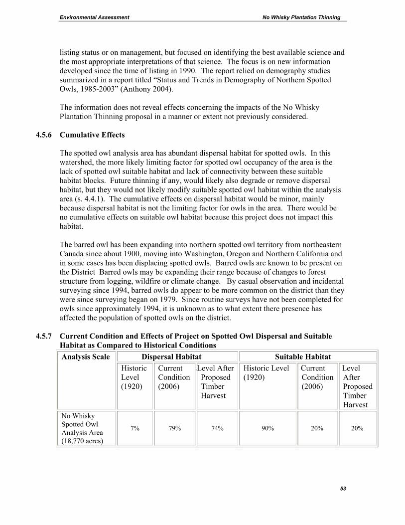
Environmental Assessment No Whisky Plantation Thinning
53
listing status or on management, but focused on identifying the best available science and the most appropriate interpretations of that science. The focus is on new information developed since the time of listing in 1990. The report relied on demography studies summarized in a report titled “Status and Trends in Demography of Northern Spotted Owls, 1985-2003” (Anthony 2004). The information does not reveal effects concerning the impacts of the No Whisky Plantation Thinning proposal in a manner or extent not previously considered.
4.5.6 Cumulative Effects
The spotted owl analysis area has abundant dispersal habitat for spotted owls. In this watershed, the more likely limiting factor for spotted owl occupancy of the area is the lack of spotted owl suitable habitat and lack of connectivity between these suitable habitat blocks. Future thinning if any, would likely also degrade or remove dispersal habitat, but they would not likely modify suitable spotted owl habitat within the analysis area (s. 4.4.1). The cumulative effects on dispersal habitat would be minor, mainly because dispersal habitat is not the limiting factor for owls in the area. There would be no cumulative effects on suitable owl habitat because this project does not impact this habitat. The barred owl has been expanding into northern spotted owl territory from northeastern Canada since about 1900, moving into Washington, Oregon and Northern California and in some cases has been displacing spotted owls. Barred owls are known to be present on the District Barred owls may be expanding their range because of changes to forest structure from logging, wildfire or climate change. By casual observation and incidental surveying since 1994, barred owls do appear to be more common on the district than they were since surveying began on 1979. Since routine surveys have not been completed for owls since approximately 1994, it is unknown as to what extent there presence has affected the population of spotted owls on the district.
4.5.7 Current Condition and Effects of Project on Spotted Owl Dispersal and Suitable Habitat as Compared to Historical Conditions
Dispersal Habitat Suitable Habitat Analysis Scale Historic Level (1920)
Current Condition (2006)
2Level After Proposed Timber Harvest
Historic Level (1920)
Current Condition (2006)
Level After Proposed Timber Harvest
No Whisky Spotted Owl Analysis Area (18,770 acres)
7% 79% 74% 90% 20% 20%
Environmental Assessment No Whisky Plantation Thinning
54
4.5.8 Northern Bald Eagle (Threatened) Habitat Characteristics: The bald eagle is a permanent resident in Oregon. Their nests are usually located in multi-storied stands with old-growth components, and are near water bodies that support an adequate food supply. Nest sites are usually within ¼ mile of water in the Cascades. Existing Situation: Bald eagles are observed occasionally on the District, especially in late summer through late winter. Due to low numbers and sporadic use, no communal roost areas are known to exist on the District. There has been consistent use by adults in two areas of the Clackamas River Ranger District, one of which has had recent nesting success by a bald eagle pair. These areas are greater than 20 miles away from the proposed project site. The project area is in close proximity to the Lower Clackamas River, an area that bald eagles are commonly observed during the spring/summer period. Although there have been no documented nesting eagles in the area, there is suitable nesting and roosting habitat along this River. The nesting quality is considered fair, with prey availability being the likely limiting factor. Habitat for bald eagles is described in terms of foraging, nesting, roosting, and perching. Many of the proposed harvest units occur within ½ mile of this river, a potential foraging source. None of the proposed harvest units have the structural components necessary for potential bald eagle nesting or communal roosting habitat. The units lack a mature multi-story structure with old-growth or older second-growth trees. However, a few of the units may provide potential perching habitat due to their proximity to the Lower Clackamas River. This potential perching habitat is considered fair/poor quality due to the minor amounts of snags and trees providing a good view of the surrounding area. In addition, several of the proposed harvest units are directly adjacent to potential bald eagle nesting habitat (i.e. late-seral stands that are adjacent to the Lower Clackamas River). Effects – Including Direct, Indirect and Cumulative Effects
Alternative A No effect to the bald eagle or its habitat would occur with implementation of this alternative. Some of the units would continue to provide poor/fair quality potential perching habitat.
Alternatives B, C and D Effects to Habitat There would no effects to potential foraging, nesting or roosting bald eagle habitat due to the lack of these habitats within the proposed harvest units. A few of the units have

Environmental Assessment No Whisky Plantation Thinning
55
potential perch trees that could be negatively affected by project implementation. Although it is unlikely that any potential perch trees would be proposed for harvest, it is possible a few, mainly snags, would need to be cut down due to safety concerns during harvest operations. It is also possible that a few potential perch trees would blow down as a result of opening up the stands. Perch trees along the Lower Clackamas River are currently abundant and have high densities of relatively large trees with irregular crowns. Because the No Whisky units are approximately ½ mile or more from the river it is not likely that the loss of a few perch trees this distance away would measurably lower the availability of overall potential bald eagle habitat being provided along the river. Effects to Individuals If a bald eagle were present in any of the units during project implementation, it would have the ability to quickly move to adjacent habitat. No harm would come to the individuals. Several of the proposed harvest units are directly adjacent to potential nesting, communal roosting and perching habitat. Disturbance caused by project implementation including the use of helicopters could cause these potential habitats to be temporary unavailable to bald eagles. Since the availability of a high quality foraging source is the limiting factor for bald eagle in the area and not the habitat components comprising roosting, nesting and perching habitats, the temporary unavailability of a small percentage these habitats is not predicted to impact bald eagles. Because of the high visibility of bald eagles, it is unlikely that this project would be implemented in an area with an undiscovered bald eagle nest or roost. If a new bald eagle nest or roost is discovered, this project activity within 0.25 miles or 0.5-mile sight distance of the nest or roost would be evaluated by the unit district biologist for potential effects on bald eagles and mitigated to prevent disturbances. Effects to Population None expected since the effects to bald eagles and their habitat would be minor. Cumulative Effects The occasional removal of hazard trees along Hwy 224 and other roads within the area has the potential of causing the loss of a few potential perch/nest/roost trees. Due to the abundance of suitable trees for bald eagles in the area, the cumulative effect of these projects is predicted to have a minimal impact on bald eagles and their habitat. All action alternatives would have a “May Affect, not Likely to Adversely Affect” on the bald eagle and its habitat.

Environmental Assessment No Whisky Plantation Thinning
56
4.5.9 Sensitive Species The following table summarizes effects from the Biological Evaluation, which is found in Appendix B.
Species
Suitable Habitat
Presence
Impact of Alternatives**
B C D Oregon Slender Salamander No NI NI NI Larch Mountain Salamander* No NI NI NI Cope’s Giant Salamander Yes MII-NLFL MII-NLFL NI Cascade Torrent Salamander No NI NI NI Oregon Spotted Frog Yes MII-NLFL MII-NLFL NI Painted Turtle No NI NI NI Northwestern Pond Turtle No NI NI NI Horned Grebe No NI NI NI Bufflehead No NI NI NI Harlequin Duck No NI NI NI American Peregrine Falcon Yes MII-NLFL MII-NLFL MII-NLFLGray Flycatcher No NI NI NI Baird’s Shrew No NI NI NI Pacific Fringe-tailed Bat Yes NI NI NI California Wolverine No NI NI NI Puget Oregonian* No NI NI NI Columbia Oregonian* No NI NI NI Evening Fieldslug* No NI NI NI Dalles Sideband* No NI NI NI Crater Lake Tightcoil* No NI NI NI *These species are also Survey and Manage Species.
** Impact abbreviations “NI” = No Impact “MII-NLFL” = May Impact Individuals, but not likely to Cause a Trend to Federal Listing or Loss of Viability to the Species Effects to the species listed above include changes to habitat as well as potential harm to individuals caused by physical impacts of logging equipment, falling and dragging trees, noise, fuels treatment, road construction, reconstruction, obliteration, log haul, snag creation, and down woody debris creation. No species that require the management of known sites occur within the affected area. The survey protocol for red tree vole was updated in October of 2002 (Version 2.1) which more narrowly defined potential red tree vole habitat. None of the units contain potential red tree vole habitat and therefore do not require pre-disturbance surveys. Surveys were not conducted for Larch Mountain salamander or great gray owl because habitat for these species is not present within the project area. Partial surveys were conducted for terrestrial mollusks. Recently, the annual species review changed the list of species requiring surveys and the ranges where species might occur. The species still on the list are usually found in habitat types and at elevations not present in this project. Surveys for terrestrial mollusks are not required for this project.

Environmental Assessment No Whisky Plantation Thinning
57
4.5.10 Snags and Down Wood Existing Situation – The snag and down woody debris density and conditions found within the formerly designated Lower Clackamas River and North Fork watersheds is based on the 1987 Forest Inventory data for unmanaged stands, 1992 Forest Inventory data in managed stands for the mid-seral stages, and 1992 contract data for the early-seral stands. According to this data, stands similar to the No Whisky units within these areas have approximately 0.1 medium snags (>15” diameter) per acre and approximately 0.1 large snags (>21” diameter) per acre. The down woody debris density in these stands that are most similar to the No Whisky units within this watershed were found to be approximately 6 hard down logs per acre and 8 soft logs per acre. Walk-through surveys confirm the above analyses of snags and down wood with some exceptions. All the units contain a few snags >15” diameter. Down wood of saw log size is widely scattered and mostly in decay classes 4 and 5. Occasionally there is a piece of down wood in decay class 3, and few if any pieces in decay class 1 & 2. There are more remnant snags (those remaining after the widespread stand replacement fire event and subsequent fires) in the eastern portion of the analysis area than in the western portion. Many of the snags remaining after the fires of 1929 and 1939 in the western portion were felled. While there are snags in the eastern portion, the majority are in an advanced state of decay (USDA 1996). The large amount of mid-seral habitat in the analysis area means that there is a temporal gap or “snag lag” in the area. This is when remnant snags from the fires are in an advanced state of decay and the stands originating from the fires are still too young for snag production. This could continue for approximately 20 years, until some of the existing mid-seral stands have trees large enough to meet the desirable diameter sizes for large snags (USDA 1996). The primary and secondary cavity nesting species for the project area are: pileated woodpecker, northern flicker, hairy woodpecker, red-breasted sapsucker, and red-breasted nuthatch. The 100% biological potential level is 3.7 snags per acre (Austin 1995). In the No Whisky analysis area, the standard and guideline from the Forest Plan (FW-215) for the harvest units is 60% of the full biological potential, or 2.2 snags per acre. DecAid Advisor DecAID is a planning tool intended to help advise and guide managers as they conserve and manage snags, partially dead trees and down wood for biodiversity (Mellen 2003). Refer to the DecAID web site listed in the References section for more detail and for
Environmental Assessment No Whisky Plantation Thinning
58
definition of terms. This advisory tool focuses on several key themes prevalent in recent literature concerning this subject and is as follows: • Decayed wood elements consist of more than just snags and down wood, such as live
trees with dead tops or stem decay. • Decayed wood provides habitat and resources for a wider array of organisms and
their ecological functions than previously thought. • Wood decay is an ecological process important to far more organisms than just
terrestrial vertebrates. DecAid is an advisory tool to help managers evaluate effects of forest conditions and existing or proposed management activities on organisms that use snags and down wood. DecAid also can help managers decide on snag and down wood sizes and levels needed to help meet wildlife management objectives. This tool is not a wildlife population simulator nor is it an analysis of wildlife population viability. A critical consideration in the use and interpretation of the DecAID tool is that of scales of space and time. DecAID is best applied at scales of subwatersheds, watersheds, subbasins, physiographic provinces, or large administrative units such as Ranger Districts or National Forests. DecAID is not intended to predict occurrence of wildlife at the scale of individual forest stands or specific locations. It is intended to be a broader planning aid not a species or stand specific prediction tool. Modeling biological potential of wildlife species has been used in the past. DecAid was developed to avoid some pitfalls associated with that approach. There is not a direct relationship between the statistical summaries presented in DecAid and past calculations or models of biological potential. Snags and Down Wood Levels Compared to DecAid Data Appendix E of the EA contains an analysis that compares the snag data to the tolerance levels for the different wildlife habitat types and structural conditions identified in the DecAID advisory tool. All of the units are located within the habitat type identified in DecAid as the Westside Lowland Conifer-Hardwood Forests of Western Oregon Cascades and vegetation condition of “small/medium trees.” Within the Westside Lowland Conifer-Hardwood Forests and vegetation condition of small/medium trees noted above, the DecAID advisor identifies the 30% tolerance level for these mid-seral stands (small/medium trees) as 5.3 snags per acre greater than 10 inches with almost 5 per acre greater than 20 inches in diameter. The 50% tolerance level for these mid-seral stands would be 18.6 snags acre greater than 10 inches with 8 per acre greater than 20 inches in diameter. DecAID advisor identifies the down wood 30% tolerance level for Western Lowland Conifer-Hardwood Forest mid-seral stands as up to 4.5% cover of down wood (including all decay classes) with sizes of pieces averaging 8-12 inches in diameter. The 50%
Environmental Assessment No Whisky Plantation Thinning
59
tolerance level for these mid-seral stands would be up to 10% cover of down wood with sizes of pieces averaging 8-12 inches in diameter. All the units within the No Whisky project currently contain snag numbers that less than the 30% tolerance level for snag density and size based on the analyses discussed above. These units also contain down woody debris densities less than the 30% tolerance level. Effects - Alternative A - The plantations would continue to be deficient in snags and down wood. Based on the information discussed above, it is presumed that there would continue to be few snags present in the units. This is likely to below the level of snags required for 60% biological potential (2.2 snags/acre). In terms of the tolerance levels for snags within the applicable habitat type and structural condition identified in the DecAID advisor, these areas would continue to be below the 30% tolerance level. Levels would be slightly higher if live trees with the elements of wood decay were included. Based on Forest Inventory surveys, the units would continue to provide roughly 2 hard and 4 soft down logs per acre. In the future, these stands would continue to increase in size and density and start to become increasingly more susceptible to damaging agents such as insects and diseases. These natural processes would create new snags and down logs, mainly from the smaller intermediate and suppressed trees in the stands.
Alternative B Effects to Snags and Down Wood: Snags are difficult to retain during logging because of their inherent instability and danger. It is likely that some snags would need to be cut down during harvest operations due to safety considerations and that some downed logs would be degraded through the process of logging. Approximately 1,367 acres would be tractor logged, 246 acres would be harvested using a skyline logging system, and 65 acres would be helicopter logged. Due to the creation of corridors involved in skyline logging, this method usually involves a greater loss of snags and down woody debris than in tractor logging. Helicopter logging typically results in a loss of snags greater than in both tractor and skyline logging and typically has less effect on the existing down wood than both ground and skyline-based systems. Approximately 1.2 miles of new temporary road would be constructed with this alternative. This would result in an additional loss of snags and damage to the course woody debris. Snags that are left standing after thinning would be more prone to wind damage and snow breakage than they would have been without thinning. There would likely be some loss of the remaining snags within 10 years after harvest. These would become down wood. To increase the likelihood that snags would be retained after timber harvest, green trees would be marked as leave trees where their live crowns touch certain key snags (Design
Environmental Assessment No Whisky Plantation Thinning
60
Criteria #2). Certain live trees would also be selected as leave trees that are defective or have the elements of decay as described in the DecAid advisor. Hollow structures are created in living trees by heartrot decay organisms over many years. These hollow structures in living trees provide especially valuable habitat for a variety of wildlife, including cavity users. Trees that have heartrot decay present may include features such as openings in the bole, broken boles with bayonet tops, large dead tops or branches, punk knots, flattened stem faces, old wounds on the bole, crooks in the bole signifying previous breakage, and the presence of fruiting bodies. Defective trees with deformities such as forked tops, broken tops, damaged and loose bark or brooms caused by mistletoe or rust can also provide important habitat for a number of species. Logs existing on the forest floor would be retained. Prior to harvest, contract administrators would approve skid trail and skyline locations in areas that would avoid disturbing key concentrations of down logs or large individual down logs where possible. The harvesting operations would also add small woody debris of the size class of the cut trees to the site. This would include the retention of cull logs, tree tops, broken logs and any snags that would be felled for safety reasons. Snags or green trees that fall down after the harvest operation would contribute to the down wood component of the future stand. The average stand diameters in the units range from 12 to 23 inches. Implementation of the proposed action would reduce the amount of natural selection that would have occurred through the process of stress and mortality. Some of the snags and downed logs that might have formed in the future from the death of the intermediate and suppressed trees would be removed through the timber harvest. As a result the proposed action would delay the attainment of moderate-sized snags and down wood through natural process because of the reduction in density of the stands. Although some trees with elements of wood decay would be left and provide habitat for snag-dependent species, fewer new snags, trees with elements of wood decay, or large down wood would be created for the short-moderate term because of this silvicultural treatment. However, the proposed action involves leaving the largest trees standing and growing. This would accelerate the growth and size of trees and would eventually provide larger snags in the long term. Some would eventually fall naturally to create large coarse woody debris as well. Effects to snags and down wood as related to DecAid levels: Snags and wildlife trees described in Design Criteria #2 are combined for the purpose of determining DecAID levels for the action alternatives. Due to the lack of snags and trees with elements of wood decay within all the units, most would have snag and defective tree densities and size guidelines below the 30% tolerance level. Leave trees damaged during the harvesting operation sometimes have the potential to become defective or decayed trees useful for wildlife species. Based on the design criteria and previous experience, the units would have down wood also below the 30% tolerance level (4.5 percent cover from all decay classes). The
Environmental Assessment No Whisky Plantation Thinning
61
project would not remove any existing coarse woody debris; although it would likely damage some of the pieces in decay class 3, 4, and 5, especially in the areas utilizing a tractor-based system. Effects to snags and down wood as related to Forest Plan standards: The standard and guideline from the Forest Plan (FW-215) for harvest units is 60% of the full biological potential, which translates into 2.2 snags per acre. Although past experience and monitoring indicate that there would likely be some snags remaining after harvest, none of the alternatives would achieve the 60% biological potential level in the stands in the short term. An exception to Forest Plan standard FW-215 is proposed because the stands are currently not capable of achieving those levels in the short term. Although many of the trees are large enough to produce snags of the desired size (22 inches diameter, FW-234), the stands are currently too healthy to begin naturally producing large diameter snags. Design Criteria #2 would result in additional protection to snags and leaves live trees with elements of wood decay which would provide some habitats in the interim. Design Criteria #2 would also result in the creation of additional snags, if funding becomes available. An exception to Forest Plan standard FW-219 is also proposed because the stands are currently not capable of achieving the prescribed levels of woody debris in the short term. Although currently the trees within the stands are large enough to produce course woody debris of the desired size (greater than 20 inches diameter and greater than 20 feet in length, Northwest Forest Plan p. C-40 and Forest Plan p. Four-74), the stands are currently too healthy to begin naturally producing large course woody debris. Design Criteria #2 would result in additional protection to large down woody debris currently present within the harvest units by the placement of skips and leave trees surrounding concentration of large woody debris. Design Criteria #3 would result in the creation of additional down logs, if funding becomes available. In the long term, thinning would result in larger trees that would eventually make better snags and better down wood compared to the sizes that would be available with no action.
Alternative C - The effects would be similar to Alternative B except that there would be no roads constructed. This would result in more acres being logged with a helicopter and skyline system and slightly less acres logged with a ground-based system. There would be an increase in helicopter logging from 65 acres to 223 acres, an increase of 158 acres. There would also be a reduction in skyline logging from 246 to 92 acres, a reduction of 134 acres. Acres logged with a ground-based system would slightly decrease to 1,363 acres. Helicopter logging typically results in a loss of snags greater than in both tractor and skyline logging and typically has less effect on the existing down wood. Skyline logged instead of tractor logged typically results in a decrease in the loss of snags and resultant damage in down woody debris. This alternative would result in the most snag loss, although the loss would still be minor

Environmental Assessment No Whisky Plantation Thinning
62
since there are few snags present in the proposed harvest units. This alternative would result in the least effect to the existing course woody debris currently present in the stands. No new temporary roads would be constructed with this alternative. As a result the snags lost and the down wood damaged as a result of constructing these roads in alternative B would not be lost in this alternative. Taking all the above in consideration, the predicted tolerance levels for down wood cover and snags would similar to Alternative B; less than 30%.
Alternative D – The effects would be similar to Alternative C except no riparian reserves would be thinned. This would result in 45 less acres being proposed for harvest and would result in 21 less acres being treated via helicopter, 9 less acres via skyline, and 15 less acres via ground based system as compared to alternative C. The effects to snags and down wood would be very similar to alternative C, but potentially slightly less due to the reduction in treated acres. As in alternative C no roads would be constructed so no loss of snags or damage to existing course woody debris would occur as a result of road construction. Taking all the above in consideration, the predicted tolerance levels for down wood cover and snags would be similar to Alternatives C and B; less than 30%.
4.5.11 Cumulative Effects – Snags are utilized by species that have medium size home ranges so appropriate size analysis areas (subwatersheds) are used to calculate cumulative effects for snags. The snag analysis presented in the table below is based on stand type and plant associations and were generated from field surveys completed by Forest inventory and ecology crews (i.e. see Existing Situation in the Snag and Down Wood Section). Weighted averages include the entire land base including all forest types, as well as all non-forest areas within the analysis area. For cumulative effects, the standard for landscapes is 40% of biological potential, which equates to about 1.5 snags per acre. The 100% biological potential would be 3.7 snags per acre. The analysis of snag habitat within the snag analysis areas includes all past, present and foreseeable projects including No Whisky. For purposes of this analysis, it is assumed some snags would need to be felled for safety reasons. Past experience and monitoring indicate that there would likely be some snags remaining afterwards. The loss of some snags would occur due to the removal of hazard trees, but is not likely to be extensive and would only occur near open roads and recreational sites. All of these projects were factored into the analysis below.

Environmental Assessment No Whisky Plantation Thinning
63
Many past timber sales have had projects to create snags afterwards. A proposed enhancement project to create snags and down woody debris within the No Whisky units would occur, if funded. Snags could be created by heart rot inoculation, tree topping, or other acceptable means. Down woody debris could be created by girdling or felling. Since funding for this enhancement project is not certain, the snag and down wood numbers were not added to the analysis below. If the projects were funded, the actual figures would be slightly higher.
4.5.12 Snag Habitat (analysis areas that overlap No Whisky units) Snag Analysis Area 15 73 74 75
Acres 4681 4675 4923 4637 Type of Snag* L M L M L M L M
Presumed level of
snags in 1920 32,800 14,000 32,700 14,000 34,500 14,800 32,500 13,900
Snags/ac. in 1920 7 3 7 3 7 3 7 3
Snag level today 16,340 24,590 3,097 37,320 5,430 55,330 2,690 34,520 Snags/ac. today 3.5 5.3 0.7 8.0 1.1 11.2 0.6 7.4
Acres in No Whisky 594 188 77 818
Snags After No Whisky 16,281 24,531 3,078 37,301 5,422 55,322 2,608 34,438
Snags/ac. After 3.5 5.2 0.7 8.0 1.1 11.2 0.6 7.4 *L = Large snags > 21” M = Medium snags > 15” and < 21”
The snag analysis areas designated for this project should still exceed the Forest Plan standard of 40% biological potential (FW-216).
4.5.13 Deer and Elk (Management Indicator Species)
Existing Situation – The harvest units are located within winter range (WR). Forest Plan Standards and Guidelines have minimum requirements for optimal cover and thermal cover habitat components but no specific level for hiding cover or forage. Briefly thermal cover for elk is defined as a stand of coniferous trees at least 40 feet tall with an average crown closure of 70 percent or more. Thermal cover for deer may include saplings, shrubs, or trees at least 5 feet tall with a 75 percent crown closure. Optimal cover is found mainly in multi-storied mature and old-growth stands. (Data source for this analysis – GIS data from Veg2004.shp and Roads.shp, summarized in open road density and cover spread sheets in analysis file.)

Environmental Assessment No Whisky Plantation Thinning
64
Existing Condition for Deer and Elk Management Areas (analysis areas that overlap No Whisky units) Forest Plan standards FW-203, 205 & 208 Analysis Area
Acres Current Optimal Cover (%)
Minimum Level for Optimal Cover (%)
Current Total Thermal Cover (%) *
Minimum Level for Total Thermal Cover (%) *
Current Forage (%)
Current Road Density (mi./sq. mi.)
Forest Plan Road Density (mi./sq. mi.)
WR 14 5982 14 20 75 40 1 2.0 2.0 WR 17 6232 4 20 82 40 7 1.9 2.0
* Optimal cover also provides thermal cover habitat. These columns represent optimal and thermal cover combined. Deer are known to occur throughout this area and are common. The known elk herd that utilizes this area is the Squaw mountain herd. This herd ranges mainly on adjacent Longview Fiber and residential lands throughout the year, although occasionally individuals from this herd would disperse into the adjacent Forest Service lands, including the No Whisky project area. Old growth and mature stands (optimal cover stands) are practically non-existent in the area the herd utilizes. This herd appears to utilize mainly young stands (mid-seral) in its home range and ranges in elevation from 1,000 to 2,000 feet. Optimal cover is apparently not needed for elk at this elevation in the drainage (ODFW, USDA 1992). Forage is widely available within the analysis area, but is generally of low quality. The low quality of the forage, especially in winter range, and the lack of wetlands and permanent low-gradient streams within winter range on the District are considered the limiting factors for elk and possibly deer within the project area. See also s. 4.4 for more landscape level detail. Effects – Including Direct, Indirect and Cumulative Effects Alternative A – Approximately 1,678 acres of second-growth stands would continue to serve as thermal cover. No cover would be lost and no forage would be gained in this alternative. Alternative B - Approximately 1,678 acres of thermal cover would be downgraded to non-habitat. This would result in a thermal cover decrease of approximately 1,150 acres for WR14, and 528 acres for WR17. This would bring the total thermal cover to 56% for WR14 and 74% for WR17, still above the minimum cover requirement of 40% for winter range, see table above and unit table s. 3.3.1. The 1,678 acres would return to thermal cover when the canopy cover reaches 70%, in about 10-15 years. On the 1,678 acres proposed for thinning, a moderate increase in forage for deer and elk in these areas would occur. The increase in forage would be caused by increased sunlight reaching the forest floor as a result of the thin. This forage created by the thinning is predicted to be low to moderate in quality, and be most abundant in the small gaps created by the harvest. Canopy closure is expected to eventually increase to the point in

Environmental Assessment No Whisky Plantation Thinning
65
which all forage benefits are lost, in approximately 10 to 15 years. Consequently forage levels would return to pre-harvest levels at this time. The loss of thermal cover and increase in forage in the proposed harvest units could alter distribution of deer and elk use of the area. Although there would be an extensive amount of acreage lost in thermal cover, there would also be an increase in forage in these same stands. The resultant positive and negative effects of the action alternatives are likely to cancel each other out. No negative effects to the deer and elk population are predicted with the implementation of the proposed action. Except for possibly an alteration in travel patterns, the project is not likely to cause a measurable reduction in the number of elk within the Squaw mountain herd.
Road Density – Approximately 1.2 miles of new temporary road construction and ½ mile of old existing temporary roads would be reopened to access several of the units. In addition, approximately 4 miles of bermed roads would be opened. These roads would not be open to the public and the only disturbance occurring as a result of these roads being opened is their use by the loggers, truck drivers and associated Forest Service personnel required to accomplish the logging operations. After logging, the roads that were opened would be closed and open road density would be back to the current level. There would be no increase in the long-term harassment of deer and elk with this alternative; effects would be short term only. There would be no increase in the permanent roads open to the public, and therefore no increase in open road density with this alternative. The closure of currently open system roads is not part of the proposed action.
Haul Routes - There are potential haul routes that go through deer and elk winter range. Hauling and snow plowing is permitted on certain “backbone” roads including road 4610 and 4613, the primary haul routes for this project. All other roads that are needed for haul that occur within crucial winter range would be restricted from hauling between December 1st to March 31st. Disturbance - The logging and road construction/reconstruction activities could potentially disturb animals that happen to be in the area at the time of implementation. Disturbance that occurs could potentially displace animals, and may have the potential to affect the health of individuals, especially if the disturbance occurs near active calving sites or during the winter. Harvest operations and associated noise level producing associated activities would be restricted between December 1st and March 31st within all areas designated as crucial winter range or under certain conditions in areas designated as high value winter range (See design criteria 1.3). This seasonal restriction is expected to reduce disturbance effects created by the project. The remaining potential disturbance is predicted to be small in scale, temporary in nature and only affect a few individuals negatively. The project is not predicted to cause a noticeable reduction in the current local population size for either deer or elk.
Environmental Assessment No Whisky Plantation Thinning
66
Alternative C – Effects would be similar to Alternative B except that no new temporary roads would be built. Approximately 1,700 feet of old existing temporary roads would be reopened to access several of the units, a reduction of 850 feet from alternative B. Refer to unit table s. 3.4.1. Approximately 4 miles of bermed roads would be opened. The elimination of road building and reduction in road reconstruction would reduce the disturbance effects to deer and elk as a result of these activities. After logging, the roads that were opened would be closed and open road density would be back to the current level. There would be no increase in the long-term harassment of deer and elk with this alternative; effects would be short term only. There would be no increase in the permanent roads open to the public, and therefore no increase in open road density with this alternative. There would be increased wildlife disturbance over the level of Alternative B with an increase in 158 acres of helicopter logging. At the time of helicopter use, disturbance to deer and elk would increase in the area due to the noise and activity of the helicopter. This disturbance would be short term, lasting only as long as the helicopter was in flight. This additional disturbance could potentially displace animals, and may affect the health of individuals if the disturbance occurs near active calving sites or during the winter. A seasonal restriction limiting helicopter use within winter range from Dec. 1st to March 31st would help mitigate effects to deer and elk as a result of this activity. Alternative D – Effects would be similar to Alternative C. As in alternative C, no temporary roads would be constructed and 1,700 feet of old road would be reconstructed. After logging, the roads that were opened would be closed and open road density would be back to the current level. There would be no increase in the long-term harassment of deer and elk with this alternative; effects would be short term only. There would be no increase in the permanent roads open to the public, and therefore no increase in open road density with this alternative. There would be a small decrease in wildlife disturbance in Alternatives D as compared to alternative C, with 21 less acres of helicopter logging occurring. Refer to unit table s. 3.5.1. At the time of helicopter use, disturbance to deer and elk would increase in the area due to the noise and activity of the helicopter. This disturbance would be short-term in nature, lasting only as long as the helicopter was in flight. This disturbance could potentially displace animals, and may affect the health of individuals if the disturbance occurs near active calving sites or during the winter. A seasonal restriction limiting helicopter use within winter range from Dec. 1st to March 31st would help mitigate effects to deer and elk as a result of this activity. Comparison of alternatives B, C, and D: Cumulative Effects - Based on a projected long-term trend of declining forage, there is expected to be a commensurate decline in deer and elk populations (USDA 2004c, p. 72).

Environmental Assessment No Whisky Plantation Thinning
67
4.5.14 Pine Marten & Pileated Woodpecker (Management Indicator Species) Existing Situation - The status and condition of management indicator species are presumed to represent the status and condition of many other species. This EA focuses on certain key species and does not specifically address common species such as bear, bobcats or squirrels except to the extent that they are represented by management indicator species. None of the proposed harvest units provide habitat for these species. These animals rely on older forest structure, while the pileated woodpecker also relies on snags and live trees with the elements of wood decay. None of the harvest units contain the stand structure or adequate snags to provide habitat for these species. No further analysis necessary due to lack of habitat.
4.5.15 Migratory Birds
Existing Situation – Close to 30 species of migratory birds occur within the Middle Clackamas River watershed, some of which are likely present within the project area during the breeding season. Some species favor habitat with late-seral characteristics while others favor early-seral habitat with large trees.
Effects – Including Direct, Indirect and Cumulative Effects Alternative A - There would be no alteration of habitat for migratory birds. There would be no benefits to species that prefer thinned stands or negative effects to species that prefer un-thinned stands.
Action Alternatives – Research has demonstrated that thinning enhances habitat for a number of migratory species and provides habitat for some species that are rare or absent in un-thinned stands. However, some species of migratory songbirds have been shown to decline following thinning. The effects of commercially thinning 1,678 acres of mid-seral stands would most likely have a combination of positive, neutral, and negative impacts on migratory songbird use within the stands depending on which species are present. Some migratory species present in the watershed that would benefit from thinning are Hammond’s flycatcher, warbling vireo and western tanager. Some species that could be negatively impacted by thinning are hermit warbler, Pacific slope flycatcher, black-throated warbler and Swainson’s thrush. This project covers only a very small portion of the migratory songbirds breeding habitat on the Clackamas River Ranger District. Un-thinned mid-seral stands are very common in adjacent drainages including most of the Roaring River and Salmon Huckleberry areas. The loss of habitat would not result in any measurable population change of the species, only a redistribution of the individuals affected.
Environmental Assessment No Whisky Plantation Thinning
68
4.5.16 Off-Highway Vehicles Current Condition: Off-Highway Vehicle (OHV) use within the No Whisky project area is concentrated along road 4610 and 4611 on La Dee Flat because of the ease of off road access, unlike the steeper slopes found in the rest of the area. The localized effect of OHV use within small wetlands and meadows in the La Dee area has resulted in the degradation of some of these habitats (USDA 1996). Wetland habitat sites are unique habitat sites that provide habitat for many wildlife species, including several amphibian species found on the Regional Forester’s Sensitive Species List. In 1998, restoration projects focused on reducing OHV use in these impacted wetland areas. Harassment of deer and elk is also a potential impact to wildlife throughout the project area from motorized recreation. However, deer are known to adapt to noise disturbance over time and may no longer be displaced by the OHV activity occurring within the La Dee Flat area. The impact of OHV use on small mammals is more directly related to the impact on vegetation and barriers created by trails and roads. Research has demonstrated the direct impacts of OHV use on small mammal species richness, abundance, and biomass. Areas of OHV use can have fewer species of vertebrates, reduced abundance of individuals, and noticeable lower small mammal biomass (Hickman et. al. 1999). With no action, the current situation would continue. With the action alternatives, Design Criteria #6.6 in section 3.6 is designed to prevent the expansion of OHV use onto temporary roads, landings and skid trails that are used by the operator. Preventive actions would be taken such as placing sufficient quantities of debris on temporary roads, landings and skidtrails to block OHV use in areas of concern. Without these measures, the action alternatives would have the potential to increase OHV use in the area by opening up areas currently inaccessible to motorized vehicles. However, the design criteria would prevent any substantial new degradation of habitat or substantial increase in noise disturbance to wildlife.
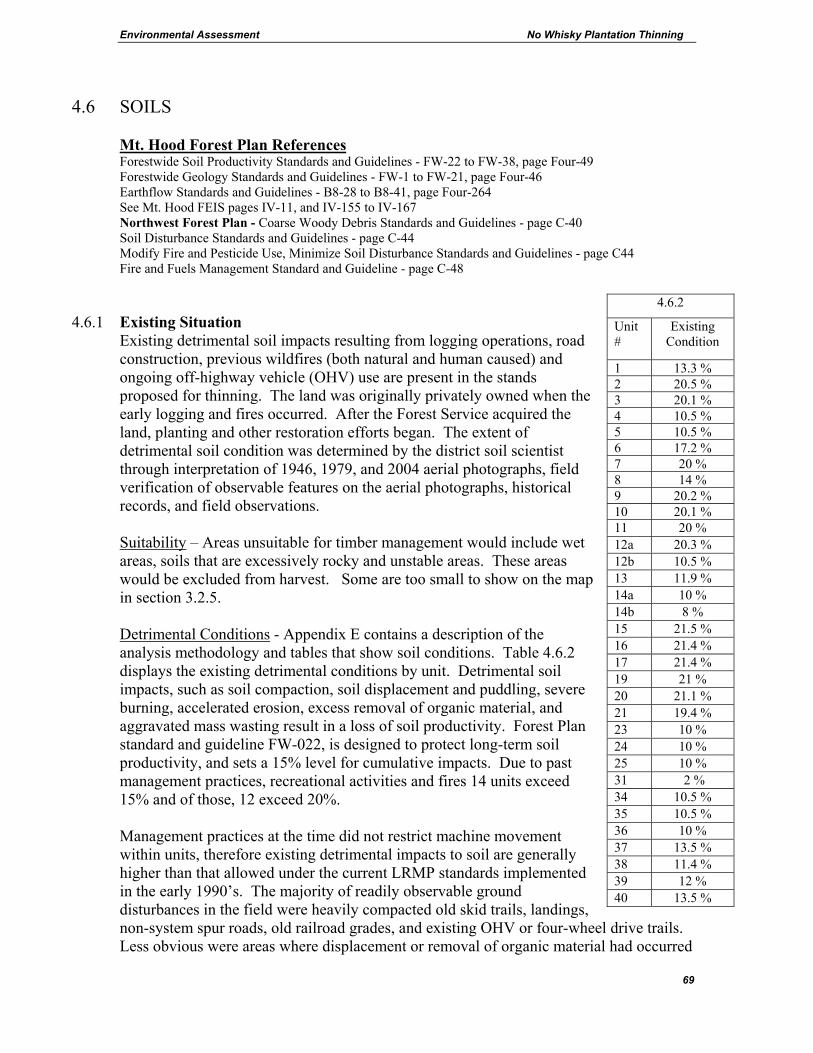
Environmental Assessment No Whisky Plantation Thinning
69
4.6 SOILS Mt. Hood Forest Plan References Forestwide Soil Productivity Standards and Guidelines - FW-22 to FW-38, page Four-49 Forestwide Geology Standards and Guidelines - FW-1 to FW-21, page Four-46 Earthflow Standards and Guidelines - B8-28 to B8-41, page Four-264 See Mt. Hood FEIS pages IV-11, and IV-155 to IV-167 Northwest Forest Plan - Coarse Woody Debris Standards and Guidelines - page C-40 Soil Disturbance Standards and Guidelines - page C-44 Modify Fire and Pesticide Use, Minimize Soil Disturbance Standards and Guidelines - page C44 Fire and Fuels Management Standard and Guideline - page C-48
4.6.1 Existing Situation Existing detrimental soil impacts resulting from logging operations, road construction, previous wildfires (both natural and human caused) and ongoing off-highway vehicle (OHV) use are present in the stands proposed for thinning. The land was originally privately owned when the early logging and fires occurred. After the Forest Service acquired the land, planting and other restoration efforts began. The extent of detrimental soil condition was determined by the district soil scientist through interpretation of 1946, 1979, and 2004 aerial photographs, field verification of observable features on the aerial photographs, historical records, and field observations. Suitability – Areas unsuitable for timber management would include wet areas, soils that are excessively rocky and unstable areas. These areas would be excluded from harvest. Some are too small to show on the map in section 3.2.5. Detrimental Conditions - Appendix E contains a description of the analysis methodology and tables that show soil conditions. Table 4.6.2 displays the existing detrimental conditions by unit. Detrimental soil impacts, such as soil compaction, soil displacement and puddling, severe burning, accelerated erosion, excess removal of organic material, and aggravated mass wasting result in a loss of soil productivity. Forest Plan standard and guideline FW-022, is designed to protect long-term soil productivity, and sets a 15% level for cumulative impacts. Due to past management practices, recreational activities and fires 14 units exceed 15% and of those, 12 exceed 20%. Management practices at the time did not restrict machine movement within units, therefore existing detrimental impacts to soil are generally higher than that allowed under the current LRMP standards implemented in the early 1990’s. The majority of readily observable ground disturbances in the field were heavily compacted old skid trails, landings, non-system spur roads, old railroad grades, and existing OHV or four-wheel drive trails. Less obvious were areas where displacement or removal of organic material had occurred
4.6.2
Unit #
Existing Condition
1 13.3 % 2 20.5 % 3 20.1 % 4 10.5 % 5 10.5 % 6 17.2 % 7 20 % 8 14 % 9 20.2 % 10 20.1 % 11 20 % 12a 20.3 % 12b 10.5 % 13 11.9 % 14a 10 % 14b 8 % 15 21.5 % 16 21.4 % 17 21.4 % 19 21 % 20 21.1 % 21 19.4 % 23 10 % 24 10 % 25 10 % 31 2 % 34 10.5 % 35 10.5 % 36 10 % 37 13.5 % 38 11.4 % 39 12 % 40 13.5 %
Environmental Assessment No Whisky Plantation Thinning
70
from historic logging activity. Soils that are impacted take time to recover; tree roots and burrowing animals eventually penetrate hardened soil and organic layers are reestablished in time. There is the opportunity to speed the recovery process by using machines such as subsoilers that fracture compacted soils. Landings and temporary roads are good candidates for mechanical treatment. Skid trails in plantations pose a dilemma for mechanical treatment because tree roots have penetrated the skid trails. Mechanical treatment in these cases may cause excessive root damage that would lead to reduced growth, and increased root disease and tree mortality. Organic Matter/Soil Fertility - Duff layers are relatively thin, presumably due to the past fire history, and range from ¼ to 1 ½ inches with an average of ½ inch. Generally there is a lack of course woody debris (CWD) on the forest floor in most units. Levels are well below historic ranges of CWD that naturally occurred in pre-settlement times in these types of plant communities. The reduced duff layers and general lack of CWD may be a factor in the large number of trees in the sale area that appeared chlorotic. Soil Erosion - On gentle slopes, surface erosion potential is low to moderate and subsoil erosion potential is moderate to high. On steeper slopes, surface erosion potential is moderate and subsoil erosion potential is high. Existing surface erosion is mainly confined to exposed soil on skidtrails, unpaved road surfaces, road cutbanks, road ditches, and OHV trails. The heavy OHV use on certain old temporary roads, landings and skid trails in the La Dee Flat area has created an ongoing erosion problem but the erosion associated with OHV use is not being transported to streams (s. 4.2.11). Unstable slope condition - Some units lie near geologic features with the potential for instability. The southern edge of the La Dee Flat bench, just on the rim of the main Clackamas River Canyon is one such area. There is an extreme slope break at this edge, and there are readily observable unstable features. These features are intermittently located along the bench margin and include old and recent failure scarps, tension cracks, down trees and seeps. Unit boundary locations adjacent to unstable areas would be identified on the ground by the Forest geologist. OHV use – There is an extensive network of temporary roads, landings and skidtrails, created during previous thinning entries in the 1970s and 1980s, on La Dee Flat. The majority of these features are currently vegetated and are not being used by OHVs, but approximately 10% of the 135 landings located within units adjacent to the 4610 and 4611 road systems are being used by OHVs as entry points into the unit interiors. Highest OHV use seems to be where topography and poor drainage allow for mud puddles to form, where undulating topography allows for hill climb experiences or where a series of trails and roads connect to form loops. General observations by law enforcement and district employees have indicated that OHV use in the area has increased in recent years, mainly from extensions of currently used trails and enlargement of landing areas. OHV trails and the impacts from past logging are included in the existing condition figures in s. 4.6.2.

Environmental Assessment No Whisky Plantation Thinning
71
4.6.3 Effects
An estimate of detrimental soil condition resulting from proposed logging, road and landing construction, reopening of old roads and felling activities was determined for each alternative. Calculations include anticipated road rehabilitation projects listed below. It was assumed landings created during previous entries would be re-used and where previous entries created higher percent detrimental conditions, a progressively greater number of existing skidtrails would be available to be re-used.
4.6.4 Alternative A Forest organic litter input, organic decomposition rates, duff layer development and soil fauna and microbe activity would remain at current levels. Organic materials would be subject to natural disturbances such as windthrow and fire. With no action, the current OHV situation would continue. Detrimental soil conditions may increase as a result of OHV use. Elsewhere, detrimental soil conditions would remain the same in the short term but would eventually slowly decline as compacted areas move toward recovery due to physical and biological processes.
4.6.5 Action Alternatives Old roads, landings and skid roads would generally be reused. Mechanical felling might occur in all or portions of units where slopes are less than 40%. Use of existing skidtrails and landings would occur where appropriate. After logging is complete, where detrimental soil conditions are in excess of the Forest Plan standards, all newly constructed and re-opened roads would be obliterated and revegetated with native species. Soils and long-term productivity are addressed by Forest Plan Standards and Guidelines for detrimental soil condition, and the retention of woody debris, ground cover, and live trees. The goal of these standards and guidelines is to protect soil structure and macropore space and soil organisms such as mycorrhizal fungi. Use of Best Management Practices and project design for harvest units and temporary road construction would result in meeting applicable standards for soil protection and long-term site productivity involving woody debris, ground cover, and live tree retention. Soil Detrimental Condition. Section 4.6.6 shows the estimated percent of each unit in a detrimental soil condition by alternative. Potential soil disturbances that have been considered are road and landing construction, reopening of old roads, OHV trails and felling and harvest operations. Calculations include obliteration of newly constructed temporary roads, obliteration of the reopened old temporary roads, and obliteration of temporary roads and landings used this entry on units where percent detrimental soil condition is greater than the Forest Plan standards.

Environmental Assessment No Whisky Plantation Thinning
72
A net increase in detrimental soil condition is predicted where more skidtrails, yarding corridors, landings and roads would be constructed than already exist. In units with greater than 15% detrimental conditions, restoration of temporary roads and landings by subsoiling and revegetation would initiate recovery of productivity, but is unlikely to return the soil to its original condition and productivity. It is estimated that 19 units would exceed 15%.
4.6.6 Projected Soil Impact by Alternative Alternative B Alternative C Alternative D
Unit #
Existing Condition
%
Direct effect
%
Cumulative Effect
%
Direct effect
%
Cumulative Effect
%
Direct effect
%
Cumulative Effect
% 1 13.3 2.1 15.4 1 14.3 1 14.3 2 20.5 0.3 20.8 0.3 20.8 0.3 20.8 3 20.1 0.3 20.4 0.3 20.4 0.3 20.4 4 10.5 2.8 13.3 2.8 13.3 2.8 13.3 5 10.5 2.5 13 2.5 13 2.5 13 6 17.2 1.3 18.5 1.3 18.5 1.3 18.5 7 20 0.3 20.3 0.3 20.3 0.3 20.3 8 14 2.3 16.3 2.3 16.3 2.3 16.3 9 20.2 0.3 20.5 0.3 20.5 0.3 20.5 10 20.1 0.3 20.4 0.3 20.4 0.3 20.4 11 20 0.3 20.3 0.3 20.3 0.3 20.3 12a 20.3 0.3 20.6 0.3 20.6 0.3 20.6 12b 10.5 2.8 13.3 2.8 13.3 2.8 13.3 13 11.9 2.8 14.7 2.8 14.7 2.8 14.7 14a 10 2.8 12.8 2.8 12.8 2.8 12.8 14b 8 1 9 1 9 1 9 15 21.5 0.3 21.8 0.3 21.8 0.3 21.8 16 21.4 0.3 21.7 0.3 21.7 0.3 21.7 17 21.4 0.3 21.7 0.3 21.7 0.3 21.7 19 21 0.3 21.3 0.3 21.3 0.3 21.3 20 21.1 0.3 21.4 0.3 21.4 0.3 21.4 21 19.4 -0.6 18.8 -0.6 18.8 -0.6 18.8 23 10 2.8 12.8 2.8 12.8 2.8 12.8 24 10 2.3 12.3 1.3 11.3 1.3 11.3 25 10 3.5 13.5 1 11 1 11 31 2 5.7 7.7 5.7 7.7 5.7 7.7 34 10.5 1 11.5 1 11.5 1 11.5 35 10.5 1 11.5 1 11.5 1 11.5 36 10 2.5 12.5 2.5 12.5 2.5 12.5 37 13.5 2.3 15.8 2.3 15.8 2.3 15.8 38 11.4 3.4 14.8 0.6 12 0.8 12.2 39 12 3.3 15.3 1.1 13.1 1.5 13.5 40 13.5 2.3 15.8 2.3 15.8 2.3 15.8

Environmental Assessment No Whisky Plantation Thinning
73
4.6.7 Soil Erosion
Bare soil would be exposed as logs are dragged on and machines travel over the ground surface. Erosion would not occur where duff and other effective ground cover is retained. Therefore, practices which limit the amount of soil exposure, or which re-establish ground cover after soil is exposed, would result in less erosion. Of the proposed yarding systems, ground based systems result in a greater amount of ground exposure than skyline and helicopter systems. Units that are prescribed for ground based systems generally have gentle to moderate slopes, so even if the potential for erosion may be high, eroding materials would not move far before redeposition occurs. When Best Management Practices are implemented there is a low potential for sediment to be delivered to streams. Low slopes, use of designated skidtrails, and establishing effective ground cover by applying seed, fertilizer, and straw mulch on the disturbed soils would aid in minimizing erosion. Organic Matter/Soil Fertility - Full suspension yarding would minimize duff disturbance in skyline operations. Designated skidtrails and the re-use of existing skidtrails in ground-based yarding operations would minimize duff layer disturbance by limiting tractors to skidtrails and minimize the amount of area over which logs are dragged across the soil surface. Soil microbial populations would likely be reduced initially in areas of exposed soils until soil organic matter and litter layers build back up. Leaving slash and needles where trees are felled should help maintain carbon and nutrient levels. Some trees would be felled and left to create new woody debris (s. 3.6.3). OHV use: Design Criteria #6.6 in section 3.6 is designed to prevent the expansion of OHV use onto temporary roads, landings and skid trails that are used by the operator. Preventive actions would be taken such as placing sufficient quantities of debris on temporary roads, landings and skidtrails to block OHV use in areas of concern. It would also restrict equipment near roads 4610 and 4611 to retain existing brush and other vegetation. Most of the 135 existing landings and connected skidtrails within the proposed No Whisky units adjacent to roads 4610 and 4611 (units 2, 3, 5, 6, 7, 8, 9, 10, 11, 12a, 14, 15, 16, 17) are now vegetated with brush, deciduous trees and young conifers, and are not currently used by OHVs. Some of these landings and connected skidtrails would be re-opened and used with the No Whisky project. Without design criteria #6.6, the skidtrail systems that are located in areas of interest to OHV users (potential loop trails, areas where topography lacks drainage and results in puddles, areas where topography allows for hill climb experiences etc.) might become additional OHV use areas. However, the design criteria would reduce the likelihood that OHV users would be attracted into new areas.
4.6.8 Recovery - The detrimental soil condition would slowly decline as compacted areas recover due to physical and biological processes. Surface erosion rates would decline as exposed soils become revegetated. Soil microbial populations would slowly increase as soil organic matter and the litter layer build back up.
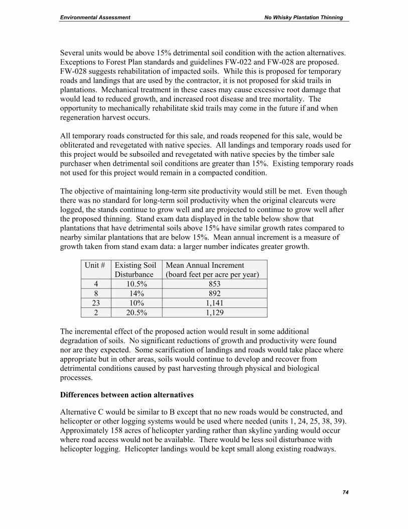
Environmental Assessment No Whisky Plantation Thinning
74
Several units would be above 15% detrimental soil condition with the action alternatives. Exceptions to Forest Plan standards and guidelines FW-022 and FW-028 are proposed. FW-028 suggests rehabilitation of impacted soils. While this is proposed for temporary roads and landings that are used by the contractor, it is not proposed for skid trails in plantations. Mechanical treatment in these cases may cause excessive root damage that would lead to reduced growth, and increased root disease and tree mortality. The opportunity to mechanically rehabilitate skid trails may come in the future if and when regeneration harvest occurs. All temporary roads constructed for this sale, and roads reopened for this sale, would be obliterated and revegetated with native species. All landings and temporary roads used for this project would be subsoiled and revegetated with native species by the timber sale purchaser when detrimental soil conditions are greater than 15%. Existing temporary roads not used for this project would remain in a compacted condition. The objective of maintaining long-term site productivity would still be met. Even though there was no standard for long-term soil productivity when the original clearcuts were logged, the stands continue to grow well and are projected to continue to grow well after the proposed thinning. Stand exam data displayed in the table below show that plantations that have detrimental soils above 15% have similar growth rates compared to nearby similar plantations that are below 15%. Mean annual increment is a measure of growth taken from stand exam data: a larger number indicates greater growth.
Unit # Existing Soil Disturbance
Mean Annual Increment (board feet per acre per year)
4 10.5% 853 8 14% 892 23 10% 1,141 2 20.5% 1,129
The incremental effect of the proposed action would result in some additional degradation of soils. No significant reductions of growth and productivity were found nor are they expected. Some scarification of landings and roads would take place where appropriate but in other areas, soils would continue to develop and recover from detrimental conditions caused by past harvesting through physical and biological processes.
Differences between action alternatives
Alternative C would be similar to B except that no new roads would be constructed, and helicopter or other logging systems would be used where needed (units 1, 24, 25, 38, 39). Approximately 158 acres of helicopter yarding rather than skyline yarding would occur where road access would not be available. There would be less soil disturbance with helicopter logging. Helicopter landings would be kept small along existing roadways.
Environmental Assessment No Whisky Plantation Thinning
75
Alternative D is similar to C but would not thin in riparian reserves. As in Alternative C, those units where new roads would not be constructed would be logged using helicopter or other logging systems (units 1, 24, 25, 38, 39). There would be less soil disturbance in 45 acres of riparian reserves.
4.7 SCENERY Mt. Hood Forest Plan References Forestwide Visual Resource Standards and Guidelines - FW-552 to FW-597, page Four-107 Scenic Viewsheds Standards and Guidelines - B2-12 to B2-42, page Four-221 Mt. Hood FEIS pages IV-127, IV-131, IV-142, and IV-155 to IV-167 This analysis considers past timber harvest and road construction as well as concurrently planned timber sales and reasonably foreseeable future actions that have occurred or may occur in the area seen from the No Whisky viewer positions.
4.7.1 Existing Situation The project cannot be seen from any primary viewer positions such as heavily traveled highways or campgrounds. The Visual Quality Objective (VQO) assigned to most of the units is modification. The North Fork Clackamas River is an eligible scenic river and therefore carries a VQO of retention in the foreground and partial retention in the middle ground as seen from the river. Portions of units 1, 4,12b, 13, 31, 34 and 35 are within the Retention zone. Due to breaks in topography, none of the other units can be seen from the river. The area seen from the river currently meets the VQOs of retention in the foreground and partial retention in the middleground. The primary concern for most of the units is how the area appears as seen from less traveled open backcountry roads. Under the modification VQO, human activity may dominate the characteristic landscape but would utilize naturally established form, line, color, and texture. The viewer positions would be from local roads that are traveled by the recreating public. Most of the local roads were built by timber operators to access past timber sales, but they are now used by a wide range of forest visitors. Currently, the local landscape near harvest units meets the VQO of modification. The forest visitor would experience older second-growth forest without obvious straight lines or high levels of vertical contrast. The proposed harvest areas are surrounded by other second-growth forest stands; therefore there is not much vertical or horizontal contrast.
Effects
4.7.2 Alternative A:
Changes in scenery would come slowly from forest growth. Stands would continue to have unbroken uniformity.
4.7.3 Effects to scenery as seen from local roads for the action alternatives: Some minor changes to foreground views from local open roads would occur. Log landings,
Environmental Assessment No Whisky Plantation Thinning
76
temporary roads, landing slash piles and skid trails and skyline corridors that lead to the landings would be noticeable in the short term by viewer positions at the landings. Landing size would be kept to the minimum size needed for safety and areas of bare soil would be seeded with grass for erosion control. The thinned forest may have some bare soil, red slash and stumps visible in the short term, but over time this would become less noticeable. The units would meet the VQO of modification from these viewer positions.
4.7.4 Effects to scenery as seen from the North Fork Clackamas River for the action
alternatives: The portions of units 1, 4,12b, 13, 31, 34 and 35 that are within the river’s viewshed are screened from view by riverside trees. It is not likely that thinning would be noticeable by viewers at the river. Landings and roads associated with these units would not be seen. The units would meet the VQO of retention and partial retention as seen from the river.
4.8 BOTANY This section addresses effects to threatened or endangered botanical species including species proposed for listing. It also addresses botanical sensitive and survey and manage species. The Botany Biological Evaluation (found in Appendix D) is incorporated by reference and summarized below. Mt. Hood Forest Plan References Forestwide Threatened, Endangered and Sensitive Plants and Animals Standards and Guidelines - FW-170 to FW-186, page Four-69 See FEIS pages IV-76 and IV-90 Northwest Forest Plan - Appendix J2 There are no Proposed, Threatened or Endangered botanical species affected by the proposed action. Surveys were conducted for Sensitive and Survey and Manage botanical species in 2005, in the proposed units and in similar habitats (e.g. streams) if immediately adjacent to the proposed units. Several fungi that have potential habitat in the project area are not considered practical to detect with field surveys with the exception of Bridgeoporus nobilissimus. It is assumed that these species are present. The following list contains the species that have potential habitat for this project. Two lichens were located that are on both the sensitive and survey and manage species lists. A number of locations for Usnea longissima (Methuselah’s Beard) and Peltigera pacifica, were found. The trees with these lichens would be marked as leave trees.

Environmental Assessment No Whisky Plantation Thinning
77
NI = No Impact MII = May Impact Individuals but would not lead to a trend toward federal listing. Species Group Impact Cimicifuga elata Vascular Plant NI Diphasiastrum complanatum Vascular Plant NI Montia howellii Vascular Plant NI Rhizomnium nudum Bryophytes NI Schistostega pennata Bryophytes NI Tetraphis geniculata Bryophytes NI Chaenotheca subroscida Lichens NI Hypogymnia duplicata Lichens NI Leptogium burnetaie var. hirsutum Lichens NI Leptogium cyanescens Lichens NI Lobaria linita Lichens NI Pannaria rubiginosa Lichens NI Peltigera neckeri Lichens NI Peltigera pacifica Lichens NI Usnea longissima Lichens NI Bridgeoporus nobilissimus Fungi NI Cordyceps capitata Fungi MII Cortinarius barlowensis Fungi MII Cudonia monticola Fungi MII Gomphus kauffmanii Fungi MII Gyromitra californica Fungi MII Leucogaster citrinus Fungi MII Mycena monticola Fungi MII Otidea smithii Fungi MII Phaeocollybia attenuata Fungi MII Phaeocollybia californica Fungi MII Phaeocollybia oregonensis Fungi MII Phaeocollybia piceae Fungi MII Phaeocollybia pseudofestiva Fungi MII Phaeocollybia scatesciae Fungi MII Ramaria amyloidea Fungi MII Ramaria gelatiniaurantia Fungi MII Sowerbyella rhenana Fungi MII
4.9 MANAGEMENT OF COMPETING AND UNWANTED VEGETATION
This section addresses invasive plants and unwanted vegetation. An Invasive Plant Risk Analysis has been generated by the team botanist. It is included in the analysis file and is incorporated by reference and summarized below.
Environmental Assessment No Whisky Plantation Thinning
78
Mt. Hood Forest Plan References Forestwide Timber Management Standards and Guidelines - FW-375 to FW-385, page Four-91 Record of Decision for Preventing and Managing Invasive Plants (2005) The Record of Decision and Mediated Agreement (MA) for the "Managing Competing and Unwanted Vegetation" Final Environmental Impact Statement (FEIS) apply to invasive plants (sometimes called noxious weeds), unwanted native vegetation, brush control and fuel treatments. Invasive plant management is now covered by the 2005 Record of Decision for Preventing and Managing Invasive Plants (USDA 2005) that amended the Forest Plan. The use of herbicides is not being proposed for any of the activities associated with the No Whisky project. Fuels treatments are exempt from the requirements above in thinning projects. Slash treatments associated with road construction is included. Invasive plants are species not native to a particular ecosystem that may cause economic or environmental harm, or harm to human health. They include, but are not limited to, the Oregon Department of Agriculture (ODA) Noxious Weed list. Invasive Plants may disrupt natural ecosystems by displacing native species and reducing natural diversity through the replacement of native communities with invasive monotypic weed stands. The noxious weeds of concern (Oregon Department of Agriculture “B” rated weeds) are located along roads that lead into and adjacent to the proposed project. They are Cytisus scoparius, Scotch broom; Hypericum perforatum, St. John’s wort; Senecio jacobea, tansy ragwort; Circium arvense, Canada thistle and Circium vulgare, bull thistle. The action alternatives would have a risk ranking of high but the design criteria would be followed to reduce the chances of these weeds spreading to new areas. Bio-control insects are established and are the primary means of control for Scotch broom and St. John’s wort. With the shade provided by the forest canopy, these weeds are not likely to spread into the stands. Equipment cleaning would prevent weeds from spreading along roads to new uninfested sites. The following analysis covers the proposed treatment of slash from temporary roads and landings. Appropriate design criteria would be incorporated into project work to minimize potential adverse impacts to the environment, project workers, and public. Site Specific Objectives for Roads and Landing Related Slash and Vegetation: • Vegetation control shall be completed along Forest roads to provide for user safety
(FW-428). • Dead, down woody material loading levels shall be managed to provide for multiple
resource objectives. Fuel profiles shall be identified, developed and maintained that contribute to the most cost effective fire protection program consistent with Management Area objectives (FW-263 and FW-265).
Environmental Assessment No Whisky Plantation Thinning
79
Expected Site Conditions Site conditions do exist that favor the presence of slash from newly constructed roads and other vegetative debris created during road maintenance or other reconstruction projects. Treatment of road related slash and vegetation would be needed to meet the safety needs and fuel management objectives. Damage thresholds for road projects would be exceeded if slash and debris obscures driver visibility or if there is greater than 15 tons/acre of slash in the 0-3" size class adjacent to the road. Road construction, reconstruction and maintenance projects are expected to need treatment of both live vegetation and slash so that management objectives can be attained. For road projects, the correction strategy is selected when the damage thresholds are exceeded. The following methods would be used where needed: Lop and Scatter - this method would entail manually cutting the slash or brush with chain saws and then scattering it outside the road prism. Piling and Burning - this method would use mechanical equipment to pile the slash. The piles would then be burned under a set of prescribed weather conditions.
The potential effects of the above treatments that have been considered include soil compaction, puddling, surface erosion, consumed coarse woody debris, removal of surface organic matter, overheating the soil, scorch or death of reserve trees, air quality degradation and the potential for an "escape" becoming a wildfire. A more complete discussion of the effects on these resources can be found elsewhere in this document. Adverse impacts would be prevented or minimized by the proper use of equipment, project supervision, training, the seasonal timing of activities, the development of a site specific burn plan, and the incorporation of appropriate design criteria.
4.10 AIR QUALITY Mt. Hood Forest Plan References Forestwide Air Quality Standards and Guidelines – FW-39 to FW-53, page Four-51 See Mt. Hood FEIS pages IV-19, and IV-155 to IV-167. Existing Situation – Air quality may be affected by burning of slash. Currently the harvest units have slash accumulations of approximately 5-10 tons per acre. Effects – Including Direct, and Indirect and Cumulative Effects Alternative A would not change air quality. Action Alternatives Dust from vehicles would not likely affect air quality. Dust from these roads would not drift toward campgrounds or any other area of popular public use. Landing slash would be burned. There would not likely be very much slash at the landings to burn because many units would use harvester/processors which leave the

Environmental Assessment No Whisky Plantation Thinning
80
limbs and tops in the units. Slash and debris would also be used to cover skid trails and temporary roads. Any pieces of wood that come to the landing that are suitable for firewood would be removed for that purpose. What small amount of debris remaining at the landings would be burned. Burning has the potential to degrade air quality for short periods of time. The principle impact to air quality from burning is the temporary visibility impairment caused by smoke to the recreational users. Past experience has shown that air quality declines are limited in scope to the general burn area and are of short duration. The effects to forest visitors would be minimal because burning would happen after the peak recreation season, in the fall (October – December) or during periods of inclement weather. Slash in the harvest units would not be burned. In addition to existing slash, the branches and tops of harvested trees would increase fuels by approximately 5 tons per acre. Indirect Effects – The following are areas of concern for smoke intrusion: Portland/ Vancouver Metropolitan Area, Mt. Hood Wilderness, Bull of the Woods Wilderness, Salmon –Huckleberry Wilderness and Mt. Jefferson Wilderness. To protect visibility in these Class I areas, prescribed burning would be restricted from July 4th weekend to September 15. All prescribed burning would be scheduled in conjunction with the State of Oregon to comply with the Oregon Smoke Implementation Plan to minimize the adverse effects on air quality. Burning would be conducted when smoke dispersion conditions are favorable to minimize the potential for adverse effects. Direct Effects – Health risk are considered greater for those individuals (workers and others) in close proximity to the burning site. Particulate matter is measured in microns and calculated in pounds per ton of fuel consumed. Particulate matter that is 10 microns or less in size create the greatest health risk. At this size the material can move past normal pulmonary filtering processes and be deposited into lung tissue. Particulates larger than 10 microns generally fallout of the smoke plume a short distance down range. Members of the public are generally not at risk. Few health effects from smoke should occur to Forest users due to their limited exposure. Due to the distance involved and the season of the burn, strong inversions are unlikely to develop and hold a dense smoke plume to adversely affect residential areas. Cumulative Effects - The areas of highest concern for possible impacts to air quality discussed above are far from the project. The project is outside Class I airsheds. The area of analysis is a large “airshed” which encompasses much of the Forest as well as adjacent forest, farm and urban areas. The Forest’s contribution to the air pollution of the region is only partially controllable or predictable due to the wildfire situation. When prescribed burning associated with No Whisky or any other timber sale on the Forest, or other burning projects is scheduled in conjunction with the State of Oregon to comply with the Oregon Smoke Implementation Plan, smoke dispersion conditions would be favorable and potential cumulative effects would be minimized. Any time fuels are reduced whether by prescribed burning or other means, the potential for wildfire smoke intrusion into high concern areas is reduced. The incremental effect of the proposed action is negligible therefore there would be no discernable cumulative effect.
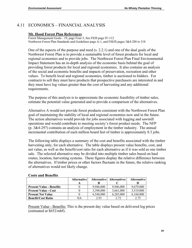
Environmental Assessment No Whisky Plantation Thinning
81
4.11 ECONOMICS – FINANCIAL ANALYSIS Mt. Hood Forest Plan References Forest Management Goals - 19, page Four-3, See FEIS page IV-112 Northwest Forest Plan Standards and Guidelines page A-1, and FSEIS pages 3&4-288 to 318 One of the aspects of the purpose and need (s. 2.2.1) and one of the dual goals of the Northwest Forest Plan is to provide a sustainable level of forest products for local and regional economies and to provide jobs. The Northwest Forest Plan Final Environmental Impact Statement has an in-depth analysis of the economic basis behind the goal of providing forest products for local and regional economies. It also contains an analysis of the social and economic benefits and impacts of preservation, recreation and other values. To benefit local and regional economies, timber is auctioned to bidders. For contracts to sell they must have products that prospective purchasers are interested in and they must have log values greater than the cost of harvesting and any additional requirements. The purpose of this analysis is to approximate the economic feasibility of timber sales, estimate the potential value generated and to provide a comparison of the alternatives. Alternative A would not provide forest products consistent with the Northwest Forest Plan goal of maintaining the stability of local and regional economies now and in the future. The action alternatives would provide for jobs associated with logging and sawmill operations and would contribute to meeting society’s forest product needs. The NFP (p. 3&4-297) contains an analysis of employment in the timber industry. The annual incremental contribution of each million board feet of timber is approximately 8.3 jobs. The following table displays a summary of the cost and benefits associated with the timber harvesting only, for each alternative. The table displays present value benefits, cost, and net value, as well as the benefit/cost ratio for each alternative as if it was sold as one timber sale. The selected alternative may be divided into multiple timber sales based on haul routes, location, harvesting systems. These figures display the relative difference between the alternatives. If timber prices or other factors fluctuate in the future, the relative ranking of alternatives would not likely change. Costs and Benefits
AlternativeA
AlternativeB
Alternatives C
Alternative D
Present Value - Benefits 0 9,946,000 9,946,000 9,679,000 Present Value - Cost 0 3,398,000 3,661,000 3,519,000 Present Net Value 0 6,548,000 6,285,000 6,160,000 Benefit/Cost Ratio NA 2.93 2.72 2.75 Present Value - Benefits: This is the present day value based on delivered log prices (estimated at $652/mbf).
Environmental Assessment No Whisky Plantation Thinning
82
Present Value - Cost: This is the present day value of the cost associated with harvesting (estimated harvesting cost is $190/mbf for mechanical, $290/mbf for skyline and $450/mbf for helicopter). Present Net Value: This is the present net value of the alternative, which is based on the value of delivered logs to a mill minus the value of cost associated with harvesting. Benefit Cost Ratio: This is a ratio derived from dividing the “Present Value – Benefits” by the “Present Value – Cost”. The bidding results of the timber sales sold recently indicates substantial competition for forest products in the region as well as a high demand for forest products from the Mt. Hood National Forest. Timber sales prepared from the No Whisky project would provide forest products consistent with the Northwest Forest Plan goal of maintaining the stability of local and regional economies now and in the future. Administrative costs are not included in the analysis above. Administrative costs for planning are already spent and would be the same for all alternatives including the no-action alternative. Other costs for timber sale preparation and sale administration for the action alternatives would be approximately proportional to the acres of each alternative.
4.12 TRANSPORTATION
Mt. Hood Forest Plan References Forestwide Timber Management Standards and Guidelines - FW-407 to FW-437, page Four-95 See FEIS page IV-123 Roads Analysis is a process of considering landscape-level information before making site-specific decisions about road management. A Roads Analysis has been developed at the Forest scale (USDA 2003a). Road management decisions are informed by this Forest-level analysis, and are focused by project-level specific information. Across the Forest, funding for road maintenance is lower than the level needed to properly maintain the approximate 3000 miles of open roads on the Forest. The Forest-wide Roads Analysis identified, for approximately half of the current road system, the need to change maintenance levels to lower standards, to store roads in a maintenance level one category or decommission. This discussion relates to system roads. There are also many temporary roads constructed and closed by loggers that do not result in the expenditure of road maintenance funds. The objective of this project-level roads analysis is to provide information to decision makers so that the future road system can be one that is safe, environmentally sound, affordable and efficient. A project level roads analysis may include topics such as: 1) construction of new permanent system roads, 2) reconstruction of existing roads needed for the project, 3) making changes to road maintenance levels, 4) decommissioning system roads, 5) storm proofing, 6) road closures and
Environmental Assessment No Whisky Plantation Thinning
83
7) the construction or reconstruction of temporary roads. The items particularly relevant to the No Whisky project are #2 and 7. Existing Situation There are no inventoried roadless areas in the project area. No uninventoried roadless areas have been identified. To the east and south of the project area, there are areas being considered for wilderness designation. Unit 16 is the only unit near the potential wilderness and it has been thinned before and roads already exist to access the unit. The project can be accessed from road 4610, the primary haul route. The closure of currently open system roads is not part of the proposed action. Open road density would remain unchanged for all alternatives including No Action. Alternative A No roads would be built or repaired. Action Alternatives The action alternatives would utilize helicopters. There are existing landings along existing roads that would meet the needs of helicopter operations. The unit tables in section 3 show the lengths of old existing temporary roads would be reopened to access the units. These roads are on dry stable landforms and do not cross any streams. In addition, approximately 4 miles of bermed system roads would be opened. Bermed system roads include 4610014, 4610019, 4610026, 4610120, 4613012, 4613013, 4613200 and 4614125. These roads are also on dry stable landforms and do not cross any streams. These roads would not be open to the public. They would temporarily be used by the loggers, truck drivers and Forest Service personnel. After logging, the roads that were opened would be closed. There would be no increase in the permanent roads open to the public. Also, gates would be temporarily opened to access roads 4610113, 4610016 and 4614120. Alternative B Alternative B would construct new temporary roads (1.2 miles) to access landings. The new temporary roads are located on dry stable landforms and do not cross any streams. Alternatives C and D would not construct new temporary roads.
Environmental Assessment No Whisky Plantation Thinning
84
4.13 HERITAGE RESOURCES Mt. Hood Forest Plan References Forestwide Timber Management Standards and Guidelines - FW-598 to FW-626, page Four-118 See FEIS page IV-149 and IV-155 to IV-167 Surveys conducted for this project located no new sites. This project is discussed in heritage resource report number 01-05-01. Remnants of a railroad logging camp and a trestle occur near unit 15. There would be no anticipated effects on heritage resources. Contracts would contain provisions for the protection of sites found during project activities. Documentation of this information has been forwarded to the State Historic Preservation Office.
4.14 ENVIRONMENTAL JUSTICE – CIVIL RIGHTS Executive Order 12898 directs agencies to identify and address disproportionately high and adverse human health or environmental effects of projects on certain populations. This includes Asian Americans, African Americans, Hispanics, American Indians, low-income populations and subsistence uses. The Civil Rights Act of 1964 prohibits discrimination in program delivery and employment. A report detailing Environmental Justice and Civil Rights issues is in the analysis file and is summarized here. There are communities with minorities and low-income populations that may be affected by the project. The town of Estacada (the nearest community) is approximately 12 miles away. Even farther away, but potentially affected are the American Indian communities of Warm Springs and Grande Ronde. There are no known areas of religious significance in the area. There are no known special places for minority or low-income communities in the area. Individuals may work, recreate, gather forest products or have other interests in the area. The report found that impacts and benefits of the No Whisky Plantation Thinning would not fall disproportionately on minorities or low-income populations. No adverse civil rights impacts were identified.
4.15 RECREATION Mt. Hood Forest Plan References Forestwide Timber Management Standards and Guidelines - FW-453 to FW-466, page Four-98 See FEIS page IV-127 In the vicinity of the No Whisky units there are no campgrounds, trails or other destination recreation features. The project area is relatively close to urban areas and is often used for dispersed camping, Off-Highway Vehicle (OHV) riding, hunting and for gathering special forest products such as mushrooms. Fire rings are present at old landings and road junctions. With the action alternatives, there may be short-term movement of individuals or groups during project implementation. Even with this temporary displacement, the availability of dispersed recreation opportunities on a landscape level would not be negatively affected. Many thousands of acres are available for camping and other forms of recreation and the No Whisky units do not represent a

Environmental Assessment No Whisky Plantation Thinning
85
special or unique recreational opportunity that is not available elsewhere. The no-action alternative would not have these effects. The effects to recreational fisheries would be minimal because fish habitat conditions downstream would not be detrimentally affected and because the roads in the project are not used by fishers to access fish bearing streams. Access to streams for angling is not altered by any of the action alternatives. Within the project area, unauthorized OHV use and shooting are occurring. OHV use includes all terrain vehicles, motorcycles and 4-wheel drive trucks some of which occurs on roads and some off roads. Shooting with guns is primarily for target practice, some of which causes severe damage or death of trees. Areas used for shooting are also littered with debris, trash, shells, broken glass and other remnants of targets. Trees are often targeted until they fall. Unauthorized OHV use and shooting are controlled by an administrative order available at Forest offices. Order number MH-256-03-98 requires that vehicles remain on designated roads. Order number MH-224-05-93 bans shooting (except for legal hunting) in the La Dee Flat area. The dumping of trash and vehicles also occurs. Law enforcement officers have been dealing with this unauthorized activity but some still occurs. The District has implemented various projects to reduce unauthorized use. However there are still concerns that logging activities could make new areas available for OHV use and/or shooting. Unauthorized shooting creates a safety hazard, harms trees, and results in trash and noise that disturbs other recreators and wildlife. There is an extensive network of temporary roads, landings and skidtrails, created during previous thinning entries in the 1970s and 1980s, on La Dee Flat. The majority of these features are currently vegetated and are not being used by OHVs, but approximately 10% of the 135 landings located within units adjacent to the 4610 and 4611 road systems are being used by OHVs as entry points into the unit interiors. Highest OHV use seems to be where topography and poor drainage allow for mud puddles to form, where undulating topography allows for hill climb experiences or where a series of trails and roads connect to form loops. Signs addressing the off road restriction have been repeatedly damaged, and compliance with the restriction has been difficult to enforce. Barriers (guardrails, boulders, root wads) have been placed at certain high impact areas, but in most cases, OHVs have driven around them creating new trails. General observations by law enforcement officers and district employees have indicated that most OHV use has been contained in current high use areas but that some expansion and pioneering of additional unauthorized routes is taking place in certain locations. Off road OHV use results in soil compaction, damage to tree roots and noise. In this area, OHV use is not creating a problem for stream sedimentation because the areas used are flat and not directly connected to streams. With other recent timber sales, efforts to minimize OHV expansion have been successful. Where temporary roads and skid trails went into areas that did not have preexisting use, closure efforts were successful. With this project, additional measures are proposed to further increase the likelihood of

Environmental Assessment No Whisky Plantation Thinning
86
success. Design Criteria #6.6 in section 3.6 is designed to prevent the expansion of OHV use onto temporary roads, landings and skid trails that are used by the operator. Preventive actions would be taken such as placing sufficient quantities of debris on temporary roads, landings and skidtrails to block OHV use in areas of concern. An analysis has begun on the Forest to determine where OHV use should be allowed and encouraged. La Dee Flat (including portions of the No Whisky project) is one of the areas under consideration. The analysis is still in the scoping phase and no site-specific proposals have been made. The area is being considered for OHV routes in part because there are few streams and the potential for impact to resources may be less at La Dee Flat than it would be elsewhere. With the no-action alternative, the current situation would continue. With the action alternatives, the strategy outlined with design criteria s. 3.6.6.6 would reduce the likelihood that OHV users would be attracted into new areas.
4.16 OTHER Farm And Prime Range Land There would be no effect upon prime farmland or prime rangeland. None are present. Flood Plains Or Wetlands No flood plains or wetlands are affected by the alternatives. Laws, Plans and Policies There are no identified conflicts between the proposed action and the objectives of Federal, Regional, State laws and local land use plans, or policies. Productivity The relationship between short-term uses and the maintenance of long-term productivity: no reductions in long-term productivity are expected. See soils section. Irreversible and Irretrievable Commitments The use of rock for road surfacing is an irreversible resource commitment.
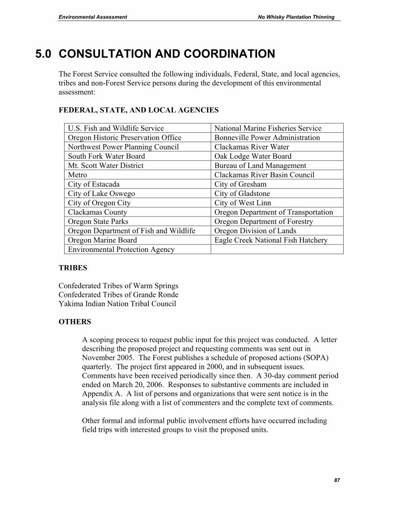
Environmental Assessment No Whisky Plantation Thinning
87
5.0 CONSULTATION AND COORDINATION The Forest Service consulted the following individuals, Federal, State, and local agencies, tribes and non-Forest Service persons during the development of this environmental assessment: FEDERAL, STATE, AND LOCAL AGENCIES
U.S. Fish and Wildlife Service National Marine Fisheries Service Oregon Historic Preservation Office Bonneville Power Administration Northwest Power Planning Council Clackamas River Water South Fork Water Board Oak Lodge Water Board Mt. Scott Water District Bureau of Land Management Metro Clackamas River Basin Council City of Estacada City of Gresham City of Lake Oswego City of Gladstone City of Oregon City City of West Linn Clackamas County Oregon Department of Transportation Oregon State Parks Oregon Department of Forestry Oregon Department of Fish and Wildlife Oregon Division of Lands Oregon Marine Board Eagle Creek National Fish Hatchery Environmental Protection Agency
TRIBES Confederated Tribes of Warm Springs Confederated Tribes of Grande Ronde Yakima Indian Nation Tribal Council
OTHERS
A scoping process to request public input for this project was conducted. A letter describing the proposed project and requesting comments was sent out in November 2005. The Forest publishes a schedule of proposed actions (SOPA) quarterly. The project first appeared in 2000, and in subsequent issues. Comments have been received periodically since then. A 30-day comment period ended on March 20, 2006. Responses to substantive comments are included in Appendix A. A list of persons and organizations that were sent notice is in the analysis file along with a list of commenters and the complete text of comments. Other formal and informal public involvement efforts have occurred including field trips with interested groups to visit the proposed units.

Environmental Assessment No Whisky Plantation Thinning
88
List of Preparers David Lebo - Westside Zone Botanist, Mt. Hood National Forest. B.A. Frostburg State College; M.A. University of Montana; M.S. University of Washington (forest ecology). David specializes in forest ecology and botany with a particular interest in cryptogamic botany (fungi, lichens, and bryophytes). He has worked for the Forest Service for two decades in Washington and Oregon including a six-year stint as interagency ecologist for the BLM and Forest Service in the Klamath Basin in southern Oregon. Glenda Goodwyne, - Forester, Certified Silviculturist. Glenda has B.S. Forest Management from Oregon State University, 1985 and an A.A.S. Forest Management from Tuskegee University, 1980. She completed Silviculture Institute at Oregon State University/University of Washington in 1998, and is certified as silviculturist and most recently re-certified in 2003. Glenda has worked as a forester with the Forest Service for 25 years in Oregon, Washington, and California. Bob Bergamini – Fisheries Biologist. A.A. Fisheries Technology, Mt. Hood Community College, B.A. Biology, University of Connecticut. He has worked for the Forest Service for 16 years. Sharon Hernandez - Wildlife Biologist. Sharon graduated from Michigan State University in 1992 with a B.S. in Wildlife Management. She has worked as a biologist for the Forest Service for 12 years in Washington and Oregon. Jim Roden - Writer/Editor. Jim has a B.S. in Forest Management from Northern Arizona University. He has worked as a forester for the Forest Service for 26 years in Wyoming, California, Idaho and Oregon. He is a specialist in timber sale planning, geographic information systems and economic analysis. James Rice – Supervisory Forester. Jim has a B.S. in Forest Science from Humboldt State University. He has worked for the Forest Service for 27 years in Southern California, Northern California and Oregon. He was a certified silviculturist in Region 5 and is currently a certified silviculturist in Region 6. Gwen Collier - Soil Scientist. Gwen has a B.S. in Biology and Environmental Science from Willamette University and a B.S. in Soil Science from Oregon State University. She has worked for the Forest Service for 27 years in Oregon, Washington and Idaho. She is a specialist in soil science and hydrology. Mike Redmond - Environmental Analysis Review - Mike has a B.S and a M.S. degree in Forestry from the University of Illinois. Mike has worked for the Forest Service for 28 years. He is a specialist in the preparation of environmental documents under the National Environmental Policy Act.

Environmental Assessment No Whisky Plantation Thinning
89
Ivars Steinblums - Forest Hydrologist. Ivars has a B.S. in Forestry from Humboldt State University (1973), and a M.S. in Forest Engineering (Watershed Management) from Oregon State University (1977). He has worked 2 years as a timber appraiser for county government in Northern California, and 28 years as a hydrologist for the Forest Service in California and Oregon. Jerry Polzin - Logging Systems Specialist. Jerry received a certificate of completion from Missoula Technical Center in 1977. He completed Forest Engineering Institute at Oregon State University in 1981 and Sale Area Layout and Harvest Institute in conjunction with Oregon State University and the University of Idaho in 2002. He has worked in timber sale preparation for the Forest Service for 25 years. Susan Rudisill - Archaeological Technician. Susan has worked for the Forest Service for 21 years. She has served as an Archaeological Technician for the Forest Service for 15 years in Oregon. Training: Archaeology at Mt. Hood Community College, Anthropology at Clackamas Community College, Lithic Analysis at The University of Nevada, Reno. She has also received the following training sessions through the Forest Service: Rec. 7, Federal Projects and Historic Preservation Laws. References
Anthony, R.G., E.D. Forsman, A.B. Franklin, D.R. Anderson, K.P. Burnham, G.C. White, C.J. Schwarz, J. Nichols, J. Hines, G.S. Olson, S.H. Ackers, S. Andrews, B.L. Biswell, P.C. Carlson, L.V. Diller, K.M. Dugger, K.E. Fehring, T.L. Fleming, R.P. Gerhardt, S.A. Gremel, R.J. Gutierrez, P. Happe, D.R. Herter, J.M. Higley, R.B. Horn, L.L. Irwin, P.J. Loschl, J.A. Reid, & S.G. Sovern. 2004. Status and Trends in Demography of Northern Spotted Owls. A Draft Report to the Interagency Regional Monitoring Program. Portland, Oregon. Austin, K. and K. Mellon. 1995. Cavity-Nesting Bird Habitat Guide: Western Cascades. Mt. Hood National Forest and Gifford Pinchot National Forest. USDA Forest Service. Pacific Northwest Region. Courtney, S P, J A Blakesley, R E Bigley, M L Cody, J P Dumbacher, R C Fleischer, AB Franklin, J F Franklin, R J Gutiérrez, J M Marzluff, L Sztukowski. 2004. Scientific evaluation of the status of the Northern Spotted Owl. Sustainable Ecosystems Institute of Portland Oregon. September 2004. <http://www.sei.org/owl/finalreport/finalreport.htm> Daniel, T. W., J.A. Helms, and F.S. Baker. 1979. Principles of Silviculture. McGraw-Hill, Inc. New York. p.122, 430-432. Johnson, David H. and Thomas A. O'Neil. 2001. Wildlife Habitat Relationships in Oregon and Washington. Oregon State University Press. p. 351.

Environmental Assessment No Whisky Plantation Thinning
90
Mellon et al. 2003. DecAID, the Decayed Wood Advisor for Managing Snags, Partially Dead Trees, and Down Wood for Biodiversity in Forests of Washington and Oregon. Pacific Northwest Research Station, USDA Forest Service. <http://wwwnotes.fs.fed.us:81/pnw/DecAID/DecAID.nsf> ODA, Oregon Department of Agriculture. 2003. Noxious Weed Policy and Classification, Oregon Department of Agriculture Noxious Weed Control Program. Oliver, C.D. and B.C. Larson. 1996. Forest Stand Dynamics. John Wiley & Sons, Inc. New York. p. 37-39, 75, 216, 217, 228, 229, 232, 233. Ruediger, Bill, Jim Claar, Steve Gniadek, Bryon Holt, Lyle Lewis, Steve Mighton, Bob Naney, Gary Patton, Tony Rinaldi, Joel Trick, Anne Vandehey, Fred Wahl, Nancy Warren, Dick Wenger, and Al Williamson. 2000. Canada Lynx Conservation Assessment and Strategy. USDA Forest Service, USDI Fish and Wildlife Service, USDI Bureau of Land Management, and USDI National Park Service. Forest Service Publication #R1-00-53, Missoula, MT. 142 pp. Scanlin, D.C. and H. Loewenstein. 1979. Response of inland Douglas-fir and grand fir to thinning and nitrogen fertilization in northern Idaho. P. 82-88 in Gessel, S.P., R.M. Kenady, and W.A. Atkinson, eds. Proc. Forest Fertilization conf., 1979. Institute of Forest resources Contrib. 40, University of Washington, Seattle. Smith, J.H.G. and D.L. Reukema. 1986. Effects of Plantation and Juvenile Spacing on Tree and Stand Development. Pg 239-245 In Oliver, C.D., D.P Hanley, and J.A. Johnson, eds. Proc. Douglas-fir: Stand Management for the Future,1986. Institute of Forest Res. Contrib. 55, Univ. of Washington, Seattle USDA Forest Service. 1979. Soil Resource Inventory, Pacific Northwest Region, Mt. Hood National Forest. USDA Forest Service. 1988. General Best Management Practices, Pacific Northwest Region, 11/88. USDA Forest Service. 1990a. Final Environmental Impact Statement for the Mt. Hood National Forest Land and Resource Management Plan and Record of Decision (Forest Plan). USDA Forest Service. 1990b. Mt. Hood National Forest Land and Resource Management Plan. (Forest Plan). USDA Forest Service. 1996a. North Fork Clackamas River Watershed Analysis. Final Report. Pacific Northwest Region, Mt. Hood National Forest. USDA Forest Service. 1996b. Lower Clackamas River Watershed Analysis. Final Report. Pacific Northwest Region, Mt. Hood National Forest.
Environmental Assessment No Whisky Plantation Thinning
91
USDA Forest Service. 1998a. Final Environmental Impact Statement on Managing Competing and Unwanted Vegetation and the Record of Decision and the Mediated Agreement. Pacific Northwest Region. USDA Forest Service. 1998b. North Willamette Late-Succession Reserve Assessment. Pacific Northwest Region, Mt. Hood National Forest. USDA Forest Service. 2001. The Guide to Noxious Weed Prevention Practices. 7/2001 USDA Forest Service. 2003a. Mt. Hood National Forest Roads Analysis. Pacific Northwest Region. <http://www.fs.fed.us/r6/mthood/documents/current/forest-wide-roads-analysis/roads-analysis-0903.pdf> USDA Forest Service. 2003b. Memorandum finding no lynx habitat on the Mt. Hood National Forest. December 3, 2003. USDA Forest Service. 2004a. General Water Quality Best Management Practices, Mt. Hood National Forest, June 2004. USDA Forest Service. 2004b. Programmatic Biological Assessment for Projects with the Potential to Modify the Habitats of Northern Spotted Owls and/or Bald Eagles or Modify Critical Habitat of the Northern Spotted Owl, Willamette Province – FY 2005-2006. August 13, 2004. USDA Forest Service. 2004c. Monitoring Report Fiscal Year 2003, Mt. Hood National Forest Land and Resource Management Plan, September 2004. USDA Forest Service. 2005. Record of Decision for Preventing and Managing Invasive Plants, October 11, 2005. USDA Forest Service, USDI Bureau of Land Management, USDI National Park Service, USDI Fish and Wildlife Service, USDC National Oceanic and Atmospheric Administration, EPA. 1993. Forest Ecosystem Management: An Ecological, Economic, and Social Assessment. FEMAT Report, July 1993 USDA Forest Service and USDI Bureau of Land Management. 1994a. Final Supplemental Environmental Impact Statement on Management of Habitat for Late-Successional and Old-Growth Forest Related Species Within the Range of the Northern Spotted Owl (Northwest Forest Plan). Portland, Oregon. USDA Forest Service and USDI Bureau of Land Management. 1994b. Record of Decision for Amendments to Forest Service and Bureau of Land Management Planning Documents within the Range of the Northern Spotted Owl; Standards and Guidelines for Management of Habitat for Late-Successional and Old-Growth Forest related Species within the Range of the Northern Spotted Owl (Northwest Forest Plan). Portland, Oregon.
Environmental Assessment No Whisky Plantation Thinning
92
USDA Forest Service and USDI Bureau of Land Management. 2001. Record of Decision and Standards and Guidelines for Amendments to the Survey and Manage, Protection Buffer, and other Mitigation Measures Standards and Guidelines. (Survey and Manage Plan) USDA Forest Service and USDI Bureau of Land Management. 2002. Memorandum on implementation of 2001 Survey and Manage Annual species Review. USDA Forest Service and USDI Bureau of Land Management. 2004a. Record of Decision to Clarify Provisions Relating to the Aquatic Conservation Strategy. March 2004. USDA Forest Service and USDI Bureau of Land Management. 2004b. Record of Decision and Standards and Guidelines to Remove or Modify the Survey and Manage Mitigation Measure Standards and Guidelines. March 2004. USDI Fish and Wildlife Service. 2005. Biological Opinion For The Willamette Province Fiscal Year 2005-2006 Habitat Modification Projects, March 29, 2005. Other References The following data sources and analyses were referenced and are in the project analysis file: GIS shape files: Snag (snag data)
Vegetation (timber type and age data, elk habitat data, owl habitat data)
Roads (road data) Spreadsheets: arp.xls (Aggregate Recover Percentage model) cover.xls (Deer and elk optimal and thermal cover
calculations) snagxacres.xls (snag analysis) Open road density.xls (Deer and elk open road density
calculations) List of Past Projects.xls Text Documents: Wildlife BA.doc - Programmatic Biological Assessment for Projects
with the Potential to Modify the Habitats of Northern Spotted Owls and/or Bald Eagles or Modify Critical Habitat of the Northern Spotted Owl Willamette Province - FY 2005-2006

Environmental Assessment No Whisky Plantation Thinning
93
Wildlife BO.doc - Biological Opinion and Letter of Concurrence for Effects to Bald Eagles, Northern Spotted Owls and Northern Spotted Owl Critical Habitat, Calendar Years 2005-2006.
Preliminary Assessment.doc
Letters and e-mail documents from commenters Mailing list