noaa satellite conference april 8-12, 2013 mary kicza assistant administrator for satellite &...
TRANSCRIPT

NOAA Satellite Conference
April 8-12, 2013
Mary KiczaAssistant Administrator for Satellite & Information Services

MISSION
Our mission is to deliver accurate, timely, and reliable satellite observations and integrated
products and to provide long-term stewardship for global environmental data in support of the NOAA
mission.
NOAA Satellite and Information Service
(NESDIS)
NOAA Satellite and Information Service: National Environmental Satellite, Data, and Information Service (NESDIS)
2
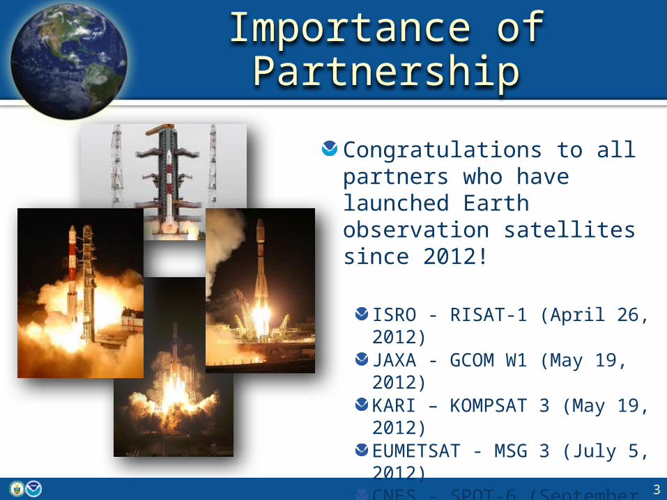
Importance of Partnership
Congratulations to all partners who have launched Earth observation satellites since 2012!
ISRO - RISAT-1 (April 26, 2012)JAXA - GCOM W1 (May 19, 2012)KARI – KOMPSAT 3 (May 19, 2012)EUMETSAT - MSG 3 (July 5, 2012)CNES - SPOT-6 (September 9, 2012)EUMETSAT - METOP-B (September 17, 2012)ISRO – SARAL (February 25, 2013)
3
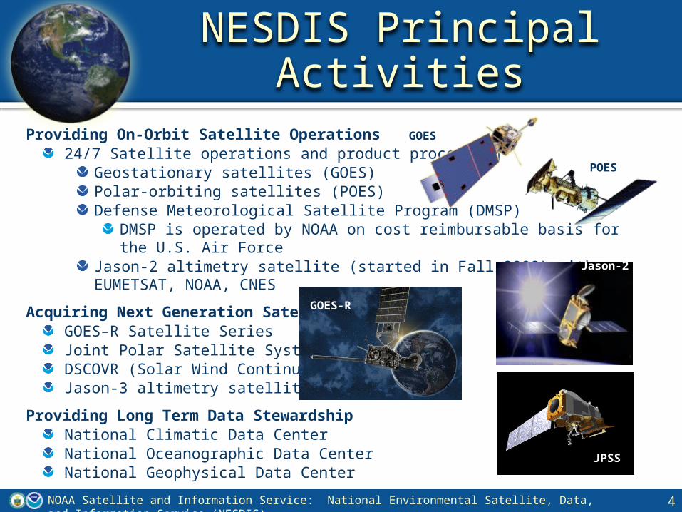
Providing On-Orbit Satellite Operations24/7 Satellite operations and product processing
Geostationary satellites (GOES)Polar-orbiting satellites (POES)Defense Meteorological Satellite Program (DMSP)
DMSP is operated by NOAA on cost reimbursable basis for the U.S. Air Force Jason-2 altimetry satellite (started in Fall 2008) with EUMETSAT, NOAA, CNES
Acquiring Next Generation SatellitesGOES–R Satellite SeriesJoint Polar Satellite System (JPSS)DSCOVR (Solar Wind Continuity)Jason-3 altimetry satellite
Providing Long Term Data StewardshipNational Climatic Data CenterNational Oceanographic Data CenterNational Geophysical Data Center
4
GOES
POES
Jason-2
NOAA Satellite and Information Service: National Environmental Satellite, Data, and Information Service (NESDIS)
JPSS
NESDIS Principal Activities
JPSS
GOES-R

GOES-R Launch Readiness Date* October 2015
Program Architecture
4 Satellites (GOES R,S,T&U), 10 year operational design life
Program Operational Life FY 2017 – FY 2036
Program Life-cycle FY 2013 President’s Budget
$10.860 billion
GOES-R Overview
5NOAA Satellite and Information Service: National Environmental Satellite, Data, and Information Service (NESDIS)
*Launch Readiness Date based on FY 2013 President’s Budget Request *
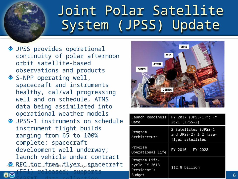
Joint Polar Satellite System (JPSS) Update
JPSS provides operational continuity of polar afternoon orbit satellite-based observations and products S-NPP operating well, spacecraft and instruments healthy, cal/val progressing well and on schedule, ATMS data being assimilated into operational weather modelsJPSS-1 instruments on schedule instrument flight builds ranging from 65 to 100% complete; spacecraft development well underway; launch vehicle under contractRFO for free flyer spacecraft (FF1) released; supports SARSAT, data collection (ARGOS) and Total Solar IrradianceTSIS Calibration Transfer Experiment (TCTE) delivered and integrated into STP-3
6
Launch Readiness Date
FY 2017 (JPSS-1)*; FY 2021 (JPSS-2)
Program Architecture 2 Satellites (JPSS-1 and JPSS-2) & 2 free-flyer satellites
Program Operational Life FY 2016 – FY 2028
Program Life-cycle FY 2013 President’s Budget
$12.9 billion
*Launch Readiness Date based on FY 2013 President's Budget Request

Joint Polar Satellite System (JPSS)
7NOAA Satellite and Information Service: National Environmental Satellite, Data, and Information Service (NESDIS)
S-NPP VIIRS IMAGERY
To provide operational global observations in the early afternoon orbit which are critical inputs to numerical weather prediction modelsTo provide uninterrupted continuity of observations from current NOAA POES, NASA EOS and Suomi NPP satellitesFY 2014 President’s Budget request will detail refined JPSS Program content and cost
S-NPP VIIRS Day Night BandHurricane Isabelle at Night
S-NPP VIIRS Day Night BandAurora Over Canada

GNSS Radio OccultationCOSMIC-2
NOAA Satellite and Information Service: National Environmental Satellite, Data, and Information Service (NESDIS)
8

Jason 3Jason-3 ensures the continuity of space-based altimetry (i.e., sea surface height) observations.NOAA instrument development progressing well and on target for delivery to CNES in early 2013Launch vehicle (Falcon 9) under contract to support launch NET Dec 2014
DSCOVRDSCOVR provides continuity of solar wind measurements in support of advanced warnings of geomagnetic storms.DSCOVR spacecraft and instrument refurbishment underway at NASA GSFC in support of launch 1st Quarter FY 2015 with routine spacecraft operations beginning early 2015 for a planned 5-year mission.DSCOVR launch services with USAF/SMC awarded to SpaceX for a Falcon 9 launch.
Jason-3 and DSCOVRUpdates
NOAA Satellite and Information Service: National Environmental Satellite, Data, and Information Service (NESDIS)
9
*Launch Readiness Dates based on FY 2013 President’s Budget Request

10NOAA Satellite and Information Service: National Environmental Satellite, Data, and Information Service (NESDIS)
Protect life & property & create business opportunities
Support transportation & commerce
Assist communities &
provide recreational
opportunities
Facilitate sustainable agriculture, fisheries, &
aquaculture
Safeguard communicatio
n & electric infrastructure
Inform renewable energy business decisions
Preparing Our Users for the Next Generation

11NOAA Satellite and Information Service: National Environmental Satellite, Data, and Information Service (NESDIS)
Thank You