nonpoint source implementation of phase ii … the new york city watershed ... and activities and...
TRANSCRIPT

Interim Report
Nonpoint Source ImplementationOf The Phase II Phosphorus TMDLs
In The New York City Watershed
March 2002
Prepared in accordance with the New York City WatershedMemorandum of Agreement (January 1997).
New York State Department of Environmental Conservation
Division of Water


P R E F A C E
This report represents the next step in the implementation process for phosphorus loadreductions in the New York City (NYC) Watershed. It has been prepared in accordance withthe NYC Watershed Memorandum of Agreement (MOA, January 1997) and focuses onnonpoint source (NPS) implementation efforts that can contribute to the attainment of PhaseII Phosphorus Total Maximum Daily Loads (TMDLs).
The report provides a snapshot of the current status of implementation programs, projectsand activities and next steps toward a final implementation plan. It has been released as“Interim” since it does not include all of the specific implementation components outlinedin the MOA and expanded upon in the U.S. Environmental Protection Agency’s (EPA’s)October 16, 2000 implementation strategy letter.
The New York State Department of Environmental Conservation (DEC) remains committedto the development of a final implementation plan. The Phase II Phosphorus TMDLsidentified eight NYC reservoirs as water quality limited and needing nonpoint (NPS)reductions. These reservoirs are in the Croton portion of the City’s watershed and arelocated east of the Hudson River . Thus, the timing of the final implementation plan willdepend on the findings and completion of Croton Planning in Putnam and WestchesterCounties, as well as the implementation of Phase II Stormwater Regulations and continuedmonitoring in the Croton Watershed.
In light of the above, the DEC recommends the establishment of an institutional frameworkto coordinate, track and assist in the development of individual basin plans as describedin the EPA’s October16, 2000 letter. Over the next several months, the DEC will develop aprocess on how to proceed and will consult with the Watershed Protection and PartnershipCouncil (WPPC).
It is important that key components to the development of an implementation plan, such asCroton Planning and Phase II Stormwater Regulations implementation, remain on schedule.Additionally, a long-term emphasis needs to be placed on ambient monitoring to assess theeffectiveness of applied best management practices (BMPs) and water quality improve-ments in individual basins. The specifics of nonpoint source implementation that are un-available at this point in time should evolve from the efforts above. In summary, theseinclude:
• identification of BMPs specific to each reservoir basin to meet TMDLs and achievedownstream standards;
• a list of municipal entities designated by Phase II Stormwater Regulations;• quantification of upstream, additional load reductions, above those to meet the TMDL
for that waterbody and necessary to achieve downstream standards;• a description of implementation mechanisms;• the time frame for implementing the actions;• funding sources for implementation; and,• a plan for evaluating/monitoring plan effectiveness.
We look forward to the continued support of all involved agencies and watershedstakeholders as the TMDL implementation process progresses.
A C K N O W L E D G M E N T S
Several agencies and many people have contributed to the development ofthis Nonpoint Source (NPS) Implementation Report. The New York StateDepartment of Environmental Conservation (NYSDEC) would like to take thisopportunity to say “Thank You”.
The Total Maximum Daily Load (TMDL) Work Group, composed of scientistsand engineers from the New York City Department of EnvironmentalProtection (NYCDEP), the U.S. Environmental Protection Agency (USEPA),and the New York State Department of Environmental Conservation(NYSDEC) have provided input, comments and technical guidance for thisreport. Special thanks to Dr. Kimberlee Kane of the NYCDEP and Ms.Maureen Krudner of the USEPA for their assistance.
Additionally, several people contributed to specific portions of the report:
!!!! Sabrina Charney - Westchester County Department of Planning
!!!! Gerry Chartier & Tom Boekeloo - NYSDEC, Nonpoint SourceManagement Section
!!!! Pat Ferracane - NYSDEC, Region #3 (Tarrytown, NY)
!!!! John Lynch - Putnam County Department of Planning
!!!! Ken Markussen - NYSDEC, Division of Water
!!!! Howard Pike - NYSDEC, Division of Water
Also, thanks to Barbara J. Crier for typing and formatting this report.
i
TABLE OF CONTENTS
Page No.
Table of Contents . . . . . . . . . . . . . . . . . . . . . . . . . . . . . . . . . . . . . . . . . . . . . . . . . . . . . iList of Tables . . . . . . . . . . . . . . . . . . . . . . . . . . . . . . . . . . . . . . . . . . . . . . . . . . . . . . . iiList of Figures . . . . . . . . . . . . . . . . . . . . . . . . . . . . . . . . . . . . . . . . . . . . . . . . . . . . . . . ii
1. Introduction . . . . . . . . . . . . . . . . . . . . . . . . . . . . . . . . . . . . . . . . . . . . . . . . . . . . . 11.1 Report Background . . . . . . . . . . . . . . . . . . . . . . . . . . . . . . . . . . . . . . . . . . . . 11.2 TMDL/MOA Overview . . . . . . . . . . . . . . . . . . . . . . . . . . . . . . . . . . . . . . . . . . 11.3 Other Considerations . . . . . . . . . . . . . . . . . . . . . . . . . . . . . . . . . . . . . . . . . . 2
2. TMDL Background . . . . . . . . . . . . . . . . . . . . . . . . . . . . . . . . . . . . . . . . . . . . . . . . 42.1 Summary of Phase II TMDL Process . . . . . . . . . . . . . . . . . . . . . . . . . . . . . . 42.2 Phase II TMDL Results . . . . . . . . . . . . . . . . . . . . . . . . . . . . . . . . . . . . . . . . . 5
3. Implementation of Phase II TMDLs-Programs . . . . . . . . . . . . . . . . . . . . . . . . . 103.1 New York State Programs . . . . . . . . . . . . . . . . . . . . . . . . . . . . . . . . . . . . . . 11
3.1.1 Phase II Stormwater Regulations . . . . . . . . . . . . . . . . . . . . . . . . . . . . 133.1.1.a Federal Regulations - Background and Criteria . . . . . . . . . . . . . . 133.1.1.b Enhanced Stormwater Management . . . . . . . . . . . . . . . . . . . . . . . 15
3.1.2 Safe Drinking Water Act and Water Resources Development Act Projects . . . . . . . . . . . . . . . . . . . . . . . . . . . . . . . 16
3.1.3 NYSDEC Region 3 Programs . . . . . . . . . . . . . . . . . . . . . . . . . . . . . . . 173.1.4 Watershed Data Management and Software
Development Project . . . . . . . . . . . . . . . . . . . . . . . . . . . . . . . . . . . 183.2 New York City Department of Environmental Protection Programs . . . . 193.3 New York City Watershed Partnership Program . . . . . . . . . . . . . . . . . . . . 20
3.3.1 Putnam County Croton Plan . . . . . . . . . . . . . . . . . . . . . . . . . . . . . . . 203.3.2 Westchester County Croton Programs . . . . . . . . . . . . . . . . . . . . . . . 22
4. Implementation of Phase II TMDLs - Actions To Be Taken . . . . . . . . . . . . . . 264.1 Background . . . . . . . . . . . . . . . . . . . . . . . . . . . . . . . . . . . . . . . . . . . . . . . . . 264.2 NYSDEC Actions . . . . . . . . . . . . . . . . . . . . . . . . . . . . . . . . . . . . . . . . . . . . . 264.3 Actions Recommended . . . . . . . . . . . . . . . . . . . . . . . . . . . . . . . . . . . . . . . . 27
4.3.1 USEPA . . . . . . . . . . . . . . . . . . . . . . . . . . . . . . . . . . . . . . . . . . . . . . . . . 274.3.2 New York City . . . . . . . . . . . . . . . . . . . . . . . . . . . . . . . . . . . . . . . . . . . 284.3.3 Local Government . . . . . . . . . . . . . . . . . . . . . . . . . . . . . . . . . . . . . . . . 29
4.3.3.a Putnam County . . . . . . . . . . . . . . . . . . . . . . . . . . . . . . . . . . . . . . . . 294.3.3.b. Westchester County . . . . . . . . . . . . . . . . . . . . . . . . . . . . . . . . . . . . 29
4.4 Implementation Schedule . . . . . . . . . . . . . . . . . . . . . . . . . . . . . . . . . . . . . . 305. Implementation Mechanisms and Next Steps . . . . . . . . . . . . . . . . . . . . . . . . . 32
5.1 Watershed Approach . . . . . . . . . . . . . . . . . . . . . . . . . . . . . . . . . . . . . . . . . . 335.2 Monitoring and Evaluation . . . . . . . . . . . . . . . . . . . . . . . . . . . . . . . . . . . . . 355.3 Conclusion . . . . . . . . . . . . . . . . . . . . . . . . . . . . . . . . . . . . . . . . . . . . . . . . . . 35
Appendix A SDWA and WRDA Funded Projects
Appendix B New York City Watershed Data Management and Software ToolsDevelopment Project
ii
LIST OF TABLES
Page No.
Table 2.1 Land Use Area - Croton System Reservoirs . . . . . . . . . . . . . . . . . . . . . 8
Table 2.2 Nonpoint Source Phosphorus Loads - Croton System Reservoirs . . . . . . . . . . . . . . . . . . . . . . . . . . . . . . . . . . . . . 9
Table 2.3 Upstream Phosphorus Loads . . . . . . . . . . . . . . . . . . . . . . . . . . . . 10
LIST OF FIGURES
Page No.
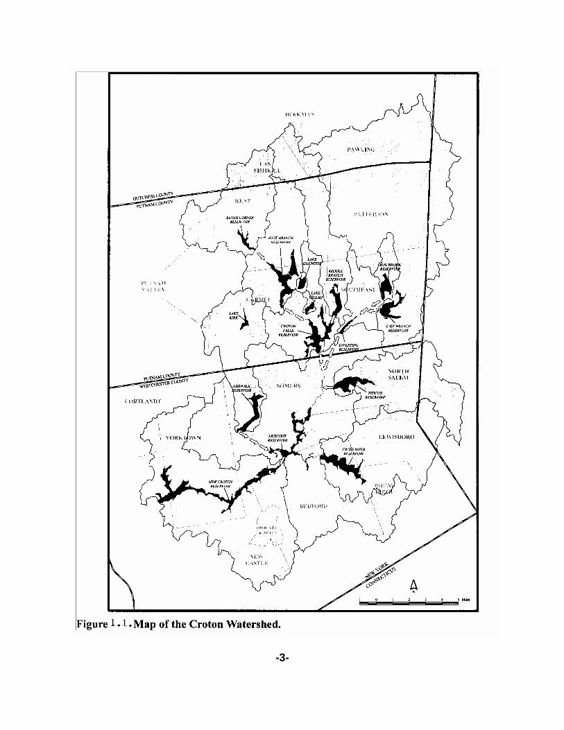
Figure 1.1. Map of Croton Watershed . . . . . . . . . . . . . . . . . . . . . . . . . . . . . . . . 3

1 Nonpoint Source Implementation of the Phase II TMDLs (April 2001).
-1-
1. INTRODUCTION
1.1 Report Background
The New York City (NYC) Watershed Memorandum of Agreement (MOA)prescribed a multi-step process for Phosphorus Total Maximum Daily Load(TMDL) development in the Watershed. Article VI, Section 162(h)(v)provides for the continuance of this process with the Nonpoint Source (NPS)Implementation of Phase II TMDLs as follows:
“Within six months of receiving a report (April 2001) 1 identifying potentialmanagement practices for nonpoint source pollution, the New York StateDepartment of Environmental Conservation (NYSDEC) shall work jointly withthe New York City Department of Environmental Protection (NYCDEP) andshall identify potential nonpoint source management practices it will imple-ment and recommend potential nonpoint source management practices tobe implemented by other parties. NYSDEC shall provide a description anda schedule of the implementation mechanisms.”
Additionally, in its October 16, 2000 letter to the NYSDEC, the U.S.Environmental Protection Agency (USEPA) recommended severalcomponents for inclusion in the NPS Implementation Reports and relatedprograms. These recommendations were related to a number of topicsincluding better quantification of phosphorus load reductions, NPSmanagement practices and implementation mechanisms and the time frameand funding sources for implementation. In summary, the EPA letter pro-vided some guidance for the development of the NPS Reports and theimportance of stakeholder involvement in the implementation process.
Based on the MOA directive above and EPA’s October 16, 2000 letter, thefocus of this report is to continue the process of outlining the strategy forachieving the load allocations (LAs) for watershed TMDLs.
1.2 TMDL/MOA Overview
Phase I TMDLs/WLAs/LAs for the Croton and Catskill-Delaware Watershedswere approved by the USEPA in April of 1997. The Phosphorus TMDLdevelopment process continued in Phase II with several enhancements overPhase I. These are outlined beginning on page two of NYSDEC’s Phase II

2 NYSDEC Phase II Phosphorus Total Maximum Daily Loads For Reservoirs In The NewYork City Watershed (June 2000).
-2-
TMDL document. 2 Dated June, 2000, the Phase II Phosphorus TMDLswere ultimately approved by EPA in October, 2000. The Phase II TMDLsidentified eight Croton reservoirs as water quality limited. Each of thesewaterbodies is located east of the Hudson River and requires nonpointsource reductions of phosphorus loads. The eight reservoirs are part of theCroton Watershed as illustrated in Figure 1.1.
EPA’s approval initiated the development of NPS Implementation Reports asdirected by the MOA. The first of these reports was issued in April, 2001 byNYCDEP along with NYSDEC. This second report is the next step in theNPS Implementation process.
1.3 Other Considerations
This report will pull together pertinent information from several programs andactivities. These include: the Phase II Phosphorus TMDLs for the New YorkCity Watershed, NYCDEP’s March 1999 TMDL Related Reports and itsCroton Watershed Strategy, New York State’s Nonpoint Source Manage-ment Program, Croton Planning for Putnam and Westchester Counties,NYSDEC’s Phase II Stormwater Program, including efforts by the Center forWatershed Protection and projects funded by Safe Drinking Water Act(SDWA) and Water Resources Development Act (WRDA).
In spite of the above programs and ongoing activities that relate to NPSimplementation efforts, there are limitations to what can be incorporated atthis time. For example:
a. The time frame for the completion of this report does not coincide withthe completion of the many ongoing activities, planning efforts andtheir prospective findings. Croton Plans for Putnam and WestchesterCounties are scheduled for release in May 2002 and final agreementin November 2002. Also, the New York City Watershed Project(Information Technology) presented in Section 3.1.4 is scheduled forcompletion in the Spring of 2003.
b. Various data and information gaps in the implementation processhave been identified. These include: an integrated, GIS-based waterquality data management program; a flexible, adaptive GIS land usedatabase; a modeling support tool-set consisting of modules tosupport terrestrial modeling (GWLF and the Upstate Freshwater
-3-

-4-
Institute’s (UFI’s) reservoir model for phosphorus; improved useraccess to such data, information and models.
c. Relating the necessary upstream NPS phosphorus reductions to theattainment of downstream, in-reservoir phosphorus standards -numerically, among municipal boundaries and geographicalboundaries - is incomplete. Section 3 discusses various imple-mentation programs including the need to develop more specificinformation on NPS pollutant sources of phosphorus and theassociated local capacity to take targeted actions that allow for themost efficient opportunities to reduce phosphorus loads.
d. Practices that are needed to control many NPS cannot be identifiedfor specific locations at this time. These decisions ultimately are bestlinked to local decision-making processes as specific practices aredefined and scheduled for implementation.
2. TMDL Background
2.1 Summary of Phase II TMDL Process
The Clean Water Act [CWA §303(D) 33 U.S.C.A §1313(D)] requires statesto develop TMDLs for water quality limited waters, or those waterbodies thatdo not attain water quality standards after the application of technology-based controls. Such waterbodies are listed in New York State’s 303(d) listwhich is derived from the Priority Waterbody List (PWL). NYSDEC hasidentified New York City Watershed reservoirs as priority waters for TMDLdevelopment for phosphorus in the 1994, 1996 and 1998 303(d) listings asrequired by the Clean Water Act.
Phase II Phosphorus TMDLs for each NYC reservoir represent thereservoir’s phosphorus loading capacity. The TMDL is the sum of the pointsource wasteload allocations (WLAs) and the nonpoint source load allo-cations (LAs) plus a margin of safety (MOS) to account for the uncertainty inthe relationship between the phosphorus loads and the reservoir’s waterquality.
NYCDEP has contributed significantly to the Phase II TMDL developmentprocess. The following three reports, each dated March 1999, can be foundon NYCDEP’s Website (http://www.ci.nyc.ny.us/htm/dep/tmdl/html).
1. Methodology for calculating Phase II Total Maximum Daily Loads(TMDLs) of Phosphorus for the New York City Drinking WaterReservoirs.

-5-
2. Proposed Phase II Phosphorus TMDL Calculation Reports for EachReservoir.
3. Development of a Water Quality Guidance Value for Phase II TotalMaximum Daily Loads (TMDLs) in the New York City Reservoirs.
These reports contain information on the following:
« phosphorus source modeling
« impact estimates of wastewater treatment plant upgrades
« basin/reservoir status with respect to the critical phosphorus load
« information and recommendations for a water supply-based criterianumber for phosphorus
« land use information and related nonpoint source phosphorus loads
« Proposed Phase II TMDL calculations for each reservoir, includinginitial wasteload allocations (WLAs) and load allocations (LAs)
2.2 Phase II TMDL Results
NYSDEC’s June 2000 TMDL Document contains Phase II TMDL results ina couple of different formats. Pages 21-45 cover each of New York City’s 19reservoirs with a summary write-up based on information in NYCDEP’sPhosphorus TMDL Calculations Reports (3/99). Additionally, there are anumber of tables that help summarize results. Table 2.1 of the April 2001NPS Report also provides a TMDL summary.
Phosphorus Sources
Throughout the TMDL process in the NYC Watershed both point andnonpoint sources of phosphorus have been modeled. Point sources includedischarges from wastewater treatment plants in the Watershed and carryoverphosphorus loads from upstream reservoirs. Nonpoint source phosphorusloads are a function of land use activities, phosphorus export coefficients andthe modeling. The land use categories were: urban, forest, agriculture andwater. Septic systems with 100 feet of a stream or reservoir were alsoincluded as sources of phosphorus.

-6-
Point Source Reductions of Phosphorus
The New York City Watershed Rules and Regulations contain requirementsfor upgrading wastewater treatment plants in the Watershed to tertiarytreatment with phosphorus removal. SPDES permit modifications to reflectthis are in place and plant upgrades are underway. This will result in asignificant reduction in point source phosphorus loads to the reservoirs.DEP’s TMDL modeling calculations reflect these point source reductionssince the wasteload allocations (WLAs) assume full compliance with theWatershed Regulations.
Nonpoint Sources
Table 4 from DEC’s June 2000 TMDL document has been expanded in thetables below with additional information about nonpoint source phosphorusloads for water quality limited reservoirs in the Croton Watershed.Additionally, primary land use activities that relate to NPS phosphorus loadshave been identified by area and estimated load contribution. Thesignificance of this information directly relates to the remaining phosphorusreductions needed for water quality limiting reservoirs after point sourceloads are in conformance with New York City Watershed Rules andRegulations.
Table 2.1 presents land use information for each of the 12 Croton WatershedReservoirs. As indicated in the Phase II TMDL Methodology Document(March 1999), the land use data is the same as that used for the Phase ITMDLs. It is derived from satellite data (LANDSAT TM) at a 28.5mresolution. Composites of 1987, 1988 and 1990 scenes were used for theEast of Hudson region. It should be noted that much of the Forest and OpenSpace land area is actually low density residential which can presentopportunities for phosphorus reductions. Currently, NYSDEC, USEPA andthe NYCDEP are working together to develop improved land use coverages.This ongoing project is presented in detail in Section 3.1.4 and Appendix B.
The first eight reservoirs listed in Table 2.1 are water quality limited forphosphorus. The next four are not. It can be seen that nearly 75% of theland area in the Croton Watershed is considered forest. Approximately 11%of the area falls into the urban category. This information is important whenexamining where NPS phosphorus reductions can be attained.
Table 2.2 expands further on the nonpoint source information base. Here,approximate NPS phosphorus loads are tabulated as a function of land useexport coefficient (Methodology Document of March 1999) for each land usecategory. This tabulation does not take into account upstream load

-7-
contributions of phosphorus from upstream reservoirs. The loads here arecalculated from land use activity within each listed reservoir basin.
Examination of this information leads to several conclusions:
1. While forested area represents nearly three quarters of the Croton’sland use activity, its phosphorus load contribution is only about 20%of the total.
2. Clearly urban areas yield most of the NPS phosphorus load at nearly60% and would seemingly present the most opportunity for loadreductions.
3. Water and septic categories are relatively small contributors ofphosphorous.
4. For three reservoirs: Amawalk, Middle Branch and Titicus, areasonable reduction of NPS urban phosphorus load would meet thenecessarily identified reductions in the TMDL.
5. When comparing the other five water quality limited reservoirs’ urbanphosphorus loads with the remaining phosphorus reductions neededit becomes obvious that substantial NPS reductions are needed tomeet the TMDLs. In the East Branch, Muscoot and New CrotonBasins, more than 60% reduction in urban NPS loads is needed. InCroton Falls and Diverting, the necessary phosphorus reductionsignificantly exceeds the urban NPS load. This means that thereductions must come from sources in addition to in-basin urban NPS.
6. The remaining four reservoirs in the Croton Watershed are not waterquality limited for phosphorus and are not significant contributors ofphosphorus to downstream reservoirs. The exception to this is CrossRiver’s urban load at nearly 600 kg/yr.
The next table presented here, Table 2.3, provides an additional column ofinformation, the calculated phosphorus loading contributed by upstreamlakes or reservoirs. On the listing of eight WQL reservoirs, this upstreamsource of phosphorus ranges from zero or insignificant to very significant.The “daisy-chain” effect of interconnected reservoirs was discussed inSection 4.2.3 of the first NPS Report (April 2001). The list of WQL reservoirscan be rearranged in increasing order of upstream phosphorus loadcontributions to numerically follow this chain.

3 After Wastewater Treatment Plant Upgrades are achieved.
-8-
While Titicus Reservoir receives no upstream lake/reservoir phosphorusloading, the next three reservoirs (Amawalk, East Branch and Middle Branch)each have upstream lakes contributing to their phosphorus load.
These are: Lake Mahopac to the Amawalk, Peach and Putnam Lakes toEast Branch Reservoir, and Lake Carmel to the Middle Branch. Theseupstream lakes are areas where opportunities exist for phosphorusreductions particularly in the urban and septic categories. The mostsignificant of these loads is the upstream load from Lake Carmel to theMiddle Branch Reservoir, estimated at 528 kg/yr.
Table 2.1Croton Watershed Reservoirs
(Located East of Hudson)Land Use Area (Hectares)
Reservoir Forest Urban Open/Ag Water Total
Phase IITMDL
PhosphorusReduction 3
(kg/yr)
Amawalk 3,409 852 616 856 5,733 122
Croton Falls 2,921 531 215 474 4,141 885
Diverting 1,234 545 67 99 1,945 983
East Branch 15,545 1,738 2,386 902 20,571 993
Middle Branch 7,001 806 420 514 8,741 204
Muscoot 13.533 3,170 1,713 646 19,062 2,058
New Croton 11,161 2,059 1,116 1,047 15,383 1,356
Titicus 4,347 676 869 371 6,263 140
TOTALS FOR EIGHT WQLRESERVOIRS % EACH LAND USE
59,151
(72.3)
10,377
(12.7)
7,402
(9.0)
4,909
(6.0)
81,839 6,741
Bog Brook 603 131 64 160 958
Boyd’s Corners 7,199 92 192 539 8,022
Cross River 6,574 657 727 696 8,654
West Branch 4,164 196 180 598 5,138
TOTALS FOR NON-WQL RESERVOIRS _______ % EACH LAND USE
18,540
(81.4)
1,076
(4.7)
1,163
(5.1)
1,993
(8.8)
22,772
TOTALS - ALL CROTONWATERSHED RESERVOIRS
% LAND USE _____
77,691
(74.2)
11,453
(11.0)
8,565
(8.2)
6,902
(6.6)
104,611

3 After Wastewater Treatment Plant Upgrades are achieved.
4 Kg/yr Septic Phosphorus Load from NYCDEP Reservoir Reports.
-9-
Table 2.2Croton Watershed Reservoirs
(Located East of Hudson)NPS Phosphorus Loads (kg/yr) By Land Use
And Export Coefficients Calculation
ReservoirName
Phase IITMDL
PhosphorusReduction 3
(kg/yr)
Forest(0.05)
Urban(0.9)
Open/Ag(0.3)
Water(0.1) Septic 4 Total
Amawalk (122) 170 767 185 86 83 1,291
Croton Falls (885) 146 478 65 47 43 779
Diverting (983) 62 491 20 10 24 607
East Branch (993) 777 1,564 716 90 171 3,318
Middle Branch (204) 350 725 126 51 18 1,270
Muscoot (2,058) 677 2,853 514 65 227 4,336
New Croton (1,356) 558 1,853 335 105 168 3,019
Titicus (140) 217 608 261 37 96 1,219
TOTALS FOR WQLRESERVOIRS
(“P” % EACH USE)
2,957
(18.7)
9,339
(59.0)
2,222
(14.0)
491
(3.1)
830
(5.2)
15,839
Bog Brook 30 118 19 16 4 187
Boyd’s Corners 360 83 58 54 80 635
Cross River 329 591 218 70 186 1,394
West Branch 208 176 54 60 63 561
TOTALS FORNON-WQLRESERVOIRS____
% EACH LAND USE
927
(33.3)
968
(34.9)
349
(12.6)
200
(7.2)
333
(12)
2,777

3 After Wastewater Treatment Plant Upgrades are achieved.
-10-
“P” NPS LOADTOTALS % ALL CROTONWATERSHEDRESERVOIRS
3,884
(20.9)
10,307
(55.4)
2,571
(13.8)
691
(3.7)
1,163
(6.2)
18,616
Clearly, the next four reservoirs listed (Croton Falls, Diverting, Muscoot and NewCroton) receive significant portions of their phosphorus loadings from upstreamsources. The long-term key to meeting reservoir phosphorus criteria there restsin the reduction of these loadings. This will necessitate efficient, targeted actions,best management practices and programs as well as local stakeholderinvolvement in the process.
Table 2.3Upstream Phosphorus Loads
Reservoir Upstream Phosphorus Loading(kg/yr)
Phase II TMDLPhosphorus Reduction 3
(kg/yr)
Titicus 0 140
Amawalk 80 122
East Branch 189 943
Middle Branch 528 204
Croton Falls 1,083 885
Diverting 2,618 983
Muscoot 5,579 2,058
New Croton 9.108 1,356
3. Implementation of Phase II Phosphorus TMDLs - Programs
Background
In April 2001, the NYCDEP and the NYSDEC jointly issued a report which identifiedpotential management practices and programs for controlling nonpoint sourcepollution. If implemented, these practices and programs would provide reasonableassurances toward attaining nonpoint source phosphorus reductions identified inPhase II TMDLs.

-11-
A recurring theme in discussions held leading up to the preparation of this secondreport has been that the report should be specific in its recommendations wherepossible and focus on the processes of implementation. Such “processes” to beconsidered include:

-12-
- incorporating ongoing programs and projects- coordination among various stakeholders and their programs- problem identification and prioritization- improved NPS data base and analysis- funding sources and implementation schedules
As indicated in the April 2001 NPS Report, existing programs that may impactnonpoint sources of phosphorus must be assessed. There are numerous State,City, County and Local program activities that will need to be evaluated relative totheir impact on identified nonpoint source phosphorus reductions. Are theseprograms sufficient or will they require modifications or additions to accommodateTMDL implementation? Obviously, program assessment and coordination will bekey to implementation efforts.
3.1 New York State NPS Programs
In accordance with Section 319 of the Clean Water Act, the NYSDEC hasprepared a Nonpoint Source Assessment and a Nonpoint SourceManagement Program. The Nonpoint Source Assessment was initiallycompleted in 1988 and approved by the EPA on July 1989. An update ofthis Assessment has been prepared every two years. The latest assessmentis in the 1996 Priority Waterbodies List. Since then, the Department haspublished the PWL assessment information on a 5-year rotating scheduleestablished as part of a Comprehensive Assessment Strategy. The strategyis fully described in the October 2000 NPS Management Program, AppendixD. The Nonpoint Source Management Program was approved by the EPAin January 1990. The Management Plan was updated and approved by theEPA in October 2000. Copies of the Management Program are availablefrom Gerry Chartier ([email protected]) (518) 402-8244.
New York State’s Nonpoint Source Management Program is charged withthe control, reduction or treatment of polluted runoff through theimplementation of structural, operational or vegetative managementpractices. The New York State Department of Environmental Conservation(NYSDEC) works with the New York Nonpoint Source CoordinatingCommittee (NYNPSCC) to administratively coordinate various stateagencies and other interested partners having regulatory, outreach,incentive-based, or funding programs that foster installation of managementpractices for any of the identified sources of nonpoint pollution threateningor impairing the waters of New York. Local implementation and statewidecoordination and evaluation are conducted on a watershed basis.
Nonpoint source pollution usually is best prevented or remediated byemploying one or more management practices. A management practice isa means of preventing or reducing the availability, release or transport of
-13-
substances which adversely affect surface and groundwaters. It is a practiceused to prevent or reduce the impact of nonpoint pollutants usually from aspecific source category. Appendix E of the NPS Management Plandescribes four statewide workgroups addressing six of New York’s prioritysource categories through project recommendations, management practiceupdating, policy recommendations and information exchange anddistribution.
New York has developed a series of ten Management Practices Catalogueseach containing management practices for a particular source category. Forthis list of tested and approved practices, the best practice should beselected and used by individuals of groups wherever needed to diminish theimpact of nonpoint source pollution. They can be used without a formalplanning process or without an identification of a specific problem. Theymake good environmental sense. Use of appropriate management practiceshelps build environmental responsibility. A summary of managementpractices by land use was provided in the April 2001 NPS Report. Thecomplete catalogues are also available from Gerry Chartier.
NYSDEC has a New York City Watershed Data Management and SoftwareTool Development Project that will develop an integrated high resolution GISdata base with a suite of management tools integral to the database that willbe used to map and model the NYC Watershed. The data and tool suite isto be internet accessible. It is our intent to use the NYC Watershed projectas a template for other watersheds in the state. One result of many will bea better capability to target management practices for greater effectiveness.This work should be completed by the Spring of 2003. See full projectdescription in Section Appendix B.
Coastal NPS Pollution Control Program
The Coastal Zone Act Reauthorization Amendments of 1990 (CZARA)included a section devoted to coastal nonpoint pollution control, now knownas Section 6217. This federal legislation requires New York and about 30other states and territories with approved coastal management programs todevelop and implement programs to control nonpoint pollution to restore andprotect coastal waters. The Croton Watershed falls within the geographicscope of 6217.
The central purpose of Section 6217 is to strengthen the links betweenfederal and state coastal zone management and water quality programs.Another purpose is to enhance state and local efforts to manage land useactivities that degrade coastal waters and coastal habitats.
-14-
At the federal level, the program is administered jointly by EPA and theNational Oceanic and Atmospheric Administration (NOAA), respectively, thefederal water quality and coastal management agencies. This approach isechoed at the state level, where DEC and the Department of State’s (DOS)Division of Coastal Resources are jointly responsible for program devel-opment and implementation. The two agencies entered into a partnership(through a Memorandum of Understanding) to develop New York State’sCoastal Nonpoint Pollution Program Document. New York receivedconditional approval on November 18, 1997. Several NPS pollution controlstrategies were submitted to EPA/NOAA since then; the last in December2001. The strategies describe how DEC and DOS programs address theconditions necessary for full program approval.
The EPA and NOAA guidance lists 57 management measures in six sourcecategories. DEC and DOS have determined, after a review of existingprograms, that about two-thirds of these management measures are alreadyin place in New York State. Such programs as waste oil recycling andwetland protection programs already achieve many of the goals of the 6217program. Given the wide range of programs and agencies involved innonpoint pollution management in New York, DEC and DOS have purposelydecided to build on existing programs wherever possible when implementingthe 6217 program.
3.1.1. Phase II Stormwater Regulations and Their Implementation inPutnam and Westchester Counties
Introduction
DEC is evaluating the geographic scope of permit issuance for municipalseparate storm sewer systems and to expand the permit requirement forconstruction activities in Westchester and Putnam Counties. This is due tothe implementation of the Federal Phase II Stormwater Regulation and thePhase II Total Maximum Daily Loads (TMDL).
3.1.1.a Federal Phase II Stormwater Regulations
Background and Designation Criteria
On October 29, 1999, USEPA issued its Phase II StormwaterRegulations. The Phase II regulations require certain municipalseparate stormwater sewer systems (MS4s) and constructionactivities to apply for Clean Water Act permits and to implementstormwater discharge management controls.

-15-
Municipal Separate Sewer Systems
Most of Westchester and Putnam Counties are categorically covered by EPA’sPhase II Rule as urbanized areas. All MS4s in areas designated as urbanized willbe required to have a permit no later than March of 2003. The permit will requirethat all MS4s develop and implement a stormwater management program whichincludes at least the following six (6) minimum control measures:
« Public Education and Outreach« Public Participation/Involvement« Illicit Discharge Detection and Elimination« Construction Site Runoff Control« Post Construction Runoff Control« Pollution Prevention/Good Housekeeping
The following towns, and any municipal stormwater systems within them, arecategorically covered:
Carmel Putnam CountyKent Putnam CountyPatterson Putnam CountyPhillipstown Putnam CountyPutnam Valley Putnam CountyBedford Westchester CountyCortlandt Westchester CountyEastchester Westchester CountyGreenburgh Westchester CountyHarrison Westchester CountyMamaroneck Westchester CountyMount Pleasant Westchester CountyNew Castle Westchester CountyNorth Castle Westchester CountyOssining Westchester CountyPelham Westchester CountyPound Ridge Westchester CountyRye Westchester CountySomers Westchester CountyYorktown Westchester County
In addition to requiring permits in the "urbanized areas," the federal Phase IIregulation provides that DEC may require permits if discharges from an MS4 "causeor have the potential to cause, an adverse impact on water quality."

-16-
The regulation suggests criteria for these discharges including:
« discharge to sensitive waters« high population density;« high growth or growth potential;« contiguity to an urbanized area;« significant contributor of pollutants to waters of the United States; and« ineffective control of water quality concerns by other programs.
DEC believes that MS4 discharges in Westchester and Putnam Counties may meetthese criteria.
Small Construction Activities (Statewide)
The Phase II regulations also expand the permit requirement to small constructionactivities, automatically designating as a small construction activities landdisturbances of equal to or greater than one and less than five acres. (Landdisturbances of greater than five acres are regulated under the Phase I rule.) DECwill develop specific requirements for Stormwater controls on Phase II constructionactivities.
DEC is reviewing whether to use the existing Phase I general permit for constructionactivities as a guide for the Phase II permits. A stormwater pollution prevention planwould likely need to be developed for each construction site greater than one acre.It is also possible that the construction activity general permit may need to includesome conditions that are geographically specific for construction activities inwatersheds that need stormwater controls for phosphorous.
3.1.1.b Enhanced Stormwater Management
In order to determine the best way to assure more protection fromstormwater discharges in Westchester and Putnam Counties, DEChas engaged the services of the Center for Watershed Protection(CWP). CWP has considerable experience developing watershedspecific programs for the control of stormwater runoff, and conductinglocal stormwater program reviews for communities in Massachusetts,Ohio, Maryland and Virginia.
The Center will:
• Review existing stormwater programs and policies in Westchesterand Putnam Counties;
• Review management measures employed elsewhere to protectwater supply watersheds;
-17-
• Evaluate alternatives and make recommendations to controlpollutants from existing development;
• Evaluate alternatives and make recommendations for controllingpollutants from new development;
• Evaluate alternatives and make recommendations for controllingsediment discharge from small construction sites.
• Review existing stormwater programs and policies in Westchesterand Putnam Counties; and
• Meet with and solicit input from stakeholders to discuss its reviewand evaluation.
Based upon this information, DEC will develop a specific plan toimplement the Phase II Stormwater Regulations in Westchester andPutnam Counties. This may include the designation of all the area inthe East of Hudson Watershed area or Counties located as an"urbanized area" requiring a permit for municipal separate stormsewers (MS4s) and the development of special permit conditions forthe MS4s and construction permits.
SCHEDULE
An initial meeting has been held with CWP to begin work. A meeting was held withWestchester and Putnam Counties to discuss the implementation of the Phase IITMDLs and Phase II Stormwater Permits. CWP has met with environmentalstakeholders to gain a better understanding of their views on stormwater controlsin the Westchester and Putnam Counties. CWP will make final recommendationsby June 2002. It is anticipated that DEC will fully develop a plan for theimplementation of stormwater permits by December 31, 2002 and begin the processof implementing the program in January 2003.
3.1.2 Safe Drinking Water Act and Water ResourcesDevelopment Act Projects
Several projects that are funded by SDWA and WRDA are presented indetail in Appendix A. They relate directly or indirectly to phosphorus waterquality concerns in the Croton Watershed and can help provide opportunitiesfor phosphorus load reductions. These projects are associated with thefollowing activities:
« Wetlands Mapping and Assessment
-18-
« Educational Outreach« BMP Assessment« Phosphorus Management« Monitoring and Modeling« Community Involvement and Stewardship« Enhancement Program for Land Use Planning and Zoning
Regulations« Stormwater Management Facilities Evaluation« Sewer System and Wastewater Treatment Facility Projects« Agricultural NPS Assessment« Croton Stormwater Conveyance and Implementation Projects« Agricultural BMP Implementation
From the standpoint of program integration and coordination, it is importantthat the products of these, and all projects in the Croton Watershed, beaccessible to Putnam and Westchester Counties. Existing implementationmechanisms need to be utilized and new implementation mechanisms needto be developed to link Croton Planning to ongoing projects.
3.1.3 NYSDEC Region 3
The DEC’s Region 3 Office is involved with several NPS programs whichmay directly or indirectly reduce NPS phosphorus loads in the CrotonWatershed. These include:
1. Stormwater Enforcement Initiative - Since January 2001, the Regionhas implemented an enhanced Stormwater Enforcement Initiativedesigned to assure compliance with the SPDES General Permit forStormwater Discharges from Construction Activity and the NYCDEPWatershed Rules and Regulations for stormwater. The Initiative,which is implemented through a coordinated effort with NYCDEP,includes site monitoring and formal enforcement actions fornoncompliance. Department Consent Orders, designed to penalizeviolators and achieve site compliance, are developed for all projectsfound to be in violation. By assuring compliance with theDepartment's and NYCDEP's stormwater management requirements,phosphorous loads associated with stormwater run off fromconstruction activity will be significantly reduced.
2. Westchester County Stormwater Advisory Committee - RegionalDOW staff are participants in the Stormwater Advisory Committee,which was formed by the Westchester County Legislature. TheCommittee's purpose is to identify regulatory, educational, andtechnical issues the County, and its communities, will need to addressto upgrade existing local stormwater control programs. Identifyinglocal stormwater management program needs, and developing
-19-
solutions, will reduce NPS phosphorus loads from existing and futuredevelopment areas.
3. Education - Regional staff participate in the delivery of educationalprograms designed to increase the public's awareness of water qualityissues associated with stormwater runoff. The educational programsinclude problem identification, potential solutions, and fundingprograms/sources. An increase awareness of stormwater qualityimpacts and their solutions will generate public resolve to mitigateadverse stormwater impacts, including the reduction of phosphorousloads to the NYC Water Supply Watershed.
4. Coordinated NPS Control Efforts - Through participation in Countyprograms, such as County Water Quality Coordinating Committees,Regional staff assist in the development and implementation of effortsto coordinate NPS runoff projects with Federal, State, County, localmunicipalities, and private environmental organizations.
5. Funding - Regional staff assist municipalities in the identification ofNPS water quality issues and potential solutions, and sourcesavailable to secure funding for corrective measures.
3.1.4 New York City Watershed Data Management and SoftwareTools Development Project
This project is funded by the EPA and the DEC and utilizes SDWA funds.It will develop an integrated high resolution GIS data base with a suite ofmanagement tools integral to the database that will be used to map andmodel the NYC Watershed. The data and tool suite is to be internetaccessible. It is the DEC’s intent to use the NYC Watershed project as atemplate for other watersheds in the state. This work should be completedby the Spring of 2003. A complete write-up of this project is presented inAppendix B.
Project Summary Watershed protection requires the cooperation of theFederal, State and local governments. Non-point source pollutant mitigationis highly dependant on land use changes and/or the modification of land usepractices. Changing the behavior of local people for the benefit of the qualityof our water resources is extremely difficult. Sweeping regulatory edictstargeted at local governments and property owners based on generallysuspected water quality limiting land use practices will not work. We needto build local capacity to use and understand the importance of the land usepractices on water quality. To do that we need to have a level ofsophistication that can identify specific pollutant sources and the means toreduce the sources of pollutant loading. This will allow targeted actions tobe considered and enacted with the cooperation of the local governments. The goal of this project is to develop an improved Information Technologyframework to better assess both the East of Hudson (EOH) and West of

-20-
Hudson (WOH) regions of the New York City (NYC) Watershed. Inparticular, there is a significant requirement in demonstrating the relativeprogress towards achieving the goals stated in the 1997 WatershedMemorandum of Agreement (MOA). It is the overall objective of this projectto complement the existing New York City Department of EnvironmentalProtection’s watershed planning and management program by developinghigher resolution data, improving the technological tools to make theprogram more effective and efficient and by developing a commonGeographic Information System to leverage the capability of the watershedprogram.
This project has the following five key objectives:
1. Develop an integrated, GIS-based, water quality data managementtool set for improved watershed management for the NYC Watershed.
2. Develop a flexible, adaptive GIS database framework which has thecapability to integrate a variety of existing geospatial data.
3. Develop a semi-automated modeling support tool set that wouldconsist of a modules to support the terrestrial model (GWLF), andUpstate Freshwater Institute’s (UFI’s) reservoir model.
4. Based upon a set of priorities established by NYSDEC and NYCDEP,develop scenario support tool set to address Stormwater BestManagement Practices (BMPs), phosphorous loads, land acquisition,stewardship, and stream bank restoration programs.
5. Develop a capability to allow different levels of user access to otherinterested agencies, including NYSDEC, USEPA, local governmentas well as selected non-governmental organizations.
3.2 New York City Department of Environmental Protection Programs
The April 2001 NPS Implementation Report detailed the various NYCDEPimplementation programs and efforts that are underway. These include: theWastewater Treatment Plant Upgrade Program, the Watershed AgriculturalProgram, Water Quality Investment Funds, Watershed Protection andPartnership Programs, Watershed Rules and Regulations, FiltrationAvoidance Determination, Croton Process Studies, the Croton WatershedStrategy and Croton System Special Studies.
Information relating to the above programs can be found in Sections 3 and5 of the April Report. This can be accessed at DEP’s website(http://www.ci.nyc.ny.us/html/dep) under TMDL Reports

-21-
Additionally, NYCDEP is directly involved with many of the Programs andProjects summarized in this Section of the Report. The individual write-upsindicate DEP’s active role.
3.3 New York City Watershed Partnership Program - Croton Planning
The New York City Watershed Partnership Program was formed byExecutive Order in October 1997. It has introduced a number of initiativesto create partnerships to protect and enhance water quality. The WatershedProtection and Partnership Council (WPPC) has been formed as apermanent, regional forum to aid in the long-term protection of drinking waterquality and the economic viability of watershed communities.
Most of the Watershed Partnership Programs have been funded by NewYork City and include projects such as infrastructure improvements,environmentally sound development, wastewater treatment plant upgrades,sewer extensions, septic system rehabilitation/replacement, stormwaterretrofits or new stormwater controls and stream corridor protection. As partof the partnership program, a Croton Watershed Protection Plan is beingdeveloped by Putnam and Westchester Counties. One of the goals ofCroton Planning is to improve water quality in the Croton Watershed therebyassisting in the attainment of water quality standards including phosphorus.
3.3.1 Putnam County Croton Plan
Activities Completed to Date
Putnam County's Croton Plan began on November 7, 1997 with the signing of anIntermunicipal Agreement (IMA) between Putnam County and the Putnammunicipalities in the New York City watershed. The IMA determined that thePutnam Croton Plan would be produced jointly by the County and the watershedmunicipalities. NYCDEP is a partner in plan preparation and the NYSDOH isavailable for consultation.
In 1998, the County produced a resource document and prepared a planninganalysis of regulatory impacts on current municipal master plans and zoningordinances. The planning analysis will serve as an appendix in the completedCroton Plan. From 1998 to the present, each municipality has been working ontheir Croton Plans. All six municipalities have completed drafts. Two of the sixmunicipalities have final drafts.
Ongoing Activities/Projects
Four municipalities are in the process of working on responses to commentsreceived from drafts. The County is in the process of drafting a summary section,which will highlight municipal findings and recommendations. In four of the sixmunicipalities, master plan and zoning ordinance revisions have been completed

-22-
or are in progress. The towns of Carmel and Patterson have adopted new masterplans. The towns of Southeast and Putnam Valley have master plan revisions inprogress. Carmel and Putnam Valley have zoning ordinance revisions in progress.Kent will likely begin master plan and zoning ordinance revisions in 2002. Pattersonand Southeast will likely begin zoning ordinance revisions in 2002. No master planor zoning ordinance changes are anticipated in Brewster in the next few years.
Aside from master plan and zoning ordinance work, which will incorporaterecommendations from municipal Croton Plans, work will be done by variousmunicipalities on other environmental ordinances. Additionally, land use planningwork will be supplemented by land acquisitions and projects related to wastewaterand stormwater improvements.
Schedules
Putnam's Croton Plan is scheduled for release in May 2002. Final agreement onthe plan is scheduled for November 2002. Between May and November, there willbe a public comment period.
Funding Sources
Funding for water quality improvement projects and land acquisition may come fromthe East of Hudson Water Quality Investment Program and other sources such asthe Clean Water/Clean Air Bond Act. Local funds will be the likely source formunicipal land use planning activities. In terms of project funding, a dedicatedsource of funds is needed. Reliance for project funding should not be oncompetitive grants or loans that fund multi-purpose program categories.
Opportunities for NPS BMPs And/or Other Load Reduction Strategies forPhosphorus at the County/local Level:
Opportunities for load reduction strategies have been identified in the Croton Plan.Strategies include both specific problem remediation, control of potential futureproblems, and policy recommendations. Opportunities for load reduction will seekto maximize the use of existing programs and fill gaps with future programs. Landacquisition, revised land use regulations, and specific project implementation will bemixed with the county's existing Lake Management Program, land acquisitionprogram, Agricultural Environmental Management Program, and GroundwaterAssessment Program.
Mechanisms for Implementation
Mechanisms for land use regulation and existing program implementation are inplace through local planning and zoning boards. Mechanisms for new programimplementation will need to be developed and will depend on programresponsibility, project location, and funding source. At this time, it is anticipated that

-23-
a county level coordinating committee will be needed. It is also anticipated thatadditional staff may be needed at the county and/or municipal level.

-24-
Coordination with NYCDEP and NYSDEC
Coordination will occur as needed. The primary coordination functions will bedetermining project priority, funding, and monitoring for project impact.
3.3.2 Westchester County Croton Watershed Protection Programs
Croton Planning
In the Spring of 1998, the ten Westchester County Croton Watershed Communitiesof Bedford, Cortlandt, Lewisboro, Mt. Kisco, New Castle, North Castle, North Salem,Pound Ridge, Somers and Yorktown passed municipal resolutions to cooperate withWestchester County and develop the Croton Watershed Water Quality ProtectionPlan (the Croton Plan) as outlined in the Rules and Regulations to Protect New YorkCity’s Drinking Water Supply.
Scope of the Croton Plan
In December 1998, the Work Plan for the Development of the Comprehensive CrotonSystem Water Quality Protection Plan in Westchester County was developed. TheWork Plan outlined various studies which would achieve the goals of the Croton Plan.
The following information provides a summary of the various components of theCroton Plan expected to be complete by May 2002.
Land Use Summary
A Land Use Summary will provide an overview of land use in the Croton Watershedboth on a municipal basis and from a watershed perspective. The foundation of theland use summary is a watershed land use classification system that was developedto address the “environmental condition” of properties within the Croton Watershed.The watershed classification system was created to define land use as it relates towater quality (i.e. the pollutant potential of differing land uses). Each parcel of landwithin the Croton Watershed was classified into a category where a “pollutantloading” coefficient could be associated with the parcel. This approach allows fordistinction of land use by the uses potential environmental impact. In addition,production of this report includes detailed geographic information system datalayersof tax parcel mapping, land use and zoning.
County and Local Ordinance Review
The Rules and Regulations to Protect New York City’s Drinking Water Supply areonly one level of land use control in the Croton Watershed. Each of the CrotonWatershed municipalities, including Westchester County, have their own localcontrols that shape development and protect the environment. An analysis of thelevel of protection that these ordinances provide for the watershed and the way thatthey shape new development within each of the communities is nearing completion.

-25-
A comparison of the protection standards set forth in New York City’s Rules andRegulations is also nearing completion.
Determining the Impact of Local Environmental Controls and NYCDEP’s Rules andRegulations (Build-Out Analysis)
The Rules and Regulations to Protect New York City’s Drinking Water Supply mayhave implications on the way that Westchester County’s communities are growing,developing and sustaining themselves. Some of the controls found within the Rulesand Regulations to Protect New York City’s Drinking Water Supply may conflict withthe way a municipality envisions its growth through existing local land use controls(master plans and zoning) and other local ordinances. Currently an analysis is beingconducted to determine the amount of development that can be expected to occurwithin a municipality and to identify the development potential of parcels that may beimpacted by the Rules and Regulations to Protect New York City’s Drinking WaterSupply.
Municipal Housekeeping Practices
Westchester County surveyed each of the Croton Watershed municipalities regardingthe type of housekeeping practices (street sweeping, recycling, catch basin cleaning,etc.) that they employed. The results of the survey led to a focused approachregarding road and stormwater infrastructure maintenance because it was an areaof most concern to the municipalities, as well as an area where the most significantpotential changes could occur to improve water quality. Summarizing the surveyresults along with other related information into a road and highway practices reportis currently underway.
Water Resource Condition Report
A compilation of existing water quality information regarding the seven watersheddrainage basins, such as known water quality problems and existing water chemistry,is nearing completion. This report serves as the water quality baseline forrecommendations made within the Croton Plan.
Point Source Pollution
Information regarding point sources of pollution in the watershed was collected duringthe data collection phase for the Water Resource Conditions Report. SPDES permitsites, hazardous waste sites and solid waste sites have been mapped in each of thesubwatershed areas. The Sewage Diversion Study identified 30 wastewatertreatment plants and 31 “focus areas” (areas where septic problems are suspectedor anticipated due to density of development) which are part of the mappinginformation for this report. Discussions and mitigation strategies for leakingunderground storage tanks and septic problem areas are underway. Developingmitigation strategies for the remaining point sources of pollution (WWTPs, hazardous

-26-
waste sites, etc.) goes beyond Westchester County’s level of authority because thesepoint sources of pollution are regulated by New York State.
Surface Waters
As part of the Croton Streamwalk program, Municipal Action Teams (localcommittees established to assist with the planning process) received informationregarding “priority areas” as identified in the Water Quality Conditions Report. Priorityareas consist of streams where known or suspected water quality impairments exist.In addition, areas where there is insufficient information to make a water qualitydetermination are noted. The Municipal Action Teams organized StreamwalkVolunteers. Westchester County held training seminars for Streamwalk Volunteersin throughout June, July and August 2001. Volunteers were asked to walk streamsegments between June and September. Given the dry weather conditions, thestreamwalk was extended through November 2001. Once the surveys are complete(expected in early January 2002), County staff will verify the impairments. Generalrestoration recommendations and cost estimates will be made based on theimpairments at each site. Restoration priorities will be identified based on thelocation of the impairment in the watershed, the suspected water quality impact of theimpairment, as well as the number of impairments identified within each town andwithin each subwatershed. Detailed implementation schedules and associatedtimelines will be determined as part of project implementation, not as part of theplanning process.
Groundwater Resources
A majority of the population within the Croton Watershed maintains private wells fordrinking water. Given the prevalence of well usage, Westchester County hasdeveloped a groundwater study to inventory existing groundwater information anddetermine future directions based on the assessment of existing information.
Stormwater
Westchester County received a Water Resources Development Act grant award tomap and assess the stormwater conveyance system in the Croton Watershed. Thisstudy is currently underway. The study, while scheduled to be complete after theCroton Plan is completed, will provide the Croton Watershed municipalities with astormwater guidance manual and detailed information regarding stormwaterrestoration in a demonstration watershed.
Watershed Stakeholders
Residents, business people, not-for-profit organizations, etc. each have a stake in theenvironmental conditions of the watershed. In January, a web-based CrotonWatershed Organizational Directory will be available on the Westchester County WebSite.

-27-
Watershed Education and Outreach
Westchester County, working with the watershed municipalities, developed educationpriorities regarding water quality protection. This information is being compiled intoan education and outreach plan including education messages, target audiences andimplementation strategies that each municipality and the County will commit toimplement after the Croton Plan is agreed to.
Other Water Quality Initiatives
Westchester County is working to protect its water resources. The followingcountywide water quality initiatives and special studies have been established in2001:
« Westchester County developed a water quality awareness campaign with“Chester the Trout” who delivers and promotes a water quality message to“Keep Westchester’s Water H2OK”. Chester can be found on WestchesterCounty’s water quality website at www.westchestergov.com/waterquality.
« A joint executive/legislative Stormwater Advisory Committee (SWAC) wasestablished. In addition to the SWAC’s exploration of stormwater issuesthroughout Westchester County, a Stormwater Management Study of theCroton Watershed was initiated. This study, focusing on the Hallocks MillBrook, will lead to the development of a land use and watershed protectionguide for municipal officials
« The Westchester County Septic Service Contractor Licensing Program wasdeveloped to assure consistent and adequate septic system installation andmaintenance. In addition, this program includes the development of a databaseto track septic permitting and maintenance activity.
« To protect agricultural land throughout Westchester County, the County, withState approval, established a county-wide Agricultural Protection District.
« Westchester County began working with the DEC to establish a VolunteerCitizen’s Monitoring Program which will involve training County volunteers tomonitor water quality in their backyards and report their findings on a web-based database.
« Westchester County conducted three Watershed Education Symposia. TheWatershed Symposium involved participation from 18 schools throughoutWestchester. The Watershed Symposia is an annual conference wherestudents gather to discuss water quality, watersheds and land use decision-making.

-28-
4. Implementation of Phase II Phosphorus TMDLs-Actions to be Taken
4.1 Background
As indicated earlier, the MOA has prescribed a multi-step process for PhosphorusTMDL development in the NYC Watershed. This includes an implementationprocess that requires NYSDEC to identify potential NPS practices and programsthat will be implemented by DEC and other parties.
4.2 Actions NYSDEC Will Implement
1. NYSDEC will continue implementing the Statewide Nonpoint SourceManagement Program which was updated in October 2000.
2. NYSDEC will continue to implement all elements of its approved CoastalNonpoint Source Management Program. This program includes all of theCroton Watershed.
3. New York State will continue to provide funding to encourage theimplementation of nonpoint source management practices. Funding priority isgiven to the implementation of NPS management practices that are inwatersheds with approved TMDLs such as the Croton Watershed.
4. New York State will implement Phase II Stormwater regulations in the CrotonWatershed as well as General SPDES Permit conditions.
5. New York State will continue to work with NYC, USEPA and all affected partiesto fully implement the NYC Watershed Agreement. New York State remainscommitted to the implementation of the Watershed Agreement. Thiscommitment involves the expenditure of more than $53 Million over a 15 yearperiod. Program committments are summarized throughout this report and aregeared toward the protection of the City’s water supply and the economic vitalityof upstate watershed communities.
6. When identified as lead agency, New York State should utilize the StateEnvironmental Quality Review Act (SEQRA) to:
« Consider the potential for Phosphorus loading of a proposed project in itsearly stages, and when necessary, require an Environmental Impact Study(EIS) to address water quality.
« Address stormwater issues associated with a proposed project.
« Evaluate compliance with the phosphorus TMDLs in the CrotonWatershed.
-29-
7. NYSDEC will continue to work with USEPA and NYCDEP on the New York CityWatershed Data Management and Software Tool Development Project.
This project is viewed as a significant component of nonpoint sourceimplementation efforts in the Watershed. It includes the following keyobjectives:
« Improved Information Technology by developing GIS-based water qualitymanagement tool set for improved watershed management in the NYCWatershed.
« Develop flexible, adaptive GIS-based database.
« Develop modeling support tool set.
« Develop tool set able to address Stormwater Best Management Practices(BMPs), phosphorus loads, etc.
« Develop capability for different levels of user access.
8. NYSDEC will continue to work on projects funded by the SDWA and WRDA.These projects are described in detail in Appendix A.
9. New York State has revised the general stormwater permit for industrialcategories and will continue to implement the industrial general permit program.The general permit for construction activities is in the process of being revisedas part of the Phase II Stormwater Permit Program.
4.3 Actions Recommended To Be Taken By Others To Implement Phase IIPhosphorus TMDLs
4.3.1 The USEPA should:
1. Reauthorize the Clean Water Act. There is a need to reauthorize the CWAto focus more on nonpoint source concerns and to provide adequatefunding to the states and local municipalities to implement water qualityprograms. Specifically, there is a need to increase the federalgovernment’s contribution to clean water. Including: reauthorize Title VIof the State Revolving Fund Program and increase funding to two billiondollars annually; Authorization for state program grants under section 106should be increased to 400 million dollars; funding for the NonpointSource Program should be authorized at 300 million dollars annually.Meanwhile EPA should continue Clean Water Act Implementation.
2. Provide continuous funding for SDWA and WRDA projects includingmonitoring.
-30-
3. Continue with its evaluation and reauthorization processes for the NewYork City Watershed Filtration Avoidance Determination (FAD).
4. Finalize regulations for TMDLs and provide guidance that addresses therole of watershed planning in TMDL implementation.
4.3.2 New York City should:
1. Fully implement all elements of the NYC Watershed Agreement;
2. Continue FAD development;
3. Continue with its Croton Watershed Strategy and Process Studies;
4. Work with USEPA and NYSDEC on the Watershed Data Managementand Software Tools Development Project. The improved information baseand models resulting from this project is expected to play an integral partin targeted phosphorus reduction implementation opportunities;
5. Continue to implement its Watershed Protection and PartnershipPrograms through funding, technical expertise and coordination;
6. Continue its water quality monitoring and assessment programs. Theseefforts are key to understanding, on a system-wide basis, the impacts ofNPS implementation projects.
7. Implement the findings of NYCDEP’s 1997 report entitled, “Croton WaterSupply System - Extended Special Study Program”. The reportspecifically recommends the restoration of wetlands and construction ofextended detention ponds as best management practices (BMPs) toreduce phosphorus loads within the Croton System.
8. When identified as lead agency, New York City should utilize the StateEnvironmental Quality Review Act (SEQRA) to:
« Consider the potential for Phosphorus loading of a proposed projectin its early stages, and when necessary, require an EnvironmentalImpact Study (EIS) to address water quality.
« Address stormwater issues associated with a proposed project.
« Evaluate compliance with the phosphorus TMDLs in the Watershed.

-31-
4.3.3 Actions To Be Taken By Local Government
4.3.3.a. Putnam County should:
1. Continue with the local master planning, zoning ordinance and landuse planning efforts as they are integral to phosphorus loadingcontrols.
2. Continue to utilize local planning and zoning boards as mechanismsfor land use controls, particularly as they relate to NPS phosphorusloads.
3. Explore the development of County Level Coordinating Committeefor Croton Planning Projects and Actions.
4. Act as a facilitator to utilize the outputs of the InformationTechnology Project (3.1.4.) And communicate and distribute theproject’s management tools to local decision makers.
5. Use funding provided by New York City as a part of the WaterQuality Investment Program to help implement projects to reducenonpoint source phosphorus loads in the Croton Watershed.
6. Consider implementation of the findings of NYCDEP’s 1997 reportfor the Croton Water Supply System referenced above, and itsspecific BMP recommendations.
7. When identified as lead agency, Putnam County should utilize theState Environmental Quality Review Act (SEQRA) to:
« Consider the potential for Phosphorus loading of a proposedproject in its early stages, and when necessary, require anEnvironmental Impact Study (EIS) to address water quality.
« Address stormwater issues associated with a proposed project.
« Evaluate compliance with the phosphorus TMDLs in theCroton Watershed.
8. Complete Croton Planning as scheduled for November 2002.
4.3.3.b. Westchester County should:
1. Continue Croton Planning including efforts relating to the followingcomponents: Land use summary; County and local ordinancereview; build-out analysis; survey of municipal housekeepingpractices; water quality streamwalk program; stormwaterassessment study; watershed education and outreach, .
-32-
2. Continue stormwater advisory committee (SWAC) efforts workingtoward the development of a land use and watershed protectionguide for municipal officials.
3. Continue County-wide programs and awareness campaigns relatingto septic systems, agricultural protection and water qualitymonitoring.
4. Act as a facilitator to utilize the outputs of the InformationTechnology Project (3.1.4.) And communicate and distribute theproject’s management tools to local decision makers.
5. Use funding provided by New York City as a part of the WaterQuality Investment Program to implement projects to reducenonpoint source phosphorus loads in the Croton Watershed.
6. Consider implementation of the findings of NYCDEP’s 1997 reportfor the Croton Water Supply System referenced above, and itsspecific BMP recommendations.
7. When identified as lead agency, Westchester County should utilizethe State Environmental Quality Review Act (SEQRA) to:
« Consider the potential for Phosphorus loading of a proposedproject in its early stages, and when necessary, require anEnvironmental Impact Study (EIS) to address water quality.
« Address stormwater issues associated with a proposed project.
« Evaluate compliance with the phosphorus TMDLs in theCroton Watershed.
8. Complete Croton Planning as scheduled for November 2002.
4.4 Implementation Schedule
The Phase I version of this report provided a schedule for the implementation ofactivities and recommendations. These scheduled efforts have been tracked andupdated as follows:
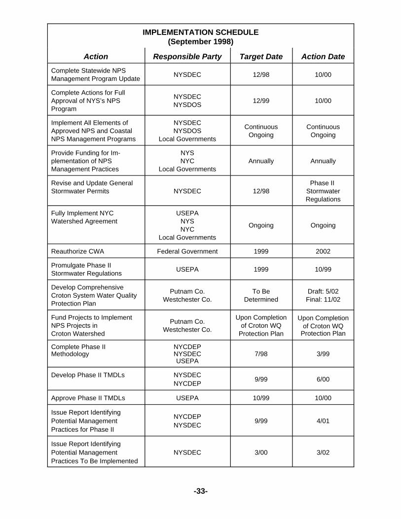
-33-
IMPLEMENTATION SCHEDULE(September 1998)
Action Responsible Party Target Date Action DateComplete Statewide NPSManagement Program Update NYSDEC 12/98 10/00
Complete Actions for FullApproval of NYS’s NPSProgram
NYSDECNYSDOS 12/99 10/00
Implement All Elements ofApproved NPS and CoastalNPS Management Programs
NYSDECNYSDOS
Local Governments
ContinuousOngoing
ContinuousOngoing
Provide Funding for Im-plementation of NPSManagement Practices
NYSNYC
Local GovernmentsAnnually Annually
Revise and Update GeneralStormwater Permits NYSDEC 12/98
Phase II StormwaterRegulations
Fully Implement NYCWatershed Agreement
USEPANYSNYC
Local Governments
Ongoing Ongoing
Reauthorize CWA Federal Government 1999 2002
Promulgate Phase IIStormwater Regulations USEPA 1999 10/99
Develop ComprehensiveCroton System Water QualityProtection Plan
Putnam Co.Westchester Co.
To BeDetermined
Draft: 5/02Final: 11/02
Fund Projects to ImplementNPS Projects inCroton Watershed
Putnam Co.Westchester Co.
Upon Completionof Croton WQ
Protection Plan
Upon Completionof Croton WQ
Protection Plan
Complete Phase IIMethodology
NYCDEPNYSDECUSEPA
7/98 3/99
Develop Phase II TMDLs NYSDECNYCDEP 9/99 6/00
Approve Phase II TMDLs USEPA 10/99 10/00
Issue Report IdentifyingPotential ManagementPractices for Phase II
NYCDEPNYSDEC 9/99 4/01
Issue Report IdentifyingPotential ManagementPractices To Be Implemented
NYSDEC 3/00 3/02

-34-
Building on the schedule above, more recent implementation actions can beadded.
IMPLEMENTATION SCHEDULE(December 2001)
Action Responsible Party Target DateComplete NYC Watershed DataManagement and Software ToolDevelopment Project
USEPANYSDEC Spring 2003
Implement Phase II StormwaterRegulations in Putnam and WestchesterCounties
Plan for PermitsMS4's Permitted
1/023/03
Center for Watershed ProtectionRecommendations CWP 6/02
Continue to Monitor and Assess NYCWatershed Reservoir System NYCDEP Ongoing
5. Implementation Mechanisms and Next Steps
Section 3 of this Report identified numerous program activities and projects that areachieving NPS phosphorus reductions or are working toward phosphorus reductionstrategies in the Croton Watershed. Examples of implementation mechanisms that arealready in-place include:
# environmental education work shops - where information and training onprograms and practices can be disseminated.
# wastewater treatment plant construction to eliminate septic system problems -where nonpoint source loadings from failing onsite wastewater treatmentsystems can be eliminated.
# advisory committees - such as Westchester County’s stormwater advisorycommittee can facilitate the upgrading of local stormwater control programs.
# local planning and zoning boards - that can utilize information on nonpointsources when making land use decisions and where appropriate, land useregulations can be put in place.
Consideration should be given to establishing an institutional framework for the CrotonWatershed, in order that implementation will proceed in an effective manner. The DEC willconsult with the Watershed Protection and Partnership Council regarding how to proceedwith this.

-35-
When implementing the actions necessary to achieve the NPS reductions identified in theTMDL it is important to recognize that beyond the individual reservoir reductions, in manysituations there also is a need to consider reductions that contribute to achievingdownstream goals.
5.1 Watershed Approach
In EPA’s Phase II TMDL approved letter of October 17, 2000 a table labeled “AttachmentA” was included. It addressed six of the water quality limited basins in the CrotonWatershed that receive significant phosphorus loads from upstream waterbodies. Theright-hand column presented herein lists preliminary upstream reduction estimates forupstream basins by reservoir system. These reduction amounts can be found in the April2001 NPS Report and are in addition to those identified in each TMDL. The magnitude ofthese numbers helps put in perspective, the tasks at-hand with regard to NPSimplementation.
The following items are important to implementing NPS load reductions in the CrotonWatershed:
1. Improved, more detailed land use information and modeling such thatimplementation can be specifically targeted, prioritized and efficient.
2. A coordinating effort to facilitate NPS implementation efforts with a focus on theCroton Watershed.
3. Program Coordination and Integration - the ability to continue and sustain theimplementation process and connect it to the results of Croton Planning byPutnam and Westchester Counties.
4. Local involvement in the phosphorus reduction process translating reservoirbasin reduction needs to the Town level and beyond.
5. DEC’s program to implement Phase II Stormwater Regulations in Putnam andWestchester Counties.
6. The continuation and refinement of a monitoring program to assess theprogress of implementation efforts.
7. The possible development of task forces by topic to facilitate implementation(Urban Stormwater, Highway Runoff/Deicing, Agriculture/Open Space).
8. The ability to reassess phosphorus TMDLs where appropriate based onadditional data and improved models.

5 Preliminary Upstream Reduction Estimates based on following factors: additional amountslisted are subsequent to 25% NPS phosphorus reduction already applied to each of the sixWQL reservoir basins and include upstream reservoir retention factors for phosphorus perApril 2001 NPS Report.
* Not currently water quality-limited.
-36-
The above elements can be viewed as next steps in the implementation process. NPSprograms and projects must continue as identified so that progress can be made towardeffective implementation and the attainment of water quality standards.
“Attachment A”
Six of the water quality-limited basins in the Croton Watershed receive significant loads from upstreamwaterbodies. In addition to in-basin nonpoint source reductions, NYSDEC has identified reduction innonpoint sources of phosphorus in upstream basins as possible management options to achievenecessary load reductions in water quality-limited basins. In upstream water quality-limited basins,additional reductions beyond those needed to achieve their TMDLs may be needed to meet thenecessary load reductions in downstream basins. Upstream basins that meet water quality standardsmay also require nonpoint source reductions for downstream reservoirs to achieve TMDLs.
Water Quality-Limited ReservoirRequired NPS
Reductions(kg/yr)
Upstream Basins PotentiallyRequiring AdditionalReductions to MeetDownstream TMDLs
(kg/yr) 5
New Croton 1356 Muscoot 893
Muscoot 2058 Cross River * 206Amawalk 123Titicus 207Croton Falls 546Diverting 552
Croton Falls 885 Middle Branch 199Diverting 633West Branch * N/A
Middle Branch 204 Lake Carmel N/A
Diverting 983 Bog Brook * 94East Branch 1022
East Branch 993 Putnam Lake * N/APeach Lake N/A

-37-
5.2 Monitoring and Evaluation
As programs and projects are completed and best management practices are applied,there will be an need for monitoring data, its analysis and the evaluation of NPSimplementation efforts.
The best way to do this is a system-wide assessment, based on endpoint monitoring(reservoir or downstream), to document improvements in water quality due to theapplication of phosphorus load reduction measures.
NYCDEP should continue to monitor and model water quality in its reservoirs. DEPmaintains a comprehensive monitoring program which is necessary to assess the impactsof point and nonpoint control measures on reservoir water quality as well as futurephosphorus reduction implementation strategies.
5.3 Conclusion
The DEC is committed to the TMDL Program. It is recognized that there is an ongoingneed to reduce phosphorus loads, particularly in the Croton Watershed. It is alsorecognized that the implementation of NPS management practices does not follow thesame regulatory framework as with point sources. As Croton Planning moves towardimplementation, the combination of the recommendations resulting from Croton WatershedProtection Plans and Stormwater Pollution Prevention Plans required by Phase II-Stormwater Regulations is important to achieving significant NPS phosphorus reductions.
The specific implementation components listed in the Preface represent the framework forthe development of a final implementation plan. They can be summarized as follows:
• identification of BMPs specific to each reservoir basin to meet TMDLs and achievedownstream standards;
• a list of municipal entities designated by Phase II Stormwater Regulations;
• quantifications of upstream, additional load reductions, above those to meet theTMDL for that waterbody and necessary to achieve downstream standards;
• a description of implementation mechanisms;
• the time frame for implementing the actions;
• funding sources for implementation; and,
• a plan for evaluating/monitoring plan effectiveness.
The specifics of implementation and the development of individual basin plans will rely onkey activities previously outlined such as: Croton Planning, Phase II StormwaterRegulations implementation and continued ambient water quality monitoring. Therefore,it is important that these activities remain sufficiently funded and on schedule.


APPENDIX A
SDWA and WRDAFunded Projects


A-1
NONPOINT SOURCE IMPLEMENTATION MEASURESFROM SDWA FUNDED PROGRAMS
FOR PHASE II PHOSPHORUS TMDLs
Wetlands Mapping Westchester County
This 2001 - 2002 wetlands mapping project is reviewing existing and potentialwetlands and amend the State designated wetlands in the NYC Watershed portion ofWestchester County consistent with the requirements in Article 24 of the NYSEnvironmental Conservation Law and 6NYCRR Part 664. This activity is being conducted,partly, in response to a request from NYC to review all wetlands in the NYC Watershed.DEC staff is conducting the program through contract and provides oversight to field work,spot-checks field verification, attends public hearings and reviews all documentation.Contract work includes conducting aerial photograph review and field verification ofpotential new wetlands under Article 24 jurisdiction in addition to wetland boundarychanges on existing mapped wetlands. Potential wetlands identified include: wetlandsidentified originally by DEC; wetlands identified by a preliminary review of the NationalWetland Inventory (NWI) Maps and USGS topographic quadrangles encompassing thestudy area; wetlands of Unusual or Local Importance (ULI) identified by DEC’s EndangeredSpecies Unit and NYC DEP; and, wetlands identified through review of hydric soils fromsoil survey information.
Evaluation of wetland boundary changes will be based on a comparison of NWI Mapboundaries and existing Article 24 mapped wetlands. Aerial photographs are beingreviewed to determine the correct boundaries. This project also includes all other tasks tocomplete the map amendment process, such as, producing draft and final maps,completing landowner lists and notification, attending/facilitating hearings, landownerfollow-up and filing of final maps. A final report, including appropriate maps, will beprepared.
Estimated Cost: $285,000Estimated Completion Date: July 2004
Streamkeeper Project
Riverkeeper, the Stroud Water Research Center (Stroud), and Hudson Basin RiverWatch (HBRW) are conducting a New York City Watershed Streamkeeper Project whichwas initially started in 2000 and continued in 2001 and is scheduled to continue in 2002.This is a program designed to enhance teacher professional development, improveenvironmental science education, and complement on-going stream monitoring programsthroughout the Delaware-Hudson region of the New York City Watershed. The programis enhancing a basin-wide network linking students, teachers, and the environmental datagathered by them on their local streams. The program seeks to have a large number ofsecondary schools spread over a broad geographic area participate in the StreamkeeperProject whereby students generate "stream health" data (using common methods) andshare it with one another in order to understand the health of a stream in their backyard.

A-2
The program components include: first, a series of teacher summer workshops thatwill give groups of teachers common understanding and knowledge of stream ecology andinstructions in using a curriculum kit called "The Leaf Pack Experiment," a noninvasiveaquatic macroinvertebrate sampling kit, and the "Hudson Basin Guidance Document"monitoring protocols; second, each school assesses the health of a nearby stream usingcommon field, laboratory, and analytical techniques contained in the Leaf Pack Kit andHBRW Guidance Document; third, each school places their data into a common database,which not only puts their results into a local and regional perspective, but also facilitatessharing and communication between students and teachers in otherwise disconnectedschool systems and social settings; fourth, the pooling of data creates a network ofsampling points such that each individual school experiment (sampling point) contains farmore value than it would as a separate project; and fifth, as each subsequent new classperforms the experiment (year after year), the strength of the database grows and the localvalue of this school project escalates. Teachers are involving groups of students in along-term ecological monitoring project that is strengthening the local school curriculum.
The goals of this project are: to promote an awareness of stream biodiversity andits connection with the landscape; to promote an understanding of local stream health andhow it relates to local land use practices; and to improve local science education and relatestudent learning to local environments.
This project is designed to be widely applicable to schools throughout the New YorkCity watershed. Intended as a supplement to the local curriculum, participating teacherscan incorporate the HBRW protocols and Leaf Pack Experiment materials easily. Allparticipating schools are required to conduct their field studies within a particular projecttime window so that data gathered will be comparable between the various participatinggroups. Both Stroud and HBRW are providing field and in-school support during thisimplementation period. A system of Quality Assurance/Quality Control is being developedfor the data, including a reference macroinvertebrate specimen collection created at eachschool.
Estimated Cost: $146,250Estimated Completion Date: September 2002 (and on-going as funding permits)
Golf Course BMP Study
This project is being conducted in 2002 to determine to what extent golf coursesuperintendents and facility managers employ best manage best management practicesto ultimately protect water quality and minimize off site impacts. Nutrient (nitrogen andphosphorous) and pesticide fate studies funded by a multitude of agencies conclude onan academic level that through the adherence to Best Management Practices (BMP's), theuse of agrochemicals on golf courses are of negligible or no environmental impact; also,the findings of the scientific community have reinforced the existence of golf courses asa responsible type of land use when in conformity to BMPs. However, efforts to date havefailed to address the final component required to fulfill the initial vision that initiated all priorresearch. Thus, to assess the level of conformity to BMPs and potential influences onenvironmental quality, the objectives of this project are to: 1) identify golf courses withvarious management expertise and environmental management philosophy; 2) conduct anexhaustive assessment of cultural, pest, and environmental management practices for
A-3
conformity to BMPs; and 3) validate the impacts of completing Audubon International'sCooperative Sanctuary Certification program requirements.
The implementation of agrochemicals on golf courses to maintain turf quality hasbeen suggested as a source of contamination to surface and ground water supplies. Inrecognition of the involvement golf courses have within their communities and the abilityfor them to enhance environmental quality, Audubon International has acknowledged thepotential for golf courses to serve as environmental leaders under their CooperativeSanctuary and Signature certification programs. This project will identify various levels ofenvironmental management programs implemented by public, private, and resort coursesbased on involvement with the Audubon Cooperative Sanctuary Program (ACSP)administered by Audubon International (Al). In support of research indicating thatimplementation of BMPs occur most effectively when small changes are made to existingprograms rather than the commitment to substantial increase in expertise and resources,the project will explore the implementation of sustainable management practices employedby facility managers. Specifically, every aspect of course management including culturalprograms such as mowing, fertilization, irrigation; pest management such asimplementation of monitoring programs as part of an IPM system; and environmentalmanagement, such as buffer strips, wildlife habitat maintenance and wetland managementwill all be reviewed to open and reinforce discussion among key personnel,patrons/members and partnering agencies. Additionally, the project seeks to identifytrends in current course management and identify areas that need additional educationalefforts. This project will also explore the differences in management and consistencies tobest management practices among public, private and resort golf courses. By surveyingAudubon and non-Audubon affiliated courses, this project seeks to validate theeffectiveness of participating in the Audubon Cooperative Sanctuary Program with regardto water quality and surrounding environmental impacts. A final report summarizing thefindings will be prepared.
Estimated Cost: $20,000Estimated Completion Date: September 2003
NYCDEP Ambient Surface Water Quality Monitoring
This monitoring effort is a High Runoff Monitoring project that initially received SDWAfunding during FFY1998. It involves the operation of automatic streamflow and waterquality sample collection, laboratory analysis and reporting. The goals of this project areto provide streamflow and water quality data that are sufficient to calculate storm eventloads of specific analytes generated at a catchment scale. The catchments that aremonitored represent two areas where land use changes are expected to occur, and a thirdarea where land use changes are not expected to occur. This latter area will be used asa reference site. The storm event loads will be used to evaluate the changes in waterquality associated with the land use changes on the two catchments, as compared to thereference catchment. Following these land use changes, additional monitoring locationsmay be added to evaluate the effect that best management practices will have on waterquality. In addition to these specific goals, data collected from this project will be availablefor Croton Process Studies and as input data for future Croton system terrestrial andreservoir models.

A-4
NYCDEP’s watershed regulations rely upon the construction of best managementpractices during site development to minimize the effects of land use changes on waterquality. Some data exists on the effectiveness of these structures at reducing analyteloads in stormwater runoff. During the stormwater pollution prevention plan applicationprocess, project developers typically utilize "cook book" values to assign pollutant removalrates to selected best management practices. This study will provide real data, applicableto the NYC watershed area, that may be able to validate or refute the pollutant removalvalues that are used during the stormwater pollution prevention plan review and approvalprocess. This study may be able to provide important data in determining the effectivenessof the NYCDEP’s watershed regulations in meeting both FAD and MOU requirements.
Rather than using the historic, routine fixed frequency monitoring program, these goalsare best met through monitoring high runoff events at selected stream sites within theCroton watershed. Best Management Practices, and the Department’s watershedregulations, are designed to control nonpoint source runoff and the increased pollutantconcentrations and loads that occur during high runoff events. How well BMPs and thenew regulations control both nonpoint source and stormwater runoff can only be assessedthrough intensive, long-term monitoring of high runoff events. The project will conductsampling at two study sites and one reference site within the Croton watershed. Thesesites will be selected so that sampling locations can be placed downstream from twoproposed development projects as well as downstream from a catchment that will not beaffected by development during the course of the study, well before construction will occur(preferably, two years of sampling prior to construction). Sampling will continue throughoutthe construction phase, and then for several years after construction. In addition to thesesampling locations, additional sampling locations may added following construction at eachsite. These additional locations will isolate inflows and outflows from BMPs constructedon the developing areas of the two study sites.
The funding for this fiscal year will allow us to continue storm event monitoring at thetwo impact sites and one control site identified and monitored under previous fundingawarded for the first two years of this project. The analytes collected at the sites will beTotal Phosphorus, Total Dissolved Phosphorus, Nitrite/Nitrate, Dissolved Organic Carbonand Total Suspended Solids. Approximately eight (8) storm events will be sampled eachyear. Samples will be collected and analyzed based on their location along thehydrograph. Approximately 10 samples will be collected from each sampling locationduring each storm event. The final report will present hydrograph and pollutographinformation as well as pollutant loads for each storm at each site. Additional years offunding will be necessary to continue monitoring the project after development hasoccurred at the two study sites.
Estimated Cost: $337,000Estimated Completion Date: October 2003
NYCDEP’s Total Phosphorus Management in Croton System
The TP Management in Croton System project will expand the scope of the CrotonWatershed Strategy project to specifically address phosphorus reductions in the CrotonSystem and improve the overall watershed strategy. The project is for the development

A-5
of a Tracking System that will be a GIS-based tool to track basin activities that are likelyto effect phosphorus loading in the reservoir basins. The software will utilize the datasetsand modeling tools developed as part of the Croton Watershed Strategy and will bedeveloped as an intranet application using ArcView 8.1 and WEB technology. A widevariety of phosphorus reduction related projects would be included such as DEP programs(Project Review, Land Acquisition, WWTP upgrades, Watershed Agricultural Program),County programs, and State programs. For each basin, the Tracking System will estimateloading changes based on project scope, schedule and implementation status andgenerate status reports. While the primary focus will be phosphorus, nonpoint sourcepollution in general will be accommodated as well.
Estimated Cost: $100,000Estimated Completion Date: February 2003
NYCDEP’s Croton System Reservoir Models
This project is for the Development and Testing of Hydrothermal and Water QualityModels for the Croton System. It is part of a three phase project. Phase I is currentlyunderway and is for the development of one-dimensional hydrothermal modeling. ThisPhase IIa project will be for limited model testing and setup in the New Croton Reservoir.The remainder of Phase II will be conducted in the future consisting of full testing of thewater quality model for the New Croton Reservoir and setup and testing of hydrothermaland water quality models for remaining Croton System Reservoirs. The future Phase IIIproject will be for linkage of reservoir and terrestrial models and development of reservoirwater quality management software. These models will serve as in-house managementtools for NYC DEP and contribute to the effective management of this reservoir system.This work will build on three critical components that are presently underway for EOHreservoirs: (1) long-term monitoring programs conducted by NYC DEP of reservoirhydrology and operations, tributary and reservoir water quality, and meteorologicalconditions; (2) detailed process studies in the EOH reservoirs and watershed; and (3)Phase I EOH reservoir modeling. The process studies are intended to resolve origins ofcritical materials, to quantify key processes, and to accurately specify forcing conditionsand temporal and spatial patterns for state variables of hydrothermal and water qualitymodels. The findings of this work will enhance the credibility and predictive capability ofthe models to be developed as a part of this work, and therefore their value asmanagement tools. Calibration of a one-dimensional hydrothermal model for seven of thereservoirs (Titicus, Diverting, Croton Falls, Amawalk, Cross River, Muscoot, and NewCroton), as well as verification testing for two of these seven systems (Muscoot and NewCroton), is to be supported in Phase I of the EOH modeling program. This hydrothermalmodel will serve as the mass balance and transport framework for the one-dimensionalwater quality models for the EOH reservoirs.
The tasks for Phase IIa will consist of testing of a two-dimensional hydrothermalmodel (this will include setup and calibration of a two-dimensional model for New CrotonReservoir for a single year) and setup of a one-dimensional water quality model (this willinclude setup for New Croton Reservoir only). Model setup involves preparation of theinput data that would be used to operate the water quality model. This task does notinclude actual operation of the model; model operation including testing would take placelater in the completion of Phase II. A summary report will be prepared.

A-6
Estimated Cost: $200,000Estimated Completion Date: May 2003
NYCDEP’s Kensico Model Enhancement
This project to is to adapt a three-dimensional (3-D) model for the KensicoReservoir. This model will require minimal staff commitments (e.g., compatible withMicrosoft Windows and with integrated graphic user interface). In addition tohydrodynamic and eutrophication (like other Catskill/Delaware models) model, the modelwill have sediment transport (alum floc), particle tracking (pathogen), spill (from adjacentroad, bridge, & airport), and flexible user defined (pathogen, turbidity) constituentcapabilities, with associated easy grid and control file generation, and post-processing. Afully 3-D model, including all Kensico Reservoir Branches, with associated graphical userinterface will be developed along with four bathymetry files using the Grid generatormodule (initial bathymetry, bathymetry #1 with existing turbidity curtain for Malcolm brook,bathymetry #2 with existing recent dredging near aqueduct intakes, bathymetry #3 withfuture turbidity curtain for Whippoorwill cove). The model will be calibrated using dye studydata from 1994 and temperature and other constituents using data from a year to bedetermined. The model calibration will be verified using data from another year to bedetermined. The model input will be prepared for the years 1992 through 1999, usingdigital data provided by NYC DEP.
Estimated Cost: $70,000Estimated Completion Date: December 2003
Department of State’s Master Planning and Zoning Enhancement Program
This program began in 2001, and will continue through at least 2002, offers (1) enhanced training and technical assistance to municipalities to assist and encourage them to create or update community development tools, land use regulations, and environmental controlsfor enhancing water quality protection; and, (2) opportunity to commence certain localactions that have been identified during the development of the Croton Plan. Thus, theprogram is being used to:
- Update existing comprehensive plans to reflect land use goals consistent with theWatershed Agreement;
- Amend or adopt local land use regulations and environmental controls forWatershed and water quality protection;
- Prepare strategic capital investment programs to address existing non-point sourcesof water pollution; and
- Prepare strategic capital investment and management plans for Designated MainStreet areas within the East of Hudson Watershed.
Estimated Cost: $370,000Estimated Completion Date: July 2003

A-7
Westchester County Volunteer Watershed Monitoring and Assessment Program
Westchester County will use education, community involvement and stewardshiptomonitor and assess streams and lakes throughout the County. The Croton and Kensicowatersheds in Westchester County will be the first target area to deliver Westchester’sVolunteer Watershed Monitoring and Assessment Program. Not only does 40% of theCounty’s land area fall within these two watersheds, the majority of the lakes within theCounty are found within the New York City Watershed area, which serves approximately85% of the County’s drinking water. The program will be conducted in the Fall of 2001 andthroughout 2002. It will include continuing and expanding the existing monitoring efforts;creation of a Westchester County Lake Group and associated Watershed Web; and,training and education of all volunteer monitors.
Estimated Cost: $270,000Estimated Completion Date: July 2004 NYCDEP Wetland Water Quality Functional Assessment
The goal of this study is to better understand the relationship between wetlands andwater quality in the Catskill/Delaware system. This project is for a two year study that will:identify and monitor approximately 22 wetland sites located throughout the Catskill andDelaware Watersheds. During year one, baseflow water quality monitoring will beconducted at 22 reference wetlands located throughout the Catskill and DelawareWatersheds and detailed vegetation and soil sampling will be conducted at 11 of the 22sites. During year two, baseflow monitoring will be continued at the 22 reference wetlands,vegetation and soil sampling will be completed at the 11 remaining year one sites, anddetailed hydrogeological investigations will be conducted at a subset of the 22 referencesites. Analytes will include color, total phosphorus, total dissolved phosphorus, totalsuspended solids, and dissolved organic carbon at the inflows and outflows of thereference wetlands. The results of the study will be used to direct the development ofwetland protection and nonpoint source programs, to quantify the roles of wetlands in waterquality modeling and to provide guidance for regulatory permit decisions.
A benefit of the NYC DEP's Wetland Functional Assessment work is that it willprovide maps derived from remotely-sensed data that denote wetlands that have thepotential to supply eight benefits, some which correspond to the state's criteria for UnusualLocal Importance (ULI). The functions assessed are: surface water detention, streamflowmaintenance, nutrient cycling, sediment and particulate retention, shoreline stabilization,fish habitat, waterfowl and waterbird habitat, and other wildlife habitat.
NYCDEP will assess whether the 22 reference wetlands meet the States ULI criteriaand will discuss the costs of re-mapping and benefits to water quality protection. NYCDEPwill also provide the results of the Wetland Functional Assessment to the State to assistDEC in their policy decisions. NYC DEP has already presented preliminary classificationsto the state DEC and EPA, ACOE and others at the Wetlands Interagency meetings.
Local governments have the authority to implement a freshwater wetlands protectionlaw or ordinance and file a freshwater wetlands map that is more protective than theState's. This is more common to East of Hudson than to West of Hudson. To encourage

A-8
this, NYCDEP will present local governments with the results of the Wetland FunctionalAssessment work as it is accomplished and provide technical support.
Estimated Cost: $500,000Estimated Completion Date: July 2004
NYCDEP Monitoring Effectiveness of Stream Restoration - Demonstration BMPs
The purpose of this project is to monitor the effectiveness of BMPs installed on threeunstable stream reaches over a five year period; however, only the first year of the fiveyear study is included in this proposal. This project will include selection of three unstablestream reaches for installation of stream stability BMPs and six control/reference reaches;monitoring of the nine reaches before installation of BMPs for geomorphic assessment,bed mobility dynamics, biological assessment, riparian characterization and aquatic habitatcharacterization; and installation of 18 crest stage gages (at upstream and downstreamend of the 9 reaches).
Stormwater Management Practices Monitoring Demonstration Project
The NYC is proposing a 3-year program to 1) assess watershed conditions, monitorwater quality and evaluate sampling data, and identify incidences of improperly controlledstormwater that result in the discharge of pollutants to the water supply, and 2) through thedesign, construction and monitoring of stormwater management practices, eliminatenonpoint sources of pollution in the water supply watersheds and generate important dataconcerning the effectiveness of different stormwater management practices in reducingstormwater related pollution. Sites where stormwater practices will be implemented will beselected based upon the availability of water quality data, watershed condition and landuse data, and the affected waterbody’s classification on the DEC’s Priority Waterbody List(PWL). The proposed program is consistent with both the New York State NonpointSource Management Plan and the applicable County Water Quality Strategies, whichprioritize watershed assessment and remediation programs. The project is also consistentwith the federal and state Unified Watershed Assessment, developed under the CleanWater Action Plan to integrate the protection and restoration of water and water-relatednatural resources.
Implementing the program will require the following steps:
1 Review existing water quality data and conduct site evaluations to determine currentwater quality conditions, identify additional data needs, and predict future water qualitytrends. Additional water quality data will be collected if necessary.
2 Identify source(s) of contaminants. Examples of sources to be investigated includeeroding stormwater conveyance systems, improperly stabilized stormwater outfalls,and stream channel erosion.
3. Characterize pollutant loads from each source and prioritize need for remediation.
4. Identify appropriate stormwater management practices at selected sites.

A-9
5. Design stormwater management practices.
6. Secure all federal, state, and local permits necessary to implement appropriatestormwater management practices.
7. Construct practices.
8. Monitor, maintain and evaluate practice performance.
9. Transfer data to the National Stormwater BMP Database.
The remediation project targets reservoirs and tributaries that are classified aspriority waterbodies by the DEC’s PWL in association with the DEP. The PWL is astatewide list of use impaired waters maintained by the DEC. It is an inventory ofwaterbodies that characterizes and tracks known and/or suspected water quality problemsand issues throughout the state. The state is mandated to create and update a list ofimpaired waters by the Clean Water Act (Clean Water Act Sec. 305(b)). The DEC acceptswaterbody nominations annually for consideration to be listed on the PWL. Regionalplanning boards make submissions, county water quality coordinating committees,watershed associations and local governments. The PWL Program uses a 5-year rotatingbasin cycle to evaluate all waterbodies in the state. In 1999, the program exceptednominations for waterbodies within the Lower Hudson Drainage of New York State. Thiscontains the Croton, Rondout and Ashokan watersheds of the New York City drinking watersupply. When available, the updated list will be incorporated into the site selection criteria.
Based upon the Department’s experience in identifying and remedying improperlycontrolled stormwater management systems, the following budget/funding request isproposed.
Estimated Cost: $187,000Estimated Completion Date: December 2004
NYCDEP - Initiation of Model Testing for East-of-Hudson Reservoirs
This will represent Phase I of a multi-phase water quality modeling initiative forNYC’s East-of-Hudson (EOH) reservoir system. The major tasks will include:
- calibration of a one-dimensional hydrothermal model for Cross River Reservoir forthe conditions of 1999, including: obtaining and reviewing hydrologic data,meteorological data, hydrodynamic measurements and temperature profile data;hydrologic budget analysis; and hydrologic model development
- calibration of a one-dimensional eutrophication model for Cross River Reservoir forthe conditions of 1999, including: obtaining and reviewing tributary and reservoir

A-10
water quality data; and evaluating speciality data sets of depositional data, opticalstudies, individual particle characterization, phosphorus fractions and bioavailability,phytoplankton growth kinetics, and zooplankton grazing data
The hydrothermal model serves as the transport framework (sub-model) forcorresponding eutrophication/water quality models. This must be successfully calibratedbefore testing of the water quality model proceeds. The hydrothermal model correspondsto the frameworks that have been successfully applied to the Catskill/Delaware reservoirs.The eutrophication modeling effort for Cross River Reservoir will be the forerunner ofmodel calibration testing to be conducted for 1999 conditions subsequently for eight otherEOH reservoirs, and verification testing for all nine reservoirs. A report will document thedevelopment of model inputs, the distributions of model state variables, and theperformance of the models in simulating the observed distributions.
Estimated Cost: $100,000Estimated Completion Date: December 2002
NONPOINT SOURCE IMPLEMENTATION MEASURESFROM WRDA FUNDED PROGRAMS
FOR PHASE II PHOSPHORUS TMDLs
Project Name:
Evaluating the Effectiveness of Stormwater Management Facilities and the Utility ofStormwater Wetland Treatment Systems
Grant Recipient:
NYCDEP
Project Description:
The department proposes to construct and evaluate the pollutant removal capabilities andmaintenance requirements of four stormwater management facilities. Two facilities willinclude created or enhanced wetlands as a stormwater treatment component. Three typesof facilities are to be evaluated: infiltration basins, retention basins and extended detentionbasins with wetland components. The project is also designed to determine the wetlandcharacteristics that will maximize pollutant removal capabilities of a wetland whileminimizing maintenance requirements.
Total Project Cost:
$ 546,667
WRDA Share:
$ 410,000

A-11
Estimated Completion:
December 2004
Selection Highlights:
1. Environmental benefit: The project will provide much-needed site-specificinformation on facility performance, design standards and maintenance needs. Thistechnical support will, in turn, advance non-point source and wetland regulatoryprograms. The study will broaden knowledge of the utility of and the long-rangeadvantages and disadvantages of created wetlands.
2. Evaluation factors: The project appears to be an excellent way to determine theeffectiveness of installed BMPs. There is also an opportunity for coordination withWestchester County for a stewardship program concerning installed BMPs.
3. Significance/role: The proposed project fills a significant gap in the scientificliterature concerning maintenance requirements of the three types of facilities to beevaluated and the treatment abilities of certain design requirements. Theinformation gained in the study will be directly applied to the Department'sregulatory and non-regulatory stormwater and non-point source managementprograms. The information is also directly applicable to federal and state wetlandand non-point source regulatory programs.
Project Name:
Patterson Hamlet Sewer Project
Grant Recipient:
Patterson, Town of
Project Description:
The scope of this project is for the plans, specifications, facility plan and permits for thecreation of a municipal sewer district along with the design of a sewage treatment plant ofapprox. 100,000 gallons per day with an associated 9,500+- linear feet of sewagecollection system. The project will be located in the Hamlet of the Town of Patterson,Putnam County. The project will combine two STPs and several subsurface sewagetreatment systems into one "state of the art" sewage treatment plant.
Total Project Cost:
$385,000
WRDA Share:

A-12
$288,750
Estimated Completion:
December 2002
Selection Highlights:
1. Environmental benefit: The proposed project will combine two aging sewagetreatment plants and several subsurface sewage treatment systems into onesewage treatment plant designed to meet current SPDES discharge standards. Thecombining of these two point discharges into one single municipal plant offersbenefits: 1-reduced O&M costs. Larger flow sewage plants are generally more costefficient to operate. 2-Better oversight of the monitoring of discharge to ensurecompliance with the SPDES standards. 3- Guaranteed revenue source to ensureimmediate correction of any malfunctions.
2. Evaluation factors: The creation of a new sewer district will be a community widesolution.
3. Significance/role: The new sewage treatment plant will reduce the phosphorousload from the two existing sewage treatment plants contribute 25.8% of the totalphosphorous discharged from point sources in the East Branch Reservoirwatershed.
Project Name:
Patterson Hamlet Sewer Project
Grant Recipient:
Town of Patterson
Project Description:
The scope of this project is for the construction of a municipal sewage treatment plant ofapprox. 100,000 gallons per day and associated about 9,500 linear feet of sewagecollection system. The project will be located in Patterson Hamlet of the Town ofPatterson, Putnam County. The project will combine two STPs and several subsurfacesewage treatment systems into one "state of the art" sewage treatment plant. The designof the system was funded through an earlier WRDA grant. The funds being provided areto help with the construction costs. The remainder of costs are from MOA Paragraph 141:Upgrades to Existing WWTPs to Comply with Watershed Regulations, and Paragraph 140:East of Hudson Water Quality Investment Program.

A-13
Total Project Cost:
$533,333
WRDA Share:
$400,000
Estimated Completion:
December 2004
Selection Highlights:
1. Environmental benefit: The proposed project will combine two aging sewagetreatment plants and several subsurface sewage treatment systems into onesewage treatment plant designed to meet current SPDES discharge standards. Thecombining of these two point discharges into one single municipal plant offersbenefits: 1- reduced O&M costs. Larger flow sewage plants are generally more costefficient to operate. 2- better oversight of the monitoring of discharge to ensurecompliance with the SPDES standards. 3- guaranteed revenue source to ensureimmediate correction of any malfunctions.
2. Evaluation factors: The creation of a new sewer district will be a community widesolution.
3. Significance/role: The new sewage treatment plant will reduce the phosphorousload from the two existing sewage treatment plants which contribute 25.8% of thetotal phosphorous discharged from point sources in the East Branch Reservoirwatershed.
Project Name:
EOH Urban Stormwater, Erosion and Sediment Control Training
Grant Recipient:
Westchester County Soil and Water Conservation District
Project Description:
The proposed project is for stewardship and training for natural resources managementin the areas of erosion and sediment control, stormwater quality and quantity in the urbanCroton watershed. Issues covered during multiple technical workshops include: techniquesand methods to quantify impacts of pollutants from development, evaluation of existing

A-14
conditions, the analysis of hydrologic changes using various runoff techniques, and BMPsto mitigate the effects of increased runoff and pollutant loading from developing areas inthe watershed. Renowned technical experts will be retained by the District to present theinformation in the format of several technical workshops. The technical workshops are tobe held at various locations throughout the Croton/Kensico watershed.
Total Project Cost:
$25,775
WRDA Share:
$19,331
Estimated Completion:
September 2002

A-15
Selection Highlights:
1. Environmental benefit: Attendees will benefit by gaining a thorough understandingof the natural and man-made contributing forces and effects of urban stormwaterand erosion and sediment control on watershed water resources. Attendees willgain a practical understanding of how to apply urban watershed BMPs in the CrotonSystem.
2. Evaluation factors: The project is well outlined, designed, good cost/benefit, wellco-ordinated and ready to be implemented. There is a real need for this type ofproject, and even could be expanded to other areas.
3. Significance/role: This project fulfills a fundamental need for education amongmunicipal officials, consulting engineers, environmental professionals and municipalpublic works staff, as well as interested citizens in the Croton watershed. Theeducation provided under this proposed project will enable municipalities to addressrestrictions on increases in impervious surfaces as described in the MOA.Non-point source education is a major work program item of the County Soil andWater Conservation District. Furthermore, the Westchester County Water QualityCoordination Committee has determined that the Croton/Kensico watershed is ofthe highest priority for addressing non-point source pollution issues.
Project Name:
Brewster (V) Collection System Extension Phases 1, 2 and 3
Grant Recipient:
Brewster, Village of
Project Description:
The scope of this project is the plans, specifications, facility plan and permits for thesewage collection system for the central, eastern and western portions of the Village ofBrewster. Once the plans are ready, NYC DEP has committed one million dollars for theconstruction of the collection system for the western portion of the project.
Total Project Cost:
$721,000
WRDA Share:
$540,750

A-16
A-17
Estimated Completion:
April 2002
Selection Highlights:
1. Environmental benefit: The project will halt the discharge of pollutants to the EastBranch of the Croton River and the Diverting Reservoir, and by eliminating thedischarge of pollutants, the potential improvement factor for the project will bereduced by two levels (impaired to none).
2. Evaluation factors: Once the design work is completed, the NYC DEP funding willbe available for immediate work to provide sewage collection for the western portionof the village.
3. Significance/role: The primary method of wastewater treatment in the Village ofBrewster is through on-site septic systems; these systems have a long history ofrepetitive failures. It is clear that such repeat failures in a densely populated anddeveloped area immediately tributary to the NYC water supply have an adverseeffect on that water supply. The proposed project will provide sewers to the village.Sewering is the single most comprehensive approach to solving the problem ofrepeating failures of on-site septic systems. It is also the most comprehensiveapproach to relieving the adverse impact of these failed systems on the waterquality of the Diverting Reservoir.
Project Name:
Agricultural Non-point Source Pollution Assessment within the NYC Watershed
Grant Recipient:
Putnam, County of
Project Description:
The project is to conduct an agricultural non-point source (NPS) pollution assessment ofthe NYC Watershed within Putnam County. The assessment will use the Tiered planningapproach of Agricultural Environmental Management (AEM) to identify which farms arecontributing to NPS pollution, what the primary pollutants are and where they areoriginating from, and what potential actions/BMPs would control the pollution.
Total Project Cost:
$87,067

A-18

A-19
WRDA Share:
$65,300
Estimated Completion:
December 2002
Selection Highlights:
1. Environmental benefit: The project will identify all farms and their exact locationswithin the NYC Watershed within Putnam County, identify which farms arecontributing NPS pollution, what the primary are, their origination, and what potentialactions / BMPs would control pollution and improve water quality.
2. Evaluation factors: This project can have broad ranging effects in the county for asmall amount of funding. It is also not in conflict with work of the WatershedAgricultural Council.
3. Significance/role: The district will conduct a voluntary Tier I and Tier II assessmentof all agricultural operations within the watershed within Putnam County. Thisprocess will be implemented through personal contacts with all farmers to ensurefull participation, initiate information exchange and provide educationalopportunities. Due to public health concerns and the potential for water qualityimpairment, Putnam County SWCD, Putnam County Water Quality StrategyCommittee and Putnam County Health Department have placed priority on effortsthat control NPS pollutants originating from agricultural operations.
Project Name:
Phase I Croton Watershed Stormwater Conveyance and Implementation Projects
Grant Recipient:
Westchester, County of
Project Description:
This project is the first phase of a project to conduct a stormwater conveyance study in apilot watershed area. The second phase of the project would be to implement BMPs whichwould reduce the pollutant (quality and quantity) potential of such stormwater runoff.
Total Project Cost:
$600,000

A-20
WRDA Share:
$450,000
Estimated Completion:
September 2002
Selection Highlights:
1. Environmental benefit: Terraced slopes and perched wetlands are expected tomake different contributions to water quality. The aim of the methods used in thisproject are to entrain the majority of surface flow volumes into soils, rhizosphere,and subsurface flow (i.e., into the water table). Thus, water from a given stormdelivered to down-gradient receiving waters via sub-surface flow will be free fromphosphorous and nitrogen.
2. Evaluation factors: This project should proceed the implementation phase since itis difficult to predict costs of implementation.
3. Significance/role: The proposed project is consistent with the MOA concernsregarding the effects of impervious surfaces on water quality. The MOA concludesthat impervious surfaces are inhibiting to water quality. Using this as the foundation,this project attempts to study stormwater conveyance, implement BMPs to reducethe impact of impervious surfaces and incorporate stormwater conveyance andBMP implementation into local government and construction process.
Project Name:
Agricultural BMP Implementation to Support Whole Farm Planning
Grant Recipient:
Watershed Agricultural Council
Project Description:
The scope of this project will include work in Dutchess County. The Watershed AgriculturalProgram (WAP) is working with watershed farmers to develop whole farm plans andimplement BMPs that address agricultural non point pollution. This project would helpexpand the scope of the WAP by cost sharing implementation of BMPs, thereby allowingWAP to implement more BMPs on more farms throughout the watershed.
Total Project Cost:

A-21
$157,000
WRDA Share:
$117,750
Estimated Completion:
December 2003
Selection Highlights:
1. Environmental benefit: The BMPs that will be implemented by this grant applicationhave been proven to help reduce and prevent agricultural non-point source pollutionfrom impacting surface waters. There are five different BMPs that will beimplemented with this grant.
2. Evaluation factors: The Watershed Agricultural Council (WAC) needs additionalfunds for BMP implementation. These are additional Whole Farm Plans that willhave off the shelve BMPs installed. These implementations will be additionalmonies beyond WAP monies available.
3. Significance/role: The BMPs will be implemented as part of the WAP, which is acomprehensive effort to address agricultural non-point source pollution in theCatskill/Delaware Watersheds. The program has already exceeded its goal to haveat least 85% of the commercial farms in the watershed participating in the program.
Project Name:
Lexington Avenue Storm Water Bio-filter Project
Grant Recipient:
Yorktown, Town ofProject Description:
The existing drainage on Lexington Avenue presently drains south along the existing roadedge and drains into the West Branch Hunter Brook stream channel. The stream channeldrains in a southerly direction into Mill Pond and ultimately into the New Croton Reservoir.The W Br Hunter Brook stream channel is a class "D" stream. The town is proposing toconstruct a bio-filter /first flush basin to trap and settle out as much of the sediments andnutrients as possible. The basin will collect the runoff and allow it to discharge into theexisting wetlands and stream channel via a stone rip-rap overflow channel. This project

A-22
has been reviewed by our local Conservation Board and any of their comments have beenincorporated into the design.

A-23
Total Project Cost:
$125,000
WRDA Share:
$ 93,750
Estimated Completion:
December 2003
Selection Highlights:
1. Environmental benefit: The installation of the bio-filter will reduce point sourcepollutants and sediments from entering the wetlands and ultimately Hunter Brookand New Croton Reservoir.
2. Evaluation factors: The region recommended this technology. The cost seemedhigh, but appears to be a good estimate Project is contingent on studies beingconducted. The project is ready to go, the plans and specs are in place to ask forbids in Spring 1999.
3. Significance/role: The project will provide a natural ecosystem approach toattenuating storm water carried pollutants and sediment that would otherwise beintroduced in the wetland areas.
Project Name:
New Castle Yeshiva Sewer District
Grant Recipient:
New Castle, Town of
Project Description:
This project planning and engineering will be to provide sanitary sewer service to aresidential area, which has had problems with sewer overflows contributing to the pollutionof the New Croton Reservoir. Another part of the area is served by a STP whichdischarges into the Kisco River, which empties into the reservoir close to the intake of theNew Croton Aqueduct. Benefits of sewering the area will be the elimination of pollutantsbeing discharged into the reservoir. Also abandonment of a STP.
Total Project Cost:

A-24
$290,000
WRDA Share:
$217,500
Estimated Completion:
January 2002
Selection Highlights:
1. Environmental benefit: Water quality will be greatly enhanced by the elimination ofsub-surface sewage disposal systems which at times have failed and dischargedeffluent into the surface waters tributary to New Croton Reservoir.
2. Evaluation factors: high cost for engineering for > 100 homes sewer diversion studythis area was noted as problem area they should use diversion study instead ofdoing all work themselves
3 Significance/role: This project is with the goals of NYC to eliminate pollution fromits reservoir system. The treatment plant that will be eliminated is the closest oneto the intake of the New Croton Aqueduct.


APPENDIX B
New York City WatershedData Management and
Software ToolsDevelopment Project


B-1
This project is funded by the USEPA and the NYSDEC and utilizes SDWA funds.It will develop an integrated high resolution GIS data base with a suite of managementtools integral to the database that will be used to map and model the NYC Watershed.The data and tool suite is to be internet accessible. It is the DEC’s intent to use the NYCWatershed project as a template for other watersheds in the state. This work should becompleted by the Spring of 2003.
Watershed protection requires the cooperation of the Federal, State and localgovernments. Non-point source pollutant mitigation is highly dependent on land usechanges and/or the modification of land use practices. Changing the behavior of localpeople for the benefit of the quality of our water resources is extremely difficult. Sweepingregulatory edicts targeted at local governments and property owners based on generallysuspected water quality limiting land use practices will not work. We need to build localcapacity to use and understand the importance of the land use practices on water quality.To do that we need to have a level of sophistication that can identify specific pollutantsources and the means to reduce the sources of pollutant loading. This will allow targetedactions to be considered and enacted with the cooperation of the local governments.
The goal of this project is to develop an improved Information Technologyframework to better assess both the East of Hudson (EOH) and West of Hudson (WOH)regions of the New York City (NYC) Watershed. In particular, there is a significantrequirement in demonstrating the relative progress towards achieving the goals stated inthe 1997 Watershed Memorandum of Agreement (MOA). It is the overall objective of thisproject to complement the existing New York City Department of EnvironmentalProtection’s watershed planning and management program by developing higher resolutiondata, improving the technological tools to make the program more effective and efficientand by developing a common Geographic Information System to leverage the capabilityof the watershed program.
This systems integration effort will address multi-agency geospatial, hydrological,as well as water quality data. Key modular components include a comprehensive relationaland Geographic Information System (GIS) database, custom model interface software,modeling support and visualization tools. The proposed framework will be developed ina two-phase program effort. The first phase will include the development of a prototypetool set, and the application of this system for a pilot study area – the Cannonsvillereservoir/watershed. The second phase will be the conduct of a formal pilot studyevaluation, and subsequent system enhancements and application to the other reservoir/watersheds, as well as the development of selected NYCDEP watershed managementprojects.
The proposed tool set configuration incorporates easy-to-use GIS graphical userinterfaces (GUIs), and allows for distributed data capture and analysis at stakeholderagencies – including NYCDEP, New York State Department of EnvironmentalConservation (NYSDEC), US Environmental Protection Agency (USEPA), New York StateDepartment of Health (NYSDOH), and designated non-governmental organizations(NGOs). Also, a scenario support tool set will be integrated to address potential MOAprogrammatic issues and concerns.
B-2
To better understand the problem, the project will commence with an overall needsassessment, which addresses existing NYCDEP watershed management anddecision-making tools and data structure. This will provide the basis for subsequentlyconducting more in-depth assessments at the major task level. The resulting product willbe a requirements document, which will serve as a detailed specification for each task.This document will further detail the amount of participation required of both NYSDEC andNYCDEP organizations. In addition, a data quality assurance and quality control plan willbe included.
Based upon discussions with NYCDEP, there are two types of watershed programsthat have been implemented in the NYC Watershed - remedial programs and protectionprograms. As highlighted in previous correspondence, these include West of Hudsoncommunity planning, land acquisition, stewardship, and stream management. Remedialprograms address existing land uses with Best Management Practices (BMPs) or otherremedial activities. Protection programs address future land uses with either limits onfuture land use development, or BMPs applied to new developments. The various datadevelopment and software tool-building efforts which have been suggested will beevaluated, in cooperation with the respective program manager, and an implementationstrategy be developed.
The experience gained and lessons learned from NYSDEC programs related to thecharacteristic development of the NY State watersheds have been significant in generatingthe approach and concepts being forwarded for this program. Many elements of NYSDECprograms are being fulfilled by this project to the overall benefit and effectiveness of theNYC Watershed assessment.
This project has the following five key objectives:
1. Develop an integrated, GIS-based, water quality data management tool setfor improved watershed management for the NYC Watershed.
2. Develop a flexible, adaptive GIS database framework which has thecapability to integrate a variety of existing geospatial data.
3. Develop a semi-automated modeling support tool set that would consist ofa modules to support the terrestrial model (GWLF), and Upstate FreshwaterInstitute’s (UFI’s) reservoir model.
4. Based upon a set of priorities established by NYSDEC and NYCDEP,develop scenario support tool set to address Stormwater Best ManagementPractices (BMPs), phosphorous loads, land acquisition, stewardship, andstream bank restoration programs.
5. Develop a capability to allow different levels of user access to otherinterested agencies, including NYSDEC, USEPA, and local governments, aswell as selected non-governmental organizations.

B-3
Based upon our stated five project summary objectives, as well as USEPA, NRC,and ILSI findings, there is a two-phase effort, which is divided into 8 major tasks.
Task 1 comprises an imagery data collection and classification effort. This effortincludes the collection of high resolution color-IR orthoimagery and IKONOSsatellite imagery for the Cannonsville Watershed. In addition, remotely-sensedLIDAR digital elevation data, and Thermal-IR data will be collected for thewatershed floodplain areas. Also, using LANDSAT and EMERGE imagery, a landcover classification will be conducted. Finally, a separate land use coverage will becreated and incorporate demographics, ownership, property value, and landuse/zoning information.
In Task 2, we will to conduct data mining and database development. One of thesignificant challenges to watershed assessment and management is the ability tosynthesize and integrate complex environmental data. The proposed system willconsist of a comprehensive relational and geographic info system database. Issuesof back-up / recovery, as well as synchronization and configuration management willbe addressed. Essentially, the system would allow for the integration of geospatial,hydrological, and water quality data.
Task 3 will develop a modeling and analysis framework in order to provide ananalytical tool to evaluate total stream integrity. In particular, through the applicationof geographic information systems (GIS), useful patterns and extents ofco-occurrence are more recognizable. The database developed in Task 2 will beinterrogated by the modeling support tools, in order to allow for a betterunderstanding of hydrological processes. The basic tool set will consist of theGWLF and UFI reservoir models, which will be later expanded to include other basinhydrology and hillslope / landscape models. Attributes of stream geomorphologyincluding bank stability, pool quality, streambed, sedimentation, and substratecomposition will be addressed through the development of an enhanced set ofstream bank tools.
In Task 4, interactive, scenario support tool set will be developed to address"what-if" questions for the watershed management and planning. A series ofcandidate Best Management Practice editors are proposed. Also, based upon yourguidance, other tool sets are offered including water quality visualization, waterbalance, and streambank evaluation tools.
In Tasks 5 and 6, the database and tool sets developed in Tasks 2-4 will beintegrated and tested. In Task 5, based upon a defined system integration and testplan, system-level testing of an alpha release configuration of the software will beconducted. Any necessary system enhancements will be made prior to proceedingto the next task. In Task 6, a beta release configuration will be applied for a pilotstudy of the Cannonsville reservoir / watershed. During Task 6, a resultscomparison will be conducted between the manually-calibrated models and thenew, semi-automated modeling analyses. Based upon the development of

B-4
additional modeling support and scenario software, additional investigations will beperformed in cooperation with NYSDEC and NYCDEP staff.
Task 7, primarily a Phase 2 effort, will commence with a cooperative evaluation ofthe Cannonsville pilot study. In addition, an evaluation of the various proposedwatershed management projects will be conducted. Based upon this evaluation,and a priority determination made by NYSDEC and NYCDEP, selected watershedmanagement project tools will be developed.
Task 8 details the overall project management tasks including a master projectschedule, organizational structure, and quality assurance plan.
There are some projects that have been accelerated as follows:
Build-Out Model Tool
The purpose of the Build-Out Model Tool (BMT) and Applicationsdevelopment is to create a state-of-the-art ArcGIS tool that will provide theNYCDEP the capability to model the effects and relationship of future landdevelopment scenarios with Land Use and Land Cover for selectedgeographic areas of the NYC Watershed. This task order is in support of abroader Build-Out Modeling initiative in support of the NYC WatershedProgram. This task order will focus on the conversion and extension of theLand Transformation Model-2 (LTM-2) previously developed by MichiganState University. The use of LTM-2 provides the basis for developing acustomized, operational tool, leveraging upon existing NYCDEP data andmodeling assets.
Impervious Cover Classification
The objective of this task order is to develop a land cover classification of theEast of Hudson (EOH) Watershed that delineates all surfaces on or abovethe ground that are impervious to water. In addition, NYCDEP hasrequested support for a related literature review for impervious surfaces.
The classified impervious surfaces will include rooftops, pavement, concrete,and any other surfaces with horizontal dimensions that are impervious towater. The final product will be a binary thematic raster map with each rastercell containing either a pervious or impervious value. This thematic rasterwill allow for tabulation of percentages of impervious surfaces inside political,hydrological, or property boundaries using GIS tools as well as providing animpervious surface " raster mask" for raster spatial analysis. It will also beuseful for land management and water quality and quantity modeling.NYCDEP has stressed the importance of tracking impervious surfaces atboth a watershed and parcel scale. Lastly, NYCDEP, NYSDEC, and USEPAwill be able to map and track temporal changes in the location and area of
B-5
impervious surfaces over time by repeating this remote sensing/classificationeffort in the future.
A classification accuracy assessment will be performed based uponcomparisons with digital aerial photography as well as other GIS referencedata, and ground reconnaissance where necessary. One hundred samplesof each class total populations will allow overall accuracy at a 95%confidence interval.
Runoff and Reservoir Modeling Support
Description: NYSDEC is interested in establishing a working relationshipwith both Cornell University and the Upstate Freshwater Institute at SyracuseUniversity. The purpose of these institutional relationships is to improve ourunderstanding of water quality modeling as it pertains to the New York CityWatershed. We are requesting that the tools that are developed in eachcontract be linked to the GIS data base that we are developing for NYCDepartment of Environmental Protection. PAR Government SystemsCorporation (PAR) is doing this work for NYCDEP. It is our intent to use thetools that are developed as a result of these contracts in other watershedsin the State. The work to be done by each of the contractors shall be welldocumented to provide other users with the ability to use the software. Thetools are as follows:
Cornell University - Cornell University is developing a Soil Moisture Runoff(SMR) Model. It should integrated into the tools sets that PAR is developingfor NYCDEP. The following items of work shall be provided:
1) The Users Manual that documents the current interfaces andfunctionality of SMR.
2) The SMR software from the Geographic Resources AnalysisSupport System (GRASS) GIS to ESRI ‘s Arc/GIS to insurethat the same functionality is attained.
3) Support the development of SMR-based tools to include:
• Improved new algorithms• Improved visualizations of inputs and outputs• Development of specific Whole Farm Program support
modules.
Upstate Freshwater Institute (UFI) - UFI is developing reservoirmodeling tools that should be integrated into the tools sets that PARis developing for NYCDEP. The following items of work shall beprovided:

B-6
1) The Users Manual that documents the current interfaces andfunctionality of the UFI Reservoir Management Modeling (1-D)software.
2) Develop a Graphical User Interface (GUI) for the UFI 2-DReservoir Management Model (LINKRES). This should bedeveloped to provide:
a) Capability to model compute and visualize the time oftravel fro reservoirs acting in series for a range of userdefined hydrologic and meteorological forcingfunctions..
b) Capability to model and visualize the impact of reservoiroperational changes on downstream/withdrawaltemperatures.
c) Capability to model, evaluate and visualize the potentialspread of non-conservative constituents, asrepresented by simple first-order kinetics, during stormrun-off events.
3) Modify UFI software to support modeling of the Kensico
Reservoir to allow the modeling of hydrothermal processes andincorporate this into the LINKRES software. Capability tovisualize the model outputs shall be provided.
4) Develop UFI based tools to improve the visualizations of inputsand outputs, incorporate the modifications developed in itemearlier items. Develop specific TMDL support modules.
Stewardship Database and Applications
Description: NYCDEP has a significant responsibility to manage and acquireits land assets. Software is needed to allow NYCDEP to more efficiently andeffectively administer the duties associated with this program. As part ofanother contract PAR is developing software to be integrated into a largerGIS Data Base Management System. This should entail the selection ofcommercial off the shelf software and the customization of that for NYCDEP.All of the NYCDEP functions and processes should be integrated into thesoftware. These should include: Land Acquisition Assistance, LandManagement Planning, Land Monitoring, Natural Resources Management,Public Access Management and Land Administration. This work should bedone in phases to include selection and than an implementation phase. The selection phase should include a description of each process by functionthe inputs and outputs, relationships, problems and bottlenecks and prioritiesfor automation. COTS software should be matched to the functions and

B-7
processes and a recommendation made. A selection should be made andthe software should be purchased. The implementation phase shouldinclude process by function by priority, installation of the software,modifications to the software to meet the characteristics of the NYCDEPfunctions and programs, data integration and testing and training.
Web-based Data Browsing and Access
Description: This should develop a prototype capability for browsing andaccessing newly acquired data and eventually all data collected as part ofthe NYC Watershed project. Meta data should be developed as well asspatial indices of current and planned data holdings. In addition there shallbe a Web-based operational prototype capacity established for DEP andDEC.
Stormwater Pilot Studies
Description: This should use the remotely sensed data that is beingcollected as part of a larger NYCDEP Contract to establish a GIS databasefrom which Stormwater Pilot Studies and Applications can be consistentlyderived. The data base should be able to support both the needs of theindividual communities as well as the modeling and mapping needs ofNYCDEP. This should build on the pilot study that is being done for theVillage of Walton.