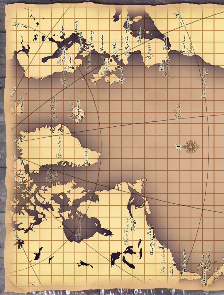
north atlantic travel map -...

4
Savage Worlds TM , Pinnacle Entertainment Group TM , Great White Games TM , and all related marks and logos are copyright © 2007-2008 by Great White Games (http://www.peginc.com). All Rights Reserved. Pirates of the Spanish Main TM , Pirates of the Barbary Coast TM , Pirates of the Cursed Seas TM , Pocketmodel TM , and all related marks and logos are copyright © 2002-2008 WizKids Games (http://www.wizkidsgames.com/pirates). This game references the Savage Worlds game system, available from Pinnacle Entertainment Group at www.peginc.com. Savage Worlds and all associated logos and trademarks are copyrights of Pinnacle Entertainment Group. Used with permission. Pinnacle makes no representation or warranty as to the quality, viability, or suitability for purpose of this product. North Atlantic Travel Map A Fan-Made Savage Worlds TM Resource by Jordan Peacock for use with Pirates of the Spanish Main TM RPG Now and then, your heroes might want to make a trek between the Old World and the New World. To handle such a journey, here’s a travel map, done in a style similar to the Caribbean map provided in Pirates of the Spanish Main: Swashbuckling Roleplaying in the Age of Sail (hereafter referred to as the Pirates RPG for brevity). For full rules on how to use this map for long-distance travel, you’ll need the Pirates RPG core book. Disclaimers This is not a resource for the study of history. It’s a game tool. Note the conspicuous lack of borders, and the fact that the map has no date on it. This map is for use “sometime in the age of piracy,” and while borders may shift, names may change, and nations may come and go, the general shape of the coastlines varies only within a margin of error that I think we can deal with. How to Use This Map Two versions of this map are provided - one that puts the whole map on a single page, and another that breaks it up into two (overlapping) sheets, printed larger for easier use. To use the overlapping sheets, just print them off separately, trim the white from around the margins, and then line them up (overlapping as necessary) and tape together. You can then use the map to keep track of the players’ ship position for journeys across the Atlantic. For complete rules on how to navigate the seas, see “Rules of the Sea” on page 128 of the Pirates RPG. Scale Difference The scale used here is that of “1 square = 210 miles,” whereas the usual travel maps use “1 square = 30 miles.” What this means is that when you use the travel rules, instead of moving your Travel Speed in squares a day, each travel cycle represents one week of journeying. For purposes of determining cabin fever, round off to the nearest week. Prevailing Winds Prevailing winds are defined by latitude. From 0° to 30°N, the Northeastery Trade Winds blow to the southwest. From 30°N to 60°N, the Westerlies blow to the northeast. From 0° to 30°S, the Southeasterly Trade Winds blow from the southeast to northwest. (See inset.) Doldrums At the narrow bands where the prevailing winds switch directions, the air is often becalmed, posing a risk to ships crossing these latitudes in the middle of the Atlantic. At the equator, this area is known as the Doldrums, while at 30°-35°N and at 30°-35°S are the Horse Latitudes. To simulate this, at any point when the ship is on a square that contains the Equator or 30° N line in it, unless it is within one square of shoreline, roll 1d6 when you try to move the ship from that square. On a 1-3, the ship does not move, and that unit of movement is “wasted” due to dead winds. On a 4-6, the ship may move normally. Ships not relying upon sails - such as galleys under oar power, “turbines” (steamships) or submarines - are not subject to this rule.

Upload: trinhmien

Post on 24-Jul-2018

214 views

Category:

Documents


0 download

TRANSCRIPT

Savage WorldsTM, Pinnacle Entertainment GroupTM, Great White GamesTM, and all related marks and logos are copyright © 2007-2008 by Great White Games (http://www.peginc.com). All Rights Reserved. Pirates of the Spanish MainTM, Pirates of the Barbary CoastTM, Pirates of the Cursed SeasTM, PocketmodelTM, and all related marks and logos are copyright © 2002-2008 WizKids Games (http://www.wizkidsgames.com/pirates). This game references the Savage Worlds game system, available from Pinnacle Entertainment Group at www.peginc.com. Savage Worlds and all associated logos and trademarks are copyrights of Pinnacle Entertainment Group. Used with permission. Pinnacle makes no representation or warranty

as to the quality, viability, or suitability for purpose of this product.

North Atlantic Travel MapA Fan-Made Savage WorldsTM Resource by Jordan Peacock

for use with Pirates of the Spanish MainTM RPG

Now and then, your heroes might want to make a trek between the Old World and the New World. To handle such a journey, here’s a travel map, done in a style similar to the Caribbean map provided in Pirates of the Spanish Main: Swashbuckling Roleplaying in the Age of Sail (hereafter referred to as the Pirates RPG for brevity). For full rules on how to use this map for long-distance travel, you’ll need the Pirates RPG core book.

DisclaimersThis is not a resource for the study of

history. It’s a game tool. Note the conspicuous lack of borders, and the fact that the map has no date on it. This map is for use “sometime in the age of piracy,” and while borders may shift, names may change, and nations may come and go, the general shape of the coastlines varies only within a margin of error that I think we can deal with.

How to Use This MapTwo versions of this map are provided - one

that puts the whole map on a single page, and another that breaks it up into two (overlapping) sheets, printed larger for easier use. To use the overlapping sheets, just print them off separately, trim the white from around the margins, and then line them up (overlapping as necessary) and tape together.

You can then use the map to keep track of the players’ ship position for journeys across the Atlantic. For complete rules on how to navigate the seas, see “Rules of the Sea” on page 128 of the Pirates RPG.

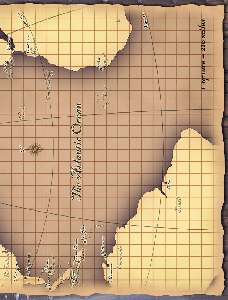
Scale DifferenceThe scale used here is that of “1 square =

210 miles,” whereas the usual travel maps use “1 square = 30 miles.” What this means is that when you use the travel rules, instead of moving your Travel Speed in squares a day, each travel cycle represents one week of journeying. For purposes of determining cabin fever, round off to the nearest week.

Prevailing WindsPrevailing winds are defined by latitude.

From 0° to 30°N, the Northeastery Trade Winds blow to the southwest. From 30°N to 60°N, the Westerlies blow to the northeast. From 0° to 30°S, the Southeasterly Trade Winds blow from the southeast to northwest. (See inset.)

DoldrumsAt the narrow bands where the prevailing

winds switch directions, the air is often becalmed, posing a risk to ships crossing these latitudes in the middle of the Atlantic. At the equator, this area is known as the Doldrums, while at 30°-35°N and at 30°-35°S are the Horse Latitudes.

To simulate this, at any point when the ship

is on a square that contains the Equator or 30° N line in it, unless it is within one square of shoreline, roll 1d6 when you try to move the ship from that square. On a 1-3, the ship does not move, and that unit of movement is “wasted” due to dead winds. On a 4-6, the ship may move normally.

Ships not relying upon sails - such as galleys under oar power, “turbines” (steamships) or submarines - are not subject to this rule.