northern area plan 2016...3 northern area plan 2016. 1.0 background to the preparation of the plan ....
TRANSCRIPT

NORTHERN A RE A PL A N 2016
AD
OP
TIO
NS
TAT
EM
EN
T
Adoption Statement

This document may be made available in alternative formats. Please contact us to discuss your requirements.
Causeway Coast and Glens Borough Council Local Planning Office County Hall Castlerock Road Coleraine BT51 3HS
Tel: +44 (0) 28 7034 7034 Website: www.causewaycoastandglens.gov.uk Email: [email protected]

3
Northern Area Plan 2016
1 .0 BACKG ROU N D TO T H E PRE PA R AT ION OF T H E PL A N
1.1 On 1 April 2015 the four Councils (Ballymoney, Coleraine, Limavady and Moyle) merged to form the new Causeway Coast and Glens Borough Council. The Northern Area Plan 2016 is the development plan for the four legacy Council Areas of Ballymoney, Coleraine, Limavady and Moyle, prepared under the provisions of Part III of the Planning (Northern Ireland) Order 1991, by the Department of the Environment. Planning Powers were transferred from the Department to Councils in April 2015, however, the legislative powers to allow the Department to adopt the Northern Area Plan 2016 were retained by the Department. The Northern Area Plan 2016 becomes the local development plan for the Council area until the Council adopts its own Local Development Plan. For the purpose of preserving materiality of the Plan references to ‘the Department’ within the Plan should now be read as the Council where appropriate.
1.2 The Plan will provide the broad land use planning framework for the Plan Area until 2016. It applies regional policies at the local level and is prepared in the context of the Regional Development Strategy (hereinafter referred to as the RDS). The RDS sets out a dynamic strategic spatial planning framework for Northern Ireland to guide physical development within the region until 2035 and provides an overarching strategic framework for the preparation of development plans. Under the provisions of the Planning (Amendment) (Northern Ireland) Order 2003, development plans must be in general conformity with the RDS.
1.3 The Plan establishes policy guidelines within which more detailed development proposals can be determined. It will assist public agencies in decisions concerning infrastructure improvements and also assist private developers in reaching their land use based decisions.
1.4 Following consultation with Ballymoney, Coleraine and Limavady Borough Councils and Moyle District Council, the Draft Plan was published in May 2005. Publication was advertised in the local and regional newspapers over 2 weeks. The statutory period for submission of representations, including objections, to the Draft Plan Policies and Proposals expired on 6th July 2005. Over 5,000 respondents submitted multiple objections to the Draft Plan.
1.5 Subsequently, the Department made the representations available for the Counter Objection period for the statutory eight week period from March to May 2006.
1.6 Progress on the Draft Plan was significantly delayed due to a judicial challenge in relation to its Strategic Environmental Assessment (SEA), which was considered by the High Court in Northern Ireland and the European Court of Justice. The Department was in a position to progress with the production of the Plan only after all matters were resolved.
1.7 In September 2010, upon consideration of submissions received to the Draft Plan, the Department requested the Planning Appeals Commission (hereinafter referred to as the Commission), to facilitate an Independent Examination (IE) to consider the objections to the Draft Plan and provide a report to the Department. The Commission appointed Commissioners Mr G Scott, Ms R Daly and Ms D O’Neill (hereinafter referred to as the Commissioner(s)) to conduct the Independent Examination. An Examination in Public opened for the consideration of strategic objections on 19th September 2011

4
ADOPTION STATEMENT
and adjourned on 11th October 2011. It reconvened to consider site specific objections on 23rd January 2012 and formally closed on 22nd March 2012. The Department received the Commissioners’ Report on the Examination on 30th May 2014 and 5th June 2014.
2 .0 FORM AT OF COM M ISSION E RS ’ RE PORT
2.1 The Commissioners’ Report of the Examination in Public was published on the Department’s internet site on 3rd July 2014. It summarises the main issues raised in objections, sets out the Commissioners’ consideration of each issue and puts forward recommendations to the Department. Where the Commissioners have made recommendations that have implications for the Draft Plan, these are highlighted in bold at the end of each section. The Report deals with the various issues raised under a number of section headings which broadly reflects the topic based format of the Examination.
3 .0 FORM AT OF T H E A DOP T ION STAT E M E NT
3.1 The recommendations contained in the Commissioners’ Report have been fully assessed by the Department and revisions to the Plan made accordingly. Appendix 1 of this Adoption Statement lists the issues where a recommendation has been made and the Department’s response to that recommendation. The Adoption Statement does not include any reference to issues where the Commissioners have recommended that there be no change to the Plan and this recommendation has been accepted by the Department. Objections relating to strategic issues are dealt with first, followed by those of a site specific nature listed by each Council area’s relevant settlement. Column 1 of Appendix 1 refers to the Draft Plan’s titles and numbering, which may be different in the Adopted Plan.
3.2 Following consideration of the Commissioners’ Report of the Examination, the Department confirms its acceptance of the majority of its recommendations. However, there are a number of recommendations where the effects of changes in the regional policy context since the Examination or other material considerations have had to be taken into account by the Department in reaching its decision on the implications for the Plan. Where the Department has disagreed with the Commissioners’ recommendation, its reasons are set out in the following paragraphs and in Appendix 1 of this Statement.
3.3 In a number of instances within the PAC reports, there is reference to the intention of the Commissioners to make a recommendation on a particular matter but this has not been carried forward to the formal Recommendations in their report. An example is in Section 1: Plan Strategy and Framework, paragraph 1.1.12 where the PAC advise that the Plan should highlight the role of the concept of ‘Living over the Shop’ and intend to recommend accordingly, however, this recommendation has not been carried forward to the formal Recommendations in bold. In such instances, the Department has sought to incorporate the change within the adopted plan. Elsewhere, the PAC formal recommendation contains part of the intention stated in the preceding paragraphs, for example in terms of an objection site in Cloughmills, where paragraph 2.4.11 states the PAC intend to recommend the site should be included in the settlement development limit and zoned for housing. However, the relevant formal recommendation only states that the site should be included within the limit. In such instances, the Department has amended the Plan in accordance with the formal recommendation in bold. The

5
Northern Area Plan 2016
Department has also taken the opportunity to rename the section entitled: Retail, Services and Offices, in light of the removal of policies RSO 1-4 of the Plan. The Department has also rationalised all of its town and district centres, renaming them as town centres, in line with the PAC recommendations on some of them. The Department has also amended the title to the section, ‘Retail, Services and Offices’, to ‘Retailing and Town Centres’ in accordance with PPS 5.
4.0 FORM AT OF T H E PL A N DOCU M E NT
4.1 The Northern Area Plan that is published today contains the amendments referred to in this Adoption Statement. The Plan consists of a Written Statement and Proposals Maps. The Plan is published both in a traditional and an electronic format. The electronic version is available on the Planning Portal (www. planningni.gov.uk).
4.2 Amendments to the content of the Draft Written Statement and Proposals Maps have been made by the Department following consideration of the Commissioners’ recommendations. Such amendments include additions to and deletions from the text and maps of the Draft Plan, for example, to include sites recommended for inclusion or exclusion by the Commissioners and also changes to the wording of some policies and proposals. Other mapping amendments reflect changes to the planning context, for example, changes to the road network. The Plan text has also been changed to incorporate changes to development site areas following consideration of recommended changes by the Commissioners. Amendments have also been made, as appropriate, to update supporting information and to correct mapping and text errors.
4.3 Changes to the regional planning context since the publication of the Draft Plan and since the Examination in Public as contained, for example, in the RDS and Planning Policy Statements, (hereinafter referred to as PPSs), have impacted on a number of the Draft Plan proposals. The Department for Regional Development, (hereinafter referred to as DRD), published a 5-Year review of the RDS in June 2008 followed by “Building a Better Future” (RDS 2035). Several new and revised PPSs and guidance documents have also been published, most notably PPS 16: Tourism, and PPS 21: Sustainable Development in the Countryside. The Department has taken into account these changes and, where practicable, the Plan provides reference to the RDS 2035 and new and revised PPSs.
4.4 The Department has published a draft Single Planning Policy Statement (SPPS) which is a statement of the Department’s policy on important planning matters that should be addressed across Northern Ireland. When finalised, the provisions of the SPPS apply to the whole of Northern Ireland. They must be taken into account in the preparation of Local Development Plans and are material to all decisions on individual planning applications and appeals.

6
ADOPTION STATEMENT
5 .0 G E N E R A L A PPROACH
5.1 The Northern Area Plan is the final development plan produced under the 1991 Order.
5.2 The adoption of the Plan will ensure an adequate supply of development land to meet needs beyond the notional end-by date of the Plan in December 2016 and will provide a sound basis for the Causeway Coast and Glen Borough Council to prepare future local development plans under the two tier planning system provided for under the Planning (NI) Act 2011.
5.3 Since work commenced on the Plan in 2001, there have been major changes in the planning context, governance and economic climate and it is anticipated that the reforms to local government will lead to further change. Accordingly, the Department has taken into account the extent of these changes when considering the PAC report.
6 .0 W IT H DR AW N POLIC I ES, PROPOSA L S A N D DESIG N AT IONS
6.1 Prior to the Department’s formal request to the PAC to hold an Independent Examination to the Draft Plan, the Department reviewed the Plan’s proposals in light of the changes in regional planning context since the publication of the Draft Plan in May 2005. As a consequence of this review, the Department notified the PAC that it wished to withdraw the following policies from the Draft Plan, and these, therefore, would not be before the PAC for consideration at the Independent Examination. These were:
Housing
Policy HOU 2: Phasing Policy HOU 4: Maintaining the Residential Stock
Retail, Offices and Services
Policy RSO 1: Developments Attracting Large Numbers of People Policy RSO 2: Facilities and Services at Local Centres Policy RSO 3: Protection of Existing Commercial Facilities Policy RSO 4: Shopfronts
Tourism
Policy TOU 1: Tourist Facilities and Attractions Policy TOU 2: Tourist Accommodation within Settlements Policy TOU 3: Tourist Accommodation in the Countryside Policy TOU 4: Camping and Caravans Policy TOU 6: Amusement Arcades
Environment and Conservation
Policy ENV 1: Biodiversity Policy ENV 6: Areas of Townscape/Village Character

7
Northern Area Plan 2016
Education, Health, Community and Cultural Facilities
Policy ECU 2: Protection of Community Facilities
Public Services and Utilities
Policy PSU 1: Watercourse Management Policy PSU 2: Ground and Surface Water Resources
Transportation
Policy TRA 1: Rural Route Protection Policy TRA 3: Rural Road Improvement Schemes Policy TRA 5: Road Schemes and Development Policy TRA 6: Public Transport, Walking and Cycling Policy TRA 7: Protection of the A26 with A44 (Cloughmills) Park and Ride/Park and Share Site
Countryside and Coast
Designation COU 1 – Limavady Green Belt Designation COU 2 – Dungiven Green Belt Designation COU 3 – Coleraine/Ballymoney Green Belt Designation COU 4 – Antrim Coast and Glens Countryside Policy Area Designation COU 5- Causeway Coast Countryside Policy Area Designation COU 6- North Derry Countryside Policy Area Designation COU 7- The Sperrins Countryside Policy Area Designation COU 8- The River Bann Corridor Countryside Policy Area Policy COU 14: The Supportive Setting to the Giant’s Causeway World Heritage Site Designation COU 16: Areas of Constraint on Mineral Development
7.0 KE Y SIT E REQU I RE M E NTS
7.1 The Commissioners have recommended that the Department should assess the usage of Key Site Requirements (KSRs) in the Plan to ensure that only key factors are identified that are critical to the development of each individual site.
7.2 The Department has noted the advice offered by the Commissioners and reviewed all of the Key Site Requirements. Key Site Requirements have been retained where there is a site specific reason and they accord with guidance as set out in PPS 1 ‘General Principles’, and other Planning Policy Statements notably, PPS 3 ‘Access Movement and Parking’, PPS 7 ‘Quality Residential Environments’, PPS 12 ‘Housing in Settlements’ and PPS 13 ‘Transportation and Land use’. However, Key Site Requirements have been removed where they do not provide clear site specific guidance and are adequately covered by regional policy. Examples include where a KSR has requested a high standard of design, or provision of a suitably sited access. The Department has also removed all the KSRs on committed zonings because future development will be subject to the conditions attached to the planning permission.

8
ADOPTION STATEMENT
8 .0 H OUSI NG
8.1 The Department has carefully considered the Commissioners’ views on the overall housing allocation and notes their conclusion that the methodology of allocation and distribution of housing across the Plan area is generally sound, and the quantum of housing land within the Plan is significantly in excess of the housing growth indicators. The level of over provision is more than sufficient to cater both for the remainder of the Plan period and for a substantial period beyond, until a replacement plan can be put in place. The Department has also considered the Regional Development Strategy 2035 and its housing growth indicators, which are slightly lower than previously presented, reinforcing the degree of flexibility provided by the Plan’s housing allocations across the settlement hierarchy and extent of housing land availability provided by housing zonings and extant permissions (as detailed in the Department’s Housing Update Paper March 2011). Accordingly, the Department has followed the general approach of the PAC which in general has not recommended the inclusion of additional housing land with the exception of where there are site specific justifications such as extant permissions and minor rounding off.
9.0 SOC I A L H OUSI NG
9.1 The Commissioners refer to PPS 12 and the need for the Plan to encourage the development of ‘balanced communities’, which includes addressing social housing need. It is clear that they expect the Plan to identify suitable sites for social housing in those settlements where need is most pressing. They suggest that the Plan should make every effort to meet the projected social housing needs identified in the latest Housing Needs Assessment (HNA), including utilisation of NIHE-owned lands, and that unforeseen shortfall can be met through the Development Management process.
9.2 Consequently, the Department has liaised with NIHE and identified social housing sites in accordance with the PAC Recommendations, in a sequential manner:
• Identify the latest Social Housing Need, for the period 2014-2019.
• Land is identified that is either on-site or is owned by a Housing Association or by NIHE and is considered ‘suitable’ for social housing over the period.
• Housing sites that were previously identified (by DOE Planning and NIHE) at Examination in Public as being ‘uncommitted’ and ‘suitable’ for social housing (and which are still uncommitted) will now have a specific HOU 2 (was HOU 5) Key Site Requirement (KSR) added. Additional Housing sites have also been identified – that are still uncommitted or that have lapsed housing permissions; these sites have been subject of a preliminary assessment for ‘suitability’ for social housing and can then also have the HOU 2 KSR attached – as necessary in order to meet the identified quantum of need in the settlement.
• Other remaining sites – which lapse or otherwise require planning permission in the future will be assessed for potential delivery of social housing need, as it then exists, against Plan Policy HOU 2, PPS 12 / dPPS 22 or PPS 21. Additionally, other social housing schemes may be identified by NIHE / Housing Associations and progressed as part of their Social Housing Development Programme.
• Where it has not been possible to identify enough suitable sites in the settlement development limits (SDLs), the Department and NIHE have then identified a number of ‘greenfield objection sites’

9
Northern Area Plan 2016
immediately beyond the SDL that are now to be included in the relevant SDL and zoned exclusively for delivery of social housing (via KSR). Such sites have been assessed as having sound physical planning reasons that would justify their inclusion within the settlement’s limits, as well as having been assessed as being suitable for social housing. All of these ‘objection sites’ have been advertised in accordance with Article 5 of the NI Planning Order – so there has been opportunity for public comment and counter objections. All of the objectors have expressed a clear willingness to accommodate the required social housing provision – either at the IE or subsequently in writing to the Department.
• After the above-mentioned ‘plan interventions’ to deliver social housing, the Development Management system can meet any unforeseen need that may arise. Therefore, it is not considered to be necessary, or feasible, to bring forward additional sites from outside settlement limits - as an alteration to the Plan under Article 6 of the Planning Order.
9.3 Accordingly, the following lands are being zoned / identified for social housing in the Plan (See Plan Allocation HOU 3 for site details):
• Coleraine: Attach HOU 2 KSR to ten identified sites. Identified need met.
• Portrush: Attach HOU 2 KSR to four identified sites, plus include one greenfield objection site. Identified need substantially met. This is considered to be acceptable, particularly given the potential for other sites to emerge, and bearing in mind the relative proximity of Coleraine and Portstewart – which can meet some of the Portrush need.
• Portstewart: Attach HOU 2 KSR to one identified site, plus include one greenfield objection site. Identified need met.
• Portballintrae: The need is to be met by the existing Housing Zoning at PEH10.
• Limavady: Attach HOU 2 KSR to one identified site. Identified need met.
• Dungiven: Modest need, adequate land identified / secured, no need for additional land
• Greysteel: Attach HOU 2 KSR to one greenfield objection site. Identified need met.
• Ballycastle: Attach HOU 2 KSR to three identified sites and zone two NIHE-owned sites in the town. Identified need is substantially met.
• Cushendall: Attach HOU 2 KSR to one identified site, plus include one greenfield objection site. Identified need met.
• Ballymoney: Modest need, adequate opportunities to deliver social housing need that may arise, including the use of NIHE land, no need for additional land to be included.
9.4 The Plan therefore includes policy that positively identifies suitable sites for social housing in those settlements where need is most pressing. In total, some twenty existing sites (220 units) have been identified, plus two urban sites zoned (20 units) and a further four greenfield sites included (127 units); it has already been accepted at the IE that this relatively modest level of additional land would not be problematic for the Regional Development Strategy. Therefore, the identified social housing need can be substantially met in all of the settlements; this has been accepted by NIHE.

10
ADOPTION STATEMENT
10.0 ECONOM IC DE V E LOPM E NT
10.1 The Draft Plan designated existing industry sites for retention, under the provisions of the Draft PPS 4: Industry, Business and Distribution. This PPS was replaced in November 2010 with PPS 4: Planning and Economic Development. The Department has amended the plan by showing existing economic development sites for information only on relevant proposals maps. Planning policy governing the future use of these sites will be that contained in PPS 4.
11 .0 TOW N CE NT RES
11.1 In line with the Commissioners’ recommendations relating to the designation of some of the proposed District Centres in the Draft Plan to Town Centres, the Department has reclassified all District Centres as Town Centres, in accordance with the definitions contained in PPS 5: Retailing and Town Centres, in recognition of their classification in the Plan’s Settlement Hierarchy.
12 .0 LIG N IT E
12.1 The proposed Lignite designation (COU 15), which sought to enlarge the Lignite Protection Area in light of survey work in 2003 by DETI, and its associated policy (MIN 1) produced a large volume of objections. The PAC supported the designation, other than amendments to exclude it from within the defined settlement limits of Dunaghy and Stranocum. In light of the Minister’s position in 2011, in association with the DETI Minister, to give significant weight to PPS 21 regarding planning applications within the designated area, the Department suggested Policy MIN 1 might be removed from the Plan, with proposals to be assessed under the Mineral Policies of the Rural Strategy. The Commissioners included this change in their recommendations.
13 .0 R AT H LI N ISL A N D
13.1 The Commissioners agreed that a bespoke policy for Rathlin Island was appropriate due to the unique circumstances of life on the island. The Department, in discussion with objectors, proposed alternative wording to the Draft Policy to take account of their views.
14.0 G I A NT ’ S C AUSE WAY
14.1 The Draft Plan contained three designations and associated policies relating to the World Heritage Site (WHS) – the site itself, and the Distinctive and Supportive Settings. The Department withdrew the policy associated with the Supportive Setting, but retained the designation. The PAC recommended the Supportive Setting Designation was also removed from the Plan as, with removal of the associated draft policy, there was no differentiation between the proposed designated area and beyond where PPS 21 applied. The WHS designation and policy, and the Distinctive Setting Designation and Policy (with slight amendment to its wording) remain.

11
Northern Area Plan 2016
15 .0 SECON D HOM ES
15.1 The Commissioners recognised the Department’s attempt to respond to the long standing concerns of local communities in relation to the increasing number of apartments in the Plan area’s five coastal settlements. However, in light of changing circumstances, and the second addendum to PPS 7, they did not consider there was a need to retain this draft policy.
16 .0 A DOP T ION OF T H E NORT H E RN A RE A PL A N 2016
16.1 The Department does not consider that the incorporation of amendments, which are consistent with the advice and recommendations of the Commission or of updated factual information, merit a formal modification to the Plan.
16.2 The Department now adopts the Northern Area Plan 2016, as amended in this Adoption Statement, as a Development Plan under Article 8 of the Planning (NI) Order 1991. The Department has made the necessary Order adopting the Area Plan. A copy of the Order is contained in Appendix 2 of this Statement.
16.3 As required by Article 28 of the Planning (Amendment) (Northern Ireland) Order 2003, prior to making an order adopting a plan, the Department must seek a determination from the Department for Regional Development (DRD) as to whether the relevant plan is in general conformity with the RDS. The Department has consulted DRD on the format and content of the final Plan and can confirm that it has been granted a ‘Statement of General Conformity’. This was a material consideration for the Department in considering the way forward for the Northern Area Plan 2016. A copy of the Statement of General Conformity is included at Appendix 3 of this Adoption Statement.
17.0 ACKNOW LE DG E M E NTS
17.1 The Department wishes to thank the elected representatives and everyone who contributed to the making of this Plan at all stages. The Department also wishes to thank Commissioners G Scott, R Daly and D O’Neill, who conducted the Examination in Public.

12
ADOPTION STATEMENT
A PPE N D IX 1 : RE FE RE NCE I N DE X
TABLE CONTENTS PAGE
Volume 1
1 Plan Strategy and Framework
2 Settlements
3 Housing
4 Industry, Business and Distribution
5 Tourism
6 Environment and Conservation
7 Education, Health, Community and Cultural Facilities
8 Open Space, Sport and Outdoor Recreation
9 Lignite and Minerals
10 Transportation
11 Countryside and Coast
Volume 2
Ballymoney Borough
B1 Ballymoney
B2 Ballybogy
B3 Cloughmills
B4 Dervock
B5 Dunloy
B6 Rasharkin
B7 Carneatly
B8 Dunaghy
B9 Ballymoney Countryside

13
Northern Area Plan 2016
TABLE CONTENTS PAGE
Coleraine Borough
C1 Coleraine
C2 Garvagh
C3 Kilrea
C4 Portrush
C5 Portstewart
C6 Articlave
C7 Castlerock
C8 Macosquin
C9 Portballintrae
C10 Craigavole
C11 Glenullin
C12 Ringsend
C13 Countryside and Coast
Limavady Borough
L1 Limavady
L2 Dungiven
L3 Ballykelly
L4 Bellarena
L5 Burnfoot
L6 Drumsurn
L7 Feeny
L8 Foreglen

14
ADOPTION STATEMENT
TABLE CONTENTS PAGE
L9 Greysteel
L10 Dernaflaw
Moyle Borough
M1 Ballycastle
M2 Bushmills
M3 Cushendall
M4 Armoy
M5 Ballintoy
M6 Waterfoot
M7 Church Bay, Rathlin
M8 Knocknacarry
M9 Lisnagunogue

15
Northern Area Plan 2016
A PPE N D IX 1
PAC Recommendations and the Department’s Decision on the Proposed Changes Relating to the Volumes 1 and 2 of the Plan.
Following consideration of the Commissioners’ Report of the Examination, the Department is generally in agreement with the PAC recommendations. The Department’s response to the individual recommendations is set out in the Table below:
TA B LE 1 : PL A N ST R AT EGY A N D FR A M E WORK
PLAN PROPOSAL
ISSUE RAISED
PAC REPORT PAGE NO.
COMMISSIONERS’ RECOMMENDATION
DEPARTMENT’S DECISION
Plan Objective The role and importance of social housing and the need to identify land for social housing should be recognised in the Plan’s objective relating to housing.
3, 6 The fourth Plan Objective should be amended to include reference to social housing.
The Department accepts the recommendation and has amended the Plan accordingly (now the fifth objective).
Plan Objective The Plan’s objectives do not explicitly recognise the role of rural communities.
3, 6 An additional Plan objective should be incorporated to refer to the role of small towns and villages.
The Department accepts the recommendation and has amended the Plan accordingly.
Plan Objective The Plan’s objectives should be amended to make reference to the role and function of hamlets.
4, 6 An additional Plan objective should be incorporated to refer to the opportunities for development in hamlets.
The Department accepts the recommendation and has amended the Plan accordingly.

16
ADOPTION STATEMENT
PLAN PROPOSAL
ISSUE RAISED
PAC REPORT PAGE NO.
COMMISSIONERS’ RECOMMENDATION
DEPARTMENT’S DECISION
General Issues The implications of the impending changes in the planning system with the transfer of planning functions to the new councils should be referenced.
7, 9 The Preamble to the Plan should set out the impending changes to the planning system with the transfer of planning functions to new councils.
The Department accepts the recommendation and has amended the Plan accordingly.
Agriculture, Forestry and Fishing
The factual information contained in this section is inaccurate.
8, 9 Given the time gap since the plan was drafted, the opportunity should be taken to update factual information and to correct any inaccuracies in the Plan in general.
The Department accepts the recommendation and has amended the Plan accordingly.
Plan Maps Information contained on the Plan’s maps should be updated to take account of the withdrawal of certain proposed designations and to correct mapping errors identified by objectors. For example, map nos 3/43, 3/44, and 3/55 refer to Limavady District rather than Coleraine District.
9 Map nos 3/43, 3/44 and 3/55 should be grouped with other maps relating to Limavady District, rather than Coleraine District.
The Department accepts the recommendation and has amended the Plan accordingly.
17
Northern Area Plan 2016
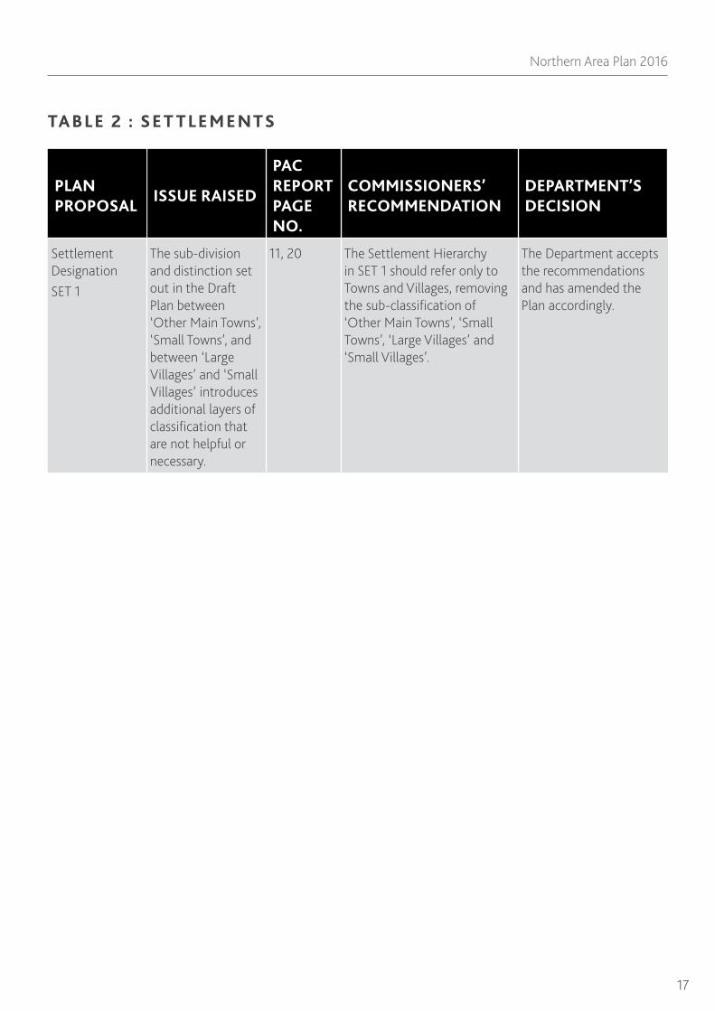
TA B LE 2 : SE T T LE M E NTS
PLAN PROPOSAL
ISSUE RAISED
PAC REPORT PAGE NO.
COMMISSIONERS’ RECOMMENDATION
DEPARTMENT’S DECISION
Settlement Designation SET 1
The sub-division and distinction set out in the Draft Plan between ‘Other Main Towns’, ‘Small Towns’, and between ‘Large Villages’ and ‘Small Villages’ introduces additional layers of classification that are not helpful or necessary.
11, 20 The Settlement Hierarchy in SET 1 should refer only to Towns and Villages, removing the sub-classification of ‘Other Main Towns’, ‘Small Towns’, ‘Large Villages’ and ‘Small Villages’.
The Department accepts the recommendations and has amended the Plan accordingly.

18
ADOPTION STATEMENT
PLAN PROPOSAL
ISSUE RAISED
PAC REPORT PAGE NO.
COMMISSIONERS’ RECOMMENDATION
DEPARTMENT’S DECISION
Settlement Designation SET 1
Dunaghy should be reclassified as a Village based on its existing functionality, rather than a hamlet based on its location within the Lignite Resource Area.
14, 20 Dunaghy should be designated as a Village in the Settlement Hierarchy.
The Department accepts the recommendations and has amended the Plan accordingly.
Settlement Designation SET 1
The location centred on Drones/Fivey/ Ballyveely should be designated as a hamlet with a corresponding limit.
14, 20 Drones Road/Ballyveely Road should be designated as a Hamlet in the Setlement Hierarchy.
The Department accepts the recommendations and has amended the Plan accordingly; it is named ‘Drones’.
Settlement Designation SET 1
The area of Loughan should be designated as a hamlet with a corresponding limit.
16, 20 Loughan should be designated as a Hamlet in the Settlement Hierarchy.
The Department accepts the recommendations and has amended the Plan accordingly.
Settlement Designation SET 1
Ballykelly should be reinstated as a Town rather than a Large Village.
16, 20 Ballykelly should be designated as Town in the Settlement Hierarchy.
The Department accepts the recommendations and has amended the Plan accordingly.
Policy SET 2 Development within Settlement Development Limits.
The policy wording is rigid and too inflexible and should be amended.
21 The word ‘only’ is removed from Policy SET 2.
The Department accepts the recommendations and has amended the Plan accordingly.

19
Northern Area Plan 2016
PLAN PROPOSAL
ISSUE RAISED
PAC REPORT PAGE NO.
COMMISSIONERS’ RECOMMENDATION
DEPARTMENT’S DECISION
Key Site Requirements
Various concerns were raised regarding Key Site Requirements from being unnecessary, unduly restrictive and a duplication of existing regional policy, to concerns that they were not restrictive enough or do not provide design guidance of appropriate detail.
22, 24 The Department should reassess the use of Key Site Requirements in the Plan to ensure that only ‘key’ factors critical to the development of a site are identified, there is no unnecessary duplication of regional planning policy, and inappropriate or unnecessary Key Site Requirements are removed.
The Department accepts the recommendations and has amended the Plan accordingly.
Policy SET 3 Proposals on Development Opportunity Sites
Various concerns were raised from the policy was too rigid or prescriptive, to it should be removed from the Plan.
24- 25 Policy SET 3 should be removed from the Plan and the supporting text relating to Development Opportunity Sites should be incorporated within that accompanying Policy SET 2.
The Department accepts the recommendations and has amended the Plan accordingly.
Target Sites These should be deleted from the Plan. They are shown ‘for information purposes only’, and there is no detailed guidance associated with them.
25 The term ‘Target Sites’ should be deleted from the Plan and all associated notations on the settlement maps removed.
The Department accepts the recommendations and has amended the Plan accordingly.
Policy SET 4 Improving the Quality of New Non-Residential Development
The Policy is too restrictive and inflexible. The Policy is unnecessary as design issues and principles are already incorporated in regional planning policies.
26 Policy SET 4 should be omitted from the Plan.
The Department accepts the recommendations and has amended the Plan accordingly.

20
ADOPTION STATEMENT
TA B LE 3 : H OUSI NG
PLAN PROPOSAL
ISSUE RAISED
PAC REPORT PAGE NO.
COMMISSIONERS’ RECOMMENDATION
DEPARTMENT’S DECISION
Policy HOU 3 Apartment Development in Settlements with Pressure for Second Homes
The Policy is too restrictive outside the designated areas and is unnecessary given there is prevailing regional policy contained in PPS 7 and its addendum: ‘Safeguarding the Character of Established Residential Areas’. The Policy would effectively encourage a concentration of apartment development within the designated areas, which could lead to the loss of other uses in the settlements’ centres.
44-48 Policy HOU 3 should be deleted from the Plan.
The Department accepts the recommendations and has amended the Plan accordingly.

21
Northern Area Plan 2016
PLAN PROPOSAL
ISSUE RAISED
PAC REPORT PAGE NO.
COMMISSIONERS’ RECOMMENDATION
DEPARTMENT’S DECISION
Policy HOU 5 Meeting Community Housing Needs
Various concerns were raised, from the Policy should be removed from the Plan and reliance placed on PPS 12, HS 2, it is unreasonable to expect larger developments to meet the main requirements for social housing provision, the policy is overly burdensome, to the policy should set out clearly the basis on which developers will be expected to meet social housing needs and delivers provision to those settlements where need is most pressing.
48-54 The recommendation is in 4 parts: *All un-committed sites and sites where permissions have lapsed that meet the thresholds in the Policy and are located in settlements where the social housing deficit is of 10 units or more as identified in the most recent Housing Needs Assessment, should be reassessed to establish if they could contribute to meeting this need. *Those sites identified as suitable should be identified in the Policy, setting out the level of provision and the mechanism for delivery. *Greenfield objection sites identified by the Department as suitable for social housing should be identified in the Policy, setting out the level of provision and mechanism for delivery, but only where there is a clear willingness by the objector to accommodate the required social housing provision and the site has been assessed as having sound physical planning reasons that justify its inclusion within the settlement limit. *If there is still a deficit in social housing, an alteration to the Plan under Article 6 of the Planning Order should be undertaken.
The Department accepts the recommendations and has amended the Plan accordingly. See Para. 9.0 above.

22
ADOPTION STATEMENT
PLAN PROPOSAL
ISSUE RAISED
PAC REPORT PAGE NO.
COMMISSIONERS’ RECOMMENDATION
DEPARTMENT’S DECISION
Policy HOU 5 Meeting Community Housing Needs
The policy title is misleading as it only deals with social and specialist housing.
54 Policy HOU 5 should be retitled ‘Social and Supported Housing’.
The Department accepts the recommendations and has amended the Plan accordingly.
Policy HOU 6 Conversion of Buildings for Multiple Occupation
Regional planning policy is in place that deals with the conversion or change of use of existing buildings to units for multiple occupancy. Concerns were raised that the policy criteria are excessive. Other objections considered the policy should include additional control mechanisms to place a cap on the number and location of student Houses in Multiple Occupation (HMOs).
55 - 57 The Policy should be amended to read: ‘Use of Dwellings for Multiple Occupation’. The precise wording of the remainder of the policy should be refined to take account of the proposed limitation of the policy to the use of dwellings as HMOs only. The explanatory text to the policy should make it clear that full account will be taken of the potentially damaging effect or cumulative changes in a neighbourhood by which proposals, although not detrimental in isolation, could be judged to be detrimental when considered alongside other recently approved development.
The Department accepts the recommendations and has amended the Plan accordingly.

23
Northern Area Plan 2016
TA B LE 4 : I N DUST RY, BUSI N ESS A N D D IST RI BU T ION
PLAN PROPOSAL
ISSUE RAISED
PAC REPORT PAGE NO.
COMMISSIONERS’ RECOMMENDATION
DEPARTMENT’S DECISION
Industry, Business and Distribution Section and Allocation IND 1
Care should be taken with the language and terminology used to avoid confusion and uncertainty.
60-61 The Section title ‘Industry, Business and Distribution’ should be changed to ‘Economic Development’. Allocation IND 1 should be renamed ‘Allocation ECD 1: Economic Development’.
The Department accepts the recommendations and has amended the Plan accordingly.
Industry, Business and Distribution
These terms have different meanings in terms of the Use Classes Order (UCO) 2004.
60-61 The text should be consistent and reflect the rewording of the section and the appropriate regional policy context, with specific reference to the UCO in relation to acceptable uses.
The Department accepts the recommendations and has amended the Plan accordingly.
Industry, Business and Distribution
Reference to the acceptable economic development uses within the UCO should be given in the zonings contained in Volume 2 of the Plan
60-61 The individual zonings in Volume 2 of the Plan should clearly set out acceptable uses with reference to the UCO.
The Department accepts the recommendations and has amended the Plan accordingly.

24
ADOPTION STATEMENT
TA B LE 5 : TOU RISM
PLAN PROPOSAL
ISSUE RAISED
PAC REPORT PAGE NO.
COMMISSIONERS’ RECOMMENDATION
DEPARTMENT’S DECISION
Policy TOU 5 Existing Caravan Parks outside Settlement Development Limits
The policy is too restrictive and inflexible. The matter is dealt with under regional planning policy.
64-66 Policy TOU 5 is removed from the Plan.
The Department accepts the recommendations and has amended the Plan accordingly.
TA B L E 6 : E N V I RO N M E N T A N D CO N S E RVAT I O N
PLAN PROPOSAL
ISSUE RAISED
PAC REPORT PAGE NO.
COMMISSIONERS’ RECOMMENDATION
DEPARTMENT’S DECISION
Policy ENV 2 Local Landscape Policy Areas (LLPAs)
Concerns were raised in relation to the rationale and justification for the policy. The appropriateness of the policy wording in relation to access to rivers, and to development in the vicinity of LLPAs was questioned.
67-69 The second paragraph of Policy ENV 2 should be amended to read: ‘Where riverbanks are included within LLPAs, access may be required to the river corridor as part of the development proposals. Any access should not have an unacceptable adverse impact on the flora and fauna of the river corridor. The third paragraph should be amended to read: ‘Where proposals are within and/ or adjoining a designated LLPA, a landscape buffer may be required to protect the environmental quality of the LLPA’.
The Department accepts the recommendations and has amended the Plan accordingly.
Policy ENV 3 Sites of Local Nature Conservation Importance
Objections to policy wording.
70-71 Policy ENV 3 should be amended with the insertion of the word ‘significant’ before ‘adverse effect’.
The Department accepts the recommendations and has amended the Plan accordingly.

25
Northern Area Plan 2016
PLAN PROPOSAL
ISSUE RAISED
PAC REPORT PAGE NO.
COMMISSIONERS’ RECOMMENDATION
DEPARTMENT’S DECISION
Policy ENV 5 Development Adjacent to a Main River
Concerns were raised in relation to the wording of criterion 1 relating to buffer strips, the recreational and tourist potential of the River Bann, and the relationship of the policy to PPS 15: Planning and Flood Risk
72-73 Policy ENV 5, criterion 1 should be amended to read: A biodiversity strip of at least 10 m from the edge of the river is provided and accompanied with an appropriate landscaping management proposal. Criterion 4 should have the following phrase added to it: and complies with the requirements of PPS 15: Planning and Flood Risk. Criterion 5 should be added to the policy and read: Any development would not prejudice future opportunities to provide a riverside walk’.
The Department accepts the recommendations and has amended the Plan accordingly.
Policy ENV 7 Areas of Significant Archaeological Interest (ASAI)
The supporting text should make it clear the policy refers specifically to the Dunluce ASAI, as the only proposed ASAI in the Plan area.
74 The explanatory text should make it clear that Policy ENV 7 applies to the Dunluce ASAI.
The Department accepts the recommendations and has amended the Plan accordingly.

26
ADOPTION STATEMENT
TA B LE 7 : E DUC AT ION , H E A LT H , COM M U N IT Y A N D CU LT U R A L FAC I LIT I ES
PLAN PROPOSAL
ISSUE RAISED
PAC REPORT PAGE NO.
COMMISSIONERS’ RECOMMENDATION
DEPARTMENT’S DECISION
Policy ECU 1 Education, Health, Community and Cultural Facilities
It is unnecessary for the plan to contain this ‘positive’ policy if there is no general presumption against their approval.
76 Policy ECU 1 should be removed from the Plan.
The Department accepts the recommendations and has amended the Plan accordingly.
TA B LE 8 : OPE N SPACE , SPORT A N D OU T DOOR RECRE AT ION
PLAN PROPOSAL
ISSUE RAISED
PAC REPORT PAGE NO.
COMMISSIONERS’ RECOMMENDATION
DEPARTMENT’S DECISION
Open Space Provision
In the interests of consistency, and in line with PPS 8, paragraph 4.11, all major areas of public open space, including recreational pitches, located within the proposed settlement development limits should be identified on settlement maps for information purposes.
77-78 All significant areas of existing open space, including recreational pitches, which are located within proposed settlement development limits, are identified on the relevant maps for information purposes.
The Department accepts the recommendations and has amended the Plan accordingly.

27
Northern Area Plan 2016
TA B LE 9 : L IG N IT E A N D M I N E R A L S
PLAN PROPOSAL
ISSUE RAISED
PAC REPORT PAGE NO.
COMMISSIONERS’ RECOMMENDATION
DEPARTMENT’S DECISION
Policy MIN 2 Natural Mineral Reserves – Hydrocarbon Extraction
This policy is incorrectly drafted and should refer to ‘exploration’ rather than ‘exploitation’.
81, 85 The word ‘exploitation’ should be replaced with ‘exploration’ in the policy.
The Department accepts the recommendations and has amended the Plan accordingly.
Extraction of Other Minerals
Concern was raised in relation to the small-scale removal of sand from certain North Coast beaches and the lack of a specific policy to prevent it continuing.
83 Additional text should be added to paragraph 10.4.3 to read: ‘In accordance with Policy MIN 1 of the Planning Strategy for Rural Northern Ireland, decisions on applications for mineral extraction will be made with regard to the preservation of natural features of the landscape, which include the coastal zone. Any application will be subject to rigorous assessment to avoid any significant adverse impacts on ecology, shoreline stability and the environmental amenity of these areas in accordance with PPS 2. The Department will continue to use its enforcement powers where unauthorised extraction takes place’. Paragraph 10.4.5 should be amended to read; ‘Proposals for extraction of all minerals will be determined in accordance with prevailing regional planning policy, currently set out in the MIN policies of the PSRNI’.
The Department accepts the recommendations and has amended the Plan accordingly.

28
ADOPTION STATEMENT
TA B LE 10 : T R A NSPORTAT ION
PLAN PROPOSAL
ISSUE RAISED
PAC REPORT PAGE NO.
COMMISSIONERS’ RECOMMENDATION
DEPARTMENT’S DECISION
Proposal TRA 2 Rural Route Protection
With the withdrawal of Policy TRA 1 (Rural Route Protection) from the Plan, Proposal TRA 2 was, by default, withdrawn also.
86, 90 Proposal TRA 2 should be updated to reflect the latest positions of the listed schemes. This update should include reference to the proposed A2 Ballykelly bypass.
The Department accepts the recommendations and has amended the Plan accordingly. The updated schemes are shown, for information only, on the respective Settlement sections and maps.
Proposal TRA 4 Rural Road Improvement Schemes
The three schemes listed in the proposal have been delivered.
87, 90 Improvement schemes that have been implemented should no longer be referred to as ‘proposals’.
The Department accepts the recommendations and has amended the Plan accordingly; therefore, Proposal TRA 4 has been removed from the Plan.
Integration of land use and transportation
The Plan does not make the integration of transportation policy and land use planning clear.
87, 90 The introduction to the Transportation section should set out more explicitly how the Plan seeks to integrate transportation and land use.
The Department accepts the recommendations and has amended the Plan accordingly.
Protection of railway services
The Plan should refer to the importance of the Northern Corridor Railway and its role in the Plan area.
87, 90 The importance of the railway network should be reinforced with the addition of the following text: ‘The plan area benefits from an existing main railway network serving the hubs of Ballymoney, Coleraine and the town of Portrush. Continued investment in the railways is important for encouraging a modal shift from the motor car and for promoting the economic development of the North Coast.
The Department accepts the recommendations and has amended the Plan accordingly.

29
Northern Area Plan 2016
TA B LE 11 : COU NT RYSI DE A N D COA ST
PLAN PROPOSAL
ISSUE RAISED
PAC REPORT PAGE NO.
COMMISSIONERS’ RECOMMENDATION
DEPARTMENT’S DECISION
Policy COU 9 Rathlin Island
The policy is too rigid
91-93 The policy is reworded to read: ‘Planning permission will be granted for single dwellings for permanent residency on site where there are significant remnants of a traditional home/ wallstead and the applicant can demonstrate either: 1. A strong island connection; or 2. That they will make a significant contribution to the economic and social vitality of the island. Any replacement dwelling that incorporates an ancillary element providing workshop accommodation for self employment may be acceptable in principle. The explanatory text should set out clearly the type of qualifying circumstances that are envisaged.
The Department accepts the recommendations and has amended the Plan accordingly.
Giant’s Causeway World Heritage Site
The World Heritage Site’s full name should be incorporated.
94-98 The World Heritage Site should be properly referred to as ‘The Giant’s Causeway and Causeway Coast World Heritage Site’.
The Department accepts the recommendations and has amended the Plan accordingly.
Policy COU 12 The Distinctive Landscape Setting of the Giant’s Causeway World Heritage Site
Concern that the policy wording would prohibit the extension or alteration of established buildings other than dwellings.
97-98 The word ‘buildings’ should be substituted for the word ‘dwellings’ in the first and last sentences of criterion 2. The explanatory text should also be adjusted to reflect this change.
The Department accepts the recommendations and has amended the Plan accordingly.

30
ADOPTION STATEMENT
PLAN PROPOSAL
ISSUE RAISED
PAC REPORT PAGE NO.
COMMISSIONERS’ RECOMMENDATION
DEPARTMENT’S DECISION
Designation COU 13 The Supportive Landscape Setting of the Giant’s Causeway World Heritage Site
With the withdrawal of Policy COU 14 by the Department, and given that PPS 21 policies would apply over the designated area as applied elsewhere in the countryside over the remainder of the Plan area, there is little logic to retaining this designation.
98 Designation COU 13 should be removed from the Plan.
The Department accepts the recommendations and has amended the Plan accordingly.
Designation COU 15 Lignite Resource Area
The area includes land within the settlement limits of Dunaghy and Stranocum, whereas it excludes land within Ballymoney.
81-83, 85 The extent of the designation should be amended to exclude from it all land that falls within the defined settlement limits of Dunaghy and Stranocum.
The Department accepts the recommendations and has amended the Plan accordingly.
Designation COU 15 Lignite Resource Area
Concerns were raised in relation to the relationship between the draft plan policy MIN 1 (now withdrawn) and the MIN policies contained in the Rural Strategy and PPS 21.
82-83, 85 Explanatory text should be added to the designation to specify the regional planning policy to be applied within the designated area.
The Department accepts the recommendations and has amended the Plan accordingly.
Historic Parks, Gardens and Demesnes
75 This section should be placed at the end of the Environment and Conservation section of the Plan Strategy.
The Department accepts the recommendations and has amended the Plan accordingly.

31
Northern Area Plan 2016
PAC Recommendations and the Department’s Decisions on Proposed Changes to Ballymoney Borough
Ballymoney Borough
Following consideration of the Commissioners’ Report of the Examination, the Department is generally in agreement with the PAC recommendations. The Department’s response to the individual recommendations is set out in the Tables below:
TA B LE B1 : BA LLY M ON E Y
PLAN PROPOSAL
ISSUE RAISED
PAC REPORT PAGE NO.
COMMISSIONERS’ RECOMMENDATION
DEPARTMENT’S DECISION
Designation BY 01 Settlement Development Limit
Land to south west of Bannfield, Bann Road was granted planning permission on appeal and is being developed. There is little benefit in leaving it outside the development limit. As the site is already being developed, there is no need to zone it for housing.
4, 6 Designation BY 01 should be amended to include land to south west of Bannfield, Bann Road.
The Department accepts this recommendation and has amended the Plan accordingly.
Designation BY 01 Settlement Development Limit
Land to the north of Drumnamallaght Road should be included in the development limit as residential development as commenced and, as such, there is no need to zone it for housing.
5, 6 Designation BY 01 should be amended to include land to north of Drumnamallaght Road.
The Department accepts this recommendation and has amended the Plan accordingly.
Housing Zoning BYH 01
BYH 01 is in commercial use and should no longer be considered as a housing zoning.
7, 9 Housing Zoning BYH 01 should be deleted from the Plan.
The Department accepts this recommendation and has amended the Plan accordingly.
32
ADOPTION STATEMENT
PLAN PROPOSAL
ISSUE RAISED
PAC REPORT PAGE NO.
COMMISSIONERS’ RECOMMENDATION
DEPARTMENT’S DECISION
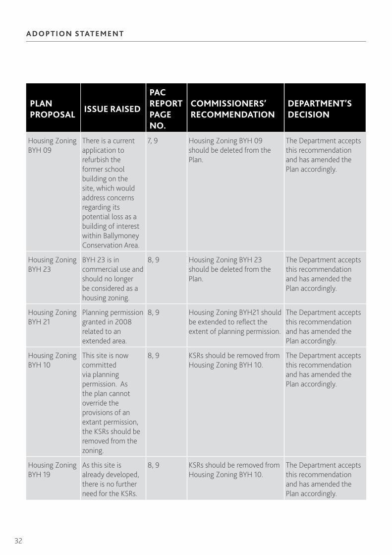
Housing Zoning BYH 09
There is a current application to refurbish the former school building on the site, which would address concerns regarding its potential loss as a building of interest within Ballymoney Conservation Area.
7, 9 Housing Zoning BYH 09 should be deleted from the Plan.
The Department accepts this recommendation and has amended the Plan accordingly.
Housing Zoning BYH 23
BYH 23 is in commercial use and should no longer be considered as a housing zoning.
8, 9 Housing Zoning BYH 23 should be deleted from the Plan.
The Department accepts this recommendation and has amended the Plan accordingly.
Housing Zoning BYH 21
Planning permission granted in 2008 related to an extended area.
8, 9 Housing Zoning BYH21 should be extended to reflect the extent of planning permission.
The Department accepts this recommendation and has amended the Plan accordingly.
Housing Zoning BYH 10
This site is now committed via planning permission. As the plan cannot override the provisions of an extant permission, the KSRs should be removed from the zoning.
8, 9 KSRs should be removed from Housing Zoning BYH 10.
The Department accepts this recommendation and has amended the Plan accordingly.
Housing Zoning BYH 19
As this site is already developed, there is no further need for the KSRs.
8, 9 KSRs should be removed from Housing Zoning BYH 10.
The Department accepts this recommendation and has amended the Plan accordingly.

33
Northern Area Plan 2016
PLAN PROPOSAL
ISSUE RAISED
PAC REPORT PAGE NO.
COMMISSIONERS’ RECOMMENDATION
DEPARTMENT’S DECISION
Housing Zoning BYH 24
As this zoning is now complete, there is no further need for the KSRs.
8, 9 KSRs should be removed from Housing Zoning BYH 24.
The Department accepts this recommendation and has amended the Plan accordingly.
Housing Zoning BYH 26
As this site is already committed and development underway, the Plan cannot override the provisions of an extant planning permission. The KSRs should be removed.
9 KSRs should be removed from Housing Zoning BYH 26.
The Department accepts this recommendation and has amended the Plan accordingly.
Housing Zoning BYH 42
As development is underway on this site, there is no further need for the KSRs.
9 KSRs should be removed from Housing Zoning BYH 42.
The Department accepts this recommendation and has amended the Plan accordingly.
Major Area of Existing Open Space at Armour Avenue
The site should not be shown as open space as it is in residential use and appears divorced from the rest of the open space.
9, 10 Land at Armour Avenue should be removed from the major area of existing open space.
The Department accepts this recommendation and has amended the Plan accordingly.
Open Space Zoning BYO 01
As Ballymoney Borough Council no longer has an interest in this open space zoning, the Department proposed that it should revert to unzoned land outside of the development limit.
9, 10 Zoning BYO 01 should be removed.
The Department accepts this recommendation and has amended the Plan accordingly.

34
ADOPTION STATEMENT
PLAN PROPOSAL
ISSUE RAISED
PAC REPORT PAGE NO.
COMMISSIONERS’ RECOMMENDATION
DEPARTMENT’S DECISION
Town Centre Boundary BYT 01
The Department indicated that the Tesco site would be fully included within the town centre boundary in the adopted plan.
10, 12 The delineation of the OS map for BYT 01 should be updated to reflect the full extent of the Tesco development and its associated car park.
The OSNI base map has been updated.
Development Opportunity Site BYT 03
The Department proposed to amend KSR 2 to increase the scale of retail warehousing to not less than 1,000 square metres gross floorspace.
12 KSR 2 of BYT 03 should be amended to read ‘ units not less than 1,000 square metres gross floorspace’ will be acceptable.
The Department accepts this recommendation and has amended the Plan accordingly.
LLPA Designation BYL 01
The Department acknowledged there was merit in including land on Balnamore Road, west of Drumnamallaght Road, within the LLPA. The Department proposed to delete supporting paragraph 12.2 to BLY 01, and to make reference to the fact that PPS 21 now contains the applicable regional policy guidance.
13, 15 Land located to the west of Drumnamallaght Road, Balnamore Road should be included within Designation BYL 01.
The Department accepts this recommendation and has amended the Plan accordingly.

35
Northern Area Plan 2016
PLAN PROPOSAL
ISSUE RAISED
PAC REPORT PAGE NO.
COMMISSIONERS’ RECOMMENDATION
DEPARTMENT’S DECISION
LLPA Designation BYL 02
The Department indicated that, due to planning approvals, and commencement of development for residential use, it would be logical for BYL 02 to be reduced to reflect the area of proposed open space within the approvals, whilst remaining along the river corridor.
14, 15 The extent of BYL 02 should be reduced to reflect the area of open space proposed by the approved planning applications on BYH 42.
The Department accepts this recommendation and has amended the Plan accordingly.
Historic Park, Garden and Demesne Designation BHPG 3: Leslie Hill HPG
The Department proposed to reduce the extent of this HPG.
15 The extent of Leslie Hill HPG designation should be reduced to that illustrated at the EIP.
The Department accepts this recommendation and has amended the Plan accordingly.
TA B LE B2 : BA LLY BOGY
PLAN PROPOSAL
ISSUE RAISED
PAC REPORT PAGE NO.
COMMISSIONERS’ RECOMMENDATION
DEPARTMENT’S DECISION
LLPA Designation BBL 01
Paragraph 4.1 identifying the key features that justify this LLPA designation should be supplemented for clarification purposes with the information contained in the Department’s topic paper.
18, 19 Designation BBL 01 should be supplemented to include reference to the old flax mill and areas of local nature conservation interest including the river corridor and associated vegetation.
The Department accepts this recommendation and has amended the Plan accordingly.

36
ADOPTION STATEMENT
Major Area of Existing Open Space at Wheatfield Park.
The Department acknowledged part of this area was incorrectly identified as it is associated with the adjacent commercial complex.
19 The Wheatfield Park area of Major Area of Existing Open Space should be identified as white land.
The Department accepts this recommendation and has amended the Plan accordingly.
TA B LE B3 : CLOUG H M I LL S
PLAN PROPOSAL
ISSUE RAISED
PAC REPORT PAGE NO.
COMMISSIONERS’ RECOMMENDATION
DEPARTMENT’S DECISION
Designation CS 01 Settlement Development Limit
As the planning approval for the extension to the former Reid’s Transport yard has been implemented, the area should be included within the development limit.
25, 27 The area of the extended former Reid’s Transport yard should be included within the settlement development limit.
The Department accepts this recommendation and has amended the Plan accordingly. The extension results in a reduced area zoned under CSO 01 – Open Space.
Designation CS 01 Settlement Development Limit
Land southwest of nos 7-11 Main Street, and south-east of nos 9-12 Princess Gardens should be included within the development limit. The site would have very little visual impact, be modest in size and have no obvious constraints.
26 The lands south-west of nos 7-11 Main Street, and southeast of nos 9-12 Princess Gardens should be included within the settlement development limit.
The Department accepts this recommendation and has amended the Plan accordingly.

37
Northern Area Plan 2016
TA B LE B 4 : DE RVOCK
PLAN PROPOSAL
ISSUE RAISED
PAC REPORT PAGE NO.
COMMISSIONERS’ RECOMMENDATION
DEPARTMENT’S DECISION
Designation DV 01 Settlement Development Limit
The Department indicated that, as part of land south of no 126 Toberdoney Road has planning permission for residential development, it should be included in the development limit.
29-30, 32 The area located south of no 126 Toberdoney Road should be included within the settlement development limit.
The Department accepts this recommendation and has amended the Plan accordingly.
Designation DV 01 Settlement Development Limit
The Department indicated that, as land west of Station Cottages, south of Travers Place has planning permission for residential development, it should be included within the development limit.
30, 32 The area located south and south-west of Travers Place, Carncullagh Road, with frontage to Station Road should be included within the settlement development limit.
The Department accepts this recommendation and has amended the Plan accordingly.
Designation DV 01 Settlement Development Limit
Land north of housing zoning DVH 01 has permission for residential development and should be included within the development limit.
31, 32 The area north of housing zoning DVH 01 should be included within the settlement development limit.
The Department accepts this recommendation and has amended the Plan accordingly.
Open Space Zoning DVO 01
The proposed open space should be included within the development limit. It is substantially enclosed by built development.
33 Open space zoning DVO 01 should be included within the settlement development limit.
The Department accepts this recommendation and has amended the Plan accordingly.

38
ADOPTION STATEMENT
TA B LE B5 : DU N LOY
PLAN PROPOSAL
ISSUE RAISED
PAC REPORT PAGE NO.
COMMISSIONERS’ RECOMMENDATION
DEPARTMENT’S DECISION
Designation DL 01 Settlement Development Limit
Land at no 30 Bellaghy Road has planning permission for residential development and should be included within the development limit.
35, 37 Land adjacent to no 30 Bellaghy Road should be included within the settlement development limit.
The Department accepts this recommendation and has amended the Plan accordingly.
Designation DL 01 Settlement Development Limit
Land at no 60 Bridge Road has planning permission for residential development and should be included within the development limit.
36, 37 Land at no 60 Bridge Road should be included within the settlement development limit.
The Department accepts this recommendation and has amended the Plan accordingly.

39
Northern Area Plan 2016
TA B LE B6 : R A SH A RKI N
PLAN PROPOSAL
ISSUE RAISED
PAC REPORT PAGE NO.
COMMISSIONERS’ RECOMMENDATION
DEPARTMENT’S DECISION
Designation RN 01 Settlement Development Limit
The Department indicated that, as planning approval for St Olcan’s Parish Centre had been implemented, the land could be included in the development limit.
42, 44 The area of St Olcan’s Parish Centre, Gortahar Road should be included in the development limit.
The Department accepts this recommendation and has amended the Plan accordingly.
Industrial Designation RNI 01
Planning permission has been granted for residential development on this site, and the Department indicated there was no benefit in retaining this designation.
44, 45 Industrial designation RNI 01 should be removed and the area shown as white land.
The Department accepts this recommendation and has amended the Plan accordingly.
Community Zoning RNC 01
As planning permission has been granted for residential development on this site, the Department indicated it would be appropriate to remove the community zoning.
45 Community zoning RNC 01 should be removed and the area become white land.
The Department accepts this recommendation and has amended the Plan accordingly.

40
ADOPTION STATEMENT
TA B LE B7 : C A RN E AT LY
PLAN PROPOSAL
ISSUE RAISED
PAC REPORT PAGE NO.
COMMISSIONERS’ RECOMMENDATION
DEPARTMENT’S DECISION
Designation CY 01 Settlement Development Limit
The Department accepted the settlement shown be referred to as Lislagan rather than Carneatly.
49, 50 The settlement should be referred to as Lislagan
The Department accepts this recommendation and has amended the Plan accordingly.
Major Area of Existing Open Space
The plan is inconsistent in that it refers to open space within Carneatly, but there is none.
50 The section on Open Space should be deleted.
No Public Open Space was shown in the Draft Plan, and the associated text was, therefore, superfluous. However, the Department has shown the existing Open Space at Torrens Park for information only on the Lislagan Settlement Map and has retained this text accordingly.
TA B LE B 8 : DU N AG H Y
PLAN PROPOSAL
ISSUE RAISED
PAC REPORT PAGE NO.
COMMISSIONERS’ RECOMMENDATION
DEPARTMENT’S DECISION
Designation DY 01 Settlement Development Limit
Land to the north of nos 68 and 70 Kilraughts Road to the west of Landsdale Gardens should be included within the development limit. They would have minimal visual impact and appear as rounding off.
54 The land to north of nos 68 and 70 Kilraughts Road to the west of Landsdale Gardens should be included within the settlement development limit.
The Department accepts this recommendation and has amended the Plan accordingly.

41
Northern Area Plan 2016
TA B LE B 9 : BA LLY M ON E Y COU NT RYSI DE
PLAN PROPOSAL
ISSUE RAISED
PAC REPORT PAGE NO.
COMMISSIONERS’ RECOMMENDATION
DEPARTMENT’S DECISION
Drones/Fivey/ Ballyveely Road junctions
Define a settlement development limit for this area in line with objection 5054.
57, 58 The new settlement limit for the Drones / Fivey / Ballyveely Road junctions area shall be as identified in objection 5054.
The Department accepts this recommendation and has amended the Plan accordingly; it is called ‘Drones’.

42
ADOPTION STATEMENT
PAC Recommendations and the Department’s Decisions on Proposed Changes to Coleraine Borough
Coleraine Borough
Following consideration of the Commissioners’ Report of the Examination, the Department is generally in agreement with the PAC recommendations. The Department’s response to the individual recommendations is set out in the Tables below:
TA B LE C 1 : COLE R A I N E
PLAN PROPOSAL
ISSUE RAISED
PAC REPORT PAGE NO.
COMMISSIONERS’ RECOMMENDATION
DEPARTMENT’S DECISION
Phasing The Department withdrew the phasing policy from Volume 1.
1, 8 Any reference to the phasing of housing zonings should be removed from the Plan.
The Department accepts this recommendation and has amended the Plan accordingly.
Inclusion of Land For Housing
Objection site at 1 The Elms, Atlantic Road should be included within the adjacent zoning CEH 47 as it would present a logical form of residential development and provide a greater opportunity for comprehensive development.
8 Objection Site at 1 The Elms, Atlantic Road should be included within the adjacent Housing Zoning.
The Department accepts this recommendation and has amended the Plan accordingly.

43
Northern Area Plan 2016
PLAN PROPOSAL
ISSUE RAISED
PAC REPORT PAGE NO.
COMMISSIONERS’ RECOMMENDATION
DEPARTMENT’S DECISION
Housing Zoning CEH 28 Adjoining the Sandel Centre
Commercial development has been built on this site.
10, 17 Housing Zoning CEH 28 Adjoining the Sandel Centre should be withdrawn from the Plan.
The Department accepts this recommendation and has amended the Plan accordingly.
Housing Zoning CEH 31 Knocktarna
Given the planning history on this site, the Department withdrew the Housing Zoning.
11, 17 Housing Zoning CEH 31 Knocktarna should be withdrawn from the Plan and its status viewed as white land.
The Department accepts this recommendation and has amended the Plan accordingly.
Housing Zoning CEH 47 Shell Bridge Road North
Key Site Requirement 3 does not permit vehicular access to Shell Bridge Park, although subsequent planning permission connects the two.
11, 17 KSR 3 of Housing Zoning CEH 47 should be amended by deleting the wording ‘No vehicular access will be permitted to Shell Bridge North where this abuts the south western corner of the site boundary’.
This site is now a committed site (CEH 02), therefore the KSRs are removed from the Plan.
Housing Zoning CEH 40 Willowfield
The Department withdrew the zoning as updated records demonstrate the majority of this site falls within the floodplain.
8, 14, 17 Map 3/01a and the supporting text in Volume 2 should be amended to take account of the withdrawal of Housing Zoning CEH 40. This zoning is withdrawn from the Plan and the site remains in the limit as whiteland.
The Department accepts this recommendation and has amended the Plan accordingly.
Industry Site CEI 07 Bushmills Road
Objection Site to rear of 151-167 Bushmills Road South of Spittal Quarry should be removed from this site. Planning permission has been granted on it for housing.
19, 21 The Objection Site to rear of 151-167 Bushmills Road should be removed from Industrial Site CEI 07.
The Department accepts this recommendation and has amended the Plan accordingly.
44
ADOPTION STATEMENT
PLAN PROPOSAL
ISSUE RAISED
PAC REPORT PAGE NO.
COMMISSIONERS’ RECOMMENDATION
DEPARTMENT’S DECISION
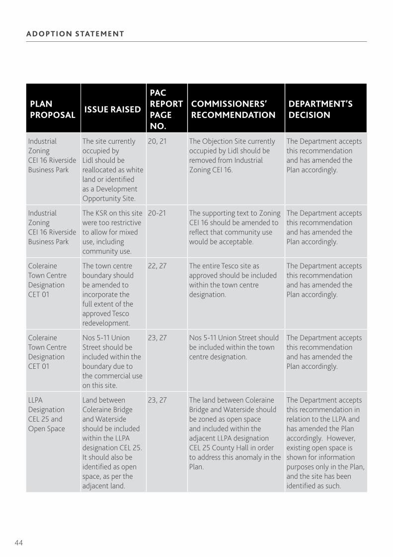
Industrial Zoning CEI 16 Riverside Business Park
The site currently occupied by Lidl should be reallocated as white land or identified as a Development Opportunity Site.
20, 21 The Objection Site currently occupied by Lidl should be removed from Industrial Zoning CEI 16.
The Department accepts this recommendation and has amended the Plan accordingly.
Industrial Zoning CEI 16 Riverside Business Park
The KSR on this site were too restrictive to allow for mixed use, including community use.
20-21 The supporting text to Zoning CEI 16 should be amended to reflect that community use would be acceptable.
The Department accepts this recommendation and has amended the Plan accordingly.
Coleraine Town Centre Designation CET 01
The town centre boundary should be amended to incorporate the full extent of the approved Tesco redevelopment.
22, 27 The entire Tesco site as approved should be included within the town centre designation.
The Department accepts this recommendation and has amended the Plan accordingly.
Coleraine Town Centre Designation CET 01
Nos 5-11 Union Street should be included within the boundary due to the commercial use on this site.
23, 27 Nos 5-11 Union Street should be included within the town centre designation.
The Department accepts this recommendation and has amended the Plan accordingly.
LLPA Designation CEL 25 and Open Space
Land between Coleraine Bridge and Waterside should be included within the LLPA designation CEL 25. It should also be identified as open space, as per the adjacent land.
23, 27 The land between Coleraine Bridge and Waterside should be zoned as open space and included within the adjacent LLPA designation CEL 25 County Hall in order to address this anomaly in the Plan.
The Department accepts this recommendation in relation to the LLPA and has amended the Plan accordingly. However, existing open space is shown for information purposes only in the Plan, and the site has been identified as such.

45
Northern Area Plan 2016
PLAN PROPOSAL
ISSUE RAISED
PAC REPORT PAGE NO.
COMMISSIONERS’ RECOMMENDATION
DEPARTMENT’S DECISION
Zoning CET 05 Bridge Street – Circular Road
The land at Bridge Street, Circular Road should be included within this Development Opportunity Site as it is a corner site at the junction of these roads.
24, 28 The land at Bridge Street, Circular Road should be included within Zoning CET 05.
The Department accepts this recommendation and has amended the Plan accordingly.
Zoning CET 07 Castle Lane (Waterside)
The KSR are too restrictive, in particular KSR 5 relating to height. Planning permission has been granted on the objection site.
27-28 Objection Site 4978 should be zoned as a separate development opportunity site CET 07a Castle Lane (Waterside Car Park) within the following KSR: 1. Development shall be considered in the context of the Clothworkers Building and neighbouring context; and 2. The site is particularly suited to mixed use redevelopment including retail, offices, entertainment, catering and residential.
The Department accepts this recommendation and has amended the Plan accordingly.
Zoning CET 06 The Harbour Estate
Clarification was sought as to whether the site lay within the town centre. Query regarding KSR 2 in relation to retail. Concern regarding the appropriateness of having public access along the entire river in KSR 4 in view of health and safety issues with adjoining working dock, port and marina.
26, 28 The Plan should clearly note that CET 06 is outside the town centre boundary and the word ‘retail’ should be deleted from KSR 2. KSR 4 should be amended to have the words ‘where appropriate’ inserted at the beginning.
The Department accepts this recommendation and has amended the Plan accordingly.

46
ADOPTION STATEMENT
PLAN PROPOSAL
ISSUE RAISED
PAC REPORT PAGE NO.
COMMISSIONERS’ RECOMMENDATION
DEPARTMENT’S DECISION
Area of Townscape Character – Lodge Road, Coleraine
The Lodge Road area has a distinctive character and merits designation as an ATC.
28-29 Lodge Road should be designated as ATC Designation CET 09 Lodge Road and in accordance with the Department’s submitted map and supporting text.
The Department accepts this recommendation and has amended the Plan accordingly.
Car Parking Sites – Coleraine
The Plan fails to provide sufficient parking for Coleraine on the basis of the Development Strategy promoting more growth which creates more pressure for parking.
33-34 Paragraph 11.4 of Coleraine Transportation section should be amended to reflect the Department’s updated position regarding parking supply in Coleraine.
The Department accepts this recommendation and has amended the Plan accordingly.
Need for integration of land use and transportation - Port and River Bann
The Plan makes no reference to the Port and its significance for transportation, or the River Bann which is navigable from the sea to Coleraine and beyond.
34 The existence of Coleraine Harbour and River Bann should be recognised in the Transportation Section.
The Department accepts this recommendation and has amended the Plan accordingly.
LLPA Designation CEL 24 Slieve Banna
This designation is not required and important trees could be retained as part of any development on the land.
37, 39 Designation CEL 24 should be removed from the Plan.
The Department accepts this recommendation and has amended the Plan accordingly.
LLPA Designation CEL 19 Somerset Woods
The wording in the associated paragraph 12.15 would restrict any further development on this land.
37, 39 The supporting paragraph to CEL 19 should be removed.
The Department accepts this recommendation and has amended the Plan accordingly.

47
Northern Area Plan 2016
TA B LE C 2 : GA RVAG H
PLAN PROPOSAL
ISSUE RAISED
PAC REPORT PAGE NO.
COMMISSIONERS’ RECOMMENDATION
DEPARTMENT’S DECISION
Housing Zoning GHH 02 Land Between and to Rear of 24 and 28 Station Road
Rivers Agency advises this site is subject to flood risk.
46, 47 Zoning GHH 02 should be withdrawn from the Plan and remain as white land within the settlement development limit.
The Department accepts this recommendation and has amended the Plan accordingly.
Housing Zoning GHH 03 Land Between 18-22 Station Road
Rivers Agency advises this site is subject to flood risk.
46, 47 Zoning GHH 03 should be withdrawn from the Plan and remain as white land within the settlement development limit.
The Department accepts this recommendation and has amended the Plan accordingly.
Housing Zoning GHH 06 Rear of 3-9 Main Street
Rivers Agency advises this site is subject to flood risk.
46, 47 Zoning GHH 06 should be withdrawn from the Plan and remain as white land within the settlement development limit.
The Department accepts this recommendation and has amended the Plan accordingly.
Housing Zoning GHH 09 Lands South of Killyvally Bridge
Rivers Agency advises this site is subject to flood risk.
46, 47 Zoning GHH 09 should be withdrawn from the Plan and remain as white land within the settlement development limit.
The Department accepts this recommendation and has amended the Plan accordingly.
Housing Zoning GHH 04 Land at Thompson Crescent
Objection to zoning on grounds of location and adverse impact of nearby engineering works
46, 48 Zoning GHH 04 should be removed from the Plan and the land remain as white land.
The Department accepts this recommendation and has amended the Plan accordingly.
Housing Zoning GHH 05 Kinnard Park
The zoning did not include a designation of land for community use. Part of the zoning is now occupied by the Jim Watt Sports Centre
47, 48 Zoning GHH 05 should be amended to remove the land relate to the sports centre.
The Department accepts this recommendation and has amended the Plan accordingly.

48
ADOPTION STATEMENT
PLAN PROPOSAL
ISSUE RAISED
PAC REPORT PAGE NO.
COMMISSIONERS’ RECOMMENDATION
DEPARTMENT’S DECISION
Designation GHDC 01 Garvagh District Centre
This wrongly describes Garvagh as a District Centre and should be described as a Town Centre in keeping with PPS 5.
48 Designation GHDC 01 should be titled as Garvagh Town Centre.
The Department accepts this recommendation and has amended the Plan accordingly.
Open Space Zoning GHO 01
This should include a reference to the creation of a riverside path that would connect Bridge Street and Kurin Road.
49, 50 Open Space Zoning GHO 01 should include a reference to the creation of a riverside path connecting Bridge Street and Kurin Road.
The Department accepts this recommendation and has amended the Plan accordingly.

49
Northern Area Plan 2016
TA B LE C 3 : KI LRE A
PLAN PROPOSAL
ISSUE RAISED
PAC REPORT PAGE NO.
COMMISSIONERS’ RECOMMENDATION
DEPARTMENT’S DECISION
Designation KA 01 Settlement Development Limit
Land to north of 10 Bann Road should be included within the limit for housing. Planning permission for housing has been granted on the majority of the site.
57, 58 The settlement development limit should be amended to include objection site 5338 and 5727 relating to the planning permission granted for housing on the site.
The Department accepts this recommendation and has amended the Plan accordingly.
Designation KADC 01 Kilrea District Centre
This wrongly describes Kilrea as a District Centre and should be described as a Town Centre in keeping with PPS 5.
60 Designation KADC 01 should be titled as Kilrea Town Centre.
The Department accepts this recommendation and has amended the Plan accordingly.
Open Space Zoning
Lands to the rear of 13 Garvagh Road and land to the north east should be removed as open space as outline permission was granted on appeal for housing.
61, 62 The area of open space that relates to the planning permission for housing should be removed from the Plan.
The Department accepts this recommendation and has amended the Plan accordingly.

50
ADOPTION STATEMENT
TA B LE C4 : PORT RUSH
PLAN PROPOSAL
ISSUE RAISED
PAC REPORT PAGE NO.
COMMISSIONERS’ RECOMMENDATION
DEPARTMENT’S DECISION
Designation PH 01 Settlement Development Limit
Land at Magheraboy Road should be included within the limit as planning permission for housing was granted on appeal.
68, 70 Land at Magheraboy Road should be included within the settlement development limit.
The Department accepts this recommendation and has amended the Plan accordingly.
Housing Zoning PHH 23 Rear of 48 to 51 Kerr Street
This site should be removed as a housing zoning.
70, 72 Housing Zoning PHH 23 should be removed from the Plan.
The Department accepts this recommendation and has amended the Plan accordingly.
Housing Zoning PHH 24 Castle Erin
This site should be removed as a housing zoning.
71, 72 Housing Zoning PHH 24 should be removed from the Plan.
The Department accepts this recommendation and has amended the Plan accordingly.
Housing Zoning PHH 30 100 Coleraine Road
This site should be removed as a housing zoning and identified as a Development Opportunity Site. Lidl occupies the site.
71, 72 Housing Zoning PHH 30 should be removed from the Plan.
The Department accepts this recommendation and has amended the Plan accordingly.
Designation PHA 01 Area of Opportunity for Apartments
As the PAC does not support the use of the associated Policy HOU 3 in Volume 1, this designation should be deleted.
72 Designation PHA 01 should be deleted from the Plan.
The Department accepts this recommendation and has amended the Plan accordingly.

51
Northern Area Plan 2016
PLAN PROPOSAL
ISSUE RAISED
PAC REPORT PAGE NO.
COMMISSIONERS’ RECOMMENDATION
DEPARTMENT’S DECISION
Status of Station Square
The PAC recommended the removal of reference to target sites in Volume 1. The identification of Station Square as a Target Site would infer that built development would be allowed. A public realm scheme has been completed.
75 Removal of the Target Site from Station Square.
The Department accepts this recommendation and has amended the Plan accordingly.
LLPA Designation PHL 01 Ramore Head
Objection to the supporting text which limits further development in this designation.
79 Amendment of the supporting text to PHL 01 to state: ‘The Department will give favourable consideration to appropriately sited buildings for uses ancillary to the enjoyment of open space and existing recreational facilities.
The Department accepts this recommendation and has amended the Plan accordingly.

52
ADOPTION STATEMENT
TA B LE C 5 : PORTST E WA RT
PLAN PROPOSAL
ISSUE RAISED
PAC REPORT PAGE NO.
COMMISSIONERS’ RECOMMENDATION
DEPARTMENT’S DECISION
Designation PT 01 Settlement Development Limit
Land between Knocknacor Drive and Dunsuivinish Avenue along Station Road should be included within the limit as planning permission has been granted for housing.
81, 86 Land between Knocknacor Drive and Dunsuivinish Avenue along Station Road should be included within the settlement development limit in accordance with the site boundary as per the approved housing scheme.
The Department accepts this recommendation and has amended the Plan accordingly.
Designation PT 01 Settlement Development Limit
Land at Lisderg, adjacent to Meadow Gardens, should be included within the limit as permission has been granted for housing.
82, 86 Land at Lisderg should be included within the settlement development limit.
The Department accepts this recommendation and has amended the Plan accordingly.
LLPA Designation PTL 05 Rockview
Land at Lisderg should be removed from the designation as it has permission for housing.
82, 86 Land at Lisderg should be removed from the designation.
The Department accepts this recommendation and has amended the Plan accordingly.
Designation PT 01 Settlement Development Limit
Land at east of Lisadell Avenue should be included within the limit as permission has been granted for housing.
82, 86 Land at east of Lisadell Avenue should be included within the settlement development limit.
The Department accepts this recommendation and has amended the Plan accordingly.
LLPA Designation PTL 01 Cromore
Land east of Lisadell Avenue should be removed from the designation as it has permission for housing.
82, 86 Land at Lisadell Avenue should be removed from the designation.
The Department accepts this recommendation and has amended the Plan accordingly.

53
Northern Area Plan 2016
PLAN PROPOSAL
ISSUE RAISED
PAC REPORT PAGE NO.
COMMISSIONERS’ RECOMMENDATION
DEPARTMENT’S DECISION
Designation PT 01 Settlement Development Limit
Land south of Agherton Village, Coleraine Road should be included within the limit. A Tesco retail store occupies the site.
82, 86 The Tesco retail store south of Agherton Village should be included within the settlement development limit.
The Department accepts this recommendation and has amended the Plan accordingly.
Inclusion of Land for Social Housing
Land at Coleraine Road, east of Housing Zoning PTH 27 should be zoned for social housing.
82,82, 86 Land at Coleraine Road east of Housing Zoning PTH 27 should be included within the settlement development limit for Social Housing. The Department should specify KSR to ensure the delivery of social housing.
The Department accepts this recommendation and has amended the Plan accordingly.
Designation PT 01 Settlement Development Limit
Land to the rear of Rockland Drive and Gardens (PTH 24) has planning permission for housing and the limit should be amended to reflect this.
85, 86 The settlement development limit should be amended to reflect the planning permission at PTH 24 Rockland Gardens.
The Department accepts this recommendation and has amended the Plan accordingly.
Designation PTA 01 Area of Opportunity for Apartment Development
As the PAC does not support the use of the associated Policy HOU 3 in Volume 1, this designation should be deleted.
88 Designation PTA 01 should be deleted from the Plan.
The Department accepts this recommendation and has amended the Plan accordingly.
Existing Open Space Link between Mill Road and Mullaghcall Playing Fields
This link should be identified as Existing Open Space
89, 90 Map 3/05a should illustrate the existing green link between the open space at Mill Road and Mullaghcall Playing Fields as an area of Existing Open Space.
The Department accepts this recommendation and has amended the Plan accordingly.

54
ADOPTION STATEMENT
PLAN PROPOSAL
ISSUE RAISED
PAC REPORT PAGE NO.
COMMISSIONERS’ RECOMMENDATION
DEPARTMENT’S DECISION
LLPA Designations PTL 02 Portstewart Point to PTL 07 Strand Head
These designations should be connected as they relate to the coastal walk and comprise a narrow rocky shore line.
93, 96 The omission sites referred to in Objection 5584 should be included within the respective adjacent LLPAs PTL 02 and PTL 07.
The Department accepts this recommendation and has amended the Plan accordingly.
LLPA Designation PTL 11 Strandview
Objections to the designation as it is within an area designated for housing in Zoning PTH 48 Strandview.
93-94, 97 Designation PTL 11 and its associated text should be removed from the Plan.
The Department accepts this recommendation and has amended the Plan accordingly.
LLPA Designation PTL01 Cromore
The designation should be amended to remove the small area where land associated with planning permission at Housing Zoning PTH 24 Rockland Gardens is to be brought within the development limit.
95, 96 The boundary of the designation is amended to remove the planning permission at PTH 24 Rockland Gardens. The supporting text is substituted with the following: ‘Within this LLPA, there will be a presumption against new development. However, favourable consideration can be given to the extension and conversion of existing buildings of historic merit’. The full extent of this LLPA should be set out clearly in the Plan.
The Department accepts this recommendation and has amended the Plan accordingly.

55
Northern Area Plan 2016
LLPA Designation PTL 01 Cromore
Land at Agherton Road should be removed from the designation as it would restrict tourism development on the land.
95, 96, 97 The designation and supporting text should be amended as follows: ‘Within this LLPA, there will be a presumption against new development. However, favourable consideration can be given to the extension and conversion of existing buildings of historic merit. The text should also be further amended: 1. Point 2 should be amended to remove reference to Green Belt; 2. The supporting text should be replaced with: ‘Favourable consideration may also be given to the extension of existing tourism facilities providing the integrity, and quality of the LLPA is not significantly harmed as required under Policy ENV 2 of the Plan’.
The Department accepts this recommendation and has amended the Plan accordingly, but the wording has been amended to align with the strategic LLPA Policy (now ENV 1).
TA B LE C6 : A RT ICL AV E
PLAN PROPOSAL
ISSUE RAISED
PAC REPORT PAGE NO.
COMMISSIONERS’ RECOMMENDATION
DEPARTMENT’S DECISION
Housing Zoning AEH 03 Rear of St Paul’s Church
Objection to the zoning as KSR 2 states additional land will be required to provide access to the public road.
101 Housing Zoning AEH 03 should be removed from the Plan.
The Department accepts this recommendation and has amended the Plan accordingly.

56
ADOPTION STATEMENT
TA B LE C 7 : C A ST LE ROCK
PLAN PROPOSAL
ISSUE RAISED
PAC REPORT PAGE NO.
COMMISSIONERS’ RECOMMENDATION
DEPARTMENT’S DECISION
Designation CKA 01 Area of Opportunity for Apartment Development
As the PAC does not support the use of the associated Policy HOU 3 in Volume 1, this designation should be deleted.
105 Designation CKA 01 should be deleted from the Plan.
The Department accepts this recommendation and has amended the Plan accordingly.
LLPA Designation CKL 03 School Lane
Objection to the lack of clarity of Map 3/07 as the designation overlaps the edge of the settlement development limit.
106 Designation CKL 03 should be clearly defined and set out in the Plan and should be referred to in the supporting text.
The Department accepts this recommendation and has amended the Plan accordingly.
TA B LE C8 : M ACOSQU I N
PLAN PROPOSAL
ISSUE RAISED
PAC REPORT PAGE NO.
COMMISSIONERS’ RECOMMENDATION
DEPARTMENT’S DECISION
Designation MN 01 Settlement Development Limit
Land north of Ringrash Road and West of Ramsey Park should be included within the limit as permission for housing was allowed on appeal.
111, 112 Land north of Ringrash Road and West of Ramsey Park should be included within the settlement development limit.
The Department accepts this recommendation and has amended the Plan accordingly.

57
Northern Area Plan 2016
TA B LE C9 : PORT BA LLI NT R A E
PLAN PROPOSAL
ISSUE RAISED
PAC REPORT PAGE NO.
COMMISSIONERS’ RECOMMENDATION
DEPARTMENT’S DECISION
Designation PEA 01 Area of Opportunity for Apartment Development
As the PAC does not support the use of the associated Policy HOU 3 in Volume 1, this designation should be deleted.
117 Designation PEA 01 should be deleted from the Plan.
The Department accepts this recommendation and has amended the Plan accordingly.
Omission of the Scheduled Archaeological Monument at the Ice House
The SAM should be shown on Map 3/10 to inform the public.
118, 119 The Scheduled Archaeological Monument at the Ice House should be shown on Map 3/10.
The Department accepts this recommendation and has amended the Plan accordingly.
Omission of an Area of Village Character
The Plan should identify an area within PEL 02 Bay LLAP (between PEH 13 and PEH 02) as an Area of Village Character.
118, 119 An Area of Village Character should be designated in the area around Beach Park, along with supporting text.
The Department accepts this recommendation and has amended the Plan accordingly.
TA B LE C 10 : CR A IGAVOLE
PLAN PROPOSAL
ISSUE RAISED
PAC REPORT PAGE NO.
COMMISSIONERS’ RECOMMENDATION
DEPARTMENT’S DECISION
Designation CV 01 Settlement Development Limit
Land at Grove Road, opposite St Mary’s RC Church should be included in the limit.
122 The Objection Site (4986) at Grove Road opposite St Mary’s RC Church should be included within the settlement development limit.
The Department accepts this recommendation and has amended the Plan accordingly.

58
ADOPTION STATEMENT
TA B LE C 11 : G LE N U LLI N
PLAN PROPOSAL
ISSUE RAISED
PAC REPORT PAGE NO.
COMMISSIONERS’ RECOMMENDATION
DEPARTMENT’S DECISION
Designation GU 01 Settlement Development Limit
Land to the south of 28 Glen Road (Area A) should be included within the limit.
123, 125 Objection Site 286 (Area A) should be included within the settlement development limit.
The Department accepts this recommendation and has amended the Plan accordingly.
TA B LE C 12 : RI NGSE N D
PLAN PROPOSAL
ISSUE RAISED
PAC REPORT PAGE NO.
COMMISSIONERS’ RECOMMENDATION
DEPARTMENT’S DECISION
Designation RE 01 Settlement Development Limit
Land to the north of Craigmore Road (Lower) (Site 3) should be included within the limit.
126, 127 Objection Site (Site 3) should be included with the settlement development limit.
The Department accepts this recommendation and has amended the Plan accordingly.

59
Northern Area Plan 2016
TA B LE C 13 : COU NT RYSI DE A N D COA ST
PLAN PROPOSAL
ISSUE RAISED
PAC REPORT PAGE NO.
COMMISSIONERS’ RECOMMENDATION
DEPARTMENT’S DECISION
Designation of a new Settlement at Loughan
The Plan should designate Loughan as a Small Settlement.
129 A Settlement Development Limit should be drawn around the roadside frontage development along Loughan Road, as indicated by Objection 4984 MKA Map 1, with exception to the extension of the proposed limit along Damhead Road.
The Department accepts this recommendation and has amended the Plan accordingly.
SLNCI Designation CSLN 45 The Rough Hills
This designation should be extended to include the raised bogs vegetation that lies within the golf course at Kilrea.
132 The designation should be extended to include Kilrea Golf Course.
The Department accepts this recommendation and has amended the Plan accordingly.
Historic Parks, Gardens and Demesnes Designation CHPG 6: Knocktarna
A small area on the edge of the settlement at Mountsandel Road should be excluded, as there is recent development on it.
133 The boundary to CHPG 6: Knocktarna should be amended to exclude Objection Site at Mountsandel Road.
The Department accepts this recommendation and has amended the Plan accordingly. NIEA has reviewed this area and further amendments to the boundary have been incorporated.

60
ADOPTION STATEMENT
PAC Recommendations and the Department’s Decisions on Proposed Changes to Limavady Borough
Limavady Borough
Following consideration of the Commissioners’ Report of the Examination, the Department is generally in agreement with the PAC recommendations. The Department’s response to the individual recommendations is set out in the Tables below:
TA B LE L1 : L I M AVA DY
PLAN PROPOSAL
ISSUE RAISED
PAC REPORT PAGE NO.
COMMISSIONERS’ RECOMMENDATION
DEPARTMENT’S DECISION
Designation LY 01 Settlement Development Limit
The Department indicated that the development limit should be amended to incorporate the presence of Tesco and its carpark at Broad Road as whiteland.
3, 5 The reduced area at Broad Road should be included within the settlement development limit.
The Department accepts this recommendation and has amended the Plan accordingly.
Designation LY 01 Settlement Development Limit
The Department indicated that the land east of Bovally, north of Whispering Pines, Rossair Road where planning permission was granted on appeal was to be included within the limit and zoned for housing. The remainder should remain outside the limit due to its environmental sensitivity.
4, 5 The land east of Bovally housing development, north of Whispering Pines, Rossair Road should be included within the settlement development limit.
The Department accepts this recommendation and has amended the Plan accordingly.
Housing Zoning LYH 07 10 Connell Street
The site is in commercial use.
7, 10 Zoning LYH 07 should be removed from the Plan.
The Department accepts this recommendation and has amended the Plan accordingly.
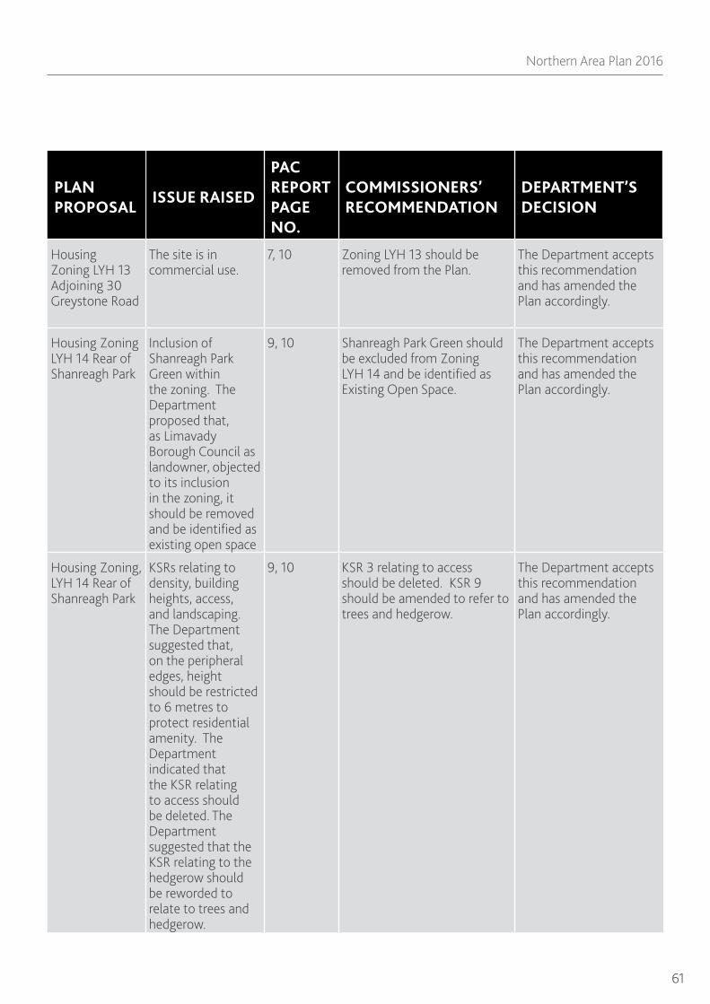
61
Northern Area Plan 2016
PLAN PROPOSAL
ISSUE RAISED
PAC REPORT PAGE NO.
COMMISSIONERS’ RECOMMENDATION
DEPARTMENT’S DECISION
Housing Zoning LYH 13 Adjoining 30 Greystone Road
The site is in commercial use.
7, 10 Zoning LYH 13 should be removed from the Plan.
The Department accepts this recommendation and has amended the Plan accordingly.
Housing Zoning LYH 14 Rear of Shanreagh Park
Inclusion of Shanreagh Park Green within the zoning. The Department proposed that, as Limavady Borough Council as landowner, objected to its inclusion in the zoning, it should be removed and be identified as existing open space
9, 10 Shanreagh Park Green should be excluded from Zoning LYH 14 and be identified as Existing Open Space.
The Department accepts this recommendation and has amended the Plan accordingly.
Housing Zoning, LYH 14 Rear of Shanreagh Park
KSRs relating to density, building heights, access, and landscaping. The Department suggested that, on the peripheral edges, height should be restricted to 6 metres to protect residential amenity. The Department indicated that the KSR relating to access should be deleted. The Department suggested that the KSR relating to the hedgerow should be reworded to relate to trees and hedgerow.
9, 10 KSR 3 relating to access should be deleted. KSR 9 should be amended to refer to trees and hedgerow.
The Department accepts this recommendation and has amended the Plan accordingly.

62
ADOPTION STATEMENT
PLAN PROPOSAL
ISSUE RAISED
PAC REPORT PAGE NO.
COMMISSIONERS’ RECOMMENDATION
DEPARTMENT’S DECISION
Housing Zoning LYH 21 Adjoining Gorteen House and Community/ Open Space Zoning LYC/O 01
Objection to the KSRs. The Department indicated that it wished to withdraw Zoning LYC/O 01, as permission has been granted on this and the adjoining LYH 21 for the erection of housing and community facilities as part of the larger LYH 21 zoning, and the area should revert to white land. Given the scale of the proposed development, it was logical that the community services are located in the northwestern corner of the area. Although the Department could not impose such a requirement, wording was put forward for inclusion in the plan’s text.
10, 11, 12 The following text should be added to LYH 21: The land to the north-east of Gorteen House is a logical location for associated community services such as a crèche or other facilities to meet the daily needs of residents. This land could also be used to provide some of the open space requirements for the adjoining residential zonings.
Planning permission was granted in October 2011 for the erection of housing with associated open space and landscaping, and community facilities on the zonings LYH 21 and the adjoining LYC/O 01. As such, this will appear as a committed site in the Plan, and future development will be subject to the conditions on the permission. The inclusion of the recommended wording is considered inappropriate in this context.
Development Opportunity Designation LYT 03 The Town Hall
The Department indicated there was no need to identify this site as it had been redeveloped.
13 Designation LYT 03 should be deleted.
The Department accepts this recommendation and has amended the Plan accordingly.

63
Northern Area Plan 2016
PLAN PROPOSAL
ISSUE RAISED
PAC REPORT PAGE NO.
COMMISSIONERS’ RECOMMENDATION
DEPARTMENT’S DECISION
Open Space Zoning LYO 01 Roe Lands Adjacent to the Castle River and Bovally Housing Area
The Department suggested the amendment of ‘formal playing field provision’ to ‘outdoor recreation’ in the policy.
13, 14 The first line of Zoning LYO 01 should be amended from ‘formal playing field provision’ to ‘outdoor recreation’.
The Department accepts this recommendation and has amended the Plan accordingly.
Open Space Zoning LYO 01 Lands Adjacent to the Castle River and Bovally Housing Area
Objection to KSR 4 in relation to its reference to playing pitches and facilities and residential amenity. The Department proposed this KSR was amended regarding impact to dwellings and wildlife.
13, 14 KSR 4 should be amended to read: any recreational activity shall be sited to minimise any adverse impacts on the amenities of neighbouring houses and wildlife interests.
The Department accepts this recommendation and has amended the Plan accordingly.
Open Space Zoning LYO 01 Lands Adjacent to the Castle River and Bovally Housing Area
The Department stated a footnote would be added in relation to the body that provides and operates the open space. This was proposed in response to the objection to use the woodland for recreational purposes.
13, 14 A footnote should be added stating: the open space can be provided either publicly by the District Council or by developers in association with neighbouring development. The open space can also be operated privately as a commercial outdoor recreational facility.
The Department accepts this recommendation and has amended the Plan accordingly.
Open Space Zoning LYO 01 Lands Adjacent to the Castle River and Bovally Housing Area
The Department indicated the open space area would be reduced in light of an appeal decision for housing on part of the site.
14 The extent of LYO 01 should be reduced in accordance with the appeal decision.
The Department accepts this recommendation and has amended the Plan accordingly.
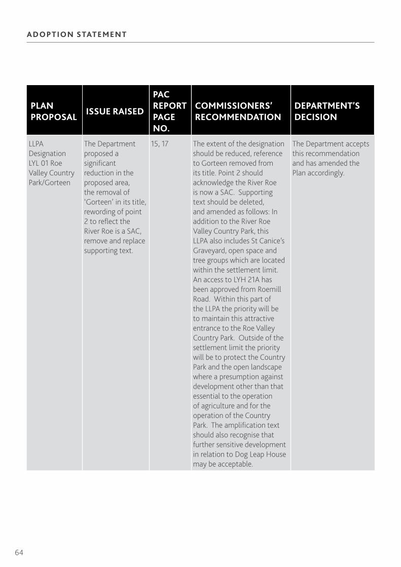
64
ADOPTION STATEMENT
PLAN PROPOSAL
ISSUE RAISED
PAC REPORT PAGE NO.
COMMISSIONERS’ RECOMMENDATION
DEPARTMENT’S DECISION
LLPA Designation LYL 01 Roe Valley Country Park/Gorteen
The Department proposed a significant reduction in the proposed area, the removal of ‘Gorteen’ in its title, rewording of point 2 to reflect the River Roe is a SAC, remove and replace supporting text.
15, 17 The extent of the designation should be reduced, reference to Gorteen removed from its title. Point 2 should acknowledge the River Roe is now a SAC. Supporting text should be deleted, and amended as follows: In addition to the River Roe Valley Country Park, this LLPA also includes St Canice’s Graveyard, open space and tree groups which are located within the settlement limit. An access to LYH 21A has been approved from Roemill Road. Within this part of the LLPA the priority will be to maintain this attractive entrance to the Roe Valley Country Park. Outside of the settlement limit the priority will be to protect the Country Park and the open landscape where a presumption against development other than that essential to the operation of agriculture and for the operation of the Country Park. The amplification text should also recognise that further sensitive development in relation to Dog Leap House may be acceptable.
The Department accepts this recommendation and has amended the Plan accordingly.

65
Northern Area Plan 2016
PLAN PROPOSAL
ISSUE RAISED
PAC REPORT PAGE NO.
COMMISSIONERS’ RECOMMENDATION
DEPARTMENT’S DECISION
LLPA Designation LYL 02 Roe Park
The Department indicated that an area of Roemill Road where planning permission had been granted should be excluded from the designation.
16 The area of planning permission B/2003/0649/O should be excluded from the designation.
The Department accepts this recommendation and has amended the Plan accordingly.
LLPA Designation LYL 06 Castle River
The Department proposed a rewording of the amplification text to address a perceived ambiguity in relation to Drenagh sawmills.
16 The amplification text to the designation should be amended to read: no further development is acceptable other than suitable redevelopment proposals in accordance with regional policy for the Drenagh sawmills site and replacement and extension of existing buildings and ancillary development associated with the open space use.
The Department accepts this recommendation and has amended the Plan accordingly.
LLPA Designation LYL 09 Old Railway
The Department acknowledged that the inclusion of the Tesco’s car park was a mapping error.
17 The removal of the car park at Tesco from the designation.
The Department accepts this recommendation and has amended the Plan accordingly.

66
ADOPTION STATEMENT
TA B LE L 2 : DU NG I V E N
PLAN PROPOSAL
ISSUE RAISED
PAC REPORT PAGE NO.
COMMISSIONERS’ RECOMMENDATION
DEPARTMENT’S DECISION
Designation DG 01 Settlement Development Limit
The Department suggested the development limit be adjusted to reflect planning permission on land to the north of the playing field.
19, 21 The land to the north of the playing field, Garvagh Road, should be included in the development limit.
The Department accepts this recommendation and has amended the Plan accordingly.
Housing Zoning DGH 08 Lands North of Finvola Park
The field to the south of Dungiven Parish Church (Church of Ireland) should be removed from the zoning.
21, 22 The field to the south of Dungiven Parish Church (Church of Ireland) should be removed from zoning DGH 08.
The Department accepts this recommendation and has amended the Plan accordingly.
Housing Zoning DGH 03 Lower Main Street
It is inappropriate to zone this area for development given the contribution the house and garden make to Dungiven’s townscape character. Its zoning appears to be at odds with the Department’s evidence in relation to the positive contribution this area makes to the town.
21-22 Zoning DGH 03 should be deleted and the area left as white land.
The Department accepts this recommendation and has amended the Plan accordingly.
Existing Areas of Open Space
Finvola Park and Fair Green should be shown as existing areas of open space.
23 The lands at Finvola Park and Fair Green should be identified as open space on the relevant settlement map.
The Department accepts this recommendation and has amended the Plan accordingly.
Existing Areas of Open Space
The open space boundary of Mitchell Park is inaccurate.
23 The inaccuracy of the boundary of Mitchell Park should be corrected.
The Department accepts this recommendation and has amended the Plan accordingly.

67
Northern Area Plan 2016
TA B LE L 3 : BA LLY KE LLY
PLAN PROPOSAL
ISSUE RAISED
PAC REPORT PAGE NO.
COMMISSIONERS’ RECOMMENDATION
DEPARTMENT’S DECISION
Housing Zoning BKH 05 Junction of Plantation Road and Main Street
Objection to the access details contained in the KSR.
28, 29 Given the introduction of PPS 3: Access, Movement and Planning Clarification of Policy AMP 3: Access to Protected Routes (October 2006), there is no need for KSR 4 in this instance. KSR 4 should be deleted.
The Department accepts this recommendation and has amended the Plan accordingly.
Existing Areas of Open Space
Objection sought the identification of LBC’s pitches at Kings Lane as open space.
30 The land at Kings Lane should be identified as a major area of open space.
The Department accepts this recommendation and has amended the Plan accordingly.
TA B LE L 4 : B E LL A RE N A
PLAN PROPOSAL
ISSUE RAISED
PAC REPORT PAGE NO.
COMMISSIONERS’ RECOMMENDATION
DEPARTMENT’S DECISION
Housing Zoning BLH 01 Adjoining 412 Seacoast Road
The land should be de-zoned. Part of the site is presently inhabited and the owner does not wish to redevelop the remainder.
33 Zoning BLH 01 should be de-zoned and left as white land within the development limit.
The Department accepts this recommendation and has amended the Plan accordingly.

68
ADOPTION STATEMENT
TA B LE L 5 : BU RN FOOT
PLAN PROPOSAL
ISSUE RAISED
PAC REPORT PAGE NO.
COMMISSIONERS’ RECOMMENDATION
DEPARTMENT’S DECISION
Designation BT 01 Settlement Development Limit
The new Burnfoot Primary School be included within the development limit.
36 The proposed development limit should be extended to include the new Primary School site.
The Department accepts this recommendation and has amended the Plan accordingly.
Housing Zoning BTH 02 Adjoining the Post Office, Drumrane Road
The development of this site is questionable given its entirety lies within the floodplain.
36 Zoning BTH 02 should be removed from the Plan.
The Department accepts this recommendation and has amended the Plan accordingly.
Open Space The path along the River Roe, for which planning permission was granted in 2005, should be identified on the Burnfoot map.
37 Additional text should be added to the plan to acknowledge the presence of the public path along the banks of the River Roe. Burnfoot benefits from a pleasant looped walk which extends from the village into the countryside to the northeast and sits on the banks of the River Roe and Bovevagh along part of its route.
The Department accepts this recommendation and has amended the Plan accordingly
TA B LE L6 : DRU MSU RN
PLAN PROPOSAL
ISSUE RAISED
PAC REPORT PAGE NO.
COMMISSIONERS’ RECOMMENDATION
DEPARTMENT’S DECISION
Open Space The playing pitch to the south-east of Nos 1-3 Rushie Park, Beech Road should be identified as open space.
40, 41 That the playing pitch and play area to the south-east of Nos 1-3 Rushie Park, Beech Road should be identified as open space.
The Department accepts this recommendation and has amended the Plan accordingly. For consistency with other areas of existing public open space, the Department has included this open space within the settlement development limit.

69
Northern Area Plan 2016
TA B LE L7 : FE E N Y
PLAN PROPOSAL
ISSUE RAISED
PAC REPORT PAGE NO.
COMMISSIONERS’ RECOMMENDATION
DEPARTMENT’S DECISION
SLNCI Designation LSLN 04 Altcattan Glen
The boundaries of the SLNCI are inaccurate as some of the land is of no nature conservation interest.
45 Altcattan Glen SLNCI should be reduced as per NIEA map presented by the Department in its topic paper.
The Department accepts this recommendation and has amended the Plan accordingly.
TA B LE L 8 : FOREG LE N
PLAN PROPOSAL
ISSUE RAISED
PAC REPORT PAGE NO.
COMMISSIONERS’ RECOMMENDATION
DEPARTMENT’S DECISION
Existing Areas of Major Open Space
Land located to the north of Columbia Park should be shown as existing open space.
48 The land north of Columbia Park should be identified as existing open space.
The Department accepts this recommendation and has amended the Plan accordingly.
LLPA Designation FNL 01
Development on that part of the proposed LLPA within the development limit could affect its environmental quality, integrity and character.
49 That part of the LLPA within the development limit has already been developed and includes St Peter and Paul Roman Catholic Church which is of architectural and historic merit. However, the explanatory text to the LLPA should be expanded to inform the reader better about the features of this designation.
The Department accepts this recommendation and has amended the Plan accordingly.

70
ADOPTION STATEMENT
TA B LE L 9 : G RE YST E E L
PLAN PROPOSAL
ISSUE RAISED
PAC REPORT PAGE NO.
COMMISSIONERS’ RECOMMENDATION
DEPARTMENT’S DECISION
Social Housing Provision
Land to the south of Ferndale Park should be zoned for social housing.
51, 52 The land to the north-west of Housing Zoning GLH 04 (Lands off Hawthorn Park) should be included within the settlement development limit to meet the need for 10 social housing units. There should be a key site requirement stating that it is for social housing purposes only.
The Department accepts this recommendation and has amended the Plan accordingly.
TA B LE L10 : DE RN A FL AW
PLAN PROPOSAL
ISSUE RAISED
PAC REPORT PAGE NO.
COMMISSIONERS’ RECOMMENDATION
DEPARTMENT’S DECISION
Open Space Objection seeking the identification of land to the northeast of Dernaflaw cottages as open space.
56 There may be merit in the request to identify the land as open space. However, it does not need to be located within the settlement development limit for this to be achieved.
Limavady Borough Council (the objector) has confirmed that it has no continuing interest in having this land retained as open space. The Department does not, therefore, consider it appropriate to identify this land.

71
Northern Area Plan 2016
PAC Recommendations and the Department’s Decisions on Proposed Changes to Moyle District
Moyle District
Following consideration of the Commissioners’ Report of the Examination, the Department is generally in agreement with the PAC recommendations. The Department’s response to the individual recommendations is set out in the Tables below:
TA B LE M1 : BA LLYC A ST LE
PLAN PROPOSAL
ISSUE RAISED
PAC REPORT PAGE NO.
COMMISSIONERS’ RECOMMENDATION
DEPARTMENT’S DECISION
Designation BE 01 Settlement Development Limit
Ballycastle settlement development limit should be amended to incorporate land to rear of nos 16-22 Drumavoley Road
3, 10 The garden area associated with no 22 Drumavoley Road should be included within the settlement development limit.
The Department accepts this recommendation and has amended the Plan accordingly.
Designation BE 01 Settlement Development Limit
Ballycastle settlement development limit should be amended to incorporate land to the rear of Dun-a-mallaght Road, south, southwest of Dun-amallaght Crescent and opposite no 29 Dun-a-mallaght Road.
5, 10 The objection site at Dun-a-mallaght Road should be included within the settlement development limit.
The Department accepts this recommendation and has amended the Plan accordingly.
Designation BE 01 Settlement Development Limit
Ballycastle settlement development limit should be amended to incorporate land immediately to the north of Housing Zoning BEH 30 off Whitepark Road.
9, 10 The objection sites off Whitepark Road should be included within the settlement development limit.
The Department accepts this recommendation and has amended the Plan accordingly.
Designation BE 01 Settlement Development Limit
Ballycastle SDL should be amended to incorporate land between Whitepark Road and Ramoan Road.
9, 10 The objection sites relating to land between Whitepark Road and Ramoan Road be included within the settlement development limit.
The Department accepts this recommendation and has amended the Plan accordingly.

72
ADOPTION STATEMENT
PLAN PROPOSAL
ISSUE RAISED
PAC REPORT PAGE NO.
COMMISSIONERS’ RECOMMENDATION
DEPARTMENT’S DECISION
Housing Zoning BEH 12 Rear of 34 Rathlin Road
Access to this site is restricted and would have to be provided through third party land.
11, 12 That zoning BEH 12 be removed from the Plan.
The Department accepts this recommendation and has amended the Plan accordingly.
Housing Zoning BEH 19 Adjoining Ballycastle High School
The zoning is landlocked to the west and south, and there is limited chance the other surrounding land will be released due to it being Church land. Part of the zoning is committed for the extension of the adjacent graveyard. KSR 4 acknowledges third party land is required to access the site. All these factors contribute to the uncertain delivery of this site.
11, 12 That zoning BEH 19 be removed from the Plan.
The Department accepts this recommendation and has amended the Plan accordingly.
Designation BEA 01 – Area of Opportunity for Apartment Development
As the PAC does not support the use of the associated Policy HOU 3 in Volume 1, this designation should be deleted.
12, 13 Designation BEA 01 should be deleted from the Plan.
The Department accepts this recommendation and has amended the Plan accordingly.
LLPA Designation BEL 01 Tow Valley
The proposed designation overlaps with Housing Zoning BEH 13. The supporting text to the designation does not take account of this.
15, 17 The supporting text to BEL 01 should be amended to reconcile the proposed designations in the Plan within the development limit.
The Department accepts this recommendation and has amended the Plan accordingly.

73
Northern Area Plan 2016
PLAN PROPOSAL
ISSUE RAISED
PAC REPORT PAGE NO.
COMMISSIONERS’ RECOMMENDATION
DEPARTMENT’S DECISION
LLPA Designation BEL 02 Glenshesk
Objections sought the removal of land at Drumavoley Road from within this designation.
16, 17 The supporting text to BEL 02 should be amended to read: ‘This area is within the Antrim Coast and Glens AONB where no further new development is appropriate other than that demonstrated to be essential for agricultural purposes. Exception also allowed for sensitively positioned outbuildings and extension of outbuildings’.
The Department accepts this recommendation and has amended the Plan accordingly.
LLPA Designation BEL 07 Ramoan
Land between Whitepark Road and Ramoan Road should be removed from the designation.
17 Objection Site 5181 in respect of the planning permission should be removed from the LLPA designation. NB: the PAC application reference is incorrect.
The Department accepts this recommendation and has amended the Plan accordingly.
TA B LE M 2 : BUSH M I LL S
PLAN PROPOSAL
ISSUE RAISED
PAC REPORT PAGE NO.
COMMISSIONERS’ RECOMMENDATION
DEPARTMENT’S DECISION
Designation BS 01 Settlement Development Limit
Land west of Priestland Road and north of Craigaboney Road should be included within the limit as permission was granted on appeal for housing.
18, 22 Land at Priestland Road, Craigaboney Road and Dunluce Rectory should be included within the settlement development limit as per the planning permission.
The Department accepts this recommendation and has amended the Plan accordingly.

74
ADOPTION STATEMENT
PLAN PROPOSAL
ISSUE RAISED
PAC REPORT PAGE NO.
COMMISSIONERS’ RECOMMENDATION
DEPARTMENT’S DECISION
Designation BS 01 Settlement Development Limit
Land to the rear of nos 1-23 Main Street should be included within the limit. Permission has been granted for an extension to the existing hotel.
22, 23 Land to the rear of nos 1-23 Main Street should be included within the settlement development limit as per the planning permission.
The Department accepts this recommendation and has amended the Plan accordingly.
Designation BS 01 Settlement Development Limit
Land adjacent to no 1 Main Street should be included within the limit as, as presently drawn, it severs the garden belonging to Woodville House, a Listed Building.
22, 23 Land adjacent to no 1 Main Street should be included within the settlement development limit.
The Department accepts this recommendation and has amended the Plan accordingly.
Housing Zoning BSH 09 Land adjacent to no 9 Ballyness Park
This zoning should be deleted as NIHE has secured funding for a nursery on it and it is not therefore available for housing.
23, 24 Housing Zoning BSH 09 should be removed from the Plan. The land should remain as white land in the Plan.
The Department accepts this recommendation and has amended the Plan accordingly.
Designation BSDC 01 Bushmills District Centre
This wrongly describes Bushmills as a District Centre and should be described as a Town Centre in keeping with PPS 5.
25 Designation BSDC 01 should be titled as Bushmills Town Centre.
The Department accepts this recommendation and has amended the Plan accordingly.
LLPA Designation BSL 01 Montalto
The area with planning permission for housing development at Priestland Road/ Craigaboney Road should be moved from the designation.
26, 28 Land relating to planning permission at Priestland Road/ Craigaboney Road should be removed from the LLPA designation.
The Department accepts this recommendation and has amended the Plan accordingly.

75
Northern Area Plan 2016
LLPA Designation BSL 03 Distillery
The supporting text is overly restrictive and could limit development on Ballyness Caravan Park.
27, 28 The supporting text to BSL 03 should be amended to read: ‘Within the development limit, well designed buildings, complementing the traditional built character of the Distillery, may be acceptable.
The Department accepts this recommendation and has amended the Plan accordingly.
TA B LE M 3 : CUSH E N DA LL
PLAN PROPOSAL
ISSUE RAISED
PAC REPORT PAGE NO.
COMMISSIONERS’ RECOMMENDATION
DEPARTMENT’S DECISION
Inclusion of Land for Social Housing
Land between Kilnadore Road and Kilnadore Park should be included within the development limit and zoned for social housing to meet identified need.
29, 33 Land between Kilnadore Road and Kilnadore Park should be included within the settlement development limit to meet the development needs of the settlement to provide social housing.
The Department accepts this recommendation and has amended the Plan accordingly.
Designation CL 01 Settlement Development Limit
Land opposite St Mary’s RC Church on Chapel Road should be included within the limit. It is a small portion of roadside land occupied by one dwelling.
31, 33 Land opposite St Mary’s RC Church on Chapel Road should be included within the settlement development limit.
The Department accepts this recommendation and has amended the Plan accordingly.
Designation CLDC 01 Cushendall District Centre
This wrongly describes Cushendall as a District Centre and should be described as a Town Centre in keeping with PPS 5.
35 Designation CLDC 01 should be titled as Cushendall Town Centre.
The Department accepts this recommendation and has amended the Plan accordingly.

76
ADOPTION STATEMENT
PLAN PROPOSAL
ISSUE RAISED
PAC REPORT PAGE NO.
COMMISSIONERS’ RECOMMENDATION
DEPARTMENT’S DECISION
LLPA Designation CLL 01 Court McMartin
Removal of land from the proposed designation. The Department recognised that, if this land is required for social housing, with the exception of the area identified as Kilnadore Graveyard, it would be appropriate to remove the remaining part from the LLPA.
37 Removal of Objection Site 11 from CLL01 with the exception of the area around Kilnadore Graveyard.
The Department has amended the LLPA to exclude that part of the area zoned for social housing.
TA B LE M4 : A RM OY
PLAN PROPOSAL
ISSUE RAISED
PAC REPORT PAGE NO.
COMMISSIONERS’ RECOMMENDATION
DEPARTMENT’S DECISION
Designation AY 01 Settlement Development Limit
Land opposite St Olcan’s Primary School and to the rear of no 158 Hillside Road should be included within the limit.
39, 41 Land opposite St Olcan’s Primary School should be included within the settlement development limit as white land.
The Department accepts this recommendation and has amended the Plan accordingly.
Designation AY 01 Settlement Development Limit
Land to north of Turnarobert Park should be included within the limit. It presents a logical rounding off to the edge of Armoy.
39, 41 Land immediately north of Turnarobert Park should be included within the settlement development limit as white land.
The Department accepts this recommendation and has amended the Plan accordingly.

77
Northern Area Plan 2016
TA B LE M 5 : BA LLI NTOY
PLAN PROPOSAL
ISSUE RAISED
PAC REPORT PAGE NO.
COMMISSIONERS’ RECOMMENDATION
DEPARTMENT’S DECISION
LLPA Designation BAL 02 Boheeshane Bay
Objection to the overlap of the designation with Housing Zoning BAH 05 129 Whitepark Road.
44, 45 The supporting text to the designation should take account of land with the settlement development limit including the housing zonings.
The Department accepts this recommendation and has amended the Plan accordingly.
TA B LE M 6 : WAT E RFOOT
PLAN PROPOSAL
ISSUE RAISED
PAC REPORT PAGE NO.
COMMISSIONERS’ RECOMMENDATION
DEPARTMENT’S DECISION
Housing Zoning WTH 03 14 Main Street
This zoning should be deleted as it is not suitable for housing development. Permission has been granted for mixed use development.
54, 55 Housing Zoning WTH 03 should be removed from the Plan.
The Department accepts this recommendation and has amended the Plan accordingly.
TA B LE M7 : CH U RCH BAY, R AT H LI N
PLAN PROPOSAL
ISSUE RAISED
PAC REPORT PAGE NO.
COMMISSIONERS’ RECOMMENDATION
DEPARTMENT’S DECISION
SLNCI Designation MSLN 21 Church Bay
Objection to this SLNCI. The Department advised this area now falls within Church Bay Area of Special Scientific Interest.
57, 58 MSLN 21 should be removed from the Plan.
The Department accepts this recommendation and has amended the Plan accordingly.

78
ADOPTION STATEMENT
TA B LE M 8 : KNOCKN AC A RRY
PLAN PROPOSAL
ISSUE RAISED
PAC REPORT PAGE NO.
COMMISSIONERS’ RECOMMENDATION
DEPARTMENT’S DECISION
Designation KY 01 Settlement Development Limit
Land to the east of Layde Road should be included within the limit. Planning permission has been granted for housing.
62, 63 Land to the east of Layde Road should be included within the settlement development limit to take account of the planning permission.
This area was already included within the proposed development limit; therefore, there is no need to amend the Plan.
LLPA Designation KYL 01 Glendun River
Objection to this designation. The Department confirmed a map of the extent of the LLPA at a suitable scale would be included in the final Plan.
62, 63 A full scale map within the Plan should be included to illustrate the extent of KYL 01.
The Department accepts this recommendation and has amended the Plan accordingly.
Inclusion of housing within Designation KY 01 Settlement Development Limit
A small group of houses at Glenview Park and Knocknacarry Crescent should be included within the limit.
62, 63 A settlement development limit should be drawn around the existing grouping of houses at Glenview Park and Knocknacarry Crescent.
The Department accepts this recommendation and has amended the Plan accordingly.

79
Northern Area Plan 2016
TA B LE M 9 : L ISN AGU NOGU E
PLAN PROPOSAL
ISSUE RAISED
PAC REPORT PAGE NO.
COMMISSIONERS’ RECOMMENDATION
DEPARTMENT’S DECISION
Designation LS 01 Settlement Development Limit
Land at 226 Whitepark Road should be included within the limit. The limit, as drawn, does not follow any physical boundaries and cuts through a yard to the rear.
65 Land at 226 Whitepark Road should be included within the settlement development limit.
The Department accepts this recommendation and has amended the Plan accordingly.

80
ADOPTION STATEMENT
A PPE N D IX 2
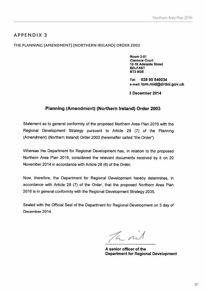
81
Northern Area Plan 2016
A PPE N D IX 3
THE PLANNING (AMENDMENT) (NORTHERN IRELAND) ORDER 2003
