nsw address policy and user manual
TRANSCRIPT

NSW Address Policy and User ManualOctober 2019

ii
NSW Addressing User Manual
Title: NSW Address Policy and User Manual / Geographical Names Board of New South Wales.
Subjects: Addresses (NSW) - Address Localities. Names, Geographical (NSW)
Other Authors/Contributors: Geographical Names Board (NSW)
Copyright
© Crown in right of New South Wales through the Geographical Names Board of New South Wales, 2019.This copyright work is licensed under a Creative Commons Attribution-NonCommercial-NoDerivatives 4.0 International License.
Disclaimer
This information is correct at the date of publication; changes after the time of publication may impact upon the accuracy of the material.
Any enquiries relating to this publication, may be addressed to Spatial Services E: [email protected]
Geographical Names Board of New South Wales
PO Box 143
Bathurst NSW 2795
T: 6332 8214
W: www.gnb.nsw.gov.au
SS P19/10/024
1
NSW Addressing User Manual
Foreword
Addresses connect people to a place and Place Names constitute the most commonly used spatial reference. There has been exponential growth in the demand for relevant, accurate and authoritative address information to support community, government and business.
Many web and database applications rely on addresses as the central reference point to connect services and integrate data. As a result, addresses must adhere to the basic principles that they are simple, singular (i.e. not-duplicated), intuitively understood and relevant to place.
These addressing principles are important for both government and the community. The community depends on the use of consistent addresses for service delivery and public safety, particularly when it comes to emergency response times. Government depends on it to deliver infrastructure and policies that make a difference to the economy and people’s lives.
Address is also the under-appreciated third component of Identity Management – Name, Address and Date of Birth. Reliable and accurate address information is fundamental to identity management in a digital economy and society.
However, when it comes to the management of addresses, there are numerous related Acts and Regulations. The aim of this manual is to provide a common approach which is based on legislative obligations and addressing standards. The manual is a consolidated reference providing clear guidelines for the creation of accurate, consistent and logical address information which meets the needs of the community, government and business.
The NSW Address Policy and User Manual, is intended to apply to all address data produced in NSW.
Since its initial release in 2014 this Address Policy and User Manual has been successful in improving compliance and streamlining the process for address approval and management. This revision provides updates and clarification on a number of matters that will continue to drive improvements for the benefit of both the Government and public of NSW.
Narelle Underwood
Surveyor-General of NSW

2
NSW Addressing User Manual
This page is intentionally blank

3
NSW Addressing User Manual
Foreword .............................................................................................................................................................. 1
Document Control ............................................................................................................................................ 7
Glossary of Terms ............................................................................................................................................. 8
1. Introduction .................................................................................... 12
1.1 Addressing Vision ............................................................................................... 12
1.2 Objectives ............................................................................................................. 14
1.3 Background .......................................................................................................... 15
1.4 Scope ..................................................................................................................... 16
1.5 Contents ................................................................................................................ 17
1.6 Related policies and documents ..................................................................... 18
2. New South Wales Address Policy .............................................. 20
2.1 Policy Statement ................................................................................................. 20
2.1.1 Objectives ...................................................................................................................................... 20
2.1.2 Scope .............................................................................................................................................. 20
2.2 Policy Components ............................................................................................. 21
2.2.1 Responsibilities .......................................................................................................................... 21
2.2.2 NSW Address Policy Review Process ........................................................................... 21
2.3 Policy Introduction ............................................................................................. 22
2.4 Legislation and Authority .................................................................................. 23
2.4.1 Authority for Numbering ...................................................................................................... 23
2.4.2 Authority for Road Naming ............................................................................................... 23
2.4.3 Authority for Address Locality Names and Boundaries ...................................... 24
2.5 Policy ...................................................................................................................... 25
2.5.1 Address Supply Chain ............................................................................................................ 25
2.5.2 Assumptions .............................................................................................................................. 25
2.5.3 Governance and Custodianship ....................................................................................... 26
2.5.4 Address Database .................................................................................................................. 27
2.5.5 Address Data Verification and Usage .......................................................................... 27
3. Address Data Governance and Custodianship ....................... 30
3.1 Governance - Data Producers .......................................................................... 31
3.2 Governance - Data Aggregators ..................................................................... 35
3.3 Governance - Data Distributors ....................................................................... 37
3.4 Governance - Data Users ................................................................................... 39
3.5 Custodianship - Data Producers ...................................................................... 40
3.6 Custodianship - Data Aggregators ................................................................ 41
3.7 Custodianship - Data Distributors ................................................................... 42
3.8 Custodianship - Data Users ............................................................................... 43

4
NSW Addressing User Manual
4. NSW Address Data, Metadata and Components ................... 46
4.1 Address Grading .................................................................................................. 47
4.2 NSW Address Database Components ............................................................ 50
4.2.1 Gazetteer of Road Names ................................................................................................... 50
4.2.2 Road Types ................................................................................................................................ 51
4.2.3 Gazetteer of Place Names ................................................................................................. 51
4.2.4 Address Localities .................................................................................................................. 51
4.3 NSW Address Database Metadata .................................................................. 52
4.4 Core Addressing String Metadata ................................................................... 53
4.5 Core Address Components ............................................................................... 56
4.6 Additional Address Components .................................................................... 57
4.7 Geocode Types .................................................................................................... 58
5. Address Data Verification and Usage ........................................ 60
5.1 Address Data Verification ................................................................................. 60
5.2 Address Data Usage ........................................................................................... 61
5.2.1 Usage of Address Data .......................................................................................................... 61
5.2.2 Confirmation of Address ..................................................................................................... 61
6. Addressing Principles .................................................................... 64
6.1 General Principles of Addressing .................................................................... 65
6.1.1 Determination of Address Number................................................................................... 65
6.1.2 Building identifier and/or site name ................................................................................ 66
6.1.3 One Road Name ....................................................................................................................... 67
6.1.4 Sub-addressing ........................................................................................................................ 67
6.1.5 Alternative Addresses ............................................................................................................ 68
6.1.6 Alternative Addresses on Sub-address Sites ............................................................. 68
6.1.7 Naming and Numbering across Boundaries ............................................................... 68
6.2 General Principles of Numbering .................................................................... 69
6.2.1 Address Numbers .................................................................................................................... 69
6.2.2 Datum Point ............................................................................................................................... 70
6.2.3 Use of Suffixes .......................................................................................................................... 72
6.2.4 Renumbering due to Redevelopment .......................................................................... 76
6.2.5 Renumbering due to Highway Declassification ....................................................... 76
6.3 Principles for Urban Numbering ...................................................................... 77
6.3.1 Reserving Numbers ................................................................................................................. 77
6.3.2 Numbering a Corner Site .................................................................................................... 78
6.4 Principles for Rural Numbering ........................................................................ 79
6.4.1 Distance Based Numbering System ............................................................................... 79
6.4.2 No Access Point to a Road ................................................................................................ 79
6.4.3 Close Address Sites ............................................................................................................... 79

5
NSW Addressing User Manual
6.4.4 Very Long Roads .................................................................................................................... 80
6.4.5 Rural Areas Affected by Development ........................................................................ 80
6.4.6 Rural/Urban Fringe Areas .................................................................................................. 81
6.5 Principles for Sub-Address Numbering ......................................................... 82
6.5.1 Primary Address Site Numbering ..................................................................................... 82
6.5.2 Sub-Address Numbering ..................................................................................................... 82
6.5.3 Uniqueness ................................................................................................................................. 84
6.5.4 Types of Sub-Addresses...................................................................................................... 86
6.5.5 Multi-level Sub-Address Allocation ................................................................................ 85
6.5.6 Carspace Addressing ............................................................................................................ 88
6.5.7 Multiple towers on the same site ..................................................................................... 88
6.6 Principles for Water-Based Numbering ......................................................... 91
6.6.1 Water Access ............................................................................................................................. 91
6.6.2 Use of Water Name................................................................................................................ 91
6.6.3 Sequence .................................................................................................................................... 91
6.6.4 Datum Point for Waterways .............................................................................................. 91
6.6.5 Datum Point for Islands, Inlets, Bays ............................................................................. 92
6.6.6 Waterways with Islands, Inlets and Bays..................................................................... 93
6.7 Principles of Road naming ................................................................................ 94
6.7.1 Ensuring Public Safety and Service Delivery .............................................................. 94
6.7.2 Language ..................................................................................................................................... 94
6.7.3 Roads to be Named ............................................................................................................... 95
6.7.4 Uniqueness Duplication........................................................................................................ 97
6.7.5 Acceptable Road Names ..................................................................................................... 99
6.7.6 Commemorative Road Names .......................................................................................... 99
6.7.7 Road Extents ............................................................................................................................. 100
6.7.8 Suffixes, Prefixes and Directional Indicators .............................................................. 101
6.7.9 Amending Road Names ....................................................................................................... 101
6.7.10 Road Types ............................................................................................................................... 101
6.7.11 Cross-Jurisdictional Naming or Renaming ................................................................. 102
6.7.12 Name of Water Feature or Island ................................................................................... 102
6.8 Principles of Address Locality Naming and Boundaries ............................ 103
6.8.1 Uniqueness, Duplication ....................................................................................................... 103
6.8.2 Official Use ................................................................................................................................. 103
6.8.3 Acceptable Address Locality Names ............................................................................ 103
6.8.4 Boundary Definition .............................................................................................................. 104
6.8.5 Boundary Determination ..................................................................................................... 104
6.9 Principles of Geocoding .................................................................................... 105
6.9.1 Geocode Location ................................................................................................................... 105
6.9.2 Geocode Coordinates ........................................................................................................... 105
6.9.3 Geocode Accuracy ................................................................................................................. 105
6.9.4 Mapping Projection and Datum ...................................................................................... 105

6
NSW Addressing User Manual
6.10 Road Types ........................................................................................................... 106
7. Addressing Procedures ................................................................. 110
7.1 Consultation ......................................................................................................... 111
7.1.1 Submitting a Request ............................................................................................................... 111
7.1.2 Responding to a Request ..................................................................................................... 112
7.1.3 Consulting on a Proposal ..................................................................................................... 113
7.1.4 Advertising and Public Notices.......................................................................................... 114
7.1.5 Submissions ................................................................................................................................. 115
7.2 Notifications ......................................................................................................... 116
7.2.1 Notification of Approved Road Names .......................................................................... 116
7.2.2 Gazettal of Road Names and Address Localities .................................................... 116
7.2.3 Road Closure ............................................................................................................................. 116
7.2.4 Ungazetted Road Names .................................................................................................... 117
7.3 Pre-Approvals ....................................................................................................... 118
7.3.1 Authorisation of Proposals ................................................................................................... 118
7.3.2 Pre-Approval .............................................................................................................................. 118
7.3.3 Suitability Advice ..................................................................................................................... 119
7.4 Signage .................................................................................................................. 120
8. Address Processes .......................................................................... 126
Process AP1: Road Naming/Renaming – Local Government ........................................ 127
Process AP2: Road Naming/Renaming - Roads and Maritime Services ................. 132
Process AP3: Address Locality Boundaries .......................................................................... 133
Process AP4: Addressing – Adding or Amending Addresses where Road Name Exists .....139
Process AP5: Addressing – Development and Subdivision ......................................... 143
Process AP6: Addressing - DA Exempt Developments .................................................. 155
Process AP7: Addressing - Public Housing [State Government Agencies] .......... 159
9. Retrospective Address Policy ...................................................... 166
9.1 Retrospective Address Policies ....................................................................... 167
9.1.1 Numbering Issues ...................................................................................................................... 167
9.1.2 Road Naming Issues................................................................................................................ 168
9.1.3 Address Locality Issues ......................................................................................................... 170
9.1.4 Address Issues ........................................................................................................................... 171
9.2 High-level process steps for resolving a retrospective address issue .... 172
Appendix ................................................................................................... 173
Appendix A: Duplicated Localities in NSW ............................................................. 174

7
NSW Addressing User Manual
Document Control
Approval
Name and Position Signature DateDes Mooney, Chair of the GNB, General Manager LPI
March 2015
Narelle Underwood, Surveyor-General of NSW
October 2019
Version Status Date Prepared by Comments1 Final October 2014 CPAS First release
2 Final February 2015 CPAS Second Release
3 Final April 2015 CPAS Third Release
4 Final September 2016 NAC Fourth Release
5 Final October 2019 Spatial Services Fifth Release
Review
This document is to be reviewed annually or as required. Where minor changes are required Spatial Services must ensure the version number is updated. However, where changes in legislation or operating environment result in substantive rewriting of the document, the sponsor must create a new document and ensure it is entered into TRIM. This will ensure the integrity of the original document.

8
NSW Addressing User Manual
Glossary of Terms
Address For the purposes of developing and maintaining a comprehensive NSW Address Database an address is defined as a:
• string of data which contains minimum components as defined in AUM Chapter 4 - Section 4.5 - Core Address Components
• a location referencing tool that describes a geographical point accessed via the road network of NSW (including pathways and waterways).
Refer to AUM Chapter 2 - Section 2.5.4 - Address Database.
Address Locality An address locality is a named geographical area with defined boundaries which represents a community or area of interest and may be rural or urban in character (where urban it is usually defined as a suburb).
Alias Address Assigned to any address which contains attributes which are known to Spatial Services to be erroneous and an authoritative or non-authoritative address must exist.
Alternative Address Where a primary site has more than one access point, it may be assigned one or more alternative addresses.
ANZLIC Australia New Zealand Land Information Council develops agreed policies and guidelines for both Australia and New Zealand aimed at achieving best practice in spatial data management.
Approve Final authorisation of an address component. This includes verification of the number and geocode conformance to requirements of the Addressing User Manual (AUM). This also includes verification of the road name/type and address locality name/boundary conformance for gazettal purposes.
AS/NZS 4819 AS/NZS 4819:2011 Rural and Urban Addressing defines specific aspects of address production.
AUM Refer to Addressing User Manual
Authoritative Address These types of addresses can be considered ‘official’ or ‘gazetted’ and can be assessed by users to be the best defined location reference for gaining access to a site from the NSW road network.
Refer to AUM Chapter 4 - Section 4.1 - Address Grading.
AVWS Address Verification Web Service
CGNA Committee for Geographic Names Australasia, now known as the Permanent Committee on Place Names (PCPN)
Cluster Boxes A grouping of mail boxes usually located at the entrance of a gated community or at an entrance point to a rural road.
Complex Site Generally large sites comprising of multiple owners, tenants or access points and which contains multiple sub addresses e.g. university, retirement village, shopping centre.
Core Address Component An essential component of an address, including house number, street name, road type and address locality, and a reference to the physical location of the address (XY coordinate or other).
Refer to AUM Chapter 4 - Section 4.5 - Core Address Components.

9
NSW Addressing User Manual
Core Address String A Core Address String consists of Core Address Components arranged in appropriate order and will be maintained by Spatial Services for each address in NSW in conformance with requirements of AS/NZS 4819 and AS 4590.
Council NSW Local Council, Municipal Council, City Council, Shire Council or Local Government
CRM Client Relationship Management System
Custodian The organisation that maintains the official address database for a defined physical extent, e.g., Councils for the extent of each Local Government Area (LGA), Spatial Services for NSW Address Database and PSMA for Australian Address Database.
Endorse Agreement to proceed to the next level of authorisation for an address component.
e-Plan An electronic plan lodgment and validation system developed by LRS.
FP Field Plan
FSDF Foundation Spatial Data Framework
Fuzzy Boundaries A GIS term for administrative or other bounding areas which are not able to be clearly defined.
Gazetting/Gazetted Gazetteer - Gazetteers are collections of names or identifiers which are compiled, maintained and published under the jurisdiction of a government authority.
G-NAF Geocoded National Address File - produced by PSMA
GNB/The Board Geographical Names Board of New South Wales
GPN Gazetteer of Place Names
Refer to AUM Chapter 4 - Section 4.2.3 – Gazetteer of Place Names.
Greenfield Development Site
An area of agricultural or forest land, or some other undeveloped site earmarked for commercial development or industrial projects.
GRN Gazetteer of Road Names
Refer to AUM Chapter 4 - Section 4.2.1 – Gazetteer of Road Names.
LIIAC The Location Intelligence Industry Advisory Committee
LLG Location Leadership Group
LRS Land Registry Services NSW
Mesh Blocks Mesh Blocks are the building blocks for all the larger regions of the Australian Statistical Geography Standard and they broadly identify land use such as residential, commercial, agricultural and parks etc.
NAMF National Address Management Framework
Neighbourhood A named geographical area which has unofficial or fuzzy boundaries and cannot be used for addressing purposes.
NES Notification and Edit Service
Non-Authoritative Address These types of addresses can be considered ‘unofficial’ or ‘ungazetted’ and can be assessed by users to be an approximated location reference for gaining access to a site from the NSW road network.
These addresses are usually good descriptions of a location but they lack the authoritativeness of a gazetted road name or address locality name to define them as approved by their Local Government and/or endorsed by the GNB.
Refer to AUM Chapter 4 - Section 4.1 - Address Grading.

10
NSW Addressing User Manual October 2014
NSW Address Database The official database repository for addresses in NSW maintained by Spatial Services.
Penalty Unit As at 1 July 2014, under the provisions of s17 of the Crimes (Sentencing Procedure) Act (1999), one Penalty Unit is equivalent to $110.
PCPN Permanent Committee on Place Names
Point of Interest (POI) Points of Interest provide the identification and location of a feature, service or activity that people may want to know about or visit.
Primary Address An address site that is not contained within another address site (as per definition in AS/NZS4819)
PSMA Public Sector Mapping Agency
The Regulations Roads Regulation (2018)
RMS Roads and Maritime Services
Roads Act Roads Act 1993
ROW Right of Way
Single Source of Truth In the context of the custodian of the NSW Address Database, Spatial Services aggregate and apply quality assurance mechanisms to address data from data producers in NSW and provision this as a single source of truth.
Spatial Services (SS), DCS Spatial Services, Department of Customer Service
Suburb Refer Address Locality
The Secretariat The Secretariat of the Geographical Names Board
Site (Address) Refers to the object being assigned an address. Can be a property, building, feature, point of interest etc.
Site Centroid Point of centre of a site and lying within its boundaries (e.g. for L-shaped site). This is the default geocode for the NSW Address Database as described in AUM Chapter 4 - Section 4.7 - Geocode Types.
Sub Address An address site that is contained within a primary address site (e.g. an apartment within a building) (definition from AS/NZS 4819)
Unique Address ID A code which identifies an address instance. At present the reference code is to be the G-NAF ID, based on provisions of the NSW Government Standard for Geospatially Enabling Information1.
Note: Analysis of requirements to support the functionality of the NSW Address Database will determine any future requirements for a NSW-specific code to identify address data maintained by Spatial Services, as custodians of the NSW Address Database.
VAR A value-added reseller is a company that adds features or services to an existing product, then resells it (usually to end-users) as an integrated product or complete solution.
1 https://www.spatial.nsw.gov.au/__data/assets/pdf_file/0005/219281/NSW_Standard_for_Spatially_Enabling_Information.pdf

Chapter 1
Introduction

12 NSW Address Policy and User Manual
Chapter 1 Introduction
1 Introduction
This manual is a key step in developing the framework for implementing the vision of an improved addressing system for New South Wales (NSW).
The NSW Address Policy and User Manual outlines the Geographical Names Board (GNB) and NSW Spatial Services policy, principles, processes and procedures for addressing in NSW.
This manual repeals all existing GNB policies and guidelines in respect to addressing in NSW. The policy contained in chapter 2 does not apply retrospectively. Retrospective Addresses are dealt with in Chapter 9: Retrospective Address Policy.
1.1 Addressing Vision
The vision is to implement the 2011 revised AS/NZS 4819: Rural and Urban Addressing standard for Australia in NSW and apply this to all forms of addressing within the state. The intention is to provide confidence in usage of address data within NSW for all stakeholders. This will be achieved by establishing policies and processes that address producers, aggregators, distributors and users can utilise in order to deliver NSW address useability, quality and completeness. The outcome will provide an address for all properties as well as sites requiring an address location to be established including individual buildings, units, businesses and location features.
Property-based addressing has typically focused on assigning an address to just properties whereas site based addressing assigns an address to the location of an identified site. For example, a house, carpark or building will be assigned an address based on primary and alternative access for visitors (refer to AUM- Chapter 6 – Principle 6.1.1).

NSW Address Policy and User Manual 13
Chapter 1 Introduction
i 19 Policy Road (Primary)
ii 12 Claire Lane (Alternative)
iii 17A Policy Road (Primary)
iv 17B Policy Road (Primary) 10B Claite Lane (Alternative)
v 10A Claire Lane (Primary)
vi 2/15 Policy Road (Primary)
vii 1/15 Policy Road (Primary)
viii 8 Claire Lane (Alternative)
ix 13 Policy Road (Alternative)
x 52 Standards Road (Primary)
xi 6 Claire Lane (Alternative)
Mansion with two access pointsa) Front doorb) Garage
Subdivided property with main houses accessed from Policy Road and Granny Flat access from Claire Lane.
Car park access from Claire Lane.O�ce buildings accessed from Policy Road.
O�ce building with three access points.
19 17B 17A 15 13
12 10B 10A 8 6
52
a) i
b) ii
iv
iii
v
vi vii
vii
ix
xi
x
Policy Road
Claire Lane
Standard
s Ro
ad

14 NSW Address Policy and User Manual
Chapter 1 Introduction
1.2 Objectives
The GNB is responsible for maintaining the state gazetteer for place names and road names, and therefore uniquely positioned to provide support for the production, aggregation, publication and usage of standardised address data across NSW. The contents of this manual are aligned with AS/NZS 4819 and replace or supplement the documents as listed in AUM Chapter 1 - Section 1.6 - Related Policies and Documents.
This AUM was developed by the Geographical Names Board and Spatial Services to outline principles, procedures and processes which can be implemented to standardise the production, aggregation, publication and usage of address data in an open and timely manner.
This manual is based on the following principles for addressing in NSW including:
1. All address sites will have a logical, unique, authoritative, geocoded, property address.
2. All new addresses will comply with the Australian/ New Zealand Geographic Information – AS/NZS 4819:2011 Rural and Urban Addressing.
3. There will be an official repository for NSW property addresses which will be deemed the ‘source of truth’ for all Government agencies.
4. Processes to formalise address components will minimise duplicated effort, ensure rapid approval and feed the official repository for NSW property addresses.
5. An efficient governance framework will allow for mediation and directions to resolve risks and issues.
6. It is expected that government agencies will use authoritative property addresses.
7. Communication mechanisms will be put in place to promote the use of authoritative property addresses.
8. Where changes to longstanding address components are required to minimise confusion, strategies will be developed to reduce disruption and distress for the affected local community.
9. An address shall be correctly and appropriately sign posted or marked.
10. The powers relating to the creation and change of address components should remain with the currently nominated level of government.
11. Services should be available for address users to validate and download authoritative property addresses.

NSW Address Policy and User Manual 15
Chapter 1 Introduction
1.3 Background
Spatial Services designed, developed and initiated the implementation of a comprehensive system of addressing to enable the efficient production, aggregation, publication and usage of address information in a consistent manner in NSW. This was an improvement on the existing system which gave rise to a number of costs and risks for the NSW community and Government, including:
• non-compliance with existing standards (e.g. Australian Standards and National Address Management Framework)
• lost revenue
• compromises service delivery and negatively impacts on customer relationships
• duplication of services and effort
• potential death and serious injury due to difficulty and delays in locating addresses for emergency services.
These risks and costs were derived from detected deficiencies in the NSW addressing system, which were summarised into three key areas:
1. Legislation: need to legislate the functions and roles for the production, aggregation, publication and usage of address data
2. Addressing Systems: need to ensure addressing systems are integrated to enable aggregation, verification and distribution of address data in a timely manner - from the point of production to the point of usage - and can be managed and can be audited.
3. Address Data: need to enable improved address data management including collection of all address types and application of quality assurance regimes.
The implementation of these improvements to the NSW addressing system has been in order to minimise the known costs and risks. The adoption of this user manual including the NSW Address Policy has ensured that addressing guidelines in NSW are consistent with the Australian Standards.
Spatial Services has delivered various projects including the NSW Address Database, NSW Point, Service Point and the establishment of the NAC during the implementation phase (note: the NAC has since been replaced by the NSW Addressing review process). This manual was introduced as part of the policy improvement initiatives and is now held in the custodianship of the GNB. Since the first introduction of this manual in November 2014 the objective has been to ensure that addressing procedures across the state are standardised and unambiguous.
16 NSW Address Policy and User Manual
Chapter 1 Introduction
1.4 Scope
The contents of the AUM apply to the production, aggregation, publication and usage of all new addresses (and components) in NSW including:
• road names (private and public)
• assignment of address numbers
• development and subdivision address processes
• complex site addressing (caravan parks, retirement villages, Educational facilities etc.)
• creation of new or amended address locality boundaries.
When creating new addresses in established areas it is intended that the new addresses fit as best to this policy as possible. However in some circumstances due consideration must be given to the existing addresses in the area. For further information see section 7.3.3 - Suitability Advice.
The policy, principles, procedures and processes contained herein are in place to meet the objectives of the Digital NSW Delivery Blueprint and to compliment the work being undertaken at a national and international level through the NSW Location Leadership Group (LLG), Location Intelligence Industry Advisory Committee (LIIAC), ANZLIC and the Permanent Committee on Place Names (PCPN).
Some of the key objectives of the Digital NSW Delivery Blueprint to which this manual responds include:
• transforming the experience of interacting with NSW government
• providing better security, transparency and trust in government
• supporting a competitive digital NSW economy
• improving the performance of government
The scope of the contents for this manual have been defined through consultation with Spatial Services, the GNB and the LGAWG through various iterations which have taken into account:
• GNB Strategic Plan and Action Items
• current legislative framework for addressing in NSW
• status of Spatial Services systems developments which will enable capture of address data
• state and national policies for addressing
• requirements for a best-practice addressing standard for application across the state.

NSW Address Policy and User Manual 17
Chapter 1 Introduction
1.5 Contents
The NSW Address Policy and User Manual (AUM) contains a set of chapters which define different elements of address data production, aggregation, maintenance, distribution and usage. Each chapter has been designed to cross-reference and draw upon the information contained throughout the manual, to ensure consistency and a standardised approach to address data management in NSW. For example, the processes explicitly cross-reference various principles and procedures which apply during various tasks of producing address data. The contents of the manual include:
Chapter 2 NSW Address Policy
A set of information regarding the objectives, scope, legislation, governance, metadata and components, verification and usage of NSW address data.
Chapter 3 Address Data Governance and Custodianship
A description of the functions and roles expected to be performed by address data producers, aggregators, distributors and users.
Chapter 4 NSW Address Database, Metadata and Components
Details the metadata and component requirements for the NSW Address Database and Core Address Strings.
Chapter 5 Address Data Verification and Usage
Provides information regarding provision of an address verification service and requirements for address data users.
Chapter 6 Addressing Principles
A set of principles which explain how to assign numbers to address sites, determine road names, delineate address locality boundaries and define geocodes.
Chapter 7 Addressing Procedures
Explains the various requirements of submitting proposals, stakeholder engagement, issuing of gazette notices and how to reserve road names.
Chapter 8 Addressing Processes
A series of processes for producing address data and informing Spatial Services of new, changed or deprecated data to ensure the NSW Address Database remains current, consistent and complete.
Chapter 9 Retrospective Address Policy
A policy to assist stakeholders, including Local Government and State Government agencies, to resolve problematic address issues that existed prior to the first publication of the AUM.

18 NSW Address Policy and User Manual
Chapter 1 Introduction
1.6 Related policies and documents
The NSW Address Policy and User Manual replaces the following the documents previously issued by the GNB.
Issuer Reference Document NameGeographical Names Board of NSW October 2013 NSW Road Naming Policy
Geographical Names Board of NSW October 2013 NSW Road Naming Procedure and Processes
Land and Property Information Draft Proposed NSW Address Policy in Respect of Address Management and Use
Geographical Names Board of NSW March 2013 Guidelines for the Naming of Roads (2013)
Geographical Names Board of NSW March 2013 The Naming and Addressing of Private Roads and Roads in Community Subdivisions (2013)
Geographical Names Board of NSW March 2013 Road Naming in NSW (2013).
Geographical Names Board of NSW March 2013 Determining Suburbs and Address Localities in NSW (2013)
Geographical Names Board of NSW March 2013 Rural Addressing for NSW (2013)
Geographical Names Board of NSW March 2013 Retrospective Address Policy
Geographical Names Board of NSW September 2014
NSW Address Policy
The NSW Address Policy and User Manual is a supplement to the following documents.
Issuer Reference Document NameGeographical Names Board of NSW March 2013 Glossary of designation values in the
Geographic Names Register
Geographical Names Board of NSW March 2013 Glossary of status values in the Geographic Names Register
The NSW Address Policy and User Manual is related to the following documents.
Issuer Reference Document NameNSW Government December
2013NSW Government Standard for Spatially Enabling Information
NSW Addressing Working Group November 2010
The NSW Address Vision
NSW Addressing Working Group November 2010
The NSW Addressing Working Group’s Gap Analysis and Recommendations
NSW Addressing Working Group December 2010
Addressing Workshop Final Report
Surveyor General of NSW September 2017
Surveyor General’s Direction No.7
Standards Australia 2011 & 2017 4590 - Interchange of Client Information & 4819 - Rural & Urban Addressing

Chapter 1
Introduction
Chapter 2
New South Wales Address Policy

20 NSW Address Policy and User Manual
Chapter 2 New South Wales Address Policy
2 New South Wales Address Policy
This chapter contains the NSW Address Policy and supplements the following chapters of the NSW Addressing Policy and User Manual (AUM). The policy and manual are first steps in the implementation of a site-based addressing system for New South Wales.
2.1 Policy Statement
This document outlines policies which should be implemented to standardise the production, aggregation, publication and usage of address data across New South Wales (NSW) in an open and timely manner.
2.1.1 Objectives
The Geographical Names Board (GNB) of NSW is responsible for maintaining the state gazetteer for place names and road names, and therefore uniquely positioned to provide support for the production, aggregation, publication and usage of standardised address data across NSW.
This document is aligned with AS/NZS 4819 and replaces the documents listed in AUM Chapter 1 - Section 1.6 - Related Policies and Documents as previously issued by the GNB.
This policy was developed by the Geographical Names Board and Spatial Services to outline principles, procedures and processes which can be implemented to standardise the production, aggregation, publication and usage of address data in an open and timely manner.
2.1.2 Scope
This policy applies to the production, aggregation, publication and usage of all new addresses (and components) in NSW, including:
• road names (private and public)
• assignment of address numbers
• development and subdivision address processes
• complex site addressing (caravan parks, retirement villages, Educational facilities etc.)
• creation of new or amended address locality boundaries.
This policy meets the objectives of the Digital NSW Delivery Blueprint and complements the work being undertaken at a national and international level through the NSW Location Leadership Group (LLG), Location Intelligence Industry Advisory Committee (LIIAC), ICSM, ANZLIC and the Permanent Committee on Place Names (PCPN).
The scope of the contents for this manual have been defined through consultation with Spatial Services and the GNB through various iterations which have taken into account:
• GNB Strategic Plan and Action Items
• current legislative framework for addressing in NSW
• status of Spatial Services systems developments which will enable capture of address data
• state and national policies for addressing
• requirements for a best-practice addressing standard for application across the state.
NSW Address Policy and User Manual 21
Chapter 2 New South Wales Address Policy
2.2 Policy Components
2.2.1 Responsibilities
Geographical Names Board
The GNB is responsible for the governance of this policy.
Spatial Services
Spatial Services is responsible for the administrative management (including the currency of information in the AUM), technical support and promotion of the policy under the auspices of the GNB.
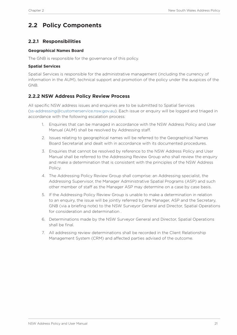
2.2.2 NSW Address Policy Review Process
All specific NSW address issues and enquiries are to be submitted to Spatial Services ([email protected]). Each issue or enquiry will be logged and triaged in accordance with the following escalation process:
1. Enquiries that can be managed in accordance with the NSW Address Policy and User Manual (AUM) shall be resolved by Addressing staff.
2. Issues relating to geographical names will be referred to the Geographical Names Board Secretariat and dealt with in accordance with its documented procedures.
3. Enquiries that cannot be resolved by reference to the NSW Address Policy and User Manual shall be referred to the Addressing Review Group who shall review the enquiry and make a determination that is consistent with the principles of the NSW Address Policy.
4. The Addressing Policy Review Group shall comprise: an Addressing specialist, the Addressing Supervisor, the Manager Administrative Spatial Programs (ASP) and such other member of staff as the Manager ASP may determine on a case by case basis.
5. If the Addressing Policy Review Group is unable to make a determination in relation to an enquiry, the issue will be jointly referred by the Manager, ASP and the Secretary, GNB (via a briefing note) to the NSW Surveyor General and Director, Spatial Operations for consideration and determination .
6. Determinations made by the NSW Surveyor General and Director, Spatial Operations shall be final.
7. All addressing review determinations shall be recorded in the Client Relationship Management System (CRM) and affected parties advised of the outcome.

22 NSW Address Policy and User Manual
Chapter 2 New South Wales Address Policy
2.3 Policy Introduction
This document outlines the GNB policy for addressing in NSW. While the GNB are not explicitly responsible for all the components of an address, under the Geographical Names Act 1966 they have responsibility for naming and defining address localities and are provided with the powers to compile a list of roads.
The intention is to take the state from a focus of applying addresses to properties solely for rating and valuation purposes, towards an addressing system which caters for sites including properties, buildings, individual units or businesses and features or Points of Interest (PoI). This document is the first step in developing the framework for implementing the vision of a site-based addressing system for NSW.
This policy repeals all existing GNB policies and guidelines in respect to addressing in NSW - refer to AUM Chapter 1 - Section 1.6 - Related Policies and Documents. This policy does not apply retrospectively, refer to Chapter 9 - Retrospective Address Policy for policy that applies to retrospective addressing. Arrangements that pre-date this policy are not necessarily subject to its terms.
Chapter 2 - Policy forms part of the Address Policy and User Manual (AUM), which has been created as a complete guide to Addressing in NSW and is issued by the GNB. The AUM as a whole is intended to be used in conjunction with this policy chapter and includes:
• Principles - descriptions of how address numbers, road names and address locality boundaries shall be defined.
• Procedures - definitions of various procedures to be followed for proposing addresses, engaging with the community, issuing gazette notices and reserving road names during the development process.
• Processes - workflows with tasks outlined for developing address proposals and submitting them for approval through mechanisms provided by the NSW Address Database custodian, Spatial Services, and the GNB.

NSW Address Policy and User Manual 23
Chapter 2 New South Wales Address Policy
2.4 Legislation and Authority
The GNB is governed by the Geographical Names Act 1966 which provides the power to assign names to places; to investigate and determine the form, spelling, meaning, pronunciation, origin and history of any geographical name; and to determine the application of each name with regard to position, extent or other reference. The Board ensures its practices; guidelines and policies adhere to international standards in this domain.
The GNB is committed to providing NSW with the best possible service in relation to location information, thereby demonstrating its commitment to public safety.
The role of the Board in the road naming process is to set policy and processes for all road naming proposals in NSW, and to compile, maintain and publish a list of road names as per s.5(2) of the Geographical Names Act 1966. The Board offers guidelines and advice for the selection of names for roads. Under the provisions of Section 10 of the Roads Regulation, ‘a road authority may not proceed with a proposal to name or rename a road against an objection made by the following persons or bodies except with the approval of the Minister’ of which the Surveyor General of NSW is a notifiable authority.
The Board is responsible for the naming of address localities and defining their extent as provided under s.2 and s.5 of the Geographical Names Act 1966.
Further information on the Board is available from the GNB website www.gnb.nsw.gov.au.
2.4.1 Authority for Numbering
The GNB expects Local Governments to pursue conformant numbering and enforce the principles which support the practice of standardised addressing. This can be enforced through the provisions of the Local Government Act 1993.
Under the provisions of the Local Government Act 1993, s.124, Order 8, a council may order a person to ‘identify premises with such numbers or other identification in such manner as is specified in the order’. Failure to comply with this order is an offence, as described under s.628, for which the maximum penalty is 50 penalty units for an individual and 100 penalty units for a corporation.
Street numbering must be included on all deposited plans as detailed in the Surveyor General Directions No.7, section 3.25 clause 60.
2.4.2 Authority for Road Naming
This policy applies to all roads in NSW, regardless of custodianship and maintenance agreements. Importantly, under this policy, all roads in NSW shall be authoritatively named and the names gazetted, where possible.
For the purposes of this policy a road is considered to be an area that is open to and/or used by the public and is navigable by vehicle or foot and can be used for assigning addresses or allowing access between points or to a feature.
Road naming is legislated under the Roads Act 1993. This Act empowers the authority in charge of the road with the rights to name it. Under the provisions of Section 10 of the Roads Regulation, ‘a road authority may not proceed with a proposal to name or rename a road against an objection made by the following persons or bodies except with the approval of the Minister’ of which the Surveyor General of NSW is a notifiable authority.

24 NSW Address Policy and User Manual
Chapter 2 New South Wales Address Policy
Responsibilities for naming and gazetting road names
Road Class Road Naming AuthorityState Roads, including National Routes and Highways
Roads and Maritime Services (RMS) are responsible only for the purposes of administrative and wayfaring road naming.
For the purposes of road naming for addressing the Local Government are responsible for endorsing the official road name and ensuring it is approved by the GNB and gazetted.
Regional roads and local roads Local Government (Roads Act 1993, Roads Regulation 2018)
Roads over rail bridges on most State, regional and local roads
Rail Access Corporation, RMS or Local Government (Roads Act 1993, Roads Regulation 2018)
For the purposes of road naming for addressing the Local Government are responsible for endorsing the official road name and ensuring it is approved by the GNB and gazetted.
Private roads, right of ways, easements (however, this should only be for easements intended as roads not for easements intended solely as driveways or utility access points).
For the purposes of this policy, the GNB advises that Local Government (with jurisdiction over the area in which the road is located) is responsible for endorsing the authoritative road name and ensuring it is endorsed by the GNB.
Crown Roads For the purpose of this policy, the GNB advises that Local Government (with jurisdiction over the area in which the road is located) is responsible for endorsing the authoritative road name and ensuring it is approved by the GNB and gazetted.
Other roads Other bodies such as State Forests, Federal Airports Corporation, Sydney Ports, National Parks and Wildlife Service or Private Sector Tollway Operators.
For the purposes of road naming for addressing purposes, the GNB encourages these agencies to work collaboratively with Local Government to ensure the road names are endorsed, addresses applied and the name is approved by the GNB and gazetted.
Local Governments are able to refer administrative requirements regarding gazettal and notification, as per the Roads Regulation 2018, to the Surveyor General, as Chair of the GNB. The online road naming system provided by the NSW Address Database custodian, Spatial Services, includes an option for the authority to request the Surveyor General, and therefore the Board, to support any agreed notifications and gazettal requirements of the Regulations.
2.4.3 Authority for Address Locality Names and Boundaries
Under s.2 and s.5 of the Geographical Names Act 1966, the GNB have responsibility for assigning names to address localities, determining their extent and publishing their details in the Gazetteer of Place Names. Refer to AUM Chapter 4 - Section 4.2.3 - Gazetteer of Place Names for more details.
The Act provides that any geographical publication shall use the official name of a address locality, unless the publication explicitly states that the name is not considered official for the purposes of the Act. Failure to comply with directions of the Act can be liable to a penalty of up to 5 penalty units.
NSW Address Policy and User Manual 25
Chapter 2 New South Wales Address Policy
2.5 Policy
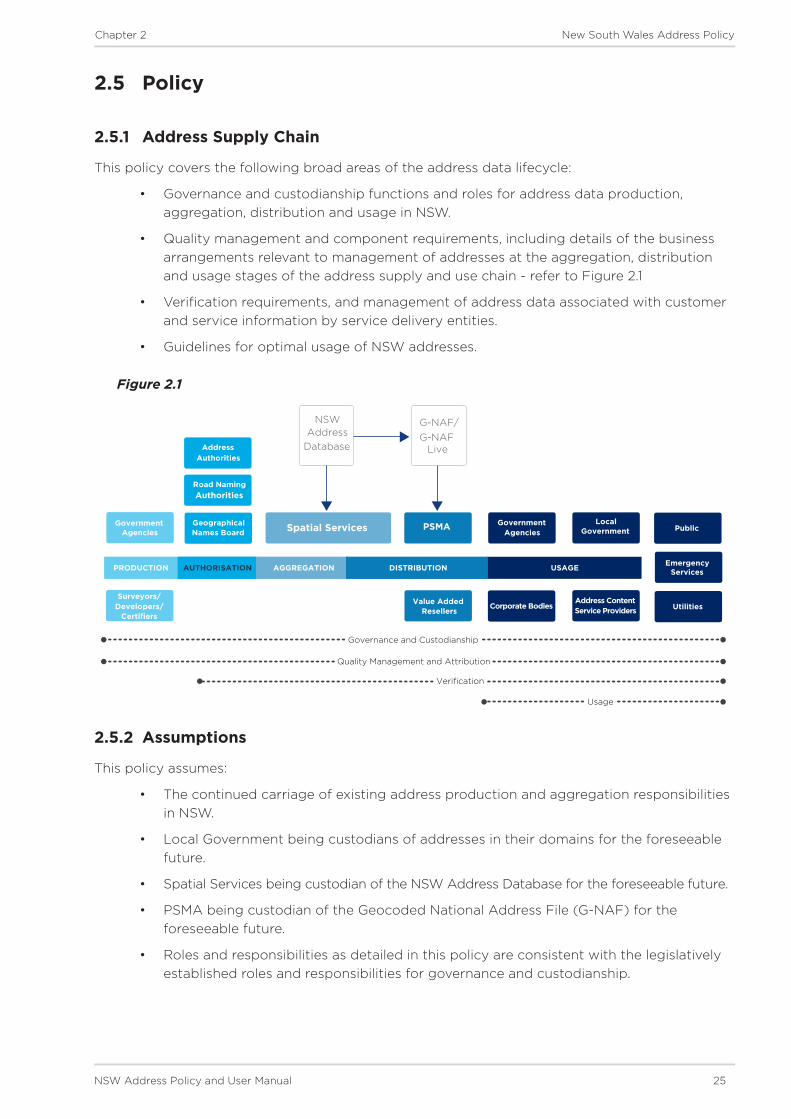
2.5.1 Address Supply Chain
This policy covers the following broad areas of the address data lifecycle:
• Governance and custodianship functions and roles for address data production, aggregation, distribution and usage in NSW.
• Quality management and component requirements, including details of the business arrangements relevant to management of addresses at the aggregation, distribution and usage stages of the address supply and use chain - refer to Figure 2.1
• Verification requirements, and management of address data associated with customer and service information by service delivery entities.
• Guidelines for optimal usage of NSW addresses.
Figure 2.1
2.5.2 Assumptions
This policy assumes:
• The continued carriage of existing address production and aggregation responsibilities in NSW.
• Local Government being custodians of addresses in their domains for the foreseeable future.
• Spatial Services being custodian of the NSW Address Database for the foreseeable future.
• PSMA being custodian of the Geocoded National Address File (G-NAF) for the foreseeable future.
• Roles and responsibilities as detailed in this policy are consistent with the legislatively established roles and responsibilities for governance and custodianship.
Government Agencies
Surveyors/ Developers/
Certifiers
Geographical Names Board
Road Naming Authorities
AddressAuthorities
Spatial Services PSMA
Value Added Resellers
Government Agencies
Local Government
Address Content Service ProvidersCorporate Bodies
Public
Utilities
Emergency Services
NSW Address
Database
G-NAF/G-NAF
Live
PRODUCTION AUTHORISATION AGGREGATION USAGEDISTRIBUTION
Governance and Custodianship
Quality Management and Attribution
Verification
Usage
Co
uncil, governm
ent autho
rity or the co
mm
unity p
rop
ose a p
ace name to
GN
B

26 NSW Address Policy and User Manual
Chapter 2 New South Wales Address Policy
2.5.3 Governance and Custodianship
Custodianship for spatial data is defined within Australia and New South Wales (particularly under the provisions of the NSW Custodianship Guidelines for Spatial Data2). For the purposes of this policy custodianship is further defined as:
• Local Governments are recognised as address custodians for all address sites within their Local Government Area.
• Spatial Services is recognised as the custodian of the NSW Address Database.
• PSMA is recognised as custodian of the Geocoded National Address File database (G-NAF).
This policy provides for ongoing governance of address data production, aggregation, and distribution and usage functions in NSW and promotes the roles of each custodianship group these are summarised below and defined in AUM Chapter 3 - Address Data Governance and Custodianship.
Data Producers
There are four types of road naming and Data Producers in NSW: Local Government; State Government agencies; those involved in the development domain i.e. planners, developers and surveyors; and the GNB.
Data Aggregators
The GNB and Spatial Services work in partnership to aggregate and administer address data. Data Aggregators are required to access data supplied from Data Producers on a regular basis and to reference the source (custodian) of address data within an aggregated system. Data Aggregators are required to supply Data Distributors with regular, consistent and verifiable address data.
Data Distributors
The main stakeholders involved in address data distribution are Spatial Services, PSMA and Value Added Resellers (VARs). Data Distributors are encouraged to access data supplied from the NSW Address Database on a regular basis and to reference the source data when supplying to Data Users. Minimum attribution, metadata statements and quality assurance metrics should be identified and made available to Data Users so that they may easily understand custodianship, quality, accuracy and currency of data.
Data Users
Data Users will be provided access to the NSW Address Database from a variety of Data Distributors. In all instances minimum attribution, metadata statements and quality assurance metrics should be identified and provided to Data Users so that they may easily understand custodianship, quality, accuracy and currency of data. Data Users are encouraged to inform the custodians of the NSW Address Database, Spatial Services, of errors or omissions in the data so that they may inform the Data Producers to resolve the issue and subsequently inform the Data Distributors.
2Currently published at https://www.spatial.nsw.gov.au/__data/assets/pdf_file/0003/219279/NSW_Custodianship_Guidelines_for_Spatial_Data.pdf

NSW Address Policy and User Manual 27
Chapter 2 New South Wales Address Policy
2.5.4 Address Database
Spatial Services will generate and maintain a NSW address database that can be used as the single source of truth for producers, aggregators, distributors and users of address data.
Given the unlimited scope of individual user requirements for address data the NSW Address Database will maintain Core Address Metadata and Core Address Components, to which users can ascribe business-case specific information within their own systems. The database will contain authoritative and non-authoritative addresses. Refer to AUM Chapter 4 - Section 4.1 - Address Grading for more details.
Spatial Services will support the ongoing improvement of the NSW Address Database with a view to standardising address data quality and maintenance regimes for the state.
For the purposes of this policy, an addressable site is defined as a location which can be accessed via the road network (including pathways and waterways defined in the ‘road types’ list provided in the AUM Chapter 6 - Section 6.10 - Road Types). An addressable site can be:
• a place of habitation, or
• a location to which services may be delivered (excluding post office boxes or cluster boxes), or
• a place where people can congregate, visit or reference for location purposes, and
• can be described as primary or alternative.
Any location which fulfils these definitions of an addressable site should be assigned an address and the data must be maintained in the NSW Address Database.
For the purposes of developing and maintaining a comprehensive NSW Address Database, an address is defined as:
• a string of data which contains minimum components as defined in AUM Chapter 4 - Section 4.5 - Core Address Components
• a tool to reference a location which describes a geographical point accessed via the road network of NSW (including pathways and waterways).
The components of the NSW Address Database, types of Core Address Strings, Metadata and Component information are defined in AUM Chapter 4 - NSW Address Database Metadata and Components.
2.5.5 Address Data Verification and Usage
Spatial Services shall provision access to Core Address Metadata and Core Address Strings from the NSW Address Database.
For the purposes of provisioning service delivery information for NSW Government agencies, Spatial Services will adopt the principles outlined in the NSW Government Standard for Spatially Enabling Information. This Standard recognises G-NAF as the national address file, directs agencies to use G-NAF IDs for address management purposes, and provides an overview of key requirements for exchange of address data.
Users of address data are encouraged to utilise and reference authoritative address data as published in the NSW Address Database maintained by Spatial Services.
Spatial Services will ensure that access to the NSW Address Database is available through multiple channels. In order to support the use and verification of authoritative address data, Spatial Services should provision a facility to verify an authoritative address, where one exists, for an address site.

28 NSW Address Policy and User Manual
Chapter 2 New South Wales Address Policy
Spatial Services shall be responsible for recording data verification transactions and utilising this information to update, improve or amend existing records in consultation with Address Producers.
Details regarding provision of verification services and requirements for Data Users are provided in AUM Chapter 5 - Address Data Verification and Usage.

Chapter 1
Introduction
Chapter 3
Address Data Governance and Custodianship

30 NSW Address Policy and User Manual
Chapter 3 Address Data Governance and Custodianship
3 Address Data Governance and Custodianship
This chapter contains the Governance and Custodianship roles and functions that support the NSW Address Policy.
Governance - outlines a set of functions for address data producers, aggregators, distributors and users.
Custodianship - defines a set of roles for address data producers, aggregators, distributors and users.
Address Data Roles
Role Stakeholders DescriptionData Producers Surveyors, Planners,
Developers
Local Government
GNB
Have various responsibilities associated with defining numbers, names and boundaries associated with core address components.
Data Aggregators GNB
Spatial Services
PSMA
Are responsible for collating information contained within, or provided from, the NSW Address Database.
Data Distributors Spatial Services
PSMA
Value Added Resellers (VARs)
The functions and roles described apply only to those who distribute data directly sourced from NSW Address Database.
Data Users Government Agencies
Commercial Entities
Members of the Public
Details the functions and roles of users who access data sourced from the NSW Address Database.
NSW Address Policy and User Manual 31
Chapter 3 Address Data Governance and Custodianship
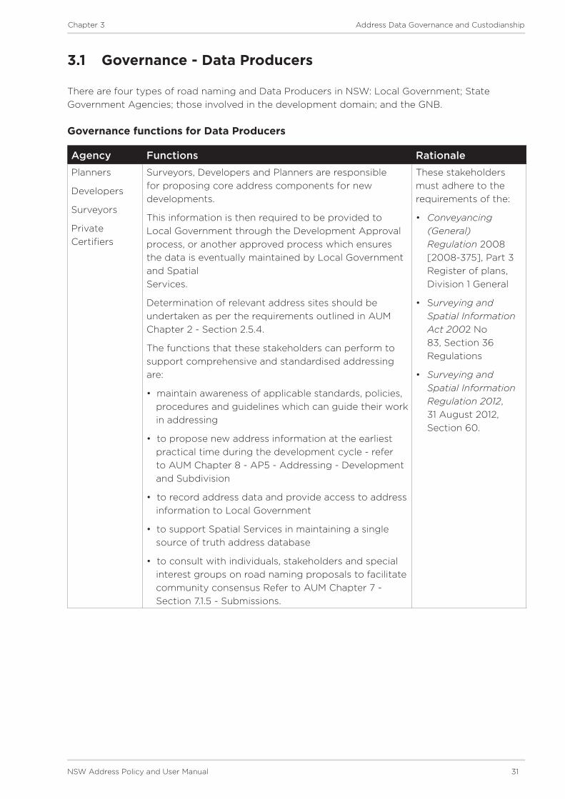
3.1 Governance - Data Producers
There are four types of road naming and Data Producers in NSW: Local Government; State Government Agencies; those involved in the development domain; and the GNB.
Governance functions for Data Producers
Agency Functions RationalePlanners
Developers
Surveyors
Private Certifiers
Surveyors, Developers and Planners are responsible for proposing core address components for new developments.
This information is then required to be provided to Local Government through the Development Approval process, or another approved process which ensures the data is eventually maintained by Local Government and Spatial Services.
Determination of relevant address sites should be undertaken as per the requirements outlined in AUM Chapter 2 - Section 2.5.4.
The functions that these stakeholders can perform to support comprehensive and standardised addressing are:
• maintain awareness of applicable standards, policies, procedures and guidelines which can guide their work in addressing
• to propose new address information at the earliest practical time during the development cycle - refer to AUM Chapter 8 - AP5 - Addressing - Development and Subdivision
• to record address data and provide access to address information to Local Government
• to support Spatial Services in maintaining a single source of truth address database
• to consult with individuals, stakeholders and special interest groups on road naming proposals to facilitate community consensus Refer to AUM Chapter 7 - Section 7.1.5 - Submissions.
These stakeholders must adhere to the requirements of the:
• Conveyancing (General) Regulation 2008 [2008-375], Part 3 Register of plans, Division 1 General
• Surveying and Spatial Information Act 2002 No 83, Section 36 Regulations
• Surveying and Spatial Information Regulation 2012, 31 August 2012, Section 60.

32 NSW Address Policy and User Manual
Chapter 3 Address Data Governance and Custodianship
Agency Functions RationaleLocal Government
Local Government are responsible for administration of core address components within their Local Government Area and the implementation of address through the installation of road and address locality signage and ensuring the appropriate display of house numbers.
Their on-ground presence and local knowledge make their administrative roles of producing road names, maintaining address records, endorsing new address components and resolving anomalies vital for establishing a quality address system for NSW.
Determination of relevant address sites should be undertaken as per the requirements outlined in AUM Chapter 2 - Section 2.5.4.
Production of addresses should be undertaken as per the policy requirements outlined in the AUM.
Functions that Local Government can perform to support comprehensive and standardised addressing are:
• maintain awareness of applicable standards, policies, procedures and guidelines which can guide their work in addressing
• to ensure names for roads are approved by the GNB and gazetted for addressing purposes
• as the authority, produce and apply addresses within their boundaries
• produce new addresses at the earliest practical time during the development cycle - refer to AUM Chapter 8 - AP5 - Addressing - Development and Subdivision
• to consult and notify authorities of proposed, amended and new address data as required by legislation and outlined in the AUM
• record address data and provide access to Spatial Services and the GNB to this information
• cooperatively work with Spatial Services to maintain a single source of truth NSW address database
• as the authority, formulate road naming and address policies for application specifically within that LGA, under the guidance of this policy
• ability to issue orders for the ‘display of a complying address and removal of a non-complying address’ on owners or occupiers of a premises whereby failure to comply is an offence and a penalty is applied – refer to AUM - Chapter 2 - Section 2.4.2 - Authority for Numbering
• consult with individuals, stakeholders and special interest groups on road naming proposals to facilitate community consensus Refer to AUM Chapter 7 - Section 7.1.5 - Submissions.
Local Government must adhere to the requirements of the:
• Local Government Act 1993
• Roads Act 1993 (No 33)

NSW Address Policy and User Manual 33
Chapter 3 Address Data Governance and Custodianship
Agency Functions RationaleState Government Agencies
State Government Agencies with oversight of residential, commercial or public land which contain addressable sites are responsible for proposing core address components within the area they govern.
This information is then required to be provided to Spatial Services, through Local Government, on a regular basis.
Production of addresses should be undertaken as outlined in the AUM.
Functions that State Government Agencies can perform to support comprehensive and standardised addressing are:
• maintain awareness of applicable standards, policies, procedures and guidelines which can guide their work in addressing
• name all roads in their area of governance that are generally open to the public or to services - refer to AUM Chapter 8 - AP6 and AP7
• to propose addresses within their area of governance including for named private roads, with reference to Local Government
• produce new addresses at the earliest practical time during the development cycle
• record address data and provide access to Local Governments, Spatial Services and the GNB to address information within their area of governance
• cooperatively work with Local Governments and Spatial Services to maintain a single source of truth address database
• as the authority, formulate road naming and street address policies for that government agency, under the guidance of this policy
• consult with individuals, stakeholders and special interest groups on road naming proposals to reach community consensus (where relevant).
Government Agencies must adhere to the requirements of the:
• Roads Act 1993 (No 33)
• State Environmental Planning Policy No 70 SEPP (Affordable Rental Housing) 2009
• Conveyancing Act 1919 No 6
• Environmental Planning and Assessment Act 1979 (No 203)
• Housing Act 2001 No 52
• Development Assessment Guidelines
• Community Land Development Regulation 2018 [2018-497]
• Conveyancing (General) Regulation 2018.
• Part 3 of the Residential (Land Lease) Communities Act 2013 No 97

34 NSW Address Policy and User Manual
Chapter 3 Address Data Governance and Custodianship
Agency Functions RationaleGeographical Names Board of NSW
The GNB is responsible under the Geographical Names Act 1966 for investigating and determining the form, spelling, meaning, pronunciation, origin and history of any geographical name and determine the application of each name with regard to position or extent. This includes the definition of address localities for addressing purposes.
Functions that the GNB can perform to support comprehensive and standardised addressing are:
• to provide support to Address Producers on address component issues and facilitate queries or dispute resolution through the NSW Address Policy Review Process (refer to AUM - chapter 2-2.2.2)
• maintain awareness of applicable standards, policies, and legislation developments within other Australian and International jurisdictions and introduce innovative practices in NSW as required
• to maintain and publish policy, principles, process, procedure and guideline documentation to inform other stakeholders in production, management and use of address data.
The GNB must adhere to and enforce the requirements of the Geographical Names Act 1966.

NSW Address Policy and User Manual 35
Chapter 3 Address Data Governance and Custodianship
3.2 Governance - Data Aggregators
There are three types of road naming and Data Aggregators in NSW: the GNB; Spatial Services and PSMA.
Governance functions for Data Aggregators
Agency Functions RationaleThe Geographical Names Board of NSW
The GNB comprises representatives from Government Agencies and peak bodies. It also includes persons with subject matter expertise. Together they form an authoritative body under the Geographical Names Act 1966.
Under this Act, the GNB is responsible for investigating and determining the form, spelling, meaning, pronunciation, origin and history of any geographical name and determining the application of each name with regard to position or extent.
The GNB supports road and address locality naming, defining address locality boundaries and setting standards for naming with the aim of eliminating ambiguity. The primary role of the GNB is to develop guidelines and regulate the creation, maintenance and distribution of address data in NSW.
The GNB is also responsible for maintenance of the Gazetteer of Place Names, and have delegated maintenance responsibilities to Spatial Services.
The GNB must adhere to and enforce the requirements of the Geographical Names Act 1966.
Spatial Services As the authority for land information, Spatial Services is responsible for the aggregation of address information it receives from Data Producers and supports the GNB in its role as custodian for the road name and address localities data. Spatial Services should:
• maintain awareness of applicable standards, policies, and legislation developments within other Australian and International jurisdictions
• apply due diligence in maintenance of the NSW Address Database in accordance with the requirements of the Addressing User Manual
• identify and refer for GNB consideration instances of addressing which do not conform to the requirements of this policy.
‘Spatial Services’ main task is to ensure the quality of address data and to increase database utility and interoperability.
Spatial Services has the infrastructure and technological expertise to administer the NSW Address Database in an efficient and effective manner.
For further information see www.spatial.nsw.gov.au

36 NSW Address Policy and User Manual
Chapter 3 Address Data Governance and Custodianship
Agency Functions RationalePSMA PSMA Australia Limited is an unlisted public
company limited by shares and owned by the state, territory and Australian governments. They offer a national asset of quality spatial information derived from authoritative data sources.
Its databases are used in both the government and private sectors, helping customers meet a diverse set of needs and ultimately deliver a wide range of benefits. Its principal objective is to facilitate broad, yet sustainable, access to data. Partnerships with the private sector are encouraged, and data distribution is facilitated through PSMA Distribution, which holds licence arrangements with value-added resellers.
As a Data Aggregator PSMA is responsible for accessing address data for NSW from the NSW Address Database maintained by Spatial Services and aggregating this into the National Address Database (referred to as the Geocoded National Address File - G-NAF). When data is aggregated PSMA should:
• include reference to the Unique Address ID
• capture the NSW assigned geocode(s)
• reference the NSW assigned quality-designation for each address string.
PSMA will collaborate with the NSW Address Database custodian to provide an exchange of information regarding quality, including missing or erroneous data.
PSMA Australia Limited is a company owned by state, territory and Australian governments, established to coordinate the collection and maintenance of fundamental national geospatial databases and to facilitate access to this data.
For further information see www.psma.com.au
The National Address Management Framework provides for the role of PSMA in the aggregation and distribution of address data at a national level in Australia.

NSW Address Policy and User Manual 37
Chapter 3 Address Data Governance and Custodianship
3.3 Governance - Data Distributors
The main stakeholders involved in address data distribution are: Spatial Services; PSMA; and Value Added Resellers.
Governance functions for Data Distributors
Agency Functions RationaleSpatial Services
Spatial Services is responsible for distributing data from the NSW Address Database, and for the maintenance of access and delivery arrangements for NSW address data.
Spatial Services is responsible for ensuring the quality and timeliness of data as per the requirements of this policy.
Spatial Services should make available guidelines which assist in effective management of address records, services and service delivery channels which effectively and efficiently provide for address verification and management practices. For details refer to AUM Chapter 2 - Section 2.5.5 - Address Data Verification and Usage and Chapter 5 - Section 5.1 - Address Data Verification.
Spatial Services maintains the NSW address database from land information regulated by Real Property, Valuation of Land and associated legislation.
Spatial Services is guided by the protocols outlined in relevant Australian and International Standards for address data management.
For further information see www.spatial.nsw.gov.au
Public Sector Mapping Agency (PSMA)
PSMA, owned by the states and territories, is responsible for aggregating NSW Address Data into the Geocoded National Address File (G-NAF).
G-NAF includes:
• location information, through the provision of a geocode that places each address at either the land parcel, the street or address locality particular to each address
• confidence level, providing an insight into whether one, two or three of the authoritative contributors have provided the address
• an extensive range of alias address information, covering information such as duplicate addresses, commonly known names and vanity addresses
• ABS Mesh Block codes for each address, simplifying analysis against ABS statistical information and similarly aligned data.
Address data contributed to G-NAF from the NSW Address Database should, where practical and required by users:
• include reference to the Unique Address ID
• identify the NSW assigned geocode(s)
• reference the NSW assigned quality-designation for each address string.
PSMA Australia Limited is a company owned by state, territory and Australian governments, established to coordinate the collection and maintenance of fundamental national geospatial databases and to facilitate access to this data.
For further information see www.psma.com.au
Under the NSW Government Standard for Spatially Enabling Information the G-NAF ID is referenced as the key identifier for exchange of address data.
The National Address Management Framework (NAMF) provides for the role of PSMA in the aggregation and distribution of address data at a national level in Australia.

38 NSW Address Policy and User Manual
Chapter 3 Address Data Governance and Custodianship
Agency Functions RationaleValue Added Resellers
Value Added Resellers are encouraged to source address data from the NSW Address Database and provide this data to users.
Methods for accessing data from Spatial Services are described in AUM Chapter 2 - Section 2.5.5 - Address Data Verification and Usage and Chapter 5 - Section 5.1 - Address Data Verification.
Address data sourced from the NSW Address Database and supplied to users should, where practical and required by users:
• include reference to the Unique Address ID
• identify the NSW assigned geocode(s)
• reference the NSW assigned quality-designation for each address string
• provide other value-add services associated with service delivery related to address, as required by NSW Government agencies to effectively and efficiently deliver services.
Value Added Resellers typically consume raw data from government agencies, then apply a set of quality assurance metrics and other metadata or attributes before on-selling the data to end-users.
This policy recommends these functions for VARs to facilitate and support the maintenance of a single-source of truth address database for NSW containing quality information which can be accessed by all Data Users.
The objective is to minimise data degradation and to provide an auditable trail for the life-cycle of an address.

NSW Address Policy and User Manual 39
Chapter 3 Address Data Governance and Custodianship
3.4 Governance - Data Users
All members of the public are beneficiaries of consistent and appropriate use of the NSW Address Database as a single-source-of-truth for address information across the state. There is a strong imperative for government agencies and corporations, who utilise address information for delivery of services, to access and reference the NSW Address Database as the authoritative source of information.
Data Users can be provided access to the NSW Address Database from a variety of Distributors. NSW Point has been developed as the NSW Government standard for access to NSW address data. In all instances minimum attribution, metadata statements and quality assurance metrics should be identified and provided to Data Users so that they may easily understand custodianship, quality, accuracy and currency of data. Data Users are encouraged to inform the custodians of the NSW Address Database, Spatial Services, of errors or omissions in the data so that they may inform the Data Producers to resolve the issue and subsequently inform the Data Distributors.
Governance functions for Data Users
Agency Functions Rationale
Government Agencies
Government Agencies should ensure they provision access to the NSW Address Database and associated Core Address Data and Core Components within their systems.
Agencies may develop in-house systems for attributing business-specific details to the data, but there is no requirement for Spatial Services to aggregate, maintain or distribute this information.
Agencies should maintain awareness of NSW Government Information Framework relevant to capture and management of address data3.
These functions for Government Agencies facilitate and support the maintenance of a single-source of truth address database for NSW containing quality information which can be accessed and exchanged with confidence by all end users.
Corporate Bodies
Corporate Bodies are encouraged to access authoritative data from the NSW Address Database through Spatial Services, PSMA or VARs.
Use of this data as a source-of-truth for address information in NSW will ensure consistency and reliability of address data usage.
These functions for Corporate Bodies facilitate and support the maintenance of a single-source of truth address database for NSW containing quality information which can be accessed and exchanged with confidence by all end users.
Public Members of the public are encouraged to utilise and reference authoritative addresses produced and endorsed by Local Government and approved by the GNB and to make use of products and services providing access to authoritative NSW Address Database.
Where a member of the public becomes aware that an address they are utilising or have made reference to, does not adequately represent, identify or locate a property, feature or point of interest, they should advise the Local Government responsible for the address in that particular area.
These functions for the public facilitate and support the maintenance of a single-source of truth address database for NSW containing quality information which can be accessed and exchanged with confidence by all end users.Regular and consistent use of authoritative data, and notification of erroneous data, will assist in improving the quality, reliability and timeliness of information in the NSW Address Database, and assist provision of services to address sites for the public.
3 https://www.digital.nsw.gov.au/sites/default/files/IM%20Framework%20infographic_0.pdf

40 NSW Address Policy and User Manual
Chapter 3 Address Data Governance and Custodianship
3.5 Custodianship - Data Producers
Data Producers, identified as Local Government, State Government Agencies, Surveyors, Developers, Planners and the GNB are encouraged to adopt the following roles in fulfillment of their obligations as custodians of Core Address Metadata and Core Address Component data - refer to AUM Chapter 4.
Custodianship roles for Data Producers
Custodians Roles RationaleLocal Government
State Government Agencies
Surveyors
Developers
Planners
Private Certifiers
Geographical Names Board of NSW
1. All addresses established in NSW must be defined with the minimum Core Address Components - refer to AUM Chapter 4 - Section 4.5 - Core Address Components.
2. Custodians can associate non-Core Address Data with data within their own systems.
3. Custodians must record all the addresses for which they are custodian, and wherever feasible provide effective maintenance arrangements.
4. New, revised or deprecated Core Address Data must be advised to Spatial Services as per established Data Supply Contracts and/or timeframes required in the AUM Chapter 8.
5. Core Address Data components must conform to the requirements of the NSW Address Policy and User Manual (AUM).
6. All addresses proposed in NSW by Developers, Planners or Surveyors must be provided to Local Government within the timeframes outlined in AUM Chapter 8 - AP5 - Development and Subdivision.
7. All addresses produced in NSW by private entities, including corporate bodies, must be provided to Local Government as outlined in AUM Chapter 8.
8. All addresses proposed in NSW by State Government Agencies must provide to Local Government within the timefranes as outlined in AUM Chapter 8.
9. Where revisions are required for existing Core Address Components, Unique Address IDs should be referenced by Local Government in data exchanges with Spatial Services to ensure consistency of data maintenance.
10. Data Producers are strongly encouraged to utilise address data from the NSW Address Database within their systems.
Addresses must be properly and unambiguously produced to allow for accurate and reliable site identification to support timely and efficient emergency service and other service delivery.
Consistency of data is required and minimum components must be provided to ensure quality and accuracy of address data.
Derivation and production of address data components is governed by the NSW Address Policy and User Manual to ensure consistency of application.

NSW Address Policy and User Manual 41
Chapter 3 Address Data Governance and Custodianship
3.6 Custodianship - Data Aggregators
Maintenance of the NSW Address Database is performed by Spatial Services; however the GNB and PSMA also play a role in custodianship of NSW Address Data.
Custodianship roles for Data Aggregators
Custodians Roles RationaleGeographical Names Board of NSW
Spatial Services
PSMA
1. Core Address Components must be quality assured and attributed - refer to AUM Chapter 4 - Section 4.5 - Core Address Components for management in the NSW Address Database.
2. Core Address Components must be maintained with a standardised geocode. Where a geocode supplied by a Data Producer does not conform to policy requirements, Spatial Services will assign a suitable default geocode for maintenance purposes in the NSW Address Database - refer to AUM Chapter 4 - Section 4.5 - Core Address Components.
3. Core Address Data must be maintained as per requirements of Australian and International Data Maintenance Standards.4
4. Core Address Components must be assigned and maintained with Unique Address IDs - refer to AUM Chapter 4 - Section 4.5 - Core Address Components.
5. Custodians can maintain non-Core Address Data where a case is established for this requirement by other Address Data Custodians.
Quality Assurance and attribution, and provision of access to quality and attribution information relevant to individual address records, for aggregators and users, is necessary to allow determination by address aggregators and users of the fitness for purpose of an address or set of addresses for a specific purpose.
Provision of accurate geocode information is required to support site identification and service delivery. Geocode allocation is most effectively performed and maintained where assigned to an aggregating authority, in the case of NSW, Spatial Services is identified as such an authority.
Geocode data should also be appropriately attributed so that end-users can determine and understand with confidence the type of geocode/s provided for each address.
4AS/NZS 4819: Rural and Urban Addressing, AS4590: Interchange of Client Information.

42 NSW Address Policy and User Manual
Chapter 3 Address Data Governance and Custodianship
3.7 Custodianship - Data Distributors
Core Address Data held in the NSW Address Database must be distributed for the benefit of all end-users. Access to the data must be facilitated either through:
• Direct access through the NSW Address Database Custodian, Spatial Services.
• Provisioned access through PSMA.
• Value-Added access through VARs.
Responsibility for distribution of the data are assigned to Spatial Services, PSMA and VARs, as per requirements defined below.
Custodianship roles for Data Distributors
Custodians Roles RationaleSpatial Services
PSMA
VARs
1. Where data is distributed from the NSW Address Database it should be identified as such.
2. It is recommended that provision be made in data distribution systems for the collection of feedback related to Core Address Data including mechanisms for data error, anomalies or issues.
This information should be provided back to the custodian of the NSW Address Database, Spatial Services, so that they may inform Data Producers to resolve the issue and subsequently inform the Data Distributors.
3. Core Address Data for NSW should be distributed and attributed with supporting information as maintained by the NSW Address Database to enable aggregator and user determination of fitness for purpose.
4. Recognised Australian Standards related to the exchange of data and the National Address Management Framework (NAMF) have been developed with wide industry participation and are targeted specifically at Australian addresses and should be adopted as the underlying rules for data sharing.
5. Distributors should utilise Unique Address IDs within their systems to facilitate standardised practice for maintaining address data consistency for end-users.
The NSW Address Database is the single source of truth for address data in NSW. Any data that does not match the requirements of the Address Policy and User Manual should be identified for resolution.
Feedback from users of the address data is vital to assisting in quality management of data held in the NSW Address Database.
Users require information about the metadata to ensure address data can be assessed for fitness of purpose.

NSW Address Policy and User Manual 43
Chapter 3 Address Data Governance and Custodianship
3.8 Custodianship - Data Users
Maintenance of the NSW Address Database is performed by Spatial Services, however the users also play a role in custodianship of the data.
Custodianship roles for Data Users
Custodians Roles RationaleGovernment Agencies
Corporate Bodies
Public
1. NSW Government agencies can access NSW Point Address Verification Web Services (AVWS) for this purpose. For more information on NSW Point please contact Spatial Services.
2. Users are encouraged to utilise Unique Address IDs within their systems to facilitate standardised practice for reporting errors, omissions, redundancies and issues with data maintained in the NSW Address Database.
3. Government Agencies should refer to the NSW Government Standard for Spatially Enabling Information for guidance on exchange mechanisms and address data management within their systems.
Maintenance of address data accuracy is an integral component of maintaining data quality within organisations. The AVWS will provide a link between address users and the NSW Address Database to ensure address data can be efficiently maintained by the user.
Unique Address IDs are the link between user systems and the NSW Address Database to ensure data integrity.

44 NSW Address Policy and User Manual
Chapter 3 Address Data Governance and Custodianship
This page is intentionally blank

Chapter 1
Introduction
Chapter 4
NSW Address Database, Metadata and Components

46 NSW Address Policy and User Manual
Chapter 4 NSW Address Data, Metadata and Components
4 NSW Address Data, Metadata and Components
This chapter contains:
Address Grading Outlines a set of address grades which should be included in the NSW Address Database.
NSW Address Database Components Defines the roles and components of the Gazetteer of Road Names and the Gazetteer of Place Names, particularly with reference to the types and status of roads, road types and address locality data contained therein.
NSW Address Database Metadata A description of the metadata which will be supplied with every transaction on the NSW Address Database.
Core Address String Metadata A description of the metadata which will be supplied with every address string held in the NSW Address Database.
Core Address Components A description of the components of each address string held within the NSW Address Database, this includes reference to additional attributes and geocode types.
Additional Address Components Outlines potential address components that may need to be considered.
Geocode Types A list of geocode types that have been derived from the AS/NZS 4819:2011

NSW Address Policy and User Manual 47
Chapter 4 NSW Address Data, Metadata and Components
4.1 Address Grading
The terms defined in the table which starts on the following page are used to define grades of authoritativeness for Core Address Strings.
For examples of primary and alternative address sites refer to Figure 4.1.
Figure 4.1
i 19 Policy Road (Primary)
ii 12 Claire Lane (Alternative)
iii 17A Policy Road (Primary)
iv 17B Policy Road (Primary) 10B Claite Lane (Alternative)
v 10A Claire Lane (Primary)
vi 2/15 Policy Road (Primary)
vii 1/15 Policy Road (Primary)
viii 8 Claire Lane (Alternative)
ix 13 Policy Road (Alternative)
x 52 Standards Road (Primary)
xi 6 Claire Lane (Alternative)
Mansion with two access pointsa) Front doorb) Garage
Subdivided property with main houses accessed from Policy Road and Granny Flat access from Claire Lane.
Car park access from Claire Lane.O�ce buildings accessed from Policy Road.
O�ce building with three access points.
19 17B 17A 15 13
12 10B 10A 8 6
52
a) i
b) ii
iv
iii
v
vi vii
vii
ix
xi
x
Policy Road
Claire Lane
Standard
s Ro
ad

48 NSW Address Policy and User Manual
Chapter 4 NSW Address Data, Metadata and Components
NSW Address Database Address Grades
Grades Definition DescriptionAuthoritative Primary Address
The Address String comprises components wherein:
• All attributes are present - refer to AUM Chapter 4 - Section 4.5 - Core Address Components.
• Number conforms to Principles at time of assignment - refer AUM Chapter 6.
• Road Name is Gazetted or was assigned prior to the commencement of the Roads Act 1993 and meets the requirements of AUM Chapter 6 - Section 6.7 - Principles of Road Naming.
• Address Locality Name is Gazetted.
• Geocode(s) falls within appropriate accuracy levels as per Metadata requirement outlined in AUM Chapter 4 - Section 4.4 - Core Address String Metadata.
The address is assigned to the primary point of access to the site - see AUM - Chapter 6 - Principle 6.1.1.
These types of addresses can be considered ‘official’ or ‘gazetted’ and can be assessed by users to be the best defined location reference for gaining access to a site from the NSW road network - refer AUM Chapter 2 - Section 2.5.4 - Address Database.
Authoritative Alternative Address
The Address String comprises components wherein:
• All attributes are present and fulfil the Metadata requirement for ‘completeness’ - refer to AUM Chapter 4 - Section 4.4 - Core Address String Metadata.
• Number conforms to Principles - refer AUM Chapter 6.
• Road Name is Gazetted or was assigned prior to the commencement of the Roads Act 1993 and meets the requirements of AUM Chapter 6 - Section 6.7 - Principles of Road Naming..
• Address Locality Name is Gazetted.
• Geocode(s) falls within appropriate accuracy levels as per Metadata requirement outlined in AUM Chapter 4 - Section 4.4 - Core Address String Metadata.
The address is assigned to an alternative point of access to the site - see Addressing User Manual - Chapter 6 - Principle 6.1.1.
These types of addresses can be considered ‘official’ or ‘gazetted’ alternatives to the primary addresses and can be assessed by users to be the best defined location reference for gaining secondary access to a site (i.e. the side entrance to a building or the location of a secondary gate to a school). Refer AUM Chapter 2 - Section 2.5.4 - Address Database.
In G-NAF these addresses are defined as ‘Secondary’.

NSW Address Policy and User Manual 49
Chapter 4 NSW Address Data, Metadata and Components
Grades Definition DescriptionNon-Authoritative Primary Address
In the Address String one of the following is present:
• One component might be missing and therefore the address does not fulfil the Metadata requirement for ‘completeness’ - refer to AUM Chapter 4 - Section 4.4 - Core Address String Metadata.
• Number does not conform to Principles (refer AUM Chapter 6).
• Road Name was assigned subsequent to the commencement of the Roads Act 1993 and has not been Gazetted.
• Address Locality Name has not been Gazetted.
• Geocode(s) does not fall within appropriate accuracy levels as per Metadata requirement outlined in Address Policy Appendix B - Core Address String Metadata.
The address is assigned to the primary point of access to the site - see AUM - Chapter 6 - Principle 6.1.1.
These types of addresses can be considered ‘unofficial’ or ‘ungazetted’ and can be assessed by users to be an approximated location reference for gaining access to a site from the NSW road network.
These addresses are usually good descriptions of a location but they lack the authoritativeness of a gazetted road name or address locality name to define them as endorsed by their Local Government and/or approved by the GNB.
Non-Authoritative Alternative Address
Where one or more of the following is present:
• One component might be missing and therefore the address does not fulfil the Metadata requirement for ‘completeness’ - refer to AUM Chapter 4 - Section 4.4 - Core Address String Metadata.
• Number does not conform to Principles - refer to AUM Chapter 6.
• Road Name was assigned subsequent to the commencement of the Roads Act 1993 and has not been Gazetted.
• Address Locality Name has not been Gazetted.
• Geocode(s) does not fall within appropriate accuracy levels (as per Metadata requirement outlined in AUM Chapter 4 - Section 4.4 - Core Address String Metadata).
The address is assigned to the alternative point of access to the site - see AUM - Chapter 6 - Principle 6.1.1.
These types of addresses can be considered ‘unofficial’ or ‘ungazetted’ and can be assessed by users to be an approximated location reference for gaining secondary access to a site from the NSW road network.
These addresses are usually good descriptions of secondary access to a location but they lack the authoritativeness of a gazetted road name or address locality name to define them as endorsed by the Local Government and/or approved by the GNB or Spatial Services.

50 NSW Address Policy and User Manual
Chapter 4 NSW Address Data, Metadata and Components
4.2 NSW Address Database Components
The essential components of the NSW Address Database are the Gazetteer of Road Names and the Gazetteer of Place Names. Gazetteers are collections of names or identifiers which are compiled, maintained and published under the jurisdiction of a government authority. In NSW the authority for place naming is the GNB, as provided for under the Geographical Names Act 1966.
There are two gazetteers in use in NSW relating to addresses:
1. Gazetteer of Road Names (provided for as a list of road names under s.5(2) of the Act)
2. Gazetteer of Place Names (provided for under s.5(1)(i) of the Act).
Each of these gazetteers is described below.
4.2.1 Gazetteer of Road Names
Under s.5(2) of the Geographical Names Act the GNB may ‘compile, maintain and publish a list of roads’. The GNB refer to this list as the ‘Gazetteer of Road Names’.
The Gazetteer of Road Names is accessed via the NSW Online Road Naming System.
Road Name Status
The list of road names accessed via the NSW Online Road Naming System can have one of the following status types: gazetted, endorsed or name in use.
Road status value Description Gazetted Road names published in the NSW
Government Gazette under the Roads Act 1993.
This can include:• roads that have been proposed through the
NSW Online Road Naming System, evaluated and found to have met road naming guidelines by GNB; and
• road names gazetted outside of the NSW Online Road Naming System
Endorsed Names for roads which have not been opened, declared or dedicated as a public road but have been proposed through the NSW Online Road Naming System, evaluated and found to have met road naming guidelines by GNB.
This includes formed roads, such as private roads, that are generally open to the public or services.
Name in Use These are long established road names that have been in-use for a long time and were named prior to the Road Act 1993.

NSW Address Policy and User Manual 51
Chapter 4 NSW Address Data, Metadata and Components
4.2.2 Road Types
Road types to be used in NSW are limited to those listed in AUM Chapter 6 - Section 6.10 - Road Types.
Various statuses can be applied to road types, as described in the table below.
Road Types with Grade Status and Descriptions
Grade Status Sub-Grade DescriptionAuthoritative Conforming Road Type conforms with requirements of AS/NZS4819
and GNB Addressing Policy
Legacy Non-Conforming road type which has been in use for many years and is deemed acceptable for inclusion in the Gazetteer of Road Names. Addresses containing a legacy road type can be considered authoritative.
Non- Authoritative
Non-Conforming As all new road names must use approved road types, non-conforming types are deemed unacceptable for use. Addresses containing an unofficial road type will not be graded as authoritative.
4.2.3 Gazetteer of Place Names
The NSW Gazetteer of Place Names is provided for under Section 5(1) of the Geographical Names Act and is the official register of place names for the State. Under s.2 or the Act:
‘Place’ means any geographical or topographical feature or any area, district, division, locality, region, city, town, village, settlement or railway station or any other place within the territories and waters of the State of New South Wales but does not include any road, any area (within the meaning of the Local Government Act 1993) or area of operations of a county council (within the meaning of that Act), any electoral district under the Parliamentary Electorates and Elections Act 1912, any school or any place or place within a class of places to which the provisions of this Act do not apply by virtue of the regulations.’
The Gazetter of Place Names is accessed via the Geographical Names Register on the Geographical Names Board of NSW website.
4.2.4 Address Localities
A address locality is a named geographical area with defined boundaries which represents a community or area of interest, and may be rural or urban in character (where urban it is usually defined as a ‘suburb’). Address Localities enable addresses to be uniquely identified. Without clearly defined address localities there can be uncertainty in an address. In order to achieve comprehensive addressing objectives it is vital that address locality names and boundaries are clear and unambiguous.
Address Localities are distinguishable from neighbourhoods which are considered to be named geographical areas which have unofficial or fuzzy boundaries: for this reason a neighbourhood name cannot be used for addressing purposes (e.g. Kings Cross is a neighbourhood, it forms part of the Potts Point, Darlinghurst, Rushcutters Bay and Elizabeth Bay address localities in Sydney). Similarly, estate names are considered to be branding for particular development areas or gated communities, and as such are not address locality names and cannot be used for addressing purposes.

52 NSW Address Policy and User Manual
Chapter 4 NSW Address Data, Metadata and Components
4.3 NSW Address Database Metadata
As per ISO 19113- Geographic Information, to consistently manage the NSW Address Database, ensure the quality of the data contained therein and to facilitate end user determination of fitness-for-purpose, a minimum set of metadata attributes should be provided, where known, with each extract of Address Data distributed to End-Users.
Metadata to define the NSW Address Database
Attribute Description RationalePurpose This field should be completed
by the NSW Address Database custodian, Spatial Services, and detail the governance and custodianship arrangements for the database.
ISO 19157 Requirement - This is the rationale for the creation of the database and contains information about its intended use.
Usage This field should be completed by the NSW Address Database custodian, Spatial Services, and define its intended application for Data Users.
Limitations of the data quality should be outlined with reference to any legislation which limits the NSW Address Database custodian responsibility for use of the data and restricts data string quality attribution - refer to AUM Chapter 4 - Section 4.4 - Core Address String Metadata, to the specific time in which the data was extracted.
ISO 19113 Requirement - This should describe the application(s) for which database can be used.
This attribute describes uses of the database by the Data Producer or by other, distinct, data users.
Completeness This field should be completed by the NSW Address Database custodian, Spatial Services, and indicate the known representative completeness of the database. Reference should be made to whether all address types are included, or whether specific types (i.e. mail-only or water-based) have been omitted.
This will assist users in identifying the types of addresses available in the database.

NSW Address Policy and User Manual 53
Chapter 4 NSW Address Data, Metadata and Components
4.4 Core Address String Metadata
Quality management attribute information which may be associated with each Core Address Data string should include, where known, the following metadata in the NSW Address Database.
NSW Address String Metadata
Attribute Description RationaleLineage This field should include reference to
the Data Producer custodian who was responsible for providing the Core Address Data contained within that string.
ISO 19157:2013 requirement states:
Lineage may contain two unique components:
• source information shall provide the parentage of the database
• process step or history information shall describe a record of events or transformations in the life of a database, including the process used to maintain the database whether continuous or periodic, and the lead time.’
Completeness This should identify if Core Address Data is missing or non-Core Data is present.
Conversely it should identify if the string is complete by having all components available - refer to AUM Chapter 4 - Section 4.5 - Core Address Components.
ISO 19113 requirement states:
• ‘Commission: excess data present in a database
• Omission: data absent from a database’.
Compliance This should indicate whether the road name and address locality name correlate with official, gazetted names in the Road Name or Place Name Gazetteers.
Quality Management requirements to determine if the components are officially designated and recognised:
• Where the names correlate (i.e. they are the same spelling and refer to the same geospatial location) they are defined as ‘authoritative’.
• Where the names do not correlate, or they do not refer to the same geospatial location, they are defined as ‘non-authoritative’.
• Where the names are identified as a type of alias, they are defined as ‘alias’.
These definitions correlate to those applied to the whole address. Refer to AUM Chapter 4 - Section 4.1 - Address Grades for description.

54 NSW Address Policy and User Manual
Chapter 4 NSW Address Data, Metadata and Components
Attribute Description RationalePositional Accuracy
This should identify the accuracy of the geocoded point assigned by the NSW Address Database custodian, Spatial Services.
The accuracy should be defined as per the levels defined in G-NAF, as shown in the table below.
In addition to the definitions provided by PSMA, ISO19113 defines three types of accuracy which can also be applied:
1. Absolute or external accuracy: closeness of reported coordinate values to values accepted as or being true.
2. Relative or internal accuracy: closeness of the relative positions of features in a database to their respective relative positions accepted as or being true.
3. Gridded data position accuracy: closeness of gridded data position values to values accepted as or being true.
Reliability Level Description Example
1
Geocode resolution recorded to appropriate surveying standard.
Address level geocode was manually geocoded with a GPS.
2
Geocode resolution sufficient to place centroid within address site boundary.
Address level geocode was automatically calculated by centroiding the cadastre property it correlated to.
3
Geocode resolution sufficient to place centroid near (or possibly within) address site boundary.
Address level geocode was automatically calculated by calculating where on the road the address was likely to appear based upon other bounding geocoded addresses.
4
Geocode resolution sufficient to associate address site with a unique road feature.
Street level geocode automatically calculated by using the road centreline reference data.
5
Geocode resolution sufficient to associate address site with a unique address locality or neighbourhood.
Address locality level geocode automatically calculated by centroiding the gazetted address locality for this address.
6
Geocode resolution sufficient to associate address site with a unique region.
Address locality level geocode derived from topographic feature.
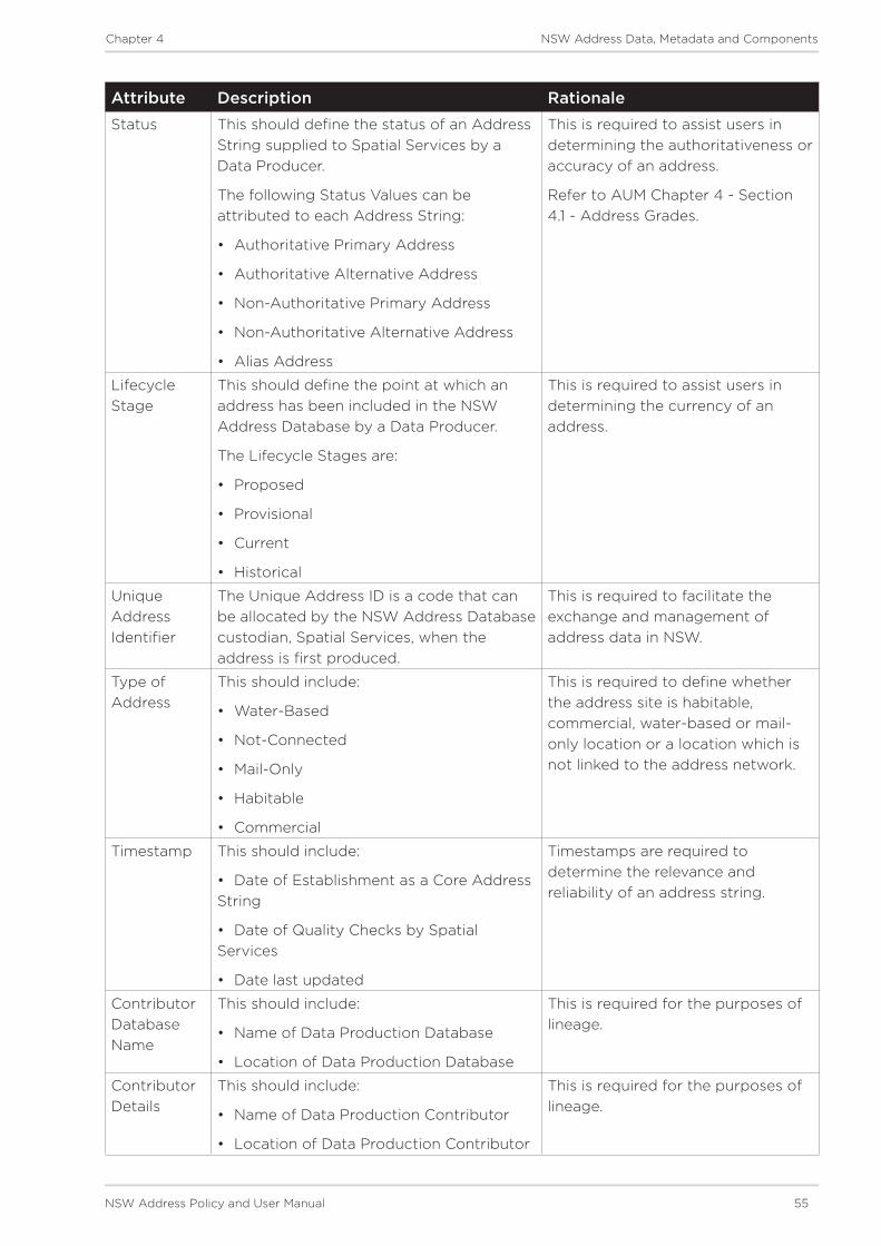
NSW Address Policy and User Manual 55
Chapter 4 NSW Address Data, Metadata and Components
Attribute Description RationaleStatus This should define the status of an Address
String supplied to Spatial Services by a Data Producer.
The following Status Values can be attributed to each Address String:
• Authoritative Primary Address
• Authoritative Alternative Address
• Non-Authoritative Primary Address
• Non-Authoritative Alternative Address
• Alias Address
This is required to assist users in determining the authoritativeness or accuracy of an address.
Refer to AUM Chapter 4 - Section 4.1 - Address Grades.
Lifecycle Stage
This should define the point at which an address has been included in the NSW Address Database by a Data Producer.
The Lifecycle Stages are:
• Proposed
• Provisional
• Current
• Historical
This is required to assist users in determining the currency of an address.
Unique Address Identifier
The Unique Address ID is a code that can be allocated by the NSW Address Database custodian, Spatial Services, when the address is first produced.
This is required to facilitate the exchange and management of address data in NSW.
Type of Address
This should include:
• Water-Based
• Not-Connected
• Mail-Only
• Habitable
• Commercial
This is required to define whether the address site is habitable, commercial, water-based or mail-only location or a location which is not linked to the address network.
Timestamp This should include:
• Date of Establishment as a Core Address String
• Date of Quality Checks by Spatial Services
• Date last updated
Timestamps are required to determine the relevance and reliability of an address string.
Contributor Database Name
This should include:
• Name of Data Production Database
• Location of Data Production Database
This is required for the purposes of lineage.
Contributor Details
This should include:
• Name of Data Production Contributor
• Location of Data Production Contributor
This is required for the purposes of lineage.

56 NSW Address Policy and User Manual
Chapter 4 NSW Address Data, Metadata and Components
4.5 Core Address Components
These are the minimum components which Spatial Services as custodian of the NSW Address Database will maintain for each address.
Component DescriptionAddress Number This is the identifying characteristic which delineates the address
from those on the same road and within the same address locality.
This can include sub address numbering elements.
Road Name and Road Type
Road Names and Types are defined in AUM Chapter 2 - Section 2.4.3 and Chapter 6 - Section 6.7 Authority for Road Naming.
Road Name and Type information is derived from Gazetteer of Road Names.
Address Locality Name Address Locality Names and Boundaries are defined in AUM Chapter 2 - Section 2.4.4 and Chapter 6 - Section 6.8
Authority for Address Locality Names and Boundaries.
Address Locality Name and Boundary information is derived from the Gazetteer of Place Names.
State Name This identifies the Australian State in which the address is located.
Field attributed within the NSW Address Database.
Geocode Each Authoritative Address must contain a geocode.
The geocode must be described in the NSW Address Database with a minimum of one of the Officially Preferred types provided in AUM Chapter 4 - Section 4.7 - Geocode Types.
Where Core Address Data is provided by a Data Producer to Spatial Services without an Officially Preferred type of geocode, one shall be assigned by Spatial Services.
Multiple geocodes can be ascribed for each address.
One default geocode will be assigned by Spatial Services to all authoritative address instances held in the NSW Address Database and this geocode should be the Site Centroid.
NSW Address Policy and User Manual 57
Chapter 4 NSW Address Data, Metadata and Components
4.6 Additional Address Components
Where applicable and available the following information shall be stored by the NSW Address Database custodian, Spatial Services, and can be provided to users where appropriate:
• Change-Log History (including address status changes).
• Alias road name, address locality name and road type.
• For sub addressing purposes a building or site name can be considered part of the address.

58 NSW Address Policy and User Manual
Chapter 4 NSW Address Data, Metadata and Components
4.7 Geocode Types
Geocode types have been derived from AS/NZS 4819, and are described in following table.
The default geocode type to be assigned in all instances of address strings maintained in the NSW Address Database is the Site Centroid.
Geocode feature type DescriptionBuilding access point Point of access to the building.
Building centroid Point as centre of building and lying within its bounds (e.g. for U-shaped building).
Centre-line dropped frontage
A point on the road centre-line opposite the centre of the road frontage of an address site.
Driveway frontage Centre of driveway on address site frontage.
Emergency access Specific building or property access point for emergency services.
Emergency access secondary
Specific building or property secondary access point for emergency services.
Front door access Front door of building.
Frontage centre Point on the centre of the address site frontage
Frontage centre setback A point set back from the centre of the road frontage within an address site.
Letterbox Place where mail is deposited.
Property access point Access point (centre of) at the road frontage of the property.
Property access point setback
A point set back from the (centre of the) access point at the road frontage of the property.
Property centroid Point of centre of parcels making up a property and lying within its boundaries (e.g. for L-shaped property).
[service type] connection point
The utility connection point (e.g. box or underground chamber). ‘Service type’ to be specified (e.g. water, electricity, gas, telephone).
[service type] meter The utility meter (e.g. box or underground chamber). ‘Service type’ to be specified (e.g. water, electricity, gas, telephone).
Unit centroid Point at centre of unit and lying within its bounds (e.g. for U-shaped unit).
Site centroid* Point of centre of site and lying within its boundaries (e.g. for L-shaped site)
For a property-based address site the geocode will be the Property Centroid (as described above). For a non-property-based address site the geocode will be centre of the feature.
* Not catered for in AS/NZS 4819 - developed exclusively for the purposes of the NSW Address Policy

Chapter 1
Introduction
Chapter 5
Address Data Verification and Usage

60 NSW Address Policy and User Manual
Chapter 5 Address Data Verification and Usage
5 Address Data Verification and Usage
This chapter contains the Address Data Verification requirements and Address Data Usage functions that support the NSW Address Policy.
Verification - outlines details of data verification service delivery provisions for NSW Address
Usage - defines a set of roles and responsibilities for Data Users and provides for a confirmation of address service.
5.1 Address Data Verification
This section defines requirements for Spatial Services, as custodian of the NSW Address Database, to provide mechanisms which enable users to verify address data.
Policy SpecificsProvision of data from the NSW Address Database will be facilitated in multiple formats which will allow users to access the information as per agency-specific business rules
Various service delivery mechanisms will be maintained by Spatial Services for provisioning access to the NSW Address Database. These include:
1. Web services.
2. Batch validation services.
3. Instance based, manual online queries.
4. Offline media delivery services.
5. NSW Point
Address Verification Web Services (AVWS) will be provisioned by Spatial Services to supply Whole of Government access to the NSW Address Database. The supply of these services is being carried out using NSW Point.
1. Ability for approved users to identify the authoritative primary or alternative address via a search and validation service should be provisioned to support queries pertaining to alias address functionality and spatial checks to resolve alias usage, along with other functionality as required.
2. Data interaction and exchange services should be provisioned to allow for:
• custodian editable business rules to support predictive text, corrective actions, alternate suggestions and/or error messages
• pre-approved, reserved and provisional address data supply functionality to support real-time transactions for early-captured address data
• approved users to access validation services for the purposes of address management, including address database maintenance, updating, anomaly resolution, imports, integrity reporting and database scrubbing to identify candidate alias naming.
Access to address data should include provision of a mechanism which can record errors or omissions detected by users
The NSW Address Database custodian, Spatial Services, should consider mechanisms to:
• find efficient opportunity to monitor use of non-authoritative address data
• inform maintenance of effective capacity for address searching and matching, and
• inform advice to address custodians of areas of address or location uncertainty.

NSW Address Policy and User Manual 61
Chapter 5 Address Data Verification and Usage
5.2 Address Data Usage
This section describes requirements for usage of address data in NSW. The purpose is to outline responsibilities and requirements for address data usage and reporting of issues.
5.2.1 Usage of Address Data
Users of address data are encouraged to utilise and reference authoritative address data produced, endorsed by Local Government and approved by the GNB, as contained in the NSW Address Database maintained by Spatial Services.
Where a user becomes aware that an address does not adequately represent, identify or locate a site they should advise Spatial Services and/or the relevant Local Government.
A mechanism should be provided to allow communication channels throughout the address supply chain, and also between Data Users and Data Aggregators. This will facilitate the reporting of any errors or omissions in the data. In instances where advice contradicts authoritative information in either the Gazetteer of Road Names or the Gazetteer of Place Names and corrective action is not required, the reported issue could be used to derive alias address information.
5.2.2 Confirmation of Address
In order to facilitate the use and verification of authoritative address data, a service should be provided by Spatial Services to enable Data Producers, Data Aggregators, Data Distributors and Data Users to confirm an address(es) for a site.
This service will facilitate the requirement to exchange address information for the purposes of business transactions.
This supports the NSW Address Policy objective of increasing the use of authoritative address information.
Data to be provided through an address confirmation service may include:
• Name of Property or Point of Interest - Site Description (either a title number or textual description).
• Textual Address String for each Address
• Map of spatial address.
• Spatial Coordinates - longitude and latitude - for Address String geocode.

62 NSW Address Policy and User Manual
Chapter 5 Address Data Verification and Usage
This page is intentionally blank

Chapter 1
Introduction
Chapter 6
Addressing Principles

64 NSW Address Policy and User Manual
Chapter 6 Addressing Principles
6 Addressing Principles
This chapter contains a set of principles which shall apply to all instances of address numbering, road naming and locality definition in NSW.
The contents include:
6.1 - General Principles of Addressing
6.2 - General Principles of Numbering
6.3 - Principles for Urban Numbering
6.4 - Principles for Rural Numbering
6.5 - Principles for Sub-Address Numbering
6.6 - Principles for Water-Based Numbering
6.7 - Principles of Road Naming
6.8 - Principles of Locality Naming and Boundaries
6.9 - Principles of Geocoding
6.10 - Road Types List

NSW Address Policy and User Manual 65
Chapter 6 Addressing Principles
6.1 General Principles of Addressing
DescriptionThe following general principles apply for all addressing in both urban and rural environments (see also Figure 6.1). Description of an address site is available in AUM Chapter 2 - Section 2.5.4 - NSW Address Database.
Figure 6.1 - Site Based Addressing
Principles
6.1.1 Determination of Address Number
The main access, or where access is most likely to occur for a visitor, from a road to an address site (e.g. front door) determines the primary address. Sometimes there might be separate vehicular and pedestrian access to a site. The primary address should be allocated to the pedestrian access point; the alternative address should be allocated to the vehicular access point. Where pedestrian access is provided via a pathway, not a named road, the pathway shall be named in accordance with Principle 6.7.3 - Roads to be Named.
Mansion with two access pointsa) Front doorb) Garage
Subdivided property with main houses accessed from Policy Road and Granny Flat access from Claire Lane.
Car park access from Claire Lane.O�ce buildings accessed from Policy Road.
O�ce building with three access points.
19 17B 17A 15 13
12 10B 10A 8 6
52
a) i
b) ii
iv
iii
v
vi vii
vii
ix
xi
x
Policy Road
Claire Lane
Standard
s Ro
ad

66 NSW Address Policy and User Manual
Chapter 6 Addressing Principles
Figure 6.2 - Numbers based on access
See example in Figure 6.2 - Numbers based on access which details how access points should be chosen for corner sites. Also refer to Principle 6.2.4 - Renumbering due to Redevelopment for details on determining an address for sites under development or Principle 6.1.4 - Alternative Addresses for details of alternative address allocation.
The access point to a property should reflect the locality of that property. If this is unable to be determined then an amendment should be made to the locality boundary.
6.1.2 Building identifier and/or site name
A building identifier and/or site name may be used as part of an address, but should always be used in conjunction with the address number and never as an alternative to an address number.
Names of a sensitive nature (eg: Women’s Refuge) must not be included for privacy reasons.
Jack
son
Ave
nue
Billroy Road
7 9
27
25
8 10 12
21
30
28
26
24
22

NSW Address Policy and User Manual 67
Chapter 6 Addressing Principles
6.1.3 One Road Name
Each address shall have only one road name. Where there are private roads within a complex site, the names of those roads shall be used for addressing purposes. See example in Figure 6.3 for details of a private road with multiple address sites.
Figure 6.3 - One road name for all addresses
6.1.4 Sub-addressing
Sub-address numbering shall be used for address sites that are contained within a primary address site e.g. an apartment building, block of flats or marina.
Generally, sub addresses are defined because there is one main access point from the road to the property from which many locations can then be accessed.
Specific principles which apply to sub-addressing can be found in Section 6.5 - Principles for Sub-Address Numbering and an example is shown in Figure 6.4.
Figure 6.4 Sub-address numbering
Eg: 17 Sunrise Vista, Sydney not 17 Sunrise Vista 784 Pacific Highway, Sydney
9
15
17
1
3
5
7
8
6
4
2
Gate at 784Pacific Highway
Pacific Highway
Sunrise Vista
Euston Road
131/15
3/15
5/15
7/15 8/15
6/15
4/15
2/1517
15 Euston Rd - Primary address
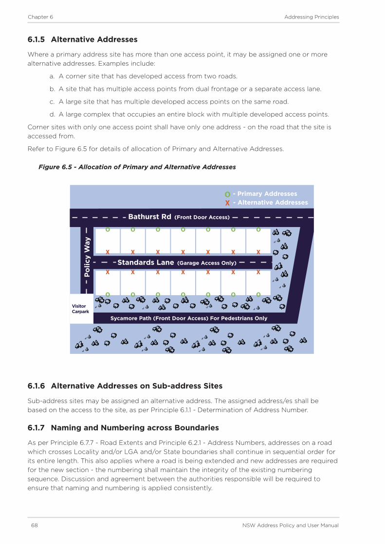
68 NSW Address Policy and User Manual
Chapter 6 Addressing Principles
6.1.5 Alternative Addresses
Where a primary address site has more than one access point, it may be assigned one or more alternative addresses. Examples include:
a. A corner site that has developed access from two roads.
b. A site that has multiple access points from dual frontage or a separate access lane.
c. A large site that has multiple developed access points on the same road.
d. A large complex that occupies an entire block with multiple developed access points.
Corner sites with only one access point shall have only one address - on the road that the site is accessed from.
Refer to Figure 6.5 for details of allocation of Primary and Alternative Addresses.
Figure 6.5 - Allocation of Primary and Alternative Addresses
6.1.6 Alternative Addresses on Sub-address Sites
Sub-address sites may be assigned an alternative address. The assigned address/es shall be based on the access to the site, as per Principle 6.1.1 - Determination of Address Number.
6.1.7 Naming and Numbering across Boundaries
As per Principle 6.7.7 - Road Extents and Principle 6.2.1 - Address Numbers, addresses on a road which crosses Locality and/or LGA and/or State boundaries shall continue in sequential order for its entire length. This also applies where a road is being extended and new addresses are required for the new section - the numbering shall maintain the integrity of the existing numbering sequence. Discussion and agreement between the authorities responsible will be required to ensure that naming and numbering is applied consistently.
X X X X X X X
O O O O O O O
X X X X X X X
O O O O O O O
OX
- Primary Addresses- Alternative Addresses
Bathurst Rd (Front Door Access)
Standards Lane (Garage Access Only)
Po
licy
Way
Sycamore Path (Front Door Access) For Pedestrians Only
Visitor Carpark
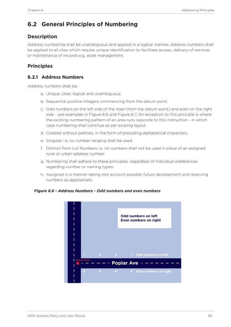
NSW Address Policy and User Manual 69
Chapter 6 Addressing Principles
6.2 General Principles of Numbering
DescriptionAddress numbering shall be unambiguous and applied in a logical manner. Address numbers shall be applied to all sites which require unique identification to facilitate access, delivery of services or maintenance of records e.g. asset management.
Principles
6.2.1 Address Numbers
Address numbers shall be:
a. Unique, clear, logical and unambiguous.
b. Sequential positive integers commencing from the datum point.
c. Odd numbers on the left side of the road (from the datum point) and even on the right side - see examples in Figure 6.6 and Figure 6.7. An exception to this principle is where the existing numbering pattern of an area runs opposite to this instruction - in which case numbering shall continue as per existing layout.
d. Created without prefixes, in the form of preceding alphabetical characters.
e. Singular, i.e. no number ranging shall be used.
f. Distinct from Lot Numbers i.e. lot numbers shall not be used in place of an assigned rural or urban address number.
g. Numbering shall adhere to these principles, regardless of individual preferences regarding number or naming types.
h. Assigned in a manner taking into account possible future development and reserving numbers as appropriate.
Figure 6.6 - Address Numbers - Odd numbers and even numbers
Poplar Ave
Odd numbers on leftEven numbers on right
1 3 5 7 Odd numbers on left
2 4 6 8 Even numbers on right
Datum Point

70 NSW Address Policy and User Manual
Chapter 6 Addressing Principles
Figure 6.7 - Address numbers - Odd numbers and Even numbers
6.2.2 Datum Point
A datum point for the start of each road name shall be defined in order to determine address numbering for the road.
A road should start (and the datum point therefore be placed) at the end of the road likely to be accessed on the most frequent basis. Where this is unable to be determined, the datum point should be placed at the end of the road closest to the centre of the locality/town. Where this is unable to be determined, the datum point should be located at the end of the road which is most southern or easterly. Refer to Figure 6.8 and Figure 6.9 for examples.
In the case of staged developments, datum points should be determined based on the complete development plan for the area. Numbers must be estimated and reserved where a road is to be developed in stages. Refer to Principle 6.3.1 - Reserving Numbers for details.
Address numbering shall continue from the datum point for the entire length of a named road, except in rural situations where the numbers become too high. Refer to Principle 6.4.4 - Very Long Roads for more details.
The datum point and existing numbering need not be changed if access to the road is changed. e.g. a road is cul-de-saced at a major intersection. Refer to Figure 6.10.
Refer to Principle 6.2.4 - Renumbering due to Redevelopment in cases where renumbering and reallocation of a datum point is required.
Datum PointCollaroy Close
1 3 5
2 4 6
7 9
11
108
Odd numbers on left
Even numbers on right

NSW Address Policy and User Manual 71
Chapter 6 Addressing Principles
Figure 6.8 - Datum Point
Figure 6.9 - Datum Point - staged development
Stephanie Rd
Lloyd Rd
Mooney Rd
Cha
rles
ton
Hw
y Ric
hard
s H
wy
Ric
hard
s H
wy
TownExtent
TownExtent
Datum Point
Datum Point
Datum Point
Datum Point
Datum Point
Tho
mas
St
Datum Point
1 3 5 7
24 6
8
9 1113
10 12
14
Too
hey
Rd

72 NSW Address Policy and User Manual
Chapter 6 Addressing Principles
Figure 6.10 - Datum Point and Existing numbers retained when access changed
6.2.3 Use of Suffixes
Urban infill frequently results in situations where there are no address numbers available for a new address site due to existing numbering on the road. In these situations alpha suffixes shall be assigned for the existing and the new address sites.
Note: Address sites that share access should be treated as sub-address sites and numbering assigned accordingly Refer to Principles Section 6.5 - Sub-Address Numbering. Shared access could be through common property or easements (except where the common property or easement is a private road, in which case it should be named). Refer to Figure 6.11 for example.
Where address sites do not share access but have individual access to the road, alpha suffixes shall be assigned. Alpha suffixes shall start at A, be assigned incrementally, and shall not extend beyond E. Where more than five sites need to be addressed using suffixes, consideration should be given to renumbering surrounding properties. Suffixes may be applied to adjacent address sites to help minimize the extent of the renumbering. The order of suffixes should be in the same direction as the numbering of addresses on the road, as shown in Figure 6.12.
Suffixes shall be assigned to every address site that uses the primary number. Under AS/NZS4819 an address site that is already using the primary number on its own may retain the number provided it is in sequence, as shown in Figure 6.13. However, the preferred method is to assign a suffix to all addresses which utilise the same numeral, as shown in Figure 6.14. Refer to Figures 6.15 and 6.16 for additional advice on number sequencing.
An address that includes a suffix should be recorded with the following details:
• Address number: 18C
• Road name: Campbell
• Road Type: Street
• Locality name: Surrey Hills
• State name: New South Wales
2
4
6
8
10
1
3
5
7
9
Datum Point
Street Cul-De-Saced
Junction Road
Thomas StreetFrancis Street

NSW Address Policy and User Manual 73
Chapter 6 Addressing Principles
Figure 6.11 - Sub-addressing where access point is shared from road in an urban area
Figure 6.12 - Order of suffixes same as existing numbering
5/13A 4/13A 3/13A 2/13A
1/13
A11
13B
1517
Alp
ha C
lose
3 5 7A 7B 7C 9
Jones Lane
Jack
son
Ave
nue
Order of su�xes same as existing numbering

74 NSW Address Policy and User Manual
Chapter 6 Addressing Principles
Figure 6.13 - Base number retained when suffixes are in order (order of suffixes same as existing numbering)
Figure 6.14 - Suffix applied where existing number is now out of order
3 5 7 7A 7B 9NEW
NEW
Jack
son
Ave
nue
Finch Road
3 5 7A 7B 7C 9NEW
NEW“7
” chan
ged to
“7B”
Jack
son
Ave
nue
Jones Lane

NSW Address Policy and User Manual 75
Chapter 6 Addressing Principles
Figure 6.15 - Use of suffixes for corner sites
Figure 6.16 - Use of suffixes for corner sites
Existing use may
be retainedNEW
1917A
1
3
17
ACCESS
Pip
er S
tree
t
Johnson Street
In most insta
nces
1 Piper Street
should be retired
NEW
191A
1B
3
17
ACCESS
Pip
er S
tree
t
Johnson Street

76 NSW Address Policy and User Manual
Chapter 6 Addressing Principles
6.2.4 Renumbering due to Redevelopment
When a portion of a road is renamed as a result of redesign or redevelopment and the integrity of the existing numbering cannot be maintained, address sites shall be renumbered as part of the process of renaming the road section. For this, a datum point shall be selected for the amended road section and numbering applied as per these principles. Refer to example in Figure 6.17.
Figure 6.17 - Road renamed and renumbered following development
6.2.5 Renumbering due to Highway Declassification
Use of a prefix to rename roads is unacceptable ie: ‘Old Marque Highway’ as that portion of road is no longer classified as a highway and therefore the road type of “Highway” is incorrect. This also poses duplication issues. Whilst few address sites exist on controlled access roads such as highways and freeways, depending on the length of the deviation consideration may need to be given to renumbering existing address sites on the main thoroughfare. In cases where the deviation or existing road crosses an LGA boundary, where possible, common datum points should be adopted for the length of the road. Refer to example in Figure 6.18.
Figure 6.18 - Road renamed and renumbered after highway bypass and declassification
Stingray Road Chase
Shark
Old section of Stingray Road renamed Shark Chase and renumbered
33 35 37
32 34 36
6311 6513
6412
Datum Point
Rowan
Way
Old section of Highway
Former route of Marque Highway
1521296
1931333
711211
141158
2721416
1139 1144
1450
LGA Boundary
Datum Point
Mar
que
Hig
hway

NSW Address Policy and User Manual 77
Chapter 6 Addressing Principles
6.3 Principles for Urban Numbering
DescriptionUrban numbering shall meet all the requirements of the general principles of numbering such that all addresses will be intuitively clear to all who need to locate an address.
Principles
6.3.1 Reserving Numbers
Additional numbers should be reserved for address sites with abnormally wide frontages or where there is potential for urban infill. This will mean there are potentially ‘gaps’ in the number sequence - this will not be an issue as long as Principle 6.2.1 - Address Numbers is applied and ranging is avoided. Reserving numbers means sufficient numbers should be available for any possible future development design. Refer to Figure 6.19 for details.
Figure 6.19 - Numbers reserved for future urban infill
Numbers reserved35
37
36 38
4246
43 45
Numbers reserved
Numbers reserved
Numbers reserved
Jackson Avenue33
32
34
39
40
41
44 48

78 NSW Address Policy and User Manual
Chapter 6 Addressing Principles
6.3.2 Numbering a Corner Site
An address site on a corner shall be given an address number on the road from which access is provided. An address number shall be reserved on the other road to allow for future development, unless it is assigned as an alternative address (if access can also be gained from that road).
When an address number is assigned to a corner site before any development takes place, the number shall be on the road with the narrowest frontage to the site, as this best accommodates potential future redevelopment of the site. If access is subsequently created from the other road, the address shall be numbered to that road. Refer to Figure 6.20 for an example.
Figure 6.20 - Numbering a corner site and reserving numbers for future use
21 127
3
5 6
4
223 Carnegie Ave
Reserved for future
development2 Holt Place based
on frontage.
25 Carnegie Ave
reserved for future
developmet
Ho
lt P
lace
Carnegie Ave
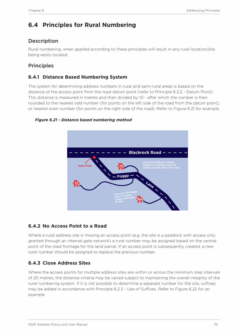
NSW Address Policy and User Manual 79
Chapter 6 Addressing Principles
6.4 Principles for Rural Numbering
DescriptionRural numbering, when applied according to these principles will result in any rural location/site being easily located.
Principles
6.4.1 Distance Based Numbering System
The system for determining address numbers in rural and semi-rural areas is based on the distance of the access point from the road datum point (refer to Principle 6.2.2 - Datum Point). This distance is measured in metres and then divided by 10 - after which the number is then rounded to the nearest odd number (for points on the left side of the road from the datum point), or nearest even number (for points on the right side of the road). Refer to Figure 6.21 for example.
Figure 6.21 - Distance based numbering method
6.4.2 No Access Point to a Road
Where a rural address site is missing an access point (e.g. the site is a paddock with access only granted through an internal gate network) a rural number may be assigned based on the central point of the road frontage for the land parcel. If an access point is subsequently created, a new rural number should be assigned to replace the previous number.
6.4.3 Close Address Sites
Where the access points for multiple address sites are within or across the minimum step intervals of 20 metres, the distance criteria may be varied subject to maintaining the overall integrity of the rural numbering system. If it is not possible to determine a separate number for the site, suffixes may be added in accordance with Principle 6.2.3 - Use of Suffixes. Refer to Figure 6.22 for an example.
73
72
154Access to 154 Foggy
Lane is located
1.54km from start
of road
Using this method a unique address is available every 20 meters on each side of the road
Blackrock Road
Foggy
Lane
Datum Point

80 NSW Address Policy and User Manual
Chapter 6 Addressing Principles
Figure 6.22 - Rural addressing for narrow frontage
6.4.4 Very Long Roads
If rural address numbers are likely to exceed 5 digits as a result of length of the road being more than 1,000 km, then an additional datum point shall be established at a major town or intersection and the numbering restarted. The direction of numbering shall continue in the same order as the previous section.
6.4.5 Rural Areas Affected by Development
Where a rural area becomes more urban, any previously assigned rural numbers should be retained if the integrity of the numbering sequence and logic can be maintained. New numbers may be assigned between the previously assigned rural numbers. Refer to Figure 6.23 for example. If the access points are located at a distance shorter than 20 metres apart and unambiguous numbering cannot be assured, alpha suffixes should then be applied.
Figure 6.23 - Infill numbering in areas affected by urban development
384382
380350394
394
0m
--
3820m
--
3503m
--
Teven Road
3880m
--
388a
388c388b
7274
7678 80 82
84
8688
9092 94 96 100
10510310199
9795
93
8987858381
7977
Existing rural
numbers
Cookes Road
91
98

NSW Address Policy and User Manual 81
Chapter 6 Addressing Principles
6.4.6 Rural/Urban Fringe Areas
The following apply to all roads that cross between, over or through a combination of rural and urban areas:
a. If the road name is the same in both rural and urban areas the rural numbering method shall continue through the town.
b. If a section of a road is assigned a separate name in an urban area or town, the urban numbering method shall apply to the extent of that separate name. The rural numbering shall continue beyond the section but shall include the distance through the town.
Figure 6.24 - Section of a road broken by a road of a different name
c. Outside of an urban area or town, if a section of road is coincident with another road then the rural numbering should continue and be assigned to the major road. The minor road rural numbering shall continue beyond the coincident section taking into account the distance of that conincident section. Refer to figure 6.24B for example.
Figure 6.24B - Numbering on a rural road with a local road name through a town
Datum Point
Datum Point
Burley Gri�n WayN
ewel
l Hw
y
New
ell H
wy
Burley Gri�n Way
96
Town Extent
Town Extent
85 77
72 24 22 20 18 16 14 12 10 8 6 4 2
23 21 19 17 15 13 11 9 7 5 3 1
32 22 10 1
19 7
Great Western HighwayGreat Western Highway Stewart StreetDatum Point
Rural numbering Urban numbering Rural numbering

82 NSW Address Policy and User Manual
Chapter 6 Addressing Principles
6.5 Principles for Sub-Address Numbering
DescriptionNumbering principles enable multiple address sites within an existing address site to be clearly and logically addressed. For example, offices in a multistorey building, apartments in a complex, strata titles or an industrial site with a common shared driveway (which does not act as a roadway). Where complex sites have internal roads, the internal roads should be used for addressing accordingly. See Section 6.1.2 One Road Name.
Principles
6.5.1 Primary Address Site Numbering
In addition to assigning sub-address numbers for all sites, an address number shall be assigned uniquely to the primary address site that contains the sub-address sites e.g. 15 Euston Road. (Also refer to section 6.2.1 - Address Numbers)
6.5.2 Sub-Address Numbering
The address number for a sub-address site shall consist of the sub-address number followed by the number of the primary address site or, in some cases, the alternative address number. See Figure 6.25 for example.
The address number for a sub-address site shall not consist of the primary number on its own e.g. 15 Euston Road. See Figures 6.26 and 6.27 for examples.
Examples of correct sub-address numbering
Figure 6.25 - Sub-address number structure
Sub-address number ‘3’ Primary address number ‘15’
3/15 Euston Road
3/15

NSW Address Policy and User Manual 83
Chapter 6 Addressing Principles
Figure 6.26 - Example of sub-address numbering
Figure 6.27 - Sub-address must include sub-address number
Euston Road
131/15
3/15
5/15
7/15 8/15
6/15
4/15
2/1517
15 Euston Rd - Primary address
Sub-address must include sub-address number
Euston Road
13
3/15
5/15
7/15 8/15
6/15
4/15
2/1517
15 Euston Rd - Primary address
15

84 NSW Address Policy and User Manual
Chapter 6 Addressing Principles
6.5.3 Uniqueness
Sub-address numbers shall be applied in a logical sequence and within a primary address site shall be unique, regardless of the type of the address site. Refer to Figure 6.28.
Figure 6.28 - Sub-address numbers to be unique regardless of type
6.5.4 Types of Sub-Addresses
A type may be assigned to a sub-address number as appropriate e.g. unit, flat, shop, however this is not a mandatory address element. Refer to the AS 4590:2017 for the list of available types.
When the unit type is recorded, it should be done as follows:
Sub-address type Shop Sub-address number 1 Primary address number 115 Road name Burwood Road Type Road Locality name Burwood Text string example Shop 1/115 Burwood Road Burwood
When the building identifier and/or name is recorded, it should be done as follows:
Building Identifier and/or site name Loxley House Sub-address number 1 Primary address number 115 Road name Burwood Road Type Road Locality name Burwood Text string example Loxley House Shop 1/115 Burwood Road Burwood
When a building identifier or name and/or unit type is recorded, it should be done as follows:
Building Identifier and/or site name Loxley House sub-address type Shop Sub-address number 1 Primary address number 115 Road name Burwood Road Type Road Locality name Burwood Text string example Loxley House Shop 1/115 Burwood Road Burwood
Building at 115
Burwood Road
O�ce 3 NOT O�ce 1 otherwise it will conflict with Shop 1
O�ce 5
Shop 1
Shop 2
O�ce 3
Shop 4
Burwood Road

NSW Address Policy and User Manual 85
Chapter 6 Addressing Principles
6.5.5 Multi-level Sub-Address Allocation
A multi-level site is a building with more than a single level. Except where an address site covers one or more levels, sub-address numbers in multi-level buildings shall consist of two parts.
The first part shall be one or more alphanumeric characters which represent the level and room. The last two digits shall be the address number for the site (this is commonly referred to as ‘hotel-style numbering’). Refer to Figure 6.29.
The last two digits in the sub-address number shall be unique on that level. Those digits shall be allocated in a logical sequence to each address site.
A zero shall be interposed in the numbering of the first nine address sites on each level for clarity e.g. for level 3 unit 9, the number shall be 309, not 39.
The first part of the sub-address number will normally refer to the level number e.g. 309 is on level 3. A level type code may be used in appropriate cases, such as ‘ground’, ‘mezzanine’, or ‘basement’ level. The appropriate level type shall be selected from those provided in the Table of Level Types and Codes. Refer to Figure 6.30.
A sub-address number which includes a level type code should be recorded as follows:
Level Type B
Sub-address number 02
Primary address number 53
Road Name Sussex
Road Type Street
Locality Newtown
B02/53 Sussex Street Newtown
Where there are multiple levels with the same level type (eg: two basement levels), the level type code and a number may be used in combination. See Figure 6.31.
Level numbers shall increase with height unless the levels are below ground, in which case they shall increase with depth (e.g. level B3 is below level B2). The ground floor should be assigned ‘G’, and should not be assigned ‘0’ or ‘1’.
An address site that occupies an entire level should be assigned a sub-address number as if it is the first address site on that level e.g. for level 4, the sub-address number would be 401. Similarly, an address site that occupies multiple levels should be assigned a sub-address number based on the level used to access the site e.g. for a site occupying levels 5 and 6 and accessed from level 5, the sub-address number would be 501.
A sub-address that is an entire level should be recorded as follows:
Sub-address number 401
Primary address number 24
Road name Castlereagh
Road Type Street
Locality Sydney
Text string example 401/24 Castlereagh Street Sydney

86 NSW Address Policy and User Manual
Chapter 6 Addressing Principles
Where there are insufficient numbers available for all of the address sites on a level e.g. for car park sites in a large car park building, alternative logical numbering methods may be applied provided the sub-address numbers are unique and unambiguous. A potential option is the use of suffixes (as described in Principle 6.2.3 - Use of Suffixes).
Figure 6.29 - Sub-address numbering method for multi-level building
Figure 6.30 - Level codes in sub-address number
Level 13
Level 1
Ground
1301 1302 1303 1304 1305
101 102 103 104 105
G01 G02 G03 G04 G05
1305/53 Sussex St
Level 13Unit 05
Ground G01 G02 G03 G04 G05
B01 B02 B03 B04 B05
B05/53
Sussex Street
Sydney
New South Wales
Address number:
Road name:
Locality name:
State name:

NSW Address Policy and User Manual 87
Chapter 6 Addressing Principles
Figure 6.31 - Sub-address level numbering where level type repeated
Level Types and Codes
Level Type Code DescriptionBasement B The lowest habitable storey of a building, usually
below ground level. The substructure or foundation of a building.
Ground G The floor of a building at or nearest ground level.
Lower Ground LG The lower entrance level where a building has entrances on two different ground levels, or a level that is below ground level.
Upper Ground UG The higher entrance level where a building has entrances on two different ground levels.
Ground
B101 B102 B103 B104 B105Basement 1
Basement 2 B205/53 Sussex StreetAddress:
B201 B202 B203 B204 B205

88 NSW Address Policy and User Manual
Chapter 6 Addressing Principles
6.5.6 Carspace Addressing
In some scenarios (particularly in large residential developments) carspaces may have separate title. In these cases carspaces should be assigned an appropriate address. There is no requirement to assign addresses to other carspaces such as those that are assigned for visitors, or those that are associated with another title (ie: part of the entitlement of a unit). See figure 6.32.
Addresses should be assigned in a logical manner and based on access; ensuring address numbers are reserved for future scenarios where other carspaces may need addressing.
Figure 6.32 - Numbering car spaces with separate title
6.5.7 Multiple towers on the same site
Where there is a building with multiple towers a single primary address should be assigned for the whole site.
ie: 55 Jules Street
Each tower within the development should then be assigned a unique alphanumeric suffix. Refer to figure 6.32 and section 6.2.3 - Suffixes.
ie: 55A Jules Street
55B Jules Street
55C Jules Street
Figure 6.33 - Multiple Towers on a site
Odd numbered spaces on the left Even numbered spaces on the right
Numbered in sequence from the entry (datum) point in a logical fashionNumbers shown in white are assigned address numbers
Numbers shown in grey and brackets are reserved for future use
drivewayentry
to basement
level 2
driveway
allocated to a unit allocated to a unit visitor
allocated to a unit allocated to a unitvisitor visitor
allocated to a unitvisitor visitor visitor
(B115) B113 (B111) (B109) (B107) (B105) (B103) B101
(B117) (B119) (B121) B123 (B125) (B127) (B129) (B131)
(B102) (B104) B106 (B108) (B110) (B112) B114 (B116) (B118) (B120) B122 B124
Datum Point
5753
Jules Street
55A 55B 55C
55

NSW Address Policy and User Manual 89
Chapter 6 Addressing Principles
Within the whole site, the apartments/units/retail units should all be allocated a unique sub-address number. The sub-address numbers should be as per the following examples.
Ground level
Building Up to 99 units across the level Over 99 units across the level55A Jules Street G01/55A Jules Street
G02/55A Jules Street
…
G14/55A Jules Street
G001/55A Jules Street
G002/55A Jules Street
…
G052/55A Jules Street
55B Jules Street G15/55B Jules Street
G16/55B Jules Street
…
G28/55B Jules Street
G053/55B Jules Street
G054/55B Jules Street
…
G078/55B Jules Street
55C Jules Street G29/55C Jules Street
G30/55C Jules Street
…
G52/55C Jules Street
G079/55C Jules Street
G080/55C Jules Street
…
G121/55C Jules Street
Level 1
Building Up to 99 units across the level Over 99 units across the level55A Jules Street 101/55A Jules Street
102/55A Jules Street
…
114/55A Jules Street
1001/55A Jules Street
1002/55A Jules Street
…
1052/55A Jules Street
55B Jules Street 115/55B Jules Street
116/55B Jules Street
…
128/55B Jules Street
1053/55B Jules Street
1054/55B Jules Street
…
1078/55B Jules Street
55C Jules Street 129/55C Jules Street
130/55C Jules Street
…
152/55C Jules Street
1079/55C Jules Street
1080/55C Jules Street
…
1121/55C Jules Street

90 NSW Address Policy and User Manual
Chapter 6 Addressing Principles
Level 14
Building Up to 99 units across the level Over 99 units across the level55A Jules Street 1401/55A Jules Street
1402/55A Jules Street
…
1414/55A Jules Street
14001/55A Jules Street
14002/55A Jules Street
…
14052/55A Jules Street
55B Jules Street 1415/55B Jules Street
1416/55B Jules Street
…
1428/55B Jules Street
14053/55B Jules Street
14054/55B Jules Street
…
14078/55B Jules Street
55C Jules Street 1429/55C Jules Street
1430/55C Jules Street
…
1452/55C Jules Street
14079/55C Jules Street
14080/55C Jules Street
…
14121/55C Jules Street
Addresses should be assigned in this manner to avoid any duplication of unit numbers between the buildings.
In the case where the site is accessed from more than one street there should be no duplication of suffixes:
Building Primary AlternativeA 22A John Street 46A Barry Road
B 22B John Street 46B Barry Road
C 46C Barry Road 22C John Street
Refer to figure 6.34
Figure 6.34 - Multiple Towers on a corner site
20
48
John Street
Bar
ry R
oad
22BTower B
22ATower A
46CBarry Road Tower
C
Comon lower floors
22 John Street
24
44

NSW Address Policy and User Manual 91
Chapter 6 Addressing Principles
6.6 Principles for Water-Based Numbering
DescriptionWater-based numbering principles have been developed to enable addresses to be applied to any site that can only be accessed by water.
Principles
6.6.1 Water Access
Water-based address numbering shall be applied to those sites that are only accessible by water. Sites that are accessible by both water and a named road shall be addressed to the named road - this includes sites accessed by a named road on an island.
A pier or wharf may also be assigned a water-based address number if it meets the above criteria.
6.6.2 Use of Water Name
In lieu of a road name, the name of the river or water-feature shall be used. A river-based address should be recorded as follows:
Address number 1015
Water Name Hawkesbury River
Locality Little Wobby
6.6.3 Sequence
Numbering for water-based sites shall be assigned using a distance based method. Odd numbers shall be on the left side and even numbers on the right, and the number is determined by dividing the distance (in metres) from the datum point by 10 and then rounding to the nearest even or odd number.
6.6.4 Datum Point for Waterways
A datum point shall be established and then numbers allocated according to the distance along the shoreline from that datum point.
For rivers and creeks, the datum point shall be at the mouth or confluence of the feature, with numbering increasing upstream from that point. Refer to figure 6.35.
Figure 6.35 - Datum point for waterways (where one side of water course is only accessible by water)
9
Patonga
Creek
flow
90m
11 13 15 1719 21 23 25 27 29 31
3335 37 39
41 43
Datum Point

92 NSW Address Policy and User Manual
Chapter 6 Addressing Principles
6.6.5 Datum Point for Islands, Inlets, Bays
For islands, a landmark or other feature should be selected and numbering commence from that point. Numbering is applied in a sequential clockwise pattern. If numbering completely encircles an island, then the highest number will be adjacent to the lowest, and the numbering pattern, being the distance divided by 10. This will result in some odd and even numbers being adjacent. This can only happen on an island or in a bay or inlet.
An island-based address (where no internal road network exists) should be recorded as follows:
Address number 32
Water name David Island
Locality David Island
For an inlet or bay the datum point will usually be placed at the end from which boat access usually occurs. Numbering shall be the distance from the datum point divided by 10. This will result in some odd and even numbers being adjacent.
Refer to figure 6.36.
Figure 6.36 - Numbering on an island
A bay-based address should be recorded as follows:
Address number 81
Water name Morning Bay
Locality Morning Bay
Refer to figure 6.37.
David Island
52
35
26
21 17 12 91
Datum Point

NSW Address Policy and User Manual 93
Chapter 6 Addressing Principles
Figure 6.37 - Numbering a bay
6.6.6 Waterways with Islands, Inlets and Bays
If a section of waterway intersects with a named island, inlet or bay, the island, inlet or bay numbering method, Principle 6.6.5 - Datum Point for Island, Inlets and Bays, shall apply to the extent of the feature. The waterway numbering shall continue beyond the section but shall include the distance through or around that feature.
5235
26
21
17
12
91
Morning Bay
Datum Point
94 NSW Address Policy and User Manual
Chapter 6 Addressing Principles
6.7 Principles of Road naming
DescriptionThe following principles for the naming of roads conform to the principles outlined in various sections of AS/NZS 4819:2011 Rural and Urban Addressing. They are designed to ensure that naming practices in NSW will be of the highest possible standard and will result in intuitively clear road names for all, minimising confusion, errors and omissions.
Road naming proposals that do not conform to the following principles will be objected to.
Principles
6.7.1 Ensuring Public Safety and Service Delivery
Road names shall not risk public and operational safety for emergency response, or cause confusion for transport, communication and mail services. Many emergency responses and other public services (such as mail) are determined by the clarity of road names and road extents, and all road name proposals shall ensure that operations will not be adversely affected. Emergency and other public services shall also actively discourage the use of road names which are known to be unofficial.
For example, a road naming authority may redesign the traffic flow for a road that results in portions of a road no longer being connected. In such instances Principle 6.7.9 - Amending Road Names states that renaming action shall occur and defines the time periods that apply. This is particularly important to ensure public and operational safety is prioritised.
With the centralisation of emergency service operational dispatch centres in NSW, uniqueness is the most essential quality when proposing a new road name. Duplication of similar and like sounding road names should be avoided as these names can cause confusion for operational dispatch and delay emergency response times.
For example, names that sound the same such as Paice, Payce or Pace are unacceptable. Similarly, names that rhyme such as Hilton and Milton should not be used. These names add ambiguity as an emergency call taker will need to make many decisions to refine a call to the correct location.
6.7.2 Language
a. Road names shall be written in standard Australian English or a recognised format of an Australian Aboriginal language local to the area of the road.
b. Road names shall be easy to pronounce, spell and write, and preferably not exceed three words (including the road type) or 25 characters. An exception to this is in the use of Aboriginal names when it is accepted that a traditional name may at first appear to be complex but will, over time, become more familiar and accepted by the community.
c. Diacritical marks (symbols such as ´ in é, ¸ in ç or : in ö ) are not used in Australian English names, and shall be omitted from names drawn from languages that use such marks.
d. The following types of punctuation as used in Australian English shall not be included as part of a road name: period (.), comma (,), colon (:), semi-colon (;), quotation marks (“”), exclamation mark (!), question mark (?), ellipsis (…), hyphen (-), dash (/), ampersand (&) and parenthesis (()). For surnames or other names that include a hyphen, the hyphen shall be omitted when used for a road name.

NSW Address Policy and User Manual 95
Chapter 6 Addressing Principles
e. An apostrophe mark shall not be included in road names written with a final ‘s’, and the possessive ‘s shall not be included e.g. St Georges Terrace not St George’s Terrace. Apostrophes forming part of an eponymous name shall be included (e.g. O’Connor Road).
f. A road name shall not include a preposition e.g. Avenue of the Allies.
g. Road names shall not include the definite article (The) as the first or sole name element of a road name e.g. The Esplanade or The Northern Road is not acceptable.
h. A road name shall not be abbreviated or contain an abbreviation, initial or acronym e.g. Mount, not Mt) except that St shall be used for Saint.
i. For the purposes of consistency, names starting with Mc or Mac shall not have a space included between the Mc or Mac and the rest of the name.
j. A road name shall not include Arabic numerals e.g. 3 or 4th or Roman numerals e.g. IV or X. Where numbers are included in a road name they shall be written in full e.g. Fifth Avenue, Ten Mile Road.
k. A road name shall have the same spelling as any name from which it is derived. A road name shall not include initials e.g. J Jones Road is not acceptable.
6.7.3 Roads to be Named
All formed roads, including private roads (roads for which the care and maintenance is not the responsibility of a Local Government) that are generally open to the public or to services shall be named in accordance with these principles. This includes, but is not limited to, highways, motorways and freeways; bike paths, bridle paths or walking tracks; roads within complexes such as universities, hospitals and retirement villages; roads within national parks and pedestrian only roads, such as malls.
Roads covered in this policy, and the responsible naming authorities are discussed in more detail in AUM Chapter 2 - Section 2.4.2 - Authority for Road Naming.
The delivery of emergency and other services are often impeded for residents and businesses when private road names are not officially recorded. In order to minimise confusion, to standardise address assignment and support emergency services, all road naming principles, procedures and processes shall be applied to private roads in NSW. Driveways providing access to a small amount of dwellings are not automatically considered to be private roads, and owner/occupiers have no authority to install signs for such driveways, unless given consent from Local Government. This same principle applies to pathways, in cases where naming is not considered necessary for addressing purposes.
Unformed roads (usually surveyed but unconstructed) should not be named unless a name is, or will be, required for addressing purposes.
Roads with five or less address sites need not be named if the address sites within the road can be assigned numbers within the adjoining road. See example in Figure 6.38.
Naming conventions should take into consideration cartographic requirements i.e. a considerably long name is difficult to represent on a short road line.
The use of an unofficial road name (a name that has not been endorsed by a naming authority) for addressing purposes is not acceptable. Such a road shall be assigned an official name (a name that has been endorsed by Local Government, approved by the GNB and gazetted). Each road shall have only one official name for addressing purposes.

96 NSW Address Policy and User Manual
Chapter 6 Addressing Principles
As shown in the example in Figure 6.39 a classified highway may include a section that is also assigned a local name where it passes through a town or suburb. Nonetheless, each section of road shall have only one official name for addressing purposes. In this example, within the town the official name for addressing purposes is Brooke Street.
Figure 6.38 - Short road with just 3 address sites named as part of Beauford Street
Figure 6.39 - Local road naming through a town
Beaufort Street
Oxley Hwy Brooke St Oxley Hwy
Somerton

NSW Address Policy and User Manual 97
Chapter 6 Addressing Principles
6.7.4 Uniqueness Duplication
Uniqueness is the most essential quality to be sought in proposing a new road name. A road name will be regarded as a duplicate if it is the same or similar in spelling or sound to an existing name, regardless of the road type.
Road names shall not be duplicated:
• Within the same address locality• Within the adjoining locality• Within a duplicated locality anywhere in NSW• Within the following proximity radius: o 10km in a Metropolitan Urban Area o 20km in a Regional Urban Area o 30km in a Rural Area
The proximity radius provides the minimum required distance between duplications.
The NSW LGA Road Name Proximities map along with land use zones, as defined by the Standard Instrument – Principal Local Environment Plan (Part 2.1), will determine which proximity radius will be applied when evaluating road names.
Land zones applied to road name evaluation can be accessed via the Planning Portal https://www.planningportal.nsw.gov.au/spatialviewer/#/find-a-property/address
Proximity Radius Areas
10 km - Metropolitan Urban Area
• All roads within Metropolitan Urban Area, as defined by the NSW Road Name Duplication Proximities map, will be evaluated for duplication within a 10km radius.
10km or 20km - Metropolitan Urban Area or Regional Urban Area
• Land use zones that are Residential Zones R1-R4, Business Zones B1-B8 and Industrial Zones IN1-IN3, within the Metropolitan or Regional Urban Proximity Area, will be evaluated as a 10km proximity radius.
• All other roads will be considered as a Regional Urban Area and a 20km proximity radius applied.
20km-30km Regional Urban Area or Rural Area
• Cities, towns and villages that are outside of the Metropolitan Urban LGA area will be evaluated as a Regional Urban Area, and a 20km radius applied. Examples include Orange, Dubbo, Wagga Wagga and Bathurst.
• If the land use zone is ‘Rural Zones RU1-RU6’, it will be evaluated as a Rural Area proximity and a 30km radius applied.
• Environmental Protection Zones E1-E4, outside of the Metropolitan Urban Areas, will be considered a Rural Area.
Notes:
• There may be occasions when a different radius is applied, however this will be determined on a case by case basis in consultation with the affected Council.
• Measurements are to be taken from the closest extent of the existing road.
• The proximity radius zone is to be applied to the proposed road, not the zone the existing road is in. e.g. if the proposed road is outside of Bathurst, and it is an area classified as a Rural Area then the rural radius is applied.
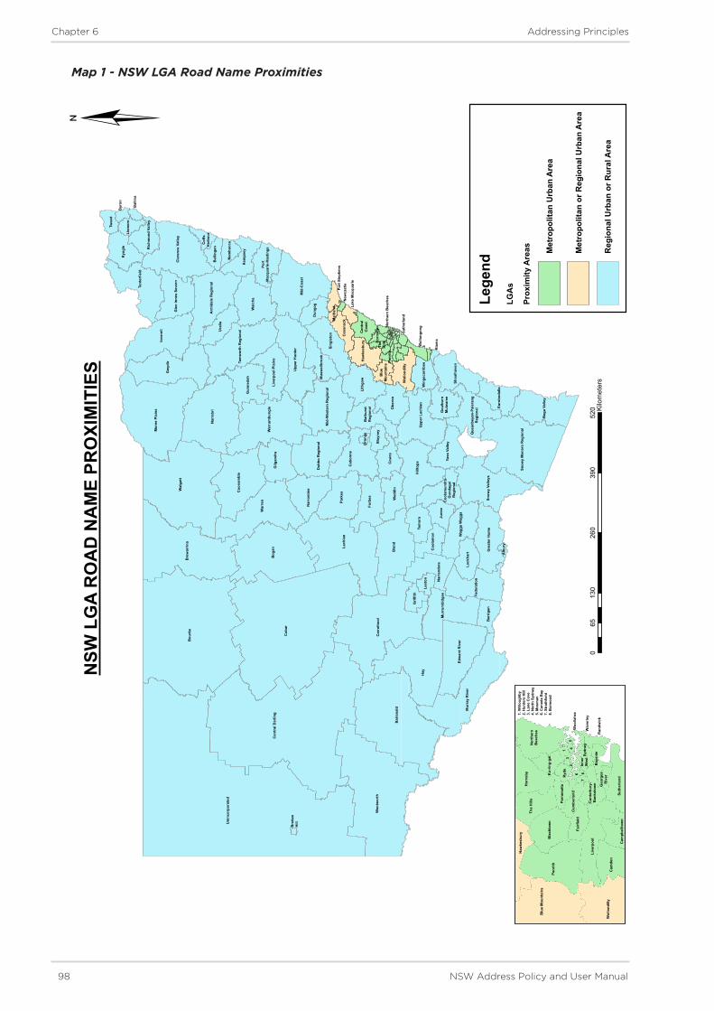
98 NSW Address Policy and User Manual
Chapter 6 Addressing Principles
Map 1 - NSW LGA Road Name Proximities
Cob
ar
Uni
ncor
pora
ted
Bou
rke
Cen
tral
Dar
ling
Hay
Wal
gett
Wen
twor
th
Bal
rana
ld
Bog
an Lach
lan
Car
rath
ool
Bre
war
rina
Nar
rabr
i
Bla
nd
War
ren
Mor
ee P
lain
s
Gw
ydir
Inve
rell
Mid
-Coa
st
Mur
ray
Riv
er
Hill
tops
Park
es
Coo
nam
ble
Wal
cha
War
rum
bung
le
Edw
ard
Riv
er
Forb
es
Cab
onne
Tent
erfie
ld
Cla
renc
e Va
lley
Snow
y M
onar
o R
egio
nal
Snow
y Va
lleys
Upp
er H
unte
r
Beg
a Va
lley
Lith
gow
Fede
ratio
n
Ura
lla
Sing
leto
n
Tam
wor
th R
egio
nal
Nar
rom
ine
Upp
er L
achl
an
Obe
ron
Kyo
gle
Gilg
andr
a
Mur
rum
bidg
ee
Gun
neda
h
Dub
bo R
egio
nal
Wed
din
Arm
idal
e R
egio
nal
Cow
ra
Gre
ater
Hum
e
Shoa
lhav
en
Mid
-Wes
tern
Reg
iona
l
Tem
ora
Nar
rand
era
Yass
Val
ley
Kem
psey
Wag
ga W
aggaJu
nee
Lock
hart
Live
rpoo
l Pla
ins
Euro
boda
lla
Gle
n In
nes
Seve
rn
Dun
gog
Ber
rigan
Mus
wel
lbro
ok
Coo
lam
on
Grif
fith
Wol
lond
illy
Haw
kesb
ury
Ces
snoc
k
Twee
d
Bla
yney
Win
geca
rrib
ee
Ric
hmon
d Va
lley
Leet
on
Bel
linge
n
Lism
ore
Nam
bucc
a
Bat
hurs
tR
egio
nal
Que
anbe
yan-
Pale
rang
Reg
iona
l
Gou
lbur
nM
ulw
aree
Port
Mac
quar
ie-H
astin
gs
Cen
tral
Coa
st
Coo
tam
undr
a-G
unda
gai
Reg
iona
l
Blu
eM
ount
ains
Byr
on
Cof
fsH
arbo
ur
Bal
lina
Port
Ste
phen
s
Wol
long
ong
Hor
nsby
Penr
ith
Lake
Mac
quar
ie
Alb
ury
Mai
tland
The
Hill
s
Kia
ma
Ora
nge
Suth
erla
nd
New
cast
le
Nor
ther
n B
each
es
Bro
ken
Hill
Lege
ndLG
As
Prox
imity
Are
as Met
ropo
litan
Urb
an A
rea
Met
ropo
litan
or R
egio
nal U
rban
Are
a
Reg
iona
l Urb
an o
r Rur
al A
rea
¦
013
026
039
052
065
Kilo
met
ers
NSW
LG
A R
OA
D N
AM
E PR
OXI
MIT
IES
Blu
e M
ount
ains
Haw
kesb
ury
Penr
ith
Wol
lond
illy
Live
rpoo
l
Cam
den
Cam
pbel
ltow
nSu
ther
land
Geo
rges
Riv
er
Bay
side
Can
terb
ury-
Ban
ksto
wn
Fairf
ield
Bla
ckto
wn
The
Hill
sH
orns
byN
orth
ern
Bea
ches
Parr
amat
ta
Cum
berla
nd
Ku-
ring-
gai
Ryd
e
Ran
dwic
k
Wav
erle
y
Woo
llahr
a
Sydn
eyIn
ner
Wes
t
13
24
56
78
1. W
illou
ghby
2. H
unte
rs H
ill3.
Lan
e C
ove
4. N
orth
Syd
ney
5. M
osm
an6.
Can
ada
Bay
7. S
trat
hfie
ld8.
Bur
woo
d

NSW Address Policy and User Manual 99
Chapter 6 Addressing Principles
6.7.5 Acceptable Road Names
Names of early settlers, war servicemen and women and other persons who have contributed to the heritage of an area, local history themes, flora, fauna, ships etc. are usually most suitable for applying to roads.
Gender diversity in the selection of names is encouraged, as are names reflecting NSW multicultural heritage. Aboriginal names are also supported and shall be in a local language chosen in consultation with the Local Aboriginal Land Council.
Local interest groups, developers or individuals are encouraged to work with the Local Government to locate/define new names according to these suggestions.
When selecting road names, all of the following shall be considered and must be adhered to:
• Road names shall not be offensive, racist, derogatory or demeaning (refer to NSW Anti-Discrimination legislation).
• Road names shall not be misspelt. In particular, the spelling of personal names shall be able to be validated by reference to primary sources.
• Commercial and business names shall not be used, particularly where the name can be construed to be promoting the business. However, business names no longer in use and which promote the heritage of an area are acceptable.
• Road types shall not be used in the formation of a road name, for example Promenade Road, Court Street etc. even if the road type is also a surname.
• When commemorating a person only one of the person’s names shall be used e.g. a given name or surname.
6.7.6 Commemorative Road Names
Naming often commemorates an event, person or place. The names of people who are still alive shall not be used because community attitudes and opinions can change over time. It is not appropriate to use nicknames as an alternative to an official name for the purposes of road naming.
Acts of bravery, community service and exceptional accomplishments are typical grounds for this recognition. The name of persons who gave their lives in service for their country are often used as commemorative names. The person commemorated should have contributed significantly to the area.
Ownership of land that has been developed is not considered as a significant reason for naming purposes.
The initials of a given name are not to be used in any instances.
Local Government shall make every effort to gain consent from family members of the person who is being commemorated. Supporting evidence that shows attempts by a Local Government to consult with family members should be provided during the lodgment of the proposal, but it is acknowledged that some names may be from an era for which this is not possible.
It is a requirement that a person is to have been deceased for at least 12 months before an application to commemoratively name a road after them is deemed acceptable.

100 NSW Address Policy and User Manual
Chapter 6 Addressing Principles
6.7.7 Road Extents
A road name shall apply from one end of the road to the other i.e. the point where the road finishes or intersects with another road or roads.
The extent of a named road shall be defined by the formed road, and shall include only one section navigable by vehicles or foot. Unconnected navigable sections, such as where separated by an unbridged stream or a physical barrier, shall be assigned separate names. Refer to Figure 6.40 for an example.
When a road extent is broken into separate sections by redevelopment or redesign, the name shall only be retained on one section and the other section(s) renamed as part of the development process. Refer to Figure 6.41 for an example.
A classified highway may be split by a section that is assigned a local name where it passes through a town. Each section of road shall have only one official name for addressing purposes. Refer to Figure 6.42 for an example.
Figure 6.40 - One section of road to be renamed
Figure 6.41 - Road naming in a staged development
Park land
Orange Rd
Road section to be built in 2+ years time
Name change over point to be identified at a suitable intersection, roundabout or intersecting street when road is constructed
Development Stage 1 Development Stage 3 Development Stage 2
Wendy Rd Celia RdDatum Point Datum Point

NSW Address Policy and User Manual 101
Chapter 6 Addressing Principles
Figure 6.42 - One section of Bexley Street to be renamed
6.7.8 Suffixes, Prefixes and Directional Indicators
A road name shall not include qualifying terminology, a cardinal indicator or a similar prefix (e.g. Upper, Lower, Old, New, East, West) unless the road name is derived from a name which includes it.
A directional or similar device shall not be used as a suffix to uniquely define road extremities e.g. Boundary Road East and Boundary Road West.
Origin to destination names, such as Bathurst-Oberon Road shall not be used. It is too easy for such names to be confusing as there are too many aliases. Further to this, road name signs for origin-destination names can create confusion when the respective names are opposite in direction to the actual location of the places as indicate by their order on the sign e.g. Bathurst Road, Oberon Road, Oberon-Bathurst Road.
6.7.9 Amending Road Names
Road names are intended to be enduring, and the renaming of roads is discouraged unless there are compelling reasons for a change. Issues that can prompt renaming include the redesign of a road, changed traffic flow, mail or service delivery problems, duplication issues and addressing problems. Where there are significant reasons for a change the road naming authority is encouraged to undertake renaming action in conformity with these principles. Information regarding submitting proposals and responding to change requests can be located in Chapter 7 - Addressing Procedures.
6.7.10 Road Types
All road names shall include a road type selected from the list of acceptable road types in Section 6.10 - Road Types. The road types available are distinguished between those for open-ended roads, culs-de-sac and pedestrian ways.
Hum
e H
wy
Bexley Road

102 NSW Address Policy and User Manual
Chapter 6 Addressing Principles
An exception to this mandatory assignation of road types only occurs on pre-approval of names for planning purposes or reserving of names, in which case the type might not yet be known. Refer to Chapter 7- Procedures - Section 7.3 Reservations and Pre-Approvals for details of this process.
Descriptions of the road types assist in the selection of types that suitably describe a road’s characteristics, and they should be chosen with the ultimate configuration of the road in mind.
Road types shall not be used to distinguish different roads of the same name or similarly sounding or spelt names. For example, the roads Lambert Street, Lambert Close and Lambert Lane are considered to be duplicates, which are not acceptable under Principle 6.7.4 - Uniqueness, Duplication. The same applies to Brown Street, Broun Crescent and Browne Lane (or similar combinations).
6.7.11 Cross-Jurisdictional Naming or Renaming
Where naming or amendments to an existing road are required, and the extent crosses Local Government or State boundaries the Local Government with the most residents affected by any naming or proposed change shall take the lead in these negotiations. Where unanimous decision is unable to be achieved, the matter shall be referred to the GNB for its advice.
Where a road is named the whole road shall be named (as per Principle 6.7.7 Road Extents) and therefore a road spanning one or many Local Government areas shall have the approval of affected Local Governments prior to being considered for gazettal.
6.7.12 Name of Water Feature or Island
For water based addressing the name of the water feature or island replaces the name of a road. For sites facing a watercourse or bay, that name of that feature replaces the road name, and in the case of islands, the island name replaces the road name. In every instance, the name shall be a name approved by the GNB and recorded in the NSW Gazetteer of Place Names e.g. 29 Patonga Creek, Patonga, NSW.

NSW Address Policy and User Manual 103
Chapter 6 Addressing Principles
6.8 Principles of Address Locality Naming and Boundaries
DescriptionAn address locality is a named geographical area with defined boundaries which represents a community or area of interest, and may be rural or urban in character (where urban it is usually defined as a ‘suburb’). Address localities enable addresses to be uniquely identified. Without clearly defined address localities there can be uncertainty in an address. To achieve comprehensive addressing objectives it is vital that address locality names and boundaries are clear and unambiguous.
Address localities are distinguishable from urban and rural places which are considered to be named geographical areas which have no official boundaries: for this reason an urban place name cannot be used for addressing purposes (e.g. Kings Cross is an urban place, it forms part of the Potts Point, Darlinghurst, Rushcutters Bay and Elizabeth Bay localities in Sydney). Similarly, estate names are considered to be branding for particular development areas or gated communities, and as such are not address locality names and cannot be used for addressing purposes.
Submissions seeking changes to address locality boundaries for reasons of perceived status or financial benefit will not be supported. Additionally, address locality name changes will have no bearing or impact on a Contract for sale and purchase of land in NSW.
Principles
6.8.1 Uniqueness, Duplication
No new name shall be duplicated within NSW or any other state or territory in Australia. Duplication includes being replicated in spelling or similar in sound. A check for duplication can be undertaken by searching the Gazetteer of Place Names www.gnb.nsw.gov.au and the Australian Gazetteer www.ga.gov.au/place-names/. Where a new address locality name is being considered, the GNB shall make contact with the PCPN - Permanent Committee on Place Names to determine whether other jurisdictions are concurrently considering a similar name, there are no existing duplications and to reserve the name for potential future use in NSW.
6.8.2 Official Use
Each address locality has one officially gazetted name. Alternative, promotional or dual names are not accepted for addressing purposes. Urban and rural place names shall not be used in place of an official name. Promotion or use of an unofficial, urban place or name other than the officially gazetted address locality name in an address (particularly in real estate marketing), is considered to be misleading or deceptive practice as defined under the Australian Competition and Consumer Act 2010.
6.8.3 Acceptable Address Locality Names
Address locality names shall conform with the general naming principles for roads and to the GNB Place Naming Policy. Refer to Principle 6.7.2 - Language and the following specific principles:
a. Short, easily pronounced names are preferred.
b. Names shall have the same spelling as any associated feature from which the name is derived.
c. The names of people who are still alive are not acceptable, because community attitudes and opinions can change over time, as per Principle 6.7.5 - Acceptable Road Names and Principle 6.7.6 - Commemorative Road Names.

104 NSW Address Policy and User Manual
Chapter 6 Addressing Principles
d. In remote areas the names of Aboriginal communities should be adopted as a locality name.
e. Names which are relevant to the local area are preferred, particularly if they relate to the history or geography of the area. The previous use of a name as an estate, subdivisional or promotional name does not give the name any priority to be accepted as an address locality name. Names for new address localities shall have a New South Wales emphasis, and preferably have a direct association with the area.
f. As per Principle 6.7.8 - Suffixes, Prefixes and Directional Indicators names should not include qualifying terminology, a cardinal indicator or a similar suffix or prefix e.g. Upper, New, North and South etc.
g. For new address localities, it is not permissible to add a word to an existing NSW address locality. Eg, Hotham Heights would not be acceptable if there is an existing locality of Hotham.
h. In the case of already duplicated existing address localities, the addition of a word to the locality name in order to decrease duplication is acceptable. Eg, if there are two address localities named Mayfield, one locality may be renamed Mount Mayfield provided this does not cause another duplication.
6.8.4 Boundary Definition
a. Address locality boundaries should be easy to identify and readily interpreted by the community. Address locality boundaries shall be determined based on good planning principles and define areas with common community interests.
b. Address locality boundaries shall be of a reasonable size for practical purposes, such as including a shopping precinct or community school. Within urban areas an ideal size is around 500ha, with a preferred minimum area of 100ha.
c. Address locality boundaries shall be contiguous and may not overlap another address locality boundary.
d. An address locality cannot be an island within another locality. All address localities should have boundaries that run alongside two or more other localities, the seashore or state boundary.
e. Address locality boundaries shall not extend beyond local government, state or territory boundaries.
6.8.5 Boundary Determination
a. Address locality boundaries should be determined as early in the planning process as possible.
b. Address locality boundaries shall follow clear and easily distinguishable lines such as rivers, railways, major road centrelines.
c. Address locality boundaries shall not bisect properties in common ownership and shall not bisect individual land parcels.
d. Boundaries should be regularly reviewed, especially in areas subject to urban development. The review process should take into primary consideration impacts on community interests. Following this, consideration can be given to the likely impact on government and commercial interests.
e. Address localities should be reflected in the address of any given site. A boundary adjustment may be required if the address locality of the access point to a site is not concurrent with the address locality for the site being addressed.
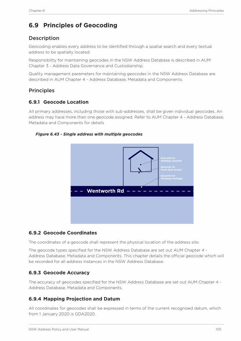
NSW Address Policy and User Manual 105
Chapter 6 Addressing Principles
6.9 Principles of Geocoding
DescriptionGeocoding enables every address to be identified through a spatial search and every textual address to be spatially located.
Responsibility for maintaining geocodes in the NSW Address Database is described in AUM Chapter 3 - Address Data Governance and Custodianship.
Quality management parameters for maintaining geocodes in the NSW Address Database are described in AUM Chapter 4 - Address Database, Metadata and Components.
Principles
6.9.1 Geocode Location
All primary addresses, including those with sub-addresses, shall be given individual geocodes. An address may have more than one geocode assigned. Refer to AUM Chapter 4 - Address Database, Metadata and Components for details
Figure 6.43 - Single address with multiple geocodes
6.9.2 Geocode Coordinates
The coordinates of a geocode shall represent the physical location of the address site.
The geocode types specified for the NSW Address Database are set out AUM Chapter 4 - Address Database, Metadata and Components. This chapter details the official geocode which will be recorded for all address instances in the NSW Address Database.
6.9.3 Geocode Accuracy
The accuracy of geocodes specified for the NSW Address Database are set out AUM Chapter 4 - Address Database, Metadata and Components.
6.9.4 Mapping Projection and Datum
All coordinates for geocodes shall be expressed in terms of the current recognised datum, which from 1 January 2020 is GDA2020.
Geocode for ‘building centroid’
Geocode for ‘front door access’
Geocode for ‘driveway frontage’
Wentworth Rd

106 NSW Address Policy and User Manual
Chapter 6 Addressing Principles
6.10 Road Types
The following road types, derived from AS/NZS 4819:2011, shall be selected as applicable to open ended roads, cul-de-sac or pedestrian only roads.
Road Type
Abbrev -iation Description Open
endedCul-de- sac
Pedestrian only
Alley AllyUsually narrow roadway in cities or towns, often through city blocks or squares.
Approach AppRoadway leading to an area of community interest (e.g. public open space, commercial area, beach etc.)
Arcade ArcPassage having an arched roof, or any covered passageway, especially one with shops along the sides.
Avenue AvBroad roadway, usually planted on each side with trees.
Boardwalk Bwlk
Promenade or path, especially of wooden planks, for pedestrians and sometimes vehicles, along or overlooking a beach or waterfront.
Boulevard BvdWide roadway, well paved, usually ornamented with trees and grass plots.
Break BrkVehicular access on a formed or unformed surface, which was originally prepared as a firebreak.
Bypass Bypa
Alternative roadway constructed to enable through traffic to avoid congested areas or other obstructions to movement.
Carpark Crpk
An area or building where cars or other vehicles may be left temporarily. Shops or residence may also be fronting the carpark.
Chase Ch Roadway leading down to a valley.
Circuit Cct Roadway enclosing an area.
Close Cl Short, enclosed roadway.
Concourse ConRoadway that runs around a central area (e.g. public open space or commercial area).
Court Ct Short, enclosed roadway.
Crescent CrCrescent-shaped thoroughfare, especially where both ends join the same thoroughfare.

NSW Address Policy and User Manual 107
Chapter 6 Addressing Principles
Road Type
Abbrev -iation Description Open
endedCul-de- sac
Pedestrian only
Crest CrstRoadway running along the top or summit of a hill.
Drive DrWide thoroughfare allowing a steady flow of traffic without many cross- streets.
Entrance Ent Roadway connecting other roads.
Esplanade EspLevel roadway, often along the seaside, lake or a river.
Firetrail FtrlVehicular access on a formed or unformed surface, which was originally prepared as a firebreak.
Freeway FwyExpress, multi-lane highway, with limited or controlled access.
Glade Glde Roadway usually in a valley of trees.
Grange GraRoadway leading to a country estate, or focal point, public open space, shopping area etc.
Grove GrRoadway that features a group of trees standing together.
Highway HwyMain road or thoroughfare, a main route.
Lane LaneNarrow way between walls, buildings or a narrow country or city roadway.
Loop LoopRoadway that diverges from and rejoins the main thoroughfare.
Mall MallSheltered walk, promenade or shopping precinct.
Mews Mews Roadway in a group of houses.
Parade PdePublic promenade or roadway that has good pedestrian facilities along the side.
Parkway PwyRoadway through parklands or an open grassland area.
Passage Psge Narrow street for pedestrians.
Path PathRoadway used only for pedestrian traffic.
Place PlShort, sometimes narrow, enclosed roadway.
Promenade PromRoadway like an avenue with plenty of facilities for the public to take a leisurely walk, a public place for walking.

108 NSW Address Policy and User Manual
Chapter 6 Addressing Principles
Road Type
Abbrev -iation Description Open
endedCul-de- sac
Pedestrian only
Quay QyRoadway leading to a landing place alongside or projecting into water.
Ramp RampAccess road to and from highways and freeways.
Retreat Rtt Roadway forming a place of seclusion.
Ridge Rdge Roadway along the top of a hill.
Rise RiseRoadway going to a higher place or position.
Road RdOpen way or public passage primarily for vehicles.
Steps Stps Route consisting mainly of steps.
Street St
Public roadway in a town, city or urban area, especially a paved thoroughfare with footpaths and buildings along one or both sides.
Subway SbwyUnderground passage or tunnel that pedestrians use for crossing under a road, railway, river etc.
Terrace TceRoadway usually with houses on either side raised above the road level.
Track Trk
Roadway with a single carriageway. A roadway through a natural bushland region. The interpretation for both Track and Trail is limited to roadways, whereas in many areas (e.g. Tasmania) these are often associated with walking rather than vehicular movement.
Trail Trl See ‘Track’.
View ViewRoadway commanding a wide panoramic view across surrounding areas.
Vista Vsta Roadway with a view or outlook.
Walk WalkThoroughfare with restricted access used mainly by pedestrians.
Way WayRoadway affording passage from one place to another. Usually not as straight as an avenue or street.
Wharf Whrf A roadway on a wharf or pier.

Chapter 1
Introduction
Chapter 7
Addressing Procedures

110 NSW Address Policy and User Manual
Chapter 7 Addressing Procedures
7 Addressing Procedures
This chapter contains procedures which shall be followed for all instances of numbering, road naming/renaming and address locality boundary definition.
The procedures apply mainly to Data Producers and Data Aggregators.
The procedures include:
7.1 Consultation 7.1.1 Submitting a Request
7.1.2 Responding to a Request
7.1.3 Consulting on a Proposal
7.1.4 Advertising and Public Notices
7.1.5 Submissions
7.2 Notifications 7.2.1 Notification of Approved Road Names
7.2.2 Gazettal of Road Names and Address Locality Boundaries
7.2.3 Road Closure
7.2.4 Ungazetted Road Names
7.3 Pre-Approvals 7.3.1 Authorisation of Proposals
7.3.2 Pre-Approval
7.3.3 Suitability Advice
7.4 Signage

NSW Address Policy and User Manual 111
Chapter 7 Addressing Procedures
7.1 Consultation
DescriptionDeveloping a proposal for a new, amended or deprecated address can require many tasks to be undertaken. Each of these procedures provides Data Producers and Aggregators with guidance on steps which should be undertaken for developing an addressing proposal.
Procedures
7.1.1 Submitting a Request
Members of the public and organisations that deal with the provision of emergency or other services (such as postal or telecommunications) can submit a suggestion or proposal to create or change an address (or address component) to the Local Government responsible for the area in which the address, number, road or address locality is situated.
A request can be to:
• create a new address, number, road or address locality
• change an address completely
• change an address number, road name, road type or address locality name/boundary.
The proposal shall include sufficient information to demonstrate that it is in the long-term interests of the community, and (where relevant) should include information that indicates that an overwhelming majority of the community which will be affected by the proposal are in support of the change.
Proposals to Local Government should include:
• the location of the address(es) (if relevant)
• the location and extent of the road (and, if relevant, its current name)
• background detail on why the Local Government shall consider changing an address component(s) or registering a new address component(s)
• details on why the change is considered to be appropriate, and
• copies of petitions, surveys etc.
Upon receiving the proposal the Local Government should initiate the formal proposal process. If a proposal affects addresses located across two or more Local Government areas, the staff of the respective areas need to coordinate the proposal’s processing as per Chapter 6 - Principle 6.1.6 - Naming and Numbering Across Boundaries.
When a proposal has been submitted from an emergency service organisation, minimum response times apply as per Procedure 7.1.2 - Responding to a Request.
Where a proposal is related to a address locality and Local Government ultimately reject the proposal, this decision can be appealed to the GNB as per Procedure 7.1.5 - Submissions.

112 NSW Address Policy and User Manual
Chapter 7 Addressing Procedures
7.1.2 Responding to a Request
Emergency Services
When a request for naming or changing an address component is proposed by an emergency service organisation and submitted to a Local Government, receipt of the request shall be acknowledged, by written letter or email to the proposer, within a total of 10 business days.
Once the response is sent an action plan shall be implemented by the Local Government within 30 business days. From then, the Local Government shall action the request and outline a proposal for resolving the issue within a total of 20 business days.
If the issue is unable to be resolved to all parties’ satisfaction within a total of 60 business days of the initial request being received, the matter may be referred to Spatial Services for its advice.
General Public
When a request for naming or changing an existing name or address is proposed by a member of the public, an organisation or business and submitted to a Local Government, receipt of the request shall be acknowledged, by written letter or email to the proposer, within a total of 20 business days.
Once the response is sent, the Local Government shall implement an action plan within a total of 30 business days. A proposal for resolving the issue must be completed within a total of 60 business days.
If the issue is unable to be resolved to all parties’ satisfaction within a total of 110 business days of the initial request being received, the matter may be referred to Spatial Services for its advice.
Where amendments to an existing address(es) are required and the extent(s) crosses Local Government boundaries the above timeframes do not apply because of the need for inter-council negotiations. For these purposes, an additional 10 to 15 business days is applied to each of the timeframes outlined above. Refer to AUM Chapter 6 - Principle 6.1.6 - Naming and Numbering Across Boundaries for details of jurisdiction in these instances.
7.1.3 Consulting on a Proposal
Under current legislative arrangements, there are different procedures required for consultation as part of the process of naming address localities and roads. There are not currently any legislative requirements for address numbering consultation.
Roads
The level and form of consultation will vary depending on the type of site for the naming proposal.
For ‘greenfield development sites’ - where there are no residents affected by the new road names - it is adequate to restrict consultation to be solely between the Local Government and the Data Producer.
For endorsement of the names of private roads, it is only necessary for the Local Government to consult with the owners of the development (usually the body corporate).
Local Government must consult with the immediate community who directly utilise the road names assigned to sites affected by a name change or addition. This includes, but is not limited to, residents, ratepayers and businesses. Consultation should only occur after the Local Government is certain that the proposed name conforms to the road naming requirements in AUM Chapter 6 - Principles.

NSW Address Policy and User Manual 113
Chapter 7 Addressing Procedures
As per the Roads Regulation 2018 the Local Government is required to:
• publish notice of its proposal in a local newspaper
• serve notice of its proposal on the prescribed authorities listed in Regulation 7.1.
The list of prescribed authorities includes:
(i) Australia Post
(ii) Registrar-General
(iii) Surveyor-General
(iv) Chief Executive of the Ambulance Service of NSW
(v) Fire and Rescue NSW
(vi) NSW Rural Fire Service
(vii) NSW Police Force
(viii) State Emergency Service
(ix) New South Wales Volunteer Rescue Association Incorporated
(x) for a classified road - the Roads and Maritime Services.
As per the Regulation, the notice to prescribed authorities must state that written submissions on the proposed name may be made to the Local Government and must specify the address to which, and the date by which, any such submissions shall be made.
If a Local Government is unsure of the level of community consultation required for a road naming proposal the Secretariat of the GNB is able to offer advice - refer to Procedure 7.3.4 - Suitability Advice for details.
Address Localities
Under the provisions of the Geographical Names Act 1966, the GNB is responsible for address locality name and boundary determination.
Principles outlined in Chapter 6 - Section 6.8 - Principles of Address Locality Naming shall be followed when creating new or amending existing address locality names/boundaries.
It is recommended that Local Government consult with the immediate community who directly utilise the addresses assigned to sites affected by a boundary change. This includes, but is not limited to, residents, ratepayers and businesses.
The level and form of consultation by the GNB can vary depending on the proposal, as follows:
• Where a boundary amendment proposal will affect less than 10 parcels or owners/ occupiers, no advertising is required (but can be undertaken). This proposal must have full support of property owners affected by the proposal and Local Government.
• Where a boundary amendment proposal will affect between 10 to 20 parcels or owners/occupiers, the GNB Secretariat can seek permission from the GNB to alter the boundaries without advertising.
• Where a proposal will affect more than 20 parcels or owners/occupiers and/or includes a name change or creation of a new address locality, the proposal must be advertised by the GNB.

114 NSW Address Policy and User Manual
Chapter 7 Addressing Procedures
7.1.4 Advertising and Public Notices
As per Procedure 7.1.3 - Consulting on a Proposal there are different procedures required for advertising and public notices regarding address locality and road naming proposals.
Roads
As per the Roads Regulation 2018 when a Local Government is required to name or rename a road that will affect the addresses of owner/occupiers - the proposal must be advertised in local papers or on the road authority’s website. The Local Government may also wish to promote the proposal via electronic media and/or on the council website.
Local Government must consult with the immediate community who directly utilise an address(es) which will be affected by a change to the road name or type. The immediate community includes, but is not limited to, residents, ratepayers and businesses. They must be notified in writing of the proposed change, and a minimum period of 15 working days allowed for feedback to the Local Government.
Following an endorsement by the Local Government, those affected by the proposal must be notified by writing within 10 working days, and the community notified in newspapers and/or electronic media, informing them that the submission is being sent to the GNB for its approval.
Address Localities
S.8 of the Geographical Names Act states that:
‘Whenever the board proposes to assign a geographical name to any place or to alter a recorded name or a geographical name it shall cause to be published in the Gazette and in a newspaper circulating in the neighbourhood of such place a notice of the proposal specifying the proposed name or alteration.’
The GNB is responsible for placing these advertisements and gazette notices.
The notice and advertisement will allow for members of the public to submit feedback to the GNB within 30 days of the advertisement or gazette notice being published (whichever is the latter).

NSW Address Policy and User Manual 115
Chapter 7 Addressing Procedures
7.1.5 Submissions
From time to time members of the public or organisations might wish to comment on, support or object to an addressing proposal, be it for numbering, road naming or address locality name/boundary definition.
Objections submitted:
• For road names - must be made directly to the Local Government during the public consultation period.
• For address localities - must be made directly to the GNB during the consultation period.
All objections must identify where or how the proposal does not conform to the Principles outlined AUM Chapter 6, if they are to be considered and responded to by Local Government in the decision making process. In addition to this, the following procedures apply.
Numbers
Requests for details of address numbers can be referred to Spatial Services for its review and feedback.
Roads
Upon receiving objections the Local Government can abandon a proposal or proceed to endorse it.
Should the Local Government uphold any objections received during the consultation period, they shall proceed to amend the proposal so that it is suitable.
Should the GNB in its consideration of approval reject a proposal, the Local Government may appeal to the Board if it can be demonstrated that the principles have been incorrectly interpreted. Objections may then be lodged with the Minister responsible for the Roads Act.
Address Localities
The GNB will summarise any objections received and forward them to Local Government (and potentially any other interested parties) for review.
Should the Local Government uphold any objections they can suggest amendments to the proposal and submit these to the GNB.
Upon receiving comments from Local Government (and any sought from interested parties) then the GNB will consider the public submissions before reaching a final recommendation.
Should the GNB proceed to endorse a suggested amendment to the proposal then they will undertake further consultation.
Should the GNB in its consideration reject a proposal, the Local Government may appeal to the Board if it can be demonstrated that the principles have been incorrectly interpreted.

116 NSW Address Policy and User Manual
Chapter 7 Addressing Procedures
7.2 Notifications
DescriptionVarious methods of notification and gazettal are required to ensure a naming or boundary proposal conforms to legislative requirements. Notices required during the consultation period are outlined in Section 7.1 - Consultation. The procedures in this section detail notification requirements once a proposal has been endorsed by the Local Government and/or approved by the GNB.
Procedures
7.2.1 Notification of Approved Road Names
The Roads Regulation 2018 requires a Local Government to publish notice of a new name in a local newspaper and serve notice to prescribed authorities. Refer to list in Procedure 7.1.3 - Consulting on a Proposal.
7.2.2 Gazettal of Road Names and Address Localities
Once a road name has been registered by the GNB, under the Roads Regulation 2018 a Local Government is required to publish notice of the new name in the NSW Government Gazette.
The Gazette notice will include the following details as a minimum:
• road Name and Type Approved by GNB/ Address Locality Name Approved by the GNB
• road name as previously known by (if any)/ Address Locality name previously known by
• address locality and/or Local Government Area
• extent/Boundaries (in written or graphic form as appropriate)
• date approved by GNB.
Address Localities
Under the provisions of the Geographical Names Act 1966 the GNB must issue a notice for a new or changed address locality name or boundary (if it affects more than 20 lots and/or owners) in the Government Gazette.
In addition to the requirements of the Act, any change to the name or extent of a address locality will be notified by the GNB Secretariat to relevant government agencies and authorities who require this information.
7.2.3 Road Closure
Closing of public roads is covered under Part 4 of the Roads Act 1993.
When a road is to be closed, except in the case where the thoroughfare is unaffected, it is important that the road name status is updated in the Gazetteer of Road Names, or, in the case of the closure of part of that named road, that the extent of the named road be updated.
Under section 162 of the Road Act a roads authority may name and number all public roads for which it is the roads authority and under section 163 of the Act that roads authority must keep a record of those roads for which it is an authority including its location and extent.
For the Gazetteer of Road Names to be kept relevant and up to date, Local Government shall advise the GNB Secretariat when a road has been amended or discontinued. The GNB Secretariat will then update the details in the Gazetteer of Road Names.

NSW Address Policy and User Manual 117
Chapter 7 Addressing Procedures
7.2.4 Ungazetted Road Names
Any pre - 1993 roads (i.e. prior to the establishment of the Roads Act 1993) which are named, but where the names have not been gazetted, should be officially gazetted by Local Government outside of the NSW Online Road Naming System.

118 NSW Address Policy and User Manual
Chapter 7 Addressing Procedures
7.3 Pre-Approvals
DescriptionTo facilitate the early capture of address information, and reduce the risk of road name duplication for development sites in close proximity, it is possible for Local Government to have road names pre-approved by the GNB Secretariat.
Procedures
7.3.1 Authorisation of Proposals
Pre-Approvals Submission
Submissions for consideration of road names for pre-approval must originate from an authorised officer of a Local Government.
An authorised officer is a person(s) who is recognised by the Local Government for liaising with the GNB.
Final Proposals
Final road naming proposals or address boundary/naming feedback (where applicable - refer Procedure 7.1.5 - Submissions) must be submitted to the GNB by a delegated officer or be supported by a resolution of Local Government prior to submission.
7.3.2 Pre-Approval
Local Government can seek to have road names pre-approved for future use within their LGA. This can be done for the purposes of reserving names for potential future development or urban infill sites. Recording pre-approved names within the Gazetteer of Road Names means that the name will be included for consideration in any future duplication checks which might be undertaken within the area - and reduce the likelihood of an issue occurring in the future when the name is finally designated to a road extent.
Local Government will check to determine if a name has already been approved for an adjoining area or is duplicated elsewhere or does not conform to the Principles outlined in AUM Chapter 6. If duplication or non-conformance are detected the Local Government will amend the proposal, or request that the Data Producer amend the proposal.
The maximum number of names that can be pre-approved for a LGA is 50, however in areas undergoing substantial development Local Government can seek GNB consideration for pre-approval of more than this amount (up to 200 names).
Where the final extent and final location might not be known for a road to which the pre-approved name will be applied, the names do not require road types to be allocated during the pre-approval process.
Where names have been screened by the GNB and pre-approved, they are recorded in the Gazetteer of Road Names with a status of ‘pre-approved’ and are available for use within the Local Government area for a period of two years from the date of GNB approval. The pre-approved status may be renewed at the end of the two year cycle. Local Government are responsible for reporting to the GNB why the expiring names should remain as pre-approved status.

NSW Address Policy and User Manual 119
Chapter 7 Addressing Procedures
It should be noted that pre-approval does not guarantee a name can be assigned, but it assists in ensuring these names are likely to be endorsed by the Local Government and approved by the GNB for gazettal at the time the associated DA is lodged with Spatial Services.
The GNB reserves the right to reject a final proposal if there is:
• limited public support and/or
• an incorrect road type and/or
• inappropriate road extent applied.
Addressing specialists in Spatial Services will work with Local Government to resolve any issues with erroneous or non-conforming final numbering and/or geocoding proposals.
7.3.3 Suitability Advice
Advice can be sought by Local Government when a numbering or naming proposal does not immediately or obviously conform to the Policies and Principles outlined in Chapters 6 and 7 of the AUM. Potential examples of this include, for example:
• cases where a duplicate road name search has delivered ambiguous results
• a name of a business or first name is proposed
• access to the site is as yet undefined and numbering is difficult to ascertain.
To obtain suitability advice Local Government should email proposal details to [email protected]
If the proposal is deemed suitable, an endorsement is issued. If the number or name is deemed to not be suitable, the Local Government must consider other options.
It should be noted that provision of advice does not guarantee a number, name or boundary can be assigned, but it assists in ensuring they are likely to be endorsed by the Local Government and approved by Spatial Services and/or approved by the GNB for gazettal at the time the final proposal is lodged.
The GNB reserves the right to reject a final proposal if there is:
• limited public support and/or
• an incorrect road type and/or
• inappropriate road extent applied.
The Addressing specialists in Spatial Services will work with Local Government to resolve any issues with erroneous or non-conforming final numbering and/or geocoding proposals.

120 NSW Address Policy and User Manual
Chapter 7 Addressing Procedures
7.4 Signage
DescriptionRural numbering, when applied according to these principles will result in any rural location/site being easily located.
ProcedureIn all instances, Local Government shall not install nor display signage prior to receiving advice from Spatial Services that the proposal has been approved and recorded in the NSW Gazetteer of Road Names.
Existence of signage prior to lodging a naming proposal with the GNB is not a valid argument for the name to be approved.
Once a name has been approved by the Board, the signage shall be installed within 30 working days, provided plans have been lodged which spatially locate the position of the road. This is particularly important on building sites, where emergency services might need to gain access during the construction period. In these instances, temporary signage is suitable for display.
Every care must be taken to ensure that the signage is in agreement with the name shown in the Gazetteer of Road Names. When attention is drawn to a discrepancy between the Gazetteer of Road Names and the signage then one or the other shall be changed following community consultation with affected residents.
The design and display of signage can differ according to Local Government requirements, as long as the name of the road is clearly indicated to the community. AS/NZS 4819 sets out the following basic requirements for road name signage, as:
• A road name sign shall be placed to clearly identify the road to which the name applies.
• Signs that identify each of the named roads shall be placed at every road intersection. This includes named private roads, access ways, tracks and pedestrian only roads.
• Additional signage information may be displayed for a private road to indicate that it is private or has restricted access and the display may include street numbering and direction of numbering.
• The road name shall be shown in full with the following exceptions:
o The road type may be abbreviated in accordance with Chapter 6 - Section 6.10 - Road Types.
o Mount may be abbreviated to Mt but only where necessary to keep the length of the sign manageable. However, as per AUM Chapter 6 - Principle 6.7.2 - Language the name will be recorded in full in the Gazetteer of Road Names.
A road name sign shall be easy to read, including at night, and its physical aspects shall comply with any applicable Standard, for example, AS 1742.5 - 1997 Manual of uniform traffic control devices - Street name and community facility name signs.

Chapter 1
Introduction
Chapter 8
Addressing Processes

122 NSW Address Policy and User Manual
Chapter 8 Addressing Processes
8 Address Processes
Multiple processes govern how address data is produced, collected, endorsed and (where relevant) gazetted for inclusion in the NSW Address Dataset.
Seven processes have been defined to date, these include:
AP1 - Road Naming/Renaming - Local Government
AP2 - Road Naming/Renaming - Road and Maritime Services
AP3 - Address Locality Boundaries
AP4 - Addressing - Adding or Amending Addresses Where Road Name Exists
AP5 - Addressing - Development and Subdivision
AP6 - Addressing - DA Exempt Developments
AP7 - Addressing - Public Housing [State Government Agencies]
The table on page 127 shows which tasks are included in each process workflow. Each of these workflows is described in full in the relevant sections of this Chapter.
To check which workflow you should use, please refer to the decision-making tree infographic on the following page. A table is also provided on page 128 to describe which types of development or subdivision are covered by the processes contained herein.
Note: Tasks referred to Spatial Services as part of a process workflow will be reviewed and approved in accordance with the NSW Address Policy Review Process as outlined in Chapter 2 - NSW Address Policy

NSW Address Policy and User Manual 123
Chapter 8 Addressing Processes
Process selection
YESIs the planning proposal exempt
from council processes?
NO
Is a Development Application involved?
NO
Is there an address already?
Is there a named road already?
NO
NO
YES Are new or changed roads
proposed?
Is the plan to be lodged at LRS?
Is the plan to be lodged at LRS?
YES
YES
YES
YES
YES
NO
This process applies to government departments or agencies who wish to exercise their legislative powers to assign addresses independently
This process applies to complex sites including:- Shopping centres- Retirement villages- Caravan parks
This process applies to: - Strata plans- Duplexes- New suburbs - Urban infill where there are no road name changes required
This process applies to: - Granny flats/workshops- Errors- Change of location use - Strata plans- Duplexes- New suburbs
This process applies to: - Sites on a property- Access via Crown Land- Data omissions in NSW Address Dataset
NO
NO
AP6ADDRESSING- D.A. EXEMPT DEVELOPMENTS
AP5ADDRESSING- DEVELOPMENT AND SUBDIVISION PROCESS (STEPS 1-4)
AP5ADDRESSING- DEVELOPMENT AND SUBDIVISION PROCESS
AP4ADDRESSING- ADDING OR AMENDING ADDRESSES WHERE ROAD NAME EXISTS
AP1ROAD NAMING/ RENAMING - LOCAL GOVERNMENT

124 NSW Address Policy and User Manual
Chapter 8 Addressing Processes
Development and Subdivision Types
Situations ProcessesAccess via Crown land Data omissionsSites on a property
AP1 - Road Naming/Renaming – Local Government followed by
AP4 - Addressing - Adding or Amending Addresses Where Road Name Exists
Change of Location Use Declassification of a Highway (eg: due to bypass)DuplexesErrorsGranny/Fonzie FlatsNew SuburbsStrata
AP4 - Addressing - Adding or Amending Addresses Where Road Name Exists
Business ParkCaravan ParksCommunity Housing Estate (Public or Private)Convention CentreConvent/MonasteryDepartment of DefenceEducational FacilitiesEntertainment VenuesFactoryHealth FacilitiesIndustrial EstateLocal Aboriginal Land Council Discreet CommunityMaritimeParking StationResearch FacilityResidential ParksRetirement Living CommunityRetirement VillagesRural Community (Commune)Shopping CentresSporting FacilitiesVineyard/Winery
AP5 - Addressing - Development and Subdivision Process (Tasks 5.1 to 5.5)
DuplexesNew SuburbsPrivate Residential Estate/Gated CommunityRural EstateStrataUrban Infill
AP5 - Addressing - Development and Subdivision Process
Defence SitesIndustrial SitesState Significant Developments (SSD)State Significant Infrastructure (SSI)
AP6 - Addressing - DA Exempt Developments
National/State ParksPublic Housing Super Lots
AP7 - Addressing - Public Housing [State Government Agencies]

NSW Address Policy and User Manual 125
Chapter 8 Addressing Processes
Process Workflow Tasks
Process # Process Name Task # Task DescriptionAP1 Road Naming/
Renaming -
Local Government
AP1.1 Define Road Extent and Select a Road Name
AP1.2 Check Name against Gazetteer, Principles and Policies
AP1.3 Help and Suitability Advice
AP1.4 Consultation with Public and Authorities
AP1.5 Finalise Proposal and Submit to GNB
AP1.6 GNB Secretariat Considers Proposal
AP1.7 GNB Considers Proposal
AP1.8 Update Gazetteer Council Issue Gazettal Notice
AP1.9 Appeal Decision - Referral to Roads Minister
AP1.10 Notification and Signage
AP2 Road Naming/Renaming - Roads and Maritime Services
AP3 Address Locality Boundaries
AP3.1 Propose Address Locality Boundary and Name Change
AP3.2 Local Government Checks Name and Boundary, Submits to GNB
AP3.3 GNB Review Procedure
AP3.4 Public Feedback
AP3.5 Local Government Considers Feedback and Prepares Final Submission
AP3.6 Consideration by GNB
AP3.7 Refer to Minister
AP3.8 Implement New Address Locality or Change
AP4 Addressing - Adding or Amending Addresses where Road Name Exists
AP4.1 Local Government Develops Addressing Request
AP4.2 Submit request to Spatial Services
AP4.3 Assessment and Verification of Request
AP4.4 Integration/Implementation of Address Updates
AP4.5 Agency and Commercial Address Maintenance Procedures
AP4.6 Spatial Services Data Quality Improvement Projects and Programs
AP5 Addressing - Development
and Subdivision
AP5.1 Development Proposal and Reserving Road Names
AP5.2 Pre-DA Consultation with Local Government
AP5.3 Development Application Process
AP5.4 Prepare Specs and Engage Contractors
AP5.5 Finalise a Building Development
AP5.6 Conduct Cadastral Survey Work
AP5.7 Surveyors Validate e-Plan and Lodge DP/SP
AP5.8 DP Examination and Address Approval
AP5.9 Issue of Gazettal Notice

126 NSW Address Policy and User Manual
Chapter 8 Addressing Processes
Process # Process Name Task # Task DescriptionAP6 Addressing - DA
Exempt DevelopmentsAP6.1 Development Identified as potentially DA
Exempt
AP6.2 Prepare Application for Environmental Assessment requirements
AP6.3 Director-General Department of Planning and Infrastructure reviews application for Environmental Assessment requirements
AP6.4 Consult with the relevant public authorities for input into the DGR
AP6.5 Consult with the Local Government(s) for input into DGRs including address
AP6.6-6.8
Department of Planning and Infrastructure issue DGRs release for Public exhibition ≥ 30 days
AP6.9-6.12
Prepare Environmental Impact Statement (EIS)
AP6.13 Survey Lodgment and Road Name Gazettal
AP7 Addressing - Public Housing [State
Government Agencies]
AP7.1 Propose development
AP7.2 Scope and prepare concept
AP7.3 Check and Reserve Road Names
AP7.4 Early consultation pre-development
AP7.5 Design Project (site and buildings)
AP7.6 Liaise on naming roads and seek pre-approval
AP7.7 Local Government Submits Proposal to Spatial Services
AP7.8-7.9 Project Construction Phase
AP7.10 Liaise on street address and approval
AP7.11 Local Government Updates Address System and Lodges Field Plan
AP7.12 Spatial Services Registers Field Plan showing Address
AP7.13 Validate site addressing
AP7.14 Local Government officialises address and notification to authorities and stakeholders
AP7.15 Approval and Gazettal action

NSW Address Policy and User Manual 127
Chapter 8 Addressing Processes
Process AP1: Road Naming/Renaming – Local Government
Overview A road naming, renaming or pre-approval proposal can be generated by the public via service authorities or Local Government.
Spatial Services has developed an online road naming system for assisting the Local Government with the process for developing, checking, submitting, approving and registering a road name. Application information can be found on the GNB website.
Procedures that inform this Process
Procedures 7.1 - Consultation
Procedures 7.2 - Notifications
Procedures 7.3 - Pre-Approvals
Procedures 7.4 - Signage
Responsibilities Local Government
GNB
Spatial Services
Workflow AP1 Road Naming/Renaming - Local Government
AP1.9Appeal Decision -Referral to Roads
Minister
AP1.6GNB Secretariat
Considers Proposal
Name Conforms
Decision Upheld
Y
AmbiguousResult
NameApproved
End
N
DecisionOverturned
Name Conforms
Proposal Scheduled
for GNB consideration
Appeal Decision
Proposal requiresclarification/editing
AP1.7GNB Considers
ProposalTerminateProposal
Decisionto Reject Name
EditProposal
Reportfor Board Meeting
AP1 Road Naming/Renaming – Local Government
AP1.1Define Road Extent and Select a Road
Name
AP1.2Check Name
Against Gazetteer, Principals and
Policies
AP1.4Consultation with
Public and Authorities
AP1.5 Finalise Proposal
and Submit to GNB
AP1.3Help and Suitability
Advice
Proposal approved by Secretariat
AP1.8Update Gazetteer
Council issueGazette Notice
AP1.10 Notification and
Signage
Local Government
Considers Name Rejection

128 NSW Address Policy and User Manual
Chapter 8 Addressing Processes
Tasks
AP1 Road Naming/Renaming - Local Government
AP1.1 Define Road Extent and Select a Road Name
AP1.2 Check Name against Gazetteer, Principles and Policies
AP1.3 Help and Suitability Advice
AP1.4 Consultation with Public and Authorities
AP1.5 Finalise Proposal and Submit to GNB
AP1.6 GNB Secretariat Considers Proposal
AP1.7 GNB Considers Proposal
AP1.8 Update Gazetteer Council issue Gazettal Notice
AP1.9 Appeal Decision - Referral to Roads Minister
AP1.10 Notification and Signage

NSW Address Policy and User Manual 129
Chapter 8 Addressing Processes
AP1.1
Define Road Extent and Select a Road Name
Defining Extent
The first requirement is to determine the extent of the road to which a name is to be applied. For assistance, applicants should refer to Principle 6.7.7 - Road Extents.
Where the proposal is for a Pre-Approved name (Refer to Procedure 7.3.2 - Pre-Approval) and the extent is not yet known, a simple coordinate for the approximate location will suffice.
Selecting a Name
The general principles for selecting a name, as set out in AUM Chapter 6 - Addressing Principles, must be considered and applied.
There are three options for selecting and then proposing a name:
a) Local Proposal
A submission made by the public or any organisation (such as emergency service providers) is sent to the Local Government the road is located in. The requirements of Procedure 7.1.1 - Submitting a Request apply here.
Determining if a name is suitable for use prior to submitting a proposal to Local Government can be established by following Task AP1.2 - Check Name against Gazetteer, Principles and Policies.
b) Use a pre-approved road name
Proposers should consult with the Local Government within which the road is located to determine if a list of pre-approved road names is available.
The requirements of Procedure 7.3.2 - Pre-Approved Road Names apply here. If a pre-approved name is available and selected, the proposer should continue with the application as per Task AP1.4 - Consultation with Public and Authorities.
c) Local Government Proposal
Local Government can develop the naming or renaming proposal in-house, by selecting a name from a pre-approved list or selecting a new name.
AP1.2
Check Name against Gazetteer, Principles and Policies
Once a name, or group of names, has been selected for a proposal, they need to be checked for conformance against the Policies and Principles outlined in Chapters 2 and 6 of the AUM.
To do this, the proposer must access the online road naming system and refer to the online system User Guide - more details and the User Guide are available by contacting the GNB at [email protected]. If following the processes for checking for duplication and conformance a name is found to not conform then alternative options need to be considered by the proposer.
Should the results delivered by the checking process be ambiguous, the proposer might wish to discuss this with the Local Government. In this case, the process outlined in Task AP1.3 - Help and Suitability Advice.
If the name conforms with all requirements, and the proposal was being checked by a member of the public or organisation, the proposer should send the proposal to the Local Government.
If the name conforms to all requirements, and the proposal was being checked by Local Government, they should skip directly to Task AP1.4 - Consultation with Public Authorities.

130 NSW Address Policy and User Manual
Chapter 8 Addressing Processes
AP1.3
Help and Suitability Advice
Additional expertise is available when determining whether a proposed name is suitable and conforms to the policies and principles for road naming in NSW.
Refer to Procedure 7.3.4 - Suitability Advice for details.
AP1.4
Consultation with Public and Authorities
Consultation is a mandatory requirement - Local Government can choose to undertake consultation with Public and Authorities at the same time, or to stagger the steps with referral to prescribed authorities undertaken prior to consultation with the public.
In both cases, consultation should only occur once a proposal has had initial in-house endorsement from the Local Government.
Public Consultation
Refer to Procedure 7.1.4 - Advertising and Public Notices for details of public consultation requirements.
Consultation with Authorities
Refer to Procedure 7.1.3 - Consulting on a Proposal for details of requirements.
a) The Surveyor-General is one of the prescribed authorities who will receive notification. This notification will be referred to the GNB Secretariat as it has delegated authority; the process will proceed to Task 1.4(b) or Task 1.4(c).
b) The Secretariat have delegated authority for considering the proposal. They will analyse the details and can endorse the name, in which case the proposal will be sent back to the Local Government for its ratification. If they are unable to endorse the name they will send the proposal back to the Local Government for clarification or amendment.
c) Should the proposal require referral to the GNB, the details will be included in the agenda notes for the next scheduled meeting. The GNB will consider the proposal, and if endorsed, the application will be sent back to the Local Government for its ratification.
AP1.5
Finalise Proposal and Submit to GNB
Following completion of the notification and consultation process, the Local Government need to ratify the proposal and either endorse it for submission to the GNB, or discard/amend it.
The Local Government will need to consider all public submissions made during the consultation period, and if this occurred at the same time as notification to prescribed authorities, feedback from these groups must also be considered at this time. Refer to Procedure 7.1.5 - Submissions for details of what must be considered.
Refer to Procedure 7.3.1 - Authorisation of Proposals for details of how the final proposal is submitted to the GNB by Local Government.

NSW Address Policy and User Manual 131
Chapter 8 Addressing Processes
AP1.6
GNB Secretariat Considers Proposal
The Secretariat has delegated authority to consider and approve road naming proposals where they are straightforward and conform to the General Principles for road naming in AUM Chapter 6, Section 6.7 - Principles of Road Naming.
If deemed suitable, the GNB Secretariat will approve the name.
If any queries arise, the proposal will be referred to the GNB for its consideration.
If a proposal is rejected by the GNB Secretariat and a Local Government still feels there are grounds for GNB consideration then full details of the proposal along with the grounds for the GNB’s consideration should be addressed by the Local Government to the Secretariat of the GNB and the matter will be referred to the next Board meeting.
AP1.7
GNB Considers Proposal
Naming proposals that are large, significant or controversial will be submitted to the GNB Board for consideration.
The Board in its considerations can:
• Approve a proposal.
• Object to a proposal.
• Uphold an appeal lodged by a Local Government for a decision made by the GNB Secretariat.
• Overturn an objection made by the GNB Secretariat where an appeal has been lodged by Local Government.
• Defer a decision and seek further information from the Local Government.
AP1.8
Update Names Gazetteer Council Issue Gazettal Notice
Once a proposal has been approved by the GNB or GNB Secretariat it is able to be delivered to notifiable authorities for their information, and gazettal action undertaken (this is now done through the online road naming system).
• A notice will be generated in the online road naming system notifying the Local Government of the approved road name.
• A notice will also be sent to all prescribed authorities as listed in the Roads Regulations 2018 as described in Procedure 7.2.1 - Notification of Approved Road Names.
• A Gazette notice can then be created by Local Government in the Online Road Naming System that will be sent for publication.
AP1.9
Appeal Decision - Referral to Roads Minister
Local Government can appeal a decision of the GNB.
Ministerial submissions must be prepared in the manner prescribed by the Ministers office explaining the justification for the proposed name/s and how the name(s) complies with the Address Policy. The Minister may support or dismiss the appeal.
The GNB Secretariat may participate in the appeal process to help draft the submission or in preparing its own counter submission clarifying the GNB’s position.
AP1.10
Notification and Signage
Once a road name has been gazetted, the Local Government shall follow Procedures 7.2.2 - Gazettal of Road Names and Address Locality Boundaries and Procedure 7.4 - Signage with regards to notifying authorities and installing signage.

132 NSW Address Policy and User Manual
Chapter 8 Addressing Processes
Process AP2: Road Naming/Renaming - Roads and Maritime Services
Overview Roads and Maritime Services Agency (RMS) of NSW has naming authority over specific types of roads. Refer to AUM Chapter 2 - Section 2.4.3 - Authority for Road Naming for details.
RMS naming of roads is only undertaken for the purposes of administration. RMS assigned road names are not considered to be the official names for the purposes of addressing unless they have been approved by the Local Government, endorsed by the GNB and gazetted.
How RMS naming authority is exercised and applied is described in its in-house policy document Infrastructure Asset Management Policy - Naming of Roads and Bridges. Further information on this policy can be located on the RMS website.
Policy that informs this Process
AUM Chapter 2 - Section 2.4.3 - Authority for Road Naming
Responsibility RMS
Workflow The workflow is managed by in-house processes defined by RMS.

NSW Address Policy and User Manual 133
Chapter 8 Addressing Processes
Process AP3: Address Locality Boundaries
Overview As address localities now cover all of New South Wales, the process for address locality boundaries relates to either creating new address localities from existing ones (usually as a result of urban growth) or amending the boundaries of an existing address locality(ies).
Local Government are encouraged to take early action if new address localities are envisaged - as significant problems often arise if proposals to create new address localities are deferred until after a community has started to move into new developments.
Considerations for Creating a New Address Locality
The following criteria are relevant to any consideration for a new address locality:
• Does the proposed new address locality represent a new community or an area of proposed urban growth?
• Does it have a unique character compared to surrounding areas?
• Is there a significant change of land use and is the area easily defined?
• Does the proposed name comply with the naming policy?
• Do the boundaries comply with the boundary guidelines?
Considerations for Amending an Existing Address Locality
The need to amend a address locality boundary will arise when there are difficulties with the efficient delivery of services to an area, problems assigning addresses or further land development and construction of new roads.
The following criteria are relevant to any proposal to amend an existing address locality:
• The spread of urban development has resulted in an area becoming too large for one address locality
• A major new road, particularly a controlled access road, has divided a community, providing an opportunity to rename part to a new address locality.
• The address locality name is duplicated in New South Wales in one or more local government areas.
The workflow for proposing a new or amended address locality is defined in the following figure and described in the process tasks below
Procedures that inform this Process
Procedures 7.1 - Consultation
Procedures 7.2 - Notifications
Responsibility Local Government
GNB
Spatial Services
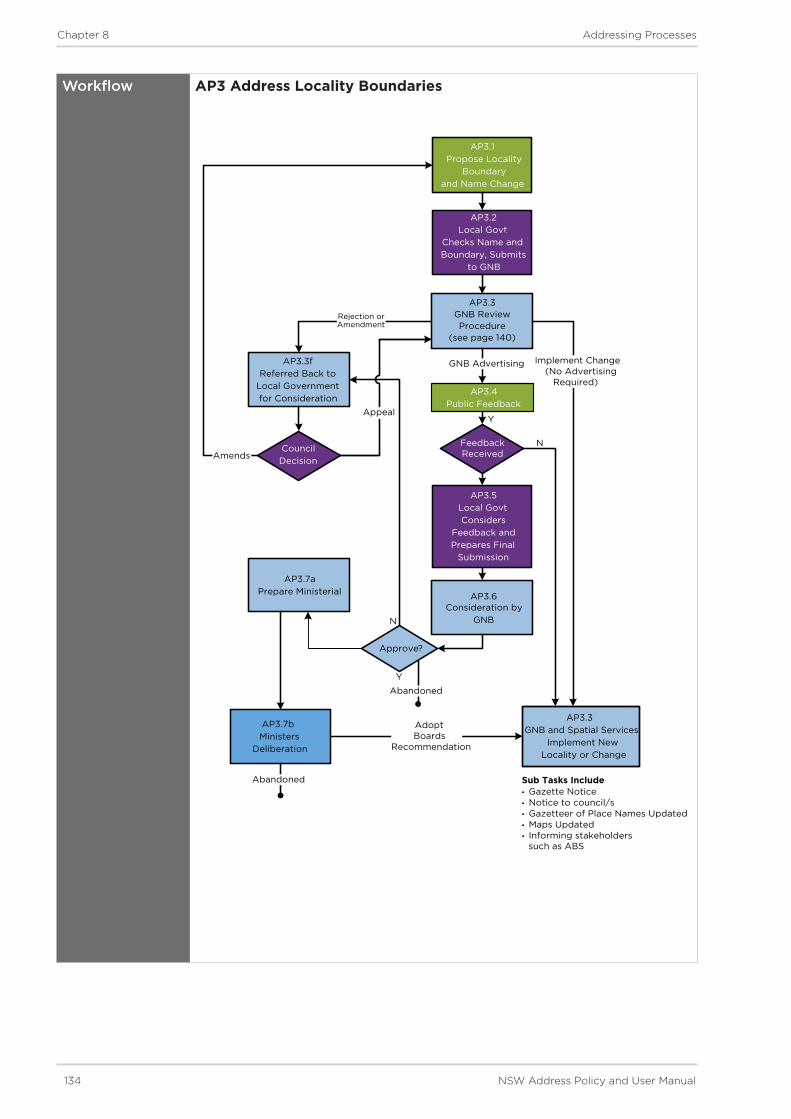
134 NSW Address Policy and User Manual
Chapter 8 Addressing Processes
Workflow AP3 Address Locality Boundaries
AP3.1Propose Locality
Boundaryand Name Change
AP3.2Local Govt.
Checks Name and Boundary, Submits
to GNB
Rejection or Amendment
Abandoned
Appeal
AP3.4Public Feedback
Amends
GNB AdvertisingAP3.3fReferred Back to
Local Government for Consideration
AP3.7bMinisters
Deliberation
Approve?
AP3.7aPrepare Ministerial
Council Decision
N
Y
Consideration by GNB
Implement Change(No Advertising
Required)
AdoptBoards
Recommendation
AP3.3GNB and Spatial Services
Implement New Locality or Change
Y
N
AP3 Locality Boundaries
Sub Tasks Include• Gazette Notice• Notice to council/s• Gazetteer of Place Names Updated• Maps Updated• Informing stakeholders such as ABS
Abandoned
AP3.3GNB ReviewProcedure
(see page 140)
AP3.6
AP3.5Local Govt. Considers
Feedback and Prepares Final
Submission
FeedbackReceived
Y
N

NSW Address Policy and User Manual 135
Chapter 8 Addressing Processes
Tasks AP3 Address Locality Boundaries
AP3.1 Propose Address Locality Boundary and Name Changes
AP3.2 Local Government Checks Name and Boundary, Submits to GNB
AP3.3 GNB Review Procedure
AP3.4 Public Feedback
AP3.5 Local Government Considers Feedback and Prepares Final Submission
AP3.6 Consideration by GNB
AP3.7 Refer to Minister
AP3.8 Implement New Address Locality or Change

136 NSW Address Policy and User Manual
Chapter 8 Addressing Processes
AP3.1
ProposeAddress Locality Boundary and/or Name Change
Where a member of the public or a Local Government wish to generate a proposal, it must include reference to the exact boundaries being considered for the new or amended address locality. Where the proposal is for an amendment to an existing name, the proposal must indicate the current boundaries of the address locality.
Extents should be defined on a clear and current map (electronic or paper) prior to proceeding to Task AP3.2 - Local Government Checks. The map should also define the existing boundaries and note any areas where existing addresses are likely to be affected.
Address locality boundaries must conform to Principles outlined in AUM Chapter 6, Section 6.8 - Address Locality Naming and Boundaries.
AP3.2
Local Government Checks Name and Boundary for Compliance then Submits to GNB
Where a new address locality is being created, or an amendment to an existing name is being proposed, the general principles for selecting a name as set out in AUM Chapter 6 - Principles must be considered and applied.
Once a name, or group of names, has been selected for a proposal, they need to be checked for conformance against the policy and principles outlined in AUM Chapters 2 and 6.
If in the process of checking for duplication and conformance with the policy and principles, a proposal is found to not conform, then alternative options need to be considered.
If the proposal conforms to all requirements members of the public or the Local Government should submit the proposal to the GNB and proceed to Task AP3.3 - GNB Review Procedure.
AP3.3
GNB Review Procedure
AP3.3 GNB Review Procedure
Submission from a
Local Government
AP3.3dEndorsed?
N
Y
-<10 lots-AP3.3
GNB’s Review Procedure
AP3.3aSecretariat Considers
AP3.3bGNB Delegates
Task to Secretariat
AP3.3cGNB
Considers
AP3.3e GNB Advertising
AP3.3fReferred Back to
Local Government for Consideration
Implement Change(No Advertising Required)
AP3.3 GNB Review Procedure
Y
10≤ parcels or owners/occupiers ≤20
>20 parcels or owners/occupiers
>10 parcels or owners/occupiers

NSW Address Policy and User Manual 137
Chapter 8 Addressing Processes
AP3.3 (Cont.)
GNB Review Procedure
For boundary adjustment a graduated approval procedure is applicable. The Sub Tasks are:
AP3.3a Secretariat Considers - Less than 10 parcels or owners/occupiers affected - Delegated Authority for Secretary’s Approval. No advertising is required for this proposal subject to all parties being in agreement and the proposal having the full support of the Local Government. Skip to Task AP3.6 - Consideration by GNB.
AP3.3b GNB Delegates Task to Secretariat - 10 to 20 parcels or owners/occupiers affected - Secretary can seek GNB agreement to delegate the approval to them and undertake as an administrative process (i.e. without advertising required). No advertising is required for this proposal subject to all parties being in agreement and the proposal having the full support of the Local Government. Skip to Task AP3.6- Consideration by GNB.
AP3.3c GNB Considers - 20 or more parcels or owners/occupiers affected - GNB approval will be required and the Secretariat will organise advertising.
For re-naming address localities or creating a new address locality these proposals must also go before the GNB for its consideration.
AP3.3d Endorsed - If deemed suitable, the proposal will proceed to Task 3.3e - GNB Advertising. However, if the proposal does not require advertising the GNB Secretariat will approve the proposal and skip to Task AP3.7 - GNB or Spatial Services implement.
AP3.3e GNB Advertising - Where the proposal requires advertising the GNB Secretariat will proceed to advertise the proposal in a local newspaper and the NSW Government Gazette. They will also notify the Local Government of the endorsed proposal and advise of the 30 day public feedback period (as per Procedure 7.1.4 - Advertising and Public Notices) and maps placed on public display. This notice will also be sent to all subscribers.
AP3.3f Referred Back to Local Government for Consideration - If not deemed suitable, the proposal will be referred back to Local Government for its consideration. As per Procedure 7.1.3 - Consulting on a Proposal, Local Government can amend or abandon the proposal or seek an appeal to the GNB.
AP3.4
Public Feedback
Public feedback, where required, will be sought for 30 days from the date at which the advertisement appears in the local newspaper, or in the Government Gazette (whichever is the latter - as per Procedure 7.1.4 - Advertising and Public Notices).
AP3.5
Local Government Considers Feedback and Prepares Final Submission
Once the public feedback period has closed, the GNB Secretariat will collate the information and Local Government will be required to assess the feedback received.
Procedure as defined in Procedure 7.1.5 - Submissions shall be followed.
Once feedback has been considered by Local Government, a final submission to the GNB can be made by following Procedure 7.1.3 - Consulting on a Proposal.

138 NSW Address Policy and User Manual
Chapter 8 Addressing Processes
AP3.6
Consideration by GNB
The proposal can be approved, referred back to the Local Government for further information or rejected at this stage.
Where a proposal is to create a new address locality or undertake a boundary and/or name amendment which will affect more than 20 parcels or owners/occupiers, it will be instantly referred to the GNB for its final consideration.
If the proposal affects between 10-20 parcels or owners/occupiers, the proposal will be referred to the GNB to decide if the Secretariat can be delegated the proposal for consideration.
Proposals affecting less than 10 parcels or owners/occupiers will be considered by the Secretariat.
If a proposal to amend a name or boundary is rejected by the GNB Secretariat and a Local Government still feels there are grounds for GNB consideration the Local Government can appeal the decision to the GNB.
AP3.7
Refer to Minister
Where a proposal was considered and approved by the GNB, and objections received, a submission must be made to the Minister for the Act seeking their approval.
Ministerial submissions must be prepared in the manner prescribed by the Ministers office explaining the justification for the proposed name(s) and how the name(s) complies to the NSW Address Policy. The Minister may support or dismiss the proposal submitted by the GNB.
AP3.8
Implement New Address Locality or Change
Where a proposal is approved by the Secretariat (and does not require GNB or Ministerial notification) they must inform government agencies.
If a proposal has been approved by the Minister, a notification and gazettal process can be implemented. Refer to Procedure 7.2.2 - Gazettal of Road Names and Address Locality Boundaries.

NSW Address Policy and User Manual 139
Chapter 8 Addressing Processes
Process AP4: Addressing – Adding or Amending Addresses where Road Name Exists
Overview Occasionally there will be a requirement to notify Spatial Services of new addresses for the NSW Address Database outside of the subdivision process.
This process applies where changes to existing addresses are required, minor additions are being made to the existing address network, addresses which currently exist are required to be registered for the first time or modifications are required to existing addresses.
An example of activities that generate address changes for this procedure are building developments over existing lots. These building developments may be small or large and may, or may not, require a DA but they don’t involve land tenure changes.
For this process road names are assumed to be existing as either gazetted, registered or known names. For the process of gazetting road names refer to Process AP1 - Road Naming/Renaming - Local Government.
Procedures that inform this Process
Procedure 7.4 - Signage
Responsibility Local Government
GNB
Spatial Services
Workflow AP4 Addressing - Adding or Amending Addresses where Road Names ExistAP4 Addressing - Adding or Amending Addresses
where Road Name Exists
Local Government Address Process
AP4.1Local Government
Develops Addressing Request
Suitable Request
AP4.2Submit Request to
Spatial ServicesEndorsed
Submission
Update Notification
AP4.5Agency and Commercial
Address Maintenance Procedures
Spatial Services
AP4.6Spatial Services
Data Quality Improvement Projects
and Programs
AP4.3Assessment and
Verification of Request
AP4.4Integration/Implementation
of Address Updates
Anomaly Reports
Update Instruction

140 NSW Address Policy and User Manual
Chapter 8 Addressing Processes
Tasks AP4 Addressing - Adding or Amending Addresses where Road Name Exists
AP4.1 Local Government Develops Addressing Request
AP4.2 Submit request to Spatial Services
AP4.3 Assessment and Verification of Request
AP4.4 Integration/Implementation of Address Updates
AP4.5 Agency and Commercial Address Maintenance Procedures
AP4.6 Spatial Services Data Quality Improvement Projects and Programs

NSW Address Policy and User Manual 141
Chapter 8 Addressing Processes
AP4.1
Local Government Develop Addressing Request
Defining Extent
A proposal must include reference to the location of the address points (if they exist currently) and the name of the address locality in which the address(es) is/will be located.
Points and extents should be defined on a clear and current map (electronic or paper) prior to proceeding to Task AP4.2 - Submit Request to Spatial Services. For details of address number allocation and geocoding applicants should refer to AUM Chapter 6 - Addressing Principles.
Selecting Address Number(s)
The general principles for selecting a name and applying address numbers as set out in AUM Chapter 6 must be considered.
If a request is initiated by a non-Local Government authority, the proposal shall be submitted to the Local Government for its assessment prior to submission to Spatial Services.
Additional expertise is available to Local Government when determining whether a proposed address is suitable and conforms to the policies and principles for addressing in NSW. Refer to Procedure 7.3.4 - Suitability Advice for details.
AP4.2
Submit Request to Spatial Services
Once the proposal is assessed as suitable and conforming to the policy and principles the Local Government need to ratify the proposal and either endorse it for submission to Spatial Services, or discard/amend it.
Refer to Procedure 7.1.5 - Submissions for details of in-house authorisation required before a proposal can be submitted.
AP4.3
Assessment and Verification of Request
If deemed suitable, Spatial Services will approve the address proposal which then triggers three actions, as described in Task AP4.4 - Integration/Implementation of Address Updates.
If any queries arise, the proposal will be referred to the Local Government for clarification.
AP4.4
Integration/ Implementation of Address Updates
Once a proposal has been approved by Spatial Services it is able to be updated in Spatial Services systems and the NSW Address Database.
Spatial Services will inform Local Government of the updates made in the NSW Address Database.
Requirements for updating the database will conform with the NSW Address Policy.
AP4.5
Agency and Commercial Address Maintenance Procedures
For external agencies and enterprises there are considerable automated and manual tasks required to fully implement the address changes within their existing systems. This could involve rematching of new addresses to existing records or creating new records. This should be part of normal maintenance tasks.
As per Procedure 7.4 - Signage, where required, signage should be installed within 30 working days of the addressing approval being notified to the Local Government.

142 NSW Address Policy and User Manual
Chapter 8 Addressing Processes
AP4.6
Spatial Services Data Quality Improvement Projects and Programs
Spatial Services has specific and general work programs to upgrade the quality of the address with the goal of achieving Authoritative Addresses (as described in NSW Address Policy). Data scrubbing and reporting are conducted to identify addresses that are missing, incomplete, inaccurate, duplications or contain erroneous attributes.

NSW Address Policy and User Manual 143
Chapter 8 Addressing Processes
Process AP5: Addressing – Development and Subdivision
Overview The planning, construction and development process involves many organisations and pieces of legislation to enable the creation of new property titles in NSW.
The process tasks defined outline the end-to-end requirements of the development and subdivision processes, using either e-Plan or traditional methods [manual lodgment over the counter] for communicating with Spatial Services.
The process elaborates on the legislative requirements for planning purposes, but also includes tasks specifically relevant to addressing.
The process encourages the capture of an authoritative address as early as possible in the development process to maximise benefits from use of the NSW Address Database.
There is considerable variation in the size and implementation of developments and the process is indicative of where the address activities could and should occur - however each development will have to determine what can be achieved within its given parameters.
The process can cover both subdivision developments and building developments that are undertaken under the formal Development Application process that is managed by Local Government.
Tasks 5.1 - 5.5 specifically cover developments that do not require the submission of a DA to Spatial Services.
The process can cover the scenarios of developments both with and without new roads. For building developments the new roads will be internal private roads.
If there are no roads being created, the road naming tasks are not required to be completed and can be omitted.
Where parks or reserves are being planned for a development area, the developer should refer to the GNB Guidelines for the naming of these geographical features.
Local Government has a key role in the allocation and approval of appropriate addresses to support developments. They are the primary contact point for addressing and they, in cooperation with Spatial Services, will create authoritative addresses in accordance with NSW legislation, Australian Standards and the NSW Address Policy. Local Government procedures and policies and may vary and so will the time taken to approve and create addresses. Developers should consult with Local Government early and often to ensure their projects are not delayed or interrupted in getting the essential addressing tasks completed.
Procedures that inform this Process
Procedures 7.1 - ConsultationProcedures 7.2 - NotificationsProcedures 7.3 - Reservations and Pre-ApprovalsProcedures 7.4 - Signage
Responsibility DevelopersSurveyorsPlanning ConsultantsLocal GovernmentGNBSpatial Services

144 NSW Address Policy and User Manual
Chapter 8 Addressing Processes
Workflow AP5 Addressing - Development and Subdivision
AP5.8Issue of Gazettal
Notice
Address for New Lots
Concept Plans
ConformingNames
AP5.2 Pre-DA
Consultation with Local
Government
Local Government Requirements
DA Determination
AP5.1 Development Proposal and
Reserving Road Names
AP5.3Development Application
Process
AP5.4 Prepare Specs
and Engage Contractors
AP5.7Surveyors
Validate ePlan and Lodge
Survey DP/SP
CAD/GIS Survey Data
AP5 Addressing – Developmentand Subdivision
Includes Info on Address PolicySpecific Address requirementsDA Information sheetsDA GuidelinesDA Checklists
Includes pre-approval of addresses
Pro
po
sed
Nam
esR
eser
ved
Nam
esP
re-A
pp
rove
dA
dd
ress
End
ors
edA
dd
ress
Ap
pro
ved
Ad
dre
ssG
azet
ted
Nam
es
AP5.6 Conduct
Cadastral Survey Work
Subdivision Engineering Works Completed
AP5.5 Finalise a Building
Development
ConstructionComplete

NSW Address Policy and User Manual 145
Chapter 8 Addressing Processes
Tasks AP5 Addressing - Development and Subdivision
AP5.1 Development Proposal and Reserving Road Names
AP5.2 Pre-DA Consultation with Local Government
AP5.3 Development Application Process
AP5.4 Finalise a Building Development
AP5.6 Conduct Cadastral Survey Work
AP5.7 Surveyors Validate e-Plan and Lodge DP/SP
AP5.8 Issue of Gazettal Notice

146 NSW Address Policy and User Manual
Chapter 8 Addressing Processes
AP5.1
Development Proposal and Reserving Road Names
Once a basic concept plan has been formed, the developer will prepare a project brief and select a planning company to flesh out the proposal and negotiate the DA approval process.
At this concept plan phase the principles of addressing should be considered and a request can be made to the Local Government to reserve any potential road names the developer might be considering. This procedure is managed by Local Government as provided in Procedure 7.3.2 - Reservation of Road Names.
AP5.2
Pre-DA Consultation with Local Government
The aim of including a Pre-DA Consultation step is to resolve issues ‘up front’ and to ensure that applications, when lodged, contain all necessary information so as to enable a prompt decision on the proposal.
The nature and extent of the pre-DA Consultation will vary with different Local Governments and for different developments with varying scale and type. There is a correlation between the scale of a development and the need and degree of consultation required. A Development Assessment Panel (DAP) or Pre-Development Unit or officer should, where possible, be available for pre-DA consultation and advice.
The service offered by Local Government is generally optional and may involve fees. Development Application Kits, often in the form suite of documents that provides a series of information sheets, should refer applicants to the NSW Address Policy and User Manual - and also include reference to any Local Government-specific addressing rules.
The concept plans that are used during the Pre-DA Consultation should show the road names (and perhaps, but not mandatorily, their type) that have been checked (and potentially pre-approved by the GNB for Local Government) for that development.
Local Government should have on its Pre-DA Consultation checklist a step to verify if pre-approved names have been used and should check that all names comply with any of its own internal addressing policies and the policy and principles of the AUM.
It would be preferable if a Local Government representative was included in the Pre-DA Consultation to explain or clarify the addressing requirements and conditions. Spatial Services are also available to assist Local Government in assigning and authorising address names and numbers - refer to Procedure 7.3.4 - Suitability Advice.
Where it is identified that a current address locality boundary dissects the proposed development area, or the boundaries might need to be amended, the Local Government should take this into account and be prepared to submit a address locality boundary change proposal to the GNB later in this process (see Task AP5.6). Refer to AP3 - Address Locality Boundaries for details.
AP5.3
Development Application Process
There is an increasing trend to use external certifiers and this may affect when Local Government receives detailed information for a particular development. Local Government still need to validate the developments address requirements and then submit details to Spatial Services as necessary for that development.
As part of this task, various sub-tasks have been identified. They are defined on the workflow diagram below and described in the following sections.

NSW Address Policy and User Manual 147
Chapter 8 Addressing Processes
AP5.3 Development Application Process
Tasks AP5.3 Development Application Process
AP5.3a Prepare Development Application
AP5.3b Lodge DA with Local Government
AP5.3c Assessment by Local Government and Referral Bodies
AP5.3d Review DA Addresses and Prepare Submission for Preapproval
AP5.3e Spatial Services or Secretariat Returns Proposal to Local Government
AP5.3f Detailed Consideration and issue DA Determination
Board Address Pre-approved?
CouncilAppeal-
Report onUnsuitable Addressing
AP5.3cAssessment by
Local Government and Referral
Bodies
DA Road NameProposal
DA in Local Government’s
format
Y
Approvals & Conditions
Submission -
-
Mandatory Address Information
LocalityRoad Name
AP5.3 Development Application Process
AP5.3dReview DA
Addresses and Prepare
Submission for Preapproval
AP5.3eGNB or Secretariat
Considers Preapproval
AP5.3fDetailed
Consideration and issue DA
Determination
AP5.3bLodge DA with
Local Government
AP5.3aPrepare
Development Application
Res
erve
dR
oad
Nam
esP
re-A
pp
rove
dR
oad
Nam
es
Pre
-Ap
pro
ved
Ad
dre
ss N
umb
ers
Pro
po
sed
Ad
dre
ss N
umb
ers
Desirable InformationRoad Type, ExtentAddress Number for parcelGeocode

148 NSW Address Policy and User Manual
Chapter 8 Addressing Processes
AP5.3a
Prepare Development Application
After receiving direction from the Pre-DA Consultation the Planning Consultant will continue the process of documenting the DA. As the Planning Consultant refines the concept plans and adds more details they need to ensure the wayfinding and addressing continues to achieve best practice levels.
The DA should include all road naming (that has been checked by LG) and addressing that complies with Local Government Addressing Policy (where relevant/available) and the NSW Address Policy.
By this stage the DA proposal subdivision plans should include:
• the address locality
• Local Government checked (and where relevant ‘reserved’ status) road names
• lot numbers and
• proposed street address numbers (not mandatory at this stage, but it is preferred).
AP5.3b
Lodge DA with Local Government
This task is based on Environmental Planning and Assessment Act 1979 Section 78A.
The mode of lodgment and process will vary with different Local Governments and also change to suit the scale and type of development. Joint lodgment of DAs and Construction Certificates (CC) is an option offered by some Local Governments which has advantages for various developments.
It is also possible that developments can cross Local Government boundaries and even state boundaries. Agreement needs to be negotiated between all stakeholders on how these development projects will be handled. This includes the ongoing servicing and maintenance of the development once completed.
The receiving officer checklist should include a check that plans include address information as indicated in Task AP5.3a - Prepare DA. It should be noted that the address shown on the concept plans only has a ‘proposed’ status at this DA stage and can potentially change during the development process.
AP5.3c
Initial Assessment by Local Government, Referral Bodies and Public Notification
This task is based on Environmental Planning and Assessment Act 1979 Sections 79, 79A and 96 and EP&A Regulation Clause 54 and contains various sub-tasks.
i) Initial Assessment of DAs This task involves initial assessment of DAs lodged with Local Government, instigation of referral procedures and potential to require additional information on a proposed development from an applicant. Assessment options for Local Government include:
• A Development Assessment Panel (DAP).
• A single senior officer e.g. a ‘Quality Applications Officer’.
• Frequent Application Review/Allocation Meetings.
Due to the subsequent Public Notification and Consultation tasks, Local Government should give consideration to making preliminary checks on addressing elements contained in a DA to ensure the plans are ready for public comment.
ii) Notification and/or ConsultationFollowing the completion of the initial assessment and receiving additional information the separate Notification and/or Consultation process can commence in accordance with the Local Government’s Notification Policy.

NSW Address Policy and User Manual 149
Chapter 8 Addressing Processes
AP5.3c (Cont.)
Initial Assessment by Local Government, Referral Bodies and Public Notification
Consultation
Weekly lists of DAs received are produced for notice in local newspaper and advice to Councillors. The Public notification/consultation procedures advise interested parties of how they can make a submission. This task is based on Environmental Planning and Assessment Act 1979 Section 79B.
External Notification
This task is a statutory-required consultation with external bodies, generally for concurrence or integrated development, and internal referrals for specialised advice from within Local Government.
The list of notified agencies (specified in Section 91 of the EP&A Act) seeks comment on DAs via referral to outside organisations, such as State Government departments. If advice from referred authorities is not received within 21 days, the Local Government can determine the DA.
The list of notifiable agencies for Integrated Developments includes:
• Department of Water and Energy
• Sydney Water for service availability
• Police for safety considerations
• Environmental Protection Agency
• Mines
• Roads and Maritime Services
• Department of Fisheries
• National Parks and Wildlife Services
• NSW Heritage
• Department of Infrastructure, Planning and Natural Resources
• Department of Housing
• Rural Fire Service
These agencies are responsible, to varying degrees, for the legislation listed as relevant to s.91 of the EP&A Act.
GNB Notification
At present the GNB is not formally included in Local Government referral lists for DAs. However, this process strongly recommends that at this stage in the consultation process, Local Government should include consultation with the GNB so that new road names can be captured for the NSW Address Database and pre-approved (refer to Procedure 7.3.3 - Pre-Approval).

150 NSW Address Policy and User Manual
Chapter 8 Addressing Processes
AP5.3d
Review DA Addresses and Prepare Submission for Preapproval
Internal Local Government Review of DA Addressing
Delegation of responsibilities for road naming and addressing are often applied to different internal departments within Local Government. The endorsement process for road naming and addressing can therefore vary from Local Government to Local Government.
The DA should be provided to the department/s responsible for road naming and addressing so that they may assess DA proposal.
Assessment of the proposal should consider how the numbering (if available), naming and address locality boundaries conform to the Principles outlined in AUM Chapter 6 and whether any procedural information needs to be considered (i.e. consultation).
Subdivisions can lead to a change in land use from rural to urban and often require adjustment to the address locality boundaries to create suburban areas. Main road construction or realignments present the major opportunity form new address locality boundaries. The Address Assessment should consider boundary changes and when required should action this in cooperation with the GNB - refer to AP3 - Address Locality Boundaries.
At this stage Local Government should, if necessary, issue directions on road layout, signage and addressing to make the subdivision easily navigable and houses easily located.
If not previously undertaken, the proposal can now be formally submitted to Spatial Services for its consideration and potential pre-approval - refer to Procedure 7.3.3 - Pre-Approval.
AP5.3e
Spatial Services or GNB Secretariat Considers Pre-Approval Proposal
Consideration by Spatial Services or GNB Secretariat
Where a proposal includes only road or address locality name/boundary proposals at this stage, the details will be referred to the GNB Secretariat for its consideration. The Secretariat has delegated authority to consider and approve proposals where they are straightforward and conform to the NSW Address Policy.
If deemed suitable, the GNB Secretariat will pre-approve the road naming proposal and set into action AP3 - Address Locality Boundary. Pre-approval means that the road name status will be updated in the NSW Online Road Naming System (NORNS) and reserved for use until such time as the plan is lodged. If a proposed road name or address locality name/boundary proposal is deemed unsuitable, the GNB Secretariat will refer the proposal back to the Local Government for amendment. Local Government can amend the proposal or appeal to the GNB directly.
Where a proposal includes address numbers the Spatial Services Addressing Program will consider these and liaise with Local Government where further details or amendments might be required.

NSW Address Policy and User Manual 151
Chapter 8 Addressing Processes
AP5.3f
Detailed Consideration and issue DA Determination
This task represents the culmination of the Local Government consultation process and it includes preparation of a response to the DA submission. It is based on Environmental Planning and Assessment Act 1979 sections 79c, 80A and 81.
‘Standard’ conditions of consent should be prepared, with variations/additions as required for the application.
Conditions of consent should include reference to any address components which require amendment and be categorised in terms of:
• General terms of approval from integrated approval bodies (e.g. authorisation under Section 100B of the Rural Fires Act 1997 from the Commissioner of the NSW Rural Fire Service).
• Terms of approval from concurrence bodies, including requirement for other (non-integrated development) approvals (e.g. Waterways Authority under s 13TA of the Maritime Services Act 1935).
Persons who made a submission on a development application are advised of the decision, including:
• Conditions of any consent.
• Reasons for any refusal.
• Rights and limitations for any appeal and judicial review.
Public notice of determination of application are usually given in a local newspaper and Minutes of Local Government panel/committee/meeting that made decision publicly available e.g. on Local Government website.
AP5.4
Prepare Specifications and Engage Contractors
During the construction phase the developer will appoint a project manager who, will take into consideration:
• the DA submission and the supporting documentation
• the DA Determination and conditions
• the original project brief and scope
• relevant legislation, policies, guidelines, standards and specifications
• the Construction Certificate if approved or alternatively submit application with support of contractors.
The developer/project manager is required to ensure all Development Consent conditions have been addressed, all Construction Certificate approved works are completed and all Compliance Certificates from certifiers are submitted.

152 NSW Address Policy and User Manual
Chapter 8 Addressing Processes
AP5.5
Finalise a Building Development
Building developments do not create new titles but they can create sites that need addressing. This task involves the finalisation of the DA process for a building development rather than a land subdivision development. The subdivision DA process continues on a different path with the submission of a survey to create title (for the DA process - where Local Government would like to formalise the addresses early, they can submit the information to Spatial Services now, or can proceed to task AP5.6 - Conduct Cadastral Survey Work).
At the conclusion of the building construction phase the developer must submit to the Local Government completion certificates stating compliance with the DA Conditions. The Local Government can then grant occupancy licences. Included in the documents that the Developer must submit to Local Government is an ‘as built plan’ or ‘linen plan’ for processing. Optimally Local Government would already have preapproved the addresses but the as-built plan would include any minor construction changes. At this point Local Government must ensure:
• road extents are determined (refer to AUM Chapter 6 - Addressing Principle 6.7.7 - Road Extents)
• road name and road types are allocated to plans (ensuring conformance with principles contained in AUM Chapter 6)
• address numbers are assigned (ensuring conformance with principles contained in AUM Chapter 6 - Sections 6.1 to 6.6)
• addresses are appropriately identified and allocated in accordance with the policy outlined in AUM Chapter 2.
This information shall be provided by Local Government to the Spatial Services for updating in the NSW Address Database.

NSW Address Policy and User Manual 153
Chapter 8 Addressing Processes
AP5.6
Conduct Cadastral Survey Work
The surveyor will commence finalisation of the land parcel boundary pegging once the engineering ground works nears completion. For strata subdivision developments this point is the completion of construction of the units. At this stage in the addressing process, the developer needs to ensure that:
• road extents are determined (refer to AUM Chapter 6 - Addressing Principle 6.7.7 - Road Extents)
• road name and road types are allocated to plans (ensuring conformance with principles contained in AUM Chapter 6)
• address numbers are assigned (ensuring conformance with principles contained in AUM Chapter 6 - Sections 6.1 to 6.6)
• addresses are appropriately identified and allocated in accordance with the policy outlined in AUM Chapter 2.
Conduct Cadastral Survey Work
Early in the construction phase the surveyor defined the subdivision site in their survey CAD package. The Planning Consultant’s proposed subdivision layout plan is overlaid to produce a best fit true dimension plan for consideration by the project manager and other contractors.
Major or minor boundary layout changes may be made throughout the construction phase due to the Conditions of Consent from the DA determination or due to engineering considerations.
The surveyor will add address locality, road names and addresses into their CAD package if or when they are available. The surveyor must ensure valid names and address are used on the final plans for the legal registration process.
Once the engineering ground works are complete the surveyor can undertake the final pegging and the lots are ready for sale.
The surveyor will give a final pegging certificate to the project manager.
Prepare Subdivision Documentation - Finalise and Validate Addresses
Once construction is complete, the Project Manager will make an application for a Subdivision Certificate from Local Government which requires all Development Consent conditions have been addressed, all Construction Certificate approved works are completed and all Compliance Certificates from certifiers submitted.
A registered surveyor must prepare the final plan of subdivision and, if relevant, prepare the 88B instrument. This plan will be signed by Local Government and is ready for lodgment at LRS - Titling and Registry Services.
At this stage the surveyor must ensure that on the plans:
• final road extents are determined - refer to AUM Chapter 6 - Principle 6.7.7 - Road Extents
• final road name and road types are allocated to plans (ensuring conformance with principles contained in AUM Chapter 6)
• final address numbers are assigned (ensuring conformance with principles contained in AUM Chapter 6 - Sections 6.1 to 6.6)
• addresses are appropriately identified and allocated in accordance with the policy outlined in AUM Chapter 2.

154 NSW Address Policy and User Manual
Chapter 8 Addressing Processes
AP5.6 Cont.
Conduct Cadastral Survey Work
The Local Government process for signing the final plan of subdivision should include the validation of the official site numbers for address. These numbers should have been issued by the Local Government earlier in the development process.
The Local Government must check the subdivision plan and where endorsed must ensure that address details are forwarded to Spatial Services. The details include:
• update to pre-approved road names, and provide explanations of why this has occurred
• update road extent details
• provide road types (if not previously provided)
• indicate address numbers for each road extent (which will be crossed referenced to the plans when deposited).
Where the Local Government identify issues with the propose numbers, road names or address localities, they should refer these issues to the surveyor/developer/Planning Consultant for amendment. Subdivisions can lead to a change in land use from rural to urban and often require adjustment to the address locality boundaries to create suburban areas. Main road construction or realignments present the major opportunity form new address locality boundaries. Local Government should have already amended the address locality boundary if necessary as an outcome of the Pre - DA Review or the DA Assessment. If this did not happen for any reason it should now be undertaken in cooperation with the GNB (refer to Process AP3 - Address Locality Boundaries).
AP5.7
Surveyors Validate ePlan and/or Lodge DP/SP
Once a Deposited Plan (DP) is formally lodged, a survey examination process validates the survey and the plan and any errors are assessed. The validation will check that each new Road Name and Type, and Address Locality Name and Boundary are valid against the NSW Address Database. Any discrepancies between the pre-approved names and those submitted on the plans are now flagged for the attention of Spatial Services.
The surveyor is required to correct any deficiencies in the Deposited Plan that are detected by LRS when examining the survey and then re-lodge the DP. This can incur additional fees and penalties.
AP5.8
Issue of Gazettal Notice
Upon receiving notice of the address approval, the Local Government needs to complete appropriate actions to incorporate the addresses in its systems and notify appropriate agencies and commercial bodies.
As per Procedure 7.4 - Signage should be installed within 30 working days of the name approval being notified.

NSW Address Policy and User Manual 155
Chapter 8 Addressing Processes
Process AP6: Addressing - DA Exempt Developments
Overview The process steps below outline the end-to-end requirements for developments that do not generally involve the DA process as some DAs are submitted under Part 4 of the EP&A Act.
DA Exempt Developments are usually large government initiatives intended to cut across established procedures to try to reduce time and costs to meet specific government objectives. The resulting developments are usually held under a single parent title or a small set of adjoining land titles on behalf of the Crown.
Applicants can be either Public or Private for:
• State Significant Developments (SSD) processed by Local Government under Part 4 of EP&A Act with flexibility to exceed local development standards. The Development Application process is used but exemptions and variations are possible to allow these developments to be built as they have a scale, significance or potential impact that makes them significant to a region or the State.
• State Significant Infrastructure (SSI) mainly public authorities constructing roads, railways or pipelines which don’t require consent but have significant environment impact (e.g. a port).
The naming and addressing of these developments will be significant and require early Local Government, Spatial Services and GNB input to ensure community expectations are met.
This process encourages the capture of an authoritative address as early in the development process as possible to maximise benefits from address use and reuse and to help avoid introduction of erroneous address data.
In addition to the planning controls of Local Government, the Department of Planning and Infrastructure is predominantly responsible for assessing planning applications under the State Significant Assessment System for projects whose size, complexity, importance or potential impacts mean they are of State, rather than local or regional, significance. The aims of the State Environmental Planning Policy (SEPP) are as follows:
a) to identify development that is State significant
b) to identify development that is State significant infrastructure and critical State significant infrastructure
c) to confer functions on joint regional planning panels to determine development applications.
It is these SEPP developments that are generally exempt from Local Government DA processes that are the subject of this address process. The steps described below are to mitigate the lack of formally approval workflow that normally enables address allocation to be managed.
Procedures that inform this Process
Procedures 7.1 - Consultation
Procedures 7.2 - Notifications
Procedures 7.3 - Reservations and Pre-Approvals
Procedures 7.4 - Signage

156 NSW Address Policy and User Manual
Chapter 8 Addressing Processes
Responsibility Local Government
State Government Agency
GNB
Spatial Services
Workflow AP6 Addressing - DA Exempt Developments
Naming and Address
Requirements
AP6 DA Exempt DevelopmentsState Significant Assessment System – Development Application process
Concept Plans
Development Documentation
DGRApplication
AP6.1Development Identified as
potentially DA Exempt
AP6.2Prepare Application for
EnvironmentalAssessment requirements
AP6.9Prepare EnvironmentalImpact Statement (EIS)
(includes DGRs, Communityconsultation & EP&A Regs)
AP6.3Director-General Dept.
Planning and Infrastructure
Environmental Assessment requirements (DGR)
UnsuitableNames
AP6.4 Consult with the relevant
public authorities for input into the DGR
AP6.5 Consult with the Local
Govt(s) for input into DGRsincluding address
AP6.11SSI Construction Phase
AP6.10SSD DA prepared for
lodgement with Local Govt. under Part 4 of EP&A Act
DA
Res
erve
dR
oad
Nam
esP
re-A
pp
rove
dR
oad
Nam
es
Pre
-Ap
pro
ved
Ad
dre
ss N
umb
ers
Pro
po
sed
Ad
dre
ss N
º.
Pro
po
sed
Nam
esA
pp
rove
dA
dd
ress
Gaz
ette
dN
ames
End
ors
edA
dd
ress
Consultation
AP6.6Dept. Planning and
Infrastructure issue DGRsrelease for Public exhibition
≥ 30days
AP6.7Public’s Consideration
AP6.8Dept. Planning and
Infrastructure Finalises and Issues
DGRs
Advertising
Feedback
DGRs &Pre-approved
Addresses
AP6.12SSD Construction Phase
see AP5.3Development Application
Process
ValidationReport
see AP5.7Surveyors
Validate ePlan and/or Lodge
DP/SP
see AP5.8DP Examination
and Address Approval
see AP5.9Issue of Gazettal
Notice
ePlan Lodged Survey DP
Address for New Lots
CAD/GIS Survey Data
reviews application for

NSW Address Policy and User Manual 157
Chapter 8 Addressing Processes
Process tasks
AP6 Addressing - DA Exempt Developments
AP6.1 Development Identified as potentially DA Exempt
AP6.2 Prepare Application for Environmental Assessment requirements
AP6.3 Director-General Department of Planning and Infrastructure reviews application for Environmental Assessment requirements (DGR)
AP6.4 Consult with the relevant public authorities for input into the DGR
AP6.5 Consult with the Local Government(s) for input into DGRs including address
AP6.6-6.8 Department of Planning and Infrastructure issue DGRs release for Public exhibition ≥ 30days
AP6.9-6.12 Prepare Environmental Impact Statement (EIS)
AP6.13 Survey Lodgment and Road Name Gazettal
AP6.1
Development Identified as Potentially DA Exempt
Developers and Government Agencies will prepare concept plans and seek support and concept approval from Government for special development treatment due to exceptional circumstances. This can reduce development time and costs and is therefore carefully considered by government.
AP6.2
Prepare Application for Environmental Assessment requirements
Once the project’s feasibility has been determined concept plans are then used to develop the DGR Application for Environmental Assessment.
This application must address strict government requirements for development and should consider addressing requirements at this early stage. Where numbering, road naming or address locality name/boundary information is included in the preparations, reference should be made to the principles outlined in AUM Chapter 6 - Addressing Principles to ensure the addresses will conform to requirements of the NSW Address Policy.
AP6.3
Director-General Department of Planning and Infrastructure reviews application for Environmental Assessment requirements (DGR)
The Department of Planning and Infrastructure reviews DGR applications and consults with other government agencies to compile a DGR document to release for public comment.
This document should consider addressing requirements and any details included for numbering, road naming or address locality boundaries should comply with the principles outlined in AUM Chapter 6 - Addressing Principles.
158 NSW Address Policy and User Manual
Chapter 8 Addressing Processes
AP6.4
Consult with the relevant public authorities for input into the DGR
At this task, the Department of Planning and Infrastructure consults with the relevant public authorities for input into the DGR.
The consultation should consider addressing requirements and reference be made to Local Government requirements for numbering, road naming or address locality boundaries which should comply with the principles outlined in AUM Chapter 6 - Addressing Principles.
AP6.5
Consult with the Local Governments(s) for input into DGRs including address
Department of Planning and Infrastructure consults with the Local Government(s) for input into DGRs at this stage. The Local Government will consider various aspects regarding the impact of the proposed development on the community.
The Local Government should include in its consideration addressing issues and prepare a submission recommending what the development proposal needs to do to comply with the NSW Address Policy and any Local Government policies which are in force. This task should include the Local Government working with the Department of Planning and Infrastructure to reserve any road names with Spatial Services, where the information provided to Local Government has been assessed as conforming to the policies and principles outlined in AUM Chapters 2 and 6.
AP6.6 - AP6.8 Department of Planning and Infrastructure issue DGRs for public exhibition for up to 30 days.
The public is able to consider the DGR and prepare submissions.
Department of Planning and Infrastructure considers all the submissions before finalising the DGR and issuing it back to the developer.
AP6.9 - AP6.12 An Environmental Impact Statement is developed at this task, and lodged with the Local Government under Part 4 of the Environmental Protection and Assessment Act.
Following this the SSI and SSD construction phases commence.
During the SSD phase there is opportunity for the address information to be submitted to Spatial Services and details entered into the NSW Address Database. Refer to AP5.3 - Development Application Process for details.
AP6.13
Survey Lodgment and Road Name Gazettal
Following on from the Construction Phase are optional stages taken from the normal land development process that sees the preparation of Deposited Plans to initiate the creation of land titles and the gazettal of road names.
The tasks required to have addresses completed and included in the NSW Address Database are referred to in AP5 - Addressing - Development and Subdivision and should be followed here, in particular:
AP5.3 Development Application Process
AP5.7 Surveyors Validate e-Plan and Lodge DP/SP
AP5.8 DP Examination and Address Approval
AP5.9 Issue of Gazettal Notice

NSW Address Policy and User Manual 159
Chapter 8 Addressing Processes
Process AP7: Addressing - Public Housing [State Government Agencies]
Overview If Public Housing Superlots include named roads within the development then they shall be treated in the same manner as any other addressing. The road names shall be processed with the owner (NSW Land and Housing Corporation) via Local Government and dwellings/units etc numbered according to the requirements of the NSW Address Policy.
As a corporate entity of Housing NSW, the Land and Housing Corporation (LAHC) are exempt under the Housing Act and Environmental Planning and Assessment Act from conforming to regular planning and subdivision processes. LAHC exemptions were created similar to many government infrastructure initiatives to ensure government policy can be enacted for the benefit of the whole community.
The main outcome of an early consultation process between Local Government and LAHC is the decision on whether a Development Application (DA) process should be used or alternatively to determine whether LAHC is to utilise its exemptions under the Housing Act and the Environment and Planning Act and proceed without a DA to expedite the development.
The workflow described below covers the developments that do not go through the DA process.
Consultation between LAHC and Local Government shall occur in both superlot development and superlot redevelopment scenarios.
Procedures Sections that Govern this Process
Procedures 7.1 - Consultation
Procedures 7.2 - Notifications
Procedures 7.3 - Reservations and Pre-Approvals
Procedures 7.4 - Signage
Responsibility Land and Housing Corporation
Local Government
GNB
Spatial Services

160 NSW Address Policy and User Manual
Chapter 8 Addressing Processes
Workflow AP7 Addressing - Public Housing [State Government Agencies]
-
-
-
AP7 Public Housing
Concept
AP7.1Propose
development
AP7.2Scope and
prepare concept
AP7.4Early consultation pre-development
AP7.5Design Project
(site and buildings)
AP7.6Liaise on naming roads and seek pre-approval
AP7.7Local Government Submits Proposal to Spatial Services
AP7.8Project
Construction Phase
AP7.9Project Finalisation
Phase(including install road
name signage)
AP7.10Liaise on street
address and approval
AP7.11Local Govt.
Updates Address System and
Lodges Field Plan
AP7.12LRS Registers
Field Plan showing Address
AP7.13Validate site addressing
AP7.15Approval and
Gazettal action
AP7.14Local Govt endorses address
and notification to Authorities and Stakeholders
Project Complete
Invalid Addresses
Authroised Addresses
Address Proposal
Lodged FP
Site Plan
Authorised Addresses Field Plan
pre-approved addresses
Development Plans
Names Conform
Concept
Concept Plans
Project Brief Unsuitable Names
AP7.3Check and Reserve
Road NamesP
rop
ose
d
Nam
esR
eser
ved
Ro
ad N
ames
Pro
po
sed
A
dd
ress
No
.
Pre
-Ap
pro
ved
R
oad
Nam
esP
re-A
pp
rove
d
Ad
dre
ss N
umb
ers
End
ors
ed A
dd
ress
Ap
pro
ved
A
dd
ress
Gaz
ette
dN
ames
Checking shortlisted road names against Gazetteer, Principals & Procedures
Get help from Local Government & GNB - Procedure 13 Suitability Advice.
Includes

NSW Address Policy and User Manual 161
Chapter 8 Addressing Processes
Process Tasks AP7 Addressing - Public Housing [State Government Agencies]
AP7.1 Propose development
AP7.2 Scope and prepare concept
AP7.3 Check and Reserve Road Names
AP7.4 Early consultation pre-development
AP7.5 Design Project (site and buildings)
AP7.6 Liaise on naming roads and seek pre-approval
AP7.7 Local Government Submits Proposal to Spatial Services
AP7.8-7.9 Project Construction Phase
AP7.10 Liaise on street address and approval
AP7.11 Local Government Updates Address System and Lodges Field Plan
AP7.12 LRS Registers Field Plan showing Address
AP7.13 Validate site addressing
AP7.14 Local Government endorses address and notification to authorities and stakeholders
AP7.15 Approval and Gazettal action
AP7.1
Propose development
LAHC has a similar role to a commercial developer when developing a super lot for affordable and/or social housing.
After locating a new site or identifying an existing site for redevelopment, LAHC will undertake a needs analysis and site analysis before deciding on its options see Draft Urban Design Guidelines for Low Rise Affordable Rental Housing, Planning NSW, December 2010.
They will consult widely with the community, Local Government, developers, community housing providers and other Non Government Organisations. They will seek funding from various sources including government schemes, public private partnerships, shared equity and commercial financiers.
Once the basic concept has been formed, LAHC will document it as a project brief and select a developer, planner or builder company to flesh out the proposal.

162 NSW Address Policy and User Manual
Chapter 8 Addressing Processes
AP7.2
Scope and prepare concept
LAHC’s lead contractor/consultant will interpret the project brief and any published policies or guidelines (such as Draft Urban Design Guidelines for Low Rise Affordable Rental Housing) to produce a formal Concept Plan
The concept will quantify and qualify the extent of the development and enable an initial assessment of its impacts. The Planning Consultant will do sufficient research to determine the government limitations and restrictions that apply to the site and the proposed improvements.
The planning consultant needs to consider wayfinding as one of the design considerations for road layout, signage and addressing. They should particularly consider the principles contained in AUM Chapter 6 when conceptualising potential road names for the area to be developed.
The planning consultant might also wish to confirm with the Local Government whether a pre-defined set of reserved road names exists for the area in which the development is occurring. Refer to Procedure 7.3.2 - Reservation of Road Names for details.
LAHC will determine the road names prior to submitting to the Local Government for consideration and potential endorsement before supplying them to the GNB for reservation or pre-approval - refer Procedure 7.3.3 - Pre-Approval for details.
AP7.3
Check and Reserve Road Names
Once a name, or group of names, has been shortlisted for a concept plan, they need to be checked for conformance against the principles contained in AUM Chapter 6.
If in the process of for checking for duplication and conformance with the policy and principles of the AUM, a name is found to not conform then alternative options need to be considered by the planning consultant and/or LAHC.
Should the results delivered by the checking process be ambiguous, the Local Government can assist the developer and/or LAHC in defining a suitable plan for addressing. Where required, Local Government can refer the concept plans to the GNB Secretariat for consideration of suitability. Refer to Procedure 7.3.4 - Suitability Advice for details.
If the name conforms with all requirements LAHC can proceed to request that the Local Government reserve the names for future use (described as per Procedure 7.3.2 - Reservation of Road Names), but this is not mandatory.
AP7.4
Early consultation pre-development
A modification to the DA process is the use of a Joint Regional Planning Panel (JRPP). Regional Panels have been established to provide independent, merit-based decision-making on regionally significant development proposals. They consist of members appointed by State and Local Government. Developments are publicly notified and assessed by Local Government planning officers but the reports are referred to the Panel for determination.
If the DA or JRPP path is chosen, Process AP5 - Addressing Development and Subdivision should be utilised.
If the DA exemption path is selected - by this stage the concept plans that are used should show the road names (and perhaps, but not mandatorily, their type) that have been checked (and potentially reserved by Local Government via GNB) for that development.

NSW Address Policy and User Manual 163
Chapter 8 Addressing Processes
AP7.5
Design Project (site and buildings)
The Design Project phase involves many different professional and technical consultants and is much more involved than land subdivisions where a Planning Consultant and a civil engineer would do most of the work in this phase.
After receiving direction from the Local Government consultation in Task 7.4 - Early Consultation, LAHC will continue the process of documenting the development. LAHC should at this stage commence liaising with Local Government regarding address numbering.
LAHC will issue contracts as required to complete the Project Design and compile the documentation including project, building and site plans and specifications.
The major outcome of the design process is the project plans and specification that are used as the basis for issuing contracts for the next construction project phase.
AP7.6
Liaise on naming roads and seek pre-approval
As the authority for naming all roads for addressing purposes the project plans and specifications should be provided to the Local Government department(s) responsible for road naming and addressing so that they may assess the proposal.
Assessment of the proposal should consider how the numbering (if available), naming and address locality boundaries conform to the principles outlined in AUM Chapter 6 and whether any procedural information needs to be considered i.e. consultation.
At this stage Local Government should if necessary discuss any concerns with LAHC regarding road layout, signage and addressing.
AP7.7
Local Government Submits Proposal to Spatial Services
The proposal can now be formally submitted to Spatial Services for its consideration and potential pre-approval - refer to Procedure 7.3.3 Pre-Approval for details.
AP7.8 - AP7.9
Project Construction Phase
During this phase the project construction works will be completed and the project will near finalisation.

164 NSW Address Policy and User Manual
Chapter 8 Addressing Processes
AP7.10
Liaise on street address and approval
As the development design nears finalisation the LAHC and Local Government should liaise to discuss final road extent and design and allocation of address numbers.
If the surveyor has assigned the street address numbers in accordance with the NSW Address Policy, the Local Government task should be simply one of validation with LAHC.
At this stage the LAHC must ensure that on the development’s Site Plan/s:
• Final road extents are determined - refer to AUM Chapter 6 - Addressing Principle 6.7.7 - Road Extents.
• Final road name and road types are allocated to plans (ensuring conformance with principles contained in AUM Chapter 6.
• Final address numbers are assigned (ensuring conformance with principles contained in AUM Chapter 6 - Sections 6.1 to 6.6.
• Addresses are appropriately identified and allocated in accordance with the policy outlined in AUM Chapter 2.
AP7.11
Local Government Updates Address System and Lodges Field Plan
Once LAHC and the Local Government are able to endorse the Site or Field Plans (FP), Local Government must ensure that the details are updated in the NSW Address Database.
The Site Plan’s should be endorsed, signed and dated as valid by Local Government Officer responsible for addressing and the plan forwarded to Spatial Services.
AP7.12 LRS Registers Field Plan showing Address
The Site Plan is lodged at LRS for registration as a Field Plan and receives a FP prefixed sequential plan number and is subsequently scanned and catalogued in LRS’s system.
AP7.13
Validate site addressing
Spatial Services will check if the addresses are suitable and will issue advice where relevant.
AP7.14
Local Government endorses address and notification to authorities and stakeholders
The Local Government will be requested by Spatial Services to confirm the address details. Where relevant, procedures contained in Chapter 7 - Section 7.1 - Consultation will apply.
AP7.15
Approval and Gazettal action
Once road names have been approved by the GNB procedures outlined in Chapter 7 - Section 7.2 - Notifications will be followed to issue gazette notices and inform authorities.

Chapter 9
Retrospective Address Policy

166 NSW Address Policy and User Manual
Chapter 9 Retrospective Address Policy
9 Retrospective Address Policy
Whilst the AUM details policy and procedures for new address creation it does not adequately support process and policies for resolving retrospective issues that compromise the quality of New South Wales (NSW) address data.
This chapter details the policy that provides a consistent approach to the management of retrospective issues, which is an important component of improving the quality of address data within NSW.
The intention of this document is to outline a robust set of policies to assist stakeholders, including Local Government and State Government agencies to resolve existing problematic address issues.
These policies are applied on a case by case basis as retrospective issues are raised by interested stakeholders. This document does not apply to new addressing queries and applications – in which instances the policies, processes and procedures outlined in Chapters 1-8 of the AUM must be applied.
This document is intended to be updated as required when new issues are discovered or process options are available.
This document contains 20 retrospective policies grouped into the four categories of:
• Numbering
• Road Naming
• Address Localities
• Addressing

NSW Address Policy and User Manual 167
Chapter 9 Retrospective Address Policy
9.1 Retrospective Address Policies
9.1.1 Numbering Issues
Problem Description PolicyNon conformant numbering (including missing house numbers)
Frequently there are many roads which do not have numbers applied to sites for addressing purposes. In addition to this, there are many cases where the numbering which is applied is non-conformant to the requirements of the AUM and/or AS/NZS4819.
Numbering is to be applied to all sites requiring an address and where necessary, non conformant numbers be altered to meet the requirements of the AUM.
Ranged numbering
A typical example of numbering problems is the continued use of ranged numbers which can lead to confusion for users. The NSW Address Policy (AUM Chapter 6- Principle 6.2.1- Address Numbers) excludes the creation of any new ranged numbers in line with similar policy in AS/NZS 4819:2011 Rural and Urban Addressing.
Where necessary, ranged numbers are to be altered to either only the low number in the range, or the most logical based on the site access point.Other numbers to be retired from use.
Urban infill At urban infill sites generally there is a requirement to apply sub numbering or number suffixes to accommodate situations where there is a lack of whole numbering solutions available. In some situations this has created a problematic situation whereby irregular or inconsistent numbering has been applied to urban infill areas. For example, where 12, 12A and 12B are alongside 1/14, 2/14 and 14 on the one road.
Where necessary, consistent numbering is to be applied whereby sub-numbering elements are applied to sub-addresses only (i.e. those accessed from the one point on the road network) and suffixes used for addresses which have their own access to the road network. (Refer to Chapter 6: Addressing Principles)
Level numbering Often there have been inconsistencies in numbering of sites within multi-level buildings. While the hotel-style numbering method is now preferred (i.e. level number followed by office, apartment or shop number), previously other methods have been used where issues typically can involve:
• Numbering starting from basement levels (i.e. Basement Level 4 is labelled Level 1 and Ground level is labelled Level 5)
• Skipped numbers (typically 4 and 13)• Use of inconsistent or difficult to
interpret level numbers or letters
Where necessary, consistent numbering is to be applied whereby numbering starts at ground level, basement levels are identified as such, approved level indicators are used (as per the AUM) and level numbers are not skipped for individual preferences and to support emergency service delivery.
Unit type numbering
There are examples where a complex building site consists of multiple sites numbered 1 or 2, with only the unit type of office or apartment to distinguish between the sites. This leads to duplicated address numbering within the site.
Where necessary, consistent numbering is to be applied whereby any address which is duplicated without the use of a unit identifier (i.e. office or apartment) is to be renumbered.

168 NSW Address Policy and User Manual
Chapter 9 Retrospective Address Policy
9.1.2 Road Naming Issues
Problem Description PolicyRoad name duplication
There are many examples where a road name is duplicated within a address locality or within the radius defined in the AUM.
In some cases the duplication can be the same or similar spelling, and sometimes it might be similar sounding names. In other cases there might be a different road type assigned to the same name on an adjoining road.
For example, a Chiswick Lane coming off a Chiswick Road, with duplication of numbers and potential for confusion.
In cases of road name duplication, renaming shall only occur where a case can be made that service delivery has been/has potential to be negatively impacted by the situation.
Broken road segments
There are many situations where a road is broken into different sections as a result of traffic management changes, without consideration of naming, numbering and access for emergency services.
In some instances a road can be broken by a park, river, embankment or non-vehicular access path. This can cause many problems for navigation and routing to addresses along these roads.
In cases of broken road segments, renaming shall only occur where a case can be made that service delivery has been/has potential to be negatively impacted by the situation.
New Road Development Segments
When a road is deviated, particularly highways, the closed sections are frequently renamed with the name ‘Old’ in front of the original name.
There are sometimes more than one old section with duplication of the use of ‘Old’, and high potential for confused addresses in those areas.
In cases of new road developments, renaming shall only occur where a case can be made that service delivery has been/has potential to be negatively impacted by the situation.
Ungazetted road names
There exists a considerable amount of road names in NSW which are currently ungazetted. A common and frequent question asked at the addressing workshops in late 2014 came from Local Governments wondering what could be done to formalise and gazette these names- many of which have been in use for 50+ years.
Where necessary and feasible, bulk-gazettal of pre-existing road names shall be undertaken by Local Government with the assistance of the Geographical Names Board (GNB) Secretariat.
Names which are found to be non-conformant with the requirements of the AUM shall be assessed and renamed in accordance with the relevant retrospective policy (for example where a road name in a bulk gazettal is identified as a duplicate, the ‘road name duplication retrospective policy’ may be applied to resolving the issue).

NSW Address Policy and User Manual 169
Chapter 9 Retrospective Address Policy
Non- Local Government road names
There are a considerable amount of roads which are not managed or maintained by Local Government. These include those owned or maintained by State agencies including Crown Lands, Land and Housing Corporation and Roads and Maritime Services.
Historically it has been difficult for Spatial Services to obtain information regarding these names and the addresses applied to them. Under the AUM there is a requirement for these organisations to cooperate with Local Government to determine appropriate road names and have these proposed to the GNB for endorsement.
All roads containing addressable sites shall be named and have addresses applied, regardless of tenure or ownership.
Non-matching road names
Often there are cases where the names recorded in Spatial Services and Local Government datasets do not match (either minor spelling differences or completely different names). There can also be a difference between what is recorded in the databases and what appears on road signs at the location.
This causes problems for identification and should be resolved.
Where discrepancies exist between the records of a road name, the spelling which was first gazetted (with reference to any relevant erratum) shall be applied.
Where this is unable to be determined the name which is in most use by the residents and businesses on the road shall be used (provided it is conformant to the AUM, particularly with regard to spelling of commemorative names).

170 NSW Address Policy and User Manual
Chapter 9 Retrospective Address Policy
9.1.3 Address Locality Issues
Problem Description PolicyDuplicated address localities
There are multiple instances of duplicated address locality names across NSW. These cause confusion and in some cases also result in duplicated addresses occurring in NSW.
A list of duplicated address localities has been provided in the AUM and there is a requirement that any future road naming in these areas be checked for duplication in all the address localities with a similar name.
Duplicated address locality names shall be reduced wherever possible. Consideration to be given to renaming the address locality which has the least address sites or least historical connections for a community. Consideration should also be given to absorbing the areas into adjoining address localities.
Non-LGA Areas
There are areas of NSW which do not fall under Local Government jurisdiction - either for assignment of a address locality name or definition of the road names and address numbers.
Examples include areas north of Broken Hill, Lord Howe Island and islands in Sydney Harbour.
All sites requiring addresses shall have them applied by Local Government and/or a relevant authority endorsed by the GNB following the processes outlined in the AUM.
Boundary creep
Often in cases of urban greenfield growth, or where the name of a neighbouring address locality is perceived as ‘more prestigious’ it will be used by residents or businesses to identify the location of their address.
This is often also employed by real estate agents when marketing a property. This causes problems for official recognition of the authoritative address.
It is recognised that with changing demographics in various areas there will be ongoing need to redefine address locality boundaries to suit popular usage.
Where regular, consistent and non-conflicting use of a address locality name is identified beyond the original boundaries assigned, consideration should be given by the Local Government and GNB to changing the boundaries for the address locality.

NSW Address Policy and User Manual 171
Chapter 9 Retrospective Address Policy
9.1.4 Address Issues
Problem Description PolicyOpal fields There is a need to apply addresses in a non-
typical way for areas in the opal fields of NSWIt is recognised that sites in remote areas, such as opal fields, might not be catered for by traditional address systems. Spatial Services welcomes advice and suggestions from stakeholders who have potential solutions in this domain.
Non-property based
Occasionally there are leasehold properties with sites on them which require addresses- a situation currently not catered for by Spatial Services systems. Examples of this include National Parks, ski fields and Snowy River Scheme towns.
It is recognised that non-property based sites, including complexes, some islands and leaseholds, might not be catered for by Local Government address systems. In these instances the NSW Address Database should endeavour to capture, maintain and publish this data for users.
Sites with limited or no-access
There are existing sites where road access is not readily available and addresses might be required for identification, service delivery or management purposes. These sites are typically located in rural areas and may be private property or Crown lands and access is sometimes granted by a right-of-way or easement.
Where a site is not accessible by road access, an address shall be defined based on the most immediate point of access from the nearest roadway. Where appropriate, creation of a legal access road should be considered.
Duplicate addresses
There is always the likelihood of road names being similar in address localities with duplicate names. This leads to the potential for duplicate addresses to exist in NSW - with only the postcode (not an official or reliable address component) to distinguish them.
Duplicate addresses across NSW are to be resolved - either through renaming of roads or address localities. In these instances the preference is to rename the address locality before considering renaming the road.
Unnamed roads
Problems can arise where a road has been constructed but never named. Many examples of this exist in both rural and urban environments.
In rural areas these roads are generally recognised as access roads to properties or visitor sites.
In urban areas these roads might be alleyways at the back of properties.
As per the requirements of the AUM all roads shall be named, and the name gazetted, where sites are required to be addressed.
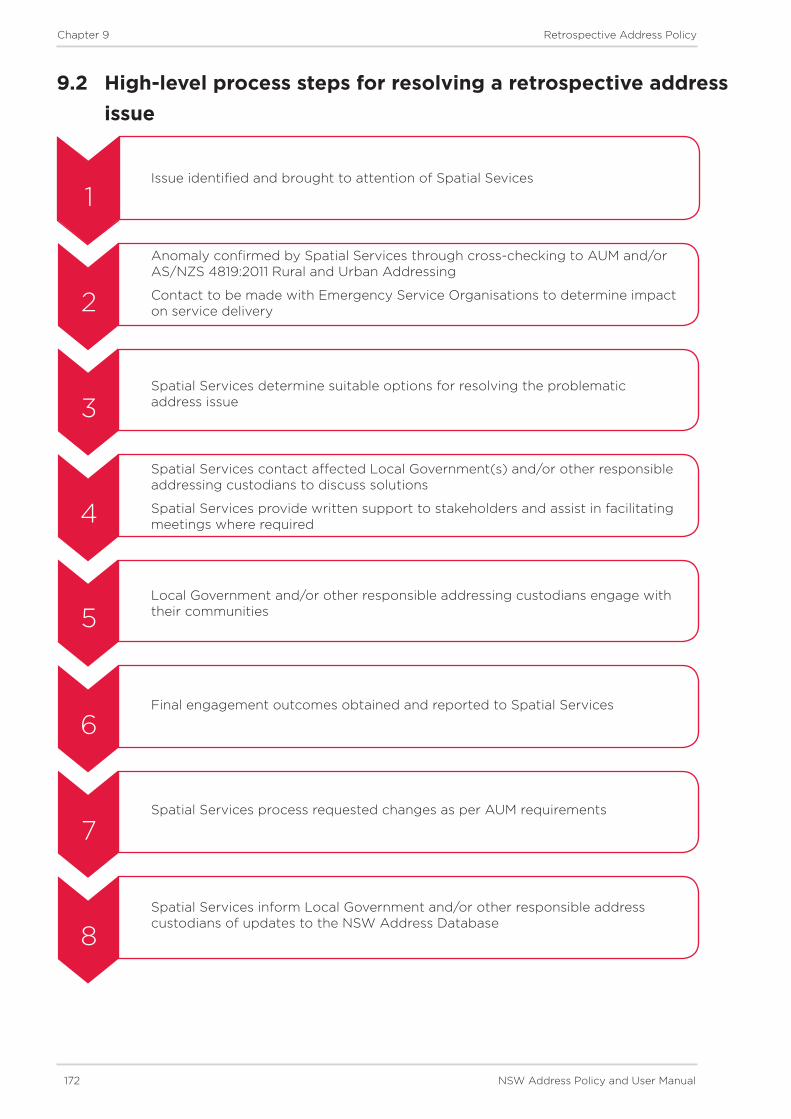
172 NSW Address Policy and User Manual
Chapter 9 Retrospective Address Policy
9.2 High-level process steps for resolving a retrospective address issue
Issue identified and brought to attention of Spatial Sevices
Anomaly confirmed by Spatial Services through cross-checking to AUM and/or AS/NZS 4819:2011 Rural and Urban Addressing
Contact to be made with Emergency Service Organisations to determine impact on service delivery
Spatial Services determine suitable options for resolving the problematic address issue
Spatial Services contact affected Local Government(s) and/or other responsible addressing custodians to discuss solutions
Spatial Services provide written support to stakeholders and assist in facilitating meetings where required
Local Government and/or other responsible addressing custodians engage with their communities
Final engagement outcomes obtained and reported to Spatial Services
Spatial Services process requested changes as per AUM requirements
Spatial Services inform Local Government and/or other responsible address custodians of updates to the NSW Address Database
1
2
3
4
5
6
7
8

Chapter 6 Addressing Principles
Appendix

174 NSW Address Policy and User Manual
Appendix A Duplicated Localities in NSW
Appendix A: Duplicated Localities in NSW
Locality Name Local Government AreaAlison Dungog
Alison Central Coast
Back Creek Bland
Back Creek Mid-Coast
Back Creek Gwydir
Back Creek Queanbeyan-Palerang Regional
Back Creek Tenterfield
Back Creek Tweed
Bakers Creek Mid-Coast
Bakers Creek Nambucca
Bakers Creek Uralla
Balmoral Lake Macquarie
Balmoral Wingecarribee
Barry Blayney
Barry Upper Hunter
Black Creek Port Macquarie - Hastings
Black Creek Snowy Valleys
Boat Harbour Lismore
Boat Harbour Port Stephens
Broadwater Bega Valley
Broadwater Lismore
Burra Queanbeyan-Palerang Regional
Burra Snowy Valleys
Cabbage Tree Island Ballina
Cabbage Tree Island Mid-Coast
Carrington Mid-Coast
Carrington Newcastle
Cedar Creek Cessnock
Cedar Creek Tweed
Colo Bathurst Regional
Colo Hawkesbury
Dalwood Ballina
Dalwood Singleton
Darlington Singleton
Darlington Sydney
Deep Creek Clarence Valley
Deep Creek Kempsey
Deep Creek Kyogle
Dural Hornsby
Dural Singleton
Elderslie Camden
Elderslie Singleton

NSW Address Policy and User Manual 175
Appendix A Duplicated Localities in NSW
Locality Name Local Government AreaEllerslie Snowy Valleys
Ellerslie Wentworth
Enmore Armidale Regional
Enmore Inner West
Glenroy Albury
Glenroy Snowy Valleys
Gowrie Singleton
Gowrie Tamworth Regional
Green Hills Armidale Regional
Green Hills Snowy Valleys
Green Point Central Coast
Green Point Mid-Coast
Greendale Bega Valley
Greendale Liverpool
Greenlands Snowy Monaro Regional
Greenlands Singleton
Hill Top Snowy Monaro Regional
Hill Top Wingecarribee
Hillgrove Armidale Regional
Hillgrove Wagga Wagga
Hillsborough Lake Macquarie
Hillsborough Maitland
Huntley Orange
Huntley Wollongong
Kings Plains Blayney
Kings Plains Inverell
Kingswood Bega Valley
Kingswood Penrith
Kingswood Tamworth Regional
Lambs Valley Glen Innes Severn
Lambs Valley Singleton
Lansdowne Canterbury-Bankstown
Lansdowne Mid-Coast
Lilli Pilli Eurobodalla
Lilli Pilli Sutherland Shire
Limeburners Creek Mid-Coast
Limeburners Creek Port Macquarie - Hastings
Long Plain Inverell
Long Plain Snowy Valleys
Long Point Campbelltown
Long Point Singleton
Lyndhurst Armidale Regional
Lyndhurst Blayney
Maryland Newcastle

176 NSW Address Policy and User Manual
Appendix A Duplicated Localities in NSW
Locality Name Local Government AreaMaryland Tenterfield
Mayfield Newcastle
Mayfield Oberon
Mayfield Queanbeyan-Palerang Regional
Mayfield Shoalhaven
Milroy Gunnedah
Milroy Mid-Western Regional
Mogo Eurobodalla
Mogo Mid-Western Regional
Morven Glen Innes Severn
Morven Greater Hume
Mount Olive Oberon
Mount Olive Singleton
Nelson Bega Valley
Nelson The Hills Shire
Oxley Balranald
Oxley Warren
Paddys Flat Snowy Monaro Regional
Paddys Flat Kyogle
Paddys River Snowy Valleys
Paddys River Wingecarribee
Paling Yards Bathurst Regional
Paling Yards Oberon
Pretty Beach Mid-Coast
Pretty Beach Shoalhaven
Punchbowl Canterbury-Bankstown
Punchbowl Clarence Valley
Red Head Mid-Coast
Redhead Lake Macquarie
Red Hill Tamworth Regional
Red Hill Snowy Valleys
Red Hill Warren
Rocky Creek Gwydir
Rocky Creek Inverell
Rocky River Tenterfield
Rocky River Uralla
Rose Valley Snowy Monaro Regional
Rose Valley Kiama
Rosewood Port Macquarie - Hastings
Rosewood Snowy Valleys
Sandy Creek Cobar
Sandy Creek Upper Hunter
Sherwood Clarence Valley
Sherwood Kempsey

NSW Address Policy and User Manual 177
Appendix A Duplicated Localities in NSW
Locality Name Local Government AreaSherwood Kyogle
Silverwater City of Parramatta
Silverwater Lake Macquarie
Smiths Creek Clarence Valley
Smiths Creek Kyogle
Smiths Creek Tweed
South Arm Clarence Valley
South Arm Nambucca
Spring Hill Orange
Spring Hill Wollongong
Springfield Snowy Monaro Regional
Springfield Central Coast
St Clair Penrith
St Clair Singleton
Stony Creek Bega Valley
Stony Creek Mid-Western Regional
Summer Hill Inner West
Summer Hill Dungog
Swan Bay Port Stephens
Swan Bay Richmond Valley
The Gap Richmond Valley
The Gap Wagga Wagga
The Rocks Bathurst Regional
The Rocks Sydney
Torryburn Dungog
Torryburn Uralla
Washpool Clarence Valley
Washpool Mid-Coast
Waverly Upper Hunter
Waverley Waverley
Westdale Tamworth Regional
Westdale Snowy Valleys
Willow Vale Kiama
Willow Vale Wingecarribee
Wog Wog Bega Valley
Wog Wog Queanbeyan-Palerang Regional
Woodburn Richmond Valley
Woodburn Shoalhaven
Woodlands Eurobodalla
Woodlands Wingecarribee
Woodstock Cowra
Woodstock Inverell

178 NSW Address Policy and User Manual
Appendix A Duplicated Localities in NSW
Locality Name Local Government AreaWoodstock Shoalhaven
Yarras Bathurst Regional
Yarras Port Macquarie - Hastings
Yellow Rock Blue Mountains
Yellow Rock Shellharbour