nwc saf geo v2016. new products, changes and …
TRANSCRIPT
Proceedings for the 2016 EUMETSAT Meteorological Satellite Conference, 26-30 September 2016, Darmstadt, Germany
NWC SAF GEO V2016. NEW PRODUCTS, CHANGES AND IMPROVEMENTS
P. Rípodas(1) , H. Legleau (2) , G. Kerdraon (2) , J.M. Moisselin (2) , F. Autones(2) ,J. García Pereda (1)
, M.A. Martínez (1), C. Marcos(1) , A. Jann(3), A. Wirth (3) , X. Calbet(1) , O. Alonso(4), C. Ariza(4)
(1) AEMET, Spain, (2) Météo-France, France, (3) ZAMG, Austria, (4) GMV, Spain
Abstract The objective of the Nowcasting Satellite Application Facility (NWC SAF) is the generation of satellite derived products for their direct application to Nowcasting for targeted users. To achieve this goal, the NWC SAF team develops, maintains and distributes software packages that allows the users to generate, at their premises and for the user defined area, satellite derived products with a direct application to Nowcasting. The NWC SAF distributes two different software packages for GEO and LEO satellites. Current operational software package for GEO satellites is MSG v2013, distributed in 2013 and applicable to MSG data. Products generated with MSG v2013 include Cloud Products (Cloud Mask, Cloud Top Temperature and Height, Cloud Type, Cloud phase), Precipitation Products (Probability of Precipitation and Convective Rainfall Rate and Probability of Precipitation and Convective Rainfall Rate from Cloud Microphysics), High Resolution Winds (HRW), Water content and Instability Indices, Automatic Satellite Image Interpretation and detection and tracking of Rapidly Developing Convective Cells. A new software package, GEO v2016, has been distributed in November 2016. Main changes and improvements of GEO v2016 respect to previous operational SW package MSG v2013 are highlighted in this paper.
TECHNICAL CHANGES
The new NWC SAF software has been prepared to deal with other satellite data than Meteosat Second Generation (MSG) data. The common library NWCLIB, that, among other functionalities, reads the input satellite data, can read satellite data from any GEO satellite, provided the data is in a defined NetCDF format. A tool implemented by Météo-France to transform GEO satellite data to the format readable by the NWCLIB, will be made available to users in the NWC SAF web site when the new version GEO v2016 is distributed. The new version of the NWCLIB gathers several functions used in the generation of several products, ensuring uniformity and consistency in the software package. The radiative transfer model for passive visible, infrared and microwave downward-viewing satellite radiometers, spectrometers and interferometers RTTOV, developed within the Numerical Weather Prediction SAF (NWP SAF) is used in the generation of some of the NWC SAF products. The RTTOV SW is distributed embeded in the NWC SAF SW package. The version used in the GEO v2016 SW package has been upgraded to RTTOV v11.2 Finally, NetCDF output format has been adopted as new data output with the objective of making it more user friendly. A trial set of output products is available to users in the NWC SAF website since May 2016. All products have been technically adapted to the new library NWCLIB and have adopted the NetCDF format as output data format. Optionally output of High Resolution Winds product can maintain BUFR format used in previous version MSG v2013.
IMPROVEMENTS OF CURRENT PRODUCTS
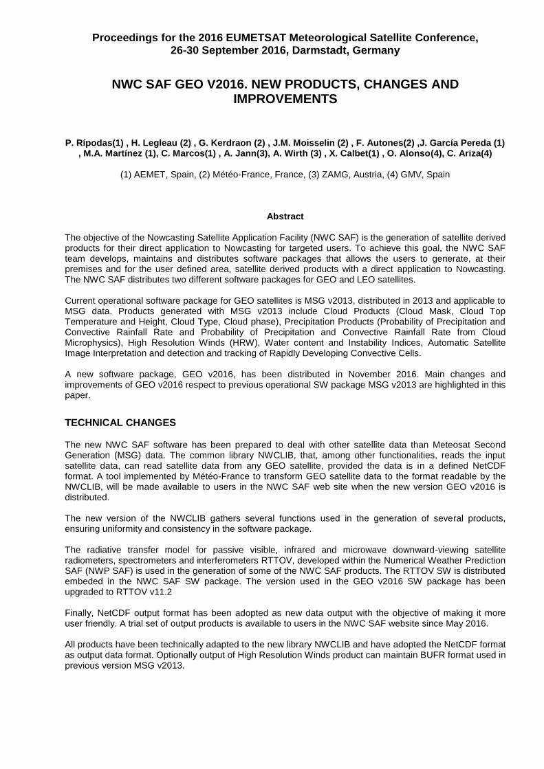
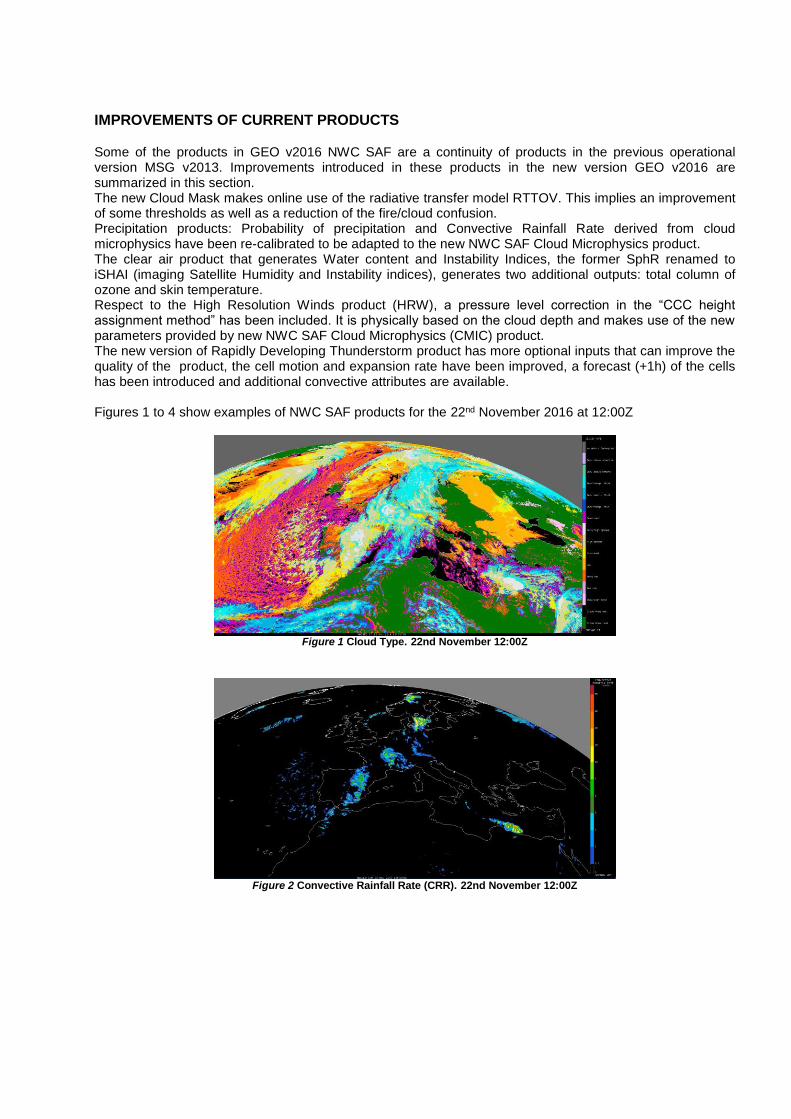
Some of the products in GEO v2016 NWC SAF are a continuity of products in the previous operational version MSG v2013. Improvements introduced in these products in the new version GEO v2016 are summarized in this section. The new Cloud Mask makes online use of the radiative transfer model RTTOV. This implies an improvement of some thresholds as well as a reduction of the fire/cloud confusion. Precipitation products: Probability of precipitation and Convective Rainfall Rate derived from cloud microphysics have been re-calibrated to be adapted to the new NWC SAF Cloud Microphysics product. The clear air product that generates Water content and Instability Indices, the former SphR renamed to iSHAI (imaging Satellite Humidity and Instability indices), generates two additional outputs: total column of ozone and skin temperature. Respect to the High Resolution Winds product (HRW), a pressure level correction in the “CCC height assignment method” has been included. It is physically based on the cloud depth and makes use of the new parameters provided by new NWC SAF Cloud Microphysics (CMIC) product. The new version of Rapidly Developing Thunderstorm product has more optional inputs that can improve the quality of the product, the cell motion and expansion rate have been improved, a forecast (+1h) of the cells has been introduced and additional convective attributes are available. Figures 1 to 4 show examples of NWC SAF products for the 22nd November 2016 at 12:00Z
Figure 1 Cloud Type. 22nd November 12:00Z
Figure 2 Convective Rainfall Rate (CRR). 22nd November 12:00Z
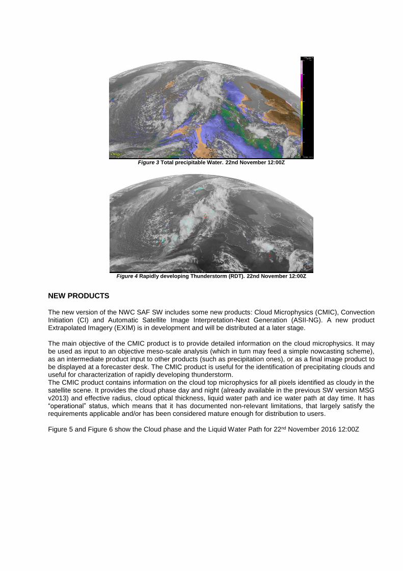
Figure 3 Total precipitable Water. 22nd November 12:00Z
Figure 4 Rapidly developing Thunderstorm (RDT). 22nd November 12:00Z
NEW PRODUCTS
The new version of the NWC SAF SW includes some new products: Cloud Microphysics (CMIC), Convection Initiation (CI) and Automatic Satellite Image Interpretation-Next Generation (ASII-NG). A new product Extrapolated Imagery (EXIM) is in development and will be distributed at a later stage. The main objective of the CMIC product is to provide detailed information on the cloud microphysics. It may be used as input to an objective meso-scale analysis (which in turn may feed a simple nowcasting scheme), as an intermediate product input to other products (such as precipitation ones), or as a final image product to be displayed at a forecaster desk. The CMIC product is useful for the identification of precipitating clouds and useful for characterization of rapidly developing thunderstorm. The CMIC product contains information on the cloud top microphysics for all pixels identified as cloudy in the satellite scene. It provides the cloud phase day and night (already available in the previous SW version MSG v2013) and effective radius, cloud optical thickness, liquid water path and ice water path at day time. It has “operational” status, which means that it has documented non-relevant limitations, that largely satisfy the requirements applicable and/or has been considered mature enough for distribution to users. Figure 5 and Figure 6 show the Cloud phase and the Liquid Water Path for 22nd November 2016 12:00Z

Figure 5 Cloud Phase. 22nd November 12:00Z
Figure 6 Liquid Water Path (Kg/m**2). 22nd November 12:00Z
The CI product provides the probability for a cloudy pixel to become a thunderstorm in a given following period range, using mainly geostationary satellite data. The product aims to catch the first steps of initiation of convection, when the first convective signs occur after the formation of clouds, or when those signs appear revealing a modification of environmental conditions. It is delivered to the users as a “demonstrational” product, which means that it has not reached the desired quality but has been considered to be useful to be disseminated in order to enable users to test the product and to provide feedback. Figure 7 shows the CI product for 22nd November 2016 12:00Z
Figure 7 Convection Initiation (CI) product. 22nd November 12:00Z

ASII-NG aims at detecting atmospheric features, which are of interest to meteorologists and other users. In contrast to the ASII product (further development is frozen) where the identification of conceptual models was in the center of interest, the ASII-NG product identifies Clear Air Turbulence (CAT) which is directly relevant for meteorologists and e.g. aviation end users. At this early development stage, the feature detection is limited to tropopause folds. A prototype for detecting gravity waves is already in place and can be delivered to users in the next version GEO 2018. ASII-NG is delivered to the users as a “demonstrational” product. Figure 8 shows the output of the ASII-NG product for 22nd November 2016.
Figure 8. ASII-NG: probability of occurrance of tropopause folding. 22nd November 12:00Z
The EXIM product, to extrapolate MSG images and some NWC SAF products using the NWC SAF HRW winds, is in development and a first version will be distributed to the users in the near future. Figure 9 shows the NWC SAF cloud Mask for 29 March 2015 at 08:15Z, Figure 10 shows the 1 hour extrapolation of the Cloud Mask with the EXIM product (valid at 09:15Z). The extrapolated cloud Mask can be compare with the NWC SAF Cloud Mask at 9:15Z in Figure 11
Figure 9 NWCSAF cloud mask for 29 March 2015, 08:15Z
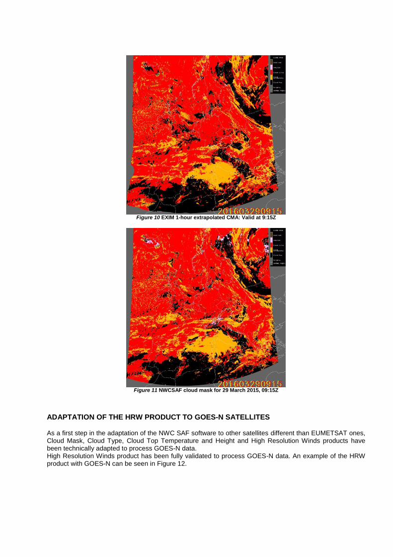
Figure 10 EXIM 1-hour extrapolated CMA: Valid at 9:15Z
Figure 11 NWCSAF cloud mask for 29 March 2015, 09:15Z
ADAPTATION OF THE HRW PRODUCT TO GOES-N SATELLITES
As a first step in the adaptation of the NWC SAF software to other satellites different than EUMETSAT ones, Cloud Mask, Cloud Type, Cloud Top Temperature and Height and High Resolution Winds products have been technically adapted to process GOES-N data. High Resolution Winds product has been fully validated to process GOES-N data. An example of the HRW product with GOES-N can be seen in Figure 12.

Figure 12 HRW in the Continental United Sattes Region. 1st July 2010 17:45Z, GOES13 satellite
ACCESS TO THE SW PACKAGE
Registered users can have access to the new SW version NWC SAF GEO v2016 in the NWC SAF website http://www.nwcsaf.org Scientific Documentation including the algorithm description, validation reports and user manuals are available in the website for registered users and the general public.
REFERENCES
http://www.nwcsaf.org