nws wilmington, ohio march 2018 regional climate … · climate sites (cincinnati cvg, columbus...
TRANSCRIPT

NWS Wilmington, Ohio March 2018
Regional Climate Summary
Regional Climate Summary
March of 2018 provided a weather pattern that seemed more like the first month of meteorological winter than the first month of
meteorological spring. Extended stretches of below normal temperatures, as well as several accumulating snow events, yielded a very wintry feel through most of the month. In fact, with 9.7” of snow measured at Cincinnati (CVG) throughout the month, March of 2018 now ranks as a top-10 snowy March on record for the site.
1

Temperatures
Although March of 2018 had extended stretches of cool and wintry-like weather in the Ohio Valley, the month sure didn’t start off that way with highs in the 40s and 50s for the first several days. Beyond this, the pattern did indeed turn a bit more towards the wintry side of things as highs only reached into the lower 30s by the 8th with light snow observed for many locations in the local area. Although temperatures rebounded somewhat in the following days, daily average temperatures remained generally 5 to 10 degrees below normal. The next shots of wintry weather (coupled with well below normal temperatures) didn’t arrive until the 20th through the 25th. Much of the area experienced highs in the 30s and 40s during this stretch with several inches of wet snow on multiple occasions (especially for parts of southwestern Ohio, central Ohio, northern Kentucky, and eastern Indiana). Although the snow created pretty wintry scenes, even with the colder than normal temperatures it didn’t stick around for too long. More seasonable temperatures returned for the final several days of the month. Although there weren’t any notable records reached during the month, Dayton (DAY) failed to reach 60°F in March for the first time since 2001 (and only the 5th time in the period of record (since 1895). Moreover, at all three of the major climate sites (Cincinnati CVG, Columbus CMH, and Dayton DAY), the average daily temperature for the month of March was colder than the site’s daily average temperature in February (2018).
Site Avg Temp
(°F) Avg High Temp (°F)
Avg Low Temp (°F)
Departure From Normal
(°F)
Maximum Temperature
(°F)
Minimum Temperature
(°F)
Cincinnati (CVG)
39.9°F 48.7°F 31.1°F - 3.7°F 62°F (03/19) 19°F (03/22)
Columbus (CMH)
38.5°F 47.5°F 29.6°F - 3.4°F 61°F (Mult.) 20°F (03/10)
Dayton (DAY)
36.7°F 45.4°F 28.0°F - 3.7°F 59°F (03/29) 19°F (03/09)
2 2

Temperatures (Continued)
Temp Graph / Graphic #1
Temp Graph / Graphic #2
3 3

Precipitation
Although steady rain moved through most of the area on the first day of the month, what followed was several weeks of drier than normal conditions without much in the way of any notable rain- or snow-makers. In fact, through the 20th of the month, much of the area had received only 1/3 to ½ of the normal precipitation that would be expected through that period. The remaining 10 days or so, however, made up for the very dry first part of the month as several systems produced widespread rain and/or snow or both in the final part of the month. On the 20th into the 21st, banded snow developed throughout much of the area, impacting many locations in west-central Ohio and east-central Indiana southward through northern Kentucky. Several inches of wet snow accumulated over a large portion of the area before melting quickly in the next day or so. Another system moved through during the afternoon hours on the 24th, producing several inches of wet snow again in parts of southeastern Indiana and northern Kentucky. Accumulations in excess of 5” were reported in some places with this system. The last 5 days or so of the month ended on a very wet note with multiple rounds of rain/showers moving through the region. In fact, at least 0.20” of precipitation was received on 5 consecutive days at Cincinnati (CVG) from the 27th through the 31st, which is tied for the 7th-longest such stretch on record for the site (the first time at the site since 2011). Moreover, the 1.36” of rain received at Dayton (DAY) on the 29th tied a daily record for the site, originally set in 1985.
Site Total
Precipitation (in.)
Departure
From Normal (in.)
Max Daily Precipitation
(in./date)
Total
Snowfall (in.)
Max Daily Snowfall
(in./date)
Cincinnati (CVG) 3.86” - 0.10” 0.63” 03/29 9.7” 3.5” Mult. Days
Columbus (CMH) 2.96” - 0.06” 0.83” 03/01 3.2” 0.9” 03/21
Dayton (DAY) 3.56” + 0.22” 1.36” 03/29 5.8” 2.1” 03/21
4 4

Precipitation (Continued)
5 5
Estimated March Liquid-Equivalent Precip. (In)

Winter Weather
Several days of snow occurred during the month. One of these events was on the 7th of March as a compact system moved along and just south of the Ohio River bringing 1-3 inches of snow. On the 8th snow showers and snow squalls moved through the region, although snowfall totals only ranged from a half inch to upwards of 2 inches these amounts occurred in a short amount of time creating icy conditions on roadways and led to numerous accidents. The night of the 9th and 11th brought accumulating snow to some locations south of the Ohio River. The 13th brought additional snow squalls across the region and the 14th had snow showers. The night of the 20th into the 21st had an area of low pressure move across with bands of snow bringing several inches of accumulation to portions of the area especially northwest and west of Dayton. Another band of snow brought accumulating snow to primarily southeast Indiana, northern Kentucky, and southern Ohio on the 24th with a very tight gradient in the snowfall values.
6 6
March 8th Snow Squalls

April Outlook
The latest outlook from the Climate Prediction Center (CPC) indicates favorable conditions for below normal temperatures and above normal precipitation during the month of April.
Site
Normal Avg Temp (°F)
Normal High (°F)
Normal Low (°F)
Cincinnati (CVG)
54.2°F 64.7°F 43.7°F
Columbus (CMH)
53.1 °F 63.5°F 42.6°F
Dayton (DAY)
51.6°F 61.9 °F 41.4°F
Site Normal
Precipitation (in.)
Normal Snowfall
(in.)
Cincinnati (CVG)
3.89” 0.5”
Columbus (CMH)
3.40 ” 1.1”
Dayton (DAY)
4.09 ” 0.6”
Upcoming Temperature Outlook Upcoming Precipitation Outlook
7 7
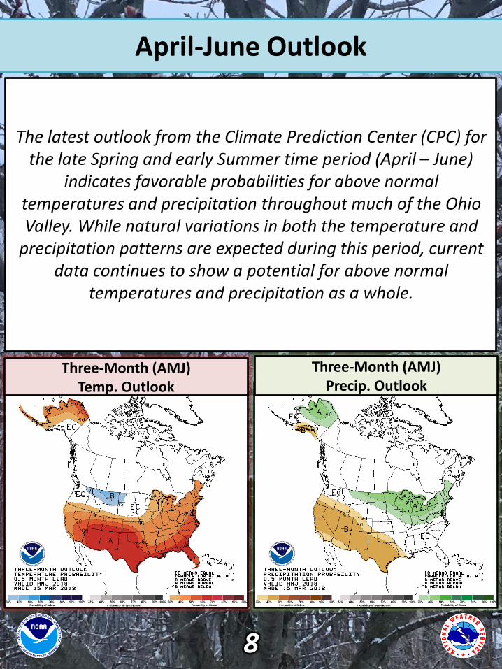
April-June Outlook
The latest outlook from the Climate Prediction Center (CPC) for the late Spring and early Summer time period (April – June)
indicates favorable probabilities for above normal temperatures and precipitation throughout much of the Ohio Valley. While natural variations in both the temperature and
precipitation patterns are expected during this period, current data continues to show a potential for above normal
temperatures and precipitation as a whole.
Three-Month (AMJ) Temp. Outlook
Three-Month (AMJ) Precip. Outlook
8 8