oecs gis needs assessment summary - june 2016
TRANSCRIPT

+
Summary - Regional OECS GIS Needs Assessment
June 22nd, 2016

“Many of the challenges we face are crosscutting in nature and characterized by complex inter-linkages – thus they are challenges
which can benefit from unleashing the power of location as the thing they have in common. Hunger, poverty, disease, disasters, climate
change, deforestation, urbanisation and environmental challenges, they all happen somewhere over space and time.”
United Nations initiative on Global Geospatial Information
Management (UN-GGIM)

+ What is Geospatial Intelligence?
n Actionable Knowledge. It is the ability to discover, describe, understand or
anticipate the human impact of an event or action within a space, time
environment.
n A Process. It is the ability to identify, collect, store and manipulate data to
create geospatial insights through critical thinking, geospatial reasoning
and analytical techniques
n A Profession. It is the ability to present knowledge in a way that is
appropriate to the decision-making environment Source: Dr. Todd S. Bacastow, Professor of Practice for Geospatial Intelligence College of Earth and Mineral Sciences PENN State University

“The Caribbean will need to significantly strengthen data generation and statistical capacity at national and regional levels, especially in light of the SDGs wider remit. Despite some improvement, the absence of basic data, timely and disaggregated, on social, economic and environmental issues,
and sectors, is evident to Caribbean researchers and must be also to policy and decision-makers. It is fully recognized, at the same time, that
small size is counter-intuitively a handicap in generating, interpreting and disseminating data. There may be fewer people to count but the sunken costs in statistical infrastructure - increasingly technology and high-level
skills - remain, and this can be prohibitive, especially for small island states and Least Developed Countries”
UN ECLAC Report - “The Caribbean and the Post-2015 Sustainable
Development Agenda

Towards strategic harmonization of OECS geographic data-ecosystems

OECS GIS Ecosystem
REQUIREMENTS SUMMARY
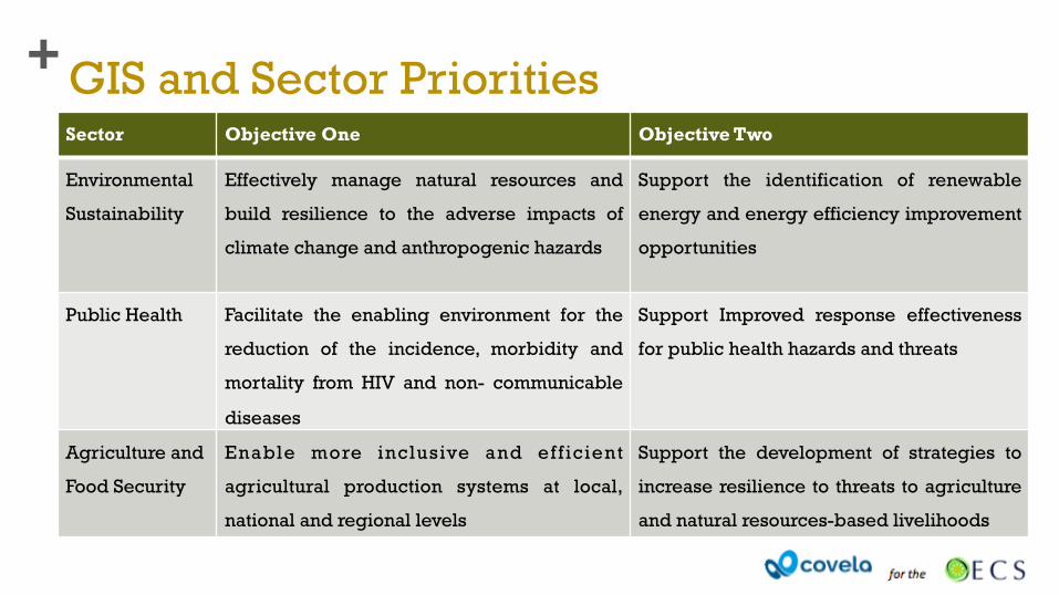
+ GIS and Sector Priorities Sector Objective One Objective Two
Environmental
Sustainability
Effectively manage natural resources and
build resilience to the adverse impacts of
climate change and anthropogenic hazards
Support the identification of renewable
energy and energy efficiency improvement
opportunities
Public Health Facilitate the enabling environment for the
reduction of the incidence, morbidity and
mortality from HIV and non- communicable
diseases
Support Improved response effectiveness
for public health hazards and threats
Agriculture and
Food Security
Enable more inclusive and eff icient
agricultural production systems at local,
national and regional levels
Support the development of strategies to
increase resilience to threats to agriculture
and natural resources-based livelihoods

+ GIS and Sector Priorities Sector Objective One Objective Two
Crime and
citizen security
Facilitate mechanisms to strengthen the
efficiency and effectiveness of the justice
and security institutions, systems and
service delivery
Support strategies aimed at reducing the
incidence of crime and youth violence
Social
Inclusion
Bolster capacity to achieve efficiency and
cohesiveness of social protection programs
Support optimisation of delivery social
security programs particularly in the informal
economy
Economic
Growth and
Employment
Facilitate the strengthening of tourism and
agriculture sectors
Support the targeting of education and
employment opportunities particularly for
youth and women

GIS Framework
Source: Covela GIS Ecosystem Considerations, Dec 2015

+ Stakeholders and Governance
Any effective governance system comprises representation from key stakeholders from all agencies and institutions that intersect with GIS. A healthy governance system advocates continuously for GIS and attempts to break the institutional barriers that prevent the realization of its value. This group deals with matters of:
n Coordination and Partnerships
n Regulation, Policy and Standards
n Operational Strategy and Structure

+ Data Architecture
n Structure and Standards for Geospatial Sources
n Structure and Standards for Geospatial Formats and Inputs
n Structure and Standards for Data Sharing
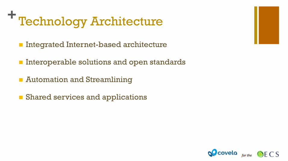
+ Technology Architecture
n Integrated Internet-based architecture
n Interoperable solutions and open standards
n Automation and Streamlining
n Shared services and applications

+ Technology Architecture
n Integrated Internet-based architecture
n Interoperable solutions and open standards
n Automation and Streamlining
n Shared services and applications

+ Operations and Performance
n Skilled Resources
n Capacity Building
n Structure and Strategy to enable coordination

Summary of Findings of Existing
Geographic and Geospatial
strategies, systems, technologies,
policies and processes in use
within the OECS

+ Three Groups
1. Governance Stakeholders – Executives with oversight or responsibility for the fulfillment of socio economic and / or environmental development objectives
2. Institutional stakeholders – Managers or Executives of a GIS function or organization
3. Users - beneficiaries and users of GIS information

Governance Needs
Assessment
Target: Executives with oversight or responsibility for the fulfillment of socio economic and / or environmental development objectives

+ Sources and Uses of Data
Sources of Data
Census Data
Civil Registration
and Vital Statistics
Household Surveys
Agricultural surveys
Other Administrative
Data
Economic Statistics
Geospatial data

+ Quality of the Current Data Experience
Chart showing the level of importance of various attributes of data against respondents’ level of satisfaction of organisational performance.

+ The Geographic and Geospatial Data Experience
Chart showing the purpose and use of geo data in the decision making process

+ Increasing the Awareness and Use of Geospatial Data

Institutional
Needs Assessment
Target: Managers or Executives of a GIS function or organization

+ The GIS Organisation

+ The GIS Function
Chart showing the purpose and use of geo data in the GIS function
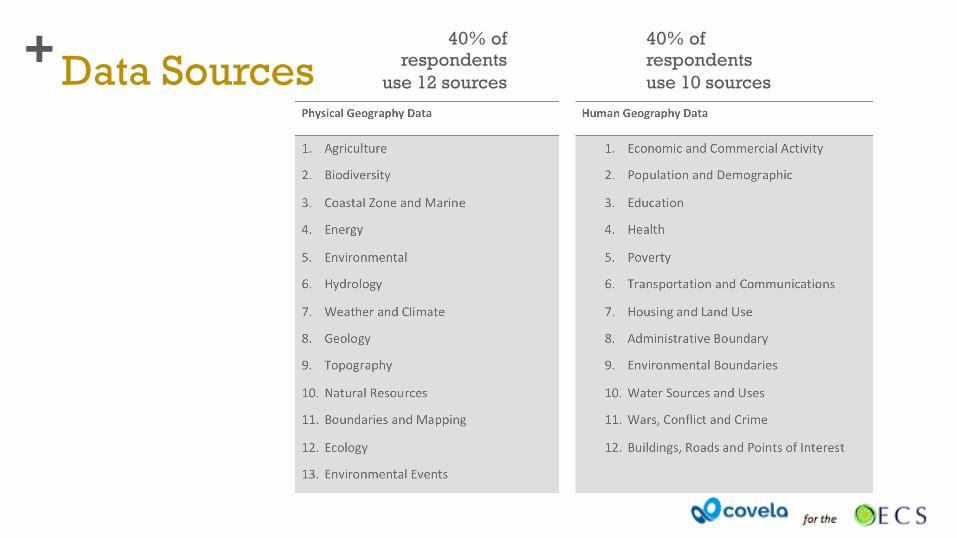
+ Data Sources 40% of
respondents use 12 sources
40% of respondents use 10 sources

“Some of the main issues in using and sharing GIS data in the Eastern Caribbean remain technical, e.g. data formats and
interoperability, while strengthening the institutional basis for the sustainability of the platforms is a key action that will lead to
policy-level commitments on data openness. This will be relevant in the future, when new tools that could replace the
GeoNode technology become available” Source: World Bank.
(2012) Geospatial Data Sharing & Disaster Risk Management in
the Eastern Caribbean

+ GIS Technology Traditional GIS Architecture Internet-based GIS architecture
• Multiple software platforms in use: • Open Source GIS, Internet GIS, Desktop GIS, CAD GIS, Business Mapping, and Mobile GIS • Desktop GIS still the most widely used, closely followed by Open Source GIS.
• 100 percent of respondents still claim to use premise-based hardware in all areas: data acquisition, data management and analysis and data output and presentation.

+ Increasing awareness and use of Geo Data

User Needs
Assessment
Target: Beneficiaries and Users of GIS Information

+ Environmental Sustainability - Respondents’ perceived level of importance placed on geospatial data to derive the information related to the stated data theme below

+ Environmental Sustainability - Respondents’ perceived level of satisfaction on the quality of their data experience to derive the information related to the stated data theme below

+ Key Observations
n Geospatial data is recognised as extremely important in supporting the delivery of environmental sustainability development objectives.
n 60 percent of GIS users are moderately / very / extremely satisfied with the quality of the data experience to access the required geospatial data in support of the development agenda.
n Vulnerability assessments and planning tops the list of most important data themes for management and is also the area where users are generally most satisfied with the quality of the data experience

+ Agriculture and Food Security- Respondents’ perceived level of importance placed on geospatial data to derive the information related to the stated data theme below

+ Agriculture and Food Security- Respondents’ perceived level of satisfaction on the quality of their data experience to derive the information related to the stated data theme below

+ Key Observations
n Geospatial data is recognised as extremely important in supporting the delivery of agriculture and food security development objectives.
n 52 percent of GIS users are moderately / very satisfied with the quality of the data experience required to support the development agenda.
n Vulnerability assessments and planning also tops the list of most important data themes for management and is also the area where users are generally most satisfied with the quality of the data experience

+ Social Inclusion - Respondents’ perceived level of importance placed on geospatial data to derive the information related to the stated data theme below

+ Social Inclusion - Respondents’ perceived level of satisfaction on the quality of their data experience to derive the information related to the stated data theme below

+ Key Observations
n A significant portion of GIS users do not recognize or see themselves as qualified to determine the importance of geo data in supporting the delivery of development objectives in this sector.
n 38 percent of GIS users see geospatial data as moderately / very important in supporting the delivery of development objectives in this sector.
n 48 percent of GIS users are somewhat to moderately satisfied with the quality of the data experience required to support of the development agenda.
n 0 percent of GIS users are extremely satisfaction or even very satisfied with the quality of the data experience to access required geospatial data.

+ Crime and Citizen Security- Respondents’ perceived level of importance placed on geospatial data to derive the information related to the stated data theme below

+ Crime and Citizen Security- Respondents’ perceived level of satisfaction on the quality of their data experience to derive the information related to the stated data theme below

+ Key Observations
n 50 percent of GIS users see geospatial data as moderately / very important in supporting the delivery of development objectives in this sector.
n 88 percent of GIS users are somewhat to moderately satisfied with the quality of the data experience required to support of the development agenda.
n 0 percent of GIS users are extremely satisfaction or even very satisfied with the quality of the data experience to access required geospatial data.

+ Public Health - Respondents’ perceived level of importance placed on geospatial data to derive the information related to the stated data theme below

+ Public Health- Respondents’ perceived level of satisfaction on the quality of their data experience to derive the information related to the stated data theme below

+ Key Observations
n A significant portion of GIS users do not recognize or do not see themselves as qualified to determine the importance of geo data in supporting the delivery of development objectives in this sector.
n 53 percent of GIS users see geospatial data as moderately / very important in supporting the delivery of development objectives in this sector.
n 70 percent of GIS users are somewhat to moderately satisfied with the quality of the data experience required to support the development agenda.
n 0 percent of GIS users are extremely satisfaction or even very satisfied with the quality of the data experience to access required geospatial data

+ Economic Growth and Employment- Respondents’ perceived level of importance placed on geospatial data to derive the information related to the stated data theme below

+ Economic Growth and Employment- Respondents’ perceived level of satisfaction on the quality of their data experience to derive the information related to the stated data theme below

+ Key Observations
n A significant portion of GIS users do not recognize or see themselves as qualified to determine the importance of geo data in supporting the delivery of development objectives in this sector.
n 44 percent of GIS users see geospatial data moderately / very / extremely important in supporting development objectives in this area.
n 44 percent of GIS users are not / somewhat / moderately satisfied with the quality of the data experience required to support the development agenda.
n 0 percent of GIS users are extremely satisfaction or even very satisfied with the quality of the data experience to access required geospatial data

+ Increasing the Awareness and Use of Geospatial Data

+ Emerging Recommendations
n More collaboration among agencies with GIS capability;
n The creation of common processes and policies governing the use and distribution of data;
n Common standards so that data from various sources can be easily manipulated;
n More training in the importance and use of geospatial information in decision making; and
n More reliable and resilient information and communications technology.

+
Prepared by: Rhea Yaw Ching
Executive Director, Covela Foundation Principal Consultant, Covela Consulting LLC
THANK YOU

+ About the Presenter Rhea Yaw Ching is an experienced executive having spent over two decades in senior executive roles for multinational corporations in the Caribbean and Latin America in sectors including telecommunications, manufacturing, distribution and the environment. She serves in strategic advisory roles to governments, international development organizations and multi stakeholder agencies with an emphasis on:
n Institutional strengthening; Capacity building; Business process reengineering; Technology integration ; Policy and regulatory harmonization
She is currently is the Managing Director and Principal Consultant at Covela Consulting, a US-based advisory services organization focusing on critical aspects of ICT-enabled development including internet governance, open data, innovation ecosystems, data security, logistics, electronic commerce and human resource development. She also serves as Executive Director of Covela Foundation, a non- profit that promotes economic growth, social inclusiveness and civic participation in the Caribbean.
Ms. Yaw Ching holds a BSc Management Studies from the University of the West Indies, an MBA from Warwick Business School and Executive Certification in Social Entrepreneurship from Stanford University.
Rhea Yaw Ching Executive Director, Covela
email: [email protected]
@rheayawching