of engineers groundwater monitoring network for the ... · groundwater monitoring network for the...
TRANSCRIPT

11/2/2007 2007 Eastern South Dakota Water Conference & 52nd Annual Midwest Groundwater Conference Slide 1
US Army Corpsof Engineers ® Development of a
Groundwater Monitoring Network for the Gateway Lake Rehabilitation Study
Development of a Groundwater Monitoring Network for the Gateway Lake Rehabilitation Study
Travis D. YontsHydraulic Engineer
U.S. Army Corps of Engineers Omaha District
Travis D. YontsHydraulic Engineer
U.S. Army Corps of Engineers Omaha District
Sheraton Hotel October 31, 2007Sheraton Hotel
October 31, 2007

11/2/2007 2007 Eastern South Dakota Water Conference & 52nd Annual Midwest Groundwater Conference Slide 2
US Army Corpsof Engineers ® Project Investigators
• Travis D. Yonts– Hydraulic Engineer, U.S. Army Corps of
Engineers, Omaha District• Doug Clemetson
– Hydrology Section Chief, U.S. Army Corps of Engineers, Omaha District
• Greg Johnson– Project Manager, U.S. Army Corps of
Engineers, Omaha District

11/2/2007 2007 Eastern South Dakota Water Conference & 52nd Annual Midwest Groundwater Conference Slide 3
US Army Corpsof Engineers ®
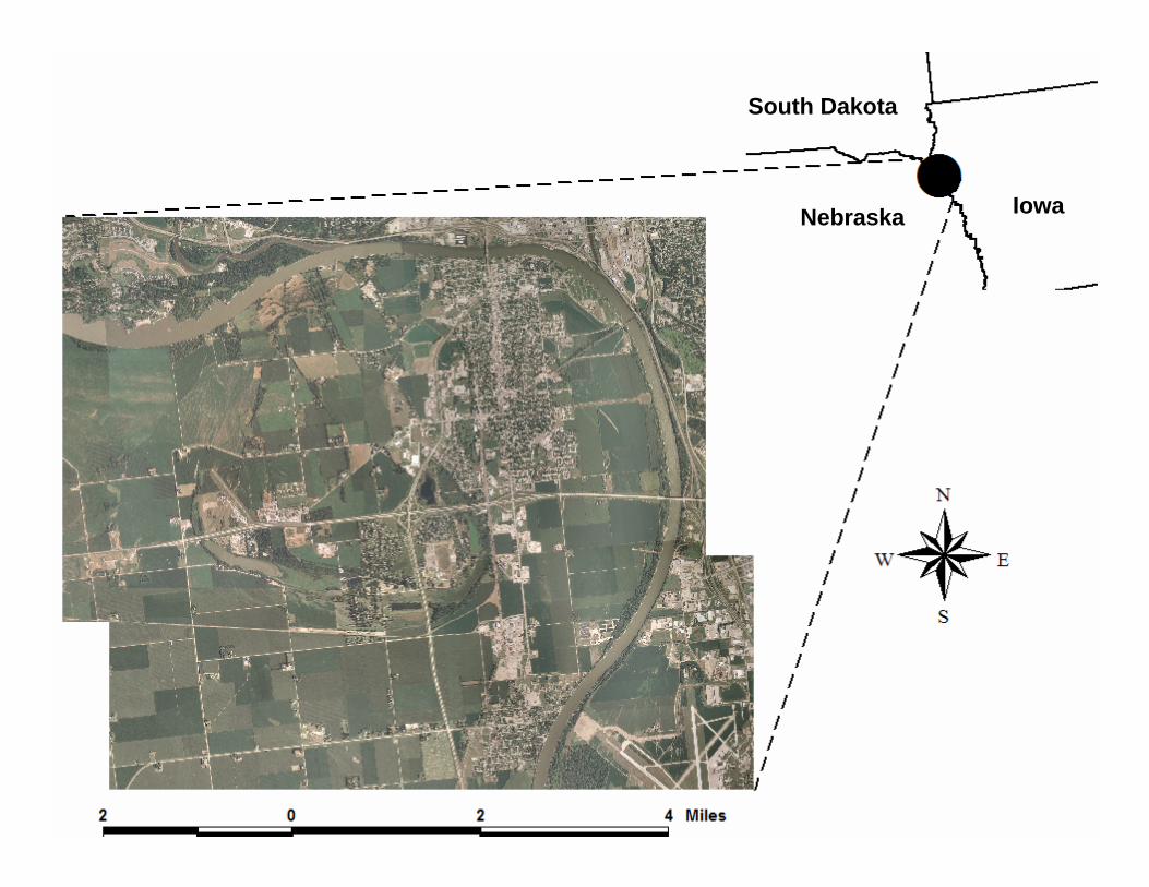
Background• Gateway Lake Rehabilitation Study
– South Sioux City, Nebraska– Project objectives is to improve wildlife
habitat and water quality– Part of former oxbow Crystal Lake
11/2/2007 2007 Eastern South Dakota Water Conference & 52nd Annual Midwest Groundwater Conference Slide 4
US Army Corpsof Engineers ®
South Dakota
Nebraska Iowa

11/2/2007 2007 Eastern South Dakota Water Conference & 52nd Annual Midwest Groundwater Conference Slide 5
US Army Corpsof Engineers ®
Background• Groundwater monitoring network
– Objective: Determine the hydrologic connection between surface and groundwater in the area
– Onset HOBO Level Loggers installed at 13 locations
• Based on locations from previous work by USACE• 9 groundwater, 4 surface water• Data collected during fall and spring Missouri
River stage changes for navigation support• Data collection commenced fall of 2006

11/2/2007 2007 Eastern South Dakota Water Conference & 52nd Annual Midwest Groundwater Conference Slide 6
US Army Corpsof Engineers ®
NNMRNW
MRSE
South Sioux City, NE
Missouri River
Hwy 77
I-129/Hwy 20
PZ 1
PZ 3
PZ 4
PZ 6
PZ 8PZ 7
PZ 5PZ 9
GL
CC
PZ 2
Hwy 110

11/2/2007 2007 Eastern South Dakota Water Conference & 52nd Annual Midwest Groundwater Conference Slide 7
US Army Corpsof Engineers ®
HOBO Level Logger• General specifications
– 15.0 cm x 2.5 cm (5.91 in x 0.97 in)– Weight of 7.0 g– Memory stores 21,000 events
• Temperature specifications– Range of -20 to 50 oC– Accuracy
• +/- 0.37 oC at 20 oC• +/- 0.50 oC over -5 oC to 40 oC
– Resolution of 0.10 oC at 20 oC

11/2/2007 2007 Eastern South Dakota Water Conference & 52nd Annual Midwest Groundwater Conference Slide 8
US Army Corpsof Engineers ®
HOBO Level Logger• Water Level specifications
– Range of 0.0 to 9.0 m– Accuracy of +/- 0.5 cm (+/- 0.05% FS)– Resolution of 0.21 cm

11/2/2007 2007 Eastern South Dakota Water Conference & 52nd Annual Midwest Groundwater Conference Slide 9
US Army Corpsof Engineers ®

11/2/2007 2007 Eastern South Dakota Water Conference & 52nd Annual Midwest Groundwater Conference Slide 10
US Army Corpsof Engineers ®

11/2/2007 2007 Eastern South Dakota Water Conference & 52nd Annual Midwest Groundwater Conference Slide 11
US Army Corpsof Engineers ®
y = 0.9134x + 95.652R2 = 0.9984
1069.00
1069.50
1070.00
1070.50
1071.00
1071.50
1072.00
1072.50
1073.00
1073.50
1074.00
1066 1067 1068 1069 1070 1071 1072
USGS South Sioux City gage (ft msl)
MR
NW
sta
ge (f
t msl
)
Mo. River Rating Curves
y = 0.9485x + 48.927R2 = 0.9994
1060.00
1060.50
1061.00
1061.50
1062.00
1062.50
1063.00
1063.50
1064.00
1064.50
1065.00
1066 1067 1068 1069 1070 1071 1072
USGS South Sioux City gage (ft msl)
MR
SE
sta
ge (f
t msl
)
Missouri River northwest location (MRNW)
Missouri River southeast location MRSE

11/2/2007 2007 Eastern South Dakota Water Conference & 52nd Annual Midwest Groundwater Conference Slide 12
US Army Corpsof Engineers ®
Results• Data analysis
– Determine groundwater response times and magnitude of groundwater change at piezometer locations due to changes in Missouri River flow.
– Compare current groundwater levels to those measured in 1959-1960.
• Determine the impact of Missouri River degradation.– Develop and calibrate a model to predict
groundwater response times and stage changes due to different river levels.
• Can be used to assess different design alternatives at Gateway Lake.

11/2/2007 2007 Eastern South Dakota Water Conference & 52nd Annual Midwest Groundwater Conference Slide 13
US Army Corpsof Engineers ®
Results
Sample of collected data from HOBO data loggers. Data has been normalized.
-0.15
-0.10
-0.05
0.00
0.05
0.10
0.15
10/5/06 10/7/06 10/9/06 10/11/06 10/13/06 10/15/06 10/17/06 10/19/06
Date
Cha
nge
in w
ater
leve
l (ft)
PZ-1 PZ-2 PZ-3 PZ-4 PZ-5PZ-6 PZ-7 PZ-8 PZ-9 CC
Rising and falling trend
Rising and falling trend
Data series of next slide
Data series of next slide

11/2/2007 2007 Eastern South Dakota Water Conference & 52nd Annual Midwest Groundwater Conference Slide 14
US Army Corpsof Engineers ®
Results
Example plot used to examine response times and groundwater fluctuations.
0.00
0.02
0.04
0.06
0.08
0.10
0.12
0.14
10/5/06 10/7/06 10/9/06 10/11/06 10/13/06 10/15/06 10/17/06 10/19/06
Date
Cha
nge
in g
roun
dwat
er s
tage
(ft)
0.0
0.5
1.0
1.5
2.0
2.5
3.0
3.5
4.0
4.5
5.0
Mea
sure
d M
isso
uri R
iver
sta
ge (f
t)
Piezometer 5
Missouri River northwestlocation
Response TimeResponse Time
Groundwater fluctuation
Groundwater fluctuation

11/2/2007 2007 Eastern South Dakota Water Conference & 52nd Annual Midwest Groundwater Conference Slide 15
US Army Corpsof Engineers ®
Results• Data analysis
– Determine groundwater response times and magnitude of groundwater change at piezometer locations due to changes in Missouri River flow.
– Compare current groundwater levels to those measured in 1959-1960.
• Determine the impact of Missouri River degradation.– Develop and calibrate a model to predict
groundwater response times and stage changes due to different river levels.
• Can be used to assess different design alternatives at Gateway Lake.

11/2/2007 2007 Eastern South Dakota Water Conference & 52nd Annual Midwest Groundwater Conference Slide 16
US Army Corpsof Engineers ®
1060
1062
1064
1066
1068
1070
1072
1074
1076
1078
0 5000 10000 15000 20000 25000 30000 35000
Distance (ft)E
leva
tion
(ft m
sl)
Oct 6, 2006
Feb 22, 2007
July 10, 2007
Results
Water surface profile MRNW, PZ-1, PZ-6, PZ-8, and MRSE.
1060
1062
1064
1066
1068
1070
1072
1074
1076
1078
1080
0 5000 10000 15000 20000 25000 30000 35000 40000
Distance (f t)
Elev
atio
n (ft
msl
)
Oct 6, 2006
Feb 22, 2007July 10, 2007
Water surface profile MRNW, PZ-3, PZ-4, PZ-5, PZ-7, and MRSE.

11/2/2007 2007 Eastern South Dakota Water Conference & 52nd Annual Midwest Groundwater Conference Slide 17
US Army Corpsof Engineers ®
NNMRNW
MRSE
South Sioux City, NE
Missouri River
Hwy 77
I-129/Hwy 20
PZ 1
PZ 3
PZ 4
PZ 6
PZ 8PZ 7
PZ 5PZ 9
GL
CC
PZ 2
Hwy 110

11/2/2007 2007 Eastern South Dakota Water Conference & 52nd Annual Midwest Groundwater Conference Slide 18
US Army Corpsof Engineers ®
Results
Comparison of 1959-1960 and 2006-2007 water surface profiles MRNW, PZ-3, PZ-4, PZ-5, PZ-7, and MRSE. For reference, the bed of the Missouri River has degraded
approximately 8 ft from 1960-present at South Sioux City, NE.
1060
1065
1070
1075
1080
1085
1090
0 5000 10000 15000 20000 25000 30000 35000
Distance (ft)
Ele
vatio
n (ft
)
Oct 6, 2006Feb 22, 2007Winter 1959-60Summer 1959Spring 1960

11/2/2007 2007 Eastern South Dakota Water Conference & 52nd Annual Midwest Groundwater Conference Slide 19
US Army Corpsof Engineers ®
Results• Data analysis
– Determine groundwater response times and magnitude of groundwater change at piezometer locations due to changes in Missouri River flow.
– Compare current groundwater levels to those measured in 1959-1960.
• Determine the impact of Missouri River degradation.– Develop and calibrate a model to predict
groundwater response times and stage changes due to different river levels.
• Can be used to assess different design alternatives at Gateway Lake.

11/2/2007 2007 Eastern South Dakota Water Conference & 52nd Annual Midwest Groundwater Conference Slide 20
US Army Corpsof Engineers ®
Results
This is the next step!!!This is the next step!!!

11/2/2007 2007 Eastern South Dakota Water Conference & 52nd Annual Midwest Groundwater Conference Slide 21
US Army Corpsof Engineers ®
Conclusions• A groundwater monitoring network was
successfully established in and around South Sioux City, NE.– Results illustrate the connection between
surface and groundwater in the area.• Next – develop/calibrate a model to predict
groundwater response times and stage changes due to different river levels.– Seasonal groundwater fluctuations– Missouri River degradation
• Use field and modeling data when evaluating design alternatives for Gateway Lake.

11/2/2007 2007 Eastern South Dakota Water Conference & 52nd Annual Midwest Groundwater Conference Slide 22
US Army Corpsof Engineers ®
Happy Halloween
…any questions
???
Happy Halloween
…any questions
???