on the oceanography of brazil’s equatorial margin: hazardous offshore currents and strategies for...
TRANSCRIPT

On the Oceanography of Brazil’s Equatorial Margin: Hazardous Offshore Currents and Strategies for Mitigation
Dave Fratantoni, Andre Gellers, and Neha Sharma
Horizon Marine, Inc.Massachusetts, USA
Image Image
• Brazil’s Equatorial Margin has both extraordinary development opportunities and significant operational challenges.
• Strong and variable ocean currents are a primary concern.
• Exchange between blue-water and coastal regimes is poorly understood.
• A regional ocean observing and prediction system can provide improved situational awareness to mitigate the impact of strong currents on offshore operations, enhance safety, and protect the environment.
Conclusions

Outline
• Geographic Context and Operational Challenges
• Oceanographic Environment
• Strategies for Mitigation

Image
Geographic Context
BEM potential may be similar to West Africa
Zaedyus find in French Guiana is encouraging
Coastline is extensive, sensitive

5 basins

TotalQuieroz GalvaoBPBHP Billiton
Quieroz Galvao
BGBPOGPBHP Billiton
ExxonMobilChevronBPOGPBHP Billiton
OGPEcopetrolExxonMobilPetrobras
5 basins
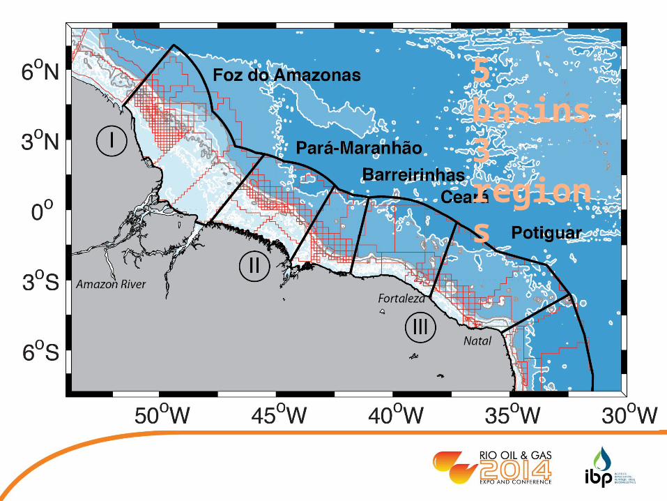
5 basins3 regions

5 basins3 regions2 regimes


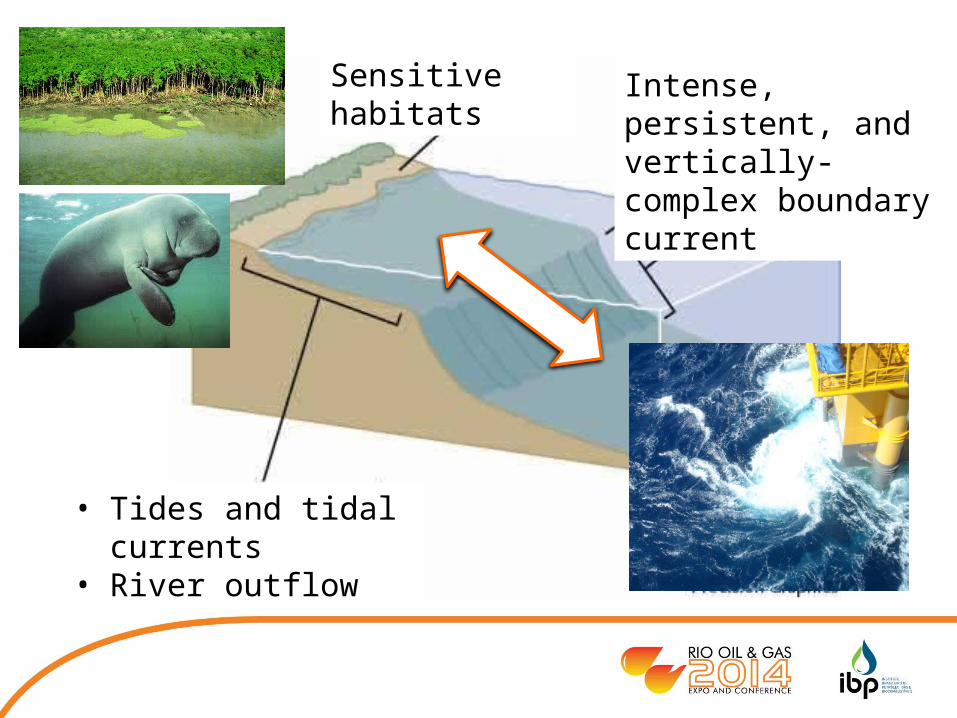
• Tides and tidal currents• River outflow
Intense, persistent, and vertically-complex boundary current
Sensitive habitats
• Tides and tidal currents• River outflow
Intense, persistent, and vertically-complex boundary current
Sensitive habitats

Image
Operational ChallengesENSCO 8503TullowFrench Guiana
• Remote location
• Extensive coastline with sensitive ecosystems
• Strong and variable ocean currents
• Poorly understood connections between offshore and coastal regimes
Holding station with 90% thrust

Image
Oceanographic Environment

Image
SeaWiFS Ocean Color
Satellite observations are descriptive – but not always quantitative.

12 years of surface drifter trajectories (n=450)
Color = Current Speed

Image
• Direct measure of surface velocity, exchange processes
• Analog for anything drifting at the ocean surface
• Excellent for model validation
• Easy to deploy from a variety of platforms
• Inexpensive robust statistics
Why surface drifters?

Image
Histogram of all drifter-derived current measurements in each BEM region

Average measured current speed as a function of WATER DEPTH
Gray dots are all measurements

Average measured current speed as a function of WATER DEPTH
Gray dots are all measurements1000 m
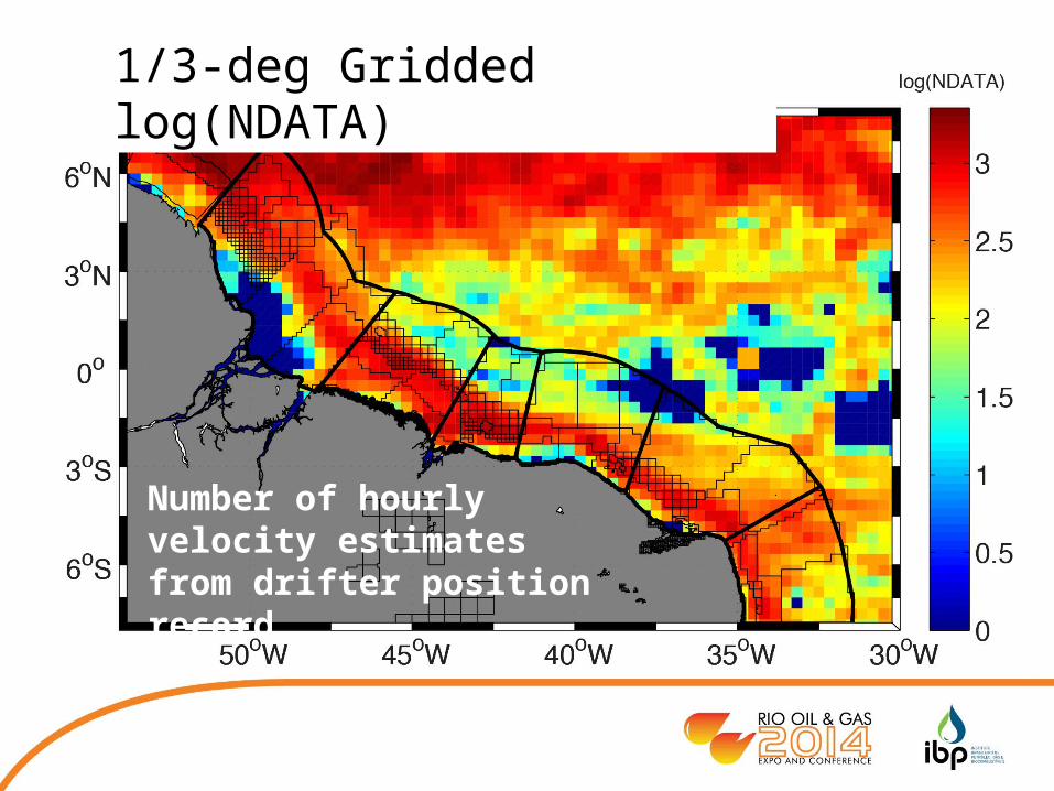
1/3-deg Gridded log(NDATA)
Number of hourly velocity estimates from drifter position record

1/3-deg Gridded Current Velocity
Image
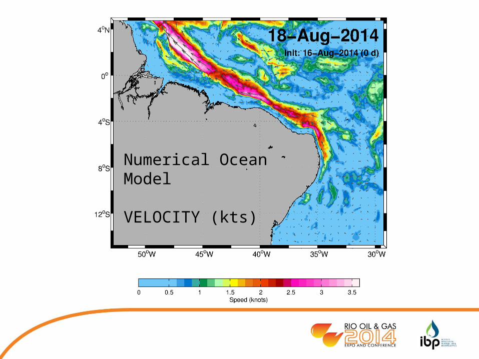
Numerical Ocean Model
VELOCITY (kts)

Models are ALWAYS wrong

Models are ALWAYS wrong

Models are ALWAYS wrong
Models can be useful if constrained and validated by observations
We must know HOW the model is wrong, and WHEN it can be trusted

Strategies for Mitigation
To mitigate the impact of strong ocean currents and operate successfully in the equatorial margin we require enhanced situational awareness, specifically:
• Accurate measurement of currents TODAY
• Accurate forecast of currents TOMORROW

Observations ForecastModel
A regional observation and prediction system

Image
• In-situ measurements of ocean currents• Inexpensive• Sustainable• Spatially diverse
• Family of appropriate numerical models• Global and regional blue-water ocean models• Coastal models with accurate tidal and river forcing• Local oil spill models for incident response
A regional observation and prediction system

• Seismic Survey• Engineering Design• Installation• Diving• ROV Operations• Pipelaying• Incident Response
A regional observation and prediction system

Observation System Status: 18 Sep 2014

Observation System Status: 18 Sep 2014

• Surface drifters have been deployed in the BEM about every two weeks since July 2014
• Surveys utilizing expendables (CTD, SV, CP) expected to begin in early 2015
• Regional 1/32o model run daily – working on drifter data assimilation
• Interpretive reports generated weekly
Observing System Summary
Image Image
• Brazil’s Equatorial Margin has both extraordinary development opportunities and significant operational challenges.
• Strong and variable ocean currents are a primary concern.
• Exchange between blue-water and coastal regimes is poorly understood.
• A regional ocean observing and prediction system can provide improved situational awareness to mitigate the impact of strong currents on offshore operations, enhance safety, and protect the environment.
• A prototype observing and prediction system is operational TODAY
Conclusions

Image
Thank you
Dr. David M. FratantoniHorizon Marine, Inc.Massachusetts, [email protected]
Mr. Andre GellersHorizon Marine do BrasilRio de Janeiro, [email protected]