open space plan
TRANSCRIPT

OP
EN
S
PA
CE
P
LA
N
COLLEGEVILLE BOROUGHMONTGOMERY COUNTY, PENNSYLVANIA
2006

COLLEGEVILLE BOROUGH OFFICIALS MONTGOMERY COUNTY, PENNSYLVANIA
491 E. Main Street
Collegeville, PA 19426
610 489-9208
BOROUGH COUNCIL MEMBERS Chuck Draksler, President
Teresa Stagliano, Vice-President
Stewart Goetz
Rowan Keenan
Timothy Mahon
Arnold Mann
Louise Tulio
MAYOR
Albert Stagliano
OPEN SPACE COMMITTEE
Carin Davis
Mary Lynn Gaydos
Rowan Keenan
Linda Korenkiewicz
Timothy Mahon
Heather Vernon
Geoff Thompson, Borough Manager
Nathan Walker, County Liaison
Perkiomen Greenway - First Avenue, Cover Background
Hunsberger Woods, Cover Foreground

COLLEGEVILLE
OPEN SPACE PLAN
2006
Prepared by the Montgomery County Planning Commission
under funding through the
Montgomery County Green Fields/Green Towns Program


COLLEGEVILLE OPEN SPACE PLAN
iii
TABLE OF CONTENTS vii Borough Resolution
CHAPTER 1 COMMUNITY PROFILE 1 Historical Background 2 Regional Setting 4 Existing Land Use Analysis 8 Community Demographic Analysis
CHAPTER 2 GOALS & OBJECTIVES 15 1995 Open Space & Environmental Resource Plan 17 2006 Open Space Plan
CHAPTER 3 EXISTING PROTECTED LAND 20 Public Open Space 22 Private Open Space 22 Discussion
CHAPTER 4 INVENTORY OF POTENTIALLY VULNERABLE RESOURCES 23 Historic & Cultural Resources 26 Geology 27 Soils 28 Topography 29 Surface Waters & Hydrology 30 Vegetation & Wildlife

COLLEGEVILLE OPEN SPACE PLAN
iv
CHAPTER 5 POTENTIAL OPEN SPACE LINKAGES 33 Benefits of Greenways 34 Collegeville Connections 36 Regional Trail Network
CHAPTER 6 ANALYSIS OF UNPROTECTED RESOURCES 41 Vulnerable Resources Analysis 42 Preservation Priorities
CHAPTER 7 EVALUATION OF GROWTH AREAS 45 Population Projections 46 Central Perkiomen Valley Regional Comprehensive Plan 50 Collegeville’s Regional Position
CHAPTER 8 EVALUATION OF OPEN SPACE NEEDS 51 Existing Parks & Facilities 53 Open Space Needs 57 Needs Summary
CHAPTER 9 EVALUATION OF COUNTY AND ABUTTING MUNICIPAL PLANS 59 Comparison to Montgomery County Comprehensive Plan 60 Relation to Plans of Abutting Municipalities 62 Relation to Other Plans
CHAPTER 10 RECOMMENDATIONS 64 Green Infrastructure 69 Community & Neighborhood Parks 73 Community Connections 78 Natural Resource Protection & Passive Recreation 79 Acquisition Methods 80 Non-Acquisition Methods 84 Implementation
CHAPTER 11 IMPLEMENTATION 85 Funding Sources 89 Implementation Matrix
COLLEGEVILLE OPEN SPACE PLAN
v
LIST OF FIGURES CHAPTER 1 COMMUNITY PROFILE 3 Figure 1 Regional Position 6 Figure 2 Existing Land Use 7 Figure 3 Existing Land Use Comparison: 1994 & 2005 8 Figure 4 Population Classification 9 Figure 5 Population Projection 9 Figure 6 Household Types 10 Figure 7 Education Level 11 Figure 8 Age Profile 11 Figure 9 Income Levels (1999$) 12 Figure 10 Special Needs Groups 13 Figure 11 Housing Types 14 Figure 12 Labor Force by Occupation 14 Figure 13 Employment Projection
CHAPTER 2 GOALS & OBJECTIVES 16 Figure 14 1995 Recommendation Status
CHAPTER 3 EXISTING PROTECTED LAND 20 Figure 15 Existing Public, Institutional, & Private Open Space 21 Figure 15A Existing Open Space
CHAPTER 4 INVENTORY OF POTENTIALLY VULNERABLE RESOURCES 24 Figure 16 Historic Resources 25 Figure 17 Historic & Scenic Resources 26 Figure 18 Scenic Resources 28 Figure 19 Soils 29 Figure 20 Topography & Hydrology 31 Figure 21 Vegetation & Wildlife

COLLEGEVILLE OPEN SPACE PLAN
vi
31 Figure 22 Expanded Piedmont Ecoregion in Pennsylvania 32 Figure 22A SmartConservation Ecoregion Priorities CHAPTER 5 POTENTIAL OPEN SPACE LINKAGES 35 Figure 23 Conceptual Collegeville Linkages 37 Figure 24 Proposed County Trail Network 38 Figure 25 Conceptual Regional Linkages
CHAPTER 6 ANALYSIS OF UNPROTECTED RESOURCES 43 Figure 26 Vulnerable Resources
CHAPTER 7 EVALUATION OF GROWTH AREAS 46 Figure 27 Population Projection 48 Figure 28 Central Perkiomen Valley Future Land Use Plan
CHAPTER 8 EVALUATION OF OPEN SPACE NEEDS 52 Figure 29 Open Space Setting & Use 55 Figure 30 Existing Open Space Service Areas 57 Figure 31 Minimum Open Space Acreage Needs
CHAPTER 10 RECOMMENDATIONS 64 Figure 32 Borough Gateways 65 Figure 32A Route 29 Gateway 66 Figure 33 Borough Plazas 68 Figure 34 Philadelphia’s Neighborhood Transportation Initiative Green City Strategy 69 Figure 35 Underserved Areas - Clayhor Avenue & Donny Brook Corridor 70 Figure 36 Underserved Areas - Collegeville Crossing 71 Figure 37 Park Expansion Opportunities 72 Figure 38 Ursinus College Campus Master Plan 75 Figure 39 Conceptual Regional Trails 77 Figure 40 Sidewalk Network Needs
CHAPTER 11 IMPLEMENTATION 90 Figure 41 Highest Priority Recommendations Implementation Matrix 91 Figure 41A Highest Priority Recommendations 92 Figure 42 High Priority Recommendations Implementation Matrix 93 Figure 42A High Priority Recommendations 94 Figure 43 Priority Recommendations Implementation Matrix 95 Figure 43A Priority Recommendations

vii

viii
1
COLLEGEVILLE OPEN SPACE PLAN
CHAPTER 1 COMMUNITY PROFILE
The Community Profile Chapter of the Collegeville Open Space Plan is designed to provide residents the
necessary background information to make well informed decisions regarding the future preservation of
community, natural, and cultural resources within the community. It consists of four parts: Historical Back-
ground, Regional Setting, Existing Land Use Analysis, and the Community Demographic Analysis.
HISTORICAL BACKGROUND Collegeville, like all of Pennsylvania, was originally
part of a grant made to William Penn by Charles II
of England in 1682. Penn designated the area
which is now the borough as the Gilbert tract.
This tract also included the present townships of Upper and Lower Providence and parts of Perki-
omen and Worcester.
The first family of settlers was the Lane family. In
1689, Edward Lane constructed a house that has
been enlarged and remodeled into the Perkiomen
Bridge Hotel, a major landmark in the region. The
hotel is listed on the National Register of Historic
Places, as is the nearby bridge.
In 1708, Edward Lane constructed the first mill
on the Perkiomen Creek. It was located near the
site of the old Collegeville Dam. This mill, which
survived until 1972, was a major element in the
early settlement of Collegeville. However, it was
not until 1799, with the construction of the Perki-
omen Bridge, that settlement began in earnest.
It was located along the banks of the creek and
soon developed into a village known as Perki-omen Bridge.
By the mid-nineteenth century another village,
called Freeland, was founded. About one-half
mile from the older village, it was clustered along
the western end of Main Street, while Perkiomen
Bridge continued in this location near the creek.
Collegeville began to take on its present form after
1868 when the railroad arrived. The two villages

2
COLLEGEVILLE OPEN SPACE PLAN
had vied for both the location and name of the
train station. The railroad settled the matter with a
compromise. The station was placed between the
two villages and named Collegeville, after the nearby Pennsylvania Female College.
The railroad's choice proved prophetic, for as the
two villages began to grow together and with the
founding in 1869 of Ursinus College, Collegeville
became the accepted name. The present Bor-
ough of Collegeville was incorporated in 1896
when it was formally separated from Upper Provi-
dence Township.
REGIONAL SETTING Historically, a small college town surrounded by
farmland, Collegeville is presently in the midst of a
rapidly suburbanizing region. Collegeville's posi-tion in the lower half of the Perkiomen Valley
places it in the Route 422 growth corridor. This
corridor will continue to be one of the fastest
growing sections of the county through the next
decade. While much of the borough is already
built out and will not experience the explosive
growth of its neighbors, Collegeville can expect
heavy development pressure on any remaining
vacant parcels and infill and redevelopment of
lower intensity areas.
As Route 422 is a primary factor in the region's
suburbanization today, transportation patterns
and developments have historically affected devel-
opment in the borough. Initially, settlement oc-
curred because of a ford in the Perkiomen Creek;
development into a village began after the con-
struction of the stone arch bridge in 1799. The
arrival of the railroad in 1868 enabled the village
to grow into a viable college town.
Similar factors are still relevant for the borough.
Following its eastern border is the intersection of
Route 29 and Ridge Pike, two arterial county
roads as shown in Figure 1. These roads provide
direct access to Collegeville; permitting the sur-
rounding areas to utilize the borough's commer-
cial districts. With the presence of a redeveloping
commercial district on Main Street and the exist-
ing shopping centers on Route 29, the borough is
thriving as a subregional shopping center. It pro-
vides convenient shopping and everyday goods
and services to much of the lower portion of the
Perkiomen Valley. While this role is not likely to enlarge due to the lack of available land and a
location on a major highway, the borough will
continue in its traditional role as the downtown
center of the valley. This will be challenged how-
ever, as the Providence Town Center, a large re-
tail, office, and restaurant complex, is slated for
construction within several years in neighboring
Upper Providence.
Ridge Pike and Route 29 also provide the bor-ough's residents with convenient access to the
region's major retail and employment centers.
Ridge Pike provides direct access to the county's
two largest boroughs: Norristown, the county Spring House at Hunsberger Woods

3
COLLEGEVILLE OPEN SPACE PLAN
Figure 1 Regional Setting

4
COLLEGEVILLE OPEN SPACE PLAN
seat and Pottstown, a site for a satellite campus of
the county's community college. Route 29 pro-
vides direct access to Route 422, via an inter-
change just south of the borough. This inter-change provides Collegeville, and the entire val-
ley, with direct access to King of Prussia, a major
retail and employment center, the Pennsylvania
Turnpike, and the cities of Philadelphia and Read-
ing. The presence of three major pharmaceutical
companies and other office buildings at sites adja-
cent to the interchange has transformed the rural
landscape to a business campus. It is expected
that more companies will settle in this area.
Collegeville is also served by public transportation.
The Southeastern Pennsylvania Transportation
Authority (SEPTA) provides bus service to the bor-
ough, through a line that extends from Norris-
town to Pottstown. In Norristown, the line termi-
nates at a regional transportation center. This
provides a direct connection to the SEPTA regional
rail network.
The borough's most significant natural feature is the Perkiomen Creek. This creek, located on the
borough's eastern border, is part of a vast water-
shed that extends far beyond the county's border.
Both the county and the borough own land
along the creek. This land protects this valuable
natural resource as well as infrastructure, both
locally and downstream.
The borough enjoys close proximity to several
major parks. Evansburg State Park, which is pri-marily located in the neighboring communities of
Lower Providence and Skippack, provides for both
passive and active recreation. The Perkiomen Trail
is a great new addition to the borough as it paral-
lels the creek from Oaks to Green Lane. It gives
access to Valley Forge National Historic Park, the
county's Norristown Farm Park, and the Upper
Perkiomen Valley/Green Lane Reservoir park.
Locally, the Central Perkiomen Valley Park helps
create the natural aesthetic of the Perkiomen
greenway and provides for a variety of recrea-
tional opportunities.
EXISTING LAND USE ANALYSIS Collegeville is largely built out and predominantly
residential. Its dominant image is that of a small college town surrounded by more recent subur-
ban developments. As previously stated, it devel-
oped gradually, assisted by transportation im-
provements. Near the Perkiomen Bridge is a
survivor from the borough's earliest period of
development--the Perkiomen Bridge Hotel. Main
Street and its immediate environs present the
image of a small college town. Spreading out,
both north and south of Main Street, are subur-
ban style developments, starting with 1950s style
ranch houses and ending with the neo-
traditional homes of today. Suburban style com-
mercial development is located on Route 29, south of Main Street, while lower Main Street
contains a traditional small town mix of commer-
cial shops and residences.
An inventory of the borough's existing land uses
is presented in Figures 2 and 3. It is interesting
to note that in the 1970 Comprehensive Plan,
vacant or farmland accounted 43 percent of all
the land in the borough. Today vacant land
accounts for only 2% of borough land. Farm-land no longer exists.
RESIDENTIAL
Greater than 50% of Collegeville is occupied with
residential dwellings, including a mixture of single-
family homes, two-family and twin homes, at-
tached townhomes, and several apartment build-ings. Density averages just above two units per
acre in residential districts that are relatively ho-
mogenous in lot size. Single family lots are by far
the largest land use in the borough.
COMMERCIAL/OFFICE
Commercial acreage has remained constant since the 1994 Open Space Plan. The commercial areas
of the borough are concentrated along Main
Street and the southern Route 29 corridor. There
are several shopping centers along Route 29, as
well as many mixed use, office, and retail build-
ings throughout the borough. Main Street boasts
a traditional downtown flavor on which revitaliza-
tion efforts are building.

5
COLLEGEVILLE OPEN SPACE PLAN
INDUSTRIAL
Just 11 acres make up the industrial land use in
Collegeville. The parcels with the largest acreages
parallel the former rail line which now makes up
the Perkiomen Trail. Another significant parcel lies
along Third Avenue. As the regional economy
changed in the last few decades, industries have
vacated the borough leaving large parcels of land
underutilized. These industrial areas are one of
the keys to the future growth of the borough as
the demands for different types of land use change towards more residential and mixed uses.
INSTITUTIONAL
Collegeville has a significant amount of institu-
tional land that consists of 17% of the borough
land area. By far, Ursinus College makes up the
greatest portion of this category of land use, controlling 140 acres. St. Eleanor Church on 6th
Avenue manages 19 acres which includes a
stream corridor, an open meadow and a stand
of trees. The other 10 acres classified as institu-
tional land use are held by various churches, the
post office, and other community groups. These
parcels offer borough residents a significant com-
munity services and open space, adding to the
appeal of Collegeville.
PARKS & OPEN SPACE
Since 1994, Collegeville has taken great strides to
enhance its park and open space system. In ten
years, the publicly-owned, permanently-protected
acreage within the borough has increased by 45
acres, or 52%. This brings the borough’s inventory
to include 109 acres of open space offering a vari-ety of both passive and active recreational opportu-
nities. Further, another 29 acres of open space lie
outside the borough which Collegeville manages.
A large portion of this increase is the acreage
within Hunsberger Woods Park, purchased under
the County Open Space Program. Due to the scar-
city of remaining vacant land in the borough, the
opportunity for new parks are few, allowing the
borough to focus some of its resources on devel-opment of existing open spaces.
Private and institutionally owned land that is per-
manently protected adds 29 acres to the open
space network. This includes acreage from three
residential developments and some dedicated col-
lege property. Existing protected land will be dis-
cussed in more detail in Chapter Three.
UTILITIES
The acreage taken up by the utilities that serve
borough residents and businesses takes up a mere
two acres of land. This acreage is located at four
sites scattered around the borough and used by
local telephone and electric companies.
UNDEVELOPED LAND
Considerable amounts of infill development are oc-
curring on the Collegeville landscape. This makes
existing land uses more dense and reduces the
amount of vacant land. Of the 16 acres remaining
that lie vacant, most will likely be developed through
the proposed Claymont subdivision on Park Avenue
and by the Harleysville National Bank upon comple-tion of the Route 29 realignment.
Bicyclists crossing Route 29 on the Perkiomen Trail

6
COLLEGEVILLE OPEN SPACE PLAN
Figure 2 Existing Land Use
E THIR
D AVE
E 5
TH
AV
E
LLOY
D A
VE
ZVAR
ICK
RD
E 4T
H
SPANGLER
TENTH
AVE
NU
E
FREELAND
FIFTH
GLE
NW
OO
D
AV
E
CLA
ME
R
AVE
FIRST
DER
R D
R
W N
INTH
AV
E
SEV
ENTH
AVE
WALNUT STREETSIXTH
FOURTH AVE
CIR
SCHOOL ST
STINE
LA
NIN
TH
THIRD
SAY
LOR
LA
EIGH
TH
MAIN
LARKIN
ST
AVE
STREET
ELEV
ENTH
JONLY
N
RUSSELL
MINER
EAS
T
STRATFORD
AVENUE
LOCUST
MAYKUT
CO
LON
I AL
RI C
HAR
D
CLAYHORSHAKESPEARE
GLEN
FARM
S
SCHOOL
SECOND
SHEL
LY
HU
NSIC
KER
DR
WE
ST
DR
RUBY
CARMEN
SON
NE
T
AVO
N
WA
Y
MA
YKU
T
AVE
NU
E
AVEN
UE
STREET
FRE
ELAND
WA
Y
DR
DR
DR
CIR
DR
AVENUE
CIR
DR
AVE
AVENUE
AVE
AVENUE
AVE
NU
E
AVE
NU
E
AVE
AVE
NU
E
DR
STREET
LA
AVEN
UE
STIN
E
AVE
NU
E
FIRST
STREET AVEN
UE
STREET
AVE
NU
E
RIC
HAR
D
LA
SECO
ND
0 1,600 3,200800 Feet
MC
PC
MontgomeryCountyPlanningCommissionMontgomery County Courthouse - Planning CommissionPO Box 311 Norristown PA 19404-0311(p) 610.278.3722 (f) 610.278.3941www.montcopa.org/plancomThis map is based on 2000 ortho photography and official sources. Property lines were compiledfrom individual block maps from the Montgomery County Board of Assessment Appeals, with no verificationfrom the deed. This map is not meant to be used as a legal definition of properties or for engineering purposes.
¯
Existing Land Use
Residential
Commercial
Industrial
Institutional
Utilties
Undeveloped
Open Space
Agriculture
Water

7
COLLEGEVILLE OPEN SPACE PLAN
2005 1994 - 2005
Acres % Total Acres % Total % Change
Residential 549 54.2% 512 50.2% -6.7%
Commercial/Office 74 7.3% 72 7.1% -2.7%
Industrial 0 0.0% 11 1.1% -
Institutional 161 15.9% 170 16.7% 5.6%
Parks/Recreation/OS 86 8.5% 131 12.8% 52.3%
Utilities 8 0.8% 2 0.2% -75.0%
Roads - 0.0% 106 10.4% -
Total Developed 878 86.7% 1,004 98.4% 14.4%
Total Undeveloped 135 13.3% 16 1.6% -88.1%
Total Acreage* 1,013 100% 1,020 100% 0.7%
Land Use1994
Figure 3 Existing Land Use Comparison: 1994 & 2005
Source: Montgomery County Planning Commission Land Use Maps.* Discrepancies due to digitization of parcel information.
Commercial/Office7%
Industrial1%
Utilities0%
Roads10%
Total Undeveloped2%
Parks/Rec/OS12%
Institutional17%
Residential50%

8
COLLEGEVILLE OPEN SPACE PLAN
LAND USE DISCUSSION
The existing land use map as presented in Figure
2 makes clear several different districts within the
borough. These districts have evolved over time
based on the presence of existing natural fea-
tures, the accessibility to transportation, and the
demands of the local economy changing from
agriculture to service based industry. These areas
are described below.
• The Perkiomen Creek, its floodplain and steep slopes, and the single crossing of the creek, have limited development on the eastern boundary of the borough.
• The railbed that now makes up the Perkiomen Trail historically attracted light industry into the borough. This area is now established with successful commercial districts and is even the site of some residential infill development.
• The traditional Main Street district of the bor-ough is the site of significant reinvestment.
• Ursinus College as a major landowner greatly contributes to the character of the borough along West Main Street.
• Collegeville has an entire quadrant of its land area devoted to residential land use. Located on the borough’s west side, this adds stability to the borough and gives it a strong commu-nity atmosphere.
Overall, Collegeville possesses a diverse mix of land uses that make it an attractive place to live, work,
and shop.
COMMUNITY DEMOGRAPHIC ANALYSIS The Community Demographic Analysis consists of
information relating to Collegeville’s population, housing, and economics. With few exceptions,
the source of the information is the decennial U.S.
Census. Demographic characteristics such as the
number of school age children can provide insight
when planning for open space preservation and
recreational development. Demographic statistics
can assist in determining not only how much land
should be preserved, but also where. Additionally,
this information can further assist a municipality in
determining what type of recreational facilities, if
any, should be placed in the preserved land.
POPULATION
The borough, located in one of the county’s desig-
nated growth areas saw a growth rate of 10% for
the period between 1990 and 2000. This placed
Collegeville 30th among county’s 62 municipalities
for growth during this period. Although popula-
tion growth did not meet the county’s average of
10.6%, indications still show the high-desirability of the area. This is due in part to nearby employment
opportunities and commercial areas.
While the population occupying households in-
creased as shown in Figure 4, the group quarters
population decreased by 7%. For Collegeville
group quarters are the St. Eleanor Church Complex
and students living in Ursinus College dormitories.
A new student dormitory on the Ursinus campus
will likely increase the group quarters population.
POPULATION PROJECTIONS
The rate of municipal population change is an
important measure of the overall change that has
occurred in a community over time. In general,
Figure 4 Population Classification
1990 2000 1990 - 2000
Number % Total Number % Total % Change
Household Population 3,289 77.8% 3,754 81.1% 14.1%
Group Quarters Population 938 22.2% 874 18.9% -6.8%
Total Population 4,227 100% 4,628 100% 9.5%
Sources: U.S. Census Bureau; Census of Population and Housing, 1990, 2000.
Population Type

9
COLLEGEVILLE OPEN SPACE PLAN
these projections are based on several factors,
including past levels of development, recently
proposed development, proximity to employment
centers, available land, and public facilities (particularly sewers). In the case of Collegeville,
the Central Perkiomen Valley Regional Plan, as
discussed in Chapter Five, will have a significant
role in guiding growth towards the borough as a
Borough Conservation Area.
Figure 5 shows population trends in the borough
projected to cover a 40 year period. At the time
of this writing at least three development propos-
als totaling 40 new residences are in the pipeline for construction. At current populations per
household, these will add over 100 new residents
in the coming years alone, on track with projec-
tions.
The population of Collegeville is expected to peak
near 2015 with approximately 5,200 residents, a
12% increase from 2000. However, the popula-
tion will then stabilize at near 5,000 residents by
2030. This still represents a 9% increase from
2000 figures and 18% since 1990.
HOUSEHOLD TYPES
Between 1990 and 2000, Collegeville households
comprised of married couples increased the great-
0
1,000
2,000
3,000
4,000
5,000
1990 2000 2010 2020 2030
Figure 5 Population Projection
Figure 6 Household Types
Population
1990 4,227
2000 4,628
2004 ** 4,676
2005 * 4,750
2010 * 4,900
2015 * 5,200
2020 * 5,160
2025 * 5,050
2030 * 5,000
Sources: U.S. Census Bureau; Census of Population and Housing, 2000; DVRPC projections and estimates.* Projected population**Estimated population
Year
1990 - 2000
Number % Total Number % Total % Change
Married Couples with Children 407 32.3% 473 33.6% 16.2%
Married Couples with No Children 372 29.5% 399 28.3% 7.3%
Single Parent 67 5.3% 66 4.7% -1.5%
Other Family 44 3.5% 73 5.2% 65.9%
1 Person Non-Family Households 316 25.1% 302 21.4% -4.4%
2+ Person Non-Family Household 53 4.2% 95 6.7% 79.2%
Total No. of Households 1,259 100% 1408 100% 11.8%
Average People per Household 2.61 2.67 2.1%
Average People per Household - Montgomery County 2.58 2.54 -1.6%
Sources: U.S. Census Bureau; Census of Population and Housing, 1990, 2000.
Household Types20001990

10
COLLEGEVILLE OPEN SPACE PLAN
Professional degree in the period from 1990 to
2000. Figure 7 shows over 42% of borough resi-
dents of working age hold at least a Bachelor’s
degree as compared to 38% within the county. Also, a strong decrease in the number of residents
without a high school diploma in working-aged
people helped to show an overall increase in edu-
cation attainment in the borough.
AGE
During the 1990s, Collegeville saw growth in all age groups, except the 18-34 age group. Signifi-
cant growth occurred, most significantly in the
population aged 45-64. In both 1990 and 2000,
Collegeville had a significantly high level of resi-
dents in the 18-24 age group, reflective of the
student body at Ursinus College. In 1990, the
median age was 26, in 2000 it jumped signifi-
cantly to 35 to nearly match the median age in
the county of 38 years. The age characteristics of
the borough’s population are shown in Figure 8
INCOME
Collegeville experienced significant growth in two
income categories during the 1990s. Although
income per capita is below the county mean, me-
dian income per household is ranked seventh in
the county. This ranking is up from 23rd in 1989.
These statistics are shown in Figure 9. This de-
scribes a situation where most households are
supported by two incomes.
Figure 7 Education Level
1990 2000 1990 - 2000
Number % Total Number % Total % Change
Less than 9th grade 26 1.2% 33 1.4% 26.9%
9th through 12th grade, no diploma 175 8.1% 78 3.3% -55.4%
High school graduate (includes equivalency) 659 30.3% 648 27.3% -1.7%
Some college or Associate degree 619 28.5% 606 25.5% -2.1%
Bachelor's degree 503 23.1% 616 26.0% 22.5%
Graduate or Professional degree 191 8.8% 391 16.5% 104.7%
Total Pop. 25 years and older 2,173 100% 2,372 100% 9.2%
Sources: U.S. Census Bureau; Census of Population and Housing, 1990, 2000.
Education Level
est. The number of married couples, both with
and without children, increased by 12%. As the
largest increases in population living in house-
holds with children, the average number of resi-
dents per household also increased. This is the
opposite trend seen in the rest of the county
where household size is decreasing. These figures are shown in Figure 6.
Non-family households with at least two people
nearly doubled during these same ten years. This
pattern is in line with trends experienced through-
out the county in which greater numbers of unre-
lated people live together.
EDUCATION
The borough saw a strong increase in the number
of residents holding a Bachelor’s, Graduate, or
Concert in Memorial Park

11
COLLEGEVILLE OPEN SPACE PLAN
1990 2000 1990 - 2000
Number Number % Change
0-4 234 5.5% 272 5.9% 16.2%
5-17 625 14.8% 762 16.5% 21.9%
18-24 1,195 28.3% 1080 23.3% -9.6%
25-34 650 15.4% 478 10.3% -26.5%
35-44 570 13.5% 736 15.9% 29.1%
45-54 380 9.0% 587 12.7% 54.5%
55-64 222 5.3% 336 7.3% 51.4%
65-74 199 4.7% 197 4.3% -1.0%
75+ 152 3.6% 180 3.9% 18.4%
Total 4,227 100% 4,628 100% 9.5%
Median Age 26.1 34.8
Sources: U.S. Census Bureau; Census of Population and Housing, 1990, 2000.
Age % Total % Total
Figure 8 Age Profile
Figure 9 Income Levels (1999 $)
Income
Collegeville Mont. Co. Collegeville Mont. Co. Collegeville Mont. Co.
Per Capita $21,798 $29,463 $26,979 $30,898 23.8% 4.9%
Median Household $60,552 $58,577 $77,499 $60,829 28.0% 3.8%
Sources: U.S. Census Bureau; Census of Population and Housing, 1990, 2000.
19991989 % Change
Age/Sex Pyramid
350 250 150 50 50 150 250 350
0-4
10-14
20-24
30-34
40-44
50-54
60-64
70-74
80-84
Ag
e G
rou
ps
Female
Male

12
COLLEGEVILLE OPEN SPACE PLAN
SPECIAL NEEDS GROUPS
Information on these groups is important for the
borough to consider when planning for open
space. Besides making all areas handicapped
accessible, the special recreational needs of sen-
iors and children must be addressed. Specifically,
any open space acquired should have areas for
both passive and active recreational activities.
As shown in Figure 10 and indicated by the in-
crease in households with children, there were 75% more youth in Collegeville in 2000 than in
1990. As this trend continues for the next 10 to
15 years, park and open space decisions should
make sure this age group has recreation opportu-
nities. However, this must be balanced as the
senior citizen population is also a significant por-
tion of the population.
HOUSING TYPES
As discussed earlier, Collegeville's dominant land
use is residential. Residential uses account for 50%
of the borough’s total land use. Figure 11 indicates
how many housing units are in Collegeville and
breaks them down by type. It also shows unit
growth since 1990. Population increases have
grown at the same pace as residential construction.
The largest housing category is single-family de-
tached dwellings. Notwithstanding the sections of
the borough that developed prior to zoning (first
adopted in Collegeville in 1948), most detached
dwellings are zoned R-1 and exist at a density of
approximately two units per acre. However, two
large detached dwelling developments, Collegeville
Crossing and Collegeville Glen, are at significantly
higher densities, up to 5.4 units per acre.
The attached housing units are the two town-
house developments (College Park and College-
ville Greene), the modern twins on Carmen Drive,
and the old twins in the Main Street area. Densi-ties of these twins can be similar to that of Col-
legeville Crossing. For townhouses, density of up
to 20 units per acre is possible. Multifamily hous-
ing is either the converted older houses in the
Main Street area or the College Arms Apartment
complex, which has 176 units.
JOBS LOCATED IN MUNICIPALITY
The Delaware Valley Regional Planning Commis-
sion stated that in 2000, 3,000 jobs were located
in the borough, thereby making it a local employ-
ment center within the county. The borough
effectively has fewer jobs within its borders than
workers between the ages of 18 and 65. It
should be noted that the Ursinus student popula-
tion is included in this population. Otherwise, the
working age population is well balanced with
employment opportunities.
OCCUPATION
The U.S. Census bureau categorizes occupations
into three broad groups that combine more re-
fined job descriptions. In Collegeville, white collar
workers make up 77% of the workforce, while
blue collar workers make up 11%. Comparatively,
in Montgomery County, 73% of the workforce are
white collar workers.
The remaining 12% of Collegeville workers work in
the Service industry. As shown in Figure 12, Col-
legeville has a well-diversified labor force to embrace
a growing, changing, and diversified economy.
Figure 10 Special Needs Groups
1990 2000 1990 - 2000
Number % Total Number % Total % Change
Persons 16-64 with Disabilities 371 8.0% N/A
Persons 16-64 with Mobility and Self Care Limitations 23 0.5% N/A
Over 65 Years of Age 351 8.3% 377 8.1% 7.4%
Under 18 Years of Age 859 20.3% 1,034 22.3% 20.4%
Income Below Poverty Level 72 1.7% 75 1.6% 4.2%
Total Population 4,227 4,628 9.5%
Sources: U.S. Census Bureau; Census of Population and Housing, 1990, 2000.
Special Needs Group

13
COLLEGEVILLE OPEN SPACE PLAN
1990 2000 1990 - 2000
Number % Total Number % Total % Change
Single Family Detached 778 59.3% 899 62.5% 15.6%
Single Family Attached 131 10.0% 228 15.9% 74.0%
Multi Family (2-4 Units) 158 12.0% 95 6.6% -39.9%
Multi Family (5 or More Units) 216 16.5% 211 14.7% -2.3%
Mobile Home/Trailer/Other 29 2.2% 5 0.3% -82.8%
Total Housing Units 1,312 100% 1,438 100% 9.6%
Sources: U.S. Census Bureau; Census of Population and Housing, 1990, 2000.
Housing Types
Figure 11 Housing Types
Housing Types Comparison
0%
10%
20%
30%
40%
50%
60%
70%
Single
Fam
ily D
etach
ed
Single
Fam
ily A
ttach
ed
Mult
i-Fam
ily (2
-4 Units
)
Mult
i-Fam
ily (5
or M
ore U
nits)
Mob
ile H
ome/
Traile
r/Oth
er
1990
2000

14
COLLEGEVILLE OPEN SPACE PLAN
EMPLOYMENT PROJECTION
The Delaware Valley Regional Planning Commis-
sion also develops employment forecasts based on
census data, past trends, the job market, and
available land. This projection is shown in Figure
13. Employment opportunities in the borough
are expected to increase 7% from 2000 to 2030.
This projection estimates there will be 3,200 jobs
in the borough at that time, keeping pace with
population growth.
STATUS OF RELEVANT PLANS
Collegeville's Comprehensive Plan, adopted on
November 1, 1972, was still in effect until Spring
2005 when the Central Perkiomen Valley Regional
Comprehensive Plan was adopted. The plans
primary recommendations for open space include
preserving stream corridors, such as along Donny
Brook, and maintaining the Memorial and Scout Cabin Parks
Other studies have been performed for Main
Street streetscaping and revitalization in both Col-
legeville and Trappe. Projects are underway
based on these studies to enhance walkability in
local neighborhoods.
The Zoning Ordinance was updated in Fall 2004.
The Subdivision & Land Development Ordinance
dates from 1985 (amended in 1997) is currently
going through the update process.
Population
1990 2,707
2000 2,980
2005 * 2,993
2010 * 3,094
2015 * 3,124
2020 * 3,150
2025 * 3,176
2030 * 3,200
Sources: DVRPC projections.* Projected population
Year
Figure 13 Employment Projection
0
1,000
2,000
3,000
1990 2000 2010 2020 2030
Figure 12 Labor Force by Occupation
2000
Number % Total
Management 497 24%
Professional 631 30%
Sales 229 11%
Clerical/Office 262 13%
Construction 127 6%
Production/Transportation 106 5%
Farming 0 0%
Services 240 11%
Total 2,092 100%
Sources: U.S. Census Bureau; Census of Population and Housing, 2000.
Occupation
White Collar
Blue Collar

15
COLLEGEVILLE OPEN SPACE PLAN
CHAPTER 2 GOALS & OBJECTIVES
In 1993, the Montgomery County Open Space Preservation Program provided an opportunity for munici-
palities to develop open space plans that reflect the needs of their residents. This chapter first describes the
goals and objectives developed by Collegeville under that program as written in the township’s 1995
Open Space and Environmental Resource Protection Plan. Combining these past goals with new and re-
fined ideas from public input and Borough Open Space Committee meetings, new goals are also set forth
here. These describe the new open space goals that served as a guide to the update process of the exist-
ing plan.
1995 OPEN SPACE & ENVIRONMENTAL RESOURCE PLAN GOALS
Collegeville Borough completed its Open Space and Environmental Resource Protection Plan in 1995. At that time, a series of goals and objectives were developed to address issues regarding the preservation of open space and the protection of environmental resources.
As a part of the update process required by the Montgomery County Green Fields/Green Towns Open Space Program, Collegeville has evaluated its previous goals and objectives to address whether the goals are still valid and to evaluate why some recommendations of the last plan were
not implemented. Below the original goals are listed.
1. Preserve Remaining Open Space
2. Protect Sensitive Natural Features
3. Enhance Natural Environment and Exist-ing Streetscapes
4. Create and Preserve Small Green Spaces
5. Recreational Needs
6. Create Pathways to Provide Access to Open Space

16
COLLEGEVILLE OPEN SPACE PLAN
RECOMMENDATIONS
The 1995 plan made some specific recommenda-
tions for both acquisition and non-acquisition pro-
jects. These recommendations followed the goals
as stated above. The extent to which these recom-
mendations were followed is discussed below.
IMMEDIATE ACQUISITION
Two parcels were listed in 1995 for immediate
acquisition. Hunsberger Woods was purchased
jointly with Ursinus College. The McAllister tract
near the Scout Cabin was purchased by a devel-
oper and now holds twelve single family homes.
Nearly three acres were preserved as open space
through this development and are managed by a
homeowner’s association.
In 1997, a one-acre parcel not listed in the plan
was purchased by the borough that increased
access to Waterworks Park in Trappe from Locust
Street in Collegeville.
FUTURE ACQUISITIONS
The following properties or regions were listed for
acquisition as funding or opportunity became
available. Their status is listed.
Land Adjacent to Scout Cabin Park - Although
still available, the loss of the McAllister Tract has
required a rethinking of the future land use of these parcels. The development of the McAllister
tract did create a pathway between Glenwood
and Clamer Avenues.
Ursinus College Property - The college still main-
tains the memorial to the Female College as a pub-
lic space.
Warren Masonic Lodge Property - This parcel is
still owned by the Lodge and utilized for parking.
It lies adjacent to the open space preserved on the
former McAllister tract.
Clahor Manor Subdivision - All lots at which open
space could have been preserved were developed.
Collegeville Crossing - The area adjacent to this
development is still owned by the county but no county plans are underway to develop active rec-
reation there.
Collegeville Memorial Park - Although available at
times in the past, no older homes were purchased
for park expansion.
NON-ACQUISITION
Figure 14 describes the non-acquisition recom-
mendations from the 1995 plan and the actions
taken since that time. Actions taken that are con-
sistent with the above goals but not specifically
recommended in the plan include the following.
• Developed and began implementation of a master plan for Waterworks Park.
• New commercial zoning has incentives for public space
• Subdivision & Land Development Ordi-nance update with greater landscaping, tree replacement, and natural resource protection measures.
Figure 14 1995 Recommendation Status
1995 Recommendation Action TakenRiparian Buffer Ordinance Adopted for the V-2 Districtalong the Perkiomen CreekUpdate Floodplain & Steep Slope Ordinances Updated 2004Enforce Tree Replacement Ordinance Update in progress - 2006Develop Institutional Overlay Created 2004Develop Main Street Zoning Created 2004Coordinate with Perkiomen Trail Development CompleteContribute to a Perkiomen Creek Greenway 13 properties purchasedCreate a Trail System Sidewalk plan created- 2000Complete Tree Planting Plan & Implement Plantings at 5 locationsCreate Small Green Spaces in Dense Areas "Gateway Park" under considerationat Perkiomen Bridge

17
COLLEGEVILLE OPEN SPACE PLAN
2. INTEGRATE OPEN SPACE WITH ALL LAND USES
A. Link together borough parks and open spaces
B. Increase pedestrian access to and from open space, neighborhoods, and com-mercial districts
C. Connect with regional open space and trail networks, including a Perkiomen Creek water trail
D. Partner with local businesses and institu-tions to maximize open space opportuni-ties and access
3. PRESERVE LAND TO EXPAND THE OPEN SPACE NETWORK
A. Expand existing parks and open spaces
B. Acquire new parks, open spaces, and plazas
4. PROVIDE A BROAD SPECTRUM OF REC-REATIONAL OPPORTUNITIES FOR ALL RESIDENTS
A. Provide a safe, accessible, and useable park and open space network
B. Develop parks with appropriate recrea-tional facilities and programs
C. Maintain parks at a high level of service to the community
D. Inform residents of recreational opportu-nities throughout the borough and the surrounding communities
5. PROTECT NATURAL RESOURCES
A. Acquire lands on which sensitive natural resources need protection
B. Adopt regulations that add further pro-tection to natural resources
2006 OPEN SPACE PLAN GOALS & OBJECTIVES
The Open Space Committee has evaluated the
goals and objectives of the previous plan and
revised them to reflect what was discussed during
the audit process. Updated goals and objectives
as developed by the 2006 Borough Open Space
Committee are include here to describe the new
direction Collegeville plans to take to preserve open space and natural resources. These goals
will serve as the framework for Collegeville’s plan
for open space preservation and protection of
natural resources. Goals are provided regarding
development, retention of open space, and pro-
tection of environmental features, followed by a
series of objectives.
1. DEVELOP A GREENER BOROUGH IMAGE
A. Fill gaps in the street tree network
B. Create new plazas and green spaces along Main Street and other commer-cial districts
C. Create highly visible green gateways at strategic borough entrances
D. Educate non-residential landowners on the benefits of maintaining green public spaces, streetscapes, and parking
E. Develop standards by which to create a borough-wide streetscape theme
The Donny Brook flowing from Eleventh Avenue

18
COLLEGEVILLE OPEN SPACE PLAN

19
COLLEGEVILLE OPEN SPACE PLAN
CHAPTER 3 EXISTING PROTECTED LAND
A key component of the open space plan is a review of existing protected land. An inventory of existing
conditions, along with an assessment of future needs, is necessary for formulating many of the plan's
goals and objectives. Existing protected land refers to land preserved for active or passive recreation use
or for environmental conservation purposes. In addition to municipally-owned areas, it can include land
preserved by private conservation groups, Montgomery County, schools sites, and private open space
preserved as part of the development process.
This chapter identifies existing open and recreational land in Collegeville and separates it into three catego-
ries of protection - public, private, or institutional. Private and institutionally owned open space makes an
important contribution to the overall aesthetic and recreation base of a community by preserving open
space, conserving significant natural features, and providing recreation facilities that do not require munici-
pal involvement in maintenance. However, privately controlled land may have a different maintenance
standard than publicly owned land, and in some cases, may be lost to development or have restricted
access. In evaluating open space needs, this distinction is important, as is the goal of increasing the
amount of permanently protected land so that future generations can also benefit from open space.

20
COLLEGEVILLE OPEN SPACE PLAN
PUBLIC OPEN SPACE BOROUGH OPEN SPACE
Collegeville's existing system of parks and open
space has grown since it adopted its 1995 Open Space Plan. Today, the public park and open
space system is made of eight sites totaling over
80 acres as shown in Figures 15 and 15A. These
parcels vary from intensely used Memorial Park to
natural areas making up part of the Perkiomen
greenway. Each offers community residents
important recreational opportunities and scenic
amenities. The latest community park is Hunsber-
ger Woods, located on 29 acres in the northern
corner of the borough, offering numerous recrea-
tional opportunities.
It is important to note that two borough-owned
parcels lie outside the borough boundaries. Wa-
terworks Park is jointly owned and managed by
Trappe Borough and primarily lies within that
municipality. On the east side of the Perkiomen
Creek in Lower Providence Township, the bor-
ough owns a wooded parcel once important for access to the Collegeville Dam. These two areas
make up over one third of the borough’s open
space acreage.
COUNTY OPEN SPACE
Montgomery County owns three parcels within
the borough. Two parcels hold sections totaling approximately 2,000 feet of the Perkiomen Trail
and make up almost 4 acres. The Central Perki-
Figure 15 Existing Public, Institutional, & Private Open Space
Open Space Type
Site Number
NameProtection
TypeAcreage
1 Hunsberger Woods Permanent 28.7
2 Perkiomen greenway Permanent 9.8
3 Central Perkiomen Valley Park * Permanent 53.8
4 Dam access ** Permanent 11.6
5 Scout Cabin Permanent 1.3
6 Perkiomen Trail * Permanent 3.8
7 Waterworks Park ** Permanent 17.5
8 Memorial Park Permanent 5.1
9 Floodplain parcels Permanent 5.9
10 Richards & Clayhor Avenues Permanent 0.5
138.0
11 Hunsberger Woods - Ursinus Permanent 7.1
12 Ursinus College open spaces Temporary 45.0
13 Women's College Memorial Permanent 0.3
14 St. Eleanor Parish Temporary 19.3
71.7
15 Bum Hollow/Glenwood Avenue Permanent 2.9
16 College Park Permanent 14.4
17 Collegeville Greene Permanent 4.1
21.4
231.1
Sources: County Board of Assessments; MCPC field checks, 1994, 2004.* Owned by Montgomery County Parks Department** Exists outside borough boundary
Public Open Space
Institutional Open Space
Total Public Open Space
Total Open Space
Private Open Space
Total Private Open Space
Total Institutional Open Space

21
COLLEGEVILLE OPEN SPACE PLAN Figure 15A Existing Open Space
3
7 3
98
6
6
5
4
2
2
1
14
17
16
13
1512
11
10
4TH AVE
E 5
TH
AVE
LLOY
D A
VE
ZVAR
ICK
RD
E 4T
H
SPANGLER
TENTH
AVEN
UE
FREELAND
FIFTH
GLE
NW
OO
D
AV
E
CLA
ME
R
AVE
FIRST
DER
R D
R
W N
INTH
AVE
SEVEN
TH AV
E
WALNUT STREETSIXTH
CIR
SCHOOL ST
STINE
LA
NIN
TH
THIRD
SAY
LOR
LA
CHESTNUT ST.
EIGH
TH
MAIN
LARKIN
ST
AVE
STREET
ELEVEN
TH
JONLY
N
RUSSELL
MINER
EAST
STRATFORD
AVENUE
LOCUST
MAYKUT
CHESTNUT
CO
LON
IAL
PARK
RIC
HAR
D
CLAYHORSHAKESPEARE
GLEN F
ARMS
SCHOOL
SECOND
SHEL
LY
HU
NSIC
KER D
R
WES
T
DR
RUBY
CARMEN
SON
NET
AVO
N
WA
Y
AVENUE
DR
DR
MA
YKUT
WA
Y
STREET
DR
CIR
FREELAN
D
DRAVE
NU
E
STIN
E
DR
AVEN
UE
AVE
NU
E
STREET
AVENUE
AVE
AVE
NU
E
AVEN
UE
AVE
DR
CIR
AVENUE
AVENU
E LA
AVE
NU
E
STREET
STREET
AVEN
UE
AVENU
E
RIC
HAR
D
LA
SECOND
0 1,600 3,200800 Feet
MC
PC
MontgomeryCountyPlanningCommissionMontgomery County Courthouse - Planning CommissionPO Box 311 Norristown PA 19404-0311(p) 610.278.3722 (f) 610.278.3941www.montcopa.org/plancomThis map is based on 2000 ortho photography and official sources. Property lines were compiledfrom individual block maps from the Montgomery County Board of Assessment Appeals, with no verificationfrom the deed. This map is not meant to be used as a legal definition of properties or for engineering purposes.
¯
Existing Land Use
Institutional
Undeveloped
Public Open Space
Private Open Space
Perkiomen Trail

22
COLLEGEVILLE OPEN SPACE PLAN
omen Valley Park is a 54-acre site that is undevel-
oped and lies predominantly in the Perkiomen
floodplain, adjacent to Collegeville Crossing.
PRIVATE OPEN SPACE HOMEOWNERS ASSOCIATIONS
Three homeowner’s associations exist in the bor-
ough that control 21 acres. Collegeville Greene
land is a band of green space that separates the
complex from adjoining properties and streets. Its
use is primarily visual and it does not provide any recreational area.
College Park open space meanders throughout
that development. It includes a large flat area that
can be used for limited recreation.
Homes built on the McAllister tract on Glenwood
Avenue are surrounded by open space. Within this
space lies a stormwater basin and a wooded slop-
ing area with a trail leading to the Scout Cabin.
INSTITUTIONAL
Collegeville Borough also has a substantial amount of open space offered by several institutions.
These open spaces differ from the publicly owned
spaces because they may not remain open
forever. Land use decisions for these institutions
depend on factors often beyond the borough’s
control. These sources of open space are still
important to Collegeville as they add to the aes-
thetic appeal of the borough and provide some diversity to the developed landscape.
Ursinus College owns 140 acres in the borough.
Of these 140 acres, approximately 45 acres are
open space. The overall visual impression is of a
small college with an attractive tree filled campus.
Victorian houses owned by the college line one
side of Main Street. At the rear of the campus is a
large wooded area that slopes toward the Perki-
omen Creek. Much of this area contains steep slopes and drainage swales. While the college is
expected to remain in the borough, it is a private
institution subject to changes in the marketplace.
Therefore its holdings, which provide the borough
with some significant open space, cannot be con-
sidered permanently protected.
Ursinus also purchased a 7-acre parcel of the
Hunsberger Tract to compliment the preservation
efforts of the borough. This parcel includes the farm house and barn and a flat area for use as a
multipurpose field.
St. Eleanor Church owns 14.7 acres, of which 8
could be considered open space. The site in-
cludes a church, school, and parsonage. The
northern end of the site contains steep slopes and
the Donny Brook. Similarly to Ursinus, it is a pri-
vate institution that could relocate.
DISCUSSION In total, Collegeville has a significant amount of
protected land, with more than 202 acres within
the borough being either permanently or tempo-
rarily protected. Added to this are 29 acres of
publicly-owned land outside the borough that
Collegeville helps maintain. This land provides
residents with many opportunities to enjoy all that
open space can offer, recreation, tranquility,
beauty, and a sense of community. However, close to half of this open space could be lost to
development in time if the land owners or land
use changes.
Private open space on Glenwood Avenue and Women’s College Memorial

23
COLLEGEVILLE OPEN SPACE PLAN
CHAPTER 4 INVENTORY OF POTENTIALLY
VULNERABLE RESOURCES
A place is not just a particular location. A place is recognizable and enjoyed because of its own unique set
of natural, historic, and cultural features. This section gives a brief description of some of Collegeville’s
most important resources as they relate to open space. While Collegeville’s physical setting and natural
features were some of the factors determining the borough’s early development patterns, these factors are
less important as the borough redevelops and land uses change. Although various resources and features
were considered for this discussion, only those important to current and future planning efforts within the
borough are included here.
HISTORIC & CULTURAL RESOURCES HISTORIC SITES
Collegeville has two structures that are listed on
the National Register of Historic Places. They are
the Perkiomen Bridge Hotel and the stone arch
bridge over the creek. Their national register list-
ing indicates an importance far beyond the bor-
ough's border. The Power House is listed as being
eligible for the National Register.
Along with the hotel, bridge, and Power House, nine
additional properties are considered historically signifi-
cant. Figure 16 gives a listing of all these properties.
All the information on these sites comes from the
Comprehensive Plan, the County Inventory, the
Borough Historic Sites Survey performed by the
Clio Group in 1986, and the 1995 Open Space Plan. The locations of these sites are shown in
Figure 17. These sites contribute to the historic
fabric and unique character of the borough.
Of special note is a group of houses along the
south side of Main Street between Fifth and Eighth
Avenues (included here is the Fetteroff House).
Owned by the college and recently renovated,

24
COLLEGEVILLE OPEN SPACE PLAN
these houses provide one of the finest examples of
a 19th Century streetscape in the county.
SCENIC ROADS AND VISTAS
Scenic resources are elements of the natural or
built environment that stand out among all the
attributes of a community. They tend to be the
most pleasant and interesting places, such as
historic sites, natural features, and recreation
areas. While personal preference plays the domi-
nant role in determining a scenic streetscape or view, discussion and debate has lead to a bal-
anced community-wide inventory.
Most scenic views and streetscapes in Collegeville
are the result of a harmonious interaction be-
tween the built and natural environment. These
areas should be preserved and linked to the
community's open space and recreation
system. Figures 17 and 18 show an inventory of
all such streetscapes and views as determined by
the Spring 2005 Topics in Environmental Studies
class at Ursinus College, using information from
the 1994 Open Space Plan. Below, they are de-
scribed and ranked based on their aesthetic value as determined by this class.
A. STONE ARCH BRIDGE
Looking either upstream or down while standing
on the bridge, one can view the creek similar to how it may have looked prior to settlement. Build-
ings and modern improvements are obscured by
trees, providing a bucolic scene. This view illus-
trates the importance of woodland preservation
along stream banks.
Depending on the final use of the potential open
space at the intersection of Route 29 and Ridge
Pike, this gateway could be one of the greatest
assets for the borough. If this site is landscaped well, it would complement the Perkiomen Bridge
and Hotel.
Figure 16 Historic Resources Map Structure Date Description
1 Stone Arch Bridge 1799Listed on the National Register of Historic Places, it is one of the oldest stone arch bridges still in use in Pennsylvania.
2 Perkiomen Bridge Hotel 1689Listed on the National Register, it is reputed to be the oldest hotel in the country, it is a good example of colonial architecture.
3Schuylkill Valley Tractionco (The Power House)
The Power House is a structure successfully adapted from an industrial structure to a commercial area, it is eligible for the National Register.
4 The Worrall House 1860Located at 105 First Avenue it is an excellent example of Victorian Italiante Architecture.
5 Clamer Hall 1890A Queen Anne Victorian style house. Clamer was a metallurgist who operated the Female College and the Collegeville Mill during the late 19th century.
6 Pennsylvania Female College 1915On the site of the Pennsylvania Female College, the first accredited women's college (1851).
7 Fetteroff House 1800One of several farmhouses still standing in the borough, it is a good example of early 19th Century rural Pennsylvania architecture.
8 Andrew Todd House 1750This stone colonial house is Collegeville's finest example of colonial architecture. It is now owned by Ursinus College and known as Isenberg Hall.
9 Fircroft Hall 1840 Hunsicker founded the Freeland Seminary, which later became Ursinus College.
10 Rees Farmhouse 1783 Located on Fifth Avenue
11 Clayhor Avenue Farmhouse 1778 Located near Avon Avenue
12 Styer House 1875Located on West Second Avenue, this structure is still standing but now part of a larger office building.

25
COLLEGEVILLE OPEN SPACE PLAN
!!!
!
!!!
!
!
!
!
!
!(C
!(E
!(B
!(D
!(A
!(F
3
4
9
8 7
6
5
2 1
12
11
10
4TH AVE
E THIRD AVE
E 5
TH
AV
E
LLOY
D AV
E
ZVAR
ICK
RD
SPANGLER
TENTH
AVEN
UE
FREELAND
FIFTH
CLA
ME
R
AVE
FIRST
DER
R D
R
W N
INTH
AV
E
SEVEN
TH AV
E
WALNUT STREETSIXTH
CIR
SCHOOL ST
STINE
LA
NIN
TH
THIRD
SAYL
OR
LA
EIGH
TH
LARKIN
ST
AVE
STREET
ELEV
ENTH
JONLY
N
EXTENSION
RUSSELL
MINER
EAST
STRATFORD
AVENUE
LOCUST
MAYKUT
CHESTNUT
CO
LON
I AL
PARK
RIC
HAR
D
CLAYHORSHAKESPEARE
GLEN F
ARM
S
SCHOOL
SECOND
SHEL
LY
HU
NSIC
KER D
R
WE
ST
DR
RUBY
CARMEN
SON
NE
T
AVO
N
WA
Y
MA
YKU
T
AVEN
UE
AVEN
UE
STREET
FRE
ELAN
D
WAY
DR
DR
DR
CIR
DR
AVENUE
CIR
DR
AVE
AVENUE
AVEAVENUE
AVE
NU
E
AVE
AVEN
UE
DR
STREET
LA
AVEN
UE
STIN
E
AVE
NU
E
STREET AVEN
UE
STREET
AVEN
UE
RIC
HAR
D
LA
SECOND
0 1,600 3,200800 Feet
MC
PC
MontgomeryCountyPlanningCommissionMontgomery County Courthouse - Planning CommissionPO Box 311 Norristown PA 19404-0311(p) 610.278.3722 (f) 610.278.3941www.montcopa.org/plancomThis map is based on 2000 ortho photography and official sources. Property lines were compiledfrom individual block maps from the Montgomery County Board of Assessment Appeals, with no verificationfrom the deed. This map is not meant to be used as a legal definition of properties or for engineering purposes.
¯
! Historic Sites
Scenic Areas
Figure 17 Historic & Scenic Resources
26
COLLEGEVILLE OPEN SPACE PLAN
B. MAIN STREET BETWEEN FIFTH & EIGHTH AVENUES
This site includes Sixth Avenue to the south of
Main Street. On the south side of Main is a group-
ing of Victorian houses . The north side provides
a view of the front grounds of Ursinus College.
The expanse of green space, populated by mature
trees, leads up to several of the college's most
impressive buildings, which are set far back from
the street. Sixth Avenue leading up to Main Street
is the borough's best example of an older tree
lined street. Older houses, set close together, are
flanked by mature street trees. An excellent exam-
ple of the interaction between the built environ-
ment and the natural one; the appearance is for-
mal but also inviting.
C. STRETCH OF GRAVEL PIKE BETWEEN NINTH AVENUE & THE FORMER DAM SITE
A scenic vista of the creek valley is available at this
intersection. The stretch of Gravel Pike provides
numerous views of steep wooded slopes, impres-
sive rock outcroppings (the result of road con-
struction) and the creek.
D. NINTH AVENUE CURVE
At the curve, one is presented with the pictur-
esque view of the Hunsberger Woods. The
wooden rail fence, pasture land, small stream,
farmhouse, and outbuildings present a rural im-
age that is rapidly disappearing from this part of the county.
E. EIGHTH AVENUE
Near the south end is a stretch of beautiful homes set back from the street lined with stately
oaks. As one begins to descend on Eighth Ave-
nue toward Main Street there is a nice overview
of Donny Brook and of Ursinus College.
F. FIFTH AVENUE AT DONNY BROOK
This stretch of Fifth Avenue provides a wooded
buffer between the College Park townhouses
and suburban style single-family houses. An
excellent example of how a wooded stream
corridor can provide a natural barrier between
different land uses.
GEOLOGY Except for surface outcrops, bedrock geology is unseen, and as a result its influence on natural
features is not always acknowledged. However,
the influence is both strong and pervasive, for
bedrock geology is the foundation of an area.
Bedrock, along with the hydrologic cycle, is
responsible for the changes in elevation, steep
slopes, location of watercourses, and orientation
(orientation, in turn, will influence vegetative
communities, soils, and availability of sunlight).
A runner on the Perkiomen Trail
Figure 18 Scenic Resources
Map Location Interest
A Stone Arch Bridge Perkiomen Creek
B Main Street & Sixth Avenue Victorian houses, Ursinus College, and tree lined neighborhood
C Gravel Pike Steep slopes, rock outcroppings, and Perkiomen Creek
D Ninth Avenue Curve Hunsberger Woods
E Eighth Avenue Donny Brook
F Fifth Avenue at Donny Brook Wooded stream corridor

27
COLLEGEVILLE OPEN SPACE PLAN
The bedrock or parent material has a great
influence on the type of soil formed. For example,
hard, igneous bedrock has resulted in soils with a
high stone and boulder content. Groundwater yield differs from one bedrock formation to the
next. In Montgomery County, the difference
ranges from under 1 gallon per minute (gpm) to
over 30 gpm.
Montgomery County is located in the Triassic Low-
land and Piedmont Upland section for the Pied-
mont Physiographic Province. The Triassic Low-
lands are primarily red shales and sandstones, with
intrusions of diabase. The Brunswick formation underlies the entirety of Collegeville. A fine grain
sandstone, the Brunswick formation was laid
down 310 million years ago during the Triassic
Age. This rockbed covers most of central Mont-
gomery County.
The Brunswick formation can provide a great
amount of water. Collegeville has six wells from
which it draws water; five of which are owned by
the Collegeville-Trappe Joint Water Works. These wells average about 150 gpm. Collegeville relies
on these wells as it main source of public water. It
is a natural reservoir that relies on continuous re-
charge from rainfall. It is critical to preserve open
space to provide an adequate supply of clean
groundwater.
SOILS Soils are a natural assortment of organic materials
and mineral fragments that cover the earth and
supports plant life. The composition of soils changes slowly over time, due to weathering of
rock and activity of soil organisms. As a
consequence, soils vary with respect to depth to
bedrock, depth to groundwater, color, mineral
characteristics, fertility, texture, and erodibility.
One of the most influential natural features, soils
are a result of the hydrology and the weathering
capacity of the underlying geology in a given
area. They are also influenced by the orientation
of the land and the types of vegetation that grow
in them. Conversely, the type of soil influences
the vegetative cover of the land, which effects the
quality and quantity of surface and groundwater, wildlife diversity, rates of erosion, and the
aesthetic quality of the landscape.
Though soils are diverse, soil scientists have
classified the soils found in Montgomery County
into several groups called soil series. Soils listed
within the same series will display similar
subsurface characteristics. The surface
characteristics of soils within a particular series
can vary in slope, degree of erosion, size of stones, and other easily recognizable features.
Although a variety of soil types exist in all parts of
the borough, the densest development has oc-
An example of Collegeville’s underlying geology along the Perkiomen Trail

28
COLLEGEVILLE OPEN SPACE PLAN
curred on Made Land, Penn Silt Loam, and Read-
ington Loam.
In addition to the soil mapping units, soils can also
be divided into hydric and alluvial soils. These
groups of soil pertinent to the borough are
described below and shown in Figure 19.
HYDRIC SOILS
Hydric soils are those soils that, in general, are
saturated with water at or near the ground
surface for substantial periods during the year. As
would be expected, such areas often exist near
water bodies and watercourses and may be part
of wetlands. Because of wetness, these soils
present a major constraint for development
wherever on-site subsurface sewage treatment is
utilized, since treatment depends largely on
adequate water percolation through the soil. In
Collegeville this is not an issue since the borough
is almost completely sewered, and such soils exist only in small concentrations along riparian corri-
dors as shown in Figure 19. However, hydric soils
and their wet condition do affect development
where they exist in the borough.
ALLUVIAL SOILS
Alluvial soils are frequently, but not always,
located within a floodplain. They are often
formed when streams carrying soil gradually lose
carrying capacity with decreasing velocity. As a
river slows down, it does not have sufficient
power to keep larger particles of soil suspended, and these particles begin to settle. These soils are
not stable as a result of their texture and
composition. The presence of alluvial soils is only
one indicator of a floodplain.
Changes in the tributary drainage area or slope of
the adjacent stream may create a floodplain that is
either larger or smaller than the area of alluvial
soils. Also, alluvial soils do not indicate the
probability of recurrence of a flood. An important aspect of alluvial soils is that they often form
aquifer recharge areas.
TOPOGRAPHY STEEP SLOPES
Slope, or frequency of change in elevation, is an
important environmental condition. When expressed as a percentage, slope is defined as the
amount of change in vertical elevation over a
specified horizontal distance. For example, a
three foot rise in elevation over a one hundred
foot horizontal distance is expressed as a three
percent slope. These changes in elevation
throughout a community contribute a great deal
to its appearance and natural diversity.
This is especially true of the steep slope areas of a community, which also cause limitations to
development. The slope and soils present on
steep slopes are in balance with vegetation,
underlying geology and precipitation levels.
Maintaining this equilibrium reduces the danger
to public health and safety posed by unstable
hillsides. Steep slopes often have a combination
of vegetation, climate, soil and underlying
geology that differs from the surrounding area.
Frequently this means that the environmental
sensitivity of the steep slope are different as well.
Susceptibility to erosion and mass movement may
Hydric SoilsAlluvial Soils
Figure 19 Soils

29
COLLEGEVILLE OPEN SPACE PLAN
be greater than the surrounding area, especially if
vegetation is removed. Increased runoff and
sedimentation from disturbed slopes require
increased public expenditure for flood control and stormwater management. Also, different species
of plants and the associated wildlife that depends
on these plants may be present only on the slopes,
creating unique recreation opportunities.
In Collegeville, elevations range from 100 feet
above sea level at the Perkiomen on the borough's
southern border to 280 feet in the western corner.
Most areas of steep slopes border the Perkiomen
Creek, north of Main Street. Overall, steep slopes make up 3% of the borough’s land area. Using
soil types from the Soil Survey as a general guide,
Figure 20 shows that concentrations of steep
slopes occur in three areas: along the Donny
Brook, along Gravel Pike and a nearby Perkiomen
Tributary, and along Route 29 near Stine Drive.
These areas coincide with lands protected by the
borough, the county, or local institutions, and will
most likely not be developed.
SURFACE WATERS & HYDROLOGY Water is a valuable resource, consumed by people
and industry, enjoyed at recreation facilities, employed in the assimilation of treated sewage,
and integral to the ecological landscape. The
average rainfall in the county varies from 43
inches near City Line Avenue to 47 inches in the
vicinity of the Green Lane Reservoir.
It should be noted that in any given year, annual
precipitation can vary from the average by as
much as ten inches. Generally speaking, 25% of
precipitation becomes direct runoff, 50%evaporates or is transpired by plants, and 25%
replenishes groundwater. The surface water that
falls on or is carried through Collegeville affects
the topography, soils, vegetation, and
groundwater and comes from two natural
sources, direct runoff and groundwater. A third,
manmade source, may also contribute to stream
flow, effluent from sewage treatment plants,
which tends to dampen the variation between
high and low flow periods in streams to which
they discharge.
Because the basins drained by a stream system are
usually larger than one community, an
interrelationship exists whereby municipalities that
are upstream contribute surface water flow to
Collegeville, while those downstream receive the
borough's runoff. With this in mind, the borough
should aim to maintain the natural conditions of
its drainage system through preservation of open
space along watercourses and education about
the benefits of riparian buffers.
STREAM CORRIDORS
The borough contains three water courses. The
Perkiomen Creek borders the borough on its east-
ern end. A significant watershed for the region
and the largest tributary to the Schuylkill River, its
bank in Collegeville is generally protected by pub-
licly owned land.
The Donny Brook is located in the southern section
of Collegeville. Most of the area surrounding it is
developed, although at a low density. It generally meanders through the backyards of single family
homes, inaccessible to all but property owners.
Steep Slopes <15%FloodplainWetlands
Figure 20 Topography & Hydrology

30
COLLEGEVILLE OPEN SPACE PLAN
An unnamed stream bisects Hunsberger Woods.
Surrounded by former agricultural land, it contains
two small man-made ponds and flows into the
larger Perkiomen Creek.
FLOODPLAINS
The 100-year floodplain is a feature that will effect
the health, safety, and welfare of borough resi-
dents. During storms the floodplain stores and
conveys floodwater. Development within the
floodplain reduces the carrying capacity and in-creases the height and destructive ability of flood-
water. In addition to carrying floodwaters, the
floodplain and stream corridor serve other impor-
tant functions such as the deposition of water-
borne sediments. The condition of the stream
corridor itself is important in minimizing erosion
and water pollution, protecting water quality, and
providing animal habitat and recreation opportu-
nities. Floodplains affecting the borough are
shown in Figure 20.
Well vegetated buffers along stream corridors
will filter out non-point source pollutants, shade
the stream, and provide wildlife habitat. Most of
the stream corridors in the borough contain am-
ple amounts of vegetation. The borough should
try to preserve these corridors and enhance
them through building setbacks from stream-
banks and encouraging planting or reforestation
in denuded areas.
WETLANDS
Wetlands that filter and impede stormwater are
frequently found along stream corridors. Wetlands
are predominantly protected by preserved lands,
but significant wetlands do lie in private hands
along the Donny Brook. Vegetation preserved
along the banks of feeder streams as well as the
main stem, pollutant loads are greatly reduced.
VEGETATION & WILDLIFE WOODLANDS
The original vegetation of Montgomery County
was a dense forest of hardwoods which covered
over 99% of the county. Oaks were the dominant
species, but chestnut, tulip poplar, hickory, ash,
red maple, and dogwoods were also present.
Several hundred years of clearing and cultivation,
and in more recent times the rapid development
of houses and commercial facilities, have reduced
woodlands to a shadow of their former extent.
Woodlands and hedgerows serve many purposes,
both functional and aesthetic. Woodlands
prevent erosion, provide habitat for wildlife,
provide buffers for creeks, offer recreational
opportunities for residents, and provide cover for
wildlife movement, shelter, and migration.
Areas of dense woodlands in the borough include the Central Perkiomen Park, the portion of the
college's property adjoining Gravel Pike, the Bum
Hollow area, Sections of Donny Brook, and the
low density residential area bounded by Locust,
Clayhor and Eighth Avenues and Donny Brook.
Figure 21 shows the location of significant wood-
lands in the borough.
HABITAT
The Montgomery County Natural Areas Inventory
defines two areas within Collegeville that contain
natural communities or features of high quality or
exceptional diversity.
• Perkiomen Creek Floodplain - Located along Gravel Pike before Rahns, this is a site of state-wide significance. Here exists a small popula-tion of an unnamed endangered plant spe-cies found in 1987. The floodplain forest habitat is marginal for this species but sup-ports many other native floodplain species. Non-native plants, such as garlic mustard are a problem.
• Collegeville Floodplain - This site has a lo-cally significant floodplain community of woods, swales, and gravel bars. There is ma-ture canopy and a diverse herb layer includ-ing water lily, monkey-flower, forget-me-not, and stonecrop. The site is impacted by run-off, nutrient input, ATVs, and clearing for adjacent development.

31
COLLEGEVILLE OPEN SPACE PLAN
Perkiomen Creek FloodplainCollegeville FloodplainWoodlands
Figure 21 Vegetation & Wildlife
NATURAL LANDS TRUST SMARTCONSERVATION PRIORITIZATION PROGRAM
This is a project developed by the Natural Lands
Trust and sponsored by DCNR, DEP, and the Wil-
liam Penn Foundation. It is a model that analyzes
large quantities of spatial data about natural re-
sources from across Pennsylvania’s expanded pied-
mont ecoregion. This is shown in Figure 22. This
includes data about native species habitat, impervi-
ous cover change, protected lands, greenway corridors and barriers, and impaired streams. The
resulting map is a tool allowing local officials to
make “educated decisions about how to prioritize
between conservation projects.”
For every area across this 15-county region, a
value was given describing that site’s relative prior-
ity status for preservation. As Figure 22A shows,
the majority of the borough has a relative conser-
vation value greater than the median across the expanded Pennsylvania piedmont ecoregion.
Significantly, several areas of the floodplain man-
aged by either the county or borough are rated in
the top 10% of lands deserving protection across
this large region. Collegeville therefore has a
great responsibility to manage this important acre-
age that retains some of the highest value habitat.
By increasing the protected lands within the flood-
plain and enhancing habitat, the value of these
lands will also increase.
Figure 22 Expanded Piedmont Ecoregion in Pennsylvania

32
COLLEGEVILLE OPEN SPACE PLAN
Figure 22A SmartConservation Ecoregion Priorities
4TH AVE
E THIR
D AVE
E 5
TH
AV
E
LLOY
D A
VE
ZVAR
ICK
RD
E 4T
H
SPANGLER
TENTH
AVE
NU
E
FREELAND
FIFTH
GLE
NW
OO
D
AV
E
CLA
ME
R
AVE
FIRST
DER
R D
R
W N
INTH
AV
E
SEV
ENTH
AVE
WALNUT STREETSIXTH
CIR
SCHOOL ST
STINE
LA
NIN
TH
THIRD
SAY
LOR
LA
EIGH
TH
MAIN
LARKIN
ST
AVE
STREET
ELEV
ENTH
JONLY
N
EXTENSION
RUSSELL
MINER
EAS
T
STRATFORD
AVENUE
LOCUST
MAYKUT
CHESTNUTC
OLO
NI A
L
PARK
RIC
HAR
D
CLAYHORSHAKESPEARE
GLEN
FARM
S
SCHOOL
SECOND
SHEL
LY
HU
NSIC
KER
DR
WE
ST
DR
RUBY
CARMEN
SON
NE
T
AVO
N
WA
Y
MA
YKU
T
AVE
NU
E
AVEN
UE
STREET
FREELAN
D
WA
Y
DR
DR
DR
CIR
DR
AVENUE
CIR
DR
AVE
AVENUE
AVE
AVENUE
AVE
NU
E
AVE
NU
E
AVE
AVE
NU
E
DR
STREET
LA
AVEN
UE
STIN
E
AVE
NU
E
FIRST
STREET AVEN
UE
STREET
AVE
NU
E
RIC
HAR
D
LA
SECO
ND
0 1,600 3,200800 Feet
MC
PC
MontgomeryCountyPlanningCommissionMontgomery County Courthouse - Planning CommissionPO Box 311 Norristown PA 19404-0311(p) 610.278.3722 (f) 610.278.3941www.montcopa.org/plancomThis map is based on 2000 ortho photography and official sources. Property lines were compiledfrom individual block maps from the Montgomery County Board of Assessment Appeals, with no verificationfrom the deed. This map is not meant to be used as a legal definition of properties or for engineering purposes.
¯
SmartConservation Regional Habitat Value
Highest 20%
Above Average
Below Average

33
COLLEGEVILLE OPEN SPACE PLAN
CHAPTER 5 POTENTIAL OPEN SPACE
LINKAGES
An important aspect of open space is the accessibility of that space to community residents and to the re-
gion as a whole. This section of the plan identifies potential open space linkages that can tie together
open space sites within the borough and connect to open space and trail opportunities in adjacent com-
munities. Such connections help form a more comprehensive open space system for residents and con-
tribute to the creation of a more effective and enjoyable regional network. They increase accessibility to
parks by encouraging pedestrian and bicycle access and also act as recreational opportunities in and of
themselves.
Already the site of nearly two miles of the Perkiomen Trail, Collegeville has an existing backbone upon
which to base its local trail system. Examples of other potential linkages include utility corridors, stream
valleys, abandoned rail lines, sidewalks, and similar linear features. Identification of potential linkages from
a regional perspective will help to contribute to Montgomery County’s vision of a county-wide trail system
complemented by local spurs.
BENEFITS OF GREENWAYS Greenway networks are generally conservation ori-
ented landscape features. Pennsylvania DCNR’s publi-cation, Pennsylvania’s Greenways - An Action Plan for
Creating Connections published in 2001, identifies a
list of the following specific benefits of greenways:
• Greenways enhance the sense of place in a community or region.
• Greenways accentuate the scenic beauty and majesty of our state.

34
COLLEGEVILLE OPEN SPACE PLAN
• Greenways protect our state's water resources by buffering non-point sources of pollution.
• Greenways provide opportunities to protect and manage wildlife, forests and ecological systems.
• Greenways provide recreation opportunities for families and individuals of all ages and abilities.
• Greenways provide alternatives to automotive transportation, reducing traffic congestion.
• Greenways add positively to our economic climate.
• Greenways are a core component of strate-gies to foster health and wellness, especially as our population ages.
In addition, Collegeville’s experience with the Perki-
omen Trail can testify that greenways help in-
crease real estate values and promote eco-tourism.
COLLEGEVILLE CONNECTIONS As described in Chapter Three, 138 acres of pub-
licly-owned open space either exist within the
borough or are managed by the borough. The
publicly owned open space acreage that exists
within the borough makes up 14% of the total
land area. However, although the total acreage
is significant, many of these acres have less than
optimal access for pedestrians. For example, the
borough-owned acreage in Lower Providence will likely never be developed for any type of
public use and access to Hunsberger Woods is
extremely limited.
Overall, linkages between most public open
spaces, neighborhoods, and commercial districts
are insufficient, creating not an open space net-
work, but rather an assortment of individual
parks. If parks are interconnected, they create a
greener image for a community, a more vibrant pedestrian atmosphere, and more useable pub-
lic space.
A sidewalk study written in 2000 created an in-
ventory of existing sidewalks in the borough and
described needs. This study reveals the areas that
have an insufficient pedestrian access network.
By improving linkages between these open
spaces, residential neighborhoods, the Main
Street corridor, and the existing Perkiomen Trail, the borough will add recreation and transporta-
tion opportunities for the entire community.
OPEN SPACE NODES
Defining specific open space destinations, the
Collegeville open space system can be divided
into the five separate nodes shown in Figure 23. Each node has its own character and offers a
different open space experience to the commu-
nity. This section of the plan will describe how to
link these nodes to enhance the open space net-
work. Currently, the Perkiomen Trail acts as both
a strong connection through the borough and a
strong starting point upon which to affix future
local trails and strengthen the sidewalk system.
The nodes are listed below.
Hunsberger Woods—A former agricultural parcel
with a mix of trails, meadows, woodlands, and a
practice field owned by Ursinus College.
Bum Hollow—A stream ravine adjoining private
open space and the Perkiomen Trail. The Scout
Cabin lies at the top of this area that leads to a
steep stream channel along which an informal
trail runs.
Perkiomen Trail at Route 29

35
COLLEGEVILLE OPEN SPACE PLAN
Figure 23 Conceptual Collegeville Linkages
Î
Î
Perkiomen Floodplain
Hunsberger Woods
Waterworks Park
Bum Hollow
Memorial Park
4TH AVE
E THIRD AVE
E 5
TH
AV
E
LLOY
D AV
E
ZVAR
ICK
RD
E 4T
H
SPANGLER
TENTH
AVE
NU
E
FREELAND
GLE
NW
OO
D
AVE
CLA
ME
R
AVE
FIRST
DER
R D
R
W N
INTH
AV
E
SEV
ENTH
AVE
WALNUT STREETSIXTH
CIR
SCHOOL ST
STINE
LA
NIN
TH
SAY
LOR
LA
EIGH
TH
MAIN
LARKIN
ST
AVE
STREET
ELEV
ENTH
JONLY
N
EXTENSION
RUSSELL
MINER
EAST
STRATFORD
AVENUE
LOCUST
MAYKUT
CHESTNUT
CO
LON
IAL
PARK
RIC
HAR
D
CLAYHORSHAKESPEARE
GLEN F
ARMS
SCHOOL
SECOND
SHEL
LY
HU
NSIC
KER
DR
WE
ST
DR
RUBY
CARMEN
SON
NE
T
AVO
N
WA
Y
MA
YKUT
AVE
NU
E
AVENU
E
STREET
FREELAN
D
WA
Y
DR
DR
DR
CIR
DR
AVENUE
CIR
DR
AVE
AVENUE
AVEAVENUE
AVE
NU
E
AVEN
UE
AVE
AVEN
UE
DR
STREET
LA
AVEN
UE
STIN
E
AVEN
UE
FIRST
STREET AVEN
UE
STREET
RIC
HAR
D
LA
SECOND
0 1,600 3,200800 Feet
MC
PC
MontgomeryCountyPlanningCommissionMontgomery County Courthouse - Planning CommissionPO Box 311 Norristown PA 19404-0311(p) 610.278.3722 (f) 610.278.3941www.montcopa.org/plancomThis map is based on 2000 ortho photography and official sources. Property lines were compiledfrom individual block maps from the Montgomery County Board of Assessment Appeals, with no verificationfrom the deed. This map is not meant to be used as a legal definition of properties or for engineering purposes.
¯
Park Nodes
Î Proposed Boat Launch
Perkiomen Trail
Conceptual Local Trails & Sidewalks
Existing Land Use
Public Open Space
Private Open Space

36
COLLEGEVILLE OPEN SPACE PLAN
Perkiomen Floodplain—A natural resource pro-
tection area, this site offers plant and wildlife habi-
tat areas, some of countywide importance.
Memorial Park—A community park with various
active recreation uses including a baseball field,
basketball courts, tot lot, and picnic area.
Waterworks Park—A joint park with Trappe, this
park has shaded picnic areas, athletic fields, and a walking path.
Using a hub and spoke approach, Figure 23 also
presents various ways to connect the existing
open spaces. Just as each park is different, these
conceptual linkages will also differ, in surface ma-
terial, width, and use.
REGIONAL TRAIL NETWORK Surrounding Collegeville are several efforts that
will become significant recreation and transporta-
tion alternatives to Perkiomen Valley residents.
The borough has the opportunity to link into
these efforts at strategic points to develop strong connections with its neighbors. They could give
the residents of Collegeville a means of accessing
other trails and parks that exist outside the bor-
ders of the borough. For instance, a strong con-
nection to Evansburg State Park and then the
Power Line Trail will add the Wissahickon green-
way to the list of destinations with trail access
from Collegeville.
Figure 24 displays the proposed County Trail Net-work. All of these will not be constructed for the
same high degree of activity as the Perkiomen
Trail, but the county will work with local munici-
palities and others to create trails suitable for each
community.
By placing Collegeville in the center of a regional
trail and linkage network, more people using
these recreation and alternative transportation
facilities will be exposed to the borough as a desti-nation, creating new economic opportunities.
Below are some local and regional projects pro-
posed conceptually or in progress outside of the
borough that should be considered. Figure 25
displays this regional trail network that compli-
ments the Perkiomen Trail, connecting College-
ville’s neighbors to its Main Street.
Evansburg Trail—Already a network of small
trails, this will be upgraded. As part of the county trail system it will use the Skippack valley as it me-
anders through Evansburg State Park and extends
upstream into Lower Salford Township’s existing
trail system.
PECO Corridor—This regional trail will bring to-
gether several municipal partners to cooperate
with PECO Energy to use its utility corridor to
connect the Perkiomen Trail above Rahns with
the Schuylkill River Trail near Royersford. Across the Perkiomen Creek, Skippack Township has also
proposed a trail along this corridor to Evansburg
State Park and Skippack Village.
Memorial Park
37
COLLEGEVILLE OPEN SPACE PLAN Fi
gure
24
Prop
osed
Cou
nty
Tra
il N
etwor
k
1. C
hest
er V
alle
y Tr
ail
2. C
resh
eim
Tra
il3.
Cro
ss C
ount
y Tr
ail
4. E
vans
burg
Tra
il5.
Lib
erty
Bel
l Tra
il6.
Man
ataw
ny T
rail
7. P
enny
pack
Tra
il8.
Per
kiom
en T
rail
9. P
ower
Lin
e Tr
ail
10. S
chuy
lkill
Eas
t Tra
il11
. Sch
uylk
ill R
iver
Tra
il12
. Sto
ny C
reek
Tra
il13
. Sun
rise
Trai
l14
. Wes
t Cou
nty
Trai
l15
. Wis
sahi
ckon
Gre
en R
ibbo
n Tr
ail
16. 2
02 T
rail
Pro
pose
d Tr
ails
Act
ive
Rai
l - F
utur
e Tr
ail
Trai
ls C
ompl
eted
by
2007
MCPCMontg
omer
yCo
unty
Plan
ning
Comm
ission
Montg
omery
Cou
nty C
ourth
ouse
- Plan
ning C
ommi
ssion
PO B
ox 31
1 N
orrist
own P
A 19
404-0
311
(p) 61
0 278
-3722
(f) 6
10 27
8-394
1ww
w.mo
ntcop
a.org/
planc
om
Cou
nty
Ow
ned
Land
Sta
te O
wne
d La
ndV
alle
y Fo
rge
Nat
iona
l His
toric
al P
ark
0
1/
2
1
2 Mi
les
6
11
14
108
8
4
14
8
13
8
49
111
1111
3
15
5
155 12
5
3 13
16
9
237
Mon
tgom
ery
Cou
nty
Prop
osed
Prim
ary
Trai
l Net
wor
k
Con
shoh
ocke
n
Nar
berth
Gre
en L
ane
Pot
tsto
wn
Sch
wen
ksvi
lle
Lans
dale
Am
bler
Willo
w G
rove
Fort
Was
hing
ton
Oak
s
Nor
risto
wn
Lehi
gh C
ount
yB
ucks
Cou
nty
Ber
ksC
ount
yC
hest
er C
ount
y
Del
awar
eC
ount
y
Phi
lade
lphi
a

38
COLLEGEVILLE OPEN SPACE PLAN
Figure 25 Conceptual Regional Linkages
4TH AVE
0 1,600 3,200800 Feet
MC
PC
MontgomeryCountyPlanningCommissionMontgomery County Courthouse - Planning CommissionPO Box 311 Norristown PA 19404-0311(p) 610.278.3722 (f) 610.278.3941www.montcopa.org/plancomThis map is based on 2000 ortho photography and official sources. Property lines were compiledfrom individual block maps from the Montgomery County Board of Assessment Appeals, with no verificationfrom the deed. This map is not meant to be used as a legal definition of properties or for engineering purposes.
¯
Trappe Borough
Perkiomen Township
Lower Providence Township
Upper Providence Township
Skippack Township
Public Open Space
Perkiomen Trail
Proposed Evansburg Trail
Conceptual Local Trails & Sidewalks

39
COLLEGEVILLE OPEN SPACE PLAN
Collegeville Crossing Loop—Working with Upper
Providence and using the Perkiomen Trail, this ap-
proximately three-mile loop would take park visitors
through an important floodplain ecosystem.
Hunsberger Woods Access—Partnering with
Trappe, the County Parks Department, and Ursi-
nus College, several access points to this valuable
park could be established.
Donny Brook Greenway—Trappe Borough is
currently working to extend this greenway from
Waterworks Park upstream. Collegeville could
continue this natural resource corridor through the borough into Upper Providence. Where the
Donny Brook flows under Stratford Avenue, a trail
should be considered to link the borough’s side-
walk network, through Upper Providence towards
the Perkiomen Trail.
Further, by offering alternatives to the automo-
bile for transportation the pedestrian scale of
Collegeville will be enhanced. This will comple-
ment other efforts in the borough to create a denser, greener environment in neighborhoods
and the commercial districts.

40
COLLEGEVILLE OPEN SPACE PLAN

41
COLLEGEVILLE OPEN SPACE PLAN
CHAPTER 6 ANALYSIS OF
UNPROTECTED RESOURCES
As outlined in Chapters Three and Four, important resources such as community parks, floodplains, wood-
lands, scenic views, and historic sites are found throughout the borough. This chapter identifies areas
where those resources important to the borough have no permanent protection or lack adequate man-
agement. The unprotected resources are those lands and resources that add to the character of the bor-
ough, are ecologically significant, contain unique visual elements, and generally help define the sense of
place that is inherent in Collegeville.
Generally, the priority categories presented in this chapter are based on the extent and concentration of re-
sources found in a given area, their contribution to community identity, and the open space goals estab-
lished in Chapter Two. The reason that the following resources are identified as vulnerable is because they
are potentially developable, privately owned, or require more attention to planning and maintenance. Any
change from the present state of these resources may have adverse impacts on the community land matrix.
VULNERABLE RESOURCES ANALYSIS Collegeville’s vulnerable resources are much more
than woodlands and stream valleys. They include
the streetscapes and neighborhoods that give the
borough its sense of place. Street trees on Main
Street and tree-lined residential neighborhoods are part of the green infrastructure network important
to borough residents.
Parks and open spaces also add a variety of interest-
ing features to Collegeville neighborhoods, such as
wetlands and stream access along the Perkiomen
Creek, walking trails and habitat meadows at Huns-
berger Woods, and active recreation facilities at
Memorial Park. These parks offer recreation oppor-
tunities while preserving features found no where

42
COLLEGEVILLE OPEN SPACE PLAN
else in the borough. However, these existing re-
sources, both natural and manmade, are vulnerable
in that they require monitoring and maintenance to
sustain their usefulness to the community.
The borough has limited resources with which to
protect and enhance places in which valuable re-
sources and vulnerable features exist. Therefore,
priority areas are described below to guide decisions.
These priorities are based on the goals set forth in
Chapter Two and discussions by the Borough Open
Space Committee, the Borough Planning Commis-
sion, and the Main Street Committee. It is important
to note that these priority areas often overlap. This is evidence of Collegeville’s efforts to integrate the open
space network with the greater community.
PRESERVATION PRIORITIES Below is a discussion of each priority region includ-
ing the rationale for its priority status. The vulner-
able resources and features as defined here and
located within these regions reflect the goals of
this plan. Figure 26 shows the generalized location of four categories of vulnerable resources
found in the borough.
1. Green Infrastructure
2. Community Accessibility
3. Recreational Opportunities
4. Natural Resources
HIGHEST PRIORITY AREAS Green Infrastructure
One of the borough’s main goals is the economic
development and vitality of its Main Street corridor.
Historically, Collegeville was one of the major cross-roads of the Perkiomen Valley. The mix of shops
and services available on Main Street and the ac-
companying cultural amenities made the borough
an attractive place to live, work, and shop.
The commercial district on Main Street has a core
of three or four blocks generally located between
Third and Sixth Avenues. Recent efforts that ex-
pand the green infrastructure on Main Street in-
clude street tree plantings, infill development, a draft Main Street Plan, and Transportation En-
hancement funding to enhance pedestrian safety
and overall aesthetics.
As highway access and industry have expanded
in neighboring municipalities, so has the popula-
tion of Collegeville. The borough is becoming a
bedroom community for these surrounding em-ployment centers. Although two large shopping
centers exist within the borough, the Main Street
commercial corridor remains the focus of the
borough’s economic development efforts. Pro-
moting this asset by enhancing the pedestrian
image of this district is important for Collegeville
to make it stand out from competing commercial
districts. This will help it fulfill its role as a local
destination and a regional center of the Central
Perkiomen Valley.
Further, by extending green infrastructure
themes across the borough on the roads most
visible to motorists, Collegeville can promote its
image as a green town. Open space efforts that
focus on building this green image for both
Main Street and the borough as a whole are the
borough’s first priority as discussed in Chapter
Two. Examples of ways to preserve and en-
hance Collegeville’s green image could include
borough gateways, street tree plantings, plaza
creation, and park enhancements. The general
road corridors to focus on for this priority are
shown in Figure 26.
Community Accessibility
By preserving and enhancing connections
throughout the borough between neighbor-
hoods, open space, the Perkiomen Trail, commer-
cial districts, and other pedestrian destinations, local quality of life will also improve. Decreasing
the necessity of using cars to access destinations
will lead to a more pedestrian-oriented commu-
nity. Enhancing the accessibility of pedestrians
and bicyclists will also support Collegeville’s goals
for its Main Street district.
This priority item also includes strengthening ap-
propriate connections with neighboring commu-
nities. The Perkiomen Trail is a regional model of
this and an anchor for a local trail system. Exam-ples of actions to increase walkability include up-
grades and maintenance of the sidewalk system,
requirements for trail connections in new devel-
opment and redevelopment, additions of pedes-
trian amenities such as benches and signage, and
education about trail opportunities. Often coinci-
dent with the Green Infrastructure priority region,

43
COLLEGEVILLE OPEN SPACE PLAN
Figure 26 Vulnerable Resources
4TH AVE
E THIRD AVE
E 5
TH
AVE
LLOYD
AVE
ZVAR
ICK
RD
E 4T
H
SPANGLER
TENTH
AVEN
UE
FREELAND
FIFTH
GLE
NW
OO
D
AVE
CLA
ME
R
AVE
FIRST
DER
R D
R
W N
INTH
AVE
SEVEN
TH AVE
WALNUT STREETSIXTH
CIR
SCHOOL ST
STINE
LA
NIN
TH
THIRD
SAY
LOR
LA
EIGH
TH
MAIN
LARKIN
ST
AVE
STREET
ELEVEN
TH
JONLY
N
EXTENSION
RUSSELL
MINER
EAST
STRATFORD
AVENUE
LOCUST
MAYKUT
CHESTNUT
CO
LON
IAL
PARK
RIC
HAR
D
CLAYHORSHAKESPEARE
GLEN F
ARMS
SCHOOL
SECOND
SHEL
LY
HU
NSIC
KER D
R
WES
T
DR
RUBY
CARMEN
SON
NE
T
AVON
WAY
MA
YKU
T
AVEN
UE
AVENU
E
STREET
FREELAN
D
WA
Y
DR
DR
DR
CIR
DR
AVENUE
CIR
DR
AVE
AVENUE
AVEAVENUE
AVEN
UE
AVEN
UE
AVE
AVEN
UE
DR
STREET
LA
AVENU
E
STIN
E
AVEN
UE
FIRST
STREET AVEN
UE
STREET
AVEN
UE
RIC
HAR
D
LA
SECOND
Perkiomen Trail
Highest Priority - Green Infrastructure
Highest Priority - Community Accessibility
High Priority - Recreation Opportunities
Priority - Natural Resource
0 1,600 3,200800 Feet
MC
PC
MontgomeryCountyPlanningCommissionMontgomery County Courthouse - Planning CommissionPO Box 311 Norristown PA 19404-0311(p) 610.278.3722 (f) 610.278.3941www.montcopa.org/plancomThis map is based on 2000 ortho photography and official sources. Property lines were compiledfrom individual block maps from the Montgomery County Board of Assessment Appeals, with no verificationfrom the deed. This map is not meant to be used as a legal definition of properties or for engineering purposes.
¯
Usinus College
Central Perkiomen Valley Park

44
COLLEGEVILLE OPEN SPACE PLAN
the Community Accessibility region is displayed on
Figure 26.
HIGH PRIORITY AREAS Recreation Opportunities
Through the 1990’s and into this decade, the
number of children living in the borough dramati-
cally outpaced total population growth. The needs of families with children include park and
open space facilities that allow for organized, ac-
tive recreation. Currently, the borough manages
these facilities at Waterworks and Memorial Parks.
As children remain a large fraction of the local
population, the maintenance of these facilities as
well as their expansion will grow as a priority.
Recreation opportunities also exist on the Ursinus
College campus. The tennis and track facilities on campus are open to the public when not in use for
college needs. These opportunities, however, may
be vulnerable as no formal agreement currently
exists between the borough and college. Those
recreational facilities located within the borough at
which the preservation or enhancement of func-
tionality is important are shown in Figure 26.
PRIORITY AREAS Natural Resources
Collegeville is a largely developed borough with
the majority of its vulnerable natural resources
concentrated in the floodplain of the Perkiomen
Creek. The borough has been successful in pro-
tecting the greater part of this floodplain. This
floodplain and its surrounding area is undevel-
oped and protected except for several remaining tracts near the Perkiomen Bridge. Another con-
centration of natural resources lie along the
Donny Brook. This stream runs predominantly
through the backyards of residents in the western
portion of the borough, therefore existing in vari-
ous states of protection and management.
The woodlands present along these streams and
the neighborhood trees throughout the borough
add to the borough’s green infrastructure net-
work. These features can function as scenic amenities, shade trees and windbreaks for homes,
habitat for migratory birds, and working flood-
plains. However, past and present management
of these resources may not let them reach their full
potential. For instance, the trees in Hunsberger
Woods create a functioning forest canopy along
this steep valley. However, the woodlands are
vulnerable because no plan exists to ensure the
growth of appropriate new canopy trees instead
of invasive shrubs. In Waterworks Park, a tree
management plan would improve local aesthetics
and make the area even more inviting for resi-
dents. Management schemes must be evaluated
in order to maintain these resources.
In other areas, where these features lie in private
hands, other methods of protection must be im-
plemented. Of specific concern are the street and
neighborhood trees that exist throughout the bor-
ough on both residential and non-residential prop-
erties. Studies have found that trees found in ur-
ban environments benefit not just the aesthetic
landscape, but also enhance energy savings.
Well-placed mature trees can reduce air-conditioning costs up to 30%. Evergreen trees
acting as windbreaks can significantly reduce heat-
ing costs. Tree canopies reduce urban heat is-
lands by providing shade to paved surfaces, filter-
ing air, and buffering sources of noise, increasing
downtown walkability. Also important to the bor-
ough’s efforts, the Wharton School’s Real Estate
Department found that minimal investments in
street trees can increase property values by as
much as 10%.

45
COLLEGEVILLE OPEN SPACE PLAN
POPULATION PROJECTIONS Many districts within Collegeville are quite stable,
with little change expected. However, some areas are underutilized at which redevelopment or revi-
talization opportunities are ripe. A trend is begin-
ning that will result in continuing infill develop-
ment on formerly underutilized lots. As the me-
dian housing price in the borough is one of the
highest in the county, this trend towards higher
density is expected to continue.
As described in Chapter One, DVRPC projects that
Collegeville’s population will remain over 5,000
CHAPTER 7 EVALUATION OF GROWTH AREAS
In addition to establishing open space preservation areas, it is important to identify areas that will accom-
modate the projected community growth. While less than 20 acres within the borough remain in an
undeveloped state, there are many opportunities for infill development. As described in the Montgomery
County Comprehensive Plan, the borough is located in the Existing Suburban District characterized by
single family homes and community commercial districts. However, with the exception of existing stable
neighborhoods, the entire borough is a growth area as redevelopment opportunities continue. There-
fore, the County plan also designates the borough as a Development Center, defined as an area that will
become more walkable with a greater mix of uses.
This chapter analyzes current demographic trends and planning efforts and how the needs of a changing
borough will help shape open space planning. This analysis is then used to support the borough’s open
space needs and goals in developing recommendations found in Chapter Ten.

46
COLLEGEVILLE OPEN SPACE PLAN
after 2015. Using this projection and current
household size of 2.67 people per household, at
least 140 new housing units would be required to
house these new residents. New proposals for developments, including Claymont at Collegeville
on Park Avenue, show that at least 41 of these pro-
jected units are in the approval process.
It is important to note that these projections per-
formed by DVRPC do not take into account the
zoning changes accompanying the Central Perki-
omen Valley Regional Comprehensive Plan
which effectively reduces density in other parts of
the region, possibly placing higher demand for even greater infill within the borough to. This
plan is described below
CENTRAL PERKIOMEN VALLEY REGIONAL COMPREHENSIVE PLAN Collegeville is participating in a regional planning
effort that will allow future development to be
directed to the most appropriate regional loca-
tions. Regional planning, among other things, increases energy efficiency and decreases future
tax burdens on local residents and businesses.
This regional approach allows some municipali-
ties to shift more intense uses to the most appro-
priate areas of the region. The Central Perki-
omen Valley region is comprised of the town-
ships of Lower Frederick, Perkiomen, and Upper
Frederick, and the boroughs of Collegeville,
Schwenksville, and Trappe.
Over the past several decades, development in
the Central Perkiomen Valley has occurred at a
rapid pace. The region is experiencing the bur-
dens of a growing school-age population, loss of
open space, diminishing natural, historic, and
scenic resources, and a congested road network.
The effects of this growth will only continue to
increase without implementation of the region’s
Future Land Use Plan. The region can then look
forward to growth and economic vitality.
The Future Land Use Plan will guide the six mu-
nicipalities in implementing land use policies. Un-
derstanding existing land use patterns in each
municipality, and properly integrating future land
use as part of one unified plan will result in a
more efficient land use pattern that preserves
open space, encourages sustainable development
and preserves the small town character that is so
important to residents. The Land Use Plan desig-
nates appropriate areas for new growth and di-rects revitalization, new development and infra-
structure improvements into those areas. Outside
of the designated growth areas, the primary land
use objective is preservation of the region’s rural
landscape and its natural and cultural resources,
through less intense development that is sensitive
to such resources.
Figure 27 Population Projection
Population
1990 4,227
2000 4,628
2004 ** 4,676
2005 * 4,750
2010 * 4,900
2015 * 5,200
2020 * 5,160
2025 * 5,050
2030 * 5,000
Sources: U.S. Census Bureau; Census of Population and Housing, 2000; DVRPC projections and estimates.* Projected population**Estimated population
Year
0
1,000
2,000
3,000
4,000
5,000
1990 2000 2010 2020 2030

47
COLLEGEVILLE OPEN SPACE PLAN
GROWTH AREAS
As a result of its geographic location in the county,
continued growth is inevitable in the Central Perki-
omen Valley. Growth, if properly managed, can
have many positive benefits on the region. It will
help to enhance the economic vitality of the re-
gion and to provide new opportunities for resi-
dents. Goals for growth include ensuring better
management of future growth, encouraging in-
vestment in open space, and the promotion of
responsible integration of historical, cultural and
natural amenities with new development.
To maximize the positive impacts of growth, it is
important that the development model make
more efficient use of land that has already been
developed, encourage reuse and infill opportuni-
ties, and provide guidelines for future develop-
ment. By locating new growth around existing
growth centers, existing services and infrastructure
can be utilized, thereby reducing the need for
expansion of public utilities and road networks.
Additionally, concentrating growth into suitable locations preserves open space and natural re-
sources that may have otherwise been sacrificed
to accommodate new development.
To this end, the future land use plan characterizes
land for more intensive development within the
growth areas and characterizes land in the non-
growth areas for less intense development, as
detailed by the four generalized Future Land Use
categories. They are: Borough Conservation Area, Designated Growth Area, Future Growth Area
and Rural Resource Conservation Area. The future
land use plan details both the residential and non-
residential uses that are permitted in these areas.
Refer to the Future Land Use Map, Figure 28, for
the boundaries of these categories.
DESIGNATED AND FUTURE GROWTH AREAS The Municipalities Planning Code (MPC) recog-
nizes two types of growth areas: designated
growth areas and future growth areas. A desig-
nated growth area is defined as “an area that
preferably includes and surrounds a borough or
village and within which residential and mixed use
development is permitted or planned for at densi-
ties of one unit to the acre or more; commercial,
industrial and institutional uses are permitted or
planned for; and public infrastructure services are provided or planned.” Future growth areas are
similar, but recognize that while “public infrastruc-
ture services...may not be [currently] provided,
future development at greater densities is planned
to accompany the orderly extension and provision
of public infrastructure services.”
In order to accommodate future growth and de-
velopment within the Central Perkiomen Valley
the following areas have been identified as desig-nated and future growth areas.
Borough Conservation Area
The Borough Conservation Area is Collegeville,
Schwenksville, Trappe and a small portion of Lower Frederick, adjacent to Schwenksville. His-
torically, this area has been the economic and
social center for the region and was the original
site of early development in the Central Perki-
omen Valley. Zvarick Road entrance to Waterworks Park

48
COLLEGEVILLE OPEN SPACE PLAN
Figure 28 Central Perkiomen Valley Future Lane Use Plan As taken from the Central Perkiomen Valley Regional Comprehensive Plan

49
COLLEGEVILLE OPEN SPACE PLAN
The area is primarily developed and character-
ized by a mix of land uses, existing public infra-
structure, and a variety of housing types at vary-
ing densities. Future development in the Bor-ough Conservation Area will be in the form of
infill development and should be compatible
with the character of the area and the heritage
of the region.
Municipal codes should encourage new develop-
ment in this area by providing for flexible stan-
dards that are supportive of infill development and
that provide standards for the preservation of the
existing character of the boroughs.
Designated Growth Area
The Designated Growth Area includes the majority
of Perkiomen Township. Areas located in the Des-
ignated Growth Area contain a variety of land uses, with the predominant land use being
“suburban-type” residential. In regard to infrastruc-
ture, the Designated Growth Area is primarily
served by public sewer and water. It contains a
variety of land uses that range in type, intensity,
and age. It is anticipated that this development
pattern will continue.
Future land use objectives shall ensure that new
development, both residential and non-residential, enhance the community character of the Desig-
nated Growth Area. Emphasis shall be placed on
the development of standards that encourage
good project design that preserves open space
and encourages the protection of natural and
historic features.
Future Growth Area
The future growth areas exist along Route 73 in
Upper Frederick and the area surrounding the
Village of Zieglerville in Lower Frederick. These
areas are characterized by a mix of old and new
development occurring on primary road networks
in rural areas. The majority of development is
served by public sewer and water.
It is anticipated that new development in the Fu-
ture Growth Area will be of a scale and intensity
characteristic of a rural village. With regard to
uses, a variety of residential and non-residential
uses will be permitted. New development shall be
sensitive to the existing character of the area by
adhering to standards that promote pedestrian
circulation and access to buildings and community
open space.
RURAL RESOURCE AREAS
By directing the majority of new development into
the growth areas through the provision of public
infrastructure and higher densities, rural resource
areas outside the growth area can be established
to preserve the Central Perkiomen Valley’s natural and cultural resources. As defined in the MPC, a
rural resource area is, “an area within which rural
resource uses including, but not limited to, agri-
culture, timbering, mining, quarrying and other
extractive industries, forest and game lands and
recreation and tourism are encouraged and en-
hanced. Development that is compatible with or
supportive of such uses is permitted and public
infrastructure services are not provided for except
in villages.”
Preserving the open spaces, farmland, woodlands
and other natural and cultural resources within
these rural resource areas is very important to
sustaining the natural environment, agricultural
economy, and the quality of life in the Central
Perkiomen Valley Region. The rural resource areas
include the majority of Upper and Lower Frederick
and a small portion of Perkiomen, east of the
Perkiomen Creek. The rural resource area includes
the undeveloped and environmentally sensitive
land in the region. To preserve the remaining
undisturbed natural features and cultural re-sources, public infrastructure will not be permit-
ted. Future development will be compatible with
rural preservation and the predominant land uses
will be low-density residential, farmland, preserved
woodlands and reforested areas.
FUTURE LAND USE PLAN
The Future Land Use Plan establishes the frame-
work for the type and character of development
that the municipalities are authorized to permit.
Implementation of the Future Land Use Plan shall
be achieved via local zoning and subdivision and
land development ordinances. In accordance with
the Pennsylvania Municipalities Planning Code,
municipal ordinances are required to be “generally
consistent” with the regional plan. In an effort to
aid the municipalities in achieving general consis-
tency with the Plan, Future Land Use Policy Matri-
ces have been developed for each Future Land

50
COLLEGEVILLE OPEN SPACE PLAN
Use Category. When determining general consis-
tency between local zoning ordinances and the
Future Land Use Plan, individual municipalities
shall reference the Future Land Use Map and Fu-ture Land Use Matrices.
COLLEGEVILLE’S REGIONAL POSITION There is room in the borough for further develop-
ment. In recent years in fact, the borough has
seen a number of submissions for the subdivision
of larger lots into smaller lots as well as multi-unit
residential buildings. Collegeville is in a strong
regional position to see a population increase in the years ahead. As growth is focused by the
Regional Comprehensive Plan into Collegeville’s
Borough Conservation Area, the demand for
housing will increase. Further population growth
in the borough will be driven by the nearby em-
ployment centers such as the one in Upper Provi-
dence Township and nearby access to the Route
422 corridor. However, although population
figures are increasing for the borough, forecasts show employment opportunities will fall behind
population growth.
Collegeville’s population is projected to grow by
approximately 500 residents in the coming dec-
ades. However, the borough will not expand
outward, but inward through infill development.
Activity in the Perkiomen Valley may also be able
to refocus inward into the borough. The vitality of
the borough is expected to increase with greater transportation, recreational, commercial, and cul-
tural amenities. This will allow Collegeville to re-
main a core area of the Central Perkiomen Valley.
Perkiomen Creek from Central Perkiomen Valley Park

51
COLLEGEVILLE OPEN SPACE PLAN
EXISTING PARKS Two categorizations exist that are important when
evaluating Collegeville’s existing and future open
space needs.
ACREAGE CATEGORIZATIONS
One way the National Recreation and Park Asso-
ciation (NRPA) defines open space is by using acre-
age. A community park is generally 20 to 100
acres in size and intended to serve people living
within one or two miles of the park. Because community parks serve a wide area of an approxi-
mate one-mile radius, people usually drive to
them. Typically, these parks include natural open
areas, athletic complexes, swimming pools, and
other large scale recreational spaces. Community
park facilities in the borough include Hunsberger Woods and the preserved floodplain along the
Perkiomen Creek.
Traditional neighborhood parks are usually less
than 20 acres and can accommodate a wide
range of recreational activities. Neighborhood
parks are used by people living from a quarter to
a half mile away who can walk or bike to the
CHAPTER 8 EVALUATION OF
OPEN SPACE NEEDS
Collegeville is a relatively small geographic place of 1.6 square miles with a population of over 4,500. The
borough has the advantage of having had the foresight to preserve parks that provide open space oppor-
tunities within this limited space. Hunsberger Woods and Memorial Park together cover the broad spec-
trum of recreation opportunities. The borough is committed with Trappe Borough to jointly manage Wa-
terworks Park which is available to borough residents. The presence of the Perkiomen Trail adds much to
the recreation opportunities of borough residents. This chapter evaluates existing open space, its ability to
serve the community, and plans for Collegeville’s future need.
52
COLLEGEVILLE OPEN SPACE PLAN
for a use of the land that requires less
maintenance.
Three corners of a triangle emerge as the far
extremes of potential open space settings as
shown in Figure 29. Every parcel within an open
space system will have varying proportions of each
of these setting types as described below. Some
will line up near a vertex, while other open spaces
will have mixed uses.
RESOURCE PROTECTION
Open space in this setting would include streams,
wetlands, and steep slopes. Special flora or fauna
species may exist in these protected areas. If
amenities exist at all, they may include only a small
parking lot and walking path. These settings may
be used by schools or summer camps for habitat
studies, fishermen, or nature enthusiasts. The
floodplain area of Central Perkiomen Park offers
passive recreation opportunities and lies in this
corner of the triangle.
RECREATIONAL FACILITY
Various forms of fields and courts exist here to
serve an active population throughout the year.
This type of site requires a good deal of
maintenance and should expect intense use
during sports seasons. This is the case at Memo-
rial Park which has become a popular spot for outdoor sports. Waterworks Park, although a
mixed use park, also provides some active rec-
reational opportunities.
COMMUNITY GATHERING PLACES & CONNECTIONS
These areas can serve as gathering areas or play
areas for a community. Main Streets and village
centers can benefit from the green space provided by these places. Included here is the Perkiomen
Trail system that link different uses. The Scout
Cabin also falls into this category.
park. These parks support those desiring infor-
mal recreation as well as facilities for short term,
frequent, and active use. Good examples are
playgrounds, tot lots, and pocket parks. These are most valuable in areas that are not conven-
iently served by community parks because of
distance or inaccessibility. In the borough, Me-
morial Park serves this role.
Neighborhood parks can also include very small
mini-parks. Mini-parks are usually less than one
acre and have facilities designed to serve only a
very limited segment of the community. Mini-
parks are used by people that live within a quarter mile radius of the park. Example of mini-parks
include everything from tot-lots in residential com-
munities to urban plazas in a commercial district.
The Scout Cabin helps fill this role in the borough.
PARK & OPEN SPACE SETTING & USE
Where population densities are high and land is highly valued, activity on open spaces may need
to be intensified on less space. Parks may need to
provide for playing fields for an active community,
leaving little room remaining for resource
protection areas. In other settings, the develop-
ment of an urban plaza inserts green spaces into
highly developed districts. Conversely, in less
developed areas, the protection of large blocks of
natural resources may be a high priority, allowing
COMMUNITY PLACES & CONNECTIONS
RECREATION RESOURCE PROTECTION
Figure 29 Open Space Setting & Use
“NO SINGLE PARK, WOULD PROVIDE PEOPLE WITH ALL THE BENEFICIAL INFLUENCES OF NATURE."
Frederick Law Olmstead, Sr. - Landscape Architect of New York’s Central Park

53
COLLEGEVILLE OPEN SPACE PLAN
OPEN SPACE NEEDS As demographics, land use, and development
pressure change within a community, so do the
needs of the population. For instance, a younger population may utilize active open space in the
form of playing fields. Active recreation facilities
should be located where significant residential
density exists or is proposed. Where older popula-
tions exist, less intense open space uses such as
walking trails and jogging routes may better serve
the community. These passive recreation areas
often allow for natural resource protection oppor-
tunities. The following is a discussion of current
open space needs.
GREEN INFRASTRUCTURE
Green infrastructure amenities such as street
and neighborhood trees make up a significant
part of Collegeville’s character. A need exists to
maintain these existing resources.
Public Trees - On public lands such as Memorial
Park and Hunsberger Woods, existing mature
trees should be supplemented with the next gen-
eration of trees to take their place.
Private Trees - On private lands, policies and pro-
grams should be created to ensure these
neighborhoods maintain their green character as
part of the larger green infrastructure network.
Gateways - To further enhance the image of the borough, a series of green gateway entrances
along the main arterial roads are needed. These
gateways could consist of enhanced streetscap-
ing and pocket green spaces that work to deline-
ate the entrance into Collegeville.
Plazas - As the development of Main Street contin-
ues and redevelopment occurs, pocket parks and
urban plazas could contribute to this green image.
Streetscape - The above features should be inte-
grated into a streetscape plan with appropriate
pedestrian amenities. Other areas within the bor-
ough that would benefit from these streetscaping
and green infrastructure concepts include the
intersection of Park Avenue and Route 29 and the
Acme and Redner’s shopping centers.
OPEN SPACE NETWORK & ACCESSIBILITY LOCAL ACCESSIBILITY
Collegeville has several significant individual parks.
On a map of the borough, the Perkiomen green-
way and Memorial Park stand out as significant
features on the landscape. But it is not enough to
have good parklands. Recreation opportunities
could be expanded using trails and sidewalks to
create a diverse and accessible open space system.
As described in Chapter Five, upgrading the exist-
ing sidewalk system and accompanying street-
scaping will increase local accessibility to the park
system as well as the overall appeal of the bor-
ough. To complement the sidewalk and trail net-work, bicycle lanes would increase accessibility to
parks, specifically on Ninth and Clayhor Avenues.
Scout Cabin

54
COLLEGEVILLE OPEN SPACE PLAN
Figure 30 reveals those areas that are currently
underserved by open space facilities as they lie
outside a quarter-mile radius. For a developed
borough existing at current densities, these are significant gaps in open space service There will
be a need for more recreational areas here in the
future as further infill occurs and density increases.
Although most neighborhoods have a reasonable
degree of accessibility, upgrading linkages, in-
cluding sidewalks, will enhance accessibility.
Expansion of existing parks or development of
pocket parks will also add accessibility.
OPEN SPACE LEVEL OF SERVICE
It should be noted that although some areas are
presented as having adequate open space accessi-
bility, some existing open spaces offer little for local
neighborhoods. An example here is the College-
ville Crossing community. Although townhomes
here border public open space, in the Central
Perkiomen Valley Park, other than hiking over of-
ten wet terrain, few opportunities exist. Therefore an effective service gap also lies here.
REGIONAL NETWORK
Improved linkages, including both trails and side-
walks, would not only connect communities within the borough, but can act regionally to con-
nect Collegeville to the larger county-wide trail
network. The Perkiomen Trail plays a significant
role in activities of this type. Opportunities to work
jointly with neighboring municipalities, the county
parks department, the school district, and other
partners will increase the level of service provided
by the open space network.
ACTIVE RECREATION
Collegeville is one of ten youngest municipalities
in Montgomery County based on 2000 Census
data. Household size is growing. These trends
usually correlate to more households with school-
aged children. The number of households with
children increased by 14% in the 1990’s, there-
fore a need exists to plan for more active recrea-
tion opportunities.
Collegeville will densify. With at least 41 units in
the pipeline for construction in the next few years
in the borough, the projections for future popula-
tion growth seem to be on target. This also results
in a greater need for active open space here, es-
pecially as more coordinated sports programming
is desired by new young families moving in.
EXISTING RECREATION FACILITIES
Currently, only 18% of the existing permanently-
protected open space is used for active recreation,
located at Memorial and Waterworks Parks. This
causes many families to take advantage of parks and youth leagues in neighboring communities
for organized active recreation opportunities.
Therefore, to fulfill municipal responsibility, proper
maintenance and expansion of these existing ac-
tive recreational lands is of great importance.
PARTNERSHIPS
Ursinus College is an open space and recreational
resource within the borough that is relatively un-
tapped. A relationship with the borough and the
college should be considered to make use of exist-
ing and proposed recreational facilities on campus
that may be of use to residents. This is important
with the loss of the fields currently located at Su-
perior Tube in Lower Providence.
Evansburg State Park, located less than a mile from
the borough is another area where local residents
could enjoy all types of recreation. As this park is
currently underdeveloped to serve active recrea-
tional needs of the growing community, the bor-
ough and other municipalities should consider ap-
proaching DCNR to create partnerships.
NATURAL RESOURCE PROTECTION & PASSIVE RECREATION
These two needs often go hand in hand. During
the last round of open space preservation spon-
sored by the county, Collegeville used its alloca-
tion to protect natural resources in Hunsberger
Woods. This in turn preserved a great deal of
land available for passive recreation.
WATER RESOURCES
Chapter Six describes the benefits woodlands,
canopy trees, streams, and wetlands offer to
borough residents. If these features are lost or degraded, Collegeville’s character will be like-
wise affected. As past preservation efforts have
protected the Perkiomen Creek along its length as
it borders the borough, the Donny Brook should

55
COLLEGEVILLE OPEN SPACE PLAN
Figure 30 Existing Open Space Service Areas
4TH AVE
E THIR
D AVE
E 5
TH
AV
E
LLOY
D A
VE
ZVAR
ICK
RD
E 4T
H
SPANGLER
TENTH
AVE
NU
E
FREELAND
FIFTH
GLE
NW
OO
D
AV
E
CLA
ME
R
AVE
FIRST
DER
R D
R
W N
INTH
AV
E
SEV
ENTH
AVE
WALNUT STREETSIXTH
CIR
SCHOOL ST
STINE
LA
NIN
TH
THIRD
SAY
LOR
LA
EIGH
TH
MAIN
LARKIN
ST
AVE
STREET
ELEV
ENTH
JONLY
N
EXTENSION
RUSSELL
MINER
EAS
T
STRATFORD
AVENUE
LOCUST
MAYKUT
CHESTNUT
CO
LON
I AL
PARK
RIC
HAR
D
CLAYHORSHAKESPEARE
GLEN F
ARMS
SCHOOL
SECOND
SHEL
LY
HU
NSIC
KER
DR
WE
ST
DR
RUBY
CARMEN
SON
NE
T
AVO
N
WA
Y
MA
YKU
T
AVE
NU
E
AVE
NU
E
STREET
FRE
ELAN
D
WA
Y
DR
DR
DR
CIR
DR
AVENUE
CIR
DR
AVE
AVENUE
AVE
AVENUE
AVE
NU
E
AVE
NU
E
AVE
AVE
NU
E
DR
STREET
LA
AVE
NU
E
STIN
E
AVE
NU
E
FIRST
STREET AVEN
UE
STREET
AVE
NU
E
RIC
HAR
D
LA
SECOND
0 1,600 3,200800 Feet
MC
PC
MontgomeryCountyPlanningCommissionMontgomery County Courthouse - Planning CommissionPO Box 311 Norristown PA 19404-0311(p) 610.278.3722 (f) 610.278.3941www.montcopa.org/plancomThis map is based on 2000 ortho photography and official sources. Property lines were compiledfrom individual block maps from the Montgomery County Board of Assessment Appeals, with no verificationfrom the deed. This map is not meant to be used as a legal definition of properties or for engineering purposes.
¯
Public Open Space
Perkiomen Trail
Open Space Service Area - 1/4-mile
Underserved Area

56
COLLEGEVILLE OPEN SPACE PLAN
plains, both along the Perkiomen and the Donny
Brook as shown in Chapter Four. Collegeville has
the responsibility of some of the region’s most
sensitive and valuable natural resources and greenway corridors. This is especially important in
a developed borough setting. Any change in land
use in these areas of the borough could have
significant affect on these resources.
VILLAGE CHARACTER & HISTORIC PRESERVATION
The preservation of local heritage is important in
maintaining quality of life in Collegeville. Local
heritage consists of the historic buildings, land-
marks, and landscapes that provide a link to a
community’s past and thereby make a valuable
contribution to current educational, cultural, and
social environment.
The inventory of historic places in Chapter Four
also describes some of the historic resources in the
borough. Protecting these sites, and others not
yet on the list, will help to maintain the character
of the borough.
NRPA ACREAGE STANDARD
The NRPA developed national standards for rec-
reation, parks, and open space (Recreation, Park
and Open Space Standards and Guidelines;
1983). These standards are widely accepted,
although they are viewed only as a guide for
planning, not as an absolute standard. The
NRPA estimates that a total of 6.25 to 10.5 acres
of municipally owned and developed open
space per 1,000 people is a useful guide. Gener-
ally speaking, the more densely populated an
area is the higher the ratio should be, so a devel-
oped borough like Collegeville would apply a higher ratio than a designated rural resource like
Lower Frederick. For the purposes of this plan,
however, both the low and high ratios are used
to create a range for evaluating existing condi-
tions and to perhaps establish an acreage goal
for the community. Figure 31 shows the results
of applying the NRPA acreage standards to acces-
sible and useful open spaces managed by the
borough.
As the role of parks and open space expands in
local communities, these standards have become
a smaller part of the open space needs equation.
also have appropriate protection. Education, out-
reach, conservation easements, and land use tools
are all viable ways to protect the stream. Also, as
redevelopment occurs, stormwater management should be a priority to increase the health of local
stream networks for Collegeville residents and
those downstream. Stormwater management and
aesthetic green infrastructure applications can help
advance several of the borough’s goals.
One of the benefits offered by the presence of the
Perkiomen Creek and its associated floodplain is
the passive recreation opportunities it creates.
Central Perkiomen Valley Park and the adjacent borough open space has wooded areas, wet-
lands, and walking trails that make it suitable for
passive recreation. The development of passive
recreation opportunities at this site and Hunsber-
ger Woods, including jogging and walking trails
and nature interpretation could improve the us-
ability of these open spaces. Improper use of these
sites including ATV use must be curbed in order to
fully integrate the park in to the open space system.
HABITAT
To support natural resource protection decisions,
the Natural Lands Trust’s SmartConservation Priori-
tization Program objectively values land based on
its habitat value. In the borough, these areas exist
in highest concentration near the borough’s flood-
Memorial Park basketball court

57
COLLEGEVILLE OPEN SPACE PLAN
Figure 31 Minimum Open Space Acreage Needs
Satisfactory acreage does not equate to a com-
plete open space system. Many times municipally-
owned lands contain areas preserved to protect
natural resources that may provide little recrea-
tional use to the community. Therefore, the
optimal acreage amount for the region and each
municipality should include all of the various com-munity needs discussed in this chapter and be
determined based on the goals of the community,
not simply an acreage calculation.
NEEDS SUMMARY Collegeville Borough is an attractive place to live in
the Central Perkiomen Valley. The borough is
poised to strengthen its status as the core of the
region. By understanding how growth will occur,
it is easier to understand the future needs of the community. Based on the discussion above, the
following needs exist in Collegeville to maintain the
quality of life residents enjoy. These are generally
listed starting with the highest priority.
• Build gateways, plant street trees, and add green infrastructure amenities to grow Col-legeville’s image as a green town.
• Develop a plan to maintain and enhance existing trees on public and private lands.
• Link commercial districts, neighborhoods, open space, and other pedestrian destinations.
• Ensure sufficient active recreation facilities by working with neighboring municipalities, Ursinus, and others.
• Maintain and expand existing park and open space facilities that serve the community.
• Create pedestrian, bicycle, and canoe/kayak connections with surrounding municipalities.
• Enhance the passive recreation experience with amenities such as trails landscaped as appropriate to their borough or natural setting.
• Preserve heritage resources to build sense of place and compliment green infrastructure and streetscaping.
2000 2010 2025
4,628 4,900 5,050
Recommended Acreage**
Range From To From To From To
Community 23 37 25 39 25 40
Neighborhood 6 12 6 12 6 13
Total 29 49 31 51 32 53Existing Acreage
Community
Neighborhood
Total
Sources: U.S. Census Bureau; MCPC; NRPA* Projected Population** Recommended Acreage - Range per 1000 persons as follows: Community Level = 5.0 - 8.0 acres; Neighborhood Level = 1.25 - 2.5 acTotal = 6.25 - 10.5 acres
100.0
22.3
122.3
Projected Population*

58
COLLEGEVILLE OPEN SPACE PLAN

59
COLLEGEVILLE OPEN SPACE PLAN
CHAPTER 9 EVALUATION OF COUNTY AND
ABUTTING MUNICIPAL PLANS
The preceding chapters investigate the resources, needs, and opportunities that exist within the municipal
bounds of Collegeville. With this information, recommendations can be made to effectively serve College-
ville residents. However, the land use decisions that Collegeville makes affect the larger region just as deci-
sions made in neighboring municipalities affect Collegeville Therefore, this open space planning effort
should not be performed in the vacuum of the municipal borders, but should consider surrounding plan-
ning efforts.
This chapter compares the needs and goals of this plan with those in the County Comprehensive Plan and
the comprehensive, open space, and development plans of abutting townships and counties. The intent
is to prevent conflicts between plans and to encourage collaboration of efforts. By gaining an understand-
ing of how Collegeville’s goals will fit into the larger open space and trail linkage picture, partners can
optimize the quality of future open space preservation and management.
COMPARISON TO MONTGOMERY COUNTY LAND USE AND OPEN SPACE PLANS In 2001, Montgomery County began updating its
Comprehensive Plan. Adopted by the County
Commissioners in September 2005, this plan will
help guide the growth of housing, transporta-
tion, economic development, and natural &
cultural resource management, through 2025
and beyond. Each of these factors could poten-
tially bear great significance on open space

60
COLLEGEVILLE OPEN SPACE PLAN
needs and opportunities in Collegeville. Within
this plan is the Vision of the County in 2025. This
Vision sets up four issues as the highest priority
for action:
• Controlling sprawl
• Controlling traffic congestion
• Preserving open space/natural areas
• Revitalizing older boroughs and townships
Collegeville’s Open Space Plan addresses each of
these four issues by setting a future course for wise land use, increasing linkages and accessibility,
working under a regional plan to guide growth
into the borough, and developing the economic
plans of its central business district.
The draft version of the County Comprehensive
Plan lists 48 goals that describe and expand upon
the Vision of the County in 2025. Several of these
goals parallel those in this plan, adding strength to
the recommendations that are set forth in the ta-ble below.
The County Comprehensive Plan identifies the
borough as a Secondary Development Center,
described as functioning as a community focal
point for the Central Perkiomen Valley. This plan
anticipates Collegeville to see continued develop-
ment and revitalization. Much of the borough’s
future land use is proposed to become more
dense with a greater mix of uses.
RELATION TO PLANS OF ABUTTING MUNICIPALITIES Four municipalities abut Collegeville. The pertinent principles from the current zoning map,
open space policies, and other information of
each municipality are briefly summarized below.
Adjacent, yet incompatible, land uses may result in
conflicts while potential linkages could lead to
cooperative partnerships between municipal
neighbors.
To participate in the Montgomery County Open
Space Program of 1993, each of these municipalities developed open space plans. In the
ten years since these open space plans were writ-
ten, parcels have been preserved, trails proposed
and developed, and the needs of the
communities have changed. It is therefore vital
that Collegeville keep abreast of the continually
evolving planning efforts of its neighbors and the
county.
Two of Collegeville’s neighbors, Trappe Borough and Perkiomen Township are partners with the
borough in the Central Perkiomen Valley Region.
As described in Chapter Seven, this region works
together to plan better land use for the future.
This should also include planning together for a
better park, recreation, and open space system.
LAND USE
• Direct Development to Designated Growth Areas
• Enhance Older Developed Areas
• Preserve and Create Community Identity & a Sense of Place
OPEN SPACE, NATURAL FEATURES, & CULTURAL RESOURCES
• Preserve Large Interconnected Areas of Significant Open Space
• Develop a Countywide Network of Interconnected Trails
• Provide Park Facilities to Meet the Public's Recreation Needs
TRANSPORTATION
• Increase Opportunities to Take Public Transit, Walk, Ride a Bike, or Other Nonautomotive Transportation Means
WATER RESOURCES
• Protect Water Quality
ECONOMIC DEVELOPMENT
• Revitalize the County's Downtowns & Main Streets
HOUSING
• Promote Walkable & Well-Designed Residential Developments
Selected County Comprehensive Plan Goals

61
COLLEGEVILLE OPEN SPACE PLAN
LOWER PROVIDENCE TOWNSHIP
The borough owns 12 acres in Lower Providence
Township along the Perkiomen Creek on River
Road. This forested wetland formerly gave access
to the Collegeville Dam. Collegeville has no plans
to develop this open space.
Lower Providence completed an update to its Rec-
reation Plan in 2002 and a draft of the updated
Open Space Plan in 2005. In these plans, it pro-
posed to purchase two parcels that would help make up the Perkiomen greenway (Superior Tube
Perkiomen Creek Property and Orioles Park)
The township also created a Trail Plan which in-
cludes an extension of the sidewalk system along
as Germantown Pike as it approaches the Perki-
omen Bridge. The township is also proposing a
trail along River and Pechins Road. This includes a
creek crossing to Upper Providence at a bridge at
Yerkes Road.
PERKIOMEN TOWNSHIP
Through Perkiomen Township to Collegeville runs
the Perkiomen Trail and Route 29. Perkiomen’s
Light Industrial District spans the township’s entire
border with Collegeville. In this district, discussion
has occurred with the owner of the Gorski Tract to
create a walking trail through some of the re-
quired landscape buffer and stormwater manage-
ment areas. As this site is adjacent to Hunsberger Woods, cooperation between Collegeville, Perki-
omen Township, and the landowner could allow
for greater access to the Perkiomen Trail, Hunsber-
ger Woods, and privately managed trails.
From a regional perspective, Perkiomen is also
considering partnerships with other neighboring
municipalities in order to create a regional trail
system that will complement the Perkiomen Trail.
Of significance, although not passing through the borough, is the PECO power line corridor. The
utilization of this corridor for a new trail could
create a loop, accessible to Collegeville residents,
that would connect the Perkiomen and Schuylkill
River Trails. This project requires cooperation from
PECO, Upper Providence, Perkiomen, and Trappe.
As this planning proceeds, Collegeville should
understand how their regional position may con-
tribute to this network.
TRAPPE BOROUGH
Sharing a mile and a half border with Collegeville,
Trappe also shares management of Waterworks
Park. Increased connections between the bor-
oughs along sidewalks and through open space
are active considerations of Trappe’s planning
efforts. Land use in Trappe is generally the same
as in Collegeville, although somewhat less dense
in Collegeville. Therefore the interface between
the two communities is relatively smoothly. As infill development occurs, especially along the
Main Street corridor, consistency should be re-
tained across the municipal border. This will be
supported as both communities are active in the
same regional planning effort.
Trappe is specifically looking at two proposals that
will add linkages with Collegeville. The first in-
cludes a land development in the early stages
proposing to significantly extend a greenway up-
stream along the Donny Brook corridor. The sec-ond proposal Trappe is considering is a develop-
ment along First Avenue that could extend the
road network from Collegeville towards the
Trappe Center shopping area.
Two other connections considered by Trappe
relate to Collegeville’s open space network. The Collegeville’s preserved floodplain contributes to the Perkiomen Greenway

62
COLLEGEVILLE OPEN SPACE PLAN
first is a trail connection from Trappe to Hunsber-
ger Woods either through the Oak Road cul-de-
sac or along a proposed easement on adjoining
agricultural lands. The second is the PECO corri-
dor in cooperation with Perkiomen and Upper
Providence.
UPPER PROVIDENCE TOWNSHIP
Upper Providence is placing a high priority on trail
connections in its Open Space Plan update. Po-
tential corridors that are important to Collegeville
include the following:
• The Floodplain Loop could begin near Col-legeville Crossing in the borough, extending through homeowner association open space to meet the Perkiomen Trail.
• The PECO corridor that runs through the western side of the township could create a loop to connect the Schuylkill River Trail and Perkiomen Trail in cooperation with Perki-omen and Trappe.
• Anderson Farm Park lies to the west of the borough and can be accessed by the sidewalk network. Improvements to this park for active recreation and future connections to the Perki-omen Trail through preserved open space, may offer opportunities for cooperation.
RELATION TO OTHER PLANS LOWER PERKIOMEN WATERSHED CONSERVATION PLAN
Expected completion in 2006, this plan is funded
by Pennsylvania Department of Conservation and
Natural Resources. Preliminary drafts show that
this plan will shed light on the future management
of groundwater resources.
MAIN STREET STREETSCAPING
A project resulting from this plan created to en-
hance the pedestrian and aesthetic environments
of both Trappe and Collegeville has recently re-
ceived funding through DVRPC. Other funding
sources are being considered that will continue
efforts to upgrade sidewalks and crosswalks, better
delineate on-street parking, and improve the
green image of both boroughs.
ECONOMIC DEVELOPMENT VISIONING
A process initiated by the Collegeville Economic
Development Corporation acquired the services
of the Pennsylvania Downtown Center devel-oped a vision for the borough’s business district.
Begun in Spring 2005, this series of public input
meetings will result in a “unified vision for Col-
legeville’s Main Street.”
The Perkiomen Trail towards Upper Providence

63
COLLEGEVILLE OPEN SPACE PLAN
CHAPTER 10 RECOMMENDATIONS
This portion of the plan details the borough’s specific intentions for open space, parks, and resource pro-
tection. The logic behind these recommendations is a result of the data gathered in the previous chapters
and the decisions by Collegeville that identify lands of community and ecological importance.
The following recommendations include proposed target areas for acquisition of new public open
space as well as other non-acquisition recommendations. They correspond to the borough’s overall
preservation plan and goals and focus on creating a sustainable network of synergistic park and open
space parcels. These recommendations are divided into four categories.
• Green Infrastructure
• Community & Neighborhood Parks
• Community Connections
• Natural Resources Protection & Passive Recreation
As a result of the desire of the borough to create a more integrated landscape, there is a great deal of
overlap between these categories. To allow for the description of specific recommendations, detailed fac-
ets of the same project are often placed under different categories. Also described here are a number of
acquisition methods available to the borough in addition to outright purchase.

64
COLLEGEVILLE OPEN SPACE PLAN
GREEN INFRASTRUCTURE Green infrastructure, as applicable to Collegeville,
is comprised of amenities that give relief to the urban environment. If implemented, the recom-
mendations given here will also help reach the
economic development goals of the borough.
Green infrastructure recommendations described
below include the following.
• Develop Borough Gateways
• Create Urban Plazas
• Maintain Street Trees & Upgrade Streetscapes
• Preserve Heritage Resources
• Develop an Urban Tree Inventory
Figure 32 Borough Gateways
!(
!(
!(
!(
!(
!( Gateways
Perkomen Trail
DEVELOP BOROUGH GATEWAYS
More motorists and trail users travel through the
borough everyday as development increases and
the Perkiomen Trail becomes more popular. All
entrances to the borough, if well landscaped and
delineated, could add greatly to the borough’s
green image. These gateways should include
street trees, plazas, and signage as appropriate to
promote a green image for the borough. Selected
in Figure 32 are five main entrances to the bor-
ough along arterial roads and the Perkiomen Trail.
These gateways will increase the awareness of
those entering the borough of the green neighbor-
hoods and districts found here. These gateways
can be on either public or private lands. On private
land, agreements should be developed with land
owners to ensure appropriate maintenance.
Symbolically, they should begin to define a sense
of place by utilizing uniform common elements that provoke feelings of the borough’s cultural
resources, history, and future direction. Amenity
features include, and are not limited to:
• Decorative Walls (Stone, Stucco)
• Decorative Fences (Stone, Iron)
• Benches
• Landscaping (Permanent & Seasonal)
• Decorative Period Lighting
• Bollards
• Fountains, Clocks & Sculptures
ROUTE 29 - SOUTH GATEWAY
As Second Avenue approaches the borough from
Upper Providence Township, it changes from a
moderate-speed suburban arterial road to one
surrounded by more dense land use and a re-
gional shopping area. To aid in traffic calming and promote the green image, a gateway could
begin near the Collegeville Professional Center
and extend to the intersection with Park Avenue.
Figure 32A depicts what this gateway may look
like as part of the development plan proposed
there. This theme could be extended onward to
the intersection of Park Avenue.

65
COLLEGEVILLE OPEN SPACE PLAN
PERKIOMEN BRIDGE GATEWAY
As the intersection of Ridge Pike and Route 29 is
realigned and the land is developed, a gateway
should be established to announce to motorists
their entrance into the borough. Discussions with
PennDOT and the landowner have occurred that
reserve land from this realignment for use as such
a gateway. This project is proposed to begin in
mid-2006.
GRAVEL PIKE GATEWAY
Traveling south from Perkiomen Township,
Gravel Pike runs between the Perkiomen Creek on
one side and the Perkiomen Trail on the other.
By creating a gateway along this corridor which is
shared by these three features, the borough can
help define its sense of place among these special characteristics.
PERKIOMEN TRAIL SOUTH
As trail users travel north into the borough, they
experience a change in the landscape from a forested former rail bed along the creek into the
borough's various commercial and residential
districts. By formalizing this approach, the bor-
ough can take advantage of the presence of the
Trail and further develop its green image.
MAIN STREET GATEWAY
As one travels into the borough east on Main
Street from Trappe, the intensity of use adjacent
to this corridor increases. Currently, this entrance
to the borough is marked with a sign that de-
Figure 32A Route 29 Gateway

66
COLLEGEVILLE OPEN SPACE PLAN
scribes the origin of Collegeville’s name. A gate-
way at this location should update this sign and
continue the streetscaping theme.
CREATE BOROUGH PLAZAS
The borough should acquire parcels and create
small parks in and around the central business dis-
trict. This will increase the usability and attractive-
ness of the district to commercial tenants, shop-
pers, commuters, and residents. These should be
designed within the context of the immediate
surroundings to add continuity to the local street-
scape. In order for these plazas to build a sense of
place for Collegeville, they should include similar amenities of a design consistent with the borough
gateways. Proposed locations are shown on Fig-
ure 33.
Parcels considered for urban plazas should fit the
following criteria:
• Within the central business district with suffi-cient street access
• At least 2,500 square feet, including sur-rounding trail and sidewalk areas, to accom-modate a variety of public uses
• Able to accommodate landscaping and street trees
• Promote pedestrian activity
MAIN STREET
In order to enhance the pedestrian environment
on Main Street, the creation of urban plazas could
increase the walkability of Main Street to integrate
the business district with the Perkiomen Trail, Ursi-
nus campus, and surrounding neighborhoods.
Specifically, this location should exist between
Fifth and Third Avenues.
• Warren Masonic Lodge - This lot is owned by the Warren Lodge and was a acquisition recommendations in the borough’s 1995 Open Space Plan. The southern end near Clamer Avenue is used by the Lodge for park-ing. The rest of the land is open green space. At the northern end privately owned open space with public access connects to the Women’s College Memorial and the Scout Cabin. The acquisition of this undevel-oped land would connect these three parcels together and create a neighborhood park that could help enliven Main Street.
This site is also near Borough Hall, so any streetscape or green infrastructure improve-ments there could be complemented by the acquisition of this site.
• Borough Hall - Already the site of a transit stop, this area could be enhanced with street trees, larger landscaped gardens, and seat-ing areas.
• Tait Tract - This tract has frontage on both Main Street and Fifth Avenue and surrounds Marzella’s Restaurant. The creation of an ur-ban plaza at this location could include the subdivision of the existing house from the open part of the tract that fronts Fifth Avenue.
• Ursinus Campus - Through a partnership with the College, an urban plaza created along Main Street could better integrate the campus with the business district.
• Collegeville Fire Company - An approved land development plan exists for this site. Following development, the front yard set-back area along Main Street may be available to create an urban plaza that is accessible from Borough Hall, the core commercial district, and Ursinus College.
!(!(
!(
!(
!(
!(!(
!( PlazasPerkomen Trail
Figure 33 Borough Plazas

67
COLLEGEVILLE OPEN SPACE PLAN
PERKIOMEN TRAIL AT MAIN STREET
Along the course of the Trail from Main Street to
Second and Park Avenues, opportunities exist to
create sitting areas and enhanced pedestrian con-
nections from the surrounding neighborhoods
and districts. One of the greatest opportunities
exist adjacent to the borough’s commercial dis-
tricts, specifically at the intersection of Main Street,
Third Avenue, and the Trail.
INFILL & REDEVELOPMENT SITES
As redevelopment occurs at sites borough-wide,
green spaces and urban plazas should be strategi-
cally placed and designed to accommodate open
space needs. This should especially occur in non-
residential districts and should be guided by the
borough’s Zoning and Subdivision & Land Devel-opment Ordinances. To enhance linkage and
greenway opportunities, districts near the Perki-
omen Creek should be considered. To add to the
appeal of the Perkiomen Trail, the creation of pla-
zas in the most intense industrial and commercial
stretches should be considered.
PUBLIC ART REQUIREMENT
As redevelopment of the borough occurs in non-
residential districts, a public art requirement
should be considered to enhance public spaces
and urban plazas.
MAINTAIN STREET TREES & UPGRADE STREETSCAPES
Street trees give relief to the urban landscape and
help create a more livable, walkable environment.
When strategically placed and maintained in rede-
velopment areas, commercial districts, parking
lots, and neighborhoods, they add aesthetic ap-
peal, filter air, provide shade, and generally im-
prove property values.
The Pennsylvania Horticultural Society’s Green City
Strategy is a model program currently used by
Philadelphia’s Neighborhood Transformation Initia-
tive (NTI). The program focuses on abandoned or
underutilized tracts, bringing green space and
gardens into urban districts. The NTI Green City
Strategy is shown in Figure 34. Many of the con-
cepts applied and lessons learned in Philadelphia
are applicable to the efforts of Collegeville to cre-
ate a greener community.
Also, when coupled with regulation concerning
façade treatments, public amenities, and building
design standards, a complete streetscape aes-
thetic can be created. This adds continuity to a
district, especially when standards are periodi-
cally reviewed.
To ensure long term viability of street trees, species
diversity should be part of planting considerations.
The business community should also be included
in the tree selection process to increase available
funds and to ensure species suitability. Below are
the specific areas on which streetscape efforts
should be focused.
MAIN STREET
Completed designs developed along the Main
Street corridor show the feasibility of installing
appropriate tree species along here. Working
with the business community is important to en-
sure all proper amenities, such as lighting and
benches are installed and spacing is appropriate.
Investments in greening and in vacant land management can increase property values by as much as 30%.
The Determinants of Neighborhood Transformation in Philadelphia, Wharton School of the University of Penn-sylvania's Real Estate Department, November 2004.
Warren Masonic Lodge Tract

68
COLLEGEVILLE OPEN SPACE PLAN
SECOND AVENUE/ROUTE 29
From Ridge Pike to the Upper Providence bor-
der, this road generally lacks tree cover. Trees
along this corridor could provide shade, a bet-
ter pedestrian atmosphere, traffic calming, and
an improved aesthetic to complement the bor-
ough’s gateways.
PARK AVENUE
Defined as a collector street, this road sees sig-
nificant traffic from both residents and through-
travelers. With improvements from the proposed
Claymont subdivision of over 20 homes here,
street trees will complement other efforts to fill in
gaps in the sidewalk system. Plantings should be
coordinated with any gateway project at Park
and Second Avenues.
THIRD AVENUE
A transition in land use occurs along this street
from Main Street into the residential areas of the
borough. Street trees would help ease this transi-
tion and inform motorists in the change in land-
scape into a residential neighborhood.
SHOPPING CENTERS
Constructed before current landscape standards
were established, the existing shopping centers
are the site of wide expanses of paved areas. To
enhance the local aesthetic and decrease the
negative impacts of this impervious cover and
heat island, the borough should work with the
local business community to plant more trees and
improve landscaping.
SIGN ORDINANCE
The borough’s current sign ordinance could be
updated to ensure a cleaner look to Main Street
and other commercial districts. More attractive
signage will improve the aesthetic and pedestrian experience within the borough.
PRESERVE HERITAGE RESOURCES
Although not directly related to open space
preservation, saving historic and cultural re-
sources is Important to defining the borough’s
sense of place. Historic resources are listed in Chapter Four. Preservation of these resources
can be achieved using a variety of methods.
These include designated historic districts, historic
review boards, tax incentives for rehabilitation,
and historic preservation ordinances.
A façade improvement program can encourage
property owners to adopt architectural styles that
will become consistent throughout the borough.
This will not homogenize architectural styles, rather it will raise the standard for new buildings,
additions, and façade upgrades.
DEVELOP AN URBAN TREE INVENTORY
An urban forestry plan should be developed for
the borough. Trees have been found to save
energy costs, improve property values, and add
to local visual appeal. This plan should include an
inventory of all trees and vegetative communities
Figure 34 Philadelphia’s Neighborhood Transportation Initiative Green City Strategy
69
COLLEGEVILLE OPEN SPACE PLAN
as they exist on borough land, including street
trees. Significant neighborhood trees and wood-
land stands should be included to develop a base-
line of existing tree cover. Gaps in the street tree network should be identified.
This plan would make recommendations on how
to maintain the borough’s current tree canopy
and enhance it where appropriate. Sustainability
strategies for both public and private parcels
should be included. Specifically, before canopy
trees die at Hunsberger Woods and Memorial and
Waterworks Parks, a forestry plan should be cre-
ated to plan the planting and maintenance of shrubs, understory trees, and future canopy trees.
COMMUNITY & NEIGHBORHOOD PARKS Well maintained parks that have high accessibility
integrate the surrounding neighborhoods and build a sense of place. These recommendations
are grouped under the following headings
• Provide Open Space Facilities for Under-served Areas
• Acquire Acreage Adjacent to Existing Parks
• Enhance Amenities at Existing Parks
• Facilitate Use of Institutional Recreation Facilities
• Participate in a Regional Open Space Council
PROVIDE OPEN SPACE FACILITIES FOR UNDERSERVED AREAS
As described in Chapter Eight some areas of
the borough are not adequately served by pub-
lic open space. As population growth will be
directed toward the borough through local zoning changes brought on by the Central
Perkiomen Valley Regional Comprehensive
Plan, this lack of publicly accessible open space
should be addressed.
CLAYHOR AVENUE
Parcels exist near the intersection of Clayhor and
Eighth Avenues that could fill this service gap and
provide better access to the Perkiomen Trail from
other neighborhoods and Waterworks Park. Fig-
ure 35 displays those areas of the borough that
are underserved by open space.
COLLEGEVILLE CROSSING
Within the borough, the County Parks Depart-
ment owns and manages 52 acres of forested
floodplain. This open space serves Collegeville
Crossing, a community of over 200 homes.
However, this open space offers little to bor-
ough residents as it consists only of informal
walking trails through often wet terrain. The
borough should open dialogue with the County
Parks Department about the ability to develop a small portion of this park in order to provide a
tot lot, picnic area, and a small multi-purpose
field for this neighborhood. Figure 36 is an ae-
rial photo of this underserved neighborhood.
E 5
TH
AVE
LLOY
D A
V E
Z VARIC
K RD
E 4T
H
TENTH
AVEN
UE
FIFTH
GLE
NW
OO
D
AVE
CLA
MER
AV
E
W N
INTH
AVE
SE VEN
T H AV
E
SIXTH
FOURTH AVE
SCHOOL ST
CIR
LA
THIRD
SAYL
OR
LA
EIGH
TH
MAIN
LARKIN
ST
AVE
TENTH
AVEN
UE
STREET
ELEVEN
TH
JONLY
N
MINER
STRATFORD
AVENUE
LOCUST
MAYKUT
CHESTNUT
CO
LON
IA L
PARK
RIC
HAR
D
CLAYHOR
SCHOOL
WES
T
EAST STR
ATFOR
DAV ON
WAY
WA
Y
CIR
AVENU
E
STRATFO
RD
MAY
KUT
RIC
HAR
D
ST
AVENU
E
A VENU
E
STREET
AVE
AVEN
UE
STREET
AVE
AVEN
UE
AVENUE
AVENU
E
AVEN
UE
A V E
AVEN
UE
CHESTNUT
Open Space Service AreaExisting Land Use
ResidentialInstitutionalPublic Open SpacePrivate Open Space
Figure 35 Underserved Areas - Clayhor Avenue & Donny Brook Corridor

70
COLLEGEVILLE OPEN SPACE PLAN
SPANGLER
FREELAND
DER
R D
R
CIR
STINE
SHEL
LY
HU
NSIC
KER
DR
DR
AVEN
UE
RUBY
SECOND
FREELAND
DR
FRE
ELAN
D
STIN
E
DR
DR
DR
DR
DR
P erkiomen Trail
Collegeville Crossing
Central Perkiomen Valley Park
Figure 36 Underserved Areas - Collegeville Crossing
ACQUIRE ACREAGE ADJACENT TO EXISTING PARKS
The borough, has insufficient active recreation
facilities for its growing population of families with
children. Therefore, to improve the level of service
provided by existing parks, the borough should
remain aware of lots adjacent to these parks for
potential acquisition.
MEMORIAL PARK
As parcels become available adjacent to this
neighborhood park, the borough should give
strong consideration to expansion. Facilities here
are popular with the local community. Expansion
of park area could allow for more basketball
courts, an improved baseball field, picnic areas, or improved landscaping and tree cover.
Parking and access are other issues affecting the
usefulness of this park. To accommodate all of the
park users, sidewalks should provide a high level of
service, adequate bicycle racks should be provided, and adjacent blocks should be investigated to find
parking opportunities. Figure 37 displays Memorial
Park and its surrounding land use.
HUNSBERGER WOODS
Although not considered for acquisition, one par-
cel lies outside the borough could expand Huns-
berger Woods. In Trappe, the Wismer Farm is
eligible for state and county funding for farmland
preservation. Coordination should be considered
with Trappe Borough to gain trail access along the
periphery of this tract along the stream corridor.
WATERWORKS PARK
Mostly lying in Trappe Borough, parcels are adja-
cent to this large facility that could allow for expan-
sion. An expansion project could build on past
cooperative park and open space efforts between
the two boroughs.
SCOUT CABIN
As mentioned before as an Urban Plaza, the park-
ing lot and associated open space currently owned
by the Warren Masonic Lodge would create addi-
tional land to expand this open space. Park devel-
opment at this site would offer greater park oppor-
tunities in close proximity to Main Street.
PRIVATE OPEN SPACES
College Park and Collegeville Greene are open
spaces within the borough managed privately. As
parcels become available, the borough should con-
sider acquiring adjacent parcels and form coopera-tive agreements with the homeowner’s associations.
These parcels are also shown in Figure 37.
ENHANCE AMENITIES AT EXISTING PARKS
Collegeville has four parks that are developed with
recreation equipment, fields, walking trails, or
other facilities. Many of those parks could be en-
hanced by adding more facilities and expanding

71
COLLEGEVILLE OPEN SPACE PLAN
the existing ones. Specifically, Collegeville would
like to enhance the facilities of its existing parks in
the following ways to make the parks safe, accessi-
ble, and usable.
HUNSBERGER WOODS
• Expand parking
• Stronger trail connections to Perkiomen Trail
• Stronger sidewalk connections to Main Street and neighborhoods
• Upgrade stream crossings
• Define walking route
• Natural resource management
SCOUT CABIN
• Define access to the Perkiomen Trail via Bum Hollow
• Increased availability for community use
MEMORIAL PARK
• Create additional basketball courts
• Improve landscaping and tree cover
• Create additional parking opportunities
• Enhance pedestrian access
• Construct the proposed memorial monument
• Additional picnic areas and pavilions
WATERWORKS PARK
• Create forest management plan
• Upgrade playing fields
• Reduce streambank erosion
FACILITATE USE OF INSTITUTIONAL RECREATION FACILITIES
Collegeville is home to two institutions which oc-
cupy large land areas and contain open space
amenities, Ursinus College and St Eleanor Church.
These two sites each offer limited open space and
recreation opportunities to area residents. Gener-
ally, as the intensity of active recreation activities
increases, more is demanded from existing facili-
ties both public and private. As public access is
not guaranteed at these sites, the borough should
facilitate a forum that brings together residents
that may desire to utilize the facilities with those
that manage them to ensure full and sustainable use. Figure 38 displays the Ursinus College Mas-
ter Plan.
PARTICIPATE IN A REGIONAL OPEN SPACE COUNCIL
The population of the borough is expected to
grow and become younger. As existing parks
are already well utilized and little space is avail-
able to expand existing parks, the borough
should look outside its borders to find adequate
parkland for use by its residents. The borough
already has joint management of Waterworks
Park and is involved in Central Perkiomen Valley
Regional Planning efforts. These two existing
arrangements may be a springboard for further
inter-municipal cooperation.
FIFTH
FOURTH AVE
SCHOOL ST
LA
THIRD
LARKIN
JONLY
N
STREET
AVE
PARK
SHAKESPEARE
AVEN
UE
DR
CARMEN
AVENUE
STREET
LA
AVEN
UE
AVENUE
Existing Land UseResidentialCommercialIndustrialInstitutionalUtiltiesUndevelopedOpen SpaceAgricultureWater
Perikomen Trail
MemorialPark
CollegePark
CollegevilleGreene
Figure 37 Park Expansion Opportunities

72
COLLEGEVILLE OPEN SPACE PLAN
Figure 38 Ursinus College Campus Master Plan (Wallace, Roberts, & Todd, LLC) The borough is collaborating with Ursinus to increase access to the Perkiomen Trail, existing recreation facilities, and Hunsberger Woods.

73
COLLEGEVILLE OPEN SPACE PLAN
COMMUNITY CONNECTIONS Trails and access are becoming more important to
Collegeville as it works to integrate neighbor-hoods and districts across the community. These
recommendations are divided into the following
three subheadings.
• Increase Local Access to the Perkiomen Trail
• Build Connections Across the Perkiomen Valley
• Strengthen Collegeville’s Internal Linkage Network
INCREASE LOCAL ACCESS TO THE PERKIOMEN TRAIL
Linkages create a more useful open space system
that provides greater accessibility to, and greater
diversity of, open space opportunities. To allow
for greater access to the Perkiomen Trail and to
attract through travelers on the Trail to visit the
borough, strong connections should be made.
These connections include those listed below.
MAIN STREET & THIRD AVENUE
The Perkiomen Trail crosses Main Street at Third
Avenue at the core of the central business district.
Where these two modes of traffic converge, a strip
of underutilized land exists that currently acts as a
parking lot. The acquisition of this parcel for mixed
use as a trailhead or an urban plaza would both
enhance aesthetics at the intersection and allow for greater access to the trail. A decision must be
made if acquired to allow for general parking for
Main Street or to reserve use for trail users.
BUM HOLLOW
The borough’s Scout Cabin provides access to this
wooded ravine and a paved trail that currently
exists along private open space. This ravine inter-
sects with the Perkiomen Trail below Glenwood
Avenue. Development of this trail and agree-
ments with private landowners would help con-
nect the adjacent apartment complex and other
neighborhoods to the Trail.
URSINUS CAMPUS
To complement the campus master plan of 2000
as shown on Figure 38, the college is consider-
ing a link to the Trail from campus through a
wooded slope. Although the campus will not
encourage general public access to their internal
trail system, students and nearby residents will have increased access.
HUNSBERGER WOODS
The entrance to this park from Gravel Pike is
across from the Perkiomen Trail. However, access is currently difficult and unsafe. A plan should be
created to increase safety at this intersection to
provide better access opportunities.
COLLEGEVILLE CROSSING
To provide an approximately three mile loop for
joggers and walkers, a trail marked from this de-
velopment within the floodplain of the Perkiomen
Creek could connect to the Trail in Upper Provi-
dence and again on Second Avenue or further
upstream at Ridge Pike.
INFILL & REDEVELOPMENT SITES
All new development that abut the Trail or can
create direct access should be required to link to
the network. This will increase the connectivity
within the borough that is vital to developing a
pedestrian atmosphere.
The borough should also consider amendments
to the Zoning Ordinance that could increase the
buffer area along the Perkiomen Trail through the
redevelopment process. This is especially impor-
tant where the Trail has a scarcity of green infra-
structure amenities surrounding it such as shade
trees and landscaping.
SIGNAGE & KIOSKS
Working with the County Parks Department, the
borough should design signage to complement
existing county signage on the Trail. This would
give specific information about the borough’s
commercial districts, jogging trails, park activities,
and neighborhoods.
BUILD CONNECTIONS ACROSS THE PERKIOMEN VALLEY
In the past several years, Southeast Pennsylvania
residents have developed a desire for greater
variety in an open space network. No longer
74
COLLEGEVILLE OPEN SPACE PLAN
does a day in the park mean “just a day in the
park.” More frequently, a need exists for more
opportunities for active or focused recreation. This
includes a regional trail system that allows resi-dents to experience a linear park system.
Building on the success of the Perkiomen Trail,
several trails are proposed in the Perkiomen Valley
both at the county and municipal level. As men-
tioned in Chapter Five, the borough’s neighbors
have trail plans with implementation campaigns at
varying levels of activity. Using a regional per-
spective, Collegeville should look to partner with
its neighbors to increase residents’ accessibility to opportunities afforded to them by local and re-
gional open space. Further, Collegeville should
develop its internal trail recommendations with
consideration to the points at its border to which
neighboring trails are proposed. A regional open
space council would be an appropriate forum at
which to discuss a networked trail system. The
proposed trail network is displayed in Figure 39
and specific links are described below.
HUNSBERGER WOODS
Several opportunities exist here to work with
Trappe, Ursinus College, local landowners, and
County Parks to create Perkiomen Trail access and
extend links towards Main Street as well as into
neighboring communities.
Specifically, in Perkiomen Township, the Gorski
Tract is zoned Light Industrial and plans exist that
subdivide this undeveloped land adjacent to Huns-
berger. The landowner’s conceptual plan lays out
a walking trail around this site, that when devel-
oped, may tie in to those at Hunsberger Woods.
FLOODPLAIN TRAIL
Running through Central Perkiomen Valley Park,
this trail would require partnership with the
County Parks Department, a homeowners associa-
tion, and Upper Providence.
DONNY BROOK GREENWAY
The Donny Brook corridor as it flows south from
Stratford Avenue, the surrounding land use is
relatively undeveloped. The potential may exist to
extend a local trail spur from the sidewalk on Strat-
ford Avenue to the Perkiomen Trail.
CONSTRUCT BOAT LAUNCHES ON THE PERKIOMEN CREEK
The residents of the Perkiomen Valley are looking
for more options from the open space network.
The Perkiomen greenway is gaining more protec-
tion through land acquisition and gaining more
visibility with increased popularity of the Trail.
Residents have a greater desire to have access to
the creek itself. A boat launch at either the former
dam access on Gravel Pike or at the acquired
floodplain parcels on First Avenue should be con-
sidered. This new form of recreation opportunity
in the borough may also lead to more economic
opportunities as more people are attracted to the
Perkiomen greenway and purchase equipment.
PECO CORRIDOR
Partner with Trappe, Perkiomen, and Upper Provi-
dence to create a regional trail to ultimately con-
nect the Schuylkill and Perkiomen Trails.
EVANSBURG TRAIL
Connect to future Evansburg Trail improvements
through Lower Providence connections along
Ridge and Germantown Pikes.
BICYCLE ROUTES
The entirety of Route 29 and Main Street as they
travel through the borough are designated in the
County Comprehensive Plan as Primary Bicycle Routes. As new development occurs along these
arterials and roads are modified, bicycle lanes
should be included.
STRENGTHEN COLLEGEVILLE’S INTERNAL LINKAGE NETWORK
To support the connections to the Perkiomen Trail
as described above, the following components of
the linkage network as present within the bor-
ough should be addressed.
UPGRADE SIDEWALK NETWORK
The principle mode of pedestrian transportation,
Collegeville’s sidewalk network nearly covers the
entire borough. However, some portions of the
network are in disrepair or are absent. A contigu-
ous sidewalk system that provides reliable links be-
tween open space, commercial areas, employment
centers, and residential neighborhoods is essential.

75
COLLEGEVILLE OPEN SPACE PLAN
Figure 39 Conceptual Regional Trails
4TH AVE
0 1,600 3,200800 Feet
MC
PC
MontgomeryCountyPlanningCommissionMontgomery County Courthouse - Planning CommissionPO Box 311 Norristown PA 19404-0311(p) 610.278.3722 (f) 610.278.3941www.montcopa.org/plancomThis map is based on 2000 ortho photography and official sources. Property lines were compiledfrom individual block maps from the Montgomery County Board of Assessment Appeals, with no verificationfrom the deed. This map is not meant to be used as a legal definition of properties or for engineering purposes.
¯
Trappe Borough
Perkiomen Township
Lower Providence Township
Upper Providence Township
Skippack Township
Public Open Space
Perkiomen Trail
Proposed Evansburg Trail
Conceptual Local Trails & Sidewalks

76
COLLEGEVILLE OPEN SPACE PLAN
These sidewalks act as the thread that ties the bor-
ough together and provides the environment that
allows a mixed use environment to occur. A study
of this sidewalk linkage network and all its compo-nents was conducted in 2000. This document
should be revisited and updated. Recommenda-
tions from that plan and specific gaps in the side-
walk network noted by the Borough Open Space
Committee are shown in Figure 40.
GATHERING PLACES
Existing community gathering places lie at Memo-
rial Park and on the front lawns of the Ursinus
campus. More of these should be created for
pedestrians as infill and redevelopment occurs,
especially in the commercial districts of the bor-
ough. Small pocket parks such as those proposed
as Urban Plazas above help fill this need.
CROSSWALKS
A critical part of this network are crosswalks. Ma-
jor intersections where pedestrian safety improve-
ments should be made include the following:
• Main Street corridor
• intersection of Park Avenue, Second Avenue, and the Perkiomen Trail.
• Freeland Drive and Route 29
WAYFINDING SIGNAGE
To further improve the pedestrian circulation sys-
tem in the borough, for both residents and visi-
tors, signage should be placed at strategic points.
This will guide pedestrians between parks, the
commercial center, and other borough destina-
tions, adding a sense of continuity to the commu-
nity. Cooperation with the County Parks Depart-
ment may lead to the installation of borough in-
formation along the Perkiomen Trail.
OPEN SPACE & LINKAGE MAPS
In concert with appropriate signage, a detailed
map of existing open space, community facilities,
and recommended linkages will make the open
space network more useful. As Collegeville’s
dwelling units and business districts increase in density, a demand for walking, biking, and jog-
ging routes will grow. Marking routes and pro-
viding maps will enable the formation of local
running and cyclist clubs. Local business and
civic organizations could be partners in this effort.
DESIGN STANDARDS
To ensure a high standard of pedestrian and bicy-
cle mobility across the borough, design standards
should be developed. These will also assist devel-
opers create these connections and provide for
adequate public access and safety.
Hunsberger Woods

77
COLLEGEVILLE OPEN SPACE PLAN
4TH AVE
E THIR
D AVE
E 5
TH
AV
E
LLOY
D AV
E
ZVAR
ICK
RD
E 4T
H
SPANGLER
TENTH
AVE
NU
E
FREELAND
FIFTH
GLE
NW
OO
D
AV
E
CLA
ME
R
AVE
FIRST
DER
R D
R
W N
INTH
AV
E
SEV
ENTH
AVE
WALNUT STREETSIXTH
CIR
SCHOOL ST
STINE
LA
NIN
TH
THIRD
SAY
LOR
LA
EIGH
TH
MAIN
LARKIN
ST
AVE
STREET
ELEV
ENTH
JONLY
N
EXTENSION
RUSSELL
MINER
EAST
STRATFORD
AVENUE
LOCUST
MAYKUT
CHESTNUT
CO
LON
I AL
PARK
RIC
HAR
D
CLAYHORSHAKESPEARE
GLEN F
ARMS
SCHOOL
SECOND
SHEL
LY
HU
NSIC
KER
DR
WE
ST
DR
RUBY
CARMEN
SON
NE
T
AVO
N
WA
Y
MA
YKU
T
AVE
NU
E
AVENU
E
STREET
FREELA
ND
WA
Y
DR
DR
DR
CIR
DR
AVENUE
CIR
DR
AVE
AVENUE
AVE
AVENUE
AVE
NU
E
AVE
NU
E
AVE
AVEN
UE
DR
STREET
LA
AVEN
UE
STIN
E
AVE
NU
E
FIRST
STREET AVEN
UE
STREET
AVEN
UE
RIC
HAR
D
LA
SECOND
0 1,600 3,200800 Feet
MC
PC
MontgomeryCountyPlanningCommissionMontgomery County Courthouse - Planning CommissionPO Box 311 Norristown PA 19404-0311(p) 610.278.3722 (f) 610.278.3941www.montcopa.org/plancomThis map is based on 2000 ortho photography and official sources. Property lines were compiledfrom individual block maps from the Montgomery County Board of Assessment Appeals, with no verificationfrom the deed. This map is not meant to be used as a legal definition of properties or for engineering purposes.
¯
Sidewalk Needs
Perkiomen Trail
Figure 40 Sidewalk Network Needs

78
COLLEGEVILLE OPEN SPACE PLAN
NATURAL RESOURCE PROTECTION & PASSIVE RECREATION A significant part of the borough’s current open space system protects natural resources and is
available to residents for passive recreation.
These resources play an important role creating
regional greenway systems that add continuity to
habitat, recreational use, environmental health,
and aesthetic quality. However, other natural
resources deserving protection in the borough
often go unnoticed.
Natural resource protection efforts should expand existing preserved lands, create a more integrated
open space network, protect ecologically impor-
tant features, and have potential for trail access.
By concentrating efforts based on these criteria,
not only will areas of environmentally sensitive
land be preserved in a sustainable form, but pub-
lic access will be available to unique natural areas
within the borough and region. The following
are specific recommendations for natural resource
protection and public access.
CONTINUE PROTECTION OF THE PERKIOMEN CREEK FLOODPLAIN
Throughout the Perkiomen Valley, land is being
preserved along the creek as municipalities under-
stand the importance of keeping floodplain and
riparian areas natural. In the last 15 years, Col-legeville has contributed to the Perkiomen green-
way with the purchase of over a dozen residential
parcels that lie in the floodplain. Further acquisi-
tion of the remaining parcels below First Avenue
will protect environmental quality, reduce prop-erty damage, and create greater passive recrea-
tion areas for borough residents.
The borough should consider the future of this
area. One option is to maintain the floodplain as
a natural area requiring very little maintenance,
similar to the Central Perkiomen Valley Park below
it. Another option is to create floodplain gardens
or an arboretum that would remain low mainte-
nance, but allow for some environmental educa-tion opportunities for camps and schools.
Collegeville also currently owns land in Lower
Providence Township that once served as access
to the former Collegeville Dam. As surrounding
communities work to protect this greenway, the
borough should consider transfer of this property
with appropriate conditions.
ESTABLISH THE DONNY BROOK GREENWAY
Nearly one half of the borough drains to the
Donny Brook. Almost 40 acres along this stream
exist as floodplain, directly affecting at least 68 parcels. Therefore, the water quality of the Donny
Brook and its ability to manage stormwater runoff
are important borough issues.
Upstream in Trappe Borough, efforts are underway
to preserve large stretches of this stream through
the development process. Restoration projects
have already occurred in Waterworks Park. Further
protection of this stream could include conservation
easements of the riparian corridor as well as educa-tion and outreach to landowners promoting the
benefits of streamside buffers.
Concert in Memorial Park

79
COLLEGEVILLE OPEN SPACE PLAN
ACQUISITION METHODS FEE SIMPLE ACQUISITION
The most direct and sometimes most appropriate
means of obtaining land for parks and open
space is through fee simple purchase. The main
advantage of this procedure is that an entire
parcel of land belongs to the organization pur-
chasing the land. However, the expense of fee
simple purchase can sometimes exceed available
funding sources.
PURCHASE OF AND LEASE-BACK OR RESALE
In certain cases, it is appropriate for a municipal-
ity to purchase land in fee simple, place restric-
tions on the deed prohibiting certain uses (e.g.
residential development) and lease it back to
interested parties. One advantage of this method is that the municipality can purchase
land for future use (before the price increases,
perhaps prohibitively so) and, and through leas-
ing, recoup some or all of the purchase price. In
this way, land is maintained in open space and
can be developed as a park when future de-
mand warrants. Resale of some or all of the land
(after placement of deed restrictions) would
maintain open space while also relieving the
municipality of maintenance obligations and
returning the land to the tax rolls.
CONSERVATION EASEMENTS
Conservation easements are used to preserve
land as a relatively low cost without acquiring it.
With a conservation easement, the land remains
privately-owned. The easement involves the
property owner voluntarily agreeing to donate
or sell the right to develop the land. The prop-
erty owner agrees to place a restriction in the deed of the property, which then becomes bind-
ing on all future owners of the land. The ease-
ment can be written in many different ways to
restrict or not restrict certain types of activities.
Most conservation easements prohibit the con-
struction of new buildings and cutting down
woodlands. Often, the granting of a conserva-
tion easement can result in federal income tax
and local property tax advantages to the prop-
erty owner.
PEDESTRIAN EASEMENTS
A conservation easement can also be combined
with a pedestrian easement to allow the public the
right to walk, hike, and ride bicycles along specific
areas, provided users follow a careful set of rules.
These easements can be particularly useful in con-
necting two or more greenway segments.
CONDEMNATION
Acquisition can occur by exercising the right of
eminent domain: where public purpose is well
defined, where fee simple acquisition is desired
but not possible at a fair price and where the
owner is reluctant to sell. It is legally prudent to
view condemnation as a last resort when acquir-
ing land for parks or open space preservation.
THE OFFICIAL MAP
The official map is a planning tool that is author-
ized by Article IV of the Municipalities Planning
Code. The official map identifies both private and
public lands for which the public has a current or
future need. Future improvements and extensions
of the municipal road network are identified and
protected by the official map. The map furthers
implementation of the comprehensive plan, open
space and recreation plan, and other identified
planning goals.
“Under (Article IV of the MPC), the official map
legally establishes the location of existing and pro-
posed streets, waterways, parks, and other public
lands and facilities. The map provides notification
of the location of public improvements, thus pre-
venting construction within future rights-of-way
and other future public areas. When a property
owner proposes to develop or subdivide land
designated on the official map the municipality is given a one-year time frame in which to purchase
the property or obtain an easement.” (The Official
Map, Planning Bulletin, Chester County Planning
Commission, November 1994.)
The official map allows for better coordination
between municipality’s goals for open space and
other improvements and proposed subdivision
and land developments. Developers who ignore
the official map and build within designated lands, such as a trail right-of way, are not entitled
to compensation by the municipality should the

80
COLLEGEVILLE OPEN SPACE PLAN
land be acquired, and would bear the cost of
removing any building.
By designating proposed open space acquisitions
on the official map, the municipality gives itself a
period to raise the necessary funds, including ap-
plying for grants. Once a subdivision or develop-
ment plan is submitted, the borough would have
one year to acquire the designated land or begin
condemnation proceedings. Placing open space
targets on the official map is also a commitment
by the municipality, which may be favorably re-
viewed by a funding agency.
The use of the official map for open space plan-
ning purposes should be drafted as follows:
PARK AND RECREATION FACILITIES
Map all existing and proposed facilities so that the
municipality has the first opportunity to acquire
when the land becomes available. Pedestrian and
bike trails, including trails along existing and future
roads, should also be included. Stream valley corri-
dors and floodplain districts may be mapped to
serve as connections between recreation sites.
Protected stream corridors can be the locations for
trails to be identified in the future.
NATURAL AND CULTURAL RESOURCES
For protection purposes, the official map may
include habitats of rare or endangered species,
high quality streams, scenic views, and historically
significant areas. Only features, which the bor-
ough is seriously interested in acquiring, should be placed on the map. Other natural features
such as steep slopes and wetlands, which are
more widespread through the borough, are bet-
ter protected through natural resource protection
standards in the Zoning and Subdivision & Land
Development Ordinances.
COLLEGEVILLE’S PROPOSED ACTION
The borough should develop an Official Map
that identifies parcels throughout the borough
that could contribute to the open space network.
As opportunities arise, the borough can act on
these parcels for both acquisition and creation of
access easements.
NON-ACQUISITION METHODS Acquisition provides the most control over land
use, but can also come at a high financial cost. An important part of open space planning in-
volves understanding and using preservation tech-
niques that are not dependent upon land acquisi-
tion which communities can use to preserve vul-
nerable resources. Such preservation might add
to the public open space system or may largely be
privately held land. As the borough proceeds
through the Subdivision & Land Development
Ordinance update process and changes zoning
based on the Central Perkiomen Regional Compre-
hensive Plan, there are several changes it should
include with regards to open space. The tech-
niques below are new ordinances and proposed amendments to include into the borough’s code
to enhance open space planning and natural
resource protection.
INCENTIVE ZONING
Communities can encourage developers through
incentive zoning to provide open space, recreation facilities, trails, and parkland. The
incentives are placed in specific zoning districts,
and might allow a developer to build a higher
density than permitted or a smaller lot size. The
ordinances should be crafted so that the cost for
providing the amenity does not exceed the benefit
received from the incentive.
COLLEGEVILLE’S PROPOSED ACTION
Investigate the benefits and applicability of incen-
tive zoning throughout the borough, especially
near proposed linkage areas.
NATURAL RESOURCE PROTECTION ORDINANCES
The ordinances discussed below protect natural
features to help maintain soil structure, water
quality, and aesthetic values.
STEEP SLOPES
Development on steep slopes, which are typically
slopes of 15% or more, can be restricted or pro-
hibited through steep slope ordinances. Develop-
ment often is permitted on slopes of 15% to 25%

81
COLLEGEVILLE OPEN SPACE PLAN
if the minimum lot size is increased and/or the
percent of the lot disturbed is limited. Some steep
slope ordinances prohibit all development, al-
though typically development is prohibited on extremely steep slopes such as 25% or more.
FLOODPLAINS
Floodplain ordinances restrict or prohibit develop-
ment within floodplains, especially development within the 100-year floodplain. There are typically
three types of floodplain restrictions in the county.
One type allows development within the flood-
plain provided that buildings are flood-proofed.
Many ordinances do not allow building within the
floodplain. This type of ordinance protects proper-
ties from flood damage, protects the environment
within the floodplain, and also reduces the possi-
bility of raising the flood level. A third type of ordi-
nance not only restricts development within the
floodplain but also requires a minimum setback
from the edge of the floodplain. This type of ordi-
nance protects the unique wooded habitat, or riparian woodlands, of the floodplain.
STREAM CORRIDORS
Stream corridor protection ordinances go beyond
floodplain ordinances to protect the water quality of the stream in addition to plant and animal habi-
tats. These ordinances have a minimum setback
requirement from the stream bank where no de-
velopment can occur. A minimum setback of 75
feet from each stream bank, for example, will help
stabilize the stream bank, control sediment, re-
move nutrients that would pollute the stream,
moderate stream temperature, and preserve wild-
life habitat. The area within the setback should be
left in its natural state.
WETLANDS
In addition to federal and state governments, mu-
nicipalities can regulate development that occurs
near wetlands. Municipalities should prohibit de-
velopment on wetlands and require wetlands to
be shown on development plans. While develop-
ers can locate homes right next to wetlands (after receiving all the federal and state permits needed),
such location might lead to future problems.
Homeowners might decide to fill in the wet areas
behind their home to have a more usable back
yard. To prevent this, local municipalities can re-
quire a minimum building setback from wetlands.
While federal and state regulations address only
the filling of wetland and not the destruction of vegetation within the wetlands, municipalities can
take the extra step and require the replacement of
destroyed wetlands vegetation.
GROUNDWATER
Wellhead protection ordinances can help protect
groundwater quality. Stormwater ordinances
which include provisions for groundwater re-
charge also help protect groundwater quality,
non-point source pollution, and the impact on
stream temperatures.
Wellhead protection areas are identified by a num-
ber of methods, such as a hydrogeologic survey.
Wellhead protection ordinances can restrict cer-tain uses such as gas stations, limit the intensity of
development (such as limiting the density of sin-
gle-family detached homes with individual septic
systems), and/or by controlling how a land use
activity occurs (such as farming with specific types
of pesticides and other chemicals) within wellhead
protection areas. A municipality can also impose
design standards that would not allow, for exam-
ple, hazardous materials containment structures or
large impervious areas such as parking to limit
potential groundwater pollution.
CANOPY TREES & WOODLANDS
Protection of existing trees and woodlands can be
accomplished with woodland preservation ordi-
nances. Some ordinances provide minimum stan-
dards that must be followed during construction
for trees that will remain. Other ordinances, when existing trees are preserved, allow developers to
put up fewer street trees, buffers, or individual lot
trees. Tree replacement is another requirement of
some ordinances.
STORMWATER MANAGEMENT
As stormwater management requirements in-
crease, better management techniques exist that
effectively reduce the volume of stormwater that
leaves a site. Water quality is also a component of
stormwater management that must now be ad-
dressed in addition to peak rate controls
82
COLLEGEVILLE OPEN SPACE PLAN
COLLEGEVILLE’S PROPOSED ACTION
The borough has in place already ordinances and
zoning that protect steep slopes, floodplains,
stream corridors, wetlands, and woodlands.
These will be reviewed and updated to increase
protection of water and soil resources. Specific
changes may include the following:
• Require buffer areas through land develop-ment that protect water resources and steep slopes.
• Work with the borough’s water supplier to ensure groundwater is protected through wellhead protection programs.
• Incorporate woodland and vegetation man-agement ordinances into the Subdivision & Land Development Ordinance.
• Comply with DEP stormwater management standards, but also investigate higher stan-dards for land development projects.
REQUIRE OPEN SPACE IN DEVELOP-MENTS OR A FEE IN LIEU OF OPEN SPACE
Municipalities can require developers to provide
open space through their zoning and/or the
subdivision ordinance.
An open space requirement when placed in the
zoning ordinance must be located in specific zon-ing districts (for example the high-density residen-
tial district). The zoning ordinance can specify the
percentage of required open space, for example
between 15 and 20 percent, and other criteria
relevant to the maintenance of common open
space. The municipality can not require the open
space to be dedicated or open to the public or to
include specific recreational facilities. However, the
community can require that the land meet specific
standards such as being flat, open land suitable
for playing fields.
The subdivision ordinance can also require devel-
opers to provide open space but it also allows
further provisions. The ordinance can require the
land to be dedicated to the borough. If a devel-
oper does not want to provide the land, the ordi-
nance can require fees in lieu of land. An adopted
recreation plan must be in existence in order to
have this requirement and must follow the provi-
sions within the Pennsylvania Municipalities Plan-
ning Code. A community needs to make a deci-
sion of whether fees in lieu of should be accepted
so as to create larger central parks for a number of neighborhoods or if there should be smaller scale
open space within developments. Requiring devel-
opments to provide open space allows municipali-
ties to meet the needs of new residents without
building additional municipal parks. The provision
of requiring open space or a fee in lieu of allows
for a community to have flexibility in establishing
their open space priorities.
Entrance to Water Works Park

83
COLLEGEVILLE OPEN SPACE PLAN
COLLEGEVILLE’S PROPOSED ACTION
The borough currently has open space require-ments and public space options for the R-3, R-4,
General Commercial, Shopping Center districts. The
borough will investigate potential updates to these
requirements and options. It will also investigate
adding open space requirements to other districts.
The borough will encourage the fee-in-lieu of op-
tion as a way to develop an extensive and inclusive
park system. To enable this, development of a park
and recreation plan should be considered.
TRANSFER OF DEVELOPMENT RIGHTS
This method of preserving rural land transfers de-
velopment from rural areas to growth areas. With
a transfer of development rights program, rural
landowners can sell their development rights to
developers in the region’s growth areas instead of developing their rural land.
For example, a rural landowner who has 50 acres
might normally be allowed to subdivide them into
twenty 2-acre lots. Instead, with a TDR program,
the landowner sells the right to build these 20 lots
to a developer in a growth area or borough con-
servation area. The developer adds those 20
units, or more as appropriate, to the number of
units normally allowed to be built. The rural land-owner, who has been paid for these development
rights, is then required to deed restrict the land
against any future development.
COLLEGEVILLE’S PROPOSED ACTION
As part of the Central Perkiomen Region, the oppor-
tunities to transfer development rights between
parcels are increased. As the borough zoning ordi-
nance is updated after passage of the regional com-
prehensive plan, this option will be investigated for
cooperation opportunities with regional partners.
HISTORIC PRESERVATION ORDINANCES
While not directly related to open space preser-
vation, historic preservation ordinances help
save historic properties that add to the charac-
ter of an area. There are a number of tech-
niques that communities can use for historic
preservation.
One possibility is that communities can amend
their building codes to require a review before
demolition permits are issued. This method de-
lays demolition and allows for community input.
Communities can also amend their zoning ordi-
nance to encourage historic preservation. One
way of encouraging historic preservation is the creation of a village ordinance that gives devel-
opment bonuses for preserving buildings or re-
stricts the uses within the district. Incompatible
uses with historic areas, such as gas stations, are
not permitted in these districts. The zoning ordi-
nance can also encourage historic preservation
by allowing historic buildings to have more uses
than normally permitted in a particular district.
For example, apartments, bed and breakfast es-
tablishments, or offices might be permitted in
historic homes located in a single-family de-
tached residential district.
A third possibility is that communities can create
historic districts with approval of the Pennsylvania
Museum Commission. This approach is more re-
strictive than the previous approaches discussed.
Once a historic district is created, municipalities
have stringent control over design and preserva-
tion of facades. A township or borough architec-
tural review board is required to be created to
review all proposed changes to historic buildings.
COLLEGEVILLE’S PROPOSED ACTION
The borough encourages the reuse of existing build-
ings, mixed uses, and the preservation of village
and Main Street character. However, practices to
further document or protect historic structures will
be investigated.
DONATIONS OF PROPERTIES FOR PERMANENT OPEN SPACE
Landowners can preserve their land by donating
the full title of their property or by donating their
development rights to a nonprofit land
conservation group. These two methods
permanently preserve open space.
Landowners who donate development rights re-
ceive tax benefits and their land must be perma-
nently restricted from future development. Land
conservation groups that operate in this region of
Montgomery County and who receive donations

84
COLLEGEVILLE OPEN SPACE PLAN
include: Montgomery County Lands Trust, Natural
Lands Trust, and Heritage Conservancy.
Some land conservation groups can also help local landowners to develop some of their land while
keeping the majority of the land open and deed-
restricted. This approach ensures that land is devel-
oped in a sensitive manner yielding the landowner
some monetary compensation, while also preserv-
ing the most important environmental amenities
on the site.
COLLEGEVILLE’S PROPOSED ACTION
The borough intends to study means of dissemi-
nating the programs of these conservation organi-
zations to its landowners that may want to con-
sider this option. The public should be educated
about the preservation options available to them
as landowners.
IMPLEMENTATION Figures 41through 43 display those recommen-
dations with specific geographic settings. The
following chapter defines the priority level of
these recommendations and describes an imple-
mentation schedule.
Opportunity exists to better utilize Collegeville’s floodplain parcels while protecting natural resources

85
COLLEGEVILLE OPEN SPACE PLAN
FUNDING SOURCES In addition to the funds allocated through the
County Open Space Program, Collegeville is eligi-
ble for funds from a variety of sources including
grants, general revenue funds, bond issues, and
donations (of cash, materials, or labor).
Collegeville will pursue other grants available
from Montgomery County, The Department of
Conservation and Natural Resources (DCNR),
and others. These grants can be used in con-junction with the County’s Open Space grants
CHAPTER 11 IMPLEMENTATION
Implementation is perhaps the most important part of the open space plan. Having identified and ex-
amined the open space issues important to the borough, a list of prioritized actions is established here
to guide Collegeville toward achieving its goals. In essence, this chapter is Collegeville’s action plan.
In the near term, implementation principally involves securing funds from Collegeville’s allocation under
the County Open Space Program for projects of the highest priority. It also means taking other, non-
acquisition actions for open space preservation and recreation network planning and development. This
will generally occur in the first phase of the Green Fields/Green Towns Program ending in Spring 2008.
Long term priorities will build upon these earlier efforts, and will be implemented in the proceeding five to
ten years. For each proposed action, primary responsibility is proposed among specific borough groups
and consultants.

86
COLLEGEVILLE OPEN SPACE PLAN
critical natural areas. Most DCNR grants require a
50/50 match. DCNR also provides pre-application
workshops to assist applicants in the preparation
of their application forms.
A priority goals of the these programs is to de-
velop and sustain partnerships with communities,
non-profits, and other organizations for recreation
and conservation projects and purposes. With this
in mind, the Community Conservation Partner-
ships Program (C2P2) was established. It is a com-
bination of several funding sources and grant
programs, including the Commonwealth’s Key-
stone Recreation, Park and Conservation Fund (KEY 93, described below), the Environmental
Stewardship and Watershed Protection Act
(Growing Greener, also described below), Act 68
Snowmobile and ATV Trails Fund, the Land and
Water Conservation Fund (LWCF) and the Recrea-
tional Trails component of the Transportation Eq-
uity Act for the Twenty-First Century (TEA-21).
PENNSYLVANIA DEPARTMENT OF ENVIRONMENTAL PROTECTION (DEP)
The Growing Greener program has funded efforts
to clean up Pennsylvania’s rivers and streams,
reclaimed abandoned mines and toxic waste sites, invested in new alternative energy sources, pre-
served farmland and open space, and developed
watershed restoration programs. Thus far, Grow-
ing Greener has generated nearly $1.50 in match-
ing funds for the environment for every $1.00 in
state money. As the Growing Greener program
evolves, it will focus on brownfield redevelop-
ment, farmland and open space preservation,
water quality improvements, enhanced state and
community parks, and an upgraded fish and wild-
life infrastructure. Growing Greener II will accom-
plish these goals while making critical investments
in community revitalization and the promotion of
the use of clean energy.
KEYSTONE RECREATION, PARK, & CONSERVATION FUND
The Keystone Recreation, Park and Conservation
Fund Act was signed into law in 1993. It directs a
portion of the state’s Real Estate Transfer Tax to
the Keystone Fund, establishing a dedicated and
permanent funding sources for recreation, parks,
conservation, and other programming. Grants
to help defray the cost of the borough’s
match. A sampling of possible grant sources is
described below.
MONTGOMERY COUNTY OPEN SPACE GRANTS (MCOS)
In 2003, a referendum to fund open space and
green infrastructure projects was passed in Mont-
gomery County. Know as the Green Fields/Green Towns Program, this funding was allocated to
municipalities, private non-profit conservation or-
ganizations and the county to preserve more open
space and enhance the livability of existing com-
munities throughout the County.
Collegeville is eligible to receive a total of
$737,199 for open space acquisition and en-
hancement. This grant requires matching funds
equal to 20% of project costs from the municipal-ity. The County grants come with several condi-
tions. The most important condition is that any
land purchased with grant money must be perma-
nently preserved as open space or for active rec-
reation. Another condition is that Collegeville
must complete and adopt the Open Space Plan.
This plan must be approved by the County’s Open
Space Board before grant money can be dis-
bursed.
MONTGOMERY COUNTY COMMUNITY REVITALIZATION PROGRAM (MCRP)
Initiated in 2000, this program is intended to cre-
ate a strategic, economic development program that will strengthen and stabilize the county’s older
communities for the long term. It helps these
communities become more vibrant, livable, and
attractive places. Funding from this competitive
program is used for projects consistent with the
borough’s Community Revitalization Plan.
PENNSYLVANIA DEPARTMENT OF CONSERVATION & NATURAL RESOURCES (DCNR)
DCNR manages a variety of grant and technical
assistance programs concerned with a variety of
issues. DCNR annually awards about $30 million
in planning, acquisition, and development grants for parks, recreation, rivers conservation, trails,
greenways, and protection of open space and

87
COLLEGEVILLE OPEN SPACE PLAN
• Main Street Program - This program provides assistance for revitalization planning and projects.
• Elm Street Program - Grant funds for plan-ning, technical assistance and physical im-provements to residential and mixed use ar-eas in proximity to central business districts.
• Industrial Sites Reuse Program - Grant and low-interest loan financing to perform envi-ronmental site assessment and remediation work at former industrial sites.
PENNSYLVANIA HISTORICAL & MUSEUM COMMISSION (PHMC) Many communities value their historic resources and work to preserve them for future generations. These resources can then be integrated into the open space network and cultural amenities of that community to enhance local image and aesthet-ics. The PHMC offers several programs that aid municipalities in these efforts.
• Certified Local Government Grant Program - Provides funding for cultural resource sur-veys, national register nominations, techni-cal and planning assistance, educational and interpretive programs, staffing and training, and pooling CLG grants and third party administration
• Keystone Historic Preservation Grant Pro-gram - Funding for preservation, restoration, and rehabilitation
• Pennsylvania History and Museum Grant Program - Funding under this program is designated to support a wide variety of mu-seum, history, archives and historic preserva-tion projects, as well as nonprofit organiza-tions and local governments. There are 10 types of grants.
PENNSYLVANIA DEPARTMENT OF TRANSPORTATION (PENNDOT) SAFE ROUTES TO SCHOOL
This category includes projects for bicyclists and
pedestrians that permit safe passage for children
to walk or bike to school. This includes activities
that enhance the transportation system through
the construction of new facilities or the improve-
ment of existing facilities to make them more
usable for pedestrians and bicyclists. Some exam-
ples of eligible activities include: sidewalk im-
provements, pedestrian/bicycle crossing improve-ments, bike lanes, traffic diversion improvements,
off-street bicycle and pedestrian facilities. In addi-
tion, this program may fund traffic calming meas-
from this program require a minimum 50% match
from the recipient municipality or nonprofit organi-
zation. As of 2002, $144 million had been
granted to more than 2,100 projects. The de-mand on the Keystone Fund already outstrips re-
sources by a 4 to 1 margin.
PENNSYLVANIA DEPARTMENT OF COMMUNITY & ECONOMIC DEVELOPMENT (DCED)
The mission DCED is “To foster opportunities for
businesses and communities to succeed and thrive
in a global economy, thereby enabling Pennsylva-
nians to achieve a superior quality of life.” There-
fore there are several assistance and grant pro-
grams available to Pennsylvania municipalities.
Often, local economic and community revitaliza-
tion efforts are supported by the implementation of green infrastructure and open space plans.
Below is a list of programs offered by DCED
through which revitalization funds may flow to
implement the recommendations described in this
open space plan.
• Community Development Block Grant Program (CDBG) - Provides grant assistance and techni-cal assistance to aid communities in their com-munity and economic development efforts
• Community Revitalization Program (CR) - Pro-vides grant funds to support local initiatives that promote the stability of communities
A need exists to complete the borough’s sidewalk network

88
COLLEGEVILLE OPEN SPACE PLAN
ures to slow the speed of cars such as the follow-
ing: curb extensions, bulb-outs, traffic circles,
raised median islands, speed humps, textured or
raised crosswalks. Funds cannot be used for
bicycle and pedestrian facilities that are solely for
recreational use.
HOME TOWN STREETS
This category includes a variety of streetscape
improvements that are vital to reestablishing our
downtown and commercial centers. These will
include activities undertaken within a defined "downtown" area that collectively enhance that
environment and promote positive interactions
with people in the area. Projects may include
sidewalk improvements, planters, benches,
street lighting, pedestrian crossings, transit bus
shelters, traffic calming, bicycle amenities, ki-
osks, community "gateway" plantings, signage
and other visual elements.
DELAWARE VALLEY REGIONAL PLANNING COMMISSION (DVRPC) TRANSPORTATION AND COMMUNITY DEVELOPMENT INITIATIVE
The TCDI program is intended to assist in reversing
the trends of disinvestment and decline in many of
the region's core cities and first generation sub-urbs by:
• Supporting local planning projects that will lead to more residential, employment or retail opportunities;
• Improving the overall character and quality of life within these communities to retain and attract business and residents, which will help to reduce the pressure for further sprawl and expansion into the growing suburbs;
• Enhancing and utilizing the existing transpor-tation infrastructure capacity in these areas to reduce the demands on the region's transpor-tation network; and
• Reducing congestion and improving the transportation system's efficiency.
CONGESTION MITIGATION AND AIR QUAL-ITY IMPROVEMENT PROGRAM (CMAQ)
This program seeks transportation-related projects
that can help the region reduce emissions from
highway sources and meet National Clean Air Act standards. The program covers the DVRPC region
of Bucks, Chester, Delaware, Montgomery, and
Philadelphia counties in Pennsylvania; and, Burling-
ton, Camden, Gloucester and Mercer counties in
New Jersey.
TRANSPORTATION ENHANCEMENT PROGRAM (TE)
Transportation Enhancements is a set-aside of Fed-
eral highway and transit funds, mandated by Con-
gress in the Transportation Equity Act for the 21st
Century (TEA-21) for the funding of "non-traditional"
projects designed to enhance the transportation
experience, to mitigate the impacts of transportation
facilities on communities and the environment, and
to enhance community character through transpor-
tation-related improvements.
NATIONAL PARK SERVICE RIVERS, TRAILS, & CONSERVATION ASSISTANCE PROGRAM
The program offers technical assistance only to non-
profit organizations, community groups, and local
or state government agencies. Rivers and Trails
technical staff offers the following types of assistance
for recreation and conservation projects:
• Building partnerships to achieve community-set goals
• Assessing resources
• Developing concept plans
• Engaging public participation
• Identifying potential sources of funding
• Creating public outreach
• Organizational development
• Providing conservation and recreation information
PECO ENERGY GREEN REGION OPEN SPACE GRANT PROGRAM
PECO Energy, a subsidiary of Exelon, is currently
involved in several environmental partnerships in-
cluding “TreeVitalize,” with DCNR, clean water pres-
ervation with The Nature Conservancy, and environ-
mental education initiatives with the Schuylkill Cen-
ter for Environmental Education and Green Valleys
Association. Green Region grants are available to municipalities in amounts up to $10,000. The
grants can be used with other funding sources to
cover a wide variety of planning and direct ex-
penses associated with development and imple-
menting open space programs, including consult-

89
COLLEGEVILLE OPEN SPACE PLAN
ing fees, surveys, environmental assessments, habi-
tat improvement, and capital improvements for
passive recreation.
GENERAL REVENUE FUNDS AND BOND ISSUE
Collegeville has the option of using general reve-
nue funds for open space and recreation pur-
poses. It also has the option of issuing a bond to
pay for the capital costs of parkland acquisition
and development. The decision to pursue these
options rests with Borough Council after being
advised by the administration.
DONATIONS
Collegeville should encourage donations from
individuals, businesses, and groups to help pay
for parkland acquisition, development, and tree planting. The donations may be cash, materials,
or labor. Collegeville could organize special days
during which local citizens and groups could
gather to participate in implementing open space
projects. The bandshell project at Whites Road
Park is an example of using donations to further
the open space goals of the borough.
IMPLEMENTATION MATRIX Figures 41 through 43 list each recommendation
based on its priority level. This matrix specifies the
goal and objective each action targets, the re-
sponsible party, and the potential source of fund-ing. The Highest Priority Recommendations
should be considered for action in a one to three
year time frame.
The Perkiomen Trail above Main Street traveling towards Rahns
Implementation Matrix Responsible Party Key BC Collegeville Borough CouncilCP Central Perk. Regional Planning Commission
DOT Pennsylvania Dept. of TransportationLPT Lower Providence TownshipMC Main Street CommitteeMCP Montgomery County Parks Dept.PC Collegeville Planning CommissionPT Perkiomen TownshipPW Collegeville/Trappe Joint Public WorksTB Trappe BoroughUC Ursinus CollegeUPT Upper Providence Township

90
COLLEGEVILLE OPEN SPACE PLAN
Figure 41 Highest Priority Recommendations Matrix (1 - 3 Year Timeframe)
CategoryResponsible
Party
Potential Funding Sources
Route 29 - South Gateway
PC Landowner
Perkiomen Bridge Gateway
BC, DOTMCOS, DVRPC, DOT
Gravel Pike Gateway BC MCOS, DVRPC
Main Street Gateway MC, BC MCOS
Main Street MC, BC, UC MCOS
Perkiomen Trail at Main Street
MC, BCMCOS, DVRPC, PECO, DCNR
Main Street MC, BC, UCMCOS, DVRPC, PECO, DCNR
Route 29 below Main Street
BC MCOS
Clayhor Avenue BC MCOS
Collegeville Crossing BCMCOS, Landowners
Memorial Park BC MCOS
Scout Cabin BC, MC MCOS, UC
Hunsberger Woods BC, MC, UC MCOS
Memorial Park BCMCOS, DVRPC, DOT
Main Street & Third Avenue
MC, BC MCOS
Bum Hollow MC, BC MCOS
East Ninth Avenue Sidewalk
BC MCOS
Third Avenue Sidewalk BC MCOS
Clayhor Avenue Sidewalk BC MCOS
Dogleg Sidewalk DOT, MC, BCMCOS, DOT, DVRPC
Wayfinding Signage & Design Standards
PC, BC MCOS
Route 29 Sidewalk - Freeland Drive
BC MCOS
Provide Open Space Facilities for Underserved Areas
Increase Local Access to the Perkiomen Trail
Strengthen Collegeville's Internal Linkage Network
Green Infrastructure
Community & Neighborhood Parks
Community Connections
Action
Maintain Street Trees & Upgrade Streetscapes
Acquire Acreage Adjacent to Existing Parks
Enhance Amenities at Existing Parks
Develop Borough Gateways
Create Borough Plazas

91
COLLEGEVILLE OPEN SPACE PLAN
Figure 41A Highest Priority Recommendations
!(
!(
!(
!(
!(!(
!(
!(
!(
!(
!(
!(
!(!(
!(
!(
!(
!(
!(
!(G
E
E
S
SP
P
G
G
G
SW
OS
SW
SW
SW
SW
PT
EX
EX
OS
4TH AVE
LLOY
D A
VE
ZVAR
ICK
RD
E 4T
H
SPANGLER
TENTH
AVE
NU
E
FREELAND
FIFTH
GLE
NW
OO
D
AV
E
FIRST
DER
R D
R
W N
INTH
AV
E
SEV
ENTH
AVE
WALNUT STREETSIXTH
CIR
SCHOOL ST
STINE
LA
SAY
LOR
LA
EIGH
TH
MAIN
LARKIN
ST
AVE
STREET
ELEV
ENTH
JONLY
N
EXTENSION
RUSSELL
MINER
EAST
STRATFORD
AVENUE
LOCUST
MAYKUT
CHESTNUT
CO
LON
I AL
PARK
RIC
HAR
D
SHAKESPEARE
GLEN F
ARM
S
SCHOOL
SECOND
SHEL
LY
HU
NSIC
KER
DR
WE
ST
DR
RUBY
CARMEN
SON
NE
T
AVO
N
WA
Y
MA
YKU
T
AVE
NU
E
AVE
NU
E
STREET
FRE
ELAND
WA
Y
DR
DR
DR
CIR
DR
AVENUE
CIR
DR
AVE
AVENUE
AVE
AVENUE
AVE
NU
E
AVE
NU
E
AVE
AVE
NU
E
DR
STREET
LA
AVE
NU
E
STIN
E
AVE
NU
E
FIRST
STREET AVEN
UE
AVE
NU
E
RIC
HAR
D
LA
0 1,600 3,200800 Feet
MC
PC
MontgomeryCountyPlanningCommissionMontgomery County Courthouse - Planning CommissionPO Box 311 Norristown PA 19404-0311(p) 610.278.3722 (f) 610.278.3941www.montcopa.org/plancomThis map is based on 2000 ortho photography and official sources. Property lines were compiledfrom individual block maps from the Montgomery County Board of Assessment Appeals, with no verificationfrom the deed. This map is not meant to be used as a legal definition of properties or for engineering purposes.
¯
Public Open Space
Private Open Space
Perkiomen Trail
!( Highest Priority Recommendations
Symbol DescriptionB Boat LaunchE Park Enhancements
EX Open Space ExpansionG GatewayI Institutional Facilities
NR Natural ResourcesOS New Open SpaceP Borough PlazaPT Perkiomen Trail ConnectionS Street Trees & Streetscaping
SW SidewalksT Property Transfer

92
COLLEGEVILLE OPEN SPACE PLAN
Figure 42 High Priority Recommendations Matrix
CategoryResponsible
Party
Potential Funding Sources
Develop Borough Gateways Perkiomen Trail South BCMCOS, DVRPC, DOT
Create Borough PlazasInfill & Redevelopment Sites
PC
Third Avenue PC MCOS, PECO
Shopping Centers PC Landowner
BC
PC
Enhance Amenities at Existing Parks
Scout Cabin BC, MC MCOS, Scouts
BC
PC
Hunsberger Woods BC, PT PT, MCOS
Collegeville Crossing BC, UPT, MCP UPT, MCOS
Infill & Redevelopment Sites
PC
Hunsberger Woods to Gorski Tract
BC, TB, PT, UC TB, PT, MCOS, Landowner
Donny Brook Greenway to Upper Providence
BC, TB, UPTTB, PT, MCOS, Landowner
Construct Boat Launches on the Perkiomen Creek
BC LPT, MCOS
PECO Corridor PT, TB, UPTPT, TB, UPT, MCOS
Strengthen Collegeville's Internal Linkage Network
Crosswalks BCMCOS, DVRPC, DOT
BC MCOS
BC, TB, UPTMCOS, Landowners
PC
Investigate Raising Open Space Requirements from Development
Update Borough Ordinances to Protect Historic Resources
Develop an Urban Tree Inventory
Maintain Street Trees & Upgrade Streetscapes
Increase Local Access to the Perkiomen Trail
Build Connections Across the Perkiomen Valley
Update Borough Ordinances to Protect Natural Resources
Community Connections
Natural Resource Protection & Passive
RecreationEstablish the Donny Brook Greenway
Continue Protection of the Perkiomen Creek Floodplain
Community & Neighbohood Parks
Green Infrastructure
Action
Facilitate Use of Institutional Recreational Facilities

93
COLLEGEVILLE OPEN SPACE PLAN
Figure 42A High Priority Recommendations
!(
!(
!(
!(
!(
!(
!(
!(
!(
!(
!(
!(
!(
!(
!(
E
S
S
I
I
G
G
B
B
PT
PT
PT
NR
NR
PT
4TH AVE
E THIRD
AVE
E 5
TH
AV
E
LLOY
D A
VE
Z VAR
ICK
RD
E 4T
H
SPANGLER
TENTH
AVE
NU
E
FREELAND
FIFTH
GLE
NW
OO
D
AV
E
CLA
ME
R
AVE
FIRST
DER
R D
R
W N
INTH
AV
E
SEV
ENTH
AVE
WALNUT STREETSIXTH
CIR
SCHOOL ST
STINE
LA
NIN
TH
THIRD
SAY
LOR
LA
EIGH
TH
MAIN
LARKIN
ST
AVE
STREET
ELEV
ENTH
JONLY
N
RUSSELL
MINER
EAS
T
STRATFORD
AVENUE
LOCUST
MAYKUT
CHESTNUT
CO
LON
I AL
PARK
RIC
HAR
D
CLAYHORSHAKESPEARE
SCHOOL
SECOND
SHEL
LY
HU
NSIC
KER D
R
WE
ST
DR
RUBY
CARMEN
SON
NE
T
AVO
N
WA
Y
AVENUE
DR
DR
MA
YKU
T
WA
Y
STREET
DR
CIR
AVE
FRE
ELAND
DRAVE
NU
E
STIN
E
DR
AVE
NU
E
AVE
NU
E
STREET
AVENUE
AVE
AVE
NU
E
AVE
NU
E
AVE
DR
CIR
AVENUE
AVEN
UE LA
AVE
NU
E
STREET AVEN
UE
AVEN
UE
RIC
HAR
D
LA
SECO
ND
Public Open Space
Private Open Space
Perkiomen Trail
Conceptual Local Trails & Sidewalks
!( High Priority Recommendations
Symbol DescriptionB Boat LaunchE Park Enhancements
EX Open Space ExpansionG GatewayI Institutional Facilities
NR Natural ResourcesOS New Open SpaceP Borough PlazaPT Perkiomen Trail ConnectionS Street Trees & Streetscaping
SW SidewalksT Property Transfer
To Anderson Farm Park
0 1,600 3,200800 Feet
MC
PC
MontgomeryCountyPlanningCommissionMontgomery County Courthouse - Planning CommissionPO Box 311 Norristown PA 19404-0311(p) 610.278.3722 (f) 610.278.3941www.montcopa.org/plancomThis map is based on 2000 ortho photography and official sources. Property lines were compiledfrom individual block maps from the Montgomery County Board of Assessment Appeals, with no verificationfrom the deed. This map is not meant to be used as a legal definition of properties or for engineering purposes.
¯
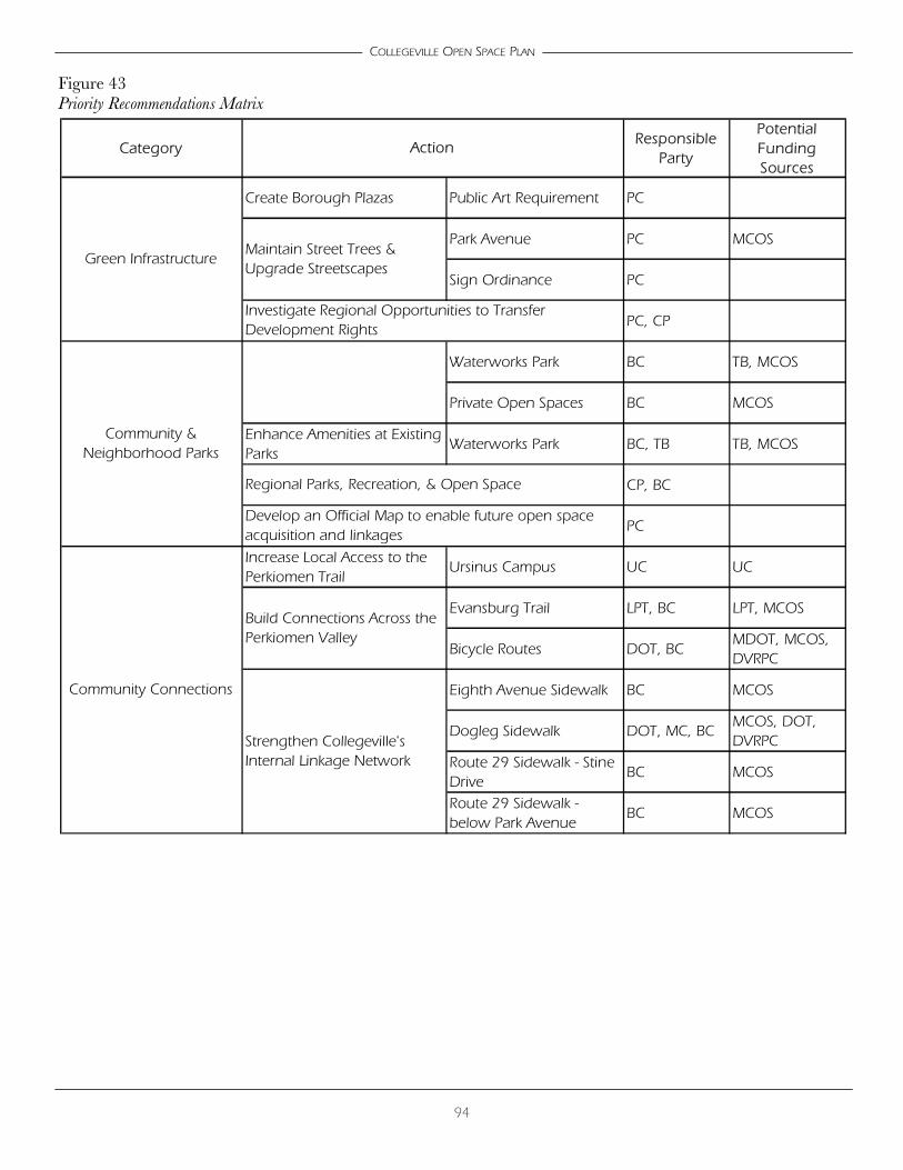
94
COLLEGEVILLE OPEN SPACE PLAN
Figure 43 Priority Recommendations Matrix
CategoryResponsible
Party
Potential Funding Sources
Create Borough Plazas Public Art Requirement PC
Park Avenue PC MCOS
Sign Ordinance PC
PC, CP
Waterworks Park BC TB, MCOS
Private Open Spaces BC MCOS
Enhance Amenities at Existing Parks
Waterworks Park BC, TB TB, MCOS
CP, BC
PC
Increase Local Access to the Perkiomen Trail
Ursinus Campus UC UC
Evansburg Trail LPT, BC LPT, MCOS
Bicycle Routes DOT, BCMDOT, MCOS, DVRPC
Eighth Avenue Sidewalk BC MCOS
Dogleg Sidewalk DOT, MC, BCMCOS, DOT, DVRPC
Route 29 Sidewalk - Stine Drive
BC MCOS
Route 29 Sidewalk - below Park Avenue
BC MCOS
Develop an Official Map to enable future open space acquisition and linkages
Strengthen Collegeville's Internal Linkage Network
Community Connections
Maintain Street Trees & Upgrade Streetscapes
Build Connections Across the Perkiomen Valley
Investigate Regional Opportunities to Transfer Development Rights
Community & Neighborhood Parks
Green Infrastructure
Regional Parks, Recreation, & Open Space
Action

95
COLLEGEVILLE OPEN SPACE PLAN
Figure 43A Priority Recommendations
!(
!(
!(
!(
!(
!(!(
!(!(
!(
!(
SE
T
SW
SW
SW
EX
EX
EX
EX
PT
4TH AVE
E THIRD
AVE
E 5
TH
AV
E
LLOY
D A
VE
ZV AR
ICK
RD
E 4T
H
SPANGLER
TENTH
AVE
NU
E
FREELAND
FIFTH
GLE
NW
OO
D
AV
E
CLA
ME
R
AVE
FIRST
DER
R D
R
W N
INTH
AV
E
SEV
ENTH
AVE
WALNUT STREETSIXTH
CIR
SCHOOL ST
STINE
LA
NIN
TH
THIRD
SAY
LOR
LA
EIGH
TH
MAIN
LARKIN
ST
AVE
STREET
ELEV
ENTH
JONLY
N
EXTENSION
RUSSELL
MINER
EAS
T
STRATFORD
AVENUE
LOCUST
MAYKUT
CHESTNUTC
OLO
NI A
L
PARK
RIC
HAR
D
CLAYHORSHAKESPEARE
GLEN F
ARM
S
SCHOOL
SECOND
SHEL
LY
HU
NSIC
KER D
R
WE
ST
DR
RUBY
CARMEN
SON
NE
T
AVO
N
WA
Y
MA
YKU
T
AVE
NU
E
AVEN
UE
STREET
FREELAN
D
WA
Y
DR
DR
DR
CIR
DR
AVENUE
CIR
DR
AVE
AVENUE
AVE
AVENUE
AVE
NU
E
AVE
NU
E
AVE
AVE
NU
E
DR
STREET
LA
AVEN
UE
STIN
E
AVE
NU
E
FIRST
STREET AVEN
UE
STREET
AVE
NU
E
RIC
HAR
D
LA
SECO
ND
0 1,600 3,200800 Feet
MC
PC
MontgomeryCountyPlanningCommissionMontgomery County Courthouse - Planning CommissionPO Box 311 Norristown PA 19404-0311(p) 610.278.3722 (f) 610.278.3941www.montcopa.org/plancomThis map is based on 2000 ortho photography and official sources. Property lines were compiledfrom individual block maps from the Montgomery County Board of Assessment Appeals, with no verificationfrom the deed. This map is not meant to be used as a legal definition of properties or for engineering purposes.
¯
Public Open Space
Private Open Space
!( Priority Recommendations
Symbol DescriptionB Boat LaunchE Park Enhancements
EX Open Space ExpansionG GatewayI Institutional Facilities
NR Natural ResourcesOS New Open SpaceP Borough PlazaPT Perkiomen Trail ConnectionS Street Trees & Streetscaping
SW SidewalksT Property Transfer

96
COLLEGEVILLE OPEN SPACE PLAN


Prepared by the Montgomery County Planning Commission .25 C / 01-06