origins and history of wirksworth: lutudarum and the · pdf fileorigins and history of...
TRANSCRIPT
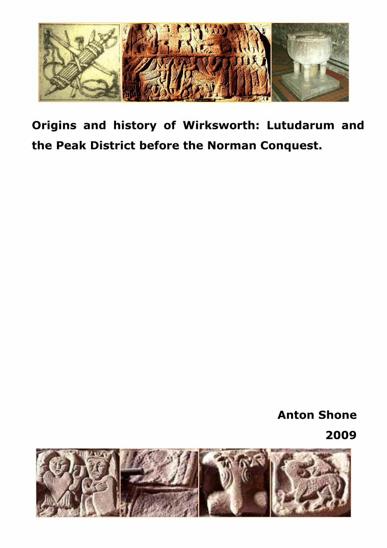
Origins and history of Wirksworth: Lutudarum and
the Peak District before the Norman Conquest.
Anton Shone
2009
1
Contents Page
Introduction 3
Chapter 1 Evidence of Lutudarum, its history and continuity
The city state of Lutudarum 5
Location 7
Place names 9
Continuity of government 11
Continuity of Christianity 13
Continuity of industry 16
Communications, rivers and roads 18
Trade and commerce 22
Dating the Roman origins of the district 24
A tour of the border of the Lutudarenses 26
The end of Roman rule 27
Chapter 2 The Pecsaete
The Mercian Province 29
A timeline of the Mercian – Northumbrian war 29
Sokes and Hundreds 32
The Danelaw 35
Province and shire 39
Wirksworth and Domesday Book 40
Conclusions 44
Reference Lists 46
Acknowledgements:
I am most grateful to all those who have assisted with this paper in any way. In particular to the
librarians and archivists at the Derby City Library, Derbyshire County Record Office, the Lichfield
Record Office, Nottingham University Library and the Derbyshire Local Studies Library at Matlock. A
number of individuals and organisations have seen and commented on the paper and these have been
most helpful and I would particularly like to thank Mr John G Evans for proof reading this edition.
12/8/09
Published by the Wirksworth Roman Project
Derby, Derbyshire
1st Edition 2006
2nd Edition 2009
Website: www.wirksworthromanproject.co.uk
2
Preface to the second edition
This history began as an attempt to consider the origins of Wirksworth. The first edition sought to
assemble all the potential sources for the early, possibly Roman, origins of the town. In doing so it
became apparent that much was missing - a huge gap existed in the academic and popular
understanding of both Wirksworth and its role in the history of the Peak District. This gap was due to
the weakness of the source material, much of which was conjecture or spurious opinion often endlessly
and inaccurately repeated, as well as a lack of archaeological work together with a failure to assemble
what was known in a way that would enable it to be properly understood.
This second edition adds to the original by bringing in some of the completed archaeological work
achieved since, for example in the assessment of the Peak District’s Roman road system, which has
resulted in a complete re-writing of the section on communications that appeared in the first edition. In
revising the first edition, the chapter which attempted to address the geology and archaeology of
Wirksworth has been removed, as this will be the subject of a separate report to be produced shortly.
The major addition to the second edition is the inclusion of a new chapter which deals with what is
known of Wirksworth and the Peak District in the Mercian and Viking period and which takes this
history forward as far as Domesday Book in 1086.
Anton Shone
Derby
1st February 2009
3
“The country was once famous for its twenty-eight noble cities as well as innumerable
fortified places equally well guarded by the strongest of walls and towers, gates and locks”
(Bede, speaking of Roman Britain).
Introduction
The key to understanding the history of Wirksworth is to understand the history of St Mary’s church. St
Mary’s is a Minster Church, what this means is that it had a function and role like the Minsters of York,
or Beverley or Ripon, it was the mother church of a large district. The Minster churches are important
because they represent the continuity of their towns over a very considerable period of time. In many
respects the failure of historians to fully understand the implications of this also represents the failure
to understand the early history of Wirksworth and of the Peak District itself. So this is a history of a city
and its church. Many might say that Wirksworth is not a city, but once, long ago, it was. The reasons
for the failure in understanding have varied but there were several contributing factors:
The first stems from an apparent difference of approach by historians to Roman towns such as “lost
Lutudarum”: one view tends to be that based on assumed continuity between the Roman and post-
Roman in certain areas. Another is that of assumed discontinuity. This latter is all very well south of the
Trent, but we are looking for Lutudarum north of the Trent, and, for this reason, and many others, we
are looking for somewhere that still exists. Dark (1998) is extremely clear that understanding the
fundamental division between those areas of the East Midlands which passed into Saxon occupation
and those areas which remained British, during the fifth century, is central to the understanding of the
issue of continuity and discontinuity in terms of location.
The second reason appears to be the lack of assessment of all known data taken together. There has
been a very haphazard approach to trying to find Lutudarum, which, for example, resulted in the
historians of lead mining being pre-occupied with the concept of Lutudarum as a lead mining district
rather than as the chief town of its district (Rieuwerts, 1988) and, similarly, the archaeologists of
Derbyshire had been so active around Carsington in the 1980s that this appeared to have overwhelmed
the coherent assessment of other locations. Many others muddied the waters by claiming Lutudarum
for their own, on the most spurious of reasoning. If it was a town, village or some other location, then
it might be Ashbourne, Chesterfield, Crich, Carsington, Matlock, Middleton, Rainster Rocks, Youlgrave
or even Wilne Ferry (!) or any number of other unlikely and incomprehensible suggestions, but not,
apparently, where the considered evidence puts it: Wirksworth. Rahtz noted that evidence of urban
continuity in Mercian towns tended to suffer from the inability to assemble and assess data from all
possible sources together. This had, at the time when Rahtz wrote (1977) only been undertaken in the
study of Worcester and it had not been, until now, attempted in terms of Wirksworth.
Finally, it is fair to say that there has also been a very general weakness of assessment of the upland
areas of Britain in archaeological terms (in comparison to the lowland areas) and an almost complete
4
failure of archaeological assessment of the small towns of the White Peak in particular, a failure which
Hodges noted in 1991 and which has barely been addressed since.
The purpose of this study is to consider such documentary research information as is available as a
coherent whole for Wirksworth and its immediate hinterland. In conjunction with the documentary
research, primary archaeological work began in 2006 to prove (or disprove) the conclusions reached by
the documentary research, and a series of reports published by the Wirksworth Roman Project deal
with the associated archaeological effort.
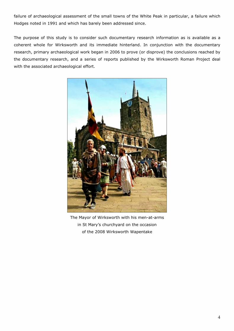
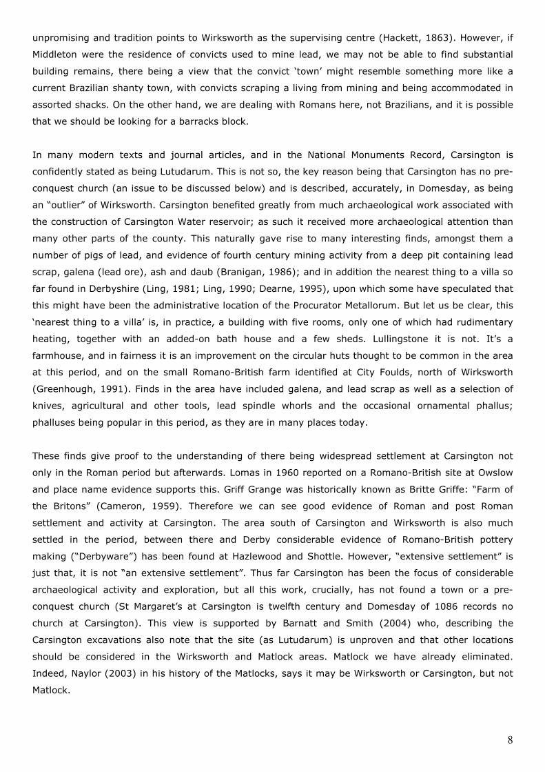
The Mayor of Wirksworth with his men-at-arms
in St Mary’s churchyard on the occasion
of the 2008 Wirksworth Wapentake
5
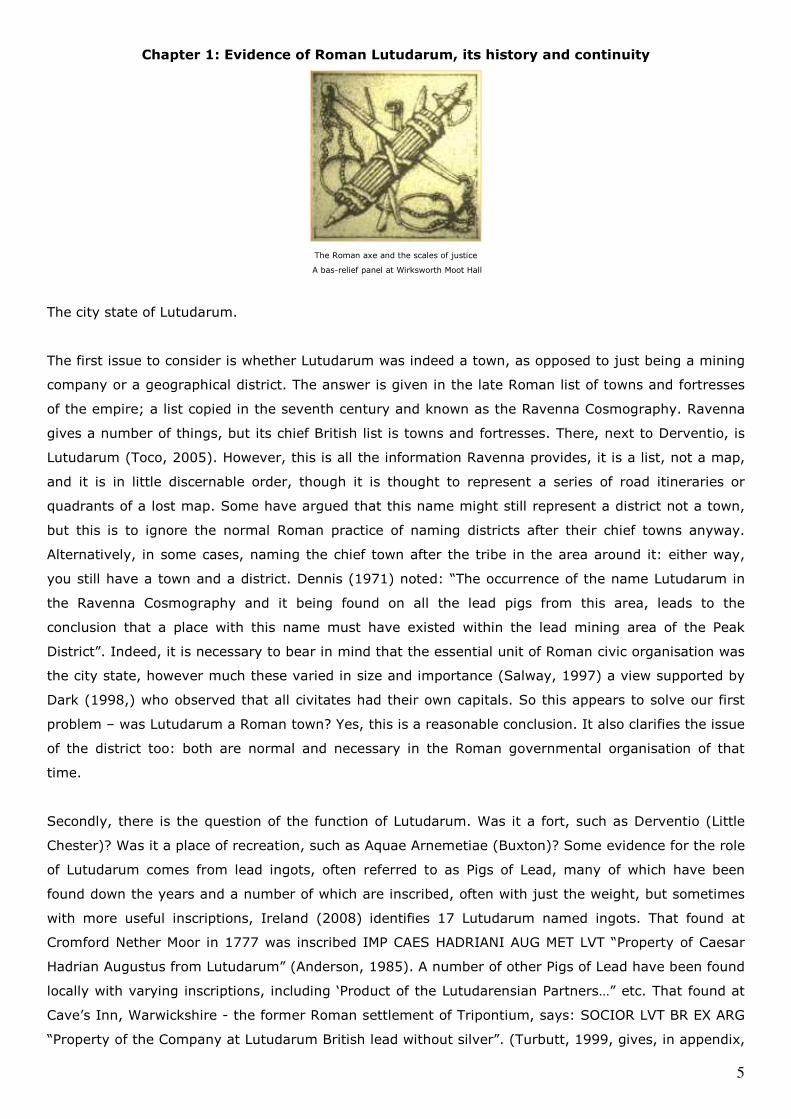
Chapter 1: Evidence of Roman Lutudarum, its history and continuity
The Roman axe and the scales of justice
A bas-relief panel at Wirksworth Moot Hall
The city state of Lutudarum.
The first issue to consider is whether Lutudarum was indeed a town, as opposed to just being a mining
company or a geographical district. The answer is given in the late Roman list of towns and fortresses
of the empire; a list copied in the seventh century and known as the Ravenna Cosmography. Ravenna
gives a number of things, but its chief British list is towns and fortresses. There, next to Derventio, is
Lutudarum (Toco, 2005). However, this is all the information Ravenna provides, it is a list, not a map,
and it is in little discernable order, though it is thought to represent a series of road itineraries or
quadrants of a lost map. Some have argued that this name might still represent a district not a town,
but this is to ignore the normal Roman practice of naming districts after their chief towns anyway.
Alternatively, in some cases, naming the chief town after the tribe in the area around it: either way,
you still have a town and a district. Dennis (1971) noted: “The occurrence of the name Lutudarum in
the Ravenna Cosmography and it being found on all the lead pigs from this area, leads to the
conclusion that a place with this name must have existed within the lead mining area of the Peak
District”. Indeed, it is necessary to bear in mind that the essential unit of Roman civic organisation was
the city state, however much these varied in size and importance (Salway, 1997) a view supported by
Dark (1998,) who observed that all civitates had their own capitals. So this appears to solve our first
problem – was Lutudarum a Roman town? Yes, this is a reasonable conclusion. It also clarifies the issue
of the district too: both are normal and necessary in the Roman governmental organisation of that
time.
Secondly, there is the question of the function of Lutudarum. Was it a fort, such as Derventio (Little
Chester)? Was it a place of recreation, such as Aquae Arnemetiae (Buxton)? Some evidence for the role
of Lutudarum comes from lead ingots, often referred to as Pigs of Lead, many of which have been
found down the years and a number of which are inscribed, often with just the weight, but sometimes
with more useful inscriptions, Ireland (2008) identifies 17 Lutudarum named ingots. That found at
Cromford Nether Moor in 1777 was inscribed IMP CAES HADRIANI AUG MET LVT “Property of Caesar
Hadrian Augustus from Lutudarum” (Anderson, 1985). A number of other Pigs of Lead have been found
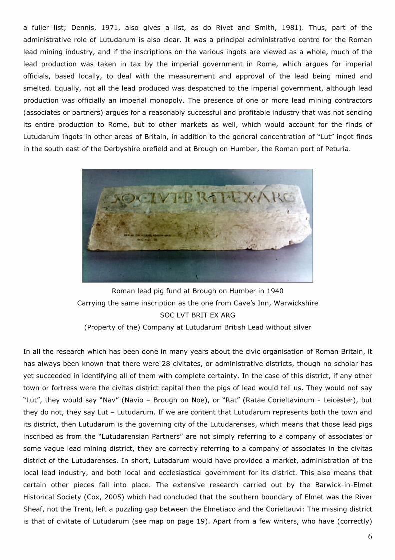
locally with varying inscriptions, including ‘Product of the Lutudarensian Partners…” etc. That found at
Cave’s Inn, Warwickshire - the former Roman settlement of Tripontium, says: SOCIOR LVT BR EX ARG
“Property of the Company at Lutudarum British lead without silver”. (Turbutt, 1999, gives, in appendix,
6
a fuller list; Dennis, 1971, also gives a list, as do Rivet and Smith, 1981). Thus, part of the
administrative role of Lutudarum is also clear. It was a principal administrative centre for the Roman
lead mining industry, and if the inscriptions on the various ingots are viewed as a whole, much of the
lead production was taken in tax by the imperial government in Rome, which argues for imperial
officials, based locally, to deal with the measurement and approval of the lead being mined and
smelted. Equally, not all the lead produced was despatched to the imperial government, although lead
production was officially an imperial monopoly. The presence of one or more lead mining contractors
(associates or partners) argues for a reasonably successful and profitable industry that was not sending
its entire production to Rome, but to other markets as well, which would account for the finds of
Lutudarum ingots in other areas of Britain, in addition to the general concentration of “Lut” ingot finds
in the south east of the Derbyshire orefield and at Brough on Humber, the Roman port of Peturia.
Roman lead pig fund at Brough on Humber in 1940
Carrying the same inscription as the one from Cave’s Inn, Warwickshire
SOC LVT BRIT EX ARG
(Property of the) Company at Lutudarum British Lead without silver
In all the research which has been done in many years about the civic organisation of Roman Britain, it
has always been known that there were 28 civitates, or administrative districts, though no scholar has
yet succeeded in identifying all of them with complete certainty. In the case of this district, if any other
town or fortress were the civitas district capital then the pigs of lead would tell us. They would not say
“Lut”, they would say “Nav” (Navio – Brough on Noe), or “Rat” (Ratae Corieltavinum - Leicester), but
they do not, they say Lut – Lutudarum. If we are content that Lutudarum represents both the town and
its district, then Lutudarum is the governing city of the Lutudarenses, which means that those lead pigs
inscribed as from the “Lutudarensian Partners” are not simply referring to a company of associates or
some vague lead mining district, they are correctly referring to a company of associates in the civitas
district of the Lutudarenses. In short, Lutadarum would have provided a market, administration of the
local lead industry, and both local and ecclesiastical government for its district. This also means that
certain other pieces fall into place. The extensive research carried out by the Barwick-in-Elmet
Historical Society (Cox, 2005) which had concluded that the southern boundary of Elmet was the River
Sheaf, not the Trent, left a puzzling gap between the Elmetiaco and the Corieltauvi: The missing district
is that of civitate of Lutudarum (see map on page 19). Apart from a few writers, who have (correctly)
7
regarded the Peak as not being part of Brigantia (see Simpson, 1964), there has been a persistent view
that the Lutudarenses were in some way part of the Brigantes, but the lead pigs also enlighten us to
this. Those lead pigs found in the territoria of the Brigantes also bear some inscriptions, such as that
from Pately Bridge in Yorkshire (CIL record 1207, 2006) which says it is Brigantian lead. None of the
lead pigs found in the Peak say this, they are commonly inscribed “Lut” for Lutudarum, not “Brig” for
Brigantia. Indeed it is typical of lead pigs to indicate their district (city state) of origin, for example,
those from Flintshire are inscribed “Dec” for Deceangli (Ireland, 2008).
Location
So, being certain enough that Lutudarum genuinely was a town and its chief role was the business of
lead mining and the administration of its district, this brings us to the very thorny question of its
location. Above all, it has to be within the area in which lead is being mined in the Roman period,
otherwise there is no attributable significance to the lead ingot inscriptions or the pattern of finds. The
Peak District orefield stretches from Castleton in the north to just below Alstonefield in the south. Lead
veins are commonest around Castleton, also east of Tideswell, west of Bakewell and north of
Wirksworth. From this information, we can immediately dismiss a number of the possible candidates for
Lutudarum, as being beyond the main orefield. Transport in Roman times was slow and expensive
(packhorses on the roads and boats on the rivers) and lead is very, very heavy, thus there would be
nothing to be gained by transporting it long distances to be assessed, measured or taxed.
The locations to be immediately dismissed as unsuitable because of their distance from the main
orefield are Chesterfield and Ashbourne. Both towns are also ruled out by their own local historians. In
the case of Chesterfield, Bestall’s view (1974) was that Lutudarum should be sought around Matlock or
Wirksworth. But we can rule out Matlock as also being relatively inconvenient in transport terms and
too late in terms of the known origins of the town (Naylor, 2003), though there was a Mercian royal
estate around Matlock, which was associated with those at Wirksworth, Ashbourne, Parwich and Darley.
Crich similarly can be ruled out, for much the same reason, and it is too far from the main orefield,
although there is some lead locally. Its claim rested on there being lead smelting recorded in
Domesday (Bunting, 1998) and that Roman coins were found on Crich Hill (Davis, 2003). However,
Roman coins are evidence of Romans, not of Roman lead mining, and in due course, Davis, in his
definitive work on the history of Crich, makes no claim for it to be Lutudarum, nor can it be. Rainster
Rocks was considered by Dennis (1971) but although it is in the right kind of geographical location in
terms of the orefield, the known archaeology is, according to Dennis, of ‘too native an origin’ and too
small for what should have some Roman context or hinterland.
Within the orefield, Middleton by Wirksworth provides little except for the inevitable pig of lead or two.
Although mentioned in Domesday (as are all most of the other places discussed here) it shows no signs
of any historic importance, except that local tradition (Dodd, 2000) recalls Middleton’s existence as the
place where Roman convicts resided as a labour force for the lead mines. (A similar tradition exists in
relation to convicts at Bradwell kept by the locals of Brough, where a Roman fortress existed). We may
simply not have found enough evidence at Middleton, but the basis for it being Lutudarum is
8
unpromising and tradition points to Wirksworth as the supervising centre (Hackett, 1863). However, if
Middleton were the residence of convicts used to mine lead, we may not be able to find substantial
building remains, there being a view that the convict ‘town’ might resemble something more like a
current Brazilian shanty town, with convicts scraping a living from mining and being accommodated in
assorted shacks. On the other hand, we are dealing with Romans here, not Brazilians, and it is possible
that we should be looking for a barracks block.
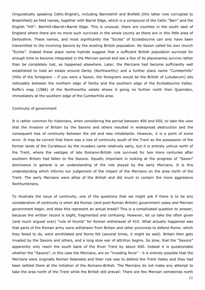
In many modern texts and journal articles, and in the National Monuments Record, Carsington is
confidently stated as being Lutudarum. This is not so, the key reason being that Carsington has no pre-
conquest church (an issue to be discussed below) and is described, accurately, in Domesday, as being
an “outlier” of Wirksworth. Carsington benefited greatly from much archaeological work associated with
the construction of Carsington Water reservoir; as such it received more archaeological attention than
many other parts of the county. This naturally gave rise to many interesting finds, amongst them a
number of pigs of lead, and evidence of fourth century mining activity from a deep pit containing lead
scrap, galena (lead ore), ash and daub (Branigan, 1986); and in addition the nearest thing to a villa so
far found in Derbyshire (Ling, 1981; Ling, 1990; Dearne, 1995), upon which some have speculated that
this might have been the administrative location of the Procurator Metallorum. But let us be clear, this
‘nearest thing to a villa’ is, in practice, a building with five rooms, only one of which had rudimentary
heating, together with an added-on bath house and a few sheds. Lullingstone it is not. It’s a
farmhouse, and in fairness it is an improvement on the circular huts thought to be common in the area
at this period, and on the small Romano-British farm identified at City Foulds, north of Wirksworth
(Greenhough, 1991). Finds in the area have included galena, and lead scrap as well as a selection of
knives, agricultural and other tools, lead spindle whorls and the occasional ornamental phallus;
phalluses being popular in this period, as they are in many places today.
These finds give proof to the understanding of there being widespread settlement at Carsington not
only in the Roman period but afterwards. Lomas in 1960 reported on a Romano-British site at Owslow
and place name evidence supports this. Griff Grange was historically known as Britte Griffe: “Farm of
the Britons” (Cameron, 1959). Therefore we can see good evidence of Roman and post Roman
settlement and activity at Carsington. The area south of Carsington and Wirksworth is also much
settled in the period, between there and Derby considerable evidence of Romano-British pottery
making (“Derbyware”) has been found at Hazlewood and Shottle. However, “extensive settlement” is
just that, it is not “an extensive settlement”. Thus far Carsington has been the focus of considerable
archaeological activity and exploration, but all this work, crucially, has not found a town or a pre-
conquest church (St Margaret’s at Carsington is twelfth century and Domesday of 1086 records no
church at Carsington). This view is supported by Barnatt and Smith (2004) who, describing the
Carsington excavations also note that the site (as Lutudarum) is unproven and that other locations
should be considered in the Wirksworth and Matlock areas. Matlock we have already eliminated.
Indeed, Naylor (2003) in his history of the Matlocks, says it may be Wirksworth or Carsington, but not
Matlock.
9
Finally then, this brings us to Wirksworth, and to a predictable problem. If Wirksworth is Roman
Lutudarum, where are the Roman remains? The issue of the lack of physical evidence is, at first glance,
intractable. In some ways it is more difficult than any of the other locations whose claims we have so
readily dismissed. This is because, if Lutudarum exists, it is buried under modern Wirksworth. However,
to regard Wirksworth as in any way modern, except perhaps in the outlook of its inhabitants, is to
commit a grave error. The town creaks under the antiquity of its buildings, its pedestrian layout, and
its mining heritage. Until recently, Wirksworth appeared to be a grim, dusty little quarrying town. A
moment’s examination of the Derbyshire Archaeological Journal on the subject of Wirksworth indicate
that between 1929 and 2009, only twice has any mentionable archaeological interest been shown in
the town and both were considerations of the iconography of the “Wirksworth Stone”. The other part of
this problem has been inadequate recording and analysis of those finds which are known.
There are several reasons why this has happened. First, the amount of professional archaeological
effort which has been expended on Wirksworth could be recorded on a postage stamp, the town has
hardly attracted the attention of archaeologists and barely registered on the horizons of historians.
Only Hilary Dennis is known to have dug a small area within the town precincts, which resulted in some
modern pottery finds and a sceatta coin (found by a passing metal detectorist, not the archaeologists),
before apparently running out of time to complete the dig. (Editorial, 1986). Eyewitnesses to that dig,
for which no report was ever made, note that it got to little over a metre in depth. The pottery in Derby
Museum from the dig does not even include the late mediaeval.
For over a century, the town could best be described as grim, dust covered, and overwhelmed by
quarrying. It lacked the romance by which other cities and towns of less history but prettier walls
behoved themselves to the scholarly. We know all about the Corieltauvi, by comparison, so too about
the Elmetiaco and the Lindenses, but the Lutudarenses are almost invisible, only a few pigs of lead
have spoken for them down the years. Nevertheless, coins and pottery have been found, there is
extensive place name evidence and the great antiquity of the church is central to the issue.
Archaeological work in conjunction with the historical research presented here has been on-going since
2006 and is presented in a series of reports by the Wirksworth Roman Project culminating in a
summary of the effort in an associated report “Issues in the archaeology of Wirksworth”.
Place names
“Lutudarum” is variously considered to mean “Muddy River” (Rivet and Smith, 1981) or “Lead Water”,
or possibly “Cindery Oakwood” (Breeze, 2002), but these are essentially unhelpful, as the geographical
or physical features to which they refer could be in any number of locations, though Rivet and Smith
interestingly state that “a site near Wirksworth seems to be indicated”. In terms of the place name,
Wirksworth was considered to mean “Weorc’s enclosure” (Weorchesuorde): Weorc apparently being a
“common” Saxon name. However, this derivation originates in a statement by Stenton (1940) which is
repeated by Cameron (1959), who also recorded but dismissed an alternative and earlier proposal by
Anderson (1934) that the derivation actually meant “Fortified enclosure”.
10
Modern academics regard the assumption of personal names as being unlikely for those place-names
originating before 900 (Stafford, 1985) and regard place names prior to 900 as tending to be the result
of references to geographical or physical features. It is therefore necessary to note the Weorchesuorde
name appears in a charter of 835 and to observe therefore that Anderson’s suggested derivation should
possibly be given greater credence.
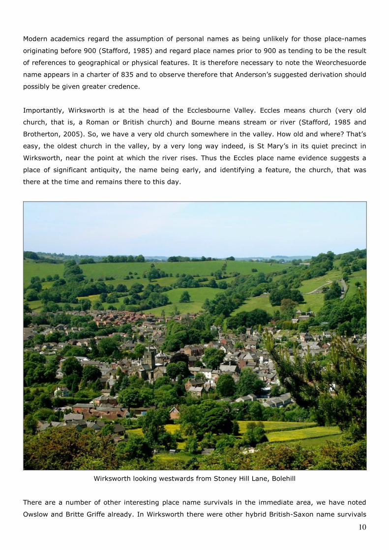
Importantly, Wirksworth is at the head of the Ecclesbourne Valley. Eccles means church (very old
church, that is, a Roman or British church) and Bourne means stream or river (Stafford, 1985 and
Brotherton, 2005). So, we have a very old church somewhere in the valley. How old and where? That’s
easy, the oldest church in the valley, by a very long way indeed, is St Mary’s in its quiet precinct in
Wirksworth, near the point at which the river rises. Thus the Eccles place name evidence suggests a
place of significant antiquity, the name being early, and identifying a feature, the church, that was
there at the time and remains there to this day.
Wirksworth looking westwards from Stoney Hill Lane, Bolehill
There are a number of other interesting place name survivals in the immediate area, we have noted
Owslow and Britte Griffe already. In Wirksworth there were other hybrid British-Saxon name survivals
11
(linguistically speaking Celtic-English), including Bannokhill and Brefeld (this latter now corrupted to
Breamfield) as field names, together with Barrel Edge, which is a compound of the Celtic “Barr” and the
English “Hill”: Barrhill>Barrel>Barrel Edge. This is unusual; there are counties in the south east of
England where there are no more such survivals in the whole county as there are in this little area of
Derbyshire. These names, and most significantly the “Eccles” of Ecclesbourne can only have been
transmitted to the incoming Saxons by the existing British population. No Saxon called his own church
“Eccles”. Indeed these place name hybrids suggest that a sufficient British population survived for
enough time to become integrated in the Mercian period and see a few of its placenames survive rather
than be completely lost, as happened elsewhere. Later, the Mercians had become sufficiently well
established to hold an estate around Derby (Northworthy) and a further place name “Cumberhills”
(Hills of the foreigners – if you were a Saxon, the foreigners would be the British of Lutudarum) sits
noticeably between the northern edge of Derby and the southern edge of the Ecclesbourne Valley.
Roffe’s map (1986) of the Northworthy estate shows it going no further north than Quarndon,
immediately at the southern edge of the Cumberhills area.
Continuity of government
It is rather common for historians, when considering the period between 400 and 650, to take the view
that the invasion of Britain by the Saxons and others resulted in widespread destruction and the
consequent loss of continuity between the old and new inhabitants. However, it is a point of some
error. It may be correct that there was a loss of continuity south of the Trent as the possession of the
former lands of the Corieltauvi by the invaders came relatively early, but it is entirely untrue north of
the Trent, where the vestiges of late Romano-British rule survived for two more centuries after
southern Britain had fallen to the Saxons. Equally important in looking at the progress of “Saxon”
dominance in general is an understanding of the role played by the early Mercians. It is this
understanding which informs our judgement of the impact of the Mercians on the area north of the
Trent. The early Mercians were allies of the British and did much to contain the more aggressive
Northumbrians.
To illustrate the issue of continuity, one of the questions that we might ask if there is to be any
consideration of continuity is when did Roman (and post-Roman British) government cease and Mercian
government begin, and does this represent an actual break? This is a complicated question to answer,
because the written record is slight, fragmented and confusing. However, let us take the often given
(and much argued over) “rule of thumb” for Roman withdrawal of 410. What actually happened was
that parts of the Roman army were withdrawn from Britain and other provinces to defend Rome: which
they failed to do, were annihilated and Rome fell (several times, it might be said). Britain then gets
invaded by the Saxons and others, and a long slow war of attrition begins. So slow, that the “Saxons”
apparently only reach the south bank of the River Trent by about 600. Indeed it is questionable
whether the “Saxons”, in this case the Mercians, are an “invading force” - it is entirely possible that the
Mercians were originally Roman federates and their role was to defend the Trent Valley and they had
been settled there at the initiation of the Romano-British. The Mercians do not make any attempt to
take the area north of the Trent while the British still prevail: There are few Mercian cemeteries north
12
of the Trent dated before 600 (Morris, 1995) and these are in areas apparently away from the areas
still inhabited (and ruled at that time) by the British, especially those with “Eccles” place names
(Barnatt and Smith, 1997) of which Wirksworth, at the head of the Ecclesbourne Valley, is an example.
The sequence of dating of events in and outside the borders of the Peak therefore deserves attention,
as it helps enlighten us to the state of its independence. In 616 the Northumbrians had taken Chester
and annexed Elmet, the Peak, Heathfield and probably Lindsey which gave them control of the north,
but this had not completely destroyed British power. In 633, the last effective British king, Cadwallon,
went with his ally, Penda of the Mercians, and broke the Northumbrians, as Morris reports (1995). So,
the British were still able to subdue the Northumbrians and it was done with Mercian help, and with the
Mercians as subordinates, because it was Cadwallon who ruled, briefly. A year later this had all been
lost, the Northumbrians had regained the supremacy and the British were never able to assert
themselves again. It was 634, and it was left to Penda and the Mercians to attempt to expel the
Northumbrians, which he did for another 20 years until he himself was killed fighting them in 655.
We must note that the Mercians were not attempting to destroy the British (even if the Northumbrians
were), they had been allies, and no Mercian king had, in the early years of the kingdom, made war
upon the British, indeed it is possible that the Mercians were sufficiently integrated into what had
remained of British political structure and thought by intermarriage or treaty and that they regarded
themselves as its proper descendants and guardians: this explanation enables us to understand why
the former British states on the borders of Mercia from the Hwicce in the west to the Peak in the north
were nominally independent for so long afterwards: they were supposed to be, and this state of affairs
shows itself in the Tribal Hidage of 661. Tributaries they may have been, part of Greater Mercia they
were not, until much later. At this early stage, there may have been little imposition of Mercian
authority or control of the Peak, except a requirement to pay tribute and an obligation of military
support. One of the curiosities of this modest imposition, is that the change from Romano-British
culture to Anglo-Saxon culture in the Peak is not because the Mercians impose a new aristocracy, but
because the existing British aristocracy saw the writing on the wall and gradually adopted the new
culture in order to safeguard their position (Loveluck, 1995) and we must remember that
“Government” in this period is essentially about the interaction of important families.
Mercia eventually prevailed, partly due to internecine strife amongst the Northumbrian nobility and
kings. Wirksworth was one of the royal estates of the Mercians, even though, for a brief period, it was
the Northumbrians who had been dominant. By the 680s it was firmly in the Mercian sphere, as the
power of the Mercian kingdom had endured, while that of Northumbria had drained away in civil wars
(Morris, 1995). Over two centuries of Mercian stability remained before the Vikings began to raid
seriously in the late 870s.
The nature of the Pecsaete or Province of the Peak is one which, if anything, has been more difficult to
understand, due to lack of research, than even its fellow districts of Elmet or of Lindsey, but various
writers, such as Brotherton (2005) and Higham (1993), suggest that the district of the Roman
Lutudarenses clearly corresponds to that of the Mercian Pecsaete. This being the case, it would be
13
reasonable to regard the “continuity” of government as: Romano-British civitas of Lutudarenses;
Mercian district of the Pecsaete; thereafter, the various Hundreds or Wapentakes which comprised the
Province were hived off to create the later shire counties with only the central ones being retained for
“Derbyshire”. A map of the reconstructed territory of the Pecsaete which this represents can be found
in Higham (1993). Higham also notes that, as reconstructed, this territory is sufficiently cohesive that it
contains all the known pagan graves of the Pecsaete.
Continuity of Christianity
It must be noted that the late Romans and the Romano-British were Christian: remember the
Ecclesbourne place name? For a church to exist, there had to be enough money to build it and maintain
it and there had to be a congregation to use it. You don’t build churches in the middle of nowhere, even
though we have a tendency to regard late Roman church building as some kind of ‘rural’ activity, even
that the Christian population worshipped in fields: this does not represent the true picture, churches
were in urban areas and specific to the civitas capitals. In the Peak, where agriculture is poor and the
population spread thinly, the church must be in a town, and one that has a sufficient source of income,
such as from lead mining: having enough wealthy Christians in and near it (note the Benty Grange
Helmet) to warrant, build and maintain a church. Even accepting the dubious argument that “Eccles”
might represent a congregation not a building, the supposition of a town can still hold. The presence of
one of the earliest and richest Minster Churches in Mercia (Turbutt, 1999) in this case, its Province of
the Pecsaete, can only be because Wirksworth was an important administrative centre, a royal estate,
a major source of revenue, and which had a long Christian heritage capable of surviving the decline of
Roman rule and the ascendancy of the Mercians.
Let us also bear in mind, in the general matter of continuity of Christianity, Lyttelton-Gell in 1916 had
first felt that continuity of Christianity was predictable in Wirksworth from the Roman period onwards,
but lacked the convincing case later made by Bassett (1992) about the continuance of Christian church
activities in the West Midlands in general, with its implications for the Peak. Bassett laid out the case
for the smooth transfer of church authority from the British bishops in the West Midland part of early
Mercia to the Mercian bishops and the continuance of the precedence of the former British churches in
their original parishes, which he equated, significantly, to the late Roman civitates. If this was so there,
why should that same transfer of ecclesiastical responsibility and authority not be the case in the
Pecsaete? Bassett also noted, from his studies of Worcester, Gloucester and other towns, that even
where British administration of a civitate had failed and the town declined, the ecclesiastical authority
did not fail. Indeed, St Mary’s in Wirksworth can only be the mother church of the Pecsaete. Its
antiquity and the topographical evidence of the size of its original parish match anything Bassett has
found elsewhere. Bonsall, Carsington, Kirk Ireton and Matlock were all apparently parochial chapelries
dependent on Wirksworth (Stroud, 2001). Alderwasley was also a parochial chapelry of Wirksworth.
Separately, it is known that tithes in Shottle, which included Postern and Windley, were not paid to
Duffield, but originally went to Wirksworth, which also implies that Duffield parish, which included
Belper and Heage, might also originally have been subservient to Wirksworth. The extent of the original
Minster church parish (the “parochiae”) was discussed by Turbutt (1999) who regarded the parochiae
14
of Wirksworth as certainly including Bonsall; Carsington; Kirk Ireton; Alderwasley; Cromford; Ible;
Ivonbrook Grange; Hopton; Biggin; Idridgehay; Alton; Middleton by Wirksworth; Callow; Ashleyhay
and possibly Darley; Farley, Cotes, Burley, Wensley; Snitterton; Matlock and Tansley.
If Wirksworth’s Minster church originally had a bishop (or abbot, as a monastic type of church) there is
now no record. It must be remembered that each Romano-British civitate originally possessed a bishop
(Morris, 1995), but the lack of a record of this is not surprising – the chief authority for early
ecclesiastical history is Bede, and Bede was disdainful of the work of the British church, in consequence
he is invariably silent about it, except occasionally to abuse it. The gap Bassett (1992) argues, which
this leaves is almost as instructive as anything Bede actually says. In the case of the conversion of the
Mercians, it has been speculated that Peada, returning from Northumberland with four priests in 653,
may have despatched one of them (Bette, who does not appear again in the historical record) to the
Pecsaete. This is probably not so. The Pecsaete were already Christian, had their own long established
churchmen, and had no need for Bette to preach to them, but the Mercians, pagans all, certainly had.
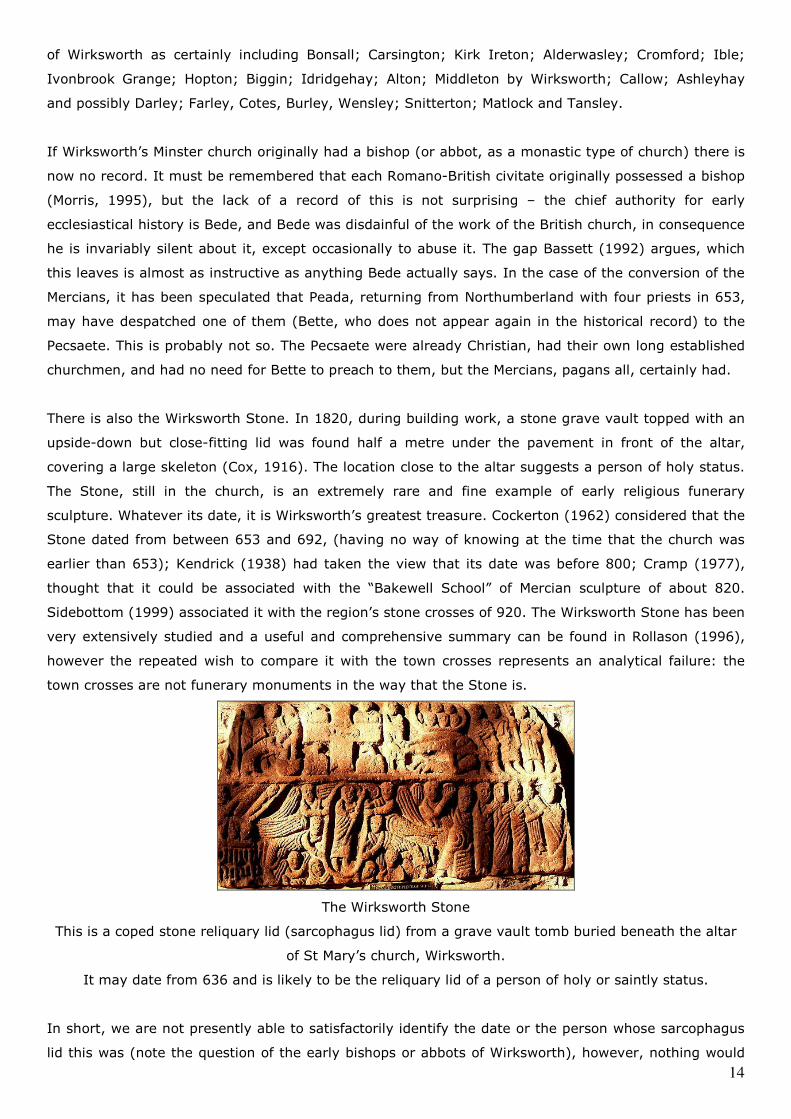
There is also the Wirksworth Stone. In 1820, during building work, a stone grave vault topped with an
upside-down but close-fitting lid was found half a metre under the pavement in front of the altar,
covering a large skeleton (Cox, 1916). The location close to the altar suggests a person of holy status.
The Stone, still in the church, is an extremely rare and fine example of early religious funerary
sculpture. Whatever its date, it is Wirksworth’s greatest treasure. Cockerton (1962) considered that the
Stone dated from between 653 and 692, (having no way of knowing at the time that the church was
earlier than 653); Kendrick (1938) had taken the view that its date was before 800; Cramp (1977),
thought that it could be associated with the “Bakewell School” of Mercian sculpture of about 820.
Sidebottom (1999) associated it with the region’s stone crosses of 920. The Wirksworth Stone has been
very extensively studied and a useful and comprehensive summary can be found in Rollason (1996),
however the repeated wish to compare it with the town crosses represents an analytical failure: the
town crosses are not funerary monuments in the way that the Stone is.
The Wirksworth Stone
This is a coped stone reliquary lid (sarcophagus lid) from a grave vault tomb buried beneath the altar
of St Mary’s church, Wirksworth.
It may date from 636 and is likely to be the reliquary lid of a person of holy or saintly status.
In short, we are not presently able to satisfactorily identify the date or the person whose sarcophagus
lid this was (note the question of the early bishops or abbots of Wirksworth), however, nothing would
15
be lost by spending less time comparing it with the “Mercian” sculpture of the Peak and more time
possibly comparing it with any comparable known funerary material from other civitas churches,
particularly those of the north.
Kurth in 1945 had concluded, of the iconography of the Wirksworth Stone, that: “On the whole, the
analogies are so numerous that the slab might well be considered as a late legacy of Roman Britain and
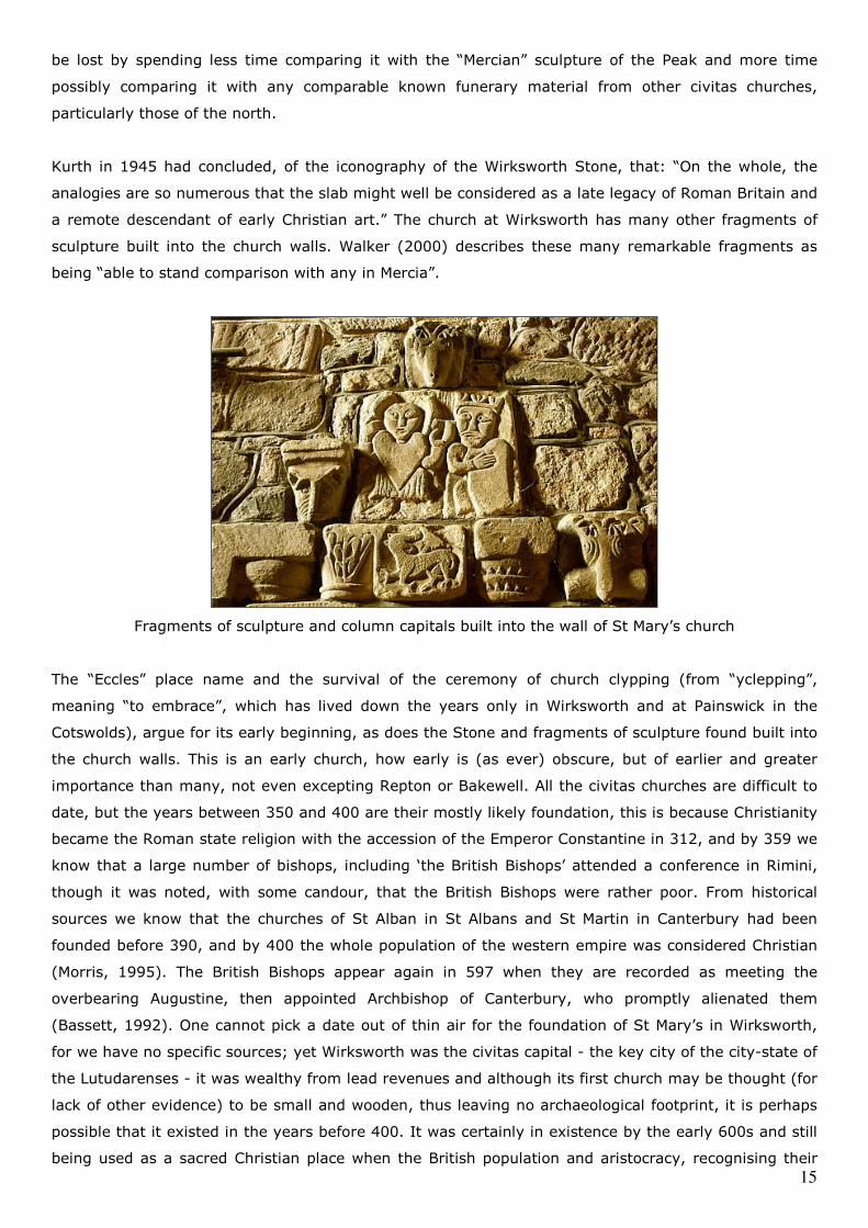
a remote descendant of early Christian art.” The church at Wirksworth has many other fragments of
sculpture built into the church walls. Walker (2000) describes these many remarkable fragments as
being “able to stand comparison with any in Mercia”.
Fragments of sculpture and column capitals built into the wall of St Mary’s church
The “Eccles” place name and the survival of the ceremony of church clypping (from “yclepping”,
meaning “to embrace”, which has lived down the years only in Wirksworth and at Painswick in the
Cotswolds), argue for its early beginning, as does the Stone and fragments of sculpture found built into
the church walls. This is an early church, how early is (as ever) obscure, but of earlier and greater
importance than many, not even excepting Repton or Bakewell. All the civitas churches are difficult to
date, but the years between 350 and 400 are their mostly likely foundation, this is because Christianity
became the Roman state religion with the accession of the Emperor Constantine in 312, and by 359 we
know that a large number of bishops, including ‘the British Bishops’ attended a conference in Rimini,
though it was noted, with some candour, that the British Bishops were rather poor. From historical
sources we know that the churches of St Alban in St Albans and St Martin in Canterbury had been
founded before 390, and by 400 the whole population of the western empire was considered Christian
(Morris, 1995). The British Bishops appear again in 597 when they are recorded as meeting the
overbearing Augustine, then appointed Archbishop of Canterbury, who promptly alienated them
(Bassett, 1992). One cannot pick a date out of thin air for the foundation of St Mary’s in Wirksworth,
for we have no specific sources; yet Wirksworth was the civitas capital - the key city of the city-state of
the Lutudarenses - it was wealthy from lead revenues and although its first church may be thought (for
lack of other evidence) to be small and wooden, thus leaving no archaeological footprint, it is perhaps
possible that it existed in the years before 400. It was certainly in existence by the early 600s and still
being used as a sacred Christian place when the British population and aristocracy, recognising their
16
increasing isolation, were beginning to use the Saxon language to rename things. It is likely that its
own bishops continued to serve it until 679 when, at last, Archbishop Theodore had enough educated
Saxons to appoint them to the reformed sees of the midlands and the north, and it is at this point that
it may have been absorbed into the See of the Mercians at Lichfield, though such a change is
unrecorded.
Continuity of industry.
Lead production is a very ancient practice which has been carried on in many parts of Britain including
the Mendips (Somerset), Flintshire, Yorkshire and Derbyshire since pre-Roman times. Lead was
extracted by following a lead vein with bell pits, many of which were found locally when the new road
along Porter Lane was constructed in connection with the reservoir at Carsington. Lead was also
extracted alluvially, that is, dug out of riverbeds, and through open cast mining. The Roman miners
used bronze picks, which leave characteristic marks and one such open cast mine with these marks has
been found at Godfrey Hole, at Wirksworth, by historian Tony Holmes (pers comm); the difficulty,
though, is that such picks continued to be used down to the twelfth century, so dating proof is difficult
without having found coinage or other datable evidence. Lead production would have continued after
the Roman army was withdrawn and the imperial government in Rome disrupted. There is no reason to
suppose it should not: there are many uses for lead and we have said there is continuity of (British)
government until at least 613. Lutudarum would still be there, its miners (who might also be farming
as well) producing lead, its townspeople going to market, its government taking the revenues from lead
production which might formerly have gone to Rome (Welch, 2001) and continuing to export it to other
parts of Britain and elsewhere. Dark (1998) takes a view that industrial production may not have
continued on the mass scale it had achieved during the Roman period, but that industry did continue
on a lesser scale in all manner of activities from pottery to tin mining; so much so, in the latter case,
that merchants from Byzantium are recorded as visiting Britain to trade for tin throughout this period.
If this is true of pottery and tin mining, there is no reason to suppose it is any less true of lead mining.
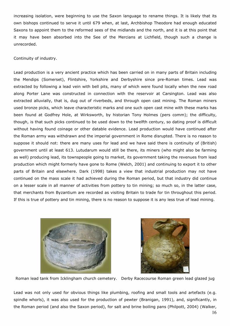
Roman lead tank from Icklingham church cemetery. Derby Racecourse Roman green lead glazed jug
Lead was not only used for obvious things like plumbing, roofing and small tools and artefacts (e.g.
spindle whorls), it was also used for the production of pewter (Branigan, 1991), and, significantly, in
the Roman period (and also the Saxon period), for salt and brine boiling pans (Philpott, 2004) (Walker,
17
2000), baptismal tanks (many of which have been found: OS map, 1997) and for coffins (Salway,
1997). One of the frequent difficulties expressed by historians of the lead industry is the inability to
find evidence of lead mining activity by way of tools and so on, but this approach, which might be
called “supply side” evidence, repeatedly overlooks the presence of “demand side” evidence – we have
boiling pans, we have baptismal tanks, we have all manner of lead artefacts from the late Roman and
early Saxon periods: that these things exist and have been found in dated contexts is evidence of the
activity going on, even if we have not yet found a lead mine with a dead Roman holding a pick on one
side and a dead Saxon holding a kibble on the other. Indeed, the history of the church of Durham notes
that Abbott Eadberht, Bishop of the Northumbrians, rebuilt the church at Lindisfarne with a roof
entirely covered in lead in 688, though its source is not recorded. However, source is reasonably
evidenced in 714 when Abbess Ecgburh (Colgrave, 1956) is recorded as sending a coffin of lead for the
burial of St Guthlac of Crowland Abbey. This can only have been done from her estates: the only ones
in Mercia having lead being those at Wirksworth. Indeed Wirksworth appears again, specifically this
time, named in a charter of 835 when Abbess Cynewaru leased land at Wirksworth to Duke Hunberht in
which a render of lead was sent to Canterbury Cathedral (Birch, 1885) (Cox, 1916).
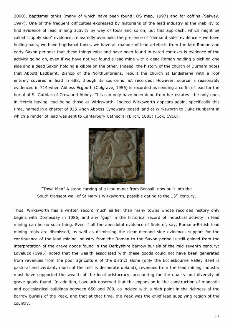
“Towd Man” A stone carving of a lead miner from Bonsall, now built into the
South transept wall of St Mary’s Wirksworth, possible dating to the 13th century.
Thus, Wirksworth has a written record much earlier than many towns whose recorded history only
begins with Domesday in 1086, and any “gap” in the historical record of industrial activity in lead
mining can be no such thing. Even if all the anecdotal evidence of finds of, say, Romano-British lead
mining tools are dismissed, as well as dismissing the clear demand side evidence, support for the
continuance of the lead mining industry from the Roman to the Saxon period is still gained from the
interpretation of the grave goods found in the Derbyshire barrow burials of the mid seventh century:
Loveluck (1995) noted that the wealth associated with these goods could not have been generated
from revenues from the poor agriculture of the district alone (only the Ecclesbourne Valley itself is
pastoral and verdant, much of the rest is desperate upland), revenues from the lead mining industry
must have supported the wealth of the local aristocracy, accounting for the quality and diversity of
grave goods found. In addition, Loveluck observed that the expansion in the construction of monastic
and ecclesiastical buildings between 650 and 700, co-incided with a high point in the richness of the
barrow burials of the Peak, and that at that time, the Peak was the chief lead supplying region of the
country.
18
Communications, rivers and roads.
The River Derwent
We have said that the key economic activity in the district of Lutudarum was lead mining. We have also
noted that, in the days of the highest form of transport being a horse, lead was very difficult to move
because of its weight. If some of the lead produced was being sent to the imperial government in Rome
then Lutudarum must have had the road or river network to despatch it. (A network to collect it would
not be required as the small amounts of ore being produced from various mines would be transported
by horse or mule along pack horse tracks). To be despatched to Rome, lead from Lutudarum must
have reached a point where it could be sent easily by ship. Some have considered (Lane, 1976) that it
might have been possible that the Derwent was navigable as far north as Cromford, and this may be
the case. It had been thought that the Derwent was not navigable (Priestley, 1831), but the discovery
in the translations of the mediaeval Cartulary of Darley Abbey (Darlington, 1945) that the monks of
Darley Abbey were licensed to carry wood by water through the Forest of Duffield Frith (meaning by
the Derwent) possibly implies navigability in the sense of being able to punt items down river, as
opposed to sailing. In addition, there is a cluster of Roman period finds, such as coins and lead pigs, at
Cromford, noted in the Sites and Monuments Record and by Dennis (1971) which suggests a possible
concentration of Roman activity there. Such activity may, taken with the navigability issue, possibly
suggest a river wharf at Cromford. This may prove significant, not only in terms of the movement of
lead pigs to the port of Peturia (Brough on Humber) by river, for trans-shipment there, but may also
help solve the transport problem raised by the presence of Hopton Wood stone (similar to marble,
quarried north west of Wirksworth) found in the baths at Godmanchester in Cambridgeshire (Green,
1960), however, in the absence of both archaeological and greater documentary evidence, it is
necessary to be circumspect about the navigability of the Derwent in Roman times, and the balance of
probability is that it was not navigable as high as Cromford in any meaningful way and that the
transport of goods was indeed by road, as was the case when the trade was eventually documented in
the Stuart period (Slack, 2000).
The Roman road network
Chesterfield to Wirksworth and Rocester
In his discussion of the “lost” town of Lutudarum, Branigan (1985) felt that the Ravenna list was based
on a known road itinerary of the Roman period and that the failure to find Lutudarum was partly due to
the failure to find the road on which it lay. Dennis (1971) felt that a route from Chesterfield to Rocester
via Old Matlock, Starkholmes, Cromford and Old Lane to Wirksworth, then Hopton, Carsington, Wall
Lands, Hognaston Winn, Kniveton and Ashbourne, but mistakenly named Hereward Street, (Henstock,
1980), would render the itinerary of the Ravenna Cosmography correct. That the Chesterfield and
Rocester Road is significant can also be considered from the tendency of lead pigs to be found near it,
and the Derbyshire finds of ingots listed in Turbutt, (plus two unlisted finds at Ashbourne), bracket this
road very firmly: Matlock Bank finds; Cromford finds; Wirksworth and Middleton finds; Carsington finds
and Ashbourne finds, all follow the route.
19
Hope to Wirksworth and Broxtowe
AE&EM Dodd (2000) wrote extensively about the (Saxon period) Portways and their research found the
occurrence of “portway” references in place names in the district to be very prevalent, and also found
various remains in terms of boundaries and later guide stones to be common. AE&EM Dodd felt that the
main Portway in the district ran from Hope, Brough, Ashford, Bakewell and Winster to Wirksworth, and
then possibly via the Gilkin and Street’s Rough to Broxtowe and Nottingham on the one hand, and via
the Gilkin and the Chevin to Little Chester and Derby on the other. In all, AE&EM Dodd took the view
that five portways converged on Wirksworth, more than any other town in the district. As there is
almost no new road building after the Roman period, the term Portway may be inferred in some cases
as indicating a route which may have been based on a former Roman road. Wroe (1982) observed that
little work that had been done on the Hope to Wirksworth (Roman) road. However, he did a little work
south of Brough, and found it to be of above average width, suggesting a road of greater importance
than many of those better known in the district.
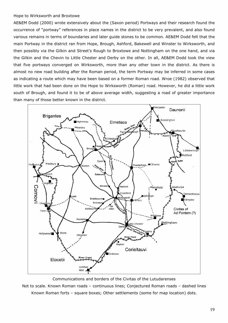
Communications and borders of the Civitas of the Lutudarenses
Not to scale. Known Roman roads – continuous lines; Conjectured Roman roads – dashed lines
Known Roman forts – square boxes; Other settlements (some for map location) dots.
20
The nature of the reporting by the Dodds of their work, in their book, (primarily a guide book), has,
however, obscured some of its clarity, the manner in which the route between Brough and Wirksworth
was described as “the most important portway in the district” obscured the Dodd’s comment that the
portway was ancient and had been used by the Romans. A road used by the Romans is, well, a Roman
road, or to speak plainly, if we consider it the Brough and Wirksworth Roman road, this assists our
clarity better than calling it a Portway, no matter how important a portway, because our purpose is to
find Lutudarum, and its road network. Given this road linked the major settlements through the Peak
from Brough southwards to Wirksworth, it should probably be considered as important as The Street,
yet, in the context of its Roman role, it is invariably ignored. Even Wroe, notwithstanding what he had
said of its width, (and thus the importance he attached to it), traced it only as far south as Ashford.
The nature of road communications around Bakewell in antiquity therefore deserve attention, it is
extremely improbable that Edward the Elder should have built a burg there in 920 if Bakewell had
inadequate communications.
Buxton to Wirksworth
Wroe made a number of observations about the Roman road network of the Peak, most importantly
noting the loss of many of the (conjectured) road courses being due to culvert failure, erosion,
diversion, and peat or woodland build up. However, the presumed “loss” of much of The Street (the
supposed Buxton to Little Chester Roman road) south of Brassington was not due to these reasons, but
was due to persistently looking in the wrong place. The course of The Street was finally confirmed in a
wide-ranging and comprehensive report (Shone and Smart, 2008) which identifies it as the Buxton to
Wirksworth Roman road: Buxton Market Place, Brierlow Bar, Street Farm at Pomeroy, Bull i’ th’ Thorn
at Hurdlow, End Moor, Middle Street Farm, Benty Grange, Oldhams at Friden, Smerrill Barn, Pike Hall,
Minninglow, Straight Knolls at Longcliffe, Peak Quarry Farm, Roundlow Farm, Bee Nest, Brassington
Lane, High Street at Enniscloud Meadow Farm, Gallows Knoll, Broxendale, The Dale and Wirksworth
Market Place.
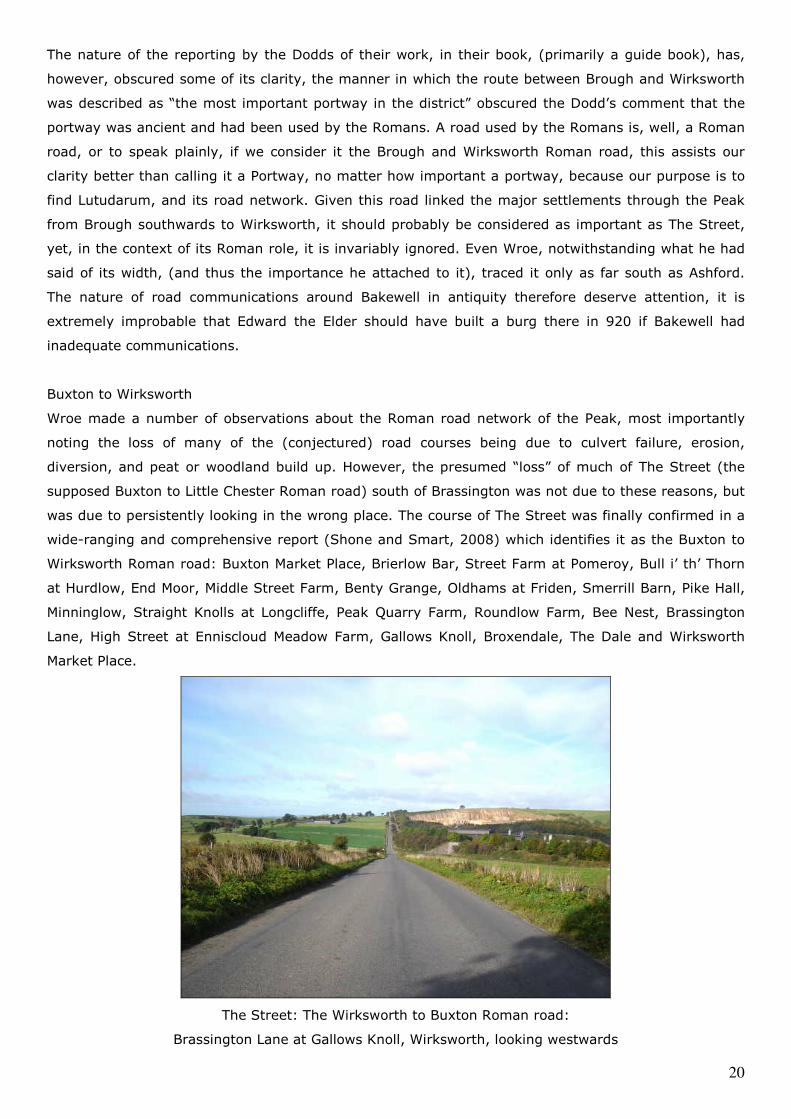
The Street: The Wirksworth to Buxton Roman road:
Brassington Lane at Gallows Knoll, Wirksworth, looking westwards
21
Wirksworth to Duffield and Little Chester
The roads which run south from Wirksworth have been possibly the least researched of any in the
Peak. The road thought to run south via Shottle and Blackbrook and then towards Little Chester by Kay
(1962), was considered to be Roman, because it was relatively straight in character. However, recent
re-assessment by the Wirksworth Roman Project has questioned this conjectured route by the process
of the mapping of archaeological finds south east of the town and around the potteries of the
Ecclesbourne Valley: at Alport, Shottle Hall, and notably at Lumb Brook at Hazlewood, where a lead
smelting hearth was also found, together with roof tiles and two balustrade columns: suggesting a
substantial building, possible even a significant villa nearby, has yet to be found (Brassington, 1988). A
substantial Roman building is also known in the grounds of Duffield Castle, identified in a
magnetometry survey by Bradford University. The mapping of these finds and many others, together
with the assessment of remains such as the ford and causeway at Wirksford, indicated that the actual
course of the road between Wirksworth and Little Chester to be the ridge-way route: Wirksworth,
Wirksford, Broadgate, Alport Triplegate, Coneygreave Hillock, Crowtrees Farm, Knaves Cross
(Wilderbrook Lane end), Longwalls Lane (with its substantial road remains and quernstone quarrying
site at Starbuck House: Palfreyman, 2007), Farnah Green, Milford (crossing the Derwent), Save Penny
Lane, Duffield Bank House, Peckwash Mill, Alfreton Road (south of New Inn Lane) and to Little Chester.
A ridge-way route of this kind makes eminent sense in terms of being a dry and defensible link
between the two locations.
Roads requiring further investigation
There are a number of roads around Wirksworth which require further investigation in addition to the
major task of the Chesterfield – Wirksworth – Rocester road. What might be called a low level route
appears to run from Wirksworth to Ashbourne via Miller’s Green, Wapentake Lane, Kirk Ireton,
Blackwall and Bradley. In addition there are two other suspected local Roman roads. The first is
Summer Lane, which appears to run from Wirksworth to Stainsborough and is referred to as the
“Roman Old Road” in old mining maps. The second is the Stonebridge Road, which runs from
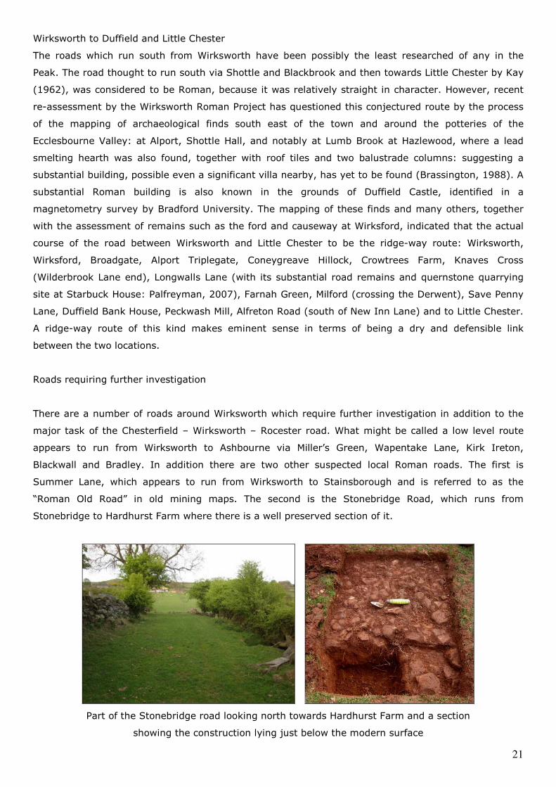
Stonebridge to Hardhurst Farm where there is a well preserved section of it.
Part of the Stonebridge road looking north towards Hardhurst Farm and a section
showing the construction lying just below the modern surface
22
This road may join the low level Ashbourne route at the Stonebridge end to the Ridge-way route at
Hardhurst Farm, and may even represent a connection through Breamfield Farm to the road from
Wirksworth to Whatstandwell Bridge via Longway Bank, which is by far the oldest of the three roads
which converge on the west bank of the Derwent at Whatstandwell, the others being the Matlock-
Belper turnpike (now the A6) and New Road which comes down from Alderwasley.
Trade and commerce.
Although strictly beyond the terms of this study, it must be observed that the tendency of scholars to
frame their work within modern county boundaries may result in some failure to consider
communication, trade and other issues in a wider context (in our case, particularly bearing in mind that
the civitas district does not correspond to the modern county). For example: the historians of
Derbyshire writing about roads (such as Dodd and Wroe) observe that the Roman road running west
from Buxton probably goes to Northwich. However, the archaeologists of Cheshire (cited by Philpott)
identify this road as the Middlewich to Buxton road. Similarly, the road southwest from Buxton is
thought (by Derbyshire sources) to run to Leek and apparently no further; but work in Staffordshire by
Wardle suggests it runs on from Leek, through Stone and Penkridge. Work by Staffordshire
archaeologists and historians about the extensive Roman and British remains in the Manifold Valley
should also perhaps be seen in relation to the Manifold being part of the civitas of the Lutudarenses. A
similar contextual consideration may be required in the study of the archaeology of the site at Mellor by
Marple in the published work by Connelly (2005), which deals with Trans-Pennine trade in the Roman
period.
This latter deserves some note here, especially in terms of Connelly’s observations about the
interpretation of pottery finds, notably Derbyware, also lead finds, the salt trade and agriculture in
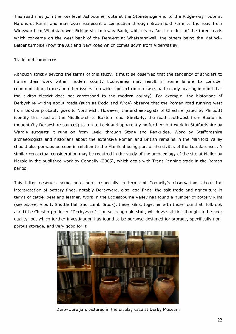
terms of cattle, beef and leather. Work in the Ecclesbourne Valley has found a number of pottery kilns
(see above, Alport, Shottle Hall and Lumb Brook), these kilns, together with those found at Holbrook
and Little Chester produced “Derbyware”: course, rough old stuff, which was at first thought to be poor
quality, but which further investigation has found to be purpose-designed for storage, specifically non-
porous storage, and very good for it.
Derbyware jars pictured in the display case at Derby Museum
23
Two types of use have been positively identified: for beans (by Derby Museum) and for linseed oil (by
the University of Liverpool). The use for beans suggests the dry storage of foodstuffs in kitchens, shops
and carriage for trade (Derbyware would be acceptable in the kitchen, but you wouldn’t want it in your
dining room). The use for linseed oil indicates the storage of medicines and paint. Roman paint being
lead and linseed oil based: for example from the possible paint production site identified at Kniveton,
on the Wirksworth to Rocester road, (Connelly, 2005), as well as the seasoning of wood and leather.
Connelly concludes that this use of Derbyware and its distribution beyond the immediate area of its
production gives an indication of the extent of trade in and around the Peak. Similar interpretations
about the extent of trade can be inferred from the ties between the lead industry of the civitas and the
salt industry in terms of the production of brine boiling (evaporation) pans. Finally, Trans-Pennine trade
also appears to have taken place in cattle, beef and leather, as archaeological work in Nottinghamshire
(at Ferry Lane Farm by Cottingham) suggests parts of that district were used for the rearing of cattle:
salt was used not only in the preservation of beef but in leather production, after tanning, for the
hardening and finishing of leather, the finishing of which also involves linseed oil. Linseed oil being
made from flax, grown in parts of the Derwent and Trent Valleys, as possibly recalled by the Flaxholme
place-name at Duffield (Watson, 1986). It is no mere observation that the Ecclesbourne Valley’s chief
agricultural products have been, on the one hand, honey, (noted in Domesday), but on the other, milk.
Thus requiring the presence of cattle and providing a source of skins for tanning and bearing in mind
that Wirksworth is known to have had tanneries throughout the mediaeval period, some of which
survived until the 1860s (Sprenger, 2004).
The lead industry is also one which should be considered when the matter of communications, trade
and transport is being scrutinised. There is no record of the routes by which Roman lead was exported
from the Wirksworth area, and we can only look to the later trade for a light to shine upon the past.
William Woolley, writing in the years from 1712 to 1715 (Glover and Riden, 1981) had observed that
lead was carried most on horse-back, and gave an example of it going to Derby on horse-back (we
would say by pack-horse), and from Derby by cart or wagon to Wilne (by Shardlow) or Sawley Ferry,
and then by barge on the Trent to Gainsborough and from there to London or elsewhere by ship. It is
known from other sources that lead was sent from Wirksworth to Bawtry via Chesterfield (note
observations on the Rocester-Wirksworth-Chesterfield Roman road above) and from Wirksworth to
Nottingham, again for transhipment. In so far as Woolley was writing before the advent of turnpike
roads, it may be that these routes were of some antiquity, certainly, in the section between Derby and
both Wilne and Sawley, this must be beyond the slightest doubt on the Roman road between Little
Chester and Sawley.
The conclusion which one must reach from the consideration of the issue of trade, is that the Peak was
no sleepy backwater. It was key to many significant industries in the Roman period, many of which
survived through to later periods. Although lead is generally thought of as the principal industry of the
civitas district, other industries appear to be pottery, tanning, and agriculture in those areas which
could sustain it, as well as the export of certain types of stone for building (we have noted that Hopton
Wood stone was found to line the baths at Godmanchester), the localised production of paint, and to

24
the north west, salt. To the east of Wirksworth, authors such as Knight (2004) observe the nature of
the agriculture of that part of the district, but feel that its prosperity and population density is lower
than that of the Trent Valley, where a series of small Roman towns along the Fosse way south and east
of the Trent, Margidunum (East Bridgford); Ad Pontem (Thorpe); Crococalana (Brough on Fosse) and
Vernemetum (Willoughby) point to greater intensity of population. A similar position appears along the
line of the Lincoln and Doncaster road with settlements at Segelocum (Littleborough) Bawtry and
Rossington. However, like the area in the immediate vicinity of Wirksworth, the apparent lack of Roman
activity, except perhaps at Broxtowe and Osmanthorpe, as well as a complete and suspect gap in our
knowledge of any Roman road network in the two Nottinghamshire wapentakes of Bassetlaw and
Broxtowe, points more probably to a lack of archaeological research and fieldwork rather than a lack of
the original activities, populations or communications themselves.
Recent scrutiny, considering the intensity of Roman activity in the Ecclesbourne Valley and the intensity
of settlement and agriculture in the area to the west of Wirksworth, as far as Ashbourne and Parwich,
also raises a further trade issue. This is about the supply of food and domestic goods: i.e. the location
of a market. If Wirksworth is not the capital and centre for trade in this district, where are all these
people going to market? AE&EM Dodd (2000) noted the furthest one could reasonably expect to travel
to market in the mediaeval period (in our case the early mediaeval) was 11 kilometres, for the morning
was spent getting to the market (on foot), a few hours were spent at the market itself, and the
afternoon and early evening were spent getting back, before dread night fell. In looking at the known
pattern of Roman towns in the Peak, if we exclude Wirksworth, it would in no way be achievable for the
population of the district to reach markets at either Buxton or Little Chester and return safe home, with
their goods, there and back in a day. This suggests Wirksworth is essential as a Roman market centre,
as it continued to be in the mediaeval period.
Dating the Roman origins of the district
It is salient to examine the dating evidence which exists from the various forts and other appropriate
sources in order to establish when the district became Roman. Brassington (1982) deals with Strutts
Park (the first fort or Roman settlement in Derby prior to Little Chester, located on the west bank of the
Derwent, on the high ground around Belper Road) and notes evidence of occupation from the Neronian
and Claudian periods, this gives a date of about AD 55 in the governorship of Aulus Didius Gallus. Toco
(2005) records archaeological finds from the same period at Templeborough and at Trent Vale. A report
of excavations at Strutts Park in 1974, given by Dool (1985) concurs. Ellis (1989) records the dating
evidence found at the fort at Chesterfield to be of the 60s. Thus the south and east of the district
appears to be in Roman control from about AD 55 / 60. (The first datable metal working evidence
comes from the cross-referencing the inscriptions on a lead pig found at Matlock Bank in 1783, which
states it as the property of Tiberius Claudius Triferna, lead from Lutudarum: a lead pig found at
Charterhouse in Somerset also refers to Tiberius Claudius Triferna and that ingot states its owner as
the Emperor Vespasian Augustus, giving it a date of between AD 69 and AD 79) (CIL record 1215,
2006). The archaeological dating evidence from the north and west of the Peak at Middlewich (Philpott,
2004), Brough and Melandra forts (Dearne, 1991) suggest their foundation to be around AD 70 or a
25
little later, in the governorship of Quintus Petilius Cerialis whom we also know (from Tacitus)
progressed into the territory of the Brigantes to the north at this time. Thus the dating evidence from
the forts suggests that the Lutudarenses probably became part of the Roman province about AD 55 or
soon after, (especially as the Strutts Park fort is west of the Derwent, thus within the district rather
than beyond its southern or eastern boundaries), and that the forts to the north and west were
constructed later, as part of the campaigns to subdue the Brigantes from AD 70 onwards by Agricola.
This approach to the building of forts is fairly consistent, the conquest of the midlands and the north of
Britain, district by district, tended to result in district boundaries being defined by the geographical
pattern of forts, as the Romans progressed north and westwards.
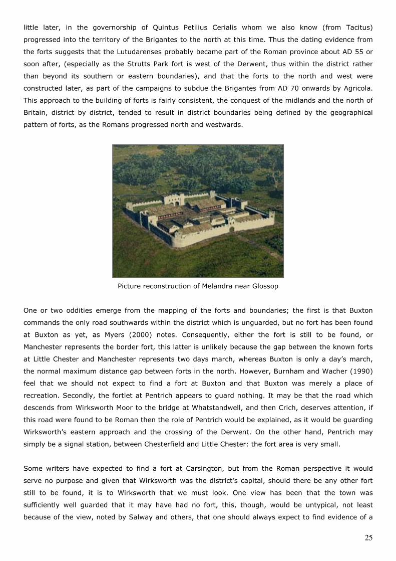
Picture reconstruction of Melandra near Glossop
One or two oddities emerge from the mapping of the forts and boundaries; the first is that Buxton
commands the only road southwards within the district which is unguarded, but no fort has been found
at Buxton as yet, as Myers (2000) notes. Consequently, either the fort is still to be found, or
Manchester represents the border fort, this latter is unlikely because the gap between the known forts
at Little Chester and Manchester represents two days march, whereas Buxton is only a day’s march,
the normal maximum distance gap between forts in the north. However, Burnham and Wacher (1990)
feel that we should not expect to find a fort at Buxton and that Buxton was merely a place of
recreation. Secondly, the fortlet at Pentrich appears to guard nothing. It may be that the road which
descends from Wirksworth Moor to the bridge at Whatstandwell, and then Crich, deserves attention, if
this road were found to be Roman then the role of Pentrich would be explained, as it would be guarding
Wirksworth’s eastern approach and the crossing of the Derwent. On the other hand, Pentrich may
simply be a signal station, between Chesterfield and Little Chester: the fort area is very small.
Some writers have expected to find a fort at Carsington, but from the Roman perspective it would
serve no purpose and given that Wirksworth was the district’s capital, should there be any other fort
still to be found, it is to Wirksworth that we must look. One view has been that the town was
sufficiently well guarded that it may have had no fort, this, though, would be untypical, not least
because of the view, noted by Salway and others, that one should always expect to find evidence of a
26
military presence in locations where mining operations are taking place. In considering where a fort at
Wirksworth might be, a footprint not unlike that of Brough on Noe may be realistic: i.e. relatively
small: the Brough fort is only sufficient, at 2 acres, (approx 100 metres by 85 metres) to accommodate
half a cohort of infantry (about 250 men) and is characterised by an unusually large strongroom, which
may possibly represent the need to keep quantities of lead ingots collected together for onward
despatch. In the case of Brough, we know from inscriptions that it lodged part of the first Cohort of the
Aquitanians, who rebuilt it in a smaller size than its first phase, perhaps about 158 AD (Simpson,
1964), and that there were other detachments of the Aquitanians in the district, as an altar stone
recording them was found in the grounds of Haddon Hall (Collingwood, 1965), where there is no
evidence of a fort.
A tour of the border of the Lutudarenses
It is considered that the boundaries of Roman civitas districts were often rivers or sometimes roads or
other “fixed” features, and occasionally we find ancient parish boundaries running along former Roman
roads (Turbutt, 1999). However, in looking systematically at the extent of the lands of the civitas
district of the Lutudarenses our evidence is in the first case largely based on work carried out by
researchers in counties and districts around the Peak where they been seeking their own boundaries
and this is the first time work has taken place to assemble that knowledge in the context of the Peak.
We have to recognise the limitations of this, and the borders and extents of the district often have to
be taken from later evidence such as the border of Mercia or from a given wapentake, for example;
thus reconstructing such a border should not be inferred as being an entirely accurate exercise. On the
other hand, in many locations this does at least give us a documented boundary to consider as a
starting place.
Dennis (1971) observes the Roman historian Tacitus, who recorded that when districts surrendered to
the Romans they were “surrounded by garrisons and forts”. If we consider the Ordnance Survey Map of
Roman Britain (1997), as well as Higham’s excellent work on the Cheshire Hundreds, we find that forts
and camps do, to some extent, march around the Peak.
Starting at Brough on Noe in the north and working clockwise, the boundary with Elmet may have run
along the line of the road north east from Brough then the River Sheaf and River Don to the fort at
Templeborough by Rotherham (Cox 2005); The River Sheaf has long been considered the boundary
between Mercia and Northumbria. Then we move east from Templeborough to Bawtry, which was in
the middle ages a major inland port on the River Idle, intimately connected with the transport of lead
from the Peak. Investigation and understanding of the Roman road network of Nottinghamshire is, if
anything, worse than that in Derbyshire. If the same routes tended to be used in the middle ages to
transport lead as had been used in the Roman period, then the possibilities of the Roman roads
connecting Bawtry and the nearby fort at Scaftworth with Chesterfield and Templeborough require a
consideration they do not yet appear to have received. Margery notes a section of road running east-
west at Catcliffe south of Templeborough (Margery 1967) and running on the north side of the Firbeck
to Oldcoates road, which may represent the Templeborough route and may conceivably represent the
27
border with the Daunonii (i.e. the conjectured but unexamined civitas of the district of Doncaster,
discussed haphazardly as “Hatfield Chase” or as the “Heathfield Land” of the Tribal Hidage) (Foot,
1993).
Moving on, Bede (quoted in Brooks, 1989) says that the River Idle was the border of Mercia. Leahy
(1993) maps the borders of Lindsey as being the Trent to the west of Lincoln and the Witham to the
south west. This perhaps suggests the Daunonii occupied the land between the Idle and the Trent,
consequently the whole of the later Nottinghamshire wapentake of Bassetlaw west of the Idle, must
have been originally part of the Peak and that for this border to continue with any integrity as being
that of later Mercia, the same has to be applied to the wapentake of Broxtowe. Although these
wapentakes are now in Nottinghamshire, it must be remembered that Nottinghamshire is a purely new
administrative device created by Edward the Elder in 930 or so.
From where the old border of the wapentake of Broxtowe joins the Trent, we then continue south and
west to where Ryknield Street also follows the Trent, past Findern (the etymology of which is the
Celtic: Findre meaning “boundary hamlet”) and as far as Alrewas: this section was probably the
boundary with the Corieltauvi. At Alrewas the Trent turns north-west and runs in that direction through
Rugeley and Stone, south of the Trent being the civitas district of Etocetum (Wall) as noted by Bassett
(1992). Forts continue along the line of the Trent at Trent Vale (Stoke) and again at Chesterton by
Newcastle under Lyme, south west of which would be the Cornovii. North from Chesterton we rely on
Higham’s hundred boundary map, which suggests the boundary ran west of Henbury and Prestbury,
and noting the camp at Wallhill by Congleton and the forts at Middlewich and Northwich are close to
this boundary. The boundary then runs north and west of Marple, northwards to the fort at Melandra
Castle by Mottram, then in a north-easterly direction to Tintwistle and its fort at Highstones, north of
which would be the Brigantes. The boundary then appears to return in a south-easterly direction to
Brough, in practice it may have run along the upper Derwent rather to the north and east of the road
which is known between Melandra Castle and Brough. The Elmetiaco (the district of Leeds) would be
north east of this boundary, which in more recent times is the boundary between Derbyshire and
Sheffield.
The end of Roman rule
The Roman history of the Peak District did not end abruptly in 410 when much of the Roman army was
withdrawn from Britain. Simply because there is no army does not mean the immediate breakdown of a
civil society: if the modern British army were destroyed by some terrible mischance, you would still go
to Tesco’s and do your shopping on a Saturday and wash your car on a Sunday – civil routine would
still continue, at least for a while, because there would be no reason to suppose the event could not be
coped with, and this appears to be the case in antiquity. However, the event could not be coped with
and gradually the western Roman empire disintegrated. (Collins, 1999, gives a readable account of this
disintegration). As its did so, the position of civil society became more parlous, there was no demand
from the remnants of the Roman military for goods and this in turn resulted in the collapse of a number
of those parts of the Roman economy of Britain which depended on it, such as the pottery industry and
28
large sections of the agricultural industry whose purpose had been to supply the army with grain.
Coupled with this were increasing attacks from initially small groups of invaders, pirates and rebels
which began to disrupt the rest of the Romano-British society. The response in Britain to this is thought
to have been a tolerably effective re-organisation of the few remnants of the Roman army left in Britain
(because the army was expected to come back, a little military organisation remained such as the
castellans, storekeepers, retired officers and men and so on) and so by some effort and by adding
federates (paid mercenaries) to deal with military emergencies, a short period of Romano-British
control remained. In the end, however, this re-organisation could not stop the loss of the south and
east of Britain to the Saxons and the takeover of parts of the north of Britain by a number of groups
which eventually resulted in the establishment of the Northumbrian kingdom.
The Peak District appears to carry on quietly as a Romano-British province from 410. It is
geographically central and the long drawn out “invasion” which had taken over the south and east of
the country did not reach it. Nor, until 616 or so, was there any threat to it from the north. In that year
(though possibly 613, there is some academic debate about the year) the Northumbrians attacked
parts of the north and this move was apparently so unexpected that they weren’t brought to battle
before they reached Chester, and at Chester the response by the British was so lax that the British
were roundly defeated and a large number of their clergy (who were nearby) were slaughtered. This
defeat brought late Romano-British rule to an end, and was the root cause of nearly 60 years of
political turmoil in and around the Peak District.
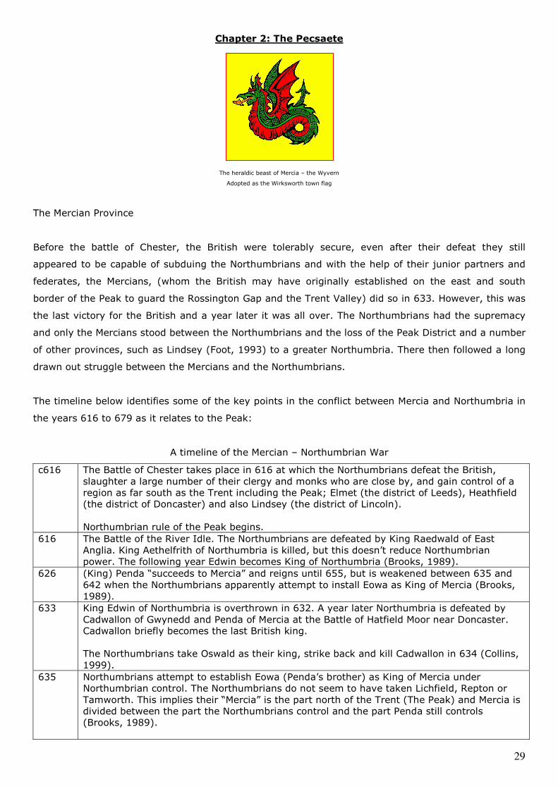
29
Chapter 2: The Pecsaete
The heraldic beast of Mercia – the Wyvern
Adopted as the Wirksworth town flag
The Mercian Province
Before the battle of Chester, the British were tolerably secure, even after their defeat they still
appeared to be capable of subduing the Northumbrians and with the help of their junior partners and
federates, the Mercians, (whom the British may have originally established on the east and south
border of the Peak to guard the Rossington Gap and the Trent Valley) did so in 633. However, this was
the last victory for the British and a year later it was all over. The Northumbrians had the supremacy
and only the Mercians stood between the Northumbrians and the loss of the Peak District and a number
of other provinces, such as Lindsey (Foot, 1993) to a greater Northumbria. There then followed a long
drawn out struggle between the Mercians and the Northumbrians.
The timeline below identifies some of the key points in the conflict between Mercia and Northumbria in
the years 616 to 679 as it relates to the Peak:
A timeline of the Mercian – Northumbrian War
c616
The Battle of Chester takes place in 616 at which the Northumbrians defeat the British,
slaughter a large number of their clergy and monks who are close by, and gain control of a
region as far south as the Trent including the Peak; Elmet (the district of Leeds), Heathfield
(the district of Doncaster) and also Lindsey (the district of Lincoln).
Northumbrian rule of the Peak begins.
616 The Battle of the River Idle. The Northumbrians are defeated by King Raedwald of East
Anglia. King Aethelfrith of Northumbria is killed, but this doesn’t reduce Northumbrian
power. The following year Edwin becomes King of Northumbria (Brooks, 1989).
626 (King) Penda “succeeds to Mercia” and reigns until 655, but is weakened between 635 and
642 when the Northumbrians apparently attempt to install Eowa as King of Mercia (Brooks,
1989).
633 King Edwin of Northumbria is overthrown in 632. A year later Northumbria is defeated by
Cadwallon of Gwynedd and Penda of Mercia at the Battle of Hatfield Moor near Doncaster.
Cadwallon briefly becomes the last British king.
The Northumbrians take Oswald as their king, strike back and kill Cadwallon in 634 (Collins,
1999).
635 Northumbrians attempt to establish Eowa (Penda’s brother) as King of Mercia under
Northumbrian control. The Northumbrians do not seem to have taken Lichfield, Repton or
Tamworth. This implies their “Mercia” is the part north of the Trent (The Peak) and Mercia is
divided between the part the Northumbrians control and the part Penda still controls
(Brooks, 1989).
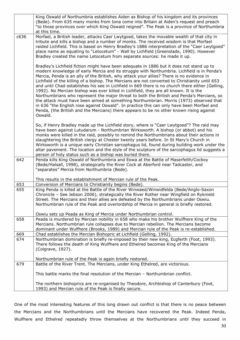
30
King Oswald of Northumbria establishes Aiden as Bishop of his kingdom and its provinces
(Bede). From 635 many monks from Iona come into Britain at Aiden’s request and preach
“to those provinces over which King Oswald reigned”. The Peak is a province of Northumbria
at this time.
c636 Morfael, a British leader, attacks Caer Lwytgoed, takes the movable wealth of that city in
tribute and kills a bishop and a number of monks. The received wisdom is that Morfael
raided Lichfield. This is based on Henry Bradley’s 1886 interpretation of the “Caer Lwytgoed”
place name as equating to “Letocetum” - Wall by Lichfield (Greenslade, 1990). However
Bradley created the name Letocetum from separate sources: he made it up.
Bradley’s Lichfield fiction might have been adequate in 1886 but it does not stand up to
modern knowledge of early Mercia and its struggle with Northumbria. Lichfield is in Penda’s
Mercia, Penda is an ally of the British, why attack your allies? There is no evidence in
Lichfield of the killing of a bishop. The Mercians are not converted to Christianity until 653
and until Chad establishes his see in Lichfield in 669 there is no church there either (Gelling,
1992). No Mercian bishop was ever killed in Lichfield, they are all known. It is the
Northumbrians who represent the major threat to both the British and Penda’s Mercians, so
the attack must have been aimed at something Northumbrian. Morris (1973) observed that
in 636 “the English rose against Oswald”. In practice this can only have been Morfael and
Penda, (the British and the Mercians) there appears to be no other known rising against
Oswald.
So, if Henry Bradley made up the Lichfield story, where is “Caer Lwytgoed”? The raid may
have been against Lutudarum - Northumbrian Wirksworth. A bishop (or abbot) and his
monks were killed in the raid, possibly to remind the Northumbrians about their actions in
slaughtering the British clergy at Chester twenty years before. In St Mary’s Church in
Wirksworth is a unique early Christian sarcophagus lid, found during building work under the
altar pavement. The location and the style of the sculpture of the sarcophagus lid suggests a
person of holy status such as a bishop was buried there.
642 Penda kills King Oswald of Northumbria and Eowa at the Battle of Maserfelth/Cocboy
(Bede/Halsall, 1998), strategically the River Cock at Aberford near Tadcaster, and
“separates” Mercia from Northumbria (Bede).
This results in the establishment of Mercian rule of the Peak.
653 Conversion of Mercians to Christianity begins (Bede).
655 King Penda is killed at the Battle of the River Winwaed/Winwidfelda (Bede/Anglo-Saxon
Chronicle – See Jebson 2006), strategically the River Rother near Wingfield on Ryknield
Street. The Mercians and their allies are defeated by the Northumbrians under Oswiu.
Northumbrian rule of the Peak and overlordship of Mercia in general is briefly restored.
Oswiu sets up Peada as King of Mercia under Northumbrian control.
658 Peada is murdered by Mercian nobility in 658 who make his brother Wulfhere King of the
Mercians. Northumbrian rule collapses due to Mercian rebellion. The Mercians become
dominant under Wulfhere (Brooks, 1989) and Mercian rule of the Peak is re-established.
669 Chad establishes the Mercian Bishopric at Lichfield (Gelling, 1992).
674 Northumbrian domination is briefly re-imposed by their new king, Ecgferth (Foot, 1993).
There follows the death of King Wulfhere and Ethelred becomes King of the Mercians
(Colgrave, 1927).
Northumbrian rule of the Peak is again briefly restored.
679 Battle of the River Trent. The Mercians, under King Ethelred, are victorious.
This battle marks the final resolution of the Mercian – Northumbrian conflict.
The northern bishoprics are re-organised by Theodore, Archbishop of Canterbury (Foot,
1993) and Mercian rule of the Peak is finally secure.
One of the most interesting features of this long drawn out conflict is that there is no peace between
the Mercians and the Northumbrians until the Mercians have recovered the Peak. Indeed Penda,
Wulfhere and Ethelred repeatedly throw themselves at the Northumbrians until they succeed in
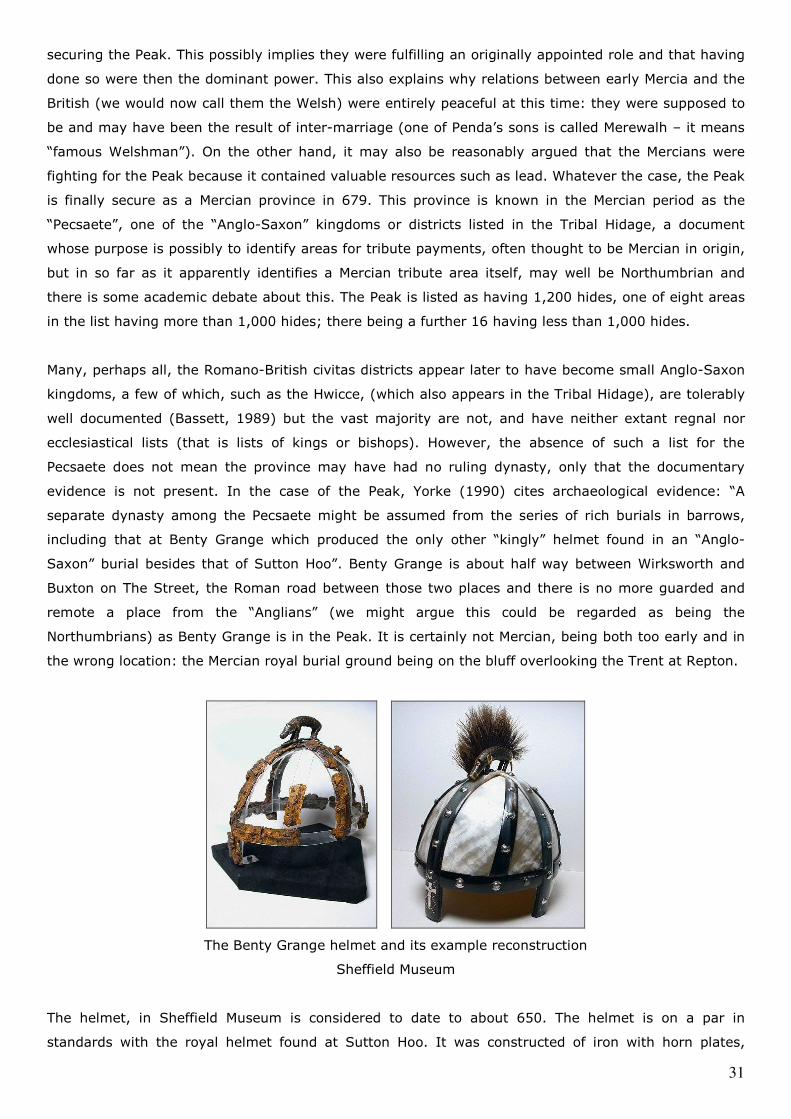
31
securing the Peak. This possibly implies they were fulfilling an originally appointed role and that having
done so were then the dominant power. This also explains why relations between early Mercia and the
British (we would now call them the Welsh) were entirely peaceful at this time: they were supposed to
be and may have been the result of inter-marriage (one of Penda’s sons is called Merewalh – it means
“famous Welshman”). On the other hand, it may also be reasonably argued that the Mercians were
fighting for the Peak because it contained valuable resources such as lead. Whatever the case, the Peak
is finally secure as a Mercian province in 679. This province is known in the Mercian period as the
“Pecsaete”, one of the “Anglo-Saxon” kingdoms or districts listed in the Tribal Hidage, a document
whose purpose is possibly to identify areas for tribute payments, often thought to be Mercian in origin,
but in so far as it apparently identifies a Mercian tribute area itself, may well be Northumbrian and
there is some academic debate about this. The Peak is listed as having 1,200 hides, one of eight areas
in the list having more than 1,000 hides; there being a further 16 having less than 1,000 hides.
Many, perhaps all, the Romano-British civitas districts appear later to have become small Anglo-Saxon
kingdoms, a few of which, such as the Hwicce, (which also appears in the Tribal Hidage), are tolerably
well documented (Bassett, 1989) but the vast majority are not, and have neither extant regnal nor
ecclesiastical lists (that is lists of kings or bishops). However, the absence of such a list for the
Pecsaete does not mean the province may have had no ruling dynasty, only that the documentary
evidence is not present. In the case of the Peak, Yorke (1990) cites archaeological evidence: “A
separate dynasty among the Pecsaete might be assumed from the series of rich burials in barrows,
including that at Benty Grange which produced the only other “kingly” helmet found in an “Anglo-
Saxon” burial besides that of Sutton Hoo”. Benty Grange is about half way between Wirksworth and
Buxton on The Street, the Roman road between those two places and there is no more guarded and
remote a place from the “Anglians” (we might argue this could be regarded as being the
Northumbrians) as Benty Grange is in the Peak. It is certainly not Mercian, being both too early and in
the wrong location: the Mercian royal burial ground being on the bluff overlooking the Trent at Repton.
The Benty Grange helmet and its example reconstruction
Sheffield Museum
The helmet, in Sheffield Museum is considered to date to about 650. The helmet is on a par in
standards with the royal helmet found at Sutton Hoo. It was constructed of iron with horn plates,
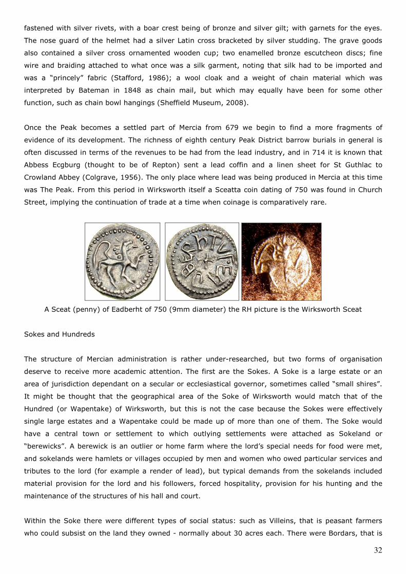
32
fastened with silver rivets, with a boar crest being of bronze and silver gilt; with garnets for the eyes.
The nose guard of the helmet had a silver Latin cross bracketed by silver studding. The grave goods
also contained a silver cross ornamented wooden cup; two enamelled bronze escutcheon discs; fine
wire and braiding attached to what once was a silk garment, noting that silk had to be imported and
was a “princely” fabric (Stafford, 1986); a wool cloak and a weight of chain material which was
interpreted by Bateman in 1848 as chain mail, but which may equally have been for some other
function, such as chain bowl hangings (Sheffield Museum, 2008).
Once the Peak becomes a settled part of Mercia from 679 we begin to find a more fragments of
evidence of its development. The richness of eighth century Peak District barrow burials in general is
often discussed in terms of the revenues to be had from the lead industry, and in 714 it is known that
Abbess Ecgburg (thought to be of Repton) sent a lead coffin and a linen sheet for St Guthlac to
Crowland Abbey (Colgrave, 1956). The only place where lead was being produced in Mercia at this time
was The Peak. From this period in Wirksworth itself a Sceatta coin dating of 750 was found in Church
Street, implying the continuation of trade at a time when coinage is comparatively rare.
A Sceat (penny) of Eadberht of 750 (9mm diameter) the RH picture is the Wirksworth Sceat
Sokes and Hundreds
The structure of Mercian administration is rather under-researched, but two forms of organisation
deserve to receive more academic attention. The first are the Sokes. A Soke is a large estate or an
area of jurisdiction dependant on a secular or ecclesiastical governor, sometimes called “small shires”.
It might be thought that the geographical area of the Soke of Wirksworth would match that of the
Hundred (or Wapentake) of Wirksworth, but this is not the case because the Sokes were effectively
single large estates and a Wapentake could be made up of more than one of them. The Soke would
have a central town or settlement to which outlying settlements were attached as Sokeland or
“berewicks”. A berewick is an outlier or home farm where the lord’s special needs for food were met,
and sokelands were hamlets or villages occupied by men and women who owed particular services and
tributes to the lord (for example a render of lead), but typical demands from the sokelands included
material provision for the lord and his followers, forced hospitality, provision for his hunting and the
maintenance of the structures of his hall and court.
Within the Soke there were different types of social status: such as Villeins, that is peasant farmers
who could subsist on the land they owned - normally about 30 acres each. There were Bordars, that is
33
smallholders, who could not subsist on their small ownership, but had to work for someone else. There
were also Sokemen, the size of their landholding doesn’t seem to be the issue, it varied. The key issue
was that they owed less service to the lord and were freer than the Villeins. The origins of this were
that the Sokemen were the inhabitants of the great estates. Soke means jurisdiction – it describes the
lands and the inhabitants of the lands attached to and paying the dues or tribute to the central hall of
the lord. This, then, is the nature of the Soke of Wirksworth - it is the area which supports the central
hall of the lord of Wirksworth. This begs the question, of course, who was the lord of Wirksworth, (to
which the provisional answer appears to be the King of Mercia) and begs a second question, even more
intractable, does this imply there is a royal Mercian building somewhere to be found in or near
Wirksworth? The Soke may also equate to the later Royal manor of Wirksworth.
A Hundred or Wapentake is an administrative division of a province. In Mercian times all the divisions
of the Province of the Peak were originally called Hundreds, but when the Vikings invaded the Kingdom
of Mercia and settled, creating the “Danelaw”, they are considered to have taken over the previously
existing administrative system (easier than bringing in a new one) and simply changed the name to
Wapentakes (Stafford, 1985). Because the Mercians (in the person of Aethelflaed, Lady of the
Mercians) eventually overcame and integrated the Vikings, the terminology the Vikings had used didn’t
entirely survive, so that in much of the Mercian Province of The Peak the administrative divisions
mostly reverted to their hundred names e.g. The Hundred of Scarsdale, Hundred of Litchurch etc. But
the Wirksworth division retained the only Wapentake title in Derbyshire, and was often just called “The
Wapentake” right until the very end of the system in the late 1800s.
The Wapentake of Wirksworth was originally called the Hundred of Hamenstan. It’s in the very middle
of the Mercian province. Hamenstan probably means “carved stone”. The carved stone was probably a
marker for the assembly ground at Hamston Hill. This map shows the Mercian Province of the Pecsaete
in terms of its possible constituent hundreds, before the creation of the shire counties. In the middle,
almost at the very centre, is Wirksworth. There is also a Hundred of Hamenstan around Prestbury and
Macclesfield in what is now Cheshire, it was also part of the Province. Then in what is now Staffordshire
is the Hundred of Totmanslow around Leek, and those parts of the Staffordshire Hundreds of Pire Hill
and Offlow which lie north of the River Trent. All the hundreds of what is now Derbyshire were in the
Province (shown in rather more detail in the map), and two hundreds in what is now Nottinghamshire,
the Hundred of Broxtowe and the Hundred of Bassetlow as far as the River Idle were as well. One of
the reasons why the understanding of this is so poor is because the Province now spans four different
counties and this has made the study of the Province very difficult because many histories tend to be
based on county areas. The Wapentakes had an assembly which met once a year or so, usually at the
same place, but sometimes elsewhere. The assembly of the Wirksworth Wapentake probably met at a
site near Topshill Farm at Wapentake Lane in Wirksworth, but before that the Hundred Assembly of
Hamenstan (it’s the same thing remember) may have met at Hamston Hill near Thorpe Cloud, where
there is a saucer shaped arena at the top of the hill.
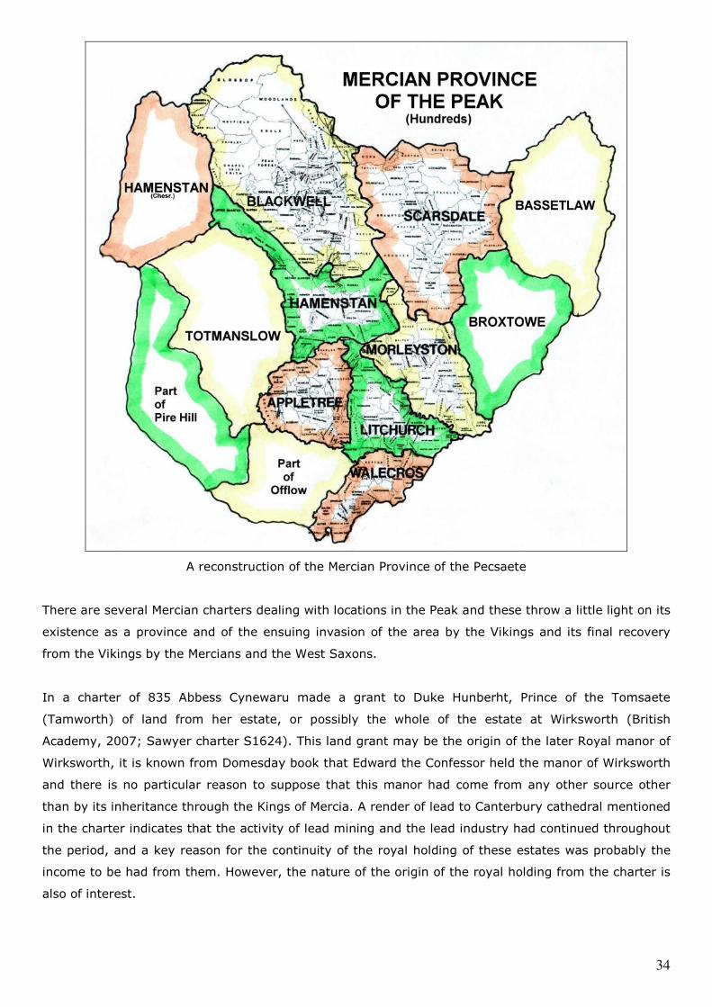
34
A reconstruction of the Mercian Province of the Pecsaete
There are several Mercian charters dealing with locations in the Peak and these throw a little light on its
existence as a province and of the ensuing invasion of the area by the Vikings and its final recovery
from the Vikings by the Mercians and the West Saxons.
In a charter of 835 Abbess Cynewaru made a grant to Duke Hunberht, Prince of the Tomsaete
(Tamworth) of land from her estate, or possibly the whole of the estate at Wirksworth (British
Academy, 2007; Sawyer charter S1624). This land grant may be the origin of the later Royal manor of
Wirksworth, it is known from Domesday book that Edward the Confessor held the manor of Wirksworth
and there is no particular reason to suppose that this manor had come from any other source other
than by its inheritance through the Kings of Mercia. A render of lead to Canterbury cathedral mentioned
in the charter indicates that the activity of lead mining and the lead industry had continued throughout
the period, and a key reason for the continuity of the royal holding of these estates was probably the
income to be had from them. However, the nature of the origin of the royal holding from the charter is
also of interest.
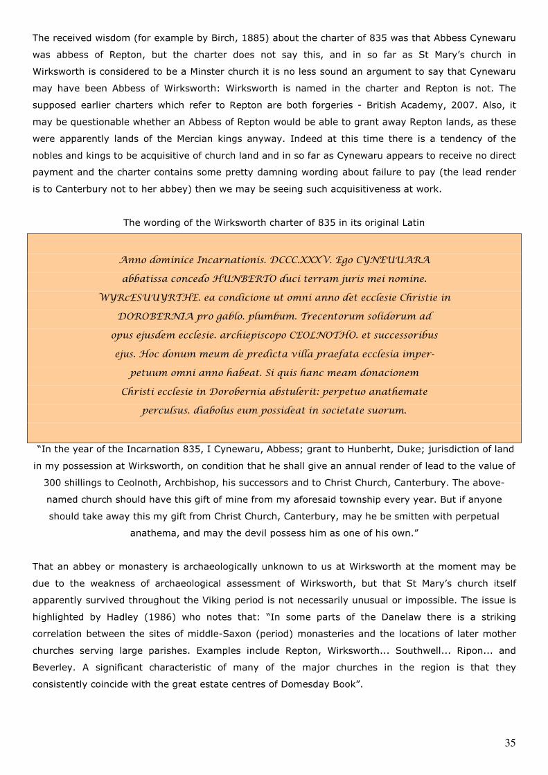
35
The received wisdom (for example by Birch, 1885) about the charter of 835 was that Abbess Cynewaru
was abbess of Repton, but the charter does not say this, and in so far as St Mary’s church in
Wirksworth is considered to be a Minster church it is no less sound an argument to say that Cynewaru
may have been Abbess of Wirksworth: Wirksworth is named in the charter and Repton is not. The
supposed earlier charters which refer to Repton are both forgeries - British Academy, 2007. Also, it
may be questionable whether an Abbess of Repton would be able to grant away Repton lands, as these
were apparently lands of the Mercian kings anyway. Indeed at this time there is a tendency of the
nobles and kings to be acquisitive of church land and in so far as Cynewaru appears to receive no direct
payment and the charter contains some pretty damning wording about failure to pay (the lead render
is to Canterbury not to her abbey) then we may be seeing such acquisitiveness at work.
The wording of the Wirksworth charter of 835 in its original Latin
Anno dominice Incarnationis. DCCC.XXXV. Ego CYNEUUARA
abbatissa concedo HUNBERTO duci terram juris mei nomine.
WYRcESUUYRTHE. ea condicione ut omni anno det ecclesie Christie in
DOROBERNIA pro gablo. plumbum. Trecentorum solidorum ad
opus ejusdem ecclesie. archiepiscopo CEOLNOTHO. et successoribus
ejus. Hoc donum meum de predicta villa praefata ecclesia imper-
petuum omni anno habeat. Si quis hanc meam donacionem
Christi ecclesie in Dorobernia abstulerit: perpetuo anathemate
perculsus. diabolus eum possideat in societate suorum.
“In the year of the Incarnation 835, I Cynewaru, Abbess; grant to Hunberht, Duke; jurisdiction of land
in my possession at Wirksworth, on condition that he shall give an annual render of lead to the value of
300 shillings to Ceolnoth, Archbishop, his successors and to Christ Church, Canterbury. The above-
named church should have this gift of mine from my aforesaid township every year. But if anyone
should take away this my gift from Christ Church, Canterbury, may he be smitten with perpetual
anathema, and may the devil possess him as one of his own.”
That an abbey or monastery is archaeologically unknown to us at Wirksworth at the moment may be
due to the weakness of archaeological assessment of Wirksworth, but that St Mary’s church itself
apparently survived throughout the Viking period is not necessarily unusual or impossible. The issue is
highlighted by Hadley (1986) who notes that: “In some parts of the Danelaw there is a striking
correlation between the sites of middle-Saxon (period) monasteries and the locations of later mother
churches serving large parishes. Examples include Repton, Wirksworth... Southwell... Ripon... and
Beverley. A significant characteristic of many of the major churches in the region is that they
consistently coincide with the great estate centres of Domesday Book”.
36
We have earlier considered the question of the relative state of the nominal independence of the
Pecsaete in terms of the possibility of its having its own ruling dynasty. It was common in the early
stages of the formation of the Mercian kingdom for dynastic estates of the subservient or component
kingdoms to be handed down through the female line as church or monastic property. By the 790s King
Offa and later King Coenwulf had sought to strengthen their positions by seizing the ownership of these
lands. Cubitt (1995) observes that Mercian royal seizures were “not examples of random royal cupidity,
but rather represent a consistent policy aimed at the consolidation of royal power in newly
subordinated kingdoms.” The comparative lateness of the seizure of the Wirksworth estates from
Cynewaru may be because of fluctuations in the dominance of the various royal lines after the death of
Offa, or it may be that the lands of the Pecsaete were in some way better protected (in the sense of
family ties) and the late seizure in 835 in the reign of King Wiglaf was a result of the death of some
protector of Cynewaru’s abbey, whether we regard that abbey as being in Wirksworth itself, or Repton
or another place.
The Danelaw
In 842 the first Viking attack took place on the coast of Mercia in the province of Lindsey (Lincolnshire).
Viking attacks increased in frequency and strength with the Vikings attacking London (a Mercian city)
and in due course routed King Beorhtwulf and the Mercian army in 851 in the south. Burgred became
king of Mercia in 852 and is thought to have beaten off Viking attacks for many years, for example,
Leicester resisted the Vikings for 12 years before finally falling to them. However, the Viking invasion
and the consequent creation of the Danelaw had several effects as well as the conquest and settlement
of northern Mercia by the Danes.
The Danelaw resulted from the inability of the Mercians to expel the Danish army from Repton during
the winter of 873-874, the kingdom being split in 877 between the pro-Danish Mercian king, Ceolwulf
along the line of Watling Street, with Ceolwulf having that part to the south-west and the Danes having
the rest (Brooks, 1989 and 2000), Burgred being deposed and fleeing to Rome in 875. There then
followed a period of about thirty years when the Danes were dominant and settling the area. We also
see the emergence of Derby as a settlement: it becomes established as a Danelaw town some time
after 877 when part of the army of Halfdan settled in Northumbria and the rest are known to have
settled in north Mercia (Stafford, 1985) presumably decamping to the Mercian estate at Northworthy
and establishing a defended settlement in the confluence of the Derwent and the Markeaton Brook. The
reason for this choice of the confluence is that it is the best defensible position against an attack from
the Mercians coming up Ryknield Street. This may explain why Derby never had its own Wapentake,
apparently being mainly in Litchurch and partly in Morleystone, the Wapentakes as an administrative
form were probably based on the Mercian Hundreds and Derby was not in existence at the time the
Hundreds had originated, this also supports the view that the Vikings simply adopted the Mercian
administrative structure.
In due course however, Aethelred, Lord of the Mercians, began a campaign to recover Mercia from the
Danes in conjunction with Alfred of Wessex and the Danes were first defeated at the battle of
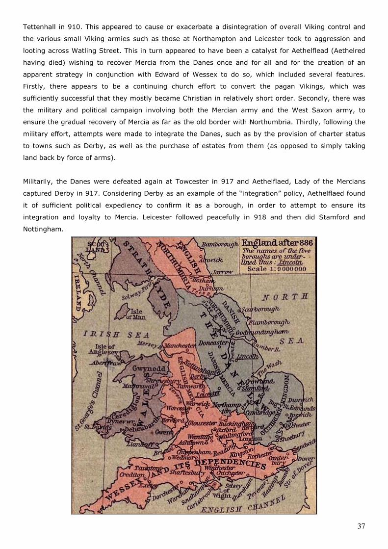
37
Tettenhall in 910. This appeared to cause or exacerbate a disintegration of overall Viking control and
the various small Viking armies such as those at Northampton and Leicester took to aggression and
looting across Watling Street. This in turn appeared to have been a catalyst for Aethelflead (Aethelred
having died) wishing to recover Mercia from the Danes once and for all and for the creation of an
apparent strategy in conjunction with Edward of Wessex to do so, which included several features.
Firstly, there appears to be a continuing church effort to convert the pagan Vikings, which was
sufficiently successful that they mostly became Christian in relatively short order. Secondly, there was
the military and political campaign involving both the Mercian army and the West Saxon army, to
ensure the gradual recovery of Mercia as far as the old border with Northumbria. Thirdly, following the
military effort, attempts were made to integrate the Danes, such as by the provision of charter status
to towns such as Derby, as well as the purchase of estates from them (as opposed to simply taking
land back by force of arms).
Militarily, the Danes were defeated again at Towcester in 917 and Aethelflaed, Lady of the Mercians
captured Derby in 917. Considering Derby as an example of the “integration” policy, Aethelflaed found
it of sufficient political expediency to confirm it as a borough, in order to attempt to ensure its
integration and loyalty to Mercia. Leicester followed peacefully in 918 and then did Stamford and
Nottingham.
38
The Danelaw from the Historical Atlas by William R. Shepherd (1926)
In 920 Edward came to Bakewell and ordered a burg (fort) to be built (Rollason, 2003). At a casual
glance Bakewell is an odd choice, it is neither on the old border between Mercia and Northumbria, as
Dore is, nor is it obviously strategic on a major road such as Ryknield Street. However, it stands on the
crossing of the Wye and is therefore between the Vikings of York and the valuable lead mining district
and the Mercian Royal estates around Wirksworth. Setting aside the rather curious strategic choice
Edward may simply have ordered the construction of a burg because this is the location he had chosen
to meet the northern kings and he is hardly likely to do this without having a defensible position to
occupy if something went wrong. However, in order to secure northern Mercia once and for all, Edward
also built a fortress at Thelwall and a Mercian army occupied the former Northumbrian fortress in
Manchester in 922. This has the appearance of fortifying the former Mercian frontier against Viking
attacks not only from York but also from across the Irish Sea.
A charter of 926 to Duke Uhtred (Sawyer charter 397) confirms the purchase of land at Hope and
Ashford from the Danes. This is a follow on to the military approach and is also part of the process to
secure the province again, this time by recovering key estates (especially those west of the Derwent).
The result of all this activity on the part of Aethelflaed and Edward and their ealdormen was to secure
the Peak and the northern Mercian border. It is curious, and perhaps worthy of further assessment
that, in addition to place-name evidence from Domesday Book, the personal name evidence also
appears to confirm the density of the settlement pattern of the Danish Vikings east of the Derwent. It
may be therefore, that the Mercians succeeded in securing the Wirksworth and High Peak areas against
longer term Danish influence by treaty, land purchase and military means, and thus confined the Danes
to the Northworthy (Derby) estate and the areas east of the Derwent. This would explain why the lead
mining district appears to remain in Mercian royal hands and is inherited by the later Saxon kings, and
also why Derby (being proximate to both Wirksworth and Repton) and not Leicester, was apparently
the first major target of Aethelflaed’s campaign.
Sidebotham (1999) takes the view that the “Mercian” town crosses found in the Peak district’s principal
towns date from this time and are political monuments stating Saxon supremacy. The primary
monuments being those at Bakewell, Eyam, Hope, Bradbourne and Wirksworth, though the cross at
Wirksworth only survives as a fragment built into the church wall. Sidebottom incorrectly includes the
Wirksworth Stone in this group, ignoring that it is a funerary monument, not a political one, and of
greater antiquity.

39
The Mercian cross at Eyam
For about 20 years matters remained fairly stable but the efforts to integrate the Danes into Mercia
were not particularly successful. In 939 there was another flurry of Viking activity and Olaf
Guthfrithsson, coming from York, overran northern Mercia again, with no resistance from Derby,
Leicester, Nottingham, Stamford and Lincoln, which Aethelflaed and Edward had attempted to
integrate. Only at Northampton and Tamworth did the Vikings meet determined resistance and the
border once again briefly became Watling Street, but Guthfrithsson died a couple of years later and the
Mercians and West Saxons re-took the whole of northern Mercia once and for all. The boroughs of
Derby, Leicester, Nottingham, Stamford and Lincoln retained some of their Danish identity in the form
of a slightly different law structure, such as the “Court of the five boroughs”, and while this is taken
into account in various law codes it is clear that the overlordship is in the hands of the Saxons.
The place-name evidence for Viking settlement (Stafford, 1985) outside Derby is relatively limited and
the pattern of Viking place-names suggests that most settlement was along the eastern boundary of
what is now Derbyshire in Scarsdale and Morleystone Wapentakes and to some extent in northern
Derbyshire, and this is reflected in personal name survivals which occur later in these areas in
Domesday book. However there are almost no locations anywhere in the East Midlands in general
where Scandanavian place-names account for more than 50% of the place-names and none of these
are in Derbyshire.
Around Wirksworth there are a very few Scandanavian place-names and the vast majority are English.
There are no end of English “tuns” around Wirksworth – Carsington, Hopton, Ireton, Middleton, but
there are no Danish “bys”, only Derby and its surrounds have these, Denby for example. This suggests
that while the Vikings, specifically the Danes here, formed a briefly dominant group, which had
implications for the administrative and legal structure of the old Mercian province of the Peak, (e.g.
40
Hundreds being called Wapentakes, and there being a “court of the five boroughs”) that these were
only one contributing factor in the change from Mercian Province to the shire counties of Derbyshire
and Nottinghamshire and that more of this change was due to the increasing West Saxon dominance of
Mercia and the gradual unification of Mercia, Northumbria and Wessex which resulted in the kingdom of
England.
Province and shire
Dating from about 920, the West Saxons, in the form of Edward the Elder, had attempted to impose a
new administrative device on the Province of the Peak with the creation of shires such as “Derbyshire”.
The purpose of this, on the face of it, was to provide a tax and manpower structure to support the
burghal fortresses being built to deal with the Viking Danelaw and to contain the Vikings of York,
though this device did not immediately result in the Mercian Province of the Peak District being
dismembered. (But given West Saxon policies towards Mercia this may be regarded just as much a
mechanism to weaken Mercian allegiances as to support the fortresses). In practice, the Peak
continued as province of Mercia, until we last hear of it in that role in 963 in a charter of King Edgar
and the Mercian Witan (council) regarding Ballidon (Brooks, 2000; Sawyer charter S712A). King Edgar
was the last king of a nominally separate Mercia from 955 to 959, when, on the death of his brother
Edwig, King of Wessex, he became King of all England and reigned until 977. Brooks notes that the
Ballidon charter is unusual in that it retains the styling of Mercian charters and also, most importantly,
records The Peak under its Mercian province title of the Pecsaete. Without this written evidence it had
been formerly thought (the charter was only rediscovered in 1985) that the Pecsaete has ceased to
exist before this time, and that “Derbyshire” had been created but simply not mentioned until 1048.
However, the charter confirms that the Pecsaete was still regarded by the Mercian council as a
functioning entity, and that this position must have prevailed at least while King Edgar reigned.
There also appeared to be a West Saxon policy of maintaining the weakness of the Mercian
ecclesiastical structure and its sees (Barrow, 1994) again for political reasons, to undermine Mercian
allegiances. In the days before St Mary’s became part of the Dean of Lincoln’s jurisdiction in the later
Norman period it is thought that Wirksworth had been part of the See of Winchester, whether this later
move was knowingly to restore the status quo of the Mercian period is not clear, but West Saxon policy
had been to move or keep vacant many of the Sees of the East and the Midlands (Rollason, 2003). The
original attachment may equally have been because the West Saxon kings had acquired the former
Mercian Royal estates around Wirksworth at some point (bearing in mind these estates were in the
later holding of Edward the Confessor) and the parishes of those manors were therefore made
subservient to Winchester as part of that process.
So it has to be remembered that the shire counties were a West Saxon creation, and they did not
become a significant administrative device while the kingdom (later the Earldom) of Mercia still existed,
and despite this West Saxon interference the Province continued for some time with the shires
presumably acting as a kind of administrative shadow. Consequently it is not surprising that we don’t
hear of “Derbyshire” until 1048, in the Anglo-Saxon Chronicle (which is, after all, a West Saxon view of
41
events). In terms of the purpose of the shire county having been a mechanism to support the burghal
fortresses, in the first case this did not work. The burghal fortresses of the north apparently provided
no resistance to the Vikings of York when they overran northern Mercia again in 939. This would
explain why in the 963 Ballidon charter we are still dealing with the Mercian province, not the shire
county. Mercia appears, then, to flicker on and off throughout the late Saxon period and retained its
own Earl up to the Norman conquest in 1066. One other issue occurs, related to the 1048 Chronicle
entry, in that it refers to an earthquake in Derby followed by disease and wildfire throughout
Derbyshire. This earthquake might possibly account for the condition of the Wirksworth Stone, upside
down and partly broken, when found in 1821.
At some point the shire counties were re-organised (presumably after Edgar’s reign) and these then
gradually became the dominant structure and the Wapentakes or hundred divisions ceased to be
structures of the Province of the Peak and a smaller number of them became Derbyshire, with the rest
of the Province’s wapentakes being lost to Nottinghamshire, Staffordshire and Cheshire. For example,
Higham (1993) noted that apparently half of the Peak district’s wapentake of Hamenstan was given to
Cheshire as part of the process, and Totmanslow to Staffordshire.
Wirksworth and Domesday Book
This uncertainty about the administrative structure still resonated when Domesday book was written in
1086. When the sequencing of Domesday book is considered we find that in almost all cases the shire
town appears at the beginning of its shire chapter, but in the case of Derbyshire, this is not so. Derby
is at the end of the Derbyshire chapter next to Nottingham. This odd juxtaposition is because these two
counties were originally both part of the Mercian province, the Peak District, and this is why they
shared a number of institutions even during the Norman period, such as the post of Sheriff. A similar
unease between the new shires and the older sokes and multiple estates is noted in Yorkshire by
Rollason (2003), where the vast and then new county of Yorkshire sat rather badly with the former
Northumbrian kingdom’s administrative arrangements.
It is commonly thought that Derby is the only town identified in Domesday book for Derbyshire. This is,
of course, not correct. Derby has a separate listing as the “shire town”. In all other cases except one,
Derbyshire locations identify a total population for any given manor, a very few also identify a small
number of people associated with a church and its priests, such as at Ashbourne and Bakewell.
However the Derbyshire Domesday book listings for any given place invariably identify the number of
“villains” and “bordars” (villagers and smallholders if you like) in the whole manor including any
berewicks. The one exception is, not surprisingly, the old Mercian capital of the Peak, Wirksworth. The
Domesday listing for Wirksworth is the only one in Derbyshire which provides two population figures.
The figure for Wirksworth itself, as opposed to the separate figure for its manorial outliers, can only
refer to the townsfolk. Here is a translation from the original Latin (Thorn, 2007):
The King’s land: M In WIRKSWORTH 3 carucates of land taxable. Land for 4 ploughs.
A priest and a church; 16 villains and 9 bordars who have 4 ploughs.
42
3 plumbariae; meadow, 26 acres; pasturable woodland 2 leagues long and 2 leagues wide.
Berewicks in this manor In CROMFORD 2 carucates; MIDDLETON(-by-Wirksworth) 2 carucates; HOPTON 4 carucates; (WELLEDENE) 2 carucates; CARSINGTON 2 carucates; CALLOW 2 carucates; (Kirk) IRETON 4 carucates. 18 carucates of land taxable. Land for as many ploughs. In these 36 villains and 13 bordars who have 14 ½ ploughs. Meadow, 14 acres; pasturable woodland and underwood 3 leagues long and 2 wide. (With Darley, Matlock, Ashbourne and Parwich, with their outliers, it paid £32 and 6½ sesters of honey before 1066; now £40 of pure silver) (Land of the King. King William holds it. King Edward held it)
Ralph, son of Hubert’s land: In WIRKSWORTH, LEA and TANSLEY 4 bovates of land taxable. Land for 1 plough. Now 3 villains and 7 borders have 1 plough
And meadow, 2½ acres. Pasturable woodland ½ league long and as wide. Value before 1066, 10s; now 7s. This land lies in the lands of Crich, but it pays tax in Hamston Wapentake. Leofric and his brother Leofnoth had it. (Land of Ralph son of Hubert)
Unlike many areas of Derbyshire, Wirksworth is not described as “waste” which was an after-effect of
the “Harrying of the North” by William the Conqueror following the rebellion of the Saxon earls of
Northumbria, Mercia and Wessex. It can only be assumed from this that Wirksworth received a
measure of protection due to it being part of William’s own landholdings. Nevertheless, the Normans
having taken all the lands of the former Saxon earls were pre-occupied by keeping down the Saxon
population and it may be that the construction of the castle at Duffield by Henry Ferrers was to ensure
the two main centres of Derbyshire’s population, Wirksworth and Derby, were kept apart.
Interpretating Wirksworth’s Domesday book entry:
The King’s land:
“In Wirksworth there are 360 taxable acres of land. Land for 4 ploughs.
A priest and a church there, and 16 villagers and 9 small holders having 4 ploughs.
There are 3 lead works and 26 acres of meadow.
Wood, pasturable, 3 miles in length and 3 miles in breadth.
Outliers in this Manor.
In Cromford 240 acres, Middleton by Wirksworth 240 acres, Hopton 480 acres, Welledene (Willow Dean
Farm) 240 acres, Carsington 240 acres, Callow 240 acres, Kirk Ireton 480 acres; 2160 taxable acres of
land. Land for as many ploughs.
In these there are 36 villagers, and 13 smallholders, having 14 ploughs and a half.
There 14 acres of meadow.
Wood, pasturable, and under-wood, 4½ miles in length and 3 in breadth.
With Darley, Matlock, Ashbourne and Parwich, with their outliers, it paid £32 and 6½ sesters of honey
before 1066; now £40 of pure silver”
The manor at Wirksworth was sufficiently large that not only did the King own most of it, but Ralph
Hubert owned some. He owned the part of Wirksworth manor which lay east of the Derwent in Lea and
Tansley and although this was attached to his main lands in Crich, the clue to its correct status is in the
statement that it pays tax in Wirksworth Wapentake (Crich is in Morleystone Wapentake).
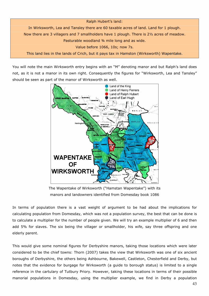
43
Ralph Hubert’s land:
In Wirksworth, Lea and Tansley there are 60 taxable acres of land. Land for 1 plough.
Now there are 3 villagers and 7 smallholders have 1 plough. There is 2½ acres of meadow.
Pasturable woodland ¾ mile long and as wide.
Value before 1066, 10s; now 7s.
This land lies in the lands of Crich, but it pays tax in Hamston (Wirksworth) Wapentake.
You will note the main Wirksworth entry begins with an “M” denoting manor and but Ralph’s land does
not, as it is not a manor in its own right. Consequently the figures for “Wirksworth, Lea and Tansley”
should be seen as part of the manor of Wirksworth as well.
The Wapentake of Wirksworth (“Hamstan Wapentake”) with its
manors and landowners identified from Domesday book 1086
In terms of population there is a vast weight of argument to be had about the implications for
calculating population from Domesday, which was not a population survey, the best that can be done is
to calculate a multiplier for the number of people given. We will try an example multiplier of 6 and then
add 5% for slaves. The six being the villager or smallholder, his wife, say three offspring and one
elderly parent.
This would give some nominal figures for Derbyshire manors, taking those locations which were later
considered to be the chief towns: Thorn (2007) takes the view that Wirksworth was one of six ancient
boroughs of Derbyshire, the others being Ashbourne, Bakewell, Castleton, Chesterfield and Derby, but
notes that the evidence for burgage for Wirksworth (a guide to borough status) is limited to a single
reference in the cartulary of Tutbury Priory. However, taking these locations in terms of their possible
manorial populations in Domesday, using the multiplier example, we find in Derby a population
44
estimate of 1,027; Wirksworth 536; Bakewell 340; Newbold (inc the hamlet of Chesterfield) 258;
Ashbourne 208; Castleton had no population associated with it being listed only as a castle. These
populations may seem a little low, Domesday notes that Derby “before 1066” had 243 burgesses but
records only 100 in 1086. It is possible that the “before 1066” statement means just that, at some
point before 1066 the population was much greater and it may be that the apparent collapse in
population might be a result of the 1048 earthquake and the disease which followed, which, if it were
the case, would possibly have implications for the population of Derbyshire generally, including
Wirksworth.
Wirksworth’s population may also be technically under-represented in Domesday, for example
Wirksworth is supposed to have a Soke (the manor may represent the Soke), but Domesday records no
Sokemen in Wirksworth. This is because Domesday is recording only those people responsible for
paying dues, especially Royal dues, and omits many groups who did not have such responsibilities: in
the Derbyshire section of Domesday Sokemen only appear intermittently and in some, not all,
Wapentakes. Sokemen are a kind of rent payer and thus may well be partially omitted, as Stafford
(1985) observes. Thorn noted of Derbyshire in Domesday that it was one of the first shires to be
undertaken, and because of this it is less well organised than later examples such as Cheshire.
Roffe (2007) took the view that the population multipliers typically used for Domesday, might in fact,
be serious underestimates, that the total population of the country should be considered as nearer 5
million not 1.75-2.25 million. If this were correct, then we should not be using a multiplier of 6 and 5%
for slaves, but something nearer 15. This would give the population of Wirksworth in 1086 as perhaps
1,270 rather than the 536 noted above. Such assessments may now depend on further academic
assessment of Domesday and other documents.
45
Conclusions of this report
Rahtz (1977), as noted in the introduction, made the most salient point in his work on the (West)
Mercian towns. He said that, with the then exception of Worcester, no survey had been made which
attempted to bring together the historical, topographical, numismatic or other sources and relate them
to what archaeological evidence existed. If this was true for such great cities as Chester and Gloucester
or ancient towns such as Shrewsbury and Tamworth, how much the more is it the case for Wirksworth?
One of the recurrent phrases found when considering almost any article written about ‘lost Lutudarum’
is “the interminable search”. In reality, this should better be described as the “interminable
speculation” as there had been no systematic search whatsoever, and this is more than regrettable, but
perhaps inevitable. Hodges (1991) noted: “As in most upland parts of Britain this period (in the Peak)
has not been studied in any systematic way”.
The case against Wirksworth being a Roman city long rested on the narrow pillar of the shortage of
physical evidence from within the town itself, but to date little such evidence had been sought or
analysed: For example, in the 130 years of the Derbyshire Archaeological Society, not one test pit,
barely one trench, had been dug in Wirksworth, not one field walked, not one wall considered and
precious few finds recorded officially. One often heard of old quarrymen telling of all kinds of ‘ancient’
artefacts they found while quarrying, but not one of these is known to have been recorded. The
purpose of the Wirksworth Roman Project was to attempt to address the uncertainty of Wirksworth’s
early history and the archaeological gap.
This study has sought to synthesise what is known, and in some cases that had been precious little.
Only when it is all gathered can we consider its significance. There is sufficient evidence for Wirksworth
to be considered ‘lost Lutudarum’. Originally the oppida of a British tribe with a modest industrial
activity smelting lead in the woods; the Romans, over a 300 years period, made it one of their “noble
cities” and when they declined, it survived their demise. Its aristocracy became accustomed to their
different world, as a Province of the kingdom of Mercia and changed the name of their capital to
Wirksworth, not the ‘enclosure’ of some Saxon called ‘Weorc’, but possibly signifying in Anderson’s
view: “fortified enclosure” or “City of the Fortress”.
Lutudarum is a recorded Roman town intimately involved in the production of lead and in the
administration of its production, as well as the administration of its surrounding district. Of the many
candidates for Lutudarum, only Wirksworth sufficiently speaks its case, the indicators of this case are:
the local place names, both in Wirksworth and nearby; the situation of government in the district at the
time of early Mercia; continuity of Christianity established in a location with a big enough population to
sustain it; continuity of the lead mining industry due to the revenues to be gained from maintaining it;
the longevity and importance of Wirksworth in the written historical record; and that Wirksworth lies at
the route centre of three known Roman Roads: the Rocester and Chesterfield Road; the Wirksworth
and Little Chester Ridge way, and the Buxton and Wirksworth road, “The Street”.
46
Above all, it is the matter of the antiquity and importance of St Mary’s Church in Wirksworth which,
when taken into consideration alongside Bassett’s work on St Helen’s in Worcester and the ancient
churches and their parishes of Gloucester, Lichfield and Wroxeter, leads to the inescapable conclusion
that the presence of such a church is representative only of those found in the late Roman civitas
capitals (Dark, 1994). The presence of the Wirksworth Stone, an early Christian sarcophagus lid found
below the church floor near the altar, and originating from well before the date of most of the other
sculptural material of the Peak, such as the stone crosses, confirms the early importance and presence
of this church. This, together with the “Eccles” place name, would make Wirksworth the lost capital of
the Lutaderenses, Lutudarum, even if we set all other evidence aside.
The presence of Wirksworth as the major settlement of central Derbyshire in the years before the
Viking invasion is certain, and again the presence of the church is key to this, the Saxons do not build
major churches in fields, a Minster Church such as St Mary’s has to serve a big enough congregation to
sustain it and the presence of a town is therefore unavoidable. The town survived through the entire
Mercian period into the Danelaw and to the very end of Anglo-Saxon rule in England, at the Norman
conquest. Wirksworth appears in 1086 in Domesday book and its position as the key market town of
central Derbyshire remained intact throughout the middle ages, indeed by 1563 when a diocesan
census of households in Derbyshire was recorded (Riden, 1978), the parish of Wirksworth was only
slightly smaller in number of households than the combined parishes of Derby. Wirksworth contained
470 households and Derby 507, or using our previous multiplier example, Derby would have a nominal
population of 3,192 and Wirksworth 2,960.
The history of Wirksworth and the history of the Peak District are inextricably linked, and although
virtually every other town and village of the Peak has a valuable and useful history book about it,
Wirksworth to date has not. This study therefore represents an attempt to address the history of
Wirksworth in the years before the Norman Conquest. Work being undertaken by the Victoria County
History will doubtless provide for the period between the Conquest and the modern world.
47
Summary conclusions of the five reports
Five reports have been undertaken by the Wirksworth Roman Project. The Project owed its beginnings
to work done in 2005 in which the potential Roman origins of Wirksworth were considered in an initial
consultation document “Origins and history of Wirksworth. The search for Lutudarum: evidence and
assessment” (of which this work is the final incarnation). A major issue arising from that original
document was that the archaeological background which one might expect for such a venerable town
did not exist, with the archaeological resource to provide such a foundation being wholly absent, and
the Derbyshire Archaeological Society having shown no interest in the town. To address this weakness,
an application was made in April of 2006 to the Derbyshire Community Foundation to fund an
archaeological project for Wirksworth. This application was successful and funds were allocated in June
2006 for one year.
The first work done by the group which gathered to carry out the Project was a training exercise and
the location chosen was a ford near Hardhurst Farm, known as Wirksford, at the suggestion of Mary
Wiltshire and Sue Woore, whose work on the Duffield Frith is well known locally. We felt we had not got
the archaeological experience to consider the town itself to begin with. To the surprise of all concerned
the little ford concealed a secret. It wasn’t a ford at all. It was a curiously well-built and substantial
culvert, it was approached by a section of ruinous causeway and a well-made wide gritstone roadway
ran off it. However, we could find no dating evidence and the associated report “The Culvert at
Wirksford” said so.
It was then suggested to us that we might be able to date the culvert by comparing it with others
which had known features associated with them. This didn’t prove exactly to be the case but it led to
the assessment of nearly 30 culverts and stream crossings between Wirksworth and Duffield on the
east bank of the Ecclesbourne, at which point it was found that six of them appeared to have the same
generic construction as the culvert at Wirksford and that a section of known Roman road, Longwalls
Lane, appeared to run in proximity to the culvert at Wilderbrook Lane End (“Knaves Cross”). A flurry of
activity then took place which resulted in the conclusion that the six culvert sites were features
probably associated with Longwalls Lane and that at Wirksford was one of the series, therefore of
Roman origin and thus part of a Roman road route along the ridge-way between Wirksworth and
Duffield, of which Longwalls Lane near Blackbrook and North Lane near Milford represented well
preserved sections. This resulted in a further report: “A ridge-way route between Wirksworth and Little
Chester, Derby: a Roman road its constructional features”.
At this point it had become clear that we couldn’t do everything that needed to be done quickly
enough, the year’s funding had expired and we still had a long list of outstanding problems to solve, so
we carried on, now with the kind help of the Wirksworth Heritage Centre. The most serious of these
outstanding problems was the question of the route of The Street, the Roman road which ran south-
eastwards from Buxton and which was invariably thought to run to Little Chester via Carsington. One of
the first documentary tasks we had undertaken was the plotting of all officially known Roman finds in
and around Wirksworth on a very large scale map. In the case of the known section of The Street and
of the Ridge-way, known finds clustered around these roads. But in the case of the supposed line of
The Street between Carsington and Little Chester, there was a vast blank space, there were no known
finds. This caused us to question the received wisdom about the supposed southern route of The Street
and in due course we found that, amongst other problems, some fumbling ineptitude on the part of
William Bennet, Bishop of Cloyne, in 1817 had effectively destroyed all subsequent rational assessment
for the route south of Longcliffe. The consequent wholesale documentary revision and associated
archaeological work finally identified the route of the southern section of The Street as Brassington
Lane and its destination as Wirksworth, and Wirksworth as a major route centre in the pre-turnpike
road network of the Peak District. The associated report “The Street: A re-evaluation of the Roman
road from Wirksworth to Buxton” was published, after a further year of effort, in summer 2008.
Finally, we undertook two limited examinations in the town, summarised in our report “Issues in the
Archaeology of Wirksworth”, which should be taken into consideration with this report. The complete
and utter lack of any prior archaeological examination of Wirksworth was breathtaking. At the
beginning of our Project no archaeological evidence existed which was capable of supporting the
documentary assessment that Wirksworth had a likely Roman past associated with a conceptual civitas
district of the Lutudarenses, and this past was probably an important and wholly overlooked one in
national terms - but the results of the five reports begin to do this. We have put the matter “on the
radar” and hope that (at the very least) some developmental archaeology may improve matters in the
future. Our very grateful thanks are extended to all who have been involved or who have helped in any
way whatsoever.
48
Reference List:
Anderson JJ (1985) Roman Derbyshire, Derby, JH Hall and Sons, p10-15
Anderson OS (1934) The English Hundred Names, University of Lund, Vol 1, p35
Arkwright Rev (1912) A survey of the Soake and Manor of Wirksworth 1649, Derbyshire Archaeological
Journal, p13-28
Barrow J (1994) English cathedral communities and reform in the late 10th and 11th centuries, in
Rollason D (ed) et al, Anglo-Norman Durham 1093-1193, Woodbridge, Boydell
Press, p25-39
Barnatt J (2004) The Peak District, Landscapes Through Time, Macclesfield, Windgather Press
Smith K p49, p54
Bassett S (1989) Churches in Worcester before and after the conversion of the Anglo-Saxons
Antiquaries Journal, p216-256
Bassett S (1992) in Blair J and Sharpe R, Pastoral Care before the Parish, London, Leicester
University Press, pp13-40, p20
Bede (the Ven)( 731) Ecclesiastical History of the English Nation, (Chapter 21) in the public domain,
Accessed on 05/02/09 at http://www.fordham.edu/halsall/basis/bede-book1.html
Bestall JM (1974) History of Chesterfield, Chesterfield, Borough of Chesterfield, p9
Birch W (1885) Cartularium Saxonicum, London, Whiting & Co, pxxvi
Branigan K (1985) Lost towns of Roman Britain, 2: Lutudarum, Popular Archaeology, September,
p39-41
Branigan K (1986) Two Roman lead pigs from Carsington, Derbyshire Archaeological Journal,
p5-17
Branigan K (1991) Civilian development in a military zone; the Peak AD 43-400 in Hodges R,
Recent developments in the Archaeology of the Peak District, University of
Sheffield, JR Collis Publications, p60
Brassington M (1982) Roman Derby, Derby, JF Hill Printers, p3
Brassington M (1988) The Lumb Brook Pottery Kilns, Hazlewood, Derbyshire Archaeological Journal
Webster WA p21-33
Breeze A (2002) The name of Lutudarum, Derbyshire, Britannia, Vol 33, p266-268
Brighton T (2005) Bakewell, Tiverton, Halsgrove Publishing, p6-13
British (2007) The electonic Sawyer: online catalogue of Anglo-Saxon charters, University of
Academy Cambridge, accessed on 11th August 2008
http://www.esawyer.org.uk/content/browse/ch_date.html
Brooks CH (1924) A little book about Wirksworth, Wirksworth, FW Brooks Publishers
Brooks N (1989) The formation of the Mercian Kingdom in Bassett S, The origins of Anglo-Saxon
Kingdoms, London, Leicester University Press, p160
Brooks N (2000) Anglo-Saxon Myths: State and Church 400-1066, London, Hambledon Press, p236
Brotherton P (2005) Celtic place names and archaeology in Derbyshire, Derbyshire Archaeological
Journal, p122
49
Bunting J (1998) Bygone industries of the Peak: Lead Smelting, Peak Advertiser, 23rd March
Burnham BC (1990) The ‘small towns’ of Roman Britain, London, Batsford, p 176-178
Wacher J
Cameron K (1959) The place names of Derbyshire, Vol 2, Cambridge, University Press
CIL (2006) Corpus Inscriptinem Latinarum, Vol VII, record no 1215, accessed at:
http://www.roman-britain.org on 01/02/06
Cockerton RW(1962) The Wirksworth Slab, Derbyshire Archaeological Journal, p1-20
Colgrave B (1956) Felix: The Life of Guthlac, Cambridge, University Press, p147
Collingwood R(1965) The Roman Inscriptions of Britain, Oxford, Clarendon Press
Wright RP
Collins R (1999) Early Mediaeval Europe 300-1000, Basingstoke, MacMillan, p186-195
Connelly P (2005) Overcoming Splendid Isolation in Nevell M and Redhead N Mellor: Living on the
Edge. A Regional Study of an Iron Age and Romano-British Upland Settlement
Manchester Archaeological Monographs, Vol1, University of Manchester, p99-106.
Cox JC (1875) Notes on the churches of Derbyshire, London, Bemrose, vol 2, p539
Cox JC (1916) Notes on the Parish Church of Wirksworth, Wirksworth, G Marsden, p8
Cox T (2005) The ancient Kingdom of Elmet, Barwicker No 39, accessed on 9th May 2005
http://www.hjsmith.clara.co.uk/3943.htm
Cramp R (1977) in Dornier A, Mercian Studies, Leicester, Leicester University Press, p191-231
Cubitt C (1995) Anglo-Saxon Church Councils c.650-c.850, London, Leicester University Press,
p223-230
Dark K (1994) Civitas to Kingdom, London, Leicester University Press, p 64-68
Dark K&P (1998) The Landscape of Roman Britain, Stroud, Sutton Publishing, p136, p123, p140
Darlington RE (1945) The Cartulary of Darley Abbey, Kendal, Titus Wilson, Vol 2, p582
Davis, JG (2003) A history of Crich, Ashbourne, Landmark
Davies, H (2002) Roads in Roman Britain, Stroud, Tempus Publishing
Dearne MJ (1991) The military vici of the South Pennines; retrospect and prospect in Hodges R,
Recent developments in the Archaeology of the Peak District, University of
Sheffield, JR Collis Publications, p69-84
Dearne MJ (1995) Excavations at Brough Field, Carsington, 1980, Derbyshire Archaeological
Et al Journal, p37-75
Dennis H (1971) The techniques of lead mining (Thesis), Cardiff, University College Cardiff,
p14-15
Dodd AE&EM (2000) Peakland Roads and Trackways, Ashbourne, Landmark, p26, p43, p44-49
Dool J (1974) Excavations at Strutts Park, Derby, 1974, Derbyshire Archaeological Journal
p15-32
Editorial (1986) Going down to the past, Community Fayre, No 25, October, p1
50
Ellis P (1989) Roman Chesterfield: Excavations by T Courtney 1974-1978, Derbyshire
Archaeological Journal, p51-127
Foot S (1993) The Kingdom of Lindsey in Pre-Viking Lindsey, Lincoln, City of Lincoln
Archaeological Unit, p128-140
Glover C (1981) William Woolley’s History of Derbyshire, Wingerworth, Derbyshire Record Society
Riden P p24 and p176-179
Green HJM (1960) An architectural survey of the Roman baths at Godmanchester, Archaeological
Newsletter, 6, (12).
Greenhough P (1991) City Foulds: Interim Report (Thesis), Leicester, Leicester University
Hackett RR (1863) Wirksworth and five miles around, Wirksworth, J Buckley
Hadley DM (1996) Conquest, Coloniization and the church: Ecclesiatical Organization in the
Danelaw, Historical Research, Vol LXIX, p109-128
Halsall P (1998) Annales Cambriae 447-954, accessed on 3rd January 2009 at
http://www.fordham.edu/halsall/source/annalescambriae.html
Hart CR (1981) The North Derbyshire Archaeological Survey to AD 1500 Chesterfield, North
Derbyshire Archaeological Trust
Henstock A (1980)The course of Hereward Street. A Re-appraisal, Derbyshire Archaeological
Journal, p35-42
Higham NJ (1993) The origins of Cheshire, Manchester, Manchester University Press, p34-5,
p175-6, p213, p177
Hodges R (1991) Notes on the Mediaeval archaeology of the White Peak in Hodges R: Recent
developments in the archaeology of the Peak District, University of Sheffield,
JR Collis Publications, p111-121
Hutchinson S (1709) The Wirksworth Township Map of the Gell Estate, held at the Derbyshire County
Archive, Matlock, accession number D258 M/18/6
Ireland S (2008) Roman Britain: A sourcebook, London, Routledge, 3 edn, p 209-211
Jebson T (2006) The Anglo Saxon Chronicle, Manuscript E (The “Peterborough”) Bodleian
Library MS Laud 636 accessed on 04/01/08 http://asc.jebbo.co.uk/e/e-L.html
Kay SO (1962) Romano-British Pottery Kilns at Hazelwood and Holbrook, Derbyshire, Derbyshire
Archaeological Journal, p21-42
Kendrick TD (1938) Anglo Saxon Art to AD 900, London, Methuen & Co, p164
Knight D (2004) The Romano-British Landscape in Knight D and Howard AJ Trent Valley
Howard AJ Landscapes, Great Dunham, Heritage Marketing and Publications Ltd.
Leary R p115-146
Kurth B (1945) The Iconography of the Wirksworth Slab, Burlington Magazine, 86, p114-121
Lane H (1986) The Romans in Derbyshire: Lead Mining and the search for Lutudarum, Bolsover,
Veritas, p57-61
Leahy K (1993) The Anglo Saxon settlement of Lindsey in Vince A, Pre-Viking Lindsey, Lincoln,
City of Lincoln Archaeology Unit, p29
Ling R (1981) Excavations at Carsington 1979-1980, Derbyshire Archaeological Journal,
51
Courtney T p58-87
Ling R et al (1990) Excavations at Carsington, Derbyshire Archaeological Journal, p30-55
Lomas J (1960) A Romano-British Site at Owslow Farm, Carsington, Derbyshire Archaeological
Journal, p109-116
Loveluck C (1995) Acculturation, Migration and Exchange: The Formation of an Anglo-Saxon
Society in the English Peak District, 400 – 700AD in Bintliff JL and Hamerow H:
Europe between late Antiquity and the Middle Ages, Oxford, Tempus Repartum
p84-98
Lyttelton-Gell P(1916)The churches of Roman Britain, Derbyshire Archaeological Journal, p75-83
Margery ID (1967) Roman Roads in Britain, London, Baker, p410-417
Morris J (1995) The Age of Arthur: The British Isles from 350 to 650, London, Pheonix, p298,
p240, p517, p351, p12-27, p243
Myers A (2000) An Archaeological Resources Assessment of Roman Derbyshire, Matlock,
Derbyshire County Council, p2
Naylor P (2003) A history of the Matlocks, Ashbourne, Landmark, p10-16
Ordnance (1997)Historical map and guide to Roman Britain, Ordnance Survey, Southampton,
Survey 5th Ed.
Palfreyman A (2007) A Romano-British quern manufacturing site at Blackbrook, Derbyshire,
Ebbins S Derbyshire Archaeological Journal, p33-48
Philpott R (ed)(2004) North West Region Archaeological Research Framework: Romano British Period
Resource Assessment, Liverpool, Liverpool Museums Service, p4, p11
Priestley F (2003) The Wirksworth Saga, Chippenham, Piper’s Ash, p12
Priestley J (1831) Navigable rivers of Britain, London, Longman, p197
Rieuwerts JH (1988) A history of the Laws and Customs of the Derbyshire Lead Mines, Sheffield, Office
Liaison, p13
Rahtz P (1977) in Dornier A, Mercian Studies, Leicester, Leicester University Press, p107–127
Riden P (1978) The population of Derbyshire in 1563, Derbyshire Archaeological Journal, p61-71
Rivet ALF (1981) The place-names of Roman Britain, London, Book Club Associates, p387-388
Smith C
Roffe D (1986) The Derbyshire Domesday, Derby, Derbyshire Museums Service, p24
Roffe D (2007) History Today, June, p50-56
Rollason D (2003) Northumbria, 500-1100: Creation and Destruction of a Kingdom,
Cambridage, cambridge University Press, p262, p270, p271
Rollason L (1996) Four Anglian Monuments in Derbyshire: Bakewell, Bradbourne, Eyam and
et al Wirksworth, Darlington, Workers Educational Association.
Salway P (1997) A history of Roman Britain, Oxford, Oxford University Press, p410-442,p455-460
Sheffield Museum (2008) The Benty Grange Helmet, Sheffield Museum collection, accessed at
http://www.idigsheffield.org.uk/index.asp?menu=expl on 12/12/08
52
Shone A (2008) The Street: A re-evaluation of the Roman road from Wirksworth to Buxton.
Smart D Derby, Wirksworth Roman Project.
Sidebottom PC(1999)Stone Crosses of the Peak and the Sons of Eadwulf, Derbyshire Archaeological
Journal, p206-220
Simpson G (1964) Britons and the Roman Army: A study of Wales and the Southern Pennines in the
1st - 3rd Centuries, London, Greggs Press, p129, p143
Slack R (2000) Lead Miner’s Heyday, Chesterfield, self published: Slack
Sprenger H (2004) The Wirksworth Branch, Usk, Oakwood Press (2nd Ed), p13
Stafford P (1985) The East Midlands in the Early Middle Ages, Leicester, Leicester University Press
p34, p89, p109-121, p135-143, p154-155 and p171,
Stenton FM (1940) Transactions of the Royal Historical Society, 4th series, vol 22, p1-22
Stroud G (2001) Derbyshire Extensive Urban Survey; Wirksworth; Archaeological Assessment
Report, Matlock, Derbyshire County Council, p4, p6
Tacitus C ( 98) The life of Cnaeus Julius Agricola, in Halsall P (1999) Ancient History
Sourcebook, accessed at www.fordham.edu on 19/01/06
Thorn C & T (2007) Introductory commentary and translation - Phillimore edition of Domesday Book
(Derbyshire), Hull, University of Hull
Tithe (1837) Tithe Map of Wirksworth, held at the Derbyshire County Archive, Matlock,
Commissioners accession number D2360 3/129
Toco (2005) Ravenna Cosmography, accessed at:
http://www.roman-britain.org.uk/geography/ravenna.htm on 01/05/05
Turbutt G (1999) A history of Derbyshire, Whitchurch, Merton Priory Press, p243, p303, p213
Walker IW (2000) Mercia and the making of England, Stroud, Sutton Press, p155, p173, p189, p152
Watson WR (1986) History of Duffield, Duffield, Chevin Books, p17
Wardle C (2002) Roman Staffordshire: the five towns and beyond, Stoke, Staffordshire County
Council
Welch M (2001) in Brown MP and Farr CA, Mercia, London, Leicester University Press, p153
Wroe P (1982) Roman Roads in the Peak, Derbyshire Archaeological Journal, p49-73
Yeatman JP (1886) The feudal history of the County of Derby, London, Bemrose, p27