the origins of wirksworth - wirksworth roman project · web viewthe word comes from the old norse...
TRANSCRIPT
WIRKSWORTH Gem of the Peak: A History
Draft 12th October 2015
ByAnton Shone and Mary Wiltshire
Assisted by Sue Woore
THIS IS A DRAFT OPEN FOR COMMENTS UNTIL 20th November 2015
ContentsPre-history to the Normans Geology and Pre-history:
Something to see at the National Stone Centre: Limestone geologyThe origins of Wirksworth“Lost” Lutudarum: Romans and leadThe Dark Ages:
Something to see at St Mary’s Church: The Wirksworth StoneSomething to see at Wirksworth Heritage Centre: The Wirksworth Sceat
A provincial town of the Mercian kingdom: The Wirksworth Charter of 835Place-names
Wirksworth: The place-nameRoads and tracks: Roads in the Peak provinceThe Viking AgeThe end of Mercia and the beginnings of England
The Normans to the Georgians The Norman Conquest and Domesday Book: Wirksworth in Domesday Book 1086The manorThe medieval churchThe growth of the town in the middle agesThe market place and its surroundingsMedieval streets and burgage plotsMillsComponent settlements: Steeple Grange, Wash Green, The Dale and Greenhill, Bolehill, Gorsey BankWho lived in Wirksworth?Anthony Gell Grammar SchoolThe AlmshousesStuart expansion
The Georgians to the present dayGeorgian prosperityVictorian IndustryLimestone quarryingGovernance of the town: Barmote Court, Manor Courts, The Court LeetReligion, Education, Social Life and local customsTwentieth century WirksworthConclusion: the past, the present and the future
AppendicesAppendix 1: The Duchy of Lancaster Manor Rental of 1415Appendix 2: Ann, the Duchess of Exeter’s Holland Manor Rental of 1473Apppendix 3: The 1649 Parliamentary Commission Survey Bibliography and Index.

Geology and Pre-history
The White Peak, that is to say that part of the Peak District which is made up of the limestone plateau and on whose south eastern edge Wirksworth lies, is important in the development of the town because of the features which the geology and the topography contain. The centre of Wirksworth is built on the edge of the limestone plateau at the point at which the geology changes to gritstone and in the short boundary of the change between the Carboniferous Limestone and Ashover Grit, the town centre and Oat Hill also overlie shale bedrock covered in a layer of Clay Till. The Till is often fawn coloured and is a glacial deposit of heavy clay containing occasional pebbles. This influence between limestone and gritstone can be also seen remarkably clearly when the fields and their boundaries are studied. In Wirksworth itself and to the immediate north and west the field boundaries are made up of limestone dry stone walls. These are built of gathered stone from the fields themselves and most of these are a fairly recent result of land enclosures between 1600 and 1800. On the other hand, to the south and east of Wirksworth the gritstone landscape has its fields bounded by gritstone walls and hedges, most obvious along the Ecclesbourne Valley which runs from Wirksworth south to Duffield.
The landscape and economy of Wirksworth is to a great extent a reflection of its geology. It lies on rocks laid down over a duration of some sixty million years in the Carboniferous Period, when an equatorial climate prevailed. The present limestones, shales, sandstones, gritstones and mudstones were deposited during periodic fluctuations in sea level, which gave rise to alternate marine and swamp conditions. Dramatic scenery has been produced by the subsequent uplifting of the limestone and the overlying gritstones to form a dome, accompanied by much fracturing and faulting. These limestones are the southernmost end of a shelf spreading southward from the Derbyshire Dome of the Pennines. Erosion has removed much of the later overlying grits and shales, but the prominent outcrops at Black Rocks and Barrel Edge remain as products of this faulting and uplift.
A major fault, the Gulf Fault, can be virtually followed along the Wirksworth to Middleton road as far as Rise End, separating the two huge former quarries of Dale and Middle Peak. These fractures and faults within the limestone gave easy routes for the subsequent passage of mineralising fluids, producing important veins of lead, zinc, fluorite, barite and other ores. Sandwiched between the limestone hills to the northwest and the gritstone scarps to the north and east, Wirksworth lies on shales between these two underlying rock formations. The Millstone Grit, also known as Ashover Grit, continues southwards along the valley of the Ecclesbourne towards the plains of central England.
Something to see at the National Stone Centre: The Quarry Trail
In the far distant past, the geology underlying Wirksworth was formed during the great movements of the world’s continents as a tropical lagoon. This distant geological past can be seen at the National Stone Centre on Porter Lane where the quarries which formed much of Wirksworth’s Victorian prosperity were dug out exposing the stone strata of that lagoon.
The fossils found in the limestone around the former quarries of the National Stone Centre tell us about the reefs and coastline of this ancient geological time and the fossils of shellfish, crustaceans and even sharks teeth embedded in the rocks can be found around the Centre. Gradually the movement and break up of the land masses which made up this geological past came to rest and formed the continent of Europe and of our island of Britain. The lagoon and its reefs gradually became the Peak District’s limestone plateau and also formed the more gentle countryside of the surrounding area.

Some views of the National Stone Centre
The National Stone Centre was opened in October 1990 on the site of six former Limestone Quarries and tells the story of stone, its geological and industrial history. The exhibition in the Visitor Centre takes you through time from the ancient planet four billion years ago to the modern world as it is now.
The Centre tells how stone has been used through the ages for building, construction, industry and for the many other uses to which it is now put. To see this to the best advantage and learn how stone was used and is still used, you can see the exhibition in the Visitor Centre and take the quarry trail around the site. The National Stone Centre also has a small cafe and shop and contains sculptural works and the remains of lead mining activity.
For more information see: www.nationalstonecentre.org.uk
The Peak District was the home to many ancient peoples from the days of hunter-gatherers, that is the Mesolithic period down to 3,500BC, from which we have flints and hammerstones collected by Dennis Vallance of Coldwell Street in the 1960s. Mr. Vallance’s collection was almost entirely of flints and associated artefacts collected within walking distance of the town. The Mesolithic hammerstones were found close to the Chariot Way at Enniscloud Meadow Farm in land being cleared for what is now the Bone Mill Quarry. In 1822 some lead miners working at the Dream Mine at Callow, a mile to the west of Wirksworth sunk a lead mining shaft into a cave in which they found the remains of a Woolly Rhinoceros. The story of the Dream Cave is told at the Wirksworth Heritage Centre.
The Neolithic period (3,500BC to 1,800BC) was characterised by a change from food gathering to farming, and by the occurrence of settlements and barrows (burial mounds). Particularly well-known are those to the north west of Wirksworth around Minninglow, Mouldridge and at Greenlow by Aldwark. The barrows tend to contain chambered tombs and the settlements tend to be characterised by scatters of flint implements and arrowheads, but there are also burial sites where the inhumations are in a couched position and which also contain Beaker pottery, sometimes stone wristguards used by archers and sometimes Jet buttons. It is thought that the burials found in 1828 at Brassington Lane just outside the town, with “black buttons” might date from this period.
Once the Bronze Age (1800 BC to 1,000 BC) is reached about four thousand years ago and the Iron Age, which ended two thousand years ago, everyday items are found much more often. Further material found by Mr. Vallance dates from this period including potsherds from Rains Cave in Brassington. In the Wirksworth Heritage Centre there is also a small collection of shards of Iron Age pottery found at Harborough Rocks. Derby Museum holds a collection of local finds including a Bronze Age Palstave (an axe) found at Bolehill during building work in 1906.
Wirksworth therefore stands at the centre of a landscape well known for its ancient remains, although these remains are rather under-examined. In the countryside around Wirksworth there are many burial mounds or ‘lows’. Some, mostly towards the north and west, have been examined and found to contain Bronze Age, Iron Age or Roman Age burials, perhaps to as late at 700AD. In the immediate area round the town are a number of these burial mounds, but none of them have been explored, examples are: Chewlows south of Summer Lane near Pitty Wood, Henlowe near Pratthall Lane, Crichlow near the north end of Chapel Lane and Tatlows, where there are three mounds between Brassington Lane and Hopton Lane. More are suggested from old field names such as Highlow Furlong, Long Lowe, Beardingslowe, Brymmynglow and
Ravenslowe to be near the town. These burial mounds on the east and south sides of the town have been almost entirely overlooked and rarely occur in assessments of the archaeological environment.
The Origins of Wirksworth
The historic centre of Wirksworth lies on a rising tongue of land, bounded on the east side by the headwaters of the River Ecclesbourne and on the south side by the former course of the Warm Brook, at Water Lane. This probably resulted in a dry and defensible area for which water was readily available, both from these streams but also from a number of springs. This tongue of land, the Hannage Peninsula, and its close neighbour Oat Hill, are composed of glacial material, limestone and shale, topped with clay till. Till is easier to work than the underlying bedrock of either limestone or gritstone on either side of it. To put up an Iron Age hut or roundhouse, posts have to be driven into the ground for the framework and this would be a far easier task on the Till than it would be on the limestone or the gritstone. Nearby, then as now, the valley and surroundings were wooded and this provided a convenient source of firewood. Once cleared of woodland there was space in which to farm. These are considerable advantages. The head of the valley in which Wirksworth rests also provides comparative shelter from the wind and weather of the limestone plateau and the surrounding hills.
Importantly, some of the springs at the head of this valley were thermal and it is necessary to look back into historic documents for evidence of this, for they are now gone. The hydrology of Wirksworth was drastically changed during the Jacobean and Georgian periods when many drainage soughs were built, destroying the thermal springs and the streams they fed. The first sough was the Dovegang Sough, started in 1632, and the later Hannage Sough started in 1693. A good example of this loss is the Warm Brook, which ran along the south side of Water Dale, now called Water Lane, where its course is completely obliterated. The thermal issue is crucial for an effective settlement because it means that there is a reliable water supply in the winter. Thomas Bagshaw, a local lawyer much involved in litigation about the soughs said, in 1702: ‘the town of Wirksworth hath borne the losses of their water from the town to the impairing of their health, being utterly deprived by the sough of as fine springs in the town as the Kingdome had’.
However, at the time of the possible origins of the settlement, these springs and streams and the defensible, easy to work tongue of land would have been important. The early development of Wirksworth is neither well researched nor yet well understood and it is not until the Roman period is reached that we begin to get hints of how Wirksworth may have developed more rapidly, not only because of the advantages of its position, but because of its proximity to the lead deposits which occurred in the Limestone plateau. It is possible then, but not yet evidenced, that an Iron Age settlement may have been present on the tongue of land here. This, as well as the presence of thermal springs and something to trade, would have been important to the Romans in looking for a settlement or fort site from which to develop the economy of the district. Recent possible evidence for trading in the district comes for the coin hoard found at Reynards Cave in Dovedale in 2014. This coin hoard included both Iron Age coinage and early Roman coinage.
‘Lost Lutudarum’ – Romans and lead
The archaeology of Wirksworth has, to date, turned up comparatively little to provide for the origins of the town, yet to take only one possible line of evidence is to fail. Much is known of Roman activity in the Peak. This is bound up with the development of the lead industry and the ‘lost’ Roman administrative centre of Lutudarum. The most famous locally related Roman epigraphic inscriptions are those found on lead ingots. Chief amongst these is that found at Cromford Nether Moor in 1777 which was inscribed IMP CAES
HADRIANI AUG MET LVT ‘Property of the Emperor Hadrian from Lutudarum’ thus dating it from between AD 117 to AD 138. A copy of this lead ingot can be seen at the Wirksworth Heritage Centre. In the epigraphic database of Roman inscriptions kept by Heidelberg University, there are twenty-five instances of the use of the Lutudarum place name. This compares to only five of which refer to Lindum (Lincoln) as a place name, for example. The presence of Lutudarum as a Roman lead mining centre, a provincial administrative capital and a market place in the Peak is well attested. The later record of Roman towns and fortresses across the empire, known as the Ravenna Cosmography, lists Lutudarum in the same geographical area with Veratino (Rocester) and Derbentione (Little Chester, Derby). Yet here lies a conundrum, for Lutudarum has long been thought lost and the antiquarians and historians of Derbyshire over the last 300 years could, for the most part, barely bring themselves to acknowledge that Wirksworth might be a candidate for that place.
Roman rule lasted almost 400 years and there is no evidence of war or turmoil in the Peak District throughout that time, indeed the Peak District’s Roman forts tend to be small and its marching camps few. This suggests that the peaceful and prosperous trade in lead was at the core of a quietly successful part of the empire and that Lutudarum was central to this success.
If indeed Wirksworth does prove to be lost Lutudarum it will be through the efforts of archaeologists and these efforts have only recently begun. Prior to this only a little pottery of the Roman Derbyshire Ware type had been found, at Pittywood Road and in St Mary’s Gate. A late second century Roman coin hoard was found in 1735, allegedly near the Blobber Mine on the west side of Swaines Meadow by Summer Lane, with 83 Roman silver denarii ranging from Emperors Augustus to Lucius Verus. A denarius would be the equivalent of a day’s pay for a soldier or a skilled person, say about £80 now, so this hoard would amount to having about £6,600 in the bank. The range of coins in the hoard would reflect the type of coins in circulation at the time the hoard was hidden. The last coins of Lucius Verus, give an approximate date for the deposition of the hoard of (at the earliest) 161 when Lucius became emperor and not much later than 169, as the hoard would have had to contain coins in circulation of Marcus Auralius or Commodus to be later. This coin hoard is often overlooked but is significant because of its value, that is to say it contained silver coinage. Many of the other better known, and sometimes larger coin hoards found locally, such as the Cromford coin hoard of about 1795, the Scarcliffe Hoard of 1876 or that found recently near Heage in 2012 are either of copper or brass coins or barbarous radiates (“emergency coinage”) of low denominations. Perhaps the closest comparator to the Wirksworth Hoard is the Parwich Hill hoard of 1769 in which 79 denarii were found, and whose date of deposition is strikingly similar.
Some spindle whorls with a sherd of Roman Derbyshire ware were found in Pittywood Road and a quernstone (a small millstone) was found near Porter Lane. The recent efforts of archaeologists have produced Samian ware (a kind of fine dining ware) from Long Close, at the top of West End, and some Severn Valley ware and Nene Valley colour coated ware from the Hannages just below St Mary’s Church, as well as more Derbyshireware locally.
Close to Wirksworth are many Roman farm or settlement sites including City Folds overlooking the Via Gellia, Pearson’s Farm north of Ryder Point, and a site near Great Mootlow, on the east side of the Chariot Way. These habitation sites must have had convenient access to a local market. The surroundings of Wirksworth have this unusual intensity of Roman finds and sites. To the west of Wirksworth at Shiningford Farm, now under Carsington Water, was a villa site (really a farmhouse), another with an aisled building at Roystone Grange by Ballidon and a possible settlement site may exist at Rainster Rocks by Brassington. A similar villa-farm site is currently being excavated overlooking the Amber at Heage.
In terms of industry, at Kniveton are the remains of what is considered to be a Roman paint-making site. To the northwest near City Folds are the Roman marble quarries at Hopton Wood. This marble was used in the Roman baths at Godmanchester (Durovigutum) and is thought to have been transported there by water. If this were so it might imply that the Derwent was navigable in Roman times at least as far as Whatstandwell, where the road from Wirksworth on Longway Bank comes down the riverside. Certainly in later medieval times it is thought possible that the Derwent was navigable this far north. It was known, from the accounts of the Duchy of Lancaster Steward, William of Birchover, that lead was delivered by barge to Nottingham in 1322. South and east of Wirksworth an intensity of Roman industrial sites are found. Quern making was carried out at Streets Rough, Alderwasley and at Starbuck House at Blackbook, close to the possible Roman road from Wirksworth to Little Chester via Belper Lane End, Dalley Lane and North Lane down to the ford at Milford (Muleford in Domesday Book). On North Lane between Blackbrook and Milford, near the former rifle butts, another mid-second century Roman coin hoard was found in 1868, close to the Roman pottery kiln site at the Chevin Golf Course. Pottery making is found extensively between Wirksworth and Little Chester. There were further Roman kiln sites at Alport Height, in Shottle near the Hall and in Hazelwood, Farnah Green, Duffield and Holbrook. This is pottery making on an industrial scale and it has to be remembered that its success depends on the close proximity to its markets and the effectiveness of the road network to enable the finished pots to be transported. These important kiln sites cannot, therefore, be seen in isolation, pots have to be sold and they have to be transported.
The Dark Ages
The Dark Ages present a conundrum; it is a turning point in history and one which is remarkably badly understood. At the end of the Roman age the Roman army was withdrawn in 410 and Britain left to look after itself, but this was at the time thought to be temporary: the army would come back. It never did. What then happened was a long and relatively slow conquest of Roman Britain by the invading Saxons which was complicated by the presence of different groups in different parts of the country. Some of these groups e.g. the Saxons, were certainly intent on conquest, but some of them, such as the Mercians, appear originally to have been the allies of the Romano-British. The Mercians were settled around the valley of the River Trent at Repton and other nearby places and their role seems to have been to guard the Trent Valley and the Rossington Gap as federates (allies) of the Romano-British. ‘Mercian’ means ‘Borderer’. For two hundred years peace prevailed as far as we can tell in the Peak, the former Roman province of the Lutudarenses. However in the early 600s another group started to make their mark: the Northumbrians. The Northumbrians defeated the Romano-British and their allies at the Battle of Chester in 616 and by this means the Northumbrians gained control of virtually everything north of the Trent including the Peak.
What happened then is very curious. The British with the Mercians waged a long war to recover the Peak District from the Northumbrians. There were many battles and Cadwallon of the British and the early kings of Mercia, Penda, Wulfhere and Ethelred made repeated and determined attempts to eject the Northumbrians from the Peak, which they eventually achieved at the Battle of the Trent in 679. This is the point at which the Mercian kingdom becomes important in the history of Wirksworth and when Wirksworth becomes part of Mercia. It is badly understood, because many of the sources are in Welsh and many of the place-names have been the subject of conjecture by historians lacking an understanding of the geography of the Mercian-Northumbrian war and of the Peak and its surroundings.
This brings up the question of what happened to the Lutudarum place-name and its unproven location despite all recent archaeological efforts. Lutudarum means “Grey Oakwood”. In the Ravenna Cosmography, Lutudarum is recorded as a significant place. In the Dark Ages there is a more Welsh version of the name: Caer Lwytgoed, sometimes written Lwytcoed or Lwytkoed. This means fortification (caer) of the grey (lwyt)

wood (goed). This name was recorded by Welsh sources and, in one of the battles in 636, Morfael and Penda defeated the Northumbrians at Caer Lwytcoed, took a great deal of plunder from the place and killed a bishop during the attack. This battle is almost always reported to be at Lichfield, probably a nonsense given any modern understanding of the geography of the Mercian – Northumbrian war.
It is possible that the Northumbrians were using the place-name simply as Ludeu, a kind of spoken shortening of the Welsh name, and this occurs in some further sources. To make understanding more difficult, the Venerable Bede, in his History of the English Church (Historia Ecclesiastica Gentis Anglorum) effectively a Northumbrian source and in Latin, reports some of these battles. His place-name for Ludeu was first copied out wrongly as Iudui and then, even worse, later copied out as Guidi, resulting in years of historians reading Bede, looking for place called Guidi and thinking it was Stirling in Scotland. This failure to get it right results in historical sources which say that one minute Penda is fighting a war in Lichfield and the next minute he’s fighting a war in Stirling, when all the time he may well be struggling with his appointed task: to eject the Northumbrians from Wirksworth and the Peak, a task which Wulfhere continued and which Ethelred succeeded in achieving in 679.
If Wirksworth proved to be this place then it is perhaps possible that the Wirksworth Stone commemorates the death of the bishop. Understanding Dark Age sources is not helped by different names being used for what may be the same place by the different groups involved. The Mercians called the place Wirksworth, but that doesn’t mean ‘fortification of the grey wood’. What Wirksworth means is the subject of another discussion (see below). These things said, it is just possible that Lwytcoed or Ludeu are faintly remembered locally, for there was a Ludwell in old documents and there still is a field called Lydia Flatts overlooking the town from the west of the valley near Summer Lane.
Nevertheless it is one of those curiosities of history and archaeology that it is only when the so called ‘Dark Ages’ are reached after the end of roman rule, that it begins to be obvious that the settlement of Wirksworth was important in a major way. To see this it is necessary to understand the beginnings of St Mary’s Church and its role as a Minster Church. Firstly it has to be remembered that the late Roman Empire was Christian and its provinces often corresponded with the dioceses of the church. Secondly that even where the civil government of a Roman province failed or was overwhelmed by invading Saxons, the governance of the church did not fail. This tells us about continuity.
Evidence, some circumstantial and some material, has pointed to the early establishment of a church here in Wirksworth. From the 7th century Christian Mercian kings spread Christianity and built minster churches on royal estates, Wirksworth being one such. If we take the view that the early Christian community established in this Romano-British lead mining area survived the social and economic disruption of the post-Roman era, then it is perhaps the only Derbyshire settlement site at which Christian worship has been maintained since Romano-British times without a break. Well-known ancient sculpture within the church and churchyard also attest to this early establishment, particularly the Wirksworth Stone, a Saxon sarcophagus lid. The ancient ecclesiastical parish included dependant chapelries at Bonsall, Carsington, Kirk Ireton and possibly Matlock at the outset, together with the area of Alderwasley, Ashleyhay, Ible, Middleton and Hopton.
Something to see at St Mary’s Church: The Wirksworth Stone
In 1820, during building work, a stone grave vault with an upside-down but close-fitting lid covering a large skeleton was found under the church floor in front of the altar. The location close to the altar suggests a person of very holy status. The Stone, still in the church, is an extremely rare and fine example of early

religious funerary sculpture, it is Wirksworth’s greatest treasure. The Wirksworth Stone has been very extensively studied, but these studies have tended to concentrate on the iconography of the Stone, what its pictures mean, not on what it represents in historical terms.
In historical terms it tells us that there was a very early church here and that church was so important that it was the burial place of a venerated holy person. For the Stone is indeed wonderful, for its time it is a piece of the highest art achievable. What does this tell us about St Mary’s Church? Most significantly it suggests that St Mary’s was no ordinary church, it was sufficiently important for a burial of the very highest status. For it is a possibility for this church to be built at all and to be endowed with such glory it had to be in a place able to afford its building and maintenance and to serve a large area. The dating of the stone causes the most difficultly, for it is unique. It has been compared on the one hand with Northumbrian stone carving of the seventh century and on the other hand with the sarcophagus of the Twelve Apostles in the church at Classe in Ravenna, dating from the fifth century, with which it bears distant similarities in terms of the bas-reliefs of its figures.
The Wirksworth Stone ? Picture to follow
St Mary’s church also contains many other examples of Mercian and later stone sculpture built into the church walls. A few pieces of these sculptures are from cross-shafts and although many of the sculptural fragments can be found inside the church, one of the important fragments is built into the exterior: high up on the north choir aisle wall is a piece of knot-work from a Mercian cross. It has considerable similarities to the cross at Leek and to the north face of the cross shaft at St Peters church in Hope. These sculptural fragments, taken together with the Wirksworth Stone, may imply the presence of a monastery or abbey in Mercian times, whose foundation was very ancient. For it should be borne in mind that St Chad, Bishop of the Mercians until 672, was according to the Welsh Annals, the Bonedd y Saint, the son of Cadvan, and here again there may, perhaps, be another faint reverberation of the Lwytcoed name:‘Siatt o Redynvre ap Cadvan Lwytcoed’ – Chad of Fern Hill, son of Cadvan Greywood. This might imply something of St Chad’s origins and his suitability for the post of Bishop of the Mercians. He may have accommodated the interests of all the parties involved, even the Northumbrians, for he spent time in Northumbria and Ireland before returning to Mercia. St Chad had three brothers and all played important roles in the development of the church at that time and this may also throw a light on the Wirksworth Stone and its possible date.
For information about the church and opening times see: www.wirksworthteamministry.co.uk/
Many early churches like the church in Wirksworth are named for St Mary. She was a cult figure in late Roman and early Mercian times, as was St Helen. Indeed St Helen’s name also occurs in Wirksworth, being one of the chantries of the church (see below). St Helen, mother of Constantine the Great, was closely associated with water and wells and, according to recent academic work, with Royal Mercian sites. Above Wirksworth on the east side of the town at the top of Wash Green is St Helen’s Lane. It runs next to the spring line whose waters supplied and still supply Wirksworth with fine, clear, soft water from the springs at Breamfield. This sunken Lane was the ‘ancient way to Derby’ in the days before the turnpike roads and leads up to Alport Height, past the Roman pottery kiln site there and so on to Duffield via Spout and Shottle.
A short distance from St Mary’s Church is Wirksworth Heritage Centre. For the person interested in history, whether that is family history or local history, the Heritage Centre is an important stopping off point. It holds many local artefacts, one of the smallest is the Wirksworth Sceat, a tiny coin, a penny, from long ago.

Something to see in the Wirksworth Heritage Centre:The Wirksworth Sceat
The Wirksworth Sceat was found by metal detectorist Cath Housley, lying on the spoil heap of an archaeological dig in Church Street in 1986. These coins are very rare and were made in the Kingdom of Northumbria and date from about 750AD. In the pictures below, the Wirksworth Sceat is on the right, the other two pictures show what Sceats look like. On the one side is a running horse or stag and on the other is the name of the king of Northumbria from 737 to 758, King Eadberht.
The Wirksworth Sceat ? Picture to follow
The Sceat is about the size of a modern 5p piece, a tiny object, but hugely informative about Wirksworth. This is because coinage of the time is very rare and this particular type of coin rarer still and tending to be found outside Northumbria only in locations with major churches or abbeys. This tiny find therefore supports the view that Wirksworth was a major ecclesiastical centre in the age before the Vikings.
For information about the Heritage Centre see: www.storyofwirksworth.co.uk/
A provincial town of the Mercian Kingdom
It might be thought from these archaeological finds that Wirksworth was part of Northumbria, but except for a short period between 616 and 679 it was not part of that kingdom, but part of the Kingdom of Mercia, the largest of the Saxon kingdoms. Indeed, because of the presence of the Great Barmote Court in Wirksworth (now the court of lead mining), Wirksworth was possibly the capital of the Mercian province called the Pecsaete, that is now called the Peak District. In today’s world many people wrongly believe that the historic Peak District means the Peak District National Park. The Peak, homeland of the Pecsaeten (the ‘Peak People’), as a province of the Kingdom of Mercia covered the entirety of later Derbyshire, the western half of Nottinghamshire as far as the River Idle, the north eastern part of Staffordshire and the south eastern part of Cheshire, a huge area. It was administered by a governor, an Ealdorman, in the same way as the other ten principal provinces of Mercia.
The role of the Great Barmote Court of the Soke and Wapentake of Wirksworth, to give it its rather cumbersome title, is to deal with matters of lead mining justice and this has been the case since the first known enquiry into its role, in 1288, when it was described as being of ‘great antiquity’. It would appear that the provincial capitals of the Mercian kingdom all had these courts. The modern Barmote Court now sits in a small courthouse, the Moothall on Chapel Lane, and is the oldest surviving court of its kind in Britain.
During the Mercian age a better picture of Wirksworth emerges and, for the first time, the name of someone directly associated with the town, the Abbess Cynewaru. She appears in the oldest written charter recording any town in the Peak, for in 835 she was compelled to give up some of her lands around ‘her township of Wirksworth’ to Duke Humbert of Tamworth. She does not appear to do so gladly, for the charter damns the Duke to become a friend of the Devil if he did not make an annual lead payment to Canterbury Cathedral.
The Wirksworth charter of 835
“In the year of the Incarnation 835, I Cyneuuara, Abbess, grant to Humbto, Duke, jurisdiction of land in my possession at Wirksworth, on condition that he shall give an annual render of lead to the value of 300 shillings to Ceolnoth, Archbishop and his successors [at Christ Church, Canterbury]. The above-named church should have this gift of mine from my aforesaid township every year. But if anyone should take away this my gift from Christ Church, Canterbury, may he be smitten with perpetual anathema, and may the devil possess him as one of his own.”
Place-names
The survival of place-names and their original meanings is often a cause of considerable interest to many people, indeed Wirksworth and its surroundings are said to boast more Celtic or British place-name survivals than some whole counties in the south of England. For example, overlooking Wirksworth is Barrel Edge, which is a compound of the Celtic barr, meaning hilltop, and the English hill: Barrhill>Barrel>Barrel Edge. However, the most important of these relates to the small river which meanders down the valley south of the town, the Ecclesbourne. Eccles is the Roman and Celtic word for church and bourne the word for stream or small river. This river has Wirksworth church at its head and Duffield church close to where it flows into the Derwent. The antiquity of this river name again alerts us again to the likely presence of St Mary’s church in very ancient times.
Place-names are not always what they seem however. An example is Summer Lane, a small lane which runs into Wirksworth from Stainsborough. In old lead mining maps it is shown as a ‘Roman old road’; it appears to be anything but this, and perhaps in this case the Roman appendage originates in the Roman coin hoard found in 1735. Summer Lane might be considered to be a lane usable only in summer, but the lane appears equally usable in winter. An alternative explanation of the place name is that Summer Lane might be a corruption of Sumpter Lane. A sumpter is the driver of a packhorse, originating in the Latin saumatiarius. Given the nature of Summer Lane this would make more sense, Summer Lane effectively acts as a bypass from west to east around the edge of the town: taking pack animals through the town itself would raise a toll and using Summer Lane and its continuation Water Lane would avoid paying this.
Returning to the Ecclesbourne Valley there are many examples of what might be regarded as the integration of the Romano-British people with the incoming Saxons. Overlooking Wirksworth on the east side is Breamfield, a corruption of the place-name Brefield, meaning the ‘fields of the British’, a similar placename near Idridgehay, Wallstone Farm, has nothing to do with walls or stones, but means ‘farm of the Welsh’, again the Romano-British in fact. Idridgehay itself is very interesting, meaning the Hay or small enclosure

belonging to Eadric, a man with a Saxon name, Eadric’s Hay. There is an interesting walk through the village of Idridgehay around the Hay, whose earthworks can still in part be seen.
The Portways include the element port, and this place name relates to roads and trackways, in effect meaning ‘main road’ (road to a market town). It occurs in old documents and charters and in local place names where the word Portway occurs or where the word Port is part of something similar, such as the field name Portcliff in a rental document of 1415. Alport Height, for example, to the south east of Wirksworth, has fine view over many counties but its place-name suggests there was a Portway nearby. This might either be the road leading to North Lane mentioned earlier, which passed Alport Height on its eastern side, or it might refer to the road from Wirksworth to Shottle and Duffield via Spout, a reliable water source, which passes over Alport Height on its western flank.
Wirksworth: The place-name
The charter from 835 quoted earlier is the first written reference to Wirksworth that has been found. Important consideration must be given to the meaning of the Wirksworth place-name and here the inadequacy of the knowledge about the origins of the town is evident. In Professor Kenneth Cameron’s three volumes on ‘The Place-names of Derbyshire’ he identifies two elements in the name, weorc (a personal name, the first element) and worth, (meaning an estate or enclosure, the second element). To explain this first element he quotes previous 1940s work suggesting there was a Saxon person named Weorc. However, a great deal of research has been done on Saxon names in the 75 years since then. There is now a large database of Saxon names created by the University of Cambridge from surviving Saxon charters and old documents. The university found 112 references to the name Eadric, as in Idridgehay, but none whatsoever for anyone called Weorc. This lack of a proven personal name for the first element of ‘Wirksworth’ is important when interpreting the meaning of the place-name. Modern academics regard the assumption of personal names as being unlikely for those place-names originating before 900 and regard place-names prior to 900 as tending to be the result of references to geographical or physical features. It is therefore necessary to note that the name Wirksworth was in use by 835 as shown by the charter quoted above.
The alternative is that the weorc in Wirksworth meant ‘fortification’, literally a work or building, a meaning Cameron suggests but dismisses. This interpretation is the only one given for weorc when found in place names by A. H. Smith in his 1956 ‘Place Name Elements’ published for the English Place Name Society. If this is the case Wirksworth may have meant ‘fortified estate/enclosure’. The present state of archaeology in Wirksworth can throw no light on this, all that can be said is that this is work in progress. To muddy the waters further weorcs may be the plural of weorc, fortification, - that is to say there was more than one fortification.
It is still undecided what the Wirksworth place name really means, but at the time of writing, it is looking less likely that Wirksworth means the estate of a person called Weorc and more likely that it perhaps means ‘fortified estate or enclosure’.
Roads and Tracks
Lead remained important from the Roman period right through the Dark Ages to the Mercian age and almost to the modern day due to its many uses: lead pipes, coffins, baptismal water tanks and lead sheeting. Transport was needed to get lead from the mines and the smelters around Wirksworth to its
markets. When looking at the road and trackway network around Wirksworth it becomes obvious that the town lies at the centre of a large network of Portways. Many of these Portways were based on the Roman road network, for Wirksworth can boast connections to Buxton and to Brough on Noe and probably to Little Chester near Derby by Roman roads. However Roman roads in the Peak are not straight as they are in the lowlands of England, they twist and turn to accommodate high hills and steep gradients. Most lead was transported on the backs of pack horses and this was the case from the Roman period right through almost to the end of the lead industry in the Victorian age, although often the use of packhorses might have been one stage in a longer journey which might also involve transport by water, which was often easier in past times.
Some of these roads and trackways still survive in their almost original condition, from the days before roads were covered in tarmac. Two of the most interesting are the Chariot Way and North Lane. The Chariot Way was part of the Portway, the Roman road from Wirksworth to Brough on Noe, and only a short section of it now remains between the quarries at Bonemill at Ryder Point on Brassington Lane and Grangemill Quarry at Grangemill. It is, however difficult to reach except by footpaths, but is nevertheless popular with walkers. North Lane, west of Belper, is part of a packhorse route which permits connection to Wirksworth with Little Chester via a crossing of the River Derwent at Milford, once known as Muleford. North Lane can be walked from Farnah Green to Milford and has delightful views eastwards over the Derwent Valley. It is not known whether North Lane was Roman, for the recent archaeological examination of it could find no evidence to date it, although it had a turf built edge, unusual for a medieval road, and bearing in mind that Turf Revetment was a method used by Roman military engineers, and the lane has a Roman coin hoard associated with it, mentioned earlier.
Roads in the Peak Province Map to be improved !

The Mercian province of the Peak (The “Pecsaetan”).
Showing known Roman roads in continuous lines, suspected Roman roads in dashed lines, known Roman forts in squares and other settlements as marked. The boundary of the province shown as a hatched line.
Roads or tracks came into Wirksworth from all directions but along the ridges not in the valley bottom. The ridge route to the south and east led from Wash Green up to Alport and by the 17th century, and probably earlier, was known as ‘the way to Derby’. The bridge at the end of Coldwell Street was New Bridge in 1649 and from Anthony Gell’s will of 1583 we know it had been there some years earlier. A Bridge Close is noted on the later Tithe map 500 metres further south on the Ecclesbourne, close to where a path crosses the railway track, suggesting an earlier bridge was sited here. A 19th century newspaper article refers to ‘a very

old pack saddle bridge’ being found at Wash Green, when the railway was built, and those having seen it having been strangely impressed by the quality of its construction.
Another route led south through Millers Green and up Wapentake Lane to Kirk Ireton. Old Lane led out of town northwards to Middleton and Cromford. West End led out of the town via Brassington Lane (known as High Street in 1613) north to Buxton, west to Brassington and north-west to Brough on Noe.
Within the town the historic street plan is still clearly visible today, the only disruption being the insertion of Harrison Drive in the late 1930s. Some names have changed, St. John’s Street was Nether Street and North End was North Town End. Coldwell Street and Warmbrook reflect two water sources in the town and The Causeway perhaps led over some boggy ground to Yokecliff but was known earlier as Gatehouse Street. Yokecliff Lane was formerly known as Wooley Lane, Wooley Green House was nearby (now called Buena Vista) but this name is not random: Wooley Green means the field with a spring in it.
The Viking Age
It is clear from the charter evidence and from the sculptural treasures in St Mary’s church that Wirksworth was an important place before the coming of the Vikings. It is unlikely that such a place would be undefended and therefore another reason for archaeologists to redouble their efforts to find the remains of such fortifications, however fleeting. The main thrust of Viking attacks in the Peak District province of the Mercian kingdom came with the overwintering of the Viking great army at or near Repton in 873 in which they overcame King Burgred. The effect of this was the start of the settlement of many parts of north and eastern Mercia by the Vikings and the founding of Derby where a large detachment of the great army took root.
It is perhaps significant that they did not appear to settle in Wirksworth. Indeed Wirksworth may have long resisted them, in the same way that Leicester resisted them, for 17 years it is said. Eventually the Vikings of Derby and of several other towns were subdued by the combined forces of Mercia and Wessex. Derby surrendered to Aethelflaed, Lady of the Mercians in 917 and Edward of Wessex took Nottingham a year later. In 920 Edward, known as the Elder, took his army to Bakewell and built a fort nearby, a ‘burg’. These efforts give every impression of a strategy not only to subdue the Vikings but also to secure Wirksworth and the valuable Peak District lead field from them. The success of this strategy shows in later place names, for those places with Viking or Danish associations often end in ‘by’, hence Derby, Denby, Skegby etc. These are most common east of the Derwent but west of Wirksworth Danish place names are rare. The earlier Celtic and later Anglo-Saxon place names survive, the latter often end in ‘tun’, hence Carsington, Hopton, Kniveton etc. In addition to the military strategy to subdue the Vikings there was a strategy of recovering lands and estates from them by purchase in the Peak and other parts of Mercia. This is shown in a charter where land at Hope and Ashford was recovered by this means in 926.
Although Viking efforts to control much of England continued on and off right up until the Norman Conquest it is clear that Mercia and Wessex had prevailed. In Wirksworth, Viking influence appears to have been short-lived. There are a few indicators of life under the Danelaw: the appearance of the word ‘Wapentake’ instead of ‘Hundred’ for the administrative district and an occasional Danish place-name, unlike very many in the north-eastern parts of Derbyshire. The Viking legacy is more obvious by its absence than its presence around Wirksworth. The Peak continued as a province of Mercia until the end of that kingdom, although by now the emergence of shire counties begins to be seen as a means of gathering tax and manpower to support the burgs and keep the Vikings in check, and as a means of replacing the Mercian provincial administration.
The earlier name of Hamenstan Hundred, used in the Domesday Book for the Wirksworth Wapentake, harks back to the names of the English hundred meeting places. It relates to the organisation of law, order and taxation, hence Hamston, the old name for a gathering, as at Hamston Hill near Thorpe and the road leading there, Hammenstan Way at Carsington. The area of jurisdiction of the Wapentakes changed over time. Generally the words Wapentake and Hundred had fused together by the 10th century, but the continued use of both terms persisted until about 1800 in Wirksworth. The name Wapentake is still used locally for Wapentake Lane, or even ‘The Wap’, leading from Millers Green to Kirk Ireton. In 1415 John Helot is recorded as renting a messuage (a house, sheds and garden) and land in Wapentakfeld.
The End of Mercia and the Beginnings of England
One of the effects of the Viking wars was the emergence of England as a kingdom, and although there are many other reasons for this, the destruction wrought by the Vikings on the three constituent parts of England, the kingdoms of Northumbria, Mercia and Wessex, resulted in a period of change. The three former kingdoms flickered on and off for a while and then gradually became earldoms of the kingdom of England.
Mercia followed this pattern. After Aethelflaed, Lady of the Mercians, there were a number of Lords or Earls of Mercia and occasional rulers until finally in 959 the last King of Mercia, Edgar, became King of All England following the death of his brother King Edwig of Wessex. Edgar, known as “the peaceful” was eventually crowned at Bath in 973: the coronation in those days was the culmination of a reign, not the start of one. It is in these later years that change is seen in the status of the Peak from a Mercian province to the shire counties. A charter issued late in this period for a land grant at Ballidon, a small village west of Wirksworth, mentions the Peak and dates from 963. It still retained the style and customs of the Mercian province.
This was the beginning of the creation of shire counties. It indicates the gradual dismemberment of the Peak Province into four parts, the central part into Derbyshire, the eastern part into some of Nottinghamshire, the south-western part into some of Staffordshire and the north-western part into some of Cheshire. Derbyshire is first mentioned in 1048 in the Anglo-Saxon Chronicle in relation to an ‘earthquake in Derby-shire’.
This dismemberment can still be found as an echo in the structure of Domesday Book almost 40 years later, after the Norman Conquest. The two shire counties of Derbyshire and Nottinghamshire are strangely lumped together and many historians, not understanding the history of the Peak, have found this strangeness inexplicable.
The Norman Conquest and Domesday Book
Before the Norman Conquest Edward the Confessor had held Wirksworth as one of several important groups of manors within the county. As with all such manors Wirksworth was a multiple estate with a central manor, a number of berewicks, a minster church and a land unit of great antiquity. This was the most archaic type of agricultural estate at the time and is often seen to have coincided with minster churches, as here.
King William succeeded Edward and personally held onto these wealthy manors in strategic positions within the county. The Wirksworth area of royal manors formed a buffer zone between the Derbyshire land of the Norman lords de Ferrers to the south and those of William Peveril to the north.
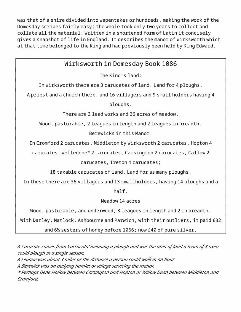
The Domesday Book is the most valuable record of life post conquest, seeking to establish the taxable value of the land and possessions. A basic structure of accounting and recording had already been in place in Anglo-Saxon times. By the 10th century the hierarchy in Derbyshire and Nottingham, run as a single shire, was that of a shire divided into wapentakes or hundreds, making the work of the Domesday scribes fairly easy; the whole took only two years to collect and collate all the material. Written in a shortened form of Latin it concisely gives a snapshot of life in England. It describes the manor of Wirksworth which at that time belonged to the King and had previously been held by King Edward.
Wirksworth in Domesday Book 1086The King’s land:
In Wirksworth there are 3 carucates of land. Land for 4 ploughs.
A priest and a church there, and 16 villagers and 9 small holders having 4 ploughs.
There are 3 lead works and 26 acres of meadow.
Wood, pasturable, 2 leagues in length and 2 leagues in breadth.
Berewicks in this Manor.
In Cromford 2 carucates, Middleton by Wirksworth 2 carucates, Hopton 4 carucates, Welledene* 2
carucates, Carsington 2 carucates, Callow 2 carucates, Ireton 4 carucates;
18 taxable carucates of land. Land for as many ploughs.
In these there are 36 villagers and 13 smallholders, having 14 ploughs and a half.
Meadow 14 acres
Wood, pasturable, and underwood, 3 leagues in length and 2 in breadth.
With Darley, Matlock, Ashbourne and Parwich, with their outliers, it paid £32 and 6½ sesters of honey
before 1066; now £40 of pure silver.
A Carucate comes from ‘carrucata’ meaning a plough and was the area of land a team of 8 oxen could plough in a single season.A League was about 3 miles or the distance a person could walk in an hour.A Berewick was an outlying hamlet or village servicing the manor.* Perhaps Dene Hollow between Carsington and Hopton or Willow Dean between Middleton and Cromford.
This gives a picture of a significant manor with seven outlying villages owing allegiance to it together with plenty of arable land, wood for pasturing stock and a small meadow. The church and priest have already been discussed as has the importance of the lead works.
It is generally agreed that it is difficult to make an accurate population estimate from the Domesday Book. It was not a population survey but a tax and ownership document. The best that can be done is to make an estimate for the number of people by using a multiplier, usually six and then adding 5% for slaves, the six being the villager or smallholder, his wife, say three offspring and one elderly parent. This would give Wirksworth a population of 536. Using this multiplier other Derbyshire manors, later considered to be the
borough towns, would have had these populations in 1086: Ashbourne 208, Bakewell 340, Newbold with Chesterfield (its berewick) 258, and Derby 1,027. The other ancient borough town of Derbyshire, Castleton, was listed only as a castle in Domesday Book, but would have had a population associated with it.
These populations may seem low. Domesday Book says that Derby in the time of King Edward had 243 burgesses but records only 100 burgesses and 40 lesser burgesses in 1086, with 103 dwellings unoccupied. This apparent and unusual collapse in population might be a result of the 1048 earthquake and an unrecorded epidemic perhaps following it, which would possibly have implications for the population of Derbyshire generally, including Wirksworth. Equally the fall might have been due to some conquest period Norman military action against Derby.
Recent researchers have taken the view that the population multipliers typically used in the past for Domesday might be serious underestimates. The total population of England could be considered nearer 5 million not the 1.75-2.25 million which a multiplier of six reaches. A multiplier nearer 15 might be used. This would give the taxable population of Wirksworth in 1086 as perhaps 1,270.
It is known Wirksworth had a Soke, but Domesday records no Sokemen in Wirksworth. In the Derbyshire section of Domesday Book Sokemen only appear intermittently and in some Wapentakes. This suggests a further under representation of the total population. Comparison with Domesday Book figures and figures from two surveys of Burton Abbey at nearly the same time showed that Domesday Book almost entirely ignored rent payers, so much so that the Domesday Book record for the population of Burton on Trent was only a third of that which the Burton Abbey surveys showed. Given that later surveys of Wirksworth list large numbers of rent payers, this might imply that not only is Domesday Book giving us an under-estimate of Wirksworth’s population, it is giving a very severe under-estimate of Wirksworth’s population in 1086 indeed. SOKE: The term soke is a survival of the pre-Conquest term, it was a kind of small county. Sokemen were free peasant farmers with small estates who paid taxes and owed some customary services to their lord. This stemmed from a requirement that any lordless man had to commend himself to a lord. However, their land may have lain outside the bounds of his lord’s manor. Sokeland is thus the area over whose inhabitants a manorial lord exercised certain jurisdictional rights. By the 11th century most sokeland was held by the king, the earls or the church. It became bonded into the territorial holdings of the landowner, as here in Wirksworth.
The Manor
The settlement at Wirksworth would have been there to service this important Royal manor with its 3 lead works. The land was divided into plough land, meadow for haymaking and pasture for grazing. The arable fields were divided into strips and villagers worked land spread throughout the town’s fields usually in acre or ½ acre strips. These ‘open’ fields lay around the town and from later documents we know they were called North Field, between Wash Green and Bolehill, Dale Field, now mostly quarried away, and Bradstone Field between Brassington Lane and Hopton Lane. Oathill, Ryefield, Wheatcrofts and Barley Flats are found in field and local names and suggest a variety of crops being grown. Inhabitants would have been primarily engaged in agriculture with mining and quarrying of importance too. These inhabitants would have lived in small houses clustered around the church and market place.
The 14 acres of meadow listed in the Domesday Book could have been The Hannages. This is the area of land between Water Lane and north end of the Anthony Gell School playing field. The word comes from the

old norse ‘hegning’ and means ‘enclosed land’, that is the land that cattle were excluded from, possibly an ancient hay meadow. The name has been preserved in recent years by the naming of Hannage Way leading from Water Lane to the school playing field.
The woodland pasture and underwood would have been scattered throughout the area with parcels on the Gilkin, at Gorsey Bank and anywhere else where the topography made ploughing difficult. These places later became known as the ‘wastes and commons’ of the manor and were used by all tenants for the grazing of cattle, sheep and pigs.
In the 12th century the Stewards of the Manor were the de Ferrers family. Henry de Ferrers came over from Normandy at or soon after the Conquest and was rewarded for his loyalty with gifts of manors in fourteen English shires. In Derbyshire he had 101 manors, mostly grouped in the area south of Wirksworth. By some means the de Ferrers family became established as lords of the manor and the wapentake of Wirksworth, but, in a period of considerable unrest and political intrigue, the family enjoyed mixed fortunes. Over the next one hundred and fifty years the lordship of Wirksworth changed hands frequently between the de Ferrers and the Crown, as feudal loyalty faltered and at times erupted into open rebellion. A dramatic change occurred in 1269 when the rebellious Robert de Ferrers was disinherited of all his lands and properties. These then came into the hands of Edward, the elder son of King Henry III who became King Edward I, and later passed to his younger brother Edmund, the Earl of Lancaster. This may be a reason for the transfer of the church to the Dean of Lincoln in 1272 and the appointment of a new vicar. Edmund’s lordship of these lands was established by decree in 1279 when there was a royal exchange of his counties and castles of Cardigan and Carmarthen for the king’s manors of Wirksworth and Ashbourne, amongst other lands.
After the death of Edmund, Earl of Lancaster in 1296-7 a brief snapshot of Wirksworth is given in his Inquisition Post Mortem. This was an inquiry into the lands held by deceased people of some status. The records survive in the National Archives at Kew. Among Edmund’s lands Wirksworth was listed as having a capital messuage (main house), 100 acres of arable land, 23 acres of meadow, 24 shillings rent of free tenants by charter, 18s 3½ d rent of tenants without charter, 24 shillings from tenants of assart at will (newly cleared areas), a fulling mill (for cleaning woollen cloth), a water mill, a market, a several pasture (a separately enclosed pasture), 13s 9d tallage (land tax) of tenants and 3 shillings for beaupleader (a court fine). The tenants of the Wapentake gave £12 instead of a riding horse.
The ‘capital messuage’ or manor house for this manor was possibly on Coldwell Street either on the site of the Old Manor House or the site of the now demolished Wirksworth Hall. The fulling mill and water mill for corn grinding must have been on the Ecclesbourne River. It is possible the ‘several pasture’ listed here could have been a hunting park similar to the ones Edmund held in neighbouring Duffield Frith. An entry in the rolls of the 1281 Eyre (court proceedings) clearly states that one was in existence: “two unknown men were found killed in Lord Edmund’s sheepfold in Wirkesworth Parke”. Two fields bear the name Park on the Tithe Map of 1845, one near Hardhurst and the other near Breck Farm on Brassington Lane.
The manor was subsequently held by the Lancasters, first earls, later dukes and then kings. However, upheaval still prevailed. After the execution of Thomas, Edmund’s heir, Wirksworth was again briefly in royal hands. The Lancastrian estates then passed through marriage to John of Gaunt, who became Duke of Lancaster. During this time there was local unrest and disruption, with rebel attacks on the town and disruption to the market. John of Gaunt’s son Henry Bolinbroke was crowned Henry 1V in 1399. Thereafter the Duchy of Lancaster estates were vested in the crown and have been ever since.
The Medieval Church
The early establishment of the church in Wirksworth has been discussed previously and in particular the notable Mercian period sculptural remains built into the walls. By the high medieval period this minster church had dependant chapelries at Bonsall, Carsington, Kirk Ireton and Matlock. All of these had become distinct parishes with their own rectories by 1291. Further chapelries were established within this large ecclesiastical parish, at Alderwasley by 1281 and Cromford by the early 16th century. The church is of cruxiform shape with a tower at the crossing. It is the widest church in Derbyshire and the third longest. Some of the lower fabric dates from 1272 when it is thought a major rebuilding took place in the Early English style. This is best seen in the lancet windows of the chancel and in the bases of the clustered piers of the central tower. A later development took place in the Decorated style, perhaps after 1300, when the tower was raised to its current height. The pointed two light window of the west end of the south aisle survives from this work, but without its original medieval stained glass. Work in the Perpendicular style took place about 1500 and this resulted in the battlemented parapets and crocketed pinnacles which adorn the exterior of the church.
In the late medieval period gifts to the church led to the establishment of a number of chantries, gifts to the church to ensure prayers were said for the soul after death. Some of these chantries had dedicated small side chapels; all were abolished by Henry Vlll following two acts of Parliament in 1545 and 1547. The records of these chantries are somewhat confused but appear in various documents and old books:
1. North Transept. The Blackwell or St Edmund’s Chantry. Richard Blackwell’s will of 1505 stated that he wished to be buried before ‘St Edmunds altar’. The Blakewell brass memorial survives on the wall of the north choir aisle and dates from 1525. It was originally two memorials and should rightly be in the north transept. The chantry is recorded in the (1524) will of Thomas Blackwell. He left money for masses to be said on alternate weeks, at St Edmund’s altar and at St Mary’s altar, as well as money for building (or perhaps rebuilding) of the north transept. The Blackwell arms can be seen in the west window of the transept. The Alton Quire, the chapel for Alton and Idridgehay, appears to be the same place and it was used, certainly in 1710 when Francis Bessano visited and recorded it, as the Vestry.
2. South Transept. The Callow Quire, the chapel for Callow, appears to have been in the south transept, the opposite and partner to the Alton Quire, but had lost all its monuments by 1710.
3. North Choir Aisle. The Gell Chantry is in the north choir aisle and contains the Gell tombs and monuments. Of these the most important is the tomb of Anthony Gell of 1583, founder of Anthony Gell School and the Almshouses on the south side of the churchyard. It is not known to which saint the chantry was dedicated.
4. South Choir Aisle. The Chantry of the Holy Rood or Chapel of the Holy Cross, is in the south choir aisle. This now contains the memorials of the Hurts of Alderwasley, of which the oldest dates from 1782. This was originally the Chantry of the Vernons, it is mentioned in 1515 and was founded by Sir Henry Vernon and contained the raised tomb of Roger Vernon, recorded as having been ‘lately removed’ in 1710 to make space for some more seats.
5. South Nave Aisle. St Catherine’s Chantry. This was founded by the Wigleys of Gate House and was on the west side of the tower in the south nave aisle. In 1540 Richard Wigley died and left instructions to be buried ‘before the St Katherine Queen’. St Catherine was ‘painted’ here, presumably on the wall of this chantry.
The chantry was described as being quite small, and one of two in the nave, sometimes described as called the ‘Great Quire’. In all probability, the Wigley memorial, which is now high on the north wall of the chancel near the altar came from this chantry.
6. North Nave Aisle. The Ible chantry or chapel. Unknown now, but recorded in 1710, as being ‘founded by the Lords of Ible’, for some time the Sacheverells. The chantry belonged by 1710 to Sir John Statham, but like the Callow chapel it had lost all its monuments, felt to be due to defacement in the Civil War.
Unknown locations: note that 3 and 6 above do not have saints ascribed to them, so may be related to one or other of the below. However, chantries were not necessarily an actual place, they were an activity, so might have been taking place in any part of the church which was convenient.
St Helen’s Chantry. Founded in 1505 by Richard Smyth, who had been vicar since 1487, its location is not recorded.
St Mary’s Chantry, apparently founded by the Lowes. A monument to the Lowes is on the north Chancel apse wall, which cannot be its original position.
The medieval church, whose interior largely remained when Francis Bassano saw it in 1710, then suffered a series of restorations and repairs some of which did damage rather than anything else. The first of these was in 1724 was not particularly injurious, but in 1820 the most appalling damage was done in a shambolic ‘restoration’ described as barbarous very soon afterwards. Little better was done again in 1855. It was not until work by Sir Gilbert Scott in 1870 that serious attempts were made to undo the wretchedness of the 1820 work. This resulted in the interior of the church being restored to a little of its medieval glory, although the roof was raised to a higher pitch over the nave at the same time and this gave the exterior a rather lumpen appearance, which can be seen in Victorian pictures and drawings of the church. Finally, this misjudgement itself was addressed in 1926 when the nave roof was lowered and restored to the delicate proportions of the Perpendicular style of the 1500s, which best suit it. It is now after all its trials and tribulations a fine building in a peaceful, cathedral-like churchyard.
The Growth of the town from the Medieval Period
The development of medieval Wirksworth as a prosperous town, based on its lead industry, is often commented upon, but this has never really been quantified. To understand the importance of Wirksworth in the medieval period suitable comparisons with other places need to be developed. This is not an easy task for comparative figures are difficult to find. However, there are Minister’s Accounts for Wirksworth; these are the accounts of the manor, compiled annually by the Bailiff. A vast number of these accounts survive for Wirksworth in the National Archives.
From these accounts and other sources we know that by the 13th century Wirksworth had three manors. The major manor was the royal or Duchy of Lancaster Manor as has been outlined earlier. The Royal Manor seems to have been divided during this time creating a second manor, sometimes known as the Holland, Exeter or Richmond Manor. This was probably a gift of part of the Lancaster holding to a trusted Duchy servant John de Holland who was created Duke of Exeter in 1397 by his half-brother King Richard II. The Holland family had risen to fame and fortune as officials for the Duchy of Lancaster during the early medieval period, but the senior branch of the family had died out by 1408. Henry, the younger son of John de Holland rose to rank of Duke of Exeter but in 1461 he followed the Lancastrian cause and his lands were forfeited. The Holland Manor reverted to the Crown and was passed to Anne, Duchess of Exeter, sister of
the Yorkist King Edward IV. In later years this manor was sometimes known as the Richmond Manor. The Lancastrian John of Gaunt had been made Earl of Richmond in 1342 and this may be the source of the name.
Holland Manor House, China House Yard: A house that bears this name is in St. Mary’s Gate adjacent to China House Yard, the site of the later Wirksworth China factory. It has a bay window facing west over St Mary’s Gate and appears from the outside to have no great antiquity. A study of the 1709 map of the town centre by Samuel Hutchinson made for the estate of Sir Philip Gell does not show a significant house on this site. However the Holland Manor was granted to the Gells of Hopton in the 1560s and on the map this area is included.
Thirdly Wirksworth had a rectorial manor, which comprised church lands whose purpose was the upkeep of the chancel of the church. The date of this, 1272, suggests it was another royal gift after Wirksworth was acquired by the king from Robert de Ferrers. This was in the hands of the Dean of Lincoln. By the early nineteenth century these rectorial land holdings included the land and buildings where the Town Hall and the Vicarage now stand, the west side of Church Street, part of the west side of St Mary’s Gate and the whole of the block on the north side of the Market Place with, oddly, the Duchy Steward’s House and the Red Lion, also the south-east end of St John’s Street from number 41 south to the Wheatsheaf (inclusive) and one house in the Cock Pit, as well as some farmland. No manorial accounts have been searched for this rectorial manor. So the rectory belonged to the Dean of Lincoln and tithes were payable to him. In 1310 his manor consisted of 60 aces of land and some tenants who paid suit to his court. It was a profitable living with various dues being paid. By Henry VIII’s time a vicarage house and garden, Easter dues and tithes of lead, geese, pigs, eggs, hemp & flax totalled an income of £42 7s 9d each year. The Dean of Lincoln continued to hold manorial land and buildings in the town until well into the 20th century.
Accounts for the Royal Manor and its lands in 1314 comprised income from the following sources:rents from tenants of land, tofts and buildingsincome from court finesrent and profits from the millrent of the fishery of the Ecclesbourneincome from the market and fair, tolls and tallageincome from small sales of food grown and renting out of pasturewith a total income for the year 1314-1315 a little over £90 at the time.
An account for the Holland Manor in 1280-1 shows it was both smaller and evidently less urban in its income, which included:
rents from tenantsincome from court finesincome from the sale of grain (probably oats as this was the main local crop)income from the sale of stock animals, chickens, cows etcwith a total income for the year 1280-1281 a little over £44 at the time.
Given the difference in dates of these two accounts, these figures nevertheless suggest the Holland Manor was worth about half as much as the Duchy of Lancaster Manor. This being the case, the total income for the town’s manors at the end of the 13th century might be argued to be of the order of £120. These accounts do not include any income from the sale of lead or the rectorial income. The value of each thirteenth dish of ore sold was given to the King and this was accounted for through Exchequer accounts separate from the manor.
This £120 manorial income can be compared with the income for other towns. For example there is a very extensive survey, called the Kilwardby Survey, of the manors of the Archbishop of Canterbury for 1279. In this, the income for Croydon in that year was £80, the income for Wimbledon was £66, the income for Aldington was £192 (the largest) and the income for Maidstone was £86. These comparisons cannot be regarded as anything but straws in the wind, for land use and circumstances differ, but, overall, Wirksworth rests in the top quarter of income when compared to the 24 locations listed in the Kilwardby survey, and this sets aside Wirksworth’s income from the lead industry and whatever the rectorial manor generated for the church.
The Market Place and its surroundings
Around the churchyard market stalls and booths would have been set up from very early times and fairs were held there on feast days. Although the market charter was only issued in 1306 it is certain that a market operated in Wirksworth before the end of the 13th century, as can be seen from Edmund’s Inquisition Post Mortem quoted above. As a royal manor it was possibly not deemed necessary to have a charter for the holding of a market, but with the changing of manorial ownership in the thirteenth century a regularisation of the situation took place and a charter issued in 1306, allowing the right to hold a market on Tuesdays and a fair annually for three days in September at the Nativity of the Virgin, September 7-9th. Another fair is listed in a document from 1649 at the Feast of Philip and Jacob [sic James], May 3rd.
The market place covered a much larger area than the present day site. It included the triangular area entered by Dale End and Coldwell Street at its NW and NE corners respectively and narrowing down to the south towards the present Zebra Crossing. The Swine Market was up West End with houses encroached onto it now making the road narrow. The block including the Hope and Anchor pub seems to be a further encroachment and another block of buildings above this are shown on an 18th century map and early 20th photographs. Sometime after 1925 these were demolished making the Market Place as it is today. Further forward encroachments onto the Market Place may have taken place on the west, north and east sides, making its area much smaller. A market cross stood in the market area in front of what is now Paynes the chemists and is marked on a map from 1709, it is possible that the piece of surviving knot-work built into the exterior north choir aisle wall of the church may be from this cross.
A Moot (or Market) Hall was a meeting place where local issues were dealt with and trading standards were overseen. An early reference to the one in Wirksworth is in 1474 when it was ordered that 80 oak trees be delivered from Shining Cliff woods for the building of a Moot Hall. On the earliest maps it is sited in the middle of the old market place where Harrison Drive has been cut through. Although described as being in great decay and in need of repairs in 1608, in 1649 it was described in a survey as “A certaine place built of tymber and commonly called the Kings Moothall conteyning three bayes of building under which court room are built six butchers shops on the west side”. It was rebuilt in the Market Place in 1773 by order of the Duchy of Lancaster. However they ordered its demolition in 1814 ‘due to the rowdy behavior and congestion by miners’, but also possibly the building had been undermined. It was rebuilt on Chapel Lane and is where the Barmote Court meets each April. For almost 500 years a dish for measuring lead was kept here but in 2011 it was removed to Chatsworth by the Barmaster.
Around the churchyard and Market Place the houses of those living in the town would have clustered. Many of these parts of the historic centre of Wirksworth were composed of blocks of buildings. There was also clearly some encroachment development on the east side of the Market Place on what must originally have been the boundary of the churchyard and it is known that the churchyard was once larger than it now
is. The market at Wirksworth was a major feature both of antiquity and of the middle ages, even in Defoe’s time it attracted inhabitants from miles away. It was a key reason for the success of the town and a contributor to its prosperity. Here, in our minds eye, we can see the stalls being set up in the early morning and the crowds gathering for the opening of the market. Listen in your mind and you can hear the market bell opening the day and see the shutters come down. Hundreds came to Wirksworth’s market, and by a small miracle in the modern world its still hangs on: long may it be before the market bell rings for the last time in our town.
Medieval Streets and Burgage plots
St John’s Street is unusual amongst the Wirksworth streets, in that it is relatively straight and wide and it has a certain dignity to it. In measuring the features of the street archaeologists found it to be exactly three perches wide and many of the house frontages a perch wide. A perch is a medieval unit of measurement, about five metres. Burgages were a medieval town planning activity, because creating them was a mechanism to improve the commercial attractiveness of a town. Space at the front was at a premium, plots are often long and narrow, with a row of outbuildings stretching to the rear of the house or shop. They were rented in medieval times to merchants, tradesmen or shopkeepers and are known as burgage plots. Narrow plots of this type can be seen fronting St. John’s Street. In addition, archaeologists working here in June 2015 began to discover large amounts of medieval pottery, dating from the eleventh century onwards. This discovery led to a re-assessment of the under-examined issue of burgage in Wirksworth.
In terms of Wirksworth, there is a reference to a grant from Thomas le Daneys of various burgages and lands to Tutbury Priory, including a burgage in Tutbury itself, as well as the one in Wirksworth. The grant makes reference to both William, Earl of Ferrers and his brother Robert, the 6th Earl of Derby. The grant has no date but the names give a time frame for the grant of between 1261 when William came of age and 1269 when Robert lost his lands to royal control. The grant also states that these properties were formerly held by Brun de Colonia of Echam, possibly Oakham, and this would suggest that the burgage existed before the time frame of the grant. In Leeds the area of Burmantofts was an additional allocation of agricultural land given with burgages. This might be similarly true in Wirksworth; some local field names might have to be considered in the same light, particularly Burley Flatt, which again contains the <bur> or <burgh> element.
Originally, the burgage plots may have been two or more plots wide and have been sub-divided over time or even coupled together again. Many of the houses in Wirksworth are older than their frontages suggest, for example numbers 15 and 17 St John’s Street were the subject of dendrochronology dating (tree ring analysis) by Nottingham University which found them to have beams from trees felled in 1676, and given what is now known about the burgages, these houses are likely to be on plots or on previous house sites which are much older. It is also possible that parts of North End and West End show the characteristics of this kind of burgage development.
Archaeology lends a hand in the town itself, because the pottery found in St John’s Street dates from the eleventh century onward, and this might imply quite an early burgage development. The earliest pottery, Doncaster Frenchgate Ware, is from a time frame not before 1050 and unlikely to be after 1200, though pottery persists after the date of its making. Given that it is known that the Ferrers were granted a market in Tutbury in 1086 and burgage is mentioned in Tutbury from 1141, we are probably seeing the same kind of commercial development activity by the Ferrers in both Tutbury and Wirksworth at the same time, a way of improving their towns and consequently their assets and their income. In short, the Wirksworth burgage development may date from almost immediately after the Norman Conquest. What has not yet been solved
is that although this development has all the characteristics of burgage plots, there is no evidence of the burgesses, it is not clear why this is, although the term “Free Tenants” of the 1314 accounts imply inhabitants of this status.
Mills
Every manor had a corn mill where the tenants had to have their corn ground and early mill sites were water powered. On the earliest surviving map of Wirksworth, drawn in 1709, three mills and their dams are shown – one at Millers Green, known as Milnhouses in 1307 on a tributary to the Ecclesbourne coming down from Callow; one on the Ecclesbourne on Water Lane; and a third at the site that is now Haarlem Mill. This is named as ‘Walk Mill’, a fulling mill, as it is described in the 1296 Inquisition post mortem. Throughout the 15th and 16th centuries this is documented as Walkmylne. The name comes from the earlier process of ‘walking’ woollen cloth in a trough to clean and soften it, hence the surname Walker. Afterwards it was laid on ‘tenters’ or frames to stretch and dry it again, giving the field name Tenter Yard. Later history of this mill site suggests it was used for corn milling in the 1770s.
In 1777 Sir Richard Arkwright bought the site at Haarlem Mill from Philip Gell of Hopton and built a cotton spinning mill here. It was converted to tape weaving between 1813 and 1815 by Maddley, Hackett and Riley of Derby and they gave it the name Haarlem Mill. At some time silk was spun in part of the premises. About 1841 James and William Tatlow took over the mill. In 1792 it had a steam engine to fill the mill pond to maintain the water level to power the mill. This was housed in the engine shed abutting the south front. The long brick range on the west was built and reconstructed at different stages between about 1832 and 1885.
The Water Lane Mill was called Middle Miln on the 1709 map, suggesting another mill was sited somewhere else upstream from this site. The most likely site for the upper mill was in the vicinity of New Bridge (Wash Green Bridge). Which of these sites is the manorial corn mill is difficult to judge and it is possible there were two corn mills in the town to serve the sizeable population and the two manors. The early reference to Mill houses suggests this site was that of the manorial corn mill from the medieval period. Speedwell Mill now stands here and was converted to a cotton mill by John Dalley by 1790 or 1791. By 1808 it had fallen into disuse and was converted to houses, later to become a hat factory and by the 1843 a corn depot for the Wheatcroft family. Joseph Wheatcroft established a tape manufactory here in 1844.
A ‘new mill’ is documented in a rental from 1473 next to Bowsfield. On the tithe map this field is shown on Hopton Lane above Yoke Cliff so it is possible the new mill was a windmill, a technology brought to England in the 12th century. It continued to grind corn until about 1830, and is the origin of the name of Windmill Farm on Hopton Lane.
Steeple Grange Land in this area to the north of the town was granted to Bicester Abbey in 1405 by two Wirksworth men, John Marchaunt and Marragdus Shorthose. It remained with the Abbey as an outlying grange or farm until the dissolution of the monasteries in 1538 when it was acquired by the Duke of Suffolk. It was then bought by the Blackwell family and later the Greensmiths. Steeple Hall, the former grange, was finally bought by Richard Arkwright from the Greensmiths in 1771. He demolished it and used the stone to build the first Cromford Mill. The road from Wirksworth to Cromford had followed the route of Old Lane but was altered

in 1756 when the route was turnpiked. In 1836 the hamlet consisted only of 8 houses and still remained quite separate from the rest of the town until the growth of both brought the parts together.
Wash Green
First documented on a Duchy of Lancaster rental in 1415, this area may derive its name from the fact that lead ore was washed and cleaned here. Good water sources exist higher up the hill to the east which would have facilitated these processes. In 1827 there was a small tape mill, a brick works, a saw mill and a bleach and dye yard, quite a concentration of labour intensive industry. Up the hill the House of Correction (town prison) was built in 1791 and later described in detail. “At the back of the keepers house are two court yards, one for men the other for women about 28 feet by 19 feet 6 inches with a sewer in each. Nine steps down in the women’s court is a damp dungeon, 7’6” by 6’4” high to the crown of the arch. All the light or ventilation here received through a grating in the door, 6” square. On each side of the keeper’s apartment a door opens into a little day-room, 11’9” by 7’ with a fireplace in both. These are for men and women and each has attached to it two small sleeping cells, 7’5” by 5’6” and 8’ high, ventilated and lighted by a grating over each door… Wooden bedsteads only are provided by the county, straw in sacking and chaff beds are furnished by the keeper…there is no water but what is fetched from a distance”. In 1805 J. Neild reported that there was only one prisoner, a shoemaker, who had been locked up for “bastardy”. It was closed in 1827 when the new county gaol was opened in Derby.
The Dale and Greenhill and later encroachments on the ‘wastes and commons’
In the medieval period the town would have been surrounded by farmland, much of which was unsuitable for growing crops. This rough grazing was often known as ‘waste and commons’ and was used by all for grazing animals. The hilly nature of the landscape close to the centre of town meant this waste ground could be ‘encroached’ for building as the town expanded in the late sixteenth and seventeenth centuries. It led to a piecemeal growth of small plots very evident up the Dale, on Greenhill, at Gorsey Bank and around Wash Green. These areas are often known as ‘squatter settlements’ as the people living there were outside the manorial system. A valuation in 1649 to regularise the situation of these cottagers shows their rents ranged from 4 pence to as much as 7 shillings, indicating a wide variety in quality and size. This 17th century development took place in a haphazard way, with cottages in small irregular plots traversed by short lanes creating a distinctive pattern. Between the Dale and Greenhill this area is known today as ‘the Puzzle Gardens’. Other areas of encroachments are at Warmbrook and the Cock Pit just beyond the limits of the medieval town at the junction of three roads. In 1649 there were 4 cottages paying rent and 2 encroachments at Warmbrook. Similar development took place on Gorsey Bank and possibly up West End on the sides of the road making it the narrow way into town it is today.
Bole Hill
This settlement on the hillside above Wirksworth is first recorded in 1599 but it is likely it was here some time before that. The names derives from a ‘bole’ or lead smelting hearth, probably situated on the hill above the houses where the prevailing westerly winds would provide a good draft for smelting. An area of small cottages and four pubs in the 19th century (The Miner’s Standard, New Inn, Hollybush and Railway Inn) it has its own distinct character. The cottages cluster around the Green and the Lanes and lead mine sites are still evident in the area. Other later industry in this area included gingham weaving workshops at Oaker House, cotton frame knitting in Hallams yard and a brickworks close to Black Rocks. The road going
through Little Bolehill to the Malt Shovel pub was subject to a major land slip in 197X and has been closed to traffic ever since.
Gorsey Bank
Another area of small cottages, possibly encroached on the ‘wastes and commons’ on the outskirts of the town. It remained quite separate from the rest of the town until the building of the local authority housing in the mid 20th century. Some of the cottages may have been to house workers at Providence Mill after it was built by George Gamble in 1881. This was a tape mill, Wirksworth being famous for its red tape, but replaced an earlier saw mill.
Who lived in Wirksworth ?
Documents survive that give the names of tenants and landholders who lived in Wirksworth at the time the rental or survey was drawn up. They give snapshots of the people living in the town at the time, but not a full picture. The Lay Subsidy Roll of 1327-8 is the earliest surviving example of such a document. King Edward III raised a tax to help fight a war with Scotland and all those with moveable items worth over 5 shillings were to give a twentieth of the value to the King. The section of the roll for the Wirksworth has not completely survived but 16 names appear together with the value of their goods and the amount of tax payable, [spelling and sums modernised]:
Wyrksworth [value] [tax] Roger del Hay 45s 2s 3dNicholas Bate 35s 21d Simon Hutte 15s 9dWilliam de Bradburn 55s 2s 9d Nicholas de Midleton 60s 3sRobert Bythebroc 50s 3s Henry de Milnehouse 20s 12dWilliam Bythebrok 20s 12d Peter de Stepul 41s 8d 2s 1dAlex Carpenter 15s 9d John Trusselove 20s 12dCecilia widow of William de Carsington
50s 2s 6d Nicholas Truselove 40s 2s
Thomas de Cromford £7 7s Randulf Tubret 25s 15dRichard del Hay 31s 8d 19d
Summa bonorum £33 13s 4d 33s 8d
The major lord of the manor/landowner in the town in the fifteenth century was the Duchy of Lancaster and a copy of a detailed rental survives in the National Archives from 1415. From this 57 names of people renting houses, cottages and land are documented, some with only a small amount of rent to pay each year, others much more. Many of these people held different parcels of land on different tenures. Some were free tenants, some tenants at will or by warranty, others in bondage usually called villeins. From this rental many of the names still in use today are recognizable. A shortened, tabulated version of this rental appears in Appendix 1.
Two further fifteenth century rentals of premises and land also furnish us with names of the tenants of the Holland manor within the parish, one for John de Holand in 1420-1 and another for 1473 for Anne Duchess of Exeter, of the same manor, see Appendix 2. Richard Blackwell rented this manor together with the major part of the land including crofts in the Hennege, 8-9 acres of meadow in Whassemeydow and on Yokeclif Hege and arable land under Gilkehill and at Otell. William Taylor held some land, 2 gardens and part of the

Hannage. Other tenants include John Webster with land at Oathill, Robert Odyngham, Thomas the Glover who held a close called Gylkhill, John Walker, William Wright who held 3 cottages and other land, William Broklehurst, William Winfield and numerous others with small parcels of land spread throughout the area. Other tenants and under-tenants are detailed with the land, cottages, barns and gardens they rented.
Anthony Gell Grammar School
The first reference to a school in Wirksworth comes in the will of Agnes Fearne, the daughter of Ralph Gell. The Gell family were establishing themselves as local landowners and minor gentry from the early 16th century, having made money from their interest in the lead industry. From 1553 Ralph Gell leased the Holland manor in Wirksworth and after his death in 1564 his numerous children, notably Anthony, Thomas and John continued to influence town life. In 1574 Agnes Fearne left 5 marks a year ‘to the use of and maintaining of the free school in Wirksworth’ if ‘after my decease there shall happen to be any free school within the town’. When Anthony died in 1583 his will, which had been made in 1578, stipulated that his brother Thomas should ‘obtain a licence for erecting a free school’ and he listed parcels of land the rent from which was to maintain the school. These included a ‘schoolhouse which I lately builded’. The Charter, by Letters Patent, for Anthony Gell’s Grammar School was granted by Queen Elizabeth I on 27th of October 1583. The provision of a school in the town appeared to stimulate others to follow and in 1585 a school was founded in Ashbourne later to become Queen Elizabeth’s Grammar School, Chesterfield founded a Grammar School in 1598 and Bakewell, rather tardily, finally founded theirs in 1637.
The original Grammar School was probably built on the site to the east of the churchyard where the building called Old Grammar School building now stands. This building was designed and built by William Maskrey, the Wirksworth stonemason in 1828, replacing the earlier one described as being ‘in a ruinous state’. It continued in use together with new buildings built on the Hannages in 1907. These were designed by the county architect George Widdows, where Anthony Gell School remains to this day.
The Almshouses
Anthony Gell also willed that his executor Thomas ‘within a year and a half of my death shall bestow of the making and building of one almshouse in the side of the Hannage near the new bridge the sum of £60.’ During the next ten years after his death ‘six aged, poor and impotent men’ were to be placed in the almshouses and given £20 between them during these ten years. Both Anthony and Francis Bunting gave £5 per annum towards the expenses of the men and sixpence a week in bread. Built at the end of the 16th century by the side of the churchyard, rather than a site closer to the New Bridge, the almshouses are still occupied today and run by the Anthony Gell and Anthony Bunting Almshouses Charitable Trust. Others too contributed both to the school and the almshouses.
Stuart Expansion
By the seventeenth century the survival of documents increases. In 1627 King Charles I levied a tax, on his subjects, known as ‘An Ayd to His Majesty King Charles’, under the guise of ‘a loan’. From this we know the names of those living in Wirksworth at that time who were considered rich enough to pay – nine names appear: Richard Wigley, John Topleis, Robert Feilding, Richard Lee, Thomas Taylor, George Somers, Dionise Wetton, John Ormefield and Henry Buxton.
A more detailed document survives from 1649 at the time of the Commonwealth when Parliament ordered a valuation before a possible sale and wanted to know what rents and dues were owed to them. A number of these Parliamentary Commissions were instigated and one such for Wirksworth gives us a lot a detail about who was living in the town at this time: The various categories of tenants are listed starting with those living on ‘the wastes’ of the manor. These are in effect squatters who have taken advantage of a common belief that if a house was erected on the common land in a manor overnight they then had the right of undisturbed possession. To make things more difficult for squatters the Erection of Cottages Act was passed in 1588 whereby a cottage could only be built if it had a minimum of 4 acres associated with it. This rental puts value on these ‘encroached’ cottages no doubt with a view to them becoming rentable at a later date. These cottages are found at Newbridge, upon Greenhill, in the Dale, at Warmbrook and at Longoe bank, thirty in total. A smithy at Bayley Croft and a cowhouse at North Town End were also listed. The next category are those living in properties owned by the manor and leased ‘for a term of years’, leasholders. This includes further cottages but also the lease of the Fairs and Market, a smithy, 2 coal pits on Longway Bank, the Moothall, shops, a barn and 8 acres of coppice and shrub at Waterdale Shrugges, land overlooking Water Lane. Following this are a lists of freeholders, 36 names in total with rents from 2d to 11s 8d, copyholders with agreed rents, 54 names with similar rental amounts, and 22 copyholders who had not yet made such agreements, one of whom was John Gell who rented the Grammar School. Full details of this survey can be found Appendix 3. Some spelling has been modernised and the information tabulated.
The Hearth Tax Return of 1670 gives details of houses with a number of hearths that could be taxed. For Wirksworth 135 houses had one hearth, 56 houses had two, 19 had three, 12 had four, 5 had five, 5 had six and three houses belonging to Edward Milward, Mr. Ballcoose and Mr. Browne respectively had eight each. Two houses are identified by name: Steeple House which had just one hearth and The Gate House that had six hearths.
From this period of Wirksworth’s history many houses and features still survive. Discussion on these is found below. The closeness of the dating of these important 17th century houses would suggest that at this time Wirksworth was enjoying a period of sufficient prosperity that a major rebuilding was being undertaken in and around the town, probably stimulated by the activities of lead merchants and possibly resulting from the profitability of lead during the 30 years war. The rebuilding of Wirksworth in stone, from its probable medieval style of timber-framed and thatched houses, continued throughout the seventeenth century, with a gap during the English Civil war. Even lesser houses were rebuilt as we have seen in St John’s Street.
The Old Manor House and the demolished Wirksworth Hall
This house is on Coldwell Street. It stands on a large plot of land with a walled garden and is now known as the Old Manor House, but it was once called ‘The Gables’. This is basically an early 17th century house with three gabled bays and mullioned windows and 18th century additions. We know from the 1296 Inquisition post mortem of Edmund Earl of Lancaster that there was a ‘capital messuage’ in Wirksworth, often known as a Hall or Manor House but whether it was on this site is not known. In the early medieval age the Lords of the Manor were non-resident in the town and a steward possibly lived here. The Old Manor House, Hopkinson’s House and Babington House form a group, three of a kind; they all have a familiarity of architecture of the 1630s.
There was a Halle Orchard recorded in 1415 suggesting that an earlier house of some size was in existence at that time, but the reference gives no location for the Orchard so we cannot know, whether the Old Manor House represents the Hall or whether Wirksworth Hall represents it. The much later Wirksworth Hall stood on the other side of Coldwell Street where Hall Gardens now are. This was built by the Hurt family of

Alderwasley in 1779, although some sources indicate this was a rebuilding of a previous house. The Hurts were landowners and lead merchants and the Hall was demolished in 1922 due to subsidence. The stable block for this is in Blind Lane, and the stable block and the building now known as The Old Manse are the only standing reminders of the former Hall. The fine wrought iron screen gates which once adorned the entrance to Wirksworth Hall were removed after the Hall was demolished and now stand at Henley Hall near Ludlow.
Hopkinson’s House, 1-3 Greenhill
This is a large early seventeenth century house built in limestone with gritstone quoins, lintels and mullions. A piece of moulded plasterwork from a chimney-breast was rescued after the roof collapsed in 1954 and bears the date 1631. The four bays along the frontage give it a distinctive roofline. It was built by William Hopkinson out of the profits of the lead industry and the probate inventory for Anne Hopkinson, his mother, in 1648 gives the contents of named rooms and outbuildings: the great chamber, the chamber over the parlour, the chamber over the buttery, the white chamber, the study chamber, the entry chamber, the brewhouse chamber, the corn chamber, the buttery, the dining parlour, the hall, the nether parlour, the kitchen, the larder, the milkhouse, the brewhouse, the hen house and the stable chamber. Anne left the house to her offspring and over the years it was divided amongst them eventually becoming one dwelling again in the early 18th century when a John Toplis of Brookwalls was in possession of it. Until the beginning of the 20th century the upper floor had been used as a bakery. It had got into a parlous state of repair before the Civic Trust’s Wirksworth Project in the 1970s when it was restored.
Babington House, Greenhill
The only house of any size on Greenhill was probably built around 1630 in coursed limestone rubble with gritstone quoins, lintels and mullions. It has two storeys and attics, a stone slate roof and gritstone ridge tiles. In the garden behind the house is an appreciable rock face. Geological research, using micro-fossils, has indicated that the highest beds in the quarry can be correlated with the lowest courses of limestone in the house. As one moves down the quarry so the building rose. In short, the house was built from its own quarry. Supposedly it has associations with Anthony Babington of Dethick who plotted to rescue the imprisoned Mary Queen of Scots. No evidence has been found to substantiate this link and, as he died in 1586, it is unlikely the house was built by him. No Babingtons are listed in 1670 Hearth Tax return. It is called Greenhill House on the 1st edition of the OS map. Between 1724 and 1829 it was used as a Poor House (workhouse) and then from 1867 to 1928 as a Cottage Hospital. Its role as a Poor House was recorded in 1797:
“The Workhouse is an old building, not originally intended for the purpose; it is not in a good situation, but as far as its construction will permit, kept clean and airy. The following is the weekly diet: Breakfast—Sunday, Wednesday, Friday—Bread and broth; rest of the week—Milk pottage. Dinner—Sunday, Wednesday, Friday—Bread, broth, butcher's meat, potatoes, etc. ; Monday—Baked puddings and treacle sauce; Tuesday, Thursday, Saturday—Bread and milk. Supper—Milk pottage and bread every day. On meat days the proportion is at 20 lbs. meat for 30 persons. The children are kept very clean, and are instructed in their catechism, reading, etc. Few of the inmates are able to work, those who are spin lint, tow, etc., for the use of the house. They are allowed one penny for every 7d. of spinning. The rooms are of various sizes, and contains 2 to 7 beds each. The beds and pillows are filled with chaff, and have 2 sheets, 1 blanket, and 1 coverlet. There are at present 28 persons in the house, 12 under 7 years of age. Subscriptions for the Poor last winter (1794-5) amounted to £60, which were laid out in purchasing coal, beef, and potatoes. The Poor in the Workhouse have oat bread, but no beer or cheese, except at Christmas. A sort of gruel called water
pottage, consisting of a small proportion of oatmeal, and a small onion boiled with water, was eaten with bread twice and sometimes thrice a day by many people in this neighbourhood. It was much used during the late hard season. The cost of such a meal was about 1¼d. for each adult. Several small donations, amounting to £45 10s, are distributed yearly among the Poor who do not receive any parish relief.”
Georgian Prosperity
In 1725 Daniel Defoe visited Wirksworth. He found it ‘a large, well frequented market town ...... the people generally coming twelve or fifteen miles to the market and sometimes much more; though there is no great trade to this town but what relates to the lead works, and to the subterranean wretches, who they call Peakrills, who work in the mines, and who live all round this town every way. The inhabitants are a rude, boorish kind of people, but they are bold, daring and even desperate kind of fellows in their search into the bowels of the earth, for no people in the world out-do them’.
Lead had been mined in the area at least since Roman tomes and Wirksworth's prosperity depended on it. The landscape to the north of the town is marked by disused lead workings and Bole Hill is a reminder of the earliest form of lead smelting. The lead mining area around Wirksworth is known as the King's Field because the Sovereign, as Duke of Lancaster, is entitled to a proportion of all lead that is mined. Since the 15th century the Crown sub-leased these royalties starting with a 40 year lease to the Earl of Warwick in 1468. Figures on lead output suggest there were peaks in production in the late 16th, late 17th and middle 18th centuries. After 1760 it fell but the occasional short-lived boom, the last being in the 1860's.
The prosperity of Wirksworth in the Georgian age should not be under-estimated; within Derbyshire only Derby and perhaps Chesterfield were more affluent. Wirksworth’s development continued to be stimulated by the profits from lead mining and further rebuilding of the town took place in this period. Until the 1750s much of this development might be described as being vernacular, that is built in the local style by local craftsmen. The older surviving cottages and buildings around the town are built in stone but these probably replace earlier ‘cruck’ framed buildings. One ‘cruck’ was revealed in a cottage on the corner of St. Mary’s Gate and has been left exposed to view. Other timber frames are still hidden within existing buildings. Older style 17th century small mullion windows can be found in a number of cottages with later ‘Georgian’ windows and doors added. Some houses at the south end of St John’s Street show the later 18th century rebuilding: numbers 40 and 42, originally one house and in particular number 32 with a fine frontage and window pattern characteristic of its building date of 1750. Similar rebuilding took place in other parts of the town, some of which was in response to the opening of the 1756 turnpike road between Derby and Wirksworth, number 22 Wash Green being such an example. It was rebuilt in 1758 as the Ship Inn. The turnpike was known as ‘top road’ and led from the Moot Hall in the Market Place, along Coldwell Street, up Wash Green and to Derby via the Bear at Alderwasley to Belper Lane End and Duffield.
Dr. Symond’s House, 15 Market Place
This fine three-storied building on the Market Place was built for the Steward of the Duchy of Lancaster in 1753, panelling from that date survives inside as does a fine staircase window at the back. It has an enclosed garden behind with a Mulberry tree and a later ‘palladian style’ building added to the left hand side in 1760. Mr. Manlove, possibly Edward Manlove who was Steward of the Barmote Court in the mid 17th
century, was charged for 6 hearths in the Hearth Tax of 1670 perhaps for an earlier house that stood on this site.
This period of prosperity saw Wirksworth reach the high point of its development with the lead industry sufficiently strong to remain important. Cotton spinning was developed in 1771 by Arkwight in his first mill at Cromford, increased the population in a village dependent on services in Wirksworth. Six years later Arkwright leased the Haarlem Mill site for the same purpose, rebuilt the mill by 1780 and installed a reciprocating steam engine, constructed by Francis Thomason of Ashover, to refill the mill dam with water which powered the mill via the mill wheel from the Pittywood Stream. By 1789 the mill was employing 200 people.
The town centre around Market Place was effectively redeveloped in a classical style. The number of permanent shops increased as their rather more affluent goods were more suited to the wider range of employed people than the lead miners, who tended to rely only on the market for essential foods and supplies. The impact of this was that the ‘shopping centre’ of Wirksworth was one of the top three in Derbyshire in the years between 1787 and 1828 even though, by 1828, Wirksworth’s position was beginning to be eroded by rapid increases in the populations of industrial towns such as Belper. Indeed Belper’s position is interesting in so far as its population can be compared about this time. The four largest towns in Derbyshire by population size in 1801 were:
Derby 10,832Belper 4,500 (approximate figure)Chesterfield 4,267Wirksworth 3,474
However, Belper largely relied on Wirksworth for its services, for, despite its rapid increase in population, Belper in 1801 had little of the infrastructure of a town, no school, no House of Correction, no Poor House or bank and most of its supplies originated in either Wirksworth or Derby.
The classical outlook of the Georgian Market Place had arrived with the construction of a new Moot Hall in 1773 in a fine, metropolitan Palladian style, designed by Joseph Pickford. There followed a major rebuild of the frontage of the Red Lion in 1768 in a Palladian style and the construction of the Duchy Steward’s House, number 15 Market Place, also known as Dr Symond’s House. Thought to date from 1753 it had an addition on the corner of Market Place and Greenhill from 1760 also in a Palladian style. On the opposite side of this lane, currently fronted by a bookshop, is the final piece of the classical jigsaw, the Arkwright townhouse, currently rather neglected and forgotten.
The culmination of this town centre development in the late eighteenth century gave Wirksworth a grandeur now lost. The 1773 Moot Hall was demolished a little after 1815 and replaced by the plain Moot Hall on Chapel Lane, a monument to the parsimony of the Duchy after the Napoleonic War. Various reasons are given for the premature demolition of the 1773 building, such as ‘noisy miners’ or ‘an obstruction to traffic’. The Gell Archive at the Derbyshire Record Office makes it clear. It contains a rather bad-tempered letter from the Duchy at Somerset House in London of 1813 demanding that the town ‘increase its subscription’ to replace the ‘dilapidated and dangerous’ 1773 Moot Hall.
From 1750, therefore, Wirksworth’s peak of prosperity lasted over half a century. Its finest year in the opinion of Dr. Dack was 1780, a year she describes as Wirksworth’s ‘Annus Mirabilis’: its miracle year. Not only had all these developments taken place but its services continued to expand and in that year John Toplis opened the first bank in Wirksworth, on St John’s Street in the present Solicitors premises. This also resulted in the construction of Nether House on the east side of St John’s Street, with gardens behind, in 1782 as the Toplis residence. This gave grandeur and style to that street and the house was in later years described as the most dignified house in Wirksworth. On the opposite side of the road Waltham House was

built in 1777 in much the same style. It was owned through the 19th century by the Wheatcroft family, owners of various of the tape mills.
The Gate House, the Causeway
A much earlier house must have stood on this site than the one that is there today. It is first documented in 1553 when John Wigley of the Gatehouse, Wirksworth married Helena Gell. Their son Francis who married Elizabeth Blackwall of Blackwall also lived there as did their son Thomas Wigley. In 1670 it had 6 hearths that were taxable. The present 3-storey red brick house of 3 bays was built by Philip Gell about 1770. At the rear of the present building a few 17th century mullioned lights can be seen with some other earlier stonework. At one time some members of the Arkwright family occupied it.
Hope and Anchor Public House
This large public house appears to be an encroachment onto the medieval market place. There are traces of 17th century stonework at the rear and to the side. The front is early 19th century with three storeys, sash windows and a cast-iron inn-sign. In the lounge bar there is a remarkable oak overmantel of crude execution and a date circa 1610. It has fluted Ionic shafts flanking a moulding around the fireplace and supporting a cornice with panels with fleurs-de-lys, unicorns, Tudor Rose, etc. A first floor room has an enriched plaster ceiling as does the entrance lobby, from around 1630. A similar ceiling remains in the Old Manor House and all are similar to that in the Gatehouse Tower at Haddon Hall. It is possible a company of plasterers employed by the manners family at Haddon also worked here in Wirksworth. The history of the house/public house is problematical and any 19th century writers’ suggestions are best ignored.
Red Lion Hotel
This imposing building at the head of the old market place has all the look of an eighteenth century coaching inn. It was rebuilt in 1768. It has an arched entrance to the rear yard and an Assembly Room upstairs. A large chimney obvious from Harrison’s Drive suggests a substantial fireplace from a much earlier building is hidden inside. Records of the Red Lion occur earlier than the rebuilding, such as a court case from 1756 held in the Derbyshire Record Office. It retains its Assembly Room, still used for functions and a cantilevered stone staircase to the upper floors with its original iron railings, quite rare today.
The history of the Red Lion is rather curious, there is no documented mention of the name before 1715 but it is known that the Red Lion you see today has a medieval building at its core, characterised by the huge chimney piece which can be seen on the outside west side of the Lion, but hidden internally behind the main bar. This chimney represents an inglenook fireplace, which would date the building to before 1680. It is also known that Wirksworth had 80 guest beds and space for 266 horses in its inns, though none of them were named in a survey in 1686 which was about billeting soldiers. We see the Lion again in a 1709 map of Wirksworth, showing properties which Philip Gell owned, but oddly, while his other properties are drawn on the map, only the list of properties shows the site as ‘A Gatehouse, Chambers and Garden’, this might be because it was being sold at the time, because in 1715 Gilbert Swift was the Proprietor of the Red Lion. In his will he left a quantity of knives and forks, a coffee grinder and two violins.
The Red Lion was completely rebuilt by later owner Francis Hurt in 1768, with a Palladian windowed frontage and an Assembly Room on the first floor. This new frontage might represent an further encroachment onto the old Market Place. The Assembly Room helps illustrate the Lion’s importance to Wirksworth’s social hierarchy. Assemblies were held year after year during this period, that is to say what

we would call a Ball or a Prom, where the local gentry and their sons and daughters would meet. This also tells us that Wirksworth was an important town socially. The rebuild was also a sign of things to come in terms of Wirksworth’s Georgian prosperity, for in 1773 the Duchy of Lancaster rebuilt the Moot Hall in a grand Palladian style. It was nearly in front of the Red Lion, and the Stewards House (15 Market Place) nearby, also had alterations in the Venetian style at the same time. This gave, for a short while, the town’s Market Place a certain grandeur that it has long lost, for the Palladian style Moot Hall was demolished only 40 years later and replaced by the rather unimpressive plain Moot Hall in Chapel Lane.
John Salt was the Innkeeper in Francis Hurt’s time and assemblies continued throughout this period, with Salt also promoting classical concerts in the Moot Hall. This was a high point in Wirksworth’s life as a town, but when Francis Hurt died in 1785 and John Salt retired, the assemblies were no longer held on a regular basis and the Red Lion settled down into its role as the chief amongst Wirksworth’s three principal inns, with the Hope and Anchor and the Crown Inn (closed in 1910) being the others. Francis Walker was the Innkeeper in 1791 and in those days a cart ran from the Lion to Derby and back on Mondays and Fridays, and the Excise Office operated from the Red Lion as well. Later innkeepers at the Lion are known from census returns: Samuel Harley in 1821, Benjamin White in 1835, Samuel Rowland in 1846, Henry Walker in 1861 and 1871, Thomas Baggaley in 1881, Edward Roobottom in 1891, George Glover in 1901, John Boam 1913, John Oates 1950, Peter Booth 2015 (can anyone fill in any gaps?).
Victorian Industry
Despite all this the lead industry was only intermittently profitable at the end of the eighteenth century and the beginning of the nineteenth. Even with the employment generated by cotton spinning and textiles the prosperity of Wirksworth could not be sustained in the face of the industrial revolution taking place faster in other towns. The lack of expansion of other forms of employment in services, inn-keeping, shops and supplies and poor transport links did not help. Worse was to come. The lead industry was in terminal decline and the small textile and other industries had yet to take its place. Even so, in 1806 lead production was sufficiently important for Wirksworth to be described as lying ‘in a bottom eternally overhung with smoke from the lead and calamine works, the principal covering being here end there broken into pillars of white smoke from smelting mills’. However, once the demand for lead stimulated by the Napoleonic War had ended and imported lead was being brought in more cheaply, the end could easily be seen. Wirksworth was less likely to be regarded as an important town and this was evident in road developments in the early years of the nineteenth century. Wirksworth’s road network, the life-blood of its commerce, was gradually bypassed on virtually all sides by the building of new turnpike roads. In 1820 a road was opened up the Derwent Valley northwards from Belper via Cromford and Matlock in effect of isolating Wirksworth and having the effect that Belper no longer relied on Wirksworth for services and supplies. To counter this the valley turnpike was opened in 1821, a final attempt to reform Wirksworth’s road network and preserve its trade. This is the present day Derby Road, constructed by linking existing roads and tracks running south from Wirksworth down the Ecclesbourne Valley via Bateman Bridge to Idridgehay, and building a new route through the medieval parks of Shottle and Postern to reach Duffield to join the main Derby turnpike, now the A6.
By the 1830s the pall of smoke, which had for years overhung the town from its industry, had dispersed as the lead, calamine and smelting mills had closed. Cheaper imported lead from Spain and Italy and the need and expense to ‘unwater’ the deeper veins by pumping and constructing underground soughs, drainage channels, had broken the local industry.

While lead production fell, other industries in the town flourished, particularly textiles. The town had had a small woollen cloth industry since at least the 14th century, but it was not until after 1777 when Sir Richard Arkwright took over Haarlem Mill that textile manufacture gained importance. By 1815 cotton spinning had been replaced by tape weaving. The manufacture of tape and red tape in particular became important. Red tape was used by government departments to tie up bundles of documents and files. By the 1880s the town had five tape mills. A host of other trades were carried on including calico and stocking weaving, silk spinning, lace making, the manufacture of checks and ginghams, hat making, brick making, implement making, tanning, corn milling, stone cutting and banking. However none of these provided large-scale employment in the way the lead industry had.
By the 1840s Wirksworth was comparatively static relative to faster growing industrial towns, even though its population had increased by about a quarter in much the same period. It remained important for services to its immediate hinterland and its dependant villages, but its road network was described as the worst in the county. Only gradually did a new industry develop to replace lead mining, that of limestone quarrying. To start with this was small scale, for the road problem was intractable and road transport expensive. However the town did benefit to some extent from the opening of the Cromford and High Peak Railway in 1830 and this helped promote the quarry trade. However the line was not a great stimulus to trade in Wirksworth itself. It had been intended to carry coal by connecting two canals but it was slow and inefficient due to its many rope worked inclines. Wirksworth continued to suffer from relative isolation and the major developments of the first part of the railway age, the ‘Railway Mania’ of the 1840s again bypassed the town in favour of a route up the Derwent Valley. Wirksworth therefore did not receive a railway until 1867, too late to arrest its relative statis in the early stages of the Industrial Revolution.
The arrival of the railway in the form of a branch line of the Midland Railway from Derby did finally provide an economic and social stimulus to the town. The route was used for carrying fresh milk to urban populations further south and limestone quarrying soon expanded with the advent of this cheap long distance haulage.
Limestone Quarrying
Limestone quarrying was the major industry of the town between the 1860s and 1989. Several quarries were opened and operated for various periods of time and provided much needed jobs for many of the town’s workforce. Sadly this industry had more of a detrimental effect on the environment of the town than lead mining. Quarrying was noisy, dirty and dusty and a pall of dust covered Wirksworth every time quarry blasting took place, so much so that local people tell of the rivers of white water which ran down the drains every time it rained, washing the accumulated dust from the streets and house roofs into the sewers.
Dale Quarry
In 1862 Arthur Harward purchased an area of land around the Dale and bought some more in 1876. He began quarrying in 1874 calling his company the Wirksworth Dale Stone and Lime Company. In 1925, after several changes of ownership, it was bought by Wirksworth Quarries who eventually sold it to Tarmac Roadstone Ltd. It produced stone for concrete aggregates, the making of Tar-macadam and the extraction of sugar from sugar beet. It was linked by a standard gauge railway tunnel to the station, opened in 1877, which is still in existence but blocked at the quarry end. By 1965 it was producing 390,000 tons a year and employed 55 staff. This quarry closed in 1968 and can be crossed from a path at the top of the Dale.
Baileycroft Quarry
In 1871 George Colledge and John Keene leased an area to the west of North End from John Smith. This resulted in a small, short-lived quarry linked to the station yard by a narrow gauge tramway through two tunnels, one under North End and one under the garden of the railway stationmaster’s house. The quarry closed in 1906 and part of the site is now the Fire Station and Co-op Store. The quarry can be seen from Harrison Drive, which was built through it in the late 1930s.
Middlepeak Quarry (Bowne and Shaws, and Hopton Wood Stone Firms)
The lower level of Middlepeak, that is Stoneycroft Quarry, was begun in 1830 at the bottom and west side of Middleton Road by John Shaw who was a smallholder and lime burner. About 1870 he was joined by a Mr Bowne, and the quarry was later known as Bowne and Shaws. A standard gauge railway connection was built in 1876 to a point just north of Cromford Road Bridge; this connection lasted until the quarry closed in 1989. The trackbed can be seen from Cromford Road bridge going west from the EVR line. There was also a narrow gauge tramway. In the centre, the upper level of Middlepeak, also Bowne and Shaw’s, was connected by another narrow gauge tramway which crossed the Middleton Road on the level and passed down inclines to tip into trucks at what is now Ravenstor platform. The quarry was also joined to the railway by an overhead conveyor built in 1954 and dismantled in 2005. The northernmost end of Middlepeak was initially owned by the Hopton Wood Company and joined the railway network by a standard gauge line at Middlepeak Wharf on the Cromford and High Peak Railway. In addition there was an aerial ropeway, out of use by 1920, which deposited stone into a Tipping Chute on the east side of where the Ravenstor platform now is. The quarry was employing 104 staff by 1965 and half of these men worked the lime kilns. At this time it held a contract to supply stone for the Port Talbot Tidal Dock Scheme and supplied nearly half a million tons for that contract during the later years of the 1960s. Its principal output following this until its closure in 1989 was for roadstone aggregate. The quarry remains can be seen from Middleton Road and from the path leading from the top of the Dale to Porter Lane.
Coal Hills Quarry (Hopton Wood Stone Firms)
This quarry was on the north side of the Cromford and High Peak Railway, and is associated with a small hamlet of about 6 houses whose remains are in the grounds of the National Stone Centre. 24 people lived here in 1901 many employed in the quarry which was also adjacent to the Greymare Lead Mine.
Colehill Quarry (Alfred Shaw)
This quarry was on the south side of the Cromford and High Peak Railway and is associated with two adjacent quarries, Pensend and Steeple Grange Quarries. Serious production began in 1912 and continued into the late 1960s. From 1964 stone from this quarry was being extracted to build the M1 motorway by George Wimpey Ltd. Colehill Quarry was connected to the Wirksworth line by a narrow gauge tramway which ran down a steep incline from the quarry, near Old Lane Bridge to where Ravenstor platform is now. The path to the platform runs down this incline and some of the rails still exist beneath and next to the path. Colehill Quarry and its relatives can be seen in the grounds of the National Stone Centre.
All these quarries closed over time, with Middlepeak, the last to remain in operation, closed in December 1989, although Tarmac still apparently retain the mineral rights. Of the quarries around the Cromford and High Peak Railway, now the High Peak Trail, almost all of these became part of the National Stone Centre. Of the quarries nearer the town, Middlepeak is disused and quietly being taken over by nature, Dale Quarry is in a similar condition. Bailycroft has long been converted into Harrison Drive and a useful part of the town
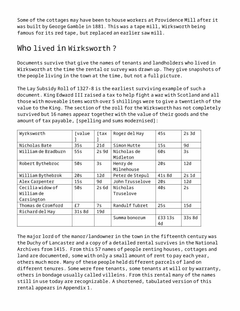
and Stoneycroft was granted by Tarmac to the town and became a millennium project to convert it for community use. Local school children and other volunteers planted numerous trees in this old quarry and voted to call it Stoney Wood. In 2005 a local artist, Aidan Shingler had an idea to create a community meeting place at the top of the wood and he designed and found the funds for the Star Disc. Officially opened in 2011, this unique gathering place has wonderful views both during the day and at night and is much admired by residents and visitors to the town.
Governance of the town
Shortly after the arrival of the Railway, a new Town Hall was constructed by the Freemasons and opened in 1871. Until the creation of the Wirksworth Local Board in 1877 and then Wirksworth Urban District Council in 1895, the governance of the town was mostly in the hands of the manorial courts and the Parish Vestry. In medieval times the ecclesiastical parish had kept records of births, marriages and deaths and by the 16th century had duties to upkeep the highways and offer relief for the poor. A Constable was appointed to be responsible for law and order and tax collection with two other officials, Surveyor of the Highways and Overseer of the Poor. The Parish Vestry Committee was effectively self-selecting and supervised by the vicar, churchwardens and other unelected local notables. Vestry committee’s responsibilities, at least before the Reform Act of 1832, included: churches and burial grounds, parish cottages and workhouses, common lands and endowed charities, market crosses, pumps, pounds, whipping posts, stocks, weights and scales, clocks and fire engines. To put it another way it was responsible for the maintenance of the church and its services, the keeping of the peace, the repression of vagrancy, the relief of destitution, the mending of roads, the suppression of nuisances, the destruction of vermin, the furnishing of soldiers, even to some extent the enforcement of religious and moral discipline.
Records of the Wirksworth vestry are largely missing; they were said, even in 1795, to be ‘all over the town’. Its effectiveness shows occasionally however, for example in the provision of a Poor House in 1729 by the purchase of a house on Greenhill (Babington House), where it remained for at least a century. In the 1790s Joseph Branson is named as the Master of the Poor House. This provision for the poor had originated in money left in the will of Robert Sage in 1661, added to over time by others. It follows a bequest in the will of Anthony Gell in 1583 leading to the establishment of almshouses for 6 elderly men in the town. By the early 1800s the town was providing for 89 apprentices at the expense of parish rate-payers. This was considered to be a well-organised system and from what few records have survived the town’s Vestry appeared to have been tolerably efficient. It was a bitter pill, when in 1840, the Charity Commissioners in London chose Belper to head the District’s Poor Law Union, believing that Belper was better able to cope with the responsibility. Until the construction of the Town Hall, it is not recorded where the Vestry Committee met, the Moot Hall is a possibility. It is equally possible the Vestry Committee met in the church, for records of the rebuilding of St Mary’s in 1870 note that the rebuilding, under Sir Gilbert Scott, had included plans for a new Vestry Room in the church, but this was no longer required and it was not built.
The Barmote Court
Mentioned previously in connection with the history of lead mining, the Barmote Court has its origins in similar ways to the Burg Moots of the other Mercian chief towns. The most well documented of these is the Burghmote Court in Canterbury, which was also, like the Wirksworth Court, concerned with the regulation of commerce. Burg Mote Courts also existed in Lincoln, Winchester, Leicester, Chester and other places, although they are often extremely badly recorded, not having survived into the modern age. In some cases, such as Leicester and Chester, this court was in fact called the Portmoot, in specific reference to its market trading and mint supervision activities. In Wirksworth the Barmote Court had become so overwhelmed

with lead mining issues that this was all that it thought it did. It had long relinquished its other commercial responsibilities, even the provision for apprentices fell to the Vestry to deal with. Throughout medieval times and right up until modern times all that is heard of the Barmote Court is in relation to lead mining. The comparison with Canterbury is salutary, however, for in both cases the Courts were unable to levy rates and this increasingly constrained their work, in the case of the Wirksworth Court, it also increasingly failed to engage in the town’s wider business, its members did less and less even given their status as key citizens of the town. By Edward Manlove’s time they only faintly remembered other duties, and by the eighteenth century had wholly forgotten it, thinking that their Court’s only role was the regulation of lead mining, not the regulation of the town’s commerce and the assurance of its dignity. For example the keeping of the Lead Miner’s Measuring Dish in the Wirksworth Moot Hall was not a token of the court’s role in the government of lead mining, but a token of the court’s role in the government of weights and measures, almost all of which, by the eighteenth century, had been lost to the Court Leet. Therefore, consideration of the activities of the Burg Courts of the other Mercian provincial capitals can illuminate us much more to what the Wirksworth Court did in antiquity. The Canterbury Court was engaged in the management of the town’s trade and in its civic affairs, the Winchester Court has records of its supervision of the Night Watch. That the Wirksworth Court lost these roles had probably more to do with its being overwhelmed by lead mining disputes than by any intention to lose them.
The Manor Courts
Each of the three manors in Wirksworth, the Royal Manor, the Holland Manor and the Rectorial Manor operated their own manorial courts and many of the records for these courts exist in the Derbyshire and other record offices. The records of the Wirksworth manor courts are very extensive and a huge resource yet to be seriously investigated. The record of the Royal and Holland manors tend to get mixed up as they are often just headed “Wirksworth” in catalogues, although those for the rectorial manor (the Dean of Lincoln’s manor) are usually more clearly catalogued. Manorial Courts originally consisted of the Lord’s Court, which was responsible for all the manors of one lord; a Court Baron which dealt with issues related to free tenants; and a Court Leet which dealt with lower issues. The functions of the Court Leet were latterly considered to have included: to enquire regularly and periodically into the proper condition of watercourses, roads, paths, and ditches, to guard against all manner of encroachments upon the public rights, to preserve landmarks, to keep watch and ward in the town, and overlook the common lands, adjust the rights over them, and restraining in any case their excessive exercise, as in the pasturage of cattle, to guard against the adulteration of food, to inspect weights and measures, to look in general to the morals of the people, and to find a remedy for each social ill and inconvenience. It also had to take cognisance of grosser crimes of assault, arson, burglary, larceny, manslaughter, murder, treason, and every felony at common law. As an example of this, this is the record of an action of the Wirksworth Court Leet in November 1558, when the wretched and bellicose John Wigley was brought to Court for blocking the Hopton Road (Hopton Lane). This was one of several court cases involving Wigley – he was a serial offender, even his family are known to have taken him to court.
The Court Leet (Lete) of Wirksworth November 1558:
‘The jurie appointed doo present that John Wigley of Wirkesworthe hathe set one wall up on a place nere Wirkesworthe called Yokkyffe whiche wall thereof is set and yet standeth in the Quenes highewaye leadynge between the towne of Wirkesworthe and Hopton* and the jurie also doo present that by reason of the said wall so sett & standinge the highewaye is turned upon the inheritance of Anthony Gell and therefore they sett a payne that the said John Wigley doo remove the said wall so yet the common highewaye may have its right course, on thisyde the next Lete upon payne of himself’.

*Ashbourne had been originally written but was crossed out, because the Queen’s Highway to Ashbourne was the road from Wirksworth via Kirk Ireton and Bradley.
We have no way of knowing whether the Court was successful in having Wigley’s wall removed from the road and its rightful course restored, instead of running over Anthony Gell’s inheritance (his land). The modern cramped and winding course of Hopton Lane as it lies beside Bowsfield does not visually give the impression of being wholly correct: another job for archaeologists to look at perhaps.
Over time only the Court Leet remained important and slowly its activities were overtaken by changes in the manor, court and county council system. Most Courts Leet were finally abolished under the Administration of Justice Act 1977.
Wirksworth township formed a constabulary in its own right and had its own House of Correction, as has been seen earlier, built above Wash Green in 1791. Records held in the Derbyshire Record Office give details of prisoners and their offences. Between 1729 and 1913 over 400 cases were recorded for Wirksworth. These are mostly for stealing, burglary, assault or ‘having a bastard child likely to be chargeable to the township’. In 1791 Francis Haynes was detained when found wandering for being ‘an incorrigible rogue and vagabond’, in 1798 Hannah Austin was said to have ‘milked a cow and carried away milk’ and in 1831 William Hall procured counterfeit money.
Religion, Education, Social Life and Local Customs
Nonconformity was an important part of the life of the town. The earliest of the chapels, the Old Meeting Room or the Old Chapel was built in plain style with an attractive horseshoe gallery by the Presbyterians in 1700. This is now the United Reform chapel. Other chapels followed in the 19th century, an Ebenezer Methodist chapel on Chapel Lane in 1810, the Baptists in 1816, a Methodist chapel in the Dale built between 1828-30 and United Free Methodist Chapel on St. John’s Street in 1886. A Temperance Hall was also built in Chapel Lane in 1860 to counter the growing number of public houses and alehouses.
In 1867 the Wirksworth Cottage Hospital was founded in Babington House by the efforts of Georgina Hurt. It had 22 beds and provision for three maternity patients. In 1927 Waltham House was bought, together with the adjacent cottage, for £1350 for use as a cottage hospital using legacies and donations from the townsfolk. A further sum was raised at the 1927 Carnival to furnish the hospital.
Apart from the Grammar School, education in the town was provided by ‘dame schools’. A Miss Stubbs ran a Lady’s Boarding School in the town in the 1790s, and other similar establishments provided some day schools in the 19th century. A National School was built at the end of North End in 1851 and the Church of England opened one on North End in 1896. When the Grammar School moved to its new site on the Hannages in 1907 the old buildings in the churchyard were used as a cookery room and wood working site. The new buildings were designed by the architect George Widdows. He also designed the school buildings at New Bridge in the 1920’s to an innovative cruciform plan as a Secondary Technical School. This is now Wirksworth Junior School.
Recreation in the town was provided by the annual fairs in September and weekly dances or musical events in the Assembly Room at the Red Lion Hotel. At the back of the Red Lion was a bowling green. This venue possibly also hosted Joseph Smedley’s Travelling Theatre Company, known to have visited in 1812. Well Dressing re-started in Wirksworth in 1827, after piped water came to the town. This ancient custom may well reflect a pagan ritual in a limestone area where water frequently disappears at certain times of the
year. Hackett, writing in 1863, said of the tradition of well-dressing that is was kept at that time only in Derbyshire and in three locations: Buxton, Tissington and Wirksworth, and in no others.
Apart from a few nineteenth century buildings including the Town Hall, the Non-conformist chapels and the schools, the town retained the character of a provincial Georgian market town, dominated by winding alleys, and narrow streets with houses and shops zig-zagging up the hillsides.
Twentieth Century Wirksworth
Private residential housing took place after the first world war along Cromford Road and Derby Road and after the second world war local authority housing expanded the town at Snowfield View by Millhouses, King George Street on the Gilkin and King Edward Street at Gorsey Bank. The most radical change to the centre of town occurred between 1938-40 when a new road, Harrisons Drive, was blasted through the former Baileycroft quarry to open the way to Cromford. This necessitated restricting the Market Place to its present site and the demolition of a number of properties, including Doxey’s Tearooms and Watts’ taxi office.
Further expansion to the town took place in the 1950s when local authority housing was built on the east side of Derby Road and in the sixties on the west side. The Anthony Gell School was enlarged on its site on the Hannages in 1965 as the Grammar School became comprehensive. Further expansion of the town followed the sale of Yokecliff Farm in the 1970’s with private development of the Yokecliff estate to the north of Summer Lane. South of Summer Lane local authority housing also expanded towards the Broadmeadow (Kings Field) Recreation Ground. Much of the older town centre property was in a poor state of repair by this time and declared a General Improvement Area by West Derbyshire District Council. In 1978 the Civic Trust chose the town for a pilot regeneration project leading to a Europa Nostra award in 1983. Many derelict properties were restored during this time, notably 1-3 Greenhill, 6-11 St. Mary’s Gate and 31-33 The Dale. Later residential development has been small scale and within the built-up area of the town.
An estate for light industry was developed on Derby Road on the site of a market garden and the bus garage and another to the west of Cromford Road during the 1980s leading to a revival of employment in the town, particularly small technology companies. The regeneration also attracted art and craft industries to establish in Wirksworth, for example metal working, woodwork, textiles and design work. The end of large scale quarrying close to the town, together with the Clean Air Act in 1956, had a major effect on the environment, which improved significantly.
These improvements and influx of new ideas led to the start of the Wirksworth Festival Art & Architecture Trail in 1995 when a group of local artists opened their houses to show off their work. This has been running ever since and over a fortnight music, drama and dance events take place during the Festival. This is based around the time of year of the Clypping of the church, an ancient ceremony where the congregation hold hands around the church and sing ‘We love the place O Lord in which thy honour dwells’, a custom revived in 1921. It takes place on the nearest Sunday to September 8th, the feast day of St. Mary the Virgin, to whom the church is dedicated.
These changes brings us to the present day, for they enabled Wirksworth to develop into its modern guise with tourism, small technological companies and practical and professional services providing local employment and an excellent place to live.

Conclusion: The past, the present and the future
It has long been said in Wirksworth that ‘Wirksworth was a town when Canterbury was a village and Liverpool was a swamp’. There is a measure of truth in this, for Wirksworth is the town in Derbyshire with the earliest surviving charter. Abbess Cynewaru, speaking twelve centuries ago in 835, calls us her ‘villa’, her town of Wirksworth. Being a town is in many ways an attitude of mind, that is to say the inhabitants of the settlement regard themselves as a town. This is certainly the case with Wirksworth, whose long-standing residents are firm in this belief: indeed many a newcomer has had their knuckles very severely rapped for using the word village when referring to Wirksworth.
Wirksworth’s role has changed many times. Each time it has coped with that change and often pulled itself up by ‘its own shoelaces’. The decline of the lead industry, and to a lesser extent agriculture, was accompanied by an almost concurrent rise in textile manufacture and limestone quarrying. The decline of these industries by the late 1980s saw an increasing reliance on services and small industry. A report commissioned by the town in 2006 found that ‘a cluster of communities around Wirksworth was home to a prolific and exceptionally talented mix of innovative, imaginative and creative companies and individuals’.
In the last twenty years by a series of small steps tourists have arrived and they demand particular services – an increase in cafes and eating places, bed and breakfast and self catering cottages. It is tourism in which Wirksworth has considerable strength, greater strength than most of our competitor towns. For Wirksworth is at the head of a fine, lovely valley, the Ecclesbourne Valley and the town boasts a range of tourist attractions and has a wonderful character in terms of its built environment and situation.
Some residents are descendants of old Wirksworth families - people whose family names appear in the early rentals, others arrive to take up a job or retire here. Once here they usually stay and all of them, and those from the surrounding area, use the local services - health provision, local shopping, schools, the Leisure Centre, tradesmen and professionals.
In looking forward to the future it is all too easy to be overtaken by the dismal attitude about the world so often seen in the pages of newspapers, and overwhelmingly in the news media in general, who delight in being depressed. Wirksworth, however, is perfectly able to hold its head up in the face of such nonsense.
Wirksworth has been a town for two thousand years: we are well capable of being a town for another two thousand years and no-one should underestimate us.

Appendix 1: Duchy of Lancaster Manor Rental 1415
Tenant Name Tenure HoldingAbbot of Derly Tenant by warranty land and tenement called Les HolmesJohn Alicon Tenant by warranty land next to the hall of NicholasRobert Barker Tenant by warranty 3 acres at EdrisaleWilliam Baron Tenant at will ½ acreWilliam Beighton Demesne tenant 9 acres at StaynsboroughWilliam Bethelbate Tenant by warranty
Tenant at will1 piece of land2 acres at Longowe
John Bradrie Free tenant Water millheirs of Nicholas Bradshagh
In bondage 4 acres under Staynsburgh
John of Bradwell Free tenant 11 acres at PitheyRadulph of Brampton
Demesne tenantTenant at will
11 acres at Bathirwyk? acres next to Warmbrook, 3 acres on le Brefeld called the Rydding feld, ½ acre on Bradstonefeld, 1 acre called Crombage, 1 acre on les Flattes
Robert de Brookwallhurst
Tenant at will piece of land called Dalezerd
Matilda Brown Demesne tenantTenant by warrantyTenant at will
½ acre under Zelcliffland in the Dale a house, 1 acre under Zelcliff, 3 acres on Wodagesiche
John Brown Tenant at will 2 acres under BurehillRichard Brown Tenant at will a house, 6 acres on WywardtreWillaim Brown Tenant at will 1 acre called CromacreRichard Bulder/s Tenant by warranty
In bondagea house with garden and land, 2 acres at Bredegarea cottage in Wyrkesworth
Richard Browne Demesne tenant 6 acres at WichiswykJohn Burgulon Free tenant
Demesne tenantIn bondage
a house & 10 acres above the Stones3 acres on Bradstonfeld, 2 acres & 1 rod under Zelcliff1 acre at Zeldcliff
John Burgynton or Burgulon ?
Tenant by warrantyTenant at will
a house, 2 acres at Pitheya house lying next the one he holds freely at Les Stones, 10 acres at Ludwalflatt, 2 acres at Dernewalsiche, 2 acres on Sotine, 2 acres on Grenhull, a piece of waste for 1 kiln there made & 1 piece of waste for a forge
William Buron Free tenant 10 acresThomas Cobyn of Allerwasley & Willaim Foun
Tenants at will hold all the land that was Walter Wolleys
John Cutte Tenant at will a piece of land called GrenzardWilliam Doudson Free tenant
Demesne tenant
Tenant at will
22 acres at Pithay4 acres above Zelchegge, 2 acres under Zelcliff, another 2 there & another 1 there, 1 acre at Withywyk a piece of land called Halle orchard, 2½ acres in Othynlegh, a piece of waste
John Edwards Demesne tenantTenant at will
3 acres at les Flattes2 acre at Syndyngwall, 2 acres of assart, 3 acres at Wywardstre, ½ acre at Syndyngwall
Thomas de Eton Free tenant a house & 13 acresJohn del Ford Demesne tenant
Tenant at willIn bondage
8 acres at Witherwyk, 6 acres under Zelcliff, 3 acres in Lidwesflatt, 1 acres, 2 acres on Les Flattes, 2 acres under Zelcliff, 2 acres at Wyadastre, 2 rods on Ludwelflatt, 6 acres above Staynsburgh,1 acre at Withywyk, 1 acre under Zelcliff, 3 rods at Ludwallflatt2 acres in Bradstonedale, a parcel called Brokenstonedale, a parcel called Ludwalsiche4 acres called Gibriddynge, 10 acres on les Croftes
John del Ford & In bondage a house, 7 acres on les Croftes and Bladsichefeld, 4 acres there, 3 acres on
William Wygley Smytheriddinge & le Fisshepole, 1 acre on Old Croftes, 2 acres on Staynesburgh, 1 acre called Hardage
John son of Nicholas de Ford
Tenant by warranty 8 acres
Nichoals Harpour In bondage a house 9 acres on le Ruddyng, 1 acre under le Mylnecliff, ½ acre in Pithey, 2 acres on Staynesburgh, 1½ acres & 1 rod there, a piece called Lambkynzerd, 3 acres at Holynwall, 1 house in Wyrkesworth, 11 acres in the Milnhous field, 2 acres at Brymmynglowe, a piece of waste called le Grene, 1 house, 1 rod at Lighthilles, 3 rods called les Croftes, 1 house & ½ acre
Richard & Michael Harpour
In bondage 3 acres in le Mylnehous feld, a house there, 2 acres on Coldbrokflatt, 2 acres on Hathurege cliff, 2 acres there, 1½ acres under le Holyn, ½ acre at le Fouldfeld, 1 acre next to Fouleside, 1 acre on Oldcroft, ½ acre at Ludwallhede, ½ acre next to Cresbroke, 1 acre at Crymbaullls, 1½ acre & 1 rod at Smythrudding, 1 garden called Wilezerd next to le Grene, 2 acres at Lightehulle, ½ acre there & 2 acres in Smythrudding
John Helot Tenant by warranty a house & land in WapentakfeldJohn Hervile Free tenant Felice ParrockJohn Holand Free tenant 16 acresJohn Husband Free tenant ChoppeshaghRichard Hutchinson Tenant at will a piece of land called le RyddingNicholas Ibull Tenant by warranty
Tenant at willa cottage a house & a piece of waste 22 perches long and 7 perches wide for a lodging & a piece of waste for a fririus & a pigsty, 1 acre at Ludwall & Brodemedesiche, 1½ acres on Ludwalflatte, 1 acre lying between the mill and the Brodemedowe, ½ next to Bredmedow, a piece of land called Hakkynge
John del Leghes Tenant by warranty 8 acresJohn Longley In bondage 4 acres of meadow called Codstye Medow, 2 acres next to WarmbrokWillaim Longley In bondage 2½ acres in le Dale, 1 acre at Midelton, ½ acre at Bradston, ½ acre at Porterway,
3 acres under Northcliffe, 1 house, ½ acre at PotterwayChristopher Marshall
Tenant by warranty land at Stepull called Rycroft, 1 acre at Longlowe also called Watfeld
Robrt Odiham Tenant at will 1 acre at Solimwath, a piece of waste for a forge buildingRobert Person Tenant by warranty a house & gardenJohn Potts Tenant by warranty a cottageRichard Raulynson Free tenant
Demesne tenantTenant at will
In bondage
a house4 acres above Pitheyland on Anluchclif, fishing in the river Ecclesbourne, a piece of waste for 1 theref superedifice called Lyrzerd6 acres with a meadow, 6 acres on Othynley, 3 acres on Staynesburgh, 1 acre under the Milne house cliff, 20 acres in Holandfeld, 4 acres in Lyetrchull, 3 acres with a mesuage, 3 acres in Smyth ruding, 2 acres 1 rod at Lighthill, 12½ acres & ½ rod with a house at le Milnehous, 4 acres in Lighthulles
Katherine Rirre Free tenant a house next to the WalkmylneJohn de Rollesley Free tenant landWillaim Sadler Demesne tenant 3 acres at Washegrene, 1 acre at IbetwallRichard Smyth Tenant by warranty a cottageWilliam Storer Tenant at will a house in WyrkesworthHenry Taillour In bondage 17 acres under Ravenslowe, 7 acres under Hardhurst, a piece of waste, 4 acres
with a house under Hardhurst, 1 acre on StonycroftWilliam Taillour Demesne tenant
Tenant at willIn bondage
2 acres at Staynsborough2 acres at Dalehede2½ acres at Zelcliff
Willaim & Henry Taillour
In bondage 1 acre on Zelchsfoot, 2 acres inle Waterdale
William Wi/ygley Demesne tenantTenant at willIn bondage
4 acres at Staynesburgh2½ acres in the Dale, 2 acres on le Dalefeld1 acre & 1 rod in Staynesburgh

William Wither/s Free tenantDemesne tenantTenant at will
2½ acres1 acre under Zelcliff a house, a piece of waste for a forge, a piece on waste on Greenhill
William Withers & Willaim Taillour
Tenant at will 1 acre and a tenement in Wyresworth
William Wooley Tenant at will sele in quarto [possibly a strip in an open field]William Wynfeld Free tenant
In bondagea house & 30 acres, 10 acres at Ingesiche6 acres in le Stenefeld, 4 acres in le Hardehurst
Appendix 2: Anne Duchess of Exeter, Holland Manor rental 1473
Tenant Undertenant Property RentRichard Wenfelde 1 acre in North Field 10dRichard Smyth Cottage & garden 12dBartholomew Hulley
A garden, 1 acre meadow in North Field
6d12d
Thomas Grene Nicholas Reyley Cottage & garden 3dRichard Bighton John Archer Cottage & garden, 1 acre in Hanneg 3s 6d
William Hervy A barn and 2 gardens 18d & 3dWilliam Jackson Joan Wylebred
John HarvyCottage & gardenA garden
4s12d
Thomas Chetill John Lyptrot 1 acre on Otyll, ½ acre on Othilltop 8d & 4dJohn Isherwood John Barker Gaskyn Croft & 1 acre in Bradstone Field 3s 4d &
8dThomas Thomas Chetill 1 acre in Othill 14dJohn Robyson, taylor
John Chedill
Thos. Chettill
A cottage & 2 gardens next the cemetery, 2 acres meadow in North Field, ½ acre in the Hanegg, ½ acre in OtillA cottage & garden
6s 6d
3s 2dHenry Stone John Wright A place called Stadfall, 1 acre next Stadfall, ½ acre
on Lytell Bradstone, 1 rood on Dalesyde, 1 acre in Bradstone field
2s, 8d, 3d 2d, 6d.
John Fletcher 2 acres on Otill 14dThomas Storer Robert
Wylkeston1 garden called Tenter Yard, 1 acre in Dale Field 10d
Richard Blackwall William Broculhurst
1½ acres under Barrell, ½ acre meadow, 1 acre meadow upon Bannockhill, 3 acres at Prest eydding, ½ acre in Middelpekend, 2 acres in Dale Field, 1½ acres in Bradstone field, ½ acre on Yolclyfhed, 1 acre on Yowclif egg, ½ acre at Hopton Crosse, 1 acre in Otilltop, 1a in Ottill
12s
Thomas Chetill John Chedill 1 acre of meadow between Fawne Meadow and Wirksworth
12d
Richard Blackwall Richard Ibull ½ acre on Litel Bradston, ½ ditto, 3 roods ditto, ½ acre next Little Pyntyllthorne, ½ acre in Hopton Dale, a further ½ acre & 2 roods1 parcel of meadow next the cross towards Stepull, 1a meadow in Wasshe meydowe
12d
3s 4d
William Beighton William BeightonJohn FletcherRichard IbullWilliam Walwayn
5 acres in Litzthilles
1 acre in Stotwall1 acre in Hanegg next the highway2 acres in Otill next Warmbrookparcel called Sondpytts
3s 4d
8d10d16d4d
Richard Spenser William BrowneRichard SpenserWilliam Heggett
Halve part of Bowfeldes
Other half of Bowfeldes
1 close of Bowfeldes next the new mylne
15s 3d
15s
8s

Appendix 3: 1649 Parliamentary Commission Survey
"A Survey of the Soake and Mannor of Wirksworth with the righte Members and appurtences thereof lying and being in the Countie of Derby late parcell of the possessions of Charles Stuart late King of England in right of the Dutchy of Lancaster made .... in the month of Novr Anno Dom one Thousand six hundred ffortie & Nine by virtue of a Comission grounded uppon the Act of the Commons of England in Parliament assembled for ye Sale of the Honours Mannors and Lands heretofore belonging to the late King, Queen and Prince ...."
The Cheif Rents due from the freeholders… in free socage… lxxxxviijs xdThe rents due from the Copyholders of Inheritance …….xliijs viijdThe Court Leet and Court Barons holden for the sayd Manor of Wirksworth…..xijli vijs ixd
An Exact valuation of certain Cottages erected and encroached in the Wastes of the said Manor of Wirksworth, and the names of the several Tenants of the same who have no right Lease or Estate therein. [ie encroachments]
Tenant Property ValueALLSOPP, Lawrence a cottage at Newbridge 1sBAMFORD, William part of a cottage at the Newbridge 2s.6d.BRADSHAW, John a cottage at Newbridge 3sBREARLEY, Francis a cottage at Longoe Banck 4sBUNTING, Thomas a cottage at Cote field gapp 6dCHETLEY, John a cottage at Newbridge 3sCLAYE, Edward a smithy or forge at Bayley Croft Steele 8sCOLLEDGE, Humphrey a cottage upon Greenhill 2s 6dDAWSON, Richard a cottage at Cote field gap 6dENSER, Thomas a cottage upon Greenhill 6dFALLOWES, Robert a cottage upon Greenhill 6sFONE, Robert a cottage in the Dale 4sFOWELL, Elizabeth a cottage in the Dale 4dGARDNER, Joseph a cottage upon Greenhill 7sGELL, John a cottage in the Dale 1s 4dGREGORY, John a cottage at Longoe Bank 4sHEALD, Ann, widow a cottage in the Dale 3s 4dHILL, John a cottage upon Greenhill 4dHORNSBYE, Robert a cottage in the Dale 2sKEY, Ruth a cottage upon Greenhill 4s 4dMATHER, Elinor a cottage at Warmbrook 4dPOYSER, Anthony a cowhouse at North Towne end 2sROOPER, Robert a cottage at Longoe Bank 4dSANDERS, George a cottage at Newbridge 1s 6dSTAFFORD, William a cottage at Newbridge 1s.6dSTEEPLE, Rowland a cottage in the Dale 2sSTORER, Henry a small parcel of arable land 3sSTORER,Thomas a cottage at Newbridge 3sTHORPE, Frances a cottage upon Greenhill 1s 8dTOMLINSON, Dorothy, widow a cottage at Warmbrook 4sTOMPSON, Alice, widow a cottage at Newbridge 1s 6dWALL, William a cottage upon Greenhill 6sWILLIAMSON, John a cottage at Newbridge 3s

A particular of all such Lands Tenements & Hereditaments belonging to the said Manor of Wirksworth as are under demise or grant for Term of years. [ie leasehold]
Tenant Property Half yearly rent
Annual Value
ALSOPP, Ralph 5 acres between Mill Lane & Broad Meadow 11s £5ALSOPP, Ralph 2 fairs viz. at Feast of Philip and Jacob and at Nativity
of Our Lady & a weekly market kept every Tuesday with toll & stallage
12d £11
ALLSOPP, Richard Smithies a shop in Wirksworth, 2s 2d 16sARCHADINE, Francis a garden/part of a house in Wirksworth 2d 3sARNEFEILD, Robert 3 cottages at Warmbrook 1s 5sBROGRAVE, Thomas of Rowlston, Staffs
Lease of Casualties viz. waifs, strays & felons 15s
BROTHERICK, Christopher
a cottage in Wirksworth 6d 10s
CHARLTON, John a cottage & garden at Mylnhouse Green 2d 4sFERNE, Elizabeth, widow a Coal delf/2 pits Longoe Bank, Crumford £7 10sFERNE, John gent lessee cottages & crofts in Wirksworth in 1631 26s 8d 80sFERNE, John Moothall & shops in WirksworthHOPKINSON, George Leadway Mill passage in Wirksworth 6d 6dHOPKINSON, George, gent
a Smelting Mill on the Bolehill 4d £7
HUDSON, John a cottage upon Greenhill 8d 12sJOHNSON, Christian a cottage, in Wirksworth 2d 1sMELLOR, William Leadway Mill passage in Wirksworth 6d 6dMOSLEY, Edward Sir supposed lease of coal delf/2 pits Longoe BankNITINGALL, John a cottage & Croft near Longoe Banck 2s 2d 22sNOTON, John land adjacent to Waterdale Shrugges in Wirksworth ORME, Arthur a cottage at Warmbrook 6d 1s 6dSCHACLOCKE, Edward a barne near the Corn Mill in Wirksworth 6d 5s 6dSHALCROFT, John Esq properties in Wirksworth in 1639, original lesseeSPENCER, Robert 8 acres coppice & shrub Waterdale Shrugges 1s 30sTOMSON, George Harrisons Houses in Wirksworth 12d 1sWALL, Robert a croft in Wirksworth 4d 2sWHITMORE, George merchant
properties in Wirksworth in 1610, original lessee
WHITMORE, Thomas, merchant,
properties in Wirksworth in 1610, original lessee
WIGLEY, Edward a cottage of 2 bays at North Town end 6d 5sWIGLEY, John Land, arable & pasture near the Ryding head 6d 30s
A perfect Rental of the several freeholders within the said Manor of Wirksworth and their several rents.
BEIGHTON, Thomas senr. rent 6d. GREATRAX, Thomas, rent 10d.BEIGHTON, Thomas junr. rent 5s. GREATRAX, William, rent 5s.6d.BENT, Hellott rent 6s.2d. HIGGOTT, William, joint rent 6d.BRADSHAW, Anthony, rent 4s.6d. MELLER, William, rent (with R. Buxton) 11s.2d.BUXTON, German, rent 11d. MORSLOWE, William [altered to Worslowe] rent 6d.BUXTON, Henry, rent 4d. NEEDHAM, Thomas Esq., rent 17dBUXSTON, Richard rent (with W.Mellor) 11s.2d. SHACLOCK, Edward, rent 6d.CARRYER, Richard, clerk, rent 6d. SHIPLEY, William, rent 8dDEANE, Edward rent 11s.8d. SOMERS, George, rent 2s.EATON, Anthony, rent 5s. TOPLEYES, John rent 2d.
FEALES, Henry rent 9s.4d. TOPLEYES, Robert senr., rent 4d.FEILDING, Robert clerk, rent 8d. TOPLYES ,Robert Junr., rent 5s.4d.FERNE, Ann (with Dorothy) 16d. TOPLEYS, William, rent 18d.FERNE, Dorothy, rent (with Ann) 16d. WIGLEY, Ralph, rent 4d.FERNE, John gent., rent 1s. WIGLEY, William, joint rent 6d.FERNE, Mary widow, rent 18d. VALLENCE, Luke, rent 2d.FOGG, Edward, rent 6d. WIGLEY, John, rent 2d.GELL, John Esq., rent 2s 7d. WIGLEY, John Gent., rent 15s.4d.
A perfect Rental of the several Copyholders of the said Manor who have compounded to make their fines certain & their several rents.
ADDAMS, Edward, rent 9d. SACHEVERELL, Valence esq., rent 2s.6d.ALLCOCK, John, rent 4d. SMEDLEY, Edward, rent 4s.4d.ALLSOP, William, rent SOWTER, James, rent 2s.8d.ALLSOP, William, rent 18s.8d. SPENCER, George, joint rent 6s.2d.ARNEFEILD, John, rent SPENCER, Robert gent., rent 19s.8d.BAYLYE, Francis, rent SPENCER, Robert, rent 18d.BOTHAM, Thomas, joint rent 6s.2d. SPENCER, William, rent 2s.BRADWALL, John, rent 8s.4d. SPENCER, William, rent 4d.BUXTON, Henry, rent 15s. TAYLOR, John, rent 5s.6d.BUXTON, Thomas, rent 20d. TOMSON, George, joint rent 6s.2d.CHALLISWORTH, Anthony, rent 6d. TOMSON, Martin, joint rent 6s.2d.FOWELL, Elizabeth, rent TOPLYE, Thomas, rent 3s.2d.GEE, Henry late c/h, rent 2s.6d. TOPLYES, Robert senr., rent 8s.GELL, John Esq., rent 4s.9s. TOPLYES, Robert junr., rent 19s.6d.GELL, Ralph, rent 18d. TOPLYES, William, rent GOODWYN, Edward rent 12d. TWIGGES, Ralph, rent 8s.8d.HEALD, Robert, rent VALLENCE, Anthony, rent 2d.HOPKINSON, Anthony, rent 8d. VALLENCE, Luke, rent 12d.HOPKINSON, Anthony, rent 13s.6d. VALENCE, Richard, rent 8d.HOPKINSON, Tobias, rent 12d. WALL, John, rent 3s.HUDSON, John, rent 1d. WALL, William, rent 8d.KIRKLAND, William, rent 3d. WETTON, Dennis, rent LOWE, Henry, rent 4d. WIGLEY, John gent., rent 36s.8d.MELLER, George, rent 3s.10d. WIGLEY, Ralph, rent MORETON, gent., rent WILMOTT, Francis, rent 12d.NOTON, John, rent 11s.2d. WOODDIWIS, Thomas, rent 17d.RICHARDSON, William, rent 10d. WRIGHT, Anthony, rent 7d
A perfect Rental of the several Copyholders within the said Manor of Wirksworth who have not yet compounded to make their fines certain, and their several rents.
BUNTING, Isabell, rent 4d. MATHER, William, rent 1d.BUNTING, Isabell, rent 4d. NOTON, John, rent 5s.FLETCHER, William, rent 1s. PEGG, Christopher, rent 12s.GAUNT, William, rent 2s.6d. SHIPLEY, William, rent 5d.GELL, Anthony, rent 6d. SPENCER, Anthony, rent 2s.6d.GELL, John esq., rent 1s. STORER, Thomas, rent 22s. ½d.GELL, John for the Grammar School, rent 6s.8d. SWALLOW, John, rent 1s.GREATRAX, John, rent 2d. TOPLYES, Robert, rent 4s.4d.JACKSON, John, rent 3s.9d. WILKOCKSON, George, rent 2d.KEMP, Anthony, rent 2d. WINGFEILD, James rent 1d.KEY, Andrew, rent 1d. WINGFIELD, Roger, rent 2d

The Survey of the Manor of Wirksworth aforesaid is a true and perfect survey taken by us whose names are here subscribed to the best of our skill and knowledge according to our oaths and instructions. In Witness whereof we have hereunto set our several hands the four and twentieth day of this instant November Anno Dom. 1649
Abell RICHARDSON, George SOUTHCOTTE, John THORNE, William TRACY, William WEBB, Supervisor Generall 1649

Bibliography
Anderson JJ (1985) Roman Derbyshire, Derby, JH Hall and Sons, p10-15
Anderson OS 1934) The English Hundred Names, University of Lund, Vol 1, p35
Arkwright Rev (1912) A survey of the Soake and Manor of Wirksworth 1649, Derbyshire Archaeological Journal, p13-28
Barrow J (1994) English cathedral communities and reform in the late 10 th and 11 th centuries , in Rollason D (ed) et al, Anglo-Norman Durham 1093-1193, Woodbridge, Boydell Press, p25-
39
Barnatt J (2004) The Peak District, Landscapes Through Time, Macclesfield, Windgather PressSmith K p49, p54
Bassett S (1989) Churches in Worcester before and after the conversion of the Anglo-SaxonsAntiquaries Journal, p216-256
Bassett S (1992) in Blair J and Sharpe R, Pastoral Care before the Parish, London, LeicesterUniversity Press, pp13-40, p20
Bede (the Ven)( 731) Ecclesiastical History of the English Nation, (Chapter 21) in the public domain, Accessed on 05/02/09 at http://www.fordham.edu/halsall/basis/bede-book1.html
Bestall JM (1974) History of Chesterfield, Chesterfield, Borough of Chesterfield, p9
Birch W(1885) Cartularium Saxonicum, London, Whiting & Co, pxxvi
Blanchard I (1967) Economic Change in Derbyshire in the Late Middle Ages 1272-1540Thesis University of London. Copy in Matlock Local Studies Library.
Branigan K (1985) Lost towns of Roman Britain, 2: Lutudarum, Popular Archaeology, September, p39-41
Branigan K (1991) Civilian development in a military zone; the Peak AD 43-400 in Hodges R, Recent developments in the Archaeology of the Peak District, University of Sheffield, JR Collis Publications, p60
Brassington M (1982) Roman Derby, Derby, JF Hill Printers, p3
Brassington M (1988) The Lumb Brook Pottery Kilns, Hazlewood, Derbyshire Archaeological JournalWebster WA p21-33
Breeze A (2002) The name of Lutudarum, Derbyshire, Britannia, Vol 33, p266-268
British (2007) The electonic Sawyer: online catalogue of Anglo-Saxon charters, University of AcademyCambridge, accessed on 11th August 2008
http://www.esawyer.org.uk/content/browse/ch_date.html
Brooks CH (1924) A little book about Wirksworth, Wirksworth, FW Brooks Publishers
Brooks N (1989) The formation of the Mercian Kingdom in Bassett S, The origins of Anglo-Saxon
Kingdoms, London, Leicester University Press, p160
Brooks N (2000) Anglo-Saxon Myths: State and Church 400-1066, London, Hambledon Press, p236
Brotherton P (2005) Celtic place names and archaeology in Derbyshire, Derbyshire Archaeological Journal, p122
Bunting J (1998) Bygone industries of the Peak: Lead Smelting, Peak Advertiser, 23rd March
Burnham BC (1990) The ‘small towns’ of Roman Britain, London, Batsford, p 176-178Wacher J
Cameron K (1959) The place names of Derbyshire, Vol 2, Cambridge, University Press
CIL (2006) Corpus Inscriptinem Latinarum, Vol VII, record no 1215, accessed at:http://www.roman-britain.org on 01/02/06
Cockerton RW(1962) The Wirksworth Slab, Derbyshire Archaeological Journal, p1-20
Collingwood R(1965) The Roman Inscriptions of Britain, Oxford, Clarendon PressWright RP
Collins R (1999) Early Mediaeval Europe 300-1000, Basingstoke, MacMillan, p186-195
Connelly P (2005) Overcoming Splendid Isolation in Nevell M and Redhead N Mellor: Living on theEdge. A Regional Study of an Iron Age and Romano-British Upland Settlement Manchester
Archaeological Monographs, Vol1, University of Manchester, p99-106.
Cox JC (1875) Notes on the churches of Derbyshire, London, Bemrose, vol 2, p539
Cox JC (1916) Notes on the Parish Church of Wirksworth, Wirksworth, G Marsden, p8
Cramp R (1977) in Dornier A, Mercian Studies, Leicester, Leicester University Press, p191-231
Cubitt C (1995) Anglo-Saxon Church Councils c.650-c.850, London, Leicester University Press, p223-230
Dack CN (2010) Urbanisation and the middling sorts in Derbyshire market towns: Ashbourne and Wirksworth 1660-1830, Thesis, Dept of Historical Studies, Leicester University,
Dark K (1994) Civitas to Kingdom, London, Leicester University Press, p 64-68
Dark K&P (1998) The Landscape of Roman Britain, Stroud, Sutton Publishing, p136, p123, p140
Darlington RE (1945) The Cartulary of Darley Abbey, Kendal, Titus Wilson, Vol 2, p582
Davies, H (2002) Roads in Roman Britain, Stroud, Tempus Publishing
Dearne MJ (1991) The military vici of the South Pennines; retrospect and prospect in Hodges R, Recent developments in the Archaeology of the Peak District, University of Sheffield, JR Collis Publications, p69-84
Dearne MJ (1995) Excavations at Brough Field, Carsington, 1980, Derbyshire Archaeological
Et al Journal, p37-75
Dennis H (1971) The techniques of lead mining (Thesis), Cardiff, University College Cardiff, p14-15
Dodd AE&EM (2000) Peakland Roads and Trackways, Ashbourne, Landmark, p26, p43, p44-49
Editorial (1986) Going down to the past, Community Fayre, No 25, October, p1
Ellis P (1989) Roman Chesterfield: Excavations by T Courtney 1974-1978, Derbyshire Archaeological Journal, p51-127
Foot S (1993) The Kingdom of Lindsey in Pre-Viking Lindsey, Lincoln, City of Lincoln Archaeological Unit, p128-140
Glover C (1981) William Woolley’s History of Derbyshire, Wingerworth, Derbyshire Record SocietyRiden P p24 and p176-179
Green HJM (1960) An architectural survey of the Roman baths at Godmanchester, Archaeological Newsletter, 6, (12).
Greenhough P (1991) City Foulds: Interim Report (Thesis), Leicester, Leicester University
Hackett RH (1863) Wirksworth and five miles around, Wirksworth, J Buckley
Hadley DM (1996) Conquest, Coloniization and the church: Ecclesiatical Organization in the Danelaw, Historical Research, Vol LXIX, p109-128
Halsall P (1998) Annales Cambriae 447-954, accessed on 3rd January 2009 athttp://www.fordham.edu/halsall/source/annalescambriae.html
Hart CR (1981) The North Derbyshire Archaeological Survey to AD 1500 Chesterfield, North Derbyshire Archaeological Trust
Henstock A (1980) The course of Hereward Street. A Re-appraisal, Derbyshire Archaeological Journal, p35-42
Hodges R (1991) Notes on the Mediaeval archaeology of the White Peak in Hodges R: Recentdevelopments in the archaeology of the Peak District, University of Sheffield,JR Collis Publications, p111-121
Hutchinson S (1709) The Wirksworth Township Map of the Gell Estate, held at the Derbyshire County Archive, Matlock, accession number D258 M/18/6
Ireland S (2008) Roman Britain: A sourcebook, London, Routledge, 3 edn, p 209-211
Jebson T (2006) The Anglo Saxon Chronicle, Manuscript E (The “Peterborough”) Bodleian Library MS Laud 636 accessed on 04/01/08 http://asc.jebbo.co.uk/e/e-L.html
Joyce B (1996) Derbyshire Detail & Character: a celebration of its towns and villagesStroud Publishing
Kay SO (1962) Romano-British Pottery Kilns at Hazelwood and Holbrook, Derbyshire, Derbyshire
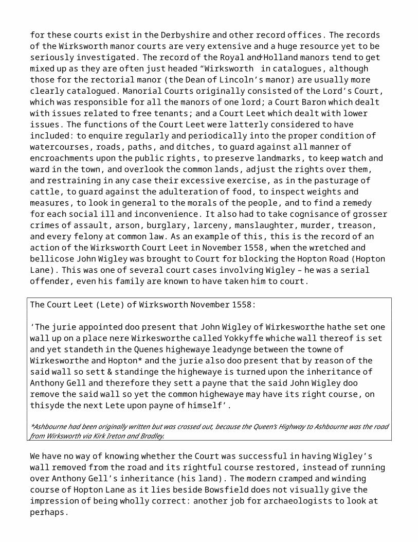
Archaeological Journal, p21-42
Kendrick TD (1938) Anglo Saxon Art to AD 900, London, Methuen & Co, p164
Knight D, & (2004) The Romano-British Landscape in Knight D and Howard AJ Trent ValleyHoward A J, Landscapes, Great Dunham, Heritage Marketing and Publications Ltd.Leary R p115-146
Kurth B (1945) The Iconography of the Wirksworth Slab, Burlington Magazine, 86, p114-121
Lane H (1986) The Romans in Derbyshire: Lead Mining and the search for Lutudarum, Bolsover, Veritas, p57-61
Leahy K (1993) The Anglo Saxon settlement of Lindsey in Vince A, Pre-Viking Lindsey, Lincoln,City of Lincoln Archaeology Unit, p29
Ling R (1981) Excavations at Carsington 1979-1980, Derbyshire Archaeological Journal, Courtney T p58-87
Ling R et al (1990) Excavations at Carsington, Derbyshire Archaeological Journal, p30-55
Lomas J (1960) A Romano-British Site at Owslow Farm, Carsington, Derbyshire Archaeological Journal, p109-116
Loveluck C (1995) Acculturation, Migration and Exchange: The Formation of an Anglo-SaxonSociety in the English Peak District, 400 – 700AD in Bintliff JL and Hamerow H:Europe between late Antiquity and the Middle Ages, Oxford, Tempus Repartump84-98
Lyttelton-Gell P (1916)The churches of Roman Britain, Derbyshire Archaeological Journal, p75-83
Margery ID (1967) Roman Roads in Britain, London, Baker, p410-417
Myers A (2000) An Archaeological Resources Assessment of Roman Derbyshire, Matlock,Derbyshire County Council, p2
Naylor P (2003) A history of the Matlocks, Ashbourne, Landmark, p10-16
Ottrey F S (1966) Geographical Aspects of the Development of Wirksworth from the Beginning of the Nineteenth Century to the Present (1800-1965), Thesis, University of Nottingham, copy in Derby City Local Studies Library
Palmer J (2105) Wirksworth Parish Records, accessed at www.wirksworth.org.uk on 14/10/2015
Palfreyman A (2007) A Romano-British quern manufacturing site at Blackbrook, Derbyshire,Ebbins S Derbyshire Archaeological Journal, p33-48
Priestley F (2003) The Wirksworth Saga, Chippenham, Piper’s Ash, p12
Priestley J (1831) Navigable rivers of Britain, London, Longman, p197
Rieuwerts JH (1988) A history of the Laws and Customs of the Derbyshire Lead Mines, Sheffield, Office Liaison, p13
Rahtz P (1977) in Dornier A, Mercian Studies, Leicester, Leicester University Press, p107–127
Riden P (1978) The population of Derbyshire in 1563, Derbyshire Archaeological Journal, p61-71
Rivet ALF (1981) The place-names of Roman Britain, London, Book Club Associates, p387-388Smith C
Roffe D (1986) The Derbyshire Domesday, Derby, Derbyshire Museums Service, p24
Roffe D (2007) History Today, June, p50-56
Rollason D (2003) Northumbria, 500-1100: Creation and Destruction of a Kingdom,Cambridge, Cambridge University Press, p262, p270, p271
Rollason L (1996) Four Anglian Monuments in Derbyshire: Bakewell, Bradbourne, Eyam andet al Wirksworth, Darlington, Workers Educational Association. Salway P (1997) A history of Roman Britain, Oxford, Oxford University Press, p410-442,p455-460
Shone A (2008) The Street: A re-evaluation of the Roman road from Wirksworth to Buxton.Smart D Derby, Wirksworth Roman Project.
Sidebottom PC (1999)Stone Crosses of the Peak and the Sons of Eadwulf, Derbyshire ArchaeologicalJournal, p206-220
Simpson G (1964) Britons and the Roman Army: A study of Wales and the Southern Pennines in the1 st - 3 rd Centuries , London, Greggs Press, p129, p143
Slack R (2000) Lead Miner’s Heyday, Chesterfield, self published: Slack
Sprenger H (2004) The Wirksworth Branch, Usk, Oakwood Press (2nd Ed), p13
Stafford P (1985) The East Midlands in the Early Middle Ages, Leicester, Leicester University Pressp34, p89, p109-121, p135-143, p154-155 and p171,
Stenton FM (1940) Transactions of the Royal Historical Society, 4th series, vol 22, p1-22
Stroud G (2001) Derbyshire Extensive Urban Survey; Wirksworth; Archaeological AssessmentReport, Matlock, Derbyshire County Council, p4, p6
Tacitus C The life of Cnaeus Julius Agricola, in Halsall P (1999) Ancient History Sourcebook, accessed at www.fordham.edu on 19/01/06
Thorn C & T (2007) Introductory commentary and translation - Phillimore edition of Domesday Book (Derbyshire), Hull, University of Hull
Tithe (1837) Tithe Map of Wirksworth, held at the Derbyshire County Archive, Matlock,Commissioners accession number D2360 3/129
Turbutt G (1999) A history of Derbyshire, Whitchurch, Merton Priory Press, p243, p303, p213

Verreth H (2012) The British section of the Ravenna Cosmography, Trismegistos Epigraphical Database, Leuven University. accessed at:
http://www.trismegistos.org/place/20281 01/08/13
Walker IW (2000) Mercia and the making of England, Stroud, Sutton Press, p155, p173, p189, p152
Welch M (2001) in Brown MP and Farr CA, Mercia, London, Leicester University Press, p153
Wroe P (1982) Roman Roads in the Peak, Derbyshire Archaeological Journal, p49-73
Yeatman JP (1886) The feudal history of the County of Derby, London, Bemrose, p27