park mini-master plans historical park - duluthmn.gov · 02. park mini-master plans historical park...
TRANSCRIPT
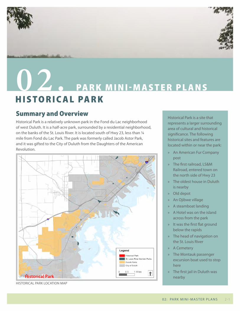
Summary and overviewHistorical Park is a relatively unknown park in the Fond du Lac neighborhood of west Duluth. It is a half-acre park, surrounded by a residential neighborhood, on the banks of the St. Louis River. It is located south of Hwy 23, less than ¼ mile from Fond du Lac Park. The park was formerly called Jacob Astor Park, and it was gifted to the City of Duluth from the Daughters of the American Revolution.
H i S t o r i c a l pa r k02. pa r k m i n i - m a S t e r p l a n S
Historical Park is a site that represents a larger surrounding area of cultural and historical significance. The following historical sites and features are located within or near the park:
» An American Fur Company post
» The first railroad, LS&M Railroad, entered town on the north side of Hwy 23
» The oldest house in Duluth is nearby
» Old depot
» An Ojibwe village
» A steamboat landing
» A Hotel was on the island across from the park
» It was the first flat ground below the rapids
» The head of navigation on the St. Louis River
» A Cemetery
» The Montauk passenger excursion boat used to stop here
» The first jail in Duluth was nearby
2 - 1 02: PA R K M I N I - M A S T E R P L A N S
HISTORICAL PARK LOCATION MAP
historical Park

existing conditionsAt the southern end of 133rd Ave W, Historical Park covers a small piece of wet and wooded land adjacent to the river. There are no formal features to the park other than a small mown area adjacent to road that features granite benches, a flagpole, and a plaque commemorating the history of the park.
In December of 2015, an Archaeological Phase I Survey for Historical Park was completed in coordination with the Duluth Archaeology Center and the City of Duluth Department of Parks and Recreation. Historical and archaeological findings from this report will be considered during any future improvements to the park. In addition, the 2015 Ethnographic Study of Indigenous Contributions to the City of Duluth will be referenced in future park improvements.
HISTORICAL PARK SITE INvENTORY
strengths/oPPortunities: » Great location for pelican
viewing – potential to create and define bird watching areas
» Panoramic views of the river exist in the park
» History of the site includes many opportunities for interpretation
» Potential location for river access, possible stop along the water trail
» Opportunity for carry down canoe/kayak launch
» Potential enhanced fishing access
» Potential path and small clearing in the woods to encourage passive recreation in the park
issues: » Lack of identity and
interpretive signage in the park
» Sensitivity to adjacent land owners, clarify property boundaries visually
» Wooded parcel is overgrown with buckthorn
» Street and sidewalk infrastructure are deteriorating; lack of defined parking areas
» Lack of wayfinding (At intersection of Hwy 23 and 133rd Ave)
» Eroding river bank could be stabilized with in-water habitat structures to improve fish habitat such as eddy creating structures, habitat logs, etc.
» Stormwater runs off the street directly into the St. Louis River without treatment
4 St. Louis River Corridor NEIGHBORHOOD PARKS MINI MASTER PLANS FACILITY INVENTORY AND EVALUATION 5DRAFT 11.18.15 DRAFT 11.18.15
0 10050 Feet
LegendPark boundaryTax Forfeit Parcel
N
HISTORICAL PARKEXISTING CONDITIONS
W 2nd Street
W 3rd Street / Hwy 23
HISTORICAL PARK
ABOUT THE PARK
EXISTING RECREATION FACILITIES
Play areas and Courts Fields PiCniCking trails other
Play equiPment Football Pavilion unPaved great river views
basketball soccer shelter Paved
tennis soFtball tables none
horseshoe baseball Grills winter sPorts
bocce ball hockey rink
volleyball recreation center Pleasure skatinG
other buildinG sleddinG hill
tyPe: cross-country skiinG
USER CONVENIENCES / SUPPORT FACILITIES
benches (2) Fire rinG restrooms Parking
bike rack GarbaGe can indoor restrooms on-street
bleacher liGhtinG oFF-street
drinkinG Fountain FlaG # hdcP sPaces
dumPster Plaques not Present
\
name historiCal Park
address 101 133rd ave wneighborhood Fond du laC
ClassiFiCation mini Park
aCreage 0.5
•Formerly Jacob Astor Park gifted to the City of Duluth from the Daughters of the American Revolution
•Proposed COGGS mountain bike trails 1/4 mile west•Area of cultural/historical significance•1st fur trading outpost•1st railroad coming into town (on the north side of 23)•Oldest house in Duluth is nearby•Old depot nearby
•Great location for pelican viewing•Panoramic views of the river
Benches, flagpole, & plaque
River View
2 - 2 S T. LO u I S R I v E R CO R R I D O R PA R K S M I N I - M A S T E R P L A N S : J u N E 2016

needs assessment/input SummaryAt the stakeholder and community meetings, a desire was expressed for every park in the corridor to have basic amenities, including a bench, a picnic table, and a grill. Wayfinding and directional signage to each park, within each park,
HISTORICAL PARK SITE ANALYSIS
Existing features include benches, a flag, and a historical monument
Current natural surface trails
Historical Park provides river access and is a local fishing spot
and to nearby trails are also desired as a way to promote the parks. Historical interpretation and archaeological considerations are important to this site.
A desire was expressed by stakeholders to clarify the name and provide identity to the park. The name “Historical Park” is new and unfamiliar to many residents. As part of Minnesota’s Clean Water, Land, and Legacy Amendment, there is a potential to write a grant for historical interpretation, art, and wayfinding elements for Historical Park.
6 St. Louis River Corridor NEIGHBORHOOD PARKS MINI MASTER PLANS FACILITY INVENTORY AND EVALUATION 7DRAFT 11.18.15 DRAFT 11.18.15
0 10050 Feet
LegendPark boundaryTax Forfeit Parcel
N
HISTORICAL PARKOPPORTUNITIES
HISTORICAL PARKSITE OBSERVATIONS
OPPORTUNITIES
NOTES & COMMENTS
•Formalize turnaround/parking•Improve signage/wayfinding (At intersection of Hwy 23 and 133rd)•Interpretive signage/kiosk•Create river access/possible stop along water trail•Create a carry down canoe/kayak access•Consider natural shore fishing access and suitable shoreline
enhancements. This includes in-water habitat structures to improve fish habitat such as eddy creating structures, habitat logs, etc.
•Create path/clearing in small woodland to gather/view river•Buckthorn management•Fencing (low key) to separate public vs. private land•Should ATV access be provided within park property?•Investigate opportunities to create stormwater management
practices along 133rd Avenue W. to treat runoff prior to it entering the St. Louis River
•Create and define bird watching areas - pelicans and other water birds are often sighted here
•Sensitivity to adjacent land owners, property boundaries•133rd Avenue ends right at river- panoramic views, no display
terminus of street•Wooded parcel is overgrown with buckthorn •Small mown area adjacent to road has granite benches, flagpole, and
plaque
•Verify property boundary of park•Potential partners
» Fond du Lac Community Club » Historical society » UMD- Environmental Education Fund/ Archaeology Club (anthropology program)
» River Corridor Coalition » St. Louis River Alliance » Fond du Lac Tribe » Active boy scout club (labor)
•Daughters of the American Revolution donated the land to the city•Possible archeological interest – fur trading history or Native
American history•Zenith City Website has more historical information
Add Signage & Wayfinding
W 3rd Street / Hwy 23
W 2nd Street
Enhance River Views
Formalize Turnaround & Parking Area
Improve interpretive
signage/ Add kiosk
Investigate stormwater management
opportunities along 133rd Ave. W
2 - 3 02: PA R K M I N I - M A S T E R P L A N S

133r
d A
venu
e W
W 2nd Street
W 3rd Street / Hwy 23
k
k
Coordinate with 2016 MnDOT reconstruction
plans for Hwy 23
Existing historical interpretation area
(benches, flag & plaque)
Potential Future Western Waterfront Trail extension
0’ 30’ 60’[
Historical Park
Existing Park Boundary
Proposed Stormwater Conveyance
New Signage/Wayfindingk
Add history/river/water quality interpretation kiosk
3
Add hedgerow/buffer7
Formalize existing natural surface trails
4
New signage and wayfinding to improve park visibility
13
Add canoe/kayak launch
Remove buckthorn
12
14
Replace existing sidewalks on both sides of 133rd Ave
2
Create rock outcrops for fishing/river viewing
5
Reconstruct Street, adding parallel parking on both sides (6 spaces)
6
Install new raingardens10
Route runoff into filtration areas8
Plant additional boulevard trees in collaboration
with Public Works/street reconstruction
1
Convert existing street to picnic area; add tables and trash cans
11
Add canoe/kayak drop off area9
Key Features:
• Incorporate conclusions/recommendations for the area from the Archeological Phase I Survey for the Historical Park prepared by the Duluth Archeological Center. » Further investigate identified archeological features before disturbing park grounds. » Expand story telling of Fond du Lac history with informational signage.
• Retain existing historical interpretation area.• Address erosion along the river by adding 3 rock outcrop areas for fishing/river
viewing and working with partners to stabilize banks.• Add canoe/kayak launch.• Formalize natural surface trail through existing floodplain forest.• Make improvements to 133rd Ave W in collaboration with street reconstruction and
Public Works » Formalize turnaround/dropoff area for canoe/kayak loading. » Create waterfront picnic area at southern terminus of 133rd Ave. » Create formalized parking spaces (6+/-). » Repair sidewalks along 133rd Ave.
Figure 2.1 historicaL park mini-master pLan
2 - 4 S T. LO u I S R I v E R CO R R I D O R PA R K S M I N I - M A S T E R P L A N S : J u N E 2016

concept plan & recommendationsThe concept plan for Historical Park addresses identity, wayfinding, natural resources, and recreation improvements. Emphasis was placed on interpreting the history of the site, addressing river access, and providing small areas for gathering and enjoying the natural location along the St. Louis River. Parks will consult the Historic Preservation Commission and the Indigenous Commission moving forward with implementation of the plan.
phasing & cost estimates PhAse 1: short-term
Action cost
# cAtegory descriPtion
3 circulation install new kiosk $7,500
4 circulation Formalize existing nature surface trails $2,100
7 vegetation add hedgerow/buffer $1,600
12 recreation build new canoe/kayak Launch $5,000
13 circulation install new park wayfinding sign $2,000
14 vegetation remove buckthorn and other invasive species $5,000
total short-term improvement costs $23,200
Figure 2.2 historicaL park short-term phasing
Remove buckthorn14
2 - 5 02: PA R K M I N I - M A S T E R P L A N S

Action cost
# cAtegory descriPtion
1 vegetation plant additional boulevard trees $2,800
2 circulation replace existing sidewalk on 133rd ave $21,000
5 recreation create rock outcrop for Fishing/viewing $60,000
6 infrastructure reconstruct street $-
8 stormwater route street runoff into parkland $6,750
9 stormwater install new raingarden/Filtration areas $6,750
10 circulation add new canoe/kayak drop-off area $5,600
11 Furnishings convert existing street into picnic area - add picnic tables & trash cans $5,000
total Long-term improvement costs $105,100
total short-term improvement costs $ 23,200
total improvement costs $128,300
PhAse 2: long-term
Figure 2.3 historicaL park Long-term phasing
2 - 6 S T. LO u I S R I v E R CO R R I D O R PA R K S M I N I - M A S T E R P L A N S : J u N E 2016