part 1. general chapter 1a. general section 1a.01 …...general chapter 1a. general section 1a.01...
TRANSCRIPT

2012 Edition Page 1
January 13, 2012 Chapter 1A, General
PART 1. GENERAL
CHAPTER 1A. GENERAL
Section 1A.01 Purpose of Traffic Control Devices
Support:
01 The purpose of traffic control devices, as well as the principles for their use, is to promote highway safety and efficiency by providing for the orderly movement
02 of all road users on streets, highways, bikeways and private roads open to public travel throughout the Nation.
03 Traffic control devices notify road users of regulations and provide warning and guidance needed for the uniform and efficient operation of all elements of the traffic stream in a manner intended to minimize the occurrences of crashes.
Standard:
04 Traffic control devices or their supports shall not bear any advertising message or any other
message that is not related to traffic control.
Support:
05 Tourist-oriented directional signs and Specific Service signs are not considered advertising; rather, they are classified as motorist service signs.
Section 1A.02 Principles of Traffic Control Devices
Support:
01 This Manual contains the basic principles that govern the design and use of traffic control devices for all streets, highways, bikeways, and private roads open to public travel (see definition in Section 1A.13) regardless of type or class or the public agency, official, or owner having jurisdiction. This Manual’s text specifies the restriction on the use of a device if it is intended for limited application or for a specific system. It is important that these principles be given primary consideration in the selection and application of each device.
Guidance:
02 To be effective, a traffic control device should meet five basic requirements:
A. Fulfill a need; B. Command attention; C. Convey a clear, simple meaning; D. Command respect from road users; and E. Give adequate time for proper response.
03 Design, placement, operation, maintenance, and uniformity are aspects that should be carefully considered in order to maximize the ability of a traffic control device to meet the five requirements listed in the previous paragraph. Vehicle speed should be carefully considered as an element that governs the design, operation, placement, and location of various traffic control devices.
Support:
04 The definition of the word “speed” varies depending on its use. The definitions of specific speed terms are contained in Section 1A.13.
Guidance:
05 The actions required of road users to obey regulatory devices are specified by the Ohio Revised Code
(ORC), or in cases not covered by State statute, by local ordinance or resolution.
06 The proper use of traffic control devices should provide the reasonable and prudent road user with the information necessary to efficiently and lawfully use the streets, highways, pedestrian facilities, and bikeways.

Page 2 2012 Edition
Chapter 1A, General January 13, 2012
Support:
07 Uniformity of the meaning of traffic control devices is vital to their effectiveness. The meanings ascribed to devices in this Manual are in general accord with the publications mentioned in Section 1A.11.
08 Additional information regarding related sections of the Ohio Revised Code (ORC) is provided in Appendices B1 and B2.
Section 1A.03 Design of Traffic Control Devices
Guidance:
01 Devices should be designed so that features such as size, shape, color, composition, lighting or retroreflection, and contrast are combined to draw attention to the devices; that size, shape, color, and simplicity of message combine to produce a clear meaning; that legibility and size combine with placement to permit adequate time for response; and that uniformity, size, legibility, and reasonableness of the message combine to command respect.
02 Aspects of a device’s standard design should be modified only if there is a demonstrated need.
Support:
03 An example of modifying a device’s design would be to modify the Combination Horizontal Alignment/Intersection (W1-10) sign to show intersecting side road on both sides rather than on just one side of the major road within the curve.
Option:
04 With the exception of symbols and colors, minor modifications in the specific design elements of a device may be made provided the essential appearance characteristics are preserved.
Section 1A.04 Placement and Operation of Traffic Control Devices
Guidance:
01 Placement of a traffic control device should be within the road user’s view so that adequate visibility is provided. To aid in conveying the proper meaning, the traffic control device should be appropriately positioned with respect to the location, object, or situation to which it applies. The location and legibility of the traffic control device should be such that a road user has adequate time to make the proper response in both day and night conditions.
02 Traffic control devices should be placed and operated in a uniform and consistent manner.
03 Unnecessary traffic control devices should be removed. The fact that a device is in good physical condition should not be a basis for deferring needed removal or change.
Section 1A.05 Maintenance of Traffic Control Devices
Guidance:
01 Functional maintenance of traffic control devices should be used to determine if certain devices need to be changed to meet current traffic conditions.
02 Physical maintenance of traffic control devices should be performed to retain the legibility and visibility of the device, and to retain the proper functioning of the device.
Support:
03 Clean, legible, properly mounted devices in good working condition command the respect of road users.
Section 1A.06 Uniformity of Traffic Control Devices
Support:
01 Uniformity of devices simplifies the task of the road user because it aids in recognition and understanding, thereby reducing perception/reaction time. Uniformity assists road users, law enforcement officers, and traffic courts by giving everyone the same interpretation. Uniformity assists public highway officials through efficiency in manufacture, installation, maintenance, and administration. Uniformity means treating similar situations in a similar way. The use of uniform traffic control devices does not, in itself, constitute uniformity. A standard device used where it is not appropriate is as objectionable as a nonstandard device; in fact, this

2012 Edition Page 3
January 13, 2012 Chapter 1A, General
might be worse, because such misuse might result in disrespect at those locations where the device is needed and appropriate.
Section 1A.07 Responsibility for Traffic Control Devices
Support:
01 As noted in the Introduction, the ―Ohio Manual of Uniform Traffic Control Devices‖ (OMUTCD) has been developed pursuant to Section 4511.09 of the ORC, to establish standards for the use of traffic control devices in the State of Ohio. ORC Section 4511.09 also requires that the ―uniform system of traffic control devices‖ established in the OMUTCD ―correlate with, and so far as possible conform to, the system approved by the federal highway administration.‖
02 23 CFR (Code of Federal Regulations) 655.603 requires that such State manuals be in substantial
conformance with the National MUTCD, published by the Federal Highway Administration
(FHWA). 03 23 CFR 655.603 also states that traffic control devices on all streets, highways, bikeways, and private
roads open to public travel in each State shall be in substantial conformance with standards issued or endorsed by the Federal Highway Administrator.
Standard:
04 As provided in ORC Sections 4511.09, 4511.10 and 4511.11, the responsibility for the design,
placement, operation, maintenance, and uniformity of traffic control devices shall rest with the public
agency or the official having jurisdiction, or, in the case of private roads open to public travel, with
the private owner or private official having jurisdiction (see Appendix B2).
Support:
05 The Introduction of this Manual contain information regarding the meaning of substantial conformance and the applicability of the OMUTCD to private roads open to public travel.
06 The National MUTCD has been adopted by the National Park Service, the U.S. Forest Service, the U.S. Military Command, the Bureau of Indian Affairs, the Bureau of Land Management and the U.S. Fish and Wildlife Service.
Section 1A.08 Authority for Placement of Traffic Control Devices
Standard:
01 Traffic control devices, advertisements, announcements, and other signs or messages within the
highway right-of-way shall be placed only as authorized by a public authority or the official having
jurisdiction, or, in the case of private roads open to public travel, by the private owner or private
official having jurisdiction, for the purpose of regulating, warning, or guiding traffic.
02 When the public agency or the official having jurisdiction over a street or highway or, in the case
of private roads open to public travel, by the private owner or private official having jurisdiction, has
granted proper authority, others such as contractors and public utility companies shall be permitted
to install temporary traffic control devices in temporary traffic control zones. Such traffic control
devices shall conform with the Standards of this Manual.
03 All regulatory traffic control devices shall be supported by laws, ordinances, or regulations.
Support:
04 Provisions of this Manual are based upon the concept that effective traffic control depends upon both appropriate application of the devices and reasonable enforcement of the regulations.
05 Although some highway design features, such as curbs, median barriers, guardrails, speed humps or tables, and textured pavement, have a significant impact on traffic operations and safety, they are not considered to be traffic control devices and provisions regarding their design and use are generally not included in this Manual.
06 Certain types of signs and other devices that do not have any traffic control purpose are sometimes placed within the highway right-of-way by or with the permission of the public agency or the official having jurisdiction over the street or highway. Most of these signs and other devices are not intended for use by road users in general, and their message is only important to individuals who have been instructed in their meanings.

Page 4 2012 Edition
Chapter 1A, General January 13, 2012
These signs and other devices are not considered to be traffic control devices and provisions regarding their design and use are not included in this Manual. Among these signs and other devices are the following:
A. Devices whose purpose is to assist highway maintenance personnel. Examples include markers to guide snowplow operators, devices that identify culvert and drop inlet locations, and devices that precisely identify highway locations for maintenance or mowing purposes.
B. Devices whose purpose is to assist fire or law enforcement personnel. Examples include markers that identify fire hydrant locations, signs that identify fire or water district boundaries, speed measurement pavement markings, small indicator lights to assist in enforcement of red light violations, and photo enforcement systems.
C. Devices whose purpose is to assist utility company personnel and highway contractors, such as markers that identify underground utility locations.
D. Signs posting local non-traffic ordinances. E. Signs giving civic organization meeting information.
Standard:
07 Signs and other devices that do not have any traffic control purpose that are placed within the
highway right-of-way shall not be located where they will interfere with, or detract from, traffic
control devices.
Guidance:
08 Any unauthorized traffic control device or other sign or message placed on the highway right-of-way by a private organization or individual constitutes a public nuisance and should be removed. All unofficial or nonessential traffic control devices, signs, or messages should be removed.
Support:
09 Section 4511.16 of the Ohio Revised Code (ORC) prohibits the display of any unauthorized sign, signal, marking or device which interferes with the effectiveness of any official traffic control device and permits its removal by the authority having jurisdiction over the street or highway (see Appendix B2).
Section 1A.09 Engineering Study and Engineering Judgment
Support:
01 Definitions of an engineering study and engineering judgment are contained in Section 1A.13.
Standard:
02 This Manual describes the application of traffic control devices, but shall not be a legal
requirement for their installation.
Guidance:
03 The decision to use a particular device at a particular location should be made on the basis of either an engineering study or the application of engineering judgment. Thus, while this Manual provides Standards, Guidance, and Options for design and application of traffic control devices, this Manual should not be considered a substitute for engineering judgment.
04 Early in the process of location and design of roads and streets, engineers should coordinate such location and design with the design and placement of the traffic control devices to be used with such roads and streets.
05 Jurisdictions, or owners of private roads open to public travel, with responsibility for traffic control that do not have engineers on their staffs who are trained and/or experienced in traffic control devices should seek engineering assistance from others, such as the Ohio Department of Transportation (ODOT), their county, a nearby large city, or a traffic engineering consultant.
Standard:
06 If site-specific conditions lead agencies to determine that it is impossible or impractical to comply with a particular Standard and that they must deviate from the Standard at that location(s), the reasons for the deviation shall be fully documented.
Support:
07 As part of the Federal-aid Program, each State is required to have a Local Technical Assistance Program (LTAP) and to provide technical assistance to local highway agencies. Requisite technical training in the

2012 Edition Page 5
January 13, 2012 Chapter 1A, General
application of the principles of the OMUTCD is available from the State’s Local Technical Assistance Program for needed engineering guidance and assistance.
Section 1A.10 Interpretations, Experimentations, Changes, and Interim Approvals
Standard:
01 Design, application, and placement of traffic control devices other than those adopted in this
Manual shall be prohibited unless the provisions of this Section are followed.
Support:
02 Continuing advances in technology will produce changes in the highway, vehicle, and road user proficiency; therefore, portions of the system of traffic control devices in this Manual will require updating. In addition, unique situations often arise for device applications that might require interpretation or clarification of this Manual. It is important to have a procedure for recognizing these developments and for introducing new ideas and modifications into the system.
Standard:
03 Except as provided in Paragraph 5, requests for any permission to experiment or interim
approval shall be submitted electronically to the Federal Highway Administration (FHWA), Office of
Transportation Operations, MUTCD team, at the following e-mail address:
[email protected]. A copy of the request shall be sent to the of the Ohio Department of Transportation (ODOT), Office of Traffic Engineering (see page ii for contact information).
04 Requests for interpretations or changes shall be sent to the Ohio Department of Transportation (ODOT), Office of Traffic Engineering (see page ii for contact information).
Option:
05 If electronic submission to FHWA is not possible, requests for permission to experiment or interim approval may instead be mailed to the Office of Transportation Operations, HOTP-1, Federal Highway Administration, 1200 New Jersey Avenue, SE, Washington, DC 20590.
Support:
06 Communications to FHWA regarding other MUTCD matters that are not related to official requests will receive quicker attention if they are submitted electronically to the MUTCD Team Leader or to the appropriate individual MUTCD team member. Their e-mail addresses are available through the links contained on the “Who’s Who” page on the MUTCD website at http://mutcd.fhwa.dot.gov/team.htm.
Support:
07 An interpretation includes a consideration of the application and operation of standard traffic control devices, official meanings of standard traffic control devices, or the variations from standard device designs.
Guidance:
08 Requests for an interpretation of this Manual should contain the following information:
A. A concise statement of the interpretation being sought; B. A description of the condition that provoked the need for an interpretation; C. Any illustration that would be helpful to understand the request; and D. Any supporting research data that is pertinent to the item to be interpreted.
Support:
09 Requests to experiment include consideration of field deployment for the purpose of testing or evaluating a new traffic control device, its application or manner of use, or a provision not specifically described in this Manual.
10 A request for permission to experiment will be considered only when submitted by the public agency or toll facility operator responsible for the operation of the road or street on which the experiment is to take place. For a private road open to public travel, the request will be considered only if it is submitted by the private owner or private official having jurisdiction.
11 A diagram indicating the process for experimenting with traffic control devices is shown in Figure 1A-1.
Guidance:
12 The request to FHWA for permission to experiment should contain the following:

Page 6 2012 Edition
Chapter 1A, General January 13, 2012
A. A statement indicating the nature of the problem. B. A description of the proposed change to the traffic control device or application of the traffic
control device, how it was developed, the manner in which it deviates from the standard, and how it is expected to be an improvement over existing standards.
C. Any illustration that would be helpful to understand the traffic control device or use of the traffic control device.
D. Any supporting data explaining how the traffic control device was developed, if it has been tried, in what ways it was found to be adequate or inadequate, and how this choice of device or application was derived.
E. A legally binding statement certifying that the concept of the traffic control device is not protected by a patent or copyright. (An example of a traffic control device concept would be countdown pedestrian signals in general. Ordinarily an entire general concept would not be patented or copyrighted, but if it were it would not be acceptable for experimentation unless the patent or copyright owner signs a waiver of rights acceptable to the FHWA. An example of a patented or copyrighted specific device within the general concept of countdown pedestrian signals would be a manufacturer’s design for its specific brand of countdown signal, including the design details of the housing or electronics that are unique to that manufacturer’s product. As long as the general concept is not patented or copyrighted, it is acceptable for experimentation to incorporate the use of one or more patented devices of one or several manufacturers.)
F. The time period and location(s) of the experiment. G. A detailed research or evaluation plan that must provide for close monitoring of the
experimentation, especially in the early stages of its field implementation. The evaluation plan should include before and after studies as well as quantitative data describing the performance of the experimental device.
H. An agreement to restore the site of the experiment to a condition that complies with the provisions of this Manual within 3 months following the end of the time period of the experiment. This agreement must also provide that the agency sponsoring the experimentation will terminate the experimentation at any time that it determines significant safety concerns are directly or indirectly attributable to the experimentation. The FHWA’s Office of Transportation Operations has the right to terminate approval of the experimentation at any time if there is an indication of safety concerns. If, as a result of the experimentation, a request is made that the National Manual be changed to include the device or application being experimented with, the device or application will be permitted to remain in place until an official rulemaking action has occurred.
I. An agreement to provide semiannual progress reports for the duration of the experimentation, and an agreement to provide a copy of the final results of the experimentation to the FHWA’s Office of Transportation Operations within 3 months following completion of the experimentation. The FHWA’s Office of Transportation Operations has the right to terminate approval of the experimentation if reports are not provided in accordance with this schedule.
Support:
13 A change to the Manual includes consideration of a new device to replace a present standard device, an additional device to be added to the list of standard devices, or a revision to a traffic control device application or placement criteria.
Guidance:
14 Requests for a change to this Manual should contain the following information:
A. A statement indicating what change is proposed; B. Any illustration that would be helpful to understand the request; and C. Any supporting research data that is pertinent to the item to be reviewed.
Support:
15 Interim approval by FHWA allows interim use, pending official rulemaking, of a new traffic control device, a revision to the application or manner of use of an existing traffic control device, or a provision not specifically described in this Manual. The FHWA issues an Interim Approval by official memorandum signed by the Associate Administrator for Operations and posts this memorandum on the MUTCD website. The

2012 Edition Page 7
January 13, 2012 Chapter 1A, General
Figure 1A-1. Process for Requesting and Conducting Experimentations for New Traffic Control Devices
issuance by FHWA of an interim approval will typically result in the traffic control device or application being placed into the next scheduled rulemaking process for revisions to the National Manual.
16 Interim approval is considered based on the results of successful experimentation, results of analytical or laboratory studies, and/or review of non-U.S. experience with a traffic control device or application. Interim approval considerations include an assessment of relative risks, benefits, costs, impacts, and other factors.
17 Interim approval allows for optional use of a traffic control device or application and does not create a new mandate or recommendation for use. Interim approval includes conditions that jurisdictions agree to comply with in order to use the traffic control device or application until an official rulemaking action has occurred.
Standard:
18 A jurisdiction, toll facility operator, or owner of a private road open to public travel that desires
to use a traffic control device for which FHWA has issued an interim approval shall request
permission from FHWA.

Page 8 2012 Edition
Chapter 1A, General January 13, 2012
Guidance:
19 The request for permission to place a traffic control device under an interim approval should contain the following:
A. A description of where the device will be used, such as a list of specific locations or highway segments or types of situations, or a statement of the intent to use the device jurisdiction-wide;
B. An agreement to abide by the specific conditions for use of the device as contained in the FHWA’s interim approval document;
C. An agreement to maintain and continually update a list of locations where the device has been installed; and 1. An agreement to:Restore the site(s) of the interim approval to a condition that complies with the
provisions in this Manual within 3 months following the issuance of a Final Rule on this traffic control device; and
2. Terminate use of the device or application installed under the interim approval at any time that it determines significant safety concerns are directly or indirectly attributable to the device or application. The FHWA’s Office of Transportation Operations has the right to terminate the interim approval at any time if there is an indication of safety concerns.
Option:
20 The Ohio Department of Transportation (ODOT) may submit a request for use of a device under interim approval for all jurisdictions in the State, as long as the request contains the information listed in Paragraph 19.
Guidance:
21 A local jurisdiction, toll facility operator, or owner of a private road open to public travel using a traffic control device or application under an interim approval that was granted by FHWA either directly or on a statewide basis based on ODOT’s request should inform ODOT of the locations of such use.
22 A local jurisdiction, toll facility operator, or owner of a private road open to public travel that is requesting permission to experiment or permission to use a device or application under an interim approval should first check for any State laws and/or directives covering the application of OMUTCD provisions that might exist.
Option:
23 A device or application installed under an interim approval may remain in place, under the conditions established in the interim approval, until an official rulemaking action has occurred.
Support:
24 A diagram outlining FHWA’s process for incorporating new traffic control devices into the National
MUTCD is shown in Figure 1A-2.
25 For additional information concerning interpretations, experimentation, changes, or interim approvals, visit the MUTCD website at http://mutcd.fhwa.dot.gov or contact the ODOT, Office of Traffic Engineering at the addresses provided on page ii.
Section 1A.11 Relation to Other Publications
Standard:
01 To the extent that they are incorporated by specific reference, the latest editions of the following
publications, or those editions specifically noted, shall be a part of this Manual: the current “Sign
Designs and Markings Manual” (SDMM), published by ODOT; and “Color Specifications for
Retroreflective Sign and Pavement Marking Materials” (appendix to subpart F of Part 655 of Title 23
of the Code of Federal Regulations).
Support:
02 The ―Sign Designs and Markings Manual‖ includes standard alphabets and symbols and arrows for signs and pavement markings.
03 For information about publications from the Federal Highway Administration, visit FHWA’s MUTCD website at http://mutcd.fhwa.dot.gov, or write to the FHWA, 400 Seventh Street, SW, HOTO, Washington, DC 20590.

2012 Edition Page 9
January 13, 2012 Chapter 1A, General
Figure 1A-2. Process for Incorporating New Traffic Control Devices into the National MUTCD

Page 10 2012 Edition
Chapter 1A, General January 13, 2012
04 For information about publications published by the Ohio Department of Transportation (ODOT), visit the ODOT reference resource website at www.dot.state.oh.us/drrc, or write to the ODOT Office of Contracts, 1980 West Broad Street, P.O. Box 899, Columbus, Ohio 43216-0899.
05 Other publications that are useful sources of information with respect to use of this Manual are listed in this paragraph. See the Preface of this Manual for ordering information for the following publications (later editions might also be available as useful sources of information):
1. “AAA School Safety Patrol Operations Manual,” 2006 Edition (American Automobile Association—AAA)
2. “A Policy on Geometric Design of Highways and Streets,” 2004 Edition (American Association of State Highway and Transportation Officials—AASHTO)
3. “Guide for the Development of Bicycle Facilities,” 1999 Edition (AASHTO) 4. “Guide for the Planning, Design, and Operation of Pedestrian Facilities,” 2004 Edition (AASHTO) 5. “Guide to Metric Conversion,” 1993 Edition (AASHTO) 6. “Guidelines for the Selection of Supplemental Guide Signs for Traffic Generators Adjacent to
Freeways,” 4th Edition/Guide Signs, Part II: Guidelines for Airport Guide Signing/Guide Signs, Part III: List of Control Cities for Use in Guide Signs on Interstate Highways,” Item Code: GSGLC-4, 2001 Edition (AASHTO)
7. “Roadside Design Guide,” 2006 Edition (AASHTO) 8. “Standard Specifications for Movable Highway Bridges,” 1988 Edition (AASHTO) 9. “Traffic Engineering Metric Conversion Folders—Addendum to the Guide to Metric Conversion,”
1993 Edition (AASHTO) 10. “2009 AREMA Communications & Signals Manual,” (American Railway Engineering &
Maintenance-of-Way Association—AREMA) 11. “Changeable Message Sign Operation and Messaging Handbook (FHWA-OP-03-070),” 2004
Edition (Federal Highway Administration—FHWA) 12. “Designing Sidewalks and Trails for Access—Part 2—Best Practices Design Guide (FHWA-EP-01-
027),” 2001 Edition (FHWA) 13. “Federal-Aid Highway Program Guidance on High Occupancy Vehicle (HOV) Lanes,” 2001
(FHWA) 14. “Maintaining Traffic Sign Retroreflectivity,” 2007 Edition (FHWA) 15. “Railroad-Highway Grade Crossing Handbook—Revised Second Edition (FHWA-SA-07-010),”
2007 Edition (FHWA) 16. “Ramp Management and Control Handbook (FHWA-HOP-06-001),” 2006 Edition (FHWA) 17. “Roundabouts-An Informational Guide (FHWA-RD-00-067),” 2000 Edition (FHWA) 18. “Signal Timing Manual (FHWA-HOP-08-024),” 2008 Edition (FHWA) 19. “Signalized Intersections: an Informational Guide (FHWA-HRT-04-091),” 2004 Edition (FHWA)
20. “Travel Better, Travel Longer: A Pocket Guide to Improving Traffic Control and Mobility for Our Older Population (FHWA-OP-03-098),” 2003 Edition (FHWA)
21. “Practice for Roadway Lighting,” RP-8, 2001 (Illuminating Engineering Society—IES) 22. “Safety Guide for the Prevention of Radio Frequency Radiation Hazards in the Use of Commercial
Electric Detonators (Blasting Caps),” Safety Library Publication No. 20, July 2001 Edition (Institute of Makers of Explosives)
23. “American National Standard for High-Visibility Public Safety Vests,” (ANSI/ISEA 207-2006), 2006 Edition (International Safety Equipment Association—ISEA)
24. “American National Standard for High-Visibility Safety Apparel and Headwear,” (ANSI/ISEA 107-2004), 2004 Edition (ISEA)
25. “Manual of Traffic Signal Design,” 1998 Edition (Institute of Transportation Engineers—ITE) 26. “Manual of Transportation Engineering Studies,” 1994 Edition (ITE) 27. “Pedestrian Traffic Control Signal Indications,” Part 1—1985 Edition; Part 2 (LED Pedestrian
Traffic Signal Modules)—2004 Edition (ITE) 28. “Preemption of Traffic Signals Near Railroad Crossings,” 2006 Edition (ITE) 29. “Purchase Specification for Flashing and Steady Burn Warning Lights,” 1981 Edition (ITE) 30. “Traffic Control Devices Handbook,” 2001 Edition (ITE) 31. “Traffic Detector Handbook,” 1991 Edition (ITE) 32. “Traffic Engineering Handbook,” 2009 Edition (ITE)

2012 Edition Page 11
January 13, 2012 Chapter 1A, General
33. “Traffic Signal Lamps,” 1980 Edition (ITE) 34. “Vehicle Traffic Control Signal Heads,” Part 1—1985 Edition; Part 2 (LED Circular Signal
Supplement)—2005 Edition; Part 3 (LED Vehicular Arrow Traffic Signal Supplement)—2004 Edition (ITE)
35. “Uniform Vehicle Code (UVC) and Model Traffic Ordinance,” 2000 Edition (National Committee on Uniform Traffic Laws and Ordinances—NCUTLO)
36. “NEMA Standards Publication TS 4-2005 Hardware Standards for Dynamic Message Signs (DMS) With NTCIP Requirements,” 2005 Edition (National Electrical Manufacturers Association—NEMA)
37. “Occupational Safety and Health Administration Regulations (Standards - 29 CFR), General Safety and Health Provisions - 1926.20,” amended June 30, 1993 (Occupational Safety and Health Administration—OSHA)
38. “Accessible Pedestrian Signals—A Guide to Best Practices (NCHRP Web-Only Document 117A),” 2008 Edition (Transportation Research Board—TRB)
39. “Guidelines for Accessible Pedestrian Signals (NCHRP Web-Only Document 117B),” 2008 Edition (TRB)
40. “Highway Capacity Manual,” 2000 Edition (TRB) 41. “Recommended Procedures for the Safety Performance Evaluation of Highway Features,” (NCHRP
Report 350), 1993 Edition (TRB) 42. “The Americans with Disabilities Act Accessibility Guidelines for Buildings and Facilities
(ADAAG),” July 1998 Edition (The U.S. Access Board) 43. ―Ohio Revised Code‖ 44. ―Traffic Engineering Manual,‖ current Edition (ODOT) 45. ―Manual on Uniform Traffic Control Devices,‖ 2009 Edition (FHWA) 46. ―Location & Design Manual, Volume One – Roadway Design,‖ current Edition (ODOT) 47. ―Manual for Assessing Safety Hardware‖ (AASHTO)
Section 1A.12 Color Code
Support:
01 The following color code establishes general meanings for 11 colors of a total of 13 colors that have been identified as being appropriate for use in conveying traffic control information. Tolerance limits for each color are contained in 23 CFR Part 655, Appendix to Subpart F and are available at the Federal Highway Administration’s MUTCD website at http://mutcd.fhwa.dot.gov or by writing to the FHWA, Office of Safety Research and Development (HRD-T-301), 6300 Georgetown Pike, McLean, VA 22101.
02 The two colors for which general meanings have not yet been assigned are being reserved for future applications that will be determined only by FHWA after consultation with the States, the engineering community, and the general public. The meanings described in this Section are of a general nature. More specific assignments of colors are given in the individual Parts of this Manual relating to each class of devices.
Standard:
03 The general meaning of the 13 colors shall be as follows:
A. Black—regulation
B. Blue—road user services guidance, tourist information, and evacuation route
C. Brown—recreational and cultural interest area guidance
D. Coral—unassigned
E. Fluorescent Pink—incident management
F. Fluorescent Yellow-Green—pedestrian warning, bicycle warning, playground warning, school
bus and school warning
G. Green—indicated movements permitted, direction guidance
H. Light Blue—unassigned
I. Orange—temporary traffic control
J. Purple—lanes restricted to use only by vehicles with registered electronic toll collection (ETC)
accounts
K. Red—stop or prohibition
L. White—regulation

Page 12 2012 Edition
Chapter 1A, General January 13, 2012
M. Yellow—warning
Section 1A.13 Definitions of Headings, Words and Phrases in This Manual
Standard:
01 When used in this Manual, the text headings of Standard, Guidance, Option, and Support shall be
defined as follows:
A. Standard—a statement of required, mandatory, or specifically prohibitive practice regarding
a traffic control device. All Standard statements are labeled, and the text appears in bold type.
The verb “shall” is typically used. The verbs “should” and “may” are not used in Standard
statements. Standard statements are sometimes modified by Options. Standard statements
shall not be modified or compromised based on engineering judgment or engineering study.
B. Guidance—a statement of recommended, but not mandatory, practice in typical situations,
with deviations allowed if engineering judgment or engineering study indicates the deviation
to be appropriate. All Guidance statements are labeled, and the text appears in unbold type.
The verb “should” is typically used. The verbs “shall” and “may” are not used in Guidance
statements. Guidance statements are sometimes modified by Options.
C. Option—a statement of practice that is a permissive condition and carries no requirement or
recommendation. Option statements contain allowable modifications to a Standard or
Guidance statement. All Option statements are labeled, and the text appears in unbold type.
The verb “may” is typically used. The verbs “shall” and “should” are not used in Option
statements.
D. Support—an informational statement that does not convey any degree of mandate,
recommendation, authorization, prohibition, or enforceable condition. Support statements are
labeled, and the text appears in unbold type. The verbs “shall,” “should,” and “may” are not
used in Support statements.
02 Unless otherwise defined in this Section, or in other Parts of this Manual, words or phrases shall
have the meaning(s) as defined in the most recent editions of the “AASHTO Transportation Glossary
(Highway Definitions),” and other publications mentioned in Section 1A.11.
03 The following words and phrases, when used in this Manual, shall have the following meanings:
1. Accessible Pedestrian Signal—a device that communicates information about pedestrian
signal timing in non-visual format such as audible tones, speech messages, and/or vibrating
surfaces.
2. Accessible Pedestrian Signal Detector—a device designated to assist the pedestrian who has
visual or physical disabilities in activating the pedestrian phase.
3. Active Grade Crossing Warning System—the flashing-light signals, with or without warning
gates, together with the necessary control equipment used to inform road users of the
approach or presence of rail traffic at grade crossings.
4. Actuated Operation—a type of traffic control signal operation in which some or all signal
phases are operated on the basis of actuation.
5. Actuation—initiation of a change in or extension of a traffic signal phase through the
operation of any type of detector.
6. Advance Preemption—the notification of approaching rail traffic that is forwarded to the
highway traffic signal controller unit or assembly by the railroad or light rail transit
equipment in advance of the activation of the railroad or light rail transit warning devices.
7. Advance Preemption Time—the period of time that is the difference between the required
maximum highway traffic signal preemption time and the activation of the railroad or light
rail transit warning devices.
8. Advisory Speed—a recommended speed for all vehicles operating on a section of highway and
based on the highway design, operating characteristics, and conditions.
9. Alley—“a street or highway intended to provide access to the rear or side of lots or buildings
in urban districts and not intended for the purpose of through vehicular traffic, and includes any street or highway that has been declared an “alley” by the legislative authority of the municipal corporation in which such street or highway is located.” [4511.01(XX), ORC]

2012 Edition Page 13
January 13, 2012 Chapter 1A, General
10. Altered Speed Zone—a speed limit, other than a statutory speed limit, that is based upon an
engineering study.
11. Approach—all lanes of traffic moving towards an intersection or a midblock location from
one direction, including any adjacent parking lane(s).
12. Arterial Highway (Street)—“any United States or state numbered route, controlled access highway, or other major radial or circumferential street or highway designated by local authorities within their respective jurisdictions as part of a major arterial system of streets or highways.” [4511.01(CCC), ORC]
13. Attended Lane (Manual Lane)—a toll lane adjacent to a toll booth occupied by a human toll
collector who makes change, issues receipts, and perform other toll-related functions.
Attended lanes at toll plazas typically require vehicles to stop to pay the toll.
14. Automatic Lane—see Exact Change Lane.
15. Average Annual Daily Traffic (AADT)—the total volume of traffic passing a point or segment
of a highway facility in both directions for one year divided by the number of days in the year.
Normally, periodic daily traffic volumes are adjusted for hours of the day counted, days of the
week, and seasons of the year to arrive at average annual daily traffic.
16. Average Daily Traffic (ADT)—the average 24 hour volume, being the total volume during a
stated period divided by the number of days in that period. Normally, this would be periodic
daily traffic volumes over several days, not adjusted for days of the week or seasons of the
year.
17. Average Day—a day representing traffic volumes normally and repeatedly found at a
location, typically a weekday when volumes are influenced by employment or a weekend day
when volumes are influenced by entertainment or recreation.
18. Backplate—see Signal Backplate.
19. Barrier-Separated Lane—a preferential lane or other special purpose lane that is separated
from the adjacent general-purpose lane(s) by a physical barrier.
20. Beacon—“a highway traffic signal with one or more signal sections that operate in a flashing
mode.” [4511.01(KKK), ORC]
21. Bicycle—“every device, other than a tricycle designed solely for use as a play vehicle by a child, propelled solely by human power upon which any person may ride having two tandem wheels, or one wheel in the front and two wheels in the rear, or two wheels in the front and one wheel in the rear, any of which is more than fourteen inches in diameter.” [4511.01(G), ORC]
22. Bicycle Facilities—a general term denoting improvements and provisions that accommodate
or encourage bicycling, including parking and storage facilities, and shared roadways not
specifically defined for bicycle use.
23. Bicycle Lane—a portion of a roadway that has been designated for preferential or exclusive
use by bicyclists by pavement markings and, if used, signs.
24. Bikeway—a generic term for any road, street, path, or way that in some manner is specifically
designated for bicycle travel, regardless of whether such facilities are designated for the
exclusive use of bicycles or are to be shared with other transportation modes.
25. Buffer-Separated Lane—a preferential lane or other special purpose lane that is separated
from the adjacent general-purpose lane(s) by a pattern of standard longitudinal pavement
markings that is wider than a normal or wide lane line marking. The buffer area might
include rumble strips, textured pavement, or channelizing devices such as tubular markers or
traversable curbs, but does not include a physical barrier.
26. Cantilevered Signal Structure—a structure, also referred to as a mast arm, that is rigidly
attached to a vertical pole and is used to provide overhead support of highway traffic signal
faces or grade crossing signal units.
27. Center Line Markings—the yellow pavement marking line(s) that delineates the separation of
traffic lanes that have opposite directions of travel on a roadway. These markings need not be
at the geometrical center of the pavement.
28. Changeable Message Sign—a sign that is capable of displaying more than one message (one of
which might be a “blank” display), changeable manually, by remote control, or by automatic
control. Electronic-display changeable message signs are referred to as Dynamic Message
Signs in the National Intelligent Transportation Systems (ITS) Architecture and are referred

Page 14 2012 Edition
Chapter 1A, General January 13, 2012
to as Variable Message Signs in the National Electrical Manufacturers Association (NEMA)
standards publication.
29. Channelizing Line Markings—a wide or double solid white line used to form islands where
traffic in the same direction of travel is permitted on both sides of the island.
30. Circular Intersection—an intersection that has an island, generally circular in design, located
in the center of the intersection where traffic passes to the right of the island. Circular
intersections include roundabouts, rotaries, and traffic circles.
31. Circulatory Roadway—the roadway within a circular intersection on which traffic travels in a
counterclockwise direction around an island in the center of the circular intersection.
32. Clear Storage Distance— when used in Part 8, the distance available for vehicle storage
measured between 6 feet from the rail nearest the intersection to the intersection stop line or
the normal stopping point on the highway. At skewed grade crossings and intersections, the 6-
foot distance shall be measured perpendicular to the nearest rail either along the center line or
edge line of the highway, as appropriate, to obtain the shorter distance. Where exit gates are
used, the distance available for vehicle storage is measured from the point where the rear of
the vehicle would be clear of the exit gate arm. In cases where the exit gate arm is parallel to
the track(s) and is not perpendicular to the highway, the distance is measured either along the
center line or edge line of the highway, as appropriate, to obtain the shorter distance.
33. Clear Zone—the total roadside border area, starting at the edge of the traveled way, that is
available for an errant driver to stop or regain control of a vehicle. This area might consist of
a shoulder, a recoverable slope, and/or a non-recoverable, traversable slope with a clear run-
out area at its toe.
34. Collector Highway—a term denoting a highway that in rural areas connects small towns and
local highways to arterial highways, and in urban areas provides land access and traffic
circulation within residential, commercial, and business areas and connects local highways to
the arterial highways.
35. Concurrent Flow Preferential Lane—a preferential lane that is operated in the same direction
as the adjacent mixed flow lanes, separated from the adjacent general-purpose freeway lanes
by a standard lane stripe, painted buffer, or barrier.
36. Conflict Monitor—a device used to detect and respond to improper or conflicting signal
indications and improper operating voltages in a traffic controller assembly.
37. Constant Warning Time Detection—a means of detecting rail traffic that provides relatively
uniform warning time for the approach of trains or light rail transit traffic that are not
accelerating or decelerating after being detected.
38. Contiguous Lane—a lane, preferential or otherwise, that is separated from the adjacent
lane(s) only by a normal or wide lane line marking. 39. Contrast Ratio—see Luminance Contrast.
40. Controller Assembly—a complete electrical device mounted in a cabinet for controlling the
operation of a highway traffic signal.
41. Controller Unit—that part of a controller assembly that is devoted to the selection and timing
of the display of signal indications.
42. Conventional Road—a street or highway other than a low-volume road (as defined in Section
5A.01), expressway, or freeway.
43. Counter-Flow Lane—a lane operating in a direction opposite to the normal flow of traffic
designated for peak direction of travel during at least a portion of the day. Counter-flow lanes
are usually separated from the off-peak direction lanes by tubular markers or other flexible
channelizing devices, temporary lane separators, or moveable or permanent barrier.
44. Crashworthy—a characteristic of a roadside appurtenance that has been successfully crash
tested in accordance with a national standard such as the National Cooperative Highway
Research Program Report 350, “Recommended Procedures for the Safety Performance
Evaluation of Highway Features,” or the “Manual for Assessing Safety Hardware” (MASH).
45. Crosswalk—“means:
(1) That part of a roadway at intersections ordinarily included within the real or projected
prolongation of property lines and curb lines or, in the absence of curbs, the edges of the
traversable roadway;

2012 Edition Page 15
January 13, 2012 Chapter 1A, General
(2) Any portion of a roadway at an intersection or elsewhere, distinctly indicated for
pedestrian crossing by lines or other markings on the surface; (3) Notwithstanding divisions (LL)(1) and (2) of this section, there shall not be a crosswalk
where local authorities have placed signs indicating no crossing.” [4511.01(LL), ORC]
46. Crosswalk Lines—white pavement marking lines that identify a crosswalk.
47. Cycle Length—the time required for one complete sequence of signal indications.
48. Dark Mode—the lack of all signal indications at a signalized location. (The dark mode is most
commonly associated with power failures, ramp meters, hybrid beacons, beacons, and some
movable bridge signals.)
49. Delineator—a retroreflective device mounted on the roadway surface or at the side of the
roadway in a series to indicate the alignment of the roadway, especially at night or in adverse
weather.
50. Design Vehicle—the longest vehicle permitted by statute of the road authority (State or other)
on that roadway.
51. Designated Bicycle Route—a system of bikeways designated by the jurisdiction having
authority with appropriate directional and informational route signs, with or without specific
bicycle route numbers.
52. Detectable—having a continuous edge within 6 inches of the surface so that pedestrians who
have visual disabilities can sense its presence and receive usable guidance information.
53. Detector—a device used for determining the presence or passage of vehicles or pedestrians.
54. Downstream—a term that refers to a location that is encountered by traffic subsequent to an
upstream location as it flows in an “upstream to downstream” direction. For example, “the
downstream end of a lane line separating the turn lane from a through lane on the approach
to an intersection” is the end of the lane line that is closest to the intersection.
55. Driver (or Operator)—“every person who drives or is in actual physical control of a vehicle, trackless trolley, or streetcar.” [4511.01 (Y), ORC]
56. Dropped Lane—a through lane that becomes a mandatory turn lane on a conventional
roadway, or a through lane that becomes a mandatory exit lane on a freeway or expressway.
The end of an acceleration lane and reductions in the number of through lanes that do not
involve a mandatory turn or exit are not considered dropped lanes.
57. Dual-Arrow Signal Section—a type of signal section designed to include both a yellow arrow
and a green arrow.
58. Dynamic Envelope—the clearance required for light rail transit traffic or a train and its cargo
overhang due to any combination of loading, lateral motion, or suspension failure (see Figure
8B-8).
59. Dynamic Exit Gate Operating Mode—a mode of operation where the exit gate operation is
based on the presence of vehicles within the minimum track clearance distance.
60. Edge Line Markings—white or yellow pavement marking lines that delineate the right or left
edge(s) of a traveled way.
61. Electronic Toll Collection (ETC)—a system for automated collection of tolls from moving or
stopped vehicles through wireless technologies such as radio-frequency communication or
optical scanning. ETC systems are classified as one of the following: (1) systems that require
users to have registered toll accounts, with the use of equipment inside or on the exterior of
vehicles, such as a transponder or barcode decal, that communicates with or is detected by
roadside or overhead receiving equipment, or with the use of license plate optical scanning, to
automatically deduct the toll from the registered user account, or (2) systems that do not
require users to have registered toll accounts because vehicle license plates are optically
scanned and invoices for the toll amount are sent through postal mail to the address of the
vehicle owner. 62. Electronic Toll Collection (ETC) Account Only Lane—a non-attended toll lane that is
restricted to use only by vehicles with a registered toll payment account.
63. Emergency-Vehicle Hybrid Beacon—a special type of hybrid beacon used to warn and control
traffic at an unsignalized location to assist authorized emergency vehicles in entering or
crossing a street or highway.
64. Emergency-Vehicle Traffic Control Signal—a special traffic control signal that assigns the
right-of-way to an authorized emergency vehicle.

Page 16 2012 Edition
Chapter 1A, General January 13, 2012
65. End-of-Roadway Marker—a device used to warn and alert road users of the end of a roadway
in other than temporary traffic control zones.
66. Engineering Judgment—the evaluation of available pertinent information, and the application
of appropriate principles, provisions, and practices as contained in this Manual and other
sources, for the purpose of deciding upon the applicability, design, operation, or installation of
a traffic control device. Engineering judgment shall be exercised by an engineer, or by an
individual working under the supervision of an engineer, through the application of
procedures and criteria established by the engineer. Documentation of engineering judgment
is not required.
67. Engineering Study—the comprehensive analysis and evaluation of available pertinent
information, and the application of appropriate principles, provisions, and practices as
contained in this Manual and other sources, for the purpose of deciding upon the applicability,
design, operation, or installation of a traffic control device. An engineering study shall be
performed by an engineer, or by an individual working under the supervision of an engineer,
through the application of procedures and criteria established by the engineer. An engineering
study shall be documented.
68. Entrance Gate—an automatic gate that can be lowered across the lanes approaching a grade
crossing to block road users from entering the grade crossing.
69. Exact Change Lane (Automatic Lane)—a non-attended toll lane that has a receptacle into
which road users deposit coins totaling the exact amount of the toll. Exact Change lanes at toll
plazas typically require vehicles to stop to pay the toll.
70. Exit Gate—an automatic gate that can be lowered across the lanes departing a grade crossing
to block road users from entering the grade crossing by driving in the opposing traffic lanes.
71. Exit Gate Clearance Time—for Four-Quadrant Gate systems at grade crossings, the amount
of time provided to delay the descent of the exit gate arm(s) after entrance gate arm(s) begin
to descend.
72. Exit Gate Operating Mode—for Four-Quadrant Gate systems at grade crossings, the mode of
control used to govern the operation of the exit gate arms.
73. Expressway—“a divided arterial highway for through traffic with full or partial control of
access with an excess of fifty percent of all crossroads separated in grade.” [4511.01(ZZ), ORC]
74. Flagger—a person who actively controls the flow of vehicular traffic into and/or through a
temporary traffic control zone using hand-signaling devices or an Automated Flagger
Assistance Device (AFAD).
75. Flasher—a device used to turn highway traffic signal indications on and off at a repetitive rate
of approximately once per second.
76. Flashing—an operation in which a light source, such as a traffic signal indication, is turned on
and off repetitively.
77. Flashing-Light Signals—a warning device consisting of two red signal indications arranged
horizontally that are activated to flash alternately when rail traffic is approaching or present
at a grade crossing.
78. Flashing Mode—a mode of operation in which at least one traffic signal indication in each
vehicular signal face of a highway traffic signal is turned on and off repetitively.
79. Freeway—“a divided multi-lane highway for through traffic with all crossroads separated in
grade and with full control of access.” [4511.01(YY), ORC]
80. Full-Actuated Operation—a type of traffic control signal operation in which all signal phases
function on the basis of actuation.
81. Gate—an automatically-operated or manually-operated traffic control device that is used to
physically obstruct road users such that they are discouraged from proceeding past a
particular point on a roadway or pathway, or such that they are discouraged from entering a
particular grade crossing, ramp, lane, roadway, or facility.
82. Grade Crossing—the general area where a highway and a railroad and/or light rail transit
route cross at the same level, within which are included the tracks, highway, and traffic
control devices for traffic traversing that area.
83. Guide Sign—a sign that shows route designations, destinations, directions, distances, services,
points of interest, or other geographical, recreational, or cultural information.

2012 Edition Page 17
January 13, 2012 Chapter 1A, General
84. High Occupancy Vehicle (HOV)—a motor vehicle carrying at least two or more persons,
including carpools, vanpools, and buses.
85. Highway (or Street)—―the entire width between the boundary lines of every way open to the use of the public as a thoroughfare for purposes of vehicular travel.” [4511.01(BB), ORC]
86. Highway, Controlled-Access—“Every street or highway in respect to which owners or occupants of abutting lands and other persons have no legal right of access to or from the same except at such points only and in such manner as may be determined by the public authority having jurisdiction over such street or highway.” [4511.01 (CC), ORC]
87. Highway, Through—“Every street or highway as provided in section 4511.65 of the Revised Code.” [4511.01(HH), ORC]
88. Highway-Light Rail Transit Grade Crossing—the general area where a highway and a light
rail transit route cross at the same level, within which are included the light rail transit tracks,
highway, and traffic control devices for traffic traversing that area.
89. Highway-Rail Grade Crossing—the general area where a highway and a railroad cross at the
same level, within which are included the railroad tracks, highway, and traffic control devices
for highway traffic traversing that area.
90. Highway Traffic Signal—“a power-operated traffic control device by which traffic is warned
or directed to take some specific action. „Highway traffic signal‟ does not include a power-
operated sign, steadily-illuminated pavement marker, warning light, or steady burning
electric lamp.” [4511.01(MMM), ORC]
91. HOV Lane—any preferential lane designated for exclusive use by high-occupancy vehicles for
all or part of a day—including a designated lane on a freeway, other highway, street, or
independent roadway on a separate right-of-way.
92. Hybrid Beacon—“a type of beacon that is intentionally placed in a dark mode between periods
of operation where no indications are displayed and, when in operation, displays both steady
and flashing traffic control signal indications.” [4511.01(LLL), ORC]
93. Inherently Low Emission Vehicle (ILEV)—any kind of vehicle that, because of inherent
properties of the fuel system design, will not have significant evaporative emissions, even if its
evaporative emission control system has failed.
94. In-Roadway Lights—a special type of highway traffic signal installed in the roadway surface
to warn road users that they are approaching a condition on or adjacent to the roadway that
might not be readily apparent and might require the road users to slow down and/or come
to a stop.
95. Interchange—a system of interconnecting roadways providing for traffic movement between
two or more highways that do not intersect at grade.
96. Interconnection— when used in Part 8, the electrical connection between the railroad or light
rail transit active warning system and the highway traffic signal controller assembly for the
purpose of preemption.
97. Intermediate Interchange—an interchange with an urban or rural route that is not a major or
minor interchange as defined in this Section.
98. Intersection—“means:
(1) The area embraced within the prolongation or connection of the lateral curb lines, or, if
none, the lateral boundary lines of the roadways of two highways that join one another
at, or approximately at, right angles, or the area within which vehicles traveling upon
different highways that join at any other angle might come into conflict. The junction of
an alley or driveway with a roadway or highway does not constitute an intersection
unless the roadway or highway at the junction is controlled by a traffic control device.
(2) If a highway includes two roadways that are thirty feet or more apart, then every
crossing of each roadway of such divided highway by an intersecting highway
constitutes a separate intersection. If both intersecting highways include two roadways
thirty feet or more apart, then every crossing of any two roadways of such highways
constitutes a separate intersection.
(3) At a location controlled by a traffic control signal, regardless of the distance between the
separate intersections as defined in division (KK)(2) of this section:

Page 18 2012 Edition
Chapter 1A, General January 13, 2012
(a) If a stop line, yield line, or crosswalk has not been designated on the roadway
within the median between the separate intersections, the two intersections and the
roadway and median constitute one intersection.
(b) Where a stop line, yield line, or crosswalk line is designated on the roadway on the
intersection approach, the area within the crosswalk and any area beyond the
designated stop line or yield line shall be part of the intersection.
(c) Where a crosswalk is designated on a roadway on the departure from the
intersection, the intersection shall include the area that extends to the far side of the
crosswalk.” [4511.01(KK), ORC]
99. Intersection Control Beacon—a beacon used only at an intersection to control two or more
directions of travel.
100. Interval—the part of a signal cycle during which signal indications do not change.
101. Interval Sequence—the order of appearance of signal indications during successive intervals
of a signal cycle.
102. Island—a defined area between traffic lanes for control of vehicular movements, for toll
collection, or for pedestrian refuge. It includes all end protection and approach treatments.
Within an intersection area, a median or an outer separation is considered to be an island.
103. Lane Drop—see Dropped Lane.
104. Lane Line Markings—white pavement marking lines that delineate the separation of traffic
lanes that have the same direction of travel on a roadway.
105. Lane-Use Control Signal—a signal face displaying indications to permit or prohibit the use
of specific lanes of a roadway or to indicate the impending prohibition of such use.
106. Legend—see Sign Legend.
107. Lens—see Signal Lens.
108. Light Rail Transit Traffic (Light Rail Transit Equipment)—every device in, upon, or by
which any person or property can be transported on light rail transit tracks, including
single-unit light rail transit cars (such at streetcars and trolleys) and assemblies of multiple
light rail transit cars coupled together.
109. Locomotive Horn—an air horn, steam whistle, or similar audible warning device (see 49
CFR Part 229.129) mounted on a locomotive or control cab car. The terms “locomotive
horn,” “train whistle,” “locomotive whistle,” and “train horn” are used interchangeably in
the railroad industry.
110. Logo—a distinctive emblem, or trademark that identifies a commercial business and/or the
product or service offered by the business.
111. Longitudinal Markings—pavement markings that are generally placed parallel and
adjacent to the flow of traffic such as lane lines, center lines, edge lines, channelizing lines,
and others.
112. Louver—see Signal Louver.
113. Luminance Contrast (or Contrast Ratio)—a photometric term used herein in describing the ratio of luminance of the lighter element to the darker one in the same display for a changeable message sign.
114. Major Interchange—an interchange with another freeway or expressway, or an interchange
with a high-volume multi-lane highway, principal urban arterial, or major rural route
where the interchanging traffic is heavy or includes many road users unfamiliar with the
area.
115. Major Street—the street normally carrying the higher volume of vehicular traffic.
116. Malfunction Management Unit—same as Conflict Monitor. 117. Managed Lane—a highway lane or set of lanes, or a highway facility, for which variable
operational strategies such as direction of travel, tolling, pricing, and/or vehicle type or
occupancy requirements are implemented and managed in real-time in response to changing
conditions. Managed lanes are typically buffer- or barrier-separated lanes parallel to the
general-purpose lanes of a highway in which access is restricted to designated locations.
There are also some highways on which all lanes are managed.
118. Manual Lane—see Attended Lane.

2012 Edition Page 19
January 13, 2012 Chapter 1A, General
119. Maximum Highway Traffic Signal Preemption Time—the maximum amount of time needed
following initiation of the preemption sequence for the highway traffic signals to complete
the timing of the right-of-way transfer time, queue clearance time, and separation time.
120. Median—“the area between two roadways of a divided highway, measured from edge of
traveled way to edge of traveled way, but excluding turn lanes. The width of a median may
be different between intersections, between interchanges, and at opposite approaches of the
same intersection.” [4511.01(NNN), ORC]
121. Minimum Track Clearance Distance—for standard two-quadrant warning devices, the
minimum track clearance distance is the length along a highway at one or more railroad or
light rail transit tracks, measured from the highway stop line, warning device, or 12 feet
perpendicular to the track center line, to 6 feet beyond the track(s) measured perpendicular
to the far rail, along the center line or edge line of the highway, as appropriate, to obtain the
longer distance. For Four-Quadrant Gate systems, the minimum track clearance distance is
the length along a highway at one or more railroad or light rail transit tracks, measured
either from the highway stop line or entrance warning device, to the point where the rear of
the vehicle would be clear of the exit gate arm. In cases where the exit gate arm is parallel to
the track(s) and is not perpendicular to the highway, the distance is measured either along
the center line or edge line of the highway, as appropriate, to obtain the longer distance.
122. Minimum Warning Time—when used in Part 8, the least amount of time active warning
devices shall operate prior to the arrival of rail traffic at a grade crossing.
123. Minor Interchange—an interchange where traffic is local and very light, such as
interchanges with land service access roads. Where the sum of the exit volumes is estimated
to be lower than 100 vehicles per day in the design year, the interchange is classified as local.
124. Minor Street—the street normally carrying the lower volume of vehicular traffic.
125. Movable Bridge Resistance Gate—a type of traffic gate, which is located downstream of the
movable bridge warning gate, that provides a physical deterrent to vehicle and/or pedestrian
traffic when placed in the appropriate position.
126. Movable Bridge Signal—a highway traffic signal installed at a movable bridge to notify
traffic to stop during periods when the roadway is closed to allow the bridge to open.
127. Movable Bridge Warning Gate—a type of traffic gate designed to warn, but not primarily to
block, vehicle and/or pedestrian traffic when placed in the appropriate position.
128. Multi-Lane—more than one lane moving in the same direction. A multi-lane street,
highway, or roadway has a basic cross-section comprised of two or more through lanes in
one or both directions. A multi-lane approach has two or more lanes moving toward the
intersection, including turning lanes.
129. Neutral Area—the paved area between the channelizing lines separating an entrance or exit
ramp or a channelized turn lane or channelized entering lane from the adjacent through
lane(s).
130. Object Marker—a device used to mark obstructions within or adjacent to the roadway.
131. Occupancy Requirement—any restriction that regulates the use of a facility or one or more
lanes of a facility for any period of the day based on a specified number of persons in a
vehicle.
132. Occupant—a person driving or riding in a car, truck, bus, or other vehicle.
133. Open-Road ETC Lane—a non-attended lane that is designed to allow toll payments to be
electronically collected from vehicles traveling at normal highway speeds. Open-Road ETC
lanes are typically physically separated from the toll plaza, often following the alignment of
the mainline lanes, with toll plaza lanes for cash toll payments being on a different
alignment after diverging from the mainline lanes or a subset thereof.
134. Open-Road Tolling—a system designed to allow electronic toll collection (ETC) from
vehicles traveling at normal highway speeds. Open-Road Tolling might be used on toll roads
or toll facilities in conjunction with toll plazas. Open-Road Tolling is also typically used on
managed lanes and on toll facilities that only accept payment by ETC.
135. Open-Road Tolling Point—the location along an Open-Road ETC lane at which roadside or
overhead detection and receiving equipment are placed and vehicles are electronically
assessed a toll.

Page 20 2012 Edition
Chapter 1A, General January 13, 2012
136. Operator—see Driver.
137. Opposing Traffic—vehicles that are traveling in the opposite direction. At an intersection,
vehicles entering from an approach that is approximately straight ahead would be
considered to be opposing traffic, but vehicles entering from approaches on the left or right
would not be considered to be opposing traffic.
138. Overhead Sign—a sign that is placed such that a portion or the entirety of the sign or its
support is directly above the roadway or shoulder such that vehicles travel below it. Typical
installations include signs placed on cantilever arms that extend over the roadway or
shoulder, on sign support structures that span the entire width of the pavement, on mast
arms or span wires that also support traffic control signals, and on highway bridges that
cross over the roadway.
139. Parking Area—a parking lot or parking garage that is separated from a roadway. Parallel
or angle parking spaces along a roadway are not considered a parking area.
140. Passive Grade Crossing—a grade crossing where none of the automatic traffic control
devices associated with an Active Grade Crossing Warning System are present and at which
the traffic control devices consist entirely of signs and/or markings.
141. Pathway—a general term denoting a public way for purposes of travel by authorized users
outside the traveled way and physically separated from the roadway by an open space or
barrier and either within the highway right-of-way or within an independent alignment.
Pathways include shared-use paths, but do not include sidewalks.
142. Pathway Grade Crossing—the general area where a pathway and railroad or light rail
transit tracks cross at the same level, within which are included the tracks, pathway, and
traffic control devices for pathway traffic traversing that area.
143. Paved—a bituminous surface treatment, mixed bituminous concrete, or Portland cement
concrete roadway surface that has both a structural (weight bearing) and a sealing purpose
for the roadway.
144. Pedestrian—“any natural person afoot.” [4511.01(X), ORC] However, for purposes of this
Manual the term Pedestrian also includes a person on foot, in a wheelchair, on skates, or on
a skateboard.
145. Pedestrian Change Interval—an interval during which the flashing UPRAISED HAND
(symbolizing DONT WALK) signal indication is displayed.
146. Pedestrian Clearance Time—the time provided for a pedestrian crossing in a crosswalk,
after leaving the curb or shoulder, to travel to the far side of the traveled way or to a
median.
147. Pedestrian Facilities—a general term denoting improvements and provisions made to
accommodate or encourage walking.
148. Pedestrian Hybrid Beacon— a special type of hybrid beacon used to warn and control
traffic at an unsignalized location to assist pedestrians in crossing a street or highway at a
marked crosswalk.
149. Pedestrian Signal Head—a signal head, which contains the symbols WALKING PERSON
(symbolizing WALK) and UPRAISED HAND (symbolizing DONT WALK), that is installed
to direct pedestrian traffic at a traffic control signal.
150. Permissive Mode—a mode of traffic control signal operation in which left or right turns are
permitted to be made after yielding to pedestrians, if any, and/or opposing traffic, if any.
When a CIRCULAR GREEN signal indication is displayed, both left and right turns are
permitted unless otherwise prohibited by another traffic control device. When a flashing
YELLOW ARROW signal indication is displayed, the turn indicated by the arrow is
permitted.
151. Physical Gore—a longitudinal point where a physical barrier or the lack of a paved surface
inhibits road users from crossing from a ramp or channelized turn lane or channelized
entering lane to the adjacent through lane(s) or vice versa.
152. Pictograph—a pictorial representation used to identify a governmental jurisdiction, an area
of jurisdiction, a governmental agency, a military base or branch of service, a governmental-
approved university or college, a toll payment system, or a government-approved institution.
153. Plaque—a traffic control device intended to communicate specific information to road users
through a word, symbol, or arrow legend that is placed immediately adjacent to a sign to

2012 Edition Page 21
January 13, 2012 Chapter 1A, General
supplement the message on the sign. The difference between a plaque and a sign is that a
plaque cannot be used alone. The designation for a plaque includes a “P” suffix.
154. Platoon—a group of vehicles or pedestrians traveling together as a group, either voluntarily
or involuntarily, because of traffic signal controls, geometrics, or other factors.
155. Portable Traffic Control Signal—a temporary traffic control signal that is designed so that
it can be easily transported and reused at different locations.
156. Post-Mounted Sign—a sign that is placed to the side of the roadway such that no portion of
the sign or its support is directly above the roadway or shoulder.
157. Posted Speed Limit—a speed limit determined by law or regulation and displayed on Speed
Limit signs.
158. Preemption—the transfer of normal operation of a traffic control signal to a special control
mode of operation.
159. Preferential Lane—a highway lane reserved for the exclusive use of one or more specific
types of vehicles or vehicles with at least a specific number of occupants.
160. Pre-Signal—traffic control signal faces that control traffic approaching a grade crossing in
conjunction with the traffic control signal faces that control traffic approaching a highway-
highway intersection beyond the tracks. Supplemental near-side traffic control signal faces
for the highway-highway intersection are not considered pre-signals. Pre-signals are
typically used where the clear storage distance is insufficient to store one or more design
vehicles.
161. Pretimed Operation—a type of traffic control signal operation in which none of the signal
phases function on the basis of actuation.
162. Primary Signal Face—one of the required or recommended minimum number of signal
faces for a given approach or separate turning movement, but not including near-side signal
faces required as a result of the far-side signal faces exceeding the maximum distance from
the stop line.
163. Principal Legend—place names, street names, and route numbers placed on guide signs.
164. Priority Control—a means by which the assignment of right-of-way is obtained or modified.
165. Private Road Open to Public Travel—“private toll road or road including any adjacent
sidewalks that generally run parallel to the road, within a shopping center, airport, sports
arena, or other similar business or recreation facility that is privately owned but where the
public is allowed to travel without access restrictions. “Private road open to public travel”
includes a gated toll road but does not include a road within a private gated property where
access is restricted at all times, a parking area, a driving aisle within a parking area, or a
private grade crossings.” [4511.01(OOO), ORC]
166. Protected Mode—a mode of traffic control signal operation in which left or right turns are
permitted to be made when a left or right GREEN ARROW signal indication is displayed.
167. Public Road—any road, street, or similar facility under the jurisdiction of and maintained
by a public agency and open to public travel.
168. Pushbutton—a button to activate a device or signal timing for pedestrians, bicyclists, or
other road users.
169. Pushbutton Information Message—a recorded message that can be actuated by pressing a
pushbutton when the walk interval is not timing and that provides the name of the street
that the crosswalk associated with that particular pushbutton crosses and can also provide
other information about the intersection signalization or geometry.
170. Pushbutton Locator Tone—a repeating sound that informs approaching pedestrians that a
pushbutton exists to actuate pedestrian timing or receive additional information and that
enables pedestrians who have visual disabilities to locate the pushbutton.
171. Queue Clearance Time—when used in Part 8, the time required for the design vehicle of
maximum length stopped just inside the minimum track clearance distance to start up and
move through and clear the entire minimum track clearance distance. If pre-signals are
present, this time shall be long enough to allow the vehicle to move through the intersection,
or to clear the tracks if there is sufficient clear storage distance. If a Four-Quadrant Gate
system is present, this time shall be long enough to permit the exit gate arm to lower after
the design vehicle is clear of the minimum track clearance distance.

Page 22 2012 Edition
Chapter 1A, General January 13, 2012
172. Quiet Zone—a segment of a rail line, with one or a number of consecutive public highway-
rail grade crossings at which locomotive horns are not routinely sounded per 49 CFR Part
222.
173. Rail Traffic—every device in, upon, or by which any person or property can be transported
on rails or tracks and to which all other traffic must yield the right-of-way by law at grade
crossings, including trains, one or more locomotives coupled (with or without cars), other
railroad equipment, and light rail transit operating in exclusive or semi-exclusive
alignments. Light rail transit operating in a mixed-use alignment, to which other traffic is
not required to yield the right-of-way by law, is a vehicle and is not considered to be rail
traffic.
174. Railroad—“a carrier of persons or property operating upon rails placed principally on a private right-of-way.” [4511.01(P), ORC]
175. Raised Pavement Marker—a device mounted on or in a road surface that has a height
generally not exceeding approximately 1 inch above the road surface for a permanent
marker, or not exceeding approximately 2 inches above the road surface for a temporary
flexible marker, and that is intended to be used as a positioning guide and/or to supplement
or substitute for pavement markings.
176. Ramp Control Signal—a highway traffic signal installed to control the flow of traffic onto a
freeway at an entrance ramp or at a freeway-to-freeway ramp connection.
177. Ramp Meter—see Ramp Control Signal.
178. Red Clearance Interval—an interval that follows a yellow change interval and precedes the
next conflicting green interval.
179. Regulatory Sign—a sign that gives notice to road users of traffic laws or regulations.
180. Retroreflectivity—a property of a surface that allows a large portion of the light coming
from a point source to be returned directly back to a point near its origin.
181. Right-of-Way—“means either of the following, as the context requires: (1) The right of a vehicle, streetcar, trackless trolley, or pedestrian to proceed
uninterruptedly in a lawful manner in the direction in which it or the individual is moving in preference to another vehicle, streetcar, trackless trolley, or pedestrian approaching from a different direction into its or the individual's path;
(2) A general term denoting land, property, or the interest therein, usually in the configuration of a strip, acquired for or devoted to transportation purposes. When used in this context, right-of-way includes the roadway, shoulders or berm, ditch, and slopes extending to the right-of-way limits under the control of the state or local authority.” [4511.01 (UU), ORC]
182. Road—see Roadway.
183. Road User—a vehicle operator, bicyclist, or pedestrian, including persons with disabilities,
within the highway or on a private road open to public travel.
184. Roadway—“that portion of a highway improved, designed, or ordinarily used for vehicular
travel, except the berm or shoulder. If a highway includes two or more separate roadways
the term "roadway" means any such roadway separately but not all such roadways
collectively.” [4511.01(EE), ORC]
185. Roadway Network—a geographical arrangement of intersecting roadways.
186. Roundabout—a circular intersection with yield control at entry, which permits a vehicle on
the circulatory roadway to proceed, and with deflection of the approaching vehicle counter-
clockwise around a central island.
187. Rumble Strip—a series of intermittent, narrow, transverse areas of rough-textured, slightly
raised, or depressed road surface that extend across the travel lane to alert road users to
unusual traffic conditions or are located along the shoulder, along the roadway center line,
or within islands formed by pavement markings to alert road users that they are leaving the
travel lanes.
188. Rural Highway—a type of roadway normally characterized by lower volumes, higher
speeds, fewer turning conflicts, and less conflict with pedestrians.
189. Safe-Positioned—the positioning of emergency vehicles at an incident in a manner that
attempts to protect both the responders performing their duties and road users traveling

2012 Edition Page 23
January 13, 2012 Chapter 1A, General
through the incident scene, while minimizing, to the extent practical, disruption of the
adjacent traffic flow.
190. Safety Zone—“the area or space officially set apart within a roadway for the exclusive use of pedestrians and protected or marked or indicated by adequate signs as to be plainly visible at all times.” [4511.01(MM), ORC]
191. School—see ORC Division 4511.21(B)(1)(b) (see Appendix B2).
192. School Zone—see ORC Division 4511.21(B)(1)(c) (see Appendix B2).
193. Semi-Actuated Operation—a type of traffic control signal operation in which at least one,
but not all, signal phases function on the basis of actuation.
194. Separate Turn Signal Face—a signal face that exclusively controls a turn movement and
that displays signal indications that are applicable only to the turn movement.
195. Separation Time—the component of maximum highway traffic signal preemption time
during which the minimum track clearance distance is clear of vehicular traffic prior to the
arrival of rail traffic.
196. Shared Roadway—a roadway that is officially designated and marked as a bicycle route, but
which is open to motor vehicle travel and upon which no bicycle lane is designated.
197. Shared Turn Signal Face—a signal face, for controlling both a turn movement and the
adjacent through movement, that always displays the same color of circular signal
indication that the adjacent through signal face or faces display.
198. Shared-Use Path—“a bikeway outside the traveled way and physically separated from
motorized vehicular traffic by an open space or barrier and either within the highway right-
of-way or within an independent alignment. A shared-use path also may be used by
pedestrians, including skaters, joggers, users of manual and motorized wheelchairs, and
other authorized motorized and non-motorized users.” [4511.01(PPP), ORC]
199. Sidewalk—“that portion of a street between the curb lines, or the lateral lines of a roadway,
and the adjacent property lines, intended for the use of pedestrians.” [4511.01(FF), ORC]
200. Sign—any traffic control device that is intended to communicate specific information to
road users through a word, symbol, and/or arrow legend. Signs do not include highway
traffic signals, pavement markings, delineators, or channelization devices.
201. Sign Assembly—a group of signs, located on the same support(s), that supplement one
another in conveying information to road users.
202. Sign Illumination—either internal or external lighting that shows similar color by day or
night. Street or highway lighting shall not be considered as meeting this definition.
203. Sign Legend—all word messages, logos, pictographs and symbol and arrow designs that are
intended to convey specific meanings. The border, if any, on a sign is not considered to be a
part of the legend.
204. Sign Panel—a separate panel or piece of material containing a word, symbol, and/or arrow
legend that is affixed to the face of a sign.
205. Signal Backplate—a thin strip of material that extends outward from and parallel to a
signal face on all sides of a signal housing to provide a background for improved visibility of
the signal indications.
206. Signal Coordination—the establishment of timed relationships between adjacent traffic
control signals.
207. Signal Face— an assembly of one or more signal sections that is provided for controlling one
or more traffic movements on a single approach.
208. Signal Head—an assembly of one or more signal faces that is provided for controlling traffic
movements on one or more approaches.
209. Signal Housing—that part of a signal section that protects the light source and other
required components.
210. Signal Indication—the illumination of a signal lens or equivalent device.
211. Signal Lens—that part of the signal section that redirects the light coming directly from the
light source and its reflector, if any.
212. Signal Louver—a device that can be mounted inside a signal visor to restrict visibility of a
signal indication from the side or to limit the visibility of the signal indication to a certain
lane or lanes, or to a certain distance from the stop line.

Page 24 2012 Edition
Chapter 1A, General January 13, 2012
213. Signal Phase—the right-of-way, yellow change, and red clearance intervals in a cycle that
are assigned to an independent traffic movement or combination of movements.
214. Signal Section—the assembly of a signal housing, signal lens, if any, and light source with
necessary components to be used for displaying one signal indication.
215. Signal System—two or more traffic control signals operating in signal coordination.
216. Signal Timing—the amount of time allocated for the display of a signal indication.
217. Signal Visor—that part of a signal section that directs the signal indication specifically to
approaching traffic and reduces the effect of direct external light entering the signal lens.
218. Signing—individual signs or a group of signs, not necessarily on the same support(s), that
supplement one another in conveying information to road users.
219. Simultaneous Preemption—notification of approaching rail traffic is forwarded to the
highway traffic signal controller unit or assembly and railroad or light rail transit active
warning devices at the same time.
220. Special Purpose Road—a low-volume, low-speed road that serves recreational areas or
resource development activities.
221. Speed—speed is defined based on the following classifications:
(a) Average Speed—the summation of the instantaneous or spot-measured speeds at a
specific location of vehicles divided by the number of vehicles observed.
(b) Design Speed—a selected speed used to determine the various geometric design
features of a roadway.
(c) 85th-Percentile Speed—the speed at or below which 85 percent of the motor vehicles
travel.
(d) Operating Speed—a speed at which a typical vehicle or the overall traffic operates.
Operating speed might be defined with speed values such as the average, pace, or 85th-
percentile speeds.
(e) Pace—the 10 mph speed range representing the speeds of the largest percentage of
vehicles in the traffic stream.
222. Speed Limit—the maximum (or minimum) speed applicable to a section of highway as
established by law or regulation.
223. Speed Limit Sign Beacon—a beacon used to supplement a SPEED LIMIT sign.
224. Speed Measurement Marking—a white transverse pavement marking placed on the
roadway to assist the enforcement of speed regulations.
225. Speed Zone—a section of highway with a speed limit that is established by law or regulation
but which might be different from a legislatively specified statutory speed limit.
226. Splitter Island—a median island used to separate opposing directions of traffic entering and
exiting a roundabout.
227. State Highway—“a highway under the jurisdiction of the department of transportation, outside the limits of municipal corporations, provided that the authority conferred upon the director of transportation in section 5511.01 of the Revised Code to erect state highway route markers and signs directing traffic shall not be modified by sections 4511.01 to 4511.79, and 4511.99 of the Revised Code.” [4511.01(II), ORC]
228. State Route—“every highway which is designated with an official state route number and so marked.” [4511.01(JJ), ORC]
229. Station Crossing—a pathway grade crossing that is associated with a station platform.
230. Statutory Speed Limit—a speed limit established by legislative action that typically is
applicable for a particular class of highways with specified design, functional, jurisdictional
and/or location characteristics and that is not necessarily displayed on Speed Limit signs.
231. Steady (Steady Mode)—the continuous display of a signal indication for the duration of an
interval, signal phase, or consecutive signal phases.
232. Stop Beacon—a beacon used to supplement a STOP sign, a DO NOT ENTER sign, or a
WRONG WAY sign.
233. Stop Line—a solid white pavement marking line extending across approach lanes to indicate
the point at which a stop is intended or required to be made.
234. Street—see Highway.

2012 Edition Page 25
January 13, 2012 Chapter 1A, General
235. Supplemental Signal Face—a signal face that is not a primary signal face but which is
provided for a given approach or separate turning movement to enhance visibility or
conspicuity.
236. Symbol—the approved design of a pictorial representation of a specific traffic control
message for signs, pavement markings, traffic control signals, or other traffic control
devices, as shown in the National MUTCD.
237. Temporary Traffic Control Signal—a traffic control signal that is installed for a limited
time period.
238. Temporary Traffic Control Zone—an area of a highway where road user conditions are
changed because of a work zone or incident by the use of temporary traffic control devices,
flaggers, uniformed law enforcement officers, or other authorized personnel.
239. Theoretical Gore—a longitudinal point at the upstream end of a neutral area at an exit
ramp or channelized turn lane where the channelizing lines that separate the ramp or
channelized turn lane from the adjacent through lane(s) begin to diverge, or a longitudinal
point at the downstream end of a neutral area at an entrance ramp or channelized entering
lane where the channelizing lines that separate the ramp or channelized entering lane from
the adjacent through lane(s) intersect each other.
240. Timed Exit Gate Operating Mode—a mode of operation where the exit gate descent at a
grade crossing is based on a predetermined time interval.
241. Toll Booth—a shelter where a toll attendant is stationed to collect tolls or issue toll tickets. A
toll booth is located adjacent to a toll lane and is typically set on a toll island.
242. Toll Island—a raised island on which a toll booth or other toll collection and related
equipment are located.
243. Toll Lane—an individual lane located within a toll plaza in which a toll payment is collected
or, for toll-ticket systems, a toll ticket is issued.
244. Toll Plaza—the location at which tolls are collected consisting of a grouping of toll booths,
toll islands, toll lanes, and, typically, a canopy. Toll plazas might be located on highway
mainlines or on interchange ramps. A mainline toll plaza is sometimes referred to as a
barrier toll plaza because it interrupts the traffic flow.
245. Toll-Ticket System—a system in which the user of a toll road receives a ticket from a
machine or toll booth attendant upon entering a toll system. The ticket denotes the user’s
point of entry and, upon exiting the toll system, the user surrenders the ticket and is charged
a toll based on the distance traveled between the points of entry and exit.
246. Traffic—“pedestrians, ridden or herded animals, vehicles, streetcars, trackless trolleys, and
other devices, either singly or together, while using for purposes of travel any highway or
private road open to public travel.” [4511.01(TT), ORC]
247. Traffic Control Device—“a flagger, sign, signal, marking, or other device used to regulate,
warn, or guide traffic, placed on, over, or adjacent to a street, highway, private road open to
public travel, pedestrian facility, or shared-use path by authority of a public agency or
official having jurisdiction, or, in the case of a private road open to public travel, by
authority of the private owner or private official having jurisdication.” [4511.01(QQ), ORC]
248. Traffic Control Signal (Traffic Signal)—“any highway traffic signal by which traffic is
alternately directed to stop and permitted to proceed.” [4511.01(RR), ORC]
249. Train—one or more locomotives coupled, with or without cars, that operates on rails or
tracks and to which all other traffic must yield the right-of-way by law at highway-rail
grade crossings. The ORC defines “Railroad train” as “a steam engine or an electric or other motor, with or
without cars coupled thereto, operated by a railroad.” [4511.01(Q), ORC] 250. Transverse Markings—pavement markings that are generally placed perpendicular and
across the flow of traffic such as shoulder markings; word, symbol, and arrow markings,
stop lines, crosswalk lines, speed measurement markings, parking space markings, and
others.
251. Traveled Way—the portion of the roadway for the movement of vehicles, exclusive of the
shoulders, berms, sidewalks, and parking lanes.

Page 26 2012 Edition
Chapter 1A, General January 13, 2012
252. Turn Bay—a lane for the exclusive use of turning vehicles that is formed on the approach to
the location where the turn is to be made. In most cases where turn bays are provided,
drivers who desire to turn must move out of a through lane into the newly formed turn bay
in order to turn. A through lane that becomes a turn lane is considered to be a dropped lane
rather than a turn bay.
253. Upstream—a term that refers to a location that is encountered by traffic prior to a
downstream location as it flows in an “upstream to downstream” direction. For example,
“the upstream end of a lane line separating the turn lane from a through lane on the
approach to an intersection” is the end of the line that is furthest from the intersection.
254. Urban Street—a type of street normally characterized by relatively low speeds, wide ranges
of traffic volumes, narrower lanes, frequent intersections and driveways, significant
pedestrian traffic, and more businesses and houses.
255. Vehicle—“every device, including a motorized bicycle, in, upon, or by which any person or
property may be transported or drawn upon a highway, except that “vehicle” does not include any motorized wheelchair, any electric personal assistive mobility device, any device that is moved by power collected from overhead electric trolley wires or that is used exclusively upon stationary rails or tracks, or any device, other than a bicycle, that is moved by human power.” [4511.01(A), ORC]
256. Vehicle, Emergency—“emergency vehicles of municipal, township, or county departments or public utility corporations when identified as such as required by law, the director of public safety, or local authorities, and motor vehicles when commandeered by a police officer.” [4511.01(D), ORC]
257. Vehicle, Motor—“every vehicle propelled or drawn by power other than muscular power or power collected from overhead electric trolley wires, except motorized bicycles, road rollers, traction engines, power shovels, power cranes, and other equipment used in construction work and not designed for or employed in general highway transportation, hole-digging machinery, well-drilling machinery, ditch-digging machinery, farm machinery, and trailers designed and used exclusively to transport a boat between a place of storage and a marina, or in and around a marina, when drawn or towed on a street or highway for a distance of no more than ten miles and at a speed of twenty-five miles per hour or less.” [4511.01(B), ORC]
258. Vehicle, Public Safety—“means any of the, following: (1) Ambulances, including private ambulance companies under contract to a municipal
corporation, township, or county, and private ambulances and nontransport vehicles bearing license plates issued under section 4503.49 of the Revised Code;
(2) Motor vehicles used by public law enforcement officers or other persons sworn to enforce the criminal and traffic laws of the state;
(3) Any motor vehicle when properly identified as required by the director of public safety, when used in response to fire emergency calls or to provide emergency medical service to ill or injured persons, and when operated by a duly qualified person who is a member of a volunteer rescue service or a volunteer fire department, and who is on duty pursuant to the rules or directives of that service. The state fire marshal shall be designated by the director of public safety as the certifying agency for all public safety vehicles described in division (E)(3) of this section.
(4) Vehicles used by fire departments, including motor vehicles when used by volunteer fire fighters responding to emergency calls in the fire department service when identified as required by the director of public safety.
Any vehicles used to transport or provide emergency medical service to an ill or injured person, when certified as a public safety vehicle, shall be considered a public safety vehicle when transporting an ill or injured person to a hospital regardless of whether such vehicle has already passed a hospital.
(5) Vehicles used by the commercial motor vehicle safety enforcement unit for the enforcement of orders and rules of the public utilities commission as specified in section 5503.34 of the Revised Code.” [4511.01(E), ORC]
259. Vibrotactile Pedestrian Device—an accessible pedestrian signal feature that communicates,
by touch, information about pedestrian timing using a vibrating surface.

2012 Edition Page 27
January 13, 2012 Chapter 1A, General
260. Visibility-Limited Signal Face or Visibility-Limited Signal Section—a type of signal face or
signal section designed (or shielded, hooded, or louvered) to restrict the visibility of a signal
indication from the side, to a certain lane or lanes, or to a certain distance from the stop line.
261. Walk Interval—an interval during which the WALKING PERSON (symbolizing WALK)
signal indication is displayed.
262. Warning Beacon—a beacon used only to supplement an appropriate warning or regulatory
sign or marker.
263. Warning Light—a portable, powered, yellow, lens-directed, enclosed light that is used in a
temporary traffic control zone in either a steady burn or a flashing mode.
264. Warning Sign—a sign that gives notice to road users of a situation that might not be readily
apparent.
265. Warrant—a warrant describes a threshold condition based upon average or normal
conditions that, if found to be satisfied as part of an engineering study, shall result in
analysis of other traffic conditions or factors to determine whether a traffic control device
or other improvement is justified. Warrants are not a substitute for engineering judgment.
The fact that a warrant for a particular traffic control device is met is not conclusive
justification for the installation of the device.
266. Wayside Equipment—the signals, switches, and/or control devices for railroad or light rail
transit operations housed within one or more enclosures located along the railroad or light
rail transit right-of-way and/or on railroad or light rail transit property.
267. Wayside Horn System—a stationary horn (or series of horns) located at a grade crossing
that is used in conjunction with train-activated or light rail transit-activated warning
systems to provide audible warning of approaching rail traffic to road users on the highway
or pathway approaches to a grade crossing, either as a supplement or alternative to the
sounding of a locomotive horn.
268. Worker—a person on foot whose duties place him or her within the right-of-way of a street,
highway, or pathway, such as street, highway, or pathway construction and maintenance
forces, survey crews, utility crews, responders to incidents within the street, highway, or
pathway right-of-way, and law enforcement personnel when directing traffic, investigating
crashes, and handling lane closures, obstructed roadways, and disasters within the right-of-
way of a street, highway, or pathway.
269. Wrong-Way Arrow—a slender, elongated, white pavement marking arrow placed upstream
from the ramp terminus to indicate the correct direction of traffic flow. Wrong-way arrows
are intended primarily to warn wrong-way road users that they are going in the wrong
direction.
270. Yellow Change Interval—the first interval following the green or flashing arrow interval
during which the steady yellow signal indication is displayed.
271. Yield Line—a row of solid white isosceles triangles pointing toward approaching vehicles
extending across approach lanes to indicate the point at which the yield is intended or
required to be made.
Section 1A.14 Meanings of Acronyms and Abbreviations in this Manual
Standard:
01 The following acronyms and abbreviations, when used in this Manual, shall have the following
meanings:
1. AADT—annual average daily traffic
2. AASHTO—American Association of State Highway and Transportation Officials
3. ADA—Americans with Disabilities Act
4. ADAAG—Americans with Disabilities Accessibility Guidelines
5. ADT—average daily traffic
6. AFAD—Automated Flagger Assistance Device
7. ANSI—American National Standards Institute
8. CFR—Code of Federal Regulations

Page 28 2012 Edition
Chapter 1A, General January 13, 2012
9. CMS—changeable message sign
10. dBA—A-weighted decibels
11. EPA—Environmental Protection Agency
12. ETC—electronic toll collection
13. EV—electric vehicle
14. FHWA—Federal Highway Administration
15. FRA—Federal Railroad Administration
16. FTA—Federal Transit Administration
17. HOT—high occupancy tolls
18. HOTM—FHWA’s Office of Transportation Management
19. HOTO—FHWA’s Office of Transportation Operations
20. HOV—high-occupancy vehicle
21. ILEV—inherently low emission vehicle
22. ISEA—International Safety Equipment Association
23. ITE—Institute of Transportation Engineers
24. ITS—intelligent transportation systems
25. LED—light emitting diode
26. LP—liquid petroleum
27. LRT – light rail transit
28. MPH or mph—miles per hour 29. MASH—“Manual for Assessing Safety Hardware”
30. MUTCD—“Manual on Uniform Traffic Control Devices”
31. NCHRP—National Cooperative Highway Research Program 32. OAC—Ohio Administrative Code 33. ODOT—Ohio Deparment of Transportation
34. OMUTCD—“Ohio Manual of Uniform Traffic Control Devices”
35. ORC—Ohio Revised Code
36. ORT—open-road tolling 37. OTE—Office of Traffic Engineering (ODOT)
38. PUCO—Pubic Utilities Commission
39. PCMS—portable changeable message sign
40. PRT—perception-response time
41. RPM—raised pavement marker
42. RRPM—raised retroreflective pavement marker
43. RV—recreational vehicle 44. SDMM—“Sign Designs and Markings Manual”
45. TDD—telecommunication devices for the deaf
46. TEM—“Traffic Engineering Manual”
47. TRB—Transportation Research Board
48. TTC—temporary traffic control
49. U.S.—United States
50. U.S.C.—United States Code
51. USDOT—United States Department of Transportation
52. UVC—Uniform Vehicle Code
53. VPH or vph—vehicles per hour
Section 1A.15 Abbreviations Used on Traffic Control Devices
Standard:
01 When the word messages shown in Table 1A-1 need to be abbreviated in connection with traffic
control devices, the abbreviations shown in Table 1A-1 shall be used.
02 When the word messages shown in Table 1A-2 need to be abbreviated on a portable changeable
message sign, the abbreviations shown in Table 1A-2 shall be used. Unless indicated by an asterisk,
these abbreviations shall only be used on portable changeable message signs.

2012 Edition Page 29
January 13, 2012 Chapter 1A, General
Guidance:
03 The abbreviations for the words listed in Table 1A-2 that also show a prompt word should not be used on a portable changeable message sign unless the prompt word shown in Table 1A-2 either precedes or follows the abbreviation, as applicable.
Standard:
04 The abbreviations shown in Table 1A-3 shall not be used in connection with traffic control devices
because of their potential to be misinterpreted by road users.
Guidance:
05 If multiple abbreviations are permitted in Table 1A-1 or 1A-2, the same abbreviation should be used throughout a single jurisdiction.
06 Except as otherwise provided in Table 1A-1 or 1A-2 or unless necessary to avoid confusion, periods, commas, apostrophes, question marks, ampersands, and other punctuation marks or characters that are not letters or numerals should not be used in any abbreviation.

Page 30 2012 Edition
Chapter 1A, General January 13, 2012
Table 1A-1. Acceptable Abbreviations
Word Message Standard
Abbreviation
Word Message Standard
Abbreviation
Afternoon / Evening PM Mile(s) MI
Alternate ALT Miles Per Hour MPH
AM Radio AM Minimum MIN
Avenue AVE, AV Minute(s) MIN
Bicycle BIKE Monday MON
Boulevard BLVD Morning / Late Night AM
Bridge (See Table 1A-2) Mount MT
CB Radio CB Mountain MTN
Center (as part of a place name) CTR National NATL
Circle CIR* North N
Civil Defense CD Parkway PKWY*
Compressed Natural Gas CNG Pedestrian PED
Court CT* Place PL*
Crossing (other than highway-rail)
X-ING Pounds LBS
Drive DR* Road RD*
East E Saint ST
Electric Vehicle EV Saturday SAT
Expressway EXPWY* South S
Feet FT State, county, or other non-US or
non-interstate numbered route (See Table 1A-2)
FM Radio FM Street ST*
Freeway FRWY, FWY* Sunday SUN
Friday FRI Telephone PHONE
Hazardous Material HAZMAT* Temporary TEMP
High Occupancy Vehicle HOV Terrace TER*
Highway HWY* Thursday THURS
Hospital HOSP Thruway THWY*
Hour(s) HR, HRS Tons of Weight T
Information INFO Trail TR*
Inherently Low Emission Vehicle ILEV Tuesday TUES*
International INTL Turnpike TPK*
Interstate (See Table 1A-2) Two-Way Intersection 2-WAY
Junction / Intersection JCT US Numbered Route US
Lane (See Table 1A-2) Wednesday WED
Liquid Propane Gas LP-GAS West W
Maximum MAX
*This abbreviation shall not be used for any application other than the name of a roadway.
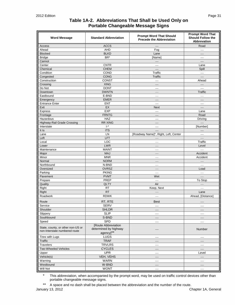
2012 Edition Page 31
January 13, 2012 Chapter 1A, General
Table 1A-2. Abbreviations That Shall be Used Only on Portable Changeable Message Signs
Word Message Standard Abbreviation Prompt Word That Should Precede the Abbreviation
Prompt Word That Should Follow the
Abbrevation
Access ACCS Road
Ahead AHD Fog
Blocked BLKD Lane
Bridge BR* [Name]
Cannot CANT
Center CNTR Lane
Chemical CHEM Spill
Condition COND Traffic
Congested CONG Traffic
Construction CONST Ahead
Crossing XING
Do Not DONT
Downtown DWNTN Traffic
Eastbound E-BND
Emergency EMER
Entrance Enter ENT
Exit EX Next
Express EXP Lane
Frontage FRNTG Road
Hazardous HAZ Driving
Highway-Rail Grade Crossing RR XING
Interstate I-* [Number]
It Is ITS
Lane LN [Roadway Name]*, Right, Left, Center
Left LFT
Local LOC Traffic
Lower LWR Level
Maintenance MAINT
Major MAJ Accident
Minor MNR Accident
Normal NORM
Northbound N-BND
Oversized OVRSZ Load
Parking PKING
Pavement PVMT Wet
Prepare PREP To Stop
Quality QLTY Air
Right RT Keep, Next
Right RT Lane
Roadwork RDWK Ahead, [Distance]
Route RT, RTE Best
Service SERV
Shoulder SHLDR
Slippery SLIP
Southbound S-BND
Speed SPD
State, county, or other non-US or non-Interstate numbered route
[Route Abbreviation determined by highway
agency]** Number
Tires with Lugs LUGS
Traffic TRAF
Travelers TRVLRS
Two-Wheeled Vehicles CYCLES
Upper UPR Level
Vehicle(s) VEH, VEHS
Warning WARN
Westbound W-BND
Will Not WONT
* This abbreviation, when accompanied by the prompt word, may be used on traffic control devices other than portable changeable message signs.
** A space and no dash shall be placed between the abbreviation and the number of the route.

Page 32 2012 Edition
Chapter 1A, General January 13, 2012
Table 1A-3. Unacceptable Abbreviations
Abbreviation Intended Word Common Misinterpretation
ACC Accident Access (Road)
CLRS Clears Colors
DLY Delay Daily
FDR Feeder Federal
L Left Lane (Merge)
LT Light (Traffic) Left
PARK Parking Park
POLL Pollution (Index) Poll
RED Reduce Red
STAD Stadium Standard
WRGN Warning Wrong