partial database for breccia pipes and collapse features...
TRANSCRIPT
Arizona Geological Surveywww.azgs.az.gov | repository.azgs.az.gov
DIGITAL INFORMATION DI-42
Partial database for breccia pipes and collapse features on the Colorado Plateau,
northwestern ArizonaJon E. Spencer, Karen J. Wenrich and Trevor Cole
May 2015
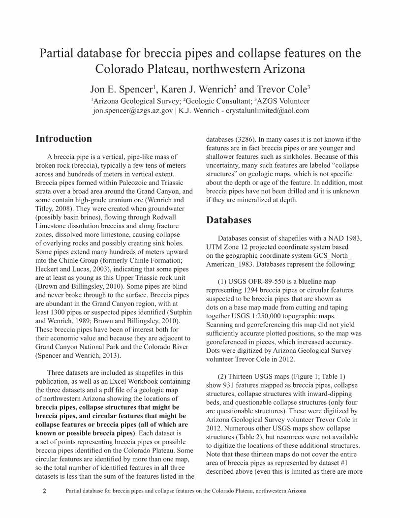
Inward-dipping beds of breccia pipe bisected by US 89, north of Arizona-Utah border.

Arizona Geological Survey
M. Lee Allison, State Geologist and Director
Manuscript approved for publication in May 2015Printed by the Arizona Geological Survey
All rights reserved
For an electronic copy of this publication: www.repository.azgs.az.govPrinted copies are on sale at the Arizona Experience Store
416 W. Congress, Tucson, AZ 85701 (520.770.3500)
For information on the mission, objectives or geologic products of the Arizona Geological Survey visit www.azgs.az.gov.
This publication was prepared by an agency of the State of Arizona. The State of Arizona, or any agency thereof, or any of their employees, makes no warranty, expressed or implied, or assumes any legal liability or responsibility for the accuracy, completeness, or usefulness of any information, apparatus, product, or process disclosed in this report. Any use of trade, product, or firm names in this publication is for descriptive purposes only and does not imply endorsement by the State of Arizona.
___________________________
Suggested Citation: Spencer J.E., Wenrich, K.J. and Cole, T., 2015, Partial database for breccia pipes and collapse features on the Colorado Plateau, northwestern Arizona. Arizona Geological Survey Digital Information, DI-42, 5 p., 1 map plate, shapefiles, and Excel Workbook.

1Partial database for breccia pipes and collapse features on the Colorado Plateau, northwestern Arizona
Table of Contents
Introduction .......................................................... 2 Databases .......................................................... 2 References Cited .......................................................... 5
Materials accompanying this report and available at the AZGS Document Repository (repository.azgs.az.gov) Breccia pipes & possible breccia pipes, northwestern Arizona -- Map Breccia Pipes & possible breccia pipes, northwestern Arizona -- Shapefiles (zip file) Breccia Pipes & possible breccia pipes, northwestern Arizona -- Database AZGS 2015 (Excel)
2 2 Partial database for breccia pipes and collapse features on the Colorado Plateau, northwestern Arizona
Partial database for breccia pipes and collapse features on the Colorado Plateau, northwestern Arizona
Jon E. Spencer1, Karen J. Wenrich2 and Trevor Cole3
1Arizona Geological Survey; 2Geologic Consultant; 3AZGS Volunteer [email protected] | K.J. Wenrich - [email protected]
Introduction A breccia pipe is a vertical, pipe-like mass of
broken rock (breccia), typically a few tens of meters across and hundreds of meters in vertical extent. Breccia pipes formed within Paleozoic and Triassic strata over a broad area around the Grand Canyon, and some contain high-grade uranium ore (Wenrich and Titley, 2008). They were created when groundwater (possibly basin brines), flowing through Redwall Limestone dissolution breccias and along fracture zones, dissolved more limestone, causing collapse of overlying rocks and possibly creating sink holes. Some pipes extend many hundreds of meters upward into the Chinle Group (formerly Chinle Formation; Heckert and Lucas, 2003), indicating that some pipes are at least as young as this Upper Triassic rock unit (Brown and Billingsley, 2010). Some pipes are blind and never broke through to the surface. Breccia pipes are abundant in the Grand Canyon region, with at least 1300 pipes or suspected pipes identified (Sutphin and Wenrich, 1989; Brown and Billingsley, 2010). These breccia pipes have been of interest both for their economic value and because they are adjacent to Grand Canyon National Park and the Colorado River (Spencer and Wenrich, 2013).
Three datasets are included as shapefiles in this publication, as well as an Excel Workbook containing the three datasets and a pdf file of a geologic map of northwestern Arizona showing the locations of breccia pipes, collapse structures that might be breccia pipes, and circular features that might be collapse features or breccia pipes (all of which are known or possible breccia pipes). Each dataset is a set of points representing breccia pipes or possible breccia pipes identified on the Colorado Plateau. Some circular features are identified by more than one map, so the total number of identified features in all three datasets is less than the sum of the features listed in the
databases (3286). In many cases it is not known if the features are in fact breccia pipes or are younger and shallower features such as sinkholes. Because of this uncertainty, many such features are labeled “collapse structures” on geologic maps, which is not specific about the depth or age of the feature. In addition, most breccia pipes have not been drilled and it is unknown if they are mineralized at depth.
DatabasesDatabases consist of shapefiles with a NAD 1983,
UTM Zone 12 projected coordinate system based on the geographic coordinate system GCS_North_American_1983. Databases represent the following:
(1) USGS OFR-89-550 is a blueline map representing 1294 breccia pipes or circular features suspected to be breccia pipes that are shown as dots on a base map made from cutting and taping together USGS 1:250,000 topographic maps. Scanning and georeferencing this map did not yield sufficiently accurate plotted positions, so the map was georeferenced in pieces, which increased accuracy. Dots were digitized by Arizona Geological Survey volunteer Trevor Cole in 2012.
(2) Thirteen USGS maps (Figure 1; Table 1) show 931 features mapped as breccia pipes, collapse structures, collapse structures with inward-dipping beds, and questionable collapse structures (only four are questionable structures). These were digitized by Arizona Geological Survey volunteer Trevor Cole in 2012. Numerous other USGS maps show collapse structures (Table 2), but resources were not available to digitize the locations of these additional structures. Note that these thirteen maps do not cover the entire area of breccia pipes as represented by dataset #1 described above (even this is limited as there are more
3Partial database for breccia pipes and collapse features on the Colorado Plateau, northwestern Arizona
in southern Utah). As a result, areas not covered by these maps are not represented in this dataset, and should not be construed to contain fewer breccia pipes or reduced potential for breccia-pipe deposits.
(3) Consulting geologist Karen Wenrich provided locations of 1061 circular features that might be breccia pipes, as identified on aerial photographs (Figure 1). About 50% of these were field checked and confirmed to be breccia pipes or collapse structures. Also included are 19 named breccia pipes. Confirmed breccia pipes are not differentiated from circular features in the database. UTM coordinates for these pipes are rounded to nearest 150 meters, which was considered to be the approximate uncertainty in locating the features on paper aerial photographs and transferring that information to USGS 7.5’ topographic maps. Areas of detailed collapse-feature identification are a small fraction of the total area
of known breccia pipes and collapse features. The high density of collapse features indicated by this dataset are the result of exceptionally detailed field investigation, and should not be interpreted to indicate that these areas contain unusually dense populations of collapse features. Rather, the dataset for these areas reflects the density of collapse features that might be identified with additional detailed mapping of other areas in the breccia-pipe province. Unusually careful study of the Hualapai Reservation on the western edge of the province also determined a high density of collapse features, as identified on four published U.S. Geological Survey geologic maps (Wenrich et al., 1996, 1997; Billingsley et al., 1999, 2000). (Note that Wenrich has uranium mining claims in areas of breccia-pipe uranium mineralization, which could be interpreted to detract from the objectivity of collapse-feature identification. However, all of the mapping was completed prior to her staking of those mining claims, and most of it more than 10 years prior.)
Table 1. Geologic maps incorporated into breccia-pipe database
Billingsley, G.H., and Dyer, H.C., 2003, Geologic map of the upper Hurricane Wash and vicinity, Mohave County, northwestern Arizona: U.S. Geological Survey Miscellaneous Field Studies Map MF-2410, scale 1:31,680, with 24 p. report.
Billingsley, G.H., and Graham, S.E., 2003, Geologic map of the Lower Hurricane Wash and vicinity, Mohave County, Northwestern Arizona: U.S. Geological Survey Miscellaneous Field Studies Map MF-2396, scale 1:31,680, with 28 p. report.
Billingsley, G.H. and Priest, S.S., 2010, Geologic map of the House Rock Valley area, Coconino County, northern Arizona: U.S. Geological Survey Scientific Investigations Map SIM-3108, scale 1:50,000, 1 sheet, with 23 p. report.
Billingsley, G.H., and Priest, S.S., 2003, Geologic map of upper Clayhole Valley and vicinity, Mohave County, Northwestern Arizona: U.S. Geological Survey Miscellaneous Field Studies Map MF-2418, scale 1:31,680, with 29 p. report.
Billingsley, G.H., Beard, L.S., Priest, S.S., Wellmeyer, J.L., and Block, D.L., 2004, Geologic map of the lower Grand Wash Cliffs and vicinity, Mohave County, northwestern Arizona: U.S. Geological Survey Miscellaneous Field Studies Map MF-2427, scale 1:31,680, with 24 p. report.
Billingsley, G.H., Block, D.L., and Dyer, H.C., 2006, Geologic Map of the Peach Springs 30’ x 60’ Quadrangle, Mohave and Coconino Counties, Northwestern Arizona: U.S. Geological Survey Scientific Investigations Map SIM-2900, scale 1:100,000, with 17 p. report (supersedes USGS I-2554).
Billingsley, G.H., Felger, T.J., and Priest, S.S., 2006, Geologic Map of the Valle 30’ x 60’ Quadrangle, Coconino County, Northern Arizona: U.S. Geological Survey Scientific Investigations Map SIM-2895, scale 1:100,000, with 23 p. report.
Billingsley, G.H., Priest, S.S., and Felger, T.J., 2004, Geologic map of Pipe Spring National Monument and the western Kaibab-Paiute Indian Reservation, Mohave County, Arizona: U.S. Geological Survey Scientific Investigations Map, SIM-2863, scale 1:31,680, with 22 p. report.
Billingsley, G.H., Priest, S.S., and Felger, T.J., 2007, Geologic Map of the Cameron 30’ x 60’ Quadrangle, Coconino County, Northern Arizona: U.S. Geological Survey Scientific Investigations Map SIM-2977, scale 1:100,000, with 35 p. report.
Billingsley, G.H., Priest, S.S., and Felger, T.J., 2008, Geologic Map of the Fredonia 30’ x 60’ Quadrangle, Mohave and Coconino Counties, Northern Arizona: U.S. Geological Survey Scientific Investigations Map SIM-3035, scale 1:100,000, with 25 p. report.
Billingsley, G.H., Wenrich, K.J., and Huntoon, P.W., 2000, Breccia-pipe and geologic map of the southeastern part of the Hualapai Indian Reservation and vicinity, Arizona: U.S. Geological Survey Geologic Investigations Map I-2643, 2 sheets, scale 1:48,000.
Wenrich, K.J., Billingsley, G.H., and Huntoon, P.W., 1996, Breccia-pipe and geologic map of the northwest part of the Hualapai Indian Reservation and vicinity, Arizona: U.S. Geological Survey Geologic Investigations Map I-2522, scale 1:48,000, with 20 p. report.
Wenrich, K.J., Billingsley, G.H., and Huntoon, P.W., 1997, Breccia-pipe and geologic map of the northeastern part of the Hualapai Indian Reservation and vicinity, Arizona: U.S. Geological Survey Geologic Investigations Map I-2440, 2 sheets, scale 1:48,000, with 19 p. report.

4 4 Partial database for breccia pipes and collapse features on the Colorado Plateau, northwestern Arizona
Figu
re 1
. Geo
logi
c m
ap o
f nor
thw
este
rn A
rizon
a sh
owin
g so
urce
s of d
ata
for d
atas
ets 2
and
3.
5Partial database for breccia pipes and collapse features on the Colorado Plateau, northwestern Arizona
TABLE 2. Incomplete list of USGS geologic maps not incorporated into breccia-pipe database.
I-2296 (Wolf Hole Mountain)I-2396 (Sullivan Draw)I-2554 (SW Hualapai) (superceded by SIM-2900)I-2628 (Littlefield)I-2688 (Grand Canyon)I-2766 (Mount Trumbull)MF-2364 (House Rock)MF-2366 (Cane)MF-2367 (House Rock Spring)MF-2368 (Uinkaret volcanic field)MF-2387 (Hidden Hills)MF-2394 (Clayhole Wash)SIM-3108 (House Rock Valley area)
References CitedBrown, K.M., and Billingsley, G.H., 2010, Map showing
geologic structure, cultural and geographic features, and geologic cross sections of northwestern Arizona: U.S. Geological Survey, Scientific Investigations Report 2010-5025, Plate 1, scale 1:375,000.
Heckert, A.B., and Lucas, S.G., 2003, Triassic stratigraphy in the Zuni Mountains, west-central New Mexico, in Lucas, S.G., Semkin, S.C., Berglof, W.R., and Ulmer-Scholle, D.S., eds., Geology of the Zuni Plateau: New Mexico Geological Society Guidebook, 54th Field Conference, p. 245-262.
Spencer, J.E., and Wenrich, K., 2011, Breccia-pipe uranium mining in the Grand Canyon region and implications for uranium levels in Colorado River water: Arizona Geological Survey Open-File Report OFR-11-04, version 1.0, 13 p.
Sutphin, H.B., and Wenrich, K.J., 1989, Map of locations of collapse-breccia pipes in the Grand Canyon region of Arizona: U.S. Geological Survey Open-File Report 89-0550, 1 sheet, scale 1:250,000.
Wenrich, K.J., and Titley, S.R., 2008, Uranium exploration for northern Arizona (USA) breccia pipes in the 21st century and consideration of genetic models, in Spencer, J.E., and Titley, S.R., eds., Ores and orogenesis: Circum-Pacific tectonics, geologic evolution, and ore deposits: Arizona Geological Society Digest 22, p. 295-309.