participatory modelling for sustainable river …...participatory modelling for sustainable river...
TRANSCRIPT

Participatory modelling for sustainable river catchment
management
Nick Jones – PhD Researcher
Email: [email protected] , Twitter: @NickIceJones
Supervisors: Prof Lindsey McEwen, Prof Chad Staddon and Dr Chris Parker

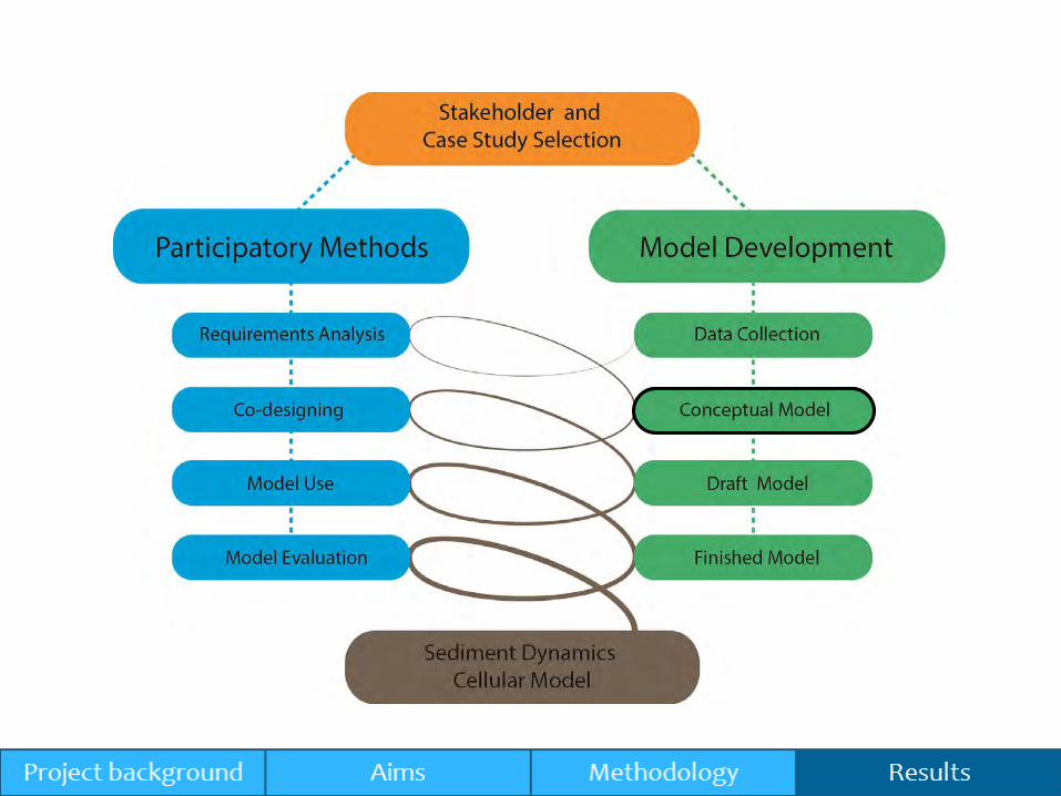
Project background
Aims
Methodology
Results
Contents

What is fluvial geomorphology?
Fluvial geomorphology
(Flow and sediment dynamics, channel form
and habitats)
Riverine ecology
(In-channel and floodplain habitats)
Engineering design
(Channel dimensions and
hydraulics)

Associated impacts
Flooding Ecology


The WFD specifically refers to the importance of fluvial geomorphology in achieving a “good ecological status” under ‘hydromorphology’
The WFD recognises the importance of engaging with stakeholders in the process of managing water resources
The Water Framework Directive(2000/60/EC)

“ The paradigm lock occurs because scientists do not grasp what managers require, and managers and stakeholders do not appreciate the
scientific alternatives available” (Gregory et al., 2008)

ST:REAM (Parker et al. 2009)
RAT (Graf, 1996)
SIAM (Gibson and Little, 2006)REAS (Wallerstein et al. 2006)
CAESAR-Lisflood (Coulthard et al. 2011)
SIBERIA (Willgoose et al. 1991)
LAPSUS (Schoorl et al. 2002)
DRAINAL (Beaumont et al. 1992)GILBERT (Chase, 1992)
DELIM (Howard, 1994)GOLEM (Tucker and Slingerland, 1994)
CASCADE (Braun and Sambridge, 1997)
CAESAR (Coulthard et al. 1997)
ZSCAPE (Densmore et al. 1998) CHILD (Tucker and Bras, 2000)
EROS (Crave and Davy, 2001)
APERO/CIDRE (Carretier and Lucazeau, 2005)
LAPSUS-D (Keesstra et al, 2013)
ARCU (Smithers and Caldecott ,1993)
PERFECT (Littleboy et al, 1991)
MIKE-SHE (Renard et al, 1997)
GUEST (Misra and Rose, 1996)
HSPF (Bicknell et al. 1996)
A selection of the developed models.

“Physical models can be very good at reproducing sediment behaviour though theysuffer from a number of disadvantages, mostly relating to scaling, which normallyrestrict their application to relatively short reaches of river” (Coulthard et al. 2012)

Animation - flow
Example: CEASAR-Lisflood


How do you get stakeholders using these models?
ST:REAM (Parker et al. 2009)
RAT (Graf, 1996)
SIAM (Gibson and Little, 2006)
REAS (Wallerstein et al. 2006)
CAESAR-Lisflood (Coulthard et al. 2011)
SIBERIA (Willgoose et al. 1991)
LAPSUS (Schoorl et al. 2002)
DRAINAL (Beaumont et al. 1992)GILBERT (Chase, 1992)
DELIM (Howard, 1994)
GOLEM (Tucker and Slingerland, 1994)
CASCADE (Braun and Sambridge, 1997)
CAESAR (Coulthard et al. 1997)
ZSCAPE (Densmore et al. 1998)
CHILD (Tucker and Bras, 2000)
EROS (Crave and Davy, 2001)
APERO/CIDRE (Carretier and Lucazeau, 2005)
LAPSUS-D (Keesstra et al, 2013)
ARCU (Smithers and Caldecott ,1993)
PERFECT (Littleboy et al, 1991)
MIKE-SHE (Renard et al, 1997)
GUEST (Misra and Rose, 1996)HSPF (Bicknell et al. 1996)

“Participatory modelling describes a diverse range of modelling activities whose common element is that they
involve stakeholders in one or more stages of the modelling process, from data collection through to model
construction and use.” (Hare, 2011)
Participatory modelling

Defines seven criteria:1. Participatory modelling purpose
2. Model type
3. Stakeholders involved
4. Timing of events
5. Participatory methods used
6. Participation mode
7. Skills needed to organize and implement the participatory modelling
Hare’s participatory modelling framework

1. To develop and evaluate a catchment-scale cellular model of sediment dynamics that can be used by stakeholders to engage in decision-making processes of sustainable river catchment management
2. To establish, implement and critically analyse a participatory modelling approach in the process of developing a catchment-scale cellular model of sediment dynamics
Research aims

Quality
Acceptance
Integration
1. Participatory modelling purpose

Numerical simulation cellular model as the proposed fundamental modelling structure
The stakeholders decide upon the role of the model
2. Model type

The organising team (me and supervisory team)
Multiple case study approach
The stakeholders primarily consist of policy-makers and management groups involved at the catchment scale
3. Stakeholders involved

Spey
Bristol Avon
Taw
Camel

Case studies
Stakeholder Type
Public bodiesPrivate
Bodies
Conservation Organisations
(Wildlife Trusts and Rivers Trusts)
Fisheries and
Agriculture
River C
atchm
ent M
anagem
ent G
rou
ps
Bristol Avon
Environment Agency, Wiltshire Council,
Bristol Council,
Bath and North East Somerset Council
Wessex
Water
Avon Wildlife Trust, Bristol Avon Rivers
Trust
Spey
Scottish Environmental Protection Agency,
National Park Authority,
Scottish National Heritage
Spey Catchment Initiative Fisheries board
Taw Environment Agency
Devon Wildlife Trust, West Country
Rivers Trust, Farming and Wildlife
Advisory Group, Silvanus Trust, North
Devon Biosphere
National Farmers
Union
Camel Environment Agency, Natural England

4. Timing of events and 5. Participatory methods


Participation mode:
Stakeholders are involved as a group with homogeneous interests
Skills needed:
Modelling skills
Facilitation skills
6. Participation mode and 7. Skills needed

Results


Two activities:
Introduction to cellular modelling
Activity-oriented questions
Thematic analysis using NVivo
Cross-case analysis and triangulation of data sources was used to create thematic maps
Requirements analysis workshop

Questions Bristol Avon Camel Taw Spey
What are the current sediment
issues effecting your river
catchment?
Sediment issues from
upstream resulting in costly
downstream dredging
Diffuse and point source
sediment
Agricultural run off
Silting issues
Impacts on fisheries
Land cover change
Phosphate associated with
the sediment
Impacts on river ecology
Impacts on flooding
Influence from urban
(impoundments and flood
defence schemes)
In the amble tributary
(Fish, diatoms, WFD
targets):
Land use (exposed ground)
Bank poaching
Tracks/roads/gates (routes
for transport)
Camel (SSSI / SAC targets):
Maize
Lanivet Stream
Structures (role in
sediment movement)
NIRS – Soil / sediment
reporting
Exceedance of NE targets
for suspended solids and
deposited sediment
impacts on in-stream
Risky crops e.g. maize /
potatoes
Over-stocked out wintering
Road sides due to narrow
lanes and gateways at
bottom of sloping fields
Poorly managed forestry
operations on steep
ground
Slurry ‘Accidents’, leaks
and spills
Maize growth / cropping
Land use (poor arable land
management)
Compacted farmland
River bank erosion
(livestock)
Invasive Species
(Himalayan Balsam)
Road run-off and road
verge erosion (hard
surfaces)
Lack of vegetation in head
waters
Upland overstocking
Lack of trees and buffer
strips in high erosion
riparian areas
Increased phosphate
(associated with sediment)
Loss of salt marsh habitat
through deposition
Deterioration of gravels
and spawning habitat
impacting upon aquatic
Abstraction of river flow in
the upper catchment for
hydro-power. It is
estimated 25% of river flow
is diverted to the River Tay.
There are other sources of
abstraction throughout the
catchment such as the
distillery.
Impact from river
impoundments, series of
dams (3/4) in the upper
catchment.
Large river catchment, with
high mountains
(Cairngorms) and a wide
flat valley floor. A typical
Spey tributary would be
steep firing lots of
sediment down onto the
floodplain where it
deposits. The Feshie fan is
an example of an
enormous source of
sediment to the Spey.
Sediment transport varies
due to the geology and
rainfall in the catchment.
There is a high spatial

“I think that is one of the things if you want your model to have credibility with stakeholders is they will say it always rains loads more here and it is always more intense here, compared to down
there, so I think there would need to be some recognition of that.” (Catchment Co-ordinator, Environment Agency, Camel)
“Also our rainfall, because you know we have practically nothing for months, but you ask us next month and it probably won’t stop
raining, so it can be boom and bust.” (Project Officer, Spey Catchment Initiative, Spey)
Quotes


Land cover (LCM 2007)
Soil (HOST)
Rainfall (Daily)
DTM (5-30m)
Discharge Gauge
Inputs
Infiltration and ground
water
Stage 2Stage 1 Stage 4Stage 3
Hillslope soil erosion
processes
*Only recalculated if DTM changes
Recalculate DTM with sediment erosion/deposition
Overland flow
Precipitation falls down onto the catchment in daily ‘timesteps’
*Multiple flow routing
Sediment transport


Model: Data processing demonstration


Three activities:
Conceptual model discussion
Model influences prioritisation (Bulls-eye – using the pressures from the thematic map)
Model application (Ranking exercise – using the model applications from the thematic map)
Co-designing workshop

Co-design results
Issue Group Supporting material Suggested incorporation
Overstocking Camel CF
“If you think of a field over winter with 2 cattle compared to 30 cattle it is
a completely different effect.”
ST
“I think you might just have to run it under different
scenarios e.g. good farmer scenario, bad farmer
scenario.”
Crop Type Camel ST
“Are we going to sort of put in what farmers management impact
is, so what their management impact is so their management
decision is, so deciding to have a kale field alongside the camel in
heavy soil is a bad decision so you can basically model bad
farming, from the environment point of view and good farming.”
ST
“DEFRA data basically on the single farm payment
data. That does say permanent grassland, pasture
land and what crop it is, so I think you can make
use of that sort of data and fit it into your 10
metre squares”


Water quality in two Icelandic rivers: the influence of impoundment, agriculture, glaciation and permafrost
Nicholas Jones and Chris Parker In Press, Uncorrected Proof, Available online 20 May 2014. doi:10.2166/nh.2014.268
Thank you questions?
Twitter: @NickIceJones
Project website: www.engage-rivers.org.uk