patterns and average rates of late neogene–recent uplift ...hera.ugr.es/doi/14981324.pdf · the...
TRANSCRIPT

Patterns and average rates of late Neogene–Recent uplift of the
Betic Cordillera, SE Spain
Juan C. Braga a,*, Jose M. Martın a, Cecilio Quesada b
aDepartamento de Estratigrafıa y Paleontologıa, Facultad de Ciencias, Universidad de Granada,
Campus de Fuentenueva s.n. 18002 Granada, SpainbIGME/Direccion de Geologıa, Rıos Rosas 23, 28003 Madrid, Spain
Received 1 September 2000; received in revised form 1 May 2001; accepted 15 July 2002
Abstract
The facies distribution in the sedimentary units infilling a series of Neogene basins has been used to reconstruct the relief
generation and uplift across the Internal Zone of the Betic Cordillera in southern Spain. Uplift amounts and average rates can be
estimated using the current elevation of the outcrops of well-dated deposits indicative of ancient sea-level positions. Coral reefs
and coastal conglomerates record the initial development of emergent Betic relief during the Langhian. Continental and
marginal marine deposits indicate the existence of a large island centred on the present Sierra Nevada–Sierra de los Filabres
chain by the end of the Middle Miocene. The precursor of the Sierra Nevada–Sierra de los Filabres chain, originally part of this
large island, remained emerged whilst the surrounding areas were re-invaded by the sea during the early Tortonian. At the end
of the Tortonian the inland basins (Granada and Guadix basins) became continental, while the Sierras de la Contraviesa, Sierra
de Gador and Sierra Alhamilla emerged, separating the Alboran Basin from the Alpujarra, Tabernas and Sorbas basins, which
became narrow passages of the Mediterranean Sea. In contrast, the Sierra Cabrera emerged during the late Messinian,
suggesting a progressive uplift from west to east of the sierras south of the Sierra Nevada–Sierra de los Filabres chain. During
the Pliocene, only the low areas closest to the present-day coast remained as marine basins and progressively emerged
throughout this stage. The highest average uplift rate recorded is 280 m/Ma for the Sierra de Gador, although the average uplift
rates of upper-Neogene coastal marine rocks since depositon have maximum values of approximately 200 m/Ma. Most of the
uplift of the Betic mountains took place before the early Pliocene. The recorded uplift of Neogene rocks was highest at the
margins of western Sierra Nevada, where peaks higher than 3000 m occur. The average rates of uplift were lower to the east of
this major relief. The main sierras and depressions in the present-day landscape correspond respectively to the emergent land, in
which uplift was concentrated, and to the marine basins that existed before the final emergence of the region. The altitude of the
sierras reflects the time at which they became emergent, the highest mountains being the first to rise above sea level.
D 2002 Elsevier Science B.V. All rights reserved.
Keywords: Uplift; Late Neogene; Palaeogeography; Betic Cordillera; SE Spain
1. Introduction
This is a study of the long-term landscape develop-
ment of the Internal Zone of the Betic Cordillera in
0169-555X/02/$ - see front matter D 2002 Elsevier Science B.V. All rights reserved.
PII: S0169 -555X(02 )00205 -2
* Corresponding author. Fax: +34-958-248528.
E-mail addresses: [email protected] (J.C. Braga), [email protected]
(J.M. Martın), [email protected] (C. Quesada).
www.elsevier.com/locate/geomorph
Geomorphology 50 (2003) 3–26

southern Spain (Fig. 1) as recorded by the sediments
which have infilled the Neogene basins that formed
and evolved as the Betic mountains were emerging
and rising. The modern topographic configuration of
southern Spain consists of a series of mountain
ranges, with peaks higher than 3000 m in the Sierra
Nevada, separated by depressions. The late-Neogene
uplift history and sedimentary evolution of the region
largely pre-determined the present-day landscape,
since the major extant ranges (sierras) and depressions
are the direct counterparts of the earlier emergent
basement highs and the intervening marine basins
respectively. The general emergence of the region
resulted in a change from marine to continental
deposition in the basins and, during the Quaternary,
continued uplift caused a switch to the net erosional
conditions prevailing in the modern landscape (Har-
vey, 2001).
Within this paper, we describe the palaeogeo-
graphic evolution of the area during the late Miocene
and Pliocene as deduced from the spatial distribution
of coastal marine deposits from successive time slices.
We also quantify the amounts and average rates of
uplift since their deposition for rocks formed in
coastal environments at the basin margins.
Previous attempts to quantify relief generation in
the Betic mountains are either localised to a specific
area (e.g. Weijermars et al., 1985) or focus only on the
Plio/Quaternary evolution of the region (Mather,
1991; Viseras, 1991; Stokes, 1997; Garcia, 2001).
Several other papers have addressed the timing and
amount of the exhumation of the metamorphic com-
Fig. 1. Geological schematic map of southeastern Spain. Unless specified, the basins are named after the main town in them.
J.C. Braga et al. / Geomorphology 50 (2003) 3–264

plexes in the Internal Zone of the Betic Cordillera (i.e.
Zeck et al., 1992; Johnson et al., 1997; Lonergan and
Johnson, 1998; Platt and Whitehouse, 1999). These
papers focus mainly on the tectonometamorphic evo-
lution of the basement rocks following their exhuma-
tion during the Early and Middle Miocene. In
contrast, we concentrate on the growth of the Betic
mountains after the emplacement of the Betic meta-
morphic complexes to shallow crustal levels.
The study area is limited to the central-eastern
portion of the Betics, roughly spanning the provinces
of Almerıa and Granada (Fig. 1), in which the
stratigraphy, facies distribution and age of the deposits
in the Neogene basins are well constrained. The late
Neogene uplift history of the Cabo de Gata volcanic
province, along the major Carboneras strike-slip fault
system, is treated separately in another paper (Martın
et al., 2003, although some references to Cabo de Gata
and the External Zone are made below.
2. Regional setting
2.1. Basement geology
The Betic Cordillera in southern Spain is the
westernmost segment of the European Alpine belt.
This cordillera has traditionally been subdivided into
an External Zone and an Internal Zone (Fig. 1). The
External Zone represents the Mesozoic to Middle
Miocene southern continental margin of the Iberian
Massif, which was divided by rifting into different
domains (Garcıa-Hernandez et al., 1980; Vera 1988).
The Prebetic constitutes the external domain where
continental and shallow-marine sedimentation pre-
vailed from the Triassic to the Middle Miocene, while
the Subbetic, to the south, became a pelagic basin
during the Early Jurassic.
The Internal Zone consists of three stacked com-
plexes that, in ascending order, are the Nevado–
Filabride, Alpujarride and Malaguide (Fig. 1). The
Nevado–Filabride Complex comprises Palaeozoic or
older (Gomez-Pugnaire et al., 2000) metamorphic
rocks. The Alpujarride tectonic units include a series
of Palaeozoic–Mesozoic metasediments (Delgado et
al., 1981; Martın and Braga, 1987; Tubıa et al., 1992).
The Malaguide complex consists of a non-metamor-
phic Mesozoic to Cenozoic cover overlying a pre-
Permian basement (Lonergan, 1993; Martın-Martın,
1996).
The upper Nevado–Filabride tectonic unit (Mulha-
cen Nappe, Puga, 1976) and the Alpujarride complex
were affected by high-pressure metamorphism due to
crustal thickening as a result of the convergence of the
African and Eurasian plates. The radiometric dates
constraining the high-pressure metamorphism in the
Nevado–Filabride Complex indicate that convergence
began at about 51 Ma (Monie et al., 1991), although
earlier dates have also been suggested (De Jong,
1991). A sharp decompression in the metamorphic
P–T path of the Nevado–Filabride and Alpujarride
complexes (Vissers, 1981; Gomez-Pugnaire and Fer-
nandez-Soler, 1987; Bakker et al., 1989; Garcıa-Casco
and Torres-Roldan, 1996) suggests rock exhumation
due to crustal-scale extension during the Early and
Middle Miocene (Monie et al., 1991; Garcıa-Duenas et
al., 1992; Watts et al., 1993; Comas et al., 1999; Platt
and Whitehouse, 1999). Thinning of the previously
thickened crust took place (Platt and Vissers, 1989) as
a result of the extension. The Malaguide complex did
not undergo Alpine metamorphism and, consequently,
was probably never subducted (De Jong, 1991). The
present contact with the underlying Alpujarride Com-
plex is marked by a thick mylonitic zone cut by normal
faults (Aldaya et al., 1991).
2.2. Neogene basins
The Betic Neogene basins developed on both the
Internal and the External Zones and underwent defor-
mation and were uplifted as they filled with sediments
(Sanz de Galdeano and Vera, 1992). Consequently, the
configuration, limits and sedimentary dynamics of
each basin changed considerably over time, reflecting
both the regional and local tectonic evolution. A
major basin, the Guadalquivir Basin, developed at
the cordillera front and was open to the Atlantic
Ocean. The intermontane basins located on the Exter-
nal Zones are either continental (Prebetic basins) or
marginal embayments of the Guadalquivir Basin and
as such related to the Atlantic Ocean. The rest of the
intermontane basins of the cordillera were connected
to the Mediterranean Sea. Two main types of Medi-
terranean-linked basins can be distinguished. (a) Inner
basins (the most distant from the present-day Medi-
terranean Sea) occur mainly at the contact between the
J.C. Braga et al. / Geomorphology 50 (2003) 3–26 5

External and Internal Zones. Although both the Gua-
dix-Baza and Granada basins belong to this type, we
have chosen the Granada Basin as the most represen-
tative example (Fig. 2). (b) Outer basins (the nearest
to the present-day Mediterranean), such as the Vera,
Sorbas, Tabernas, and Almerıa–Nıjar, are located in
the Internal Zone. The Sorbas Basin has been selected
as the representative example (Fig. 3).
The two types of Mediterranean-linked basins have
a similar sedimentary evolution up to the late Torto-
nian. At the latest Tortonian–early Messinian, the
inner basins were isolated from the Mediterranean
Sea and became continental (Vera, 2000). The outer
basins remained connected to the Mediterranean Sea
during the rest of the Miocene and, in some cases even
during the Pliocene, except for a short time-interval in
the Messinian during the so-called ‘‘Messinian Salin-
ity Crisis’’ (Riding et al., 1998).
From the Middle-Miocene to the early Tortonian,
the Mediterranean-linked basins evolved under crus-
tal-scale extension, as recorded by normal faults that
are well dated in the Alboran Basin (Comas et al.,
1992, 1999), while contractive deformation related to
wrench tectonics has prevailed since the late Tortonian
(Comas et al., 1999). The interaction of strike-slip
fault systems determines a complex pattern of trans-
tensive and transpressive local conditions (Keller et
al., 1995).
Fig. 2. Neogene stratigraphy of the Granada Basin at its eastern margin. This is representative of the Mediterranean-linked inner basins
(modified from Braga et al., 1990).
J.C. Braga et al. / Geomorphology 50 (2003) 3–266

2.3. Topography
A series of mountain ranges, trending roughly
E–W and separated by basins, determine the top-
ography of the study area. Sierra Nevada (Fig. 1) is
the highest mountain range in southern Spain with
several peaks over 3000 m (3482 m in the Mulhacen).
This, together with the Sierra de los Filabres (2168 m)
to the east, is the main outcrop of the lowest Betic
nappes. North of Sierra Nevada, the Granada and
Guadix basins are separated by the Sierra Arana
(1943 m) at the contact between the External and
Internal Zones of the cordillera (Fig. 1). Several ranges
of Mesozoic rocks of the External Zone extend north-
wards to the Guadalquivir Basin at the cordillera front.
The Alpujarra Corridor, a very narrow, E–W
trending Neogene basin, separates Sierra Nevada from
the Sierra de Lujar–Sierra de la Contraviesa–Sierra
de Gador chain to the south. The Sierra de Lujar (1824
m) and the Sierra de la Contraviesa (1508 m) con-
Fig. 3. Neogene stratigraphy of the Sorbas Basin. This is representative of the Mediterranean-linked outer basins (modified from Martın and
Braga, 1994).
J.C. Braga et al. / Geomorphology 50 (2003) 3–26 7

stitute a coastal range while the topography of the
Poniente Basin descends gradually from the southern
foot of Sierra de Gador (2236 m) to the Mediterranean
(Fig. 1). To the east of the Andarax valley, the
Tabernas and Sorbas basins occupy the depression
between the Sierra de los Filabres and the Sierra
Alhamilla (1387 m)–Sierra Cabrera (960 m). The
Almerıa–Nıjar Basin descends from the southern
slope of the latter chain to the Mediterranean Sea
delimited at its southeastern margin by the volcanic
Sierra de Cabo de Gata (Fig. 1).
3. Methods
In this paper, we describe and quantify the regional
scale, spatial and temporal pattern of relief generation
of the central sector of the Betic mountains during the
late Neogene. The palaeogeographic evolution was
deduced from the distribution of coastal deposits in
the successive upper Neogene sedimentary units fill-
ing the basins in the study area. Uplift rates were
calculated by using the time-averaged elevation of
upper Miocene and Pliocene coastal and marginal
marine rocks above modern sea level. These rocks
formed at the basin margins and were elevated above
sea level as the basement highs and the region in
general were uplifted.
Two types of rocks have been used to estimate
uplift amounts and rates:
(a) Coral-reef and beach deposits that allow the
(palaeo)position of sea level at the outcrop
localities to be reconstructed with a margin of
error of only a few metres (less than 10 m).
(b) Rocks of shallow-water marine origin deposited
on inner platforms in depths of less than 30 m,
mostly inner-platform limestones. The identifica-
tion of the palaeoposition of sea level with these
deposits which is affected by a methodological
error of F 30 m.
The age of these shallow-marine sediments is
usually well constrained with precise biostratigraphic
or stable-isotope data in time intervals of a few
hundred thousand years (100 ka).
The elevation of specific shoreline-marker rocks of
each time slice analysed gives the amount of rock
uplift from sea level since their deposition at each
locality. The current elevation, however, has been
corrected with available data on global sea-level
position (Hardenbol et al., 1998) at the time of
formation of the studied rocks (Fig. 4). Average uplift
rates were obtained by dividing the corrected eleva-
tion by the estimated absolute age of the rocks.
Methodological errors arise both from uncertainties
in the identification of the ancient shorelines and from
the time ranges of available age constraints. The
pattern for the amount of uplift of the coastal marine
rocks of any studied time slice is indicative of the
differential uplift within the region since the deposi-
tion of these rocks.
The minimum average uplift rate of the highest
peaks can be estimated for the Sierra de Gador,
Sierra Alhamilla and Sierra Cabrera as the time of
the emergence of these sierras above sea level can be
constrained with the stratigraphic record in the
nearby basins. The current elevation of the peaks is
the result of the interaction between the uplift of the
sierras and accompanying erosion. The time-aver-
Fig. 4. The present-day elevation of shoreline-marker rocks of each time slice analysed (E) has been corrected with available data on global sea-
level position (Hardenbol et al., 1998) at the time of formation of the studied rocks (S) to obtain the rock uplift since deposition (U). S can be
negative. Average uplift rates (AUR) can be obtained by dividing the corrected elevation (U) by the estimated absolute age of the rocks (T).
J.C. Braga et al. / Geomorphology 50 (2003) 3–268

aged current elevation of the highest peaks is there-
fore the minimum average uplift rate since their
emergence.
4. Neogene sedimentary record and
palaeogeographic evolution of the area
The Neogene basins in southern Spain are filled by
sedimentary units separated by unconformities. The
facies distribution in coeval units from different basins
is used here to reconstruct the palaeogeography of the
study area in successive time slices. The outcrops of
the pre-upper Tortonian units are generally small and
disconnected, making an accurate reconstruction of
the paleogeography before the late Tortonian difficult.
The stratigraphic record and data quality is substan-
tially better for younger deposits, and therefore, the
descriptions below focus on the palaeogeography of
the area during the deposition of the upper Tortonian,
uppermost Tortonian– lowermost Messinian, lower
Messinian, upper Messinian and lower Pliocene sedi-
mentary units.
4.1. Pre-Tortonian evolution
The progressive unroofing and erosion of Betic
nappes is recorded by the lithological variety of clasts
incorporated in various types of mass-flow deposits
within lower Miocene pelagic sediments (Rodrıguez-
Fernandez, 1982). However, the first evidence for
emerging Betic basement highs is the occurrence of
upper Langhian coral reefs and associated coastal
conglomerates in the southern Granada Basin (Braga
et al., 1996a) and in the Vera Basin (Barragan, 1997).
In the Granada Basin these deposits appear in a single
isolated outcrop near Murchas (Fig. 1), indicating the
presence to the north of an emerged Betic island,
probably the precursor of the Sierra Nevada–La
Tortola chain (Fig. 1). The nature of the clasts in the
conglomerates suggests that only the uppermost Betic
complex in the area (the Alpujarride Complex) was
exposed and eroded. The occurrence of Langhian
coral reefs in deposits from the Vera Basin points to
the existence of an emerged relief in the eastern part of
the present-day Sierra de los Filabres as well. Most
clasts in the associated conglomerates here come from
the uppermost basement complex, the Malaguide
Complex, but Alpujarride rocks were eroded as well
(Barragan, 1997).
To the north, Langhian shallow-water marine lime-
stones were deposited on the platform that developed
on the southern margin of the Iberian Massif, corre-
sponding to the Prebetic, i.e., the northern domain of
the Betic External Zone. These shallow-water carbo-
nates change southwards to slope and basinal marls
and mass-flow deposits (Comas, 1978; Geel et al.,
1992), thereby suggesting a complete disconnection
between the Betic island(s) and the Iberian mainland
by a deep-water trough (‘‘North Betic Straits’’, Geel et
al., 1992).
In the southern Granada Basin, the upper-Langhian
shallow-marine deposits are overlain by a continental
unit of red conglomerates, sandstones and silts (Fig. 2)
that can be traced around Sierra Nevada (Rodrıguez-
Fernandez, 1982). Flanking the Sierra de los Filabres,
red-to-grey conglomerates overlying marine upper?
Langhian marls, older Neogene units or the basement
has been interpreted as alluvial and fan-delta deposits
(Kleverlaan, 1989; Doyle et al., 1996) (Fig. 3). The
red conglomerates extend southwards to the Sierras de
la Contraviesa and Gador (Rodrıguez-Fernandez et
al., 1990), Alhamilla and Cabrera (Montenat, 1990;
Barragan, 1997), and northwards to the Sierra de las
Estancias (Braga and Martın, 1988) and Sierra de
Baza (Soria, 1993), underlying later marine deposits
in the basins. These continental deposits indicate the
existence of a large emerged Betic upland (Fig. 5). In
the Granada Basin, micromammal fossils in the red
silts point to a Serravallian age (Martın-Suarez et al.,
1993), but in general the age of the red conglomeratic
units is poorly constrained and a lowermost Tortonian
age, suggested by authors such as Montenat (1990)
and Doyle et al. (1996) at least for parts of the units,
cannot be discarded, even though in most localities
they are overlain by lower Tortonian marine sedi-
ments.
To the south of Sierra Alhamilla and Sierra Cab-
rera, the Serravallian and lower-Tortonian deposits are
pelagic marls (Serrano, 1990). Together with the
occurrence of deep-water Serravallian deposits in the
southern External Zone (Subbetic domain, Soria,
1993), this suggests that the red units formed on an
island separated from the Iberian mainland (Fig. 5).
The existence of such a large emergent Betic
upland by the end of the Serravallian–earliest Torto-
J.C. Braga et al. / Geomorphology 50 (2003) 3–26 9
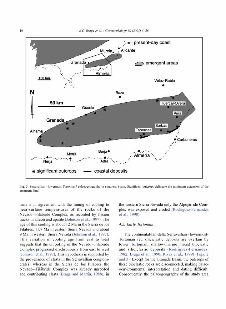
nian is in agreement with the timing of cooling to
near-surface temperatures of the rocks of the
Nevado–Filabride Complex, as recorded by fission
tracks in zircon and apatite (Johnson et al., 1997). The
age of this cooling is about 12 Ma in the Sierra de los
Filabres, 11.7 Ma in eastern Sierra Nevada and about
9 Ma in western Sierra Nevada (Johnson et al., 1997).
This variation in cooling age from east to west
suggests that the unroofing of the Nevado–Filabride
Complex progressed diachronously from east to west
(Johnson et al., 1997). This hypothesis is supported by
the provenance of clasts in the Serravallian conglom-
erates: whereas in the Sierra de los Filabres the
Nevado–Filabride Complex was already unroofed
and contributing clasts (Braga and Martın, 1988), in
the western Sierra Nevada only the Alpujarride Com-
plex was exposed and eroded (Rodrıguez-Fernandez
et al., 1990).
4.2. Early Tortonian
The continental/fan-delta Serravallian–lowermost-
Tortonian red siliciclastic deposits are overlain by
lower Tortonian, shallow-marine mixed bioclastic
and siliciclastic deposits (Rodrıguez-Fernandez,
1982; Braga et al., 1990; Rivas et al., 1999) (Figs. 2
and 3). Except for the Granada Basin, the outcrops of
these bioclastic rocks are disconnected, making palae-
oenvironmental interpretation and dating difficult.
Consequently, the palaeogeography of the study area
Fig. 5. Serravallian– lowermost Tortonian? palaeogeography in southern Spain. Significant outcrops delineate the minimum extension of the
emergent land.
J.C. Braga et al. / Geomorphology 50 (2003) 3–2610

cannot be reconstructed for the early Tortonian with
the same confidence as for later intervals.
Lower Tortonian carbonate platforms rim the La
Tortola–Sierra Nevada–Sierra de los Filabres chain
(Rodrıguez-Fernandez, 1982), suggesting that this
chain remained emergent during the early Tortonian.
Terrigenous material shed from upland fed localised
fan deltas around Sierra Nevada. The clasts in these
fan deltas indicate that the Alpujarride Complex was
still the only basament complex at the surface in the
western Sierra Nevada (Rodrıguez-Fernandez, 1982;
Martın and Braga, 1997) (Fig. 6).
Lower Tortonian shallow-marine deposits occur
south of the La Tortola–Sierra Nevada–Sierra de
los Filabres chain in scattered outcrops on the south-
ern margins of the Tabernas, Sorbas and Vera basins.
The Alpujarride provenance of the clasts suggests
they derived from locally emergent reliefs at the
location of the modern Sierra Alhamilla and Sierra
Cabrera. Coastal volcaniclastic and bioclastic deposits
point to the existence of emergent volcanic highs in
the Cabo de Gata volcanic province at this time
(Braga et al., 1996b; Betzler et al., 1997).
North of the La Tortola–Sierra Nevada–Sierra de
los Filabres chain, shallow-water platforms with car-
bonate sedimentation extended over both Internal and
External Zone substrates. Several Subbetic upland
areas were already emerged (Rodrıguez-Fernandez,
Fig. 6. Erosion pulses of western Sierra Nevada and stratigraphic architecture of the corresponding conglomerate units (modified from Martın
and Braga, 1997).
J.C. Braga et al. / Geomorphology 50 (2003) 3–26 11

1982) and islands rimmed by shallow-water marine
platforms replaced the former deep-water trough in
the North Betic Straits (Soria, 1993). However, the
lack of accurate dating and sedimentological analysis
of the shallow-water deposits makes reconstructing
the precise palaeogeography of the External Zone at
this time a difficult task. The Iberian mainland
expanded southwards by the partial emersion of the
Prebetic domain, on which shallow-marine sedimen-
tation is restricted to the southernmost areas.
4.3. Late Tortonian
Upper Tortonian deposits in the Neogene basins in
the study area comprise proximal deltaic siliciclastic
sediments and carbonates that include coral reefs.
These proximal deposits pass laterally to distal marls,
silty marls and turbidite sandstones and conglomer-
ates (Martın et al., 1989; Braga et al., 1990; Martın
and Braga, 1994) (Figs. 2 and 3). The distribution of
these upper Tortonian deposits indicates that a narrow
platform with coral reefs and localised fan deltas
rimmed the southern margin of the Sierra Nevada–
Sierra de los Filabres chain (Martın and Braga, 1996),
but to the south of this main chain deep-water marine
basins developed in areas that had been emergent
during the early Tortonian and at the end of the
Middle Miocene (Fig. 7). Upper Tortonian marls
and turbidites were deposited on top of the continental
conglomeratic and shallow-marine bioclastic units in
the Alpujarra, Tabernas, Sorbas and Vera basins
(Rodrıguez-Fernandez et al., 1990; Weijermars et al.,
1985; Kleverlaan, 1989), which were laterally con-
nected at that time. Pelagic sediments encroach the
sides of present-day sierras south of these basins, such
as the Contraviesa, Gador, Alhamilla and Cabrera.
These sierras have no shallow-water deposits around
them, indicating that they were not emergent (Fig. 7).
Nevertheless, current direction and sedimentary body
geometries suggest the existence of submarine swells
at the modern location of the sierras (Haughton, 1994,
2000). Deep-water marine sedimentation extended
southwards to the Almerıa–Nıjar (Serrano, 1990)
and Alboran basins (Comas et al., 1996).
The Nevado–Filabride Complex was unroofed and
subjected to erosion, providing clasts incorporated in
fan-delta conglomerates deposited around the Sierra
Nevada for the first time, especially at its western end
(Martın and Braga, 1997; Fig. 6). Coral reefs devel-
oped on these fan deltas and on the shelves rimming
the emergent uplands, thus allowing the upper Torto-
nian palaeogeography to be accurately traced (Esteban
et al., 1996). La Tortola remained as an island (Braga
et al., 1990) and the main relief was the Sierra
Nevada–Sierra de los Filabres chain, which merged
with the extensively emergent External Zone to the
north (Rodrıguez-Fernandez, 1982; Soria, 1993; Soria
et al., 1999). The northern coasts of the marine
Granada and Guadix basins were rimmed by coral
reefs as well (Fig. 7). By the end of the late Tortonian,
most of the Subbetic and Prebetic areas formed a
continuous mainland with the Iberian Massif (Soria et
al., 1999; Fig. 7). The Guadalquivir basin was still
open to the Atlantic and the Guadix basin was con-
nected to the east with the main Mediterranean by the
Almanzora corridor. Some fan deltas developed in this
corridor, probably reflecting a pulse in the uplift of the
Sierra de los Filabres. The northern coast of the reef-
fringed Almanzora corridor (Martın et al., 1989) was
formed by an Internal Zone high (Sierra de las
Estancias), probably continuous with the above-men-
tioned emergent External Zone.
4.4. Latest Tortonian–earliest Messinian
Uppermost Tortonian–lowermost Messinian rocks
in the Granada and Guadix basins consist of fluviatile
conglomerates, sandstones and silts with lacustrine
clays and evaporites (Dabrio et al., 1982; Martın et al.,
1984; Soria et al., 1999; Garcıa-Aguilar and Martın,
2000; Fig. 2). In the basins south of the Sierra
Nevada–Sierra de los Filabres, proximal deposits of
this age comprise bioclastic carbonates with various
proportions of siliciclastic grains (Fig. 3) and local
fan-delta conglomerates (Rodrıguez-Fernandez et al.
1990; Martın and Braga, 1994), except for the Taber-
nas Basin in which only siliciclastic fan deltas occur
(Kleverlaan, 1989). All these shallow-water materials
pass laterally to distal marls and turbidite conglom-
erates and sandstones (Kleverlaan, 1989; Haughton,
1994; Braga et al., 2001). The geographical distribu-
tion of the deposits from this time interval indicates
that at the end of the Tortonian, the Granada, Guadix
and Almanzora basins were uplifted and became
continental basins with fluviatile and lacustrine sed-
imentation. The Sierra de la Contraviesa, Sierra de
J.C. Braga et al. / Geomorphology 50 (2003) 3–2612

Gador and Sierra Alhamilla were also uplifted and
emerged, restricting the marine basins to the south of
the Sierra Nevada–Sierra de los Filabres as a narrow
E–W corridor open to the Alboran Basin through the
Andarax Corridor and to the Mediterranean through
the Vera and Almerıa–Nıjar basins (Fig. 8A and B).
Re-folding of the Betic basement units by crustal
shortening and isostatic uplift has been suggested as
the most likely mechanism to explain the emergence
of Sierra Alhamilla at the end of the Tortonian
Fig. 7. (A) Upper Tortonian palaeogeography of southern Spain. (B) Enlarged schematic map of the study area showing the outcrops of reefs
and other coastal deposits of this age (modified from Esteban et al., 1996).
J.C. Braga et al. / Geomorphology 50 (2003) 3–26 13

(Weijermars et al., 1985). In the Cabo de Gata area
several volcanic highs, including recently formed
volcanic domes, were also emergent (Martın et al.,
1996; Betzler et al., 2000).
4.5. Early Messinian (pre-evaporitic)
Lower Messinian marine deposits are restricted to
the SE Betic Neogene basins. In the study area, they
Fig. 8. (A) Uppermost Tortonian– lowermost Messinian palaeogeography of southern Spain. (B) Enlarged schematic map of the study area. (C)
Lower Messinian palaeogeography of SE Spain. (D) Upper Messinian palaeogeography of SE Spain. Note the progressive emergence of the
sierras and surrounding areas in the region from west to east during the Messinian (B–C).
J.C. Braga et al. / Geomorphology 50 (2003) 3–2614

occur in the Tabernas, Sorbas, Vera, Poniente and
Almerıa–Nıjar basins. Proximal sediments of this age
consist of two successive reef units characterised
respectively by bioherms and fringing reefs with
associated calcarenites and calcirudites (Riding et
al., 1991; Martın and Braga, 1994; Fig. 3). Bodies
of deltaic siliciclastic deposits occur locally among
these carbonates (Braga and Martın, 1996). Both reef
units change laterally to silty marls, marls and turbi-
dite conglomerates and sandstones (Fig. 3). As before,
siliciclastic deposits prevailed in the Tabernas Basin
(Kleverlaan, 1989; Haughton, 2000). The location of
lower Messinian reef outcrops suggests a landward
displacement of the palaeocoast around the Sierra
Nevada–Sierra de los Filabres that could be the result
of the global eustatic sea-level rise recorded during
the early Messinian (Haq et al., 1987). Uplift none-
theless continued in the Sierra de Gador and Sierra
Alhamilla, both of which expanded to displace the
palaeocoast radially from the sierra axes. The western
part of the Alpujarra corridor was also uplifted,
restricting the marine basin to its easternmost part as
the emergent areas in the Sierra de la Contraviesa–
Sierra de Gador chain merged with the Sierra Nevada
(Fig. 8C). In the Cabo de Gata, a re-arrangement of
the volcanic highs produced changes in the palaeo-
geography of the area (Braga et al., 1996b).
4.6. Late Messinian
After the desiccation of the Mediterranean related
to the ‘‘Messinian Salinity Crisis’’ and before the end
of the Messinian, the sea re-invaded the Tabernas,
Sorbas, Vera and Almerıa–Nıjar basins (Riding et al.,
1998), but the area of marine sedimentation was more
restricted compared to previous periods. Evaporites,
mainly gypsum, formed in the first phases of sea-level
recovery. As the sea level rose, conglomerates, sand-
stones, oolites, stromatolites and coral patch-reefs
formed on top of the previous lower Messinian reef
platforms (Fig. 3; Dabrio et al., 1985; Martın et al.,
1993). These proximal deposits change basinwards to
silts and silty marls with turbidite intercalations (Mar-
tın et al., 1993; Aguirre and Sanchez-Almazo, 2000).
During this period, a N–S high separated the Taber-
nas and Sorbas basins. The Sierra Cabrera remained
as a submerged swell during the early Messinian with
no evidence of shallow-water sedimentation around it
(Braga et al., 2001) and emerged in the late Messinian
to separate the open-marine Vera Basin from the
restricted evaporitic Almerıa–Nıjar Basin to the south
(Riding et al., 1998; Fig. 7D).
4.7. Early Pliocene
During the early Pliocene, marine sedimentation
took place only in the basins closest to the present-
day Mediterranean: the Poniente, Almerıa–Nıjar and
Vera basins, except for a brief sea invasion of the
already continental Sorbas Basin (Mather, 1991).
The lower Pliocene proximal deposits in these basins
include mostly conglomerates and sandstones, with
variable proportions of bioclastic material and cal-
carenites locally. These coarse-grained sediments
change laterally and prograde over distal silts and
silty marls (Fortuin et al., 1995; Stokes, 1997;
Aguirre, 1998). The emergence of the eastern portion
of the Alpujarra corridor and the eastern part of the
Fig. 9. Lower Pliocene palaeogeography of southeastern Spain (modified from Aguirre, 1998).
J.C. Braga et al. / Geomorphology 50 (2003) 3–26 15

Fig. 10. Altitude in metres of the outcrops of lower Tortonian inner-platform deposits in the study area. Contour interval, 100 m. A few contours
have been suppressed for clarity.
Fig. 11. Altitude in metres of the outcrops of upper Tortonian reefs and other coastal deposits in the study area. Contour interval, 100 m. A few
contours have been suppressed for clarity.
J.C. Braga et al. / Geomorphology 50 (2003) 3–2616

Tabernas basin concentrated the southern siliciclastic
discharge from the Sierra Nevada–Sierra de los
Filabres in a delta located between the Sierra de
Gador and Sierra Alhamilla and open to the Alme-
rıa–Nıjar Basin (Postma, 1983) (Fig. 9). The vol-
canic relief of the Cabo de Gata was almost
completely emerged except for small embayments
of the Mediterranean Sea, such as the Carboneras
and Agua Amarga basins (Aguirre, 1998). The
coarse-grained clastics produced by their erosion
accumulated in a delta discharging into the Alme-
rıa–Nıjar basin (Boorsma, 1992, 1993) (Fig. 9).
At the end of the early Pliocene, a regression in all
the marine basins in the area resulted in a progressive
withdrawal of the sea. The palaeogeography during
the late Pliocene, probably after an uplift pulse
(Aguirre, 1998), was quite similar to the present day
and only the southernmost areas of the Almerıa–Nıjar
and Poniente basins were still covered by the sea,
forming a shallow bay (Aguirre, 1998).
As mentioned above, the Granada and Guadix
basins have been continental since the latest Torto-
nian. The source of the conglomerate clasts and the
locations of alluvial fans suggest a widening of the
Sierra Nevada relief during the early Pliocene (Martın
and Braga, 1997) (Fig. 6). During the late Pliocene
and Pleistocene, a later denudation phase associated
with the eastern part of Sierra Nevada is recorded in
the Guadix Basin (Garcıa-Aguilar and Martın, 2000)
and the emergent Tabernas Basin (Kleverlaan, 1989).
5. Uplift amounts and average rates
We report here the amount and average rate of
uplift of shoreline-marker rocks of the analysed time
Fig. 12. Altitude in metres of the outcrops of uppermost Tortonian– lowermost Messinian inner-platform deposits in the study area. Contour
interval, 100 m. A few contours have been suppressed for clarity.
J.C. Braga et al. / Geomorphology 50 (2003) 3–26 17

slices since the early Tortonian. The current elevation
corrected with the known values of global sea-level
position at the time of deposition (amount of rock
uplift) of outcrops of rocks of the succesive units is
plotted in Figs. 10–14. The contours indicate points
of estimated similar uplift since the formation of the
rocks. The absolute age range of the rocks of each
analysed time slice is discussed and then used to
obtain the average uplift rate since deposition.
In the case of the Sierra Nevada–Sierra de los
Filabres chain, uplift rates can be estimated only for
the surrounding basin margins, since the altitude that
had been reached by the major Middle Miocene
upland area when the lower Tortonian shallow-marine
sedimentation started is unknown. The subsequent
uplift history of the spine of the sierras is also poorly
constrained.
5.1. Lower Tortonian rocks
Outcrops of lower Tortonian inner-platform depos-
its reach their maximum elevations in the western and
northwestern margins of the Sierra Nevada and in the
Sierra Arana, with altitudes of up to 1830 m (Sanz de
Galdeano and Lopez-Garrido, 1999), which can be
considered the minimum uplift value of Sierra Nevada
since the early Tortonian (Fig. 10). According to
Brachert et al. (1996), these platform deposits prob-
ably formed during the global sea-level lowstand
separating cycles TB3.1 and TB3.2 of Haq et al.
(1987). The estimated global sea level at that low-
stand was about 10 m lower than at the present-day
(Hardenbol et al., 1998). This difference in sea level
is lower than our methodological error in estimating
sea-level position by inner-platform facies distribu-
tion and is a negligible percentage of the present-day
altitude of the lower-Tortonian outcrops in the study
area.
The elevation values for the lower Tortonian inner-
platform deposits decrease in very steep gradients
towards the Granada and Valle de Lecrın depressions
(Fig. 10). Lower Tortonian shallow-water deposits in
Sierra de la Tortola crop out up to 1380 m, defining a
highly elevated area separated from Sierra Nevada
(Fig. 10). In the eastern part of the Sierra Nevada–
Sierra de los Filabres chain, the maximum height of
lower Tortonian inner-platform deposits always
remains below 870 m, suggesting a general eastward
decrease of the Sierra Nevada–Sierra de los Filabres
average uplift since the early Tortonian.
Fig. 13. Altitude in metres of the outcrops of lower Messinian reefs in the study area. Contour interval, 100 m. A few contours have been
suppressed for clarity.
J.C. Braga et al. / Geomorphology 50 (2003) 3–2618

The lower Tortonian mixed siliciclastic and bio-
clastic materials considered here formed after the
appearance of N. acostaensis (Rivas et al., 1999)
dated at 10.9 Ma (Berggren et al., 1995) and before
the first occurrence of N. humerosa (Martın-Perez,
1997) at 8.5 Ma (Berggren et al., 1995). The most
accurate estimate for the age of these deposits is the Sr
isotopic age of approximately 9.2 Ma determined in
Sierra Alhamilla by Hodgson (2002). This age value
implies maximum average uplift rates since the early
Tortonian (for the deposits at the western Sierra
Nevada margin) of up to 200 m/Ma (Fig. 15A).
5.2. Upper Tortonian rocks
The first occurrence of N. humerosa (8.5 Ma,
Berggren et al., 1995) is in the fine-grained materials
at the bottom of the upper Tortonian reef unit in the
Granada Basin and in the Almanzora Corridor
(Guerra-Merchan and Serrano, 1993; Martın-Perez,
1997). The Planktonic Foraminifer Event 1 of Sierro
et al. (1993), dated at 7.5 Ma (Krijgsman et al., 1997),
is recorded almost at the top of this unit in the Sorbas
Basin (Sanchez-Almazo, 1999). Upper Tortonian
reefs, therefore, formed approximately in the time
interval from 8.5 to 7.5 Ma. According to Esteban
et al. (1996) and Brachert et al. (1996), this upper
Tortonian reef unit can be correlated with the high-
stand of TB3.2 cycle of Haq et al. (1987), which
reached a sea level about 30 m above the present-day
one (Hardenbol et al., 1998).
The maximum altitudes of outcrops of upper Tor-
tonian reef and other coastal sediments are concen-
trated at the western and northwestern margins of
Sierra Nevada and southeastern Sierra Arana, with a
rapid decrease in values towards the Granada depres-
sion away from the Sierra Nevada (Fig. 11). La
Tortola stands out as an area of highly elevated upper
Tortonian reef outcrops isolated from the Sierra
Nevada. As in the underlying sedimentary unit, max-
imum outcrop elevation generally decreases towards
the eastern Sierra Nevada–Sierra de los Filabres
Fig. 14. Altitude in metres of the outcrops of lower Pliocene inner-platform deposits in the study area. Contour interval, 100 m. A few contours
have been suppressed for clarity.
J.C. Braga et al. / Geomorphology 50 (2003) 3–26 19

chain. In some areas, such as to the north and north-
west of Granada, the similarity in altitude of the lower
and upper Tortonian deposits indicates that almost no
uplift took place at those basin margins between the
formation of the two sedimentary units, except per-
haps for the several tens of metres needed to com-
pensate for global sea-level rise between the formation
of the lower and upper units. These areas were,
therefore, mostly uplifted during the last 7.5 Ma. In
other regions, such as the western Sierra Nevada
margin and La Tortola, significant uplifts of one to
several hundred metres are recorded from 9 to 7.5 Ma.
The maximum average rate of uplift estimated for
the upper Tortonian coastal sediments since their
formation is approximately 150F 10 m/Ma (Fig.
15A). This value for the reefs in La Tortola and the
western Sierra Nevada and Sierra Arana margins
contrasts strongly with the much lower rates of 60
m/Ma estimated for the outcrops in the Alpujarra and
the eastern Almanzora corridors.
Fig. 15. (A) Maximum average uplift rates since formation of the coastal rocks from the lower Tortonian to the lower Pliocene in SE Spain. (B)
Minimum average uplift rates of the highest peaks in Sierra de Gador, Sierra Alhamilla and Sierra Cabrera. Rates correspond to m/Ma. Shaded
segments in the time scale correspond to the constrained interval of formation for the studied units.
J.C. Braga et al. / Geomorphology 50 (2003) 3–2620

5.3. Uppermost Tortonian– lowermost Messinian
rocks
The uppermost Tortonian–lowermost Messinian
bioclastic carbonates were deposited after 7.5 Ma
(datum recorded in the underlying unit). These shal-
low-water carbonates change laterally and upwards to
marls and silty marls in which the first occurrence of
Globorotalia mediterranea (dated at 7.2 Ma, Krijgs-
man et al., 1997) has been recorded (Sierro et al.,
1993). An absolute age of 7.2F 0.2 Ma is considered
the best estimate for this sedimentary unit, which
probably formed during the lowstand separating
cycles TB3.2 and TB3.3 of Haq et al. (1987) (Martın
and Braga, 1994; Brachert et al., 1996). The global
sea level was only 5 m lower than today (Hardenbol et
al., 1998), which makes a negligible difference to the
uplift-rate estimates for this sedimentary unit.
The uppermost Tortonian–earliest Messinian shal-
low-water carbonates formed in the southeastern Betic
basins in areas which had yet to emerge by the late
Tortonian. The maximum altitudes of the inner-plat-
form carbonate outcrops of this age can be found in
the Sierra de Gador at ca. 1600 m (Fig. 12). The
elevation of the outcrops decreases radially outwards
from the centre of the sierra. Outcrop altitude likewise
decreases away from the margins of Sierra de la
Contraviesa, Sierra Alhamilla and Sierra de los Fila-
bres to the surrounding depressions. In addition, a
general decrease in elevation of the inner-platform
outcrops of this unit from the Sierra de Gador to the
east can also be recognised. The lowest outcrops in
the study area occur in the Vera Basin at the eastern
end of Sierra de Filabres (Fig. 12).
The Sierra de Gador was not emergent during the
deposition of the upper-Tortonian reef unit (Fig. 7).
The highest peak of the sierra (2126 m) has therefore
been uplifted over the last 7.5 Ma with a minimum
average rate of 280 m/Ma (Fig. 15B). The highest
outcrops of uppermost Tortonian–lowermost Messi-
nian carbonates in the sierra rose at an average rate of
220F 5 m/Ma over the last 7.2F 0.2 Ma (Fig. 14A).
Likewise, the Sierra Alhamilla emerged after the
deposition of the upper-Tortonian reef unit (Figs. 7
and 8A,B) and its highest peak (1387 m) was uplifted
at a minimum average rate of 180 m/Ma (Fig. 15B).
The areas with outcrops of uppermost Tortonian–
lowermost Messinian carbonates at the eastern margin
of Sierra Alhamilla have uplifted at much lower rates
(from 100 to 40 m/Ma).
5.4. Lower Messinian rocks
The Messinian reefs were coeval with the Plank-
tonic Foraminifer Event 4 of Sierro et al. (1993, dated
at 6.36 Ma by Krijgsman et al., 1997) recorded in the
lower reef unit (Braga and Martın, 1996), continuing
until the end of the pre-evaporitic Messinian marine
sedimentation dated at 5.9 Ma in the Sorbas Basin
(Gautier et al., 1994; Krijgsman et al., 1999). The pre-
evaporitic Messinian reefs in the basins of southeast-
ern Spain therefore grew from approximately 6.4 to
5.9 Ma, during the highstand of Cycle TB3.3 of Haq
et al. (1987) (Martın and Braga, 1994; Brachert et al.,
1996). The highest sea level in this highstand was
about 40 m above present-day sea level (Hardenbol et
al., 1998). Sea-level oscillations have been recorded
within the Messinian reef units (Goldstein and
Franseen, 1995; Braga and Martın, 1996), but reefs
at the highest altitudes in each outcrop area probably
formed at the peak of the global highstand.
The Messinian reefs crop out several tens of metres
higher than the previous bioclastic-carbonate unit at the
Sierra de los Filabres margin (Fig. 13). This increase in
elevation is mostly the result of a global sea-level rise
between the formation of the two units, implying that
the margin of Sierra de los Filabres was essentially
stable from 7.2 to 5.9Ma and no substantial uplift of the
area took place during that time interval. In contrast, the
northeastern margin of the Sierra Alhamilla was prob-
ably uplifted some tens of metres since the uppermost
Tortonian–lowermost Messinian bioclastic carbonates
crop out several tens of metres higher than the Messi-
nian reefs. Discounting the additional 40 m in the
global sea level compared to the present day, maximum
average uplift rates of the reef outcrops have been
110F 5 m/Ma (Fig. 15A). Present-day Messinian reef
altitudes (Fig. 13) and the corresponding uplift rates
decrease towards the eastern Sierra de Filabres and
towards the depression of the Almerıa–Nıjar Basin
away from Sierra de Gador and Sierra Alhamilla.
5.5. Upper Messinian
After the desiccation of the Mediterranean related
to the ‘‘Messinian Salinity Crisis’’ and evaporite
J.C. Braga et al. / Geomorphology 50 (2003) 3–26 21

formation, sea level recovered and the remaining
marine basins in SE Spain were re-flooded at the
end of the Messinian (Riding et al., 1998) (Fig 8D).
The first sedimentary evidence of the emergence of
the Sierra Cabrera is coeval with gypsum deposition
in the Sorbas and Almerıa–Nıjar basins, which took
place approximately 5.5 Ma ago (Riding et al., 1998,
1999). The highest peak in Sierra Cabrera (961 m) has
been uplifted at a minimum average rate of 170 m/Ma
since then (Fig. 15B).
5.6. Lower Pliocene rocks
The marine sedimentation in the basins of south-
eastern Almerıa continued during the early Pliocene
and shallow-water platform deposits from this age
can be used to estimate the uplift of the basin
margins since then. The lower Pliocene deposits in
the Almerıa basin formed from 5.2 to 3.6 Ma (Aguirre,
1998), which includes the highstand of the TB3.4
cycle of Haq et al. (1987) with a highest sea level
some 90 m above the present-day level (Hardenbol et
al., 1998).
The highest elevations of lower Pliocene inner-
platform deposits are found in the Tabernas Basin
(620 m), decreasing southwards along the modern
Andarax Valley depression (Fig. 14). High altitudes
of up to 540 m are concentrated around Sorbas while
altitudes of up to 410 m are recorded in the Almerıa–
Nıjar basin, where outcrop elevation decreases south-
wards away from Sierra Alhamilla and Sierra Cabrera.
This was the last episode of marine sedimentation in
the Tabernas and Sorbas basins as they emerged above
sea level soon afterwards. Taking into account that
global sea-level was up to 90 m higher during the
early Pliocene than today, average uplift rates range
between 70 and 100F 20 m/Ma for the Sorbas Basin
outcrops and up to 120F 20 m/Ma for the Tabernas
Basin (Fig. 15A). If we accept the above-mentioned
figure of a lower Pliocene sea level 90 m higher than
today, the Poniente area has subsided during the last
3.6 Ma, since all the lower Pliocene outcrops in the
area are below 80 m. Nonetheless, uncertainties intro-
duced by the methodological error of estimating
palaeobathymetry (F 30 m in the case of inner-plat-
form deposits), together with the difficulties of estab-
lishing the accurate timing of sediment formation in
the Poniente Basin in relation to the sea-level oscil-
lations inside the lower Pliocene sea-level cycles,
prevent any confident conclusion.
6. Concluding remarks
The palaeogeographic evolution of the Internal
Zone of the Betic Cordillera from the end of the
Middle Miocene to the Pliocene can be summarised
as follows:
–There was a large island at the end of the Middle
Miocene, which records the initial uplift of the
present-day highest peaks in the Betic Cordillera,
the Sierra Nevada–Sierra de los Filabres chain (Fig.
5). The spine of this chain remained emergent for the
rest of the Cenozoic but during the early Tortonian the
sea invaded the previously emergent southern part of
the Middle Miocene island on which the Alpujarra,
Tabernas, Sorbas and Vera basins started to develop as
marginal basins connected to the Alboran Basin (Fig.
7).
–These basins reached their maximum water depth
during the late Tortonian and became narrow corridors
at the end of this interval, when the Sierra de la
Contraviesa, Sierra de Gador and Sierra Alhamilla
emerged (Fig. 8A,B).
–Major uplift of the External Zone connected the
Betic islands to the Iberian mainland during the
Tortonian. In the latemost Tortonian, the inland Gran-
ada and Guadix basins, together with the Almanzora
Corridor, became continental.
–The Sierra Cabrera emerged in the Late Messi-
nian, suggesting a progressive uplift from west to east
of the southern sierras (Sierra de la Contraviesa, Sierra
de Gador, Sierra Alhamilla and Sierra Cabrera) (Fig.
8A–D).
–During the Pliocene only the basins closest to the
modern Mediterranean remained marine and progres-
sively emerged throughout this period (Fig. 9).
–The average rock uplift rates of upper–Neogene
coastal and shallow–water marine deposits in the
study area since their formation have maximum values
of approximately 200 m/Ma. The maximum average
uplift rate calculated for a particular sierra since its
emergence is 280 m/Ma in the case of Sierra de Gador.
All these values lie well below the exhumation rates
estimated for the of the Nevado–Filabride Complex
after metamorphism (500–700 m/Ma, Weijermars et
J.C. Braga et al. / Geomorphology 50 (2003) 3–2622

al., 1985) or during its cooling to near-surface temper-
atures by extensional tectonic unroofing. Johnson et
al. (1997) proposed cooling rates of 105–200 jC/Ma
from 25 to 10 Ma, which may equal exhumation rates
of 700–1400 m/Ma. Platt and Whitehouse (1999)
obtained minumum exhumation rates of 6000 m/Ma
from approximately 27–19 Ma for diverse Betic
basement units.
–A general fall of average uplift rates since dep-
osition with time can be recognised: The average rates
since deposition are generally lower for younger units
from the lower Tortonian to the lower Pliocene (Fig.
15A). The estimated average rates also imply that
most of the uplift of the Betic mountains took place
before the early Pliocene.
–Since the early Tortonian, the regional uplift of
the Betic complexes and the basins that developed on
them has been highest in the western Sierra Nevada
(the location of present-day peaks higher than 3000
m) and the surrounding basin margins. The average
rates of uplift since the formation of the analysed
sedimentary units has been progressively lower to the
east (Figs. 10–14).
–The altitude reached and the implied uplift rates
for the shoreline markers of any age also decrease
away from the present-day sierras, where the uplift
was obviously greatest during the late Neogene his-
tory of relief generation (Figs. 10–14).
–The major sierras and depressions that dominate
the modern landscape directly correspond respec-
tively to the emergent land and marine basins during
the palaeogeographical evolution before the progres-
sive emergence of the region. The altitude of the
sierras also reflects their age as emergent uplands,
the highest mountains being the first to rise above
sea level.
Acknowledgements
JCB and JMM’s work was funded by the Fundacion
Ramon Areces, Project ‘‘Cambios climaticos en el sur
de Espana durante el Neogeno’’ and DGCYT Project
PB97-0809. We are very grateful to Juan Gonzalez
Lastra (TECNA) for his technical support and advice
on the elaboration of altitude contour maps. We thank
P. Haughton and L. Lonergan for their critical
comments that helped us to improve the manuscript.
We are most grateful to Antonio Herrera (Parque
Nacional de Sierra Nevada) for his assistance with
fieldwork inside the Sierra Nevada Park. We also thank
Christine Laurin for the revision of the English text.
This research has been carried out within the frame-
work of IGCP 453 ‘‘Uniformitarism revisited: a
comparison of recent and ancient orogens’’.
References
Aguirre, J., 1998. El Plioceno del SE de la Penınsula Iberica
(provincia de Almerıa). Sıntesis estratigrafica, sedimentaria,
bioestratigrafica y paleogeografica. Rev. Soc. Geol. Esp. 11,
297–315.
Aguirre, J., Sanchez-Almazo, I.M., 2000. Tempestite-to-turbidite
deposition in post-evaporitic Messinian sediments of the Ga-
fares area (Almerıa, SE Spain). TTR-9 Post-Cruise Conference:
Geological processes on European continental margins, Abstract
book, Granada, Spain, 7 pp.
Aldaya, F., Alvarez, F., Galindo-Zaldıvar, J., Gonzalez-Lodeiro, J.,
Jabaloy, A., Navarro-Vila, F., 1991. The Malaguide-Alpujarride
contact (Betic Cordilleras, Spain): a brittle extensional detach-
ment. Compt. Rend. Acad. Sci. Paris 313, 1447–1453.
Bakker, H.E., De Jong, K., Helmers, H., Biermann, C., 1989. The
geodynamic evolution of the Internal Zone of the Betic Cordil-
leras (south-east Spain): a model based on structural analysis
and geothermobarometry. J. Metamorph. Geol. 7, 359–381.
Barragan, G., 1997. Evolucion geodinamica de la Depresion de
Vera. Provincia de Almerıa. Cordilleras Beticas. PhD thesis,
Univ. Granada, Spain (unpublished), 698 pp.
Berggren, W.A., Kent, D.V., Swisher III, C.C., Aubry, M.P. 1995. A
revised Cenozoic geochronology and chronostratigraphy. In:
Berggren, W.A., Kent, D.V., Aubry, M.P., Hardenbol, J.
(Eds.), Geochronology Time Scales and Global Stratigraphic
Correlation. Spec. Publ. Soc. Econ. Paleontol. Mineral. 54,
129–212.
Betzler, C., Brachert, T.C., Braga, J.C., Martın, J.M., 1997. Near-
shore, temperate, carbonate depositional systems (lower Torto-
nian, Agua Amarga Basin, southern Spain): implications for
carbonate sequence stratigraphy. Sediment. Geol. 113, 27–53.
Betzler, C., Martın, J.M., Braga, J.C., 2000. Non-tropical carbonates
related to rocky submarine cliffs (Miocene, Almerıa, Southern
Spain). Sediment. Geol. 131, 51–65.
Boorsma, L.J., 1992. Syn-tectonic sedimentation in a Neogene
strike-slip basin containing a stacked Gilbert-type delta (CBB
subbasin, SE Spain); an example of basin formation under con-
stant stress conditions. Sediment. Geol. 81, 105–123.
Boorsma, L.J., 1993. Syn-tectonic sedimentation in a Neogene
strike-slip basin (Serrata area, SE Spain). PhD thesis, Univ.
Amsterdam, The Netherlands, 85 pp.
Brachert, T.C., Betzler, C., Braga, J.C., Martın, J.M., 1996. Record
of climatic change in neritic carbonates: turnover in biogenic
associations and depositional modes (late Miocene, southern
Spain). Geol. Rundsch. 85, 327–337.
J.C. Braga et al. / Geomorphology 50 (2003) 3–26 23

Braga, J.C., Martın, J.M., 1988. Neogene coralline-algal growth-
forms and their palaeoenvironments in the Almanzora river val-
ley (Almerıa, S.E. Spain). Palaeogeog., Palaeoclimatol., Palae-
oecol. 67, 285–303.
Braga, J.C., Martın, J.M., 1996. Geometries of reef advance in
response to relative sea-level changes in a Messinian (uppermost
Miocene) fringing reef (Cariatiz reef, Sorbas Basin, SE Spain).
Sediment. Geol. 107, 61–81.
Braga, J.C., Martın, J.M., Alcala, B., 1990. Coral reefs in coarse
terrigenous sedimentary environments (upper Tortonian, Gran-
ada basin, S. Spain). Sediment. Geol. 66, 135–150.
Braga, J.C., Jimenez, A.P., Martın, J.M., Rivas, P., 1996a. Middle
Miocene, coral-oyster reefs (Murchas, Granada, southern
Spain). In: Franseen, E.K., Esteban, M., Ward, W.C., Rouchy,
J.M. (Eds.), Models for Carbonate Stratigraphy from Miocene
Reef Complexes of Mediterranean Regions. Concepts in Sedi-
mentology and Paleontology Series, vol. 5. SEPM, Tulsa, OK,
pp. 131–139.
Braga, J.C., Martın, J.M., Betzler, C., Brachert, T.C., 1996b. Mio-
cene temperate carbonates in the Agua Amarga Basin (Almerıa,
SE Spain). Rev. Soc. Geol. Esp. 9, 285–296.
Braga, J.C., Martın, J.M., Wood, J.L., 2001. Submarine lobes and
feeder channels of redeposited, temperate carbonate and mixed
siliciclastic-carbonate platform-deposits (Vera Basin, Almerıa,
southern Spain). Sedimentology 48, 99–116.
Comas, M.C., 1978. Sobre la geologıa de los Montes Orientales.
Sedimentacion y evolucion paleogeografica desde el Jurasico al
Mioceno inferior (Zona Subbetica, Andalucıa). PhD thesis,
Univ. Bilbao, Spain (unpublished), 323 pp.
Comas, M.C., Garcıa Duenas, V., Jurado, M.J., 1992. Neogene
tectonic evolution of the Alboran Sea from MCS data. Geo-
Mar. Lett. 12, 157–164.
Comas, M.C., Zahn, R., Klaus, A., et al., 1996. Proc. ODP, Initial
Reports 161, 1023 pp.
Comas, M., Platt, J.P., Soto, J.I., Watts, A.B., 1999. The origin and
tectonic history of the Alboran basin: insights from leg 161
results. Proc. ODP, Sci. Results 161, 555–580.
Dabrio, C.J., Martın, J.M., Megıas, A.G., 1982. Signification sed-
imentaire des evaporites de la depression de Grenade (Espagne).
Bull. Soc. Geol. Fr. 24, 705–710.
Dabrio, C.J., Martın, J.M., Megıas, A.G., 1985. The tectosedimen-
tary evolution of Mio-Pliocene reefs in the Province of Almerıa.
In: Mila, M.D., Rosell, J. (Eds.), 6th European Regional Meet-
ing of Sedimentologists, Excursion Guidebook. IAS, Lleida,
Spain, pp. 269–305.
De Jong, K., 1991. Tectono-metamorphic studies and radiometric
dating in the Betic Cordilleras (SE Spain). PhD thesis, Univ.
Amsterdam, The Netherlands, 204 pp.
Delgado, F., Estevez, A., Martın, J.M., Martın-Algarra, A., 1981.
Observaciones sobre la estratigrafıa de la formacion carbonatada
de los Mantos Alpujarrides (Cordilleras Beticas). Estud. Geol.
37, 45–57.
Doyle, P., Mather, A.E., Bennet, M.R., Bussell, M.A., 1996. Mio-
cene barnacle assemblages from southern Spain and their palae-
oenvironmental significance. Lethaia 29, 267–274.
Esteban, M., Braga, J.C., Martın, J.M., Santisteban, C., 1996. West-
ern Mediterranean reef complexes. In: Franseen, E.K., Esteban,
M., Ward, W.C., Rouchy, J.M. (Eds.), Models for Carbonate
Stratigraphy from Miocene Reef Complexes of Mediterranean
Regions. Concepts in Sedimentology and Paleontology Series,
vol. 5. SEPM, Tulsa, OK, pp. 55–72.
Fortuin, A.R., Kelling, J.M.D., Roep, T.B., 1995. The enigmatic
Messinian-Pliocene section of Cuevas del Almanzora (Vera ba-
sin, SE Spain) revisited. Erosional features and strontium iso-
tope age. Sediment. Geol. 97, 177–201.
Garcia, A.F., 2001. Quaternary stream incision and topographic
development in the eastern Alpujarran Corridor, Betic Cordil-
lera, southern Spain. Unpublished PhD thesis, University of
California, Santa Barbara, USA.
Garcıa-Aguilar, J.M., Martın, J.M., 2000. Late Neogene to Recent
continental history and evolution of the Guadix-Baza basin (SE
Spain). Rev. Soc. Geol. Esp. 13, 65–77.
Garcıa-Casco, A., Torres-Roldan, R.L., 1996. Disequilibrium in-
duced by fast decompression in St-Bt-Grt-Ky-Sil-And meta-
pelites from the Betic Belt (southern Spain). J. Petrol. 37,
1207–1239.
Garcıa-Duenas, V., Balanya, J.C., Martınez-Martınez, J.M., 1992.
Miocene extensional detachments in the outcropping basement
of the northern Alboran Basin (Betics) and their tectonic impli-
cations. Geo-Mar. Lett. 12, 88–95.
Garcıa-Hernandez, M., Lopez-Garrido, A.C., Rivas, P., Sanz de
Galdeano, C., Vera, J.A., 1980. Mesozoic palaeogeographic
evolution of the External Zones of the Betic Cordillera. Geol.
Mijnbouw 59, 155–168.
Gautier, F., Clauzon, G., Suc, J.-P., Cravatte, J., Violanti, D., 1994.
Age et duree de la crise de salinite messinienne. Compt. Rend.
Acad. Scienc. Paris 318, 1103–1109.
Geel, T., Roep, Th.B., Kate, W.T., Smit, J., 1992. Early–Middle
Miocene stratigraphic turning points in the Alicante region (SE
Spain): reflections of Western Mediterranean plate-tectonic re-
organization. Sediment. Geol. 75, 223–239.
Goldstein, R.H., Franseen, E.K., 1995. Pinning points: a method
that provides quantitative constraints on relative sea-level his-
tory. Sediment. Geol. 95, 1–10.
Gomez-Pugnaire, M.T., Fernandez-Soler, J.M., 1987. High-pressure
metamorphism in metabasites from the Betic Cordilleras (SE
Spain). Contrib. Mineral. Petrol. 95, 231–244.
Gomez-Pugnaire, M.T., Braga, J.C., Martın, J.M., Sassi, F.P., Del
Moro, A., 2000. The age of the Nevado–Filabride cover (Betic
Cordilleras, S Spain): regional implications. Schweiz. Mineral.
Petrogr. Mitt. 80, 45–52.
Guerra-Merchan, A., Serrano, F., 1993. Tectosedimentary setting
and chronostratigraphy of the Neogene reefs in the Almanzora
Corridor (Betic Cordillera, Spain). Geobios 26, 57–67.
Haq, B.U., Hardenbol, J., Vail, P.R., 1987. Chronology of fluctuat-
ing sea levels since the Triassic. Science 235, 1156–1167.
Hardenbol, J., Thierry, J., Farley, M.B., Jacquin, T., de Graciansky,
P.C., Vail, P.R., 1998. Mesozoic and Cenozoic sequence chro-
nostratigraphic framework of European Basins. In: de Gracian-
sky, P.C., Hardenbol, J., Jacquin, T., Vail, P.R. (Eds.), Mesozoic
and Cenozoic sequence stratigraphy of European Basins. Soc.
Sediment. Geol. Spec. Publ. 60, 3–13.
Harvey, A.M., 2001. Uplift, dissection and landform evolution: the
Quaternary. In: Mather, A.E., Martın, J.M., Harvey, A.M., Bra-
J.C. Braga et al. / Geomorphology 50 (2003) 3–2624

ga, J.C. (Eds.), A Field Guide to the Geology and Geomor-
phology of the Neogene Sedimentary Basins of the Almerıa
Province, SE Spain. Blackwell, Oxford, pp. 227–239.
Haughton, P.D.W., 1994. Deposits of deflected and ponded turbidity
currents, Sorbas Basin, southeast Spain. J. Sediment. Res. A 64,
233–246.
Haughton, P.D.W., 2000. Evolving turbidite systems on a deforming
basin floor, Tabernas, SE Spain. Sedimentology 47, 497–518.
Hodgson, D.M., 2002. Tectono-stratigraphic evolution of a Neogene
oblique extensional orogenic basin, southeast Spain, PhD The-
sis, University of London.
Johnson, C., Harbury, N., Hurford, A.J., 1997. The role of extension
in the Miocene denudation of the Nevado–Filabride Complex,
Betic Cordillera (SE Spain). Tectonics 16, 189–204.
Keller, J.V.A., Hall, S.H., Dart, C.J., McClay, K.R., 1995. The
geometry and evolution of a transpressional strike-slip system:
the Carboneras fault, SE Spain. J. Geol. Soc. London 152,
339–351.
Kleverlaan, K., 1989. Tabernas fan complex. A study of a Torto-
nian fan complex in a Neogene basin, Tabernas, Province of
Almerıa, SE Spain. PhD thesis, Univ. Amsterdam, The Nether-
lands, 97 pp.
Krijgsman, W., Hilgen, F.J., Negri, A., Wijbrans, J.R., Zachariasse,
W.J., 1997. The Monte del Casino section (Northern Apennines,
Italy): a potential Tortonian/Messinian boundary stratotype? Pa-
laeogeogr., Palaeoclimat., Palaeoecol. 133, 27–47.
Krijgsman, W., Hilgen, F.J., Raffi, I., Sierro, F.J., Wilson, D.S.,
1999. Chronology, causes and progression of the Messinian
salinity crisis. Nature 400, 652–655.
Lonergan, L., 1993. Timing and kinematics of deformation in the
Malaguide Complex, Internal Zone of the Betic Cordillera. Tec-
tonics 12, 460–476.
Lonergan, L., Johnson, C., 1998. Reconstructing orogenic exhuma-
tion histories using synorogenic detrital zircons and apatites: an
example from the Betic Cordillera (S. Spain). Basin Res. 10,
353–364.
Martın, J.M., Braga, J.C., 1987. Alpujarride carbonate deposits
(southern Spain)—marine sedimentation in a Triassic Atlantic.
Palaeogeogr., Palaeoclimat., Palaeoecol. 59, 243–260.
Martın, J.M., Braga, J.C., 1994. Messinian events in the Sorbas
Basin in southeastern Spain and their implications in the recent
history of the Mediterranean. Sediment. Geol. 90, 257–268.
Martın, J.M., Braga, J.C., 1996. Tectonic signals in the Messinian
stratigraphy of the Sorbas basin (Almerıa, SE Spain). In: Friend,
P.F., Dabrio, C.J. (Eds.), Tertiary Basins of Spain: The Strati-
graphic Record of Crustal Kinematics. Cambridge Univ. Press,
Cambridge, pp. 387–391.
Martın, J.M., Braga, J.C., 1997. Sierra Nevada: historia del levan-
tamiento de un relieve deducida de las unidades conglomera-
ticas de su borde. In: Calvo, J.P., Morales, J. (Eds.), Avances
en el conocimiento del Terciario Iberico. Universidad Complu-
tense de Madrid-Museo Nacional Ciencias Naturales, Madrid,
pp. 117–120.
Martın, J.M., Ortega Huertas, M., Torres Ruiz, J., 1984. Genesis and
evolution of strontium deposits of the Granada Basin (south-
eastern Spain): evidence of diagenetic replacement of a stroma-
tolite belt. Sediment. Geol. 39, 281–298.
Martın, J.M., Braga, J.C., Rivas, P., 1989. Coral successions in
Upper Tortonian reefs in SE Spain. Lethaia 22, 271–286.
Martın, J.M., Braga, J.C., Riding, R., 1993. Siliciclastic stromato-
lites and thrombolites, late Miocene, S.E. Spain. J. Sediment.
Petrol. 63, 131–139.
Martın, J.M., Braga, J.C., Betzler, C., Brachert, T.C., 1996. Sedi-
mentary model and high-frequency cyclicity in a Mediterranean,
shallow-shelf, temperate-carbonate environment (uppermost
Miocene, Agua Amarga Basin, Southern Spain). Sedimentology
43, 263–277.
Martın, J.M., Braga, J.C., Betzler, C., 2003. Late Neogene-Recent
uplift of the Cabo de Gata volcanic province, Almerıa, SE
Spain. Geomorphology, this volume.
Martın-Martın, M., 1996. El Terciario del dominio Malaguide en
Sierra Espuna (Cordillera Betica oriental, SE de Espana): Estra-
tigrafıa y evolucion paleogeografica. PhD thesis, Universidad de
Granada, Spain, 297 pp.
Martın-Perez, J.A., 1997. Nanoplancton calcareo del Mioceno de la
Cordillera Betica (Sector oriental). PhD thesis, Univ. Granada,
Spain (unpublished), 329 pp.
Martın-Suarez, E., Freudenthal, M., Agusti, J., 1993. Micromam-
mals from the Middle Miocene of the Granada Basin (Spain).
Geobios 26, 377–387.
Mather, A.E., 1991. Late Caenozoic drainage evolution of the Sor-
bas Basin, Southeast Spain. PhD Thesis, University of Liver-
pool, 276 pp.
Monie, P., Galindo-Zaldıvar, J., Goffe, B., Jabaloy, A., 1991. First
report on 40Ar/39Ar geochronology of alpine tectonism in the
Betic cordilleras (southern Spain). J. Geol. Soc. London 148,
289–297.
Montenat, C. (Ed.), 1990. Les bassins Neogenes du domaine betique
oriental (Espagne). Doc. Trav. IGAL 12–13, Paris, 392 pp.
Platt, J.P., Vissers, R.L.M., 1989. Extensional collapse of thickened
continental lithosphere: a working hypothesis for the Alboran
sea and Gibraltar arc. Geology 17, 540–543.
Platt, J.P., Whitehouse, M.J., 1999. Early Miocene high-temperature
metamorphism and rapid exhumation in the Betic Cordillera
(Spain): evidence from U–Pb zircon ages. Earth Planet. Sci.
Lett. 171, 591–605.
Postma, G., 1983. Water-scape structures in the context of a depo-
sitional model of a mass-flow dominated conglomeratic fan-
delta (Abrioja Formation, Pliocene, Almerıa basin, SE Spain).
Sedimentology 30, 91–103.
Puga, E., 1976. Investigaciones petrologicas en Sierra Nevada oc-
cidental (Cordilleras Beticas). PhD thesis, Univ. Granada, Spain,
279 pp.
Riding, R., Martın, J.M., Braga, J.C., 1991. Coral-stromatolite reef
framework, Upper Miocene, Almerıa, Spain. Sedimentology 38,
799–818.
Riding, R., Braga, J.C., Martın, J.M., Sanchez-Almazo, I.M., 1998.
Mediterranean Messinian Salinity Crisis: constraints from a co-
eval marginal basin, Sorbas, SE Spain. Mar. Geol. 146, 1–20.
Riding, R., Braga, J.C., Martın, J.M., 1999. Late Miocene Mediter-
ranean desiccation: topography and significance of the ‘Salinity
Crisis’ erosion surface on-land in southeast Spain. Sediment.
Geol. 123, 1–7.
Rivas, P., Braga, J.C., Sanchez-Almazo, I.M., 1999. Arrecifes del
J.C. Braga et al. / Geomorphology 50 (2003) 3–26 25

Tortoniense inferior en la cuenca de Granada (Cordillera Betica,
Espana). Trab. Geol. Univ. Oviedo 21, 309–320.
Rodrıguez-Fernandez, J., 1982. El Mioceno del sector central de las
Cordilleras Beticas. PhD thesis, Univ. Granada, Spain, 216 pp.
Rodrıguez-Fernandez, J., Sanz de Galdeano, C., Serrano, F., 1990.
Le couloir des Alpujarras. In: Montenat, C. (Ed.), Les bassins
Neogenes du domaine betique oriental (Espagne). Doc. Trav.
IGAL 12–13, Paris, 87–100.
Sanchez-Almazo, I.M., 1999. Evolucion paleoambiental de las
Cuencas Neogenas de Almerıa en el Messiniense. PhD thesis.
Univ. Granada, Spain (unpublished), 427 pp.
Sanz de Galdeano, C., Vera, J.A., 1992. Stratigraphic record and
palaeogeographical context of the Neogene basins in the Betic
Cordillera, Spain. Basin Res. 4, 21–36.
Sanz de Galdeano, C., Lopez-Garrido, A.C., 1999. Estratigrafıa y
estructura de las unidades alpujarrides en el borde occidental de
Sierra Nevada (Granada, Espana). Rev. Soc. Geol. Esp. 12,
187–198.
Serrano, F., 1990. El Mioceno Medio en el area de Nıjar (Almerıa,
Espana). Rev. Soc. Geol. Esp. 3, 65–77.
Sierro, F.J., Flores, J.A., Civis, J., Gonzalez-Delgado, J.A., Frances,
G., 1993. Late Miocene globorotaliid event-stratigraphy and
biogeography in the NE-Atlantic and Mediterranean. Mar. Mi-
cropaleontol. 21, 143–168.
Soria, F.J., 1993. La sedimentacion neogena entre Sierra Arana y el
rıo Guadiana Menor. Evolucion desde un margen continental
hasta una cuenca intramontanosa. PhD thesis, Univ. Granada,
Spain, 291 pp.
Soria, J.M., Fernandez, J., Viseras, C., 1999. Late Miocene stratig-
raphy and palaeogeographic evolution of the intramontane Gua-
dix Basin (Central Betic Cordillera, Spain): implications for an
Atlantic –Mediterranean connection. Palaeogeogr., Palaeocli-
mat., Palaeoecol. 151, 255–266.
Stokes, M., 1997. Plio–Pleistocene drainage evolution of the Vera
Basin, SE Spain. PhD Thesis, University of Plymouth, 396 pp.
Tubıa, J.M., Cuevas, J., Navarro-Vila, F., Alvarez, F., Aldaya, F.,
1992. Tectonic evolution of the Alpujarride Complex (Betic
Cordilleras, southern Spain). J. Struct. Geol. 14, 193–203.
Vera, J.A., 1988. Evolucion de los sistemas de deposito en el mar-
gen iberico de las Cordilleras Beticas. Rev. Soc. Geol. Esp. 1,
373–391.
Vera, J.A., 2000. El Terciario de la Cordillera Betica: estado actual
de conocimientos. Rev. Soc. Geol. Esp. 13, 345–373.
Viseras, C., 1991. Estatigrafia y sedimentologia del relleno aluvial
de la cuenca de Guadix. Tesis doctoral, Universidad de Granada,
Spain.
Vissers, R.L.M., 1981. A structural study of the central Sierra de los
Filabres (Betic Zone, SE Spain). GUA Papers of Geol. Ser. I 15,
1–154.
Watts, A.B., Platt, J.P., Buhl, P., 1993. Tectonic evolution of the
Alboran Sea basin. Basin Res. 5, 153–177.
Weijermars, R., Roep, T.B., van den Eeckhout, B., Postma, G.,
Kleverlaan, K., 1985. Uplift history of a Betic fold nappe in-
ferred from Neogene-Quaternary sedimentation and tectonics
(in the Sierra Alhamilla and Almeria, Sorbas and Tabernas Ba-
sins of the Betic Cordillera, SE Spain). Geol. Mijnbouw 64,
397–411.
Zeck, H.P., Monie, P., Villa, I.M., Hansen, B.T., 1992. Very high
rates of cooling and uplift in the Alpine belt of the Betic Cor-
dilleras, southern Spain. Geology 20, 79–82.
J.C. Braga et al. / Geomorphology 50 (2003) 3–2626