patuxent river watershed functional plan -...
TRANSCRIPT


TI11E Functional \laster Plan for the Patuxent Ril'er
Watershed in \lontgome1y Count)
AUTHOR The \lai-·land-\ational Capital Park and
Planning Commi:sion
Functional \laster Plan for tl1e Patuxent Ril'er \\'atershed in \lontgomei- Count)·
DATE \01·ember 1993
PUNNING AGENCY The \Ian land-\ational Capital Park and
Planning Cammi ion s~s~ Georgia Al'enue
Sill'er Spring. \\D 20910-3~60
SOURCE OF COPIES The \lai-land-\ational Capital Park and
Planning Commission s~s~ Georgia Al'enue
Siller Spring.\!D 20910-3"6o
ABSTRACT This document contains the text. 11ith supporting
graphics. for the Functional \laster Plan for tl1e Patuxent Rim\\ atershed in
\lontgomm Count\. This plan amends the General Plan for the ,\lan·land-\X'ashington Regional District and the \laster Plan for Highwa1, for the \lard and-\\ ashington
Regional District. and the following area master plans:
Damascus. Olnel'. Sandi Spring-Ashton Special Stud, Area. Eastern \lontgomei-·
Count\·. as well as the Functional \laster Plan for Presefl'ation of Agriculture and Rural
Open Space. and the Patuxent Ril'er \\ atershed Park .\laster Plan.

COPYRIGHT The Maryland-National Capital Park and
Planning Commission 1993
PUBLISHED BY The Montgomery County Planning
Department of
The Maryland-National Capital Park and Planning Commission 8787 Georgia Avenue
Silver Spring, Maryland 20910.3760
APPROVED BY The Montgomery County Council
October 1993
ADOPTED BY The Maryland-National Capital Park and
Planning Commission November 1993

THE MARYLAND-NATIONAL CAPITAL
PARK AND PLANNING COMMISSION
is a bi-county agency created by the General
Assembly of Maryland in 1927.
The
Commission's geographic authority extends to the
great majority of
Montgomery and Prince George's Counties; the
Maryland-Washington Regional District
(M-NCPPC planningjurisdiction)
comprises 1,001 square miles,
while the Metropolitan District (parks) comprises 919
square miles, in the two counties.
The
Commission has three major functions:
(1) The preparation, adoption, and, from time to
time, amendment or extension of the
General Plan for the physical development of the
Maryland-Washington Regional District;
(2) The acquisition, development, operation, and
maintenance of a public park system; and
(3) In Prince George's County only,
the operation of the entire County public
recreation program.
The
Commission operates in each county through a
Planning Board appointed by and responsible
to the county government.
All local plans, recommendations on zoning
amendments,
administration of subdivision regulations,
and general administration of parks
are responsibilities of the Planning Boards.

ELECTED & APPOINTED OFFICIALS
COUNTY COUNCIL
Marilyn]. Praisner, President William E. Hanna, Jr., Vice President
Bruce Adams Derick P. Berlage
Nancy Dacek Gail Ewing
Betty Ann Krahnke Isiah Leggett
Michael L. Subin
COUNTY EXECUTIVE
Neal Potter
THE MARYLAND-NATIONAL CAPITAL
PARK AND PLANNING COMMISSION
Gus Bauman, Chai171lan John W. Rhoads, Vice Chai171lan
COMMISSIONERS
MONTGOMERY COUNTY PLANNING BOARD
Gus Bauman, Chai171lan Nancy M. Floreen, Vice Chair
Ruthann Aron Patricia S. Baptiste
Davis M. Richardson
PRINCE GEORGE'S COUNTY PLANNING BOARD
John W. Rhoads, Chai171lan Roy I. Dabney, Vice Chairman
Zola E. Boone James M. Brown Regina J. McNeill

THE MARYLAND-NATIONAL CAPITAL
PARK AND PLANNING COMMISSION
encourages the
involvement and participation
of
individuals with disabilities,
and
its facilities are accessible.
For assistance
with special needs
(i.e.,
large print materials,
assisted listening devices,
sign language interpretation,
etc.)
please contact
the
Community Relations Office,
301-4954600.
i:i: / '"'"'
,:,:,,, :i' ,,,,,, ,,,,,, ,,,,,,, ,,,,,, ,,,,,,, ,,,,, :,:,:,
,,,,, ,,,,,,, ,,,,,,
,,,,,, ,,,,,, ,,,,
''"' "'
"'"' "'"' :,:,:
"''' ,,,,,,
"'''
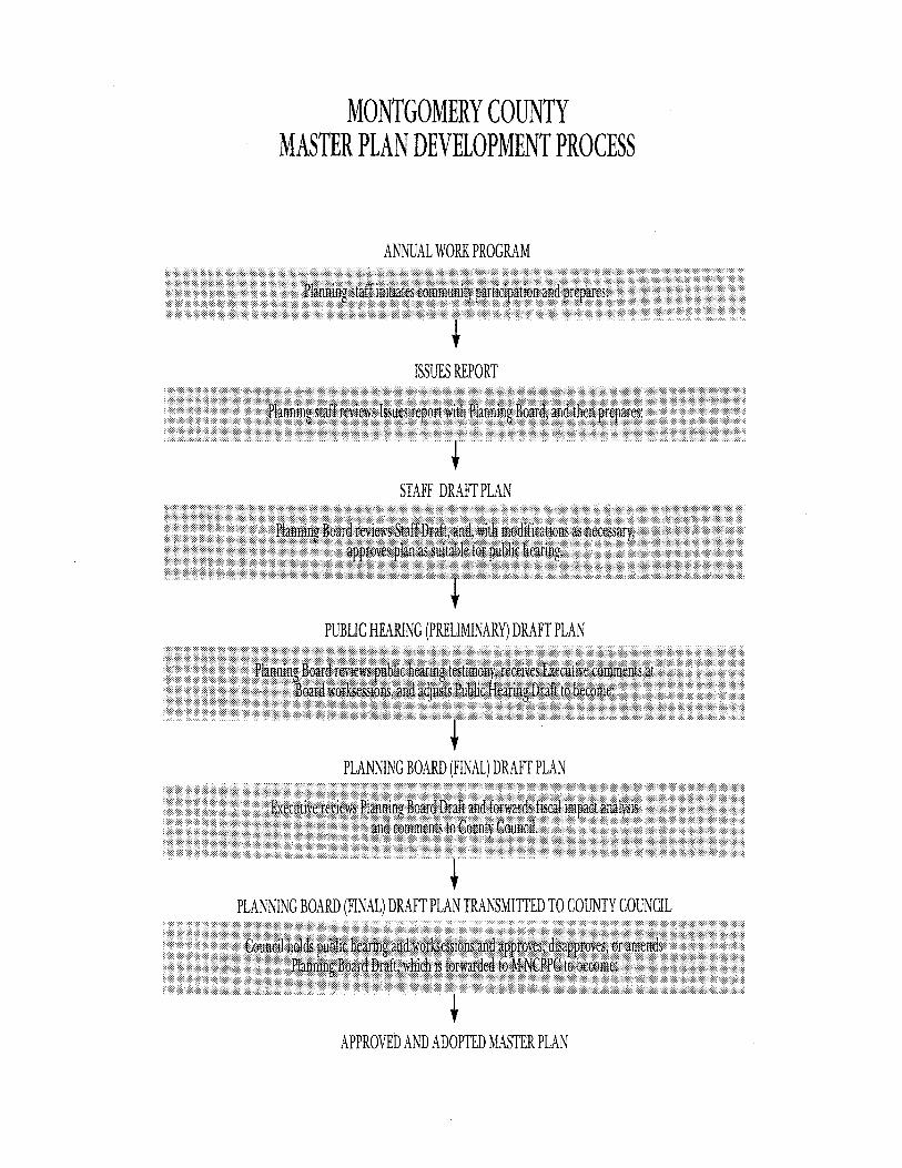
MONTGOMERY COUNTY MASTER PLAN DEVELOPMENT PROCESS
ANNUAL WORK PROGRAM '"'' '"'' '''''"'''''''''''''' :,,,: ,,, ,:,:, :,:,:
.,., ... , .. , ..
,.,.,.,.,.,.,.
, . ISSUES REPORT
STAFF DRAFT PLAN
,,
PUBLIC HEARING (PRELIMINARY) DRAFT PLAN
PLANNING BOARD (FINAL) DRAFT PLAN "'
:,:,:,:,:"'
1
PLANNING BOARD (FINAL) DRAFT PLAN TRANSMITTED TO COUNTY COUNCIL
APPROVED AND ADOPTED MASTER PLAN
,,,,,,
"'"' "'"' ,,,,
., .. , ,,,,,,,
,,,,,, ,,,,,,
,,,,,,
"''' ,,,,,

THE MASTER PLAN PROCESS

TABLE
OF
CONTENTS
EXECUTIVE SUMMARY PAGE I
SUMMARY OF FINDINGS & RECOMMENDATIONS PAGE II
Chapter One
INTRODUCTION PAGE I
Chapter Two
PURPOSE & SCOPE PAGE J
A. Background and Context of Plan .......................................................................... 3 B. Relationship ofFunctional Plan to Existing Area Master Plans ........................... 5
Chapter Three
POLICY FRAMEWORK PAGE~
A. Chesapeake Bay Initiatives ..................................................................................... 9 B. Federal Clean Water Act and State of Maryland's Initiatives: 208 Water Quality
Management Plan, Patuxent River Policy Plan ................................................... IO C. Montgomery County's Patuxent Watershed Initiatives ....................................... 11 D. Montgomery County Development Regulations ................................................. 11 E. Erosion and Sediment Control... .......................................................................... 12 F. Stormwater Management.. .................................................................................... 12 G. Soil Conservation District .................................................................................... 12 H. Users of the Reservoirs ........................................................................................ 12

TABLE
OF
CONTENTS
Chapter Four
POLICY RECOMMENDATIONS PAGE B
A. Protection of Water Quality in the Triadelphia & Rocky Gorge Reservoirs ...... ..14 B. Protection of Water Quality in the Streams ........................................................ .14 C. Protection of Groundwater and Wells .................................................................. 21 D. Protection of Stream Channels from Erosion ...................................................... 22 E. Protection of Properties, Roads, and Bridges from Flood Damage ..................... 22 F. Implementation Strategy ...................................................................................... 24
l. Action by County Executive ............................................................... 24 2. Action Program .................................................................................. 25
Chapter Five
SUMMARY OF THE PATUXENT RIVER WATERSHED TECHNICAL REPORT
PAGE 21
A. Background .......................................................................................................... 27 B. Scope .................................................................................................................... 27
l. Technical Advisory Group ................................................................. 28 2. Original Water Quality Data .............................................................. 28 3. Farm Inventory ................................................................................... 28 4. Water Quality Modeling ..................................................................... 28
C. Results .................................................................................................................. 29 D. WSSC Studies ....................................................................................................... 31
Appendix A: Flood-prone Structures ....................................................................... 33 Appendix B: Flood problems at Stream Crossings and Dams ................................ ..34 Appendix C ................................................................................................................... 36
I. Montgomery County Implementation Activities Patuxent River Commission Action Program, 1991-1992 ........................................... ..36
II . Recommendations of the Patuxent River Policy Plan .......................... .40 III. Summary of Montgomery County Implementation Activities for
the Ten Strategies of the State Patuxent Ploicy Plan ........................... .41 Glossary ......................................................................................................................... 45 References and Bibliography ........................................................................................ 47 Resolution ..................................................................................................................... 53

LIST
OF
FIGURES
Figure 1
STUDY AREA LOCATION PAGE4
Figure 2
GENERAL PLAN CONCEPT-1969 PAGE 1
Figure 3
MASTER PLAN BOUNDARIES PAGE 8
Figure 4
RAWLINGS RIVER PRIORITY SUBBASINS PAGE 1,
Figure 5
LOCATION OF TRIADELPHIA AND ROCKY GORGE RESERVOIRS
PAGE 17
Figure 6
RAWLINGS RIVER WATERSHED STREAM CHANNEL EROSION
PAGE B

LIST
OF
TABLES
Table 1
ESTIMATED LAND USE IN THE MONTGOMERY COUNTY PORTION
OF THE PATUXENT RIVER WATERSHED
PAGE JO

EXECUTIVE SUMMARY
This Functional Master Plan for the Patuxent River Watershed establishes policy recommendations to restore and
maintain water quality in the Patuxent River Watershed in Montgomery County, including the Triadelphia and Rocky
Gorge Reservoirs. The primary recommendation of this plan is the establishment of an interjurisdictional working
group to develop and oversee an ongoing water quality monitoring program, part of which would involve the devel
opment of water quality criteria by which the success of efforts to improve water quality can be judged.
Other recommendations of this plan include the reduction of nonpoint sources of runoff through a combination of
agricultural and urban land management practices. Agricultural stream buffer programs should be expanded and
stronger incentives for the use of agricultural Best Management Practices developed. The establishment of a
Primary Management Area within which development densities are limited and extraordinary Best Management PAGE l
Practices are utilized, is strongly recommended for the control of nonpoint sources of pollution from developing
areas and agricultural land. The details of the Primary Management Area concept are included in the document
entitled Environmental Management of Development in Montgomery County.
The necessity for this functional master plan has arisen from the efforts to restore water quality in the Patuxent
River as well as the Chesapeake Bay, from the need to address nonpoint sources of pollution from a regional perspec
tive, and from the need to protect the two drinking water reservoirs which are located along the Montgomery ·
Howard County border.

PAGc II
SUMMARY OF FINDINGS &
RECOMMENDATIONS
THIS PLAN IS BASED ON THE FINDING ...
• THAT under existing land use conditions,
the Triadelphia and Rocky Gorge Reservoirs are
under significant stress from nutrient enrichment;
• THAT modeling results indicate that under existing land use conditions,
sediment loads were predicted to be consistently lower and total nutrient loads higher than
for ultimate land use conditions.
These results, however, need to be further verified through monitoring;
• THAT it cannot be assumed that water quality conditions will improve
as ultimate land use conditions are implemented due to the fact that the transition from
existing to ultimate conditions will be slow,
and that existing high levels of nutrient inputs will continue to present a problem
over time due to build- up in reservoir bottom sediments;
• THAT water quality problems identified in the technical report and
other studies include eutrophic conditions in the reservoirs, high sediment loads and
nutrient levels in watershed streams during storm events,
and stream channel erosion problems;

• THAT water quality problems which have arisen in the
Patuxent River Watershed are largely the result ofland use that disturbs existing land cover,
which includes agriculture and urban development;
• THAT under "ultimate" land use conditions based on present zoning,
agricultural land will remain a significant land use category in the Patuxent River Watershed.
THIS PLAN RECOMMENDS ...
• the establishment of an interjurisdictional working group to develop appropriate watershed programs;
• an ongoing water quality monitoring program of surface waters, and the enhancement of model reliability through
collection of additional data and model verification;
• the control of nonpoint sources of pollution through the implementation of the primary management area concept
on developed and agricultural lands;
• THAT the effectiveness of voluntary BMPs in controlling nonpoint sources of pollution be enhanced;
• THAT WASHINGTON SUBURBAN SANITARY COMMISSION (WSSC) be encouraged to continue research efforts to determine
the potential groundwater effects of septic development in the Patuxent River Watershed,
and that a groundwater monitoring program be developed if research indicates it is warranted.
PAGE Ill
PAGE IV
In addition, this plan recognizes that no conclusive theory has yet been formulated which completely explains the
relationship between nonpoint sources of pollution from agricultural and developed land uses in a given watershed.
It is generally accepted that throughout the Chesapeake Bay Watershed, agricultural land ~elds higher nutrient pol
lutants, while developed land ~elds higher sediment loads due to higher levels of streambank erosion associated with
increased runoff velocities attributed to increased imperviousness. Additionally, runoff from developed land gen
erally contains more heavy metals and other contaminants associated with automobile use and may cause greater
thermal impacts to the streams. However, nutrient levels in runoff from developed areas may remain high when fer
tilizers are widely used in lawn maintenance, and sediment loads from agricultural land may be high when erosion is
not addressed through the use of appropriate BMPs. This plan strongly recommends an ongoing water quality
monitoring program which is designed to provide baseline information as well as to monitor changes in water quali
ty resulting from BMPs and regulatory action. It is emphasized that because of involved analysis of complex prob
lems, future updates are warranted. The proposed monitoring would provide a basis for the updating through the
enhancement of model reliability. This, in turn, may result in refinement of the findings of this study and reduce
the uncertainties.

This Functional Master Plan for the Patuxent River Watershed is the third such func
tional plan to address watershed management
issues in Montgomery County from a basin-wide
perspective. This plan and the two preceding it,
the Functional Master Plan for Conservation and Management in the Seneca Creek and Muddy Branch Basins, 1977 and the Functional Master Plan for Conservation and Management in the Rock Creek Basin1 1980, have been developed as
part of the ongoing Watershed Technical Analysis
Program which was initiated by the Planning
Department in the early 1970's under the direction
of the County Council. The technical analysis pro
gram develops concept plans for the major
drainage basins of Montgomery County. The tech-
nical reports and the ensuing functional master ~AGE l
plans are to assist the Council in tailoring its capi-
tal programming needs for conservation and man-
agement in the basins and to provide guidance to
the Planning Board in regulating land uses.
Technical studies without ensuing functional mas-
ter plans have been completed for the Cabin John Creek, Little Falls, and Anacostia River Watersheds.
The Functional Master Plan for the Patuxent River Watershed has four main objectives:
(1) protection of water quality in the Rocky Gorge and Triadelphia reservoirs,
(2) protection of water quality in the watershed streams, (3) protection of stream channels from erosion,

PAGE l
( 4) protection of properties from flood.
These objectives have been balanced with the need to protect agricultural activities in the watershed. This plan recognizes that the preservation of prime and viable agricultural land is a county priority. The functional master plan consists of the following elements which support the attainment of the plan's objectives:
(a) policies and recommendations identifying actions by the various involved agencies and jurisdictions to control pollution from urban and agricultural stormwater runoff;
(b) the concept of a Primary Management Area (PMA) as defined in the chapter, "Primary Management Area Guidelines for the Patuxent River Watershed in Montgomery County," Guidelines for Environmental Management of Development in Montgomery County, which establishes a land manage ment corridor along all watershed rivers and streams to prevent the transport of sediment, nutrients, and pollutants to those watercourses;
(c) an interjurisdictional working group of appropriate local and state officials to be established by the County Executives of Montgomery, Howard, and Prince George's Counties to address the complicated policy needs of the tri-county upper watershed;
(d) floodplain maps for the Hawlings River and major tributaries within the basin, and maps showing stream channel erosion areas;1
(e) maps showing structures and properties inundated by the 100-year ultimate floods;1
(0 a summary of the technical report and WSSC findings which together provide land use and water quality information on which this plan is based.
The Patuxent River Watershed in Montgomery County makes up 30 percent of the county land area which was
designated for agricultural and rural preservation in the Functional Master Plan for Preservation of Agriculture and Rural Open Space (1980). Within the watershed, more than 50 percent of the land has been designated as Agricultural Reserve (ROT zone) and the remainder as Rural Open Space (RC zone), excluding the communities of Damascus and Olney/Brookeville. The watershed also contains two drinking water reservoirs, Triadelphia and Rocky Gorge. This functional master plan differs from the two preceding watershed functional plans ( the Functional Master Plan for Conservation and Management in the Seneca Creek and Muddy Branch Basins, 1977 and the Functional Master Plan for Conservation and Management in the Rock Creek Basin, 1980) in that it addresses water quality issues stemming from agricultural and low density development areas, as opposed to concentrated growth centers. This functional master plan reaffirms the objectives of the Functional Master Plan for Preservation of Agriculture and Rural Open Space, but re-examines the environmental implications of the land-use recommendations for the Patuxent River Watershed in light of recent and ongoing research in nonpoint sources of pollution. Nonpoint sources of pollution pose serious environmental and economic risks to the stream systems and drinking water reservoirs in the Patuxent River Watershed. Based on a technical study conducted as part of the development of this plan, as well as on other research conducted in the watershed, this functional master plan identifies areas of critical concern in the watershed and recommends and outlines a series of policy needs and monitoring requirements for ensuring the improvement and maintenance of water quality in the watershed streams and reservoirs.
1 These maps are available al the Montgomery County Planning Department,
Environmental Planning Division, 8787 Georgia Avenue, Silver Spring, MD 20910.

A.
BACKGROUND
AND
CONTEXT
OF
PLAN
The Patuxent River Watershed in Montgomery County covers approximately 61 square miles; about 12 percent of the County. (See Figure 1.) The Montgomery County portion of the upper watershed represents approximately 6 percent of the entire watershed in Maryland, and constitutes a significant portion of the headwaters of this river. The Patuxent River forms the boundary between Montgomery and Howard Counties, and the two counties together constitute the upper watershed which drains into the WSSC reservoirs and then into Prince George's County. The Howard County portion of the Patuxent Watershed covers approximately 71 square miles and contains the remaining headwater area. The Patuxent River is an important tributary of the Chesapeake Bay and is the focus of the Patuxent River Commission, established in 1980 to address nonpoint source pol- PAGE J
lution problems affecting the Patuxent River and, consequently, the bay.
In addition to the focus placed on the watershed by the Patuxent River Commission, the Washington Suburban Sanitary Commission (WSSC), in its studies to monitor the reservoirs over the past 10 years, has found that siltation and eutrophication could significantly affect water quality of the reservoirs in the near future. The Triadelphia and Rocky Gorge Reservoirs straddle the Montgomery-Howard County border and have as their primary function the supply of over 11 billion gallons of drinking water to the suburban areas of Montgomery and Prince George's Counties, and secondary functions of recreation and flood control. The major tributaries to the Triadelphia Reservoir are the Patuxent mainstem, Cattail Creek (Howard Co.), Big Branch (Howard Co.), Pigtail Branch (Howard Co.), and Nichols Run (Howard Co.). The major tributaries to the Rocky Gorge Reservoir are the Patuxent mainstem and the Rawlings River (Montgomery Co.) (Ecological Analysts, 1991 ).

PAGE 4
FIGURE I
STUDY AREA LOCATION
SENECA
N
EB • • • • Study Area Boundary
•• ".. ... : .... • e • e e STUDY AREA e.
:11~
CREEK
e VICINITY MAP
• •
. ..... r.:·· f-.....
ANACOSTIA J's RIVER /8 I
ii I~
II# !& ,JI
FUNCTIONAL MASTER PLAN FOR THE PATUXENT RIVER WATERSHED MONTGOMERY COUNTY,MARYLAND
STUDY AREA LOCATION
"j The Maryland-National Capital Park and Planning Commission

In short, eutrophication occurs when excessive nutrient levels trigger the growth of algae in the water, which in turn depletes the dissolved oxygen necessary for the maintenance of a healthy aquatic ecosystem. Siltation, caused in large part by heavy sediment loads in the streams, blocks sunlight from reaching aquatic plants and blankets benthic (bottom dwelling) plants and organisms. Studies have also indicated that sediments on the bottom, when coupled with high nutrient levels, may retain those excessive nutrients and release them continuously over time, aggravating and prolonging the nutrient level problem. The nutrients and sediments which are degrading the streams and reservoirs of the upper Patuxent Watershed come primarily from nonpoint sources. Nonpoint source pollution is directly related to the land use practices in the watershed and is associated largely with land development and ongoing agricultural activities. The degree to which the reservoirs and streams will continue to be degraded depends in large part upon the degree to which current and proposed regulations and policies designed to prevent degradation in water quality are enforced and on future land use decisions.
The Patuxent River Watershed in Montgomery County is located predominately in the Piedmont Plateau physiographic province, which is characterized by large areas of fractured bedrock. An additional land management concern in this watershed is the widespread use of septic systems and the potential for groundwater contamination from those septic systems, and ultimately, the effects on the reservoirs.
Chapter III of this document will discuss the existing regulations, policies, and agencies which affect water quality in the watershed. Chapter IV contains the specific policies and recommendations of this functional plan to address areas where additional regulation and effort is needed to ensure that water quality conditions
in the watershed are restored and protected against future degradation, and Chapter V details the Technical Study conducted by Greenhorne and O'Mara, Incorporated, which examined the existing and ultimate land use conditions in the watershed and the effects land use has had and will have on water quality. The remainder of this chapter describes the framework of existing land use plans into which this functional plan will fit.
B.
RELATIONSHIP
OF
FUNCTIONAL PLAN
TO
EXISTING AREA
MASTER PLANS
This Functional Master Plan for the Patuxent River Watershed is developed through a process similar to that of a land use master plan and is an amendment to the General Plan of 1964, updated in 1969. As a functional master plan, it provides guidance for the preparation and update of local area master plans in their recommendations for land use, densities, and other features that could adversely affect the character or quality of the watershed. This functional master plan does not recommend any changes in the existing zoning and is not accompanied by a sectional map amendment. The 100-year ultimate floodplain delineation, as identified in the technical study, will be used in planning and enforcing the zoning and subdivision regulations of Montgomery County.
The Patuxent Watershed is covered by four existing local area master plans and the 1980 Functional Master Plan for Preservation of Rural and Agricultural Open Space. The four local area master plans govern land use
PAGE,

PAGE o
and follow the general guidelines in the County's General Plan (See Figure 2.). The General Plan recommends extensive areas of open space and agricultural land for the Patuxent River watershed. These plans are the Olney Master Plan, Damascus Master Plan, Sandy Spring/ Ashton Special Study Plan and the Eastern Montgomery County Plan. (See Figure 3.) In general, all these planning areas are zoned to preserve the rural and agricultural character of this portion of the county and contain provisions for the protection of environmentally sensitive areas.
The Olney Master Plan recommends the preservation of rural open space and farmland within the majority of the Patuxent Watershed area covered by the master plan. The Sandy Spring-Ashton Special Study Plan recommends clustering at low residential densities to preserve environmentally sensitive areas and to encourage farming. The Damascus Master Plan recommends clustering of low-density residential developments and designates the Agricultural Reserve Area to preserve the County's critical mass of farmland. The Eastern Montgomery County Mastef Plan recommends the concentration of development along existing transportation corridors to maintain the rural character of the Patuxent Watershed, thereby protecting Rocky Gorge Reservoir. Additionally, the entire Patuxent Watershed area within Montgomery County is covered by the Functional Master Plan for the Preservation of Agriculture and Rural Open Space. This functional plan recommends specific zoning categories and an innovative transfer of development rights program to protect agricultural land from suburban development. Thus, Montgomery County has ensured, through land use planning and zoning, preservation of the largely rural and agricultural character of the Patuxent Eatershed within the County.
As a functional master plan for the Patuxent
Watershed, this plan offers a policy framework for developing a land management strategy to protect the watershed's streams and reservoirs. The policies and actions recommended in this functional plan will be incorporated into the existing master plans as the land use recommendations in those plans are implemented and updated.
A Hydrologic Simulation Program in Fortran (HSPF) was used to simulate watershed processes in the technical study and will be available for the continued analysis of stormwater management and pollutant transport issues. The model reliability will be enhanced if additional data are collected and the model is verified and adjusted if needed.
The various actions and policies for protecting water quality which are identified in this plan are not selfimplementing. Implementation of the recommendations will require separate actions, coordinated with the agencies that have authority for enforcement and permitting, and through the various existing master plans. In addition, the policies and actions in this plan approved by the County Council and adopted by the Montgomery County Planning Board will provide guidance in preparing other documents such as the County's Ten-Year Comprehensive Water Supply and Sewerage System Plan, the six-year Capital Improvements Program, and updates to local area master plans.
The intent of this functional plan is to promote actions necessary to protect the water resources in the watershed. The watershed streams and reservoirs will be continually monitored. The results will then be used to evaluate and modify existing and proposed regulatory practices. Thus, the plan is dynamic, allowing for modifications in response to new data and understanding.

FIGURE 2
GENERAL PLAN CONCEPT· 1969
N
E9 -
Concentrated Growth Centers, · Corridor Cities,and Satellite
· Communities
0 Low Density "WEDGE" Areas
0 . Patuxent Watershed
••••• Upper Patuxent River Watershed Boundary (Study Area)
Montgomery County Boundary
"I The Maryland-National Capital Park and Planning Commission
••• •• •• •• • • • • • • • •• • • • • • • • •• • • •
FUNCTIONAL MASTER PLAN FOR THE PATUXENT RIVER WATERSHED MONTGOMERY COUNTY,MARYLAND
GENERAL PLAN CONCEPT-1969
•
PAGE 1

_,--'
~oo· 20yw
Jl'j The Ma,yland·Na1,onal Capital Park and Planmn9Comm1ss1on
HOWARD
;;;: c-,, = 00
COUNTY
FUNCTIONAL MASTER PLAN FOR THE PATUXENT RIVER WATERSHED MONTGOMERY COUNTV.MARYL ANO
MASTER PLAN BOUNDARIES -
~ ~ i---3 t:'rj ::::,:::, ~
g;;:: :; ~ ~ t::,:::I <..>,,
c::=:> c:::::: ~
~ ~ -t:'rj C'-:)
Policies affecting water quality within the
Patuxent River Watershed include state and federal legislation and agreements on the Chesapeake Bay
and nonpoint source pollution, county agreements and policies aimed at controlling point and non
point sources of pollution through storm water management, erosion and sediment control, and
zoning regulations designed to permit the appro
priate use of land. The existing framework, howev
er, requires multijurisdictional cooperation and
effort to supplement the policies already in place. The establishment of an ongoing water quality monitoring plan to augment existing data and iden
tification of areas where changes in existing policy
may be required for the improvement and mainte
nance of water quality are two steps that may help.
The following information summarizes the existing PAGE~
framework of policies and agency responsibilities, and Chapter IV identifies the policy recommenda-tions of this plan.
A.
CHESAPEAKE
BAY
INITIATIVES
The Chesapeake Bay is the largest and the most bountiful estuary in North America. Because of the bay's multi-state nature, it comes under the jurisdiction of several federal measures and agencies, including the Federal Clean Water Act and the U.S. Environmental Protection Agency. In the recent past, disturbing

PAGE 10
trends have been observed in the bay's resources. Submerged aquatic vegetation has been disappearing, and the productivity of the fishing and oystering industries has declined. In 1983, the U.S. Environmental Protection Agency found that the Chesapeake Bay was an ecosystem in decline and that nonpoint sources of pollution were among the chief causes. The study concluded that excessive levels of nutrients and toxic pollutants were causing decreased oxygen concentrations in the water.
Consequently, in December 1983, the governors of Pennsylvania, Maryland, and Virginia; the mayor of the District of Columbia, and the administrator of the EPA pledged to address nonpoint as well as other sources of pollution to restore and protect the Chesapeake Bay. This commitment, known as the Chesapeake Bay Agreement of 1983, established the Chesapeake Executive Council to coordinate bay cleanup efforts undertaken by the signatories to the Agreement. Implementation of programs to reduce nonpoint source (NPS) pollution is one of the most significant elements of the cooperative cleanup effort.
B.
FEDERAL CLEAN
WATER ACT & STATE
OF MARYLAND'S
INITIATIVES: 2 0 8
WA_TE.R, ___ QUALI.T_Y
MAN AG E_M_E_NT ____ P_LAN_;
PATUXENT RIVER
POLICY PLAN
Pursuant to section 208 of the Clean Water Act, the
State of Maryland has prepared the 208 Water Quality Management Plan for the Patuxent River Basin (1983) which, in addition to addressing point sources of pollution discharged into the basin waters, also outlines a total nutrient control strategy that includes nonpoint source assessments and control strategies. In addition, the Clean Water Act amendments of 1987 call for the regulation of nonpoint sources through the use of BMPs. BMP implementation is generally conducted on a voluntary basis, yet the U.S. EPA (1989) states that voluntary approaches alone generally are not sufficient to deal with the nonpoint source problem. (Foran, et.al., 1991)
In 1980, the Maryland General Assembly enacted the Patuxent River Watershed Act. The Act established the Patuxent River Commission which, in 1984, adopted the Patuxent River Policy Plan which recommends a land management strategy for controlling nonpoint source pollution in the watershed. The Montgomery County Council and six other counties forming the Patuxent Watershed endorsed this state Policy Plan. The plan recommends a series of land use actions that the abutting seven counties should undertake to improve the existing water quality of the Patuxent. One of the principal features of the Patuxent River Policy Plan is the concept of a Primary Management Area (PMA), a transition area between the stream and any development area. A PMA is a water quality protection and restoration area where land activities are regulated to enhance water quality in the stream. Although not mandatory, the state Policy Plan strongly recommends that each local jurisdiction develop its own PMA guidelines. As a general guide, the Patuxent Policy Plan provides for a PMA width of 1/ 4 mile along both sides of the Patuxent mainstem and 1/8 mile along both sides of tributary streams where natural vegetation is retained as a buffer to minimize stormwater

runoff and nonpoint source pollution. Future development should be planned in a manner sensitive to the purpose of the PMA and coordinated with existing nonpoint pollution control programs in the County.
C
MONTGOMERY
COUNTY'S
PATUXENT
WATERSHED
INITIATIVES
In 1984, the Montgomery County Council endorsed the state's Patuxent River Policy Plan and subsequently has participated in developing Annual Action Programs to achieve the objectives of the policy plan. This functional master plan and the technical study are elements of Montgomery County's participation in the state's Action Program. (See Appendix C). Pursuant to the recommendation in the state policy plan that local jurisdictions adopt their own Primary Management Area, the Montgomery County Planning Board approved the Patuxent River Watershed Primary Management Area guidelines in November 1991. These guidelines were developed with the input of a technical advisory group representing the concerns of County and state agencies. The Montgomery County Primary Management Area is consistent with the state's Patuxent River Policy Plan recommended PMA widths of 1/4 mile (1320') for each side of the Patuxent mainstem and 1/8 mile (660') for each side of all tributaries. In addition, Montgomery County is also recommending a 1/ 4 mile PMA for each side of the mainstem of the Hawlings River. The PMA guidelines for the Patuxent River Watershed in Montgomery County
are approved as part of the staff guidelines entitled Environmental Management of Development in Montgomery County and are included in this functional master plan by reference.
D
MONTGOMERY
COUNTY
DEVELOPMENT
REGULATIONS
The Montgomery County Planning Board and its Planning Department administer the subdivision regulations as set forth in the Montgomery County Zoning Ordinance. Protection of environmentally sensitive areas is an important factor in the Planning Board's decisions in administering subdivision regulations.
A major consideration is the impact of proposed development on stormwater runoff. The increase in impervious surfaces due to development contributes to increased runoff and the transport of sediment and pollutants to the streams. To provide a buffer between development and streams, thereby decreasing sediment and pollutant transport to streams, the County Zoning Ordinance prohibits development within the ultimate 100-year floodplain. In addition, the Planning Board has approved and adopted stream buffer guidelines for use in the review of development proposals. These guidelines recommend the preservation of buffer areas in their natural state, based on slope and soil conditions.
PAGE ll

PAGE 12
E.
EROSION
&
SEDIMENT
CONTROL
The Montgomery County Department of Environmental Protection, with the approval of the Montgomery Soil Conservation District, administers the County's Sediment Control Law. Under the law, a permit is required for any land development project that exceeds 5,000 square feet of disturbed area. The intended purpose is to minimize off-site siltation through the utilization of various urban BMPs.
F.
STORMWATER
MANAGEMENT
The Stormwater Management (SWM) Law, administered by the County Department of Environmental Protection (DEP), generally requires water quantity and quality control for all new construction in the County. The law and its associated regulations require reduction of post-development discharges to pre-development (meadow or forest) discharges for two-year storms. Presently, there is increased emphasis on water quality control in reviewing SWM concepts. Recent studies indicate that in the absence of regular maintenance, the effectiveness of SWM devices is severely limited (R. Cohn-Lee and D. Cameron, 1991). This plan recommends that the DEP look into the feasibility of requiring SWM for land parcels of 30 acres or more and a density of 1 unit per acre or less.
G
SOIL
CONSERVATION
DISTRICT
The Montgomery County Soil Conservation District is authorized to review and approve plans for the clearing and grading associated with development. In minimizing streambank erosion, the District also reviews and approves stormwater management plans. During 1987, the District transferred these urban responsibilities to Montgomery County. This left the District with urban responsibilities for the municipalities of Gaithersburg and Rockville only. With fewer urban responsibilities, the District was able to concentrate its remaining resources toward the development of agricultural soil conservation and water quality plans. Each plan contains various BMPs that will minimize agricultural nonpoint source pollution. The program is administered under voluntary participation.
H.
USERS OF THE
RESERVOIRS
The Washington Suburban Sanitary Commission (WSSC) is a bi-county agency responsible for providing water and sanitary sewer service for the Washington metropolitan area. The WSSC is responsible for the maintenance and management of the Triadelphia and Rocky Gorge Reservoirs. (See Figure 5.) Water from Rocky Gorge Reservoir is supplied to parts of Montgomery, Prince George's, and Howard Counties. A coalition of the user jurisdictions is necessary to develop an effective system to protect and maintain the water quality in the reservoirs.
This chapter describes the major policy
recommendations of this functional plan for water
shed management. The primary goal of these
recommendations is to establish a comprehensive
program which will achieve water quality and
quantity control in the streams and restore and
maintain water quality in the Triadelphia and
Rocky Gorge Reservoirs. The six key elements of
this program are:
A.
PROTECTION OF WATER QUALITY IN THE
TRIADELPHIA & ROCKY GORGE RESERVOIRS
B.
PROTECTION OF WATER QUALITY IN THE STREAMS
C.
PROTECTION OF GROUNDWATER AND WELLS
D.
PROTECTION OF STREAM CHANNELS FROM EROSION
E.
PROTECTION OF PROPERTY FROM FLOOD DAMAGE
F.
IMPLEMENTATION
These elements are highly interrelated and
are based upon the need for control of nonpoint
sources of pollution. To achieve the control of non
point sources (NPS) of pollution in the Patuxent
PAGE B

PAGE 14
Watershed, the identification of baseline
water quality conditions is essential. This
must be accomplished through the establishment of an ongoing water quality mon
itoring program, with monitoring conduct
ed throughout the watershed and at criti
cal points for gathering an understanding
of the relative contributions of different
land uses. Once baseline conditions have
been identified, water quality criteria
should be established for the improvement and maintenance of water quality. Water
quality criteria should be developed based on thresholds identified as critical for the
protection of water quality in the reser
voirs. Critical stream segments can be
identified for special management, and overall loadings can be reduced through a
comprehensive watershed management
program.
The following text examines the
six elements noted above in terms of the
recommendations of this plan. The strategy for achieving elements A and B is the same; therefore, they are discussed togeth
er.
A.
PROTECTION OF
WA TE_R __ ,.Q_U ALI_TY
IN THE
TRIADELPHIA
&
ROCKY GORGE
RESERVOIRS.
B.
PROTECTION OF
W ATE_R .... Q.UALI_TY
IN THE
STREAMS.
~TRATEGY: REDUCE NONPOINT rnURCE~ OF POiLUTION 1
INClUDING NUTRrnNT RWUCT!ON 1 AND REDUCTION IN ~EDIMENT lOAD~.
The two Washington Suburban Sanitary Commission (WSSC) reservoirs supply water to parts of Montgomery, Howard, and Prince George's Counties, and maintain water levels in the Patuxent River during dry periods. Secondary functions of the reservoirs include flood control and recreation. Preservation of water quality in the Triadelphia and Rocky Gorge Reservoirs is a primary goal of this plan. The Patuxent Technical Report detected indications of water quality deterioration in the reservoirs. If the total phosphorous load continues to increase at the present rate, taste and odor problems in the water supply will cause increased water treatment costs. Also, algal blooms and the decrease in dissolved oxygen impair the habitat for fish and wildlife, thereby adversely affecting recreational use of the reservoir.
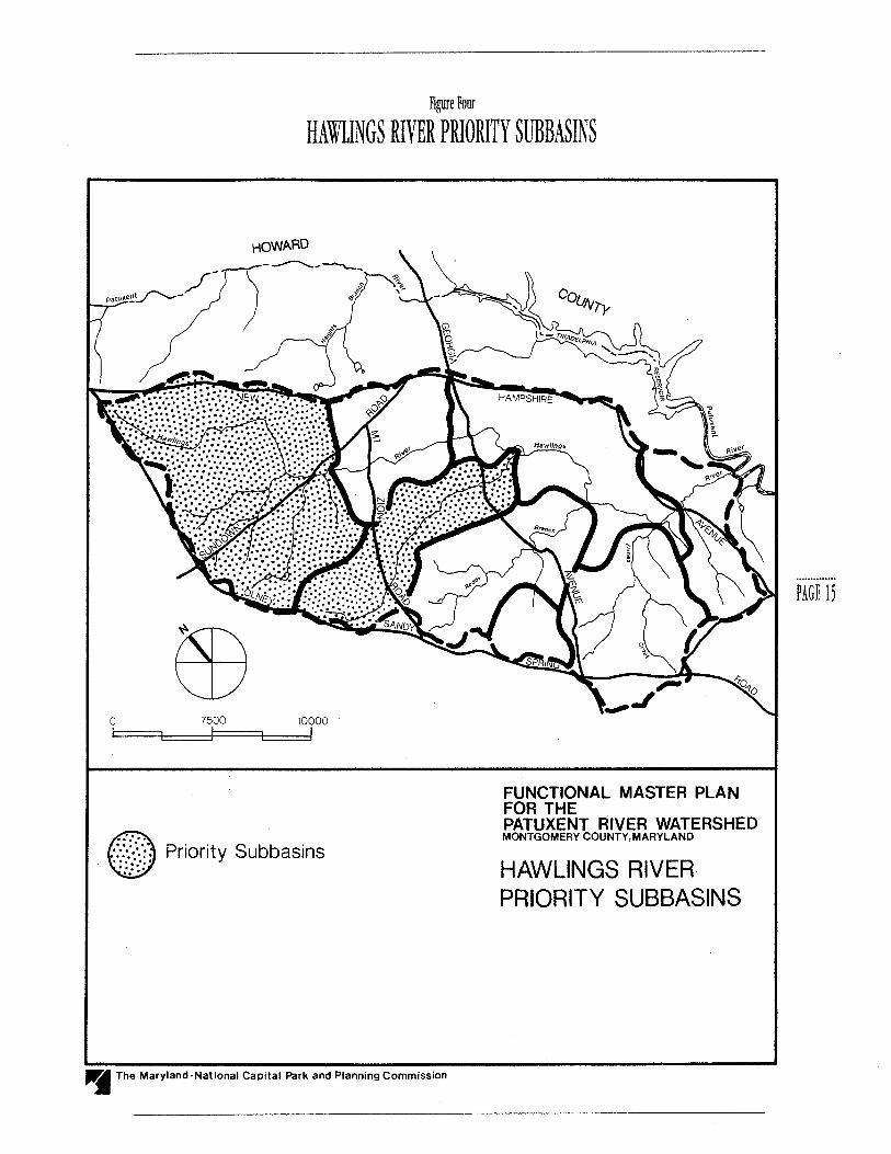
Figure Four
HAWLINGS RIVER PRIORITY SUBBASINS
HOWARD
0 7500 10000
Priority Subbasins
~ The Maryland-National Capital Park and Planning Commission
FUNCTIONAL MASTER PLAN FOR THE PATUXENT RIVER WATERSHED MONTGOMERY COUNTY,MARYLAND
HAWLINGS RIVERPRIORITY SUBBASINS
PAGE 1,
PAGE 16
The technical report has identified that currently the farmlands are major contributors of nutrients and sediment to the Triadelphia and Rocky Gorge Reservoirs. Since the continued eutrophication of reservoirs may impair their future use as water supply sources, management of agricultural lands to reduce NPS runoff is essential. Cropland areas require careful management to reduce pollutant runoff since fertilizers, herbicides, and pesticides are routinely applied during farming. Presently, the Montgomery County portion of the Upper Patuxent River Watershed is 40 percent agricultural land (Patuxent River Watershed Technical Report, 1990). Nearly 69 percent of agricultural lands are croplands. Approximately 56 percent of the farms in Montgomery County have conservation plans registered with the Soil Conservation District (SCD). According to the technical study, the Rocky Gorge Reservoir is phosphorous limited. Therefore, agricultural management techniques should be designed to reduce phosphorous in runoff from agricultural lands. Phosphorous is primarily associated with sediment, so best management practices must control sediment as well.
The quality of water in the reservoirs can be improved by reducing NPS loading, particularly phosphorous loads, through a combination of agricultural and urban land management practices. Phosphorus input from both agricultural and urban land can be reduced through a reduction in fertilizer applied to crops and lawns, appropriate timing of application, and effective control of runoff. The Rocky Gorge Reservoir receives water from five subbasins. Three of these basins, the Upper Patuxent, Triadelphia, and Cattail, first drain into the Triadelphia Reservoir. Addressing water quality problems in both reservoirs, requires the control of nonpoint source loadings from Howard County as well as Montgomery County. The Cattail Creek subbasin in Howard County has been identified as a significant source of nonpoint source loadings to the Triadelphia
Reservoir (EA Engineering, 1991). The high trapping efficiency of the Triadelphia Reservoir greatly reduces phosphorous and sediment loads delivered downstream from these subbasins. The Rawlings River subbasin drains into the Patuxent River below Triadelphia Reservoir and the Rocky Gorge subbasin drains directly to Rocky Gorge Reservoir. These two subbasins, without the mitigating effect of the upstream reservoir, contribute much higher total phosphorous loads to Rocky Gorge and downstream reaches.
Consequently, the most effective measure for the protection of the Rocky Gorge Reservoir is the reduction of loadings from the Rawlings and Rocky Gorge subbasins. The Rocky Gorge subbasin is partially filtered by the existing buffer strips surrounding the reservoir and has land uses which contribute proportionally less nonpoint source pollution than the Rawlings River subbasin. Therefore, the Rawlings River subbasin is the key subbasin to target for reduction of nonpoint source pollution. The technical report identifies that subareas, shown as Priority Subbasins in Figure 4, in the upper reaches of the Rawlings River Watershed contributed 15-50 percent more pollutant loads than the average and that these areas should be high priorities for future management activities. Total phosphorous input from the Rawlings Watershed must be reduced through a combination of agricultural and urban land management strategies.
RECOMMENDATION~ rOR THE REDUCTION Of NONPOINT rnURCE~ Or POLLUTION IN THE TRIADELPHIA & ROCKY GORGE mERVOIR~ AND THE WATER~HED ~TREAM~.
All jurisdictional users of the Triadelphia and Rocky Gorge water supply sources should share

Figure 5
LOCATION OF TRIADELPHIA AND ROCKY GORGE RESERVOIRS
N
EB 0 1 2 3 i====L _ _,==!~ .--I
• Patuxent River Watershed within Montgomery County
- " Hawlings River Subbasin Boundary
Upper Patuxent River •••••
Watershed Study Area
"j The Maryland-National Capital Park and Planning Commission
FUNCTIONAL MASTER PLAN FOR THE PATUXENT RIVER WATERSHED MONTGOMERY COUNTY,MARYLAND
LOCATION OF TRiADELPHIA AND ROCKY GORGE RESERVOIRS
PAGE 11

PAGE 18
responsibility for protecting the quality of water reaching these reservoirs.
Develop interagency programs to implement actions necessary to protect the watershed and the reserv01rs.
Establish an ongoing watershed monitoring program to better understand the biological and chemical characteristics of streams in the watershed.
Develop and foster participation in pollution management incentive pro grams to control nutrient and sediment loading generated from agricultural land uses in the Patuxent Watershed. Evaluate the effectiveness of voluntary BMPs in controlling nonpoint sources of pollution. If nutrient and sediment loading problems associated with agriculture do not show improvement, analyze alternative management plans that do not rely on voluntary implementation.
Existing incentive programs should be supplemented with local cost-share incentives through the County budget process to stimulate greater farmer participation. Local funding could be 'piggy-backed' onto federal and state cost-share formulas to increase program effectiveness.
Promote tree preservation and reforestation ofland converted from agricultural to residential uses.
Promote and encourage landowners to enroll cropland along streams into the Conservation Reserve Program (CRP). This federal program pays landowners to plant highly erodible land and other environmentally sensitive land as permanent cover for a period of 10 to 15 years. If the adjacent land is later subdivided to create residential lots, subdivision regulations would apply and the land enrolled in CRP would remain as permanent buffers.
RECOMMENDATION~ FOR CONTROLLING AGRICUlTURAL RUNOFF.
The following Best Management Practices (BMPs),
which are particularly effective in controlling sediment and phosphorous loadings, are recommended.
PRIMARY MANAGEMENT AREA
(PMA)
Lands adjoining streams are especially critical for protecting and maintaining water quality in streams. Sediment and pollutants resulting from development and agricultural uses near streams readily enter them. Most of the land area adjoining streams within the Patuxent Watershed are agricultural areas. Stream buffers containing forest effectively improve and maintain water quality in streams. The trees and shrubs fil. ter and trap sediments and absorb pollutants from overland runoff and subsurface flow. Forest buffer strips prevent excess nutrients from entering waterways and they are also effective sediment traps. Grass buffers also provide a measure of protection and can be used in areas where forest cover is not appropriate.
This plan incorporates the concept of the Primary Management Area (PMA) and the creation of stream buffers for all streams in the Patuxent River Watershed. The PMA recommendations for the Patuxent Watershed within Montgomery County are discussed in detail in the Environmental Management of Development in Montgomery County, under "Primary Manage- ment Area Guidelines for The Patuxent River Watershed in Montgomery County." These guidelines specify measures for implementing the PMA on agricultural lands undergoing the development process.
In addition, this plan recommends that implementation of Montgomery County's forest conservation law be coordinated with agricultural stream buffer programs. The implementation of the forest conservation law and associated programs, and the need to designate poten-

tial tree receiving areas may provide the opportunity for developers to contribute to the reforestation/ afforestation of buffers within agricultural areas as an off-site planting alternative. In addition, it is highly recommended that priority for reforestation/afforestation be given to PMA's in the Patuxent Watershed.
CON~ERVATION T!LlAGE
An effective form of conservation tillage is called notill farming. No-till farming involves chemically killing a cover crop and then planting a new crop without tilling the soil. The plant residue remains to protect the soil from wind and water erosion. This method can reduce soil loss by 95 percent, when compared to conventional plowing systems. While no-till provides good erosion control, its benefits can be lessened by the effects of improperly applied rates of herbicide and pesticide applications.
According to the Soil Conservation District, approximately 95 percent of the farmers in Montgomery County use some form of conservation tillage. Apparently, there is a high degree of cooperation between the watershed farmers and the Soil Conservation District. This plan recommends that the District enhance their conservation programs by incorporating effective water quality oriented programs.
CONTOUR FARMING & CONTOUR ~TRIP CROPPING
Contour farming is another method of reducing runoff during the growing season. Contour farming involves tilling and planting the entire field along the natural contours of the landscape. The effectiveness of contour planting is reduced during heavy storms and dor-
mant seasons because the contour edges may be worn and breached by high levels of rain. Very few farmers within the Hawlings River Watershed use contour farming. A more effective technique is contour strip cropping. Using this method, crops are planted in strips along the contour of a hill with strips of cover crop, such as hay, in between.
COVER CROP~
Winter cover crops, such as small grain grasses and legumes, are often planted to reduce runoff and soil loss in the fall, winter, and early spring. The winter cover crop is normally killed chemically. For full effectiveness, cover crops must be planted early enough for good fall growth. If the cover crop is chemically killed and its residue is left in place for no-till planting of a row crop, it provides erosion control into May and June. Cover crops can reduce nitrogen in runoff and infiltrated water as well.
CROP ROTATION
The practice of using a small grain or hay in crop rotation in Montgomery County is common. In some cases, winter cover may be provided during the rotation sequence. Crop rotation helps enrich the soil with nutrients typically depleted during the growing season. Crop rotation also improves the overall structure of the soil during the part of the rotation in hay, reducing the potential for erosion in subsequent years.
GRAmD WATERWAY~
Grassed waterways are stabilized channels that often receive the drainage from croplands. They are highly effective at preventing pollutant transport to streams by trapping sediment and decreasing water velocity when properly designed.
PAGE I~

PAGE 10
In the Rawlings Watershed, there are many grassed waterways in operation. Many of these waterways can be improved by regrading and widening. The grassed waterways are planted with fescue and rye grass and are maintained by periodic mowing. However, they may be damaged when herbicides are applied to control weeds m row crops.
Many farmers in the survey found grassed waterways incompatible with large farm equipment. Waterways may take land from production but compensate by draining excess water from other areas, thus making wetter areas arable.This plan recommends that more emphasis be placed on the use of grassed waterways and on their careful maintenance. Grass waterways also provide habitat for small wildlife species when interspersed with carefully placed rock obstructions.
WATERING TROUGmjHNCING
PA~TURE lAND
To provide fresh water for animals and prevent stream pollution, some farmers are fencing pasture land adjacent to streams and installing trough systems which receive water from springs. Cost of installation of troughs is about i2,ooo; they are efficient and easy to maintain and provide a constant supply of fresh water to animals. Long fences adjacent to streams, however, can be expensive and vulnerable to flood damage. The technical report farm inventory indicates that a significant number of streams are used for watering by cattle or are accessible to cattle. The use of watering troughs and fences along streams should be given a higher priority as a best management practice, particularly where streambank damage has already occurred.
POND~
Ponds can act as another pollution control device
where suitable sites are available. Ponds collect runoff from agricultural areas. A pond functions as a pollution control device by providing containment while chemical transformations and sediment deposition take place, resulting in reduction of dissolved agricultural chemicals and sediment discharge to receiving waters.
In addition to controlling nonpoint source pollution runoff, ponds have other environmental benefits. Ponds provide clean water to livestock as well as resting and breeding places for waterfowl during seasonal migrations. Ducks, blue gills, turtles, frogs, and sunfish are some of the indigenous resident species of fauna. As agricultural BMPs, ponds serve to reduce nonpoint source pollution runoff.
MANAGEMENT Or rERTlllZER / mT!CIDE / HERBICIDE APPLICATION~
Proper timing and application of fertilizers, pesticides, and herbicides are important to ensure both agricultural productivity and control of water quality. The amount of fertilizer applied will also affect water quality. Control of fertilizers is highly significant due to results of recent evaluations which have indicated that the Patuxent reservoirs are under stress due to high phosphorous levels. Furthermore, modeling efforts have indicated that nitrogen control measures play an important role in protection of the Chesapeake Bay. Soil testing helps prevent overuse by giving each farmer a fertilizer application rate specific to the needs of the soil and specific crop. In general, the same timing and application precautions apply to pesticides. The application of pesticides and herbicides during appropriate wind and rain conditions prevents possible adverse impacts on the environment.

ANIMAL STORAGE FACILITIES
Properly constructed storage facilities greatly reduce animal waste runoff. Many factors must be considered when storage basins are constructed. Soil type, depth to bedrock or water table, and prevailing wind direction are some of the major factors to be considered.
RECOMMENDATIONS FOR CONTROLLING URBAN RUNOfF
All areas which are not zoned agricultural (agricultural zones include Rural, Rural Cluster, and Rural Density Transfer) are categorized as urban for the purpose of this plan. The Montgomery County portion of the Patuxent Watershed is primarily forested or in agriculture, with clustering of low-density development occurring predominantly in the Olney area. Based on the results of the technical report, existing urban runoff and subsequent stream channel erosion are the major contributors to urban pollution in the watershed. Appropriate stormwater management measures are necessary to control pollution from urban runoff.
Most of the watershed area is zoned agricultural, with few exceptions; therefore, development in the future is not likely to exacerbate the present situation, provided that the application of current measures to control urban runoff pollution will continue. The following measures are recommended to supplement existing County regulations and programs:
adequate maintenance of SWM facilities; location of stormwater management facili
ties OUTSIDE buffer areas when feasible to avoid adverse impact to wetlands and habitat;
implementation and enforcement of the
Primary Management Area concept as detailed in the most recent edition of Guidelines for Environmental Management ofDevelopment in Montgomery County;
a survey of existing stormwater outfalls should identify points where impacts from storm drainage outfalls are significant. Measures should be taken to mitigate or retrofit these problem areas;
development of effective BMP's, beyond existing minimum requirements, to address continuing problems with urban runoff. High concentrations of sediment, phosphorous, nitrogen, industrial fluids, and heavy metals are commonly found in urban runoff. Street sweeping is a BMP that would reduce accumulated potential pollutants in urban areas;
reduction of the level and frequency of application of lawn fertilizers to reduce phosphorus levels in runoff.
C:
P R_O T_E_C T I_O_N
OF
G_ROUN_DWATER
&
WELLS ..........................
STRATEGY: !DcNTIFY THE POTENT!Al rOR GROUNDWATER POLLUTION FROM SEPTIC SHTEMS AND AGRICULTURAL CONTAMINANTS.
Subsurface flow as groundwater is both a source of drinking water supply for non-serviced areas of the watershed and the source of base flow in the tributary network. Potential sources of groundwater pollution include failed septic systems, leaking sewer lines, seepage from landfills, illegal disposal of oil and industrial chemicals, and leaching of agricultural contaminants
PAGE 21
PAGE 22
through the soil. The Patuxent River Watershed contains areas of fractured bedrock which has led to speculation about the potential for contamination of groundwater from septic systems. Although no data presently exists to substantiate these concerns, it may be prudent, particularly for large residential developments, to conduct case-by-case groundwater monitoring.
RECOMMENDATION~ FOR THE PROTECTION OF GROUNDWATER AND WELL~:
Encourage and work with WSSC to continue research efforts to determine the potential groundwater effects of septic development in the Patuxent Watershed. Develop a groundwater monitoring program should research indicate it is warranted.
Educate residential and agricultural communities about the appropriate use and timing of lawn and agricultural chemicals, on the appropriate disposal of toxic waste ( oil, fertilizer, pesticides, etc.), and on the maintenance requirements of individual septic systems.
D:
PROTECTION OF .................................................................. STREAM CHANNELS .............................................. u ............................ ..
FROM EROSION
~TRATEGY: REDUCE PEAK HOOD Dl~CHARGE AND VELOCITY A~ WELL A~ ~EDIMENT LOAD CARRrnD IN RUNOFF.
Urbanization increases the imperviousness of land, which results in the increase of both the quantity of stormwater reaching the streams and the velocity of flow in the stream channels. Land surface erosion and subsequent sediment deposits in the streams, will decrease the carrying capacity of the streams resulting
in flooding and channel erosion which are detrimental to the ecology of the stream systems.
RECOMMENDATION~ FOR PROTECTION OF ~TREAM CHANNEU:
The technical study identified stream channel areas in the Rawlings River where channel erosion is likely to occur in the future (See Figure 6.) This plan recommends that future development contain adequate stormwater management to prevent erosion, and that existing development in these areas be considered for stormwater management retrofitting. The County Department of Environmental Protection should undertake appropriate measures to stabilize stream banks where erosion problems have been identified.
This plan recommends enforcement of the Primary Management Area guidelines, including the use of extraordinary Best Management Practices and methods of stormwater management which increase infiltration of stormwater runoff.
E.
PROTECTION OF
PR_OP_E_RTI_E_S, ____ R_OAD_S_,
AND
BRIDGES FROM FLOOD
DAMAGE.
~TRATEGY: FLOOD-PROOFING ~HOULD BE CONDUCTED BY INDIVIDUAL PROPERTY OWNER~ AND FUTURE ROAD~ AND BRIDGE~ ~HOULD BE DE~IGNED TO THE ULTIMATE 100-YEAR FLOOD CAPACITm IDENTIFIED IN THE TECHNICAL ~TUDY.
Five properties have been identified in the technical
Figure 6
HAWLINGS RIVER WATERSHED STREAM CHANNEL EROSION
HOWARD
0 7500 10000
• . HIGH POTENTIAL
• MEDIUM POTENTIAL
--..- HAWLINGS RIVER WATERSHED
FUNCTIONAL MASTER PLAN FOR THE PATUXENT RIVER WATERSHED MONTGOMERY COUNTY, MARYLAND
HAWLINGS RIVER WATERSHED STREAM CHANNEL EROSION
"JI The Maryland-National Capital Park and Planning Commission
PAGE tJ

PAGE 14
study which are likely to experience flooding during a 100-year storm event. A list showing the locations of these flood-prone dwellings is included in Appendix A. This plan recommends individual flood-proofing for each of these houses to protect them from future flooding. Structural flood controls, such as darns or levees, are not considered feasible. No commercial buildings are identified as being impacted by the 100- year event.
As identified in the technical study, all the roads in the Rawlings River Watershed are predicted to be flooded during a 100-year storm event. A list of these road crossings and darns is provided in the Appendix B. The depth of flooding over many of these roads is greater than two feet, which causes a hazard to vehicles and makes roads unsafe during storm peaks. Calibrated posts should be installed at the bridges to warn motorists of the depth of flooding. This plan recommends that the Montgomery County Department of Transportation design future structures to pass the 100-year flood without overtopping.
RECOMMENDATION~ rOR PROTECTION Or PROPERTY, ROAD~, AND
BRIDGE~:
Encouragement of owners of structures situated in the existing floodplain to purchase federal flood insurance and to take flood-proofing measures to minimize impacts from floods.
The incorporation into applicable master plans and zoning maps of the ultimate 100-year floodplain, which is delineated in the technical study.
Placement of flood warning signs and calibrated posts at the bridges on road crossings over streams where the 100-year flood is forecast to overtop the road at a depth greater than two feet.
F:
IMPLEMENTATION
STRATEGY
~TRATEGY:
THI~ PLAN RECOMMEND~ THE r01LOWING 1!MMEDIATE" ACTION~:
l. ACTION BY COUNTY EXECUTIVE
The County Executive of Montgomery County will work with the County Executives of Howard and Prince George's County to establish an interjurisdictional group of appropriate local and state agency officials and at least one person from the Montgomery County agricultural community. This group will develop a program which coordinates efforts of the counties which border and receive drinking water supply from the Triadelphia and Rocky Gorge Reservoirs to provide water quality protection of the reservoirs and their watersheds (the upper Patuxent River Watershed). The interjurisdictional group will develop an interim program within 90 days of establishment, to go into effect immediately until a permanent Action Plan is developed.
This group shall accomplish the following within a period of two years:
(a) Draft a recommended Action Program (see Action Program below) to protect water quality in the upper Patuxent River Watershed.
(b) Draft an interjurisdictional agreement on policies to protect Triadelphia and Rocky Gorge Reservoirs.
( c) Establish county working groups in each of the three counties to 1) evaluate the effectiveness of

present management practices in the watershed, including the effectiveness of voluntary BMPs, and 2) develop a comprehensive watershed management program which is responsive to the monitoring program to be developed by the interjurisdictional policy group. In Montgomery County, the working group must include at least one person from the agricultural community.
This plan recommends a comprehensive watershed management program that addresses the problem associated with voluntary implementation of best manage ment practices in controlling nonpoint sources of pollution. The program should try to use a stream segment approach to assess, quantitatively and qualitatively, segments within which nonpoint sources of pollution need regulation to meet water quality criteria established to protect the streams and reservoirs. All parties potentially responsible for nonpoint source (NPS) pollution within a segment would have the responsibility for bringing water quality into compliance with water quality and biological criteria, either by targeting one or more specific nonpoint sources or land-use activities through BMPs, or through other innovative techniques. A significant degree of flexibility may be appropriate in the enforce ment of standards due to the innovative nature of regulating for NPS pollution.1
2. ACTION PROGRAM
This plan recommends an action program consisting of the following implementation elements for timely achievement of the policy statements identified in this functional plan:
(a) Water Quality Monitoring
An ongoing watershed monitoring and reservoir mod-
eling program is necessary to obtain a better understanding of the biological and chemical characteristics of the upper Patuxent River and its tributaries. This should be coordinated with the Patuxent Estuary Demonstration Project currently being conducted by the Maryland Department of the Environment.
(b) Reporting and Pollution Control Targets
The working group will prepare an annual report to the county executives on the status of implementation efforts to protect water quality in the upper Patuxent River Watershed. Within five years of its creation, the working group will report on the observed effectiveness of sediment and nutrient control efforts and will recommend pollution control targets for each participating jurisdiction to pursue over the succeeding fiveyear period.
(c) Education, Incentive, and Awards
This program will encourage local implementation of best management practices to reduce nutrient and sediment loadings from agricultural and developed areas.
( d) Voluntary ~tr earn Buffers
This program will encourage farmers to provide voluntary stream buffer areas through programs such as tax exemptions, easements, rental payments, or other appropriate financial incentives.
1 These rewmmendations for regulating nont-Oint sources are based on the findings by
U.S. EPA that voluntary methods alone are not sufficient for controlling nonpoint
sources of pollution, and on a proposal for regulating nonpoint source pollution in
surface waters developed by ].A. Foran, P. Butler, L. Cleckner, and]. Bulklry (Foran,
etal, 1991).
PAGE 2,

PAGt 2o
( e) Tree Preservation
Develop agricultural incentive programs which complement the Montgomery County forest conservation law.
The Montgomery County forest conservation law has been developed in accordance with state initiatives as stated in the Maryland state forest conservation law. The county law establishes a local forest conservation program tailored to conditions in Montgomery County.
The forest conservation program stipulated by the law provides a regulatory framework for the preservation of existing forest and trees and the reforestation of cleared areas, and specifies minimum afforestation requirements for non-forested land and agricultural areas when they are converted to residential use. This plan recommends that agricultural incentive programs complement the forest conservation law by encouraging the use of forested stream buffers on agricultural land.
The Montgomery County forest conservation law requires developers to compensatefor trees taken down during construction by planting new trees on- site or, if not feasible, at designated off-site locations. This &mctional plan recommends that agricultural stream buffer areas be targeted as tree receiving areas.
(f) W~~C Participation in Implementation
WSSC should actively participate in the implementation activities. The county executives should work with WSSC to obtain cooperation and participation in funding for the program. Together WSSC and the county executives should explore the possibility of utilizing WSSC's authority to generate additional funds for implementing programs towards maintenance of water quality.

A.
BACKGROUND
The Technical Report for the Patuxent River Watershed Management Study, Montgomery County, Maryland, prepared by Greenhorne and O'Mara, Incorporated, completed in February 1990, represents a continuation of the watershed technical analysis program which was undertaken by the Planning Department in the early 1970's. The study and its findings are made a part of this functional master plan by reference.
Urgency for the Patuxent technical study arose as a result of WSSC's Patuxent River Reservoirs Watershed Protection Program (Water Project 144) recommendations, as well as other studies, which indicated that the Triadelphia and Rocky Gorge Reservoirs were being threatened by pollution associated with urbanization and agricultural activities within the Patuxent Watershed. The Technical Report for the Patuxent River Watershed provides recommendations for watershed management on which this functional plan is based, as well as providing land use and water quality information used in developing Primary Management Area guide- PAGt 27 lines. The Primary Management Area guidelines are based upon recommendations made in the state's Patuxent River Policy Plan and are included in the Guidelines for Environmental Management of Development in Montgomery County. Copies of the Patuxent Technical Report are available at the Silver Spring office of the M-NCPPC.
B
SCOPE
Within the region there has been a growing emphasis on the protection and enhancement of the Chesapeake Bay. The Patuxent River is unique because it is a major bay tributary within the state of Maryland that contains two water supply reservoirs and has a multijurisdictional dimension in the upper watershed. In addition, agriculture has been directly or indirectly identified as a major source of pollution to the Patuxent. As a result, the scope of the Patuxent Technical Report was considerably different than
the previous studies conducted by the Planning Department. The most significant differences in the approach taken included:
1. TECHNICAL ADV!WRY GROUP
A Technical Advisory Group (TAG) consisting of representatives from several agencies was formed to actively participate in the study. They are the Washington Suburban Sanitary Commission, Montgomery County Department of Environmental Protection (DEP), Howard County government, Prince George's County government, Metropolitan Washington Council of Governments, Montgomery Soil Conservation District, and the State Department ofNatural Resources.
t ORIGINAL WATER QUAUTY DATA
Since very little water quality data existed, it was agreed that monitoring take place at four additional locations besides those already monitored by state and federal agencies. During the time of the study there were very few significant rainfall events and extension of the monitoring period was necessary. This extension was made possible due to grants from the state and WSSC. Data collected was provided to the state and stored in EPA's STORET System.
J. f ARM INVENTORY
A prototype inventory of existing farms and farm practices was conducted for farms in excess of 50 acres located within the Rawlings River subbasin. This activity was conducted in close coordination with the Montgomery Soil Conservation District. Eighteen farms of the 43 farms identified were visited. These 18 farms represent approximately 87 percent of the farmland in the Rawlings Watershed. Farmers were interviewed and impressions recorded. It was found that 92
percent of the farmers followed both best management practices (BMPs) and conservation practices recommended by the Montgomery Soil Conservation District.
4. WATER QUAUTY MODELING
A computerized hydrologic simulation model in Fortran (HSPF) was used to simulate watershed processes. This model, in public domain, has been used for the Chesapeake Bay study and the state is currently using it to depict water quality for its total Patuxent Watershed analysis.
The scope of services for this study was based on the assumption that a comprehensive watershed analysis would be done for the entire watershed upstream of the lower reservoir, including the Howard County portion. This concept was discussed at the Patuxent River Commission and generally endorsed. Every effort was made to get Howard County involved in a joint study. However, although the Howard County staff participated in the TAG meetings and provided land use data, they could not succeed in obtaining the necessary funding to run HSPF for their part of the watershed. Howard County staff stated that they were already implementing BMPs and were recommending their own PMA. They also felt that their grading regulations, restriction of activities in floodplains, and a strong Soil Conservation District would go a long way toward controlling nonpoint source pollution. Therefore, they felt the cost of the modeling was excessive and not necessary at that point in time for their county.
With this turn of events, a policy decision was made (in consultation with TAG) to run HSPF only for the Rawlings River Basin and extrapolate the results to the

entire Patuxent Watershed using a desktop model called NonPoint Source Screen (spread sheet). This desktop model is a refinement of COG's loading rate, based upon observed water quality data and the simulation run on the Rawlings River.
The Rawlings River is a major tributary of the Patuxent, entering the stream system below Triadelphia Reservoir. It is well documented that Triadelphia acts as an efficient trapping basin for sediment and other pollutants. It was also decided that it would be prudent to concentrate using our limited funds on areas under Montgomery County jurisdiction. The total Rawlings River subwatershed is within Montgomery County. Most of the subbasin area is in the Rural Density Transfer and Rural Cluster zones, with the lower western portion around Olney moderately developed.
Using a computer simulation model, water quality data for the Rawlings River basin was modelled and analyzed and from this model, water quality information was extrapolated for the rest of the watershed. R-ROUT and HEC-2 models were used for hydrology and hydraulic analysis. R-ROUT is a derivative of the Stanford model, an early version of HSPF. HEC-2 is universally used for hydraulic analysis and determining the potential for stream channel erosion. The technical report and associated floodplain maps identify locations and extent of flooding and erosion potential.
For water quality modeling, existing and ultimate land use scenarios were considered. Land uses were divided into different categories and hydraulic segments. Different channel segments were developed as well. Under the ultimate land use scenario most of the watershed would be zoned RDT and Rural Cluster. This scenario is very similar to existing land use. Low level aerial photography showed existing land use.
C.
RE_SULT_S
The RDT zone encompasses a major portion of the study area with the ultimate land cover in the RDT zone estimated at 38 percent of the upper Patuxent watershed within Montgomery County. For use in the HSPF model, the land use mix within the RDT zone was estimated by examining six existing representative farms. Based on this analysis, the distribution of land cover within the RDT zone was 40 percent cropland, 20 percent pasture, 20 percent forest, and 20 percent low density rural residential. The HSPF model analysis assumed that the rural residential, pasture, and cropland areas included 3 percent impervious surface area. However, the actual land cover of the RDT zone may vary throughout the watershed due to flexibility allowed in zoning. The Rural and Rural Cluster zones which are designed to accommodate a limited amount of residential development in conjunction with farming activities, for the purposes of the technical report, are expected to have a distribution of land uses similar to the RDT zone. Under ultimate conditions, 30 percent of the watershed will consist of Rural and Rural Cluster, resulting in 68 percent of the watershed having a land use cover of 40 percent cropland, 20 percent pasture, 20 percent forest, and 20 percent low density residential.
Using the estimated RDT zone land use distribution along with the overall ultimate land use percentages for the Patuxent River Watershed within Montgomery County, it is estimated that under fully developed ultimate conditions, land use in the watershed will consist of approximately 29 percent forest, 27 percent cropland, 14 percent pasture, 14 percent rural residential, 6 percent large lot residential, and 8 percent other residential and commercial. The existing land use for the Patuxent Watershed in Montgomery County (1985 aeri-
PAGE l~

PAGE JO
Table I
ESTIMATED LAND USE IN THE MONTGOMERY COUNTY PORTION OF THE PATUXENT RIVER WATERSHED*
LAND USE EXISTING ACRES ULTIMATE ACRES %CHANGE
Forest 1 17,206 11,525 · 33.0% Cropland 2 11,801 10,843 -8.1%
Pasture 3,743 5,652 +33.8% Rural Residential 3,047 5,349 +43.0% Large Lot / Residential 767 2,242 +65.8% Other Residential / Commercial 3 2,127 3,081 +31.0%
*based on Table 9.6 of Technical Report, p.9- 25. The ultimate RDTandRural Residential land uses from Table 9.6 are broken into the land use distributions for crop/an~ pasture, forest, and rural residential based on the assumptions described above, and then added to the remaining area as listed in Table 9. 6 of the technical report. Existing acreages are derived from 1985 aerial photos.
1 includes Forest and Open Space (implementation of the 1992 Forest Conservation Law will affect the results of this study)
2includes Crop- Conservation and Crop-Conventional
3 includes Low Density Residential, Medium Density Residential, Low-Medium Residential, Light Commercial, Heavy Commercial, Townhouse, Landfill
al photos) consists of approximately 40 percent forest, 30 percent cropland, 10 percent pasture, 10 percent rural and large lot residential, and 10 percent other residential and commercial. (See Table 1.) The actual intensity of agricultural land use under ultimate conditions will depend upon the continued implementation of the RDT zone and the extent to which the Rural and Rural Cluster zones are utilized for agricultural purposes.
The model calibration for water quality parameters was completed for years 1983 to 1987 and verified for years
1979 to 1982. No verification period existed for sediment and water quality parameters because of the limited data. The Technical Advisory Group agreed the study is a necessary first step and this effort should continue in the years to come if funding were made available. As more data is collected, models can be refined and results can be predicted with a higher degree of confidence.
Based on ultimate land use projections, modeling results indicate that sediment loads were predicted to be consistently higher and total nutrient loads lower

for ultimate conditions than for existing conditions. Modeling results for existing conditions indicate tha~ on an average annual basis, both Triadelphia and Rocky Gorge Reservoirs are under significant stress from nutrient enrichment. In addition, the HSPF model was used to predict major sources of sediment, total phosphorus, and total nitrogen within the Rawlings Watershed, and found that two subareas (shown as Priority Subbasins in Figure 4) in the upper reaches of the watershed contributed 15-50 percent more pollutant loads than the average and should be targeted for future management activities.
In its conclusions, the technical report recommends that existing land use conditions should be the focus of efforts to reduce loadings of sediment and nutrients due to the slow! transition from existing to ultimate land use and the lack of immediate response by hydrologic system to decreased nutrient inputs, particularly in the reservoirs where nutrients are stored. The increase in sediment loads and the decrease in nutrient loads under ultimate conditions is due to the increase in rural residential housing and the assumed conversion of existing farms into smaller 25-acre farms. The model simulation of the RDT zoning assumes the conversion of some high intensity cropland areas to pasture and forest. Sediment and nutrient loadings are a significant concern under both scenarios. The magnitude of loading would vary depending upon many variables, including but not limited to: actual land use; improved and expanded use of agricultural BMPs; rainfall; time and intensity of fertilization; and amount, type and location of forest. Thus, based upon the amount of data collected and the simulation made, it is difficult to predict with confidence the absolute values of water quality indicators.
While there is some uncertainty about the precise val-
water supply reservoirs need protection. The technical report identifies priority areas as well as the benefits of potential BMPs. In addition, the technical report suggests that 300 feet is an optimum stream buffer width for water quality benefits. Considering the variables associated with determination of an appropriate buffer, this width will be re-evaluated and adjusted as more data becomes available.
D.
WSSC STUDIES
Three studies have been completed by WSSC concerning water quality conditions in the reservoirs. These are the (1) Patuxent River Watershed Protection Program (Ecological Analysts, Inc. 1981), (2) the Patuxent River Reservoirs Water Quality Assessment GTC 1984), and (3)Water Quality Monitoring and Nutrient Loading Analysis of the Patuxent River Reservoirs Watershed (EA Engineering, 1991 ).
The first study by Ecological Analysis had the following six goals:
1) to ascertain existing and projected land use characteristics and population density projections for the Patuxent River Watershed above Triadelphia and Rocky Gorge Reservoirs,
2) to identify and review other previously conducted studies or programs which addressed the reservoir watersheds,
3) to review and summarize reservoir management practices and uses,
4) to review reservoir water quality and nonpoint source pollutant loadings data,
5) to assess the trophic state of the two reservoirs (Estimated Land Use in the Montgomery County Portion of the Patuxent River Watershed), and
6) to recommend a reservoir watershed protection program based on the findings of this study.
ues, the trend is very clear. The rivers, streams, and Ecological Analysts considered three previously con-
PAGE H

PAGE J2
ducted water quality studies: 1) Patuxent River Nonpoint Loading Studies by the Maryland Department of Natural Resources, Tidewater Administration, 2) Water Quality Sampling in the Patuxent River Basin, by the Maryland Department of Health and Mental Hygiene, and 3) Water Quality Analyses-Patuxent Reservoir. The studies concluded that both reservoirs were eutrophic, and in the development of recommendations for implementing a watershed protection program, included reservoir and stormwater sampling, continuance of reservoir surveys for sedimentation characteristics, biannual meetings between WSSC, M-NCPPC, Howard and Montgomery Counties, and continued implementation and development of watershed best management practices.
The second study by the Patuxent River Reservoirs Water Quality Assessment was to determine reservoir water quality through a one-year sampling program. This study found that phosphorus was the limiting nutrient for algal growth in the reservoirs. Triadelphia was classified as slightly eutrophic and Rocky Gorge as intermediate mesotrophic/ eutrophic.
The third study by EA Engineering was to supplement and continue stream and reservoir water quality monitoring with the specific goal of better describing and predicting the sediment and nutrient loading rates of the Triadelphia and Rocky Gorge Reservoirs, and to enable WSSC to identify trends and evaluate the predictions of previous desktop eutrophication models. The results of this study include the finding that stormflow loadings accounted for 95-97 percent of the total loadings of total suspended solids and 85-88 percent of total loadings of phosphorus, whereas loadings for nitrogen were equally distributed between baseflow and stormflow (45-51 percent). It was also found that loadings from the Cattail Creek watershed, though 15 percent smaller than the Rawlings watershed, ~elded
loadings of phosphorus and total suspended solids that were essentially equal to the Rawlings, and nitrogen loadings that were 40 percent higher. The higher loadings from the Cattail Creek watershed were attributed to higher stormwater concentrations for all three parameters. This third study also indicated that loading estimates from the 1990 stormwater monitoring program (done as part of this study) with loading estimates from the earlier nonpoint source models, but that sediment loading estimates from both the earlier models and the stormwater monitoring were substantially lower than loading rates estimated from a sedimentation survey of the two reservoirs, due to a lack of adequate data for high flows. The final recommendation was the continuation of stormwater sampling program with an emphasis on collecting data for high flow events, and the evaluation of sampling station and program design.
The findings of the Patuxent watershed technical report, along with findings from the WSSC studies and recommendations received from the Technical Advisory Group, Citizen's Advisory Committee, staff of the DEP and County Executive, and the Montgomery Soil Conservation District, have provided the basis for this functional master plan. Additionally, the Maryland Department of the Environment has undertaken the Patuxent Estuary Demonstration Project to be conducted through the Patuxent River Commission. This project has been undertaken to document the linkages between existing water quality, living resource conditions and past land use decisions, and to provide a solid technical basis for making environmentally sound land use decisions. Information that becomes available through this project will be used to enhance the monitoring and modelling efforts already undertaken in the upper watershed, and future efforts conducted pursuant to this master plan will be closely coordinated with the demonstration project.

APPENDIX A
FLOOD-PRONE STRUCTURES
LOCATION * ** FLOODING SOURCE 100- YR WSEL (Ff) FIRST FLOOR ELEV. (Ff) FLOOD DEPTil (IT)
41 Haviland Mill Rd.
2100 I Georgia Ave.
3300 Gregg Rd.
Market St., west side of road, appr. 300 ft. south of intersection with Brookeville Rd.
18709 Brooke Road
*Water Surface Elevation **Approximate Sill Elevation
Hawlings River (Patuxent Backwater)
Tributary HI
Tributary HI
Tributary RI
Sandy Spring
Source: Greenhorne & O'Mara Technical Report 1990, Table 10.11.
323.5 320.0 3.5
384.0
387.0 384.0 3.0
383.8 380.2 3.6
356.2 354.5 1.7
PAGE JJ

PAG~ J4
STREAM NAME
Hawlings River
Brighton Dam Rd.
Tributary HI
Tributary H3
Tributary H4
Tributary HS
Tributary H7
Reddy Branch
*Backwater Elevations ** Top of Dam
APPENDIX B
FLOOD-PROBLEMS AT
STEAM CROSSINGS & DAMS
ROADWAY FLOOD ELEVATION MINIMUM STRUCTURE 2-YR. 10-YR. 100-YR. FLOOD
ROADWAY ELEV (IT)
Haviland Mill Road 303.3 309.9 * 323.5 * 305.4 New Hampshire 310.4 316.3 323.5 * 312.0 Gold Mine Road 318.7 320.5 323.5 * 315.6
334.7 338.4 241.5 329.3 12.2 Georgia Avenue 376.0 379.7 385.9 380.6
Zion Road 441.4 442.8 445.0 439.1 Sundown Road 458.6 460.6 461.5 458.9
Griffith Road 477.2 480.4 481.0 478.6
Georgia Avenue 381.4 382.8 383.7 381.8 Gregg Road 394.9 396.9 398.3 395.0
Zion Road 490.0 494.7 495.9 491.5
Zion Road 438.7 * 442.0 * 443.9* 439.1 Berstein Road 469.7 470.9 471.9 474.0 **
Sundown Road 478.8 479.7 480.3 478.3
Sundown Road 461.0 462.6 463.l 461.6
Riggs Road 495.8 499.5 500.4 499.6
Sundown Road 507.4 510.0 513.3 513.3
Brighton Road 328.9 332.3 333.1 329.5
Source: Greenhorne & O''Mara Technical Report 1990, Table 10-2
DEPTII (IT)
18.1 11.5 7.9
5.3 5.9 2.6 2.4
1.9 3.3 4.4
4.8
2.0
1.5
0.8
0.1
3.6

STREAM NAME
Reddy Branch
Tributary Rl
James Creek
APPEND_IX ___ B_(C_ONT_'_D.)
FLOOD-PROBLEMS AT
STEAM CROSSINGS & DAMS
ROADWAY FLOOD ELEVATION MINIMUM STRUCTURE 2-YR. 10-YR. 100-YR.
Georgia Ave. 376.7 380.5 381.8 I.Brookeville Road 387.5 388.3 389.3 2.Brookeville Road 401.2 404.0 404.8 3.Brookeville Road 410.0 410.8 411.5
Brookeville Road 378.6 380.4 * 382.0* Olney Mill Road 400.2 403.1 408.5
Olney Family Park Pond 414.7 415.3 416.0
Chandlee Mill Road 314.8 318.8 323.5 Unnamed Road 337.8 339.7* 343.5 *
Olney Sandy Spring Road 452.3 453.4 453.9
Tributary J3
Tributary JS
Sandy Spring Creek
* Backwater Elevations ** Top of Dam
Unnamed Road 408.7
Brooke Grove Road 431.6
Brooke Grove Road 351.4
Source: Greenhorne & O'Mara Technical Report 1990, Table 10-2
409.9 410.8
432.6 433.0
354.4 355.1
FLOOD DEPTI:I ROADWAY (ff) ELEV (ff)
377.8 4.0 385.9 3.4 401.3 3.5 408.6 2.9
377.2 4.8 407.0 1.5 414.5** 1.5
PAGE ,, 318.7 4.8
339.3 4.2 452.0 1.9
406.8 4.0
430.9 2.1
353.8 1.2

PAGE JD
APPENDIX C
I. MONTGOMERY COUNTY
IMPLEMENTATION ACTIVITIES
Patuxent River Commission Action Program 1991 -1992. (from: Patuxent River Commission. Action Program 1991-1992. Maryland Office of Planning. October 1991.)
11~ 11111r11~ 1111 ~ ~1@111111~1111111111111t11111111r1111i~1,111ilillli 1991 · 1992 TASKS TIME ANTICIPATED PRODUCT/ ACCOMPLISHMENTS
1. Prepare approved and adopted Patuxent Watershed Functional Master Plan containing recommendations for establishing Primary Management Areas within the Patuxent watershed. (1,2)
2. Preparation of: The Tree Report - The Conservation in Montgomery County and Recommendations for a Comprehensive Tree Conservation Ordinance. A drafi copy has been prepared. Conduct approval process. (7)
3. Preparation of "Environmental Management of Development in Montgomery County Maryland" which contains guidelines for PMA buffer areas. Apply guidelines in reviewing development. (1,2)
1. Adopt County Water Quality Plan. Provides general support to all Patuxent Policy Plan recommendations
2. Participate in interagency development of M-NCPPC's Patuxent Watershed Functional Master Plan
FY 1991- 92 Approval and adoption of the plan.
FY 1991- 92 Review and comment by related agencies and groups towards approval and adoption.
FY 1991· 92 Apply guidelines for review of development in the watershed.
1992 Amendment to County Ten Year Water Supply and Sewerage Systems Plan which sets forth adopted County Policies and an action plan to protect County water resources.
1991-1992 Approved Functional Watershed Master Plan covering County lands in Patuxent watershed.
Note: The numbers in parentheses following each task are references to the Patuxent River Policy Plan recommendation numbers.

3. Participate in interagency development 1991- 1992 Approved Primary Management Area guidelines. Apply of Primary Management Area guidelines to to new development and seek voluntary protect Patuxent stream buffer. (1,2) implementation on agricultural lands.
4. Seek funding to enable local cost- share 1991-1992 Local cost-share incentives to add to available incentives that would help stimulate voluntary Federal-State grants to farmers who agree to implementation of agricultural BMPs for control voluntarily install BMPs. of animal wastes and the reservation of stream buff er areas. ( 2)
5. Seek to establish an interagency monitoring 1992 Draft interagency agreement to track water quality program on the Upper Patuxent River. (3) and pollutant loadings in the Upper Patuxent River
and tributaries to the two water supply reservoirs.
6. Adopt and enforce a local water quality 1992 Draft County Water Quality Ordinance ordinance. (3) and proposed staffing for enforcement.
PAGE JI
7. Participate in Maryland's Chesapeake Cleanup 1991-1992 Organization and support to volunteer tree planting Campaign and Adopt a Dump Day activities. (10) stream cleanup projects in Patuxent watershed.
8. Continue to implement stormwater retrofit 1991-1992 Retrofit of stormwater controls to areas which projects to previously developed areas as developed before modern stormwater management opportunities and funding permit. (2,4) controls were required.
9. Preserve additional farmland through 1991- 1992 Continuation of incentive programs to maintain these County/State programs: (6,8) County agricultural land uses.
1. *Transferable Development Rights (TDR) program.
2. * Agricultural Easement Program (AEP) 3. *MD Agricultural Land Preservation
Foundation (MALPF) 4. *MD Environmental Trust (MET)
(Note: The County Office of Economic Development is the lead agency for these programs)

PAGE J8
1991-1992 TASKS
10. Draft and adopt a Forest Conservation Ordinance to preserve existing tree stands and reforest previously cleared areas as they undergo development
11. Prepare a 1992- 1993 Action Program. ( 10)
TIME
1991
1992
ANTICIPATED PRODUCT/ ACCOMPLISHMENTS
Approved Forest Conservation Ordinance
County Action Program for use in Patuxent River Commission's 1992-1993 Action Programs.
: 1~11111,1~i11111m~i1111f1111ui11t1i111t1111i1~11111111 i i 1988 · 1989 TASKS TIME ACTUAL PRODUCT / ACCOMPLISHMENTS
I. Review existing legal and institutionals policies relating to watershed management
2. Develop a methodology to facilitate review of development proposals.
3. Develop a functional master plan for the Montgomery portion of the Patuxent watershed, using the Patuxent River Policy Plan and the Seneca Creek and Rock Creek Functional Master Plans as guides. (1,2,5,6,7,8)
4. Identify and categorize problems as to whether they are erosion/sedimentation, flooding, and/or water quality related. (3)
1988 · 1989 The Patuxent River Watershed Technical Repor~ published in Feb. 1990, deals with watershed management.
1988 · 1989 The agency published "Environmental Management of Development in Montgomery County, Maryland." This document contains guidelines which are applied during review of development proposals in the County including the Patuxent Watershed area.
1988 · 1989 Staff draft of the Patuxent River Functional Plan is developed. It is scheduled for approval during FY 1991-92.
1988 -1989 Patuxent River Watershed Study is completed. This document identifies flooding and erosion problems and related mitigation methods in the Patuxent Watershed. The document also identifies water quality in streams and reservoirs within the watershed. It discusses actions necessary to protect the water bodies.

: 1 11~11~i,~111ii11~iiltlll!lll!~111111111~1i11t1~11m1t1111~11~1111i i 1 988 · 1989 TASKS TIME ACTUAL PRODUCT/ ACCOMPLISHMENTS
5. Consider: amendments to zoning and 1988-1989 Same as accomplishments under number 2. subdivision regulations; establishment of buffers; amendments to master plans; appropriate BMPs; stormwater management schemes; reservoir protection strategies.
6. Participate in Patuxent Discovery Day. ( 10) 1988-1989 Activities to enhance environmental awareness were conducted within Mon~omery County.
7. Analysis of Primary Management Areas 1988 -1989 Analysis of Primary Management Area concept was concept. (I) conducted to develop the PMA guidelines.
8. Translate recommendations of functional plan 1988 The draft functional master plan for the watershed for Patuxent Watershed into planning tools. contains Primary Management Area concepts, recom-
mending buffer areas which would be implemented during the development review process.
9. Revision of "Transfer of Development 1988 No documentation published. Rights" mechanism in the watershed.
1. Form a Patuxent River Advisory Committee, consisting of key County agencies, to coordinate activities that impact the County's portion of the River.
PAGE ,~

PAGE 4ij
II.
RECOMMENDATIONS OF THE ....................................................................................................................... PATUXENT RIVER POLICY PLAN
1. Establishing a Primary Management Area (PMA) A Primary Management Area, delineating the area along the river and its tributaries, will be established to identify and manage land
from which pollution is most likely to be transported into the river.
2. Providing Best Management Practices (BMP'S) and Vegetative Buffers Programs for providing BMPs and vegetative buffers immediately adjacent to the river and its tributaries will be developed.
3. Identifying Major Nonpoint Pollution Sites The state, in conjunction with local governments, will survey the watershed and identify major nonpoint pollution sites.
4. Retrofitting Existing Development The state will develop a cost-sharing program to aid local governments in correcting and managing stormwater pollution from
existing developed areas.
5. Accommodating Future Development Future development will be accommodated in ways to minimize impact on water quality and maximize existing opportunities.
6. Increasing Recreation and Open Space Additional recreation and open space lands will be acquired in the Patuxent Watershed by State and local governments.
7. Protecting Forest Covers Existing forest cover will be retained and important sensitive areas will be reforested to protect water quality.
8. Preserving Agricultural Land Prime and productive agricultural land will be preserved in the Patuxent Watershed.
9. Extracting Sand and Gravel Sand and gravel activities will be managed to allow extraction of the resource without damage to the river.
10. Adopting an Annual Action Program The Patu:xent River Commission will annually develop and adopt an action program to implement the strategies.

III.
SUMMARY
OF
MONTGOMERY ........... u .............................................. .
COUNTY
IMPLEMENTATION ............................................................................ ACTIVITIES ...................................... u ...... .
FOR THE TEN ........................................................ STRATEGIES OF THE ......................................................................................
STATE PATUXENT .......................................................................... POLICY PLAN ........................................................
(Department of Environmental Protection, Sept.13, 1990)
Montgomery County's efforts in support of the ten implementation strategies of the Patuxent Policy Plan are summarized below under the appropriate strategy headings.
I. E~TABmH PRIMARY MANAGEMENT AHA (PMA) Montgomery County's side of the Patuxent main channel is already well protected by public land holdings devoted largely to passive recreation or conservation uses. Upstream of the two public water supply reservoirs, about 10,000 acres of state parkland protects the Patuxent main channel. The shorelines around the Triadelphia and Duckett Reservoirs are protected by 4,220 acres of mostly undeveloped and largely forested buffer area managed by the Washington Suburban Sanitary Commission.
As lands undergo development within Patuxent drainage, stream valley areas are acquired as parkland or protected from development through conservation easements and the County's floodplain ordinance. The M-NCPPC currently owns about 1,200 acres of stream valley parkland within the County's Patuxent drainage. When conservation easements are applied, the width of reserved buff er areas is determined through M- NCPPC stream buffer guidelines which set criteria for buffers based upon slope, soils
and other factors. The Rawlings River and Reddy Branch are the principal waterways affected by development within Patuxent drainage in the Olney, MD area. These streams lie within protected stream valley parks managed by the M- NCPPC.
The M-NCPPC is developing a draft functional master plan for the Patuxent Watershed. The draft policy plan is under active interagency review. It includes recommendations to expand stream buffer widths in Patuxent drainage beyond those required by existing M-NCPPC stream buffer guidelines applied to other waterways. The M-NCPPC has proposed buffer widths for the Patuxent and its tributaries ranging from 200-500 feet in width.
1. PROVIDE fOR BEST MANAGEMENT PRACTICES
(BMPS) AND VEGETATIVE BUFfER
In urbanizing areas, the County stormwater management law requires implementation of water quality oriented BMPs to control increases in runoff from all new development. Overall, County development activity in the Patuxent Watershed is relatively light. Development that is occurring ( e.g., around Olney, and to a lesser extent, Burtonsville and Damascus) is controlled by a combination of privately and publicly installed stormwater management ponds and other BMPs. Facilities installed since the mid-1980's have included aquatic plantings and other enhancements to wetlands to further upgrade runoff quality and increase habitat areas for birds and aquatic life.
To improve control of runoff quality from agricultural areas, the County Department of Environmental Protection (DEP) is developing a new project proposal for possible introduction as part of the County's FY 92-97 Capital Improvements Program and FY 92 Operating Budget. The project under consideration would provide local cost-share incentives to stimulate greater farmer participation in voluntary water pollution control efforts in the County. Local
PAGE 41

PAGE 42
funding would be "piggy-backed" onto federal and state cost- share formulas.
Incentives being proposed by DEP would focus on nutrient and sediment management from farm operations. Cost-share funding allocations would initially be directed to installation of BMPs for the control of animal waste concentration areas which yield high nutrient loadings. Local funding would also enable increased payments under the Conservation Reserve Program for IO-year land rentals to keep stream buffer areas out of production. Subsidies on lands so reserved would require reforestation through planting programs or natural succession to foster creation of forested stream buffer areas. If farmland is converted to urban land uses, reserved stream buffers could be permanently protected through subdivision controls and emerging County tree conservation legislation.
Because of their drainage to public water supply reservoirs, farms in the Patuxent Watershed would receive priority consideration in the allocation of cost- share funding.
), IDENT!fY MAJOR NONPOINT rnuRCE POLlUTION
~!TE~ The M- NCPPC recently completed a water quality survey and modelling study which assessed existing and future loading sources to the Patuxent River as it passes through Montgomery County (Greenhorne & O'Mara, Technical Report for Patuxent River Watershed, Montgomery County, Maryland, February 1990). The study estimates existing and projected loadings to the Patuxent Reservoir system from Montgomery, Howard and Prince George's Counties.
There is some concern that the nutrient and sediment loading projections presented in the study have been understated. This is because the model used in the study was calibrated to a relatively dry monitoring period (1986) which had 50 percent less rainfall
than an average year. However, even with these very conservative model projections, it is clear that improved control over agricultural runoff loadings will be critical to the long-term protection of reservoir water quality and to arresting of nutrient loadings delivered downstream to the Patuxent's tidal reaches.
In the upper Patuxent Watershed, efforts to reduce agricultural loadings will likely require a coordinated and comprehensive effort from Montgomery and Howard Counties, their respective Soil Conservation Districts (SCDs ), the Maryland Department of Agriculture, and the Maryland Department of the Environment. Montgomery County hopes to soon initiate this effort with the parties.
t RETROflTT!NG EXlmNG DEVELOPMENT The County has an active project in the Capital Improvements Program (FY 91 funding i950,000) to upgrade runoff controls provided to previously developed areas. The project funds construction of upgrades to previously installed stormwater management facilities to enhance pollution removal. Thus far this has been accomplished primarily through construction of modifications to extend runoff detention times, add wet pool storage, and establish marsh vegetation areas in existing dry stormwater management ponds. One new project will involve the construction of a peat sand filter BMP as an experimental effort to upgrade runoff quality discharging from a storm drain outfall.
Thus far, nearly all County retrofit projects have been located in the County's older developed areas of the Anacostia Watershed. These projects were undertaken to help support the Anacostia Restoration Agreement signed by Montgomery and Prince George's Counties, Maryland, and the District of Columbia. FY 92 project funding is also committed to the Anacostia. Future project initiatives will cover other County watersheds as conditions warrant.
Except for possible isolated cases, little need is seen for urban retrofit projects in the Patuxent Watershed. Development in most of the County's Patuxent drainage has been accompanied by modern BMPs or been of such low density that controls were not needed.
Regarding agriculture, participation in federal-state cost-share programs for voluntary BMP installations to upgrade existing farm runoff quality has been limited thus far. A local "piggy-back" funding initiative to increase attractiveness of state-federal BMP cost- share programs to farmers (as described above under item 32) is under active exploration by DEP. If adopted, it is hoped that this program will prove effective in stimulating increased participation in voluntary control of farm runoff quality.
,. ACCOMMODATING fUTURE DEVELOPMENT
The M-NCPPC's emerging draft Patuxent Functional Master Plan is addressing many of the recommendations of the Patuxent Policy Plan directed toward mitigating the impacts of new development. The draft functional master plan for the watershed contains guidance for the protection of steep slopes, wetlands, reservoirs, and other sensitive areas. Stream buffer areas are proposed, ranging from 200-500 feet in width. Area master plans covering developing portions of the watershed contain similar guidance on protection of sensitive areas. All public and private development that does occur will also incorporate BMPs as required under County stormwater management requirements.
o. INCREA~ING RECREATION AND OPEN ~PACE
The M-NCPPC Park Acquisition program actively reserves stream valley areas from development. As indicated, the M-NCPPC currently owns about 1,200 acres of parkland within the watershed. This is in addition to the 10,000 acres of state parkland and 4,200 acres of WSSC holdings that are also used for recreational purposes. Enforcement of M-NCPPC
Subdivision Regulations and the County's floodplain ordinance also work to reserve conservation easements and keep structures out of floodplains when development occurs.
1. PROTECTING fORE~T COVER
There are about 14,500 acres of forest within the County's portion of Patuxent drainage. The County has an existing law which prevents the cutting of tree stands in advance of M-NCPPC development review. This enables the M-NCPPC to preserve many tree stands as part of its subdivision review powers. The County also has under consideration a comprehensive tree conservation ordinance which protects existing tree stands and requires reforestation of open lands to achieve minimum tree canopy coverage on lot areas coincident with development. The draft ordinance also expands requirements for the planting and maintenance of street trees County-wide.
If adopted, the tree ordinance will add further protection to existing tree stands and also enable reforestation of previously cleared areas and areas coincident with any new development of these lands. The proposed ordinance could lead to substantial increases in the County's existing tree cover in all developing watersheds. If the substantial land holdings in the Patuxent now reserved for agriculture were to develop, reforestation requirements would add to the existing tree cover in the watershed.
The County and the M-NCPPC also actively supports volunteer tree planting projects in stream buffers as part of the Chesapeake Bay Cleanup Campaign.
8. PRE~ERVING AGRICULTURAL LAND
Preservation of rural land for agricultural use has a high priority in Montgomery County. More than 105,000 of the County's 316,800 acres are still in agricultural uses. There are about 15,500 acres of cropland and pasture in the County's Patuxent drainage.
PAGE H

PAGE 44
This accounts for about 15 percent of the County's agricultural land and 39 percent of the County's portion of the Patuxent Watershed.
The County has four separate programs to preserve agricultural uses, rural communities, and rural open space. Statistics are not readily available to enable isolating information on these programs directly to the Patuxent Watershed. Information provided reflects County-wide participation levels in each program. However, the impact of these programs on agricultural land preservation in the Patuxent can be roughly inferred, assuming participation levels are uniform throughout the County's farmed areas.
a. Montgomery County Transfer of Development Rights Program (TDR): As part of its functional Master Plan for the Preservation of Agricultural and Rural Open Space, the County established the TDR program in 1981. Approximately 89,000 acres of County land are designated as the Agricultural Reserve and have Rural Density Transfer (RDT) zoning. Within the Patuxent, about 15,000 acres fall under this zoning category. This represents about 17 percent of the County's RDT zoned land.
b. Montgomery County Agricultural Easement Program (AEP): The AEP enables the County to purchase an agricultural land preservation easement to preserve land for agricultural production. Estimated agricultural easements may range in value from i100-i4,000/acre. As of January 1990, the County had purchased easements on farms totalling 1,005 acres and had plans to purchase easements on 11 additional farms totalling 1,350 acres.
c. Maryland Agricultural Land Preservation Foundation (MALPF): The MALPF preserves agricultural land by purchasing it directly from the landowner for cash. Following easement purchases, agricultural uses of the prop-
erty are still permitted and encouraged. The MALPF program works in two steps. First, the landowner voluntarily creates an agricultural district (of 100 acres or more) in cooperation with the MALPF. Easements are ranked according to a ratio which is based on the appraised value versus the applicant's asking price. Applicants having the lowest ratio are ranked first and become first in line to sell an easement to the MALPF.
d. Maryland Environmental Trust (MET): The MET was established by the state in 1967 to encourage landowners to donate easements to protect scenic farmland, wildlife habitat, waterfront, unique or rare areas, and historic sites. Montgomery County currently has five properties totalling 1,879 acres which are preserved through the MET program.
~- HTRACTING ~AND AND GRAVEl Montgomery County has no known active sand and gravel operations of significant size in the Patuxent Watershed. Any future proposals for such operations would be subject to the County's zoning regulations and related environmental protection regulations.
rn. ADOPTING AN ANNUA1 ACTION PROGRAM
The Patuxent River Policy Plan calls for the Patuxent River Commission to annually develop and adopt an action program to implement any agreed upon management strategies. As indicated in the above discussion, the County has many important and discrete programs which contribute substantially to protection of the Patuxent's water resources. However, there is no formal action program adopted annually by the County that is dedicated exclusively to Patuxent Watershed protection.
Agricultural Reserve:
Algal Blooms:
Best Management Practice
(BMP):
Buffering:
Calibration:
Dissolved Oxygen (DO):
Eutrophication:
Flood Frequency:
Floodplain:
Floodplain Plan and
Profile Maps:
Groundwater:
Hydrologic Simulation:
GLOSSARY
Primary agricultural areas of Montgomery County which include the majority of the County's
remaining working farms and certain other non-farm land uses.
A surge in the algal population of lakes, streams, or ponds stimulated by excess nutrient
availability.
A practice, or combination of practices, that is determined to be the most effective, practicable
means of preventing or reducing the amount of pollution generated by nonpoint sources, including
technological, economic, and institutional considerations.
The practice of isolating stream channels from near-stream land uses by means of parallel grass,
forest, or other vegetative strips for purposes of protecting the watercourse from negative water
quantity and/ or quality impacts.
The adjustment of model parameters to reasonably reproduce, or simulate, observed values.
The concentration of oxygen dissolved in water. Usually expressed in milligrams per liter (mg/1).
Dissolved oxygen levels necessary for the support of aquatic life forms can be depleted by algal
blooms caused by nutrient enrichment.
The process of aging of surface waters, particularly slow flowing bodies of water such as lakes or
ponds, in which aquatic plants become abundant. Algal blooms may occur, and oxygen levels often
become deficient in summer. Eutrophication occurs naturally but is accelerated by enrichment of
water with surface and subsurface flow containing excessive nitrogen and phosphorus.
The frequency with which a flood may be expected to occur at a site in any average interval of
years. Frequency analysis defines the "n-year flood" as being the flood that will, over a longer
period of time, be equaled or exceeded on the average once 'n' years.
For a given flood event, that area of land adjoining a watercourse which has been covered
temporarily by water.
Maps based upon hydrologic and hydraulic analysis which depict the water surface elevation of a
given frequency flow on profile and topographic map sections.
Subsurface water occupying the saturation zone, from which wells and springs are fed
Groundwater can drain into streams providing continuous flow even when no rainfall event has
recently occurred.
The representation of the hydrologic system with the aid of computers to reflect the behavior of
the system.
PAGE 4)

PAGn 40
Impervious Surface:
Mainstream:
Nonpoint Source Pollution:
One-Hundred Year
Ultimate Floodplain:
Point Source Pollution:
Runoff:
Rural Density Transfer
Zone(RDT):
Stormwater Management:
Suspended Sediment:
Transfer of Development
Rights (TDR):
Turbidity:
Verification:
Watershed:
That portion of the land surface through which water cannot readily infiltrate, causing a
larger percentage of rainfall to become surface runoff.
The principal stream in a watershed to which smaller streams are tributary.
Pollution that enters a water body from diffuse origins in the watershed and does not result
from discernible, confined, or discrete conveyances, such as discharge from a pipe.
The area along a river, stream, pond, stormwater structure, or watercourse that could be
inundated by a 100.year flood, based on ultimate development of the watershed under
existing zoning.
Pollutants emanating from specific sources and discharged to specific locations, e.g., water
and wastewater treatment plants. These pollutants are usually discharged from a pipe, hence
the term "point source".
That portion of precipitation on a drainage area that is discharged from the area in stream
channels. Runoff can pick up pollutants from the air and land and carry them to the
receiving waters.
The zone applied to the agricultural Reserve. Actual development is limited to one house
per 25 acres, with the provision that such development can be clustered on lots of 40,000
square feet (approximately 1 acre). The property in this area is designated 'sending areas'
which maintain development rights at one dwelling unit per 5 acres which can be sold and
transferred to designated 'receiving areas'. In this way, farmland owners still retain a
marketable value of their land, thereby enabling them to continue to farm.
The application of various techniques for mitigating the adverse effects of runoff.
The very fine soil particles that remain in suspension in water for a considerable period of
time.
The conveyance of development rights by deed,, easement, or other legal instrument
authorized-by local law, to another parcel of land and the recordation of that conveyance
among the land records of Montgomery County. This conveyance is the basis for the Rural
Density Transfer Zone (RDT).
A measure of light penetration in a water body that influences the depth to which biological
activity in aquatic plants will occur.
The process of checking the validity of the calibration of a hydrologic model by comparing
historic data with the simulation of those events.
The area contained within a topographic divide (ridge line) upstream of a specified point on
a stream.

REFERENCES & BIBLIOGRAPHY
AI Austin, T.
The Audubon Society
Nature Guides
"Utilization of Models in Water Resources". Water Resources Bulletin. American Water Resources
Association. (22). February 1986.
North American Wetlands. Alfred A. Knopf, Inc. New York, NY 1985.
Brush, Rick Montgomery County Soil Conservation District, Telephone conservation. December, 1986.
Camp, Dresser, & McKee, Inc. Water Quality Assessment for Patuxent Watershed. Task I-G Draft Report. 1987.
Chesapeake Executive Council Chesapeake Bay Restoration and Protection Plan. EPA. Washington, D.C. 1985.
Cohn-Lee, R. and Urban Stormwater Runoff Contamination of the Chesapeake Bay: Sources and Mitigation. NRDC.
D.M. Cameron Water and Coastal program. Washington, D.C. 1991.
Conservation Tillage: Conference Proceedings. Nashville: N .P., 1984.
Strategies for the Future.
Coughlin, Robert E.
Crosson, Pierre
Davey, William B.
Dorfman, Robert;
Jacoby, Henry D. ; and
Thomas, Jr., Harold A., eds.
EA Engineering, Science, &
Technology, Inc.
EA Engineering, Science, &
Technology, Inc.
Ecological Analysts, Inc.
Environmental Quality
Improvement Act of 1970
State and Local Regulations for Reducing Agricultural Erosion. APA. PAS Report 386. Chicago, IL.
1984.
Conservation Tillage and Convential Tillage: A Comparative Assessment. Soil Conservation
Society of America. Ankeny, Iowa. 1981.
Conservation Districts and 208 Water Quality Management. EPA. Washington, D.C. 1977.
Models for Mana~ng Regional Water Quality. Harvard University Press. Cambridge, MA. 1972.
Water Quality Monitoring and Nutrient Loading Analysis of the Patuxent River Reservoirs
Watershed. Sparks, MD 1989.
Interim Report: Sedimentation in Triadelphia and Rocky Gorge Reservoirs. Sparks, MD. 1989.
Patuxent River Reservoirs Watershed Protection Program (WSSC Water Project 144). Sparks, MD.
1981.
(42 U.S.C. 4374, Approved April 3, 1970; amended by P.L. 94-52,July 3, 1975; P.L. 94-298, May 29,
1976; P.L. 95-300,June 26, 1978; P.L. 97-350, October 18, 1982; P.L. 98-581, October 30, 1984).
PAGE 11

PAGE 48
Improper Citation
Federal Water Pollution
Control Act
Foran, Jeffery A.; Butler P.,
Clecknew, L.B.; and
Bulkey,J.W.
Goldfarb, William.
Greenhome & O'Mara, Inc.
Greenhome & O'Mara, Inc.
Greenhorne & O'Mara, Inc.
Harrison, David C.
"Ethics and the Land". American Land Forum Ma~azine. Summer, 1986.
as Amended by the Clean Water Act of 1977 (commonly referred to as the Clean Water
Act). (Enacted by Public Law 92-500, October 18, 1972, 86 Stat. 816; 33 U.S.C. 1251 et seq;
Amended by PL 93-207, December 28, 3, and PL 93-243, January 2, 1974; PL 93-592,
January 2, 1975; PL 94-238, March 23,1976; PL 94-273, April 21, 1976; PL 94-558, October
19, 1976; PL 95-217, December 28, 1977; PL 95-576, November 2, 1978; PL 96-148,
December 16, 1979; PL 96-478, PL 96-483, October 21, 1980; PL 96-561, December 22, 1980;
PL 97-35, August 13, 1981; PL 96-510, December 11, 1981; L 97-117, December 29, 1981;
PL 97-164, April 2, 1982; affected by PL 97-216,July 18, 1982; PL 97-272, September 30,
1982; amended by PL 97-440,January 8, 1983; affected by PL 98-45,July 12, 1983; PL 98-
371,July 19, 1984; PL 98-396, August 22, 1984; PL 99-88, August 15, 1985; PL 99-190,
December 19, 1985; PL 99-349,July 2, 1986, PL 99-499, October 17, 1986) [Editor's note:
The Federal Water Pollution Control Act Amendments of 1972, PL 92-500, replaced the pre
vious language of the Act entirely, including the Water Quality Act of 1965, the Clean Water
Restoration Act of 1966, and the Water Quality Improvement Act of 1970, all of which had
been amendments of the Federal Water Pollution Control Act first passed in 1956. The
1977 amendments, PL 95-217, further amended PL 92-500, as did PL 95-576].
"Regulating Nonpoint Source Pollution in
Surface Water: A Proposal". Water Resources Bulletin. American Water Resources
AssociationJune 1991.
Clean Water Act Amendments of 1986 -I: Nonpoint Source Control". Water Resources
~-American Water Resources Association. 23 (3):523-524. 1987.
Technical Report for the Patuxent River Watershed Mana~ement Study, Mont~omery
County, Maryland. Greenbelt, MD. February 1990.
RROUT User's Manual. Prepared for the Maryland National Capital Park and Planning
Commission. 1986.
"Using NPS Screen", Revision 1.0. 1988.
"Organization of the Water Policy Process 'From the Bottom Up': The Red River Valley of
the North Experiment". Water Resources Bulletin. American Water Resources Association.
22 (5). 1986.
Heatwole, C.D., Bottcher A.B., "Modeling Cost- Effectiveness of Abatement Programs on Two Florida basins". ~
and Baldwin L.B.. Resources Bulletin. American Water Resources Association.
23 (1). February 1977.
Henderson, Jim E. "Environmental Designs for Streambank Protection Projects". Water Resources Bulletin.
American Water Resources Association. (22 (4). August 1986.

Hrezo, Margaret S.
JTC Environmental
Consultants, Inc.
Kaiser, EdwardJ.,
and Burby, Raymond J.
La Baugh, James W.
Lamb, Berton L.
Loucks, Daniel P.,
Stedinger, Jerry R. and Haith, Douglas A.
Lowdermilk, W.C.
Maryland Department of
Health and Mental Hygiene.
M-NCPPC.
M-NCPPC.
M-NCPPC.
M-NCPPC.
M-NCPPC.
M-NCPPC.
M-NCPPC.
"Social Feasibility As An Alternative Approach to Water Resources Planning". Br Resources Bulletin. American Water Resources Association. 22 (6). December 1986.
"Patuxent River Resources Water Quality Assessment Final Report."
Environmental Services Unit Washington Suburban Sanitary Commission . March 1984.
"Emerging State Roles in Urban Stormwater Management".
Water Resources Bulletin. American Water Resources Association. 23. 1987.
"Wetland Ecosystem Studies From a Hydrologic Perspective". Water Resources
Bulletin. American Water Resources Association. vol. 22, no. 1. February 1986.
"Meeting the Challenge of Policy-Relevant Science: Lessons from a Water Resource
Project". Water Resources Bulletin. American Water Resources Association. vol. 22, no. 1.
February 1986.
Water Resource Systems Plannin~ and Analysis. Prentice-Hall.
Englewood Cliffs, N.J. 1981.
Conquest of the Land Throu~h Seven Thousand Years. USDA, SCS. Agriculture
Information Bulletin No. 99. Washington D.C. 1975.
Office of Environmental Programs. 208 Water Quality Mana~ement Plan for the
Patuxent River Basin. Baltimore, MD. 1983.
Montgomery County Planning Board. APJlroved and Adopted Damascus Master Plan. 1985.
Montgomery County Planning Board. Functional Master Plan for the Preservation of
A~riculture and Rural Open Space in Mont~omery County. 1980.
Montgomery County Planning Board. APJlroved and Adopted Olnev Master Plan. 1980.
Montgomery County Planning Board. Approved and Adopted Sandy Sprin~/Ashton Special
Study Plan. 1980.
Montgomery County Planning Board. APJlroved and Adopted Master Plan for Eastern
Mont~omerv Countx, 1981.
Montgomery County Planning Board. Staff Guidelines for the Protection of Stream Valleys
and Slopes. 1983.
Montgomery County Planning Board. Environmental Planning Division. Environmental
Mana~ement ofDevelopment in Mont~omery County. 1991.
PAGE 4~

PAGE ,o
Maryland Department Water Resources Administration. Statewide Agriculture Water Quality Management
ofNatural Resources Program for the Control of Sediment and Animal Wastes.1990.
Maryland Office of Planning. (Comprehensive Planning Department.) Patuxent River Commission Action Program 1991-
~- Comprehensive Planning Department. Publication No. 91-10. October 1991.
Maryland Department Patuxent River Policy Plan: A Land Management Strategy. 1984.
of State Planning
Maryland Department
of State Planning
Maryland Office of
Environmental Protection,
Ecological Monitoring Section.
Maryland State Soil
Conservation Committee.
Melon,J. Walter.
Midwest Plan Service.
Napier, Ted L.,
Cambonia, Silvana M.
and Goe, W. Richard
Northern Virginia Planning
District Commission.
Rast, Jones, W., R. and
Lee, G.F.
The Primary Management Area Handbook. 1986.
Preliminary Studv Plan for the Patuxent River Basin Nonpoint Source Monitoring and
Modeling Program. Rev. 12/85.
Statewide Critical Areas for the Potential Release of Agricultural Nonpoint Phosphorus and
Nitrogen. 1984. Maryland Water Resources Law (Maryland Natural Resources Code, Title 8 ·
Water and Water Resources, Subtitles 1, 2, 14 and 15; amended by Maryland Laws of 1973,
1st special session, Chapter 4; Laws of 1974, Chs. 135,350; Laws of 1975, Chs. 318,350,
444, 851; Laws of 1976, Chs. 183, 185, 351, 436, 618, 659, 691; Laws of 1977, Chs. 37, 187,
784; Laws of 1978, Chs. 124, 308, 601, 808, 810, 989; Laws of 1979, Chs. 42, 65, 145; Laws
of 1980, Chs. 27, 57, 461, 528, 714, 741, 788, 815; Laws of 1982, Chs. 240, 820, 911; Laws of
1983, Chs. 382, 385, 563, 583; Laws of 1984, Chs. 182, 187, 285, 636, Laws of 1986, ch. 608)
Administering Agency: Department ofNatural Resources, Water Resources Administration,
State Office Building, Annapolis, MD.
"Optimizing Non point Source Controls in Water Quality Regulation". Water Resources
~- American Water Resources Association. 23(3):387-396. 1987.
Livestock Waste Facilities Handbook. MWPS- 18. 1985.
"An Assessment of Uses Made of a Multipurpose Reservoir". Water Resources Bulletin.
American Water Resources Association. 22 (1). February 1986.
Guidebook for Screening Urban Nonpoint Pollution Management Strategies. Metropolitan
Washington Council of governments. April 1980.
"Predictive Capability ofU.S. OECD Phosphorus Loading- Eutrophication Response
Models. journal of Water Pollution Control Federation. v.55 no.7. 1983.

Ribaudo, Marc 0.
Sanders, Welford.
Sanders, Welford and
Thurow, Charles.
Soil Conservation Service.
Soil Conservation Service.
Soil Conservation Service.
Soil Conservation Service.
Soil Conservation Service.
Soil Conservation Service.
Soil Conservation Service.
Spangenberg, N. Earl.
Stewar~ B.A., et al.
Summers, Robert.
Tiner, Ralph W.
Tobin, Graham A. and
Newton, Thomas G.
University of Maryland.
"Consideration of Offsite Impacts in Targeting Soil Conservation Programs". Land
Economics. v.62, no.4. November 1986.
The Cluster Subdivision: A Cost-Effective Approach. APA. (PAS Report 356). Chicago. 1980.
Water Conservation in Residential Development: Land-use.Techniques. APA (PAS Report 373).
Chicago 1982.
TR-20, Project Formulation -Hydrology (Technical Release No. 20). NTIS. Springfield, VA.
May 1982 (manual), September 1983 (program).
TR-55 Computer Program. The Affordable Technology Group. December 1986.
U.S. Department of Agriculture Soil Survev Howard County, Maryland. 1968.
U.S. Department of Agriculture Soil Survey Montgomery Countv, Maryland. 1961.
Soil Survev, Montgomery County, Mary land. USDA. October 1984.
Erosion and Sediment Surveys of Baltimore Regional Planning Council Area. USDA. College
Park, MD. 1977.
Ponds: Planning, Design, Construction. USDA. (Agriculture Handbook No. 590). 1982.
"Implementation Strategies for Agricultural and Silvicultural Nonpoint Source Pollution Control
in California and Wisconsin". Water Resources Bulletin. American Water Resources Association.
23 ( 1 ). February 1987.
Control of Water Pollution from Cropland Volume I: A Manual for Guideline Development.
USDA, Agricultural Research Service. Washington D.C. 1975.
"HSPF Modeling of the Patuxent River Basin". proceeding of Effects of Upland and
Shoreline Activities on the Chesapeake Bay: A Chesapeake Bay Research Conference.
Williamsburg, Virginia. March 20-21, 1986.
Wetlands of the United States: Current Status and Recent Trends. US Fish and Wildlife
Service. Washington D.C. 1984.
"A Theoretical Framework of Flood Induced Changes in Urban Land Values".
Water Resources Bulletin. American Water Resources Association. 22 (1).
February 1986.
Cooperative Extension Service. Pest Control Recommendations for Field Crops.
Colle~e Park, Maryland. 1982-83.
PAGE ,I
PAGE ,1
U.S. Army Corps of Engineers. HEC-2 Water Surface Profiles Users Manual. September 1982.
U.S.D.A. Soil Conservation
Service.
U.S. Department of
Housing and
Urban Development
Earlv American Soil Conservationists. (Miscellaneous Publication no. 449). 1941.
Federal Insurance Administration. Flood Insurance Studv.Montgomery County, Maryland.
July 1979.
U.S. Environmental Protection National Environmental Policv Act. ( 42 U.S.C. 4341; amended by PL 94-52 July 3, 1975; PL
Agency 94-83, August 9, 1975).
U.S. Environmental Protection (Office of Water Regulations and Standards.) Nonpoint Sources: Agenda for the Future.
Agency Office of Water Regulations Standards. 1989.
U.S. Environmental Protection 1990 Progress Report for the Baywide Nutrient Reduction Strate~. Chesapeake Bav
Agency Program. Annapolis, MD. 1991.
U.S. Environmental Protection Environmental Protection Agency Guidelines for Water Quality Management Program
Agency Development -Water Quality Standards.
U.S. Environmental Protection Hvdrolo~cal Simulation Program -Fortran User's Manual for Release 8.0. Aprill 984.
Agency, Environmental
Research Laboratory, Office of
Research and Development.
Water Resources Council.
Wolman, Abel.
wssc.
wssc.
"Principles and Standards for Planning Water and Related Land Resources" (38 FR 24778,
September 10, 1973; revised by 45 FR 72978, December 14, 1979). Bureau ofNational
Affairs. Washington D.C. 1980.
"International Conference on Water and Human Health". Water Resources Bulletin.
American Water Resources Association. 22 (6). December 1986.
Proposed Land Use Map. Montgomery County, MD. 1981.
Zoning Map, Patuxent Watershed. June 1981.
M-N THE,MARYLA~D-NATIONAL CAPITAL PARK AND PLANNING COMMISSION pp 8787 Georgia Avenue. Silver Spring, Maryland 20910-3760
•c MCPB NO. 93-22
M-NCPPC NO. 93-20
RESOLUTION u ....................................................................... .
WHEREA~,
The Maryland-National Capital Park and Planning Commission, by virtue of Article
28 of the Annotated Code of Maryland, is authorized and empowered, from time to
time, to make and adopt, amend, extend, and add to a General Plan for the Physical
Development of the Maryland-Washington Regional District; and
WHEREA~,
The Montgomery County Planning Board of The Maryland-National Capital Park and
Planning Commission, pursuant to said law, held a duly advertised public hearing on
July 23, 1992, on the Preliminary Draft Plan for the Functional Master Plan for the
Patuxent River Watershed; being also an amendment to the General Plan for the
Physical Development of the Maryland-Washington Regional District and the Master
Plan of Highways within Montgomery County; and
The Montgomery County Planning Board, after said public hearing and due delibera
tion and consideration, on October 22, 1992, approved the Final Draft Plan, and rec
ommended that it be approved by the District Council; and
PAGE JJ
PAGE '4
WHEREA~I
The Final Draft Plan as sent to the Montgomery County Executive requesting that
review comments be forwarded to the Montgomery County Council; and
WHEREA~I
The Montgomery County Council, sitting as the District Council for the portion of
the Maryland-Washington Regional District lying within Montgomery County, held a
public hearing on July 27, 1993, wherein testimony was received concerning the Final
Draft Plan; and
WHEREA~I
The District Council, on October 12, 1993, approved the Final Draft Plan for the
Patuxent River Watershed subject to the modifications and revisions set forth in
Resolution No. 12-1309.
NOW1 THEREfORE, BE IT REW1VED,
1hat the Montgomery County Planning Board and The Maryland-National Capital
Park and Planning Commission hereby adopt the said Plan as an amendment to the
General Plan for the Physical Development of the Maryland-Washington Regional dis
trict and the Master Plan of Highways within Montgomery County as approved by the
Montgomery County District Council in the attached Resolution No. 12-1309; and
BE IT FURTHER REWlVED,
That appropriate certification of adoption shall be recorded on the maps, plan and
descriptive matter, said certificate shall contain the signature of the Chairman, Vice
Chairman, and Secretary-Treasurer of this Commission; and
BE IT FURTHER REWlVWI
That copies of said Plan shall be certified by The Maryland-National Capital Park and
Planning Commission and filed with the Clerk of the Circuit Court of each
Montgomery and Prince George's Counties, as required by law.

MCPB NO. 93-22
M-NCPPC NO. 93-20
This is to certify that the foregoing is a true
and correct copy of a resolution adopted by The Maryland-National Capital Park and
Planning Commission on motion of Commissioner Baptiste, seconded by Commissioner
Richardson, with Commissioners Floreen, Baptiste and Richardson voting in favor of the
motion, with Commissioners Bauman and Aron being absent at its meeting held on
Monday, November 8, 1993 in Silver Spring, Maryland.
~dg.
Executive Director
This is to certify that the foregoing is a true
and correct copy of a resolution adopted by The Maryland-National Capital Park and
Planning Commission on motion of Commissioner Floreen, seconded by Commissioner
Baptiste, with Commissioners Bauman, Baptiste, Boone, Brown, Dabney, Floreen, McNeill,
and Rhoads voting in favor, and Commissioners Aron and Richardson being absent, at its
regular meeting held Wednesday, November 17, 1993 in Silver Spring, Maryland.
Executive Director
PAGE ;;


....
... ...
••
.
i
•·•·•·•·•·•·•·•·•···.•.•
•••••
......... ·········
·········· ff
•··•·····
) .... ) ·•••·•·I
· .. · .. ····?······ ...... ..:.. .... ...... "" ..
. 'Ui·
1 .· ..
.... ········ \/ .•
···\····· I .•••••
·•···•
••••• I
. .. · ....... .
.. < ... < ···•· ...••. , .. ·i.!·········;·i; •• ;i.j.·
···;.:,:.:
·-. :: . .. ·_:
.. · .. it·.• ..•..
···•) .,. ••••
:::::::::::::::::::::::::=-:-:::::::::::::::::::::,;-:::=:=::::::;:;:::: ;:::;:;::/_:/ ::::::::::: : ;;::::;::; :;:;:;:;;;
......... ., ········ :•·•·•·•·•·······..,_,_.
NOTE~
•·•·•·•·•·
·•····· . ., ..... ..:-
......
...
•·. •••· I .. ( i . ::::::-
)•··
... I • ..... .
{ .•.. . · .....
•••••
..... i . I
II
i I •••• •••••••••••••
....
·•··············
••••·•········
....... , .........................•..
···························•···· .::::;:;::•:-:-;.:'.;:;:--
. -:-:-;-;:;:;:;:;:;:::··
......................
····· ··•··
··········! :'. \·.: > .............. , ....•..•••••....... :. •• ..... : ············/········•••: .•.•...••....•.•••••••••••.•••••••.•......... ·
•·•·•
·•·•·•·•·•····--
·•·•·•
········
·•·•·•·•
.............
•·•·•
•·•·•·····
.....
·····
···•·•
I
•·•·•·•·•
•••
......
•····· •···•·

PATUXENT WATER~HED rUNCTIONAL
MA~TER PLAN C!TIZEN1~ ADVIWRY
COMMITTEE
The staff wishes to thank the members of the Citizen's Advisory Committee for their assistance in the development of this plan.
Their discussions formed an extremely valu-able part of this process. The committee members and their primary affiliations,
where applicable, are listed below. The listing of the names of the Citizen's Advisory Committee members does not indicate the approval or disapproval of this preliminary draft plan by any member. Members were
not asked to take positions or to vote on any aspect of the plan.
ROBERT ~TABLER Chair
Local farmer; 2,700 acre farm mostly in the Patuxent Watershed; Supervisor with
Montgomery County Soil Conservation District; Member, Advisory Board,
University of Maryland Agriculture Institute; Past director, Montgomery County
Agricultural Stabilization and Conservation Service.
JOHN PHILIP V-Chair
Montgomery County Soil Conservation District; Employee, U.S. Department of
Agriculture
DONNA L. HAVILAND
Secretary, Brink.low/Bridgton Area Civic Association; Family has resided in the area
since 1970.
JOHN K. HART~OCK
Representative of Ashton-Sandy Spring Citizens Association; Consulting Geologist; Past Visiting Professor, University of MD.
JAY rnEPPARD
Represents Trout Unlimited; PotomacPatuxent Chapter; Active in management of
Special Trout Regulation Area on the Patuxent River.

ACl\O\TIEDGDIE\TS
PU.\~I\G DEPARD!E\T \11\AGD!E\T
Robert 'ii'. \larriott.Jr. Planning Director
Jorge A. \'alladares. P.E. Chief Emironmental Planning Dil'ision
PROJECT STAFF
Nazir Baig. P.E. Coordinator. Enzironmental Planning Dirision
Swam Al'l'a Endronmenlal Planning Diiision. Project Planner
Pamela Rowe Enzironmenlal Planning Dirision
Katherine \elson Emironmental Planning Di1ision
TECH~ICAL STAFF
Om Fugitt .flapping and Grapbu;s Section
fal'e Smith J!apping and Graphics Section
Sheila Sampson lford Processing Cnil
Francis \ aughn ll'ord Processing Cntl
\larie Elaine E. Lanza Publi£ations [, n ii
OTHER CO\TRIB[TIO\S
Community Relations
Administratil'e Ser.ices
Special aclmwledgmenls are due to RICI, BRUH & C.wERO.\ i-rE!G.{ \D of the Countr Department of Emfronmental Protecti(}l1.
T/.11 lf-tRJL-t I of the Office of Economic Derelopment.
Jl1101WJ. R'.E of.l!ontgomery Soil Con.sl'rrntion District and
DR. )IOH.iJ/J/£D HJJJ!Bl' \ of !be 1-r'tisbin[<lon Suburban Sanitary Commission for their contribution in preparing the plan
Tl11 JlcCoR.111a· of Greenhonze & 0 '. lfara
serred as the project manager for the consul/an/ tecbnical study.
llll[~llJIJ~lll 11111111111 0
_ •
PATUXENT RI VER MP