257.74 naughtonfgd5 liner design criteria §257.72 indicates the pond must be constructed with a...
TRANSCRIPT
CCR Rule Design Criteria §257.72 As-Built Liner Design CriteriaCertification for a New CCR SurfaceImpoundment
FGD Pond 5 Naughton Power Plant Kemmerer, Wyoming
October 30, 2017
PREPARED FOR PREPARED BY
PacifiCorp1407 West North Temple
Salt Lake City, UT 84116
(801) 521-0376
Fax (801) 220-4748
Tetra Tech1551 Three Crowns Drive
Suite 210
Casper, Wyoming 826048

PROFESSIONAL ENGINEER CERTIFICATION
I hereby certify, as a Professional Engineer in the State of Wyoming, that the information in this document was
assembled under my direct supervisory control. This report is not intended or represented to be suitable for reuse
by PacifiCorp or others without specific verification or adaptation by the Engineer.
I hereby certify, as a Professional Engineer in the State of Wyoming that FGD pond 5 at the Naughton Power Plant
has been constructed in accordance with the requirements of 40 Code of Federal Regulations §257.72.
______________________________ October 30, 2017
Jason M. Stratton, P.E. Date
Design Criteria - §257.72 Liner Design Criteria PacifiCorp – Naughton Power Plant FGD Pond 5
i October 30, 2017
TABLE OF CONTENTS
PROFESSIONAL ENGINEER CERTIFICATION ......................................................................................................II
1.0 INTRODUCTION ..................................................................................................................................................1
2.0 EXISTING CONDITIONS .....................................................................................................................................1
3.0 CONCLUSION ......................................................................................................................................................1
SOURCE(S) ................................................................................................................................................................2
REVISIONS ................................................................................................................................................................3
FIGURES
Figure 1. Site Vicinity ..............................................................................................................................................4
APPENDICES
Appendix B. ................................................................................................................................................ GEOTECHNICAL STUDY
Design Criteria - §257.72 Liner Design Criteria PacifiCorp – Naughton Power Plant FGD Pond 5
October 30, 2017
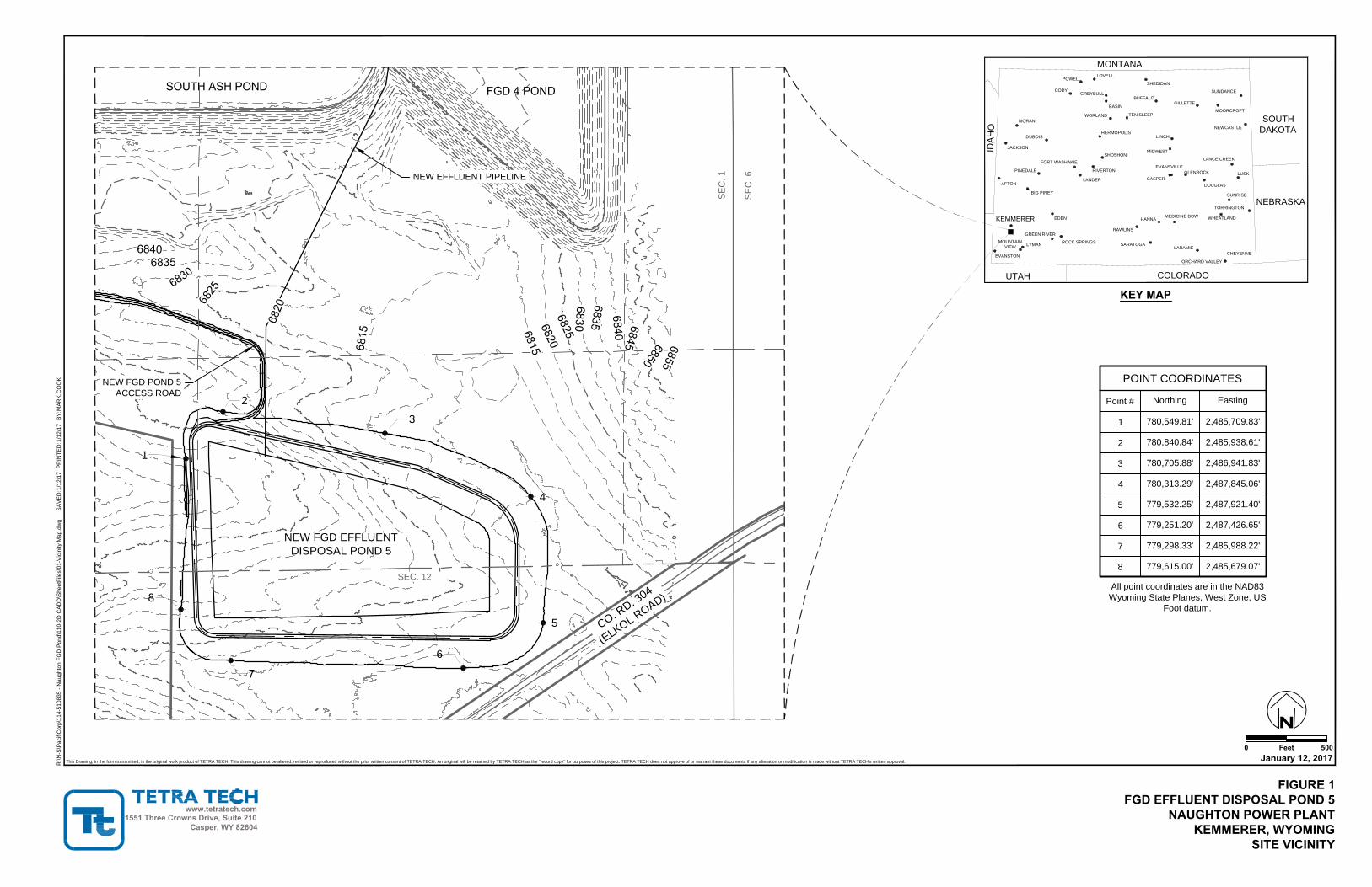
1.0 INTRODUCTION The PacifiCorp Naughton Power Plant is located approximately three miles southwest of Kemmerer, Wyoming.
This report addresses the requirements of §257.72 – Liner Design Criteria, as it pertains to FGD Pond 5 at the
Plant. FGD Pond 5 was constructed in 2017. This report presents the initial evaluation immediately following
completion of construction and prior to the pond being placed into service.
Specifically, §257.72 indicates the pond must be constructed with a composite liner system or an approved
alternative liner system. A composite liner system must consist of an upper component and a lower component
where: a) the upper component consists of a geomembrane liner (minimum 60-mil thick for HDPE) and b) the lower
component consists of at least a two-foot layer of compacted soil with a hydraulic conductivity of no more than 1x10-
7 centimeters per second (cm/sec). The upper component must be installed in direct and uniform contact with the
lower component.
2.0 EXISTING CONDITIONS
The Naughton Power Plant is located approximately 3 miles southwest of Kemmerer, Wyoming. The Plant consists
of three coal-fueled units, rated with a net dependable capacity of 156 MW, 201 MW, and 330 MW, respectively.
Coal combustion by-products at the Plant include several types of materials including bottom ash, fly ash, and FGD
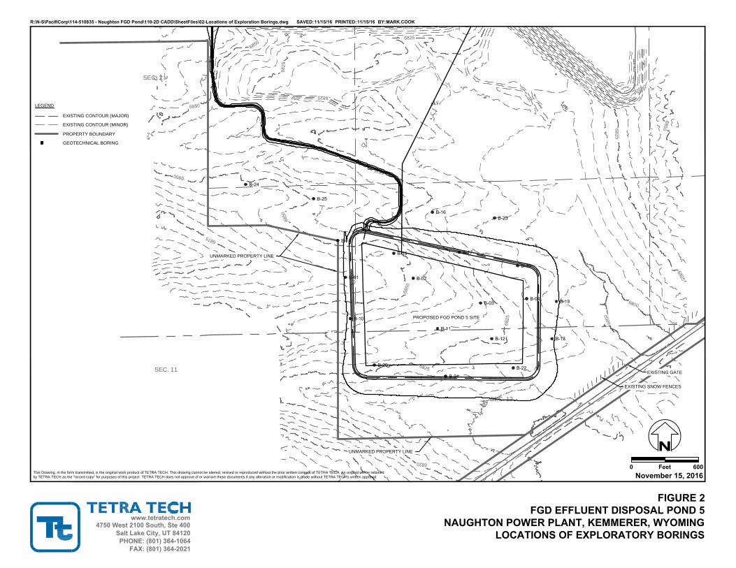
materials. FGD Pond 5 was constructed in 2017 at the location shown on Figure 1. The pond has a permitted
capacity of 1,467 acre-ft which is expected to provide approximately 10 years of disposal capacity. The pond may remain operational when full to allow additional evaporation of water. As water evaporates, additional effluent may be added eventually filling the pond with solids. When filled with solids or when continued operation is no longer feasible, a cover will be constructed and the pond will be permanently closed.
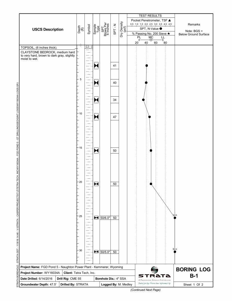
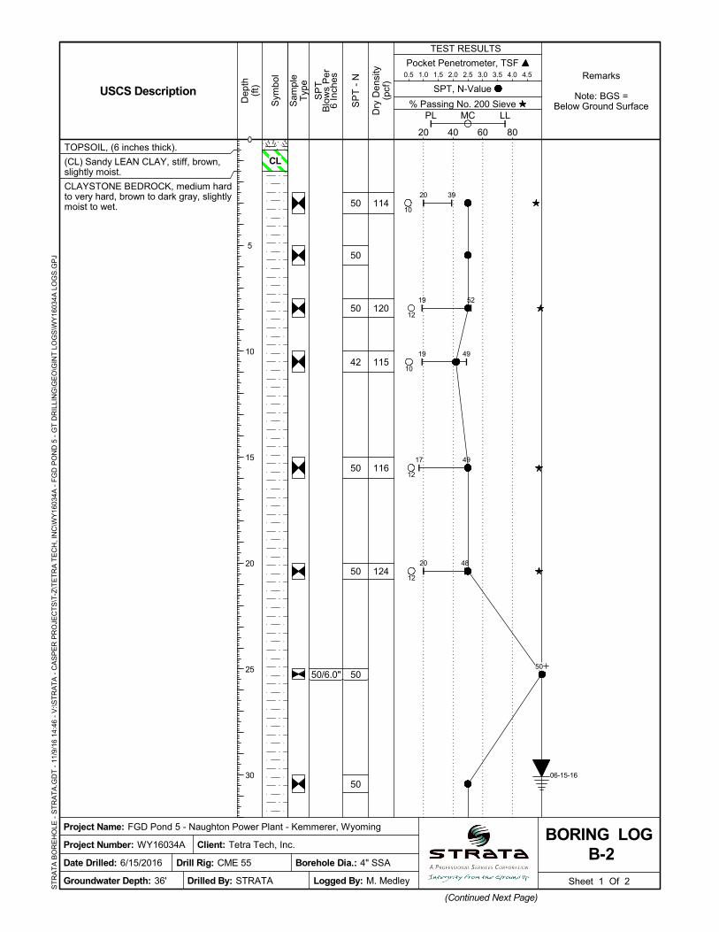
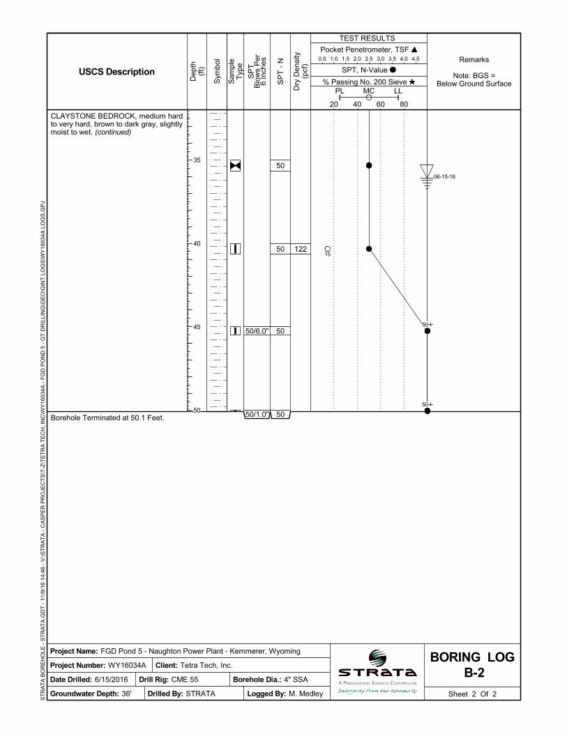
The pond has a surface area of 49 acres at the crest with a maximum interior depth of 46 ft. The pond is located on a topographically high area with surface water drainage away from the pond in all directions. The only source of water or waste entering the pond is through two effluent delivery pipelines as well as any precipitation falling within the pond area. No surface water run-on is allowed to enter the pond. The pond has no discharge outlets or spillways (all water entering the pond will be evaporated). The pond embankments have 3 horizontal to 1 vertical slopes and was constructed using soil excavated from within the pond limits and an adjacent borrow area. The pond foundation materials consist of stiff clay and claystone bedrock. Permanent ballast consisting of grout filled tubes was placed over the geomembrane to prevent wind damage. A chain link security fence was installed around the pond to prevent larger wildlife from entering the area. A bird hazing system was installed to reduce impacts to migratory water fowl.
The pond was constructed with a composite liner system consisting of a 60-mil HDPE geomembrane (upper component) in direct contact with a two-foot layer of compacted soil with a hydraulic conductivity of no more than 1 x 10⁻⁷ cm/sec (lower component) (Clay liner material obtained from claystone bedrock borrow indicated in Appendix B).
3.0 CONCLUSION
As indicated above, FGD Pond 5 was constructed with a composite liner system in accordance with the
requirements of §257.74 – Liner Design Criteria.
.
Design Criteria - §257.72 Liner Design Criteria PacifiCorp – Naughton Power Plant FGD Pond 5
October 30, 2017
SOURCE(S)
[1] USEPA, 2015. 40 CFR Parts 257 and 261, Hazardous and Solid Waste Management System; Disposal of Coal Combustion Residuals from Electric Utilities; Final Rule. April 17, 2015. 201 pp.
Design Criteria - §257.72 Liner Design Criteria PacifiCorp – Naughton Power Plant FGD Pond 5
October 30, 2017
REVISIONS
Revision Number Date Revision Made By Whom
0 10/30/2017 Initial Issue Tetra Tech
SEC. 12
SE
C. 1
SE
C. 6
1
2
3
4
5
6
POINT COORDINATES
Point #
1
2
3
4
5
6
7
8
Northing
780,549.81'
780,840.84'
780,705.88'
780,313.29'
779,532.25'
779,251.20'
779,298.33'
779,615.00'
Easting
2,485,709.83'
2,485,938.61'
2,486,941.83'
2,487,845.06'
2,487,921.40'
2,487,426.65'
2,485,988.22'
2,485,679.07'
R:\N
-S
\P
acifiC
orp\114-510835 - N
aughton F
GD
P
ond\110-2D
C
AD
D\S
heetF
iles\01-V
icinity M
ap.dw
g S
AV
ED
:1/12/17
P
RIN
TE
D:1/12/17
B
Y:M
AR
K.C
OO
K
www.tetratech.com
0 Feet
This Drawing, in the form transmitted, is the original work product of TETRA TECH. This drawing cannot be altered, revised or reproduced without the prior written consent of TETRA TECH. An original will be retained by TETRA TECH as the "record copy" for purposes of this project. TETRA TECH does not approve of or warrant these documents if any alteration or modification is made without TETRA TECH's written approval.
FIGURE 1FGD EFFLUENT DISPOSAL POND 5
NAUGHTON POWER PLANTKEMMERER, WYOMING
SITE VICINITY
500January 12, 2017
1551 Three Crowns Drive, Suite 210Casper, WY 82604
NEW FGD EFFLUENT
DISPOSAL POND 5
C
O
.
R
D
.
3
0
4
(
E
L
K
O
L
R
O
A
D
)
NEW EFFLUENT PIPELINE
NEW FGD POND 5
ACCESS ROAD
UTAH
COLORADO
NEBRASKA
SOUTH
DAKOTA
MONTANA
ID
AH
O
CHEYENNE
LARAMIE
SARATOGA
RAWLINS
ROCK SPRINGS
HANNA
MEDICINE BOW
WHEATLAND
TORRINGTON
SUNRISE
DOUGLAS
GLENROCK
LANCE CREEK
EVANSVILLE
CASPER
MIDWEST
LINCH
NEWCASTLE
MOORCROFT
SUNDANCE
GILLETTE
SHEDIDAN
BUFFALO
TEN SLEEP
BASIN
WORLAND
THERMOPOLIS
GREYBULL
CODY
SHOSHONI
RIVERTON
LANDER
FORT WASHAKIE
PINEDALE
BIG PINEY
AFTON
JACKSON
DUBOIS
MORAN
POWELL
LOVELL
EDEN
KEMMERER
GREEN RIVER
MOUNTAIN
VIEW
LYMAN
EVANSTON
ORCHARD VALLEY
LUSK
KEY MAP
All point coordinates are in the NAD83
Wyoming State Planes, West Zone, US
Foot datum.
FGD Effluent Disposal Pond 5 PacifiCorp – Naughton Power Plant
November, 2016
APPENDIX B – GEOTECHNICAL STUDY
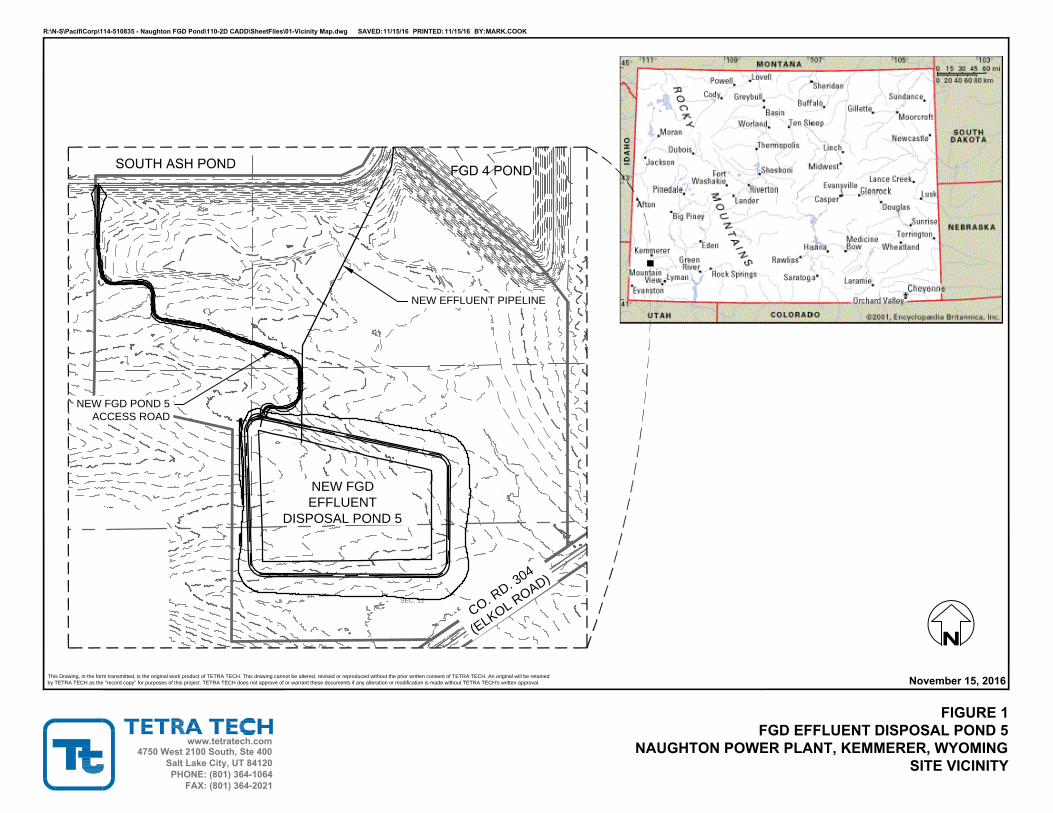
SEC. 12
NEW FGD
EFFLUENT
DISPOSAL POND 5
C
O
.
R
D
.
3
0
4
(
E
L
K
O
L
R
O
A
D
)
R:\N-S\PacifiCorp\114-510835 - Naughton FGD Pond\110-2D CADD\SheetFiles\01-Vicinity Map.dwg SAVED:11/15/16 PRINTED:11/15/16 BY:MARK.COOK
www.tetratech.com
This Drawing, in the form transmitted, is the original work product of TETRA TECH. This drawing cannot be altered, revised or reproduced without the prior written consent of TETRA TECH. An original will be retained
by TETRA TECH as the "record copy" for purposes of this project. TETRA TECH does not approve of or warrant these documents if any alteration or modification is made without TETRA TECH's written approval.
FIGURE 1FGD EFFLUENT DISPOSAL POND 5
NAUGHTON POWER PLANT, KEMMERER, WYOMINGSITE VICINITY
November 15, 2016
4750 West 2100 South, Ste 400Salt Lake City, UT 84120PHONE: (801) 364-1064
FAX: (801) 364-2021
NEW EFFLUENT PIPELINE
NEW FGD POND 5
ACCESS ROAD
SEC. 12
SEC. 2
SEC. 11
LEGEND
GEOTECHNICAL BORING
PROPERTY BOUNDARY
EXISTING CONTOUR (MINOR)
EXISTING CONTOUR (MAJOR)
EXISTING GATE
EXISTING SNOW FENCES
UNMARKED PROPERTY LINE
UNMARKED PROPERTY LINE
PROPOSED FGD POND 5 SITE
R:\N-S\PacifiCorp\114-510835 - Naughton FGD Pond\110-2D CADD\SheetFiles\02-Locations of Exploration Borings.dwg SAVED:11/15/16 PRINTED:11/15/16 BY:MARK.COOK
www.tetratech.com
0 FeetThis Drawing, in the form transmitted, is the original work product of TETRA TECH. This drawing cannot be altered, revised or reproduced without the prior written consent of TETRA TECH. An original will be retained
by TETRA TECH as the "record copy" for purposes of this project. TETRA TECH does not approve of or warrant these documents if any alteration or modification is made without TETRA TECH's written approval.
FIGURE 2FGD EFFLUENT DISPOSAL POND 5
NAUGHTON POWER PLANT, KEMMERER, WYOMINGLOCATIONS OF EXPLORATORY BORINGS
600November 15, 2016
4750 West 2100 South, Ste 400Salt Lake City, UT 84120PHONE: (801) 364-1064
FAX: (801) 364-2021
50/6.0"
50/5.0"
TOPSOIL, (6 inches thick).
CLAYSTONE BEDROCK, medium hardto very hard, brown to dark gray, slightlymoist to wet.
41
40
34
47
50
50
50
50
Pocket Penetrometer, TSF 0.5 1.0 1.5 2.0 2.5 3.0 3.5 4.0 4.5
Sheet 1 Of 2
(Continued Next Page)
Sam
ple
Typ
e
% Passing No. 200 Sieve
TEST RESULTS
SP
TB
low
s P
er6
Inch
es
20 40 60 80
PL LLMC
Sym
bol
Dep
th(f
t)
Project Number: WY16034A
Dry
Den
sity
(pcf
)
Logged By: M. Medley
Project Name: FGD Pond 5 - Naughton Power Plant - Kemmerer, Wyoming
Date Drilled: 6/14/2016
SPT, N-Value
B-1BORING LOG
USCS Description
Groundwater Depth: 47.5'
Remarks
Note: BGS =Below Ground Surface
Borehole Dia.: 4" SSA
Client: Tetra Tech, Inc.
Drilled By: STRATA
SP
T -
N
Drill Rig: CME 55
ST
RA
TA
BO
RE
HO
LE -
ST
RA
TA
.GD
T -
11/
9/1
6 1
4:46
- V
:\ST
RA
TA
- C
AS
PE
R P
RO
JEC
TS
\T-Z
\TE
TR
A T
EC
H, I
NC
\WY
1603
4A -
FG
D P
ON
D 5
- G
T D
RIL
LIN
G\G
EO
\GIN
T L
OG
S\W
Y16
034A
LO
GS
.GP
J
0
5
10
15
20
25
30
50
50

50/4.0"
50/5.0"
50/6.0"
50/6.0"
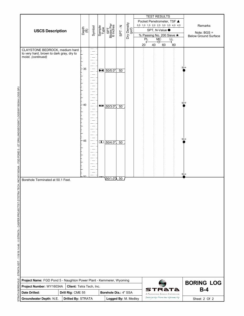
CLAYSTONE BEDROCK, medium hardto very hard, brown to dark gray, slightlymoist to wet. (continued)
Borehole Terminated at 50.5 Feet.
50
50
50
50
Pocket Penetrometer, TSF 0.5 1.0 1.5 2.0 2.5 3.0 3.5 4.0 4.5
Sheet 2 Of 2
Sam
ple
Typ
e
% Passing No. 200 Sieve
TEST RESULTS
SP
TB
low
s P
er6
Inch
es
20 40 60 80
PL LLMC
Sym
bol
Dep
th(f
t)
Project Number: WY16034A
Dry
Den
sity
(pcf
)
Logged By: M. Medley
Project Name: FGD Pond 5 - Naughton Power Plant - Kemmerer, Wyoming
Date Drilled: 6/14/2016
SPT, N-Value
B-1BORING LOG
USCS Description
Groundwater Depth: 47.5'
Remarks
Note: BGS =Below Ground Surface
Borehole Dia.: 4" SSA
Client: Tetra Tech, Inc.
Drilled By: STRATA
SP
T -
N
Drill Rig: CME 55
ST
RA
TA
BO
RE
HO
LE -
ST
RA
TA
.GD
T -
11/
9/1
6 1
4:46
- V
:\ST
RA
TA
- C
AS
PE
R P
RO
JEC
TS
\T-Z
\TE
TR
A T
EC
H, I
NC
\WY
1603
4A -
FG
D P
ON
D 5
- G
T D
RIL
LIN
G\G
EO
\GIN
T L
OG
S\W
Y16
034A
LO
GS
.GP
J
35
40
45
50
50
50
50
50
06-16-1606-14-16
50/6.0"
114
120
115
116
124
TOPSOIL, (6 inches thick).
(CL) Sandy LEAN CLAY, stiff, brown,slightly moist.
CLAYSTONE BEDROCK, medium hardto very hard, brown to dark gray, slightlymoist to wet. 50
50
50
42
50
50
50
50
Pocket Penetrometer, TSF 0.5 1.0 1.5 2.0 2.5 3.0 3.5 4.0 4.5
Sheet 1 Of 2
(Continued Next Page)
Sam
ple
Typ
e
% Passing No. 200 Sieve
TEST RESULTS
SP
TB
low
s P
er6
Inch
es
20 40 60 80
PL LLMC
Sym
bol
Dep
th(f
t)
Project Number: WY16034A
Dry
Den
sity
(pcf
)
Logged By: M. Medley
Project Name: FGD Pond 5 - Naughton Power Plant - Kemmerer, Wyoming
Date Drilled: 6/15/2016
SPT, N-Value
B-2BORING LOG
USCS Description
Groundwater Depth: 36'
Remarks
Note: BGS =Below Ground Surface
Borehole Dia.: 4" SSA
Client: Tetra Tech, Inc.
Drilled By: STRATA
SP
T -
N
Drill Rig: CME 55
ST
RA
TA
BO
RE
HO
LE -
ST
RA
TA
.GD
T -
11/
9/1
6 1
4:46
- V
:\ST
RA
TA
- C
AS
PE
R P
RO
JEC
TS
\T-Z
\TE
TR
A T
EC
H, I
NC
\WY
1603
4A -
FG
D P
ON
D 5
- G
T D
RIL
LIN
G\G
EO
\GIN
T L
OG
S\W
Y16
034A
LO
GS
.GP
J
20 39
19 52
19 49
17 49
20 48
10
12
10
12
12
0
5
10
15
20
25
30
50
06-15-16
CL
50/6.0"
50/1.0"
122
CLAYSTONE BEDROCK, medium hardto very hard, brown to dark gray, slightlymoist to wet. (continued)
Borehole Terminated at 50.1 Feet.
50
50
50
50
Pocket Penetrometer, TSF 0.5 1.0 1.5 2.0 2.5 3.0 3.5 4.0 4.5
Sheet 2 Of 2
Sam
ple
Typ
e
% Passing No. 200 Sieve
TEST RESULTS
SP
TB
low
s P
er6
Inch
es
20 40 60 80
PL LLMC
Sym
bol
Dep
th(f
t)
Project Number: WY16034A
Dry
Den
sity
(pcf
)
Logged By: M. Medley
Project Name: FGD Pond 5 - Naughton Power Plant - Kemmerer, Wyoming
Date Drilled: 6/15/2016
SPT, N-Value
B-2BORING LOG
USCS Description
Groundwater Depth: 36'
Remarks
Note: BGS =Below Ground Surface
Borehole Dia.: 4" SSA
Client: Tetra Tech, Inc.
Drilled By: STRATA
SP
T -
N
Drill Rig: CME 55
ST
RA
TA
BO
RE
HO
LE -
ST
RA
TA
.GD
T -
11/
9/1
6 1
4:46
- V
:\ST
RA
TA
- C
AS
PE
R P
RO
JEC
TS
\T-Z
\TE
TR
A T
EC
H, I
NC
\WY
1603
4A -
FG
D P
ON
D 5
- G
T D
RIL
LIN
G\G
EO
\GIN
T L
OG
S\W
Y16
034A
LO
GS
.GP
J
15
35
40
45
50
50
50
06-15-16
50/6.0"
113
124
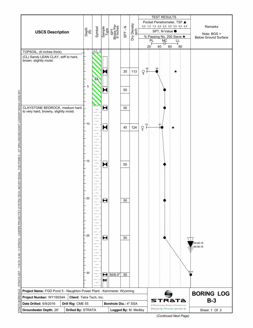
TOPSOIL, (6 inches thick).
(CL) Sandy LEAN CLAY, stiff to hard,brown, slightly moist.
CLAYSTONE BEDROCK, medium hardto very hard, browny, slightly moist.
35
50
50
45
50
50
50
50
Pocket Penetrometer, TSF 0.5 1.0 1.5 2.0 2.5 3.0 3.5 4.0 4.5
Sheet 1 Of 2
(Continued Next Page)
Sam
ple
Typ
e
% Passing No. 200 Sieve
TEST RESULTS
SP
TB
low
s P
er6
Inch
es
20 40 60 80
PL LLMC
Sym
bol
Dep
th(f
t)
Project Number: WY16034A
Dry
Den
sity
(pcf
)
Logged By: M. Medley
Project Name: FGD Pond 5 - Naughton Power Plant - Kemmerer, Wyoming
Date Drilled: 6/8/2016
SPT, N-Value
B-3BORING LOG
USCS Description
Groundwater Depth: 26'
Remarks
Note: BGS =Below Ground Surface
Borehole Dia.: 4" SSA
Client: Tetra Tech, Inc.
Drilled By: STRATA
SP
T -
N
Drill Rig: CME 55
ST
RA
TA
BO
RE
HO
LE -
ST
RA
TA
.GD
T -
11/
9/1
6 1
4:46
- V
:\ST
RA
TA
- C
AS
PE
R P
RO
JEC
TS
\T-Z
\TE
TR
A T
EC
H, I
NC
\WY
1603
4A -
FG
D P
ON
D 5
- G
T D
RIL
LIN
G\G
EO
\GIN
T L
OG
S\W
Y16
034A
LO
GS
.GP
J
16 35
15 41
9
8
0
5
10
15
20
25
30 50
06-09-16
06-08-16
CL

50/1.0"
50/4.0"
50/3.0"
50/1.0"
CLAYSTONE BEDROCK, medium hardto very hard, browny, slightly moist.(continued)
Borehole Terminated at 50.1 Feet.
50
50
50
50
Pocket Penetrometer, TSF 0.5 1.0 1.5 2.0 2.5 3.0 3.5 4.0 4.5
Sheet 2 Of 2
Sam
ple
Typ
e
% Passing No. 200 Sieve
TEST RESULTS
SP
TB
low
s P
er6
Inch
es
20 40 60 80
PL LLMC
Sym
bol
Dep
th(f
t)
Project Number: WY16034A
Dry
Den
sity
(pcf
)
Logged By: M. Medley
Project Name: FGD Pond 5 - Naughton Power Plant - Kemmerer, Wyoming
Date Drilled: 6/8/2016
SPT, N-Value
B-3BORING LOG
USCS Description
Groundwater Depth: 26'
Remarks
Note: BGS =Below Ground Surface
Borehole Dia.: 4" SSA
Client: Tetra Tech, Inc.
Drilled By: STRATA
SP
T -
N
Drill Rig: CME 55
ST
RA
TA
BO
RE
HO
LE -
ST
RA
TA
.GD
T -
11/
9/1
6 1
4:46
- V
:\ST
RA
TA
- C
AS
PE
R P
RO
JEC
TS
\T-Z
\TE
TR
A T
EC
H, I
NC
\WY
1603
4A -
FG
D P
ON
D 5
- G
T D
RIL
LIN
G\G
EO
\GIN
T L
OG
S\W
Y16
034A
LO
GS
.GP
J
35
40
45
50
50
50
50
50
50/6.0"
50/6.0"
94
118
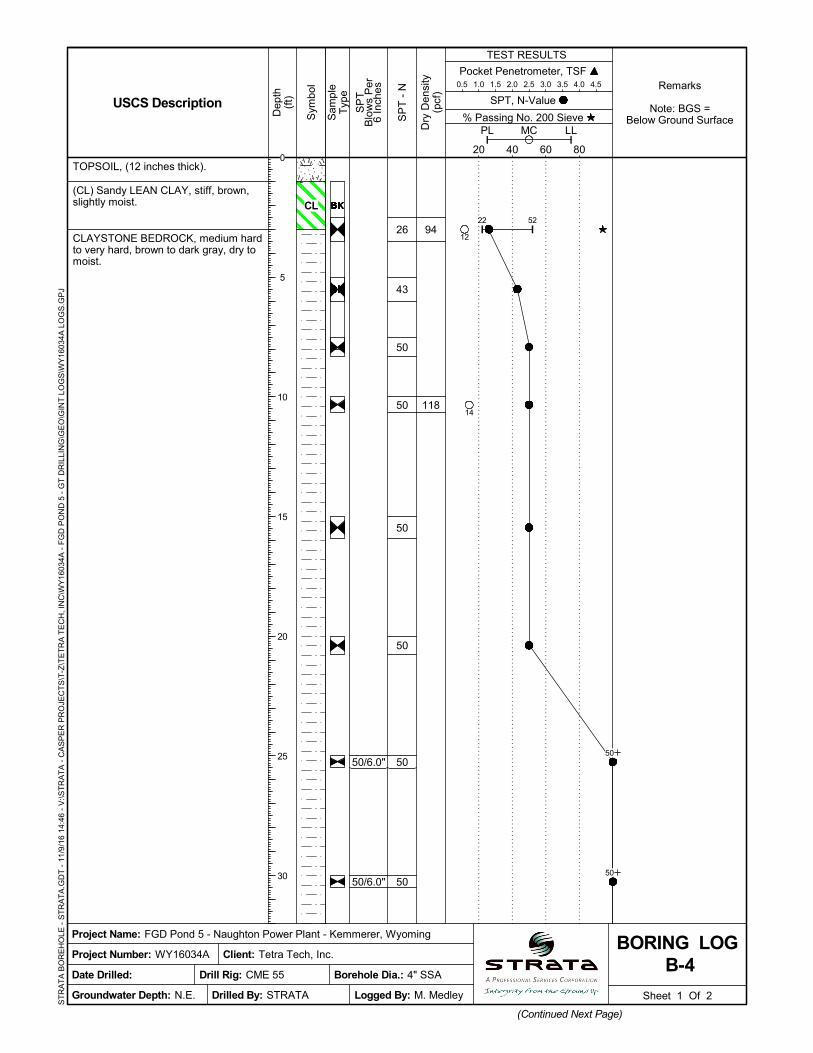
TOPSOIL, (12 inches thick).
(CL) Sandy LEAN CLAY, stiff, brown,slightly moist.
CLAYSTONE BEDROCK, medium hardto very hard, brown to dark gray, dry tomoist.
26
43
50
50
50
50
50
50
Pocket Penetrometer, TSF 0.5 1.0 1.5 2.0 2.5 3.0 3.5 4.0 4.5
Sheet 1 Of 2
(Continued Next Page)
Sam
ple
Typ
e
% Passing No. 200 Sieve
TEST RESULTS
SP
TB
low
s P
er6
Inch
es
20 40 60 80
PL LLMC
Sym
bol
Dep
th(f
t)
Project Number: WY16034A
Dry
Den
sity
(pcf
)
Logged By: M. Medley
Project Name: FGD Pond 5 - Naughton Power Plant - Kemmerer, Wyoming
Date Drilled:
SPT, N-Value
B-4BORING LOG
USCS Description
Groundwater Depth: N.E.
Remarks
Note: BGS =Below Ground Surface
Borehole Dia.: 4" SSA
Client: Tetra Tech, Inc.
Drilled By: STRATA
SP
T -
N
Drill Rig: CME 55
ST
RA
TA
BO
RE
HO
LE -
ST
RA
TA
.GD
T -
11/
9/1
6 1
4:46
- V
:\ST
RA
TA
- C
AS
PE
R P
RO
JEC
TS
\T-Z
\TE
TR
A T
EC
H, I
NC
\WY
1603
4A -
FG
D P
ON
D 5
- G
T D
RIL
LIN
G\G
EO
\GIN
T L
OG
S\W
Y16
034A
LO
GS
.GP
J
22 52
12
14
0
5
10
15
20
25
30
50
50
CL
50/5.0"
50/3.0"
50/4.0"
50/1.0"
CLAYSTONE BEDROCK, medium hardto very hard, brown to dark gray, dry tomoist. (continued)
Borehole Terminated at 50.1 Feet.
50
50
50
50
Pocket Penetrometer, TSF 0.5 1.0 1.5 2.0 2.5 3.0 3.5 4.0 4.5
Sheet 2 Of 2
Sam
ple
Typ
e
% Passing No. 200 Sieve
TEST RESULTS
SP
TB
low
s P
er6
Inch
es
20 40 60 80
PL LLMC
Sym
bol
Dep
th(f
t)
Project Number: WY16034A
Dry
Den
sity
(pcf
)
Logged By: M. Medley
Project Name: FGD Pond 5 - Naughton Power Plant - Kemmerer, Wyoming
Date Drilled:
SPT, N-Value
B-4BORING LOG
USCS Description
Groundwater Depth: N.E.
Remarks
Note: BGS =Below Ground Surface
Borehole Dia.: 4" SSA
Client: Tetra Tech, Inc.
Drilled By: STRATA
SP
T -
N
Drill Rig: CME 55
ST
RA
TA
BO
RE
HO
LE -
ST
RA
TA
.GD
T -
11/
9/1
6 1
4:46
- V
:\ST
RA
TA
- C
AS
PE
R P
RO
JEC
TS
\T-Z
\TE
TR
A T
EC
H, I
NC
\WY
1603
4A -
FG
D P
ON
D 5
- G
T D
RIL
LIN
G\G
EO
\GIN
T L
OG
S\W
Y16
034A
LO
GS
.GP
J
35
40
45
50
50
50
50
50

50/6.0"
50/5.0"
50/4.0"
125
115
127
TOPSOIL, (6 inches thick).
CLAYSTONE BEDROCK, firm to veryhard, brown to dark gray, slightly moistto wet.
Borehole Terminated at 30.9 Feet.
50
50
50
50
50
50
50
50
Pocket Penetrometer, TSF 0.5 1.0 1.5 2.0 2.5 3.0 3.5 4.0 4.5
Sheet 1 Of 1
Sam
ple
Typ
e
% Passing No. 200 Sieve
TEST RESULTS
SP
TB
low
s P
er6
Inch
es
20 40 60 80
PL LLMC
Sym
bol
Dep
th(f
t)
Project Number: WY16034A
Dry
Den
sity
(pcf
)
Logged By: M. Medley
Project Name: FGD Pond 5 - Naughton Power Plant - Kemmerer, Wyoming
Date Drilled: 6/10/2016
SPT, N-Value
B-10BORING LOG
USCS Description
Groundwater Depth: 25'
Remarks
Note: BGS =Below Ground Surface
Borehole Dia.: 4" SSA
Client: Tetra Tech, Inc.
Drilled By: STRATA
SP
T -
N
Drill Rig: CME 55
ST
RA
TA
BO
RE
HO
LE -
ST
RA
TA
.GD
T -
11/
9/1
6 1
4:46
- V
:\ST
RA
TA
- C
AS
PE
R P
RO
JEC
TS
\T-Z
\TE
TR
A T
EC
H, I
NC
\WY
1603
4A -
FG
D P
ON
D 5
- G
T D
RIL
LIN
G\G
EO
\GIN
T L
OG
S\W
Y16
034A
LO
GS
.GP
J
17 38
18 37
19 36
9
8
11
0
5
10
15
20
25
30
50
50
50
06-10-16
06-10-16
2850
50/5.0"
TOPSOIL, (6 inches thick).
CLAYSTONE BEDROCK, medium hardto very hard, brown to dark gray, slightlymoist to wet.
Borehole Terminated at 30.4 Feet.
34
31
50
50
50
50
78
50
Pocket Penetrometer, TSF 0.5 1.0 1.5 2.0 2.5 3.0 3.5 4.0 4.5
Sheet 1 Of 1
Sam
ple
Typ
e
% Passing No. 200 Sieve
TEST RESULTS
SP
TB
low
s P
er6
Inch
es
20 40 60 80
PL LLMC
Sym
bol
Dep
th(f
t)
Project Number: WY16034A
Dry
Den
sity
(pcf
)
Logged By: M. Medley
Project Name: FGD Pond 5 - Naughton Power Plant - Kemmerer, Wyoming
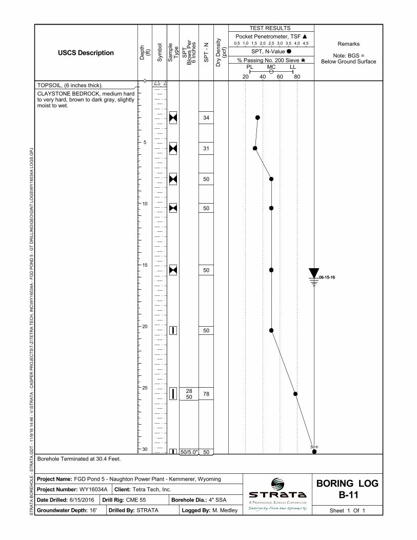
Date Drilled: 6/15/2016
SPT, N-Value
B-11BORING LOG
USCS Description
Groundwater Depth: 16'
Remarks
Note: BGS =Below Ground Surface
Borehole Dia.: 4" SSA
Client: Tetra Tech, Inc.
Drilled By: STRATA
SP
T -
N
Drill Rig: CME 55
ST
RA
TA
BO
RE
HO
LE -
ST
RA
TA
.GD
T -
11/
9/1
6 1
4:46
- V
:\ST
RA
TA
- C
AS
PE
R P
RO
JEC
TS
\T-Z
\TE
TR
A T
EC
H, I
NC
\WY
1603
4A -
FG
D P
ON
D 5
- G
T D
RIL
LIN
G\G
EO
\GIN
T L
OG
S\W
Y16
034A
LO
GS
.GP
J
0
5
10
15
20
25
30 50
06-15-1606-15-16
2850/5.0"
TOPSOIL, (6 inches thick).
(CL) Sandy LEAN CLAY, stiff, brown,slightly moist.
CLAYSTONE BEDROCK, medium hardto very hard, brown to dark gray, slightlymoist to wet.
Borehole Terminated at 30.9 Feet.
50
50
50
50
50
50
50
100+
Pocket Penetrometer, TSF 0.5 1.0 1.5 2.0 2.5 3.0 3.5 4.0 4.5
Sheet 1 Of 1
Sam
ple
Typ
e
% Passing No. 200 Sieve
TEST RESULTS
SP
TB
low
s P
er6
Inch
es
20 40 60 80
PL LLMC
Sym
bol
Dep
th(f
t)
Project Number: WY16034A
Dry
Den
sity
(pcf
)
Logged By: M. Medley
Project Name: FGD Pond 5 - Naughton Power Plant - Kemmerer, Wyoming
Date Drilled: 6/9/2016
SPT, N-Value
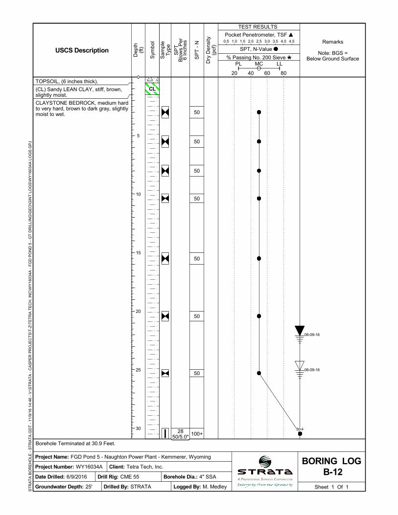
B-12BORING LOG
USCS Description
Groundwater Depth: 25'
Remarks
Note: BGS =Below Ground Surface
Borehole Dia.: 4" SSA
Client: Tetra Tech, Inc.
Drilled By: STRATA
SP
T -
N
Drill Rig: CME 55
ST
RA
TA
BO
RE
HO
LE -
ST
RA
TA
.GD
T -
11/
9/1
6 1
4:46
- V
:\ST
RA
TA
- C
AS
PE
R P
RO
JEC
TS
\T-Z
\TE
TR
A T
EC
H, I
NC
\WY
1603
4A -
FG
D P
ON
D 5
- G
T D
RIL
LIN
G\G
EO
\GIN
T L
OG
S\W
Y16
034A
LO
GS
.GP
J
0
5
10
15
20
25
30 50
06-09-16
06-09-16
CL
50/5.0"
TOPSOIL, (6 inches thick).
CLAYSTONE BEDROCK, medium hardto very hard, brown to dark gray, slightlymoist to wet.
Borehole Terminated at 30.4 Feet.
24
24
26
40
50
40
50
50
Pocket Penetrometer, TSF 0.5 1.0 1.5 2.0 2.5 3.0 3.5 4.0 4.5
Sheet 1 Of 1
Sam
ple
Typ
e
% Passing No. 200 Sieve
TEST RESULTS
SP
TB
low
s P
er6
Inch
es
20 40 60 80
PL LLMC
Sym
bol
Dep
th(f
t)
Project Number: WY16034A
Dry
Den
sity
(pcf
)
Logged By: M. Medley
Project Name: FGD Pond 5 - Naughton Power Plant - Kemmerer, Wyoming
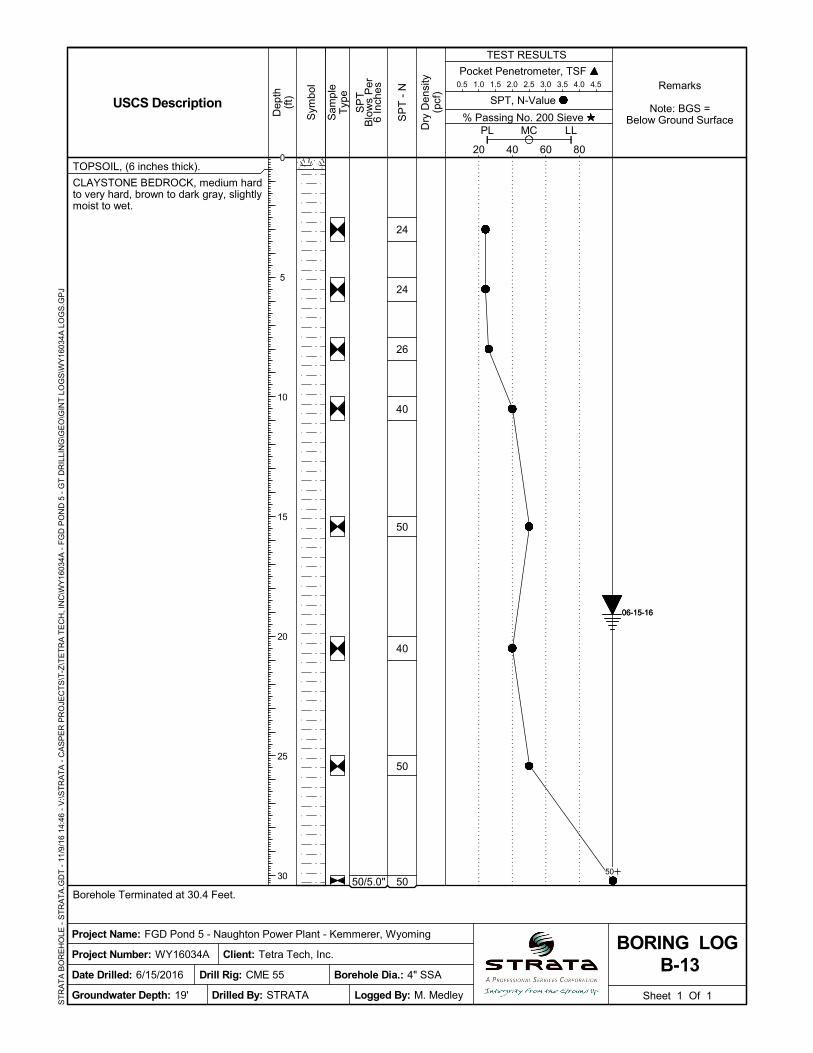
Date Drilled: 6/15/2016
SPT, N-Value
B-13BORING LOG
USCS Description
Groundwater Depth: 19'
Remarks
Note: BGS =Below Ground Surface
Borehole Dia.: 4" SSA
Client: Tetra Tech, Inc.
Drilled By: STRATA
SP
T -
N
Drill Rig: CME 55
ST
RA
TA
BO
RE
HO
LE -
ST
RA
TA
.GD
T -
11/
9/1
6 1
4:46
- V
:\ST
RA
TA
- C
AS
PE
R P
RO
JEC
TS
\T-Z
\TE
TR
A T
EC
H, I
NC
\WY
1603
4A -
FG
D P
ON
D 5
- G
T D
RIL
LIN
G\G
EO
\GIN
T L
OG
S\W
Y16
034A
LO
GS
.GP
J
0
5
10
15
20
25
30 50
06-15-1606-15-16
50/5.0"
50/6.0"
50/5.0"
103
TOPSOIL, (6 inches thick).
(CL) Sandy LEAN CLAY, very stiff,brown, slightly moist.
CLAYSTONE BEDROCK, medium hardto very hard, brown to dark gray, slightlymoist to wet.
Borehole Terminated at 30.4 Feet.
32
44
50
50
50
50
50
50
Pocket Penetrometer, TSF 0.5 1.0 1.5 2.0 2.5 3.0 3.5 4.0 4.5
Sheet 1 Of 1
Sam
ple
Typ
e
% Passing No. 200 Sieve
TEST RESULTS
SP
TB
low
s P
er6
Inch
es
20 40 60 80
PL LLMC
Sym
bol
Dep
th(f
t)
Project Number: WY16034A
Dry
Den
sity
(pcf
)
Logged By: M. Medley
Project Name: FGD Pond 5 - Naughton Power Plant - Kemmerer, Wyoming
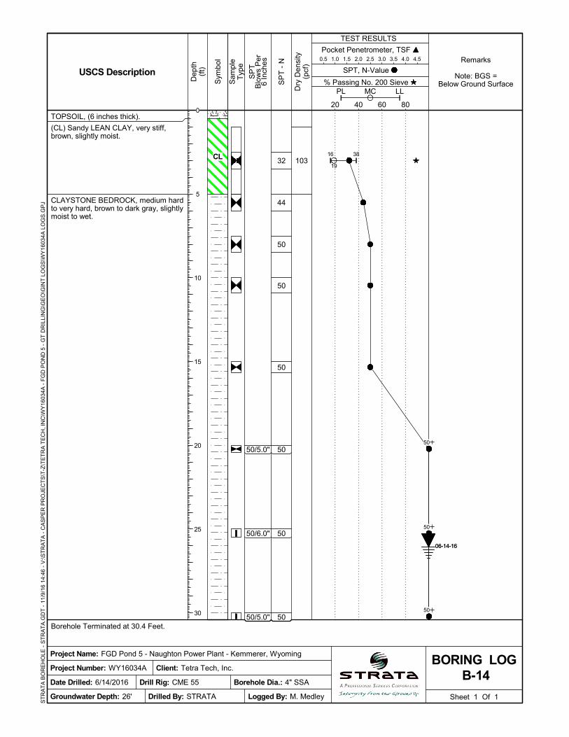
Date Drilled: 6/14/2016
SPT, N-Value
B-14BORING LOG
USCS Description
Groundwater Depth: 26'
Remarks
Note: BGS =Below Ground Surface
Borehole Dia.: 4" SSA
Client: Tetra Tech, Inc.
Drilled By: STRATA
SP
T -
N
Drill Rig: CME 55
ST
RA
TA
BO
RE
HO
LE -
ST
RA
TA
.GD
T -
11/
9/1
6 1
4:46
- V
:\ST
RA
TA
- C
AS
PE
R P
RO
JEC
TS
\T-Z
\TE
TR
A T
EC
H, I
NC
\WY
1603
4A -
FG
D P
ON
D 5
- G
T D
RIL
LIN
G\G
EO
\GIN
T L
OG
S\W
Y16
034A
LO
GS
.GP
J
16 38
19
0
5
10
15
20
25
30
50
50
50
06-14-1606-14-16
CL
50/5.0"
TOPSOIL, (6 inches thick).
(CL) Sandy LEAN CLAY, hard, brown,slightly moist.
CLAYSTONE BEDROCK, medium hardto very hard, brown to dark gray, slightlymoist.
Borehole Terminated at 30.4 Feet.
48
50
38
30
44
46
42
50
Pocket Penetrometer, TSF 0.5 1.0 1.5 2.0 2.5 3.0 3.5 4.0 4.5
Sheet 1 Of 1
Sam
ple
Typ
e
% Passing No. 200 Sieve
TEST RESULTS
SP
TB
low
s P
er6
Inch
es
20 40 60 80
PL LLMC
Sym
bol
Dep
th(f
t)
Project Number: WY16034A
Dry
Den
sity
(pcf
)
Logged By: M. Medley
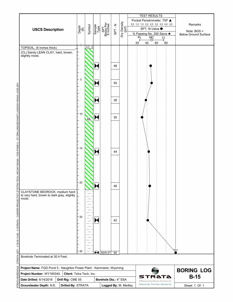
Project Name: FGD Pond 5 - Naughton Power Plant - Kemmerer, Wyoming
Date Drilled: 6/14/2016
SPT, N-Value
B-15BORING LOG
USCS Description
Groundwater Depth: N.E.
Remarks
Note: BGS =Below Ground Surface
Borehole Dia.: 4" SSA
Client: Tetra Tech, Inc.
Drilled By: STRATA
SP
T -
N
Drill Rig: CME 55
ST
RA
TA
BO
RE
HO
LE -
ST
RA
TA
.GD
T -
11/
9/1
6 1
4:46
- V
:\ST
RA
TA
- C
AS
PE
R P
RO
JEC
TS
\T-Z
\TE
TR
A T
EC
H, I
NC
\WY
1603
4A -
FG
D P
ON
D 5
- G
T D
RIL
LIN
G\G
EO
\GIN
T L
OG
S\W
Y16
034A
LO
GS
.GP
J
0
5
10
15
20
25
30 50
CL
50/4.0"
50/4.0"
TOPSOIL, (6 inches thick).
(CL) Sandy LEAN CLAY, stiff, brown,slightly moist.
CLAYSTONE BEDROCK, firm to veryhard, brown to dark gray, slightly moist.
Borehole Terminated at 30.3 Feet.
30
34
40
50
50
50
50
50
Pocket Penetrometer, TSF 0.5 1.0 1.5 2.0 2.5 3.0 3.5 4.0 4.5
Sheet 1 Of 1
Sam
ple
Typ
e
% Passing No. 200 Sieve
TEST RESULTS
SP
TB
low
s P
er6
Inch
es
20 40 60 80
PL LLMC
Sym
bol
Dep
th(f
t)
Project Number: WY16034A
Dry
Den
sity
(pcf
)
Logged By: M. Medley
Project Name: FGD Pond 5 - Naughton Power Plant - Kemmerer, Wyoming
Date Drilled: 6/8/2016
SPT, N-Value
B-16BORING LOG
USCS Description
Groundwater Depth: 20'
Remarks
Note: BGS =Below Ground Surface
Borehole Dia.: 4" SSA
Client: Tetra Tech, Inc.
Drilled By: STRATA
SP
T -
N
Drill Rig: CME 55
ST
RA
TA
BO
RE
HO
LE -
ST
RA
TA
.GD
T -
11/
9/1
6 1
4:46
- V
:\ST
RA
TA
- C
AS
PE
R P
RO
JEC
TS
\T-Z
\TE
TR
A T
EC
H, I
NC
\WY
1603
4A -
FG
D P
ON
D 5
- G
T D
RIL
LIN
G\G
EO
\GIN
T L
OG
S\W
Y16
034A
LO
GS
.GP
J
0
5
10
15
20
25
30
50
50
06-08-16
06-08-16
CL
50/4.0"
TOPSOIL, (6 inches thick).
(CL) Sandy LEAN CLAY, stiff, brown,slightly moist.
CLAYSTONE BEDROCK, firm, brownto dark gray, slightly moist.
Borehole Terminated at 25.3 Feet.
25
46
50
50
50
50
50
Pocket Penetrometer, TSF 0.5 1.0 1.5 2.0 2.5 3.0 3.5 4.0 4.5
Sheet 1 Of 1
Sam
ple
Typ
e
% Passing No. 200 Sieve
TEST RESULTS
SP
TB
low
s P
er6
Inch
es
20 40 60 80
PL LLMC
Sym
bol
Dep
th(f
t)
Project Number: WY16034A
Dry
Den
sity
(pcf
)
Logged By: M. Medley
Project Name: FGD Pond 5 - Naughton Power Plant - Kemmerer, Wyoming
Date Drilled: 6/8/2016
SPT, N-Value
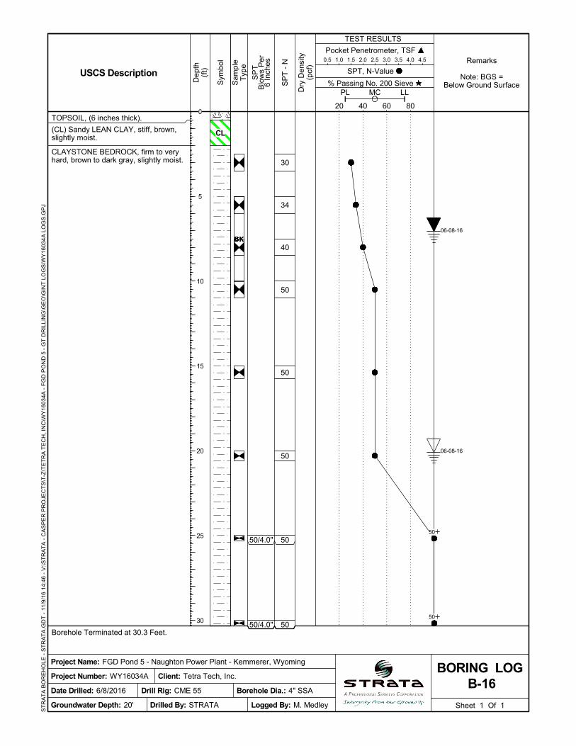
B-17BORING LOG
USCS Description
Groundwater Depth: 13.5'
Remarks
Note: BGS =Below Ground Surface
Borehole Dia.: 4" SSA
Client: Tetra Tech, Inc.
Drilled By: STRATA
SP
T -
N
Drill Rig: CME 55
ST
RA
TA
BO
RE
HO
LE -
ST
RA
TA
.GD
T -
11/
9/1
6 1
4:46
- V
:\ST
RA
TA
- C
AS
PE
R P
RO
JEC
TS
\T-Z
\TE
TR
A T
EC
H, I
NC
\WY
1603
4A -
FG
D P
ON
D 5
- G
T D
RIL
LIN
G\G
EO
\GIN
T L
OG
S\W
Y16
034A
LO
GS
.GP
J
0
5
10
15
20
2550
06-08-16
06-08-16
CL

50/3.0"
50/4.0"
TOPSOIL, (6 inches thick).
(CL) Sandy LEAN CLAY, stiff, brown,slightly moist.
CLAYSTONE BEDROCK, medium hardto very hard, gray to dark gray, slightlymoist to moist.
Borehole Terminated at 30.3 Feet.
40
50
50
46
50
50
50
50
Pocket Penetrometer, TSF 0.5 1.0 1.5 2.0 2.5 3.0 3.5 4.0 4.5
Sheet 1 Of 1
Sam
ple
Typ
e
% Passing No. 200 Sieve
TEST RESULTS
SP
TB
low
s P
er6
Inch
es
20 40 60 80
PL LLMC
Sym
bol
Dep
th(f
t)
Project Number: WY16034A
Dry
Den
sity
(pcf
)
Logged By: M. Medley
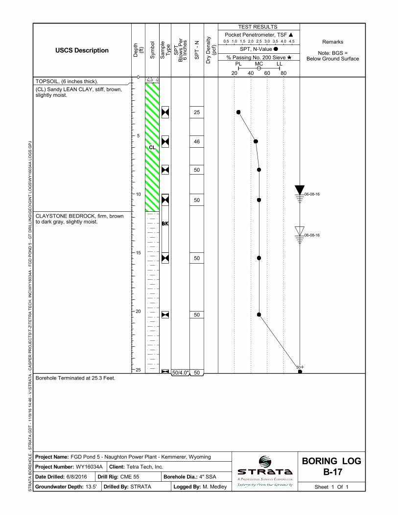
Project Name: FGD Pond 5 - Naughton Power Plant - Kemmerer, Wyoming
Date Drilled: 6/8/2016
SPT, N-Value
B-18BORING LOG
USCS Description
Groundwater Depth: 18'
Remarks
Note: BGS =Below Ground Surface
Borehole Dia.: 4" SSA
Client: Tetra Tech, Inc.
Drilled By: STRATA
SP
T -
N
Drill Rig: CME 55
ST
RA
TA
BO
RE
HO
LE -
ST
RA
TA
.GD
T -
11/
9/1
6 1
4:46
- V
:\ST
RA
TA
- C
AS
PE
R P
RO
JEC
TS
\T-Z
\TE
TR
A T
EC
H, I
NC
\WY
1603
4A -
FG
D P
ON
D 5
- G
T D
RIL
LIN
G\G
EO
\GIN
T L
OG
S\W
Y16
034A
LO
GS
.GP
J
0
5
10
15
20
25
30
50
50
06-08-16
06-08-16
CL
50/4.0"
50/3.0"
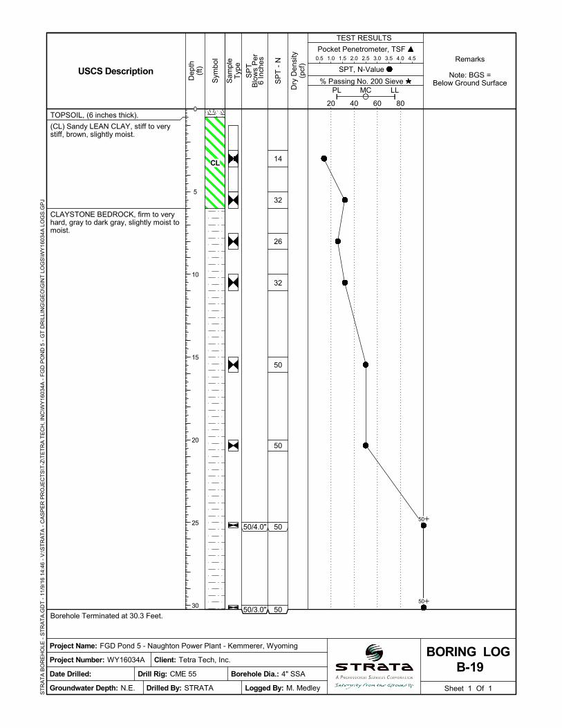
TOPSOIL, (6 inches thick).
(CL) Sandy LEAN CLAY, stiff to verystiff, brown, slightly moist.
CLAYSTONE BEDROCK, firm to veryhard, gray to dark gray, slightly moist tomoist.
Borehole Terminated at 30.3 Feet.
14
32
26
32
50
50
50
50
Pocket Penetrometer, TSF 0.5 1.0 1.5 2.0 2.5 3.0 3.5 4.0 4.5
Sheet 1 Of 1
Sam
ple
Typ
e
% Passing No. 200 Sieve
TEST RESULTS
SP
TB
low
s P
er6
Inch
es
20 40 60 80
PL LLMC
Sym
bol
Dep
th(f
t)
Project Number: WY16034A
Dry
Den
sity
(pcf
)
Logged By: M. Medley
Project Name: FGD Pond 5 - Naughton Power Plant - Kemmerer, Wyoming
Date Drilled:
SPT, N-Value
B-19BORING LOG
USCS Description
Groundwater Depth: N.E.
Remarks
Note: BGS =Below Ground Surface
Borehole Dia.: 4" SSA
Client: Tetra Tech, Inc.
Drilled By: STRATA
SP
T -
N
Drill Rig: CME 55
ST
RA
TA
BO
RE
HO
LE -
ST
RA
TA
.GD
T -
11/
9/1
6 1
4:46
- V
:\ST
RA
TA
- C
AS
PE
R P
RO
JEC
TS
\T-Z
\TE
TR
A T
EC
H, I
NC
\WY
1603
4A -
FG
D P
ON
D 5
- G
T D
RIL
LIN
G\G
EO
\GIN
T L
OG
S\W
Y16
034A
LO
GS
.GP
J
0
5
10
15
20
25
30
50
50
CL
50/6.0"
50/5.0"
TOPSOIL, (6 inches thick).
CLAYSTONE BEDROCK, very hard,brown to dark gray, slightly moist towet.
Borehole Terminated at 20.4 Feet.
50
50
50
50
50
50
Pocket Penetrometer, TSF 0.5 1.0 1.5 2.0 2.5 3.0 3.5 4.0 4.5
Sheet 1 Of 1
Sam
ple
Typ
e
% Passing No. 200 Sieve
TEST RESULTS
SP
TB
low
s P
er6
Inch
es
20 40 60 80
PL LLMC
Sym
bol
Dep
th(f
t)
Project Number: WY16034A
Dry
Den
sity
(pcf
)
Logged By: M. Medley
Project Name: FGD Pond 5 - Naughton Power Plant - Kemmerer, Wyoming
Date Drilled: 6/10/2016
SPT, N-Value
B-20BORING LOG
USCS Description
Groundwater Depth: 18'
Remarks
Note: BGS =Below Ground Surface
Borehole Dia.: 4" SSA
Client: Tetra Tech, Inc.
Drilled By: STRATA
SP
T -
N
Drill Rig: CME 55
ST
RA
TA
BO
RE
HO
LE -
ST
RA
TA
.GD
T -
11/
9/1
6 1
4:46
- V
:\ST
RA
TA
- C
AS
PE
R P
RO
JEC
TS
\T-Z
\TE
TR
A T
EC
H, I
NC
\WY
1603
4A -
FG
D P
ON
D 5
- G
T D
RIL
LIN
G\G
EO
\GIN
T L
OG
S\W
Y16
034A
LO
GS
.GP
J
0
5
10
15
20
50
50
06-10-16
06-10-16
TOPSOIL, (6 inches thick).
(CL) Sandy LEAN CLAY, stiff, brown,slightly moist.
CLAYSTONE BEDROCK, medium hardto very hard, brown to dark gray, slightlymoist to moist.
Borehole Terminated at 20.7 Feet.
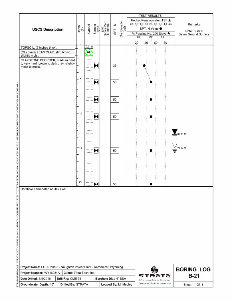
36
50
50
50
50
50
Pocket Penetrometer, TSF 0.5 1.0 1.5 2.0 2.5 3.0 3.5 4.0 4.5
Sheet 1 Of 1
Sam
ple
Typ
e
% Passing No. 200 Sieve
TEST RESULTS
SP
TB
low
s P
er6
Inch
es
20 40 60 80
PL LLMC
Sym
bol
Dep
th(f
t)
Project Number: WY16034A
Dry
Den
sity
(pcf
)
Logged By: M. Medley
Project Name: FGD Pond 5 - Naughton Power Plant - Kemmerer, Wyoming
Date Drilled: 6/9/2016
SPT, N-Value
B-21BORING LOG
USCS Description
Groundwater Depth: 15'
Remarks
Note: BGS =Below Ground Surface
Borehole Dia.: 4" SSA
Client: Tetra Tech, Inc.
Drilled By: STRATA
SP
T -
N
Drill Rig: CME 55
ST
RA
TA
BO
RE
HO
LE -
ST
RA
TA
.GD
T -
11/
9/1
6 1
4:46
- V
:\ST
RA
TA
- C
AS
PE
R P
RO
JEC
TS
\T-Z
\TE
TR
A T
EC
H, I
NC
\WY
1603
4A -
FG
D P
ON
D 5
- G
T D
RIL
LIN
G\G
EO
\GIN
T L
OG
S\W
Y16
034A
LO
GS
.GP
J
0
5
10
15
20
06-09-16
06-09-16
CL
TOPSOIL, (6 inches thick).
(CL) Sandy LEAN CLAY, very hard,brown, slightly moist.
CLAYSTONE BEDROCK, firm to veryhard, brown to dark gray, slightly moist.
Borehole Terminated at 20.7 Feet.
50
50
50
25
40
50
Pocket Penetrometer, TSF 0.5 1.0 1.5 2.0 2.5 3.0 3.5 4.0 4.5
Sheet 1 Of 1
Sam
ple
Typ
e
% Passing No. 200 Sieve
TEST RESULTS
SP
TB
low
s P
er6
Inch
es
20 40 60 80
PL LLMC
Sym
bol
Dep
th(f
t)
Project Number: WY16034A
Dry
Den
sity
(pcf
)
Logged By: M. Medley
Project Name: FGD Pond 5 - Naughton Power Plant - Kemmerer, Wyoming
Date Drilled: 6/9/2016
SPT, N-Value
B-22BORING LOG
USCS Description
Groundwater Depth: N.E.
Remarks
Note: BGS =Below Ground Surface
Borehole Dia.: 4" SSA
Client: Tetra Tech, Inc.
Drilled By: STRATA
SP
T -
N
Drill Rig: CME 55
ST
RA
TA
BO
RE
HO
LE -
ST
RA
TA
.GD
T -
11/
9/1
6 1
4:46
- V
:\ST
RA
TA
- C
AS
PE
R P
RO
JEC
TS
\T-Z
\TE
TR
A T
EC
H, I
NC
\WY
1603
4A -
FG
D P
ON
D 5
- G
T D
RIL
LIN
G\G
EO
\GIN
T L
OG
S\W
Y16
034A
LO
GS
.GP
J
0
5
10
15
20
06-09-16
CL

TOPSOIL, (6 inches thick).
(CL) Sandy LEAN CLAY, stiff, brown,slightly moist.
CLAYSTONE BEDROCK, firm, gray todark gray, slightly moist.
Borehole Terminated at 20.8 Feet.
15
22
40
50
50
50
Pocket Penetrometer, TSF 0.5 1.0 1.5 2.0 2.5 3.0 3.5 4.0 4.5
Sheet 1 Of 1
Sam
ple
Typ
e
% Passing No. 200 Sieve
TEST RESULTS
SP
TB
low
s P
er6
Inch
es
20 40 60 80
PL LLMC
Sym
bol
Dep
th(f
t)
Project Number: WY16034A
Dry
Den
sity
(pcf
)
Logged By: M. Medley
Project Name: FGD Pond 5 - Naughton Power Plant - Kemmerer, Wyoming
Date Drilled: 6/8/2016
SPT, N-Value
B-23BORING LOG
USCS Description
Groundwater Depth: N.E.
Remarks
Note: BGS =Below Ground Surface
Borehole Dia.: 4" SSA
Client: Tetra Tech, Inc.
Drilled By: STRATA
SP
T -
N
Drill Rig: CME 55
ST
RA
TA
BO
RE
HO
LE -
ST
RA
TA
.GD
T -
11/
9/1
6 1
4:46
- V
:\ST
RA
TA
- C
AS
PE
R P
RO
JEC
TS
\T-Z
\TE
TR
A T
EC
H, I
NC
\WY
1603
4A -
FG
D P
ON
D 5
- G
T D
RIL
LIN
G\G
EO
\GIN
T L
OG
S\W
Y16
034A
LO
GS
.GP
J
18 46
0
5
10
15
20
CL
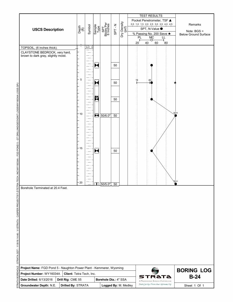
50/6.0"
50/5.0"
TOPSOIL, (6 inches thick).
CLAYSTONE BEDROCK, very hard,brown to dark gray, slightly moist.
Borehole Terminated at 20.4 Feet.
50
50
50
50
50
50
Pocket Penetrometer, TSF 0.5 1.0 1.5 2.0 2.5 3.0 3.5 4.0 4.5
Sheet 1 Of 1
Sam
ple
Typ
e
% Passing No. 200 Sieve
TEST RESULTS
SP
TB
low
s P
er6
Inch
es
20 40 60 80
PL LLMC
Sym
bol
Dep
th(f
t)
Project Number: WY16034A
Dry
Den
sity
(pcf
)
Logged By: M. Medley
Project Name: FGD Pond 5 - Naughton Power Plant - Kemmerer, Wyoming
Date Drilled: 6/13/2016
SPT, N-Value
B-24BORING LOG
USCS Description
Groundwater Depth: N.E.
Remarks
Note: BGS =Below Ground Surface
Borehole Dia.: 4" SSA
Client: Tetra Tech, Inc.
Drilled By: STRATA
SP
T -
N
Drill Rig: CME 55
ST
RA
TA
BO
RE
HO
LE -
ST
RA
TA
.GD
T -
11/
9/1
6 1
4:46
- V
:\ST
RA
TA
- C
AS
PE
R P
RO
JEC
TS
\T-Z
\TE
TR
A T
EC
H, I
NC
\WY
1603
4A -
FG
D P
ON
D 5
- G
T D
RIL
LIN
G\G
EO
\GIN
T L
OG
S\W
Y16
034A
LO
GS
.GP
J
19 46
0
5
10
15
20
50
50
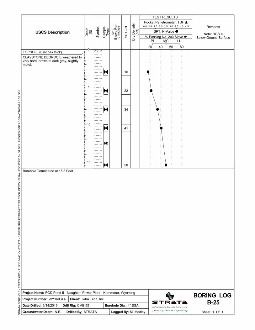
TOPSOIL, (6 inches thick).
CLAYSTONE BEDROCK, weathered tovery hard, brown to dark gray, slightlymoist.
Borehole Terminated at 15.8 Feet.
16
22
34
41
50
Pocket Penetrometer, TSF 0.5 1.0 1.5 2.0 2.5 3.0 3.5 4.0 4.5
Sheet 1 Of 1
Sam
ple
Typ
e
% Passing No. 200 Sieve
TEST RESULTS
SP
TB
low
s P
er6
Inch
es
20 40 60 80
PL LLMC
Sym
bol
Dep
th(f
t)
Project Number: WY16034A
Dry
Den
sity
(pcf
)
Logged By: M. Medley
Project Name: FGD Pond 5 - Naughton Power Plant - Kemmerer, Wyoming
Date Drilled: 6/14/2016
SPT, N-Value
B-25BORING LOG
USCS Description
Groundwater Depth: N.E.
Remarks
Note: BGS =Below Ground Surface
Borehole Dia.: 4" SSA
Client: Tetra Tech, Inc.
Drilled By: STRATA
SP
T -
N
Drill Rig: CME 55
ST
RA
TA
BO
RE
HO
LE -
ST
RA
TA
.GD
T -
11/
9/1
6 1
4:46
- V
:\ST
RA
TA
- C
AS
PE
R P
RO
JEC
TS
\T-Z
\TE
TR
A T
EC
H, I
NC
\WY
1603
4A -
FG
D P
ON
D 5
- G
T D
RIL
LIN
G\G
EO
\GIN
T L
OG
S\W
Y16
034A
LO
GS
.GP
J
0
5
10
15

Tetra Tech
Billings, MT
(no specification provided)
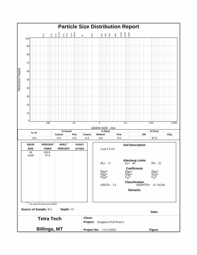
PL= LL= PI=
D90= D85= D60=D50= D30= D15=D10= Cu= Cc=
USCS= AASHTO=
*
Lean CLAY#4
#200100.0
95.6
20 39 19
CL A-6(19)
Naughton FGD Pond 5
114-510835
Soil Description
Atterberg Limits
Coefficients
Classification
Remarks
Source of Sample: B-2 Depth: 2.5'Date:
Client:
Project:
Project No: Figure
SIEVE PERCENT SPEC.* PASS?
SIZE FINER PERCENT (X=NO)
PE
RC
EN
T F
INE
R
0
10
20
30
40
50
60
70
80
90
100
GRAIN SIZE - mm.
0.0010.010.1110100
% +3"Coarse
% Gravel
Fine Coarse Medium
% Sand
Fine Silt
% Fines
Clay
0.0 0.0 0.0 0.9 1.7 1.8 95.6
6 in
.
3 in
.
2 in
.
1½
in.
1 in
.
¾ in
.
½ in
.
3/8
in.
#4
#1
0
#2
0
#3
0
#4
0
#6
0
#1
00
#1
40
#2
00
Particle Size Distribution Report

Tetra Tech
Billings, MT
(no specification provided)
PL= LL= PI=
D90= D85= D60=D50= D30= D15=D10= Cu= Cc=
USCS= AASHTO=
*
Fat CLAY#4
#200100.0
99.4
19 52 33
CH A-7-6(36)
Naughton FGD Pond 5
114-510835
Soil Description
Atterberg Limits
Coefficients
Classification
Remarks
Source of Sample: B-2 Depth: 7.5'Date:
Client:
Project:
Project No: Figure
SIEVE PERCENT SPEC.* PASS?
SIZE FINER PERCENT (X=NO)
PE
RC
EN
T F
INE
R
0
10
20
30
40
50
60
70
80
90
100
GRAIN SIZE - mm.
0.0010.010.1110100
% +3"Coarse
% Gravel
Fine Coarse Medium
% Sand
Fine Silt
% Fines
Clay
0.0 0.0 0.0 0.1 0.3 0.2 99.4
6 in
.
3 in
.
2 in
.
1½
in.
1 in
.
¾ in
.
½ in
.
3/8
in.
#4
#1
0
#2
0
#3
0
#4
0
#6
0
#1
00
#1
40
#2
00
Particle Size Distribution Report

Tetra Tech
Billings, MT
(no specification provided)
PL= LL= PI=
D90= D85= D60=D50= D30= D15=D10= Cu= Cc=
USCS= AASHTO=
*
Leam CLAY#4
#200100.0
97.6
19 49 30
CL A-7-6(32)
Naughton FGD Pond 5
114-510835
Soil Description
Atterberg Limits
Coefficients
Classification
Remarks
Source of Sample: B-2 Depth: 10'Date:
Client:
Project:
Project No: Figure
SIEVE PERCENT SPEC.* PASS?
SIZE FINER PERCENT (X=NO)
PE
RC
EN
T F
INE
R
0
10
20
30
40
50
60
70
80
90
100
GRAIN SIZE - mm.
0.0010.010.1110100
% +3"Coarse
% Gravel
Fine Coarse Medium
% Sand
Fine Silt
% Fines
Clay
0.0 0.0 0.0 0.5 0.9 1.0 97.6
6 in
.
3 in
.
2 in
.
1½
in.
1 in
.
¾ in
.
½ in
.
3/8
in.
#4
#1
0
#2
0
#3
0
#4
0
#6
0
#1
00
#1
40
#2
00
Particle Size Distribution Report
Tetra Tech
Billings, MT
(no specification provided)
PL= LL= PI=
D90= D85= D60=D50= D30= D15=D10= Cu= Cc=
USCS= AASHTO=
*
Lean CLAY#4
#200100.0
97.9
17 49 32
CL A-7-6(34)
Naughton FGD Pond 5
114-510835
Soil Description
Atterberg Limits
Coefficients
Classification
Remarks
Source of Sample: B-2 Depth: 15'Date:
Client:
Project:
Project No: Figure
SIEVE PERCENT SPEC.* PASS?
SIZE FINER PERCENT (X=NO)
PE
RC
EN
T F
INE
R
0
10
20
30
40
50
60
70
80
90
100
GRAIN SIZE - mm.
0.0010.010.1110100
% +3"Coarse
% Gravel
Fine Coarse Medium
% Sand
Fine Silt
% Fines
Clay
0.0 0.0 0.0 0.4 0.8 0.9 97.9
6 in
.
3 in
.
2 in
.
1½
in.
1 in
.
¾ in
.
½ in
.
3/8
in.
#4
#1
0
#2
0
#3
0
#4
0
#6
0
#1
00
#1
40
#2
00
Particle Size Distribution Report

Tetra Tech
Billings, MT
(no specification provided)
PL= LL= PI=
D90= D85= D60=D50= D30= D15=D10= Cu= Cc=
USCS= AASHTO=
*
Lean CLAY#4
#200100.0
98.0
20 48 28
CL A-7-6(30)
Naughton FGD Pond 5
114-510835
Soil Description
Atterberg Limits
Coefficients
Classification
Remarks
Source of Sample: B-2 Depth: 20'Date:
Client:
Project:
Project No: Figure
SIEVE PERCENT SPEC.* PASS?
SIZE FINER PERCENT (X=NO)
PE
RC
EN
T F
INE
R
0
10
20
30
40
50
60
70
80
90
100
GRAIN SIZE - mm.
0.0010.010.1110100
% +3"Coarse
% Gravel
Fine Coarse Medium
% Sand
Fine Silt
% Fines
Clay
0.0 0.0 0.0 0.4 0.7 0.9 98.0
6 in
.
3 in
.
2 in
.
1½
in.
1 in
.
¾ in
.
½ in
.
3/8
in.
#4
#1
0
#2
0
#3
0
#4
0
#6
0
#1
00
#1
40
#2
00
Particle Size Distribution Report
Tetra Tech
Billings, MT
(no specification provided)
PL= LL= PI=
D90= D85= D60=D50= D30= D15=D10= Cu= Cc=
USCS= AASHTO=
*
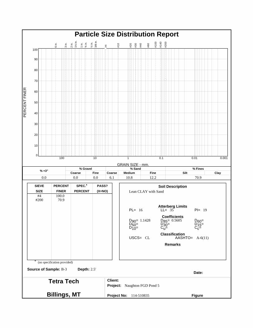
Lean CLAY with Sand#4
#200100.0
70.9
16 35 19
1.1428 0.5605
CL A-6(11)
Naughton FGD Pond 5
114-510835
Soil Description
Atterberg Limits
Coefficients
Classification
Remarks
Source of Sample: B-3 Depth: 2.5'Date:
Client:
Project:
Project No: Figure
SIEVE PERCENT SPEC.* PASS?
SIZE FINER PERCENT (X=NO)
PE
RC
EN
T F
INE
R
0
10
20
30
40
50
60
70
80
90
100
GRAIN SIZE - mm.
0.0010.010.1110100
% +3"Coarse
% Gravel
Fine Coarse Medium
% Sand
Fine Silt
% Fines
Clay
0.0 0.0 0.0 6.1 10.8 12.2 70.9
6 in
.
3 in
.
2 in
.
1½
in.
1 in
.
¾ in
.
½ in
.
3/8
in.
#4
#1
0
#2
0
#3
0
#4
0
#6
0
#1
00
#1
40
#2
00
Particle Size Distribution Report

Tetra Tech
Billings, MT
(no specification provided)
PL= LL= PI=
D90= D85= D60=D50= D30= D15=D10= Cu= Cc=
USCS= AASHTO=
*
Sandy Lean CLAY#4
#200100.0
66.0
15 41 26
1.4016 0.7613
CL A-7-6(15)
Naughton FGD Pond 5
114-510835
Soil Description
Atterberg Limits
Coefficients
Classification
Remarks
Source of Sample: B-3 Depth: 10'Date:
Client:
Project:
Project No: Figure
SIEVE PERCENT SPEC.* PASS?
SIZE FINER PERCENT (X=NO)
PE
RC
EN
T F
INE
R
0
10
20
30
40
50
60
70
80
90
100
GRAIN SIZE - mm.
0.0010.010.1110100
% +3"Coarse
% Gravel
Fine Coarse Medium
% Sand
Fine Silt
% Fines
Clay
0.0 0.0 0.0 7.1 12.7 14.2 66.0
6 in
.
3 in
.
2 in
.
1½
in.
1 in
.
¾ in
.
½ in
.
3/8
in.
#4
#1
0
#2
0
#3
0
#4
0
#6
0
#1
00
#1
40
#2
00
Particle Size Distribution Report

Tetra Tech
Billings, MT
(no specification provided)
PL= LL= PI=
D90= D85= D60=D50= D30= D15=D10= Cu= Cc=
USCS= AASHTO=
*
Fat CLAY#4
#200100.0
93.5
22 52 30
CH A-7-6(31)
Naughton FGD Pond 5
114-510835
Soil Description
Atterberg Limits
Coefficients
Classification
Remarks
Source of Sample: B-4 Depth: 2.5'Date:
Client:
Project:
Project No: Figure
SIEVE PERCENT SPEC.* PASS?
SIZE FINER PERCENT (X=NO)
PE
RC
EN
T F
INE
R
0
10
20
30
40
50
60
70
80
90
100
GRAIN SIZE - mm.
0.0010.010.1110100
% +3"Coarse
% Gravel
Fine Coarse Medium
% Sand
Fine Silt
% Fines
Clay
0.0 0.0 0.0 1.4 2.4 2.7 93.5
6 in
.
3 in
.
2 in
.
1½
in.
1 in
.
¾ in
.
½ in
.
3/8
in.
#4
#1
0
#2
0
#3
0
#4
0
#6
0
#1
00
#1
40
#2
00
Particle Size Distribution Report

Tetra Tech
Billings, MT
(no specification provided)
PL= LL= PI=
D90= D85= D60=D50= D30= D15=D10= Cu= Cc=
USCS= AASHTO=
*
Lean CLAY#4
#200100.0
95.4
17 38 21
CL A-6(20)
Naughton FGD Pond 5
114-510835
Soil Description
Atterberg Limits
Coefficients
Classification
Remarks
Source of Sample: B-10 Depth: 2.5'Date:
Client:
Project:
Project No: Figure
SIEVE PERCENT SPEC.* PASS?
SIZE FINER PERCENT (X=NO)
PE
RC
EN
T F
INE
R
0
10
20
30
40
50
60
70
80
90
100
GRAIN SIZE - mm.
0.0010.010.1110100
% +3"Coarse
% Gravel
Fine Coarse Medium
% Sand
Fine Silt
% Fines
Clay
0.0 0.0 0.0 1.0 1.7 1.9 95.4
6 in
.
3 in
.
2 in
.
1½
in.
1 in
.
¾ in
.
½ in
.
3/8
in.
#4
#1
0
#2
0
#3
0
#4
0
#6
0
#1
00
#1
40
#2
00
Particle Size Distribution Report

Tetra Tech
Billings, MT
(no specification provided)
PL= LL= PI=
D90= D85= D60=D50= D30= D15=D10= Cu= Cc=
USCS= AASHTO=
*
Lean CLAY#4
#200100.0
97.1
18 37 19
CL A-6(19)
Naughton FGD Pond 5
114-510835
Soil Description
Atterberg Limits
Coefficients
Classification
Remarks
Source of Sample: B-10 Depth: 7.5'Date:
Client:
Project:
Project No: Figure
SIEVE PERCENT SPEC.* PASS?
SIZE FINER PERCENT (X=NO)
PE
RC
EN
T F
INE
R
0
10
20
30
40
50
60
70
80
90
100
GRAIN SIZE - mm.
0.0010.010.1110100
% +3"Coarse
% Gravel
Fine Coarse Medium
% Sand
Fine Silt
% Fines
Clay
0.0 0.0 0.0 0.6 1.1 1.2 97.1
6 in
.
3 in
.
2 in
.
1½
in.
1 in
.
¾ in
.
½ in
.
3/8
in.
#4
#1
0
#2
0
#3
0
#4
0
#6
0
#1
00
#1
40
#2
00
Particle Size Distribution Report

Tetra Tech
Billings, MT
(no specification provided)
PL= LL= PI=
D90= D85= D60=D50= D30= D15=D10= Cu= Cc=
USCS= AASHTO=
*
Lean CLAY#4
#200100.0
94.7
19 36 17
CL A-6(16)
Naughton FGD Pond 5
114-510835
Soil Description
Atterberg Limits
Coefficients
Classification
Remarks
Source of Sample: B-10 Depth: 20'Date:
Client:
Project:
Project No: Figure
SIEVE PERCENT SPEC.* PASS?
SIZE FINER PERCENT (X=NO)
PE
RC
EN
T F
INE
R
0
10
20
30
40
50
60
70
80
90
100
GRAIN SIZE - mm.
0.0010.010.1110100
% +3"Coarse
% Gravel
Fine Coarse Medium
% Sand
Fine Silt
% Fines
Clay
0.0 0.0 0.0 1.1 2.0 2.2 94.7
6 in
.
3 in
.
2 in
.
1½
in.
1 in
.
¾ in
.
½ in
.
3/8
in.
#4
#1
0
#2
0
#3
0
#4
0
#6
0
#1
00
#1
40
#2
00
Particle Size Distribution Report

Tetra Tech
Billings, MT
(no specification provided)
PL= LL= PI=
D90= D85= D60=D50= D30= D15=D10= Cu= Cc=
USCS= AASHTO=
*
Lean CLAY#4#10#20#40#80
#200
100.0100.0
99.799.597.088.7
16 38 22
0.0845
CL A-6(19)
Naughton FGD Pond 5
114-510835
Soil Description
Atterberg Limits
Coefficients
Classification
Remarks
Source of Sample: B-14 Depth: 1'-5'Date:
Client:
Project:
Project No: Figure
SIEVE PERCENT SPEC.* PASS?
SIZE FINER PERCENT (X=NO)
PE
RC
EN
T F
INE
R
0
10
20
30
40
50
60
70
80
90
100
GRAIN SIZE - mm.
0.0010.010.1110100
% +3"Coarse
% Gravel
Fine Coarse Medium
% Sand
Fine Silt
% Fines
Clay
0.0 0.0 0.0 0.0 0.5 10.8 88.7
6 in
.
3 in
.
2 in
.
1½
in.
1 in
.
¾ in
.
½ in
.
3/8
in.
#4
#1
0
#2
0
#3
0
#4
0
#6
0
#1
00
#1
40
#2
00
Particle Size Distribution Report

Tetra Tech
Billings, MT
(no specification provided)
PL= LL= PI=
D90= D85= D60=D50= D30= D15=D10= Cu= Cc=
USCS= AASHTO=
*
Lean CLAY3/8#4#10#20#40#80
#200
100.099.497.996.996.594.285.9
18 46 28
0.1092
CL A-7-6(25)
Naughton FGD Pond 5
114-510835
Soil Description
Atterberg Limits
Coefficients
Classification
Remarks
Source of Sample: B-23 Depth: 1'-5'Date:
Client:
Project:
Project No: Figure
SIEVE PERCENT SPEC.* PASS?
SIZE FINER PERCENT (X=NO)
PE
RC
EN
T F
INE
R
0
10
20
30
40
50
60
70
80
90
100
GRAIN SIZE - mm.
0.0010.010.1110100
% +3"Coarse
% Gravel
Fine Coarse Medium
% Sand
Fine Silt
% Fines
Clay
0.0 0.0 0.6 1.5 1.4 10.6 85.9
6 in
.
3 in
.
2 in
.
1½
in.
1 in
.
¾ in
.
½ in
.
3/8
in.
#4
#1
0
#2
0
#3
0
#4
0
#6
0
#1
00
#1
40
#2
00
Particle Size Distribution Report
Tetra Tech
Billings, MT
(no specification provided)
PL= LL= PI=
D90= D85= D60=D50= D30= D15=D10= Cu= Cc=
USCS= AASHTO=
*
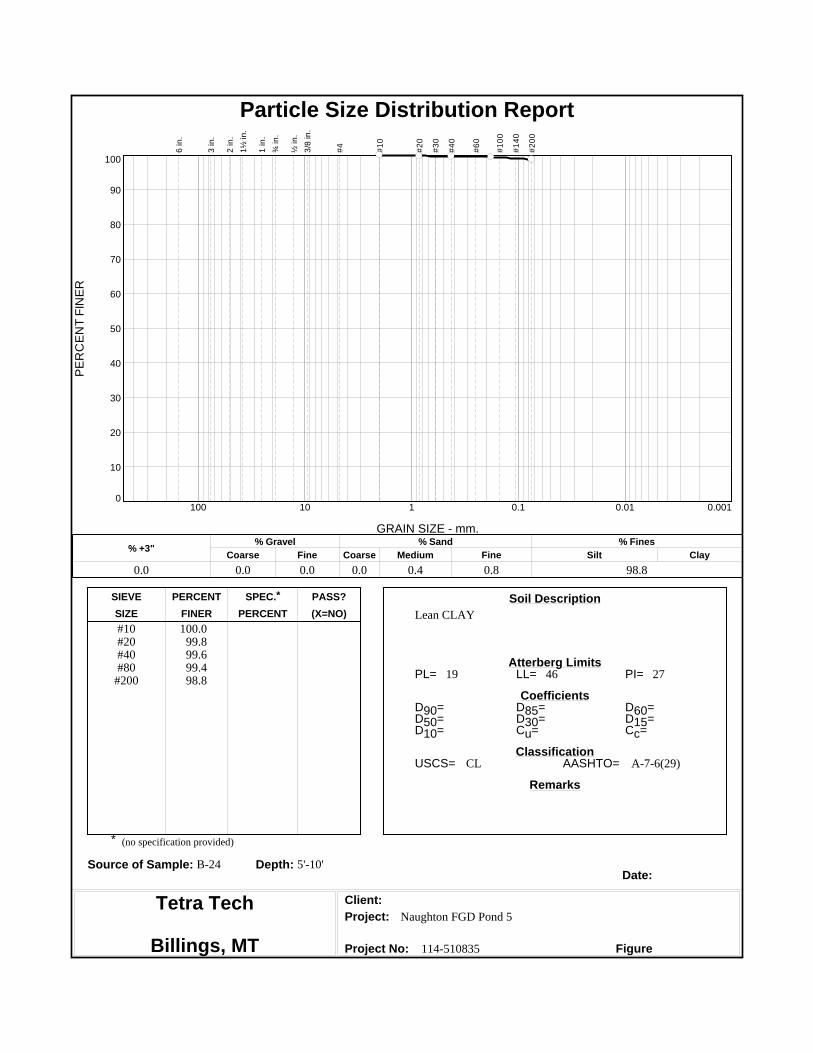
Lean CLAY#10#20#40#80
#200
100.099.899.699.498.8
19 46 27
CL A-7-6(29)
Naughton FGD Pond 5
114-510835
Soil Description
Atterberg Limits
Coefficients
Classification
Remarks
Source of Sample: B-24 Depth: 5'-10'Date:
Client:
Project:
Project No: Figure
SIEVE PERCENT SPEC.* PASS?
SIZE FINER PERCENT (X=NO)
PE
RC
EN
T F
INE
R
0
10
20
30
40
50
60
70
80
90
100
GRAIN SIZE - mm.
0.0010.010.1110100
% +3"Coarse
% Gravel
Fine Coarse Medium
% Sand
Fine Silt
% Fines
Clay
0.0 0.0 0.0 0.0 0.4 0.8 98.8
6 in
.
3 in
.
2 in
.
1½
in.
1 in
.
¾ in
.
½ in
.
3/8
in.
#4
#1
0
#2
0
#3
0
#4
0
#6
0
#1
00
#1
40
#2
00
Particle Size Distribution Report
COMPACTION TEST REPORT
Dry
de
nsi
ty, p
cf
100
102
104
106
108
110
Water content, %
13.5 15 16.5 18 19.5 21 22.5
17.5%, 107.8 pcf
ZAV forSp.G. =2.75
Test specification: ASTM D 698-12 Method A Standard
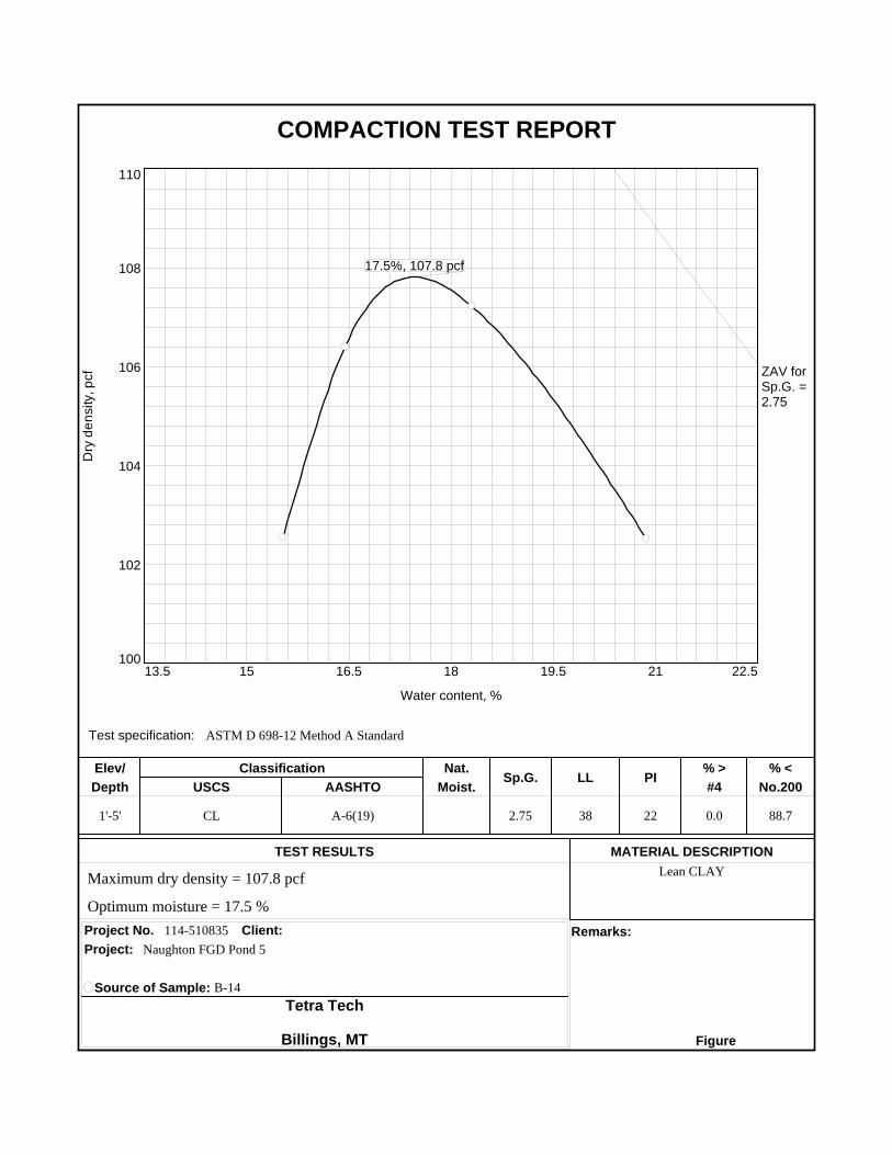
1'-5' CL A-6(19) 2.75 38 22 0.0 88.7
Lean CLAY
114-510835
Elev/ Classification Nat.Sp.G. LL PI
% > % <
Depth USCS AASHTO Moist. #4 No.200
TEST RESULTS MATERIAL DESCRIPTION
Project No. Client: Remarks:
Project:
Source of Sample: B-14
Tetra Tech
Billings, MT Figure
Maximum dry density = 107.8 pcf
Optimum moisture = 17.5 %
Naughton FGD Pond 5
COMPACTION TEST REPORT
Dry
de
nsi
ty, p
cf
95
97.5
100
102.5
105
107.5
Water content, %
16 18 20 22 24 26 28
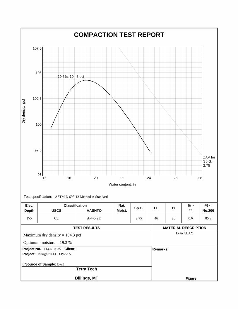
19.3%, 104.3 pcf
ZAV forSp.G. =2.75
Test specification: ASTM D 698-12 Method A Standard
1'-5' CL A-7-6(25) 2.75 46 28 0.6 85.9
Lean CLAY
114-510835
Elev/ Classification Nat.Sp.G. LL PI
% > % <
Depth USCS AASHTO Moist. #4 No.200
TEST RESULTS MATERIAL DESCRIPTION
Project No. Client: Remarks:
Project:
Source of Sample: B-23
Tetra Tech
Billings, MT Figure
Maximum dry density = 104.3 pcf
Optimum moisture = 19.3 %
Naughton FGD Pond 5
COMPACTION TEST REPORT
Dry
de
nsi
ty, p
cf
103
104
105
106
107
108
Water content, %
13.5 15 16.5 18 19.5 21 22.5
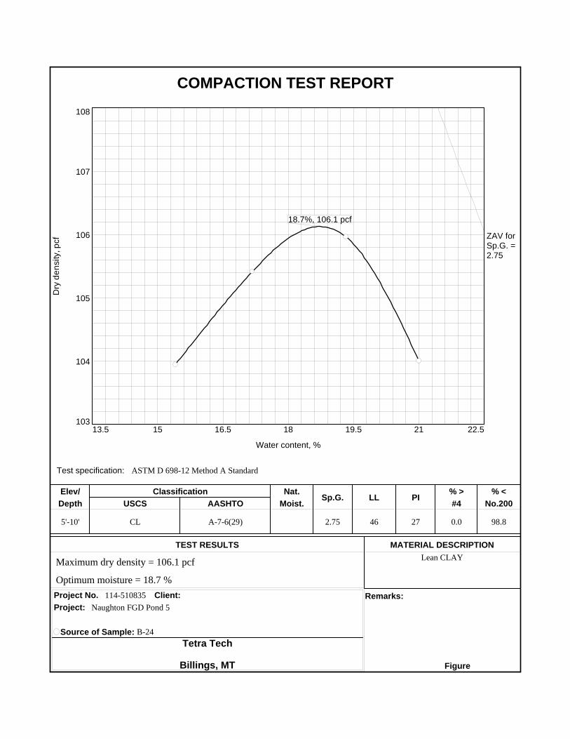
18.7%, 106.1 pcf
ZAV forSp.G. =2.75
Test specification: ASTM D 698-12 Method A Standard
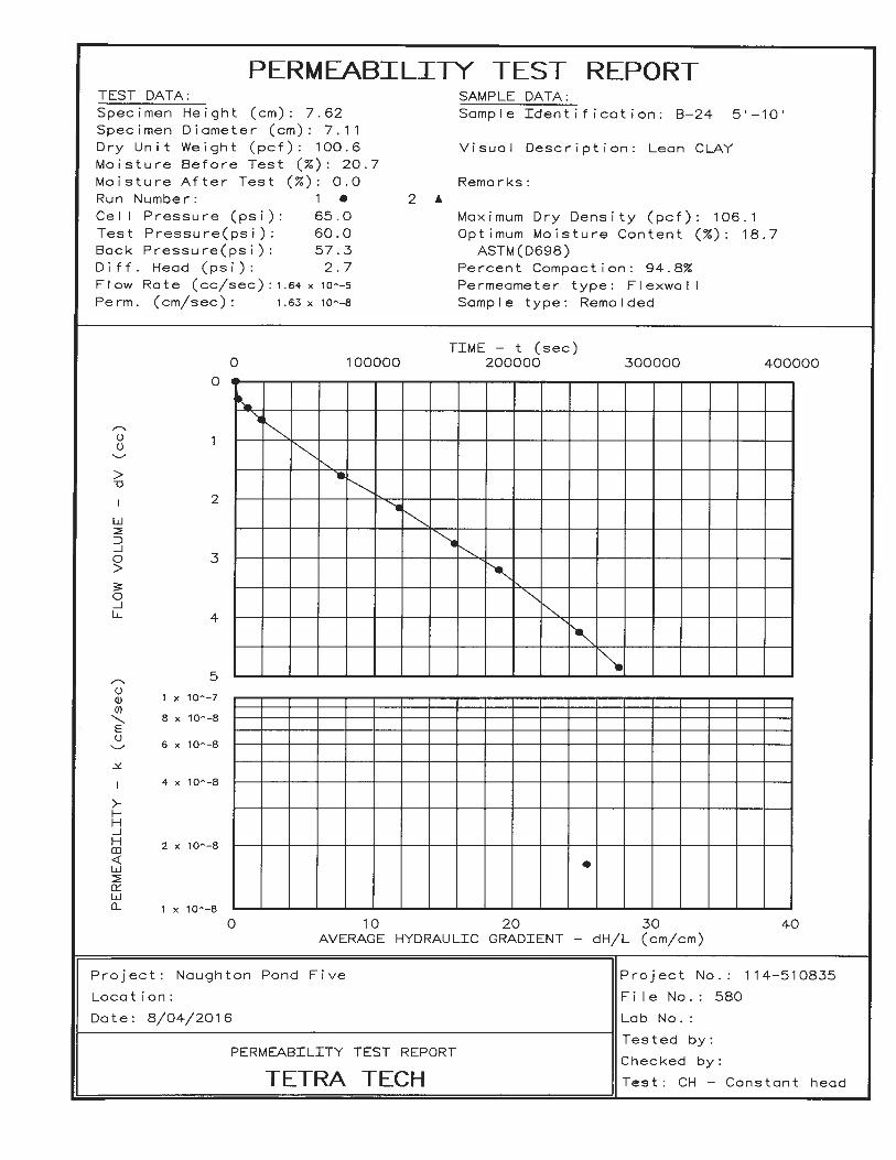
5'-10' CL A-7-6(29) 2.75 46 27 0.0 98.8
Lean CLAY
114-510835
Elev/ Classification Nat.Sp.G. LL PI
% > % <
Depth USCS AASHTO Moist. #4 No.200
TEST RESULTS MATERIAL DESCRIPTION
Project No. Client: Remarks:
Project:
Source of Sample: B-24
Tetra Tech
Billings, MT Figure
Maximum dry density = 106.1 pcf
Optimum moisture = 18.7 %
Naughton FGD Pond 5
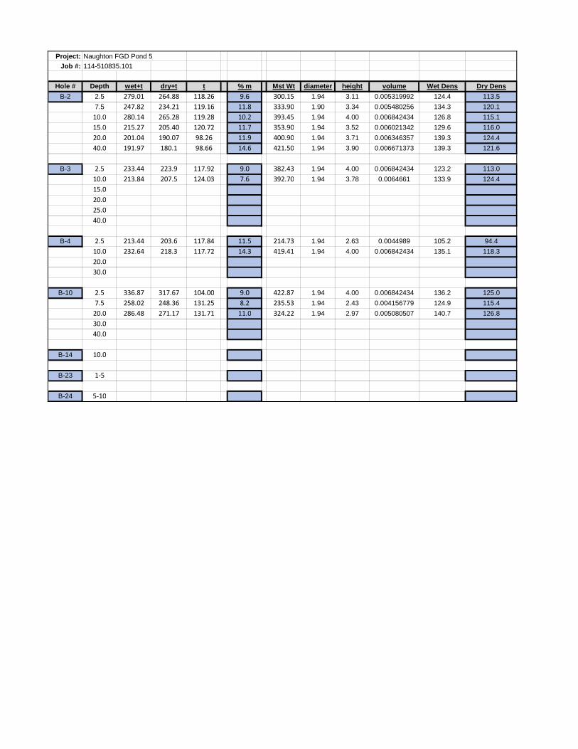
Project: Naughton FGD Pond 5
Job #: 114-510835.101
Hole # Depth wet+t dry+t t % m Mst Wt diameter height volume Wet Dens Dry Dens
B-2 2.5 279.01 264.88 118.26 9.6 300.15 1.94 3.11 0.005319992 124.4 113.5
7.5 247.82 234.21 119.16 11.8 333.90 1.90 3.34 0.005480256 134.3 120.1
10.0 280.14 265.28 119.28 10.2 393.45 1.94 4.00 0.006842434 126.8 115.1
15.0 215.27 205.40 120.72 11.7 353.90 1.94 3.52 0.006021342 129.6 116.0
20.0 201.04 190.07 98.26 11.9 400.90 1.94 3.71 0.006346357 139.3 124.4
40.0 191.97 180.1 98.66 14.6 421.50 1.94 3.90 0.006671373 139.3 121.6
B-3 2.5 233.44 223.9 117.92 9.0 382.43 1.94 4.00 0.006842434 123.2 113.0
10.0 213.84 207.5 124.03 7.6 392.70 1.94 3.78 0.0064661 133.9 124.4
15.0
20.0
25.0
40.0
B-4 2.5 213.44 203.6 117.84 11.5 214.73 1.94 2.63 0.0044989 105.2 94.4
10.0 232.64 218.3 117.72 14.3 419.41 1.94 4.00 0.006842434 135.1 118.3
20.0
30.0
B-10 2.5 336.87 317.67 104.00 9.0 422.87 1.94 4.00 0.006842434 136.2 125.0
7.5 258.02 248.36 131.25 8.2 235.53 1.94 2.43 0.004156779 124.9 115.4
20.0 286.48 271.17 131.71 11.0 324.22 1.94 2.97 0.005080507 140.7 126.8
30.0
40.0
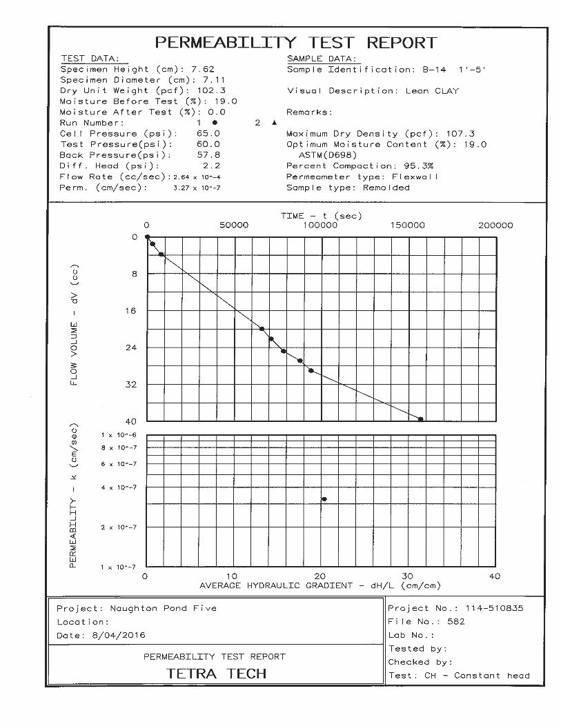
B-14 10.0
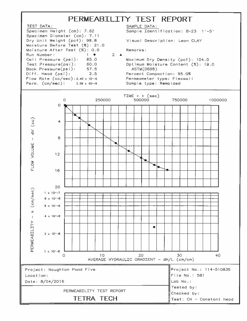
B-23 1-5
B-24 5-10