penticton heritage registry - july 2009
TRANSCRIPT

0
Penticton Heritage Registry
Phases 1 to 4 July 2009
PPeennttiiccttoonn
1
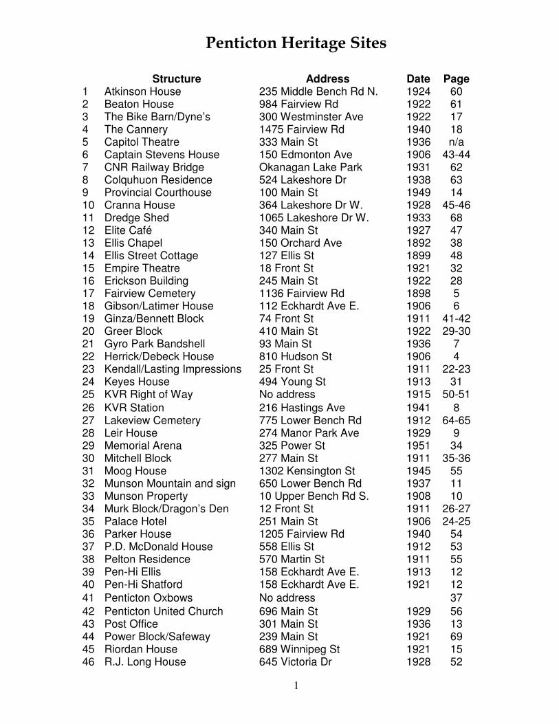
Penticton Heritage Sites
Structure Address Date Page 1 Atkinson House 235 Middle Bench Rd N. 1924 60 2 Beaton House 984 Fairview Rd 1922 61 3 The Bike Barn/Dyne’s 300 Westminster Ave 1922 17 4 The Cannery 1475 Fairview Rd 1940 18 5 Capitol Theatre 333 Main St 1936 n/a 6 Captain Stevens House 150 Edmonton Ave 1906 43-44 7 CNR Railway Bridge Okanagan Lake Park 1931 62 8 Colquhuon Residence 524 Lakeshore Dr 1938 63 9 Provincial Courthouse 100 Main St 1949 14 10 Cranna House 364 Lakeshore Dr W. 1928 45-46 11 Dredge Shed 1065 Lakeshore Dr W. 1933 68 12 Elite Café 340 Main St 1927 47 13 Ellis Chapel 150 Orchard Ave 1892 38 14 Ellis Street Cottage 127 Ellis St 1899 48 15 Empire Theatre 18 Front St 1921 32 16 Erickson Building 245 Main St 1922 28 17 Fairview Cemetery 1136 Fairview Rd 1898 5 18 Gibson/Latimer House 112 Eckhardt Ave E. 1906 6 19 Ginza/Bennett Block 74 Front St 1911 41-42 20 Greer Block 410 Main St 1922 29-30 21 Gyro Park Bandshell 93 Main St 1936 7 22 Herrick/Debeck House 810 Hudson St 1906 4 23 Kendall/Lasting Impressions 25 Front St 1911 22-23 24 Keyes House 494 Young St 1913 31 25 KVR Right of Way No address 1915 50-51 26 KVR Station 216 Hastings Ave 1941 8 27 Lakeview Cemetery 775 Lower Bench Rd 1912 64-65 28 Leir House 274 Manor Park Ave 1929 9 29 Memorial Arena 325 Power St 1951 34 30 Mitchell Block 277 Main St 1911 35-36 31 Moog House 1302 Kensington St 1945 55 32 Munson Mountain and sign 650 Lower Bench Rd 1937 11 33 Munson Property 10 Upper Bench Rd S. 1908 10 34 Murk Block/Dragon’s Den 12 Front St 1911 26-27 35 Palace Hotel 251 Main St 1906 24-25 36 Parker House 1205 Fairview Rd 1940 54 37 P.D. McDonald House 558 Ellis St 1912 53 38 Pelton Residence 570 Martin St 1911 55 39 Pen-Hi Ellis 158 Eckhardt Ave E. 1913 12 40 Pen-Hi Shatford 158 Eckhardt Ave E. 1921 12 41 Penticton Oxbows No address 37 42 Penticton United Church 696 Main St 1929 56 43 Post Office 301 Main St 1936 13 44 Power Block/Safeway 239 Main St 1921 69 45 Riordan House 689 Winnipeg St 1921 15 46 R.J. Long House 645 Victoria Dr 1928 52

2
47 Robb House 267 Hastings Ave 1916 57 48 S.S. Sicamous 1065 Lakeshore Dr W. 1914 16 49 St. Andrew’s Presbyterian 391 Martin St 1929 58 50 St. Savior’s Anglican 150 Orchard Ave 1929 38-39 51 Sutcliffe Residence 196 Penticton Ave 1912 70 52 Tupper House 230 Orchard Ave 1938 71 53 Walker Home 452 Lakeshore Dr W. 1936 72 54 Warren House 434 Lakeshore Dr W. 1912 19 55 White Lodge 1425 McMillan Ave 1927 20

3
Penticton Register of Historic Places 2006 – Phase 1

4
Herrick/Debeck House - 1906 810 Hudson Street
The Herrick/Debeck House consists of a two-storey side-gabled house, which is elevated above the surrounding country and beautified with formal gardens and hardwood trees.
Constructed by Howard L. Debeck in 1908, 810 Hudson Street is valued for its historic associations with early local land development and orcharding. Debeck was a New Westminster businessman and lumber merchant who invested in the Okanagan. As the first house built on the bench after the irrigation system was completed, it is indicative of early domestic settlement intended to support agricultural endeavors. Originally a one-storey home, its composite design provides a good example of a substantial colonial revival house and the evolution of a farm house over nearly a century. The house is also notable as an example of the type of dwelling and picturesque location associated with the wealthy merchant class of the era.
Key elements that define the heritage character of 810 Hudson Street include:
- Mature trees and lawns provide a picturesque landscape - Original porch rails and gable decoration

5
Fairview Cemetery - 1898 1136 Fairview Road
Fairview Cemetery, originally called St. Saviour's Anglican Cemetery, is a two-acre churchyard located to the east of the former Ellis homestead, on the southeast corner of Fairview Road and Regina Avenue.
First used as early as 1892, this historic site is valued as the oldest Christian burial ground in the City, and contains the graves of many of the earliest pioneers. The site is also notable for its location on the old wagon road to Fairview as well as for the opportunity for multi-denominational worship for travellers. Fairview Cemetery is valued for its association with the historic Ellis family, who first owned the land and developed the family-built Ellis chapel, originally located to the east of the cemetery, as a way to give thanks for surviving a family wagon accident. The chapel was sold to the Anglican Church in 1905 by the Ellis family for the consideration of $1. Fairview Cemetery is also valued for its connection to the early practice of the Anglican Church in the south Okanagan, which eventually took over ownership of the site and operated it as the location of the first Anglican Church from 1883 to 1965.
Key elements that define the heritage character of the Fairview Cemetery include:
- Grave sites and headstones from the early years of European settlement - Fence defining the cemetery bounds - Mature trees - Association with notable citizens and tragic events in the history of the City including graves of the first constable murdered in the City, the City's first Reeve, and the first burial from settlers' families (a child who drowned in 1898) - Marble and granite monuments from the Granite Island quarry in the Gulf Islands - Red granite headstones from Nova Scotia - Granite outline of expanded 1906 church

6
Gibson House - 1906 112 Eckhardt Avenue West
Gibson House is a colonial revival house, built in 1906 on a prominent corner lot. The house can be identified by its one and one half story colonial gambrel form, Etruscan porch posts, leaded windows, decorative bargeboards, and oriel window. The site includes a stone wall and mature ornamental trees.
Gibson House, one of the oldest surviving houses built in the Penticton townsite, is important as a reflection of early civic development and the evolution of the City to meet the needs of its professional elite. Built in 1906, this historic house is valued as an example of the type of high- quality residence which suited its original owner, F.H. Latimer for 40 years, and civic leaders such as Dr. Gibson, a prominent physician who lived there for over 50 years, from 1946 to 2000. The architecture of Gibson House is significant to Penticton's heritage because it speaks to social values and wealth that are symbols of prestige in a bygone era. This is evident in the bold colonial gambrel style and architectural detailing which were an expression of the social values and wealth of early civic leaders in Penticton and elsewhere in the Okanagan. Furthermore, the original townsite lot on which Gibson House sits provides insight into the early pattern of civic development at the southern edge of the townsite. The intact historical landscape, which contains visible evidence of the original 1906 landscape plan, is important because it contributes to the continuity of the streetscape and, as a documented landscape plan, is rare for its period in Penticton.
Key elements that define the heritage character of Gibson House include:
- The prominent corner location and large landscaped lot - The colonial gambrel form of the house - External design features, including Etruscan columns, decorative friezes, leaded windows, and parapet decorations - The original fieldstone wall framing two sides of the property - Original garden layout with original walkways and original sugar maples (Acer saccharum) - Intact internal features in the living and dining rooms and second floor bedrooms, including fir woodwork, iron fireplace with classical motifs, and original doors, windows, and frames - The sympathetic modern addition at the rear of the house - Surviving features of the 1906 landscape plan - Association with Latimer seen in the architectural style chosen by the owner - Association with Dr. Gibson seen in his desire to retain the original architectural and landscape features - Association with City of Penticton conservation initiative through conservation covenant

7
Gyro Bandshell - 1936 24 Lakeshore Drive West / 93 Main Street
The Gyro Bandshell is a steel truss and concrete structure, comprising a stage with a concave, hemispheric shell at rear which serves as a sounding board. Located in Gyro Park at the north end of Main Street, it is surrounded by a large expanse of lawn and trees.
The Gyro Bandshell is valued because it is a familiar landmark at the north entrance to downtown on the original route of Highway 97 through the City. Constructed in 1951 to replace an earlier bandshell, this historic site is also notable for its continuous use as place of public assembly for entertainment and civic functions since 1936. The location of the bandshell is important because it reflects the community planning that made ideal use of this high traffic area when the main highway entered town at this location. The work of the Gyro Club and the City of Penticton in developing the park and maintaining the Bandshell (through refurbishments in 1992 and 2000) reflects the social value of this historic place.
Key elements that define the heritage character of the Gyro Bandshell include:
- The bandshell form with its distinctive circular roof - Association with earlier 1912 and 1936 bandshells which were on this site - The intact Gyro Park setting, allowing views of the bandshell from Main Street - Relationship to other elements of the civic precinct at the north entrance to downtown, such as the Courthouse and City Hall

8
Kettle Valley Railway Station - 1941 216 Hastings Avenue
The Kettle Valley Railway Station is a two-storey 1941 structure with a steeply pitched chalet style roofs and two gabled bays at each end, the easterly one having been added in 1945. It includes a single story warehouse added in 1965.
The Kettle Valley Railway Station is valued for its association with the transition of railway passenger business from the Penticton waterfront to the south Penticton industrial area in the 1930s and 1940s. It is further valued as a symbol of the role of Penticton as an important division point on the Kettle Valley Division of the Canadian Pacific Railway which linked the mines and smelters of the Kootenays to the coast and provided an alternative passenger service to the CPR main line. The building is also symbolic of the evolution of this area as the industrial centre of the south Okanagan, having been significantly expanded to meet demands of growth in railway traffic. The building is also valued for its Tudor style architecture, known as "Hunt Club", which is unique in western CPR stations. The station's survival as a public building is a reflection of its ongoing social significance as a gathering place. The building is also valued as a symbol of Penticton's interest in preserving heritage character. The neighborhood is the only one in the City to have architectural guidelines requiring multi-family buildings to reflect the form and character of the railway heritage.
Key elements that define the heritage character of this site include:
- The massing of the building, reflective of Elizabethan revival architecture used by railway companies - The physical layout of the building, including its large freight doors, which reflects its multiple roles in loading and unloading freight, and its division offices on the second floor - Remnants of the original chalet style design in the centre section, including the steep pitched roof with curved overhang and prominent brackets - Half-timbering in the gable ends - Multi-light windows in the upper storey - Location adjacent to the main KVR rail line - Proximity to historic KVR roundhouse, stores buildings, yard and workshops - 1945 additions in a style compatible with the original.

9
Leir House - 1929 220 Manor Park Avenue
Leir House is a large, eclectic 1920s stone-clad mansion situated in spacious grounds in a residential neighbourhood of Penticton. The site includes numerous rock-faced walkways, ponds and garden structures in the expansive grounds
Leir House and grounds are valued as a rare example of a 1920s estate which has survived in virtually intact condition. Its excellent craftsmanship as well as unique construction methods and materials make it a significant historic and social landmark in Penticton. It was constructed over a period of three years starting in 1927. Architecturally, Leir House is one of the most interesting and important examples of grand domestic architecture in the city. The key physical elements of the place are those associated with its first owner, Hugh Leir, an important lumberman in the early years of Penticton. The cross-gabled design, which encompasses important interior features such as high ceilings and thirteen bedrooms to accommodate each of the eleven Leir children, is a valued example of eclectic vernacular architecture influenced heavily by the needs and desires of its owner-builder. The monolithic massing and scale, the extensive gardens and rockeries, and the prominent location speak to the social status of the Leir family. The use of local materials, such as edge-grain fir milled at Leir's own sawmill, and unique exterior cladding made up of stones collected on site, reflect the tenacity and prowess behind Leir's success as a businessman. It is significant that the original architectural features and design of Leir House have survived virtually intact throughout a series of different uses. After being used as the Leir family residence until 1951, it functioned as a nurses' residence for 26 years until 1979, and as a community arts centre for the last 30 years. The various uses have elevated its social status and value in the community. It is a testament to its excellent craftsmanship executed in a variety of local materials, and to its relevant and purposeful composition, both inside and out, that Leir House has retained its original context as a majestic landmark home since 1929.
Key elements that define the heritage character of Leir House include:
- The extensive grounds containing mature trees - Stone landscape features including summer house, small storage building, stone stairs to garden, stone edges to sunken garden and flower beds, original stamped concrete pathways - The eclectic design of the house exterior with original and local stone cladding, chimneys, window frames and stone/concrete sills, and dormers - The dominant entrance porch and stairs - The stone carriage house and stone arch connecting to the house - The original layout of main floor rooms leading from a central entrance hall - The plain original interior decoration including: - Original decorative glass in the entry way - Original fireplaces and hearths in the hall and living room - Original woodwork and built-ins in the principle rooms - Original high ceilings, stairway railings and posts

10
Munson / Cleland Property - 1908 10 Upper Bench Road South
The Munson / Cleland property comprises three buildings: the main house, which is a one-and-one-half side-gabled colonial bungalow with a broad verandah and three shed dormers; a smaller residence or cottage; and a barn. This historic place is located on a fruit lot on the east bench of Penticton.
The house, the cottage and barn which comprise the Munson/Cleland Property were built in 1907-1908. This property is significant to the heritage of Penticton because it represents the early twentieth century investment in Okanagan fruit lots by British and Canadian investors, particularly those associated with the Canadian Pacific Railway. Built as a summer house by J. H. Munson KC, a prominent Winnipeg businessman and a lawyer for the Railway, this historic place is reflective of the CPR's policy to encourage its senior staff to purchase land in the Okanagan as a way of encouraging local investment in agriculture and economic development. Its value lies in its association with early fruit ranching and the European settlement of the benches. The property is also value for its association with the Cleland family, who have been resident on the property since 1919, have owned it for over 70 years, and who were leaders in the Penticton arts community. The Edwardian Classical Revival elements on the house, including the gently curving arches and classical porch rails, and the landscaped grounds with terraced gardens, cottage, and barn, evoke the genteel life of wealthy local land owners in the early years of the twentieth century.
Key elements that define the heritage character of the Munson/Cleland property include:
- The prominent location on a hill on the east bench of Penticton - The surviving terraces and rock walls from the original picturesque terraced gardens - The massing of the house with a symmetrical design - Architectural details that emphasize the Edwardian Revival design, including the three shed dormers, curved arches, and classical porch rails - The deep verandah which emphasizes the bungalow style - The sympathetically designed cottage - The barn - Historical association with investment in Okanagan fruit ranching by businessmen associated with the Canadian Pacific Railway - Association with the Cleland family, leaders in the Penticton arts community

11
Munson Mountain Sign - 1937 650 Lower Bench Road
Munson Mountain is a prominent hill located on the North Bench which overlooks the city. It bears large silica and concrete letters spelling out the word "PENTICTON." It is highly visible from Highway 97 and from the Kettle Valley Railway right-of-way on the West Bench where visitors have historically and currently approached the city from the north.
Munson Mountain is valued because its pebble constructed sign is a symbol of civic pride which has been maintained by volunteer groups since its construction in 1937. Literally built by civic boosters to "put Penticton on the map", it was compared to the Hollywood sign. First constructed by members of the Board of Trade, it was improved in 1941 by Jaycees, Board of Trade members, and boy scouts. Between 1972 and 1983 volunteers hauled 44,000 pounds of silica rock to the site. In 1998 concrete was laid down and silica imbedded in it. The mountain is also valued as a prominent geographic feature which stands out from the surrounding benchland and provides a panoramic view of the City. It has long had social significance as a site for local celebrations. The first recorded evidence of this use was on July 1, 1927 when a day of civic activities was capped off with a beacon fire on Munson Mountain.
Key elements that define the heritage character of Munson Mountain include:
- The silica from a south Okanagan quarry, embedded in concrete, creating a sign measuring 54.33 feet (16.5m) high and 308.39 feet (93.99m) wide - The mountain setting including the undisturbed hill above the sign and natural vegetation around it - The continuity of association with volunteer groups who have maintained the sign - Association with community celebrations
12
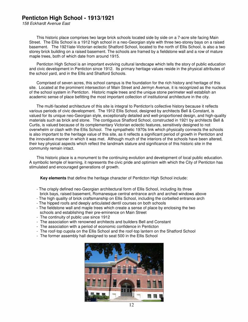
Penticton High School - 1913/1921 158 Eckhardt Avenue East
This historic place comprises two large brick schools located side by side on a 7-acre site facing Main Street. The Ellis School is a 1912 high school in a neo-Georgian style with three two-storey bays on a raised basement. The 1921late-Victorian eclectic Shatford School, located to the north of Ellis School, is also a two storey brick building on a raised basement. The schools are framed by a fieldstone wall and a row of mature maple trees, both of which date from around 1915.
Penticton High School is an important evolving cultural landscape which tells the story of public education and civic development in Penticton since 1912. Its primary heritage values reside in the physical attributes of the school yard, and in the Ellis and Shatford Schools. Comprised of seven acres, this school campus is the foundation for the rich history and heritage of this site. Located at the prominent intersection of Main Street and Jermyn Avenue, it is recognized as the nucleus of the school system in Penticton. Historic maple trees and the unique stone perimeter wall establish an academic sense of place befitting the most important collection of institutional architecture in the city. The multi-faceted architecture of this site is integral to Penticton's collective history because it reflects various periods of civic development. The 1912 Ellis School, designed by architects Bell & Constant, is valued for its unique neo-Georgian style, exceptionally detailed and well-proportioned design, and high-quality materials such as brick and stone. The contiguous Shatford School, constructed in 1921 by architects Bell & Curtis, is valued because of its complementary Victorian eclectic features, sensitively designed to not overwhelm or clash with the Ellis School. The sympathetic 1970s link which physically connects the schools is also important to the heritage value of this site, as it reflects a significant period of growth in Penticton and the innovative manner in which it was met. Although much of the interiors of the schools have been altered, their key physical aspects which reflect the landmark stature and significance of this historic site in the community remain intact. This historic place is a monument to the continuing evolution and development of local public education. A symbolic temple of learning, it represents the civic pride and optimism with which the City of Penticton has stimulated and encouraged generations of growth.
Key elements that define the heritage character of Penticton High School include:
- The crisply defined neo-Georgian architectural form of Ellis School, including its three brick bays, raised basement, Romanesque central entrance arch and arched windows above - The high quality of brick craftsmanship on Ellis School, including the corbelled entrance arch - The hipped roofs and deeply articulated dentil courses on both schools - The fieldstone wall and maple trees which create a sense of place by enclosing the two schools and establishing their pre-eminence on Main Street - The continuity of public use since 1912 - The association with renowned architects and builders Bell and Constant - The association with a period of economic confidence in Penticton - The roof-top cupola on the Ellis School and the roof-top lantern on the Shatford School - The former assembly hall designed to seat 500 in the Ellis School

13
Penticton Post Office - 1936 301 Main Street
The Penticton Post Office is a striking brick and stone building located on the east side of Main Street on a corner location. It comprises a two storey structure with a corner clock tower and four bays on the east and north facades, divided by brick pilasters. There is a concrete cornice with a dentil course. The arched windows in the clock tower are framed with cut stone while each of the bays contains six double-hung windows divided by strongly defined concrete partitions. The Penticton Post Office is valued as a landmark building in the centre of the Main Street commercial district. It is symbolic of the Federal presence in Penticton, originally housing not only the post office but customs offices and other Federal agencies from 1936 to 1979. It is sited to take advantage of the prominent corner lot on Main Street and complemented other brick buildings on Main Street, many of which have been lost. Designed by Penticton's most notable architect, Robert Lyon, the Penticton Post Office was a prototype for the Art Deco architectural movement in the Okanagan. It reflects a time of economic confidence and growth in Penticton, despite the impacts of the Great Depression on other parts of the country. Its refurbishment in 1989 as private offices reflects the rebirth of Main Street as a significant business district.
Key elements that define the heritage character of this site include:
- Clock tower with two clocks - The well-crafted red brick detailing - The use of cut stone on the tower - The use of concrete on the cornice and around the windows - The prominent corner location - The architecturally sympathetic additions in the 1940’s

14
Penticton Provincial Courthouse - 1949 100 Main Street
The Penticton Provincial Court house is a two storey Art Deco-Moderne office building The Penticton Provincial Courthouse is significant as a symbol of the Provincial Government presence in Penticton, both as a Courthouse and home of many Provincial departments and agencies. Its construction in 1948 reflects the growth of Penticton as a regional business and government centre after World War II. This building is important architecturally as an example of the transition between Art Deco design of the 1930s and 1940s and the Streamline Moderne motifs of the 1950s, especially evident in the northwest entrance and entrance hall. The park to the north of the building contributes to the continuity of the site and is integral to the government precinct and landscaped setting created at the north entrance to Penticton in the 1930s and 1940s.
Key elements that define the heritage character of the Penticton Provincial Courthouse include: - The location of the north-west corner entrance, emphasizing the building's relationship to the historic highway entrance to downtown - The historic association with justice and government administration - Association with citizenship ceremonies - The Streamlined Moderne elements in the round forms in the entrance hall and stairway - Architectural elements including the stone details on the entrance, double interior staircase with aluminum railings, cast iron pillars, terrazzo entrance floor, glass doors, and original metal sign - The adjacent park with mature trees and cenotaph, which was moved to the park in 1948

15
Riordan House - 1921 689 Winnipeg Street
The Riordan House is a two and one half storey Arts & Crafts home constructed in 1921. The side-gabled first storey is dominated by broad overhanging eaves with exposed rafters, a porte-cochere with battered Craftsman piers on the south side and a porch entry with decorative roof on the north side. The historic site is located on a prominent corner lot and includes the original garage and mature landscaping.
Riordan House is valued as an expression of the kind of architecturally designed homebuilt by prominent businessmen in the post World War I era. The home evokes a period of economic optimism, expressed in its rich architectural detailing, as built by its original owners, the Riordan family, who lived in it from 1921 to 1940. The house is also valued for its contribution to the continuity of an elite precinct in this area which housed doctors, lawyers, and merchants, many of whom built large homes; this is evidenced by its second owner, Dr. Wickett, who owned it until 1980. The house is also notable for its association with David Riordan, a prominent hotel owner and reputed bootlegger. It is rumoured that liquor was hidden in the basement of the Riordan house during Prohibition. The richly detailed interior, which is virtually in original condition, is a reflection of the social prominence and personality of its original owner. Its association with Penticton's hospitality industry continued with its use during the 1980s alternating between a teahouse and restaurant, and since 1991 as a Bed and Breakfast.
Key elements that define the heritage character of the Riordan House include:
- The prominent corner lot location - The bold architectural form which expresses Arts and Crafts and Craftsman principles - The porte-cochere - The decorative porch entrance - The deep overhanging eaves - Craftsman elements including the use of vertical elements which contrast with and break the horizontal planes (upper storey massing of gables, tall chimney, battered piers on the porte-cochere, and heavy porch supports reaching to the ground - Exposed rafter ends and decorative knee braces - Upper storey dormers - Rich interior woodwork of Nova Scotia fir and oak - Original built-in cupboards and window seats - Original windows, doors, frames, and mouldings - Association with a colourful local character, David Riordan - Original concrete wall around perimeter of the property - Original rear garage - Original landscaping and mature trees - Original boiler and hot water heating system
16
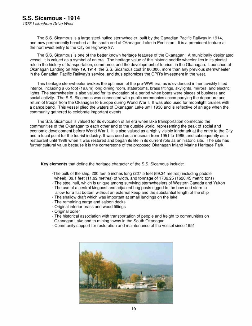
S.S. Sicamous - 1914 1075 Lakeshore Drive West
The S.S. Sicamous is a large steel-hulled sternwheeler, built by the Canadian Pacific Railway in 1914, and now permanently beached at the south end of Okanagan Lake in Penticton. It is a prominent feature at the northwest entry to the City on Highway 97.
The S.S. Sicamous is one of the better known heritage features of the Okanagan. A municipally designated vessel, it is valued as a symbol of an era. The heritage value of this historic paddle wheeler lies in its pivotal role in the history of transportation, commerce, and the development of tourism in the Okanagan. Launched at Okanagan Landing on May 19, 1914, the S.S. Sicamous cost $180,000, more than any previous sternwheeler in the Canadian Pacific Railway's service, and thus epitomizes the CPR's investment in the west. This heritage sternwheeler evokes the optimism of the pre-WWI era, as is evidenced in her lavishly fitted interior, including a 65 foot (19.8m) long dining room, staterooms, brass fittings, skylights, mirrors, and electric lights. The sternwheeler is also valued for its evocation of a period when boats were places of business and social activity. The S.S. Sicamous was connected with public ceremonies accompanying the departure and return of troops from the Okanagan to Europe during World War I. It was also used for moonlight cruises with a dance band. This vessel plied the waters of Okanagan Lake until 1936 and is reflective of an age when the community gathered to celebrate important events. The S.S. Sicamous is valued for its evocation of an era when lake transportation connected the communities of the Okanagan to each other and to the outside world, representing the peak of social and economic development before World War I. It is also valued as a highly visible landmark at the entry to the City and a focal point for the tourist industry. It was used as a museum from 1951 to 1965, and subsequently as a restaurant until 1988 when it was restored and began its life in its current role as an historic site. The site has further cultural value because it is the cornerstone of the proposed Okanagan Inland Marine Heritage Park.
Key elements that define the heritage character of the S.S. Sicamous include:
-The bulk of the ship, 200 feet 5 inches long (227.5 feet (69.34 metres) including paddle wheel), 39.1 feet (11.92 metres) of width, and tonnage of 1786.25 (1620.45 metric tons) - The steel hull, which is unique among surviving sternwheelers of Western Canada and Yukon - The use of a central kingpost and adjacent hog posts rigged to the bow and stern to allow for a flat bottom without an external keep and the substantial length of the ship - The shallow draft which was important at small landings on the lake - The remaining cargo and saloon decks - Original interior brass and wood fittings - Original boiler - The historical association with transportation of people and freight to communities on Okanagan Lake and to mining towns in the South Okanagan - Community support for restoration and maintenance of the vessel since 1951

17
The Bike Barn - 1922 300 Westminster Avenue West
The Bike Barn is a large wood-frame warehouse with a gabled roof. It includes two additions, one wood frame and one concrete block and brick.
This Bike Barn is important to Penticton's architectural and cultural history because it the only extant functioning commercial building retaining an angled front façade, which was so-designed to make maximum use of importing and exporting goods via the Canadian Pacific Railway Townline rail spur. Although typical of utilitarian buildings of similar vintage, it is a good example of an early vernacular warehouse within the city. Furthermore, its design is significant because it includes evidence of unique historic details, such as loading bays on its eastern façade facing Brunswick Street, which reflect the former importance of providing ease of trans-shipment of goods from rail to road to facilitate commercial success. As the location of Dynes Feed and Supply (1922 – 1982), which provided feed, seeds, and other agricultural supplies to farmers in Penticton and elsewhere along the Kettle Valley Railway, this historic place was one of the most successful and well-known businesses in the community, associated with the early local agriculture. Its rehabilitation as the Bike Barn in 1983 reflects the more recent trends of the local economy which has shifted to focus on outdoor recreation and sports tourism.
Key elements that define the heritage character of the Bike Barn include:
- Location adjacent to former railway line - High gable roof - Exposed attic in the interior - Rail and car / truck loading ramps - Rocks used as footings for foundation of second addition - Historic use of the mezzanine in the first phase of the building - Elements of its design which identify it as an early twentieth century warehouse, such as rough-cut uprights, wide-plank wooden floors, clerestory windows - Elements of its design which relate to its historic relationship with the former railway, such as its angled back façade - Surviving elements of its design which relate to its evolution as a commercial building, including loading bay doors on Brunswick Street. - The patina of its years of use as and industrial and commercial building, seen in wear patterns on floors and walls.

18
The Cannery Trade Centre - 1940 1475 Fairview Road
The Cannery is a large industrial complex located on Fairview Road. Now converted to commercial uses, it comprises four conjoined buildings: a wood-frame former warehouse at the westerly end built in either 1936 or 1942, a large concrete former processing plant at the easterly end built in 1948, a connecting concrete-block former storage building built later in 1948, and a rear concrete block warehouse built in 1968.
The value of the Cannery Trade Centre (formerly Aylmer Cannery) lies in the primary role it played in the economic life of Penticton from 1948 to 1982. It was an important seasonal employer and a vital source of income for local vegetable and fruit growers. It is particularly significant because, as an employer of a large number of men and women, it reflects labour practices and social conditions over several decades. The tall chimney, now lost, identified the Aylmer brand the plant was known for, and provided the power for the daily whistle, which defined the beginning and end of the work day, heard throughout Penticton. The complex is also important because it expresses the evolution of industrial design through its physical development and construction materials. It also reflects the evolution of the canning industry in Canada, and in particular the evolution of industrial buildings to reflect economic changes, the growth and decline of local agriculture, and the history of employment of women in industry.
Key elements that define the heritage character of the Cannery Trade Centre include:
- The four construction phases reflecting the evolution of the complex - The location adjacent to and serviced by the railway - The loading bays designed to accommodate boxcar shipments - The truck loading docks to the northeast - The high windows to admit natural light to the production plant - The association with women's labour - The central gutter in the production building - Stamped metal sheets on the floors - Original canning equipment - Proximity to KVR/CPR rail facilities, including the roundhouse - Association with development of the canning industry, including the consolidation and decline of the industry - Association with Aylmer, Delmonte and Royal City labels reflecting those brand names

19
Warren House - 1912 434 Lakeshore Drive West
The Warren House is a large two-storey Georgian Revival structure located on the south side of Lakeshore Drive. The wood frame house features a central entrance with sidelights and symmetrical multi-light windows. The original cedar siding has been clad with stucco.
The Warren House is an important part of Penticton's heritage because it retains the historic character of Lakeshore Drive as the prime location of genteel residences built for the moneyed class in the era of economic growth and maturity of the city during the early twentieth century. Constructed for J. J. Warren, President of the Kettle Valley Railway, it is symbolic of the wealth and prestige associated with the construction of the railway, which provided an important transportation link between the Southern Okanagan and the world in 1912. Furthermore, it is valued as a reflection of the former grandeur of this area, which included a group of significant structures such as the Incola Hotel, and the CPR Station and dock. Architecturally, Warren House epitomizes the Georgian Revival style which began to replace earlier Late Victorian and Edwardian styles in the Okanagan at this time. The house is also valued for its association with J. J. Warren, President of the Kettle Valley Railway, and its proximity to the CPR's Incola Hotel, CPR Station, and dock, all built within an 18 month period. The Kettle Valley Railway, which provided an important transportation link between the Southern Okanagan and the outside world, was under construction in 1912 when this house was built. The terminus of the railway was on the lakeshore to the east of the Warren House.
Key elements that define the heritage character of Warren House include:
- The two-storey symmetrical form of the house - The hipped roof and shed dormers - The central entrance and sidelights - Multi-paned windows - The prominent location on Lakeshore Drive, well set back and centered on its lot - Association with CPR history, including other historic buildings on the Penticton Lakeshore - Physical relationship of the house to Lakeshore Drive - The contribution of the house to the continuity of the historic streetscape

20
White Lodge - 1927 1425 McMillan Ave
White Lodge is a two storey Moderne house with smooth stucco finish and a flat roof. The house comprises a series of asymmetrically arranged geometric blocks with an absence of exterior decoration. A porte-cochere is located on the entrance front. This historic place is located on Macmillan Road to the east of downtown Penticton.
White Lodge, built in 1927, has heritage value to British Columbia because it is a rare example of a Moderne building in a rural setting and further because it is a very early example of the style in the Province. The house is virtually unaltered, both externally and internally. This historic place possesses heritage value because of its association with Major E. C. Holden, an innovative consulting engineer who emigrated from England in 1911. He served on Penticton Council and was secretary of the Penticton Cooperative. He also designed and built the first cold storage facility in Penticton. The house is a monument to this man who designed and built it in a style unique to the Okanagan.
Key elements that define the heritage character of White Lodge include:
- The prominent location at a bend in the Naramata Road - The exterior of the house with geometric Moderne styling and an absence of architectural detail - The prominent porte-cochere - The horizontal emphasis of design which is reinforced with wooden lines above the first and second stories - The International Style windows - The interior elevator shaft which dates from construction - The intact original interior - Association of the house with E. C. Holden - Association of the house with Joe Harris, Penticton Museum manager who maintained the fabric of the house for many years - Mature historic landscaping, including a large copper beech tree in front of the house

21
Penticton Register of Historic Places 2007 – Phase 2

22
Kendall / Lasting Impressions – 1911 LOCATION
Address # Street Community Postal Cadastral 25 Front Street Penticton V2A 1H2 P.I.D. 004-140-681
DESCRIPTION
25 Front Street is a two story brick-faced flat-iron commercial building, whose angles fit the diagonal intersection of Front Street and a laneway. It has a cutaway corner
Boundaries
Located on the west side of Front Street very close to Main Street
Heritage Value
25 Front Street symbolizes the optimism of the 1911 building boom and provides an important visual anchor to Front Street. It is valued for its flat-iron shape, warmly coloured brick façade, and prominent location near the westerly end of Front Street as it approaches Main Street. Its unusual shape and modest scale invites attention from pedestrians entering Front Street. The corner block form with cutaway corner entrance is important because it is a physical reminder of the original town plan and of the influence of the railway line planned where Front Street now lies at an angle to other streets and reflected in the sharp angle of the building. As one of five masonry “fire-proof” buildings erected on Front and Main Streets in Penticton in 1911, a pivotal year in Penticton during the Canada-wide pre-WWI building boom, it is an example of the first non-wooden buildings, indicative of the confidence shown by the developers in the town’s economy and future in the pre-WWI era leading up to the opening of the KVR and Penticton’s developing identity as a transportation hub for the south Okanagan. Aesthetically, the building was well suited to its role as the office of Kendall and Mason, early Penticton realtors. It was built by E. Ritchie of Kelowna for W.H.T. Gahan, a lawyer, who occupied the upper floor. Restored around 1980, the building retains its original brick veneer and concrete cornice line. The concrete walls and galvanized iron ceilings were intended to prevent fire, indicative of the capital investment reflecting the longevity that the building was intended to have. The historical value of 25 Front Street derives from its association with W.H.T. Gahan, one of Penticton’s early solicitors and notaries, and M. C. Kendall, one of Penticton’s earliest realtors, respectively, both of whom were involved in the early development of Penticton town-site and with the establishment of commercial orchards in the area.
Character-Defining Elements
Key elements that define the heritage character of the Kendall / Gahan Block include: - Late Victorian commercial design - Original brick exterior with corbelled string courses and a concrete cornice line - Unusual corner block form with cutaway corner entrance - Good quality brickwork - Original double hung windows - Awnings
COMMENTS and INFORMATION (not used by registrar)
Built in 1911 as one of the first 5 masonry buildings in Penticton, this building had concrete walls with brick entrance, surfacing, galvanized metal ceilings, and was steam-heated. It was built and owned by Mr. Gahan who first set up business as a solicitor in Penticton in 1908, and was

23
appointed solicitor for the municipality in 1909. His first offices were down by the bridge on Front Street, then the (first, wooden) Murk block on Front Street. In 1911 he completed 25 Front Street and had his offices upstairs, while leasing to Kendall & Mason realty on the main floor. He and his wife moved to Victoria in 1913. The downstairs was rented to a real estate firm, in 1911 known as Kendall and Mason, but eventually Kendall practiced on his own. Mr. Kendall was one of the earliest realtors in Penticton to operate independently of the South Okanagan Land Company, setting up business here in 1906. Later while operating as Kendal & Co., he handled realty, insurance, rents, loans and estates. After living here for 35 years, he retired to Victoria.

24
Palace Hotel - 1906
LOCATION
Address # Street Community Postal Cadastral 251 Main Street Penticton V2A 5B1 P.I.D. 012-452-998
DESCRIPTION
251 Main Street is a two storey wood frame structure with a steeply pitched front gabled roof. It is fronted by a wooden false front on the upper level and a single storey brick storefront on the lower level.
Boundaries
Located centrally on the west side of the 200 Block of Main Street.
Heritage Value
251 Main Street is valued for its unique identity as the only remaining wood framed commercial building on Main Street. Constructed in 1902 as the Palace Hotel, it is an important reminder of the era of false-fronted wooden buildings that pre-dated fireproof brick and concrete construction. At the end of World War I it was converted to a hardware store; later the single storey brick front was added. Because of its original role as the Palace Hotel, 251 Main Street is a landmark structure that reflects the importance of Penticton as a staging area for the trade between the South Okanagan and Similkameen mining towns and the Okanagan Lake transportation system. The hotel was an important meeting place for commercial visitors and for local boarders, as it was considered a clean, well run establishment without a saloon, and also hosted a veranda where local news could be heard. In later years it served as a retail outlet for the Reid-Coates Hardware and more recently as a stereo outlet. The brick addition (c. 1919) has served as an office for the City Deputy of Public Works and as a doctor’s office. These uses reflect the changing landscape of one of the core blocks of downtown Penticton. The hotel is also important because it is a reminder of the original broad dimensions of Main before 1911.
Character-Defining Elements
Key elements that define the heritage character of the Palace Hotel include: - Large two storey wood frame structure - Original board cladding - Original false front - Original double hung windows - Original flagpole
COMMENTS and INFORMATION (not used by registrar)
The Palace Hotel was built in 1902 by Tom Hudon and family, who also owned a blacksmith shop. It was built during the time when Penticton was a small boardwalk town - the building were all one or two storey wooden buildings, and the sidewalks were wooden boardwalks. When first built, it was set back from the street. Later (after 1907, in 1908 or1909), a verandah was built on the bottom with a balcony that ran the full width of the second floor. In 1911, the Hudon's sold their Penticton interests and moved away, and the boarding facility was taken over by Mr. and Mrs. Quincy Fulkerson until 1917. Although named as a hotel, it operated more as a boarding house, with regular long-term boarders. The absence of a bar also contributed to it being perceived as "nice" place to stay. At one time, it may have had as many as 10 rooms upstairs, and very narrow hallways. After its use as a hotel, it became a hardware. First for a short period of time as Ross Hardware, then known for a long period as Reid-Coates Hardware, and for a brief period as Murrays. For over 20 years now, it has been a stereo store, in 2007 bearing the name Audio Visions. The front has been modified. When the

25
brick was added on, the front may have been used by offices. It may be the oldest wooden commercial building in the City.

26
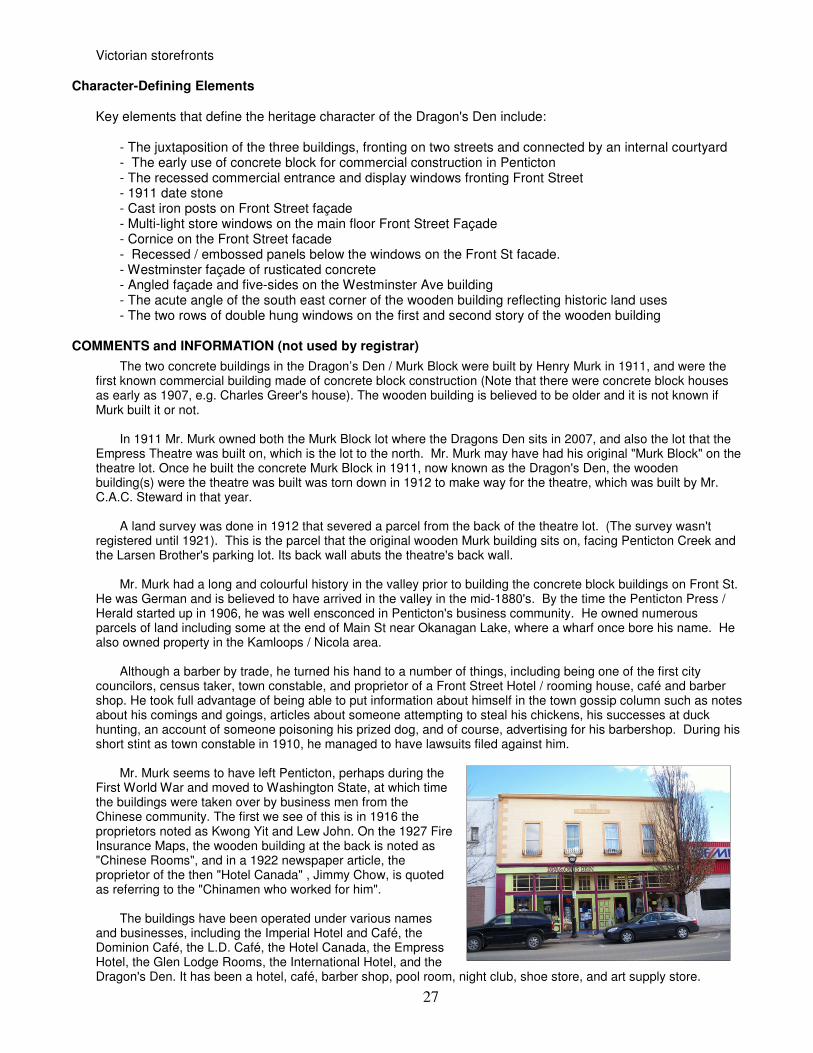
Murk Block/Dragon's Den - 1911
LOCATION
Address # Street Community Postal Cadastral 12 Front Street Penticton V2A 1H1 P.I.D. 011-852-186, 011- 852-216, 012-445-177, 012-445-215 DESCRIPTION
The Dragon’s Den comprises three buildings of mixed commercial and residential use located between Front Street, Westminster Avenue and Penticton Creek. The two concrete buildings are two stories in height and constructed of concrete blocks; one faces Front Street and the other faces Westminster Avenue and Penticton Creek. The wooden building is two stories in height and faces Penticton Creek. All three buildings are connected by an internal courtyard.
Boundaries
Located on the east side of Front Street between Main Street and Forbes Street
Heritage Value
The Dragon’s Den buildings are valued because they are representative of the multi-purpose commercial buildings that were built in Penticton’s early civic phase of development. The wooden building predates the concrete ones, and is a rare example of a wooden commercial building from Penticton’s early commercial activities. The two concrete buildings in this complex were the first cement block commercial buildings erected in Penticton, and one of five masonry “fire-proof” buildings erected in Penticton in 1911, a pivotal year in Penticton during the Canada-wide pre-WWI building boom. These first non-wooden buildings were indicative of the confidence shown by the developers in the town’s emerging economy leading up to the opening of the Kettle Valley Railroad and Penticton’s developing role as a key transportation hub for the southern interior. The concrete building facing Front Street was designed for two street level stores with offices or boarding rooms above while the concrete building at the rear was built as rental rooms for single men. The buildings have been used for a multitude of commercial and residential uses over the years, including a hotel, barbershop, pool rooms, restaurants, rooming house, and various retail shops. These uses are representative of the stages of economic and cultural development in Penticton, and a reflection of the enduring commercial role of Front Street. The third, wooden building facing Penticton Creek pre-dates the two concrete buildings, and was severed off the Larsen’s Tire Warehouse lot by legal survey in 1912 when the owner of the complex, Henry Murk, sold the remainder of the lot to Mr. C.A.C. Steward for a theatre. Its wooden vernacular architecture with its double hung windows reminiscent of the original structures built to support the emerging Front Street commercial activity. The buildings are also notable for their association with Henry Murk, a pioneer of the Okanagan valley since the mid-1880s. Mr. Murk was a barber by trade, but also an entrepreneur who was involved in a number of commercial ventures, typical of the individualistic, resourceful and opportunistic men that typified the civic leadership and developers of this key period in Penticton’s development. He was a member of Penticton’s first City Council, a police constable, builder, land speculator and investor in commercial enterprises. The Dragon’s Den is also noted for its proximity to and association with Penticton’s historic and vanished Chinese community during the period covering World War I and the twenties, when it was operated by a string of Chinese businessmen. Being in the vicinity of Penticton’s Chinatown, its Chinese proprietors employed Chinese workers and housed them in the wooden building at the rear. Aesthetically, the buildings are good examples of the early Edwardian commercial buildings being built in Penticton at this time. They are characterized by their simple forms and symmetrical features. The building facing Front Street has a recessed entrance with display windows, and is symbolic of the transition from Late
27
Victorian storefronts Character-Defining Elements
Key elements that define the heritage character of the Dragon's Den include: - The juxtaposition of the three buildings, fronting on two streets and connected by an internal courtyard - The early use of concrete block for commercial construction in Penticton - The recessed commercial entrance and display windows fronting Front Street - 1911 date stone - Cast iron posts on Front Street façade - Multi-light store windows on the main floor Front Street Façade - Cornice on the Front Street facade - Recessed / embossed panels below the windows on the Front St facade. - Westminster façade of rusticated concrete - Angled façade and five-sides on the Westminster Ave building - The acute angle of the south east corner of the wooden building reflecting historic land uses - The two rows of double hung windows on the first and second story of the wooden building
COMMENTS and INFORMATION (not used by registrar)
The two concrete buildings in the Dragon’s Den / Murk Block were built by Henry Murk in 1911, and were the first known commercial building made of concrete block construction (Note that there were concrete block houses as early as 1907, e.g. Charles Greer's house). The wooden building is believed to be older and it is not known if Murk built it or not. In 1911 Mr. Murk owned both the Murk Block lot where the Dragons Den sits in 2007, and also the lot that the Empress Theatre was built on, which is the lot to the north. Mr. Murk may have had his original "Murk Block" on the theatre lot. Once he built the concrete Murk Block in 1911, now known as the Dragon's Den, the wooden building(s) were the theatre was built was torn down in 1912 to make way for the theatre, which was built by Mr. C.A.C. Steward in that year. A land survey was done in 1912 that severed a parcel from the back of the theatre lot. (The survey wasn't registered until 1921). This is the parcel that the original wooden Murk building sits on, facing Penticton Creek and the Larsen Brother's parking lot. Its back wall abuts the theatre's back wall. Mr. Murk had a long and colourful history in the valley prior to building the concrete block buildings on Front St. He was German and is believed to have arrived in the valley in the mid-1880's. By the time the Penticton Press / Herald started up in 1906, he was well ensconced in Penticton's business community. He owned numerous parcels of land including some at the end of Main St near Okanagan Lake, where a wharf once bore his name. He also owned property in the Kamloops / Nicola area. Although a barber by trade, he turned his hand to a number of things, including being one of the first city councilors, census taker, town constable, and proprietor of a Front Street Hotel / rooming house, café and barber shop. He took full advantage of being able to put information about himself in the town gossip column such as notes about his comings and goings, articles about someone attempting to steal his chickens, his successes at duck hunting, an account of someone poisoning his prized dog, and of course, advertising for his barbershop. During his short stint as town constable in 1910, he managed to have lawsuits filed against him. Mr. Murk seems to have left Penticton, perhaps during the First World War and moved to Washington State, at which time the buildings were taken over by business men from the Chinese community. The first we see of this is in 1916 the proprietors noted as Kwong Yit and Lew John. On the 1927 Fire Insurance Maps, the wooden building at the back is noted as "Chinese Rooms", and in a 1922 newspaper article, the proprietor of the then "Hotel Canada" , Jimmy Chow, is quoted as referring to the "Chinamen who worked for him". The buildings have been operated under various names and businesses, including the Imperial Hotel and Café, the Dominion Café, the L.D. Café, the Hotel Canada, the Empress Hotel, the Glen Lodge Rooms, the International Hotel, and the Dragon's Den. It has been a hotel, café, barber shop, pool room, night club, shoe store, and art supply store.

28
Erickson Block - 1922
LOCATION
Address # Street Community Postal Cadastral 243 - 249 Main Street Penticton V2A 5B1 P.I.D. 012-453-013
DESCRIPTION
The Erickson Block is a two story concrete and brick commercial building designed in the Edwardian classical revival style.
Boundaries
The Erickson Block is centrally located on the west side of the 200 block of Main
Heritage Value
The Erickson Block is of historic value because it is one of a group of commercial blocks built on Main Street in the early 1920s, a reflection the postwar economic prosperity of the time, and the expansion of the social development of the City. These buildings reflect growing demand for consumer staples and luxury goods, and are associated with the growing trend in entertainment being sought by the middle class and its increase in disposable income. The Erickson Block was typical of this trend of consumer wealth through its use for the sale of men’s and ladies wear goods, as the home of Penticton’s first stand-alone tobacco store, and for many years as the home of the Harris Music Store. The building is noteworthy as an example of late Edwardian Classical Revival architecture, evident in the pressed brick front, stone detailing, prominent cornice line, pilasters, and symmetrically arranged pairs of double-hung windows, and is significant in that its original façade has had little alteration since its construction. The building is also notable for its association with Gus Erickson, original owner of the building and its namesake, who was prominent businessman in Penticton, and the owner of a number of commercial enterprises.
Character-Defining Elements
Key elements that define the heritage character of the Erickson Block include:
- The location of the building amongst other period buildings, especially the Palace Hotel which is directly south on Main Street and the adjacent Power Building. - The Edwardian Classical Revival styling - Elegant brick and stone façade
COMMENTS and INFORMATION (not used by registrar)
The Erickson Block was built for and named after Gus Erickson, a local business man. Prior to building the Erickson Block he operated a confectionary well known for its ice cream, called the Glen across Main Street. Mr. Erickson also made a public name for himself when he was arrested for purchasing bootleg liquor from Dave Riordan. The opened with a smoke shop in one half of it, and continues to serve a variety of retail uses. It was known for many years as the Harris Music Store. It was home to Howeson's Children's Wear, a wool shop, a barber shop, and numerous apartments upstairs.

29
Greer Block - 1922
LOCATION
Address # Street Community Postal Cadastral 410-414 Main Street Penticton V2A 5C5 P.I.D. 012-459-551
DESCRIPTION
The Greer Block is a two story cement block commercial building on the west side of Main Street. It has a false front and Edwardian Classical Revival design elements.
Boundaries
Located on the northern half of the east side of the 400 block of Main Street
Heritage Value
The building is of value because of its location in the 400 block of Main, which not only reflects the economic boom of the post-war, early 1920’s but also reflects the expansion of Penticton’s business district as it grew south from its core around the waterfront and the two lower blocks of Main Street and Front Street historic areas. The building is also notable for its association with Charles Greer, who was typical of the resilient, resourceful and opportunistic pioneers who were prevalent in the area during its early period of settlement, exemplified by the many ventures he undertook including farming a pre-emption near Fairview; commercial building construction in many south Okanagan communities; the livery business; orcharding; building the first cement block house in Penticton; road construction; proprietor of an early Ford dealership in Penticton; civic politics; real estate; and finally the establishment of a business block which bears his name. The continuity of commercial uses to the present day is a reflection of the continuing economic value of Main Street to the City, and is illustrated by the varied uses this building has had: holding two stores on the main floor and a hall upstairs, it was initially home to a children’s wear store, a tea house / sweet’s confectionary, and a dance hall, and has subsequently been home to the Masons, a meat market, a grocery store, professional offices for accountants and lawyers, and a dance studio. Currently, the upstairs has been converted to apartments. Aesthetically, the building is valued as an example of Edwardian Classical Revival architecture, which has a symmetrical façade framed by two brick pilasters, with a large central window and two narrower ones on the second floor, surmounted by a cornice and high pediment on the front façade of the building, reminiscent of earlier false fronted buildings on the street and the era.
Character-Defining Elements Key elements that define the heritage character of the Munson/Cleland property include: - Brick pilasters - Cornice line and pediment - Original upstairs windows - Decorative finials above the pediment - Interlocking rusticated concrete block façade - Name and date stone
COMMENTS and INFORMATION (not used by registrar)
The Greer Block was associated with Charles Greer who came to Penticton in 1905. He was a business man involved in many ventures. He had a pre-emption near Fairview and was involved in construction projects in the south Okanagan, including the Alexandra Hotel in Oliver. In Penticton, he is the first to have built with concrete, building his house of concrete block construction in

30
1907. He was on City Council in its early years and again in the years leading up to his death in 1922. He was involved in the livery business, road construction, and later became the Ford dealer. The Greer Block was built during the early 1920's boom period. Main Street businesses were expanding and several buildings were erected during this period. Unfortunately, Mr. Greer died suddenly of a stroke just as the Greer Block was being finished. A Mr. Rossum took it over and opened up a confectionary, while a clothing store opened up on the other half, and a hall on the second floor. Mr. Rossum went bankrupt in about 6 months, but the building continued to function. The upstairs hall was rented to the Masons for a period. Other uses have been a bakery, professional offices, a dance studio, a butcher, grocery store. Mr. Greer died as the construction of the building was nearing its end, and his name stayed with the building, being left on the name and date stone on the building's façade. Mrs. Greer stayed on in Penticton after Mr. Greer's death.

31
Keyes House - 1913
LOCATION
Address # Street Community Postal Cadastral 494 Young Street Penticton V2A 5T1 P.I.D. 011-793-333
DESCRIPTION
The Keyes House is one and one half story Late Victorian cottage, constructed around 1913, featuring steeply pitched paired gables, and a shingled gable truss.
Boundaries
Situated on the northeast corner of Young Street and Orchard Avenue
Heritage Value
The Keyes house is important as a rare example of a Late Victorian cottage in Penticton, originally featuring an open wrap around porch. It is notable in its striking eclectic design, which features steeply pitched Gothic paired gables, a shingle style hooded gable end, and a variety of surface materials typical of Queen Anne Revival architecture. The house’s aesthetic value is enhanced by its prominent corner location and its contrasting south and west facades in that the hooded gable on the west is strikingly different from the pair of steeply pitched gables on the south. Historically, this building is a reminder of the early settlement of Penticton and is important for its association with. R. G. (Robert Grey) Keyes, who owned several 10-acre parcels in this area, which he later subdivided into residential lots; and who was a member of City Council.
Character-Defining Elements
Key elements that define the heritage character of the Keyes House include:
- The use of different surface materials, including shingle and lap siding - The contrasting eaves - The hooded shingle gable on the west façade - The wrap-around porch, now enclosed - Steeply-pitched paired gables on the south façade
COMMENTS and INFORMATION (not used by registrar)
The property the Keyes House sits on was part of a 10 acre orchard lot surveyed in 1906. Mr. Keyes took over the lot in 1913 / 14. Documentation shows that the house was built for him. He subdivided his orchard lot into the urban size parcels that exist today in 1916/17/18 (there is a lag between the time of the actual survey and registration, and the old plan is difficult to read). The house was originally built with open verandas that have since been closed in. Mr. Keyes moved to the upscale area of Martin Street in 1922 or 23. The house on Orchard and Young was sold to a Mr. Vance during this period. Mr. Keyes was a city councilor, and a school trustee. He may have also been a salesmen and machinist for the Ford dealership of Greer & Butler in the 1920's. In 1936, an R.G. Keyes was listed in the community directory as an investigator for the BC Government. Mr. Vance will be remembered in the Okanagan and Kootenays for his contributions to the Fruit Growers Industry through his connection with the Associated Growers and then as Manager of the Kelowna Growers Exchange where he developed the Sun Rype Industry.

32
Empire Theatre - 1921
LOCATION
Address # Street Community Postal Cadastral 18 Front Street Penticton V2A 1H1 P.I.D. 026-796-881
DESCRIPTION
Larsen’s Tire Warehouse was formerly a theatre, and is a two story flat roofed concrete building from which the original cornice and classical entrance have been removed. Concrete pilasters frame the entrance front, and eight small rectangular windows surmount the second story facing Front Street.
Boundaries
Located on the east side of Front Street between Main Street and Forbes Street
Heritage Value
Larsen’s Tire Warehouse is valued for its original function as the Empire Theatre, which is noteworthy for being an integral part of the historic Front Street area, reflecting Front street’s rise and fall as a commercial area. Front Street had its origins in the early days of Penticton’s settlement when it was the main business street accessed by passengers disembarking the paddle-wheelers. The construction of the theatre represents a key period in Canada and Penticton during the pre-World War I boom when, during a two year period, a handful of downtown buildings in Penticton were constructed of concrete for the first time: the materials used are significant in that they show the confidence by the builders in Penticton’s emerging economy as the city was developing into a major regional transportation hub. The theatre was valued for its role in the early cultural life of Penticton. It seated 540, opening with a sold-out crowd on January 8th, 1913. Until 1936 it was used for movies, opera, theatre, and public events until its business was usurped by a theatre on Main Street. It then fell into disrepair and was used as a tire warehouse for many decades, thus reflecting the change in location of the business community in Penticton from Front Street to Main Street. Larsen’s Tire Warehouse is also important for its association with two key people in Penticton’s development, C.A.C. Steward and A. F. Pelton. C.A.C. Steward was a very early south Okanagan resident residing in Fairview prior to moving to Penticton, and was involved in numerous businesses including entertainment and culture. His furniture store housed Steward’s Hall or the Opera House on its second floor, and he also owned Penticton’s previous movie theater, the Dreamland. He was responsible for providing Penticton with a range of events in all three venues which illustrated North American trends in the entertainment and motion picture industry spanning the first three decades of the 20th century. The lifespan of the theatre, as both the Empire and the Empress Theatres, included the period of vaudeville, silent movies, the advent of movie chains by becoming part of the Paramount Pictures Berry circuit as “Empress Theatre” starting August 1, 1918, and “talkies”, which were introduced around 1930, when the theatre was renovated. The association with one of Penticton’s most important early architects, A. F. Pelton is also notable. The use of “poured in place” concrete for its construction rather than wood, concrete blocks, or bricks was described as “revolutionary” in the 1912 Penticton Herald. Its original classical entrance front was valued aesthetically as an early example of Edwardian classical revival in the City. The architecture, described at the time of construction as “Roman Doric” with Romanesque archway and Doric columns is typical of the eclectic classical and fantastic designs of early North American movie theatres. This Romanesque entranceway was altered in 1930 to a recessed entrance with double doors. In recent years the entrance has been removed to create a flat plate glass front, and the “Empress Theatre” sign has been plastered over.
Character-Defining Elements
Key elements that define the heritage character of the Empress Theatre include: - Association with early North American theatre architecture - Early use of poured in place concrete construction

33
- Central location in the Front Street heritage conservation area - Classical architectural elements, including pilasters and eight symmetrical second story windows - Association with early cultural events in Penticton - Interior ceiling moldings and painted frescos
COMMENTS and INFORMATION (not used by registrar)
The Empire Theatre was built in 1912 by Mr. C.A.C. Steward, and designed by architect A.F. Pelton. The grand opening was January 8, 1913. It operated as the Empire until August, 1918 when it became the Empress, affiliated with the Berry Circuit and Paramount pictures. Later that year, in November, 1918, it was closed as part of the very successful city-wide quarantine during the Spanish Flu epidemic - very few people in Penticton died during this period. It was renovated sometime around 1930, when the roman arched doorway was replaced by a rectangular structure. This may have also coincided with its conversion to "talkies". However, the theatre didn't last long after that. The larger and more modern Capitol Theatre on Main Street opened in 1936 and the Empress closed its doors as a theatre. It was used as Larsen's Tire Warehouse for many years, and in 2007 is undergoing renovation to become combination residential and retail. Mr. Steward, the original builder, was a resident of Fairview and later moved to Penticton to open a furniture store. When he built his own building on Main Street in 1907, it had retail at street level and a hall on the second floor which was referred to as Steward's Hall or the Opera House, which he both rented out and staged performances of various kinds. He also owned the Dreamland Theatre, showing silent movies there until he built the Empire on Front Street for that purpose.

34
Memorial Arena - 1951
LOCATION
Address # Street Community Postal Cadastral 273 Power Street Penticton V2A 7K9 P.I.D. 023-678-356
DESCRIPTION
Memorial Arena is a large structure built for ice hockey. Its most notable feature is its half barrel-shaped roof constructed with laminated wooden arches.
Boundaries
Located on the west side of Power Street across from Wade Avenue
Heritage Value
Memorial Arena is valued for its role as a community memorial to war veterans, and for its role in Penticton’s legacy of sports. Its value as a community war memorial stems from the post World War II period when, like many communities in Canada, Penticton considered building a fitting war memorial project. Despite City Council’s preference for more practical projects, a strong citizens’ movement pushed for a “living Memorial” to Penticton residents who lost their lives in World War II. Some $62,000 was raised from citizens between 1946 and 1948, and in 1949 a plebiscite raised further funds and a contract for $226,777.77 was let to Kenyon and Company, with W.K. Noppe as the architect. Major renovations were made to the building between 1994-1996 to ensure its functionality and structural stability. The building is notable for its use of laminated supporting beams which spanned a distance of 146 feet and measured 187 feet over the arc, which made them the largest of their kind in North America at the time of construction. Due to rot, the beams were reinforced with steel during the 1990s renovations. Opening in 1951, the arena was key to the development of sports, recreation and other forms of entertainment in Penticton, creating the first indoor artificial ice in the City, used by hockey players, figure skaters, and other winter sports, as well as the first large arena available for shows and various community activities. The arena has also been important to the economic development of Penticton as home to Penticton’s hockey school, and was likely the facility that started Penticton’s identity as a sports tourism destination. The arena is a reflection of the history of hockey in the Okanagan and in Canada over the past half century. It is valued in the community as a source of excitement and pride as the home of the world champion 1955 Penticton Vees, numerous other local, national and regional championships and for its contribution to the career development of many NHL stars who played and trained here during their early careers. It is also valued as one of the last surviving memorial arenas in Canada as a “vintage jewel”, and is considered of value in the national context has having the “great Canadian hockey atmosphere”. It is important as a heritage site in that it retains the charm, character and atmosphere of a wooden, post war community arena.
Character-Defining Elements
Key elements that define the heritage character of Memorial Arena include: - The early use of glue laminated beams in the roof construction - The large interior open span - The large collection of hockey memorabilia housed in the building - Association with civic events for more than 60 years - Association with hockey history - The original 1951 score clock

35
Mitchell Block - 1911
LOCATION
Address # Street Community Postal Cadastral 271-277 Main Street Penticton V2A 5B1 P.I.D. 017-842-301
DESCRIPTION
The Mitchell Block is a two storey brick commercial building. It was built in the Edwardian classical revival style with a symmetrical façade comprising three bays, with two recessed side bays.
Boundaries
Located on the west side of the 200 Block of Main Street, near the southern end, near the intersection with Nanaimo Ave
Heritage Value
The Mitchell block is important because it is the largest remaining of a number of commercial buildings built on Front and Main Streets during the 1911 building boom that was key to Penticton’s commercial development. Its broad façade is 68 feet wide, covering two and a half lots, was much wider than other earlier commercial buildings, and more horizontal in emphasis. It was described in the Penticton Herald of the day as presenting “a modern scheme worked out on simple lines, the walls being of solid brick, with street façade of Clayburn pressed brick, laid in English cross bond, with trimmings of cement stone”. The main floor featured large plate glass windows and two Romanesque arches. The upstairs had four pairs of double hung windows on the outer bays and two oval windows in the centre bay. At the centre of the roof line was a substantial entablature with a strong cornice line and a central panel with the date 1911 on it. Built at a cost of over $28,000, it was fitted with the newest features, including steam heating and electric light. The simple Edwardian Classical style represented a watershed in design and materials, as it replaced the earlier wooden buildings with their Late Victorian design details. The expense taken in building the Mitchell Block, such as the detail of transporting bricks from Clayburn, near Abbotsford, prior to having a railroad in Penticton, reflect the investment being made in substantial, well-built structures during the era of economic optimism during the year of the sod-turning for the Kettle Valley Railway, and generally upbeat economic conditions in Canada. The building is a symbol of the growing economic commerce of this period. Its layout of three stores at street level and offices above was typical of the day but the scale was larger than had been seen previously in Penticton, and represented the most modern retail storefront and office building in town at that time. That it was filled immediately both up and down was also significant in that it reflected the need for new and modern retail and office space, given the growing pains of boom time Penticton. The building is also of value because of its association with .J. R. Mitchell. Although a tailor by trade, he was a resourceful pioneer, one of Penticton’s early orchardists and one of its early realtors He was an early member of City Council, an active member of his church, involved in the board of trade, and was active in many other community organizations. He was the land agent for the Kettle Valley Railway, negotiated many key land purchases for the company. As a commissioned officer during World War I he commanded a company of the Rocky Mountain Rangers and ran an enemy internment camp. The building is also notable because of its association with the Clement family of Kelowna, the most pre-eminent brick builders in the Okanagan during this period.
Character-Defining Elements
Key elements that define the heritage character of the Mitchell Block include: - Broad dimensions of the façade - Edwardian classical-revival architecture

36
- Use of Clayburn pressed bricks - Prominent location in the historic 200 block of Main Street - Double hung windows on 2nd floor COMMENTS and INFORMATION (not used by registrar)
The Mitchell Block covers 2 and 1/2 lots in the 200 block of Main Street. It was built in 1911 during a boom era in Penticton. When constructed it was the largest and most expensive retail & office building In Penticton. Mr. James Ryerson Mitchell came to Penticton in 1905 and was involved in orcharding, real estate and insurance, and worked for the South Okanagan Land Company. He was involved in various community interests, including municipal council, school board, the Masonic Order, was a member of the Orion Lodge, and the rifle association.

37
Penticton Oxbows
LOCATION
Address # Street Community Postal Cadastral Penticton Centre Point 312070E, 5482336N, NAD 83, Zone 11
DESCRIPTION
The Penticton oxbows are truncated remnants of the Okanagan River along the channelized Okanagan River between Okanagan and Skaha Lakes.
Boundaries
Located in the south part of Penticton north of Skaha Lake.
Heritage Value
The oxbows are important to Penticton’s history because they are the last remaining physical evidence of the natural waterways which originally ran through the area. They are symbolic of the former significance of water as the life-blood which sustained local human settlement since time immemorial. These historic resources are important because they tell the story of the evolution of Penticton’s cultural landscape. Their natural forms and locations remind us of the importance of the local natural riparian ecology. They also possess heritage value as a byproduct of the era of modifying waterways in which man could triumph over nature through engineering works, which began locally with dredging in the 1880’s and hit its apex in the 1948 when the Okanagan River was dammed for flood-control reasons.
Character-Defining elements
Key elements that define the heritage character of this site include:
- Relationships to the Okanagan river and other local waterways. - Associations with Okanagan Indian fishing sites and villages - Ecological values of oxbows for water quality, nutrient storage, fish and riparian habitat
COMMENTS and INFORMATION (not used by registrar)
The Oxbows first underwent modification in the 1880's when some of the oxbows were truncated for commercial river travel. The River Channel was constructed in 1952, as part of a flood control system to manage the often occurring flooding of Osoyoos Lake from the runoff of the Similkameen River, and to also feed into existing irrigation systems. The remnant oxbows are reminders of the natural river channel.

38
St. Saviour's Anglican Church - 1929
LOCATION
Address # Street Community Postal Cadastral 150 Orchard Avenue Penticton V2A 1X8 P.I.D. 012-460-389
DESCRIPTION
St. Saviour’s Church comprises a stone faced gothic revival church, built in 1930, a stone faced hall, built in 1937, and a wooden chapel, built in 1891, moved to the site in 1934, and faced with stone; and a 2003 addition that supports a soup kitchen and outreach centre for the less fortunate
Boundaries
Located on the south east corner of Winnipeg Street and Orchard Avenue
Heritage Value
St. Saviour’s Church is important for its association with the Anglican tradition in Penticton from the earliest years of European settlement to the present day. It comprises a complex of buildings, the earliest which dates from the 1890s, with major construction taking place in the 1930’s, the 1960s and 2003. The oldest building on the site is the Ellis Chapel, constructed in 1891as the first church in Penticton, and is notable for its association with both the pioneer Tom Ellis, known as “the cattle king of the Okanagan” and Penticton’s first Reeve, Alfred Wade, to whom the chapel is dedicated. The chapel was originally built on Ellis land in gratitude for the family’s “miraculous escape” from a wagon accident The continued growth of the town and its associated need for a larger Anglican Church in Penticton is reflected in the church’s continued expansion and number of additions: the original chapel from the Ellis site was moved to the current location and faced with stone in the early 1930s, part of the first major expansion of the church, followed again in the 1960’s and again in 2003. The church buildings are also associated with other prominent citizens of the City, including Hugh Leir, who donated lumber for the church, and who was a large financial contributor to the 1930 buildings; Reverend John Cleland, an early minister; and Reverend Beams, who was minister during the 1930 construction period, and who was trained as an architect. The cultural legacy of the church is shown by the number of memorial fixtures and plaques associated with leading families in Penticton, such as the stain glass windows in the Ellis Chapel which are dedicated to members of the Ellis family. Architecturally, the 1930 church is valued for its aesthetic appeal, its architecture, for its use of local materials, and for its association with local tradesmen. It was designed by Vancouver architects Twizzle and Burr in the perpendicular gothic style reflected in its tall gothic windows and the large stained glass window at the east end. Its association with local materials includes the use of Skaha Lake stone to face the church, Ellis Chapel, and the church hall, which form an important aesthetic component to the site. The stonework was completed by Nick Biagioni, Penticton’s most skilled stonemason. Socially, the buildings are a testament to the determination of early church members who raised funds to complete and pay for the church during difficult economic times, and who moved the Ellis Chapel to the site. It is also reflective of the continuity of the spiritual tradition that the church was quickly restored after a devastating fire in 1963, and the hall was extended in 1969, and again in 2003 to house a soup kitchen and outreach centre for the less fortunate.
Character-Defining Elements
Key elements that define the heritage character of St. Saviour's Anglican Church include: - The prominent location of the buildings at the corner of Orchard Avenue and Winnipeg Street - The gothic revival architecture, including tall gothic arched windows, stained glass windows, gothic arched doorways, and the castellated entrance - The large complex of buildings from different eras

39
- The pioneer Ellis chapel - The use of local stone to face the buildings - The extensive memorial items reflecting the history of the City and association with Penticton pioneering families.

40
Penticton Register of Historic Places 2007 – Phase 2

41
Bennett Block / Ginza - 1911
LOCATION
Address # Street Community Postal Cadastral 74 Front Street Penticton V2A 1H1 P.I.D. 011-851-970, 011- 852-003, 011-852-020, 012-445-118, 012-445- 134, 012-445-142
DESCRIPTION
The Bennett Block is a two story commercial block on the northeast side of Front Street. It has pressed brick front, with the remainder of the building being constructed of reinforced concrete.
Boundaries
Located on the east southeast side of Front Street southwest of the intersection with Forbes Street.
Heritage Value
This building is valued for its association with the 1911 building boom that defined Front Street as the commercial centre of the new municipality of Penticton. The crisp classical-revival design of the brick-faced front façade shows the confidence of investors of the day. The façade was framed by brick pilasters and a parapet with cornice. The front was divided into three panels, each with large plate glass windows. There was a central entrance. It is likely this was one of the first uses of Penticton brick on a commercial building. The original owner, A.E. Bennett, was an investor in the first brickyard using local clay. It was started in 1911. Another innovation was the use of a skylight, reputedly the first of its kind in Penticton.
Character-Defining Elements
Key elements that define the heritage character of this site include: - Use of Penticton pressed brick - Use of reinforced concrete - Skylight - Edwardian classical design details
COMMENTS and INFORMATION (not used by registrar)
74 Front Street was built for Mr. A. E. Bennett in 1911. The building was designed with a pressed brick face and the other walls of reinforced concrete. The store front was recessed five feet from the sidewalk, with a central entrance (now modified). The main central staircase is original, as is the gallery which runs around three sides of the building on the second floor. The building was constructed with a central ceiling light. The building has been modified to some extent. Additional concrete blocks were added to the front and the side, possibly to stabilize the top of the storefront at some point. There is a second doorway with a stairwell leading directly to the second floor, not generally used by the public. Also, the "skylight" has been either covered up or was destroyed around 2000. It was designed by P. Edmund Corby, an architect who had apprenticed in England. He arrived in Canada and Penticton in 1911, moved to Kelowna in 1912 only staying in Penticton for about a year and a half. He moved to Victoria after WWI. The building was first used as a stationary and art supply store by Mr. Bennett but was bought out by a Mr. T.H. Wilson. In 1912, the building was sold to Cunningham and Soanes who operated the Veribest Bakery and later ice cream shop until moving to Main Street. It has seen many uses, including Penticton Saddlery, a second-hand store, a furniture store, an office for the Inland Natural Gas Company, H & K Trading, a lunch counter, perhaps a silver replating shop, a ladies dress shop known as the Twiggery, the original home of the Dream Café in Penticton, and as of 2008 is operating as the Ginza Japanese Restaurant. Originally from Ontario, A. E. Bennett was involved in the banking business and was an orchardist in

42
Peachland, prior to moving to Penticton in 1907 as the manager for the Penticton Fruit Exchange. He purchased orchard land in Penticton from the South Okanagan Land Company. He was involved in the real estate business, left Penticton for a short time and then relocated here to start a brick plant on Block 31of the original townsite, and build his edifice on Front Street. He sold the brick business to Jacob Winger, a builder and mason who was involved in the building of Leir House and St. Andrew's Presbyterian Church. It is plausible that 74 Front Street was built to showcase the bricks manufactured at the Bennett / Winger brick plant. Mr. Bennett moved to Manitoba and later Alberta where he was once again involved in the banking business and visited Penticton again in 1922.

43
Captain Stevens House - 1906
LOCATION
Address # Street Community Postal Cadastral 150 Edmonton Avenue Penticton V2A 2G8 P.I.D. 015-737-853
DESCRIPTION
This historic place is a one and one half storey Edwardian English cottage built in 1907 for Captain I.M. Stevens. It includes an architecturally compatible garage built recently at the rear and a fieldstone wall along the Edmonton Avenue frontage.
Boundaries
Located on the south side of Edmonton Avenue between Main and Manitoba Streets
Heritage Value
This site is valued for its association with Captain I.M. Stevens, who bought 80 acres from the Southern Okanagan Land Company in 1906, the year the townsite was laid out. Stevens is notable, not only for being an early settler in the townsite, but also for being a Councilor and subsequently Reeve of the fledgling municipality in 1912, a prominent real estate agent, the owner of a Main St. car dealership and garage, a war veteran and a President of the Penticton Fruit Union in its formative years. Stevens sold many of the business lots in the townsite as well as the 7 acre site for the Ellis School. The house is important as one of the earliest substantial houses built on the new townsite and the largest built in Penticton to that date. It is an excellent and intact example of an Edwardian classical-revival house with a symmetrical form and high-quality use of original materials and craftsmanship. The fieldstone wall, which extends west of the property, is a reminder that the property originally fronted Main Street.
Character-Defining Elements
Key elements that define the heritage character of this site include: - The Edwardian classical revival form of the house with hipped roof, central dormer and full-façade porch - The classical detailing including the six porch rails, decorative gable truss, overhanging eaves with exposed rafter ends, and the two large chimneys - Original fieldstone wall - Original entrance with leaded-glass sidelights - Eye-brow gable over front door COMMENTS and INFORMATION (not used by registrar)
Captain Stevens had purchased land from the South Okanagan Land Company by 1906, and eventually owned several parcels for a total of approximately 80 acres. He had his large house under construction, then noted as a Main Street property and in the fall of 1907, he went off to England for the winter. In February, 1908, he arrived back in Penticton with his bride. Captain Stevens was involved in numerous things: orcharding, real estate sales, real estate development, fire insurance, lending, and civic politics. He was Reeve of Penticton for only one year, 1912, during which time the Kettle Valley Rail Road was under construction along the east bench across one of his orchard properties. He contested the right of way, along with other landholders, and the construction was halted for several months until the situation was resolved. With the coming of WWI, Captain Stevens and family went back to England where he re-enlisted. His grand house was sold to city Councillor McCauley. Although injured in battle, he recuperated in England and then took a posting to India, returning to Penticton in 1920.

44
At some point he was elevated to Major Stevens. In the twenties, he opened a garage in the 300 Block of Main Street. Mrs. Stevens was involved in the community and was one of the cofounders of the Girl Guide movement in Penticton, with a Mrs. McNeil.

45
Cranna House - 1928
LOCATION
Address # Street Community Postal Cadastral 364 Lakeshore Drive Penticton V2A 1B8 P.I.D. 010-605-541
DESCRIPTION
This historic place is a turreted stucco house, built in 1935 in a storybook style.
Boundaries Located on the south side of Lakeshore Drive between Winnipeg and Power Streets
Heritage Value
The Cranna house is culturally significant as a unique South Okanagan example of a whimsical and extravagant form of architecture known as “Storybook”. This style, based loosely on a mixture of European cottage styles, is associated with the exposure of North American troops to European architecture during World War One, and with the sets of Hollywood films in the 1920’s and 1930’s. The Cranna house expresses many Storybook features. The side gabled form with steeply pitched roof and rolled eaves is typical. Other Storybook elements include the use of smooth stucco on the walls and chimney, triple windows with many small lights, the prominent conical tower, and the use of arched windows and an arched doorway in the tower. The heavy board door, decorative quoins around windows and doorways, and the extended battered walls are also important features true to the Storybook style. This historic place is important for its association with the use of Lakeshore Drive as a residential neighborhood for prominent Penticton citizens in the 1920’s and 1930’s. The house was built for W.R. Cranna, a successful jeweler who moved to Penticton from Merritt where he had been mayor.
Character-Defining Elements
Key elements that define the heritage character of this site include: - The eccentric style of the house - Conical tower - Decorative quoins around windows and entrance - Rolled shingle roof - Multi-light windows - Arched entry with heavy wooden door - Buttressed walls - Sympathetically designed garage
COMMENTS and INFORMATION (not used by registrar)
William Cranna was born in 1887 and immigrated to Canada from Scotland in 1907 due to health reasons. He was sickly in the Scottish climate: at 6'1" tall, he weighed only 98 lbs. When it was suggested to him that he seek a climate better for his health, he moved Canada. He thrived in the dry climate of the BC interior, and within two years weighed 160 lbs. He first established himself in Merrit, where he became the mayor and owned a jewelry store with a partner. In 1927, Merrit was on a downturn and Penticton was seen as an opportunity. Mr. Cranna bought out H.M. Ramsey's jewelry store in Penticton and relocated here. In doing so, he also taking on the watch inspector or timekeeper function for the Kettle Valley Railroad; which had specifications on what makes of watches its employees could use and who could service them, ensuring the trains ran on schedule. He also established a store in Oliver. In 1935, Mr. Cranna had his house built on Lakeshore. He was an avid angler, curler and lawn bowler, and was a member of the Masonic Order

46
The house was built in 1935, and originally had a garage underneath it. It was accessed by the existing driveway from the front of the house, and took a sharp u-turn at the back to go under the house. The garage, built in sympathetic style with a round, peaked turret was added in the 1980s or early 1990s.

47
Elite Café - 1927
LOCATION
Address # Street Community Postal Cadastral 340 Main Street Penticton V2A 5C3 P.I.D. 012-459-135
DESCRIPTION
This historic place comprises a one story commercial building; its 1950’s free standing neon sign, and its interior seating.
Boundaries
Located on the east side of the 300 Block of Main Street midway between Nanaimo and Wade Avenues
Heritage Value
The Elite Café is valued as a symbol of the origins and continuity of café culture on Main Street from the 1930’s to the present day. The Peterson family opened the Pandora Café on the corner of Wade Avenue and Main Street in 1927. In 1936 they moved to the current location and renamed it the Elite Café. It was strategically located across from the new Capital Theatre and next to Woolworths. The Elite Café is the only building on Main Street to have retained its 1950’s neon sign, a symbol of a past era of commercial signage. The café was given special dispensation to keep its large sign when other signage was removed in the 1970s, a testament to its status as a landmark on Main Street. The interior of the café retains its 1950’s décor of streamlined metal and vinyl booths and tables, an important survival of art modern interior decoration. The café was for many years at the centre of civic social life. It was once visited by film stars Elizabeth Taylor and Richard Burton.
Character-Defining Elements
Key elements that define the heritage character of this site include: - Free-standing neon sign - Interior booths
COMMENTS and INFORMATION (not used by registrar)
The Elite Café was built in 1936 by proprietor Mr. H.C. Peterson, who had owned the Pandora Café for the previous 8 years in another location. The layout of the Café has not changed much, retained its counter on the south side and open booths. It was renovated in 1964 and had a grand "reopening". It was also noteworthy as the only Main Street business that retained its neon lights when City Council passed a by-law outlawing them. The Elite Café apparently took the issue to court and won. The Elite Café stayed in the family until 2002, when it was purchased by Brent and David Mattson. Neither the interior nor the menu has changed much, becoming Penticton's retro eatery.

48
Ellis Street Cottage - 1899
LOCATION
Address # Street Community Postal Cadastral 127 Ellis Street Penticton V2A 4L4 P.I.D. 012-303-887
DESCRIPTION
The Ellis Street cottage is a small vernacular wood-frame house located adjacent to Penticton Creek and close to the site of the CPR wharf on Okanagan Lake in Penticton. The site comprises the cottage and the triangular lot on which it sits, between Ellis Street and Penticton Creek.
Boundaries Located on the north end of Ellis Street, on the west side adjacent to Penticton Creek.
Heritage Value
This simple side-gabled vernacular cottage was one of the earliest substantial residences built on the Penticton flats adjacent to Okanagan Lake, and is quite possibly the oldest surviving house in Penticton. It was predated by several smaller dwellings and was contemporary with two other houses, all of which have been lost. It was constructed prior to 1900 as it was assessed during 1899 for the 1900 Assessment Roll, the oldest currently known for Penticton, and shown as being owned by H. E. Walker at that time. Mr. Walker was noted as a non-resident and may have been a surveyor from Vernon. It was originally surrounded by a white picket fence and had a closed in verandah which was removed by 1958. The location of the cottage on Ellis Street is important as a remnant of the earliest townsite laid out by Thomas Ellis in 1892 on the east side of Penticton Creek, with Ellis St. developing a mixed use of businesses and residences. The Ellis Street area is reminiscent of the commercial activity around the CPR wharf where goods were transported between the lake boats and wagons to the Fairview Road. The mixed uses on Ellis St at the time the cottage was constructed provided support to nearby hotels, liveries, stores and services to traveling merchants and miners. While a few businesses sprung up on Ellis St, within four years the commercial core moved west across Penticton Creek to Front Street, and subsequently to Main Street. The cottage is important in its association with L.C. Barnes, who owned it by 1901. He is representative of the migration of settlers from the failing townsite of Fairview to the growing townsite of Penticton. His contributions to Penticton’s early years include being a member of the first Penticton City Council, being the second owner of the well known livery stable eventually known as Welby’s and owing a general store on Ellis Street. Thus the house reflects the close interaction between Penticton and the mining town of Fairview in the early years of the 20th century. It is also a testament to the early days of townsite settlement, when people lived in close proximity to their places of work. By 1909 the cottage was lived in by a Mr. Chadwick, who within two years had built a new house further up the east hill. The cottage then passed through many owners and tenants, including black and Chinese tenants who worked in the industries and services nearby, including a steam laundry next door. This rich history of working class occupants and ethnic minorities gives this site important cultural value to the community and reflects the change in the land use of Ellis St., as the commercial district moved first to Front Street and then to Main St. The cottage’s location adjacent to vacant crown land, on the north, originally the end of Victoria Avenue, a lost street from the original survey reminds us of the original Ellis townsite.
Character-Defining Elements
Key elements that define the heritage character of this site include: - The location of the house facing Ellis Street and backing onto Penticton Creek - The proximity to the former CPR wharf and the original bridge over Penticton Creek - The original drop siding cladding and double hung windows

49
- The pine stumps above the windows that were used as ceiling joists for the former verandah COMMENTS and INFORMATION (not used by registrar)
The Ellis Street Cottage was the home of L.C. Barnes who was the assistant to Mr. A.H. Wade, postmaster, in 1900 and was one of the people who came from Fairview during its downturn. L. C. Barnes had owned a livery in Fairview and after moving to Penticton, bought the livery barn, originally built by a Mr. Hall, but more commonly associated with Mr. Welby who purchased it in 1902 or 1903. Mr. Barnes also owned a store on Ellis St, later sold to W.R. King and Company before it moved to its Main Street location in the 100 Block. Mr. Barnes was also a member of the Municipal Council in 1909. While he continued to own the house until at least 1912, he had mining interests in the Princeton area so was often not resident in Penticton while he owned the house, and he eventually moved permanently to the Princeton area. The livery stables on the NW corner of Van Horne Street and Victoria Ave, and Mr. Wade's house (believed to have been on the corner of Ellis St and Victoria Ave, on the higher, eastern part of the lot adjacent to the lane) were both built by a J.R. Browne, of Fairview. It is possible that Mr. Brown also built the Ellis Street cottage, but no documentation has been found to determine this. The exact date of the cottage is not known either, but the 1900 Assessment Rolls show it having being assessed in 1899 as existing and being owned by a Mr. H.E. Walker, who was a non-resident. Mr. Barnes did own the house 1901. Pictures show its white picket fence with a gap where the gate is for the front walk and glimpses of the house through the cottonwoods growing along the creek in photos dating 1907 and 1908. It was originally built with a porch that wrapped around the east and north sides and the narrow, straight tree trunks used to support the roof can be seen poking out of the exterior walls.

50
Kettle Valley Railway Right of Way - 1915
LOCATION
Address # Street Community Postal Cadastral Penticton
DESCRIPTION
This historic place comprises the right of way for the Kettle Valley Railway through the City of Penticton. It stretches from the north-east boundary of the city east of Okanagan Lake and drops to lake level east of the commercial centre, continuing south-west to the eastern end of Hastings Avenue. From here the route follows Hastings Avenue westward, then curves north on Railway Street to Power Street. From here the right of way has been sold but is still visible in the plan of lot boundaries that continue in a north-easterly direction to the Okanagan Lake waterfront at the north terminus of Main Street, thence east to the site of the former CPR wharf. Historically, the main line of the KVR extended across Okanagan River on a bridge at the westerly end of Hastings Avenue. It then extended north to Summerland and south to Oliver and Osoyoos. This historic place includes the right of way on the Penticton side of the River and the remains of the bridge.
Boundaries
The Kettle Valley Right of Way is a linear site. It originates from the vicinity of the Kettle Valley Station on Hastings Street and moves out in two lines from here: one line to the east and one to the west. The eastern section originates on Fairview Road, just south of Cossar Avenue and cuts through town to the northeast, then moves north along the east side of Okanagan Lake, from which it angles northeast beyond Lakeview Cemetery along the Naramata Bench. The western line originates at the train station, goes west along Hastings Street, north along Railway until it intersects with Wade Ave where it begins to angle northeast through town to the lakeshore.
Heritage Value
The building of the Kettle Valley Railroad was an important technological achievement and a seminal event in the growth of Penticton as a transportation centre. The remaining right of way is a reminder of the importance the railway once had to the economic life of the City. The grade on the east side of Okanagan Lake was laid out in1912 using teams of horses. It cut through newly planted orchards, and, closer to Penticton townsite, divided newly subdivided town lots. Today, this right of way is a reminder of a new form of transportation which changed established land use patterns. The corridor is valued for its association with three significant phases of economic development in Penticton. First, the construction of the railway during the 1911-15 period was a time of significant residential and commercial development in the Penticton townsite. It also coincided with the growth of water transportation on Okanagan Lake, including the launch of the SS Sicamous and the construction of the CPR wharf. In 1915, Penticton became the divisional headquarters for the railway. The right of way is also associated with the decline of rail transport in the 1950-1970 periods. Early in this timeframe, the waterfront station was closed and the line closed between the waterfront and Hastings Avenue. A new South Penticton station was constructed. The right of way is also associated with the tradition of public recreation in Penticton. The City acquired a portion of the route in the 1970’s and paved sections of it for recreation such cycling, walking, and horse back riding. A portion of the right of way has been recognized as part of the Trans Canada Trail.
Character-Defining Elements
Key elements that define the heritage character of the KVR Right of way include: - Development and use as a recreation corridor - View corridors opened by the right of way

51
- The grade of the right of way - The pattern of lots created by the right of way - Historic buildings defined by the railway right of way - Modern utility building built in historic CPR style

52
R.J. Long House - 1928
LOCATION
Address # Street Community Postal Cadastral 645 Victoria Drive Penticton V2A 5N5 P.I.D. 012-102-482, 012- 102-521
DESCRIPTION
This historic place comprises a two story side-gabled frame house and its lot.
Boundaries
Located on the west side of Victoria Drive in the middle of the block.
Heritage Value
This historic place is valued as a good example of a middle class 1920’s home built in the new Victoria Drive residential area. The house exemplifies the restrained style of architecture built in Penticton by the rising merchant class during this period. A vernacular, side-gabled cottage, it reveals some craftsman elements but is not ornately detailed except for the barrel-shaped roof on the porch entry. The house and its large lot are typical of the development in the Victoria Drive subdivision in the 1920’s. The area was populated with successful middle-class families involved in merchandising and professions. In particular, it is associated with the Long family, who owned a lumber supply business during the 1920’s. Later, it was associated with the McGinnis family who owned the Rexall Drugstore. The use of four inch cedar edge grained siding and edge grain woodwork is perhaps further evidence of this historic association.
Character-Defining Elements
Key elements that define the heritage character of this site include: - Edge grain cedar exterior siding - Barrel shaped porch roof - Large lot - Heritage butternut tree in rear yard

53
P.D. McDonald House - 1912
LOCATION
Address # Street Community Postal Cadastral 558 Ellis St Penticton V2A 4M3 P.I.D. 008-011-222, 008- 011-231
DESCRIPTION
This historic place is a rusticated concrete block house. Built in 1912 for P.D. McDonald, it is cross gabled, with a mixture of classical revival elements and
Boundaries
Located on the east side of Ellis Street between Padmore and White Avenues.
Heritage Value
This site is an important example of the use of rusticated concrete block in residential construction in Penticton. Its value derives both from its rarity and its early date. The house is architecturally valuable for its high quality of design and its use of architectural details. These include the wide overhanging eaves with decorative end boards and the symmetrical classical revival form of the entrance front with central entry, four square concrete block porch posts, paired double hung windows in the cross-gable, and the use of decorative exposed timbers.
Character-Defining Elements
Key elements that define the heritage character of this site include: - The use of rusticated concrete blocks as a construction material - The symmetrical classical style of the house, including four square porch posts with ionic detailing, broken pediments, paired double-hung windows, and central entry - Wide overhanging eaves with Victorian brackets - Exposed beams in the cross-gables - Dutch style chimney pots - Original glass panels enclosing side walls of porch

54
Parker House - 1940
LOCATION
Address # Street Community Postal Cadastral 1205 Fairview Road Penticton V2A 5Z5 P.I.D. 003-409-317
DESCRIPTION
This historic place is an art moderne house, designed by the important British Columbia architect Robert Lyon, and built in 1940.
Boundaries
Located on the northwest corner of Fairview Road and Conklin Avenue
Heritage Value
This house is valued as a mature example of Robert Lyon’s streamline modern architectural work in the Okanagan. Lyon was an important Scots-born architect who came to B.C. in 1910. He moved to Penticton in 1922, where he worked on commercial and institutional buildings, as well as residential commissions. His most important works were Leir House and City Hall in Penticton, post offices in Penticton and Kelowna, and a large modern house in Kelowna. This house was one of a number of smaller residences he designed in Penticton. It was built in 1940, the same year Lyon’s modern Penticton City Hall was completed. The house is architecturally important as a complete example of the arte moderne style. This includes its series of rectangular blocks with a flat roof and rounded corners. The rows of windows extend around the corners, accentuating the streamlined look. The use of smooth stucco surfacing, rounded concrete steps and the addition of the coping at the roof line strengthen this effect. The house is relatively unaltered, except for the conversion of the garage to a studio and the replacement of the original glass block windows to the right of the entrance door. The continuity of design adds to the architectural value of the building.
Character Defining Elements
Key elements that define the heritage character of this site include: - Association with Robert Lyon - The art moderne style of the house - Design details, including the flat roofs, rounded corners, groupings of windows, smooth stucco surface and coping at the roof line - The continuity of the original design intent - Compatible alteration of the attached garage
COMMENTS and INFORMATION (not used by registrar)
Robert Lyon, who was the architect, was also one of Penticton's mayors. He also designed Penticton's 1936 Post Office at 301 Main Street. The house was originally owned by a F.A.W. Grahame, and was purchased by Mr. Parker in the early 1950's. Mr. Parker may have been involved with Valley Dairies and Parker Motors.

55
Pelton House - 1911
LOCATION
Address # Street Community Postal Cadastral 570 Martin Street Penticton V2A 5L4 P.I.D. 012-461-458
DESCRIPTION
This historic place is a two story shingle style home. It was designed in 1911 by the architect A.F. Pelton, who was the original owner.
Boundaries
Located on the east side of Martin Street between Orchard and White Avenues
Heritage Value
This historic place is valued as the last survivor on a street of high-style residences built in the first decade of the Penticton townsite. Its neighbors included a second shingle style house built for E.C. Pelton, the architect’s father, and a number of large Queen Anne style homes. The shingle style of this house and its lost neighbour represented a new period of civic confidence and a break with traditional residential styles. The house is a distinct example of the shingle style. It is distinguished by the cross-gable form, with flared eaves and a prominent pedimented gable on the Martin Avenue façade. The full front porch with square shingled porch posts, the double hung windows, and continuous wall covering of square cut shingles all contribute to the house’s cultural importance. The survival of this building with its original design and architectural elements virtually intact is illustrative of the continuity of the high-style architectural tradition in the original Penticton townsite. The house is also valued for its association with the architect A. F. Pelton. Pelton originated in Halifax, coming to Penticton around 1911. He is best known in Penticton for designing the Incola Hotel in 1911. This important Penticton landmark was built for the Okanagan Land Company, the chief shareholder of which was the CPR. He also designed the Empress Theatre on Front Street.
Character-Defining Elements
Key elements that define the heritage character of this site include:
- Association with historic Martin Avenue residential area - Integrity of original shingle style design - Cladding of square cut shingles - Full-width front porch with square shingle covered port posts - Original double hung windows COMMENTS and INFORMATION (not used by registrar)
The Pelton family was in Penticton prior to WWI and were involved in architecture and building. Father E.C. Pelton had a house immediately north of the subject property, which burned in 1911 when still in the final stages of construction. Brother to A.F. was L.A. Pelton who was in the construction business and built many buildings and homes here, and was also known in the partnership of Pelton and Carter.

56
Penticton United Church – 1929
LOCATION
Address # Street Community Postal Cadastral 696 Main Street Penticton V2A 5C8 P.I.D. 012-463-132, 012- 463-141, 012-463-167, 012-463-175, 012-463-191
DESCRIPTION
This historic place is a large Gothic revival stone and stucco United Church. It is sited on a prominent corner of Main Street.
Boundaries
Located n the northeast corner of Main Street and Eckhardt Avenue East
Heritage Value
Penticton United Church is valued for its association with an important event in Penticton church history, the uniting of the Methodist and Presbyterian churches in 1925. Following church union, the two churches formed a new church and built this edifice on the site of the old Presbyterian Church. From the beginning, the church committee was determined to build the largest and most imposing church in the City. Sharp and Thompson, one of Vancouver’ best architectural firms, was engaged to do the design. The firm was best known for winning the design competition for the University of British Columbia, where they designed a number of Gothic revival buildings, including the Anglican Theological College. The Penticton church was a large structure with a 600 seat auditorium and gallery. Downstairs was an assembly room for Christian education, which could seat 450 people. This large structure is exemplary of the maturity of the municipality in the late 1920’s. The height of the building, use of Gothic design elements, including the tower, use of dressed stone and stucco, and the Gothic stained glass windows are important elements in placing Main Street at the centre of civic life. The newspaper of the day noted,” The completion and dedication of the new United Church of Penticton marks a great step in the spiritual development of the community. The stone and stucco structure is regarded as one of the most beautiful churches in the whole of British Columbia.” The cornerstone was laid by the Governor-General, the Duke of Connaught, in 1927. At the official dedication a year later, the church was crowded with worshippers of all faiths. The church is also valued for its association with many of Penticton’s most prominent citizens. They are commemorated though the stained glass windows, organ, chimes, and other church fittings.
Character-Defining Elements
Key elements that define the heritage character of this site include:
- Square tower - Stained glass windows depicting The Good Shepherd, The First Easter Morn, and The Ascension - Additional stained glass installed in 1995 depicting Saint Francis - Gothic arched windows and doorways - Use of stonework and stucco - Interior design features, including exposed roof trusses - Pipe organ donated by the Women's Association - Okanagan trees, plants, and flowers - carillon bells installed in 1957 - compatible Christian education wing, added in 1952

57
Robb House - 1916
LOCATION
Address # Street Community Postal Cadastral 267 Hastings Avenue Penticton V2A 2V5 P.I.D. 001-704-061
DESCRIPTION
The Robb house is side-gabled vernacular house. It was built in 1916 by C.H. Robb, who was from a lumber milling family from Okanagan Falls.
Boundaries
Located on the north side of Hastings Street midway between Fairview Road and Argyle Street.
Heritage Value
The Robb house is valued for its association with the industrial area which sprung up in this area of Penticton after the construction of the Kettle Valley Railroad. Robb was from a family that had originally come to Okanagan Falls from Ontario, and then moved to Penticton in 1911. Despite being competition to the Leir sawmill, the family retained a friendly association with Leir with one family member eventually working in the Leir sawmill. Both the Leir and Robb families profited from the development of irrigation systems in the South Okanagan through the sale of timber for flumes. The Robb house is a good example of I vernacular architecture from a period of rapid growth in Penticton. The form is reminiscent of the Ontario farmhouse. This style features a two story side gable frame structure with a secondary cross-gable in the centre of the façade. The door is centered and two double-hung windows are arranged symmetrically above. There is a full porch across the entrance façade. In 1916 the Penticton Herald reports that "Harry Robb, owner of the Okanagan Falls mill, and head of the Okanagan Falls Lumber Co., has gone to Penticton to take charge of a large planer for the Penticton Lumber Company." This coincides with the construction date of the Robb House in Penticton. Architecturally, the house is also important because it retains its original exterior features, including the use of decorative saw-tooth shingles in the gables, the use of drop siding as the exterior cladding, and survival of the original double-hung windows and turned porch rails.
Character-Defining Elements
Key elements that define the heritage character of this site include: - The simple side-gabled I form of the house - The central cross- gable with returned eaves - The central entry with two double-hung windows above - The porch extending across the front façade - Original cladding including the drop siding, double hung windows, and decorative saw- tooth shingles in the gables
COMMENTS and INFORMATION (not used by registrar)
Prior to moving to Penticton, the Robb Family had moved from Ontario to Okanagan Falls, where they operated a sawmill, and built a wharf along the lake. They moved to Penticton where they were involved in construction, including flumes for the local irrigation system.

58
St. Andrew's Presbyterian Church - 1929
LOCATION
Address # Street Community Postal Cadastral 391 Martin Street Penticton V2A 1T7 P.I.D. 010-879-455, 010- 879-471
DESCRIPTION
This historic place comprises a large stone church, built in the gothic revival style. It includes the church on its corner lot and an adjacent wood frame hall.
Boundaries
Located on the northwest corner at the intersection of Martin Street and Wade Avenue.
Heritage Value
St. Andrews Church is illustrative of the continuity of the Presbyterian tradition in Penticton. The first Presbyterian services were held in the Palace Hotel in 1904. A small wooden church was built in 1904. It was later moved to a site on Main Street. With church union in 1925, a number of Presbyterians joined with Methodists in Penticton to form Penticton United Church. A group of dissenting Presbyterians bought this property on Martin Street, and, in 1927, erected this church. This church is an important physical statement to the determination of a sector of the Presbyterian Church to remain independent. As a definitive statement, the church building committee decided to build the church with dressed field stone. The decision to add the tall spire was made by the Toronto office of the national church. Prominently located at the corner of Martin Street and Wade Avenue, the church, with its tall spire, makes a strong aesthetic statement and is a prominent feature in downtown Penticton. The gothic architectural details and the use of finely crafted dressed stone add to the church’s architectural value. Compatible additions to the church in the early 1970s are a further indication of the cultural value of this church to the community.
Character-Defining Elements
Key elements that define the heritage character of this site include:
- Prominent corner lot - Gothic revival style of the church - Architectural details, including tall gothic-arched windows and arched entrances - Tall steeple - Use of dressed local stone as a building material - Compatible stone additions - Adjacent office

59
Penticton Register of Historic Places 2009 – Phase 4

60
Atkinson Residence - 1924
LOCATION
Address Street Community Postal Cadastral 235 Middle Bench Road N Penticton V2A 8S6
DESCRIPTION
The Atkinson Residence is a one and one half storey colonial bungalow located on the east bench of Penticton. The house is notable for its low pitched roof and cobblestone cladding.
Boundaries
Located on the west side of Middle Bench Road, south of its intersection with Tupper Road.
Heritage Value
The Atkinson House is valued as an expression of arts and crafts architectural ideals in a rural agricultural setting. The house is in the form of a colonial bungalow, with a low pitched side-gabled roof curving to bell-cast ends. The main floor is built of courses of cobblestones with large concrete lintels. The eaves were finished with roughcast and featured decorative exposed timbers. Decorative rafter ends were extended along the overhanging gables. The Atkinson Residence is located in a prominent position on the east bench of Penticton. Early fruit ranchers throughout the Okanagan chose such locations for their houses, and similar colonial bungalow ranch houses can be found in Coldstream, Kelowna, and Summerland. The stone for the house was hauled from Penticton Creek with a horse and wagon. The house may have been started as early as 1911, but reached its final form in 1924, and contains a cobblestone fireplace, coffered ceilings and a built-in sideboard carved from a walnut tree on the property. It is likely that the dormer is part of a rear addition. This historic site is also valued for its association with the Atkinson family. Edward Atkinson moved to Penticton in 1907. An employee of the CPR mail service, Atkinson was one of the first purchasers of land on the Penticton bench. He planted one of the first orchards and lived on the property until his death in 1955. He operated a private fruit packing house for many years from his property and his wife made dried fruits and jellies which she marketed to Woodward’s stores, and family members have continued this tradition in today’s Summerland Sweets, a cottage industry known for its fruit jams, jellies and syrups. Edward was one of the early postmasters in Penticton and was Chairman of the School Board during the construction of Ellis School in 1912 and 1913.
Character-Defining Elements
Key elements that define the heritage character of this site include: - The prominent location on the bench above Penticton - The low bungalow massing of the house with low-pitched bell-cast eaves - The use of Penticton Creek cobblestones as cladding on the main floor - Decorative arts and crafts elements, including the stucco and exposed timbers in the gable ends, exposed decorative rafters, large concrete lintels - Agricultural outbuildings - Stone retaining walls, built from Penticton Creek cobbles - Open porch with stone piers

61
Beaton House - 1922
LOCATION
Address Street Community Postal Cadastral 984 Fairview Road Penticton V2A 5Y8
DESCRIPTION
The Log House is a one and one-half storey saddle-notched log house located on the east side of Fairview Road in Penticton. Built in 1921, the house is notable for its low profile, log construction, extensions, prominent corner lot, and large mature gardens with a variety of ornamental trees and shrubs.
Boundaries
Located on the northeast corner of Fairview Road and Preston Avenue.
Heritage Value
The Log House is valued for its association with the Beaton family, who bought it within five years of construction and lived there for seventy-five years. Bertie Beaton was a member of a pioneer family who arrived in 1906 and ran the Penticton Hotel. Her husband worked for the Kettle Valley Railway. The house is also significant as an example of vernacular log construction. The house features post and beam construction with saddle-notched logs on the main side-gabled structure and a series of shingled additions. The original builder, Clifford Manahan, may have brought some of the cedar logs from Greenwood. The Penticton newspaper noted, on June 21, 1921, that “It is understood that Mr. Manahan will construct a fine home along the picturesque lines of a long [sic] house”. Mr. Manahan is believed to have been involved in mining in the area.
Character-Defining Elements
Key elements that define the heritage character of this site include: - The prominent corner lot location on Fairview Road - Saddle-notched cedar log construction - Deep front porch and wide steps - Extensive landscaped grounds with mature maple and chestnut trees - The massing of the house as expressed by the low-pitched side-gabled roof - The rooftop shed dormer - The angled rear property line which follows the abandoned bed of Shatford Creek - The fireplace constructed with cobbles from Shatford Creek - The gold ore embedded in the end gables of the house and fireplace

62
CN Railway Bridge, Penticton Creek - 1931
LOCATION
Address Street Community Postal Cadastral Penticton
DESCRIPTION
The CN Railway bridge is a timber bridge spanning Penticton Creek in Penticton, situated near the mouth of Penticton Creek on Okanagan Lake.
Boundaries
Located in Okanagan Lake Park, approximately 100 meters from the mouth of Penticton Creek.
Heritage Value
The CN Railway bridge is valued as a symbol of two important transportation systems in Penticton in the early 1930’s. The bridge, constructed in 1930, linked the CN docks and industrial spur lines on the Penticton waterfront east of Penticton Creek to the Kettle Valley Railway line, a CPR subsidiary, located to the west of Penticton Creek. The waterfront industrial area evolved from the late 1800s as an industrial area and transport point connecting the paddle wheelers which plied Okanagan Lake between Okanagan Landing and Penticton, to land based transportation. When the Kettle Valley Railway was started in 1912, it traversed the slope east of downtown and passed through the central part of the City before crossing Okanagan River to head north to Summerland. A spur line, generally referred to as the Town Line, connected the main lines to the waterfront. By the 1930’s an array of cold storage plants, fruit packing warehouses, and canneries were strung along the shore but there was no rail line connecting the industrial areas on either side of Penticton Creek. With the growth of the fruit industry in the south Okanagan, it was rumored that the CNR was going to build a line down the valley, as it had developed a base in Kelowna and established its presence on Okanagan Lake in the mid-1920’s with a passenger boat, the Pentowna, and a number of tugboats. While the rail line came to nothing, the railway applied to construct a bridge over Penticton Creek so fruit and other commodities could be shipped on the Kettle Valley lines under a joint user agreement. The bridge allowed CN to have a rail transfer barge in operation to transport rail cars from directly from water to land. The Penticton waterfront industrial area continued until the 1970’s. With the closure of the Kettle Valley line, industries closed and the west side of Penticton Creek became a waterfront Park. In the early 2000’s a waterfront pathway was completed between the creek and Penticton Marina, In 2005 the Japanese Gardens were built .immediately east of the creek. The area in front of the previous CN headquarters and dock was developed as park and the bridge became a gateway to the Gardens and the new park area. Today, the railway bridge is the sole remnant of Penticton’s once bustling industrial waterfront and the two railways that served it. The CN Railway Bridge is also valued as an example of industrial design from the railway era. This is illustrated by the use of heavy wooden timbers and cross ties surmounting solid wooden support posts. The bridge also adds to the continuity of transportation along the Penticton waterfront as evidenced by its conversion into a waterfront trail and its embellishment as a gateway to create an entrance into the Japanese Garden.
Character-Defining Elements
Key elements that define the heritage character of this site include: - The location of the bridge in the historic industrial waterfront of Penticton - Flared east end, indicating splitting of tracks to sidings on eastern side of creek - Surrounding public park, walkway and art gallery - Original wood timbers, cross beams, support posts - Decorative Japanese gateway and railings

63
Colquhoun Residence - 1938
LOCATION
Address Street Community Postal Cadastral 524 Lakeshore Drive W Penticton V2A 1B9
DESCRIPTION
The Colquhoun Residence is a two storey foursquare house located on Lakeshore Drive in Penticton. Built in 1938, the house features a low pitched hip roof, central porch, and multi-paned windows.
Boundaries
Located on the south side of Lakeshore Drive West midway between Power and Winnipeg Streets.
Heritage value
The Colquhoun Residence is valued as an example of the kind of prestigious home built by upper middle class families in the Lakeshore Drive neighborhood in the 1930s. It is an imposing structure with a symmetrical form, featuring a hipped roof with wide overhanging eaves, central entry porch, and pairs of multi-light windows. The Colquhoun Residence is also notable for its association with M. M. Colquhoun, a County Court Judge, and the prominent Penticton architect, Robert Lyon. In 1938 Lyon was busy designing prestigious homes for important Okanagan clients, including not only Judge Colquhoun, but also Charles Tupper, MLA for Similkameen, and Mayor Hughs-Games of Kelowna. While Lyon was experimenting with art moderne and art deco designs that year, the more traditional design of the Colquhoun residence is testimony to Lyon’s versatility as an architect.
Character-Defining Elements
Key elements that define the heritage character of this site include: - The picturesque setting of the house on a large lot on Lakeshore Drive opposite Okanagan Lake - The massing and form of the house, including its two storey height, hipped roof and overhanging eaves - The symmetrical arrangement of paired multi-light windows - Decorative bands around the house which emphasize its horizontality - The glassed breakfast room on the east side of the house - Tall brick chimneys - Hipped entry porch

64
Lakeview Cemetery - 1912
LOCATION
Address Street Community Postal Cadastral 775 Lower Bench Road Penticton
DESCRIPTION
Situated on the east bench of Penticton, Lakeview Cemetery is the City’s municipal burial ground. Its location, below the Naramata Road, offers a spectacular view of Okanagan Lake. Established in 1910, the cemetery contains many original tombstones and burial markers, as well as mature trees and a network of roadways and pathways.
Boundaries
Located above the eastern shoreline of Okanagan Lake, northwest of Munson's Mountain Park and southwest of the intersection of Lower Bench and Corbishley
Heritage Value
Lakeview Cemetery is valued as the City’s civic burial ground, evolving over almost a century to reflect the growth in the community, maturing of civic and community roles, and shifting social values. The site is a testament to the perseverance of early City Councils and community groups who worked to create a public cemetery, starting with The Board of Trade, which initiated the drive for a civic cemetery as early as 1905 when the Anglican Church announced that it no longer had room for burials of citizens who were not members of its congregation. Several sites were considered but were rejected due to poor drainage or because neighbouring property-owners objected. The first five acres of the site was acquired from the Southern Okanagan Land Company in 1910, by a City Council which had only been in existence for two years, and was concerned that the cost of productive orchard land was too much to be spent on a cemetery. An “artistic plan” was approved later that year, including a 30 foot entrance road and a circular avenue around the 2 acres of burial plots. Two years later the Council negotiated with the Kettle Valley Railway to permit it to build its right of way through the easterly portion of the cemetery. New trees were planted, paths were improved, and new roads added. In 1916 a new survey led to the laying out of 2000 plots in 3 sections, including a section for “paupers”. Sections were reserved for groups such as Chinese and members of the Oddfellows Lodge, although the Chinese-designated area was outside the proper boundaries of the Cemetery. In 1917 schoolchildren “beautified” the cemetery under the guidance of the Civic Improvement League. The first restoration of overturned gravestones occurred in 1927. By 1928, the cemetery was filling up and additional parcels of farmland were acquired. Over time improvements were made, such as the addition of concrete gates and the planting of poplar and spruce trees in 1928. Maintenance was an ongoing issue and, when a new section was laid out in 1945, it was planted as lawn and vertical markers were not permitted. Lakeview cemetery is also valued as the final resting place of many Penticton citizens and is therefore an evocation of the history of the community. The first burial was of a man killed in a logging accident, and later burials included soldiers from the First and Second World Wars, in addition to prominent citizens like architect and mayor Robert Lyon and Dr. McGregor. Chief engineer of the Kettle Valley Railway, Andrew McCulloch, and his secretary A. A. Swift. are also buried there, appropriate because the railway passes through the cemetery grounds. The many original headstones and memorials are a physical expression of the values of past generations. They include carved monuments in granite, marble, sandstone, and concrete displaying names and dates of burials as well as an array of traditional Christian symbols. Portions of the cemetery contain markers in Chinese and Japanese, reflecting the ethnic diversity of Penticton.
Character-Defining Elements
Key elements that define the heritage character of this site include: - Location on the east bench of Penticton overlooking Okanagan Lake

65
- Proximity to Naramata Road and Kettle Valley Railway - Pattern of roads, pathways, and grave plots - Mixture of gravestone designs and materials

66
Moog Residence - 1945
LOCATION
Address Street Community Postal Cadastral 1308 Kensington Street Penticton V2A 4N6
DESCRIPTION
The Moog residence is located on the corner of Kensington Street and Municipal Avenue in Penticton. Built in 1945, the modest one and one half storey bungalow is an example of over 100 houses built in a subdivision for returning veterans following World War II.
Boundaries
Located on the southeast corner of Kensington Street and Municipal Avenue
Heritage Value
This historic place is valued for its association with the social changes that took place in 1945 when the Federal Government funded the construction of 100 homes for returning veterans. Wartime Housing Inc., a federal agency, provided $360,000 for the scheme, and the old cricket ground and this area, Westview, were turned into a residential subdivision by Okanagan Constructions, which was contracted to undertake the work. The project is a testament to the perseverance of civic leaders who complained to the Federal Government and obtained commitments to undertake the project. In response to the urgent need for soldier’s housing, the Penticton Citizens Rehabilitation Committee was formed and members traveled to Vancouver to lobby for housing funds. Once construction funds were secured the municipality was required to sell the land to the Federal Government for $1 per lot. The houses were rented to veterans at a monthly rent of $22 for two bedroom houses and $30 for four bedroom homes, with a sum of $75 per year budgeted for maintenance. After a 13 year rental period, they were to be sold. The Moog house exemplifies one of three architectural types that were built in the subdivision. These types, all of the bungalow form, make this neighbourhood a distinct area in Penticton, and the construction of this entire subdivision in the modern minimalist bungalow form was the first iteration of this design in Penticton. While three bungalow designs were incorporated into the subdivision, five roof colours and various trim colours and a mixture of surface materials were used to create variety. One design featured a one and one half story house with steep one-quarter pitch roof and overhanging eaves, which is the design of the Moog house. The upper storey is clad with boards and the main story is stuccoed. The second design was a variation on the one and a half story house, notable for its roof being hipped at the gable ends. A third design was for a single storey home with a flatter roof of one-third pitch, giving a flatter and broader appearance, and is a precursor of the modern ranch style. Together the housing styles in the Westview subdivision, known for its street names that start with “K” (Killarney, Kilwinning, King and Kensington) exemplify the advent of post-WWII housing subdivisions in Penticton. They comprise a combination of stripped down traditional Tudor and bungalow styles without the embellishments of earlier eras. These modest homes create a sense of place which is unique in the City and which expresses the frugal values of a generation that had been through the Great Depression, a world war and which was subsequently struggling to adapt to a peacetime economy. The wartime housing project also evokes memories of a period when governments and community volunteers worked together to resolve a national housing crisis and provide accommodation for thousands of veteran families returning to Canada. That memory is evident in the modest scale and rhythm of building setbacks, simple designs, and small lots that comprise the subdivision, and the Moog house is an excellent example of all these features. The Moog house is also valued for its association with the Moog family, which comprised two generations of hockey icons in Penticton. Don Moog was a goaltender for the Penticton Vees when they won the World

67
Hockey Championship in 1955. His son Andy played 18 years as a goaltender in the National Hockey League, winning three Stanley Cups with the Edmonton Oilers. Andy was also instrumental in raising funds for the Moog and Friends hospice house in Penticton.
Character-Defining Elements
Key elements that define the heritage character of this site include: - Modest residential form, scale and massing as expressed by the one and one half storey height and steeply-pitched roof - The setting in a subdivision of similar modest bungalows on small lots - Use of mixed surface materials including wooden boards in the gable ends and stucco on the main floor

68
Penticton Dredge Shed - 1933
LOCATION
Address Street Community Postal Cadastral 1075 Lakeshore Drive W Penticton V2A 1B7
DESCRIPTION
The dredge shed is a large timber storage building located west of Lakeshore Drive near the mouth of the Okanagan River in Penticton.
Boundaries
Located near the shore of Okanagan Lake, near the outlet of Okanagan River, at the west end of Lakeshore Drive near its intersection with Riverside and Lakeshore Drives.
Heritage Value
The dredge shed’s value lies in the role it played in the development of water transportation on the Okanagan River and Okanagan Lake. Constructed in 1933, the dredge shed is a 20 foot by 50 foot building which housed Dominion Coast Guard tools and equipment required to maintain navigable depths on Okanagan River between Okanagan and Skaha Lakes, and to build breakwaters and to dredge dock sites inundated with sediment from Penticton Creek along the Penticton waterfront for navigation purposes. Dredging in Okanagan River had commenced in 1908 when the Dominion Government placed Joe McDonald in charge of operating a swing-boom to dredge the channel, and to place brush along the banks and drive piles to prevent erosion. Passenger and freight service between Penticton and Kaleden started in 1912 with the vessel Mallard, under the guidance of A. S. Hatfield, but navigation on the river portion between Skaha Lake and Okanagan Lake was not terribly successful, and several years later a control dam was constructed at the mouth of Okanagan River on Okanagan Lake and any attempts at commercial navigation ceased. However, dredging continued as a flood control measure, to keep water flowing in the channel and off land adjacent to the river channel, yet this also signaled the early stages of controlling water levels throughout the Okanagan Basin. The dredge shed was situated so that vessels could be loaded from the north side and land access could be achieved on the east side. In this manner fuel, provisions, and tools were loaded onto the dredges and other vessels used by the Dominion Government on the lake and river. The double doors on the second level of the north side provided access to the shed for materials to be moved by the boom on the dredge. The dredge shed is valued as an important industrial structure which served the south Okanagan from the 1930’ s to the 1950’s. Its simple vernacular design speaks to its functionality. This is evident in its rugged construction of large timbers, broad low-pitched roof with wide overhang, cladding of wide dropped, solid loading docks, and large loading doors.
Character-Defining Elements
Key elements that define the heritage character of this site include:
- The location near Okanagan lake and adjacent to the mouth of the Okanagan River - The industrial vernacular style of the building with its massing and simple design - The use of large timbers and wide boards - The massive roof with wide overhangs’ - The large loading doors

69
Power Block - 1921
LOCATION
Address Street Community Postal Cadastral 239 Main Street Penticton V2A 5B1
DESCRIPTION
The Power block is a one storey concrete block commercial building located on the east side of the 200 block of Main Street in Penticton. The pressed brick façade has been covered with wooden cladding.
Boundaries
Located on the west side of the 200 Block of Main Street, approximately a third of a block south of the intersection of Main Street and Westminster Avenue.
Heritage Value
The Power block is significant as part of the commercial development on Main Street that accompanied Penticton’s commercial growth in the early 1920’s, a period when the city became the business centre of the south Okanagan and Penticton was experiencing its post WWI boom. By 1921, the year the block was built, the city’s population reached 4000 people. Within a year West Kootenay Power extended a line to the city and the Provincial Government moved its offices from Fairview to Penticton. Together with the Erikson block, constructed in 1922, and the CPR Telegraph building, both to the south, it is valuable for its continuity of commercial use, being part of an intact 1920’s commercial streetscape in that block. Like other buildings of this era, the Power block was constructed of concrete blocks, with a brick front. It was first occupied by a drug store and featured an extraordinarily large front display window for its time. The Power block is also valued for its association with Safeway stores which occupied the building from the late 1920’s until 1950. Canada Safeway was incorporated in 1929 and by 1931 there were more than 3200 Safeway stores in Canada, with its success largely due to the arrival of home refrigeration and new consumer behavior. Safeway stores pioneered the provision of a wide variety of goods and services in a single store, including groceries and drugs, self-service, low margin sales, weigh scales for customers, and vertical product integration. The Power block is also notable for its association with prominent Penticton pioneer John Power. Power came to Penticton in 1906 to take up the position of secretary-treasurer for the Southern Okanagan Land Company, which was responsible for developing the Penticton town site and irrigation system that served the town. Power was involved with many early Penticton institutions, including the Board of Trade and the Aquatic Club, and he was part owner of the Penticton Herald newspaper. Power commissioned the design of the block that bears his name; it is notable that he chose Lindsay Swan, a well-known commercial architect of the day, to complete his project. Swan is valued for his contribution to such early Penticton buildings as the Kettle Valley Lakeshore Station, the municipal power house, and the B.C. Growers Warehouse.
Character-Defining Elements
Key elements that define the heritage character of this site include: - Part of the 1920’s commercial streetscape on the 200 block of Main Street - Association with the Erikson block to the south - Low one-storey profile - Brick cornice - Hollow concrete block construction - Pressed brick façade - Large display windows - Glass tiles below the windows, arranged in a brick work pattern - Indented entrance way

70
Sutcliffe Residence - 1912
LOCATION
Address Street Community Postal Cadastral 196 Penticton Avenue Penticton V2A 2M3
DESCRIPTION
The Sutcliffe residence is a one and one-half storey Queen Anne Revival wood-frame house located on Penticton Avenue in Penticton. The house is distinctive for its hipped roof, original lap siding and shingle cladding, and a prominent corner turret.
Boundaries
Located mid-block, on the south side of Penticton Avenue, between Main and Manitoba Streets.
Heritage Value
The Sutcliffe residence, built in 1912, is valued as a superior example of the Queen Anne Revival style of domestic architecture. Constructed a decade after the first Queen Anne Revival houses appeared in Vernon, the Sutcliffe residence is typical of Penticton’s late Victorian high style houses, designed to enhance the social standing of its owners. It is a modest design, lacking the full tower and decorative detailing of its North Okanagan antecedents. However, its design is crisp, with a steeply-pitched hip roof, shed dormer, and corner turret with upper and lower storey bay windows. The front of the house is clad with shingle, while the recent rear addition is clad with lap siding. The turret is crowned with a decorative finial. It is likely that the original owner, William Trotter who was a carpenter and worked on the Incola Hotel, played a part in the construction of the house. The Sutcliffe property and residence is notable as an early example of the conversion of agricultural lots on the outskirts of Penticton to town lots. The property was part of a subdivision of ten acre lots laid out in 1906 to the south of the town site. The area was originally planted in orchards. A severe frost killed many of the orchards in the winter of 1908-9, and the lots on this block were subdivided into small town lots in 1910.
Character-Defining Elements
Key elements that define the heritage character of this site include: - Prominent location on the south side of Penticton Avenue with generous sized lot - Distinctive Queen-Revival style, including the massing of the residence, steeply-pitched hip roof and corner turret with bay windows and finial - Double hung windows - Shingle and lap siding cladding - Mature trees and gardens - Field stone wall and gate - Wrap-around side porch - Front porch with shingle-style supports and cladding

71
Tupper Residence - 1938
LOCATION
Address Street Community Postal Cadastral 230 Orchard Avenue Penticton V2A 1Y1
DESCRIPTION
The Tupper Residence is an art moderne residence located on Orchard Avenue in Penticton. Built in 1938, it is distinctive for its smooth stucco finish, curved corners and horizontal bands, which are typical of the art moderne style.
Boundaries
Located on the south side of Orchard Avenue approximately 1/4 block from its intersection with Winnipeg Street
Heritage Value
The Tupper Residence is valued for its association with Charles H. Tupper, for whom it was built in 1938. Charles Tupper arrived in Penticton in 1908, settling on Fairview Road where he planted an orchard. He married Mabel Rowe in 1910 and built a house on Hansen Street, while working as an engineer for the Kettle Valley Railway. In 1933 Tupper was elected Liberal MLA for the Similkameen riding. Tupper lived in the house on Orchard Avenue from the time it was built until his death in 1950. This house is also valued as a good example of art moderne architecture, as expressed by its form and massing, and its architectural details. The house is given a horizontal orientation by its flat roof, horizontal bands, curved corners, and multi-paned window which wrap around corners. The stucco finish and recessed entrance are typical of the style, as is the asymmetrical massing of the building. The art moderne style is based on the streamlined design of ships, automobiles, and aeroplanes, prevalent in the 1930s. The smooth surfaces, horizontal emphasis, and curved corners are intended to evoke the sense that air can flow freely over the surface of the building. The use of such a modern design expresses the desire of its owner to use the newest and most up to date architectural style. The style stood out on the street amongst its more traditional neighbours and still is striking today. The Tupper Residence is also valued because of its association with the important British Columbia architect, Robert Lyon. Lyon moved to Penticton from Vancouver in 1922 and established a successful practice of commercial, institutional, and residential commissions. He designed homes for a number of prominent Okanagan residents, including Hugh Leir and Judge Colquhoun in Penticton, and Mayor Hughs-Games in Kelowna. The Hughs-Games house was also in the art modern style and also was designed in 1938, the same year Lyon designed a stunning art deco post office in Kelowna. Two years later, he designed Penticton Municipal Hall, also in the art moderne style. In 1948 Lyon was elected Reeve of Penticton.
Character-Defining Elements
Key elements that define the heritage character of this site include: - The low horizontal massing of the building - The location in the residential setting of Orchard Avenue - The streamlined form of the residence, including curved corners, flat roofs, curved concrete steps and wrap-around windows - Horizontal banding designed to emphasize the horizontality of the residence - Multi-paned windows, recessed entrance - One room upper storey at the rear of the house, comprising the master bedroom

72
Walker Residence - 1936
LOCATION
Address Street Community Postal Cadastral 452 Lakeshore Drive W Penticton V2A 1B9
DESCRIPTION
The Walker Residence is a two storey-side gabled colonial revival house located on Lakeshore Drive in Penticton. It is distinctive for its large size, twin gabled dormers, and enclosed porch.
Boundaries
Located on the south side of Lakeshore Drive West midway between Power and Winnipeg Streets.
Heritage Value
This historic place is valued as an important example of the large homes built by upper middle-class professional class families on Lakeshore Drive in the 1930’s. In the years following the construction of the Kettle Valley Railway to Penticton in 1912, senior employees and directors of the KVR, employees of the South Okanagan Land Company, and prominent civic leaders and businessmen constructed residences on Lakeshore Drive. The Walker residence represents the second wave of construction on this prestigious street in a year when Penticton had the third highest building figures in the Province, reflecting the optimism in the community despite the economic downturn in the general economy. Built in 1936, the house features 1800 square feet on each of its three floors, and three bathrooms, and was described in the Penticton Herald of the day as “a palatial $9,400 home”. The massing of the house, the steeply pitched side-gabled roof, gabled dormers, and large double-hung windows with wooden sashes, exemplify its colonial revival origins and contributes to the pattern of large historic residences on the street and the prestige of the neighbourhood. The Walker Residence is valued for its associations with the two families that have owned it. Dr. Walker was a prominent physician who became President of the British Columbia College of Physicians and Surgeons. Locally, he was President of the Penticton Board of Trade, a prominent Mason, and active in sports. He was a colourful character who was known for providing care for people who did not want to be known to the legal authorities. The Palmer family has owned the home for the past 21 years.
Character-Defining Elements
Key elements that define the heritage character of this site include: - The picturesque setting on a large lot with mature trees across from Okanagan Lake - The location as part of the historic Lakeshore Drive neighbourhood - The form, scale and massing of the house as expressed by the three storey height and steeply-pitched side-gabled roof with twin gabled dormers and the flat-roofed front porch - The use of roughcast stucco as a surface material - The use of double hung windows and wooden sashes - Variety of woods such as larch, walnut and fir, used internally in constructing built in bookcases with leaded glass, wide heavy mouldings, cove ceilings, and wooden floors