peshastin mill site phase ii report final
TRANSCRIPT
Port of Chelan County
Former Peshastin Mill Site
Phase II Environmental Site Assessment Report
October 2014
Prepared by RH2 Engineering, Inc.
Signed: October 13, 2014
Signed: October 13, 2014
Page 1
10/13/2014 2:37 PM J:\data\PCC\208-020\05 General Services\520 PMS Uplands Environmental Assessment\Report\Peshastin Mill Site Phase II Report_Final.docx
Introduction
The Port of Chelan County (Port) is the owner of a large undeveloped site along the Wenatchee River just north of the Community of Peshastin, Washington, referred to as the Former Peshastin Mill Site, or just the Peshastin Mill Site. As part of an effort to sell the property the Port hired RH2 Engineering, Inc., (RH2) to complete a Phase 1 Environmental Site Assessment (ESA) on the property to evaluate site environmental conditions. The conclusions of the Phase 1 ESA recommended that sufficient evidence of environmental conditions exist on the site to warrant additional investigation (RH2, 2014a). RH2 oversaw a series of subsurface explorations in the form of test pits on August 15th and 18th, 2014. This Phase 2 ESA summarizes those efforts, their results, and conclusions based on the results.
Site Summary
Location
The subject property is located northwest of the Community of Peshastin, Washington, along the east bank of the Wenatchee River. It is described as the upland portion of two adjacent parcels, which are shown in Figure 1. The parcels are described by Chelan County Assessor as follows:
• Parcel 241808340100: Township 24N Range 18E W.M. Section 08 TAX 34 & 32 ADD PTN SE SW PTN SW SE Acres - 49.3000.
• Parcel 241817772005: Peshastin Orchards Block 1 PTN B 1 & PTN FORMER RR ROW Acres - 12.7600.
Site history and a summary of previous site investigations are included in the Phase 1 ESA (RH2, 2014a).
Site Characteristics
The subject property is located on flat terrain at approximately 1,050 feet in elevation above mean sea level. The general layout of the subject property is shown in Figure 1. Site photographs, aerial photographs, and historical topographic maps of the site vicinity are included in the Phase 1 ESA (RH2, 2014a).
The subject property is a flat to gently sloping upland bench, north and east of the Wenatchee River. It is primarily vegetated with native grasses with some trees (cottonwood and Ponderosa pine) and shrubs (sage brush, balsam root, and serviceberry) scattered throughout, mainly in the southern half of the site and near areas of surface water. Two drainages cross the subject property from northeast to southwest. Groundwater likely exists at depths of approximately 10 to 30 feet beneath the existing ground based on the level of the Wenatchee River and the distance from the shoreline.
No structures exist on the subject property at this time. Historical imagery and interviewee statements indicate there may have been several small (less than 1,000 square feet (sf)) buildings in or adjacent to the upland area prior to 1973. There is no mention of these buildings within previous reports (RH2 2014a). The use or condition of these buildings was previously not documented, according to local knowledge some may have been used for temporary or seasonal housing.
The subject property contains one gravel access road that enters from the south near the Peshastin Hi-Up facility. The road proceeds to the north then northwest, and then traverses the upland area.
Port of Chelan County Former Peshastin Mill Site Phase 2 Environmental Site Assessment Report October 2014
Page 2
10/13/2014 2:37 PM J:\data\PCC\208-020\05 General Services\520 PMS Uplands Environmental Assessment\Report\Peshastin Mill Site Phase II Report_Final.docx
Above-ground power and telephone enter the subject property on the north and south property lines crossing the Burlington Northern Santa Fe (BNSF) Railroad near the adjacent residence and south to the residence directly across the Wenatchee River from the site. The lines branch to the east and terminate near the eastern property line near the BNSF Railroad.
One concrete structure is located on the site. The structure consists of a 3-foot by 5-foot concrete slab with two standard monitoring well lids and rings. One ring is current closed (unable to open while on site), the other does not include a lid, and has two polyvinyl chloride (PVC) casings installed. Inspection of the structure was inconclusive as to the function of the structure.
Several small pieces of solid waste material were observed during the site mapping as part of the Phase 1 effort. Solid waste consisted of asphalt, concrete, and brick rubble, as well as metal, wire, cables, cans, and plastic. The Phase 1 ESA Report contains additional information.
The subject property is underlain by fill composed of sawdust, bark, and small pieces of wood and metal debris from previous mill operations, which are underlain by native sand, gravel, and silt derived from recent river processes and Ice Age glacial floods (Forsgren, 1996). The depth to groundwater varies across the site from an estimated 25 feet near the southern end to the surface level in the northeast corner to 8 feet near the northwest corner (Forsgren, 1996).
Two drainages cross the site from the northeast to the southwest. Both are visible in the 1957 aerial photo and approximately in the same locations as they currently exists. The subject property borders the shoreline area, which borders the north shore of the Wenatchee River for approximately 4,500 feet.
Phase 1 ESA Summary
The Phase 1 ESA report was completed and formatted according to American Society for Testing and Materials (ASTM) 1527-13. This assessment concluded that there is no direct evidence of environmental conditions in connection with the subject property. However, several items were identified as potential sources for environmental conditions on the subject property, including: 1) the historical placing/disposing of potentially contaminated demolition materials from the Mill Site on the subject property; 2) the prior use of the property for agriculture, 3) the use of the subject property for agricultural related helicopter staging, 4) the presence of heavy lubricants and vehicle fuels due to the prior use of the site as part of the former mill operations, 5)heavy lubricants and creosote associated with the former railroad line bisecting the subject property, and 6) the reference to waste oil, as documented in previous investigations.
Phase 2 ESA Field Investigation
RH2 prepared a sampling and analysis plan (SAP) to guide field explorations and laboratory analysis (RH2, 2014b). On August 15th and 18th, 2014 RH2 worked with Pipkin Construction to complete 22 test pits across the subject property (Figure 1), in accordance with the SAP, to further characterize the subsurface conditions, including: 1) presence of any environmental conditions, 2) bark and sawdust associated with former mill activities, 3) and depth to groundwater. The test pit logs are included in Appendix A of this report.
Samples of either granular fill material and/or native soil were collected at all test pit locations; multiple samples were collected at several locations. A total of 25 samples were shipped to the analytical laboratory, Analytical Resources, Inc., (ARI) for analysis. Appendix B contains copies of

Port of Chelan County Former Peshastin Mill Site Phase 2 Environmental Site Assessment Report October 2014
Page 3
10/13/2014 2:37 PM J:\data\PCC\208-020\05 General Services\520 PMS Uplands Environmental Assessment\Report\Peshastin Mill Site Phase II Report_Final.docx
the laboratory reports. Field observations and screening of those explorations revealed no indications (visual, odor, or photoionization detector (PID) readings) of the presence of contaminants at any exploration location.
Post-sampling review of the sampled locations, field screening results, and soil density concluded that a full analysis of the all sample sets for all potential contaminants was unwarranted. RH2 directed the laboratory to analyze selected samples from the entire sampling program in order to focus analysis on the most were analyzed reduced sample set and analysis suite would be more cost effective and would still achieve the necessary coverage for a thorough Phase 2 ESA. Table 1 summarizes the details of the sampling and analysis.
Findings
No samples or test pit sidewalls exhibited obvious indications of contamination. No groundwater was encountered in any of the test pits. Laboratory analyses detected several compounds, almost all at concentrations that are less than the Washington State Department of Ecology (Ecology) Model Toxics Control Method A (MTCA) Unrestricted Land Use Cleanup Level. Tables 2, 3, and 4 summarize the results of laboratory analysis for detectable concentrations of total petroleum hydrocarbons (TPH) and benzene, toluene, ethylbenzene, and total xylenes (BTEX); metals; and semi-volatile organic compounds (SVOCs) and polychlorinated biphenyls (PCBs), respectively. Of the samples containing detectable concentrations of analytes, four contain analyte concentrations that are equal to or exceed the MTCA Method A Unrestricted Land Use Cleanup Level, summarized as follows:
• Soil Sample S-6 at a depth of 3 feet contains TPH as gasoline (140 milligrams (mg/kg)), which exceeds the cleanup level of 30 mg/kg.
• Soil Sample S-13 at a depth of 1 foot contains arsenic 20 mg/kg, which is equal to the cleanup level.
• Fill Sample S-17 at a depth of 2 feet contains TPH as gasoline (30 mg/kg) which is equal to the cleanup level.
• Fill Sample S-19 at a depth of 4 feet contains benzene (0.052 mg/kg), which exceeds the cleanup level of 0.030 mg/kg.
• None of the samples contain concentrations of SVOCs or PCBs that exceed cleanup levels.
Conclusions and Recommendations
The results of field investigation and laboratory analyses of selected samples indicate that the fill, debris, and shallow native soil contain detectable concentrations of various organic compounds and metals. These findings were anticipated based on the findings of the Phase 1 ESA and historical uses of the property which included placement of the Mill site demolition materials, and as a former orchard. The detectable concentrations of analytes are generally below the lowest, most conservative site cleanup level that is protective for unrestricted land use.
The few samples that contain concentrations of analytes that exceed cleanup levels suggest that soil contamination on the subject property is restricted to a few scattered locations, and that groundwater contamination resulting from leaching of the residual compounds in fill, debris, and soil is unlikely.
Port of Chelan County Former Peshastin Mill Site Phase 2 Environmental Site Assessment Report October 2014
Page 4
10/13/2014 2:37 PM J:\data\PCC\208-020\05 General Services\520 PMS Uplands Environmental Assessment\Report\Peshastin Mill Site Phase II Report_Final.docx
It is recommended that in those areas where the presence of compounds in fill and soil are at concentrations above MTCA Method A cleanup levels, that “hot spot” removal of associated fill and soil at these locations and confirmation sampling of excavation sidewalls be performed to confirm that any residual compound concentrations are below cleanup levels. The results of the Phase 2 investigation along with the hot spot removal and results of the confirmation sampling should be provided to Ecology in a letter report describing and confirming the independent cleanup action.
Hot spot removal should consist of excavating and offsite disposal at a permitted disposal facility of fill/soil from the areas of known cleanup level exceedances. For sample locations S-6 and S-13, it is recommended that approximately 10 cubic yards be removed from each location. For Sample locations S-17 and S-19, it is recommended that besides the soils around the sample location, the area between the two sample locations be removed which is estimated at a total of 250 cubic yards. Given the close proximity of the proposed excavation area for sample locations S-17 and S-19 to the shorelines area, the extent of the proposed excavation area was surveyed and determined to be outside of the shorelines area.
Field screening during excavation will guide the extent of initial fill/soil removal. Any apparently contaminated fill/soil exhibiting sheen, staining, odors should be removed down to the point at which no evidence of contamination is present or to the water table. Excavated soil should be placed into a stockpile for characterization and subsequent transport for offsite disposal at a permitted disposal facility.
Confirmation Soil Sampling and Analysis
Once fill/soil has been excavated, five confirmation soil samples should be collected, one from each of the four sidewalls and one from the bottom of the excavation. Samples should be submitted for analysis of the compound at that location that was detected with a concentration that exceeded the cleanup level.
Once confirmation sample analytical results indicate that no soil samples contains residual compounds that exceed cleanup levels, the excavation should be backfilled with imported structural fill placed in 1-foot-thick lifts and compacted.
References
Forsgren Associates (1996). Phase 1 and Phase 2 Environmental Site Assessment for Hi-Up Growers.
RH2 Engineering, Inc. (2014a). Phase 1 Environmental Site Assessment Report former Peshastin Mill – Upland Area, Chelan County, Washington Preliminary. Prepared by RH2 Engineering, Inc. for the Port of Chelan County July 2014.
RH2 Engineering, Inc. (2014b). Phase 2 ESA Sampling and Analysis Plan, Former Peshastin Mill Site, prepared for Port of Chelan County.

Figure

!
!
!
!!!
! !
!
!!
!
!
!
!
!
!
!
!
!
!
!
TP5
TP8
TP3
TP4
TP6
TP7
TP9
TP2
TP1
TP14
TP16
TP22
TP20
TP15 TP10
TP11
TP12TP13
TP19TP17
TP18
TP21
Source: Esri, DigitalGlobe, GeoEye, i-cubed, Earthstar Geographics,CNES/Airbus DS, USDA, USGS, AEX, Getmapping, Aerogrid, IGN, IGP,swisstopo, and the GIS User Community
O Port of Chelan County - Peshastin Mill Property
Document Path: J:\data\PCC\208-020\05 General Services\520 PMS Uplands Environmental Assessment\GIS\Peshastin_ph2_explorations.mxd1 inch = 400 feet
FIGURE 1Exploration Locations! Explorations (ESA Phase 2)
Port Subject PropertyChelan County Parcels
0 400200Feet

Tables 1 through 4
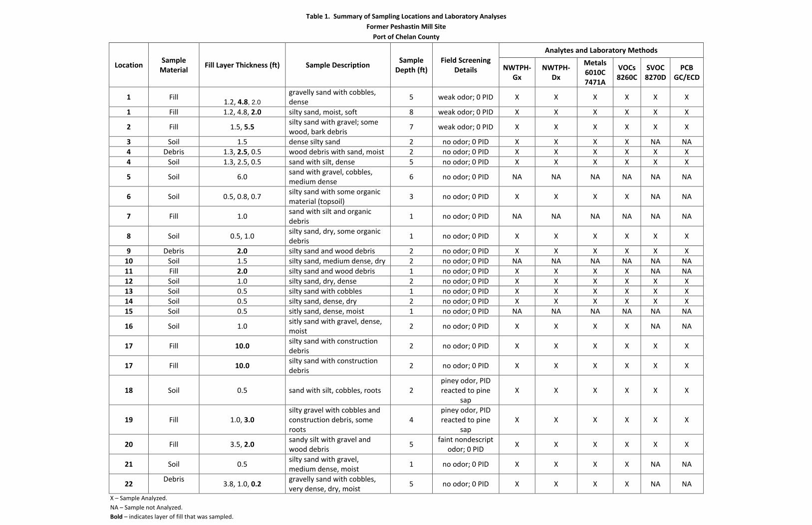
X – Sample Analyzed.
NA – Sample not Analyzed.
Bold – indicates layer of fill that was sampled.
Table 1. Summary of Sampling Locations and Laboratory Analyses
Former Peshastin Mill Site
Port of Chelan County
Location Sample
Material Fill Layer Thickness (ft) Sample Description
Sample Depth (ft)
Field Screening Details
Analytes and Laboratory Methods
NWTPH-Gx
NWTPH-Dx
Metals 6010C 7471A
VOCs 8260C
SVOC 8270D
PCB GC/ECD
1 Fill 1.2, 4.8, 2.0
gravelly sand with cobbles, dense
5 weak odor; 0 PID X X X X X X
1 Fill 1.2, 4.8, 2.0 silty sand, moist, soft 8 weak odor; 0 PID X X X X X X
2 Fill 1.5, 5.5 silty sand with gravel; some wood, bark debris
7 weak odor; 0 PID X X X X X X
3 Soil 1.5 dense silty sand 2 no odor; 0 PID X X X X NA NA
4 Debris 1.3, 2.5, 0.5 wood debris with sand, moist 2 no odor; 0 PID X X X X X X
4 Soil 1.3, 2.5, 0.5 sand with silt, dense 5 no odor; 0 PID X X X X X X
5 Soil 6.0 sand with gravel, cobbles, medium dense
6 no odor; 0 PID NA NA NA NA NA NA
6 Soil 0.5, 0.8, 0.7 silty sand with some organic material (topsoil)
3 no odor; 0 PID X X X X NA NA
7 Fill 1.0 sand with silt and organic debris
1 no odor; 0 PID NA NA NA NA NA NA
8 Soil 0.5, 1.0 silty sand, dry, some organic debris
1 no odor; 0 PID X X X X X X
9 Debris 2.0 silty sand and wood debris 2 no odor; 0 PID X X X X X X
10 Soil 1.5 silty sand, medium dense, dry 2 no odor; 0 PID NA NA NA NA NA NA
11 Fill 2.0 silty sand and wood debris 1 no odor; 0 PID X X X X NA NA
12 Soil 1.0 silty sand, dry, dense 2 no odor; 0 PID X X X X X X
13 Soil 0.5 silty sand with cobbles 1 no odor; 0 PID X X X X X X
14 Soil 0.5 silty sand, dense, dry 2 no odor; 0 PID X X X X X X
15 Soil 0.5 sitly sand, dense, moist 1 no odor; 0 PID NA NA NA NA NA NA
16 Soil 1.0 sitly sand with gravel, dense, moist
2 no odor; 0 PID X X X X NA NA
17 Fill 10.0 silty sand with construction debris
2 no odor; 0 PID X X X X X X
17 Fill 10.0 silty sand with construction debris
2 no odor; 0 PID X X X X X X
18 Soil 0.5 sand with silt, cobbles, roots 2 piney odor, PID reacted to pine
sap X X X X X X
19 Fill 1.0, 3.0 silty gravel with cobbles and construction debris, some roots
4 piney odor, PID reacted to pine
sap X X X X X X
20 Fill 3.5, 2.0 sandy silt with gravel and wood debris
5 faint nondescript
odor; 0 PID X X X X X X
21 Soil 0.5 silty sand with gravel, medium dense, moist
1 no odor; 0 PID X X X X NA NA
22 Debris
3.8, 1.0, 0.2 gravelly sand with cobbles, very dense, dry, moist
5 no odor; 0 PID X X X X NA NA

Table 2. Summary of Total Petroleum Hydrocarbons (TPH) and BTEX Detections
Former Peshastin Mill Site
Port of Chelan County
Sample Number Analyte
TPH-Gasoline
TPH-Diesel TPH-Oil PAHs Benzene Toluene
m,p-Xylene
S-1-F-08 - 12 42 0.0067 - - -
S-2-F-07 - 20 54 0.0581 0.0032 0.0027 -
S-3-S-02 - - - - 0.0019 - -
S-4-D-02 - 38 180 0.176 0.0024 0.0052 -
S-4-S-05 - - - - 0.0014 - -
S-6-S-03 140 - - - 0.0200 0.27 -
S-8-S-01 11 - - - 0.0140 0.003 -
S-9-D-02 21 15 79 - 0.0059 0.095 -
S-11-F-01 - 34 130 - 0.0047 - -
S-12-S-02 - - - - 0.0039 0.0043 -
S-13-S-01 - - - 0.0525 - - -
S-17-F-02 30 21 160 0.107 0.0089 0.0097 -
S-17-F-10 20 110 540 - 0.0050 0.0084 -
S-18-S-02 - - - 0.125 - 0.0051 -
S-19-F-04 19 29 130 0.374 0.0520 0.026 0.003
S-20-F-05 - 67 180 0.046 0.0083 0.0045 -
S-21-S-01 - - 12 - - - -
S-22-D-05 89 360 - - 0.003 -
MTCA Method A Cleanup Level 30 2,000 2,000
See note 0.0300 7 9
Results reported in milligrams per kilogram (mg/kg), equivalent to parts per million (ppm)
– Not Detected above Limit of Quantitation.
BTEX - Benzene, toluene, ethylbenzene, and total xylenes
PAHs – polynuclear aromatic hydrocarbons; included with TPH concentration for comparison to cleanup level.
Bold – equal to or greater than MTCA Method A Cleanup Level.

Table 3. Summary of Metals Detections
Former Peshastin Mill Site
Port of Chelan County
Sample Number
Analytes
Arsenic Chromium Copper Lead Mercury
S-1-F-05 - 72 25.3 0.04
S-1-F-08 - 95 34.4 6 0.05
S-2-F-07 - 49.2 22.8 11 -
S-3-S-02 - 28.3 13.3 7 -
S-4-D-02 - 31.1 18.0 7 0.04
S-4-S-05 - 24.7 12.3 7 -
S-6-S-03 - 30.5 17.2 11 -
S-8-S-01 - 30 16.4 9 -
S-9-D-02 - 27.5 17.2 64 -
S-11-F-01 - 43 78.3 37 -
S-12-S-02 - 31 26.6 - -
S-12-S-02 - - - 10 -
S-13-S-01 20 25 17.5 107 -
S-14-S-02 - 28 20.3 10 -
S-16-S-02 - 31 25.0 14 -
S-17-F-02 - 42.6 38.2 60 0.03
S-17-F-10 - 47 29.4 40 0.03
S-18-S-02 - 29 17.6 8 -
S-19-F-04 - 57 128 73 0.04
S-20-F-05 7 29.3 17.8 54 -
S-21-S-01 - 9.8 24.3 - -
S-21-S-01 - - - 17 -
S-22-D-05 - 38.4 14.3 6 0.03
MTCA Method A Cleanup Level 20 2,000 none 250 2
Results reported in milligrams per kilogram (mg/kg), equivalent to parts per million (ppm)
– Not Detected above Limit of Quantitation.
Bold – equal to or greater than MTCA Method A Cleanup Level.

Table 4. Summary of Semi Volatile Organic Compound and PCB Detections
Former Peshastin Mill Site
Port of Chelan County
Individual cPAH compound
Sample Number
Total Naphthalenes
Dibenzo furan
PCB mixtures
4-Iso propyl toluene
tert-Butyl
benzene
combined cPAHs
Benzo(a) anthracene
Benzo(a) pyrene
Benzo(b) fluor
anthene
Benzo(k) fluor anthene
Total Benzo-fluor anthenes
Chrysene
Indeno (1,2,3-
cd) pyrene
S-1-F-08 16.9 - - - - - - - - - - - -
S-2-F-07 40.3 4.7 - - - 1.08 - - 5.2 - 10 7.6 -
S-6-S-03 - - - 6500 - - - - - - - - -
S-9-D-02 50.4 11 - 7.0 - 14.7 11 10 15 6.0 27 21 6.8
S-13-S-01 15.1 6.4 - - - 0.05 - - - - - 5.0 -
S-14-S-02 - - 57 - - - - - - - - -
S-17-F-02 - - - - - 2.81 - - - - 26 21 0
S-17-F-10 136 31 74 - 4.9 5.53 - - 20 36 23 17
S-18-S-02 - - - 1.4 - 18.4 14 14 9.9 5.5 21 19 6.8
S-19-F-04 324 78 - 7.4 - 5.96 20 - 22 - 35 46 -
TEF 0.1 1 0.1 0.1 0.1 0.01 0.1
MTCA Method A Cleanup Level
5,000 none 1,000 none none 100
Results reported in micrograms per kilogram (g/kg), equivalent to parts per billion (ppb)
– Not Detected above Limit of Quantitation.
PCBs - Polychlorinated biphenyls.
cPAHs – carcinogenic polynuclear aromatic hydrocarbons.
TEF – toxic equivalency factor used to calculate combined cPAH concentrations.
No analyte concentrations are equal to or greater than MTCA Method A Cleanup Level.