petaluma watershed science and ecosystem restoration project
TRANSCRIPT

Petaluma Watershed Science and Ecosystem Restoration Project
Project Information1. Proposal Title:
Petaluma Watershed Science and Ecosystem Restoration Project
2. Proposal applicants:
Leandra Swent, Southern Sonoma County Resource Conservation District Nadav Nur, Point Reyes Bird Observatory Laurel Collins, Geomorphology Consultant
3. Corresponding Contact Person:
Leandra Swent Southern Sonoma County Resource Conservation District 1301 Redwood Way, Suite 170 Petaluma, CA 94954 707 794-1242 [email protected]
4. Project Keywords:
Geomorphology Habitat Restoration, Riparian Saline-freshwater Interfaces
5. Type of project:
Implementation_Pilot
6. Does the project involve land acquisition, either in fee or through a conservation easement?
No
7. Topic Area:
Riparian Habitat
8. Type of applicant:
Local Agency
9. Location - GIS coordinates:
Latitude: 38.071
Longitude: -122.374
Datum: NAD83
Describe project location using information such as water bodies, river miles, roadintersections, landmarks, and size in acres.
The Petaluma River is located in southern Sonoma County and a portion of northeastern MarinCounty. It drains a 146 square mile, pear shaped basin. The Petaluma River empties into the northwestportion of San Pablo Bay. The largest sub-watershed is San Antonio Creek located in the westernportion of the watershed, south of the community of Petaluma. It flows from near Laguna Lake inChileno Valley to the Petaluma marsh and divides Marin and Sonoma Counties. U.S. Highway 101bisects the watershed nearly in half, trending north-south. The watershed is approximately 19 mileslong and 13 miles wide with the City of Petaluma near its center.
10. Location - Ecozone:
2.4 Petaluma River, 2.5 San Pablo Bay
11. Location - County:
Marin, Sonoma
12. Location - City:
Does your project fall within a city jurisdiction?
No
13. Location - Tribal Lands:
Does your project fall on or adjacent to tribal lands?
No
14. Location - Congressional District:
US Congress 6
15. Location:
California State Senate District Number: District 3
California Assembly District Number: District 6
16. How many years of funding are you requesting?
3
17. Requested Funds: a) Are your overhead rates different depending on whether funds are state or federal?
No
If no, list single overhead rate and total requested funds:
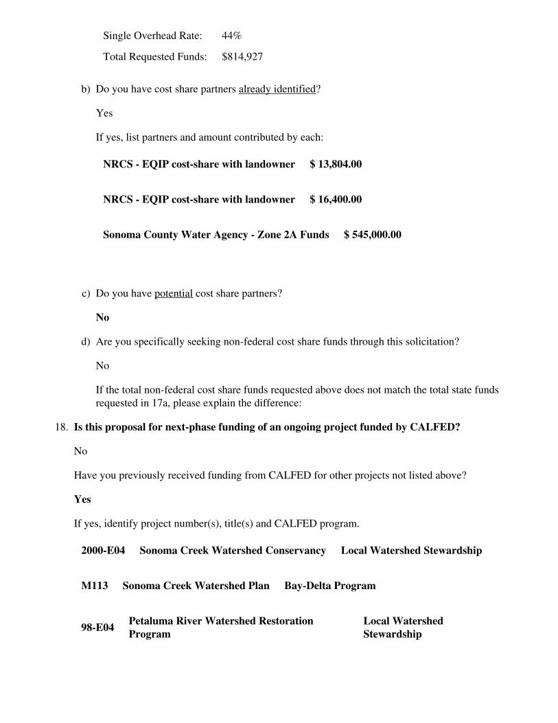
Single Overhead Rate: 44%
Total Requested Funds: $814,927
b) Do you have cost share partners already identified?
Yes
If yes, list partners and amount contributed by each:
NRCS - EQIP cost-share with landowner $ 13,804.00
NRCS - EQIP cost-share with landowner $ 16,400.00
Sonoma County Water Agency - Zone 2A Funds $ 545,000.00
c) Do you have potential cost share partners?
No
d) Are you specifically seeking non-federal cost share funds through this solicitation?
No
If the total non-federal cost share funds requested above does not match the total state fundsrequested in 17a, please explain the difference:
18. Is this proposal for next-phase funding of an ongoing project funded by CALFED?
No
Have you previously received funding from CALFED for other projects not listed above?
Yes
If yes, identify project number(s), title(s) and CALFED program.
2000-E04 Sonoma Creek Watershed Conservancy Local Watershed Stewardship
M113 Sonoma Creek Watershed Plan Bay-Delta Program
98-E04 Petaluma River Watershed Restoration Program
Local Watershed Stewardship

19. Is this proposal for next-phase funding of an ongoing project funded by CVPIA?
No
Have you previously received funding from CVPIA for other projects not listed above?
No
20. Is this proposal for next-phase funding of an ongoing project funded by an entity other thanCALFED or CVPIA?
Yes
If yes, identify project number(s), title(s) and funding source.
205(j) Petaluma WatershedEnhancement Plan
San Francisco Bay Regional Water QualityControl Board
319(h) Petaluma Watershed Sediment Retentionand Riparian Restoration Project
San Francisco Bay RegionalWater Quality Control Board
n/a Channel Improvement, Maintenance andRevegetation Project
Sonoma County Water Agency- Zone 2A
Please list suggested reviewers for your proposal. (optional)
Paul Jones U.S. EPA (415) 744-1976 [email protected]
Carmen Fewless
San Francisco Bay RWQCB -Region 2
(510) 622-2316 [email protected]
Sandia Potter
San Francisco Bay RWQCB -Region 2
(510) 622-2426 [email protected]
21. Comments:
Environmental Compliance ChecklistPetaluma Watershed Science and Ecosystem Restoration Project
1. CEQA or NEPA Compliance a) Will this project require compliance with CEQA?
Yes b) Will this project require compliance with NEPA?
No c) If neither CEQA or NEPA compliance is required, please explain why compliance is not
required for the actions in this proposal.
2. If the project will require CEQA and/or NEPA compliance, identify the lead agency(ies). Ifnot applicable, put "None".
CEQA Lead Agency: Southern Sonoma County Resource Conserservation District NEPA Lead Agency (or co-lead:) NEPA Co-Lead Agency (if applicable):
3. Please check which type of CEQA/NEPA documentation is anticipated.
CEQA -Categorical Exemption XNegative Declaration or Mitigated Negative Declaration -EIR -none
NEPA -Categorical Exclusion -Environmental Assessment/FONSI -EIS Xnone
If you anticipate relying on either the Categorical Exemption or Categorical Exclusion for thisproject, please specifically identify the exemption and/or exclusion that you believe covers thisproject.
4. CEQA/NEPA Process a) Is the CEQA/NEPA process complete?
No
If the CEQA/NEPA process is not complete, please describe the dates for completing draftand/or final CEQA/NEPA documents.
A draft Initial Study and subsequent Negative Declaration will be prepared at the end of Year1 (likely Oct. 2003).

b) If the CEQA/NEPA document has been completed, please list document name(s):
5. Environmental Permitting and Approvals (If a permit is not required, leave both Required?and Obtained? check boxes blank.)
LOCAL PERMITS AND APPROVALS
Conditional use permit
Variance
Subdivision Map Act
Grading Permit Required
General Plan Amendment
Specific Plan Approval
Rezone
Williamson Act Contract Cancellation
Other
STATE PERMITS AND APPROVALS
Scientific Collecting Permit
CESA Compliance: 2081
CESA Compliance: NCCP
1601/03
CWA 401 certification
Coastal Development Permit
Reclamation Board Approval
Notification of DPC or BCDC Required
Other
FEDERAL PERMITS AND APPROVALS
ESA Compliance Section 7 Consultation
ESA Compliance Section 10 Permit
Rivers and Harbors Act
CWA 404
Other
PERMISSION TO ACCESS PROPERTY
Permission to access city, county or other local agency land.Agency Name:
Permission to access state land.Agency Name:
Permission to access federal land.Agency Name:
Permission to access private land. Landowner Name: Lubbermann/Googins Required, Obtained
6. Comments.
8. A Streambed Alteration Agreement (permit) will be required and will be obtained by theCalifornia Department of Fish and Game.

Land Use ChecklistPetaluma Watershed Science and Ecosystem Restoration Project
1. Does the project involve land acquisition, either in fee or through a conservation easement?
No
2. Will the applicant require access across public or private property that the applicant doesnot own to accomplish the activities in the proposal?
Yes
3. Do the actions in the proposal involve physical changes in the land use?
No
If you answered no to #3, explain what type of actions are involved in the proposal (i.e., researchonly, planning only).
The project proposes research and study primarily, with one on-the-ground restoration task. Landuse on the restoration site will not be affected by project work. This "on-the-ground" project isrestoration and enhancement oriented and will not alter or affect existing land uses of livestockgrazing and rural residential.
4. Comments.

Conflict of Interest ChecklistPetaluma Watershed Science and Ecosystem Restoration Project
Please list below the full names and organizations of all individuals in the following categories:
Applicants listed in the proposal who wrote the proposal, will be performing the tasks listed in theproposal or who will benefit financially if the proposal is funded. Subcontractors listed in the proposal who will perform some tasks listed in the proposal and willbenefit financially if the proposal is funded. Individuals not listed in the proposal who helped with proposal development, for example byreviewing drafts, or by providing critical suggestions or ideas contained within the proposal.
The information provided on this form will be used to select appropriate and unbiased reviewers foryour proposal.
Applicant(s):
Leandra Swent, Southern Sonoma County Resource Conservation District Nadav Nur, Point Reyes Bird Observatory Laurel Collins, Geomorphology Consultant
Subcontractor(s):
Are specific subcontractors identified in this proposal? Yes
If yes, please list the name(s) and organization(s):
Laurel Collins Consulting Geomorphologist
Nadav Nur Point Reyes Bird Observatory
None None
None None
None None
None None
Helped with proposal development:
Are there persons who helped with proposal development?
Yes
If yes, please list the name(s) and organization(s):
Leandra Swent Southern Sonoma County Resource Conservation District

Laurel Collins Consulting Geomorphologist
Paul Sheffer Southern Sonoma County Resource Conservation District
Susan Haydon Southern Sonoma County Resource Conservation District
David Luther Southern Sonoma County Resource Conservation District
Nadav Nur Point Reyes Bird Observatort
Comments:

Budget SummaryPetaluma Watershed Science and Ecosystem Restoration Project
Please provide a detailed budget for each year of requested funds, indicating on the form whether theindirect costs are based on the Federal overhead rate, State overhead rate, or are independent of fund source.
Federal Funds
Year 1Task No.
Task Description
DirectLabor Hours
Salary(per year)
Benefits(per year)
Travel Supplies & Expendables
Services or Consultants Equipment
OtherDirect Costs
TotalDirect Costs
Indirect Costs
Total Cost
1
ProjectManagement
and Administration
700 16,760 1510 500 6500 25270.0 12,880 38150.00
2
On-the-GroundRestoration
Project- SanAntonio Creek
380 9043 884 1400 11327.0 6992 18319.00
3 Geomorphology Study 40,000 40000.0 40000.00
4 GIS Integrative Assessment 80 1847 138 4500 6485.0 1472 7957.00
5
Bayland/UplandInterface:Limiting
FactorsAffecting Birds
69,548 69548.0 69548.00
6 Watershed Coordination 820 19,787 2025 200 200 22212.0 15,088 37300.00
1980 47437.00 4557.00 0.00 700.00 109548.00 6500.00 6100.00 174842.00 36432.00 211274.00
Year 2Task No. Task Description
DirectLabor Hours
Salary(per year)
Benefits(per year)
Travel Supplies & Expendables
Services or Consultants Equipment
OtherDirect Costs
TotalDirect Costs
Indirect Costs
Total Cost
1Project
Management and Administration
700 16,760 1510 500 18770.0 12,880 31650.00
2
On-the-GroundRestoration
Project- SanAntonio Creek
380 12,775 1277 500 237,200 251752.0 9,568 261320.00
3 Geomorphology Study 40,000 40000.0 40000.00
4 GIS Integrative Assessment 80 1847 138 500 2485.0 1472 3957.00
5
TheBaylands/Uplands
Interface:Limiting FactorsAffecting Birds
69,542 69542.0 69542.00
6 Watershed Coordination 820 19,787 2025 200 22012.0 15,088 37100.00
1980 51169.00 4950.00 0.00 1000.00 346742.00 0.00 700.00 404561.00 39008.00 443569.00

Year 3Task No. Task Description
DirectLabor Hours
Salary(per year)
Benefits(per year)
Travel Supplies & Expendables
Services or Consultants Equipment
OtherDirect Costs
TotalDirect Costs
Indirect Costs
Total Cost
1Project
Management and Administration
700 16,760 1,510 500 18770.0 12,880 31650.00
2
On-the-GroundRestoration
Project- SanAntonio Creek
180 4,677 492 5169.0 3,312 8481.00
4 GIS Integrative Assessment 256 5,331 455 500 6286.0 4,710 10996.00
5
TheBaylands/Uplands
Interface:Limiting FactorsAffecting Birds
71,657 71657.0 71657.00
6 Watershed Coordination 820 19,787 2025 200 200 22212.0 15,088 37300.00
1956 46555.00 4482.00 0.00 700.00 71657.00 0.00 700.00 124094.00 35990.00 160084.00
Grand Total=814927.00
Comments.

Budget JustificationPetaluma Watershed Science and Ecosystem Restoration Project
Direct Labor Hours. Provide estimated hours proposed for each individual.
RCD Personnel: Total number of labor hours estimated for three year period. RCD District Manager-596 hrs. Senior Resource Conservationist- 2300 hrs. Resource Conservationist- 580 hrs. EngineeringTechnician- 1580 hrs. Education & Outreach Coord.- 1,000 hrs.
Salary. Provide estimated rate of compensation proposed for each individual.
RCD Personnel: District Manager- $32/hr. Sen. Resource Conservationist- $21/hr ResourceConservationist- $20/hr. Engineering Technician- $26/hr. Education & Outreach Coord.- $27/hr.
Benefits. Provide the overall benefit rate applicable to each category of employee proposed in theproject.
RCD Personnel: District Manager- $3.50/hr. Sen. Resource Conservationist- $2/hr. ResourceConservationist- $2/hr. Engineering Technician- $3/hr. Education & Outreach Coord.- $2.25/hr. Note:Benefit rates are applied to per-hour salary rates when overall billing rates are computed.
Travel. Provide purpose and estimate costs for all non-local travel.
All travel associated with this project is estimated to be local site locations within the watershed.
Supplies & Expendables. Indicate separately the amounts proposed for office, laboratory, computing,and field supplies.
Office supplies- $1,500 ($500 each year) Graphics (maps/media materials) Printing- $1,000 Fieldsupplies- $500 Film & Developing- $400
Services or Consultants. Identify the specific tasks for which these services would be used. Estimateamount of time required and the hourly or daily rate.
Task 2: On the ground Restoration Project (San Antonio Creek) Total costs associated withconstruction services provided by outside consultants and/or contractors are estimated at $237,200.This amount includes erosion control materials, fencing, plant materials and contractors to perform thework. Rates vary widely depending on type of specific technical work to be performed. Hourly rates forequipment and operator will be based on local prevailing wages. No detailed bids exist forbio-technical work or construction services. However, the work and materials have been carefullyestimated by the RCD engineering technician and NRCS engineering staff. Task 3: GeomorphologyStudy The geomorphology study will be conducted by Laurel Collins, consulting geomorphologist. 28field days are estimated at 10 hours per day at a daily rate of $1,440. This daily rate includes Ms.Collins, as principal investigator and two field technicians as assistants. 30 or more office days (fordata refinement, reporting, etc.) are estimated at $1,152 per day, using an 8-hour work day. Total costfor this task is estimated at $80,000. Task 5: Bayland/Upland Interface: Limiting Factors AffectingBirds Point Reyes Bird Observatory estimates total costs for three years at $210,457. The principalinvestigators time is estimated at 128 hours per year (384 hours total) at an average hourly rate of $53.A GIS specialist is estimated at 248 hours at $88 per hour. Field biologist(s) time is estimated at 2,268hours at an average of $37.50 per hour. 200 field days each are proposed for each of the three years at adaily rate of $55 per person. The principal investigators time is estimated at 128 hours per year (384
hours total) at an average hourly rate of $53. Other direct costs include banding supplies, GPSequipment and other field equipment and travel.
Equipment. Identify non-expendable personal property having a useful life of more than one (1) yearand an acquisition cost of more than $5,000 per unit. If fabrication of equipment is proposed, list partsand materials required for each, and show costs separately from the other items.
Milti-media slide projector (for Power Point use)-$6500
Project Management. Describe the specific costs associated with insuring accomplishment of aspecific project, such as inspection of work in progress, validation of costs, report preparation, givingpresentatons, reponse to project specific questions and necessary costs directly associated with specificproject oversight.
Task 1 of this proposal is designated as "Project Management and Administration". Costs associatedwith this task directly apply to the administration of the grant, presentations, and management ofconsultants. Total costs equal-$101,450. This includes labor and expenses over a three year period. Themulti-media slide projector is an assigned expense to this task.
Other Direct Costs. Provide any other direct costs not already covered.
GIS software "Spatial Analyst"- $3000 Digital camera with GPS-$1500 Digital Planimeter- $1000
Indirect Costs. Explain what is encompassed in the overhead rate (indirect costs). Overhead shouldinclude costs associated with general office requirements such as rent, phones, furniture, general officestaff, etc., generally distributed by a predetermined percentage (or surcharge) of specific costs.
The RCD uses the Federal Office of Business and Managements OMB Circular No. 87 for calculatingindirect costs. Overhead costs (indirect costs) are distributed by a predetermined surcharge of specificcosts based on the RCDs previous years actual expenses. As allowed under OMB Circular No. 87,these costs encompass: County property tax administration costs, insurance, legal services,accounting/bookkeeping and audit expenses, training, trade dues and subscriptions, storage spacerental, indirect staff hours and office supplies. Overhead costs are not different for state and federalfunds.
Executive SummaryPetaluma Watershed Science and Ecosystem Restoration Project
This proposal, entitled Petaluma Watershed Science and Ecosystem Restoration Project seeks toempower landowners and the community-at-large to understand the issues agencies face and toimplement restorative actions to improve the health of our watershed. This project addresses key issuesfor this watershed, located in the San Francisco Bay Region where the Petaluma River Watershed hoststhe largest and most important in-tact tidal marsh in the West. The Petaluma River is characterized asan Impaired Water body with highly erodible soils and considerable sedimentation contributing towater quality. This proposal involves two specific tasks focusing on the sub-watershed of San AntonioCreek, the largest sub-watershed having been identified through the Petaluma Watershed EnhancementPlan as requiring critical restorative actions to improve water quality and riparian habitat in this locale.The first component is an on-the-ground bank stabilization and riparian restoration project. Secondly, ageomorphology study on San Antonio Creek is proposed to assist decision makers in prioritizing futurerestoration projects. Also included are the habitat and ecosystem assessment tools of a Limiting FactorsAnalysis for Birds and development of a GIS map of known fish barriers and integrative assessment.Further, a Watershed Coordinator is provided to conduct the needed education and outreach duties,considered vital to the success of any ecosystem restoration program. This position serves to conductall the ancillary duties of agency consultation, permit acquisition and CEQA compliance, outreach tolandowner and stakeholder groups, and needed coordination with other programs going on in thewatershed. Our project directly meets Calfeds goals through our riparian habitat restoration project andthrough the Bird Habitat and Geomorphologic studies by building a body of knowledge that will helpdecision makers prioritize future data needs and restoration priorities ultimately improving the health ofour unique watershed. This project, with many tasks focused on the sub-watershed of San AntonioCreek- a benchmark watershed, serves to test our hypothesis and model for acheiving Calfed programgoals in this region.

Proposal
Southern Sonoma County Resource Conservation District
Petaluma Watershed Science and Ecosystem Restoration Project
Leandra Swent, Southern Sonoma County Resource Conservation District Nadav Nur, Point Reyes Bird Observatory Laurel Collins, Geomorphology Consultant

Southern Sonoma County Resource Conservation District – Petaluma Watershed Science and Ecosystem Restoration Project
1
A. Project Description: Project Goals and Scope of Work
1. Problem. The Petaluma watershed and the San Pablo Bay downstream of it, have been transformed by human impacts, from its pre-European state with large floodplains and riparian corridors to one with extensive agriculture and increasing urbanization. Riparian corridors vanished, replaced by houses and farms. Culverts and roads now interrupt anadromous fish migration and a number of plant and animal species are listed as threatened and endangered. Riparian and marsh habitat, and connectivity of these habitats, are of key functional importance for populations of species of concern. This region although not as bad as many in the bay area has a history of loss of these habitats. The Petaluma Watershed is located in Sonoma County and northeastern Marin County. It drains a 146 square mile, pear-shaped basin (see Figure 1-Watershed Map). The Petaluma Watershed system empties into the northwest portion of San Pablo Bay. The overall focus of this project will encompass scientific studies to address key uncertainties in channel morphology, habitat conditions for at risk species and habitat connectivity. This work will take place throughout the entire Petaluma watershed with special emphasis and restoration activities occurring in the San Antonio Creek sub-watershed. We have chosen San Antonio Creek as our demonstration benchmark watershed because of previous data gathered about the watershed and its high potential “to have self-sustaining biotic communities that will persist without continual high levels of human manipulation of ecosystem processes and species abundances” (Implementation Plan Goal 2). The Petaluma River supports a variety of marine and estuarine species and freshwater fish. Tributaries to the river as well as the main stem are used by these species for spawning, rearing and migration. The Petaluma River and its receiving waters, San Pablo Bay, are on the California’s Impaired Waterbody 303(d) List thus indicating a threat to the health of species using the watershed. The watercourse is commonly called the Petaluma “River” but is geomorphologically a tidal slough. The lower reaches of the slough experience regular tidal exchange from San Pablo Bay. Thus, the watershed is host to one of the largest remaining intact marsh and tidal wetland areas and forms the Petaluma River marsh and tidal wetlands. Tidal exchange and naturally occurring highly erodible soils cause sediment deposition to the Petaluma River and its tributaries. Thus the watercourse has been listed as impaired due to sediment and requires regular dredging to remain open and navigable. Tidal marsh was once the dominant habitat type in the Petaluma watershed especially where San Antonio Creek intercepts the main stem of the Petaluma River. Today, much of the watershed area still remains relatively undeveloped and the Petaluma Marsh complex is the largest intact tidal marsh within the San Francisco estuary system. The marsh still exhibits many historical features and has a high potential for various restoration opportunities. Numerous groups have identified restoration of the Petaluma River and marsh complex as a priority goal. The Goals project 1999, Baylands Ecosystem Habitat Goals by the San Francisco Bay Area Wetlands Ecosystem Goals Project, March 1999, states that “there is a unique opportunity to enhance the stream/marsh ecotone between San Antonio Creek and tidal habitats, one of the few places where such restoration can take place. Also, this segment provides opportunities to restore extensive tidal marsh and natural marsh/upland transitions near the subregion’s largest brackish marsh.”

Southern Sonoma County Resource Conservation District – Petaluma Watershed Science and Ecosystem Restoration Project
2
San Antonio Creek is the largest sub-watershed of the Petaluma Watershed and is located south of the community of Petaluma. It flows from near Laguna Lake in Chileno Valley to the Petaluma Marsh. During the writing of the Petaluma Watershed Enhancement Plan by the Southern Sonoma County Resource Conservation District (RCD) in conjunction with the people of the Petaluma Watershed, July 1999, local landowners were interviewed and all indicated that the most apparent problem in San Antonio Creek Sub-watershed is severe streambank erosion, which cuts into pastures and mature riparian vegetation. Some of these cut banks are 15 to 20 feet high, and in some locations they have cut to bedrock. Several thousand cubic feet of fine sediment may have been deposited to San Antonio Creek during heavy winter rains.
San Antonio Creek sub-watershed was mapped and categorized in the study Relative Slope Stability and Land Use Planning in the San Francisco Bay Region by the USGS and the Department on Housing and Urban Development, 1979. This study mapped slope stability using five categories (with category 1 being stable and category 5 being unstable). The majority of San Antonio Creek was categorized as unstable (category 5). In the Petaluma Watershed Enhancement Plan, the sub-watershed is characterized as having a very high potential for erosion activity, high erosion potential, and high repair priority. In the greater Petaluma Watershed, San Antonio Creek is in one of the worst conditions and is desperately in need of restoration and enhancement help. The RCD has good support from active and able landowners willing to provide access to private property for study and restoration activities and a great willingness to practice wildlife friendly agriculture. By conducting this project we will improve our understanding of the tidal marsh interface and linkages between species and flows. Outcomes will also result in on-the-ground enhancement of riparian habitat along the stream channel and stabilization of the streambank in critical areas. We will keep the landowners, public, and agency stewards in the watershed informed and active in this important pursuit towards restoration of our local watershed and ecosystems. All the proposed tasks relate to the hypothesis that if we assess conditions (watershed, riparian/aquatic, and fisheries), identify and address unknown stressors and limiting factors, restore and maintain key habitat types, and educate the community about current watershed conditions and how they can improve them, we will improve watershed health in Petaluma River and the San Pablo Bay. The scope of work for this proposal includes:
• project management and administration • 2 miles of Riparian restoration projects on San Antonio Creek • geomorphological studies of San Antonio Creek • GIS mapping to locate fish barriers and consolidate existing watershed information • upland Interface Issues and Baylands Habitat Uses • watershed coordination.
The main goal of this project is to improve the overall health of the watershed. Individual goals are to:
• repair and enhance riparian habitat • decrease sedimentation through bank stabilization and revegetation

Southern Sonoma County Resource Conservation District – Petaluma Watershed Science and Ecosystem Restoration Project
3
• install fencing to protect riparian corridor from livestock • survey current channel conditions of San Antonio Creek and compare to historical
conditions to improve restoration design • map data collected • provide recommendations for wildlife friendly agricultural and other land-use practices
in marsh-adjacent baylands • provide coordination of all studies, projects and provide a liaison with the local
landowners and residents of the watershed.
The general objectives of the project include: rehabilitate natural processes in the Petaluma watershed to fully support natural aquatic and associated terrestrial biotic communities and habitats; achieve recovery of at-risk species living in and dependent on the Petaluma watershed; protect and restore functional habitat types to support species and biotic communities, ecological processes, and scientific research; and improve water and sediment quality conditions that fully support healthy and diverse aquatic ecosystems in the Petaluma watershed. We expect to understand key uncertainties for at-risk species in the watershed, improve habitat for steelhead, red legged frog, and other aquatic and riparian species in the local watershed, and enhance habitat values in San Pablo Bay to benefit all Bay-Delta anadromous species. Task-level objectives: several proposed tasks will assess key uncertainties for habitat connectivity and at-risk species, restore riparian habitat, identify anadromous fish barriers, assess riparian conditions throughout the watershed, and improve local and regional awareness of watershed ecology and restoration.
[Figure 1]
2. Justification. The projects in this proposal focus on implementation of the 1999 multi-stakeholder developed watershed plan, entitled Petaluma Watershed Enhancement Plan and provide broad ecosystem benefits meeting Calfed’s Restoration Priorities for the Bay Region, specifically the following priorities: BR-1, BR-3, BR-4, BR-5, BR-7 and BR-8.
Conceptual Model. Figure 2 depicts a model plan for addressing Petaluma River’s watershed enhancement goals and study priorities. The Model for our work makes explicit the causal connections between land and water use and the health of the Petaluma River’s watershed as well as the Bay-Delta area. It shows how information on watershed conditions can feed back into resource use patterns. The tasks identified will improve our understanding of conditions in uplands, riparian and aquatic/fisheries area, as well as improve information feedback. Hypotheses being tested. All the proposed tasks relate to one general hypothesis; that if we assess conditions (watershed, riparian/aquatic, and at-risk species), determine unknown stressors and limiting factors, address identified stressors and limiting factors, restore and maintain key habitat types, and educate the community about current watershed conditions and how they can improve them, we will improve watershed health in Petaluma River and the San Pablo Bay. Proposed monitoring and research tasks (as well as other funded non-CALFED projects, see B2 on Other Ecosystem Restoration Projects) will yield useful information on significant parts of this general hypothesis. Our project is designed to test this hypothesis by obtaining baseline conditions of watershed health throughout the watershed to best assess high priority habitats and limiting factors. Our project will also test our hypothesis with an in-depth study of San Antonio Creek, a sub-watershed within the Petaluma watershed, to better understand what it takes to recreate a self

Southern Sonoma County Resource Conservation District – Petaluma Watershed Science and Ecosystem Restoration Project
4
maintaining channel morphology and its impacts on other watershed functions then applying our new information to other creeks throughout the watershed. Uncertainties. The proposal addresses several key uncertainties in the ERP Draft Stage 1 Implementation Plan. Task 3 (geomorphology study) continues a two-year investigation into improving knowledge of physical processes related to stream channel dynamics and sediment transport, gathering additional information for restoring riparian habitat and a better understanding of sediment movement. (Calfed ERP Goals 2,4,6). Task 3 (geomorphology study) also addresses uncertainties about pre-disturbance conditions and processes. Tasks 4 and 5 (GIS assessment and bird studies) begin to address a series of hypotheses concerning factors limiting at-risk species, in this case steelhead, clapper rail, black rail (Calfed ERP Goals 1 and 3). Project tasks #’s 4, 5 and 6 explore integrating uplands and wildlife friendly agriculture into regional restoration and additional information for restoring riparian habitat (Calfed ERP Goal 4). We do not know how historical changes have altered the relation of the watershed to riparian and aquatic conditions. Much uncertainty still exists about which riparian and/or aquatic parameters, alone and in combination, are limiting the health of the watershed and at-risk species, and what the population size and structure is. It is not known how much improvement in Petaluma River and other North Bay watershed health could improve San Pablo Bay’s functioning, or how much improvements in San Pablo Bay could improve overall Bay-Delta fisheries. It is unclear how well planning and regulatory authorities can practice adaptive management based on information about biological and physical conditions within their jurisdiction. As new information becomes available we will revisit our conceptual model and use adaptive management to accommodate this new information and adjust our focus. For example, the Fisheries Appendix to the Petaluma Watershed Enhancement Plan identified which sub-watersheds that had or have runs of steelhead. San Antonio Creek was identified as most likely to regain runs of steelhead, thus we have directed a focused effort to study San Antonio Creek and its conditions. Another example of adaptive management would be if in the Petaluma Marsh we find that upland habitat connectivity is not a limiting factor for at-risk species, then we will develop and test a new hypothesis to assess the decline of species in this habitat.
3. Approach. Our approach is designed to maximize the information richness of previous studies and enhancement plans for the Petaluma Watershed. This proposal will implement projects that have been previously identified to reduce stressors and limiting factors to at-risk species and improve watershed health. We are focusing our “on-the-ground” restoration project and geomorphology study on the previously identified priority sub-watershed, San Antonio Creek. Other analytical and data gathering tasks will consider the greater Petaluma River watershed. This project involves a multi-faceted scope of work with five main components as follows:
• Riparian restoration and bank stabilization project (San Antonio Creek) • Geomorphologic study on San Antonio Creek • GIS Integrative Assessment • The Upland/Bayland Interface: Limiting Factors Affecting Birds • Watershed Coordinator: Technical Assistance, Permit Acquisition & Public
Outreach/Agency Consultation Our Work Program is described below and involves six main tasks.
Southern Sonoma County Resource Conservation District – Petaluma Watershed Science and Ecosystem Restoration Project
5
Task 1: Project Management and Administration. Under this task, the RCD District Manager and appropriate staff will manage and administer the grant funding for the contracted scope of work. These duties include: grant administration and contracting, management of sub-consultants, and coordination with Calfed and all study partners. Presentations to agencies and any interested parties will also be included. All reporting, monitoring, and project documentation will be prepared as required and submitted in a timely manner. Task 2: Conduct an “On-the-Ground” Restoration Project- San Antonio Creek. The “on-the-ground” project on San Antonio Creek involves continued erosion control through bank stabilization, restoration and enhancement of the riparian habitat with installation of “riparian friendly fencing” and planting of native species. Our work proposed here is consistent and in direct compliance with CALFED goals and objectives as well as the goals and objectives established in the Petaluma Watershed Enhancement Plan, prepared by local stakeholders and our Resource Conservation District in 1999. This on-the-ground project will be conducted by the SSCRCD with construction performed by qualified local contractors. Preliminary work concepts and designs have been prepared to date and consent from all affected landowners has been secured. Work to be performed will involve agency consultation and require a Streambed Alteration Agreement from the California Department of Fish & Game.
Erosion control work will encompass approximately 1600 linear feet along the streambank of San Antonio Creek. Bio-technical bank stabilization techniques will be used to prevent further erosion which contributes fine sediment to the creek. We will use a rock toe and terraced willow walls inter-planted with other native riparian trees, shrubs, and grasses to prevent further erosion and enhance the riparian corridor. Approximately 2 acres of area will be revegetated. Plantings will be watered with drip irrigation and inspected monthly by the landowners. Also, plant survival counts will take place and dead plants will be replaced with live plants for the first 2 years to ensure success of plant establishment. Avian point counts will take place to monitor the return of avifauna to the restored site. All of these measures will take place to test our hypothesis that our restoration efforts will result in the reduction of fine sediment from this site into the river. Replanting riparian vegetation will provide shelter value to native faunal species. The project will be followed by NRCS standardized photographic monitoring methods to assess the integrity of the restored bank. Preliminary designs call for approximately 9,600 linear feet of fencing.
This project will be funded in-part by CALFED, and by the Natural Resources Conservation Service’s (NRCS) Environmental Quality Incentives Program (EQIP) funding. EQIP funding is a cost-share program where landowners provide match funds to the federal dollars from the NRCS. All fence and revegetation designs will meet with NRCS engineering standards.
Task 3: Conduct Geomorphology Study. The main objective in this study is to survey current channel conditions, identify relevant geomorphic processes, and changes in conditions and processes since non-native settlement so that this information can be used to improve restoration design, reduce erosion and sedimentation, and ultimately improve water quality and habitat. This San Antonio Creek Geomorphology Study represents a continuation of study on areas within this sub-watershed not covered by an initial study conducted under a previously funded Calfed study. This study will address roughly 8 miles of stream channel with a focus on the remainder of the main stem of San Antonio Creek up to the headwaters (approximately four miles of stream channel) and
Southern Sonoma County Resource Conservation District – Petaluma Watershed Science and Ecosystem Restoration Project
6
cover the main tributaries in the upper watershed portion (approximately an additional 4 miles of stream channel).
The methodology of analysis will be to collect and use factual data obtained on the ground to describe channel conditions that reflect past and ongoing processes in the stream channel. The approach will be modeled after San Francisco Estuary Institute’s Watershed Science Approach. The method provides measurement data obtained in a limited time, at a small cost, that can be used to hypothesize history and trends in various facts of the channel system. The observational data that we collect provides the basis for hypotheses that can guide further data collection and deeper interpretation. Since this sub-watershed is identified as having high erosion potential and is in critical need for restoration, it is given a high priority in characterizing the geomorphic processes in this area. This study will provide a larger watershed-scale view of sediment sources nd channel conditions that the first study that was just confined to the mainstem channel could not provide. By developing a watershed picture, future restoration efforts will have a greater chance for success. Restoration goals could range from reduced sediment supply, increased base flow, reduced flood peaks, improved fish habitat, increased ground water storage, and increased channel stability. A photographic base map will be created using aerial photos at a scale of 1:7,200. A centerline tape will be pulled continuously along the channel. All data will be referenced to distance stations along the tape. Telescoping survey rods will be used to measure bankful width, height of terraces, and heights and depths of bank and terrace erosion. Bank measurements will be separated into sections below and above bankful height, which, in concept is equivalent to the height of the floodplain. Bankful discharge occurs every 1.3 to 1.7 years on average and is regarded as the channel-forming flow that maintains the hydraulic geometry of the channel to move the most water and sediment over time. The threshold for measuring bank erosion will be at least .25 ft retreat for the overall height of the bank. Level-line surveying methods will be used to measure cross sections that helped determine bankfull height. Standard sieve sizes will be used to establish sediment size classes to characterize the channel bed into “D50” size classes, where 50% of the particles are either finer or equal to this size category. All pools greater or equal to 1 ft deep will be measured and documented at the time of initial field data collection. The Rosgen Stream Classification system is used.
Interviews with landowners will be conducted to document the history of water course changes over time. Laurel Collins, a qualified geomorphologist with assistance from the RCD Watershed Coordinator, will conduct the study and interviews. Ms. Collins was the principal scientist and author of the previous geomorphologic study on San Antonio Creek. Task 4: Geographic Information System Integrative Assessment. As the scope of watershed activities and studies grow, we have a greater need to communicate within the watershed and share collected data. By consolidating existing mapped studies into Arcview 3.2 we will be able to create many maps that can be used as planning tools for present and future watershed enhancement efforts. The first GIS project in this task will be to analyze existing material to identify potential anthropogenic migration barriers to anadromous fish. Under this task we will also compile and analyze data on annual precipitation, water quality monitoring, flooding and flood plain delineation, erosion and sedimentation highlighting high priority sub-watersheds point and non-point source

Southern Sonoma County Resource Conservation District – Petaluma Watershed Science and Ecosystem Restoration Project
7
locations, riparian plant communities, and past and present steelhead streams. See figure 3 for an example of the data and methods that will be used for this task. The most commonly used features used for analysis on this task will be Query Builder, convert to shapefile and select by theme . This task will allow us to identify trends in data, create new relationships in the data, view complex relationships between data sets and ultimately make more informed and effective watershed management decisions. The GIS mapping and assessment will allow us to better prioritize high priority projects and will allow us to determine what type of data we need to collect for future analysis. In Year 3 we will provide a GIS needs assessment to prioritize future analysis needs.
Task 5: The Upland/Bayland Interface: Limiting Factors Affecting Birds. Three focused studies are proposed below that will provide information for prioritizing and designing future restoration projects in marsh-adjacent baylands. Information gathered will allow us to make recommendations for wildlife-friendly land use practices (agricultural and others). Additionally we anticipate being able to identify constraints on recolonization by different species. The Point Reyes Bird Observatory (PRBO), led by Dr. Nadav Nur, will conduct these studies. 5a) Compare and quantify the use of tidal marsh, muted tidal marsh, and diked baylands for breeding and wintering birds. As tidal marsh restoration projects increase available habitat for many marsh-dependent species, it is important to evaluate the overall influence of habitat conversion through a habitat-specific accounting of breeding and wintering bird use. While we have collected substantial data on bird distributions and abundance in San Francisco Bay tidal marshes, we know little about how other modified bayland habitats are used by birds. By replicating our point count survey protocol in filled, diked, and muted tidal bayland habitats adjacent to existing tidal marsh study sites, we will be able to provide a more complete picture of the large-scale effects of habitat conversion. 5b) Evaluate the effects of adjacent land use on reproductive success of tidal marsh breeding birds. PRBO has been studying reproductive success of tidal marsh breeding birds at two sites in San Pablo Bay since 1996 and a third site since 1999. The major focus has been the San Pablo song sparrow, a California Species of Special Concern and a priority species (“R” species) identified by CALFED. Funds are requested to continue these studies at two sites: Black John Slough and the marsh at Petaluma River Mouth, and to add a third site, near the Bahia development, also within the Petaluma River watershed. Studies at these sites will complement PRBO studies at two other sites, China Camp in Marin County and Benicia State Park in Solano County, thus providing the opportunity to examine nest success across a spectrum of surrounding land use conditions. Habitat adjacent to saline and brackish marsh range from semi-natural oak woodlands at China Camp and Black John Slough, to agriculture at Black John Slough and Petaluma River Mouth, to urban development at Benicia. The establishment of an additional nest plot at a marsh site near the existing Bahia Subdivision (which land Marin Audubon Society is attempting to purchase) will improve the sample size and range of surrounding landscape conditions for analysis. Parameters for analysis include the fate (success/failure) of each nest, clutch size and number of young fledged, with respect to upland edge proximity and surrounding land use composition.
5c) Evaluating barriers to dispersal in tidal marsh breeding birds and the potential for recolonization. We propose to follow movements of individually color-banded birds across years, thus determining mean and maximum juvenile dispersal distances for breeding tidal marsh birds, and evaluating the effects of surrounding land use on dispersal and movement. During previous

Southern Sonoma County Resource Conservation District – Petaluma Watershed Science and Ecosystem Restoration Project
8
years of intensive population studies at Benicia, China Camp, Petaluma River Mouth and Black John Slough, we have placed color bands on nestlings and tracked their movements. Through intensive banding effort in the first year of the project and then through intensive resighting effort following, we expect to obtain information on a substantial number of color-banded individuals and obtain additional data on their future movements. Using existing GIS land use data we can also quantify the effects of landscape composition and configuration on dispersal ability. In this way we will identify and characterize barriers to dispersal for this species, which will help us evaluate population viability and the ability to recolonize future restoration sites.
Methods: Bird Studies: For Tasks 5a and 5b, information on presence/absence, relative abundance, species richness, and species diversity will be obtained using the point count method. These surveys will be conducted based on standardized protocols (Ralph et al. 1995) and protocols developed for the Wetlands Regional Monitoring Program (Nur & Spautz unpubl.). Further information and examples are provided in Nur et al. (1997). Analysis follows Nur et al. (1999). We will conduct point count surveys at four time periods: fall, winter, early spring and late spring, with the last two time periods corresponding to the breeding season. Surveys begin within 15 minutes of sunrise (before or after) and are completed within approximately 4 hours (i.e., during the time of maximum bird activity during the day). Individual point count stations are placed 200 meters apart (to avoid counting the same birds from adjacent points) and at least 50 m from the edge of the marsh, where possible. Each point is surveyed for 5 minutes. Detections of each individual of every bird species are recorded by distance from the observer, in 10-meter increments up to 100 meters, with an additional column for detections beyond 100 m. Information on the distance at which individuals are detected can be used to estimate absolute density for select species (those with sufficient detections). Density will be estimated using the program DISTANCE (Buckland et al. 1993); an example of such analysis is provided in Nur et al. (1997). This method takes into account differences in detection probability (which may change with site, year, season, etc.). The breeding or nesting success of birds (Task 5c) will be monitored using nest monitoring methods at three study sites adjacent to the Petaluma River. This intensive method involves finding and monitoring nest attempts throughout the breeding season (early March through end of July). Methods will follow that of Martin and Geupel (1993); these methods have been used by PRBO at sites in San Pablo Bay since 1996 (Nur et al. 1997). Nest monitoring provides information on breeding productivity and its components, including as nest survivorship, clutch size and the number of young fledged. Nest vegetation assessment is also conducted at each site where nests are found, in order to identify micro-habitat influences on breeding productivity (Martin and Geupel 1993). The density of breeding birds is also surveyed using territory mapping methods at each nest monitoring plot. We will relate nesting success to surrounding landscape characteristics (i.e., adjacent land use and surrounding landscape composition; tidal marsh configuration) using ArcView 3.2a (ESRI 2000) and Patch Analyst (Elkie et al. 1999). PRBO has already developed its own data layers for the Petaluma River area, applicable to this project, and will work closely with other GIS Specialists on this team.

Southern Sonoma County Resource Conservation District – Petaluma Watershed Science and Ecosystem Restoration Project
9
Task 6: Watershed Coordination. An RCD Watershed Coordinator will fulfill the duties under this task where the project will be coordinated and integrated into other projects on-going in the Petaluma Watershed. The coordinator’s function is considered vital to the success of any work in the watershed and represents the important role of RCD personnel who provide technical assistance and outreach to local landowners and stakeholders, agency representatives and consultants working in the watershed. The Watershed Coordinator will: a) coordinate grant administration and management with District Manager, other RCD staff, and sub-consultants, b) work with the landowners to provide access for study and work and to give input throughout the life of the project, c) conduct and prepare an oral history in the area as it relates to land use and geomorphologic changes along the creek, d) conduct agency consultation and prepare documentation with reference to acquiring required permits for project restoration work, e) document study results and prepare maps of study findings and fish barriers within the study area, and f) assist the geomorphologist, where appropriate, in field work and landowner access throughout the grant period. The RCD has been working consistently with landowners in this area and, over our 60-year history, we have built strong relationships and a good rapport with landowners. The landowners’ willingness to practice recommended “best management practices” has been achieved by RCD outreach. Most landowners now understand the long-term benefits of improved ecosystem health and sustainability. With support and willingness from these landowners, many activities have an excellent opportunity for success. The RCD utilizes this approach in all our work.
4. Feasibility. The scope of work presented in this proposal is entirely feasible to accomplish within the 3-year period. The scientific study methods are sound, based on current priorities in the watershed. All tasks are ready to begin immediately upon contract completion. Most of the tasks are continuation of work, or work identified in the Conceptual Model, that are currently given a top priority. Preliminary design concepts have been prepared for the restoration work to be conducted in Task 2. Work proposed by PRBO is a continuation of studies that they have been conducting at two Petaluma river sites, but with a focus now on the Upland/Marsh interface. Permitting and access: All RCD projects are conducted on properties/site with willing landowners and in study areas where landowner permission is obtained in advance and access is granted. Presently, no obstacles exist to conduct these projects on the ground. The RCD has already conducted pre-project consultation with all affected landowners and permitting agencies. Permits will need to be obtained from the CDFG and Sonoma Co. Public Works. A review of CEQA/NEPA compliance will be conducted. Permission letters of access and willingness to participate in project have been received from San Antonio Creek property owners and are provided in Attachment A. Both landowners reside on the property making contact and participation easy.
5. Performance Measures Task 1 (Project Admin. & Mgmt.) performance measures are the same as the project outcomes. Because this task relates to managing all other tasks in the grant, preparing quarterly reports, obtaining permits, and printing newsletters, the performance measures for this task will be to successfully produce all deliverables. For a list of deliverables, see Section 7 Expected Products/Outcomes Task 1. The primary goal for task 2 is to successfully stabilize the streambank and to reestablish riparian vegetation. The project activities for this task can be broken in to several metrics: 1) will be to perform a preliminary site assessment of the project site, 2) obtain 3 bids from consultants, 3) chose one bid and contract for a project design, 4) retain the finished bank stabilization, fencing and riparian planting design, 4) perform the in the ground project work, and 5)
Southern Sonoma County Resource Conservation District – Petaluma Watershed Science and Ecosystem Restoration Project
10
monitor the site three times a year: during the winter to check the integrity of the bank stabilization project, in the summer to count plant species survival and in the spring to monitor for avifauna moving into the project site. All of these measures together will ensure project success for task 2. Task 3 project goals are to further the understanding of the fluvial geomorphic conditions in the San Antonio Creek and use this understanding of the creek channel and its processes to identify limiting factors for fish, identify large inputs of fine sediment, and identify high priority projects that will be most effective in rehabilitating this sub-watershed. Metric measures within the performance measures to ensure the success of this project will be: following an established QAPP, finishing the mainstem of the creek, studying aerial photographs to determine mass wasting, and identifying sites inputing large sources of sediment that will be rehabilitated. Our target for this task is to complete the fieldwork portion of this project in the first year of funding, analyze the data and identify locations for future rehabilitation projects in the second year of funding. The baseline data that we have for this study is the original geomorphic study done by Laurel Collins in 1999 funded by CALFED. The goal of Task 4 is to take advantage of previous species richness throughout the watershed by consolidating and enhancing previous studies throughout the watershed with integrated analysis of those studies. The baseline for this project is the Petaluma Watershed Enhancement Plan. This plan contains basic information to guide further analysis of watershed and ecosystem conditions. We will be able to compare the information in the Enhancement Plan to information at the end of this task to measure our overall success in Task 4. Performance measures to ensure the success of this task will be measures in units of metrics and those metrics are: successfully converting riparian, fish, watershed map, streams, water quality, flooding, and erosion Autocad files into shapefiles, obtaining DEM files roads and other necessary basic files to make a watershed map template on which to base our analysis. Other metrics that will measure the performance of this task will be watershed maps that delineate barriers to anadromous fish, sub-watersheds with high potential for erosion, floodplain delineation, water quality monitoring, land use, historic and present riparian habitat and annual precipitation maps. Our target for this task is to layer these maps together to determine sub-watersheds that have the best most cost effective chance for recovery of at-risk species populations and self-maintaining ecosystem health. The overall goal for Task 5 is to provide recommendations for wildlife-friendly agricultural and other land use practices in marsh-adjacent baylands. Other goals of this task are to gain information that will aid the design of future restoration projects and identify constraints on recolonization. This goal has been partitioned into three subgoals that will be performance measures to gaining information about the overall goal. The first subgoal is to compare and quantify the use of tidal marsh, muted tidalmarsh, and diked baylands for breeding and wintering birds. The second subgoal is to evaluate the effects of adjacent land use on reproductive success of tidal marsh breeding birds. And the third subgoal is to evaluate barriers to dispersal in tidal marsh breeding birds and the potential for recolonization. The performance measures for the first two subgoals are gaining information on presence/absence, relative abundance, species richness, and species diversity. These performance measures will be met by performing standardized point count surveys during the winter, spring, summer and fall. The third subgoal performance measures are gaining information about breeding success of birds in the Petaluma Marsh. The metric to measure this will be using standardized nest monitoring at three sites adjacent to the Petaluma River. Measurements of success for this goal will be finding the nests, monitoring the nest throughout the breeding season, inputting all of the data and surveying territory mapping for each nest plot. The baseline conditions

Southern Sonoma County Resource Conservation District – Petaluma Watershed Science and Ecosystem Restoration Project
11
for this goal are to include similar work done in the San Pablo bay by Martin and Geupel since 1993. Their methods will be used and the information gained in this task will be compared to and added to other information from throughout San Pablo Bay. Once all metrics have been completed and each subgoal performance measures addressed we will use GIS to created layers of all data gathered so that we can analyze the data compared to surrounding landscape characteristics to understand and provide recommendations for wildlife-friendly agricultural and other land use practices in marsh-adjacent baylands.
The goal of the Watershed Coordinator, Task 6, is to provide outreach to landowners in order to convey information from other tasks in this grant to landowners making the decisions about how to best manage their land and encourage better stewardship of the land in urban areas and through wildlife friendly farming. Performance measures for this task will be meeting logs and summaries, acquisition of project permits, and a written oral history report of the San Antonio Creek watershed. Because this task is so intertwined with all of the other tasks the best measure of success for this task is the successful progress of all other tasks. The baseline condition for this task resides in previous contacts with landowners and support from the community for RCD endeavors to promote watershed-wide ecosystem health. The target for this task will to complete all performance measures and deliverables by the end of the third year of funding.
6. Data Handling and Storage. Qualitative and quantitative data from assessments, research, and
monitoring will be placed into a database integrated with GIS map layers compiled by the RCD. Study data will be stored appropriately by the RCD and its consulting partners. Data, study results, and interpretation are disseminated by final or yearly reports to grantors and interested parties. It is the RCD’s practice and policy to keep the name of the individuals undisclosed for reasons of confidentiality and privacy so that we may retain our trust and rapport with our constituents. Where appropriate, data and study results could be posted on our District website.
7. Expected Products/Outcomes. Progress reports and final reports will document the project
outcomes and products. A summary of expected products and/or outcomes are described by task below. Task 1: Project Admin. & Mgmt.- Progress and Final reports required by contract, photo documentation of on-the-ground work, meeting summaries, newsletters, presentation materials related to project study methodology and results, attendance records at relevant professional training, workshops, and /or community meetings will be maintained by the RCD. Task 2: Steambank stabilization, revegetation and repair project: San Antonio Creek.- Before and after, photographs of work site will be taken and monitoring will be conducted during construction and upon project completion. Task 3: Geomorphology Study- Graphics, written study findings and report will be completed to compliment and continue previous studies. At a minimum, three key meetings /presentations will be conducted. Meetings and presentations will provide information on: 1) data collection and landowner access, 2) coordination with Watershed Coordinator and other project staff, and 3) presentation of findings.
Task 4:GIS Integrative Assessment- Mapping will include identification of known anadromous fish barriers in Petaluma River Watershed, consolidation of existing watershed maps including; historic and present riparian conditions, locations of current water quality monitoring, flooding and flood
Southern Sonoma County Resource Conservation District – Petaluma Watershed Science and Ecosystem Restoration Project
12
plain delineation. A needs assessment will be also prepared. All of these maps will be used as tools for integrative watershed assessment. Presentations of mapped data will be conducted for landowner groups, stakeholder groups and other project partners and agencies. Task 5: Bird Studies - A report will summarize study findings and results; presentation materials to RCD and landowner groups and other community stakeholder groups on study results. Scientific results will be presented at scientific meetings, including the appropriate State of the Estuary Conference and/or CALFED Science Conference. In addition, we anticipate at least two scientific publications to result from this work (one focusing on bird distribution and one resulting from intensive studies of song sparrows). Task 6:Watershed Coordination- Acquisition of project permits, coordination of project consultants, written oral history report as it relates to geomorphology on San Antonio Creek, meeting logs and summaries, presentations of study data and project outcomes to interested parties, stakeholders, agencies and landowners and other interested community members will be the responsibility of RCD staff.
8. Work Schedule. The following table describes the proposed work schedule (Table 1). Further
refinement of actual schedule and timing will occur upon contract completion. Based on consultation with Calfed grant assistance staff, we estimate a project start time of October 2002 and a termination date of September 2005. Task 1 represents the overall management of the grant and project work and is identified as a separate task. Tasks 1’s associated costs are evenly apportioned throughout the three year period with major reporting occurring each quarter. In addition, Task 6- Watershed Coordination, is also apportioned in the same way providing service and coverage of a Watershed Coordinator functioning throughout the life of the grant. Task 1, 2, 4, and 6 are considered inseparable in that they work together, as RCD tasks, to achieve Calfed’s goals and support the other tasks in their execution of the project’s scope of work. Task 3 is a two-year geomorphology study with a study report due at the end of Year 2. Task 5, Bird Studies, will require a three year period with study findings reported at the end of each year.
B. Applicability to CALFED ERP and Science Program Goals and Implementation Plan and CVPIA Priorities
1. ERP, Science Program and CVPIA Priorities 1. At-Risk Species. According to Calfed, “all Central Valley anadromous fish pass through the
North Bay and rely on it for some stage of their lives. The health of the North Bay affects the health of Sacramento/San Joaquin watersheds and their salmonid populations.” (ERP, Vol. II, p. 142). Proposed tasks under this grant, target non-oceanic life stages of steelhead, California clapper rail, saltmarsh common yellowthroat, and San Pablo song sparrow. Proposed tasks will create durable improvements to habitats, populations and understanding of species habitat requirements of at-risk species, and begin to “resolve conflicts between water management/land use and listed species.” Task 5 will address the immediate needs of at-risk species by gathering information about how they respond to modifications to ecosystem functions and processes aiming to identify thresholds of habitat modifications for local at-risk species. By surveying the presence or absence of species, habitat thresholds for at-risk species, and by referencing

Southern Sonoma County Resource Conservation District – Petaluma Watershed Science and Ecosystem Restoration Project
13
previous work on the life histories of the same at-risk species we can design implementation projects to best address the needs of these species. Task 3 will improve the understanding of the ecological and physical processes affecting at-risk fishery resources in the San Antonio Creek sub-watershed. Tasks 3, 4 and 5 will also provide the information to guide ecosystem restoration projects so that they can provide for the protection and conservation of affected at-risk species.
Project Task 5, Bird Studies assists in meeting ERP Goal 1 by gaining information on how at-risk bird species respond to modifications to ecosystem functions and processes. This information is valuable to address both maintenance of viable populations and to enhance the recovery potential of at-risk species. The work of the Point Reyes Bird Observatory will be to address habitat management needs and habitat requirements for clapper rail, black rail, San Pablo song sparrow, salt marsh yellowthroat, and other at-risk species. Proposal Task 4 will also meet Calfed’s Goal 1 by identifying and mapping stressors and limiting factors to anadromous fish within the watershed. This task will look at the immediate needs of at-risk anadromous fish species and result in a list of highest priorities to be addressed to aid in the recovery of these species. Task 6, outreach coordination will also aid in advancing Calfed’s Strategic Goal 1 by heightening public awareness about at-risk species and helping landowners to change land use practices that might be adversely affecting species.
2. Ecosystem Processes. Both in the near term and over the long term, proposed tasks will provide
more information about natural sediment and water supplies to the San Pablo Bay and to streams in Petaluma watershed. If the San Pablo Bay’s role as nursery and feeding ground for at-risk species is to be maximized, habitat and water quality conditions in the San Pablo Bay watershed must be maintained and improved. Ecological factors having the greatest influence on North Bay and marsh fish and wildlife include freshwater inflow from rivers, wetlands, riparian vegetation, and aquatic habitat diversity. Improving ecosystem processes helps reverse downward population trends of native riparian and aquatic species that are not yet listed, and prevent establishment of non-native species. Task 3 (geomorphology studies) is designed to better understand local channel dynamics, particularly how they affect habitat restoration and at-risk species” (Goal 2 p. 10). ERP Goal 2 is met through the study of channel geomorphology to wholly understand the existing and past fluvial processes for application to restoration project design on specific sites in the watershed. To a greater extent, Task 2, the restoration project will rehabilitate and improve channel flow in the stream through the proper design of biotechnical erosion control techniques and streambank stabilization. Tasks 2 and 3 combined will allow us the unique opportunity to get a “better understanding about channel dynamics, particularly how they affect habitat restoration” (draft stage 1 implementation plan p.10).
ERP Goal 3 is met directly through the construction of the “on-the-ground” restoration project on San Antonio Creek, revegetation and erosion control of the creek banks. By provision of riparian friendly fencing along critical areas of the streambank, livestock will be restricted from the riparian corridor renewing the health of this important habitat and further helping to establish new native plantings. By planting native species along the stream bank, the goal of preventing establishment of vigorous non-native invasive species is achieved (ERP Goal 5).
3. Habitats. Proposed tasks will improve our understanding of three habitats: Aquatic riverine
habitat, riparian habitat and saltmarsh wetland habitat. Task 2 will provide additional information for restoring riparian habitats by looking at planting success and various planting

Southern Sonoma County Resource Conservation District – Petaluma Watershed Science and Ecosystem Restoration Project
14
methods. ERP Goal 6 is met through the installation of fencing (Task 2) that excludes livestock from the riparian corridor along the creek, thereby reducing the direct contamination of water by ammonia and organic matter. Task 3 will address some of the scientific uncertainties associated with the relationship of upland areas to the riparian zone. The geomorphology study will assist us in prioritizing and understanding appropriate locations for restoration and rehabilitation sites in the future, thus achieving ERP Goal 6. Task 5 will begin a baseline study to understand scientific uncertainties associated with restoring tidal and riparian processes and functions as they relate to flora and avifauna. ERP Goal 4 will be addressed in Task 5. Task 6 will help us to integrate uplands and wildlife-friendly agriculture into regional restoration strategies. Through outreach we will “encourage farming practices that favor wildlife and reduce runoff to nearby waterways” (Goal 4 p. 34).
4. Sediment and Water Quality. Task 6 will increase awareness of urban and agricultural effects on water quality, to reduce “excessive loads of organic matter and nutrients from anthropogenic sources into aquatic ecosystems where they cause eutrophication, lower dissolved oxygen, and raise ammonia toxicity which has adverse impacts on aquatic organisms” (Goals 6 p.13) and improve land use practices to reduce sedimentation, water temperatures, and water diversions. Because “Fine sediment loads from human activities can and have degraded benthic habitat and adversely affected aquatic organisms in streams in the Sacramento, San Joaquin, and Bay regions” (Goal 6 p. 13). Task 3 is designed to study, identify, and understand the processes contributing fine sediment to the creeks. Once this is understood and problem locations are identified we will prioritize appropriate locations for restoration and rehabilitation sites in the future, thus achieving ERP Goal 6.
This project is applicable to the ERP Science Program goals in many ways. Because any sustainable restoration program must include on-going investment in science our project is designed to address key scientific uncertainties affecting at-risk species while balancing our scientific studies with adaptive management, monitoring and broad communication of science knowledge and scientific activities. Because “High priority is necessary for environments where monitoring programs are least well developed, such as riparian zones, floodplains and wetlands,” (Science program goals p. 15). Task3 will study the instream habitat of the riparian zone and be coupled with Task 2, a bank stabilization and restoration project that will be studied and monitored for its success. Task 5 includes coordination and extends existing monitoring work within the tidal marsh to characterize bird distributions along a salinity gradient, compare and quantify the use of tidal marsh, muted tidal marsh and diked baylands for breeding and wintering birds. All tasks are designed to take advantage of existing data by building on previous studies or consulting and partnering with groups that have performed similar work. GIS mapping in Task 4 is designed to build on existing data and manipulate the preexisting data to answer questions about the health of the watershed. Task 3 will advance process understandings of creek channel dynamics and their implications for restoration. Task 5 will build the ground work for population model building for at-risk species in the Petaluma marsh. The Watershed Coordinator duties and tasks work directly to address societal issues related to restoration. Working directly with willing landowners on stewardship projects provides us with exceptional models to share and compare with other community members and other communities. The RCD sponsors many ‘service learning’ experiences (school children working and learning alongside adults in an outdoor classroom setting) where willing landowners accept the help and

Southern Sonoma County Resource Conservation District – Petaluma Watershed Science and Ecosystem Restoration Project
15
support of local students in the installation of native plants on their properties using “adopt-a-watershed” type curriculum. This kind of collaborative effort between community groups and landowners fosters a lifelong awareness of watershed issues and environmental stewardship.
The projects in this proposal focus on implementation of the multi-stakeholder developed watershed plan, entitled Petaluma Watershed Enhancement Plan, completed July 1999. Projects also provide broad ecosystem benefits meeting Calfed’s Restoration Priorities for the Bay Region, specifically the following priorities: BR-1, BR-3, BR-4, BR-5, BR-7 and BR-8.
2. Relationship to Other Ecosystem Restoration Projects. This project will strengthen and support
past, present and future restoration projects in the watershed. All these projects are related through their goals towards improving the health of the watershed and removing the listing of the Petaluma River from the state’s 303(d) List of Impaired Waterbodies. Indirectly, this project will provide support for TMDL criteria to be addressed in the near future.
This project compliments previous efforts including the SWRCB 205(j) funding for the Petaluma Watershed Enhancement Plan, and the previous and current SWRCB 319(h) funding to implement the goals of the watershed plan and thus reduce sedimentation and other non-point source pollutants affecting water quality in the watershed. The SSCRCD has just begun working on a 319(h) grant funded by the Regional Water Quality Control Board. This project focuses on several riparian restoration projects in the upper watershed of the Petaluma River. Another main focus of the grant funding is for a demonstration project of a sediment retention and solution to the presence of legacy tires (widespread practice of old vehicle tires placed decades ago on private lands for erosion control purposes). The SSCRCD, in partnership with many local, county and state resource agencies, are working on a solution to resolve this critical, widespread issue for landowners. This Calfed proposal is also related to the above mentioned 319(h) project in terms of the riparian restoration and erosion control focus endemic to this watershed. The watershed coordination and role of RCD personnel in oversight and liaison amongst its other scientific and study partners will be necessary to continue with all on-going projects in the watershed. The Watershed Coordinator with related technical assistance and outreach functions will enable the RCD, the City of Petaluma, the County of Sonoma, and state and federal resource agencies the opportunity to share information, develop good models and restoration plans, and best address ecosystem and watershed-wide issues of concern including the TMDL. In addition, the has RCD just been awarded a contract to conduct flood control projects including restoration and stream channel maintenance for the Sonoma County Water Agency in the Petaluma River watershed. Restoration work will occur on Adobe, Lynch, and Ellis Creeks.
3. Requests for Next-Stage Funding. This proposal is not a specific request for Next-Stage Funding. This request represents supplementary and continued funding in the San Antonio Creek sub-watershed and greater Petaluma River watershed. The last funding source received for work conducted in this area was from Calfed and that granting period ended in 2000.
4. Previous Recipients of CALFED Program or CVPIA Funding. Fortunately, the SSCRCD has
been a previous recipient of Calfed funding on several projects. These are listed below:

Southern Sonoma County Resource Conservation District – Petaluma Watershed Science and Ecosystem Restoration Project
16
• Petaluma River Watershed Restoration Program, #98-E04 (completed) • Sonoma Creek Watershed Plan #M113-E02, Sonoma Creek Watershed Conservancy* • Sonoma Creek Watershed Conservancy 2000-E04, Sonoma Creek Watershed Conservancy
5. System-wide Ecosystem Benefits. For over 60 years, the Resource Conservation Districts have
been assisting landowners in soil and water conservation through provision of funding, technical assistance, workshops and education, permit and regulatory advice and assistance. RCDs support community and student education by provided information and work opportunities in watersheds teaching the delicate balance of ecosystems. Through our continued commitment to working with each other and communicating with other stakeholder groups, we inform the scientific community, agricultural producers, the community at-large, and policy makers on the many aspects of accepted “best management practices” and their benefit to ecosystem and watershed-wide health improvement. The the health of the watershed remains paramount to the District and its inhabitants we serve.
6. Additional Information for Proposals containing Land Acquisition. This proposal does not
involve land acquisition.
C. Qualifications. The proposed tasks will be managed by a Watershed Coordinator at SSCRCD with direction from the SSCRCD Board of Directors. The Watershed Coordinator will report regularly to the District Manager and to the District’s Board of Directors on a monthly basis. The fundamental role of the Watershed Coordinator will be to meet and coordinate with all partners and interested organizations in the watershed and manage the overall work program meeting Calfed objectives and reporting guidelines. The RCD, as lead agency, will manage the work of the following sub-consultants: Laurel Collins-geomorphology consultant, and the scientists at Point Reyes Bird Observatory. The RCD has worked successfully on previous projects with these two sub-contractors and highly respect their work and ability to complete work within the time and cost constraints of a contract. J. Leandra Swent- District Manager, SSCRCD. Ms. Swent is the RCD’s Manager and oversees the work of all staff members. She will serve as Financial Manager on this Calfed grant. Ms. Swent successfully manages over one million dollars of public and private grant funding annually at the RCD. She has over a decade of experience as a private consultant working on wetlands restoration and mitigation monitoring issues. B.A., Natural Resources and Planning. Emphasis in Biology. Sonoma State University. Jennifer P. Allen- Senior Resource Conservationist, SSCRCD. Ms. Allen, a Petaluma native, has served as a Watershed Coordinator for Stemple Creek for over 3 years and will serve as the primary coordinator for Petaluma under this grant. She was a contributing author to the Petaluma Watershed Enhancement Plan and has successfully managed numerous federal, state, and privately funded grant programs for the RCD. Ms. Allen has conducted a number of ranch planning workshops for equine facility owners as well as vineyard planning workshops. Ms. Allen and Ms. Haydon work cooperatively in administering watershed education and outreach programs to local schools. She is trained in the curriculums of: Adopt-a-Watershed, Food-Land & People, and FARMS. B.S., Environmental Biology and Management. UC, Davis.
Southern Sonoma County Resource Conservation District – Petaluma Watershed Science and Ecosystem Restoration Project
17
David Luther- Resource Conservationist, SSCRCD. Mr. Luther has served as Watershed Coordinator for the Sonoma Creek watershed for over 3 years and will continue in this position. He will assist the Watershed Coordinator when needed and will be primarily responsible for the GIS Integrative Assessment. He was the Project Manager for the development of the Petaluma Watershed Enhancement Plan and has successfully managed numerous federal, state, and privately funded grant programs for the RCD. David has worked with U.C. Cooperative Exchange on riparian habitat issues in vineyards and hosting ranch planning workshops for landowners. B.S., Biology. Focus on ecology. University of Oregon. Paul Sheffer- Engineering Technician, SSCRCD. Mr. Sheffer will serve landowners and study partners with provision of engineering and technical assistance on projects. Mr. Sheffer offers a long history of contact and excellent working relationships with area landowners. He brings to this project, over 30 years of experience working for the USDA Natural Resource Conservation Service and over 10 years service with the SSCRCD. He is involved in every on-the-ground District restoration project. Mr. Sheffer has managed the acquisition of the levee permit for Petaluma River and Sonoma Creek since 1979. Since 1974, he has designed the first animal waste systems for dairies and since the early 1980’s he has been active in initiating cover crops within vineyards which is now an accepted and recommended practice. B.A., Psychology. University of Miami, Oxford, Ohio.Graduate Studies, Anthropology, University of Arizona. Susan D. Haydon- Education & Outreach Coordinator, SSCRCD. Ms. Haydon will provide assistance in project management, landowner outreach, permit acquisition, and assist in project presentations and preparing all project documents and map materials. Ms. Haydon brings over 15 years experience in environmental assessment and permit consultation and expertise in grant writing and grant management. Ms. Haydon was the primary author and editor of the Petaluma Watershed Enhancement Plan, District Strategic Plan and Annual Work Plan, and has worked extensively on projects for the Petaluma watershed over the past 3 years. B.A., Geography. Humboldt State University. Graduate Studies, Geography, CA State University, Hayward. Laurel Collins, Geomorphologist. Ms. Collins, a consulting geomorphologist, will conduct the geomorphology study on San Antonio Creek. She was the principal scientist and author of the San Francisco Estuary Institute’s geomorphic study conducted under a previous Calfed grant. She brings to the team over 21 years of experience in fluvial geomorphology. B.A., Earth Sciences. University of California, Berkeley. Nadav Nur, Ph.D., Point Reyes Bird Observatory. Dr. Nur is the Director of Population Ecology at Point Reyes Bird Observatory. He was Alexander von Humboldt Research Fellow, at the University of Tübingen from 1986-1987. From 1989 to the present Dr. Nur has served as the quantitative and population ecologist for the Point Reyes Bird Observatory. He is also an adjunct professor at San Francisco State University since 1998. Dr. Nur is author or co-author of over 50 scientific publications, including A Statistical Guide to Data Analysis of Avian Monitoring Programs, published in 1999 by the US Fish & Wildlife Service. He is lead author of the Population Viability Analysis incorporated into the draft Snowy Plover Recovery Plan and has served on two working groups of the CMARP arm of CALFED. Ph.D., Zoology. Duke University. M.S., Biostatistics. University of Washington.
Southern Sonoma County Resource Conservation District – Petaluma Watershed Science and Ecosystem Restoration Project
18
D. Cost
1. Budget
2. Cost-Sharing . Task 2, San Antonio Creek’s “on-the-ground” restoration project, will be funded in-part by Calfed funds (this request), and through the Natural Resources Conservation Service’s (NRCS) Environmental Quality Incentives Program (EQIP) funding which is a cost-sharing program where landowners provide match funding with the federal dollars from the NRCS. The federal EQIP funding total equals $30,204 for restoration work. It represents two EQIP grants to two adjacent landowners. These EQIP recipients are required in-turn, to provide cash and in-kind services as match to these federal monies.
Task 4, GIS Integrative Assessment, will utilize in-kind cost sharing through the utilization and coordination with GIS data with the City of Petaluma and the County of Sonoma. Task 5, Bird Studies, conducted by PRBO, is supported by $56,000 in 2001 from three private foundations. This study is also funded by Calfed’s BREACH II Project at approx. $50,000 for year 2002 and for work done at other sites in San Pablo Bay and Suisun Bay. Both the SSCRCD and USDA, NRCS (separate agencies=special district and federal agency) are housed in one office through a cooperative federal agreement. Because of our unique relationship with our federal partner, NRCS, a significant amount of our overhead costs are provided directly to the District at no-charge. Our rent, utilities, phone, vehicle use, and basic office tools are shared. We also work closely with NRCS technical staff on a daily basis to collaborate and coordinate on mutual projects. We are fortunate to provide our staff’s services on federal and state grants at a relatively low cost because of the generous fiscal support and technical advice of our federal NRCS partner. These costs do not burden any grants we are awarded. The District, with its mission to restore and enhance the watersheds we serve, therefore, represents a very cost-effective local agency that delivers resource conservation services.
D. Local Involvement. Inherent in all SSCRCD work is the direct involvement of local landowners and outreach to local governments, agencies, and community groups. This CALFED project is no exception. One of the primary goals of the SSCRCD is to provide education and outreach to all parties within the areas we serve. The District is fully committed to working with local jurisdictions and other resource agencies in sharing information and study components. Local agency consultation and involvement will include: City of Petaluma, County of Sonoma, CA Dept. of Fish and Game, U.S. Fish & Wildlife Service, Natural Resources Conservation Service, and the California Coastal Conservancy. In addition to agency involvement, the RCD will work with it’s neighboring RCD partner, Marin County Resource Conservation District and other local stakeholder groups including the Petaluma Watershed Foundation, Marin Audubon Society, and landowners in the San Antonio Creek sub-watershed.
E. Compliance with Standard Terms and Conditions. The District, as applicant, will comply with the State and Federal contract terms described in Attachments D and E of the Calfed 2002 Proposal Solicitation Package.

Southern Sonoma County Resource Conservation District – Petaluma Watershed Science and Ecosystem Restoration Project
19
F. Literature Cited References used to facilitate the preparation of this proposal are listed below. • Buckland, S.T., D.R. Anderson, K.P. Burnham, and J.L. Laake. 1993. Distance sampling:
Estimating abundance of biological populations. Chapman & Hall, London, U.K. • Elkie,P., R. Rempel and A. Carr. 1999. Patch Analyst User’s Manual. Ont. Min. Natur. Resour.
Northwest Sci. & Technol. Thunder Bay, Ont. TM–002. • ESRI (Environmental Systems Research Institute). 2000. ArcView 3.2a. Redlands, CA. • Goals Project. 1999. Baylands Ecosystem Habitat Goals. A report of habitat recommendations
prepared by the San Francisco Bay Area Wetlands Ecosystem Goals Project. U.S. Environmental Protection Agency, San Francisco, Calif./S.F. Bay Regional Water Quality Control Board, Oakland, Ca.
• Martin, T. E., and G. R. Geupel. 1993. Nest monitoring plots: methods for locating nests and monitoring success. Journal of Field Ornithology 64: 507-519.
• Natural Resource Conservation Service, 2000. EQIP cost-share program files for streambank restoration and erosion control, San Antonio Creek.
• Nur, N., S. Zack, J. Evens, and T. Gardali. 1997. Tidal marsh birds of the San Francisco Bay region: Status, distribution, and conservation of five Category 2 taxa. Final draft report to National Biological Survey (now US Geological Survey). Available from Point Reyes Bird Observatory, Stinson Beach, CA.
• Nur, N., S.L. Jones, and G.R. Geupel. 1999. A Statistical Guide to Data Analysis of Avian Monitoring Programs. Biological Technical Publication, US Fish & Wildlife Service, BTP-R6001-1999.
• Prunuske Chatham, Inc., 2000. Proposal for San Antonio Creek, Googins Ranch Streambank Repair Planning, Design, and Permit Acquisition Services.
• Ralph, C.J. , S. Droege, and J.R. Sauer. 1995. Managing and monitoring birds using point counts: standards and applications. In C. J. Ralph, J. R. Sauer and S. Droege (Eds.), Monitoring Bird Populations by Point Counts. USDA Forest Service Publication, Gen. Tech. Rep. PSW-GTR-149, Albany, CA .
• San Francisco Estuary Institute, 2000. Application of the San Francisco Estuary Institute Watershed Science Approach to San Antonio Creek
• Southern Sonoma County Resource Conservation Service, 2000. Habitat Restoration Proposal: Private Lands/Partners for Fish and Wildlife. Design drawings and plan by SSCRCD and contractor, Prunuske-Chatham, Inc.
• Southern Sonoma County Resource Conservation District, past years. Meeting records of RCD consultation with San Antonio Creek landowner group.
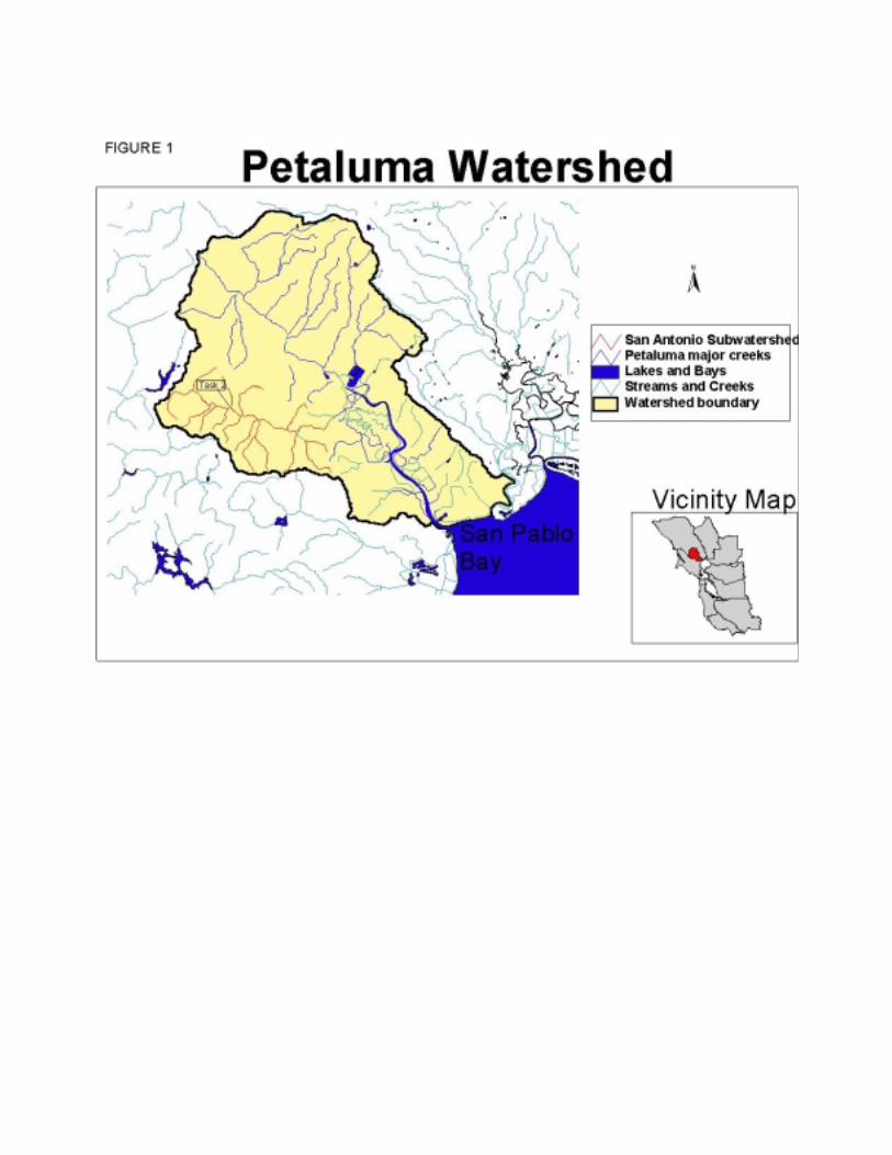

Figure 2 CONCEPTUAL MODEL PETALUMA RIVER WATERSHED Hypotheses being tested: If we assess, monitor, increase public understanding about and address stressors and limiting factorsinfluencing the health of the watershed, then the Petaluma watershed and San Pablo Bay health will be improved and the watershed will be removed from the State 303(d) list of Impaired Water Bodies. The subjects that we will address in this grant are italicized.
Watershed Forming Conditions Soils/geology Slope/aspect Local climate Land use past/present Tidal influence Water Quality
Factors Effecting Aquatic Conditions Water quality Channel stability Riparian conditions Sediment quality/quantity In-stream habitat structure Habitat connectivity Water quantity and timing Floodplain conditions Land use past/present Tidal marsh conditions
Assessment Monitoring Information exchange Adaptive Management
Public environmental understanding Policy and regulations Economic conditions
Factors outside of the watershed that influence watershed health
San Pablo Bay habitat conditions Tidal Influence Air Quality Ocean Conditions Global Climate changes
Distinctive characteristic of the Petaluma Watershed Largest intact marsh left in Bay Area, 5000acres
Key uncertainties -If we do address all negative factors influence health of watershed will the watershed health recover? -Will population numbers of T& E species respond positively to enhanced watershed health?
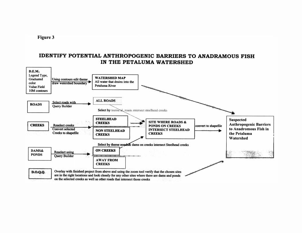
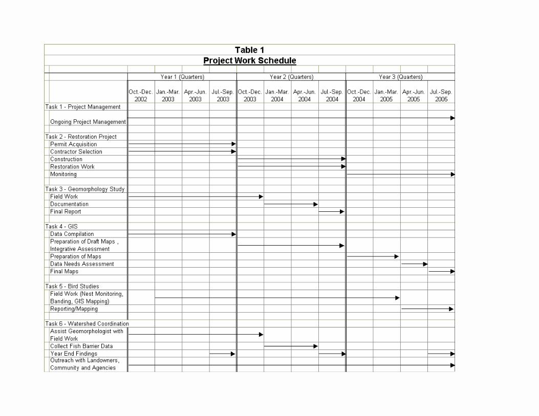

Attachment A Original letters from landowners available for verification. (They will not translate into a PDF file.)