phase i environmental site assessment - merced county
TRANSCRIPT

Appendix E Phase I Environmental Site Assessment

September 29, 2011Project #2825.0
Mr. Greg Swaffar,Summit Engineering, Inc.463 Aviation Blvd. Ste 200Santa Rosa, CA 95403
RE: REPORT: PHASE 1 ENVIRONMENTAL SITE ASSESSMENTGallo Winery Eastside Expansion of 18000 River Rd. Facility Livingston, CaliforniaMerced County APN 047-130-034 and 030
Dear Mr. Swaffar:
Bauer Associates (Bauer ) prepared the enclosed Phase 1 Environmental Site Assessment (ESA) for thereferenced property. We generally followed the ASTM E1527-05 format for Phase 1 ESA reports, aslimited by our Agreement, and by the report.
In addition, our format and scope of work includes as appropriate, additional rules under the guidelinesfor the US EPA’s “All Appropriate Inquiry” or AAI. Although the ASTM format (as modified by the AAIguidelines) is a broadly accepted standard for Phase 1 ESA’s, some users may require differentinformation, or may want the information presented in a different format. If the format needs to bedifferent, or if additional information is needed, Bauer will complete such revisions under an addendumto our Agreement. Our scope of work for this Phase 1 ESA did not include borings, sampling, testing, orlaboratory analysis of any substance at, in, on or to the subject property and adjacent properties.
It is our opinion that there are Recognized Environmental Conditions (REC) at the subject site (parcels047-130-034 and 030) as a result of use and storage of hazardous materials used in the wineryoperations. However, we discovered no evidence of residual hazardous materials or petroleum productcontamination. Significantly, the area of Parcel 030 proposed for the facility expansion had no RECs.____________________________________________________________________________________
Thank you for the opportunity to provide consulting services. Three hard copy(s) of this report, will besubmitted under separate cover. If you have any questions, please call us.
Sincerely,Bauer Associates
Marc W. Seeley, REA-IISenior Geologist & Registered Environmental Assessor
Enclosures: Phase 1 Environmental Site Assessment (PDF Version), GalloWinery Expansion of 18000 River Rd. Facility, Livingston, California, MercedCounty APN 047-130-034 and 030

REPORTPHASE 1 ENVIRONMENTAL SITE ASSESSMENT
Gallo Winery Eastside Expansion of 18000 River Rd. Facility Livingston, California
Merced County APN 047-130-034 and 030
Prepared For:
Mr. Greg Swaffar,Summit Engineering, Inc.
463 Aviation Blvd. Ste 200Santa Rosa, CA 95403
Prepared By:
Bauer AssociatesForestville, CA 95436
_______________________________________________________
David L. Bush, REA-I #08276Project Manager
Marc W. Seeley, REA-II #20157Senior Project Manager
Project #2825.0September 29, 2011

i
Bauer Associates
Table of Contents
1.0 EXECUTIVE SUMMARY.. . . . . . . . . . . . . . . . . . . . . . . . . . . . . . . . . . . . . . . . . . . . . . . . . . Page -1-
2.0 INTRODUCTION. . . . . . . . . . . . . . . . . . . . . . . . . . . . . . . . . . . . . . . . . . . . . . . . . . . . . . . . Page -2-2.1 Purpose. . . . . . . . . . . . . . . . . . . . . . . . . . . . . . . . . . . . . . . . . . . . . . . . . . . . . . . . . . Page -2-2.2 Scope of Services. . . . . . . . . . . . . . . . . . . . . . . . . . . . . . . . . . . . . . . . . . . . . . . . . . Page -5-2.3 Significant Assumptions. . . . . . . . . . . . . . . . . . . . . . . . . . . . . . . . . . . . . . . . . . . . . Page -6-2.4 Limitations and Exceptions. . . . . . . . . . . . . . . . . . . . . . . . . . . . . . . . . . . . . . . . . . . Page -7-2.5 Data Gaps. . . . . . . . . . . . . . . . . . . . . . . . . . . . . . . . . . . . . . . . . . . . . . . . . . . . . . . . Page -8-2.6 Special Terms and Conditions. . . . . . . . . . . . . . . . . . . . . . . . . . . . . . . . . . . . . . . . . Page -8-2.7 User Reliance. . . . . . . . . . . . . . . . . . . . . . . . . . . . . . . . . . . . . . . . . . . . . . . . . . . . . Page -9-2.8 Involved Parties. . . . . . . . . . . . . . . . . . . . . . . . . . . . . . . . . . . . . . . . . . . . . . . . . . . . Page -9-2.9 Shelf Life. . . . . . . . . . . . . . . . . . . . . . . . . . . . . . . . . . . . . . . . . . . . . . . . . . . . . . . . . Page -9-
3.0 GENERAL PROPERTY CHARACTERISTICS. . . . . . . . . . . . . . . . . . . . . . . . . . . . . . . . . Page -10-3.1 Site Location and Legal Description. . . . . . . . . . . . . . . . . . . . . . . . . . . . . . . . . . . Page -10-3.2 Site and Vicinity General Characteristics. . . . . . . . . . . . . . . . . . . . . . . . . . . . . . . . Page -10-3.3 Current Use of the Property.. . . . . . . . . . . . . . . . . . . . . . . . . . . . . . . . . . . . . . . . . Page -10-3.4 Description of Improvements. . . . . . . . . . . . . . . . . . . . . . . . . . . . . . . . . . . . . . . . . Page -11-
3.4.1 Structures. . . . . . . . . . . . . . . . . . . . . . . . . . . . . . . . . . . . . . . . . . . . . . . . Page -11-3.4.2 Roads. . . . . . . . . . . . . . . . . . . . . . . . . . . . . . . . . . . . . . . . . . . . . . . . . . . Page -12-3.4.3 Sewage Disposal. . . . . . . . . . . . . . . . . . . . . . . . . . . . . . . . . . . . . . . . . . Page -12-3.4.4 Water Supply. . . . . . . . . . . . . . . . . . . . . . . . . . . . . . . . . . . . . . . . . . . . . Page -13-3.4.5 Heating and Cooling Systems. . . . . . . . . . . . . . . . . . . . . . . . . . . . . . . . . Page -13-
3.5 Current Use of Adjoining Properties. . . . . . . . . . . . . . . . . . . . . . . . . . . . . . . . . . . Page -13-
4.0 USER PROVIDED INFORMATION.. . . . . . . . . . . . . . . . . . . . . . . . . . . . . . . . . . . . . . . . . Page -13-4.1 Title Reports. . . . . . . . . . . . . . . . . . . . . . . . . . . . . . . . . . . . . . . . . . . . . . . . . . . . . Page -13-4.2 Environmental Liens. . . . . . . . . . . . . . . . . . . . . . . . . . . . . . . . . . . . . . . . . . . . . . . Page -13-4.3 Use Limitations. . . . . . . . . . . . . . . . . . . . . . . . . . . . . . . . . . . . . . . . . . . . . . . . . . . Page -14-4.4 Specialized Knowledge. . . . . . . . . . . . . . . . . . . . . . . . . . . . . . . . . . . . . . . . . . . . . Page -14-4.5 Valuation Reduction for Environmental Issues.. . . . . . . . . . . . . . . . . . . . . . . . . . . Page -14-4.6 Owner, Property Manager, and Occupant Information.. . . . . . . . . . . . . . . . . . . . . Page -14-4.7 Reason for Performing Phase 1. . . . . . . . . . . . . . . . . . . . . . . . . . . . . . . . . . . . . . Page -15-
5.0 RECORDS REVIEW.. . . . . . . . . . . . . . . . . . . . . . . . . . . . . . . . . . . . . . . . . . . . . . . . . . . . Page -15-5.1 Standard Environmental Records Sources. . . . . . . . . . . . . . . . . . . . . . . . . . . . . . Page -15-5.2 Additional Environmental Sources. . . . . . . . . . . . . . . . . . . . . . . . . . . . . . . . . . . . . Page -18-5.3 Tribal Records. . . . . . . . . . . . . . . . . . . . . . . . . . . . . . . . . . . . . . . . . . . . . . . . . . . . Page -19-5.4 Physical Setting. . . . . . . . . . . . . . . . . . . . . . . . . . . . . . . . . . . . . . . . . . . . . . . . . . . Page -19-
5.4.1 Regional Physiographic Conditions.. . . . . . . . . . . . . . . . . . . . . . . . . . . . Page -19-5.4.2 Soil Conditions. . . . . . . . . . . . . . . . . . . . . . . . . . . . . . . . . . . . . . . . . . . . Page -19-5.4.3 Geologic Conditions . . . . . . . . . . . . . . . . . . . . . . . . . . . . . . . . . . . . . . . . Page -19-5.4.4 Ground Water Conditions. . . . . . . . . . . . . . . . . . . . . . . . . . . . . . . . . . . . Page -20-
5.5 Results of Site History and Land Use Review. . . . . . . . . . . . . . . . . . . . . . . . . . . . Page -20-5.5.1 Sanborn Fire Insurance Maps. . . . . . . . . . . . . . . . . . . . . . . . . . . . . . . . . Page -20-5.5.2 City Directory. . . . . . . . . . . . . . . . . . . . . . . . . . . . . . . . . . . . . . . . . . . . . Page -20-5.5.3 City Records Review. . . . . . . . . . . . . . . . . . . . . . . . . . . . . . . . . . . . . . . . Page -20-5.5.4 Aerial Photographs. . . . . . . . . . . . . . . . . . . . . . . . . . . . . . . . . . . . . . . . . Page -21-5.5.5 Personal Interviews.. . . . . . . . . . . . . . . . . . . . . . . . . . . . . . . . . . . . . . . . Page -23-5.5.6 Synopsis of Previous and Current Environmental Investigations.. . . . . . Page -23-5.5.7 Summary of Land Use. . . . . . . . . . . . . . . . . . . . . . . . . . . . . . . . . . . . . . Page -23-
ii
Bauer Associates
6.0 SITE RECONNAISSANCE.. . . . . . . . . . . . . . . . . . . . . . . . . . . . . . . . . . . . . . . . . . . . . . . Page -24-6.1 Methodology and Limiting Conditions. . . . . . . . . . . . . . . . . . . . . . . . . . . . . . . . . . Page -24-6.2 General Site Setting. . . . . . . . . . . . . . . . . . . . . . . . . . . . . . . . . . . . . . . . . . . . . . . Page -24-
6.2.1 Current Use of Subject Property. . . . . . . . . . . . . . . . . . . . . . . . . . . . . . . Page -25-6.2.2 Adjacent Off-Site and Vicinity Observations. . . . . . . . . . . . . . . . . . . . . . Page -25-
6.3 Exterior Observations. . . . . . . . . . . . . . . . . . . . . . . . . . . . . . . . . . . . . . . . . . . . . . Page -25-6.4 Interior Observations. . . . . . . . . . . . . . . . . . . . . . . . . . . . . . . . . . . . . . . . . . . . . . . Page -25-
7.0 INTERVIEWS. . . . . . . . . . . . . . . . . . . . . . . . . . . . . . . . . . . . . . . . . . . . . . . . . . . . . . . . . . Page -25-7.1 Interviews with Owner and Others. . . . . . . . . . . . . . . . . . . . . . . . . . . . . . . . . . . . . Page -27-7.2 Interviews with Occupants of Subject Property. . . . . . . . . . . . . . . . . . . . . . . . . . . Page -27-7.3 Interview with Local Officials. . . . . . . . . . . . . . . . . . . . . . . . . . . . . . . . . . . . . . . . . Page -27-
8.0 FINDINGS.. . . . . . . . . . . . . . . . . . . . . . . . . . . . . . . . . . . . . . . . . . . . . . . . . . . . . . . . . . . . Page -27-
9.0 CONCLUSIONS. . . . . . . . . . . . . . . . . . . . . . . . . . . . . . . . . . . . . . . . . . . . . . . . . . . . . . . . Page -31-
Attachment A Plates
Attachment B Site Photos
Attachment C EDR Radius Map w/ GeoCheck®
Attachment D EDR Historical Aerial Photography Service
Attachment E EDR Historical Topographic Map Report
Attachment F EDR City Directory Abstract
Attachment G EDR Sanborn Fire Insurance Map Coverage
Attachment H Proof of Qualifications

REPORT: PHASE 1 ENVIRONMENTAL SITE ASSESSMENTGallo Winery Expansion of 18000 River Rd. Facility Livingston, CaliforniaMerced County APN 047-130-034 and 030
Page 1
Bauer Associates
1.0 EXECUTIVE SUMMARY
Pursuant to the request and assignment of Mr. Greg Swaffar, President, Summit Engineering,Inc., (Client), Bauer Associates (Bauer), Consultant, performed a Phase 1 Environmental SiteAssessment (ESA) on Merced County APNs 047-130-034 and 030 on which is located theexisting E & J Gallo Winery Facility and the newer “Eastside Winery”, at 18000 River Road,Livingston, State of California (Plate 1, Site Location Map, Attachment A). The Client hasrequested this Phase 1ESA as part of the application process for Major Modification No. MM11-018 to Conditional Use Permit No. CUP2714 for the winery expansion to the east of the existingfacility. Also the Phase 1 ESA is to be used, among other documentation as part of theinformation needed to make a Preliminary Determination for the project as part of CEQAcompliance. The property consists of Merced County Assessor Parcel numbers 047-130-034and 030. The existing, major portion of the winery facility occupies both of these parcels, whilethe Eastside Winery is located on Parcel 047-130-034. The proposed expansion will be locatedon Parcel 047-130-034 to the east of Eastside Winery (Plate 2, Site Location Map, AttachmentA). The address 18000 River Road is that of the existing winery facility, not parcel 034.
Bauer and its’ Environmental Professionals researched the site history and historical records toidentify past and present land uses as part of due diligence to determine if RecognizedEnvironmental Conditions (RECs) may exist, or may have existed on the property. Our researchattempted to identify conditions indicative of an existing release, a past release, or a materialthreat of a release of any hazardous substances or petroleum products.
Bauer’s scope of research and records review consisted of subcontracting a regulatory agencyrecords review to Environmental Data Resources, Inc., conducting file reviews and/or inquiriesat the Merced County Department of Agriculture, the Merced County Department of Public Health- Division of Environmental Health (DEH), State GeoTracker Database, and others, inquiries withvarious personnel at the Gallo Winery facility and Gallo Vineyards, Inc. offices, review ofhistorical aerial photography and topographical maps, and other historical records, as well asinterviews with persons who have current and past knowledge of the property including thecurrent farming tenant, Singh Farms, and others, where possible. In addition, our EnvironmentalProfessional conducted a site reconnaissance of the property to visually observe existingconditions. We also observed the adjacent properties to the extent possible without crossingproperty lines.
Surface topography is flat lying at an elevation of approximately 112 ft. above mean sea level(MSL). The area of the subject site is located within an area of agricultural land use and is zonedA-1 (General Agricultural) and located about 4 miles west of the City of Livingston, California.Access to the site is via River Road, and the property is located between Griffith Avenue andVinewood Avenue.
The subject property appears to have been historically used as agricultural land since at least1946 based on the historic air photos. Based on our review of historic topographic maps the sitehas been undeveloped or in agricultural use dating back to at least 1917. The surrounding area

REPORT: PHASE 1 ENVIRONMENTAL SITE ASSESSMENTGallo Winery Expansion of 18000 River Rd. Facility Livingston, CaliforniaMerced County APN 047-130-034 and 030
Page 2
Bauer Associates
has remained in agricultural use from at least the date of the earliest air photos (1946) throughthe present. Development of the existing winery facility was completed in 1970, with the additionof the Eastside Winery, that consists of an unloading facility, de-stemming/crushing andfermenting addition, and a pilot plant, on the northeastern part of parcel 047-130-034 in 2001.
The site of the proposed facility expansion on parcel 047-130-034 (to the east of the EastsideWinery), is leased to Singh Farms and is currently planted in sweet potatoes. Currentdevelopment of this parcel is limited to an irrigation well, irrigation improvements that includebelow grade irrigation pipes, winery process water distribution pipes, stand pipes, and an atgrade irrigation pump with a poly tank for fertilized injection into the irrigation water. Also alongthe eastern portion of parcel 047-130-034 is a marked underground cable, and farther to theeast, possibly on the adjacent parcel, is a marked underground gas pipeline.
Adjacent and nearby properties to the north, south, and east of the subject property aredeveloped as agricultural properties. The property to the west of the proposed expansion facilityis occupied by the existing Gallo Winery facility. The site of the proposed facility expansion liesabout 2000 feet south of the Merced River. Just to the north of the newer Eastside Winery(unloading facility, de-stemming/crushing and fermenting) on the southwestern part of parcel 047-130-030 is a discharge pond (approximately 650 ft x 300 ft), that was used for process waterdischarge prior to the early 1980's and is no longer in use.
The term Recognized Environmental Condition is defined, pursuant to the ASTM 1527-05Standard of Practice, in Section 2.1 of this report. During our site research and sitereconnaissance, we identified Recognized Environmental Conditions (RECs) on parts of the twoparcels that are the subject of this assessment, but not on the part planned for the wineryexpansion. These RECs are described as follows:
1). Recognized Environmental Conditions (REC) exist on that portion of theproperty occupied by the main winery and the “Eastside Winery”. These RECs arerelated to:
a) A very old (1965), possible UST leak associated with the compostingoperation or an associated trucking operation (reported on Geotracker withno subsequent action). This and four 1970's era fuel tanks are also listedin the current EDR Radius Report.
b) A past ammonia leak in the cooling system at the main winery for whichcorrective action has been taken,
c) The current production, use and storage of significant quantities ofhazardous materials for the winery operations. This REC is not related toexisting contamination of the property from spills, leaks or unauthorizeddischarges. The production, use and storage of hazardous materials resultsin the determination of a REC.
REPORT: PHASE 1 ENVIRONMENTAL SITE ASSESSMENTGallo Winery Expansion of 18000 River Rd. Facility Livingston, CaliforniaMerced County APN 047-130-034 and 030
Page 3
Bauer Associates
2) Recognized Environmental Conditions (REC) do not exist on the part of theproperty planned for the facility expansion.
It is the opinion of Bauer Associates, based on our site research and site reconnaissance, andin accordance with the US EPA’s All Appropriate Inquiries (AAI, Section 2.1 of this report ), thatthere are Recognized Environmental Conditions (RECs) at the part of the property occupied bythe winery and associated operations, but not on that part of the property proposed for theexpansion project. We did not identify conditions which would indicate RECs exist on sites in thevicinity of the subject property.
The determination of a REC for these parcels is due to the use and storage of significantquantities of various caustic chemicals for equipment and process disinfection. These includepotassium hydrochloride, chlorine dioxide, sulphur dioxide, and “Cenerox 207A” (a chlorinesolution). At the main or older winery facility there is also a significant quantity of liquid ammoniaused for cooling, and there are two 500 gallon Aboveground Storage Tanks (ASTs), onecontaining gasoline and one containing diesel. The State GeoTracker database and the EDRreport indicates a leaking UST on the older part of the facility dating from 1965, apparently in thecomposting facility. The EDR report also indicates four fuel tanks installed in the 1970's. Theolder section of the winery also generates and stores large quantities of distilled spirits (ethylalcohol) as a product, and distillery sludge contains residual ethyl alcohol. A listing of allhazardous materials and their quantities is included in the Gallo Winery facility HazardousMaterials Business Plan.
The following sections present the Phase I Environmental Site Assessment (Phase I ESA),prepared in accordance with the ASTM E1527-05 Standard of Practice and the US EPA’s AllAppropriate Inquiries (AAI).
2.0 INTRODUCTION
It is our understanding that the Client has requested this Phase 1ESA as part of the applicationprocess for Major Modification No. MM11-018 to Conditional Use Permit No. CUP2714. Also thePhase 1 ESA is to be used, among other documentation, as part of the documentation neededto make a Preliminary Determination for the project as part of CEQA compliance. The propertyconsists of Merced County Assessor Parcel numbers 047-130-034 and 030. The existing, majorportion of the winery facility occupies parcel 047-130-030 and the newer Eastside Winery facilityis located on parcel 047-130-034. The address 18000 River Road is that of the existing wineryfacility, not parcel 034.
2.1 Purpose
The purpose of this Phase 1 Environmental Site Assessment (ESA) is to provide a review andevaluation of existing available information concerning the property herein referred to as MercedCounty APN 047-130-034 and 030 (Plate 1, Site Location Map).

REPORT: PHASE 1 ENVIRONMENTAL SITE ASSESSMENTGallo Winery Expansion of 18000 River Rd. Facility Livingston, CaliforniaMerced County APN 047-130-034 and 030
Page 4
Bauer Associates
Information for this ESA was provided by the Client, as well as from interviews with Gallopersonnel who have knowledge of the property, our review, and evaluation of currently availableinformation concerning the property as contained in various records of the federal, state, tribal,and local government regulatory agencies concerned with the property.
The purpose of a Phase 1 ESA is to provide information as to the presence, if any, ofRecognized Environmental Conditions which may or may not be in connection with the subjectproperty or properties near the aforementioned property. This Phase 1 Environmental SiteAssessment generally follows the guidelines established by the American Society for Testing andMaterials (ASTM) in the document entitled "Standard Practice for Environmental SiteAssessments: Phase I Environmental Site Assessment Process" and designated E 1527-05 andit incorporates requirements of the US EPA’s All Appropriate Inquiries (AAI) rules (40 C.F.R. Part312, Standards for Conducting All Appropriate Inquiries). The purpose did not include providinga facility compliance audit or any other scope beyond that of a Phase 1 ESA.
A goal of the Phase 1 ESA typically is to identify Recognized Environmental Conditions withrespect to the range of contaminants within the scope of the Comprehensive EnvironmentalResponse, Compensation and Liability Act (CERCLA) and petroleum products. Under the AAIrule this Phase 1 ESA also serves to identify conditions indicative of an existing release, a pastrelease, or a material threat of a release of any hazardous substances or petroleum products,on the subject site.
As such, the Phase 1 ESA would permit the property Owner (E & J Gallo Winery) to satisfy oneof the requirements to qualify for the innocent landowner defense for CERCLA liability if preparedduring the property acquisition process. The Owner should consult with an attorney to fully coverlegal questions and to determine additional requirements needed to qualify for the innocentlandowner defense for CERCLA liability, should the need for such a defense arise. Since theproperty may or may not change ownership as a part of the proposed facility expansion, weadvise the Owner (E & J Gallo Winery) to have their legal counsel review this aspect of thePhase 1 ESA (i.e. innocent landowner defense). Further, it is our understanding that compliancewith CEQA requires that a Phase 1 ESA be prepared for the site of the proposed facilityexpansion. This assessment, in addition to other typical uses, is intended to fulfill thatrequirement for CEQA processing.
The Scope of Services for this Phase I Environmental Site Assessment as conducted by Bauerconsisted of four components: Records Review, Site Reconnaissance, Interviews, and Report.The objective of the first three components under the ASTM standard is to help identifyRecognized Environmental Conditions in connection with the aforementioned property.
Recognized Environmental Conditions are defined as:
“The presence or likely presence of any hazardous substances or petroleum products ona property under conditions that indicate an existing release, a past release, or a materialthreat of a release of any hazardous substances or petroleum products into structures on

REPORT: PHASE 1 ENVIRONMENTAL SITE ASSESSMENTGallo Winery Expansion of 18000 River Rd. Facility Livingston, CaliforniaMerced County APN 047-130-034 and 030
Page 5
Bauer Associates
the property or into the ground, groundwater, or surface water of the property. The termincludes hazardous substances or petroleum products even under conditions in compliancewith laws. The term is not intended to include de minimis conditions that generally do notpresent a material risk of harm to public health or the environment and that generally wouldnot be the subject of an enforcement action if brought to the attention of appropriategovernmental agencies. Conditions determined to be de minimis are not recognizedenvironmental conditions.” (ASTM E 1527-05, 1.1.1 Recognized Environmental Conditions)
In addition, pursuant to the ASTM E-1527-05 Standard of Practice and the AAI standard,Recognized Environmental Conditions do not include Asbestos Containing Materials, Mold, orLead-based paint or other non-CERCLA related conditions (i.e. regulatory compliance, wetlands,indoor air quality, flood zones, soils and geologic conditions, etc.). Therefore identification ofthese conditions are not a part of this scope of work.
We recommend that the Client consult with a professional specializing in these areas to conductan assessment for these issues, if needed.
2.2 Scope of Services
The Scope of Services for this Phase I Environmental Site Assessment consists of four overalltasks:
< Task I: Research and review of regulatory information.< Task II: A site reconnaissance of subject property and overview of nearby property.< Task III: Interviews of persons with knowledge of subject and surrounding property.< Task IV: Preparation of the final Environmental Site Assessment Report.
The Scope of Services for this Phase I Environmental Site Assessment generally follows theStandard Practice for Environmental Site Assessments designated as E 1527-05 of the ASTMand the US EPA’s All Appropriate Inquiries (AAI) rule. Accordingly, the Phase I EnvironmentalSite Assessment is targeted toward the range of contaminants within the scope of theComprehensive Environmental Response, Compensation and Liability Act (CERCLA) andpetroleum products. As such, “appropriate inquiry into the previous ownership and uses of theproperty consistent with good commercial or customary practice” as defined in 42 USC9601(35)(B) is applied within the AAI rule. However, an evaluation of business environmentalrisk associated with a parcel of real estate may necessitate investigation beyond that identifiedin this assessment.
With regard to Task II, the site reconnaissance or site visit, the AAI standards recognize that thisis one component of the assessment that should be conducted by a qualified EnvironmentalProfessional (or EP) as defined by the EPA. Therefore all site visits made by Bauer wereconducted by EP’s. Refer to Proof of Qualifications section included as Attachment H.

REPORT: PHASE 1 ENVIRONMENTAL SITE ASSESSMENTGallo Winery Expansion of 18000 River Rd. Facility Livingston, CaliforniaMerced County APN 047-130-034 and 030
Page 6
Bauer Associates
The Scope of Services includes observations for Recognized Environmental Conditions, as wellas information that can be obtained from regulatory files that are obtainable without investigationinto archives of the various agencies. Accordingly, it cannot be guaranteed that all files areexamined or that every contingency is investigated. In some cases entities such as tribalauthorities may have no records or they may not be open to review. These limitations are inconformance with the stated guidelines of ASTM Standard of Practice E 1527-05 Sections7.1.4.1, 7.1.4.2 and 7.1.4.3.
The Records Review includes files available at federal, state, county, tribal, local, and otherpublic agency offices as listed in Section 5.1 and 5.2 of this report. In some cases, the statusof a site is determined from telephone interviews of staff persons of these offices. The SiteReconnaissance consists of the subject property, adjacent properties (especially with regard tostorage tanks), and the identification of nearby properties. Interviews are conducted of personsreasonably available at the time of the Site Reconnaissance, and on occasion, by telephonewhen such interviews are possible. The report format generally follows the guidelines of theASTM E 1527-05 Standard Practice for Environmental Site Assessments: Phase I EnvironmentalSite Assessment Process, and as modified by the US EPA AAI rule.
2.3 Significant Assumptions
The Phase I Environmental Site Assessment (ESA) is intended to assess the environmentalconditions of the referenced parcels of agricultural zoned real estate. It is intended to constituteall appropriate inquiry for purposes of CERCLA’s innocent landowner defense; however, it is notintended to be limited to that purpose. In this case the purpose is to provide information neededfor CEQA evaluation and processing of the proposed development.
Also under the AAI rule a Phase I ESA alone does not provide the landowner with protectionagainst CERCLA liability. Failure to identify an environmental condition during AAI does notrelieve the landowner from complying with other statutory requirements for obtaining liabilityprotections.
This Phase I ESA is intended to reflect a commercially prudent and reasonable inquiry designedto recognize environmental conditions in connection with a property.
It is understood by the parties hereto, that the Client is requesting the assessment set forth in thisESA, to comply with due diligence, and to evaluate environmental risk prior to comply with therequirements of the CEQA evaluation of the proposed development of the property. We assumethat the Client, and all other parties we contacted, have acted in good faith, and providedcomplete information based on their knowledge and understanding of the property and its history.
Lastly, we assume that the records we reviewed, and those records searched through ourdatabase subcontractor, are reasonably complete and accurate.

REPORT: PHASE 1 ENVIRONMENTAL SITE ASSESSMENTGallo Winery Expansion of 18000 River Rd. Facility Livingston, CaliforniaMerced County APN 047-130-034 and 030
Page 7
Bauer Associates
2.4 Limitations and Exceptions
The Scope of Services performed to complete this Phase I Environmental Site Assessment islimited in nature. While we consider work of this type to be valuable in the preliminary evaluationof potential hazardous materials or waste at a site, we also must alert the Client that thisassessment may not reveal hazardous materials releases that have occurred. Also, the siteconditions can change with time, and our assessment is not intended to predict future or hiddensite conditions. Because of the limited nature of this assessment, this report is not a riskassessment and the Scope of Services does not include a determination of the extent ofbusiness environmental risk nor the public health impact of, known, or suspected hazardousmaterials or wastes.
This service has been performed in accordance with generally accepted environmentalassessment practices for similar Phase I ESA’s conducted at this time and in this geographicarea. No other guarantees or warranties, expressed or implied, are provided.
No samples were collected or analyzed as a scope of this Phase I ESA. The scope of work forthis Phase 1 Environmental Site Assessment of potential hazardous materials, excludes wetlandissues, determination of flood zones, as well as addressing or sampling for suspect mold,asbestos containing materials (ACM), radon, or lead at the property.
Under the AAI rule, a Phase I ESA alone does not provide the landowner with protection againstCERCLA liability. Failure to identify an environmental condition during AAI does not relieve thelandowner from complying with other statutory requirements for obtaining liability protections.Our scope of services expressly excludes the determination of additional liability protections thatmay be required by the Client or landowner. Expert legal counsel should be obtained for sucha determination.
The AAI rule states that searches for environmental liens must be conducted, however AAIindicates this may be a user responsibility. For purposes of this Phase I ESA our search forenvironmental liens was limited to what was provided to us by the Client or by our subcontractedregulatory records search company Environmental Data Resources, Inc. (EDR). If weencountered an environmental lien as part of our scope of services it is reported. An additionalsearch of environmental liens was not included in the scope of work and the Client is advised thatreports of environmental liens contained herein are not to be construed as a complete listing ofsuch liens.
We understand that the Client agrees to hold Consultant harmless for any inverse condemnationor devaluation of said property that may result if the Consultant's report, or informationgenerated, is used for other purposes. Although not a part of our scope of work, we are prepared

REPORT: PHASE 1 ENVIRONMENTAL SITE ASSESSMENTGallo Winery Expansion of 18000 River Rd. Facility Livingston, CaliforniaMerced County APN 047-130-034 and 030
Page 8
Bauer Associates
to meet with the Client and discuss the findings, if so requested. Because property uses andconditions can change over time, this Phase 1 ESA is valid for a period of 180 days from its dateof issue (see Section 2.9 Shelf Life). However, if during this 180-day period any of the interestedparties become aware of any changed condition it is the responsibility of that person to notify theClient. Bauer and its subcontractors are explicitly exempt from liabilities associated with changedconditions that occur after the date of our last site visit.
2.5 Data Gaps
This section addresses the US EPA’s All Appropriate Inquiries (AAI) rule for documentation ofdata gaps. The ownership of the property was based on information provided to Bauer by Clientand the Owner’s representatives, and based on our review of historical aerial and topographicmapping and other records. The current owner purchased the property in 1970, and prior to thattime, the site was used as agricultural land since at least 1946 based on the historic air photos.Based on our review of historic topographic maps the site has been undeveloped or inagricultural use dating back to at least 1917. The surrounding area has remained in agriculturaluse from at least the date of the earliest air photos (1946) through the present. Development ofthe existing older portion of the winery facility was completed in 1970 with the addition of theEastside Winery consisting of an unloading facility, de-stemming/crushing and fermentingaddition, and a pilot plant, on the northwestern part of parcel 047-130-034 in 2001. We were notable to review files with the Merced County Environmental Health Division due to their approvalprocess time. The use of the property prior to 1917 is not known.
2.6 Special Terms and Conditions
This Phase 1 ESA addresses two parcels, Merced County APNs 047-130-034 and 030 whichconsists of farmed land, an older (1970) large winery facility and associated operations (e.g.sludge composting), a newer winery and pilot winery facility (referred to as the “Eastside Winery”)and a small portion of parcel 030 to the east of the Eastside Winery which is proposed for thewinery expansion project.
The Scope of Services for this Phase I Environmental Site Assessment does not include analysisof Asbestos Containing Materials (ACM), although if obvious visual indications of ACM areobserved, they are reported. Neither does the Scope of Services include analysis of the buildingconstituents for mold, lead based paint, lead in water pipes or fixtures, or other non-CERCLArelated conditions (i.e., regulatory compliance, wetlands, indoor air quality, radon, groundwater,soils and geologic conditions, etc.).
It is our understanding that the Owner, the Client, and the Client’s agents, agree to limit the useof information developed about this property and presented herein, to providing such information
REPORT: PHASE 1 ENVIRONMENTAL SITE ASSESSMENTGallo Winery Expansion of 18000 River Rd. Facility Livingston, CaliforniaMerced County APN 047-130-034 and 030
Page 9
Bauer Associates
to the Clients’ legal counsel, prospective lenders, or to satisfy regulatory agency requirements.No other use or disclosure is intended by Consultant.
Client agrees to hold Consultant harmless for any inverse condemnation or devaluation of saidproperty that may result if the Consultant’s report or information generated is used for otherpurposes. Also, this report is issued with the understanding that it is to be used and is valid for180 days from the date of issue.
2.7 User Reliance
Only E&J Gallo Winery, their representatives, regulators processing permit application, and theiragents may rely upon this report. No other person or entity may have reliance upon this reportwithout the express written consent of Bauer (Consultant).
2.8 Involved Parties
The primary parties involved are Mr. Greg Swaffar, President, Summit Engineering, Inc. (Client),E&J Gallo Winery, (Owner) who are in the application process for Major Modification No. MM11-018 to Conditional Use Permit No. CUP2714 and submitting information required for aPreliminary Determination for the project as part of CEQA compliance. Other involved partiesare, Mr. David L Bush, Project Geologist, and Mr. Marc W. Seeley, Senior Project Geologist,Consultants for Bauer, the Environmental Professionals (EPs) who prepared this ESA. Theseparties are also listed in Section 7.0.
2.9 Shelf Life
The US EPA’s AAI rule guidance considers a Phase 1 ESA generally valid for a period of up toone year provided there are no material changes to the use of the property, and the condition ofthe property.
Because of the likelihood of changed conditions, the US EPA advises that after 180 days fromthe date of issue, the following sections of the Phase 1 ESA should be updated: 1) interviews,2) reviews of federal, state, tribal, and local government records, 3) searches for recordedenvironmental cleanup liens, 4) visual site and adjoining property inspections (site and areareconnaissance), 5) declaration by Environmental Professional responsible for the assessmentor update.
It is the position of Bauer and the ASTM E 1527-05 (Section 4.0) that the Phase 1 ESA shouldnot be relied upon if there is any material change to the use of and the condition of the propertysince the date of the Phase 1 ESA, and in all cases the Phase 1 ESA should not be considered

REPORT: PHASE 1 ENVIRONMENTAL SITE ASSESSMENTGallo Winery Expansion of 18000 River Rd. Facility Livingston, CaliforniaMerced County APN 047-130-034 and 030
Page 10
Bauer Associates
valid after 180 days. This ESA is issued with the 180 day shelf life as a limit (see Section 2.4Limitations and Exceptions).
3.0 GENERAL PROPERTY CHARACTERISTICS
3.1 Site Location and Legal Description
Site Address: 18000 River Rd.Livingston, California
County: Merced
Assessor’s Designation: APN 047-130-034 and 030
U. S. G. S. Quadrangle: Turlock, 7.5’
Latitude, Longitude: 37.3778 degrees North, 120.8086 degrees West
3.2 Site and Vicinity General Characteristics
The subject property which consists of two assessor parcels, is located in the San JoaquinValley, about 4 miles west of the of the City of Livingston, California. The property isgenerally flat lying at an elevation of approximately 112 ft above mean sea level (MSL) in anarea of agricultural land use, and is zoned A-1 (General Agricultural). Access to the site is viaRiver Road, and the property is located between Griffith Avenue and Vinewood Avenue. Adjacent and nearby properties to the north, south, west and east of the subject property aredeveloped as agricultural properties. The existing Gallo Winery facility is located on MercedCounty APNs 047-130-034 and 030, and the adjacent “Eastside Winery” is located onMerced County APN 047-130-034. The site of the proposed facility expansion lies about2000 feet south of the Merced River and is on APN 047-130-030 adjacent to and east of the“Eastside Winery”.
3.3 Current Use of the Property
The northwestern part of parcel 047-130-034 is occupied by the newer Eastside Winery(unloading facility, de-stemming/crushing and fermenting, and pilot plant). Adjoining theEastside Winery is the older, larger winery which is on Parcels 047-130-030 and 034. Theremaining parts (majority) of the site (parcels 047-130-034 and 030) are in agricultural use,presently planted in sweet potatoes and other crops. Photos 1 through 6, Attachment B,

REPORT: PHASE 1 ENVIRONMENTAL SITE ASSESSMENTGallo Winery Expansion of 18000 River Rd. Facility Livingston, CaliforniaMerced County APN 047-130-034 and 030
Page 11
Bauer Associates
present a general overview of the property. Refer to Plate 2 of this Report for the SiteOverview Map (Attachment A).
3.4 Description of Improvements
The subject property consists of Merced Assessor Parcels 047-130-034 and 030. Thesouthern of the two parcels, 047-130-034, is mostly agricultural land. Parcel 030 and a partof 034 is occupied by the larger, original winery facility constructed in 1970, paved parking,access roads, a solar array, and a composting facility. This parcel also contains a dischargepond (approximately 650 ft x 300 ft), that was used for process water discharge prior to theearly 1980's and is no longer in use. Parcel 047-130-034 is primarily agricultural land, but thenorthwest corner is developed with the “Eastside Winery” which was constructed in 2001. This consists of unloading facility, de-stemming/crushing and fermenting, and pilot plant,concrete and asphalt paved areas, and access roads.
3.4.1 Structures
The older portion of the winery site is parcels 047-130- 030 and 034, and the newer EastsideWinery is on parcel 047-130-034. The structures on these parcels are as follows:
Steam PlantOne gas-fired boiler, 150 psig operating pressure, 120,000 lb/hr max steam generationOne gas-fired boiler, 150 psig operating pressure, 75,000 lb/hr max steam generation
Distillery3 sets of stripping/rectifying columns (1- 84”, 2-72”)3 aldehyde columns (1-72”, 1-54”, 1-53”-decommissioned)All distillation columns steam driven
Juice EvaporatorFalling film plate & frame, 4 effect, 6 stageSteam driven
Refrigeration15,300 nominal tons ammonia cooled refrigeration units
Tank FarmDedicated distilled spirits processing and storage = 26 tanks, ranging in size from1,800 gallons to 636,000 gallons.
Wine storage and fermentation tanks:

REPORT: PHASE 1 ENVIRONMENTAL SITE ASSESSMENTGallo Winery Expansion of 18000 River Rd. Facility Livingston, CaliforniaMerced County APN 047-130-034 and 030
Page 12
Bauer Associates
126 @ 637,000-gallon nominal capacity124 @ 350,000-gallon nominal capacity33 @ 335,000-gallon nominal capacity (1 tank dedicated for potablewater storage)60 @ 214,000-gallon nominal capacity (1 tank currently damaged andunusable)63 @ 102,000-gallon nominal capacity (1 tank dedicated for boiler feedwater)20 @ 63,000-gallon nominal capacity55 @ 54,000-gallon nominal capacity
Grape Processing Equipment4 receiving pits (west side)22 membrane presses (west side)17 screw presses (west side)1 receiving pit (east side)2 membrane presses (east side)
BuildingsMain Office/Administration – southwest end of the plantProduction Office/Analytical Lab/Employee Breakroom – center of plantOperations Processing Building – center of plantOffice trailers (3) – center of plantFood Ingredient Warehouse (current) – west central part of plantWine making office trailers – east edge of plant
3.4.2 Roads
The site is accessed via River Road (Plate 1, Attachment A). On the site there are a numberof paved and unpaved roads on the property.
3.4.3 Sewage Disposal
Facility process water which consists of equipment, tank and piping wash water, and relatedsources of waste water used in the winery operations routes to a central sump which isdischarged under RWQCB permit to agricultural areas of the subject parcels and adjacentparcels owned by E&J Gallo Winery or its related ranch land holding business. Distribution isvia a network of underground piping. Discharge is conducted in compliance with WasteDischarge Requirements permitting from the Regional Water Quality Control Board. Waste from Main Office and Production Office restrooms goes to underground septic tanks.

REPORT: PHASE 1 ENVIRONMENTAL SITE ASSESSMENTGallo Winery Expansion of 18000 River Rd. Facility Livingston, CaliforniaMerced County APN 047-130-034 and 030
Page 13
Bauer Associates
3.4.4 Water Supply
The site water supply consist of process (potable) water and cooling water (non potable). The Process water is supplied by 4 fresh water wells, located offsite on Gallo Ranch property. The cooling water is pumped from the Merced River to a storage tank on winery property fordistribution in the winery.
3.4.5 Heating and Cooling Systems
The office buildings on the property are equipped with central natural gas heat and electric airconditioning system. Winery process systems are cooled by water sourced from the MercedRiver and with an ammonia based refrigeration system.
3.5 Current Use of Adjoining Properties
Adjacent and nearby properties to the north, south, west and east of the subject property aredeveloped as agricultural properties. The property to the west of the proposed wineryexpansion is occupied by the existing East side Winery and the Gallo Winery facility. The siteof the proposed facility expansion lies about 2000 feet south of the Merced River (Photo 2,Attachment B).
4.0 USER PROVIDED INFORMATION
4.1 Title Reports
Copies of parts of four Title Reports were provided by the Gallo legal department. Mr. TimByrd, (209-341-3716), reported that the land was acquired over a period of years between1956 and 1983.
4.2 Environmental Liens
The AAI rule states that searches for environmental liens must be conducted, however AAIindicates this may be a user responsibility. For purposes of this Phase I ESA our search forenvironmental liens consisted of what was provided to us by our subcontracted regulatoryrecords search company Environmental Data Resources, Inc. (EDR), which did not indicatean environmental lien exists associated with the property. We also submitted a request toGallo’s legal department, Mr. Tim Byrd, (209-341-3716) he reported there were noenvironmental liens.

REPORT: PHASE 1 ENVIRONMENTAL SITE ASSESSMENTGallo Winery Expansion of 18000 River Rd. Facility Livingston, CaliforniaMerced County APN 047-130-034 and 030
Page 14
Bauer Associates
4.3 Use Limitations
The information contained in this Phase I ESA is for the sole use of the Owner, the Client,and the Client’s and Owner’s agents, including their legal counsel, to satisfy regulatoryagency requirements including permitting and CEQA requirements. No other use ordisclosure is intended by Consultant. No other person or entity may have reliance upon thisreport without the express written consent of Bauer (Consultant). This report is to be usedonly in its entirety.
4.4 Specialized Knowledge
Background information pertaining to the property was provided by Mr. John Pardiso, E&JGallo Senior Technical Manager, Mr. Parm Dhaliwal, Gallo Ranch Manager, Mr. JohnChavez, E&J Gallo Environmental Manager, Mr. Nick Wilhem, Simplot, and others as listed inSection 5.5.5. Personal Interviews. Bauer reviewed the information provided from thesesources as part of this assessment to evaluate the presence of current or past RecognizedEnvironmental Conditions (RECs) on the subject property.
4.5 Valuation Reduction for Environmental Issues
Bauer identified Recognized Environmental Conditions (RECs) on parts of the subjectparcels. However, these RECs are primarily related to the use and storage of significantquantities of hazardous materials for the winery operations, and not to existing contaminationof the property from spills, leaks or unauthorized discharges. We recommend the Client orOwner seek professional assistance with property valuation matters if valuation issues are aconcern.
The term Recognized Environmental Conditions is defined, pursuant to the ASTM 1527-05Standard of Practice, in section 2.1 of this report.
4.6 Owner, Property Manager, and Occupant Information
Current Owner: E & J Gallo Winery, Inc.18000 River Road, Livingston, CA
Previous Tenants: Portions of Parcel 047-130-034, leased in 2009 and 2011 toSingh Farms, 13388 Longview Rd., Livingston, CA 95334209-394-3879

REPORT: PHASE 1 ENVIRONMENTAL SITE ASSESSMENTGallo Winery Expansion of 18000 River Rd. Facility Livingston, CaliforniaMerced County APN 047-130-034 and 030
Page 15
Bauer Associates
Previous occupant information is based on our review of information from Gallo RanchManager, Parm Dhaliwal, (209-394-5880), and may not be a complete list. The agriculturalareas of parcels 047-130-034 and 030 are either leased to farmers or planted by farmingoperations of Gallo. Cover crops planted by Gallo and / or tenants include corn, oats, andsweet potatoes. The cover crops are planted to absorb nitrates from process waterdischarged to soil under permit. Gallo has been doing this for the past 10 to 11 years. Priorto this use the land was planted in grapes. Process water has been discharged to the land(including the area of the proposed facility expansion) since the winery started producing in1970.
4.7 Reason for Performing Phase 1
The Client has requested this Phase 1 ESA as part of the application process for MajorModification No. MM11-018 to Conditional Use Permit No. CUP2714. Also the Phase 1 ESAis to be used, among other documentation as part of the information needed to make aPreliminary Determination for the project as part of CEQA compliance. The property consistsof Merced County Assessor Parcel numbers 047-130-034 and 030. The existing, majorportion of the winery facility occupies parcel 047-130-030 and a small part of 034 TheEastside Winery facility is located on parcel 047-130-034. The proposed expansion will be onparcel 047-130-034. This Phase I ESA is also intended to reflect a commercially prudent andreasonable inquiry designed to identify Recognized Environmental Conditions in connectionwith the property.
5.0 RECORDS REVIEW
The records review for this Phase I ESA consisted of subcontracting a regulatory agency filereview to Environmental Data Resources, Inc. (EDR), making follow up inquiries with theMerced County Environmental Health Division, Merced County Department of Agriculture,California Department of Toxic Substances Control (DTSC), Clovis Office, California RegionalWater Quality Control Board (RWQCB), Fresno Office, State GeoTracker Database, personswith knowledge of the property, and researching historic aerial photos and topographicalmaps, and other historical records.
5.1 Standard Environmental Records Sources
The ASTM E 1527-05 and US EPA AAI standards include research of a number of sources ofpublic information compiled by various regulatory agencies for their specific purposes. Theseinclude federal, state, tribal, and local agencies, and some of these sources containoverlapping information. If a site is listed with some of these agency databases it does notnecessarily mean there is a contamination problem at the site. If there is a problem at the

REPORT: PHASE 1 ENVIRONMENTAL SITE ASSESSMENTGallo Winery Expansion of 18000 River Rd. Facility Livingston, CaliforniaMerced County APN 047-130-034 and 030
Page 16
Bauer Associates
listed site it does not necessarily mean the contamination extends off site to other properties. As noted above we retained the services of Environmental Data Resources, Inc. (EDR) toconduct an ASTM / AAI standard database search for this section of the Phase I ESA, usingthe part of the subject site where the facility expansion is proposed as the “target site”. Distances and directions of listed sites below are referenced from the “target site”, which isthe project site (the northwest corner of parcel 047-130-034, adjacent to and just east of theEastside Winery).
The search by EDR looked at the sources which are listed and described in the following sub-paragraphs. The findings and search distances for each database search are alsosummarized in the attached EDR report. The EDR report from which this summary isextracted is attached to this Phase 1 ESA. The EDR Report dated September 13, 2011includes a number of radius maps that locate and identify the various sites identified in thefollowing summary paragraphs. The reader is advised to refer to the EDR report and itsmaps, which are attached to this report (Attachment C).
US EPA TRIS (Toxics Release Inventory System) contains information from facilitieson the amounts of over 300 listed toxic chemicals that these facilities release directly toair, water, land, or that are transported off-site. A review of the TRIS list, as providedby EDR in their report, has revealed that the site is listed as a TRIS site.
HIST UST: Historical UST Registered databases. A review of the HIST UST list, asprovided by EDR has revealed that there is a HIST UST on the site. The listingshows three diesel tanks( 2 installed in 1977 and 1 in 1970) and one gasolinetank (installed in 1973).
CHMIRS (The California Hazardous Material Incident Report System) containsinformation on reported hazardous material incidents, i.e., accidental releases or spills. The source is the California Office of Emergency Services. A review of the CHMIRSlist, as provided by EDR in their report, has revealed that the target property is listedas a CHMIRS site.
HAZNET: These data are extracted from the copies of hazardous waste manifestsreceived each year by the DTSC (California Department of Toxic Substance Control). Data are from the manifests submitted without correction, and therefore many containsome invalid values for data elements such as generator ID, TSD ID, waste category,and disposal method. The source is the DTSC. A review of the HAZNET list, asprovided by EDR in their report, has revealed that the target property is listed on theHAZNET database. The database indicates that Coleman Transportation, 18000River Rd., not the E & J Gallo Winery is listed.

REPORT: PHASE 1 ENVIRONMENTAL SITE ASSESSMENTGallo Winery Expansion of 18000 River Rd. Facility Livingston, CaliforniaMerced County APN 047-130-034 and 030
Page 17
Bauer Associates
SWEEPS (Statewide Environmental Evaluation and Planning System) is anunderground storage tank listing was updated and maintained by a company contactedby the SWRCB in the early 1990's. The listing is no longer updated or maintained. The local agency is the contact for a site on the SWEEPS list. A review of thedatabase lists provided by EDR in their report has revealed that the subject site is aSWEEPS site.
LDS (Land Disposal Sites Listing). The Land Disposal program regulates of wastedischarge to land for treatment, storage and disposal in waste management units. Areview of the database lists provided by EDR in their report has revealed that thesubject site is an LDS site.
CUPA Facility List is a listing of sites included in the Merced County’s Certified UnifiedProgram Agency database. California’s Secretary for Environmental Protectionestablished the unified hazardous materials and hazardous waste regulatory programas required by chapter 6.11 of the California Health and Safety Code. The UnifiedProgram consolidates the administration, permits, inspections, and enforcementactivities. The EDR report shows that this site is on the CUPA list for MercedCounty.
WDS (Waste Discharge System Sites) are sites which have been issued wastedischarge requirements. The EDR report shows that this site is listed as a WDS site.
ERNS (Emergency Response Notification System Emergency Response NotificationSystem) records and stores information on reported releases of oil and hazardoussubstances. A review of the lists provided by EDR in their report, has revealed that thesite is listed as an ERNS site.
FINDS (Facility Index System/Facility Registry System Facility Index System) containsboth facility information and ’pointers’ to other sources that contain more detail. EDRincludes the following FINDS databases in this report: PCS (Permit ComplianceSystem), AIRS (Aerometric Information Retrieval System), DOCKET (EnforcementDocket used to manage and track information on civil judicial enforcement cases for allenvironmental statutes), FURS (Federal Underground Injection Control), C-DOCKET(Criminal Docket System used to track criminal enforcement actions for allenvironmental statutes), FFIS (Federal Facilities Information System), STATE (StateEnvironmental Laws and Statutes), and PADS (PCB Activity Data System). A reviewof the lists provided by EDR in their report, has revealed that the site is listed as aFINDS site, but there are no other FINDS sites within approximately 0.25 miles of thetarget property.

REPORT: PHASE 1 ENVIRONMENTAL SITE ASSESSMENTGallo Winery Expansion of 18000 River Rd. Facility Livingston, CaliforniaMerced County APN 047-130-034 and 030
Page 18
Bauer Associates
EMI (Emissions Inventory Data Toxics) contains criteria pollutant emissions datacollected by the ARB and local air pollution agencies. The site is listed on the EMIdatabase, but there are no other EMI sites within approximately 0.25 miles of thetarget property.
RCRA Info: The Resource Conservation and Recovery Act database includes selectedinformation on sites that generate, store, treat, or dispose of hazardous waste asdefined by the Act. The source of this database is the U.S. EPA. A review of theRCRA list, as provided by EDR in their report, has revealed that the site is listed as aRCRA Small Quantity Generator site, but there are no other RCRA sites withinapproximately 0.25 miles of the target property.
LUST: The Leaking Underground Storage Tank Incident Reports contain an inventoryof reported leaking underground storage tank incidents. These data come from theState Water Resources Control Board Leaking Underground Storage Tank InformationSystem. A review of the LUST list, as provided by EDR, has revealed that there areno mapped LUST sites within approximately 0.5 miles of the target property.
In addition to the above referenced database searches, a search of tribal records wasconducted by EDR resulting in no sites having a VCP (voluntary cleanup) of a UST within0.25 miles of the target property area.
As noted at the beginning of this section, the reader is advised to refer to the radius maps inthe attached EDR report, and to read the attached EDR report (Attachment C) in its entirety,in conjunction with this Phase I ESA. There are numerous state and federal environmentaldatabases on which the site is not listed.
5.2 Additional Environmental Sources
As part of the Phase I ESA, Bauer contacted a number of individuals and agencies includingthe Merced County Environmental Health Division (MCEHD), State GeoTracker Database,and the Merced County Department of Agriculture, California Regional Water Quality ControlBoard (RWQCB), Fresno Office and those listed in Section 5.5.5 to determine if previous siteinvestigations have occurred related to the referenced property. Based on our review ofthese sources, no environmental investigations related to contamination produced from thesubject site were identified. However the ammonia coolant piping leak which occurred in2006 or 2007 was responded to and remediated with no apparent investigation report. Weunderstand that as a result of the leak a preventative maintenance plan was initiated by Galloto minimize the potential for a recurrence of such an event.

REPORT: PHASE 1 ENVIRONMENTAL SITE ASSESSMENTGallo Winery Expansion of 18000 River Rd. Facility Livingston, CaliforniaMerced County APN 047-130-034 and 030
Page 19
Bauer Associates
5.3 Tribal Records
The US EPA’s AAI rule (Section 312.26, Reviews of federal, state, tribal, and localgovernment records) includes a provision to review tribal records if they exist for a site. Oursubcontracted record database search company’s (EDR) report (attached to this report)indicated no properties under their tribal database review and located within 0.25 miles of thesubject site that had a previous UST. We discovered no additional information indicatingthat there would be tribal records available for this site.
5.4 Physical Setting
5.4.1 Regional Physiographic Conditions
The subject property is located in the San Joaquin Valley, about 4 miles west of the of theCity of Livingston, California. The subject property is generally flat lying at an elevation ofapproximately 112 ft. above sea level (MSL) in an area of agricultural land use, and is zonedA-1 (General Agricultural). Access to the site is via River Road, and the property is locatedbetween Griffith Avenue and Vinewood Avenue. Adjacent and nearby properties to the north,south, west and east of the subject parcels are developed as agricultural properties. Theproperty to the west of the proposed expansion facility is occupied by the existing “EastsideWinery” and the main Gallo Winery facility. The site of the proposed facility expansion liesabout 2000 feet south of the Merced River.
Regional topography gradually slopes from the south to north toward the Merced River. Refer also to the Physical Setting Source Summary in the attached EDR report and theassociated maps Attachment C.
5.4.2 Soil Conditions
Soils overlying the site and area are of the primarily Delhi series with some Dello and relatedseries soils nearby. These are characterized as sandy loam soils to loamy fine sands. Theseare generally coarse grained silty sand, sand and fine sand to depths of approximately 58inches. Refer also to the Physical Setting Source Summary in the attached EDR report forfurther soils description (Attachment C).
5.4.3 Geologic Conditions
Mapping by the California Division of Mines & Geology (Geologic Map of California: SantaCruz Sheet, 1965, scale 1:250,000.) indicates the area of the subject site and area around

REPORT: PHASE 1 ENVIRONMENTAL SITE ASSESSMENTGallo Winery Expansion of 18000 River Rd. Facility Livingston, CaliforniaMerced County APN 047-130-034 and 030
Page 20
Bauer Associates
Livingston is underlain by Quaternary sands (Qs). Refer also to the Physical Setting SourceSummary in the attached EDR report (Attachment C).
5.4.4 Groundwater Conditions
Shallow groundwater in the general vicinity of the site likely flows in a northerly directiontoward the Merced River. The direction of movement of deeper groundwater is not knownfrom readily available sources. The site is 2000 feet south of the Merced River (Plate 2,Attachment A). There are eight reported wells within one mile of the site. The existing facilityobtains its potable water from 4 fresh water wells, located on Gallo ranch property. Referalso to the Physical Source Summary in the attached EDR report (Attachment C).
5.5 Results of Site History and Land Use Review
5.5.1 Sanborn Fire Insurance Maps
There is no Sanborn coverage for this property as indicated by EDR (Attachment G).
5.5.2 City Directory
The subject parcels include the existing Gallo Winery with the address of 18000 River Road,about 4 miles west of the limits of Livingston, California (Plate 1). The subject site consists ofMerced County APN 047-130-034 and 030. The City Directory listing in Attachment Findicates E & J Gallo Winery and others as site users.
5.5.3 City Records Review
EDR’s City Directory Abstract lists the subject site address and current and historical tenantsdating back to 1981. The EDR City Directory Abstract addresses adjacent properties as well. The EDR City Directory Abstract is included as part of this Phase 1 ESA as Attachment F.
5.5.4 Aerial Photographs
Aerial photographs provided from Environmental Data Resources, Inc. (EDR) were reviewedfor this Phase 1 ESA. Results of the aerial photo review (Attachment D) are as follows:
EDR, 2006, Color, non stereo frame, scale 1" = 604': Current site buildings present atthe time of this photo. Surrounding area agricultural use similar or same as currentuse.

REPORT: PHASE 1 ENVIRONMENTAL SITE ASSESSMENTGallo Winery Expansion of 18000 River Rd. Facility Livingston, CaliforniaMerced County APN 047-130-034 and 030
Page 21
Bauer Associates
EDR, 2005, Color, non stereo frame, scale 1" = 604': Current site buildings present atthe time of this photo. Surrounding area agricultural use similar or same as currentuse and same as 2006.
EDR, 1998, B&W, non stereo frame, scale 1"= 666': Main (western) winery sitebuildings present at the time of this photo, however the Eastside Winery is not present. Surrounding area agricultural development similar to current development.
EDR, 1998, B&W, non stereo frame, scale 1"= 604': Main (western) winery sitebuildings present (with some expansion to western side of winery as compared to 1987air photo) at the time of this photo, however Eastside Winery is not present. Surrounding area agricultural development similar to current development.
EDR, 1987, B&W, non stereo frame, scale 1"= 604': Main (western) winery sitebuildings present with fewer structures to western side of winery as compared to 1998air photo. Surrounding area agricultural development similar to current agriculturaldevelopment.
EDR, 1974, B&W, non stereo frame, 1"= 541': The site and surrounding area aresimilar to that observed on the 1987 air photo.
EDR, 1966, B&W copy, non stereo frame, scale 1"= 655': The site and surroundingarea only developed as agricultural land. The winery is not present and there is a farmhouse several hundred feet north of the present location of the Eastside Winery.
EDR, 1957, B&W copy, non stereo frame, scale 1"= 555': The site and surroundingarea only developed as agricultural land. The winery is not present and there is a farmhouse several hundred feet north of the present location of the Eastside Winery.
EDR, 1946, B&W copy, non stereo frame, scale 1"= 555': The site and surroundingarea only developed as agricultural land. The winery is not present and there is a farmhouse several hundred feet north of the present location of the Eastside Winery.
5.5.5 Personal Interviews
Information was obtained for this Phase 1 ESA through consultations with one or more of thefollowing: the Client and Client’s representative(s), regulatory agency personnel, City orCounty personnel, current site business owner, tenant(s), adjacent parcel business

REPORT: PHASE 1 ENVIRONMENTAL SITE ASSESSMENTGallo Winery Expansion of 18000 River Rd. Facility Livingston, CaliforniaMerced County APN 047-130-034 and 030
Page 22
Bauer Associates
personnel, and others with relevant knowledge of the property. Those interviewed and theirrelationship to the property are as follows:
Ms. Jessica OviedaE & J Gallo WineryOn-site Coordinator / Engineering Intern 209-201-8793
Mr. John ChavezE & J Gallo WineryEnvironmental Manger 209-394-5872
Mr. John ParadisoE & J Gallo WinerySr. Technical Manager 209-394-6224
Mr. Parm DhaliwalGallo Ranch Manager 209-394-5880
Mr. Nick Wilhem Simplot 209-667-6013
Mr. Tim ByrdE & J Gallo WineryAssociate General Council 209-341-3716
Mr. Milford EsauMerced CountyDepartment of Agriculture 209-385-7431
Counter StaffEnvironmental Health DivisionMerced County 209-381-1100
Sarah, Office StaffCalifornia Department of Toxic Substances Control (DTSC)Clovis Office 559-297-3901

REPORT: PHASE 1 ENVIRONMENTAL SITE ASSESSMENTGallo Winery Expansion of 18000 River Rd. Facility Livingston, CaliforniaMerced County APN 047-130-034 and 030
Page 23
Bauer Associates
Mr. Jeff Pyle, Staff Engineering Geologist StaffCalifornia Regional Water Quality Control Board (RWQCB)Fresno Office 559-445-5116
Mrs. Gurmit SinghSingh Farms - Current / Previous Tenant13388 Longview Rd.Livingston, CA 95334 209-394-3879
Information from these sources is included in various sections of this Phase 1 ESA report,and reference is made to the source of information where obtained through consultation withindividuals.
5.5.6 Synopsis of Previous and Current Environmental Investigations
The Client and the various Owner representatives were not aware of any previousenvironmental investigations and none are documented in the databases reviewed. However, as reported by Mr. Paradiso, Senior Technical Manger, various public agencieswere involved in the response to the ammonia coolant leak in 2006 or 2007 (on 11/15/2007based on EDR Radius Report . Subsequent to the leak and cleanup activities, Gallo initiateda preventative maintenance plan for the insulated coolant piping to prevent future leaks.
Bauer also reviewed portions of a previous Geotechnical Investigation Report dated March18, 2011 (geotechnical report update) prepared by Kleinfelder, Inc.. This report did notaddress environmental conditions.
5.5.7 Summary of Land Use
The subject property has historically been developed as agricultural land dating back to sometime before 1946 (based on our review of historic aerial photography). This earlierdevelopment included a farm house located on parcel 047-130-030. Surrounding areadevelopment was also agricultural and land use in the area continues to be agricultural. TheGallo Winery was developed on parcels 047-130-034 and 030 in 1970 and the “EastsideWinery” was added in 2001. The current site development is described in Section 3.4.1.
Adjacent and nearby properties to the north, west, south and east of the subject property aredeveloped as agricultural land.

REPORT: PHASE 1 ENVIRONMENTAL SITE ASSESSMENTGallo Winery Expansion of 18000 River Rd. Facility Livingston, CaliforniaMerced County APN 047-130-034 and 030
Page 24
Bauer Associates
6.0 SITE RECONNAISSANCE
6.1 Methodology and Limiting Conditions
We conducted the site reconnaissance on September 19, 2011. The site reconnaissancewas conducted by Bauer’s Environmental Professional Marc W. Seeley, REA II #20157, tobecome familiar with the site, adjacent properties, and nearby conditions and to conductinterviews with personnel available at that time. The site and surrounding structures andfeatures were observed to with regard to the current conditions and surrounding land use, aswell as obtaining information, if any, indicating the likelihood of identifying RecognizedEnvironmental Conditions in connection with the property.
The site reconnaissance methodology consisted of walking and driving over portions of thesite, flying over the site, taking field notes, and photographing visibly observable conditions. Selected photographs are attached to this Phase 1 ESA as Attachment B. No samples ofany materials were collected, nor were any tests conducted. Our site reconnaissance waslimited to observing readily visible conditions within a limited time frame. We did not conducta facility audit, nor a compliance audit, nor were was any exploration, digging, drilling, probingor excavation conducted. Existing materials were not moved.
The subject property was observed to document current conditions of land use and toobserve potential visibly identifiable conditions that would indicate an existing release, a pastrelease, or a material threat of a release of any hazardous substances or petroleum productsat the subject property and adjacent properties. Observations made by our EnvironmentalProfessional are reported in various sections of this Phase 1 ESA.
6.2 General Site Setting
The subject property consists of two assessor parcels located in the San Joaquin Valley,about 4 miles west of the of the City of Livingston, California. The property is generally flatlying at an elevation of approximately 112 ft above mean sea level (MSL) in an area ofagricultural land use, and is zoned A-1 (General Agricultural). Access to the site is via RiverRoad, and the property is located between Griffith Avenue and Vinewood Avenue. Adjacentand nearby properties to the north, south, west and east of the subject property aredeveloped as agricultural properties. The existing Gallo Winery facility is located on MercedCounty APNs 047-130-034 and 030, and the adjacent “Eastside Winery” is located onMerced County APN 047-130-034. The site of the proposed facility expansion is to the eastof the “Eastside Winery” and lies about 2000 feet south of the Merced River and is on APN047-130-034.

REPORT: PHASE 1 ENVIRONMENTAL SITE ASSESSMENTGallo Winery Expansion of 18000 River Rd. Facility Livingston, CaliforniaMerced County APN 047-130-034 and 030
Page 25
Bauer Associates
Regional topography gradually slopes from the south to north toward the Merced River. Refer also to the Physical Setting Source Summary in the attached EDR report and theassociated maps Attachment C.
6.2.1 Current Use of Subject Property
The Gallo Winery was developed on parcels 047-130-034 and 030 in 1970 and the “EastsideWinery” was added in 2001. The remaining parts of Merced County APNs 047-130-034 and030 are planted in crops. The part of APN 047-130-034 planned for the expansion facility iscurrently planted in sweet potatoes which are in the process of being harvested. The currentsite development is described further in Section 3.4.1. A site overview photo is included(Plate 2 in Attachment and Photo 1, Attachment B).
6.2.2 Adjacent Off-Site and Vicinity Observations
Adjacent and nearby properties to the north, west, east, and south of the subject property arein agricultural use. Some of these lands are used for the discharge under permit of wineryprocess water and are planted in various cover crops for the uptake of nitrates and othernutrients in the discharged water.
6.3 Exterior Observations
The exterior of the current winery buildings and facility, landscaping and asphalt parkingareas appear to be in good repair.
6.4 Interior Observations
Limited observations of the interior of the current site buildings and the facility structures weremade. Our site reconnaissance observations indicate that the interior and exterior of thebuildings and facility, appears to be in good repair.
7.0 INTERVIEWS
7.1 Interviews with Owner and Others
A list of those interviewed is provided in a previous report section (5.5.5). Informationprovided by the current tenant, Gallo representatives and others is cited in relevant sectionsof this report and below. These interviews provided information on the site history, uses, andownership as follows:

REPORT: PHASE 1 ENVIRONMENTAL SITE ASSESSMENTGallo Winery Expansion of 18000 River Rd. Facility Livingston, CaliforniaMerced County APN 047-130-034 and 030
Page 26
Bauer Associates
Mr. John Paradiso, Sr. Technical Manager of the E & J Gallo, provided information onthe site facility, structures and buildings, adjacent land uses and as well as facilityhistory including information about the ammonia pipe leak, and information on theGallo facility Hazardous Materials Business Plan (HMBP).
Ms. Jessica Ovieda, E & J Gallo Winery On-site Coordinator / Engineering Internprovided site access for the reconnaissance and facility contact information.
Mr. John Chavez, E & J Gallo Winery Environmental Manger provided informationabout facility operations, process water discharges and permitting, and hazardousmaterials used and history of the ammonia leak and information on follow up remedialwork and preventive maintenance plans and operations.
Mr. Parm Dhaliwal, Gallo Ranch Manager described the ranching operations, irrigation,wells and use of cover crops and process water.
Mr. Nick Wilhem of Simplot provided information on use and kinds of fertilizers andpesticides on the site of the proposed facility expansion and nearby farmed land.
Mr. Milford Esau, Merced County Department of Agriculture conducted a file reviewand drafted a letter stating that his office had no reported agricultural chemical incidentreports for the subject parcels.
Sarah, Office Staff at the California Department of Toxic Substances Control (DTSC)Clovis Office reported they had no reports of incident reports on the subject property.
Mr. Jeff Pyle, Staff Engineering Geologist, California Regional Water Quality ControlBoard (RWQCB), Fresno Office reported he was not aware of hazardous materialsincidents related to the site and its facilities but that there were permits for processwater discharges and monitoring was required. He reported that the Gallo facility wasin substantial compliance regarding process water discharges and monitoring.
Mrs. Gurmit Singh, Singh Farms - Current and Previous Tenant of the agricultural landarea that is proposed for facility expansion, described their use of fertilizers andagricultural chemicals as being in compliance with regulations.
Counter Staff at the Environmental Health Division of Merced County were contactedby e-mail and by telephone but did not provide information on their files related to theproperty. As requested a file review request form was submitted but processing of therequest would take at least two weeks and information has not been received as of thetime this report was prepared. No verbal information was provided.

REPORT: PHASE 1 ENVIRONMENTAL SITE ASSESSMENTGallo Winery Expansion of 18000 River Rd. Facility Livingston, CaliforniaMerced County APN 047-130-034 and 030
Page 27
Bauer Associates
Mr. Tim Byrd’s office (E & J Gallo Winery, Associate General Council) provided copiesof Title Reports for their property acquisition (which occurred over a number of years)in 1956, 1959, 1976 and 1983. Mr. Tim Byrd also reported that there were no previousenvironmental reports and there were no environmental liens on the property.
7.2 Interview With Occupant of Subject Property
The subject property, Merced County APN 047-130-034 and 030, is occupied by the E & JGallo Winery, and the agricultural (farmed) parts of the property are occupied by Gallofarming operations and at least one tenant, Singh Farms. Interview results from Gallo andSingh Farms representatives are presented in Section 7.1. Information provided by thesereferences was used and incorporated in relevant sections of this report.
7.3 Interviews With Local Officials
We spoke with counter personnel and technical staff at State and County offices regardingthe agricultural and winery operations at the property. The names (where available) and theresults of those interviews are presented in Section 7.1. Information provided by thesereferences was used and incorporated in relevant sections of this report.
8.0 FINDINGS
As requested by Mr. Greg Swaffar, President, Summit Engineering, Inc., (Client), BauerAssociates (Bauer), Consultant, performed a Phase 1 Environmental Site Assessment (ESA)on Merced County APNs 047-130-034 and 030. The existing E & J Gallo Winery Facility andthe newer “Eastside Winery” are located on these parcels having the address 18000 RiverRoad, Livingston, State of California. (Plate 1, Site Location Map, Attachment A).
The Client has requested this Phase 1 ESA as part of the application process for MajorModification No. MM11-018 to Conditional Use Permit No. CUP2714 for the Gallo Wineryexpansion to the east of the existing facility. The Phase 1 ESA will also be used, amongother documentation, as part of the information needed to make a Preliminary Determinationfor the project as part of CEQA compliance.
The existing, major portion of the Gallo Winery facility occupies parts of both Assessor Parcelnumbers 047-130-034 and 030. The Eastside Winery is located on Parcel 047-130-034. Theproposed expansion will be located on Parcel 047-130-034 to the east of Eastside Winery(Plate 2, Site Location Map, Attachment A).

REPORT: PHASE 1 ENVIRONMENTAL SITE ASSESSMENTGallo Winery Expansion of 18000 River Rd. Facility Livingston, CaliforniaMerced County APN 047-130-034 and 030
Page 28
Bauer Associates
The work conducted by Bauer for this Phase I ESA consisted of the observation of thesubject property, observations of adjacent properties as visible from property boundaries andfrom the air, with such observations limited to surficial conditions. We also reviewed federal,state, and local records, as available, related to hazardous materials issue, and conductedinterviews with appropriate available personnel regarding the site in general conformance with the stated guidelines of ASTM Standard of Practice E 1527-00 Sections 7.1.4.1, 7.1.4.2,and 7.1.4.3 and the US EPA AAI rule.
Our assessment resulted in the following findings:
# The subject property consists of two assessors parcels, Merced County AssessorParcel numbers 047-130-034 and 030.
# The property is occupied by a large winery complex constructed in 1970 withassociated activities that includes a solar array, a composting facility, and a newersmaller winery complex (“Eastside Winery”) constructed in 2001, that includes a pilotwinery plant. The remainder of the property is used for process water discharge andfor agricultural production.
# The proposed winery expansion project lies to the east of the “Eastside Winery” in anarea occupied by farmed land.
# Access to the site is via River Road, and the property is located between GriffithAvenue and Vinewood Avenue. Adjacent and nearby properties to the north, south,west and east of the proposed expansion facility are developed as agriculturalproperties.
# The property is generally flat lying at an elevation of approximately 112 ft above sealevel (MSL).
# The area around the subject property is in agricultural land use, and is zoned A-1(General Agricultural).
# The property to the west of the proposed expansion facility is occupied by the existingGallo Winery facility including the “Eastside Winery”. The site of the proposed facilityexpansion lies about 2000 feet south of the Merced River.
# Our scope of research and records review consisted of subcontracting a regulatoryagency records review to Environmental Data Resources, Inc. (EDR) The EDRdocument review report indicated the ammonia leak but no other incident reports as

REPORT: PHASE 1 ENVIRONMENTAL SITE ASSESSMENTGallo Winery Expansion of 18000 River Rd. Facility Livingston, CaliforniaMerced County APN 047-130-034 and 030
Page 29
Bauer Associates
enumerated in Section 5.1. Indications of RECs included the production (ethylalcohol), use and storage of hazardous materials, including petroleum products(including gasoline and diesel vehicle fuel). The EDR documents also noted the andfacility process water discharges under permit.
# Bauer also conducted file reviews and/or inquiries with the Merced County Departmentof Agriculture, the California Department of Toxic Substances Control (DTSC) ClovisOffice, and the California Regional Water Quality Control Board (RWQCB), FresnoOffice. These offices reported no hazardous materials incidents or significantcompliance violations.
# Our review of the State GeoTracker Database for the address of 18000 River Road,Livingston, indicates a leaking UST site associated with the composting operationlocated to the west of the main winery facility. The Global ID Number isL10009389657 and the status is “open” as of January 1, 1965, with no site historyavailable. Media affected (soil or groundwater) are not specified. This site is alsolisted in the current EDR Radius Report prepared for this assessment (see AttachmentC).
# The subject property has historically been developed as agricultural land dating backto before 1946 (from historic aerial photography). This earlier development included afarm house located on parcel 047-130- 030. A currently unused process waterdischarge pond is located on Parcel 030, just to the north of the proposed facilityexpansion. Surrounding area development was also agricultural and land use in thearea continues to be agricultural.
# The Gallo Winery was developed on parcels 047-130-034 and 030 in 1970 and the“Eastside Winery” was added in 2001. The site of the proposed expansion facility isprimarily on farmed agricultural land.
# The main Gallo Winery facility had an ammonia coolant pipe leak on November 15,2007. Subsequent to the leak and cleanup activities, Gallo initiated a preventativemaintenance plan for the insulated coolant piping to prevent future leaks.
# The subject property has historically been developed as farmland dating back to sometime before 1946 (based on our review of historic aerial photography) and likely earlierthan 1917 based on historical topographic maps.
# Surrounding area development has been limited to farming operations.

REPORT: PHASE 1 ENVIRONMENTAL SITE ASSESSMENTGallo Winery Expansion of 18000 River Rd. Facility Livingston, CaliforniaMerced County APN 047-130-034 and 030
Page 30
Bauer Associates
# It is the opinion of Bauer Associates, based on our site research and sitereconnaissance, and in accordance with the US EPA’s All Appropriate Inquiries (AAI),that:
1) Recognized Environmental Conditions (REC) exist on portions of theproperty occupied by the main winery and the “Eastside Winery”. However,these RECs are related to:
a) A very old (1965), possible UST leak associated with the compostingoperation or an associated trucking operation, and other reported fueltanks,
b) A November 15, 2007 ammonia leak in the cooling system at the mainwinery for which corrective action (including a preventative maintenanceplan) has been taken,
c) The current use and storage of significant quantities of hazardousmaterials for the winery operations which are potential sources ofcontamination. This REC is not related to existing contamination of theproperty from spills, leaks or unauthorized discharges.
2) Recognized Environmental Conditions (REC) do not exist on the part of theproperty planned for the facility expansion.
# The term Recognized Environmental Conditions is defined, pursuant to the ASTM1527-05 Standard of Practice, in section 2.1 of this report.
# We reviewed the historical aerial photography and topographical maps provided byEDR as part of this Phase I ESA (Attachments D and E), and found no evidence ofprevious development or land use indicative of adverse impacts (or REC’s).
# The attached EDR report indicates no off site locations that are or have been includedon Federal and State lists. Further information can be found in the attached EDRReport (Attachment C).
# It is recommended that the reader review all attachments included in this Phase IEnvironmental Site Assessment (Attachments A - H).
REPORT: PHASE 1 ENVIRONMENTAL SITE ASSESSMENTGallo Winery Expansion of 18000 River Rd. Facility Livingston, CaliforniaMerced County APN 047-130-034 and 030
Page 31
Bauer Associates
9.0 CONCLUSIONS
Bauer has performed a Phase I Environmental Site Assessment in conformance with thescope and limitations of the ASTM Practice E 1527-05 and the US EPA’s All AppropriateInquiries rule of that real property located at 18000 River Road, Livingston, California. Thesite consists of Merced County APN 047-130-034 and 030 which include farmed land, theexisting winery facility and associated operations, and the part of Parcel 057-130-034 wherethe facility expansion is planned. Any exceptions to, or deletions from, this practice aredescribed in section 2.4 of this report.
This assessment identified Recognized Environmental Conditions (RECs) related to parts ofthe property occupied by the main winery, the composting operation to the west, and the“Eastside Winery. However, Recognized Environmental Conditions (REC) were not identifiedon the part of the property planned for the facility expansion (as documented in the attachedEDR Database Report and the State GeoTracker database). The term RecognizedEnvironmental Conditions is defined, pursuant to the ASTM 1527-05 Standard of Practice, insection 2.1 of this report.

Bauer Associates
ATTACHMENT A
Plates

PLATE
1
CLIENT: GalloPROJECT: 2825.0DRAFTED BY: DLBDATE: 2011
SITE LOCATION MAPPHASE 1 ENVIRONMENTAL SITE ASSESSMENT
Gallo Winery Expansion of 18000 River Rd. FacilityMerced County APN 047-130-034 and 030
Livingston, California
N
SITE LOCATION
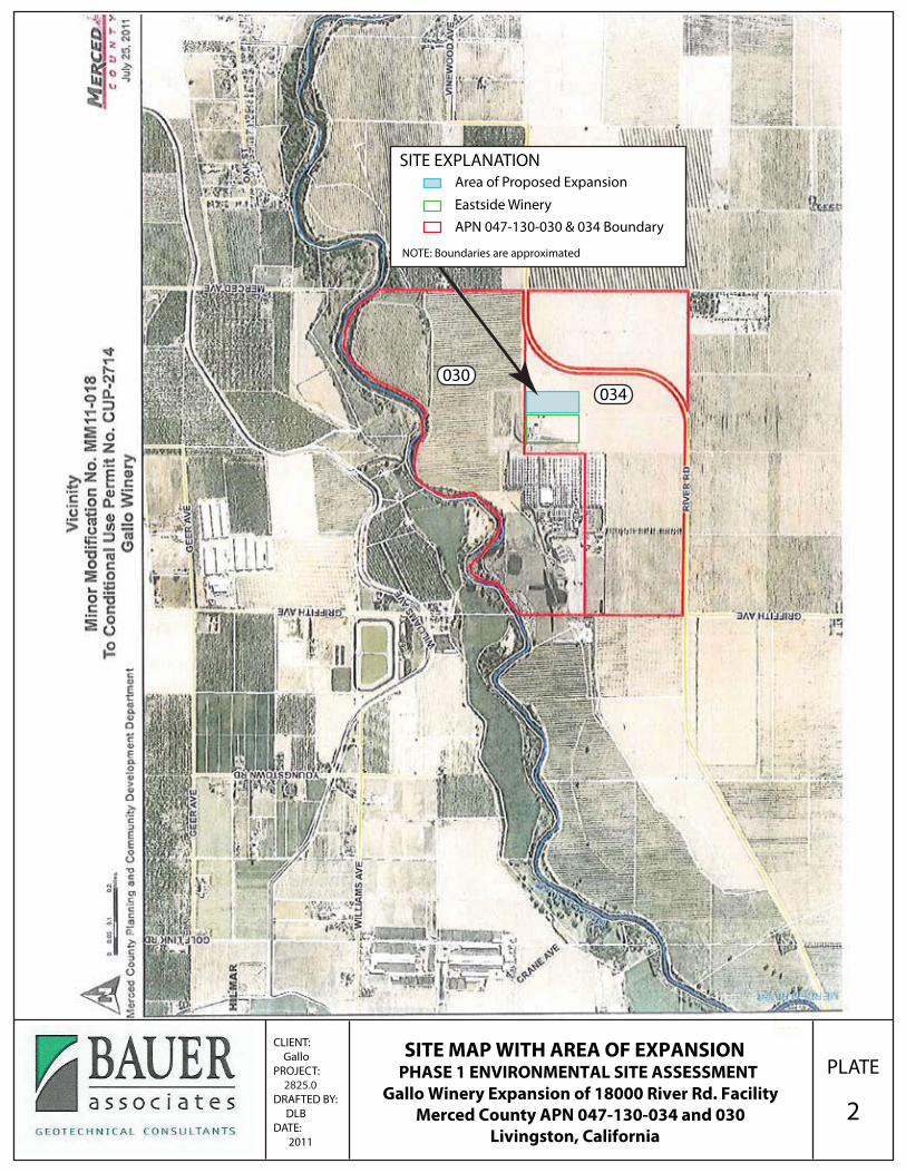
PLATE
2
CLIENT: GalloPROJECT: 2825.0DRAFTED BY: DLBDATE: 2011
SITE MAP WITH AREA OF EXPANSION PHASE 1 ENVIRONMENTAL SITE ASSESSMENT
Gallo Winery Expansion of 18000 River Rd. FacilityMerced County APN 047-130-034 and 030
Livingston, California
034030
SITE EXPLANATIONArea of Proposed Expansion
Eastside WineryAPN 047-130-030 & 034 Boundary
NOTE: Boundaries are approximated

Bauer Associates
ATTACHMENT B
Site Photos

REPORT: Phase 1 Environmental Site Assessment, Gallo Winery East Expansion BAUER ASSOCIATES
Photo 1: Aerial view looking south at eastern portion of Gallo Winery Facility. Eastside Winery and Area of Proposed Expansion shown.
Area of Proposed Expansion Eastside Winery
Photo 2: View looking west. Area of Proposed Expansion in midground.Eastside Winery in background.

REPORT: Phase 1 Environmental Site Assessment, Gallo Winery East Expansion BAUER ASSOCIATES
Photo 3: Overview of site looking north from River Road.Eastside Winery and Area of Proposed Expansion in background.
Photo 4: View looking northwest at well and fertilizer tank
Eastside Winery
Area of Proposed Expansion

REPORT: Phase 1 Environmental Site Assessment, Gallo Winery East Expansion BAUER ASSOCIATES
Photo 5: View of Chlorine Dioxide distribution tank.Chemical used for clean-in-place (CIP) lines at facility.
Photo 6: View looking east toward Area of Proposed Expansion (background).Containers of Chlorine Dioxide in foreground, distribution tank (Photo 5) on left.

Bauer Associates
ATTACHMENT C
EDR Radius Map with GeoCheck Report

FORM-STD-TXV
®kcehCoeG htiw tropeR ™paM suidaR RDE ehT
440 Wheelers Farms RoadMilford, CT 06461Toll Free: 800.352.0050www.edrnet.com
E&J Gallo Livingston Eastside Facility Expansion18000 River RdLivingston, CA 95334
Inquiry Number: 3165321.2sSeptember 13, 2011
SECTION PAGE
Executive Summary ES1
Overview Map 2
Detail Map 3
Map Findings Summary 4
Map Findings 7
Orphan Summary 24
Government Records Searched/Data Currency Tracking GR-1
GEOCHECK ADDENDUM
Physical Setting Source Addendum A-1
Physical Setting Source Summary A-2
Physical Setting SSURGO Soil Map A-5
Physical Setting Source Map A-11
Physical Setting Source Map Findings A-13
Physical Setting Source Records Searched A-31
TC3165321.2s Page 1
Thank you for your business.Please contact EDR at 1-800-352-0050
with any questions or comments.
Disclaimer - Copyright and Trademark Notice
This Report contains certain information obtained from a variety of public and other sources reasonably available to Environmental DataResources, Inc. It cannot be concluded from this Report that coverage information for the target and surrounding properties does not exist fromother sources. NO WARRANTY EXPRESSED OR IMPLIED, IS MADE WHATSOEVER IN CONNECTION WITH THIS REPORT. ENVIRONMENTALDATA RESOURCES, INC. SPECIFICALLY DISCLAIMS THE MAKING OF ANY SUCH WARRANTIES, INCLUDING WITHOUT LIMITATION,MERCHANTABILITY OR FITNESS FOR A PARTICULAR USE OR PURPOSE. ALL RISK IS ASSUMED BY THE USER. IN NO EVENT SHALLENVIRONMENTAL DATA RESOURCES, INC. BE LIABLE TO ANYONE, WHETHER ARISING OUT OF ERRORS OR OMISSIONS, NEGLIGENCE,ACCIDENT OR ANY OTHER CAUSE, FOR ANY LOSS OF DAMAGE, INCLUDING, WITHOUT LIMITATION, SPECIAL, INCIDENTAL,CONSEQUENTIAL, OR EXEMPLARY DAMAGES. ANY LIABILITY ON THE PART OF ENVIRONMENTAL DATA RESOURCES, INC. IS STRICTLYLIMITED TO A REFUND OF THE AMOUNT PAID FOR THIS REPORT. Purchaser accepts this Report "AS IS". Any analyses, estimates, ratings,environmental risk levels or risk codes provided in this Report are provided for illustrative purposes only, and are not intended to provide, norshould they be interpreted as providing any facts regarding, or prediction or forecast of, any environmental risk for any property. Only a Phase IEnvironmental Site Assessment performed by an environmental professional can provide information regarding the environmental risk for anyproperty. Additionally, the information provided in this Report is not to be construed as legal advice.
Copyright 2011 by Environmental Data Resources, Inc. All rights reserved. Reproduction in any media or format, in wholeor in part, of any report or map of Environmental Data Resources, Inc., or its affiliates, is prohibited without prior written permission.
EDR and its logos (including Sanborn and Sanborn Map) are trademarks of Environmental Data Resources, Inc. or its affiliates. All othertrademarks used herein are the property of their respective owners.
TABLE OF CONTENTS

EXECUTIVE SUMMARY
TC3165321.2s EXECUTIVE SUMMARY 1
A search of available environmental records was conducted by Environmental Data Resources, Inc (EDR).The report was designed to assist parties seeking to meet the search requirements of EPA’s Standardsand Practices for All Appropriate Inquiries (40 CFR Part 312), the ASTM Standard Practice forEnvironmental Site Assessments (E 1527-05) or custom requirements developed for the evaluation ofenvironmental risk associated with a parcel of real estate.
TARGET PROPERTY INFORMATION
ADDRESS
18000 RIVER RDLIVINGSTON, CA 95334
COORDINATES
37.380700 - 37˚ 22’ 50.5’’Latitude (North): 120.803600 - 120˚ 48’ 13.0’’Longitude (West): Zone 10Universal Tranverse Mercator: 694465.8UTM X (Meters): 4139165.5UTM Y (Meters): 112 ft. above sea levelElevation:
USGS TOPOGRAPHIC MAP ASSOCIATED WITH TARGET PROPERTY
37120-D7 TURLOCK, CATarget Property Map:1976Most Recent Revision:
37120-C7 STEVINSON, CASouth Map:1987Most Recent Revision:
AERIAL PHOTOGRAPHY IN THIS REPORT
2006, 2005Portions of Photo from:USDASource:
TARGET PROPERTY SEARCH RESULTS
The target property was identified in the following records. For more information on thisproperty see page 7 of the attached EDR Radius Map report:
EPA IDDatabase(s)Site
GALLO, E&J (AGRO-POMACE)18000 WEST RIVER ROADLIVINGSTON, CA 95353
N/AEMI
E & J GALLO WINERY18000 W. RIVER RD.LIVINGSTON, CA 95334
95334JGLLW18RCRA-SQGTRISFINDSHIST USTHAZNETEMI
18000 WEST RIVER RD18000 WEST RIVER RDLIVINGSTON, CA
N/AERNS
EXECUTIVE SUMMARY
TC3165321.2s EXECUTIVE SUMMARY 2
18000 W. RIVER ROAD18000 W. RIVER ROADLIVINGSTON, CA 95334
N/AERNS
18000 W RIVER RD18000 W RIVER RDLIVINGSTON, CA
N/AERNS
18000 W. RIVER RD18000 W. RIVER RDLIVINGSTON, CA 95334
N/AERNS
18000 W RIVER RD18000 W RIVER RDLIVINGSTON, CA 95334
N/AERNS
E & J GALLO WINERY18000 W. RIVER ROADLIVINGSTON, CA 95334
N/AWDSCUPA ListingsSWEEPS UST
COLEMAN TRANSPORTATION INC18000 RIVER RDLIVINGSTON, CA 95334
N/AHAZNET
E & J GALLO WINERY18000 W. RIVER ROADLIVINGSTON, CA 95344
N/AEMI
18000 W. RIVER ROAD18000 W. RIVER ROADLIVINGSTON, CA
N/ACHMIRS
LIVINGSTON WINERY - COMPOST18000 RIVERLIVINGSTON, CA 95334
N/ALDS
DATABASES WITH NO MAPPED SITES
No mapped sites were found in EDR’s search of available ("reasonably ascertainable ") governmentrecords either on the target property or within the search radius around the target property for thefollowing databases:
STANDARD ENVIRONMENTAL RECORDS
Federal NPL site list
NPL National Priority List

EXECUTIVE SUMMARY
TC3165321.2s EXECUTIVE SUMMARY 3
Proposed NPL Proposed National Priority List SitesNPL LIENS Federal Superfund Liens
Federal Delisted NPL site list
Delisted NPL National Priority List Deletions
Federal CERCLIS list
CERCLIS Comprehensive Environmental Response, Compensation, and Liability Information SystemFEDERAL FACILITY Federal Facility Site Information listing
Federal CERCLIS NFRAP site List
CERC-NFRAP CERCLIS No Further Remedial Action Planned
Federal RCRA CORRACTS facilities list
CORRACTS Corrective Action Report
Federal RCRA non-CORRACTS TSD facilities list
RCRA-TSDF RCRA - Treatment, Storage and Disposal
Federal RCRA generators list
RCRA-LQG RCRA - Large Quantity GeneratorsRCRA-CESQG RCRA - Conditionally Exempt Small Quantity Generator
Federal institutional controls / engineering controls registries
US ENG CONTROLS Engineering Controls Sites ListUS INST CONTROL Sites with Institutional Controls
State- and tribal - equivalent NPL
RESPONSE State Response Sites
State- and tribal - equivalent CERCLIS
ENVIROSTOR EnviroStor Database
State and tribal landfill and/or solid waste disposal site lists
SWF/LF Solid Waste Information System
State and tribal leaking storage tank lists
LUST Geotracker’s Leaking Underground Fuel Tank ReportSLIC Statewide SLIC CasesINDIAN LUST Leaking Underground Storage Tanks on Indian Land
State and tribal registered storage tank lists
UST Active UST Facilities
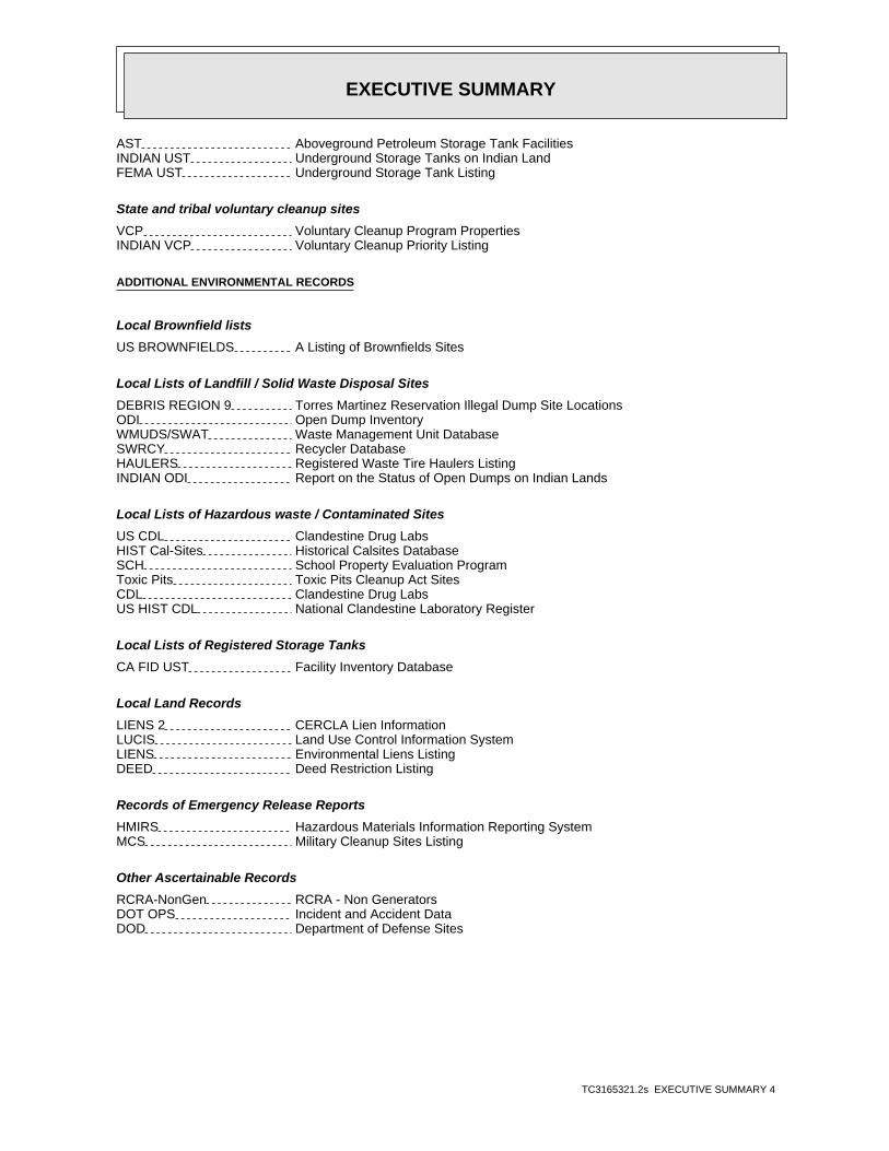
EXECUTIVE SUMMARY
TC3165321.2s EXECUTIVE SUMMARY 4
AST Aboveground Petroleum Storage Tank FacilitiesINDIAN UST Underground Storage Tanks on Indian LandFEMA UST Underground Storage Tank Listing
State and tribal voluntary cleanup sites
VCP Voluntary Cleanup Program PropertiesINDIAN VCP Voluntary Cleanup Priority Listing
ADDITIONAL ENVIRONMENTAL RECORDS
Local Brownfield lists
US BROWNFIELDS A Listing of Brownfields Sites
Local Lists of Landfill / Solid Waste Disposal Sites
DEBRIS REGION 9 Torres Martinez Reservation Illegal Dump Site LocationsODI Open Dump InventoryWMUDS/SWAT Waste Management Unit DatabaseSWRCY Recycler DatabaseHAULERS Registered Waste Tire Haulers ListingINDIAN ODI Report on the Status of Open Dumps on Indian Lands
Local Lists of Hazardous waste / Contaminated Sites
US CDL Clandestine Drug LabsHIST Cal-Sites Historical Calsites DatabaseSCH School Property Evaluation ProgramToxic Pits Toxic Pits Cleanup Act SitesCDL Clandestine Drug LabsUS HIST CDL National Clandestine Laboratory Register
Local Lists of Registered Storage Tanks
CA FID UST Facility Inventory Database
Local Land Records
LIENS 2 CERCLA Lien InformationLUCIS Land Use Control Information SystemLIENS Environmental Liens ListingDEED Deed Restriction Listing
Records of Emergency Release Reports
HMIRS Hazardous Materials Information Reporting SystemMCS Military Cleanup Sites Listing
Other Ascertainable Records
RCRA-NonGen RCRA - Non GeneratorsDOT OPS Incident and Accident DataDOD Department of Defense Sites

EXECUTIVE SUMMARY
TC3165321.2s EXECUTIVE SUMMARY 5
FUDS Formerly Used Defense SitesCONSENT Superfund (CERCLA) Consent DecreesROD Records Of DecisionUMTRA Uranium Mill Tailings SitesMINES Mines Master Index FileTSCA Toxic Substances Control ActFTTS FIFRA/ TSCA Tracking System - FIFRA (Federal Insecticide, Fungicide, & Rodenticide Act)/TSCA (Toxic Substances Control Act)HIST FTTS FIFRA/TSCA Tracking System Administrative Case ListingSSTS Section 7 Tracking SystemsICIS Integrated Compliance Information SystemPADS PCB Activity Database SystemMLTS Material Licensing Tracking SystemRADINFO Radiation Information DatabaseRAATS RCRA Administrative Action Tracking SystemCA BOND EXP. PLAN Bond Expenditure PlanNPDES NPDES Permits ListingCortese "Cortese" Hazardous Waste & Substances Sites ListHIST CORTESE Hazardous Waste & Substance Site ListNotify 65 Proposition 65 RecordsDRYCLEANERS Cleaner FacilitiesWIP Well Investigation Program Case ListINDIAN RESERV Indian ReservationsSCRD DRYCLEANERS State Coalition for Remediation of Drycleaners ListingHWP EnviroStor Permitted Facilities ListingHWT Registered Hazardous Waste Transporter DatabaseCOAL ASH EPA Coal Combustion Residues Surface Impoundments ListFINANCIAL ASSURANCE Financial Assurance Information ListingPCB TRANSFORMER PCB Transformer Registration DatabasePROC Certified Processors DatabaseMWMP Medical Waste Management Program ListingCOAL ASH DOE Sleam-Electric Plan Operation Data
EDR PROPRIETARY RECORDS
EDR Proprietary Records
Manufactured Gas Plants EDR Proprietary Manufactured Gas Plants
SURROUNDING SITES: SEARCH RESULTS
Surrounding sites were not identified.
Unmappable (orphan) sites are not considered in the foregoing analysis.

EXECUTIVE SUMMARY
TC3165321.2s EXECUTIVE SUMMARY 6
Due to poor or inadequate address information, the following sites were not mapped. Count: 37 records.
Site Name Database(s)____________ ____________
LIVINGSTON BYPASS GENERAL LUST SAN MATEO,HIST CORTESELOT 12671 HIST CORTESEPG&E, LIVINGSTON SUB FTTS,HIST FTTS INSPBERT CRANE RANCHES/SUNRISE SWEEPS USTJ.J. RATZLAFF SWEEPS USTGUJJAR SINGH SAHI SWEEPS USTFOSTER FARMS LINCOLN COMPLEX CUPA FRESNOFOSTER FARMS LIVINGSTON TRUCK SHOP CUPA FRESNO,LUST SAN MATEOLIVINGSTON BYPASS GENERAL LUST SAN MATEOLOT 12671 LUST SAN MATEOLOT 12671 LUST SAN MATEOCALTRANS MERCED RIVER BRIDGE VCP,ENVIROSTORBLEVINS SHELL SERVICE HIST USTYAGI BROS. HIST USTFERTILIZER PLANT ASTLINCOLN RANCH 3 ASTLINCOLN RANCH 4 ASTLIVINGSTON TRUCK STOP ASTCALTRANS LIVINGSTON FREEWAY HAZNETS/B HWY 99 LIVINGSTON LIGHTS ERNSCITY OF LIVINGSTON FINDSLIVINGSTON, CITY OF WWTP FINDSCITY OF LIVINGSTON FINDSLIVINGSTON DOMESTIC STP FINDSJOSEPH GALLO FINE CHEESE FINDSPG&E LIVINGSTON SUBSTATION FINDSE & J GALLO WINERY FINDSFOSTER FARMS LINCOLN RANCH SLIC REGION 2FOSTER POULTRY FARMS FERTILIZER PL SLIC REGION 2FOSTER FARMS HIGHWAY 140 RANCH COM SLIC REGION 2J BLASINGAME & SON, INC. MINESCALAVERAS MATERIALS, INC. MINESLIVINGSTON AUTO BODY EMIJOSEPH GALLO FINE CHEESE EMIJOSEPH GALLO FINE CHEESE EMIJOSEPH GALLO FINE CHEESE EMILIVINGSTON CITY DUMP ENVIROSTOR

EDR Inc.EDR Inc.EDR Inc.EDR Inc.EDR Inc.EDR Inc.EDR Inc.EDR Inc.EDR Inc.EDR Inc.EDR Inc.EDR Inc.EDR Inc.EDR Inc.EDR Inc.EDR Inc.EDR Inc.EDR Inc.EDR Inc.EDR Inc.EDR Inc.EDR Inc.EDR Inc.EDR Inc.EDR Inc.EDR Inc.EDR Inc.EDR Inc.EDR Inc.EDR Inc.EDR Inc.EDR Inc.EDR Inc.EDR Inc.EDR Inc.EDR Inc.EDR Inc.EDR Inc.EDR Inc.EDR Inc.
1 2 0
1
8 0808 0
120
8 0
80
8 0
80
80
8 0

EDR Inc.EDR Inc.EDR Inc.EDR Inc.EDR Inc.EDR Inc.EDR Inc.EDR Inc.EDR Inc.EDR Inc.EDR Inc.EDR Inc.EDR Inc.EDR Inc.EDR Inc.EDR Inc.EDR Inc.EDR Inc.EDR Inc.EDR Inc.EDR Inc.EDR Inc.EDR Inc.EDR Inc.EDR Inc.EDR Inc.EDR Inc.EDR Inc.EDR Inc.EDR Inc.EDR Inc.EDR Inc.EDR Inc.EDR Inc.EDR Inc.EDR Inc.EDR Inc.EDR Inc.EDR Inc.EDR Inc.

MAP FINDINGS SUMMARY
SearchTarget Distance Total
Database Property (Miles) < 1/8 1/8 - 1/4 1/4 - 1/2 1/2 - 1 > 1 Plotted
STANDARD ENVIRONMENTAL RECORDS
Federal NPL site list
0 NR 0 0 0 0 1.000NPL 0 NR 0 0 0 0 1.000Proposed NPL 0 NR NR NR NR NR TPNPL LIENS
Federal Delisted NPL site list
0 NR 0 0 0 0 1.000Delisted NPL
Federal CERCLIS list
0 NR NR 0 0 0 0.500CERCLIS 0 NR 0 0 0 0 1.000FEDERAL FACILITY
Federal CERCLIS NFRAP site List
0 NR NR 0 0 0 0.500CERC-NFRAP
Federal RCRA CORRACTS facilities list
0 NR 0 0 0 0 1.000CORRACTS
Federal RCRA non-CORRACTS TSD facilities list
0 NR NR 0 0 0 0.500RCRA-TSDF
Federal RCRA generators list
0 NR NR NR 0 0 0.250RCRA-LQG 0 NR NR NR 0 0 0.250 XRCRA-SQG 0 NR NR NR 0 0 0.250RCRA-CESQG
Federal institutional controls /engineering controls registries
0 NR NR 0 0 0 0.500US ENG CONTROLS 0 NR NR 0 0 0 0.500US INST CONTROL
Federal ERNS list
0 NR NR NR NR NR TP XERNS
State- and tribal - equivalent NPL
0 NR 0 0 0 0 1.000RESPONSE
State- and tribal - equivalent CERCLIS
0 NR 0 0 0 0 1.000ENVIROSTOR
State and tribal landfill and/orsolid waste disposal site lists
0 NR NR 0 0 0 0.500SWF/LF
State and tribal leaking storage tank lists
0 NR NR 0 0 0 0.500LUST 0 NR NR 0 0 0 0.500SLIC
TC3165321.2s Page 4

MAP FINDINGS SUMMARY
SearchTarget Distance Total
Database Property (Miles) < 1/8 1/8 - 1/4 1/4 - 1/2 1/2 - 1 > 1 Plotted
0 NR NR 0 0 0 0.500INDIAN LUST
State and tribal registered storage tank lists
0 NR NR NR 0 0 0.250UST 0 NR NR NR 0 0 0.250AST 0 NR NR NR 0 0 0.250INDIAN UST 0 NR NR NR 0 0 0.250FEMA UST
State and tribal voluntary cleanup sites
0 NR NR 0 0 0 0.500VCP 0 NR NR 0 0 0 0.500INDIAN VCP
ADDITIONAL ENVIRONMENTAL RECORDS
Local Brownfield lists
0 NR NR 0 0 0 0.500US BROWNFIELDS
Local Lists of Landfill / SolidWaste Disposal Sites
0 NR NR 0 0 0 0.500DEBRIS REGION 9 0 NR NR 0 0 0 0.500ODI 0 NR NR 0 0 0 0.500WMUDS/SWAT 0 NR NR 0 0 0 0.500SWRCY 0 NR NR NR NR NR TPHAULERS 0 NR NR 0 0 0 0.500INDIAN ODI
Local Lists of Hazardous waste /Contaminated Sites
0 NR NR NR NR NR TPUS CDL 0 NR 0 0 0 0 1.000HIST Cal-Sites 0 NR NR NR 0 0 0.250SCH 0 NR 0 0 0 0 1.000Toxic Pits 0 NR NR NR NR NR TPCDL 0 NR NR NR NR NR TPUS HIST CDL
Local Lists of Registered Storage Tanks
0 NR NR NR 0 0 0.250CA FID UST 0 NR NR NR 0 0 0.250 XHIST UST 0 NR NR NR 0 0 0.250 XSWEEPS UST
Local Land Records
0 NR NR NR NR NR TPLIENS 2 0 NR NR 0 0 0 0.500LUCIS 0 NR NR NR NR NR TPLIENS 0 NR NR 0 0 0 0.500DEED
Records of Emergency Release Reports
0 NR NR NR NR NR TPHMIRS 0 NR NR NR NR NR TP XCHMIRS 0 NR NR NR NR NR TP XLDS
TC3165321.2s Page 5
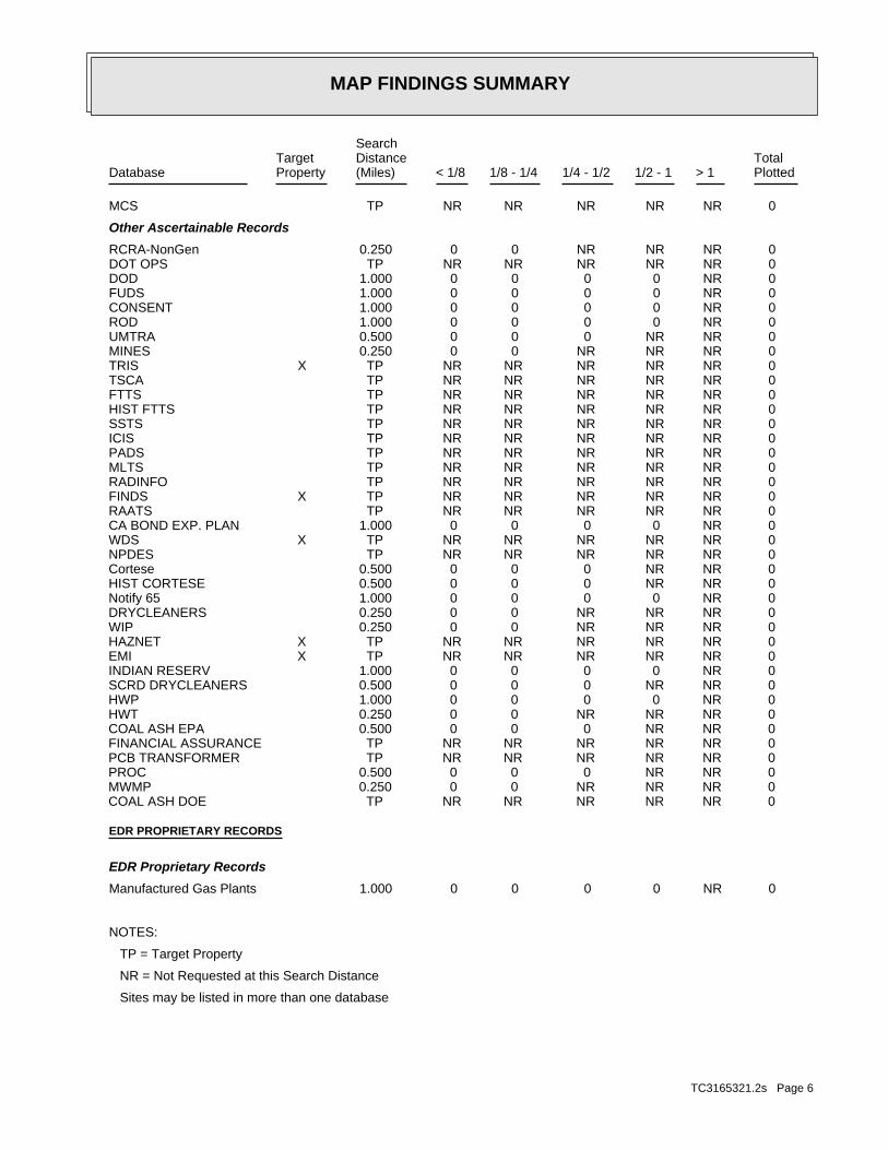
MAP FINDINGS SUMMARY
SearchTarget Distance Total
Database Property (Miles) < 1/8 1/8 - 1/4 1/4 - 1/2 1/2 - 1 > 1 Plotted
0 NR NR NR NR NR TPMCS
Other Ascertainable Records
0 NR NR NR 0 0 0.250RCRA-NonGen 0 NR NR NR NR NR TPDOT OPS 0 NR 0 0 0 0 1.000DOD 0 NR 0 0 0 0 1.000FUDS 0 NR 0 0 0 0 1.000CONSENT 0 NR 0 0 0 0 1.000ROD 0 NR NR 0 0 0 0.500UMTRA 0 NR NR NR 0 0 0.250MINES 0 NR NR NR NR NR TP XTRIS 0 NR NR NR NR NR TPTSCA 0 NR NR NR NR NR TPFTTS 0 NR NR NR NR NR TPHIST FTTS 0 NR NR NR NR NR TPSSTS 0 NR NR NR NR NR TPICIS 0 NR NR NR NR NR TPPADS 0 NR NR NR NR NR TPMLTS 0 NR NR NR NR NR TPRADINFO 0 NR NR NR NR NR TP XFINDS 0 NR NR NR NR NR TPRAATS 0 NR 0 0 0 0 1.000CA BOND EXP. PLAN 0 NR NR NR NR NR TP XWDS 0 NR NR NR NR NR TPNPDES 0 NR NR 0 0 0 0.500Cortese 0 NR NR 0 0 0 0.500HIST CORTESE 0 NR 0 0 0 0 1.000Notify 65 0 NR NR NR 0 0 0.250DRYCLEANERS 0 NR NR NR 0 0 0.250WIP 0 NR NR NR NR NR TP XHAZNET 0 NR NR NR NR NR TP XEMI 0 NR 0 0 0 0 1.000INDIAN RESERV 0 NR NR 0 0 0 0.500SCRD DRYCLEANERS 0 NR 0 0 0 0 1.000HWP 0 NR NR NR 0 0 0.250HWT 0 NR NR 0 0 0 0.500COAL ASH EPA 0 NR NR NR NR NR TPFINANCIAL ASSURANCE 0 NR NR NR NR NR TPPCB TRANSFORMER 0 NR NR 0 0 0 0.500PROC 0 NR NR NR 0 0 0.250MWMP 0 NR NR NR NR NR TPCOAL ASH DOE
EDR PROPRIETARY RECORDS
EDR Proprietary Records
0 NR 0 0 0 0 1.000Manufactured Gas Plants
NOTES:
TP = Target Property
NR = Not Requested at this Search Distance
Sites may be listed in more than one database
TC3165321.2s Page 6

MAP FINDINGSMap IDDirection
EDR ID NumberDistanceEPA ID NumberDatabase(s)SiteElevation
1995Year:
2Part. Matter 10 Micrometers & Smllr Tons/Yr: 6Particulate Matter Tons/Yr: 0SOX - Oxides of Sulphur Tons/Yr: 4NOX - Oxides of Nitrogen Tons/Yr: 15Carbon Monoxide Emissions Tons/Yr: 37Reactive Organic Gases Tons/Yr: 53Total Organic Hydrocarbon Gases Tons/Yr: Not reportedConsolidated Emission Reporting Rule: Not reportedCommunity Health Air Pollution Info System: SAN JOAQUIN VALLEY UNIFIED APCDAir District Name: 2084SIC Code: SJUAir District Name: 1237Facility ID: SJVAir Basin: 24County Code: 1993Year:
2Part. Matter 10 Micrometers & Smllr Tons/Yr: 5Particulate Matter Tons/Yr: 0SOX - Oxides of Sulphur Tons/Yr: 0NOX - Oxides of Nitrogen Tons/Yr: 0Carbon Monoxide Emissions Tons/Yr: 0Reactive Organic Gases Tons/Yr: 0Total Organic Hydrocarbon Gases Tons/Yr: Not reportedConsolidated Emission Reporting Rule: Not reportedCommunity Health Air Pollution Info System: SAN JOAQUIN VALLEY UNIFIED APCDAir District Name: 2084SIC Code: SJUAir District Name: 51Facility ID: SJVAir Basin: 24County Code: 1990Year:
1Part. Matter 10 Micrometers & Smllr Tons/Yr: 1Particulate Matter Tons/Yr: 0SOX - Oxides of Sulphur Tons/Yr: 88NOX - Oxides of Nitrogen Tons/Yr: 7Carbon Monoxide Emissions Tons/Yr: 88Reactive Organic Gases Tons/Yr: 127Total Organic Hydrocarbon Gases Tons/Yr: Not reportedConsolidated Emission Reporting Rule: Not reportedCommunity Health Air Pollution Info System: SAN JOAQUIN VALLEY UNIFIED APCDAir District Name: 2084SIC Code: SJUAir District Name: 50Facility ID: SJVAir Basin: 24County Code: 1990Year:
EMI:
Site 1 of 12 in cluster A
Actual:112 ft.
Property LIVINGSTON, CA 95353Target 18000 WEST RIVER ROAD N/AA1 EMIGALLO, E&J (AGRO-POMACE) S106831473
TC3165321.2s Page 7

MAP FINDINGSMap IDDirection
EDR ID NumberDistanceEPA ID NumberDatabase(s)SiteElevation
1Part. Matter 10 Micrometers & Smllr Tons/Yr: 1Particulate Matter Tons/Yr: 0SOX - Oxides of Sulphur Tons/Yr: 4NOX - Oxides of Nitrogen Tons/Yr: 15Carbon Monoxide Emissions Tons/Yr: 0Reactive Organic Gases Tons/Yr: 0Total Organic Hydrocarbon Gases Tons/Yr: Not reportedConsolidated Emission Reporting Rule: Not reportedCommunity Health Air Pollution Info System: SAN JOAQUIN VALLEY UNIFIED APCDAir District Name: 2084SIC Code: SJUAir District Name: 1237Facility ID: SJVAir Basin: 24County Code:
GALLO, E&J (AGRO-POMACE) (Continued) S106831473
NOT REQUIREDOwner/operator name:
Not reportedOwner/Op end date: Not reportedOwner/Op start date: OwnerOwner/Operator Type: PrivateLegal status: (415) 555-1212Owner/operator telephone: Not reportedOwner/operator country: NOT REQUIRED, ME 99999 NOT REQUIREDOwner/operator address: E & J GALLO WINERYOwner/operator name:
Owner/Operator Summary:
hazardous waste at any time waste during any calendar month, and accumulates more than 1000 kg of hazardous waste at any time; or generates 100 kg or less of hazardous waste during any calendar month and accumulates less than 6000 kg of Handler: generates more than 100 and less than 1000 kg of hazardousDescription: Small Small Quantity GeneratorClassification: 09EPA Region: Not reportedContact email: (209) 579-3557Contact telephone: USContact country: LIVINGSTON, CA 95334 18000 RIVER RDContact address: ENVIRONMENTAL MANAGERContact: LIVINGSTON, CA 95334 18000 W RIVER RDMailing address: CAD981452428EPA ID: LIVINGSTON, CA 95334 18000 RIVER RDFacility address: E & J GALLO WINERYFacility name: 05/20/1986Date form received by agency:
RCRA-SQG:
EMIHAZNETSite 2 of 12 in cluster A
HIST UST
Actual:112 ft.
Property FINDSLIVINGSTON, CA 95334Target TRIS18000 W. RIVER RD. 95334JGLLW18A2 RCRA-SQGE & J GALLO WINERY 1000120410
TC3165321.2s Page 8

MAP FINDINGSMap IDDirection
EDR ID NumberDistanceEPA ID NumberDatabase(s)SiteElevation
these facilities release directly to air, water, land, or that arefrom facilities on the amounts of over 300 listed toxic chemicals thatUS EPA TRIS (Toxics Release Inventory System) contains information
facilities.generators, transporters, and treatment, storage, and disposalprovides California with information on hazardous waste shipments forCalifornia Hazardous Waste Tracking System - Datamart (HWTS-DATAMART)
their precursors, as well as hazardous air pollutants (HAPs).on stationary and mobile sources that emit criteria air pollutants andThe NEI (National Emissions Inventory) database contains information
of the Clean Air Act.redesign to support facility operating permits required under Title Vestimation of total national emissions. AFS is undergoing a majorto comply with regulatory programs and by EPA as an input for theAFS data are utilized by states to prepare State Implementation Plansused to track emissions and compliance data from industrial plants.information concerning airborne pollution in the United States. AFS isAerometric Data (SAROAD). AIRS is the national repository forNational Emission Data System (NEDS), and the Storage and Retrieval ofSubsystem) replaces the former Compliance Data System (CDS), theAFS (Aerometric Information Retrieval System (AIRS) Facility Environmental Interest/Information System
110000485154Registry ID:
FINDS:
No violations foundViolation Status:
NoUsed oil transporter: NoUsed oil transfer facility: NoUsed oil Specification marketer: NoUsed oil fuel marketer to burner: NoUser oil refiner: NoUsed oil processor: NoUsed oil fuel burner: NoFurnace exemption: NoOn-site burner exemption: NoUnderground injection activity: NoTreater, storer or disposer of HW: NoTransporter of hazardous waste: NoRecycler of hazardous waste: NoMixed waste (haz. and radioactive): NoU.S. importer of hazardous waste:
Handler Activities Summary:
Not reportedOwner/Op end date: Not reportedOwner/Op start date: OperatorOwner/Operator Type: PrivateLegal status: (415) 555-1212Owner/operator telephone: Not reportedOwner/operator country: NOT REQUIRED, ME 99999 NOT REQUIREDOwner/operator address:
E & J GALLO WINERY (Continued) 1000120410
TC3165321.2s Page 9

MAP FINDINGSMap IDDirection
EDR ID NumberDistanceEPA ID NumberDatabase(s)SiteElevation
1973Year Installed: 4LW500GRContainer Num: 004Tank Num:
Stock InventorLeak Detection: Not reportedTank Construction: DIESELType of Fuel: PRODUCTTank Used for: 00003947Tank Capacity: 1970Year Installed: 3LW4K0Container Num: 003Tank Num:
Stock InventorLeak Detection: Not reportedTank Construction: DIESELType of Fuel: PRODUCTTank Used for: 00010152Tank Capacity: 1977Year Installed: 2LW10K0Container Num: 002Tank Num:
Stock InventorLeak Detection: Not reportedTank Construction: DIESELType of Fuel: PRODUCTTank Used for: 00020562Tank Capacity: 1977Year Installed: 1LW20K0Container Num: 001Tank Num:
MODESTO, CA 95353Owner City,St,Zip: 600 YOSEMITE BLVD.Owner Address: E. & J. GALLO WINERYOwner Name: 2093946210Telephone: BOB SLAYTONContact Name: 0004Total Tanks: WINERYOther Type: OtherFacility Type: 00000002811Facility ID: STATERegion:
HIST UST:
112(r) of the Clean Air Act (CAA).certain flammable or toxic substances, as required under sectionplans reported by companies that handle, manufacture, use, or storeUS EPA Risk Management Plan (RMP) database stores the risk management
corrective action activities required under RCRA.program staff to track the notification, permit, compliance, andand treat, store, or dispose of hazardous waste. RCRAInfo allows RCRAevents and activities related to facilities that generate, transport,Conservation and Recovery Act (RCRA) program through the tracking ofRCRAInfo is a national information system that supports the Resource
transported off-site.
E & J GALLO WINERY (Continued) 1000120410
TC3165321.2s Page 10
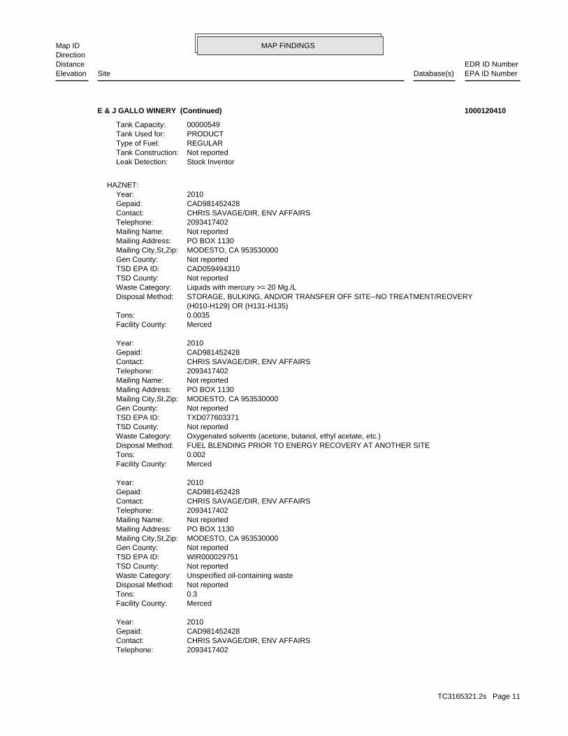
MAP FINDINGSMap IDDirection
EDR ID NumberDistanceEPA ID NumberDatabase(s)SiteElevation
2093417402Telephone: CHRIS SAVAGE/DIR, ENV AFFAIRSContact: CAD981452428Gepaid: 2010Year:
MercedFacility County: 0.3Tons: Not reportedDisposal Method: Unspecified oil-containing wasteWaste Category: Not reportedTSD County: WIR000029751TSD EPA ID: Not reportedGen County: MODESTO, CA 953530000Mailing City,St,Zip: PO BOX 1130Mailing Address: Not reportedMailing Name: 2093417402Telephone: CHRIS SAVAGE/DIR, ENV AFFAIRSContact: CAD981452428Gepaid: 2010Year:
MercedFacility County: 0.002Tons: FUEL BLENDING PRIOR TO ENERGY RECOVERY AT ANOTHER SITEDisposal Method: Oxygenated solvents (acetone, butanol, ethyl acetate, etc.)Waste Category: Not reportedTSD County: TXD077603371TSD EPA ID: Not reportedGen County: MODESTO, CA 953530000Mailing City,St,Zip: PO BOX 1130Mailing Address: Not reportedMailing Name: 2093417402Telephone: CHRIS SAVAGE/DIR, ENV AFFAIRSContact: CAD981452428Gepaid: 2010Year:
MercedFacility County: 0.0035Tons: (H010-H129) OR (H131-H135) STORAGE, BULKING, AND/OR TRANSFER OFF SITE--NO TREATMENT/REOVERYDisposal Method: Liquids with mercury >= 20 Mg./LWaste Category: Not reportedTSD County: CAD059494310TSD EPA ID: Not reportedGen County: MODESTO, CA 953530000Mailing City,St,Zip: PO BOX 1130Mailing Address: Not reportedMailing Name: 2093417402Telephone: CHRIS SAVAGE/DIR, ENV AFFAIRSContact: CAD981452428Gepaid: 2010Year:
HAZNET:
Stock InventorLeak Detection: Not reportedTank Construction: REGULARType of Fuel: PRODUCTTank Used for: 00000549Tank Capacity:
E & J GALLO WINERY (Continued) 1000120410
TC3165321.2s Page 11

MAP FINDINGSMap IDDirection
EDR ID NumberDistanceEPA ID NumberDatabase(s)SiteElevation
Not reportedConsolidated Emission Reporting Rule: Not reportedCommunity Health Air Pollution Info System: SAN JOAQUIN VALLEY UNIFIED APCDAir District Name: 2084SIC Code: SJUAir District Name: 1237Facility ID: SJVAir Basin: 24County Code: 2000Year:
2Part. Matter 10 Micrometers & Smllr Tons/Yr: 3Particulate Matter Tons/Yr: 0SOX - Oxides of Sulphur Tons/Yr: 5NOX - Oxides of Nitrogen Tons/Yr: 19Carbon Monoxide Emissions Tons/Yr: 0Reactive Organic Gases Tons/Yr: 1Total Organic Hydrocarbon Gases Tons/Yr: Not reportedConsolidated Emission Reporting Rule: Not reportedCommunity Health Air Pollution Info System: SAN JOAQUIN VALLEY UNIFIED APCDAir District Name: 2084SIC Code: SJUAir District Name: 1237Facility ID: SJVAir Basin: 24County Code: 1999Year:
EMI:
47 additional CA_HAZNET: record(s) in the EDR Site Report.Click this hyperlink while viewing on your computer to access
MercedFacility County: 1.14Tons: (H010-H129) OR (H131-H135) STORAGE, BULKING, AND/OR TRANSFER OFF SITE--NO TREATMENT/REOVERYDisposal Method: Waste oil and mixed oilWaste Category: Not reportedTSD County: CAL000190816TSD EPA ID: Not reportedGen County: MODESTO, CA 953530000Mailing City,St,Zip: PO BOX 1130Mailing Address: Not reportedMailing Name: 2093417402Telephone: CHRIS SAVAGE/DIR, ENV AFFAIRSContact: CAD981452428Gepaid: 2010Year:
MercedFacility County: 0.1Tons: Not reportedDisposal Method: Unspecified oil-containing wasteWaste Category: Not reportedTSD County: WIR000029751TSD EPA ID: Not reportedGen County: MODESTO, CA 953530000Mailing City,St,Zip: PO BOX 1130Mailing Address: Not reportedMailing Name:
E & J GALLO WINERY (Continued) 1000120410
TC3165321.2s Page 12

MAP FINDINGSMap IDDirection
EDR ID NumberDistanceEPA ID NumberDatabase(s)SiteElevation
1Particulate Matter Tons/Yr: 2SOX - Oxides of Sulphur Tons/Yr: 4NOX - Oxides of Nitrogen Tons/Yr: 17Carbon Monoxide Emissions Tons/Yr: 0Reactive Organic Gases Tons/Yr: 1Total Organic Hydrocarbon Gases Tons/Yr: Not reportedConsolidated Emission Reporting Rule: Not reportedCommunity Health Air Pollution Info System: SAN JOAQUIN VALLEY UNIFIED APCDAir District Name: 2084SIC Code: SJUAir District Name: 1237Facility ID: SJVAir Basin: 24County Code: 2003Year:
2Part. Matter 10 Micrometers & Smllr Tons/Yr: 5Particulate Matter Tons/Yr: 2SOX - Oxides of Sulphur Tons/Yr: 4NOX - Oxides of Nitrogen Tons/Yr: 3Carbon Monoxide Emissions Tons/Yr: 0Reactive Organic Gases Tons/Yr: 0Total Organic Hydrocarbon Gases Tons/Yr: Not reportedConsolidated Emission Reporting Rule: Not reportedCommunity Health Air Pollution Info System: SAN JOAQUIN VALLEY UNIFIED APCDAir District Name: 2084SIC Code: SJUAir District Name: 1237Facility ID: SJVAir Basin: 24County Code: 2002Year:
2Part. Matter 10 Micrometers & Smllr Tons/Yr: 3Particulate Matter Tons/Yr: 2SOX - Oxides of Sulphur Tons/Yr: 5NOX - Oxides of Nitrogen Tons/Yr: 4Carbon Monoxide Emissions Tons/Yr: 0Reactive Organic Gases Tons/Yr: 0Total Organic Hydrocarbon Gases Tons/Yr: Not reportedConsolidated Emission Reporting Rule: Not reportedCommunity Health Air Pollution Info System: SAN JOAQUIN VALLEY UNIFIED APCDAir District Name: 2084SIC Code: SJUAir District Name: 1237Facility ID: SJVAir Basin: 24County Code: 2001Year:
1Part. Matter 10 Micrometers & Smllr Tons/Yr: 2Particulate Matter Tons/Yr: 2SOX - Oxides of Sulphur Tons/Yr: 4NOX - Oxides of Nitrogen Tons/Yr: 4Carbon Monoxide Emissions Tons/Yr: 0Reactive Organic Gases Tons/Yr: 0Total Organic Hydrocarbon Gases Tons/Yr:
E & J GALLO WINERY (Continued) 1000120410
TC3165321.2s Page 13

MAP FINDINGSMap IDDirection
EDR ID NumberDistanceEPA ID NumberDatabase(s)SiteElevation
1237Facility ID: SJVAir Basin: 24County Code: 2007Year:
2.757733005813598547Part. Matter 10 Micrometers & Smllr Tons/Yr: 3.173019417125191855Particulate Matter Tons/Yr: 2.0094647757530226SOX - Oxides of Sulphur Tons/Yr: .6009635948181158NOX - Oxides of Nitrogen Tons/Yr: .8112447068786622Carbon Monoxide Emissions Tons/Yr: 171.0169322413306237Reactive Organic Gases Tons/Yr: 171.3129039977125247Total Organic Hydrocarbon Gases Tons/Yr: Not reportedConsolidated Emission Reporting Rule: Not reportedCommunity Health Air Pollution Info System: SAN JOAQUIN VALLEY UNIFIED APCDAir District Name: 2084SIC Code: SJUAir District Name: 1237Facility ID: SJVAir Basin: 24County Code: 2006Year:
.36405461611175532Part. Matter 10 Micrometers & Smllr Tons/Yr: .4345938930233577012Particulate Matter Tons/Yr: 1.5954475744247447SOX - Oxides of Sulphur Tons/Yr: 2.555938120269774NOX - Oxides of Nitrogen Tons/Yr: 9.6461849542617835Carbon Monoxide Emissions Tons/Yr: .208174330460548558Reactive Organic Gases Tons/Yr: .4658843157251176225Total Organic Hydrocarbon Gases Tons/Yr: Not reportedConsolidated Emission Reporting Rule: Not reportedCommunity Health Air Pollution Info System: SAN JOAQUIN VALLEY UNIFIED APCDAir District Name: 2084SIC Code: SJUAir District Name: 1237Facility ID: SJVAir Basin: 24County Code: 2005Year:
0.432881781Part. Matter 10 Micrometers & Smllr Tons/Yr: 0.483738706Particulate Matter Tons/Yr: 0.894573994SOX - Oxides of Sulphur Tons/Yr: 2.985735864NOX - Oxides of Nitrogen Tons/Yr: 11.80596844Carbon Monoxide Emissions Tons/Yr: 0.240060761Reactive Organic Gases Tons/Yr: 0.557711257Total Organic Hydrocarbon Gases Tons/Yr: Not reportedConsolidated Emission Reporting Rule: Not reportedCommunity Health Air Pollution Info System: SAN JOAQUIN VALLEY UNIFIED APCDAir District Name: 2084SIC Code: SJUAir District Name: 1237Facility ID: SJVAir Basin: 24County Code: 2004Year:
1Part. Matter 10 Micrometers & Smllr Tons/Yr:
E & J GALLO WINERY (Continued) 1000120410
TC3165321.2s Page 14

MAP FINDINGSMap IDDirection
EDR ID NumberDistanceEPA ID NumberDatabase(s)SiteElevation
3.890170213873291322Part. Matter 10 Micrometers & Smllr Tons/Yr: 4.492706291453365561Particulate Matter Tons/Yr: 1.7368169363975553SOX - Oxides of Sulphur Tons/Yr: .653936988449097NOX - Oxides of Nitrogen Tons/Yr: .3148312984466557Carbon Monoxide Emissions Tons/Yr: 224.1266886492714886Reactive Organic Gases Tons/Yr: 320.9906451124697057Total Organic Hydrocarbon Gases Tons/Yr: Not reportedConsolidated Emission Reporting Rule: YCommunity Health Air Pollution Info System: SAN JOAQUIN VALLEY UNIFIED APCDAir District Name: 2084SIC Code: SJUAir District Name: 1237Facility ID: SJVAir Basin: 24County Code: 2007Year:
1.801092198858642783Part. Matter 10 Micrometers & Smllr Tons/Yr: 2.056434934363440625Particulate Matter Tons/Yr: 1.4270225246906294SOX - Oxides of Sulphur Tons/Yr: .6261440101623534NOX - Oxides of Nitrogen Tons/Yr: .3207365061950677Carbon Monoxide Emissions Tons/Yr: 216.0190645808954739Reactive Organic Gases Tons/Yr: 216.3029521133804701Total Organic Hydrocarbon Gases Tons/Yr: Not reportedConsolidated Emission Reporting Rule: YCommunity Health Air Pollution Info System: SAN JOAQUIN VALLEY UNIFIED APCDAir District Name: 2084SIC Code: SJUAir District Name:
E & J GALLO WINERY (Continued) 1000120410
additional ERNS detail in the EDR Site Report.Click this hyperlink while viewing on your computer to access
Site 3 of 12 in cluster A
Actual:112 ft.
Property LIVINGSTON, CA Target 18000 WEST RIVER RD N/AA3 ERNS18000 WEST RIVER RD 2007329731
additional ERNS detail in the EDR Site Report.Click this hyperlink while viewing on your computer to access
Site 4 of 12 in cluster A
Actual:112 ft.
Property LIVINGSTON, CA 95334Target 18000 W. RIVER ROAD N/AA4 ERNS18000 W. RIVER ROAD 2009916597
TC3165321.2s Page 15

MAP FINDINGSMap IDDirection
EDR ID NumberDistanceEPA ID NumberDatabase(s)SiteElevation
additional ERNS detail in the EDR Site Report.Click this hyperlink while viewing on your computer to access
Site 5 of 12 in cluster A
Actual:112 ft.
Property LIVINGSTON, CA Target 18000 W RIVER RD N/AA5 ERNS18000 W RIVER RD 91207077
additional ERNS detail in the EDR Site Report.Click this hyperlink while viewing on your computer to access
Site 6 of 12 in cluster A
Actual:112 ft.
Property LIVINGSTON, CA 95334Target 18000 W. RIVER RD N/AA6 ERNS18000 W. RIVER RD 91210245
additional ERNS detail in the EDR Site Report.Click this hyperlink while viewing on your computer to access
Site 7 of 12 in cluster A
Actual:112 ft.
Property LIVINGSTON, CA 95334Target 18000 W RIVER RD N/AA7 ERNS18000 W RIVER RD 91466499
Designated/Influent or Solid Wastes that pose a significant threat toPrimary Waste Type: wastewater, vegetable washwater) Washwater Waste (Product washwater wastes: E.G., photo reusePrimary Waste: Not reportedSIC Code 2: 2084SIC Code: PrivateAgency Type: 2093946268Agency Telephone: KEN CHAFFEEAgency Contact: LIVINGSTON 95334Agency City,St,Zip: 18000 W RIVER RDAgency Address: GALLO E & JAgency Name: KEN CHAFFEEFacility Contact: Not reportedFacility Telephone: 0Subregion: Not reportedNPDES Number: under Waste Discharge Requirements. Active - Any facility with a continuous or seasonal discharge that isFacility Status: pumping. repairing, oil production, storage and disposal operations, water washing, geothermal operations, air conditioning, ship building and processing operation of whatever nature, including mining, gravel semisolid wastes from any servicing, producing, manufacturing or Industrial - Facility that treats and/or disposes of liquid orFacility Type: San Joaquin 242004001Facility ID:
CA WDS:
Site 8 of 12 in cluster A
Actual:112 ft.
Property SWEEPS USTLIVINGSTON, CA 95334Target CUPA Listings18000 W. RIVER ROAD N/AA8 WDSE & J GALLO WINERY S102004693
TC3165321.2s Page 16
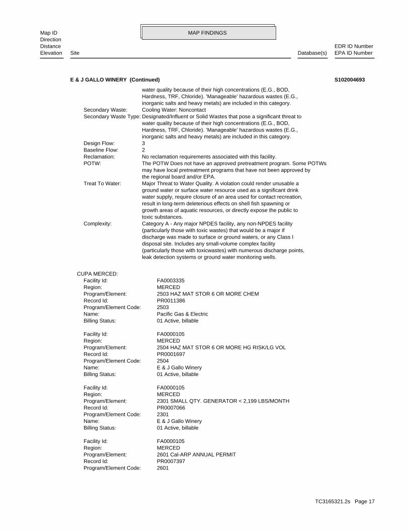
MAP FINDINGSMap IDDirection
EDR ID NumberDistanceEPA ID NumberDatabase(s)SiteElevation
2601Program/Element Code: PR0007397Record Id: 2601 Cal-ARP ANNUAL PERMITProgram/Element: MERCEDRegion: FA0000105Facility Id:
01 Active, billableBilling Status: E & J Gallo WineryName: 2301Program/Element Code: PR0007066Record Id: 2301 SMALL QTY. GENERATOR < 2,199 LBS/MONTHProgram/Element: MERCEDRegion: FA0000105Facility Id:
01 Active, billableBilling Status: E & J Gallo WineryName: 2504Program/Element Code: PR0001697Record Id: 2504 HAZ MAT STOR 6 OR MORE HG RISK/LG VOLProgram/Element: MERCEDRegion: FA0000105Facility Id:
01 Active, billableBilling Status: Pacific Gas & ElectricName: 2503Program/Element Code: PR0011386Record Id: 2503 HAZ MAT STOR 6 OR MORE CHEMProgram/Element: MERCEDRegion: FA0003335Facility Id:
CUPA MERCED:
leak detection systems or ground water monitoring wells. (particularly those with toxicwastes) with numerous discharge points, disposal site. Includes any small-volume complex facility discharge was made to surface or ground waters, or any Class I (particularly those with toxic wastes) that would be a major if Category A - Any major NPDES facility, any non-NPDES facilityComplexity: toxic substances. growth areas of aquatic resources, or directly expose the public to result in long-term deleterious effects on shell fish spawning or water supply, require closure of an area used for contact recreation, ground water or surface water resource used as a significant drink Major Threat to Water Quality. A violation could render unusable aTreat To Water: the regional board and/or EPA. may have local pretreatment programs that have not been approved by The POTW Does not have an approved pretreatment program. Some POTWsPOTW: No reclamation requirements associated with this facility.Reclamation: 2Baseline Flow: 3Design Flow: inorganic salts and heavy metals) are included in this category. Hardness, TRF, Chloride). ’Manageable’ hazardous wastes (E.G., water quality because of their high concentrations (E.G., BOD, Designated/Influent or Solid Wastes that pose a significant threat toSecondary Waste Type: Cooling Water: NoncontactSecondary Waste: inorganic salts and heavy metals) are included in this category. Hardness, TRF, Chloride). ’Manageable’ hazardous wastes (E.G., water quality because of their high concentrations (E.G., BOD,
E & J GALLO WINERY (Continued) S102004693
TC3165321.2s Page 17

MAP FINDINGSMap IDDirection
EDR ID NumberDistanceEPA ID NumberDatabase(s)SiteElevation
2811Comp Number: Not reportedStatus:
Not reportedNumber Of Tanks: DIESELContent: PRODUCTStg: M.V. FUELTank Use: 3947Capacity: Not reportedActv Date: 24-000-002811-000003Swrcb Tank Id: Not reportedOwner Tank Id: Not reportedTank Status: Not reportedCreated Date: Not reportedAct Date: Not reportedRef Date: 44-014315Board Of Equalization: Not reportedNumber: 2811Comp Number: Not reportedStatus:
Not reportedNumber Of Tanks: DIESELContent: PRODUCTStg: M.V. FUELTank Use: 10152Capacity: Not reportedActv Date: 24-000-002811-000002Swrcb Tank Id: Not reportedOwner Tank Id: Not reportedTank Status: Not reportedCreated Date: Not reportedAct Date: Not reportedRef Date: 44-014315Board Of Equalization: Not reportedNumber: 2811Comp Number: Not reportedStatus:
4Number Of Tanks: DIESELContent: PRODUCTStg: M.V. FUELTank Use: 20562Capacity: Not reportedActv Date: 24-000-002811-000001Swrcb Tank Id: Not reportedOwner Tank Id: Not reportedTank Status: Not reportedCreated Date: Not reportedAct Date: Not reportedRef Date: 44-014315Board Of Equalization: Not reportedNumber: 2811Comp Number: Not reportedStatus:
SWEEPS UST:
01 Active, billableBilling Status: E & J Gallo WineryName:
E & J GALLO WINERY (Continued) S102004693
TC3165321.2s Page 18

MAP FINDINGSMap IDDirection
EDR ID NumberDistanceEPA ID NumberDatabase(s)SiteElevation
Not reportedNumber Of Tanks: LEADEDContent: PRODUCTStg: M.V. FUELTank Use: 549Capacity: Not reportedActv Date: 24-000-002811-000004Swrcb Tank Id: Not reportedOwner Tank Id: Not reportedTank Status: Not reportedCreated Date: Not reportedAct Date: Not reportedRef Date: 44-014315Board Of Equalization: Not reportedNumber:
E & J GALLO WINERY (Continued) S102004693
1936 S WALNUT RDMailing Address: Not reportedMailing Name: 0000000000Telephone: COLEMAN TRANSPORTATION INCContact: CAL000176997Gepaid: 1999Year:
MercedFacility County: 0.0208Tons: T01Disposal Method: Unspecified organic liquid mixtureWaste Category: Santa ClaraTSD County: CAL000175030TSD EPA ID: MercedGen County: TURLOCK, CA 953800000Mailing City,St,Zip: 1936 S WALNUT RDMailing Address: Not reportedMailing Name: 0000000000Telephone: COLEMAN TRANSPORTATION INCContact: CAL000176997Gepaid: 1999Year:
MercedFacility County: 0Tons: R01Disposal Method: Not reportedWaste Category: Santa ClaraTSD County: CAL000175030TSD EPA ID: MercedGen County: TURLOCK, CA 953800000Mailing City,St,Zip: 1936 S WALNUT RDMailing Address: Not reportedMailing Name: 0000000000Telephone: COLEMAN TRANSPORTATION INCContact: CAL000176997Gepaid: 1999Year:
HAZNET:
Site 9 of 12 in cluster A
Actual:112 ft.
Property LIVINGSTON, CA 95334Target 18000 RIVER RD N/AA9 HAZNETCOLEMAN TRANSPORTATION INC S104580792
TC3165321.2s Page 19

MAP FINDINGSMap IDDirection
EDR ID NumberDistanceEPA ID NumberDatabase(s)SiteElevation
MercedFacility County: 0Tons: T01Disposal Method: Not reportedWaste Category: Santa ClaraTSD County: CAL000175030TSD EPA ID: MercedGen County: TURLOCK, CA 953800000Mailing City,St,Zip:
COLEMAN TRANSPORTATION INC (Continued) S104580792
Not reportedCommunity Health Air Pollution Info System: SAN JOAQUIN VALLEY UNIFIED APCDAir District Name: 2084SIC Code: SJUAir District Name: 1237Facility ID: SJVAir Basin: 24County Code: 1997Year:
1Part. Matter 10 Micrometers & Smllr Tons/Yr: 2Particulate Matter Tons/Yr: 0SOX - Oxides of Sulphur Tons/Yr: 4NOX - Oxides of Nitrogen Tons/Yr: 16Carbon Monoxide Emissions Tons/Yr: 0Reactive Organic Gases Tons/Yr: 0Total Organic Hydrocarbon Gases Tons/Yr: Not reportedConsolidated Emission Reporting Rule: Not reportedCommunity Health Air Pollution Info System: SAN JOAQUIN VALLEY UNIFIED APCDAir District Name: 2084SIC Code: SJUAir District Name: 1237Facility ID: SJVAir Basin: 24County Code: 1996Year:
1Part. Matter 10 Micrometers & Smllr Tons/Yr: 1Particulate Matter Tons/Yr: 0SOX - Oxides of Sulphur Tons/Yr: 80NOX - Oxides of Nitrogen Tons/Yr: 6Carbon Monoxide Emissions Tons/Yr: 103Reactive Organic Gases Tons/Yr: 147Total Organic Hydrocarbon Gases Tons/Yr: Not reportedConsolidated Emission Reporting Rule: Not reportedCommunity Health Air Pollution Info System: SAN JOAQUIN VALLEY UNIFIED APCDAir District Name: 2084SIC Code: SJUAir District Name: 50Facility ID: SJVAir Basin: 24County Code: 1987Year:
EMI:
Site 10 of 12 in cluster A
Actual:112 ft.
Property LIVINGSTON, CA 95344Target 18000 W. RIVER ROAD N/AA10 EMIE & J GALLO WINERY S106830350
TC3165321.2s Page 20
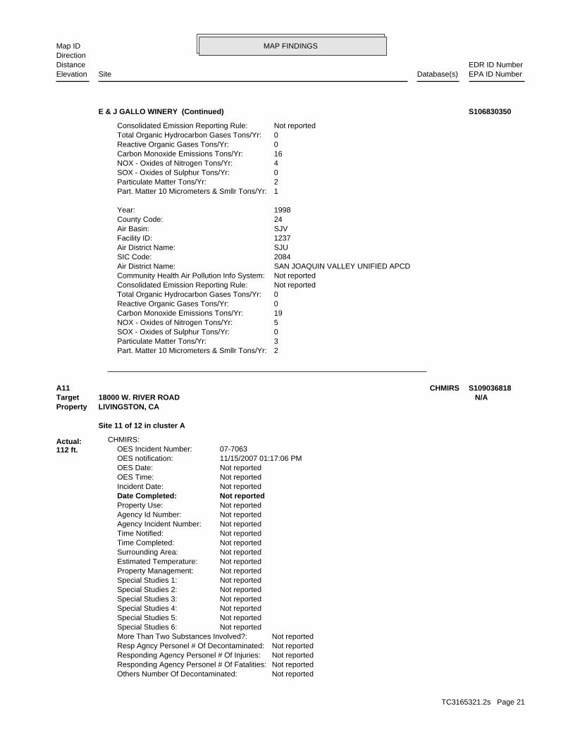
MAP FINDINGSMap IDDirection
EDR ID NumberDistanceEPA ID NumberDatabase(s)SiteElevation
2Part. Matter 10 Micrometers & Smllr Tons/Yr: 3Particulate Matter Tons/Yr: 0SOX - Oxides of Sulphur Tons/Yr: 5NOX - Oxides of Nitrogen Tons/Yr: 19Carbon Monoxide Emissions Tons/Yr: 0Reactive Organic Gases Tons/Yr: 0Total Organic Hydrocarbon Gases Tons/Yr: Not reportedConsolidated Emission Reporting Rule: Not reportedCommunity Health Air Pollution Info System: SAN JOAQUIN VALLEY UNIFIED APCDAir District Name: 2084SIC Code: SJUAir District Name: 1237Facility ID: SJVAir Basin: 24County Code: 1998Year:
1Part. Matter 10 Micrometers & Smllr Tons/Yr: 2Particulate Matter Tons/Yr: 0SOX - Oxides of Sulphur Tons/Yr: 4NOX - Oxides of Nitrogen Tons/Yr: 16Carbon Monoxide Emissions Tons/Yr: 0Reactive Organic Gases Tons/Yr: 0Total Organic Hydrocarbon Gases Tons/Yr: Not reportedConsolidated Emission Reporting Rule:
E & J GALLO WINERY (Continued) S106830350
Not reportedOthers Number Of Decontaminated: Not reportedResponding Agency Personel # Of Fatalities: Not reportedResponding Agency Personel # Of Injuries: Not reportedResp Agncy Personel # Of Decontaminated: Not reportedMore Than Two Substances Involved?: Not reportedSpecial Studies 6: Not reportedSpecial Studies 5: Not reportedSpecial Studies 4: Not reportedSpecial Studies 3: Not reportedSpecial Studies 2: Not reportedSpecial Studies 1: Not reportedProperty Management: Not reportedEstimated Temperature: Not reportedSurrounding Area: Not reportedTime Completed: Not reportedTime Notified: Not reportedAgency Incident Number: Not reportedAgency Id Number: Not reportedProperty Use: Not reportedDate Completed: Not reportedIncident Date: Not reportedOES Time: Not reportedOES Date: 11/15/2007 01:17:06 PMOES notification: 07-7063OES Incident Number:
CHMIRS:
Site 11 of 12 in cluster A
Actual:112 ft.
Property LIVINGSTON, CA Target 18000 W. RIVER ROAD N/AA11 CHMIRS S109036818
TC3165321.2s Page 21
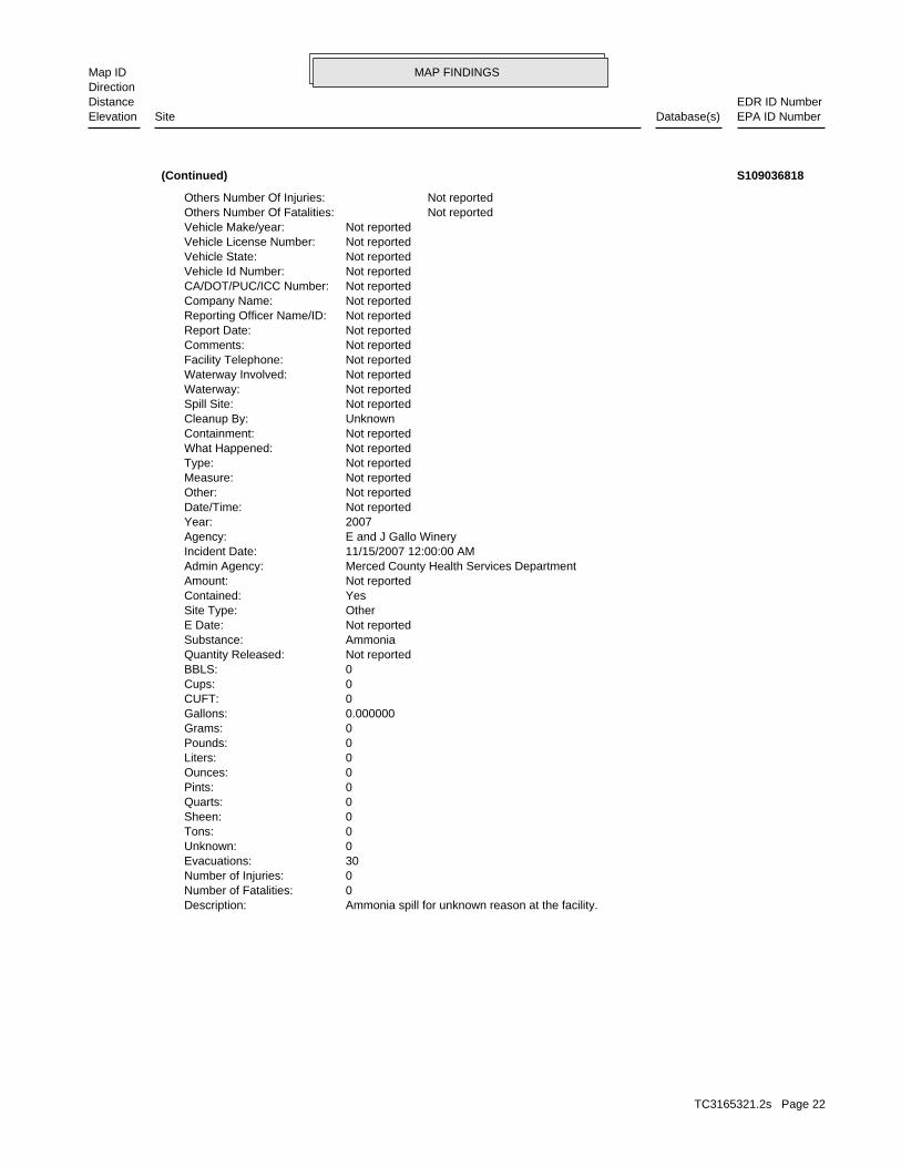
MAP FINDINGSMap IDDirection
EDR ID NumberDistanceEPA ID NumberDatabase(s)SiteElevation
Ammonia spill for unknown reason at the facility.Description: 0Number of Fatalities: 0Number of Injuries: 30Evacuations: 0Unknown: 0Tons: 0Sheen: 0Quarts: 0Pints: 0Ounces: 0Liters: 0Pounds: 0Grams: 0.000000Gallons: 0CUFT: 0Cups: 0BBLS: Not reportedQuantity Released: AmmoniaSubstance: Not reportedE Date: OtherSite Type: YesContained: Not reportedAmount: Merced County Health Services DepartmentAdmin Agency: 11/15/2007 12:00:00 AMIncident Date: E and J Gallo WineryAgency: 2007Year: Not reportedDate/Time: Not reportedOther: Not reportedMeasure: Not reportedType: Not reportedWhat Happened: Not reportedContainment: UnknownCleanup By: Not reportedSpill Site: Not reportedWaterway: Not reportedWaterway Involved: Not reportedFacility Telephone: Not reportedComments: Not reportedReport Date: Not reportedReporting Officer Name/ID: Not reportedCompany Name: Not reportedCA/DOT/PUC/ICC Number: Not reportedVehicle Id Number: Not reportedVehicle State: Not reportedVehicle License Number: Not reportedVehicle Make/year: Not reportedOthers Number Of Fatalities: Not reportedOthers Number Of Injuries:
(Continued) S109036818
TC3165321.2s Page 22

MAP FINDINGSMap IDDirection
EDR ID NumberDistanceEPA ID NumberDatabase(s)SiteElevation
Click here to access the California GeoTracker records for this facility:
Not reportedSite History: Not reportedPotential Contaminants of Concern: Not reportedPotential Media Affect: Not reportedFile Location: Not reportedLOC Case Number: 5B24SC00001RB Case Number: Not reportedLocal Agency: CMMCaseworker: CENTRAL VALLEY RWQCB (REGION 5F)Lead Agency: 01/01/1965Status Date: OpenStatus: Land Disposal SiteCase Type: -120.81409Longitude: 37.374956Latitude: L10009389657Global Id:
LDS:
Site 12 of 12 in cluster A
Actual:112 ft.
Property LIVINGSTON, CA 95334Target 18000 RIVER N/AA12 LDSLIVINGSTON WINERY - COMPOST S109287730
TC3165321.2s Page 23

ORPHAN SUMMARY
City EDR ID Site Name Site Address Zip Database(s)
Count: 37 records.
LIVINGSTON 1004444077 PG&E LIVINGSTON SUBSTATION WASHINGTON WESTSIDE 95334 FINDSLIVINGSTON 1006094992 JOSEPH GALLO FINE CHEESE 10607 WEST STATE HWY 140 95334 FINDSLIVINGSTON 1009520601 PG&E, LIVINGSTON SUB WASHINGTON - WESTSIDE 95334 FTTS,HIST FTTS INSPLIVINGSTON 1010042063 LIVINGSTON, CITY OF WWTP 7160 N. GALLO RD. 95334 FINDSLIVINGSTON 1011985354 CITY OF LIVINGSTON END OF JOSEPH GALLO DRIVE FINDSLIVINGSTON 1011989939 E & J GALLO WINERY 5953 N WEIR RD 95334 FINDSLIVINGSTON 1011993064 CITY OF LIVINGSTON LIVINGSTON/CRESSEY ROAD AT NUT FINDSLIVINGSTON 1012274469 LIVINGSTON DOMESTIC STP ONE MILE NORTH OF VINEWOOD AND 95334 FINDSLIVINGSTON 90189914 S/B HWY 99 LIVINGSTON LIGHTS S/B HWY 99 LIVINGSTON LIGHTS 95334 ERNSLIVINGSTON A100225987 LIVINGSTON TRUCK STOP 1000 SWAN STREET 95334 ASTLIVINGSTON A100226146 FERTILIZER PLANT 12997 W. HWY. 140 95334 ASTLIVINGSTON A100226270 LINCOLN RANCH 3 12619 W. HWY. 140 95334 ASTLIVINGSTON A100226271 LINCOLN RANCH 4 12817 W. HWY. 140 95334 AST M300003109 J BLASINGAME & SON, INC. BLASINGAME BACKHOLE MINES M300003111 CALAVERAS MATERIALS, INC. RIVER ROCK PLANT MINESLIVINGSTON S100188305 LIVINGSTON CITY DUMP END OF GALLO RD 95334 ENVIROSTORLIVINGSTON S101307566 LIVINGSTON BYPASS GENERAL HWY 99 95334 LUST SAN MATEO,HIST CORTESELIVINGSTON S103631938 CALTRANS LIVINGSTON FREEWAY 1502 HWY 99 PARCEL 12497 00000 HAZNETLIVINGSTON S103883830 CALTRANS MERCED RIVER BRIDGE HIGHWAY 99 AND MERCED RIVER 95334 VCP,ENVIROSTORLIVINGSTON S104735730 LOT 12671 EAST AVE/HWY 99 95334 LUST SAN MATEOLIVINGSTON S105024493 LOT 12671 E. AVE & HWY 99 95334 HIST CORTESELIVINGSTON S106127575 FOSTER FARMS LIVINGSTON TRUCK SHOP 1000 SWAN STREET 95334 CUPA FRESNO,LUST SAN MATEOLIVINGSTON S106486752 FOSTER POULTRY FARMS FERTILIZER PL 12997 WEST HIGHWAY 140 SLIC REGION 2LIVINGSTON S106833605 JOSEPH GALLO FINE CHEESE 10561 W HIGHWAY 140 EMILIVINGSTON S106833606 JOSEPH GALLO FINE CHEESE 10607 W HIGHWAY 140 EMILIVINGSTON S106833607 JOSEPH GALLO FINE CHEESE 10607 W HWY 140 EMILIVINGSTON S106834594 LIVINGSTON AUTO BODY 1444 HWY. 99 95334 EMILIVINGSTON S106923269 BERT CRANE RANCHES/SUNRISE 13407 W HIGHWAY 140 95334 SWEEPS USTLIVINGSTON S106926960 GUJJAR SINGH SAHI 3396 N WEIR 95334 SWEEPS USTLIVINGSTON S106927627 J.J. RATZLAFF 13589 W PEACH 95334 SWEEPS USTLIVINGSTON S107473151 FOSTER FARMS HIGHWAY 140 RANCH COM 18125 WEST HIGHWAY 140 SLIC REGION 2LIVINGSTON S108543202 FOSTER FARMS LINCOLN RANCH 12781 & 12619 W. HWY 140 SLIC REGION 2LIVINGSTON S110654652 LIVINGSTON BYPASS GENERAL HWY 99 95334 LUST SAN MATEOLIVINGSTON S110654653 LOT 12671 EAST AVE/HWY 99 95334 LUST SAN MATEOLIVINGSTON S110738765 FOSTER FARMS LINCOLN COMPLEX 12781 W HWY 140 95334 CUPA FRESNOLIVINGSTON U001606028 BLEVINS SHELL SERVICE 144-HWY 99 95334 HIST USTLIVINGSTON U001606132 YAGI BROS. 2049 HWY 99 SO. 95334 HIST UST
TC3165321.2s Page 24
To maintain currency of the following federal and state databases, EDR contacts the appropriate governmental agencyon a monthly or quarterly basis, as required.
Number of Days to Update: Provides confirmation that EDR is reporting records that have been updated within 90 daysfrom the date the government agency made the information available to the public.
STANDARD ENVIRONMENTAL RECORDS
Federal NPL site list
NPL: National Priority ListNational Priorities List (Superfund). The NPL is a subset of CERCLIS and identifies over 1,200 sites for prioritycleanup under the Superfund Program. NPL sites may encompass relatively large areas. As such, EDR provides polygoncoverage for over 1,000 NPL site boundaries produced by EPA’s Environmental Photographic Interpretation Center(EPIC) and regional EPA offices.
Date of Government Version: 03/31/2011Date Data Arrived at EDR: 04/13/2011Date Made Active in Reports: 06/14/2011Number of Days to Update: 62
Source: EPATelephone: N/ALast EDR Contact: 07/12/2011Next Scheduled EDR Contact: 10/24/2011Data Release Frequency: Quarterly
NPL Site Boundaries
Sources:
EPA’s Environmental Photographic Interpretation Center (EPIC)Telephone: 202-564-7333
EPA Region 1 EPA Region 6Telephone 617-918-1143 Telephone: 214-655-6659
EPA Region 3 EPA Region 7Telephone 215-814-5418 Telephone: 913-551-7247
EPA Region 4 EPA Region 8Telephone 404-562-8033 Telephone: 303-312-6774
EPA Region 5 EPA Region 9Telephone 312-886-6686 Telephone: 415-947-4246
EPA Region 10Telephone 206-553-8665
Proposed NPL: Proposed National Priority List SitesA site that has been proposed for listing on the National Priorities List through the issuance of a proposed rulein the Federal Register. EPA then accepts public comments on the site, responds to the comments, and places onthe NPL those sites that continue to meet the requirements for listing.
Date of Government Version: 03/31/2011Date Data Arrived at EDR: 04/13/2011Date Made Active in Reports: 06/14/2011Number of Days to Update: 62
Source: EPATelephone: N/ALast EDR Contact: 07/12/2011Next Scheduled EDR Contact: 10/24/2011Data Release Frequency: Quarterly
NPL LIENS: Federal Superfund LiensFederal Superfund Liens. Under the authority granted the USEPA by CERCLA of 1980, the USEPA has the authorityto file liens against real property in order to recover remedial action expenditures or when the property ownerreceived notification of potential liability. USEPA compiles a listing of filed notices of Superfund Liens.
Date of Government Version: 10/15/1991Date Data Arrived at EDR: 02/02/1994Date Made Active in Reports: 03/30/1994Number of Days to Update: 56
Source: EPATelephone: 202-564-4267Last EDR Contact: 08/15/2011Next Scheduled EDR Contact: 11/28/2011Data Release Frequency: No Update Planned
TC3165321.2s Page GR-1
GOVERNMENT RECORDS SEARCHED / DATA CURRENCY TRACKING

Federal Delisted NPL site list
DELISTED NPL: National Priority List DeletionsThe National Oil and Hazardous Substances Pollution Contingency Plan (NCP) establishes the criteria that theEPA uses to delete sites from the NPL. In accordance with 40 CFR 300.425.(e), sites may be deleted from theNPL where no further response is appropriate.
Date of Government Version: 03/31/2011Date Data Arrived at EDR: 04/13/2011Date Made Active in Reports: 06/14/2011Number of Days to Update: 62
Source: EPATelephone: N/ALast EDR Contact: 07/12/2011Next Scheduled EDR Contact: 10/24/2011Data Release Frequency: Quarterly
Federal CERCLIS list
CERCLIS: Comprehensive Environmental Response, Compensation, and Liability Information SystemCERCLIS contains data on potentially hazardous waste sites that have been reported to the USEPA by states, municipalities,private companies and private persons, pursuant to Section 103 of the Comprehensive Environmental Response, Compensation,and Liability Act (CERCLA). CERCLIS contains sites which are either proposed to or on the National PrioritiesList (NPL) and sites which are in the screening and assessment phase for possible inclusion on the NPL.
Date of Government Version: 02/25/2011Date Data Arrived at EDR: 03/01/2011Date Made Active in Reports: 05/02/2011Number of Days to Update: 62
Source: EPATelephone: 703-412-9810Last EDR Contact: 09/01/2011Next Scheduled EDR Contact: 12/12/2011Data Release Frequency: Quarterly
FEDERAL FACILITY: Federal Facility Site Information listingA listing of National Priority List (NPL) and Base Realignment and Closure (BRAC) sites found in the ComprehensiveEnvironmental Response, Compensation and Liability Information System (CERCLIS) Database where EPAa??s FederalFacilities Restoration and Reuse Office is involved in cleanup activities.
Date of Government Version: 12/10/2010Date Data Arrived at EDR: 01/11/2011Date Made Active in Reports: 02/16/2011Number of Days to Update: 36
Source: Environmental Protection AgencyTelephone: 703-603-8704Last EDR Contact: 07/15/2011Next Scheduled EDR Contact: 10/24/2011Data Release Frequency: Varies
Federal CERCLIS NFRAP site List
CERCLIS-NFRAP: CERCLIS No Further Remedial Action PlannedArchived sites are sites that have been removed and archived from the inventory of CERCLIS sites. Archived statusindicates that, to the best of EPA’s knowledge, assessment at a site has been completed and that EPA has determinedno further steps will be taken to list this site on the National Priorities List (NPL), unless information indicatesthis decision was not appropriate or other considerations require a recommendation for listing at a later time.This decision does not necessarily mean that there is no hazard associated with a given site; it only means that,based upon available information, the location is not judged to be a potential NPL site.
Date of Government Version: 02/25/2011Date Data Arrived at EDR: 03/01/2011Date Made Active in Reports: 05/02/2011Number of Days to Update: 62
Source: EPATelephone: 703-412-9810Last EDR Contact: 09/01/2011Next Scheduled EDR Contact: 12/12/2011Data Release Frequency: Quarterly
Federal RCRA CORRACTS facilities list
CORRACTS: Corrective Action ReportCORRACTS identifies hazardous waste handlers with RCRA corrective action activity.
TC3165321.2s Page GR-2
GOVERNMENT RECORDS SEARCHED / DATA CURRENCY TRACKING

Date of Government Version: 03/09/2011Date Data Arrived at EDR: 03/15/2011Date Made Active in Reports: 06/14/2011Number of Days to Update: 91
Source: EPATelephone: 800-424-9346Last EDR Contact: 08/15/2011Next Scheduled EDR Contact: 11/28/2011Data Release Frequency: Quarterly
Federal RCRA non-CORRACTS TSD facilities list
RCRA-TSDF: RCRA - Treatment, Storage and DisposalRCRAInfo is EPA’s comprehensive information system, providing access to data supporting the Resource Conservationand Recovery Act (RCRA) of 1976 and the Hazardous and Solid Waste Amendments (HSWA) of 1984. The databaseincludes selective information on sites which generate, transport, store, treat and/or dispose of hazardous wasteas defined by the Resource Conservation and Recovery Act (RCRA). Transporters are individuals or entities thatmove hazardous waste from the generator offsite to a facility that can recycle, treat, store, or dispose of thewaste. TSDFs treat, store, or dispose of the waste.
Date of Government Version: 06/15/2011Date Data Arrived at EDR: 07/07/2011Date Made Active in Reports: 08/08/2011Number of Days to Update: 32
Source: Environmental Protection AgencyTelephone: (415) 495-8895Last EDR Contact: 07/07/2011Next Scheduled EDR Contact: 10/17/2011Data Release Frequency: Quarterly
Federal RCRA generators list
RCRA-LQG: RCRA - Large Quantity GeneratorsRCRAInfo is EPA’s comprehensive information system, providing access to data supporting the Resource Conservationand Recovery Act (RCRA) of 1976 and the Hazardous and Solid Waste Amendments (HSWA) of 1984. The databaseincludes selective information on sites which generate, transport, store, treat and/or dispose of hazardous wasteas defined by the Resource Conservation and Recovery Act (RCRA). Large quantity generators (LQGs) generateover 1,000 kilograms (kg) of hazardous waste, or over 1 kg of acutely hazardous waste per month.
Date of Government Version: 06/15/2011Date Data Arrived at EDR: 07/07/2011Date Made Active in Reports: 08/08/2011Number of Days to Update: 32
Source: Environmental Protection AgencyTelephone: (415) 495-8895Last EDR Contact: 07/07/2011Next Scheduled EDR Contact: 10/17/2011Data Release Frequency: Quarterly
RCRA-SQG: RCRA - Small Quantity GeneratorsRCRAInfo is EPA’s comprehensive information system, providing access to data supporting the Resource Conservationand Recovery Act (RCRA) of 1976 and the Hazardous and Solid Waste Amendments (HSWA) of 1984. The databaseincludes selective information on sites which generate, transport, store, treat and/or dispose of hazardous wasteas defined by the Resource Conservation and Recovery Act (RCRA). Small quantity generators (SQGs) generatebetween 100 kg and 1,000 kg of hazardous waste per month.
Date of Government Version: 06/15/2011Date Data Arrived at EDR: 07/07/2011Date Made Active in Reports: 08/08/2011Number of Days to Update: 32
Source: Environmental Protection AgencyTelephone: (415) 495-8895Last EDR Contact: 07/07/2011Next Scheduled EDR Contact: 10/17/2011Data Release Frequency: Quarterly
RCRA-CESQG: RCRA - Conditionally Exempt Small Quantity GeneratorsRCRAInfo is EPA’s comprehensive information system, providing access to data supporting the Resource Conservationand Recovery Act (RCRA) of 1976 and the Hazardous and Solid Waste Amendments (HSWA) of 1984. The databaseincludes selective information on sites which generate, transport, store, treat and/or dispose of hazardous wasteas defined by the Resource Conservation and Recovery Act (RCRA). Conditionally exempt small quantity generators(CESQGs) generate less than 100 kg of hazardous waste, or less than 1 kg of acutely hazardous waste per month.
Date of Government Version: 06/15/2011Date Data Arrived at EDR: 07/07/2011Date Made Active in Reports: 08/08/2011Number of Days to Update: 32
Source: Environmental Protection AgencyTelephone: (415) 495-8895Last EDR Contact: 07/07/2011Next Scheduled EDR Contact: 10/17/2011Data Release Frequency: Varies
TC3165321.2s Page GR-3
GOVERNMENT RECORDS SEARCHED / DATA CURRENCY TRACKING

Federal institutional controls / engineering controls registries
US ENG CONTROLS: Engineering Controls Sites ListA listing of sites with engineering controls in place. Engineering controls include various forms of caps, buildingfoundations, liners, and treatment methods to create pathway elimination for regulated substances to enter environmentalmedia or effect human health.
Date of Government Version: 03/16/2011Date Data Arrived at EDR: 03/25/2011Date Made Active in Reports: 06/14/2011Number of Days to Update: 81
Source: Environmental Protection AgencyTelephone: 703-603-0695Last EDR Contact: 09/12/2011Next Scheduled EDR Contact: 12/26/2011Data Release Frequency: Varies
US INST CONTROL: Sites with Institutional ControlsA listing of sites with institutional controls in place. Institutional controls include administrative measures,such as groundwater use restrictions, construction restrictions, property use restrictions, and post remediationcare requirements intended to prevent exposure to contaminants remaining on site. Deed restrictions are generallyrequired as part of the institutional controls.
Date of Government Version: 03/16/2011Date Data Arrived at EDR: 03/25/2011Date Made Active in Reports: 06/14/2011Number of Days to Update: 81
Source: Environmental Protection AgencyTelephone: 703-603-0695Last EDR Contact: 09/12/2011Next Scheduled EDR Contact: 12/26/2011Data Release Frequency: Varies
Federal ERNS list
ERNS: Emergency Response Notification SystemEmergency Response Notification System. ERNS records and stores information on reported releases of oil and hazardoussubstances.
Date of Government Version: 04/05/2011Date Data Arrived at EDR: 04/05/2011Date Made Active in Reports: 06/14/2011Number of Days to Update: 70
Source: National Response Center, United States Coast GuardTelephone: 202-267-2180Last EDR Contact: 07/05/2011Next Scheduled EDR Contact: 10/17/2011Data Release Frequency: Annually
State- and tribal - equivalent NPL
RESPONSE: State Response SitesIdentifies confirmed release sites where DTSC is involved in remediation, either in a lead or oversight capacity.These confirmed release sites are generally high-priority and high potential risk.
Date of Government Version: 08/09/2011Date Data Arrived at EDR: 08/09/2011Date Made Active in Reports: 09/09/2011Number of Days to Update: 31
Source: Department of Toxic Substances ControlTelephone: 916-323-3400Last EDR Contact: 08/09/2011Next Scheduled EDR Contact: 11/21/2011Data Release Frequency: Quarterly
State- and tribal - equivalent CERCLIS
ENVIROSTOR: EnviroStor DatabaseThe Department of Toxic Substances Control’s (DTSC’s) Site Mitigation and Brownfields Reuse Program’s (SMBRP’s)EnviroStor database identifes sites that have known contamination or sites for which there may be reasons to investigatefurther. The database includes the following site types: Federal Superfund sites (National Priorities List (NPL));State Response, including Military Facilities and State Superfund; Voluntary Cleanup; and School sites. EnviroStorprovides similar information to the information that was available in CalSites, and provides additional site information,including, but not limited to, identification of formerly-contaminated properties that have been released forreuse, properties where environmental deed restrictions have been recorded to prevent inappropriate land uses,and risk characterization information that is used to assess potential impacts to public health and the environmentat contaminated sites.
TC3165321.2s Page GR-4
GOVERNMENT RECORDS SEARCHED / DATA CURRENCY TRACKING

Date of Government Version: 08/09/2011Date Data Arrived at EDR: 08/09/2011Date Made Active in Reports: 09/09/2011Number of Days to Update: 31
Source: Department of Toxic Substances ControlTelephone: 916-323-3400Last EDR Contact: 08/09/2011Next Scheduled EDR Contact: 11/21/2011Data Release Frequency: Quarterly
State and tribal landfill and/or solid waste disposal site lists
SWF/LF (SWIS): Solid Waste Information SystemActive, Closed and Inactive Landfills. SWF/LF records typically contain an inve ntory of solid waste disposalfacilities or landfills. These may be active or i nactive facilities or open dumps that failed to meet RCRA Section4004 criteria for solid waste landfills or disposal sites.
Date of Government Version: 05/23/2011Date Data Arrived at EDR: 05/24/2011Date Made Active in Reports: 06/15/2011Number of Days to Update: 22
Source: Department of Resources Recycling and RecoveryTelephone: 916-341-6320Last EDR Contact: 08/24/2011Next Scheduled EDR Contact: 12/05/2011Data Release Frequency: Quarterly
State and tribal leaking storage tank lists
LUST REG 9: Leaking Underground Storage Tank ReportOrange, Riverside, San Diego counties. For more current information, please refer to the State Water ResourcesControl Board’s LUST database.
Date of Government Version: 03/01/2001Date Data Arrived at EDR: 04/23/2001Date Made Active in Reports: 05/21/2001Number of Days to Update: 28
Source: California Regional Water Quality Control Board San Diego Region (9)Telephone: 858-637-5595Last EDR Contact: 06/27/2011Next Scheduled EDR Contact: 10/10/2011Data Release Frequency: No Update Planned
LUST REG 7: Leaking Underground Storage Tank Case ListingLeaking Underground Storage Tank locations. Imperial, Riverside, San Diego, Santa Barbara counties.
Date of Government Version: 02/26/2004Date Data Arrived at EDR: 02/26/2004Date Made Active in Reports: 03/24/2004Number of Days to Update: 27
Source: California Regional Water Quality Control Board Colorado River Basin Region (7)Telephone: 760-776-8943Last EDR Contact: 08/01/2011Next Scheduled EDR Contact: 11/14/2011Data Release Frequency: No Update Planned
LUST REG 6V: Leaking Underground Storage Tank Case ListingLeaking Underground Storage Tank locations. Inyo, Kern, Los Angeles, Mono, San Bernardino counties.
Date of Government Version: 06/07/2005Date Data Arrived at EDR: 06/07/2005Date Made Active in Reports: 06/29/2005Number of Days to Update: 22
Source: California Regional Water Quality Control Board Victorville Branch Office (6)Telephone: 760-241-7365Last EDR Contact: 09/12/2011Next Scheduled EDR Contact: 12/26/2011Data Release Frequency: No Update Planned
LUST REG 6L: Leaking Underground Storage Tank Case ListingFor more current information, please refer to the State Water Resources Control Board’s LUST database.
Date of Government Version: 09/09/2003Date Data Arrived at EDR: 09/10/2003Date Made Active in Reports: 10/07/2003Number of Days to Update: 27
Source: California Regional Water Quality Control Board Lahontan Region (6)Telephone: 530-542-5572Last EDR Contact: 09/12/2011Next Scheduled EDR Contact: 12/26/2011Data Release Frequency: No Update Planned
LUST REG 5: Leaking Underground Storage Tank DatabaseLeaking Underground Storage Tank locations. Alameda, Alpine, Amador, Butte, Colusa, Contra Costa, Calveras, ElDorado, Fresno, Glenn, Kern, Kings, Lake, Lassen, Madera, Mariposa, Merced, Modoc, Napa, Nevada, Placer, Plumas,Sacramento, San Joaquin, Shasta, Solano, Stanislaus, Sutter, Tehama, Tulare, Tuolumne, Yolo, Yuba counties.
TC3165321.2s Page GR-5
GOVERNMENT RECORDS SEARCHED / DATA CURRENCY TRACKING
Date of Government Version: 07/01/2008Date Data Arrived at EDR: 07/22/2008Date Made Active in Reports: 07/31/2008Number of Days to Update: 9
Source: California Regional Water Quality Control Board Central Valley Region (5)Telephone: 916-464-4834Last EDR Contact: 07/01/2011Next Scheduled EDR Contact: 10/17/2011Data Release Frequency: Quarterly
LUST REG 4: Underground Storage Tank Leak ListLos Angeles, Ventura counties. For more current information, please refer to the State Water Resources ControlBoard’s LUST database.
Date of Government Version: 09/07/2004Date Data Arrived at EDR: 09/07/2004Date Made Active in Reports: 10/12/2004Number of Days to Update: 35
Source: California Regional Water Quality Control Board Los Angeles Region (4)Telephone: 213-576-6710Last EDR Contact: 09/06/2011Next Scheduled EDR Contact: 12/19/2011Data Release Frequency: No Update Planned
LUST REG 3: Leaking Underground Storage Tank DatabaseLeaking Underground Storage Tank locations. Monterey, San Benito, San Luis Obispo, Santa Barbara, Santa Cruz counties.
Date of Government Version: 05/19/2003Date Data Arrived at EDR: 05/19/2003Date Made Active in Reports: 06/02/2003Number of Days to Update: 14
Source: California Regional Water Quality Control Board Central Coast Region (3)Telephone: 805-542-4786Last EDR Contact: 07/18/2011Next Scheduled EDR Contact: 10/31/2011Data Release Frequency: No Update Planned
LUST REG 2: Fuel Leak ListLeaking Underground Storage Tank locations. Alameda, Contra Costa, Marin, Napa, San Francisco, San Mateo, SantaClara, Solano, Sonoma counties.
Date of Government Version: 09/30/2004Date Data Arrived at EDR: 10/20/2004Date Made Active in Reports: 11/19/2004Number of Days to Update: 30
Source: California Regional Water Quality Control Board San Francisco Bay Region (2)Telephone: 510-622-2433Last EDR Contact: 06/20/2011Next Scheduled EDR Contact: 09/05/2011Data Release Frequency: Quarterly
LUST REG 1: Active Toxic Site InvestigationDel Norte, Humboldt, Lake, Mendocino, Modoc, Siskiyou, Sonoma, Trinity counties. For more current information,please refer to the State Water Resources Control Board’s LUST database.
Date of Government Version: 02/01/2001Date Data Arrived at EDR: 02/28/2001Date Made Active in Reports: 03/29/2001Number of Days to Update: 29
Source: California Regional Water Quality Control Board North Coast (1)Telephone: 707-570-3769Last EDR Contact: 08/01/2011Next Scheduled EDR Contact: 11/14/2011Data Release Frequency: No Update Planned
LUST: Geotracker’s Leaking Underground Fuel Tank ReportLeaking Underground Storage Tank Incident Reports. LUST records contain an inventory of reported leaking undergroundstorage tank incidents. Not all states maintain these records, and the information stored varies by state. Formore information on a particular leaking underground storage tank sites, please contact the appropriate regulatoryagency.
Date of Government Version: 08/09/2011Date Data Arrived at EDR: 08/11/2011Date Made Active in Reports: 09/12/2011Number of Days to Update: 32
Source: State Water Resources Control BoardTelephone: see region listLast EDR Contact: 08/11/2011Next Scheduled EDR Contact: 10/03/2011Data Release Frequency: Quarterly
LUST REG 8: Leaking Underground Storage TanksCalifornia Regional Water Quality Control Board Santa Ana Region (8). For more current information, please referto the State Water Resources Control Board’s LUST database.
TC3165321.2s Page GR-6
GOVERNMENT RECORDS SEARCHED / DATA CURRENCY TRACKING

Date of Government Version: 02/14/2005Date Data Arrived at EDR: 02/15/2005Date Made Active in Reports: 03/28/2005Number of Days to Update: 41
Source: California Regional Water Quality Control Board Santa Ana Region (8)Telephone: 909-782-4496Last EDR Contact: 08/15/2011Next Scheduled EDR Contact: 11/28/2011Data Release Frequency: Varies
SLIC: Statewide SLIC CasesThe SLIC (Spills, Leaks, Investigations and Cleanup) program is designed to protect and restore water qualityfrom spills, leaks, and similar discharges.
Date of Government Version: 08/09/2011Date Data Arrived at EDR: 08/11/2011Date Made Active in Reports: 09/12/2011Number of Days to Update: 32
Source: State Water Resources Control BoardTelephone: 866-480-1028Last EDR Contact: 08/11/2011Next Scheduled EDR Contact: 10/03/2011Data Release Frequency: Varies
SLIC REG 1: Active Toxic Site InvestigationsThe SLIC (Spills, Leaks, Investigations and Cleanup) program is designed to protect and restore water qualityfrom spills, leaks, and similar discharges.
Date of Government Version: 04/03/2003Date Data Arrived at EDR: 04/07/2003Date Made Active in Reports: 04/25/2003Number of Days to Update: 18
Source: California Regional Water Quality Control Board, North Coast Region (1)Telephone: 707-576-2220Last EDR Contact: 08/01/2011Next Scheduled EDR Contact: 11/14/2011Data Release Frequency: No Update Planned
SLIC REG 2: Spills, Leaks, Investigation & Cleanup Cost Recovery ListingThe SLIC (Spills, Leaks, Investigations and Cleanup) program is designed to protect and restore water qualityfrom spills, leaks, and similar discharges.
Date of Government Version: 09/30/2004Date Data Arrived at EDR: 10/20/2004Date Made Active in Reports: 11/19/2004Number of Days to Update: 30
Source: Regional Water Quality Control Board San Francisco Bay Region (2)Telephone: 510-286-0457Last EDR Contact: 06/20/2011Next Scheduled EDR Contact: 09/05/2011Data Release Frequency: Quarterly
SLIC REG 3: Spills, Leaks, Investigation & Cleanup Cost Recovery ListingThe SLIC (Spills, Leaks, Investigations and Cleanup) program is designed to protect and restore water qualityfrom spills, leaks, and similar discharges.
Date of Government Version: 05/18/2006Date Data Arrived at EDR: 05/18/2006Date Made Active in Reports: 06/15/2006Number of Days to Update: 28
Source: California Regional Water Quality Control Board Central Coast Region (3)Telephone: 805-549-3147Last EDR Contact: 07/18/2011Next Scheduled EDR Contact: 10/31/2011Data Release Frequency: Semi-Annually
SLIC REG 4: Spills, Leaks, Investigation & Cleanup Cost Recovery ListingThe SLIC (Spills, Leaks, Investigations and Cleanup) program is designed to protect and restore water qualityfrom spills, leaks, and similar discharges.
Date of Government Version: 11/17/2004Date Data Arrived at EDR: 11/18/2004Date Made Active in Reports: 01/04/2005Number of Days to Update: 47
Source: Region Water Quality Control Board Los Angeles Region (4)Telephone: 213-576-6600Last EDR Contact: 07/01/2011Next Scheduled EDR Contact: 10/17/2011Data Release Frequency: Varies
SLIC REG 5: Spills, Leaks, Investigation & Cleanup Cost Recovery ListingThe SLIC (Spills, Leaks, Investigations and Cleanup) program is designed to protect and restore water qualityfrom spills, leaks, and similar discharges.
TC3165321.2s Page GR-7
GOVERNMENT RECORDS SEARCHED / DATA CURRENCY TRACKING

Date of Government Version: 04/01/2005Date Data Arrived at EDR: 04/05/2005Date Made Active in Reports: 04/21/2005Number of Days to Update: 16
Source: Regional Water Quality Control Board Central Valley Region (5)Telephone: 916-464-3291Last EDR Contact: 09/12/2011Next Scheduled EDR Contact: 12/26/2011Data Release Frequency: Semi-Annually
SLIC REG 6V: Spills, Leaks, Investigation & Cleanup Cost Recovery ListingThe SLIC (Spills, Leaks, Investigations and Cleanup) program is designed to protect and restore water qualityfrom spills, leaks, and similar discharges.
Date of Government Version: 05/24/2005Date Data Arrived at EDR: 05/25/2005Date Made Active in Reports: 06/16/2005Number of Days to Update: 22
Source: Regional Water Quality Control Board, Victorville BranchTelephone: 619-241-6583Last EDR Contact: 08/15/2011Next Scheduled EDR Contact: 11/28/2011Data Release Frequency: Semi-Annually
SLIC REG 6L: SLIC SitesThe SLIC (Spills, Leaks, Investigations and Cleanup) program is designed to protect and restore water qualityfrom spills, leaks, and similar discharges.
Date of Government Version: 09/07/2004Date Data Arrived at EDR: 09/07/2004Date Made Active in Reports: 10/12/2004Number of Days to Update: 35
Source: California Regional Water Quality Control Board, Lahontan RegionTelephone: 530-542-5574Last EDR Contact: 08/15/2011Next Scheduled EDR Contact: 11/28/2011Data Release Frequency: No Update Planned
SLIC REG 7: SLIC ListThe SLIC (Spills, Leaks, Investigations and Cleanup) program is designed to protect and restore water qualityfrom spills, leaks, and similar discharges.
Date of Government Version: 11/24/2004Date Data Arrived at EDR: 11/29/2004Date Made Active in Reports: 01/04/2005Number of Days to Update: 36
Source: California Regional Quality Control Board, Colorado River Basin RegionTelephone: 760-346-7491Last EDR Contact: 08/01/2011Next Scheduled EDR Contact: 11/14/2011Data Release Frequency: No Update Planned
SLIC REG 8: Spills, Leaks, Investigation & Cleanup Cost Recovery ListingThe SLIC (Spills, Leaks, Investigations and Cleanup) program is designed to protect and restore water qualityfrom spills, leaks, and similar discharges.
Date of Government Version: 04/03/2008Date Data Arrived at EDR: 04/03/2008Date Made Active in Reports: 04/14/2008Number of Days to Update: 11
Source: California Region Water Quality Control Board Santa Ana Region (8)Telephone: 951-782-3298Last EDR Contact: 09/12/2011Next Scheduled EDR Contact: 12/26/2011Data Release Frequency: Semi-Annually
SLIC REG 9: Spills, Leaks, Investigation & Cleanup Cost Recovery ListingThe SLIC (Spills, Leaks, Investigations and Cleanup) program is designed to protect and restore water qualityfrom spills, leaks, and similar discharges.
Date of Government Version: 09/10/2007Date Data Arrived at EDR: 09/11/2007Date Made Active in Reports: 09/28/2007Number of Days to Update: 17
Source: California Regional Water Quality Control Board San Diego Region (9)Telephone: 858-467-2980Last EDR Contact: 08/08/2011Next Scheduled EDR Contact: 11/21/2011Data Release Frequency: Annually
INDIAN LUST R10: Leaking Underground Storage Tanks on Indian LandLUSTs on Indian land in Alaska, Idaho, Oregon and Washington.
TC3165321.2s Page GR-8
GOVERNMENT RECORDS SEARCHED / DATA CURRENCY TRACKING

Date of Government Version: 08/04/2011Date Data Arrived at EDR: 08/05/2011Date Made Active in Reports: 09/13/2011Number of Days to Update: 39
Source: EPA Region 10Telephone: 206-553-2857Last EDR Contact: 08/01/2011Next Scheduled EDR Contact: 11/14/2011Data Release Frequency: Quarterly
INDIAN LUST R1: Leaking Underground Storage Tanks on Indian LandA listing of leaking underground storage tank locations on Indian Land.
Date of Government Version: 05/05/2011Date Data Arrived at EDR: 08/02/2011Date Made Active in Reports: 09/13/2011Number of Days to Update: 42
Source: EPA Region 1Telephone: 617-918-1313Last EDR Contact: 08/02/2011Next Scheduled EDR Contact: 11/14/2011Data Release Frequency: Varies
INDIAN LUST R8: Leaking Underground Storage Tanks on Indian LandLUSTs on Indian land in Colorado, Montana, North Dakota, South Dakota, Utah and Wyoming.
Date of Government Version: 08/18/2011Date Data Arrived at EDR: 08/19/2011Date Made Active in Reports: 09/13/2011Number of Days to Update: 25
Source: EPA Region 8Telephone: 303-312-6271Last EDR Contact: 08/01/2011Next Scheduled EDR Contact: 11/14/2011Data Release Frequency: Quarterly
INDIAN LUST R6: Leaking Underground Storage Tanks on Indian LandLUSTs on Indian land in New Mexico and Oklahoma.
Date of Government Version: 05/10/2011Date Data Arrived at EDR: 05/11/2011Date Made Active in Reports: 06/14/2011Number of Days to Update: 34
Source: EPA Region 6Telephone: 214-665-6597Last EDR Contact: 08/01/2011Next Scheduled EDR Contact: 11/14/2011Data Release Frequency: Varies
INDIAN LUST R4: Leaking Underground Storage Tanks on Indian LandLUSTs on Indian land in Florida, Mississippi and North Carolina.
Date of Government Version: 08/11/2011Date Data Arrived at EDR: 08/12/2011Date Made Active in Reports: 09/13/2011Number of Days to Update: 32
Source: EPA Region 4Telephone: 404-562-8677Last EDR Contact: 08/01/2011Next Scheduled EDR Contact: 11/14/2011Data Release Frequency: Semi-Annually
INDIAN LUST R9: Leaking Underground Storage Tanks on Indian LandLUSTs on Indian land in Arizona, California, New Mexico and Nevada
Date of Government Version: 01/31/2011Date Data Arrived at EDR: 02/01/2011Date Made Active in Reports: 03/21/2011Number of Days to Update: 48
Source: Environmental Protection AgencyTelephone: 415-972-3372Last EDR Contact: 08/01/2011Next Scheduled EDR Contact: 11/14/2011Data Release Frequency: Quarterly
INDIAN LUST R7: Leaking Underground Storage Tanks on Indian LandLUSTs on Indian land in Iowa, Kansas, and Nebraska
Date of Government Version: 02/16/2011Date Data Arrived at EDR: 06/02/2011Date Made Active in Reports: 09/13/2011Number of Days to Update: 103
Source: EPA Region 7Telephone: 913-551-7003Last EDR Contact: 08/02/2011Next Scheduled EDR Contact: 11/14/2011Data Release Frequency: Varies
State and tribal registered storage tank lists
TC3165321.2s Page GR-9
GOVERNMENT RECORDS SEARCHED / DATA CURRENCY TRACKING
UST: Active UST FacilitiesActive UST facilities gathered from the local regulatory agencies
Date of Government Version: 08/09/2011Date Data Arrived at EDR: 08/11/2011Date Made Active in Reports: 09/09/2011Number of Days to Update: 29
Source: SWRCBTelephone: 916-480-1028Last EDR Contact: 08/11/2011Next Scheduled EDR Contact: 10/03/2011Data Release Frequency: Semi-Annually
AST: Aboveground Petroleum Storage Tank FacilitiesRegistered Aboveground Storage Tanks.
Date of Government Version: 08/01/2009Date Data Arrived at EDR: 09/10/2009Date Made Active in Reports: 10/01/2009Number of Days to Update: 21
Source: State Water Resources Control BoardTelephone: 916-341-5712Last EDR Contact: 07/08/2011Next Scheduled EDR Contact: 10/24/2011Data Release Frequency: Quarterly
INDIAN UST R10: Underground Storage Tanks on Indian LandThe Indian Underground Storage Tank (UST) database provides information about underground storage tanks on Indianland in EPA Region 10 (Alaska, Idaho, Oregon, Washington, and Tribal Nations).
Date of Government Version: 08/04/2011Date Data Arrived at EDR: 08/05/2011Date Made Active in Reports: 09/13/2011Number of Days to Update: 39
Source: EPA Region 10Telephone: 206-553-2857Last EDR Contact: 08/01/2011Next Scheduled EDR Contact: 11/14/2011Data Release Frequency: Quarterly
INDIAN UST R9: Underground Storage Tanks on Indian LandThe Indian Underground Storage Tank (UST) database provides information about underground storage tanks on Indianland in EPA Region 9 (Arizona, California, Hawaii, Nevada, the Pacific Islands, and Tribal Nations).
Date of Government Version: 08/04/2011Date Data Arrived at EDR: 08/05/2011Date Made Active in Reports: 09/13/2011Number of Days to Update: 39
Source: EPA Region 9Telephone: 415-972-3368Last EDR Contact: 08/01/2011Next Scheduled EDR Contact: 11/14/2011Data Release Frequency: Quarterly
INDIAN UST R8: Underground Storage Tanks on Indian LandThe Indian Underground Storage Tank (UST) database provides information about underground storage tanks on Indianland in EPA Region 8 (Colorado, Montana, North Dakota, South Dakota, Utah, Wyoming and 27 Tribal Nations).
Date of Government Version: 08/18/2011Date Data Arrived at EDR: 08/19/2011Date Made Active in Reports: 09/13/2011Number of Days to Update: 25
Source: EPA Region 8Telephone: 303-312-6137Last EDR Contact: 08/01/2011Next Scheduled EDR Contact: 11/14/2011Data Release Frequency: Quarterly
INDIAN UST R7: Underground Storage Tanks on Indian LandThe Indian Underground Storage Tank (UST) database provides information about underground storage tanks on Indianland in EPA Region 7 (Iowa, Kansas, Missouri, Nebraska, and 9 Tribal Nations).
Date of Government Version: 04/01/2011Date Data Arrived at EDR: 06/01/2011Date Made Active in Reports: 06/14/2011Number of Days to Update: 13
Source: EPA Region 7Telephone: 913-551-7003Last EDR Contact: 08/02/2011Next Scheduled EDR Contact: 11/14/2011Data Release Frequency: Varies
INDIAN UST R6: Underground Storage Tanks on Indian LandThe Indian Underground Storage Tank (UST) database provides information about underground storage tanks on Indianland in EPA Region 6 (Louisiana, Arkansas, Oklahoma, New Mexico, Texas and 65 Tribes).
TC3165321.2s Page GR-10
GOVERNMENT RECORDS SEARCHED / DATA CURRENCY TRACKING

Date of Government Version: 05/10/2011Date Data Arrived at EDR: 05/11/2011Date Made Active in Reports: 06/14/2011Number of Days to Update: 34
Source: EPA Region 6Telephone: 214-665-7591Last EDR Contact: 08/01/2011Next Scheduled EDR Contact: 11/14/2011Data Release Frequency: Semi-Annually
INDIAN UST R5: Underground Storage Tanks on Indian LandThe Indian Underground Storage Tank (UST) database provides information about underground storage tanks on Indianland in EPA Region 5 (Michigan, Minnesota and Wisconsin and Tribal Nations).
Date of Government Version: 07/01/2011Date Data Arrived at EDR: 08/26/2011Date Made Active in Reports: 09/13/2011Number of Days to Update: 18
Source: EPA Region 5Telephone: 312-886-6136Last EDR Contact: 08/01/2011Next Scheduled EDR Contact: 11/14/2011Data Release Frequency: Varies
INDIAN UST R4: Underground Storage Tanks on Indian LandThe Indian Underground Storage Tank (UST) database provides information about underground storage tanks on Indianland in EPA Region 4 (Alabama, Florida, Georgia, Kentucky, Mississippi, North Carolina, South Carolina, Tennesseeand Tribal Nations)
Date of Government Version: 08/11/2011Date Data Arrived at EDR: 08/12/2011Date Made Active in Reports: 09/13/2011Number of Days to Update: 32
Source: EPA Region 4Telephone: 404-562-9424Last EDR Contact: 08/01/2011Next Scheduled EDR Contact: 11/14/2011Data Release Frequency: Semi-Annually
INDIAN UST R1: Underground Storage Tanks on Indian LandThe Indian Underground Storage Tank (UST) database provides information about underground storage tanks on Indianland in EPA Region 1 (Connecticut, Maine, Massachusetts, New Hampshire, Rhode Island, Vermont and ten TribalNations).
Date of Government Version: 05/05/2011Date Data Arrived at EDR: 08/08/2011Date Made Active in Reports: 09/13/2011Number of Days to Update: 36
Source: EPA, Region 1Telephone: 617-918-1313Last EDR Contact: 08/02/2011Next Scheduled EDR Contact: 11/14/2011Data Release Frequency: Varies
FEMA UST: Underground Storage Tank ListingA listing of all FEMA owned underground storage tanks.
Date of Government Version: 01/01/2010Date Data Arrived at EDR: 02/16/2010Date Made Active in Reports: 04/12/2010Number of Days to Update: 55
Source: FEMATelephone: 202-646-5797Last EDR Contact: 07/18/2011Next Scheduled EDR Contact: 10/31/2011Data Release Frequency: Varies
State and tribal voluntary cleanup sites
INDIAN VCP R7: Voluntary Cleanup Priority LisitngA listing of voluntary cleanup priority sites located on Indian Land located in Region 7.
Date of Government Version: 03/20/2008Date Data Arrived at EDR: 04/22/2008Date Made Active in Reports: 05/19/2008Number of Days to Update: 27
Source: EPA, Region 7Telephone: 913-551-7365Last EDR Contact: 04/20/2009Next Scheduled EDR Contact: 07/20/2009Data Release Frequency: Varies
VCP: Voluntary Cleanup Program PropertiesContains low threat level properties with either confirmed or unconfirmed releases and the project proponentshave request that DTSC oversee investigation and/or cleanup activities and have agreed to provide coverage forDTSC’s costs.
TC3165321.2s Page GR-11
GOVERNMENT RECORDS SEARCHED / DATA CURRENCY TRACKING
Date of Government Version: 08/09/2011Date Data Arrived at EDR: 08/09/2011Date Made Active in Reports: 09/09/2011Number of Days to Update: 31
Source: Department of Toxic Substances ControlTelephone: 916-323-3400Last EDR Contact: 08/09/2011Next Scheduled EDR Contact: 11/21/2011Data Release Frequency: Quarterly
INDIAN VCP R1: Voluntary Cleanup Priority ListingA listing of voluntary cleanup priority sites located on Indian Land located in Region 1.
Date of Government Version: 05/05/2011Date Data Arrived at EDR: 07/05/2011Date Made Active in Reports: 09/13/2011Number of Days to Update: 70
Source: EPA, Region 1Telephone: 617-918-1102Last EDR Contact: 07/05/2011Next Scheduled EDR Contact: 10/17/2011Data Release Frequency: Varies
ADDITIONAL ENVIRONMENTAL RECORDS
Local Brownfield lists
US BROWNFIELDS: A Listing of Brownfields SitesIncluded in the listing are brownfields properties addresses by Cooperative Agreement Recipients and brownfieldsproperties addressed by Targeted Brownfields Assessments. Targeted Brownfields Assessments-EPA’s Targeted BrownfieldsAssessments (TBA) program is designed to help states, tribes, and municipalities--especially those without EPABrownfields Assessment Demonstration Pilots--minimize the uncertainties of contamination often associated withbrownfields. Under the TBA program, EPA provides funding and/or technical assistance for environmental assessmentsat brownfields sites throughout the country. Targeted Brownfields Assessments supplement and work with other effortsunder EPA’s Brownfields Initiative to promote cleanup and redevelopment of brownfields. Cooperative AgreementRecipients-States, political subdivisions, territories, and Indian tribes become Brownfields Cleanup RevolvingLoan Fund (BCRLF) cooperative agreement recipients when they enter into BCRLF cooperative agreements with theU.S. EPA. EPA selects BCRLF cooperative agreement recipients based on a proposal and application process. BCRLFcooperative agreement recipients must use EPA funds provided through BCRLF cooperative agreement for specifiedbrownfields-related cleanup activities.
Date of Government Version: 06/27/2011Date Data Arrived at EDR: 06/27/2011Date Made Active in Reports: 09/13/2011Number of Days to Update: 78
Source: Environmental Protection AgencyTelephone: 202-566-2777Last EDR Contact: 06/27/2011Next Scheduled EDR Contact: 10/10/2011Data Release Frequency: Semi-Annually
Local Lists of Landfill / Solid Waste Disposal Sites
ODI: Open Dump InventoryAn open dump is defined as a disposal facility that does not comply with one or more of the Part 257 or Part 258Subtitle D Criteria.
Date of Government Version: 06/30/1985Date Data Arrived at EDR: 08/09/2004Date Made Active in Reports: 09/17/2004Number of Days to Update: 39
Source: Environmental Protection AgencyTelephone: 800-424-9346Last EDR Contact: 06/09/2004Next Scheduled EDR Contact: N/AData Release Frequency: No Update Planned
DEBRIS REGION 9: Torres Martinez Reservation Illegal Dump Site LocationsA listing of illegal dump sites location on the Torres Martinez Indian Reservation located in eastern RiversideCounty and northern Imperial County, California.
Date of Government Version: 01/12/2009Date Data Arrived at EDR: 05/07/2009Date Made Active in Reports: 09/21/2009Number of Days to Update: 137
Source: EPA, Region 9Telephone: 415-947-4219Last EDR Contact: 06/27/2011Next Scheduled EDR Contact: 10/10/2011Data Release Frequency: No Update Planned
TC3165321.2s Page GR-12
GOVERNMENT RECORDS SEARCHED / DATA CURRENCY TRACKING
WMUDS/SWAT: Waste Management Unit DatabaseWaste Management Unit Database System. WMUDS is used by the State Water Resources Control Board staff and theRegional Water Quality Control Boards for program tracking and inventory of waste management units. WMUDS is composedof the following databases: Facility Information, Scheduled Inspections Information, Waste Management Unit Information,SWAT Program Information, SWAT Report Summary Information, SWAT Report Summary Data, Chapter 15 (formerly Subchapter15) Information, Chapter 15 Monitoring Parameters, TPCA Program Information, RCRA Program Information, ClosureInformation, and Interested Parties Information.
Date of Government Version: 04/01/2000Date Data Arrived at EDR: 04/10/2000Date Made Active in Reports: 05/10/2000Number of Days to Update: 30
Source: State Water Resources Control BoardTelephone: 916-227-4448Last EDR Contact: 08/15/2011Next Scheduled EDR Contact: 11/28/2011Data Release Frequency: No Update Planned
SWRCY: Recycler DatabaseA listing of recycling facilities in California.
Date of Government Version: 06/01/2011Date Data Arrived at EDR: 06/21/2011Date Made Active in Reports: 07/15/2011Number of Days to Update: 24
Source: Department of ConservationTelephone: 916-323-3836Last EDR Contact: 06/21/2011Next Scheduled EDR Contact: 10/03/2011Data Release Frequency: Quarterly
HAULERS: Registered Waste Tire Haulers ListingA listing of registered waste tire haulers.
Date of Government Version: 05/24/2011Date Data Arrived at EDR: 05/24/2011Date Made Active in Reports: 06/15/2011Number of Days to Update: 22
Source: Integrated Waste Management BoardTelephone: 916-341-6422Last EDR Contact: 09/06/2011Next Scheduled EDR Contact: 12/05/2011Data Release Frequency: Varies
INDIAN ODI: Report on the Status of Open Dumps on Indian LandsLocation of open dumps on Indian land.
Date of Government Version: 12/31/1998Date Data Arrived at EDR: 12/03/2007Date Made Active in Reports: 01/24/2008Number of Days to Update: 52
Source: Environmental Protection AgencyTelephone: 703-308-8245Last EDR Contact: 08/08/2011Next Scheduled EDR Contact: 11/21/2011Data Release Frequency: Varies
Local Lists of Hazardous waste / Contaminated Sites
US CDL: Clandestine Drug LabsA listing of clandestine drug lab locations. The U.S. Department of Justice ("the Department") provides thisweb site as a public service. It contains addresses of some locations where law enforcement agencies reportedthey found chemicals or other items that indicated the presence of either clandestine drug laboratories or dumpsites.In most cases, the source of the entries is not the Department, and the Department has not verified the entryand does not guarantee its accuracy. Members of the public must verify the accuracy of all entries by, for example,contacting local law enforcement and local health departments.
Date of Government Version: 04/08/2011Date Data Arrived at EDR: 06/16/2011Date Made Active in Reports: 09/13/2011Number of Days to Update: 89
Source: Drug Enforcement AdministrationTelephone: 202-307-1000Last EDR Contact: 09/07/2011Next Scheduled EDR Contact: 12/19/2011Data Release Frequency: Quarterly
HIST CAL-SITES: Calsites DatabaseThe Calsites database contains potential or confirmed hazardous substance release properties. In 1996, CaliforniaEPA reevaluated and significantly reduced the number of sites in the Calsites database. No longer updated by thestate agency. It has been replaced by ENVIROSTOR.
TC3165321.2s Page GR-13
GOVERNMENT RECORDS SEARCHED / DATA CURRENCY TRACKING

Date of Government Version: 08/08/2005Date Data Arrived at EDR: 08/03/2006Date Made Active in Reports: 08/24/2006Number of Days to Update: 21
Source: Department of Toxic Substance ControlTelephone: 916-323-3400Last EDR Contact: 02/23/2009Next Scheduled EDR Contact: 05/25/2009Data Release Frequency: No Update Planned
SCH: School Property Evaluation ProgramThis category contains proposed and existing school sites that are being evaluated by DTSC for possible hazardousmaterials contamination. In some cases, these properties may be listed in the CalSites category depending on thelevel of threat to public health and safety or the environment they pose.
Date of Government Version: 08/09/2011Date Data Arrived at EDR: 08/09/2011Date Made Active in Reports: 09/09/2011Number of Days to Update: 31
Source: Department of Toxic Substances ControlTelephone: 916-323-3400Last EDR Contact: 08/09/2011Next Scheduled EDR Contact: 11/21/2011Data Release Frequency: Quarterly
TOXIC PITS: Toxic Pits Cleanup Act SitesToxic PITS Cleanup Act Sites. TOXIC PITS identifies sites suspected of containing hazardous substances where cleanuphas not yet been completed.
Date of Government Version: 07/01/1995Date Data Arrived at EDR: 08/30/1995Date Made Active in Reports: 09/26/1995Number of Days to Update: 27
Source: State Water Resources Control BoardTelephone: 916-227-4364Last EDR Contact: 01/26/2009Next Scheduled EDR Contact: 04/27/2009Data Release Frequency: No Update Planned
CDL: Clandestine Drug LabsA listing of drug lab locations. Listing of a location in this database does not indicate that any illegal druglab materials were or were not present there, and does not constitute a determination that the location eitherrequires or does not require additional cleanup work.
Date of Government Version: 06/30/2011Date Data Arrived at EDR: 08/11/2011Date Made Active in Reports: 09/09/2011Number of Days to Update: 29
Source: Department of Toxic Substances ControlTelephone: 916-255-6504Last EDR Contact: 08/08/2011Next Scheduled EDR Contact: 10/17/2011Data Release Frequency: Varies
US HIST CDL: National Clandestine Laboratory RegisterA listing of clandestine drug lab locations. The U.S. Department of Justice ("the Department") provides thisweb site as a public service. It contains addresses of some locations where law enforcement agencies reportedthey found chemicals or other items that indicated the presence of either clandestine drug laboratories or dumpsites.In most cases, the source of the entries is not the Department, and the Department has not verified the entryand does not guarantee its accuracy. Members of the public must verify the accuracy of all entries by, for example,contacting local law enforcement and local health departments.
Date of Government Version: 09/01/2007Date Data Arrived at EDR: 11/19/2008Date Made Active in Reports: 03/30/2009Number of Days to Update: 131
Source: Drug Enforcement AdministrationTelephone: 202-307-1000Last EDR Contact: 03/23/2009Next Scheduled EDR Contact: 06/22/2009Data Release Frequency: No Update Planned
Local Lists of Registered Storage Tanks
CA FID UST: Facility Inventory DatabaseThe Facility Inventory Database (FID) contains a historical listing of active and inactive underground storagetank locations from the State Water Resource Control Board. Refer to local/county source for current data.
Date of Government Version: 10/31/1994Date Data Arrived at EDR: 09/05/1995Date Made Active in Reports: 09/29/1995Number of Days to Update: 24
Source: California Environmental Protection AgencyTelephone: 916-341-5851Last EDR Contact: 12/28/1998Next Scheduled EDR Contact: N/AData Release Frequency: No Update Planned
TC3165321.2s Page GR-14
GOVERNMENT RECORDS SEARCHED / DATA CURRENCY TRACKING

UST MENDOCINO: Mendocino County UST DatabaseA listing of underground storage tank locations in Mendocino County.
Date of Government Version: 09/23/2009Date Data Arrived at EDR: 09/23/2009Date Made Active in Reports: 10/01/2009Number of Days to Update: 8
Source: Department of Public HealthTelephone: 707-463-4466Last EDR Contact: 09/06/2011Next Scheduled EDR Contact: 12/19/2011Data Release Frequency: Annually
HIST UST: Hazardous Substance Storage Container DatabaseThe Hazardous Substance Storage Container Database is a historical listing of UST sites. Refer to local/countysource for current data.
Date of Government Version: 10/15/1990Date Data Arrived at EDR: 01/25/1991Date Made Active in Reports: 02/12/1991Number of Days to Update: 18
Source: State Water Resources Control BoardTelephone: 916-341-5851Last EDR Contact: 07/26/2001Next Scheduled EDR Contact: N/AData Release Frequency: No Update Planned
SWEEPS UST: SWEEPS UST ListingStatewide Environmental Evaluation and Planning System. This underground storage tank listing was updated andmaintained by a company contacted by the SWRCB in the early 1990’s. The listing is no longer updated or maintained.The local agency is the contact for more information on a site on the SWEEPS list.
Date of Government Version: 06/01/1994Date Data Arrived at EDR: 07/07/2005Date Made Active in Reports: 08/11/2005Number of Days to Update: 35
Source: State Water Resources Control BoardTelephone: N/ALast EDR Contact: 06/03/2005Next Scheduled EDR Contact: N/AData Release Frequency: No Update Planned
Local Land Records
LIENS 2: CERCLA Lien InformationA Federal CERCLA (’Superfund’) lien can exist by operation of law at any site or property at which EPA has spentSuperfund monies. These monies are spent to investigate and address releases and threatened releases of contamination.CERCLIS provides information as to the identity of these sites and properties.
Date of Government Version: 05/05/2011Date Data Arrived at EDR: 05/11/2011Date Made Active in Reports: 09/13/2011Number of Days to Update: 125
Source: Environmental Protection AgencyTelephone: 202-564-6023Last EDR Contact: 08/12/2011Next Scheduled EDR Contact: 11/14/2011Data Release Frequency: Varies
LUCIS: Land Use Control Information SystemLUCIS contains records of land use control information pertaining to the former Navy Base Realignment and Closureproperties.
Date of Government Version: 12/09/2005Date Data Arrived at EDR: 12/11/2006Date Made Active in Reports: 01/11/2007Number of Days to Update: 31
Source: Department of the NavyTelephone: 843-820-7326Last EDR Contact: 07/11/2011Next Scheduled EDR Contact: 09/05/2011Data Release Frequency: Varies
LIENS: Environmental Liens ListingA listing of property locations with environmental liens for California where DTSC is a lien holder.
Date of Government Version: 06/28/2011Date Data Arrived at EDR: 06/29/2011Date Made Active in Reports: 07/08/2011Number of Days to Update: 9
Source: Department of Toxic Substances ControlTelephone: 916-323-3400Last EDR Contact: 09/12/2011Next Scheduled EDR Contact: 12/26/2011Data Release Frequency: Varies
TC3165321.2s Page GR-15
GOVERNMENT RECORDS SEARCHED / DATA CURRENCY TRACKING

DEED: Deed Restriction ListingSite Mitigation and Brownfields Reuse Program Facility Sites with Deed Restrictions & Hazardous Waste ManagementProgram Facility Sites with Deed / Land Use Restriction. The DTSC Site Mitigation and Brownfields Reuse Program(SMBRP) list includes sites cleaned up under the program’s oversight and generally does not include currentor former hazardous waste facilities that required a hazardous waste facility permit. The list represents deedrestrictions that are active. Some sites have multiple deed restrictions. The DTSC Hazardous Waste ManagementProgram (HWMP) has developed a list of current or former hazardous waste facilities that have a recorded landuse restriction at the local county recorder’s office. The land use restrictions on this list were required bythe DTSC HWMP as a result of the presence of hazardous substances that remain on site after the facility (orpart of the facility) has been closed or cleaned up. The types of land use restriction include deed notice, deedrestriction, or a land use restriction that binds current and future owners.
Date of Government Version: 06/13/2011Date Data Arrived at EDR: 06/14/2011Date Made Active in Reports: 07/15/2011Number of Days to Update: 31
Source: Department of Toxic Substances ControlTelephone: 916-323-3400Last EDR Contact: 09/13/2011Next Scheduled EDR Contact: 12/26/2011Data Release Frequency: Semi-Annually
Records of Emergency Release Reports
HMIRS: Hazardous Materials Information Reporting SystemHazardous Materials Incident Report System. HMIRS contains hazardous material spill incidents reported to DOT.
Date of Government Version: 04/05/2011Date Data Arrived at EDR: 04/05/2011Date Made Active in Reports: 09/13/2011Number of Days to Update: 161
Source: U.S. Department of TransportationTelephone: 202-366-4555Last EDR Contact: 07/05/2011Next Scheduled EDR Contact: 10/17/2011Data Release Frequency: Annually
CHMIRS: California Hazardous Material Incident Report SystemCalifornia Hazardous Material Incident Reporting System. CHMIRS contains information on reported hazardous materialincidents (accidental releases or spills).
Date of Government Version: 12/31/2010Date Data Arrived at EDR: 05/03/2011Date Made Active in Reports: 06/15/2011Number of Days to Update: 43
Source: Office of Emergency ServicesTelephone: 916-845-8400Last EDR Contact: 08/01/2011Next Scheduled EDR Contact: 11/14/2011Data Release Frequency: Varies
LDS: Land Disposal Sites ListingThe Land Disposal program regulates of waste discharge to land for treatment, storage and disposal in waste managementunits.
Date of Government Version: 08/09/2011Date Data Arrived at EDR: 08/11/2011Date Made Active in Reports: 09/12/2011Number of Days to Update: 32
Source: State Water Qualilty Control BoardTelephone: 866-480-1028Last EDR Contact: 08/11/2011Next Scheduled EDR Contact: 10/03/2011Data Release Frequency: Quarterly
MCS: Military Cleanup Sites ListingThe State Water Resources Control Board and nine Regional Water Quality Control Boards partner with the Departmentof Defense (DoD) through the Defense and State Memorandum of Agreement (DSMOA) to oversee the investigationand remediation of water quality issues at military facilities.
Date of Government Version: 08/09/2011Date Data Arrived at EDR: 08/11/2011Date Made Active in Reports: 09/12/2011Number of Days to Update: 32
Source: State Water Resources Control BoardTelephone: 866-480-1028Last EDR Contact: 08/11/2011Next Scheduled EDR Contact: 10/03/2011Data Release Frequency: Quarterly
Other Ascertainable Records
TC3165321.2s Page GR-16
GOVERNMENT RECORDS SEARCHED / DATA CURRENCY TRACKING

RCRA-NonGen: RCRA - Non GeneratorsRCRAInfo is EPA’s comprehensive information system, providing access to data supporting the Resource Conservationand Recovery Act (RCRA) of 1976 and the Hazardous and Solid Waste Amendments (HSWA) of 1984. The databaseincludes selective information on sites which generate, transport, store, treat and/or dispose of hazardous wasteas defined by the Resource Conservation and Recovery Act (RCRA). Non-Generators do not presently generate hazardouswaste.
Date of Government Version: 06/15/2011Date Data Arrived at EDR: 07/07/2011Date Made Active in Reports: 08/08/2011Number of Days to Update: 32
Source: Environmental Protection AgencyTelephone: (415) 495-8895Last EDR Contact: 07/07/2011Next Scheduled EDR Contact: 10/17/2011Data Release Frequency: Varies
DOT OPS: Incident and Accident DataDepartment of Transporation, Office of Pipeline Safety Incident and Accident data.
Date of Government Version: 01/12/2011Date Data Arrived at EDR: 02/11/2011Date Made Active in Reports: 05/02/2011Number of Days to Update: 80
Source: Department of Transporation, Office of Pipeline SafetyTelephone: 202-366-4595Last EDR Contact: 08/09/2011Next Scheduled EDR Contact: 11/21/2011Data Release Frequency: Varies
DOD: Department of Defense SitesThis data set consists of federally owned or administered lands, administered by the Department of Defense, thathave any area equal to or greater than 640 acres of the United States, Puerto Rico, and the U.S. Virgin Islands.
Date of Government Version: 12/31/2005Date Data Arrived at EDR: 11/10/2006Date Made Active in Reports: 01/11/2007Number of Days to Update: 62
Source: USGSTelephone: 888-275-8747Last EDR Contact: 07/22/2011Next Scheduled EDR Contact: 10/31/2011Data Release Frequency: Semi-Annually
FUDS: Formerly Used Defense SitesThe listing includes locations of Formerly Used Defense Sites properties where the US Army Corps of Engineersis actively working or will take necessary cleanup actions.
Date of Government Version: 12/31/2009Date Data Arrived at EDR: 08/12/2010Date Made Active in Reports: 12/02/2010Number of Days to Update: 112
Source: U.S. Army Corps of EngineersTelephone: 202-528-4285Last EDR Contact: 09/12/2011Next Scheduled EDR Contact: 12/26/2011Data Release Frequency: Varies
CONSENT: Superfund (CERCLA) Consent DecreesMajor legal settlements that establish responsibility and standards for cleanup at NPL (Superfund) sites. Releasedperiodically by United States District Courts after settlement by parties to litigation matters.
Date of Government Version: 12/31/2010Date Data Arrived at EDR: 04/05/2011Date Made Active in Reports: 06/14/2011Number of Days to Update: 70
Source: Department of Justice, Consent Decree LibraryTelephone: VariesLast EDR Contact: 07/01/2011Next Scheduled EDR Contact: 10/17/2011Data Release Frequency: Varies
ROD: Records Of DecisionRecord of Decision. ROD documents mandate a permanent remedy at an NPL (Superfund) site containing technicaland health information to aid in the cleanup.
Date of Government Version: 05/31/2011Date Data Arrived at EDR: 06/15/2011Date Made Active in Reports: 09/13/2011Number of Days to Update: 90
Source: EPATelephone: 703-416-0223Last EDR Contact: 06/15/2011Next Scheduled EDR Contact: 09/26/2011Data Release Frequency: Annually
TC3165321.2s Page GR-17
GOVERNMENT RECORDS SEARCHED / DATA CURRENCY TRACKING

UMTRA: Uranium Mill Tailings SitesUranium ore was mined by private companies for federal government use in national defense programs. When the millsshut down, large piles of the sand-like material (mill tailings) remain after uranium has been extracted fromthe ore. Levels of human exposure to radioactive materials from the piles are low; however, in some cases tailingswere used as construction materials before the potential health hazards of the tailings were recognized.
Date of Government Version: 09/14/2010Date Data Arrived at EDR: 10/21/2010Date Made Active in Reports: 01/28/2011Number of Days to Update: 99
Source: Department of EnergyTelephone: 505-845-0011Last EDR Contact: 08/31/2011Next Scheduled EDR Contact: 12/12/2011Data Release Frequency: Varies
MINES: Mines Master Index FileContains all mine identification numbers issued for mines active or opened since 1971. The data also includesviolation information.
Date of Government Version: 05/06/2011Date Data Arrived at EDR: 06/08/2011Date Made Active in Reports: 09/13/2011Number of Days to Update: 97
Source: Department of Labor, Mine Safety and Health AdministrationTelephone: 303-231-5959Last EDR Contact: 09/08/2011Next Scheduled EDR Contact: 12/19/2011Data Release Frequency: Semi-Annually
TRIS: Toxic Chemical Release Inventory SystemToxic Release Inventory System. TRIS identifies facilities which release toxic chemicals to the air, water andland in reportable quantities under SARA Title III Section 313.
Date of Government Version: 12/31/2009Date Data Arrived at EDR: 12/17/2010Date Made Active in Reports: 03/21/2011Number of Days to Update: 94
Source: EPATelephone: 202-566-0250Last EDR Contact: 09/01/2011Next Scheduled EDR Contact: 12/12/2011Data Release Frequency: Annually
TSCA: Toxic Substances Control ActToxic Substances Control Act. TSCA identifies manufacturers and importers of chemical substances included on theTSCA Chemical Substance Inventory list. It includes data on the production volume of these substances by plantsite.
Date of Government Version: 12/31/2006Date Data Arrived at EDR: 09/29/2010Date Made Active in Reports: 12/02/2010Number of Days to Update: 64
Source: EPATelephone: 202-260-5521Last EDR Contact: 06/30/2011Next Scheduled EDR Contact: 10/10/2011Data Release Frequency: Every 4 Years
FTTS: FIFRA/ TSCA Tracking System - FIFRA (Federal Insecticide, Fungicide, & Rodenticide Act)/TSCA (Toxic Substances Control Act)FTTS tracks administrative cases and pesticide enforcement actions and compliance activities related to FIFRA,TSCA and EPCRA (Emergency Planning and Community Right-to-Know Act). To maintain currency, EDR contacts theAgency on a quarterly basis.
Date of Government Version: 04/09/2009Date Data Arrived at EDR: 04/16/2009Date Made Active in Reports: 05/11/2009Number of Days to Update: 25
Source: EPA/Office of Prevention, Pesticides and Toxic SubstancesTelephone: 202-566-1667Last EDR Contact: 08/31/2011Next Scheduled EDR Contact: 12/12/2011Data Release Frequency: Quarterly
FTTS INSP: FIFRA/ TSCA Tracking System - FIFRA (Federal Insecticide, Fungicide, & Rodenticide Act)/TSCA (Toxic Substances Control Act)A listing of FIFRA/TSCA Tracking System (FTTS) inspections and enforcements.
Date of Government Version: 04/09/2009Date Data Arrived at EDR: 04/16/2009Date Made Active in Reports: 05/11/2009Number of Days to Update: 25
Source: EPATelephone: 202-566-1667Last EDR Contact: 08/31/2011Next Scheduled EDR Contact: 12/12/2011Data Release Frequency: Quarterly
TC3165321.2s Page GR-18
GOVERNMENT RECORDS SEARCHED / DATA CURRENCY TRACKING

HIST FTTS: FIFRA/TSCA Tracking System Administrative Case ListingA complete administrative case listing from the FIFRA/TSCA Tracking System (FTTS) for all ten EPA regions. Theinformation was obtained from the National Compliance Database (NCDB). NCDB supports the implementation of FIFRA(Federal Insecticide, Fungicide, and Rodenticide Act) and TSCA (Toxic Substances Control Act). Some EPA regionsare now closing out records. Because of that, and the fact that some EPA regions are not providing EPA Headquarterswith updated records, it was decided to create a HIST FTTS database. It included records that may not be includedin the newer FTTS database updates. This database is no longer updated.
Date of Government Version: 10/19/2006Date Data Arrived at EDR: 03/01/2007Date Made Active in Reports: 04/10/2007Number of Days to Update: 40
Source: Environmental Protection AgencyTelephone: 202-564-2501Last EDR Contact: 12/17/2007Next Scheduled EDR Contact: 03/17/2008Data Release Frequency: No Update Planned
HIST FTTS INSP: FIFRA/TSCA Tracking System Inspection & Enforcement Case ListingA complete inspection and enforcement case listing from the FIFRA/TSCA Tracking System (FTTS) for all ten EPAregions. The information was obtained from the National Compliance Database (NCDB). NCDB supports the implementationof FIFRA (Federal Insecticide, Fungicide, and Rodenticide Act) and TSCA (Toxic Substances Control Act). SomeEPA regions are now closing out records. Because of that, and the fact that some EPA regions are not providingEPA Headquarters with updated records, it was decided to create a HIST FTTS database. It included records thatmay not be included in the newer FTTS database updates. This database is no longer updated.
Date of Government Version: 10/19/2006Date Data Arrived at EDR: 03/01/2007Date Made Active in Reports: 04/10/2007Number of Days to Update: 40
Source: Environmental Protection AgencyTelephone: 202-564-2501Last EDR Contact: 12/17/2008Next Scheduled EDR Contact: 03/17/2008Data Release Frequency: No Update Planned
SSTS: Section 7 Tracking SystemsSection 7 of the Federal Insecticide, Fungicide and Rodenticide Act, as amended (92 Stat. 829) requires allregistered pesticide-producing establishments to submit a report to the Environmental Protection Agency by March1st each year. Each establishment must report the types and amounts of pesticides, active ingredients and devicesbeing produced, and those having been produced and sold or distributed in the past year.
Date of Government Version: 12/31/2009Date Data Arrived at EDR: 12/10/2010Date Made Active in Reports: 02/25/2011Number of Days to Update: 77
Source: EPATelephone: 202-564-4203Last EDR Contact: 08/18/2011Next Scheduled EDR Contact: 11/14/2011Data Release Frequency: Annually
ICIS: Integrated Compliance Information SystemThe Integrated Compliance Information System (ICIS) supports the information needs of the national enforcementand compliance program as well as the unique needs of the National Pollutant Discharge Elimination System (NPDES)program.
Date of Government Version: 01/07/2011Date Data Arrived at EDR: 01/21/2011Date Made Active in Reports: 03/21/2011Number of Days to Update: 59
Source: Environmental Protection AgencyTelephone: 202-564-5088Last EDR Contact: 06/27/2011Next Scheduled EDR Contact: 10/10/2011Data Release Frequency: Quarterly
PADS: PCB Activity Database SystemPCB Activity Database. PADS Identifies generators, transporters, commercial storers and/or brokers and disposersof PCB’s who are required to notify the EPA of such activities.
Date of Government Version: 11/01/2010Date Data Arrived at EDR: 11/10/2010Date Made Active in Reports: 02/16/2011Number of Days to Update: 98
Source: EPATelephone: 202-566-0500Last EDR Contact: 07/22/2011Next Scheduled EDR Contact: 10/31/2011Data Release Frequency: Annually
TC3165321.2s Page GR-19
GOVERNMENT RECORDS SEARCHED / DATA CURRENCY TRACKING

MLTS: Material Licensing Tracking SystemMLTS is maintained by the Nuclear Regulatory Commission and contains a list of approximately 8,100 sites whichpossess or use radioactive materials and which are subject to NRC licensing requirements. To maintain currency,EDR contacts the Agency on a quarterly basis.
Date of Government Version: 06/21/2011Date Data Arrived at EDR: 07/15/2011Date Made Active in Reports: 09/13/2011Number of Days to Update: 60
Source: Nuclear Regulatory CommissionTelephone: 301-415-7169Last EDR Contact: 09/12/2011Next Scheduled EDR Contact: 12/26/2011Data Release Frequency: Quarterly
RADINFO: Radiation Information DatabaseThe Radiation Information Database (RADINFO) contains information about facilities that are regulated by U.S.Environmental Protection Agency (EPA) regulations for radiation and radioactivity.
Date of Government Version: 01/11/2011Date Data Arrived at EDR: 01/13/2011Date Made Active in Reports: 02/16/2011Number of Days to Update: 34
Source: Environmental Protection AgencyTelephone: 202-343-9775Last EDR Contact: 07/12/2011Next Scheduled EDR Contact: 10/24/2011Data Release Frequency: Quarterly
FINDS: Facility Index System/Facility Registry SystemFacility Index System. FINDS contains both facility information and ’pointers’ to other sources that contain moredetail. EDR includes the following FINDS databases in this report: PCS (Permit Compliance System), AIRS (AerometricInformation Retrieval System), DOCKET (Enforcement Docket used to manage and track information on civil judicialenforcement cases for all environmental statutes), FURS (Federal Underground Injection Control), C-DOCKET (CriminalDocket System used to track criminal enforcement actions for all environmental statutes), FFIS (Federal FacilitiesInformation System), STATE (State Environmental Laws and Statutes), and PADS (PCB Activity Data System).
Date of Government Version: 04/14/2010Date Data Arrived at EDR: 04/16/2010Date Made Active in Reports: 05/27/2010Number of Days to Update: 41
Source: EPATelephone: (415) 947-8000Last EDR Contact: 09/13/2011Next Scheduled EDR Contact: 12/26/2011Data Release Frequency: Quarterly
RAATS: RCRA Administrative Action Tracking SystemRCRA Administration Action Tracking System. RAATS contains records based on enforcement actions issued under RCRApertaining to major violators and includes administrative and civil actions brought by the EPA. For administrationactions after September 30, 1995, data entry in the RAATS database was discontinued. EPA will retain a copy ofthe database for historical records. It was necessary to terminate RAATS because a decrease in agency resourcesmade it impossible to continue to update the information contained in the database.
Date of Government Version: 04/17/1995Date Data Arrived at EDR: 07/03/1995Date Made Active in Reports: 08/07/1995Number of Days to Update: 35
Source: EPATelephone: 202-564-4104Last EDR Contact: 06/02/2008Next Scheduled EDR Contact: 09/01/2008Data Release Frequency: No Update Planned
BRS: Biennial Reporting SystemThe Biennial Reporting System is a national system administered by the EPA that collects data on the generationand management of hazardous waste. BRS captures detailed data from two groups: Large Quantity Generators (LQG)and Treatment, Storage, and Disposal Facilities.
Date of Government Version: 12/31/2009Date Data Arrived at EDR: 03/01/2011Date Made Active in Reports: 05/02/2011Number of Days to Update: 62
Source: EPA/NTISTelephone: 800-424-9346Last EDR Contact: 09/01/2011Next Scheduled EDR Contact: 12/12/2011Data Release Frequency: Biennially
TC3165321.2s Page GR-20
GOVERNMENT RECORDS SEARCHED / DATA CURRENCY TRACKING

CA BOND EXP. PLAN: Bond Expenditure PlanDepartment of Health Services developed a site-specific expenditure plan as the basis for an appropriation ofHazardous Substance Cleanup Bond Act funds. It is not updated.
Date of Government Version: 01/01/1989Date Data Arrived at EDR: 07/27/1994Date Made Active in Reports: 08/02/1994Number of Days to Update: 6
Source: Department of Health ServicesTelephone: 916-255-2118Last EDR Contact: 05/31/1994Next Scheduled EDR Contact: N/AData Release Frequency: No Update Planned
WDS: Waste Discharge SystemSites which have been issued waste discharge requirements.
Date of Government Version: 06/19/2007Date Data Arrived at EDR: 06/20/2007Date Made Active in Reports: 06/29/2007Number of Days to Update: 9
Source: State Water Resources Control BoardTelephone: 916-341-5227Last EDR Contact: 08/31/2011Next Scheduled EDR Contact: 12/12/2011Data Release Frequency: Quarterly
NPDES: NPDES Permits ListingA listing of NPDES permits, including stormwater.
Date of Government Version: 05/24/2011Date Data Arrived at EDR: 05/24/2011Date Made Active in Reports: 06/15/2011Number of Days to Update: 22
Source: State Water Resources Control BoardTelephone: 916-445-9379Last EDR Contact: 08/24/2011Next Scheduled EDR Contact: 12/05/2011Data Release Frequency: Quarterly
CORTESE: "Cortese" Hazardous Waste & Substances Sites ListThe sites for the list are designated by the State Water Resource Control Board (LUST), the Integrated WasteBoard (SWF/LS), and the Department of Toxic Substances Control (Cal-Sites). This listing is no longer updatedby the state agency.
Date of Government Version: 07/01/2011Date Data Arrived at EDR: 07/01/2011Date Made Active in Reports: 07/15/2011Number of Days to Update: 14
Source: CAL EPA/Office of Emergency InformationTelephone: 916-323-3400Last EDR Contact: 07/01/2011Next Scheduled EDR Contact: 10/17/2011Data Release Frequency: Quarterly
HIST CORTESE: Hazardous Waste & Substance Site ListThe sites for the list are designated by the State Water Resource Control Board [LUST], the Integrated Waste Board[SWF/LS], and the Department of Toxic Substances Control [CALSITES].
Date of Government Version: 04/01/2001Date Data Arrived at EDR: 01/22/2009Date Made Active in Reports: 04/08/2009Number of Days to Update: 76
Source: Department of Toxic Substances ControlTelephone: 916-323-3400Last EDR Contact: 01/22/2009Next Scheduled EDR Contact: N/AData Release Frequency: No Update Planned
NOTIFY 65: Proposition 65 RecordsListings of all Proposition 65 incidents reported to counties by the State Water Resources Control Board and theRegional Water Quality Control Board. This database is no longer updated by the reporting agency.
Date of Government Version: 10/21/1993Date Data Arrived at EDR: 11/01/1993Date Made Active in Reports: 11/19/1993Number of Days to Update: 18
Source: State Water Resources Control BoardTelephone: 916-445-3846Last EDR Contact: 06/27/2011Next Scheduled EDR Contact: 10/10/2011Data Release Frequency: No Update Planned
TC3165321.2s Page GR-21
GOVERNMENT RECORDS SEARCHED / DATA CURRENCY TRACKING

DRYCLEANERS: Cleaner FacilitiesA list of drycleaner related facilities that have EPA ID numbers. These are facilities with certain SIC codes:power laundries, family and commercial; garment pressing and cleaner’s agents; linen supply; coin-operated laundriesand cleaning; drycleaning plants, except rugs; carpet and upholster cleaning; industrial launderers; laundry andgarment services.
Date of Government Version: 06/28/2011Date Data Arrived at EDR: 07/21/2011Date Made Active in Reports: 08/11/2011Number of Days to Update: 21
Source: Department of Toxic Substance ControlTelephone: 916-327-4498Last EDR Contact: 09/12/2011Next Scheduled EDR Contact: 12/26/2011Data Release Frequency: Annually
WIP: Well Investigation Program Case ListWell Investigation Program case in the San Gabriel and San Fernando Valley area.
Date of Government Version: 07/03/2009Date Data Arrived at EDR: 07/21/2009Date Made Active in Reports: 08/03/2009Number of Days to Update: 13
Source: Los Angeles Water Quality Control BoardTelephone: 213-576-6726Last EDR Contact: 07/01/2011Next Scheduled EDR Contact: 10/17/2011Data Release Frequency: Varies
HAZNET: Facility and Manifest DataFacility and Manifest Data. The data is extracted from the copies of hazardous waste manifests received each yearby the DTSC. The annual volume of manifests is typically 700,000 - 1,000,000 annually, representing approximately350,000 - 500,000 shipments. Data are from the manifests submitted without correction, and therefore many containsome invalid values for data elements such as generator ID, TSD ID, waste category, and disposal method.
Date of Government Version: 12/31/2010Date Data Arrived at EDR: 07/19/2011Date Made Active in Reports: 08/16/2011Number of Days to Update: 28
Source: California Environmental Protection AgencyTelephone: 916-255-1136Last EDR Contact: 07/19/2011Next Scheduled EDR Contact: 10/31/2011Data Release Frequency: Annually
EMI: Emissions Inventory DataToxics and criteria pollutant emissions data collected by the ARB and local air pollution agencies.
Date of Government Version: 12/31/2008Date Data Arrived at EDR: 09/29/2010Date Made Active in Reports: 10/18/2010Number of Days to Update: 19
Source: California Air Resources BoardTelephone: 916-322-2990Last EDR Contact: 06/30/2011Next Scheduled EDR Contact: 10/10/2011Data Release Frequency: Varies
INDIAN RESERV: Indian ReservationsThis map layer portrays Indian administered lands of the United States that have any area equal to or greaterthan 640 acres.
Date of Government Version: 12/31/2005Date Data Arrived at EDR: 12/08/2006Date Made Active in Reports: 01/11/2007Number of Days to Update: 34
Source: USGSTelephone: 202-208-3710Last EDR Contact: 07/22/2011Next Scheduled EDR Contact: 10/31/2011Data Release Frequency: Semi-Annually
SCRD DRYCLEANERS: State Coalition for Remediation of Drycleaners ListingThe State Coalition for Remediation of Drycleaners was established in 1998, with support from the U.S. EPA Officeof Superfund Remediation and Technology Innovation. It is comprised of representatives of states with establisheddrycleaner remediation programs. Currently the member states are Alabama, Connecticut, Florida, Illinois, Kansas,Minnesota, Missouri, North Carolina, Oregon, South Carolina, Tennessee, Texas, and Wisconsin.
Date of Government Version: 03/07/2011Date Data Arrived at EDR: 03/09/2011Date Made Active in Reports: 05/02/2011Number of Days to Update: 54
Source: Environmental Protection AgencyTelephone: 615-532-8599Last EDR Contact: 07/15/2011Next Scheduled EDR Contact: 11/07/2011Data Release Frequency: Varies
TC3165321.2s Page GR-22
GOVERNMENT RECORDS SEARCHED / DATA CURRENCY TRACKING

PROC: Certified Processors DatabaseA listing of certified processors.
Date of Government Version: 06/01/2011Date Data Arrived at EDR: 06/21/2011Date Made Active in Reports: 07/15/2011Number of Days to Update: 24
Source: Department of ConservationTelephone: 916-323-3836Last EDR Contact: 06/21/2011Next Scheduled EDR Contact: 10/03/2011Data Release Frequency: Quarterly
MWMP: Medical Waste Management Program ListingThe Medical Waste Management Program (MWMP) ensures the proper handling and disposal of medical waste by permittingand inspecting medical waste Offsite Treatment Facilities (PDF) and Transfer Stations (PDF) throughout thestate. MWMP also oversees all Medical Waste Transporters.
Date of Government Version: 06/09/2011Date Data Arrived at EDR: 06/16/2011Date Made Active in Reports: 07/15/2011Number of Days to Update: 29
Source: Department of Public HealthTelephone: 916-558-1784Last EDR Contact: 09/12/2011Next Scheduled EDR Contact: 12/26/2011Data Release Frequency: Varies
COAL ASH DOE: Sleam-Electric Plan Operation DataA listing of power plants that store ash in surface ponds.
Date of Government Version: 12/31/2005Date Data Arrived at EDR: 08/07/2009Date Made Active in Reports: 10/22/2009Number of Days to Update: 76
Source: Department of EnergyTelephone: 202-586-8719Last EDR Contact: 07/18/2011Next Scheduled EDR Contact: 10/31/2011Data Release Frequency: Varies
COAL ASH EPA: Coal Combustion Residues Surface Impoundments ListA listing of coal combustion residues surface impoundments with high hazard potential ratings.
Date of Government Version: 08/17/2010Date Data Arrived at EDR: 01/03/2011Date Made Active in Reports: 03/21/2011Number of Days to Update: 77
Source: Environmental Protection AgencyTelephone: N/ALast EDR Contact: 06/14/2011Next Scheduled EDR Contact: 09/26/2011Data Release Frequency: Varies
HWT: Registered Hazardous Waste Transporter DatabaseA listing of hazardous waste transporters. In California, unless specifically exempted, it is unlawful for anyperson to transport hazardous wastes unless the person holds a valid registration issued by DTSC. A hazardouswaste transporter registration is valid for one year and is assigned a unique registration number.
Date of Government Version: 07/18/2011Date Data Arrived at EDR: 07/19/2011Date Made Active in Reports: 08/11/2011Number of Days to Update: 23
Source: Department of Toxic Substances ControlTelephone: 916-440-7145Last EDR Contact: 07/19/2011Next Scheduled EDR Contact: 10/31/2011Data Release Frequency: Quarterly
HWP: EnviroStor Permitted Facilities ListingDetailed information on permitted hazardous waste facilities and corrective action ("cleanups") tracked in EnviroStor.
Date of Government Version: 08/09/2010Date Data Arrived at EDR: 08/11/2010Date Made Active in Reports: 08/20/2010Number of Days to Update: 9
Source: Department of Toxic Substances ControlTelephone: 916-323-3400Last EDR Contact: 09/01/2011Next Scheduled EDR Contact: 12/12/2011Data Release Frequency: Quarterly
FINANCIAL ASSURANCE 2: Financial Assurance Information ListingA listing of financial assurance information for solid waste facilities. Financial assurance is intended to ensurethat resources are available to pay for the cost of closure, post-closure care, and corrective measures if theowner or operator of a regulated facility is unable or unwilling to pay.
TC3165321.2s Page GR-23
GOVERNMENT RECORDS SEARCHED / DATA CURRENCY TRACKING

Date of Government Version: 03/15/2011Date Data Arrived at EDR: 03/16/2011Date Made Active in Reports: 04/26/2011Number of Days to Update: 41
Source: California Integrated Waste Management BoardTelephone: 916-341-6066Last EDR Contact: 08/18/2011Next Scheduled EDR Contact: 12/05/2011Data Release Frequency: Varies
FINANCIAL ASSURANCE 1: Financial Assurance Information ListingFinancial Assurance information
Date of Government Version: 03/01/2007Date Data Arrived at EDR: 06/01/2007Date Made Active in Reports: 06/29/2007Number of Days to Update: 28
Source: Department of Toxic Substances ControlTelephone: 916-255-3628Last EDR Contact: 08/05/2011Next Scheduled EDR Contact: 11/14/2011Data Release Frequency: Varies
FEDLAND: Federal and Indian LandsFederally and Indian administrated lands of the United States. Lands included are administrated by: Army Corpsof Engineers, Bureau of Reclamation, National Wild and Scenic River, National Wildlife Refuge, Public Domain Land,Wilderness, Wilderness Study Area, Wildlife Management Area, Bureau of Indian Affairs, Bureau of Land Management,Department of Justice, Forest Service, Fish and Wildlife Service, National Park Service.
Date of Government Version: 12/31/2005Date Data Arrived at EDR: 02/06/2006Date Made Active in Reports: 01/11/2007Number of Days to Update: 339
Source: U.S. Geological SurveyTelephone: 888-275-8747Last EDR Contact: 07/22/2011Next Scheduled EDR Contact: 10/31/2011Data Release Frequency: N/A
PCB TRANSFORMER: PCB Transformer Registration DatabaseThe database of PCB transformer registrations that includes all PCB registration submittals.
Date of Government Version: 01/01/2008Date Data Arrived at EDR: 02/18/2009Date Made Active in Reports: 05/29/2009Number of Days to Update: 100
Source: Environmental Protection AgencyTelephone: 202-566-0517Last EDR Contact: 08/05/2011Next Scheduled EDR Contact: 11/14/2011Data Release Frequency: Varies
EDR PROPRIETARY RECORDS
EDR Proprietary Records
Manufactured Gas Plants: EDR Proprietary Manufactured Gas PlantsThe EDR Proprietary Manufactured Gas Plant Database includes records of coal gas plants (manufactured gas plants)compiled by EDR’s researchers. Manufactured gas sites were used in the United States from the 1800’s to 1950’sto produce a gas that could be distributed and used as fuel. These plants used whale oil, rosin, coal, or a mixtureof coal, oil, and water that also produced a significant amount of waste. Many of the byproducts of the gas production,such as coal tar (oily waste containing volatile and non-volatile chemicals), sludges, oils and other compoundsare potentially hazardous to human health and the environment. The byproduct from this process was frequentlydisposed of directly at the plant site and can remain or spread slowly, serving as a continuous source of soiland groundwater contamination.
Date of Government Version: N/ADate Data Arrived at EDR: N/ADate Made Active in Reports: N/ANumber of Days to Update: N/A
Source: EDR, Inc.Telephone: N/ALast EDR Contact: N/ANext Scheduled EDR Contact: N/AData Release Frequency: No Update Planned
TC3165321.2s Page GR-24
GOVERNMENT RECORDS SEARCHED / DATA CURRENCY TRACKING

COUNTY RECORDS
ALAMEDA COUNTY:
Contaminated SitesA listing of contaminated sites overseen by the Toxic Release Program (oil and groundwater contamination fromchemical releases and spills) and the Leaking Underground Storage Tank Program (soil and ground water contaminationfrom leaking petroleum USTs).
Date of Government Version: 07/21/2011Date Data Arrived at EDR: 07/21/2011Date Made Active in Reports: 08/11/2011Number of Days to Update: 21
Source: Alameda County Environmental Health ServicesTelephone: 510-567-6700Last EDR Contact: 07/18/2011Next Scheduled EDR Contact: 10/17/2011Data Release Frequency: Semi-Annually
Underground TanksUnderground storage tank sites located in Alameda county.
Date of Government Version: 07/21/2011Date Data Arrived at EDR: 07/21/2011Date Made Active in Reports: 08/11/2011Number of Days to Update: 21
Source: Alameda County Environmental Health ServicesTelephone: 510-567-6700Last EDR Contact: 07/18/2011Next Scheduled EDR Contact: 10/17/2011Data Release Frequency: Semi-Annually
BUTTE COUNTY:
CUPA Facility ListingCupa facility list.
Date of Government Version: 03/29/2011Date Data Arrived at EDR: 04/20/2011Date Made Active in Reports: 05/17/2011Number of Days to Update: 27
Source: Public Health DepartmentTelephone: 530-538-7149Last EDR Contact: 07/18/2011Next Scheduled EDR Contact: 10/31/2011Data Release Frequency: Varies
COLUSA COUNTY:
CUPA Facility ListCupa facility list.
Date of Government Version: 12/01/2010Date Data Arrived at EDR: 04/20/2011Date Made Active in Reports: 05/17/2011Number of Days to Update: 27
Source: Health & Human ServicesTelephone: 530-458-0396Last EDR Contact: 08/15/2011Next Scheduled EDR Contact: 10/31/2011Data Release Frequency: Varies
CONTRA COSTA COUNTY:
Site ListList includes sites from the underground tank, hazardous waste generator and business plan/2185 programs.
Date of Government Version: 06/13/2011Date Data Arrived at EDR: 06/14/2011Date Made Active in Reports: 07/15/2011Number of Days to Update: 31
Source: Contra Costa Health Services DepartmentTelephone: 925-646-2286Last EDR Contact: 08/09/2011Next Scheduled EDR Contact: 11/21/2011Data Release Frequency: Semi-Annually
EL DORADO COUNTY:
TC3165321.2s Page GR-25
GOVERNMENT RECORDS SEARCHED / DATA CURRENCY TRACKING
CUPA Facility ListCUPA facility list.
Date of Government Version: 03/28/2011Date Data Arrived at EDR: 05/13/2011Date Made Active in Reports: 06/15/2011Number of Days to Update: 33
Source: El Dorado County Environmental Management DepartmentTelephone: 530-621-6623Last EDR Contact: 08/22/2011Next Scheduled EDR Contact: 11/21/2011Data Release Frequency: Varies
FRESNO COUNTY:
CUPA Resources ListCertified Unified Program Agency. CUPA’s are responsible for implementing a unified hazardous materials and hazardouswaste management regulatory program. The agency provides oversight of businesses that deal with hazardous materials,operate underground storage tanks or aboveground storage tanks.
Date of Government Version: 07/18/2011Date Data Arrived at EDR: 07/19/2011Date Made Active in Reports: 08/11/2011Number of Days to Update: 23
Source: Dept. of Community HealthTelephone: 559-445-3271Last EDR Contact: 07/18/2011Next Scheduled EDR Contact: 10/31/2011Data Release Frequency: Semi-Annually
HUMBOLDT COUNTY:
CUPA Facility ListCUPA facility list.
Date of Government Version: 02/08/2011Date Data Arrived at EDR: 03/03/2011Date Made Active in Reports: 03/24/2011Number of Days to Update: 21
Source: Humboldt County Environmental HealthTelephone: N/ALast EDR Contact: 09/12/2011Next Scheduled EDR Contact: 12/12/2011Data Release Frequency: Varies
INYO COUNTY:
CUPA Facility ListCupa facility list.
Date of Government Version: 06/13/2011Date Data Arrived at EDR: 06/14/2011Date Made Active in Reports: 07/19/2011Number of Days to Update: 35
Source: Inyo County Environmental Health ServicesTelephone: 760-878-0238Last EDR Contact: 09/12/2011Next Scheduled EDR Contact: 12/12/2011Data Release Frequency: Varies
KERN COUNTY:
Underground Storage Tank Sites & Tank ListingKern County Sites and Tanks Listing.
Date of Government Version: 08/31/2010Date Data Arrived at EDR: 09/01/2010Date Made Active in Reports: 09/30/2010Number of Days to Update: 29
Source: Kern County Environment Health Services DepartmentTelephone: 661-862-8700Last EDR Contact: 09/13/2011Next Scheduled EDR Contact: 11/28/2011Data Release Frequency: Quarterly
KINGS COUNTY:
TC3165321.2s Page GR-26
GOVERNMENT RECORDS SEARCHED / DATA CURRENCY TRACKING

CUPA Facility ListA listing of sites included in the county?s Certified Unified Program Agency database. California?s Secretaryfor Environmental Protection established the unified hazardous materials and hazardous waste regulatory programas required by chapter 6.11 of the California Health and Safety Code. The Unified Program consolidates the administration,permits, inspections, and enforcement activities.
Date of Government Version: 06/09/2011Date Data Arrived at EDR: 06/09/2011Date Made Active in Reports: 07/08/2011Number of Days to Update: 29
Source: Kings County Department of Public HealthTelephone: 559-584-1411Last EDR Contact: 09/12/2011Next Scheduled EDR Contact: 12/12/2011Data Release Frequency: Varies
LOS ANGELES COUNTY:
San Gabriel Valley Areas of ConcernSan Gabriel Valley areas where VOC contamination is at or above the MCL as designated by region 9 EPA office.
Date of Government Version: 03/30/2009Date Data Arrived at EDR: 03/31/2009Date Made Active in Reports: 10/23/2009Number of Days to Update: 206
Source: EPA Region 9Telephone: 415-972-3178Last EDR Contact: 03/28/2011Next Scheduled EDR Contact: 10/10/2011Data Release Frequency: No Update Planned
HMS: Street Number ListIndustrial Waste and Underground Storage Tank Sites.
Date of Government Version: 03/31/2011Date Data Arrived at EDR: 06/09/2011Date Made Active in Reports: 06/15/2011Number of Days to Update: 6
Source: Department of Public WorksTelephone: 626-458-3517Last EDR Contact: 07/18/2011Next Scheduled EDR Contact: 10/31/2011Data Release Frequency: Semi-Annually
List of Solid Waste FacilitiesSolid Waste Facilities in Los Angeles County.
Date of Government Version: 07/25/2011Date Data Arrived at EDR: 07/27/2011Date Made Active in Reports: 08/11/2011Number of Days to Update: 15
Source: La County Department of Public WorksTelephone: 818-458-5185Last EDR Contact: 07/27/2011Next Scheduled EDR Contact: 11/07/2011Data Release Frequency: Varies
City of Los Angeles LandfillsLandfills owned and maintained by the City of Los Angeles.
Date of Government Version: 03/05/2009Date Data Arrived at EDR: 03/10/2009Date Made Active in Reports: 04/08/2009Number of Days to Update: 29
Source: Engineering & Construction DivisionTelephone: 213-473-7869Last EDR Contact: 08/23/2011Next Scheduled EDR Contact: 12/05/2011Data Release Frequency: Varies
Site Mitigation ListIndustrial sites that have had some sort of spill or complaint.
Date of Government Version: 02/09/2011Date Data Arrived at EDR: 02/09/2011Date Made Active in Reports: 03/04/2011Number of Days to Update: 23
Source: Community Health ServicesTelephone: 323-890-7806Last EDR Contact: 07/22/2011Next Scheduled EDR Contact: 11/07/2011Data Release Frequency: Annually
TC3165321.2s Page GR-27
GOVERNMENT RECORDS SEARCHED / DATA CURRENCY TRACKING

City of El Segundo Underground Storage TankUnderground storage tank sites located in El Segundo city.
Date of Government Version: 02/03/2011Date Data Arrived at EDR: 02/08/2011Date Made Active in Reports: 03/03/2011Number of Days to Update: 23
Source: City of El Segundo Fire DepartmentTelephone: 310-524-2236Last EDR Contact: 07/25/2011Next Scheduled EDR Contact: 11/07/2011Data Release Frequency: Semi-Annually
City of Long Beach Underground Storage TankUnderground storage tank sites located in the city of Long Beach.
Date of Government Version: 03/28/2003Date Data Arrived at EDR: 10/23/2003Date Made Active in Reports: 11/26/2003Number of Days to Update: 34
Source: City of Long Beach Fire DepartmentTelephone: 562-570-2563Last EDR Contact: 05/02/2011Next Scheduled EDR Contact: 11/14/2011Data Release Frequency: Annually
City of Torrance Underground Storage TankUnderground storage tank sites located in the city of Torrance.
Date of Government Version: 07/18/2011Date Data Arrived at EDR: 07/21/2011Date Made Active in Reports: 08/11/2011Number of Days to Update: 21
Source: City of Torrance Fire DepartmentTelephone: 310-618-2973Last EDR Contact: 07/18/2011Next Scheduled EDR Contact: 10/31/2011Data Release Frequency: Semi-Annually
MADERA COUNTY:
CUPA Facility ListA listing of sites included in the county?s Certified Unified Program Agency database. California?s Secretaryfor Environmental Protection established the unified hazardous materials and hazardous waste regulatory programas required by chapter 6.11 of the California Health and Safety Code. The Unified Program consolidates the administration,permits, inspections, and enforcement activities.
Date of Government Version: 06/07/2011Date Data Arrived at EDR: 06/08/2011Date Made Active in Reports: 07/08/2011Number of Days to Update: 30
Source: Madera County Environmental HealthTelephone: 559-675-7823Last EDR Contact: 09/12/2011Next Scheduled EDR Contact: 12/12/2011Data Release Frequency: Varies
MARIN COUNTY:
Underground Storage Tank SitesCurrently permitted USTs in Marin County.
Date of Government Version: 07/15/2011Date Data Arrived at EDR: 07/25/2011Date Made Active in Reports: 08/11/2011Number of Days to Update: 17
Source: Public Works Department Waste ManagementTelephone: 415-499-6647Last EDR Contact: 07/11/2011Next Scheduled EDR Contact: 10/24/2011Data Release Frequency: Semi-Annually
MERCED COUNTY:
CUPA Facility ListCUPA facility list.
TC3165321.2s Page GR-28
GOVERNMENT RECORDS SEARCHED / DATA CURRENCY TRACKING
Date of Government Version: 06/06/2011Date Data Arrived at EDR: 06/06/2011Date Made Active in Reports: 06/15/2011Number of Days to Update: 9
Source: Merced County Environmental HealthTelephone: 209-381-1094Last EDR Contact: 09/12/2011Next Scheduled EDR Contact: 12/12/2011Data Release Frequency: Varies
MONTEREY COUNTY:
CUPA Facility ListingCUPA Program listing from the Environmental Health Division.
Date of Government Version: 07/07/2011Date Data Arrived at EDR: 07/08/2011Date Made Active in Reports: 08/11/2011Number of Days to Update: 34
Source: Monterey County Health DepartmentTelephone: 831-796-1297Last EDR Contact: 08/31/2011Next Scheduled EDR Contact: 12/12/2011Data Release Frequency: Varies
NAPA COUNTY:
Sites With Reported ContaminationA listing of leaking underground storage tank sites located in Napa county.
Date of Government Version: 07/09/2008Date Data Arrived at EDR: 07/09/2008Date Made Active in Reports: 07/31/2008Number of Days to Update: 22
Source: Napa County Department of Environmental ManagementTelephone: 707-253-4269Last EDR Contact: 09/06/2011Next Scheduled EDR Contact: 12/19/2011Data Release Frequency: No Update Planned
Closed and Operating Underground Storage Tank SitesUnderground storage tank sites located in Napa county.
Date of Government Version: 01/15/2008Date Data Arrived at EDR: 01/16/2008Date Made Active in Reports: 02/08/2008Number of Days to Update: 23
Source: Napa County Department of Environmental ManagementTelephone: 707-253-4269Last EDR Contact: 09/06/2011Next Scheduled EDR Contact: 12/19/2011Data Release Frequency: No Update Planned
NEVADA COUNTY:
CUPA Facility ListCUPA facility list.
Date of Government Version: 03/04/2011Date Data Arrived at EDR: 05/12/2011Date Made Active in Reports: 06/23/2011Number of Days to Update: 42
Source: Community Development AgencyTelephone: 530-265-1467Last EDR Contact: 08/22/2011Next Scheduled EDR Contact: 11/21/2011Data Release Frequency: Varies
ORANGE COUNTY:
List of Industrial Site CleanupsPetroleum and non-petroleum spills.
Date of Government Version: 05/02/2011Date Data Arrived at EDR: 05/20/2011Date Made Active in Reports: 06/15/2011Number of Days to Update: 26
Source: Health Care AgencyTelephone: 714-834-3446Last EDR Contact: 08/17/2011Next Scheduled EDR Contact: 11/28/2011Data Release Frequency: Annually
TC3165321.2s Page GR-29
GOVERNMENT RECORDS SEARCHED / DATA CURRENCY TRACKING

List of Underground Storage Tank CleanupsOrange County Underground Storage Tank Cleanups (LUST).
Date of Government Version: 05/05/2011Date Data Arrived at EDR: 05/20/2011Date Made Active in Reports: 06/15/2011Number of Days to Update: 26
Source: Health Care AgencyTelephone: 714-834-3446Last EDR Contact: 08/17/2011Next Scheduled EDR Contact: 11/28/2011Data Release Frequency: Quarterly
List of Underground Storage Tank FacilitiesOrange County Underground Storage Tank Facilities (UST).
Date of Government Version: 05/05/2011Date Data Arrived at EDR: 05/17/2011Date Made Active in Reports: 06/20/2011Number of Days to Update: 34
Source: Health Care AgencyTelephone: 714-834-3446Last EDR Contact: 08/17/2011Next Scheduled EDR Contact: 11/28/2011Data Release Frequency: Quarterly
PLACER COUNTY:
Master List of FacilitiesList includes aboveground tanks, underground tanks and cleanup sites.
Date of Government Version: 06/20/2011Date Data Arrived at EDR: 06/21/2011Date Made Active in Reports: 07/08/2011Number of Days to Update: 17
Source: Placer County Health and Human ServicesTelephone: 530-889-7312Last EDR Contact: 09/12/2011Next Scheduled EDR Contact: 12/26/2011Data Release Frequency: Semi-Annually
RIVERSIDE COUNTY:
Listing of Underground Tank Cleanup SitesRiverside County Underground Storage Tank Cleanup Sites (LUST).
Date of Government Version: 07/14/2011Date Data Arrived at EDR: 07/22/2011Date Made Active in Reports: 08/11/2011Number of Days to Update: 20
Source: Department of Environmental HealthTelephone: 951-358-5055Last EDR Contact: 06/27/2011Next Scheduled EDR Contact: 10/10/2011Data Release Frequency: Quarterly
Underground Storage Tank Tank ListUnderground storage tank sites located in Riverside county.
Date of Government Version: 07/20/2011Date Data Arrived at EDR: 07/22/2011Date Made Active in Reports: 08/11/2011Number of Days to Update: 20
Source: Department of Environmental HealthTelephone: 951-358-5055Last EDR Contact: 06/27/2011Next Scheduled EDR Contact: 10/10/2011Data Release Frequency: Quarterly
SACRAMENTO COUNTY:
Toxic Site Clean-Up ListList of sites where unauthorized releases of potentially hazardous materials have occurred.
Date of Government Version: 05/02/2011Date Data Arrived at EDR: 07/19/2011Date Made Active in Reports: 08/11/2011Number of Days to Update: 23
Source: Sacramento County Environmental ManagementTelephone: 916-875-8406Last EDR Contact: 07/08/2011Next Scheduled EDR Contact: 10/24/2011Data Release Frequency: Quarterly
TC3165321.2s Page GR-30
GOVERNMENT RECORDS SEARCHED / DATA CURRENCY TRACKING

Master Hazardous Materials Facility ListAny business that has hazardous materials on site - hazardous material storage sites, underground storage tanks,waste generators.
Date of Government Version: 05/02/2011Date Data Arrived at EDR: 07/19/2011Date Made Active in Reports: 08/11/2011Number of Days to Update: 23
Source: Sacramento County Environmental ManagementTelephone: 916-875-8406Last EDR Contact: 07/08/2011Next Scheduled EDR Contact: 10/24/2011Data Release Frequency: Quarterly
SAN BERNARDINO COUNTY:
Hazardous Material PermitsThis listing includes underground storage tanks, medical waste handlers/generators, hazardous materials handlers,hazardous waste generators, and waste oil generators/handlers.
Date of Government Version: 06/09/2011Date Data Arrived at EDR: 06/09/2011Date Made Active in Reports: 06/15/2011Number of Days to Update: 6
Source: San Bernardino County Fire Department Hazardous Materials DivisionTelephone: 909-387-3041Last EDR Contact: 08/15/2011Next Scheduled EDR Contact: 11/28/2011Data Release Frequency: Quarterly
SAN DIEGO COUNTY:
Hazardous Materials Management Division DatabaseThe database includes: HE58 - This report contains the business name, site address, business phone number, establishment’H’ permit number, type of permit, and the business status. HE17 - In addition to providing the same informationprovided in the HE58 listing, HE17 provides inspection dates, violations received by the establishment, hazardouswaste generated, the quantity, method of storage, treatment/disposal of waste and the hauler, and informationon underground storage tanks. Unauthorized Release List - Includes a summary of environmental contamination casesin San Diego County (underground tank cases, non-tank cases, groundwater contamination, and soil contaminationare included.)
Date of Government Version: 09/09/2010Date Data Arrived at EDR: 09/15/2010Date Made Active in Reports: 09/29/2010Number of Days to Update: 14
Source: Hazardous Materials Management DivisionTelephone: 619-338-2268Last EDR Contact: 06/17/2011Next Scheduled EDR Contact: 09/26/2011Data Release Frequency: Quarterly
Solid Waste FacilitiesSan Diego County Solid Waste Facilities.
Date of Government Version: 10/01/2010Date Data Arrived at EDR: 11/16/2010Date Made Active in Reports: 01/25/2011Number of Days to Update: 70
Source: Department of Health ServicesTelephone: 619-338-2209Last EDR Contact: 08/01/2011Next Scheduled EDR Contact: 11/14/2011Data Release Frequency: Varies
Environmental Case ListingThe listing contains all underground tank release cases and projects pertaining to properties contaminated withhazardous substances that are actively under review by the Site Assessment and Mitigation Program.
Date of Government Version: 03/23/2010Date Data Arrived at EDR: 06/15/2010Date Made Active in Reports: 07/09/2010Number of Days to Update: 24
Source: San Diego County Department of Environmental HealthTelephone: 619-338-2371Last EDR Contact: 09/12/2011Next Scheduled EDR Contact: 12/26/2011Data Release Frequency: No Update Planned
SAN FRANCISCO COUNTY:
TC3165321.2s Page GR-31
GOVERNMENT RECORDS SEARCHED / DATA CURRENCY TRACKING

Local Oversite FacilitiesA listing of leaking underground storage tank sites located in San Francisco county.
Date of Government Version: 09/19/2008Date Data Arrived at EDR: 09/19/2008Date Made Active in Reports: 09/29/2008Number of Days to Update: 10
Source: Department Of Public Health San Francisco CountyTelephone: 415-252-3920Last EDR Contact: 08/15/2011Next Scheduled EDR Contact: 11/28/2011Data Release Frequency: Quarterly
Underground Storage Tank InformationUnderground storage tank sites located in San Francisco county.
Date of Government Version: 11/29/2010Date Data Arrived at EDR: 03/10/2011Date Made Active in Reports: 03/15/2011Number of Days to Update: 5
Source: Department of Public HealthTelephone: 415-252-3920Last EDR Contact: 08/15/2011Next Scheduled EDR Contact: 11/28/2011Data Release Frequency: Quarterly
SAN JOAQUIN COUNTY:
San Joaquin Co. USTA listing of underground storage tank locations in San Joaquin county.
Date of Government Version: 06/27/2011Date Data Arrived at EDR: 06/29/2011Date Made Active in Reports: 07/08/2011Number of Days to Update: 9
Source: Environmental Health DepartmentTelephone: N/ALast EDR Contact: 06/27/2011Next Scheduled EDR Contact: 10/10/2011Data Release Frequency: Semi-Annually
SAN LUIS OBISPO COUNTY:
CUPA Facility ListCupa Facility List.
Date of Government Version: 05/31/2011Date Data Arrived at EDR: 05/31/2011Date Made Active in Reports: 07/08/2011Number of Days to Update: 38
Source: San Luis Obispo County Public Health DepartmentTelephone: 805-781-5596Last EDR Contact: 09/12/2011Next Scheduled EDR Contact: 12/12/2011Data Release Frequency: Varies
SAN MATEO COUNTY:
Business InventoryList includes Hazardous Materials Business Plan, hazardous waste generators, and underground storage tanks.
Date of Government Version: 07/13/2011Date Data Arrived at EDR: 07/15/2011Date Made Active in Reports: 08/11/2011Number of Days to Update: 27
Source: San Mateo County Environmental Health Services DivisionTelephone: 650-363-1921Last EDR Contact: 06/20/2011Next Scheduled EDR Contact: 09/05/2011Data Release Frequency: Annually
Fuel Leak ListA listing of leaking underground storage tank sites located in San Mateo county.
Date of Government Version: 06/20/2011Date Data Arrived at EDR: 06/21/2011Date Made Active in Reports: 07/15/2011Number of Days to Update: 24
Source: San Mateo County Environmental Health Services DivisionTelephone: 650-363-1921Last EDR Contact: 06/20/2011Next Scheduled EDR Contact: 09/05/2011Data Release Frequency: Semi-Annually
SANTA BARBARA COUNTY:
TC3165321.2s Page GR-32
GOVERNMENT RECORDS SEARCHED / DATA CURRENCY TRACKING

CUPA Facility ListingCUPA Program Listing from the Environmental Health Services division.
Date of Government Version: 11/22/2010Date Data Arrived at EDR: 03/03/2011Date Made Active in Reports: 03/24/2011Number of Days to Update: 21
Source: Santa Barbara County Public Health DepartmentTelephone: 805-686-8167Last EDR Contact: 08/31/2011Next Scheduled EDR Contact: 12/12/2011Data Release Frequency: Varies
SANTA CLARA COUNTY:
HIST LUST - Fuel Leak Site Activity ReportA listing of open and closed leaking underground storage tanks. This listing is no longer updated by the county.Leaking underground storage tanks are now handled by the Department of Environmental Health.
Date of Government Version: 03/29/2005Date Data Arrived at EDR: 03/30/2005Date Made Active in Reports: 04/21/2005Number of Days to Update: 22
Source: Santa Clara Valley Water DistrictTelephone: 408-265-2600Last EDR Contact: 03/23/2009Next Scheduled EDR Contact: 06/22/2009Data Release Frequency: No Update Planned
LOP ListingA listing of leaking underground storage tanks located in Santa Clara county.
Date of Government Version: 07/20/2011Date Data Arrived at EDR: 08/11/2011Date Made Active in Reports: 09/09/2011Number of Days to Update: 29
Source: Department of Environmental HealthTelephone: 408-918-3417Last EDR Contact: 09/06/2011Next Scheduled EDR Contact: 12/19/2011Data Release Frequency: Annually
Hazardous Material FacilitiesHazardous material facilities, including underground storage tank sites.
Date of Government Version: 08/31/2009Date Data Arrived at EDR: 08/31/2009Date Made Active in Reports: 09/18/2009Number of Days to Update: 18
Source: City of San Jose Fire DepartmentTelephone: 408-535-7694Last EDR Contact: 08/31/2011Next Scheduled EDR Contact: 11/28/2011Data Release Frequency: Annually
SANTA CRUZ COUNTY:
CUPA Facility ListCUPA facility listing.
Date of Government Version: 08/31/2011Date Data Arrived at EDR: 08/31/2011Date Made Active in Reports: 09/09/2011Number of Days to Update: 9
Source: Santa Cruz County Environmental HealthTelephone: 831-464-2761Last EDR Contact: 08/31/2011Next Scheduled EDR Contact: 12/12/2011Data Release Frequency: Varies
SHASTA COUNTY:
CUPA Facility ListCupa Facility List.
Date of Government Version: 05/31/2011Date Data Arrived at EDR: 05/31/2011Date Made Active in Reports: 07/08/2011Number of Days to Update: 38
Source: Shasta County Department of Resource ManagementTelephone: 530-225-5789Last EDR Contact: 08/31/2011Next Scheduled EDR Contact: 12/12/2011Data Release Frequency: Varies
SOLANO COUNTY:
TC3165321.2s Page GR-33
GOVERNMENT RECORDS SEARCHED / DATA CURRENCY TRACKING

Leaking Underground Storage TanksA listing of leaking underground storage tank sites located in Solano county.
Date of Government Version: 06/09/2011Date Data Arrived at EDR: 06/29/2011Date Made Active in Reports: 07/08/2011Number of Days to Update: 9
Source: Solano County Department of Environmental ManagementTelephone: 707-784-6770Last EDR Contact: 06/20/2011Next Scheduled EDR Contact: 09/05/2011Data Release Frequency: Quarterly
Underground Storage TanksUnderground storage tank sites located in Solano county.
Date of Government Version: 06/09/2011Date Data Arrived at EDR: 07/01/2011Date Made Active in Reports: 07/13/2011Number of Days to Update: 12
Source: Solano County Department of Environmental ManagementTelephone: 707-784-6770Last EDR Contact: 06/20/2011Next Scheduled EDR Contact: 09/05/2011Data Release Frequency: Quarterly
SONOMA COUNTY:
Leaking Underground Storage Tank SitesA listing of leaking underground storage tank sites located in Sonoma county.
Date of Government Version: 04/05/2011Date Data Arrived at EDR: 04/06/2011Date Made Active in Reports: 05/12/2011Number of Days to Update: 36
Source: Department of Health ServicesTelephone: 707-565-6565Last EDR Contact: 07/05/2011Next Scheduled EDR Contact: 10/17/2011Data Release Frequency: Quarterly
SUTTER COUNTY:
Underground Storage TanksUnderground storage tank sites located in Sutter county.
Date of Government Version: 06/13/2011Date Data Arrived at EDR: 06/14/2011Date Made Active in Reports: 07/13/2011Number of Days to Update: 29
Source: Sutter County Department of AgricultureTelephone: 530-822-7500Last EDR Contact: 09/12/2011Next Scheduled EDR Contact: 12/26/2011Data Release Frequency: Semi-Annually
VENTURA COUNTY:
Business Plan, Hazardous Waste Producers, and Operating Underground TanksThe BWT list indicates by site address whether the Environmental Health Division has Business Plan (B), WasteProducer (W), and/or Underground Tank (T) information.
Date of Government Version: 04/26/2011Date Data Arrived at EDR: 06/14/2011Date Made Active in Reports: 07/15/2011Number of Days to Update: 31
Source: Ventura County Environmental Health DivisionTelephone: 805-654-2813Last EDR Contact: 08/23/2011Next Scheduled EDR Contact: 12/05/2011Data Release Frequency: Quarterly
Inventory of Illegal Abandoned and Inactive SitesVentura County Inventory of Closed, Illegal Abandoned, and Inactive Sites.
Date of Government Version: 04/01/2011Date Data Arrived at EDR: 04/07/2011Date Made Active in Reports: 05/12/2011Number of Days to Update: 35
Source: Environmental Health DivisionTelephone: 805-654-2813Last EDR Contact: 08/22/2011Next Scheduled EDR Contact: 10/24/2011Data Release Frequency: Annually
TC3165321.2s Page GR-34
GOVERNMENT RECORDS SEARCHED / DATA CURRENCY TRACKING

Listing of Underground Tank Cleanup SitesVentura County Underground Storage Tank Cleanup Sites (LUST).
Date of Government Version: 05/29/2008Date Data Arrived at EDR: 06/24/2008Date Made Active in Reports: 07/31/2008Number of Days to Update: 37
Source: Environmental Health DivisionTelephone: 805-654-2813Last EDR Contact: 08/23/2011Next Scheduled EDR Contact: 12/05/2011Data Release Frequency: Quarterly
Medical Waste Program ListTo protect public health and safety and the environment from potential exposure to disease causing agents, theEnvironmental Health Division Medical Waste Program regulates the generation, handling, storage, treatment anddisposal of medical waste throughout the County.
Date of Government Version: 07/26/2011Date Data Arrived at EDR: 08/08/2011Date Made Active in Reports: 09/09/2011Number of Days to Update: 32
Source: Ventura County Resource Management AgencyTelephone: 805-654-2813Last EDR Contact: 08/01/2011Next Scheduled EDR Contact: 11/14/2011Data Release Frequency: Quarterly
Underground Tank Closed Sites ListVentura County Operating Underground Storage Tank Sites (UST)/Underground Tank Closed Sites List.
Date of Government Version: 05/25/2011Date Data Arrived at EDR: 06/21/2011Date Made Active in Reports: 07/13/2011Number of Days to Update: 22
Source: Environmental Health DivisionTelephone: 805-654-2813Last EDR Contact: 06/21/2011Next Scheduled EDR Contact: 10/03/2011Data Release Frequency: Quarterly
YOLO COUNTY:
Underground Storage Tank Comprehensive Facility ReportUnderground storage tank sites located in Yolo county.
Date of Government Version: 04/26/2011Date Data Arrived at EDR: 05/03/2011Date Made Active in Reports: 06/20/2011Number of Days to Update: 48
Source: Yolo County Department of HealthTelephone: 530-666-8646Last EDR Contact: 08/22/2011Next Scheduled EDR Contact: 10/24/2011Data Release Frequency: Annually
YUBA COUNTY:
CUPA Facility ListCUPA facility listing for Yuba County.
Date of Government Version: 12/31/2010Date Data Arrived at EDR: 05/12/2011Date Made Active in Reports: 06/15/2011Number of Days to Update: 34
Source: Yuba County Environmental Health DepartmentTelephone: 530-749-7523Last EDR Contact: 08/08/2011Next Scheduled EDR Contact: 11/21/2011Data Release Frequency: Varies
OTHER DATABASE(S)
Depending on the geographic area covered by this report, the data provided in these specialty databases may or may not becomplete. For example, the existence of wetlands information data in a specific report does not mean that all wetlands in thearea covered by the report are included. Moreover, the absence of any reported wetlands information does not necessarilymean that wetlands do not exist in the area covered by the report.
TC3165321.2s Page GR-35
GOVERNMENT RECORDS SEARCHED / DATA CURRENCY TRACKING

CT MANIFEST: Hazardous Waste Manifest DataFacility and manifest data. Manifest is a document that lists and tracks hazardous waste from the generator throughtransporters to a tsd facility.
Date of Government Version: 12/31/2007Date Data Arrived at EDR: 08/26/2009Date Made Active in Reports: 09/11/2009Number of Days to Update: 16
Source: Department of Environmental ProtectionTelephone: 860-424-3375Last EDR Contact: 08/26/2011Next Scheduled EDR Contact: 12/05/2011Data Release Frequency: Annually
NJ MANIFEST: Manifest InformationHazardous waste manifest information.
Date of Government Version: 12/31/2010Date Data Arrived at EDR: 07/20/2011Date Made Active in Reports: 08/11/2011Number of Days to Update: 22
Source: Department of Environmental ProtectionTelephone: N/ALast EDR Contact: 07/20/2011Next Scheduled EDR Contact: 10/31/2011Data Release Frequency: Annually
NY MANIFEST: Facility and Manifest DataManifest is a document that lists and tracks hazardous waste from the generator through transporters to a TSDfacility.
Date of Government Version: 12/31/2010Date Data Arrived at EDR: 05/12/2011Date Made Active in Reports: 05/24/2011Number of Days to Update: 12
Source: Department of Environmental ConservationTelephone: 518-402-8651Last EDR Contact: 08/09/2011Next Scheduled EDR Contact: 11/21/2011Data Release Frequency: Annually
PA MANIFEST: Manifest InformationHazardous waste manifest information.
Date of Government Version: 12/31/2008Date Data Arrived at EDR: 12/01/2009Date Made Active in Reports: 12/14/2009Number of Days to Update: 13
Source: Department of Environmental ProtectionTelephone: 717-783-8990Last EDR Contact: 07/15/2011Next Scheduled EDR Contact: 10/10/2011Data Release Frequency: Annually
RI MANIFEST: Manifest informationHazardous waste manifest information
Date of Government Version: 12/31/2010Date Data Arrived at EDR: 06/24/2011Date Made Active in Reports: 06/30/2011Number of Days to Update: 6
Source: Department of Environmental ManagementTelephone: 401-222-2797Last EDR Contact: 08/31/2011Next Scheduled EDR Contact: 12/12/2011Data Release Frequency: Annually
WI MANIFEST: Manifest InformationHazardous waste manifest information.
Date of Government Version: 12/31/2009Date Data Arrived at EDR: 07/06/2010Date Made Active in Reports: 07/26/2010Number of Days to Update: 20
Source: Department of Natural ResourcesTelephone: N/ALast EDR Contact: 08/15/2011Next Scheduled EDR Contact: 10/03/2011Data Release Frequency: Annually
Oil/Gas Pipelines: This data was obtained by EDR from the USGS in 1994. It is referred to by USGS as GeoData Digital Line Graphsfrom 1:100,000-Scale Maps. It was extracted from the transportation category including some oil, but primarilygas pipelines.
Electric Power Transmission Line DataSource: Rextag Strategies Corp.Telephone: (281) 769-2247U.S. Electric Transmission and Power Plants Systems Digital GIS Data
TC3165321.2s Page GR-36
GOVERNMENT RECORDS SEARCHED / DATA CURRENCY TRACKING

Sensitive Receptors: There are individuals deemed sensitive receptors due to their fragile immune systems and special sensitivityto environmental discharges. These sensitive receptors typically include the elderly, the sick, and children. While the location of allsensitive receptors cannot be determined, EDR indicates those buildings and facilities - schools, daycares, hospitals, medical centers,and nursing homes - where individuals who are sensitive receptors are likely to be located.
AHA Hospitals:Source: American Hospital Association, Inc.Telephone: 312-280-5991The database includes a listing of hospitals based on the American Hospital Association’s annual survey of hospitals.
Medical Centers: Provider of Services ListingSource: Centers for Medicare & Medicaid ServicesTelephone: 410-786-3000A listing of hospitals with Medicare provider number, produced by Centers of Medicare & Medicaid Services,a federal agency within the U.S. Department of Health and Human Services.
Nursing HomesSource: National Institutes of HealthTelephone: 301-594-6248Information on Medicare and Medicaid certified nursing homes in the United States.
Public SchoolsSource: National Center for Education StatisticsTelephone: 202-502-7300The National Center for Education Statistics’ primary database on elementaryand secondary public education in the United States. It is a comprehensive, annual, national statisticaldatabase of all public elementary and secondary schools and school districts, which contains data that arecomparable across all states.
Private SchoolsSource: National Center for Education StatisticsTelephone: 202-502-7300The National Center for Education Statistics’ primary database on private school locations in the United States.
Daycare Centers: Licensed FacilitiesSource: Department of Social ServicesTelephone: 916-657-4041
Flood Zone Data: This data, available in select counties across the country, was obtained by EDR in 2003 & 2011 from the FederalEmergency Management Agency (FEMA). Data depicts 100-year and 500-year flood zones as defined by FEMA.
NWI: National Wetlands Inventory. This data, available in select counties across the country, was obtained by EDRin 2002 and 2005 from the U.S. Fish and Wildlife Service.
Scanned Digital USGS 7.5’ Topographic Map (DRG)Source: United States Geologic SurveyA digital raster graphic (DRG) is a scanned image of a U.S. Geological Survey topographic map. The map imagesare made by scanning published paper maps on high-resolution scanners. The raster imageis georeferenced and fit to the Universal Transverse Mercator (UTM) projection.
STREET AND ADDRESS INFORMATION
© 2010 Tele Atlas North America, Inc. All rights reserved. This material is proprietary and the subject of copyright protectionand other intellectual property rights owned by or licensed to Tele Atlas North America, Inc. The use of this material is subjectto the terms of a license agreement. You will be held liable for any unauthorized copying or disclosure of this material.
TC3165321.2s Page GR-37
GOVERNMENT RECORDS SEARCHED / DATA CURRENCY TRACKING

TC3165321.2s Page A-1
geologic strata.of the soil, and nearby wells. Groundwater flow velocity is generally impacted by the nature of theGroundwater flow direction may be impacted by surface topography, hydrology, hydrogeology, characteristics
2. Groundwater flow velocity. 1. Groundwater flow direction, and
Assessment of the impact of contaminant migration generally has two principle investigative components:
forming an opinion about the impact of potential contaminant migration.EDR’s GeoCheck Physical Setting Source Addendum is provided to assist the environmental professional in
1987Most Recent Revision:37120-C7 STEVINSON, CASouth Map:
1976Most Recent Revision:37120-D7 TURLOCK, CATarget Property Map:
USGS TOPOGRAPHIC MAP
112 ft. above sea levelElevation:4139165.5UTM Y (Meters): 694465.8UTM X (Meters): Zone 10Universal Tranverse Mercator: 120.8036 - 120˚ 48’ 12.9’’Longitude (West): 37.38070 - 37˚ 22’ 50.5’’Latitude (North):
TARGET PROPERTY COORDINATES
LIVINGSTON, CA 9533418000 RIVER RDE&J GALLO LIVINGSTON EASTSIDE FACILITY EXPANSION
TARGET PROPERTY ADDRESS
®GEOCHECK - PHYSICAL SETTING SOURCE ADDENDUM®

TC3165321.2s Page A-2
should be field verified.on a relative (not an absolute) basis. Relative elevation information between sites of close proximitySource: Topography has been determined from the USGS 7.5’ Digital Elevation Model and should be evaluated
SURROUNDING TOPOGRAPHY: ELEVATION PROFILES
Ele
vatio
n (f
t)E
leva
tion
(ft)
TP
TP0 1/2 1 Miles
✩Target Property Elevation: 112 ft.
North South
West East
108
107
108
109
110
111
111
111
111
112
112
1129177
89
102
109
110
10984 85
88 88
91
93
109
111
112
112
113
113
113
114
115
115
116
116
116
General WNWGeneral Topographic Gradient:TARGET PROPERTY TOPOGRAPHY
should contamination exist on the target property, what downgradient sites might be impacted.assist the environmental professional in forming an opinion about the impact of nearby contaminated properties or,Surface topography may be indicative of the direction of surficial groundwater flow. This information can be used toTOPOGRAPHIC INFORMATION
collected on nearby properties, and regional groundwater flow information (from deep aquifers).sources of information, such as surface topographic information, hydrologic information, hydrogeologic datausing site-specific well data. If such data is not reasonably ascertainable, it may be necessary to rely on otherGroundwater flow direction for a particular site is best determined by a qualified environmental professionalGROUNDWATER FLOW DIRECTION INFORMATION
®GEOCHECK - PHYSICAL SETTING SOURCE SUMMARY®

TC3165321.2s Page A-3
Not Reported
GENERAL DIRECTIONLOCATIONGROUNDWATER FLOWFROM TPMAP ID
hydrogeologically, and the depth to water table.authorities at select sites and has extracted the date of the report, groundwater flow direction as determinedflow at specific points. EDR has reviewed reports submitted by environmental professionals to regulatoryEDR has developed the AQUIFLOW Information System to provide data on the general direction of groundwater
AQUIFLOW®
Search Radius: 1.000 Mile.
Not found Status:1.25 miles Search Radius:
Site-Specific Hydrogeological Data*:
* ©1996 Site−specific hydrogeological data gathered by CERCLIS Alerts, Inc., Bainbridge Island, WA. All rights reserved. All of the information and opinions presented are those of the cited EPA report(s), which were completed undera Comprehensive Environmental Response Compensation and Liability Information System (CERCLIS) investigation.
contamination exist on the target property, what downgradient sites might be impacted.environmental professional in forming an opinion about the impact of nearby contaminated properties or, shouldof groundwater flow direction in the immediate area. Such hydrogeologic information can be used to assist theHydrogeologic information obtained by installation of wells on a specific site can often be an indicatorHYDROGEOLOGIC INFORMATION
YES - refer to the Overview Map and Detail MapTURLOCK
NATIONAL WETLAND INVENTORYNWI ElectronicData CoverageNWI Quad at Target Property
Not ReportedAdditional Panels in search area:
06047C - FEMA DFIRM Flood dataFlood Plain Panel at Target Property:
YES - refer to the Overview Map and Detail MapMERCED, CA
FEMA FLOOD ZONEFEMA FloodElectronic DataTarget Property County
and bodies of water).Refer to the Physical Setting Source Map following this summary for hydrologic information (major waterways
contamination exist on the target property, what downgradient sites might be impacted.the environmental professional in forming an opinion about the impact of nearby contaminated properties or, shouldSurface water can act as a hydrologic barrier to groundwater flow. Such hydrologic information can be used to assistHYDROLOGIC INFORMATION
®GEOCHECK - PHYSICAL SETTING SOURCE SUMMARY®

TC3165321.2s Page A-4
Map, USGS Digital Data Series DDS - 11 (1994).of the Conterminous U.S. at 1:2,500,000 Scale - a digital representation of the 1974 P.B. King and H.M. BeikmanGeologic Age and Rock Stratigraphic Unit Source: P.G. Schruben, R.E. Arndt and W.J. Bawiec, Geology
ROCK STRATIGRAPHIC UNIT GEOLOGIC AGE IDENTIFICATION
Stratifed SequenceCategory:CenozoicEra:QuaternarySystem:QuaternarySeries:QCode: (decoded above as Era, System & Series)
at which contaminant migration may be occurring.Geologic information can be used by the environmental professional in forming an opinion about the relative speedGEOLOGIC INFORMATION IN GENERAL AREA OF TARGET PROPERTY
move more quickly through sandy-gravelly types of soils than silty-clayey types of soils.characteristics data collected on nearby properties and regional soil information. In general, contaminant plumesto rely on other sources of information, including geologic age identification, rock stratigraphic unit and soilusing site specific geologic and soil strata data. If such data are not reasonably ascertainable, it may be necessaryGroundwater flow velocity information for a particular site is best determined by a qualified environmental professionalGROUNDWATER FLOW VELOCITY INFORMATION
®GEOCHECK - PHYSICAL SETTING SOURCE SUMMARY®

EDR Inc.EDR Inc.EDR Inc.EDR Inc.EDR Inc.EDR Inc.EDR Inc.EDR Inc.EDR Inc.EDR Inc.EDR Inc.EDR Inc.EDR Inc.EDR Inc.EDR Inc.EDR Inc.EDR Inc.EDR Inc.EDR Inc.EDR Inc.EDR Inc.EDR Inc.EDR Inc.EDR Inc.EDR Inc.EDR Inc.EDR Inc.EDR Inc.EDR Inc.EDR Inc.EDR Inc.EDR Inc.EDR Inc.EDR Inc.EDR Inc.EDR Inc.EDR Inc.EDR Inc.EDR Inc.EDR Inc.
1
3
5
2
4
0 1/16 1/8 1/4 Miles

TC3165321.2s Page A-6
Min: 6.1Max: 7.8
Min: 42Max: 141
Silty Sand.Sands with fines,SOILS, Sands,COARSE-GRAINED
and Sand.Clayey Gravel200), Silty, orpassing No.pct. or lessmaterials (35Granularsand68 inches44 inches 3
Min: 6.1Max: 7.8
Min: 42Max: 141
Silty Sand.Sands with fines,SOILS, Sands,COARSE-GRAINED
and Sand.Clayey Gravel200), Silty, orpassing No.pct. or lessmaterials (35Granularloamy sand44 inches11 inches 2
Min: 6.1Max: 7.8
Min: 42Max: 141
Silty Sand.Sands with fines,SOILS, Sands,COARSE-GRAINED
and Sand.Clayey Gravel200), Silty, orpassing No.pct. or lessmaterials (35Granularloamy sand11 inches 0 inches 1
Soil Layer Information
Boundary Classification Saturatedhydraulicconductivitymicro m/sec
Layer Upper Lower Soil Texture Class AASHTO Group Unified Soil Soil Reaction(pH)
> 0 inchesDepth to Watertable Min:
> 0 inchesDepth to Bedrock Min:
ModerateCorrosion Potential - Uncoated Steel:
Hydric Status: Not hydric
Somewhat excessively drainedSoil Drainage Class:
excessively drained sands and gravels.Class A - High infiltration rates. Soils are deep, well drained toHydrologic Group:
loamy sandSoil Surface Texture:
DelhiSoil Component Name:
Soil Map ID: 1
in a landscape. The following information is based on Soil Conservation Service SSURGO data.for privately owned lands in the United States. A soil map in a soil survey is a representation of soil patternsSurvey (NCSS) and is responsible for collecting, storing, maintaining and distributing soil survey informationThe U.S. Department of Agriculture’s (USDA) Soil Conservation Service (SCS) leads the National Cooperative Soil
DOMINANT SOIL COMPOSITION IN GENERAL AREA OF TARGET PROPERTY
®GEOCHECK - PHYSICAL SETTING SOURCE SUMMARY®

TC3165321.2s Page A-7
Somewhat excessively drainedSoil Drainage Class:
excessively drained sands and gravels.Class A - High infiltration rates. Soils are deep, well drained toHydrologic Group:
loamy sandSoil Surface Texture:
DelhiSoil Component Name:
Soil Map ID: 3
Min: 6.6Max: 8.4
Min: 42Max: 141
Silty Sand.Sands with fines,SOILS, Sands,COARSE-GRAINED
and Sand.Clayey Gravel200), Silty, orpassing No.pct. or lessmaterials (35Granularsand59 inches 5 inches 2
Min: 6.6Max: 8.4
Min: 42Max: 141
Silty Sand.Sands with fines,SOILS, Sands,COARSE-GRAINED
and Sand.Clayey Gravel200), Silty, orpassing No.pct. or lessmaterials (35Granularloamy fine sand 5 inches 0 inches 1
Soil Layer Information
Boundary Classification Saturatedhydraulicconductivitymicro m/sec
Layer Upper Lower Soil Texture Class AASHTO Group Unified Soil Soil Reaction(pH)
> 0 inchesDepth to Watertable Min:
> 0 inchesDepth to Bedrock Min:
HighCorrosion Potential - Uncoated Steel:
Hydric Status: Partially hydric
Somewhat poorly drainedSoil Drainage Class:
movement of water, or soils with moderately fine or fine textures.Class C - Slow infiltration rates. Soils with layers impeding downwardHydrologic Group:
loamy fine sandSoil Surface Texture:
DelloSoil Component Name:
Soil Map ID: 2
®GEOCHECK - PHYSICAL SETTING SOURCE SUMMARY®

TC3165321.2s Page A-8
> 0 inchesDepth to Watertable Min:
> 0 inchesDepth to Bedrock Min:
ModerateCorrosion Potential - Uncoated Steel:
Hydric Status: Not hydric
Somewhat excessively drainedSoil Drainage Class:
excessively drained sands and gravels.Class A - High infiltration rates. Soils are deep, well drained toHydrologic Group:
loamy sandSoil Surface Texture:
DelhiSoil Component Name:
Soil Map ID: 4
Min: 6.1Max: 7.8
Min: 42Max: 141
Silty Sand.Sands with fines,SOILS, Sands,COARSE-GRAINED
and Sand.Clayey Gravel200), Silty, orpassing No.pct. or lessmaterials (35Granularsand68 inches44 inches 3
Min: 6.1Max: 7.8
Min: 42Max: 141
Silty Sand.Sands with fines,SOILS, Sands,COARSE-GRAINED
and Sand.Clayey Gravel200), Silty, orpassing No.pct. or lessmaterials (35Granularloamy sand44 inches11 inches 2
Min: 6.1Max: 7.8
Min: 42Max: 141
Silty Sand.Sands with fines,SOILS, Sands,COARSE-GRAINED
and Sand.Clayey Gravel200), Silty, orpassing No.pct. or lessmaterials (35Granularloamy sand11 inches 0 inches 1
Soil Layer Information
Boundary Classification Saturatedhydraulicconductivitymicro m/sec
Layer Upper Lower Soil Texture Class AASHTO Group Unified Soil Soil Reaction(pH)
> 0 inchesDepth to Watertable Min:
> 0 inchesDepth to Bedrock Min:
ModerateCorrosion Potential - Uncoated Steel:
Hydric Status: Not hydric
®GEOCHECK - PHYSICAL SETTING SOURCE SUMMARY®
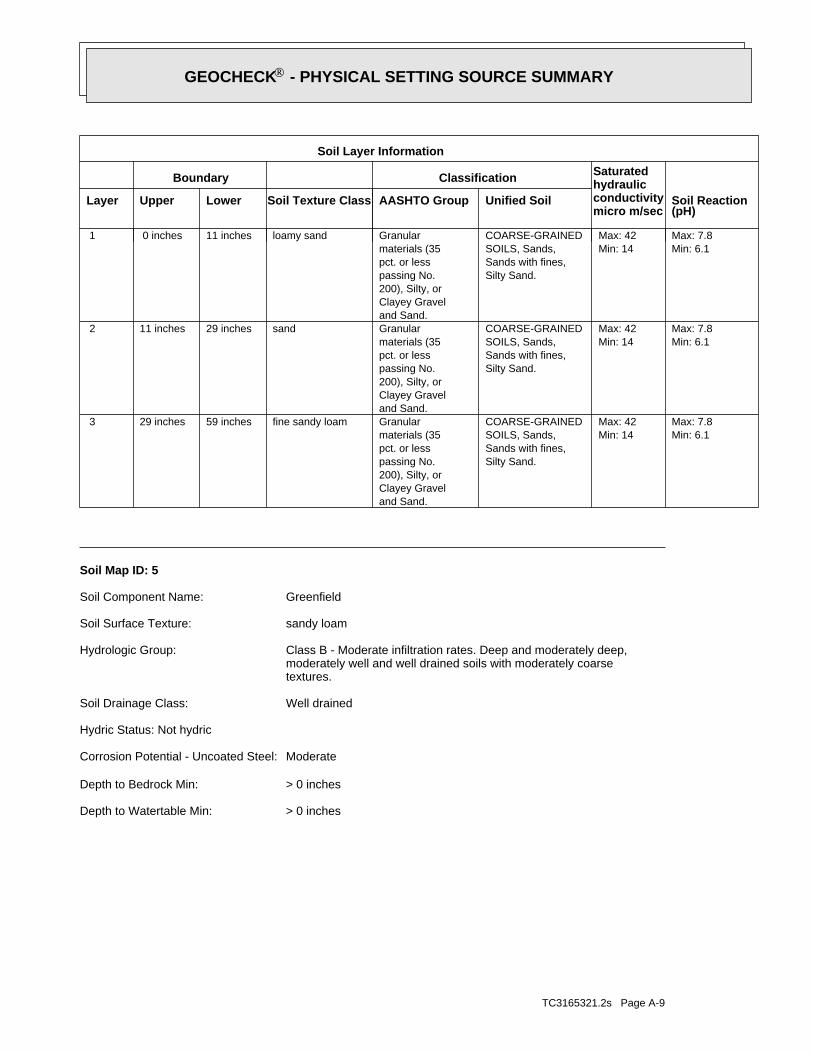
TC3165321.2s Page A-9
> 0 inchesDepth to Watertable Min:
> 0 inchesDepth to Bedrock Min:
ModerateCorrosion Potential - Uncoated Steel:
Hydric Status: Not hydric
Well drainedSoil Drainage Class:
textures.moderately well and well drained soils with moderately coarseClass B - Moderate infiltration rates. Deep and moderately deep,Hydrologic Group:
sandy loamSoil Surface Texture:
GreenfieldSoil Component Name:
Soil Map ID: 5
Min: 6.1Max: 7.8
Min: 14Max: 42
Silty Sand.Sands with fines,SOILS, Sands,COARSE-GRAINED
and Sand.Clayey Gravel200), Silty, orpassing No.pct. or lessmaterials (35Granularfine sandy loam59 inches29 inches 3
Min: 6.1Max: 7.8
Min: 14Max: 42
Silty Sand.Sands with fines,SOILS, Sands,COARSE-GRAINED
and Sand.Clayey Gravel200), Silty, orpassing No.pct. or lessmaterials (35Granularsand29 inches11 inches 2
Min: 6.1Max: 7.8
Min: 14Max: 42
Silty Sand.Sands with fines,SOILS, Sands,COARSE-GRAINED
and Sand.Clayey Gravel200), Silty, orpassing No.pct. or lessmaterials (35Granularloamy sand11 inches 0 inches 1
Soil Layer Information
Boundary Classification Saturatedhydraulicconductivitymicro m/sec
Layer Upper Lower Soil Texture Class AASHTO Group Unified Soil Soil Reaction(pH)
®GEOCHECK - PHYSICAL SETTING SOURCE SUMMARY®
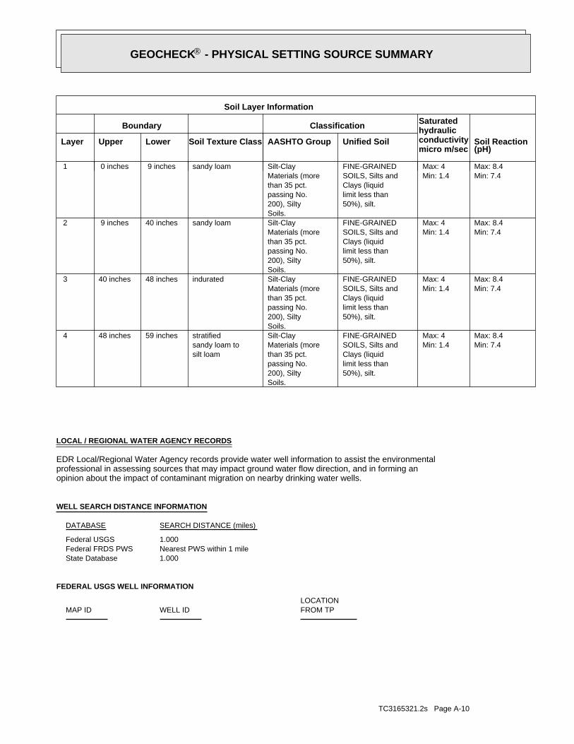
TC3165321.2s Page A-10
FEDERAL USGS WELL INFORMATION
LOCATIONFROM TPWELL IDMAP ID
1.000State DatabaseNearest PWS within 1 mileFederal FRDS PWS1.000Federal USGS
WELL SEARCH DISTANCE INFORMATION
SEARCH DISTANCE (miles)DATABASE
opinion about the impact of contaminant migration on nearby drinking water wells.professional in assessing sources that may impact ground water flow direction, and in forming anEDR Local/Regional Water Agency records provide water well information to assist the environmental
LOCAL / REGIONAL WATER AGENCY RECORDS
Min: 7.4Max: 8.4
Min: 1.4Max: 4
50%), silt.limit less thanClays (liquidSOILS, Silts andFINE-GRAINED
Soils.200), Siltypassing No.than 35 pct.Materials (moreSilt-Clay
silt loamsandy loam tostratified59 inches48 inches 4
Min: 7.4Max: 8.4
Min: 1.4Max: 4
50%), silt.limit less thanClays (liquidSOILS, Silts andFINE-GRAINED
Soils.200), Siltypassing No.than 35 pct.Materials (moreSilt-Clayindurated48 inches40 inches 3
Min: 7.4Max: 8.4
Min: 1.4Max: 4
50%), silt.limit less thanClays (liquidSOILS, Silts andFINE-GRAINED
Soils.200), Siltypassing No.than 35 pct.Materials (moreSilt-Claysandy loam40 inches 9 inches 2
Min: 7.4Max: 8.4
Min: 1.4Max: 4
50%), silt.limit less thanClays (liquidSOILS, Silts andFINE-GRAINED
Soils.200), Siltypassing No.than 35 pct.Materials (moreSilt-Claysandy loam 9 inches 0 inches 1
Soil Layer Information
Boundary Classification Saturatedhydraulicconductivitymicro m/sec
Layer Upper Lower Soil Texture Class AASHTO Group Unified Soil Soil Reaction(pH)
®GEOCHECK - PHYSICAL SETTING SOURCE SUMMARY®

TC3165321.2s Page A-11
1/2 - 1 Mile NWCAOG70000194091 41/2 - 1 Mile NWCAOG70000194092 31/2 - 1 Mile NWCAOG70000194095 21/2 - 1 Mile SWCAOG70000194075 1
STATE OIL/GAS WELL INFORMATION
LOCATIONFROM TPWELL IDMAP ID
OTHER STATE DATABASE INFORMATION
1/2 - 1 Mile WSWCADW40000036665 201/2 - 1 Mile SWCADW40000036630 191/2 - 1 Mile NECADW40000036706 141/2 - 1 Mile SECADW40000036640 131/4 - 1/2 Mile WSWCADW40000036666 1
STATE DATABASE WELL INFORMATION
LOCATIONFROM TPWELL IDMAP ID
Note: PWS System location is not always the same as well location.
No PWS System Found
FEDERAL FRDS PUBLIC WATER SUPPLY SYSTEM INFORMATION
LOCATIONFROM TPWELL IDMAP ID
1/2 - 1 Mile NNEUSGS3206012 211/2 - 1 Mile NorthUSGS3206190 B181/2 - 1 Mile NorthUSGS3206188 B171/2 - 1 Mile NorthUSGS3206187 B161/2 - 1 Mile NorthUSGS3206189 B151/4 - 1/2 Mile NorthUSGS3206150 A121/4 - 1/2 Mile NorthUSGS3206160 A111/4 - 1/2 Mile NorthUSGS3206159 A101/4 - 1/2 Mile NorthUSGS3206153 A91/4 - 1/2 Mile NorthUSGS3206152 A81/4 - 1/2 Mile NorthUSGS3206158 A71/4 - 1/2 Mile NorthUSGS3206151 A61/4 - 1/2 Mile NorthUSGS3206154 A51/4 - 1/2 Mile NorthUSGS3206155 A41/4 - 1/2 Mile NorthUSGS3206157 A31/4 - 1/2 Mile NorthUSGS3206156 A2
FEDERAL USGS WELL INFORMATION
LOCATIONFROM TPWELL IDMAP ID
®GEOCHECK - PHYSICAL SETTING SOURCE SUMMARY®
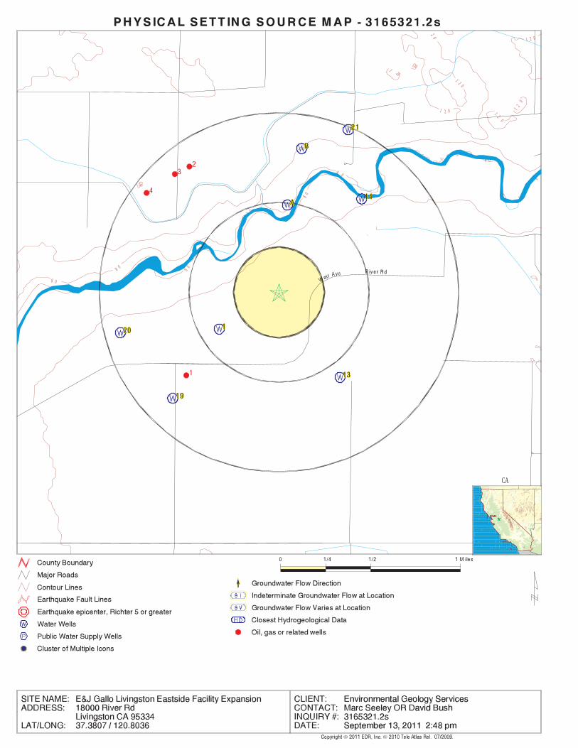
EDR Inc.EDR Inc.EDR Inc.EDR Inc.EDR Inc.EDR Inc.EDR Inc.EDR Inc.EDR Inc.EDR Inc.EDR Inc.EDR Inc.EDR Inc.EDR Inc.EDR Inc.EDR Inc.EDR Inc.EDR Inc.EDR Inc.EDR Inc.EDR Inc.EDR Inc.EDR Inc.EDR Inc.EDR Inc.EDR Inc.EDR Inc.EDR Inc.EDR Inc.EDR Inc.EDR Inc.EDR Inc.EDR Inc.EDR Inc.EDR Inc.EDR Inc.EDR Inc.EDR Inc.EDR Inc.EDR Inc.
120
1 20
1 2 0
1 2 0
12
0
1 20
20
1 2 0
8 08 0
8120
8 0
8 0
8 0
8 0
80
80
8 0
CA

TC3165321.2s Page A-13
7Ground water data count:2004-09-08Ground water data end date:Ground water data begin date: 2004-02-240Water quality data count:0000-00-00Water quality data end date:0000-00-00Water quality data begin date:0Peak flow data count:0000-00-00Peak flow data end date:0000-00-00Peak flow data begin date:0Daily flow data count:0000-00-00Daily flow data end date:0000-00-00Daily flow data begin date:0Real time data flag:
96779BI86Project number:reporting agency (generally USGS)Source of depth data:
205.Hole depth:185.Well depth:TURLOCK LAKE FORMATION - PLEISTOCENEAquifer:Confined single aquiferAquifer Type:Single well, other than collector or Ranney typeType of ground water site:NLocal standard time flag:
PSTMean greenwich time offset:20040224Date inventoried:20031029Date construction:Ground-water other than SpringSite type:
Alluvial or marine terraceTopographic:Middle San JoaquinLower MercedLower Stanislaus. California. Area = 1830 sq.mi.Hydrologic:North American Vertical Datum of 1988Altitude datum:.5Altitude accuracy:Differential Global Positioning System (GPS)Altitude method:92.81Altitude:
24000Map scale:TURLOCKLocation map:NENWNES030TOO6S R011E MLand net:USCountry:047County:06State:06District:NAD83Dec latlong datum:NAD83Latlong datum:5Coor accr:DCoor meth:-120.80275278Dec lon:37.38773333Dec lat:1204809.91Longitude:USGS3206156EDR Site id:372315.84Latitude:
006S011E30B008MSite name:372316120481007Site no:USGSAgency cd:
A2North1/4 - 1/2 MileLower
USGS3206156FED USGS
CADW40000036666Site id:502204Gwcode:24Countyco:ZWelluseco:8Districtco:06S11E30N001MStwellno:37.3778Latiude:-120.8086Longitude:
1WSW1/4 - 1/2 MileLower
CADW40000036666CA WELLS
Map IDDirectionDistanceElevation EDR ID NumberDatabase
®GEOCHECK - PHYSICAL SETTING SOURCE MAP FINDINGS®

TC3165321.2s Page A-14
A4North1/4 - 1/2 MileLower
USGS3206155FED USGS
2004-03-03 15.94 2004-02-24 16.412004-05-11 11.62 2004-04-13 16.762004-09-08 17.67 2004-07-27 17.82
DateFeet belowSurface
Feet toSealevel
-------------------------------------------------Date
Feet belowSurface
Feet toSealevel
-------------------------------------------------
Ground-water levels, Number of Measurements: 6
6Ground water data count:2004-09-08Ground water data end date:Ground water data begin date: 2004-02-240Water quality data count:0000-00-00Water quality data end date:0000-00-00Water quality data begin date:0Peak flow data count:0000-00-00Peak flow data end date:0000-00-00Peak flow data begin date:0Daily flow data count:0000-00-00Daily flow data end date:0000-00-00Daily flow data begin date:0Real time data flag:
96779BI86Project number:reporting agency (generally USGS)Source of depth data:
205.Hole depth:25.Well depth:ALLUVIUM OF THE SIERRA NEVADAAquifer:Unconfined single aquiferAquifer Type:Single well, other than collector or Ranney typeType of ground water site:NLocal standard time flag:
PSTMean greenwich time offset:20040224Date inventoried:20031029Date construction:Ground-water other than SpringSite type:
Alluvial or marine terraceTopographic:Middle San JoaquinLower MercedLower Stanislaus. California. Area = 1830 sq.mi.Hydrologic:North American Vertical Datum of 1988Altitude datum:.5Altitude accuracy:Differential Global Positioning System (GPS)Altitude method:92.81Altitude:
24000Map scale:TURLOCKLocation map:NENWNES030T006S R011E MLand net:USCountry:047County:06State:06District:NAD83Dec latlong datum:NAD83Latlong datum:5Coor accr:DCoor meth:-120.80275278Dec lon:37.38773333Dec lat:1204809.91Longitude:USGS3206157EDR Site id:372315.84Latitude:
006S011E30B009MSite name:372316120481008Site no:USGSAgency cd:
A3North1/4 - 1/2 MileLower
USGS3206157FED USGS
2004-02-24 16.052004-04-13 23.23 2004-03-03 16.042004-05-11 27.83 2004-05-11 27.932004-09-08 37.62 2004-07-27 42.55
DateFeet belowSurface
Feet toSealevel
-------------------------------------------------Date
Feet belowSurface
Feet toSealevel
-------------------------------------------------
Ground-water levels, Number of Measurements: 7
®GEOCHECK - PHYSICAL SETTING SOURCE MAP FINDINGS®
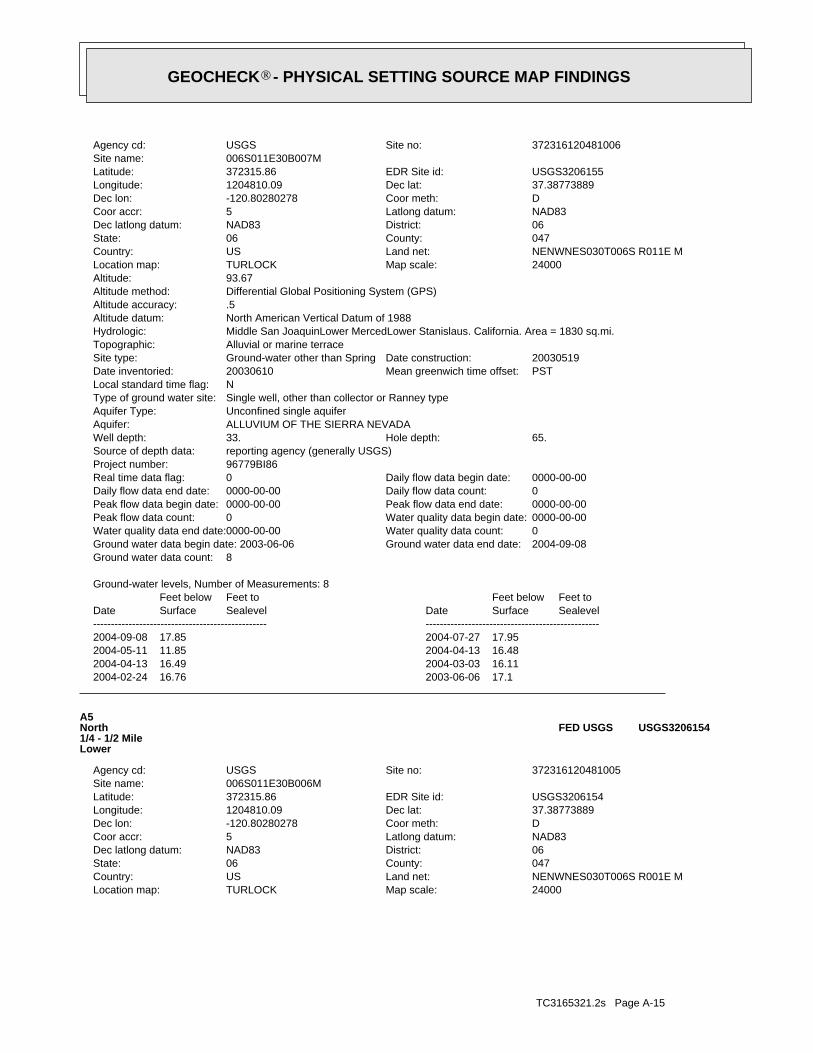
TC3165321.2s Page A-15
24000Map scale:TURLOCKLocation map:NENWNES030T006S R001E MLand net:USCountry:047County:06State:06District:NAD83Dec latlong datum:NAD83Latlong datum:5Coor accr:DCoor meth:-120.80280278Dec lon:37.38773889Dec lat:1204810.09Longitude:USGS3206154EDR Site id:372315.86Latitude:
006S011E30B006MSite name:372316120481005Site no:USGSAgency cd:
A5North1/4 - 1/2 MileLower
USGS3206154FED USGS
2004-02-24 16.76 2003-06-06 17.12004-04-13 16.49 2004-03-03 16.112004-05-11 11.85 2004-04-13 16.482004-09-08 17.85 2004-07-27 17.95
DateFeet belowSurface
Feet toSealevel
-------------------------------------------------Date
Feet belowSurface
Feet toSealevel
-------------------------------------------------
Ground-water levels, Number of Measurements: 8
8Ground water data count:2004-09-08Ground water data end date:Ground water data begin date: 2003-06-060Water quality data count:0000-00-00Water quality data end date:0000-00-00Water quality data begin date:0Peak flow data count:0000-00-00Peak flow data end date:0000-00-00Peak flow data begin date:0Daily flow data count:0000-00-00Daily flow data end date:0000-00-00Daily flow data begin date:0Real time data flag:
96779BI86Project number:reporting agency (generally USGS)Source of depth data:
65.Hole depth:33.Well depth:ALLUVIUM OF THE SIERRA NEVADAAquifer:Unconfined single aquiferAquifer Type:Single well, other than collector or Ranney typeType of ground water site:NLocal standard time flag:
PSTMean greenwich time offset:20030610Date inventoried:20030519Date construction:Ground-water other than SpringSite type:
Alluvial or marine terraceTopographic:Middle San JoaquinLower MercedLower Stanislaus. California. Area = 1830 sq.mi.Hydrologic:North American Vertical Datum of 1988Altitude datum:.5Altitude accuracy:Differential Global Positioning System (GPS)Altitude method:93.67Altitude:
24000Map scale:TURLOCKLocation map:NENWNES030T006S R011E MLand net:USCountry:047County:06State:06District:NAD83Dec latlong datum:NAD83Latlong datum:5Coor accr:DCoor meth:-120.80280278Dec lon:37.38773889Dec lat:1204810.09Longitude:USGS3206155EDR Site id:372315.86Latitude:
006S011E30B007MSite name:372316120481006Site no:USGSAgency cd:
®GEOCHECK - PHYSICAL SETTING SOURCE MAP FINDINGS®

TC3165321.2s Page A-16
0000-00-00Peak flow data end date:0000-00-00Peak flow data begin date:0Daily flow data count:0000-00-00Daily flow data end date:0000-00-00Daily flow data begin date:0Real time data flag:
96779BI86Project number:reporting agency (generally USGS)Source of depth data:
99.Hole depth:86.Well depth:ALLUVIUM OF THE SIERRA NEVADAAquifer:Unconfined single aquiferAquifer Type:Single well, other than collector or Ranney typeType of ground water site:NLocal standard time flag:
PSTMean greenwich time offset:20030610Date inventoried:20030519Date construction:Ground-water other than SpringSite type:
Alluvial or marine terraceTopographic:Middle San JoaquinLower MercedLower Stanislaus. California. Area = 1830 sq.mi.Hydrologic:North American Vertical Datum of 1988Altitude datum:.5Altitude accuracy:Differential Global Positioning System (GPS)Altitude method:92.42Altitude:
24000Map scale:TURLOCKLocation map:NENWNES030T006S R011E MLand net:USCountry:047County:06State:06District:NAD83Dec latlong datum:NAD83Latlong datum:5Coor accr:DCoor meth:-120.80273056Dec lon:37.387775Dec lat:1204809.83Longitude:USGS3206151EDR Site id:372315.99Latitude:
006S011E30B003MSite name:372316120481002Site no:USGSAgency cd:
A6North1/4 - 1/2 MileLower
USGS3206151FED USGS
2004-02-24 16.48 2003-06-06 16.62004-05-11 12.19 2004-03-03 15.992004-09-08 17.45 2004-07-27 17.48
DateFeet belowSurface
Feet toSealevel
-------------------------------------------------Date
Feet belowSurface
Feet toSealevel
-------------------------------------------------
Ground-water levels, Number of Measurements: 6
6Ground water data count:2004-09-08Ground water data end date:Ground water data begin date: 2003-06-060Water quality data count:0000-00-00Water quality data end date:0000-00-00Water quality data begin date:0Peak flow data count:0000-00-00Peak flow data end date:0000-00-00Peak flow data begin date:0Daily flow data count:0000-00-00Daily flow data end date:0000-00-00Daily flow data begin date:0Real time data flag:
96779BI86Project number:reporting agency (generally USGS)Source of depth data:
65.Hole depth:58.Well depth:ALLUVIUM OF THE SIERRA NEVADAAquifer:Unconfined single aquiferAquifer Type:Single well, other than collector or Ranney typeType of ground water site:NLocal standard time flag:
PSTMean greenwich time offset:20030610Date inventoried:20030519Date construction:Ground-water other than SpringSite type:
Alluvial or marine terraceTopographic:Middle San JoaquinLower MercedLower Stanislaus. California. Area = 1830 sq.mi.Hydrologic:North American Vertical Datum of 1988Altitude datum:.5Altitude accuracy:Differential Global Positioning System (GPS)Altitude method:93.67Altitude:
®GEOCHECK - PHYSICAL SETTING SOURCE MAP FINDINGS®
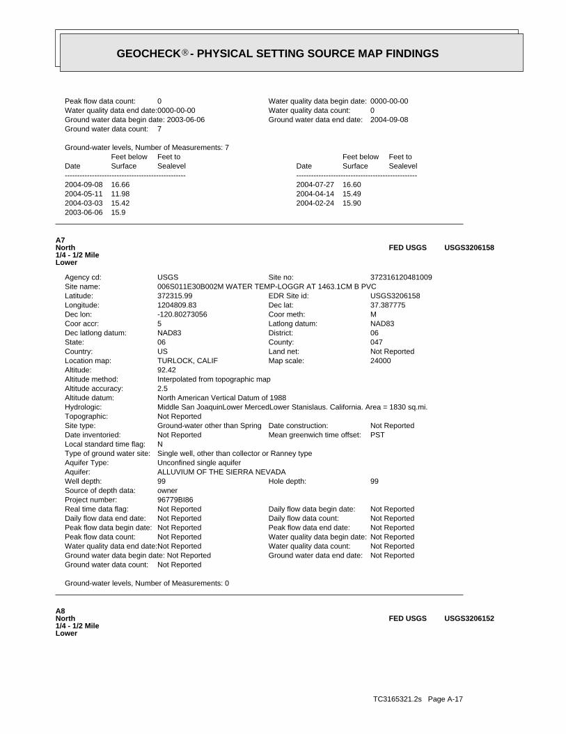
TC3165321.2s Page A-17
A8North1/4 - 1/2 MileLower
USGS3206152FED USGS
Ground-water levels, Number of Measurements: 0
Not ReportedGround water data count:Not ReportedGround water data end date:Ground water data begin date: Not ReportedNot ReportedWater quality data count:Not ReportedWater quality data end date:Not ReportedWater quality data begin date:Not ReportedPeak flow data count:Not ReportedPeak flow data end date:Not ReportedPeak flow data begin date:Not ReportedDaily flow data count:Not ReportedDaily flow data end date:Not ReportedDaily flow data begin date:Not ReportedReal time data flag:
96779BI86Project number:ownerSource of depth data:
99Hole depth:99Well depth:ALLUVIUM OF THE SIERRA NEVADAAquifer:Unconfined single aquiferAquifer Type:Single well, other than collector or Ranney typeType of ground water site:NLocal standard time flag:
PSTMean greenwich time offset:Not ReportedDate inventoried:Not ReportedDate construction:Ground-water other than SpringSite type:
Not ReportedTopographic:Middle San JoaquinLower MercedLower Stanislaus. California. Area = 1830 sq.mi.Hydrologic:North American Vertical Datum of 1988Altitude datum:2.5Altitude accuracy:Interpolated from topographic mapAltitude method:92.42Altitude:
24000Map scale:TURLOCK, CALIFLocation map:Not ReportedLand net:USCountry:047County:06State:06District:NAD83Dec latlong datum:NAD83Latlong datum:5Coor accr:MCoor meth:-120.80273056Dec lon:37.387775Dec lat:1204809.83Longitude:USGS3206158EDR Site id:372315.99Latitude:
006S011E30B002M WATER TEMP-LOGGR AT 1463.1CM B PVCSite name:372316120481009Site no:USGSAgency cd:
A7North1/4 - 1/2 MileLower
USGS3206158FED USGS
2003-06-06 15.92004-03-03 15.42 2004-02-24 15.902004-05-11 11.98 2004-04-14 15.492004-09-08 16.66 2004-07-27 16.60
DateFeet belowSurface
Feet toSealevel
-------------------------------------------------Date
Feet belowSurface
Feet toSealevel
-------------------------------------------------
Ground-water levels, Number of Measurements: 7
7Ground water data count:2004-09-08Ground water data end date:Ground water data begin date: 2003-06-060Water quality data count:0000-00-00Water quality data end date:0000-00-00Water quality data begin date:0Peak flow data count:
®GEOCHECK - PHYSICAL SETTING SOURCE MAP FINDINGS®

TC3165321.2s Page A-18
24000Map scale:TURLOCKLocation map:NENWNES030T006S R011E MLand net:USCountry:047County:06State:06District:NAD83Dec latlong datum:NAD83Latlong datum:5Coor accr:DCoor meth:-120.80273056Dec lon:37.387775Dec lat:1204809.83Longitude:USGS3206153EDR Site id:372315.99Latitude:
006S011E30B005MSite name:372316120481004Site no:USGSAgency cd:
A9North1/4 - 1/2 MileLower
USGS3206153FED USGS
2003-06-06 16.32004-03-03 15.59 2004-02-24 16.192004-05-11 11.78 2004-04-13 15.822004-09-08 17.07 2004-07-27 17.10
DateFeet belowSurface
Feet toSealevel
-------------------------------------------------Date
Feet belowSurface
Feet toSealevel
-------------------------------------------------
Ground-water levels, Number of Measurements: 7
7Ground water data count:2004-09-08Ground water data end date:Ground water data begin date: 2003-06-060Water quality data count:0000-00-00Water quality data end date:0000-00-00Water quality data begin date:0Peak flow data count:0000-00-00Peak flow data end date:0000-00-00Peak flow data begin date:0Daily flow data count:0000-00-00Daily flow data end date:0000-00-00Daily flow data begin date:0Real time data flag:
96779BI86Project number:reporting agency (generally USGS)Source of depth data:
99.Hole depth:54.Well depth:ALLUVIUM OF THE SIERRA NEVADAAquifer:Unconfined single aquiferAquifer Type:Single well, other than collector or Ranney typeType of ground water site:NLocal standard time flag:
PSTMean greenwich time offset:20030610Date inventoried:20030519Date construction:Ground-water other than SpringSite type:
Alluvial or marine terraceTopographic:Middle San JoaquinLower MercedLower Stanislaus. California. Area = 1830 sq.mi.Hydrologic:North American Vertical Datum of 1988Altitude datum:.5Altitude accuracy:Differential Global Positioning System (GPS)Altitude method:92.42Altitude:
24000Map scale:TURLOCKLocation map:NENWNES030T006S R011E MLand net:USCountry:047County:06State:06District:NAD83Dec latlong datum:NAD83Latlong datum:5Coor accr:DCoor meth:-120.80273056Dec lon:37.387775Dec lat:1204809.83Longitude:USGS3206152EDR Site id:372315.99Latitude:
006S011E30B004MSite name:372316120481003Site no:USGSAgency cd:
®GEOCHECK - PHYSICAL SETTING SOURCE MAP FINDINGS®

TC3165321.2s Page A-19Not ReportedPeak flow data end date:Not ReportedPeak flow data begin date:Not ReportedDaily flow data count:Not ReportedDaily flow data end date:Not ReportedDaily flow data begin date:Not ReportedReal time data flag:
96779BI86Project number:ownerSource of depth data:
99Hole depth:99Well depth:ALLUVIUM OF THE SIERRA NEVADAAquifer:Unconfined single aquiferAquifer Type:Single well, other than collector or Ranney typeType of ground water site:NLocal standard time flag:
PSTMean greenwich time offset:Not ReportedDate inventoried:Not ReportedDate construction:Ground-water other than SpringSite type:
Not ReportedTopographic:Middle San JoaquinLower MercedLower Stanislaus. California. Area = 1830 sq.mi.Hydrologic:North American Vertical Datum of 1988Altitude datum:2.5Altitude accuracy:Interpolated from topographic mapAltitude method:92.42Altitude:
24000Map scale:TURLOCK, CALIFLocation map:Not ReportedLand net:USCountry:047County:06State:06District:NAD83Dec latlong datum:NAD83Latlong datum:5Coor accr:MCoor meth:-120.80273056Dec lon:37.387775Dec lat:1204809.83Longitude:USGS3206159EDR Site id:372315.99Latitude:
006S011E30B002M WATER TEMP-LOGGR AT 1915.2CM B PVCSite name:372316120481010Site no:USGSAgency cd:
A10North1/4 - 1/2 MileLower
USGS3206159FED USGS
Note: The site was dry (no water level recorded).2003-06-062004-05-11 11.612004-07-27 14.30 2004-05-11 11.56
DateFeet belowSurface
Feet toSealevel
-------------------------------------------------Date
Feet belowSurface
Feet toSealevel
-------------------------------------------------
Ground-water levels, Number of Measurements: 4
4Ground water data count:2004-07-27Ground water data end date:Ground water data begin date: 2003-06-060Water quality data count:0000-00-00Water quality data end date:0000-00-00Water quality data begin date:0Peak flow data count:0000-00-00Peak flow data end date:0000-00-00Peak flow data begin date:0Daily flow data count:0000-00-00Daily flow data end date:0000-00-00Daily flow data begin date:0Real time data flag:
96779BI86Project number:reporting agency (generally USGS)Source of depth data:
99.Hole depth:17.Well depth:ALLUVIUM OF THE SIERRA NEVADAAquifer:Unconfined single aquiferAquifer Type:Single well, other than collector or Ranney typeType of ground water site:NLocal standard time flag:
PSTMean greenwich time offset:20030610Date inventoried:20030519Date construction:Ground-water other than SpringSite type:
Alluvial or marine terraceTopographic:Middle San JoaquinLower MercedLower Stanislaus. California. Area = 1830 sq.mi.Hydrologic:North American Vertical Datum of 1988Altitude datum:.5Altitude accuracy:Differential Global Positioning System (GPS)Altitude method:92.42Altitude:
®GEOCHECK - PHYSICAL SETTING SOURCE MAP FINDINGS®

TC3165321.2s Page A-20
A12North1/4 - 1/2 MileLower
USGS3206150FED USGS
Ground-water levels, Number of Measurements: 0
Not ReportedGround water data count:Not ReportedGround water data end date:Ground water data begin date: Not ReportedNot ReportedWater quality data count:Not ReportedWater quality data end date:Not ReportedWater quality data begin date:Not ReportedPeak flow data count:Not ReportedPeak flow data end date:Not ReportedPeak flow data begin date:Not ReportedDaily flow data count:Not ReportedDaily flow data end date:Not ReportedDaily flow data begin date:Not ReportedReal time data flag:
96779BI86Project number:ownerSource of depth data:
99Hole depth:99Well depth:ALLUVIUM OF THE SIERRA NEVADAAquifer:Unconfined single aquiferAquifer Type:Single well, other than collector or Ranney typeType of ground water site:NLocal standard time flag:
PSTMean greenwich time offset:Not ReportedDate inventoried:Not ReportedDate construction:Ground-water other than SpringSite type:
Not ReportedTopographic:Middle San JoaquinLower MercedLower Stanislaus. California. Area = 1830 sq.mi.Hydrologic:North American Vertical Datum of 1988Altitude datum:2.5Altitude accuracy:Interpolated from topographic mapAltitude method:92.42Altitude:
24000Map scale:TURLOCK, CALIFLocation map:Not ReportedLand net:USCountry:047County:06State:06District:NAD83Dec latlong datum:NAD83Latlong datum:5Coor accr:MCoor meth:-120.80273056Dec lon:37.387775Dec lat:1204809.83Longitude:USGS3206160EDR Site id:372315.99Latitude:
006S011E30B002M WATER TEMP-LOGGR AT 2352.1CM B PVCSite name:372316120481011Site no:USGSAgency cd:
A11North1/4 - 1/2 MileLower
USGS3206160FED USGS
Ground-water levels, Number of Measurements: 0
Not ReportedGround water data count:Not ReportedGround water data end date:Ground water data begin date: Not ReportedNot ReportedWater quality data count:Not ReportedWater quality data end date:Not ReportedWater quality data begin date:Not ReportedPeak flow data count:
®GEOCHECK - PHYSICAL SETTING SOURCE MAP FINDINGS®

TC3165321.2s Page A-21
CADW40000036640Site id:502204Gwcode:24Countyco:ZWelluseco:8Districtco:06S11E31A001MStwellno:37.3739Latiude:-120.7964Longitude:
13SE1/2 - 1 MileHigher
CADW40000036640CA WELLS
2003-06-06 15.92004-03-03 15.40 2004-02-24 15.922004-05-11 11.97 2004-04-14 15.492004-09-08 16.64 2004-07-27 16.58
DateFeet belowSurface
Feet toSealevel
-------------------------------------------------Date
Feet belowSurface
Feet toSealevel
-------------------------------------------------
Ground-water levels, Number of Measurements: 7
7Ground water data count:2004-09-08Ground water data end date:Ground water data begin date: 2003-06-060Water quality data count:0000-00-00Water quality data end date:0000-00-00Water quality data begin date:0Peak flow data count:0000-00-00Peak flow data end date:0000-00-00Peak flow data begin date:0Daily flow data count:0000-00-00Daily flow data end date:0000-00-00Daily flow data begin date:0Real time data flag:
96779BI86Project number:reporting agency (generally USGS)Source of depth data:
99.Hole depth:99.Well depth:ALLUVIUM OF THE SIERRA NEVADAAquifer:Unconfined single aquiferAquifer Type:Single well, other than collector or Ranney typeType of ground water site:NLocal standard time flag:
PSTMean greenwich time offset:20030610Date inventoried:20030519Date construction:Ground-water other than SpringSite type:
Alluvial or marine terraceTopographic:Middle San JoaquinLower MercedLower Stanislaus. California. Area = 1830 sq.mi.Hydrologic:North American Vertical Datum of 1988Altitude datum:.5Altitude accuracy:Differential Global Positioning System (GPS)Altitude method:92.42Altitude:
24000Map scale:TURLOCKLocation map:NENWNES030T006S R011E MLand net:USCountry:047County:06State:06District:NAD83Dec latlong datum:NAD83Latlong datum:5Coor accr:DCoor meth:-120.80273056Dec lon:37.387775Dec lat:1204809.83Longitude:USGS3206150EDR Site id:372315.99Latitude:
006S011E30B002MSite name:372316120481001Site no:USGSAgency cd:
®GEOCHECK - PHYSICAL SETTING SOURCE MAP FINDINGS®

TC3165321.2s Page A-22
8Ground water data count:2004-09-07Ground water data end date:Ground water data begin date: 2004-02-240Water quality data count:0000-00-00Water quality data end date:0000-00-00Water quality data begin date:0Peak flow data count:0000-00-00Peak flow data end date:0000-00-00Peak flow data begin date:0Daily flow data count:0000-00-00Daily flow data end date:0000-00-00Daily flow data begin date:0Real time data flag:
96779BI86Project number:reporting agency (generally USGS)Source of depth data:
99.Hole depth:47.Well depth:ALLUVIUM OF THE SIERRA NEVADAAquifer:Unconfined single aquiferAquifer Type:Single well, other than collector or Ranney typeType of ground water site:NLocal standard time flag:
PSTMean greenwich time offset:20040224Date inventoried:20031026Date construction:Ground-water other than SpringSite type:
Alluvial or marine terraceTopographic:Middle San JoaquinLower MercedLower Stanislaus. California. Area = 1830 sq.mi.Hydrologic:North American Vertical Datum of 1988Altitude datum:.5Altitude accuracy:Differential Global Positioning System (GPS)Altitude method:101.58Altitude:
24000Map scale:TURLOCKLocation map:NESWSES019T006S R011E MLand net:USCountry:047County:06State:06District:NAD83Dec latlong datum:NAD83Latlong datum:5Coor accr:DCoor meth:-120.80130556Dec lon:37.39231667Dec lat:1204804.70Longitude:USGS3206189EDR Site id:372332.34Latitude:
006S011E19Q003MSite name:372333120480103Site no:USGSAgency cd:
B15North1/2 - 1 MileLower
USGS3206189FED USGS
CADW40000036706Site id:502204Gwcode:24Countyco:ZWelluseco:8Districtco:06S11E29D001MStwellno:37.3883Latiude:-120.7942Longitude:
14NE1/2 - 1 MileLower
CADW40000036706CA WELLS
Map IDDirectionDistanceElevation EDR ID NumberDatabase
®GEOCHECK - PHYSICAL SETTING SOURCE MAP FINDINGS®

TC3165321.2s Page A-23
2004-03-03 19.07 2004-02-24 19.292004-05-01 19.2 2004-04-15 18.542004-05-11 16.55 2004-05-10 18.42004-09-07 18.46 2004-07-27 17.93
DateFeet belowSurface
Feet toSealevel
-------------------------------------------------Date
Feet belowSurface
Feet toSealevel
-------------------------------------------------
Ground-water levels, Number of Measurements: 8
8Ground water data count:2004-09-07Ground water data end date:Ground water data begin date: 2004-02-240Water quality data count:0000-00-00Water quality data end date:0000-00-00Water quality data begin date:0Peak flow data count:0000-00-00Peak flow data end date:0000-00-00Peak flow data begin date:0Daily flow data count:0000-00-00Daily flow data end date:0000-00-00Daily flow data begin date:0Real time data flag:
96779BI86Project number:reporting agency (generally USGS)Source of depth data:
99.Hole depth:87.Well depth:ALLUVIUM OF THE SIERRA NEVADAAquifer:Unconfined single aquiferAquifer Type:Single well, other than collector or Ranney typeType of ground water site:NLocal standard time flag:
PSTMean greenwich time offset:20040224Date inventoried:20031026Date construction:Ground-water other than SpringSite type:
Alluvial or marine terraceTopographic:Middle San JoaquinLower MercedLower Stanislaus. California. Area = 1830 sq.mi.Hydrologic:North American Vertical Datum of 1988Altitude datum:.5Altitude accuracy:Differential Global Positioning System (GPS)Altitude method:101.58Altitude:
24000Map scale:TURLOCKLocation map:NESWSES019T006S R011E MLand net:USCountry:047County:06State:06District:NAD83Dec latlong datum:NAD83Latlong datum:5Coor accr:DCoor meth:-120.80130556Dec lon:37.39231667Dec lat:1204804.70Longitude:USGS3206187EDR Site id:372332.34Latitude:
006S011E19Q001MSite name:372333120480101Site no:USGSAgency cd:
B16North1/2 - 1 MileLower
USGS3206187FED USGS
2004-03-03 19.22 2004-02-24 19.452004-05-01 17.6 2004-04-14 18.742004-05-11 16.64 2004-05-10 16.72004-09-07 18.65 2004-07-27 18.03
DateFeet belowSurface
Feet toSealevel
-------------------------------------------------Date
Feet belowSurface
Feet toSealevel
-------------------------------------------------
Ground-water levels, Number of Measurements: 8
®GEOCHECK - PHYSICAL SETTING SOURCE MAP FINDINGS®

TC3165321.2s Page A-24
B18North1/2 - 1 MileLower
USGS3206190FED USGS
2004-03-03 19.15 2004-02-24 19.382004-05-01 19.3 2004-04-14 18.672004-05-11 16.60 2004-05-10 18.52004-09-07 18.54 2004-07-27 17.93
DateFeet belowSurface
Feet toSealevel
-------------------------------------------------Date
Feet belowSurface
Feet toSealevel
-------------------------------------------------
Ground-water levels, Number of Measurements: 8
8Ground water data count:2004-09-07Ground water data end date:Ground water data begin date: 2004-02-240Water quality data count:0000-00-00Water quality data end date:0000-00-00Water quality data begin date:0Peak flow data count:0000-00-00Peak flow data end date:0000-00-00Peak flow data begin date:0Daily flow data count:0000-00-00Daily flow data end date:0000-00-00Daily flow data begin date:0Real time data flag:
96779BI86Project number:reporting agency (generally USGS)Source of depth data:
99.Hole depth:66.Well depth:ALLUVIUM OF THE SIERRA NEVADAAquifer:Unconfined single aquiferAquifer Type:Single well, other than collector or Ranney typeType of ground water site:NLocal standard time flag:
PSTMean greenwich time offset:20040224Date inventoried:20031026Date construction:Ground-water other than SpringSite type:
Alluvial or marine terraceTopographic:Middle San JoaquinLower MercedLower Stanislaus. California. Area = 1830 sq.mi.Hydrologic:North American Vertical Datum of 1988Altitude datum:.5Altitude accuracy:Differential Global Positioning System (GPS)Altitude method:101.58Altitude:
24000Map scale:TURLOCKLocation map:NESWSES019T006S R011E MLand net:USCountry:047County:06State:06District:NAD83Dec latlong datum:NAD83Latlong datum:5Coor accr:DCoor meth:-120.80130556Dec lon:37.39231667Dec lat:1204804.70Longitude:USGS3206188EDR Site id:372332.34Latitude:
006S011E19Q002MSite name:372333120480102Site no:USGSAgency cd:
B17North1/2 - 1 MileLower
USGS3206188FED USGS
Map IDDirectionDistanceElevation EDR ID NumberDatabase
®GEOCHECK - PHYSICAL SETTING SOURCE MAP FINDINGS®

TC3165321.2s Page A-25
CADW40000036630Site id:502204Gwcode:24Countyco:ZWelluseco:8Districtco:06S10E36A001MStwellno:37.3722Latiude:-120.8133Longitude:
19SW1/2 - 1 MileLower
CADW40000036630CA WELLS
2004-02-24 18.552004-05-01 16.1 2004-03-03 18.472004-05-11 15.91 2004-05-10 16.02004-09-07 16.89 2004-07-27 14.07
DateFeet belowSurface
Feet toSealevel
-------------------------------------------------Date
Feet belowSurface
Feet toSealevel
-------------------------------------------------
Ground-water levels, Number of Measurements: 7
7Ground water data count:2004-09-07Ground water data end date:Ground water data begin date: 2004-02-240Water quality data count:0000-00-00Water quality data end date:0000-00-00Water quality data begin date:0Peak flow data count:0000-00-00Peak flow data end date:0000-00-00Peak flow data begin date:0Daily flow data count:0000-00-00Daily flow data end date:0000-00-00Daily flow data begin date:0Real time data flag:
96779BI86Project number:reporting agency (generally USGS)Source of depth data:
99.Hole depth:25.Well depth:ALLUVIUM OF THE SIERRA NEVADAAquifer:Unconfined single aquiferAquifer Type:Single well, other than collector or Ranney typeType of ground water site:NLocal standard time flag:
PSTMean greenwich time offset:20040224Date inventoried:20031026Date construction:Ground-water other than SpringSite type:
Alluvial or marine terraceTopographic:Middle San JoaquinLower MercedLower Stanislaus. California. Area = 1830 sq.mi.Hydrologic:North American Vertical Datum of 1988Altitude datum:.5Altitude accuracy:Differential Global Positioning System (GPS)Altitude method:101.58Altitude:
24000Map scale:TURLOCKLocation map:NESWSES019T006S R011E MLand net:USCountry:047County:06State:06District:NAD83Dec latlong datum:NAD83Latlong datum:5Coor accr:DCoor meth:-120.80130556Dec lon:37.39231667Dec lat:1204804.70Longitude:USGS3206190EDR Site id:372332.34Latitude:
006S011E19Q004MSite name:372333120480104Site no:USGSAgency cd:
®GEOCHECK - PHYSICAL SETTING SOURCE MAP FINDINGS®

TC3165321.2s Page A-26
27Ground water data count:1994-09-02Ground water data end date:Ground water data begin date: 1981-02-253Water quality data count:1985-06-27Water quality data end date:1983-07-27Water quality data begin date:0Peak flow data count:0000-00-00Peak flow data end date:0000-00-00Peak flow data begin date:0Daily flow data count:0000-00-00Daily flow data end date:0000-00-00Daily flow data begin date:0Real time data flag:
470600205Project number:drillerSource of depth data:
187Hole depth:182Well depth:Not ReportedAquifer:Not ReportedAquifer Type:Single well, other than collector or Ranney typeType of ground water site:YLocal standard time flag:
PSTMean greenwich time offset:19820210Date inventoried:19810225Date construction:Ground-water other than SpringSite type:
Valley flatTopographic:Lower CosumnesLower Mokelumne. California. Area = 747 sq.mi.Hydrologic:National Geodetic Vertical Datum of 1929Altitude datum:2.5Altitude accuracy:Interpolated from topographic mapAltitude method:110.00Altitude:
24000Map scale:TURLOCKLocation map:S19 T06S R11E MLand net:USCountry:047County:06State:06District:NAD83Dec latlong datum:NAD27Latlong datum:SCoor accr:MCoor meth:-120.79659064Dec lon:37.39382647Dec lat:1204744Longitude:USGS3206012EDR Site id:372338Latitude:
006S011E19J001MSite name:372338120474401Site no:USGSAgency cd:
21NNE1/2 - 1 MileHigher
USGS3206012FED USGS
CADW40000036665Site id:502203Gwcode:24Countyco:ZWelluseco:8Districtco:06S10E25Q001MStwellno:37.3775Latiude:-120.8186Longitude:
20WSW1/2 - 1 MileLower
CADW40000036665CA WELLS
Map IDDirectionDistanceElevation EDR ID NumberDatabase
®GEOCHECK - PHYSICAL SETTING SOURCE MAP FINDINGS®

TC3165321.2s Page A-27
1981-02-25 14 Note: The site had been pumped recently.1982-02-10 29.071983-02-01 24.92 1982-06-30 30.32 Note: The site had been pumped recently.1983-07-26 28.29 Note: The site had been pumped recently.1983-07-27 28.29 Note: The site had been pumped recently.1984-01-23 25.92 Note: The site had been pumped recently.1984-06-19 33.901985-06-27 36.45 1985-02-13 27.771986-02-26 29.25 1986-02-14 30.101987-02-03 31.41 1986-07-16 33.78 Note: The site had been pumped recently.1987-07-16 40.211988-02-09 30.18 Note: The site had been pumped recently.1988-07-14 45.491989-04-04 42.05 Note: The site had been pumped recently.1989-07-27 47.03 Note: The site had been pumped recently.1990-01-31 38.08 Note: The site was being pumped.1990-07-241992-02-04 35.621993-01-25 33.06 1992-08-19 51.52 Note: The site was being pumped.1993-06-291994-09-02 50.75 1994-03-11 35.09
DateFeet belowSurface
Feet toSealevel
-------------------------------------------------Date
Feet belowSurface
Feet toSealevel
-------------------------------------------------
Ground-water levels, Number of Measurements: 27
®GEOCHECK - PHYSICAL SETTING SOURCE MAP FINDINGS®

TC3165321.2s Page A-28
MDBasemeridi:10ERange:6STownship:24Section:Any AreaAreaname:Any FieldFieldname:
Samuel V. Cornell et alOperatorna:3Wellnumber:Not ReportedLeasename:
MercedCountyname:Not ReportedConfidenti:DHWellsymbol:GPSGissourcec:006Statuscode:0Geodistric:5District:04700006Apinumber:
3NW1/2 - 1 Mile
CAOG70000194092OIL_GAS
CAOG70000194095Site id:-120.81265844Long83:37.39085753Lat83:
MDBasemeridi:11ERange:6STownship:19Section:Any AreaAreaname:Any FieldFieldname:
Delhi Oil Association, Ltd.Operatorna:1Wellnumber:Not ReportedLeasename:
MercedCountyname:Not ReportedConfidenti:DHWellsymbol:HUDGissourcec:002Statuscode:0Geodistric:5District:04700010Apinumber:
2NW1/2 - 1 Mile
CAOG70000194095OIL_GAS
CAOG70000194075Site id:-120.81297109Long83:37.37400396Lat83:
MDBasemeridi:11ERange:6STownship:31Section:Any AreaAreaname:Any FieldFieldname:
Bob Ferguson IndependentOperatorna:1Wellnumber:Sunland-GalloLeasename:
MercedCountyname:Not ReportedConfidenti:DHWellsymbol:HUDGissourcec:006Statuscode:0Geodistric:5District:04720002Apinumber:
1SW1/2 - 1 Mile
CAOG70000194075OIL_GAS
Map IDDirectionDistance EDR ID NumberDatabase
®GEOCHECK - PHYSICAL SETTING SOURCE MAP FINDINGS®

TC3165321.2s Page A-29
CAOG70000194091Site id:-120.81698851Long83:37.38873255Lat83:
MDBasemeridi:10ERange:6STownship:25Section:Any AreaAreaname:Any FieldFieldname:
Hilmar Comm. Oil & Gas Co.Operatorna:1Wellnumber:FausoneLeasename:
MercedCountyname:Not ReportedConfidenti:DHWellsymbol:GPSGissourcec:006Statuscode:0Geodistric:5District:04700008Apinumber:
4NW1/2 - 1 Mile
CAOG70000194091OIL_GAS
CAOG70000194092Site id:-120.81412846Long83:37.39024353Lat83:
®GEOCHECK - PHYSICAL SETTING SOURCE MAP FINDINGS®

TC3165321.2s Page A-30
Not ReportedNot ReportedNot ReportedNot ReportedBasementNot ReportedNot ReportedNot ReportedNot ReportedLiving Area - 2nd Floor0%10%90%2.050 pCi/LLiving Area - 1st Floor
% >20 pCi/L% 4-20 pCi/L% <4 pCi/LAverage ActivityArea
Number of sites tested: 10
Federal Area Radon Information for MERCED COUNTY, CA
: Zone 3 indoor average level < 2 pCi/L. : Zone 2 indoor average level >= 2 pCi/L and <= 4 pCi/L. Note: Zone 1 indoor average level > 4 pCi/L.
Federal EPA Radon Zone for MERCED County: 3
AREA RADON INFORMATION
®GEOCHECK - PHYSICAL SETTING SOURCE MAP FINDINGSRADON
®

TOPOGRAPHIC INFORMATION
USGS 7.5’ Digital Elevation Model (DEM)Source: United States Geologic SurveyEDR acquired the USGS 7.5’ Digital Elevation Model in 2002 and updated it in 2006. The 7.5 minute DEM correspondsto the USGS 1:24,000- and 1:25,000-scale topographic quadrangle maps. The DEM provides elevation datawith consistent elevation units and projection.
Scanned Digital USGS 7.5’ Topographic Map (DRG)Source: United States Geologic SurveyA digital raster graphic (DRG) is a scanned image of a U.S. Geological Survey topographic map. The map imagesare made by scanning published paper maps on high-resolution scanners. The raster imageis georeferenced and fit to the Universal Transverse Mercator (UTM) projection.
HYDROLOGIC INFORMATION
Flood Zone Data: This data, available in select counties across the country, was obtained by EDR in 2003 & 2011 from the FederalEmergency Management Agency (FEMA). Data depicts 100-year and 500-year flood zones as defined by FEMA.
NWI: National Wetlands Inventory. This data, available in select counties across the country, was obtained by EDRin 2002 and 2005 from the U.S. Fish and Wildlife Service.
HYDROGEOLOGIC INFORMATION
AQUIFLOW Information SystemR
Source: EDR proprietary database of groundwater flow informationEDR has developed the AQUIFLOW Information System (AIS) to provide data on the general direction of groundwater
flow at specific points. EDR has reviewed reports submitted to regulatory authorities at select sites and hasextracted the date of the report, hydrogeologically determined groundwater flow direction and depth to water tableinformation.
GEOLOGIC INFORMATION
Geologic Age and Rock Stratigraphic UnitSource: P.G. Schruben, R.E. Arndt and W.J. Bawiec, Geology of the Conterminous U.S. at 1:2,500,000 Scale - A digitalrepresentation of the 1974 P.B. King and H.M. Beikman Map, USGS Digital Data Series DDS - 11 (1994).
STATSGO: State Soil Geographic DatabaseSource: Department of Agriculture, Natural Resources Conservation ServicesThe U.S. Department of Agriculture’s (USDA) Natural Resources Conservation Service (NRCS) leads the nationalConservation Soil Survey (NCSS) and is responsible for collecting, storing, maintaining and distributing soilsurvey information for privately owned lands in the United States. A soil map in a soil survey is a representationof soil patterns in a landscape. Soil maps for STATSGO are compiled by generalizing more detailed (SSURGO)soil survey maps.
SSURGO: Soil Survey Geographic DatabaseSource: Department of Agriculture, Natural Resources Conservation Services (NRCS)Telephone: 800-672-5559SSURGO is the most detailed level of mapping done by the Natural Resources Conservation Services, mappingscales generally range from 1:12,000 to 1:63,360. Field mapping methods using national standards are used toconstruct the soil maps in the Soil Survey Geographic (SSURGO) database. SSURGO digitizing duplicates theoriginal soil survey maps. This level of mapping is designed for use by landowners, townships and countynatural resource planning and management.
TC3165321.2s Page A-31
PHYSICAL SETTING SOURCE RECORDS SEARCHED

LOCAL / REGIONAL WATER AGENCY RECORDS
FEDERAL WATER WELLS
PWS: Public Water SystemsSource: EPA/Office of Drinking WaterTelephone: 202-564-3750Public Water System data from the Federal Reporting Data System. A PWS is any water system which provides water to at
least 25 people for at least 60 days annually. PWSs provide water from wells, rivers and other sources.
PWS ENF: Public Water Systems Violation and Enforcement DataSource: EPA/Office of Drinking WaterTelephone: 202-564-3750Violation and Enforcement data for Public Water Systems from the Safe Drinking Water Information System (SDWIS) after
August 1995. Prior to August 1995, the data came from the Federal Reporting Data System (FRDS).
USGS Water Wells: USGS National Water Inventory System (NWIS)This database contains descriptive information on sites where the USGS collects or has collected data on surfacewater and/or groundwater. The groundwater data includes information on wells, springs, and other sources of groundwater.
STATE RECORDS
Water Well DatabaseSource: Department of Water ResourcesTelephone: 916-651-9648
California Drinking Water Quality DatabaseSource: Department of Health ServicesTelephone: 916-324-2319The database includes all drinking water compliance and special studies monitoring for the state of California
since 1984. It consists of over 3,200,000 individual analyses along with well and water system information.
OTHER STATE DATABASE INFORMATION
California Oil and Gas Well LocationsSource: Department of ConservationTelephone: 916-323-1779Oil and Gas well locations in the state.
RADON
State Database: CA RadonSource: Department of Health ServicesTelephone: 916-324-2208Radon Database for California
Area Radon InformationSource: USGSTelephone: 703-356-4020The National Radon Database has been developed by the U.S. Environmental Protection Agency(USEPA) and is a compilation of the EPA/State Residential Radon Survey and the National Residential Radon Survey.The study covers the years 1986 - 1992. Where necessary data has been supplemented by information collected atprivate sources such as universities and research institutions.
EPA Radon ZonesSource: EPATelephone: 703-356-4020Sections 307 & 309 of IRAA directed EPA to list and identify areas of U.S. with the potential for elevated indoorradon levels.
TC3165321.2s Page A-32
PHYSICAL SETTING SOURCE RECORDS SEARCHED

OTHER
Airport Landing Facilities: Private and public use landing facilitiesSource: Federal Aviation Administration, 800-457-6656
Epicenters: World earthquake epicenters, Richter 5 or greaterSource: Department of Commerce, National Oceanic and Atmospheric Administration
California Earthquake Fault Lines: The fault lines displayed on EDR’s Topographic map are digitized quaternary fault lines,prepared in 1975 by the United State Geological Survey. Additional information (also from 1975) regarding activity at specific faultlines comes from California’s Preliminary Fault Activity Map prepared by the California Division of Mines and Geology.
STREET AND ADDRESS INFORMATION
© 2010 Tele Atlas North America, Inc. All rights reserved. This material is proprietary and the subject of copyright protectionand other intellectual property rights owned by or licensed to Tele Atlas North America, Inc. The use of this material is subjectto the terms of a license agreement. You will be held liable for any unauthorized copying or disclosure of this material.
TC3165321.2s Page A-33
PHYSICAL SETTING SOURCE RECORDS SEARCHED

Bauer Associates
ATTACHMENT D
EDR Historical Aerial Photographic Service

The EDR Aerial Photo Decade Package
E&J Gallo Livingston Eastside Facility Expansion
18000 River Rd
Livingston, CA 95334
Inquiry Number: 3165321.5
September 19, 2011

EDR Aerial Photo Decade Package
Environmental Data Resources, Inc. (EDR) Aerial Photo Decade Package is a screening tool designed to assistenvironmental professionals in evaluating potential liability on a target property resulting from past activities. EDR’sprofessional researchers provide digitally reproduced historical aerial photographs, and when available, provide one photoper decade.
When delivered electronically by EDR, the aerial photo images included with this report are for ONE TIME USEONLY. Further reproduction of these aerial photo images is prohibited without permission from EDR. For moreinformation contact your EDR Account Executive.
Thank you for your business.Please contact EDR at 1-800-352-0050
with any questions or comments.
Disclaimer - Copyright and Trademark Notice
This Report contains certain information obtained from a variety of public and other sources reasonably available to Environmental Data Resources, Inc.It cannot be concluded from this Report that coverage information for the target and surrounding properties does not exist from other sources. NOWARRANTY EXPRESSED OR IMPLIED, IS MADE WHATSOEVER IN CONNECTION WITH THIS REPORT. ENVIRONMENTAL DATARESOURCES, INC. SPECIFICALLY DISCLAIMS THE MAKING OF ANY SUCH WARRANTIES, INCLUDING WITHOUT LIMITATION,MERCHANTABILITY OR FITNESS FOR A PARTICULAR USE OR PURPOSE. ALL RISK IS ASSUMED BY THE USER. IN NO EVENT SHALLENVIRONMENTAL DATA RESOURCES, INC. BE LIABLE TO ANYONE, WHETHER ARISING OUT OF ERRORS OR OMISSIONS, NEGLIGENCE,ACCIDENT OR ANY OTHER CAUSE, FOR ANY LOSS OF DAMAGE, INCLUDING, WITHOUT LIMITATION, SPECIAL, INCIDENTAL,CONSEQUENTIAL, OR EXEMPLARY DAMAGES. ANY LIABILITY ON THE PART OF ENVIRONMENTAL DATA RESOURCES, INC. IS STRICTLYLIMITED TO A REFUND OF THE AMOUNT PAID FOR THIS REPORT. Purchaser accepts this Report AS IS. Any analyses, estimates, ratings,environmental risk levels or risk codes provided in this Report are provided for illustrative purposes only, and are not intended to provide, nor should theybe interpreted as providing any facts regarding, or prediction or forecast of, any environmental risk for any property. Only a Phase I Environmental SiteAssessment performed by an environmental professional can provide information regarding the environmental risk for any property. Additionally, theinformation provided in this Report is not to be construed as legal advice.
Copyright 2011 by Environmental Data Resources, Inc. All rights reserved. Reproduction in any media or format, in whole or in part, of any report or mapof Environmental Data Resources, Inc., or its affiliates, is prohibited without prior written permission.
EDR and its logos (including Sanborn and Sanborn Map) are trademarks of Environmental Data Resources, Inc. or its affiliates. All other trademarksused herein are the property of their respective owners.

Date EDR Searched Historical Sources:Aerial PhotographySeptember 19, 2011
Target Property:18000 River Rd
Livingston, CA 95334
Year Scale Details Source
1946 Aerial Photograph. Scale: 1"=555' Flight Year: 1946 USGS
1957 Aerial Photograph. Scale: 1"=555' Flight Year: 1957 Cartwright
1966 Aerial Photograph. Scale: 1"=655' Flight Year: 1966 Mcdonnal/Douglas
1974 Aerial Photograph. Scale: 1"=541' Flight Year: 1974 NASA
1987 Aerial Photograph. Scale: 1"=666' Flight Year: 1987 USGS
1998 Aerial Photograph. Scale: 1"=604' /Composite DOQQ - acquisition dates: 1998 EDR
1998 Aerial Photograph. Scale: 1"=666' Flight Year: 1998 USGS
2005 Aerial Photograph. Scale: 1"=604' Flight Year: 2005 EDR
2006 Aerial Photograph. Scale: 1"=604' Flight Year: 2006 EDR
3165321.52
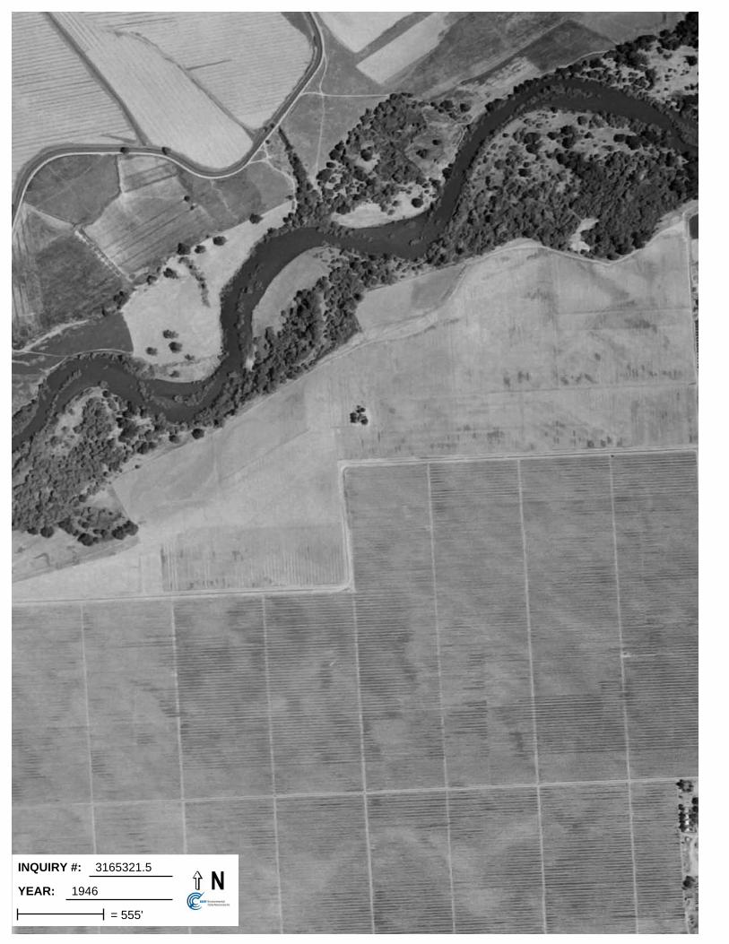
INQUIRY #:
YEAR:
3165321.5
1946
= 555'

INQUIRY #:
YEAR:
3165321.5
1957
= 555'

INQUIRY #:
YEAR:
3165321.5
1966
= 655'

INQUIRY #:
YEAR:
3165321.5
1974
= 541'

INQUIRY #:
YEAR:
3165321.5
1987
= 666'

INQUIRY #:
YEAR:
3165321.5
1998
= 604'

INQUIRY #:
YEAR:
3165321.5
1998
= 666'

INQUIRY #:
YEAR:
3165321.5
2005
= 604'

INQUIRY #:
YEAR:
3165321.5
2006
= 604'

Bauer Associates
ATTACHMENT E
EDR Historical Topographic Map Report

EDR Historical Topographic Map Report
E&J Gallo Livingston Eastside Facility Expansion
18000 River Rd
Livingston, CA 95334
Inquiry Number: 3165321.4
September 13, 2011

EDR Historical Topographic Map Report
Environmental Data Resources, Inc.s (EDR) Historical Topographic Map Report is designed to assist professionals inevaluating potential liability on a target property resulting from past activities. EDRs Historical Topographic Map Reportincludes a search of a collection of public and private color historical topographic maps, dating back to the early 1900s.
Thank you for your business.Please contact EDR at 1-800-352-0050
with any questions or comments.
Disclaimer - Copyright and Trademark Notice
This Report contains certain information obtained from a variety of public and other sources reasonably available to Environmental Data Resources, Inc.It cannot be concluded from this Report that coverage information for the target and surrounding properties does not exist from other sources. NOWARRANTY EXPRESSED OR IMPLIED, IS MADE WHATSOEVER IN CONNECTION WITH THIS REPORT. ENVIRONMENTAL DATARESOURCES, INC. SPECIFICALLY DISCLAIMS THE MAKING OF ANY SUCH WARRANTIES, INCLUDING WITHOUT LIMITATION,MERCHANTABILITY OR FITNESS FOR A PARTICULAR USE OR PURPOSE. ALL RISK IS ASSUMED BY THE USER. IN NO EVENT SHALLENVIRONMENTAL DATA RESOURCES, INC. BE LIABLE TO ANYONE, WHETHER ARISING OUT OF ERRORS OR OMISSIONS, NEGLIGENCE,ACCIDENT OR ANY OTHER CAUSE, FOR ANY LOSS OF DAMAGE, INCLUDING, WITHOUT LIMITATION, SPECIAL, INCIDENTAL,CONSEQUENTIAL, OR EXEMPLARY DAMAGES. ANY LIABILITY ON THE PART OF ENVIRONMENTAL DATA RESOURCES, INC. IS STRICTLYLIMITED TO A REFUND OF THE AMOUNT PAID FOR THIS REPORT. Purchaser accepts this Report AS IS. Any analyses, estimates, ratings,environmental risk levels or risk codes provided in this Report are provided for illustrative purposes only, and are not intended to provide, nor should theybe interpreted as providing any facts regarding, or prediction or forecast of, any environmental risk for any property. Only a Phase I Environmental SiteAssessment performed by an environmental professional can provide information regarding the environmental risk for any property. Additionally, theinformation provided in this Report is not to be construed as legal advice.
Copyright 2011 by Environmental Data Resources, Inc. All rights reserved. Reproduction in any media or format, in whole or in part, of any report or mapof Environmental Data Resources, Inc., or its affiliates, is prohibited without prior written permission.
EDR and its logos (including Sanborn and Sanborn Map) are trademarks of Environmental Data Resources, Inc. or its affiliates. All other trademarksused herein are the property of their respective owners.

Historical Topographic Map
→
NTARGET QUADTARGET QUADNAME: TURLOCKMAP YEAR: 1917
SERIES: 7.5SCALE: 1:31680
SITE NAME: E&J Gallo LivingstonEastside Facility
ADDRESS: 18000 River RdLivingston, CA 95334
LAT/LONG: 37.3807 / -120.8036
CLIENT: Environmental Geology ServicesCONTACT: Marc Seeley OR David BushINQUIRY#: 3165321.4RESEARCH DATE: 09/13/2011

Historical Topographic Map
→
NTARGET QUADTARGET QUADNAME: TURLOCKMAP YEAR: 1948
SERIES: 7.5SCALE: 1:24000
SITE NAME: E&J Gallo LivingstonEastside Facility
ADDRESS: 18000 River RdLivingston, CA 95334
LAT/LONG: 37.3807 / -120.8036
CLIENT: Environmental Geology ServicesCONTACT: Marc Seeley OR David BushINQUIRY#: 3165321.4RESEARCH DATE: 09/13/2011

Historical Topographic Map
→
NTARGET QUADTARGET QUADNAME: TURLOCKMAP YEAR: 1961
SERIES: 7.5SCALE: 1:24000
SITE NAME: E&J Gallo LivingstonEastside Facility
ADDRESS: 18000 River RdLivingston, CA 95334
LAT/LONG: 37.3807 / -120.8036
CLIENT: Environmental Geology ServicesCONTACT: Marc Seeley OR David BushINQUIRY#: 3165321.4RESEARCH DATE: 09/13/2011
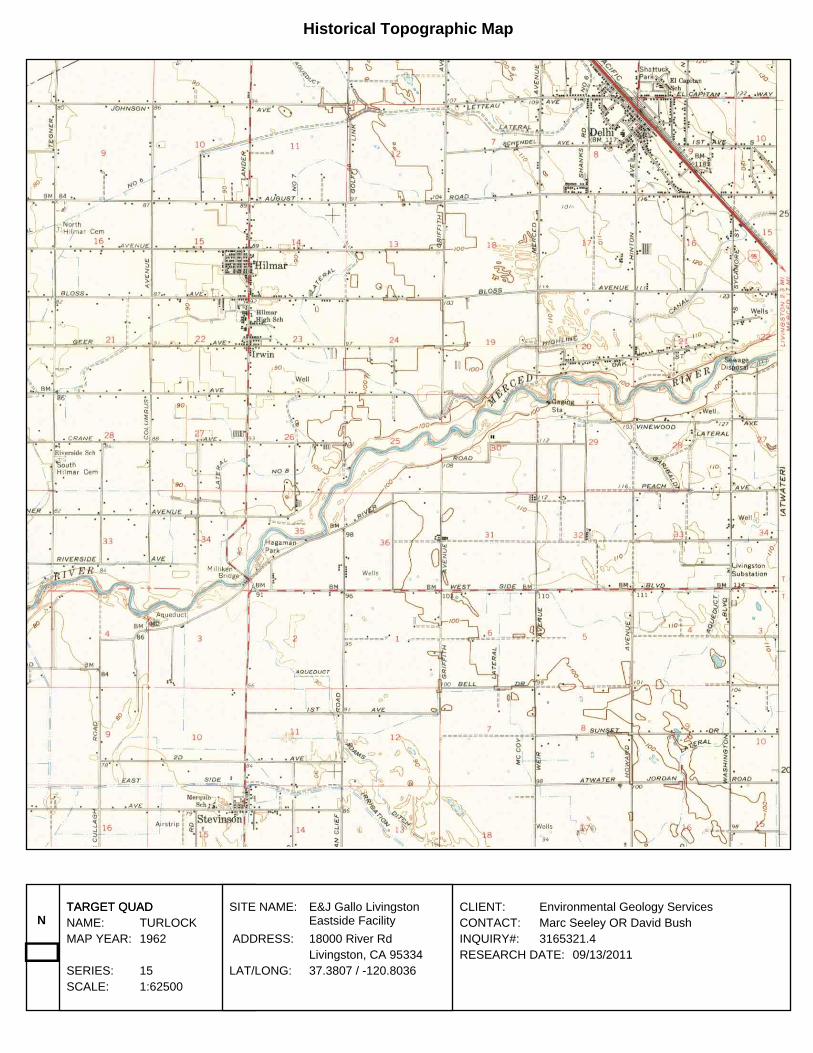
Historical Topographic Map
→
NTARGET QUADTARGET QUADNAME: TURLOCKMAP YEAR: 1962
SERIES: 15SCALE: 1:62500
SITE NAME: E&J Gallo LivingstonEastside Facility
ADDRESS: 18000 River RdLivingston, CA 95334
LAT/LONG: 37.3807 / -120.8036
CLIENT: Environmental Geology ServicesCONTACT: Marc Seeley OR David BushINQUIRY#: 3165321.4RESEARCH DATE: 09/13/2011
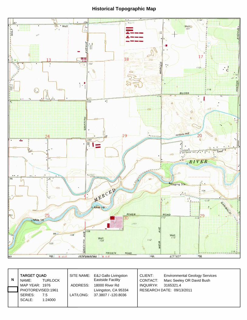
Historical Topographic Map
→
NTARGET QUADTARGET QUADNAME: TURLOCKMAP YEAR: 1976PHOTOREVISED:1961SERIES: 7.5SCALE: 1:24000
SITE NAME: E&J Gallo LivingstonEastside Facility
ADDRESS: 18000 River RdLivingston, CA 95334
LAT/LONG: 37.3807 / -120.8036
CLIENT: Environmental Geology ServicesCONTACT: Marc Seeley OR David BushINQUIRY#: 3165321.4RESEARCH DATE: 09/13/2011

Bauer Associates
ATTACHMENT F
EDR City Directory Abstract

E&J Gallo Livingston Eastside Facility Expansion
18000 River RdLivingston, CA 95334
Inquiry Number: 3165321.6September 16, 2011
The EDR-City Directory Abstract
440 Wheelers Farms RoadMilford, CT 06461800.352.0050www.edrnet.comEnvironmental Data Resources IncEnvironmental Data Resources IncEnvironmental Data Resources IncEnvironmental Data Resources Inc

TABLE OF CONTENTS
SECTION
Executive Summary
Findings
Thank you for your business. Please contact EDR at 1-800-352-0050
with any questions or comments.
Disclaimer - Copyright and Trademark Notice
This Report contains certain information obtained from a variety of public and other sources reasonably available to Environmental Data Resources, Inc. It cannot be concluded from this Report that coverage information for the target and surrounding properties does not exist from other sources. NO WARRANTY EXPRESSED OR IMPLIED, IS MADE WHATSOEVER IN CONNECTION WITH THIS REPORT. ENVIRONMENTAL DATA RESOURCES, INC. SPECIFICALLY DISCLAIMS THE MAKING OF ANY SUCH WARRANTIES, INCLUDING WITHOUT LIMITATION, MERCHANTABILITY OR FITNESS FOR A PARTICULAR USE OR PURPOSE. ALL RISK IS ASSUMED BY THE USER. IN NO EVENT SHALL ENVIRONMENTAL DATA RESOURCES, INC. BE LIABLE TO ANYONE, WHETHER ARISING OUT OF ERRORS OR OMISSIONS, NEGLIGENCE, ACCIDENT OR ANY OTHER CAUSE, FOR ANY LOSS OR DAMAGE, INCLUDING, WITHOUT LIMITATION, SPECIAL, INCIDENTAL, CONSEQUENTIAL, OR EXEMPLARY DAMAGES. ANY LIABILITY ON THE PART OF ENVIRONMENTAL DATA RESOURCES, INC. IS STRICTLY LIMITED TO A REFUND OF THE AMOUNT PAID FOR THIS REPORT. Purchaser accepts this Report "AS IS". Any analyses, estimates, ratings, environmental risk levels or risk codes provided in this Report are provided for illustrative purposes only, and are not intended to provide, nor should they be interpreted as providing any facts regarding, or prediction orforecast of, any environmental risk for any property. Only a Phase I Environmental Site Assessment performed by an environmental professional can provide information regarding the environmental risk for any property. Additionally, the information provided in this Report is not to be construed as legal advice.
Copyright 2009 by Environmental Data Resources, Inc. All rights reserved. Reproduction in any media or format, in whole or in part, of any report or map of Environmental Data Resources, Inc. or its affiliates is prohibited without prior written permission.
EDR and its logos (including Sanborn and Sanborn Map) are trademarks of Environmental Data Resources, Inc. or its affiliates. All other trademarks used herein are the property of their respective owners.

EXECUTIVE SUMMARY
DESCRIPTION
Environmental Data Resources, Inc.’s (EDR) City Directory Abstract is a screening tool designed to assist environmental professionals in evaluating potential liability on a target property resulting from past activities. EDR’s City Directory Abstract includes a search and abstract of available city directory data. For each address, the directory lists the name of the corresponding occupant at five year intervals.
RESEARCH SUMMARY
The following research sources were consulted in the preparation of this report. An "X" indicates where information was identified in the source and provided in this report.
Source TPYear Adjoining Text Abstract Source Image
2008 HAINES & COMPANY INC. X X X -
2000 HAINES & COMPANY INC. X X X -
1994 HAINES & COMPANY INC. X X X -
1988 HAINES & COMPANY INC. X X X -
1981 HAINES & COMPANY INC. X X X -
3165321- 6 Page 1

FINDINGS
TARGET PROPERTY INFORMATION
ADDRESS
18000 River RdLivingston, CA 95334
FINDINGS DETAIL
Target Property research detail.
Year Uses Source
2008 Air Products & Chemicals HAINES & COMPANY INC.
Brewn Minneapolis Tank HAINES & COMPANY INC.
Gallo E & J Winery HAINES & COMPANY INC.
Sanjqn Valley Express OR HAINES & COMPANY INC.
2000 Coleman Transportation HAINES & COMPANY INC.
Gallo E&J Winery HAINES & COMPANY INC.
San Joaquin Valley Express HAINES & COMPANY INC.
1994 Gallo E&J Winery HAINES & COMPANY INC.
San Joaquin Valley Express HAINES & COMPANY INC.
1988 Gallo E&J Winery HAINES & COMPANY INC.
1981 Gallo E&J Winery HAINES & COMPANY INC.
3165321- 6 Page 2

FINDINGS
ADJOINING PROPERTY DETAIL
The following Adjoining Property addresses were researched for this report. Detailed findings are provided for each address.
River Rd
River Rd
Year Uses Source
2008 No other addresses (17900-18199) block River Rd
HAINES & COMPANY INC.
2000 No address listings beyond the Target Property
HAINES & COMPANY INC.
No other addresses (17900-18199) block River Rd
HAINES & COMPANY INC.
1994 No other addresses (17900-18199) block River Rd
HAINES & COMPANY INC.
1988 No other addresses (17900-18199) block River Rd
HAINES & COMPANY INC.
1981 No address listings beyond the Target Property
HAINES & COMPANY INC.
No other addresses (17900-18199) block River Rd
HAINES & COMPANY INC.
3165321- 6 Page 3
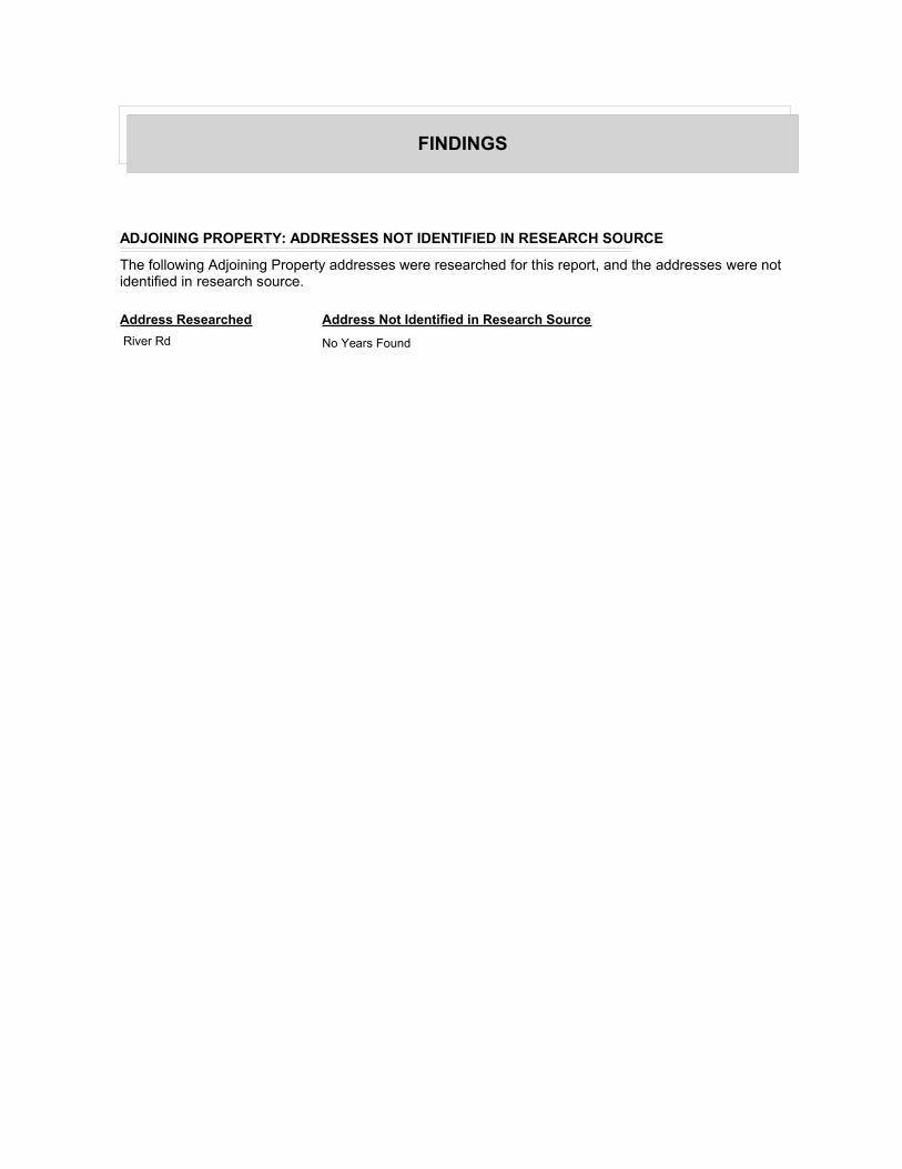
FINDINGS
ADJOINING PROPERTY: ADDRESSES NOT IDENTIFIED IN RESEARCH SOURCE
The following Adjoining Property addresses were researched for this report, and the addresses were not identified in research source.
Address Researched Address Not Identified in Research Source
River Rd No Years Found

Bauer Associates
ATTACHMENT G
EDR Sanborn Fire Insurance Map Coverage

Certified Sanborn® Map Report
E&J Gallo Livingston Eastside Facility Expansion
18000 River Rd
Livingston, CA 95334
Inquiry Number: 3165321.3
September 13, 2011

Certified Sanborn® Map Report 9/13/11
Site Name:E&J Gallo Livingston Eastside18000 River RdLivingston, CA 95334
Client Name:Environmental Geology1695 Willowside RdSanta Rosa, CA 95401
EDR Inquiry # 3165321.3 Contact: Marc Seeley OR David
The complete Sanborn Library collection has been searched by EDR, and fire insurance maps covering the targetproperty location provided by Environmental Geology Services were identified for the years listed below. The certifiedSanborn Library search results in this report can be authenticated by visiting www.edrnet.com/sanborn and entering thecertification number. Only Environmental Data Resources Inc. (EDR) is authorized to grant rights for commercialreproduction of maps by Sanborn Library LLC, the copyright holder for the collection.
Certified Sanborn Results:
Site Name: E&J Gallo Livingston Eastside FacilityAddress: 18000 River RdCity, State, Zip: Livingston, CA 95334Cross Street:P.O. # 456.0911Project: E&J Gallo Livingston EastsideCertification # D0FB-48C4-8DD4
Library of Congress
University Publications of America
EDR Private Collection
The Sanborn Library LLC Since 1866™
The Sanborn Library includes more than 1.2 millionSanborn fire insurance maps, which track historicalproperty usage in approximately 12,000 Americancities and towns. Collections searched:
Sanborn® Library search resultsCertification # D0FB-48C4-8DD4
UNMAPPED PROPERTYThis report certifies that the complete holdings of the SanbornLibrary, LLC collection have been searched based on clientsupplied target property information, and fire insurance mapscovering the target property were not found.
Limited Permission To Make CopiesEnvironmental Geology Services (the client) is permitted to make up to THREE photocopies of this Sanborn Map transmittal and each fireinsurance map accompanying this report solely for the limited use of its customer. No one other than the client is authorized to make copies. Uponrequest made directly to an EDR Account Executive, the client may be permitted to make a limited number of additional photocopies. Thispermission is conditioned upon compliance by the client, its customer and their agents with EDR's copyright policy; a copy of which is availableupon request.
Disclaimer - Copyright and Trademark noticeThis Report contains certain information obtained from a variety of public and other sources reasonably available to Environmental Data Resources, Inc. It cannot beconcluded from this Report that coverage information for the target and surrounding properties does not exist from other sources. NO WARRANTY EXPRESSED ORIMPLIED, IS MADE WHATSOEVER IN CONNECTION WITH THIS REPORT. ENVIRONMENTAL DATA RESOURCES, INC. SPECIFICALLY DISCLAIMS THEMAKING OF ANY SUCH WARRANTIES, INCLUDING WITHOUT LIMITATION, MERCHANTABILITY OR FITNESS FOR A PARTICULAR USE OR PURPOSE. ALLRISK IS ASSUMED BY THE USER. IN NO EVENT SHALL ENVIRONMENTAL DATA RESOURCES, INC. BE LIABLE TO ANYONE, WHETHER ARISING OUT OFERRORS OR OMISSIONS, NEGLIGENCE, ACCIDENT OR ANY OTHER CAUSE, FOR ANY LOSS OF DAMAGE, INCLUDING, WITHOUT LIMITATION, SPECIAL,INCIDENTAL CONSEQUENTIAL, OR EXEMPLARY DAMAGES. ANY LIABILITY ON THE PART OF ENVIRONMENTAL DATA RESOURCES, INC. IS STRICTLYLIMITED TO A REFUND OF THE AMOUNT PAID FOR THIS REPORT. Purchaser accepts this Report "AS IS". Any analyses, estimates, ratings, environmental risklevels or risk codes provided in this Report are provided for illustrative purposes only, and are not intended to provide, nor should they be interpreted as providingany facts regarding, or prediction or forecast of, any environmental risk for any property. Only a Phase I Environmental Site Assessment performed by anenvironmental professional can provide information regarding the environmental risk for any property. Additionally, the information provided in this Report is not to beconstrued as legal advice.
Copyright 2011 by Environmental Data Resources, Inc. All rights reserved. Reproduction in any media or format, in whole or in part, of any report or map ofEnvironmental Data Resources, Inc., or its affiliates, is prohibited without prior written permission.
EDR and its logos (including Sanborn and Sanborn Map) are trademarks of Environmental Data Resources, Inc. or its affiliates. All other trademarks used herein arethe property of their respective owners.
3165321 - 3 page 2
Bauer Associates
ATTACHMENT H
Proof of Qualifications

PROOF OF QUALIFICATIONS
This section presents the qualifications and background of the person or persons preparingthe Phase I ESA. The following summary is provided to comply with the ASTM PracticeE 1527-05 requirement and that the US EPA’s AAI Rule for minimum requirements aremet.
We declare to the best of our professional knowledge and belief, we meet the definition ofEnvironmental Professional (EP) as defined in 312.10 of 40 CFR 312. We have thespecific qualifications based on education, training, and experience to assess the nature,history, and setting of the subject property. We have developed and performed the allappropriate inquiries in conformance with the standards and practices set forth in 40 CFRpart 312 and ASTM E 1527-05.

The environmental professional in charge of and responsible for the Phase I ESA, thetechnical reviewer and registered signer of the report is Marc W. Seeley. His qualificationsare as follows:
Education: - University of California, Berkeley: B.A. Geology; 1969. California State University, Hayward: M.S. Geology,1985. The Engineering Geology Short Course. The Geological Engineering Foundation, Berkeley, CA. 1974. Universityof California, Davis: Certificate Program in Hazardous Waste Management, various courses, 1985-91.
Registration & Certification:
CERTIFICATION DATE EARNED METHOD REGISTRATION # STATES1
Registered Geologist 1977, 1978, 1995,1998
EX, R, R, R 3407, 089,891,6824 CA, OR, ID, CA
Engineering Geologist 1978, 1987 EX, R 1014, E089 CA, OR
Environmental Manager 1993 EX EM-1268 NV
Registered HazardousSubstance Professional
1993 EX 44767 Nat. EnvironmentalHealth Assoc.
RegisteredEnvironmental Assessor,Level I & II
REA-I 1988REA-II 2000
EAEA
511,20157 CACA
NOTE 1: EX = by Examination, Education and Experience; R = by Reciprocity; EA = Experience and Application
Hazmat Training: - OSHA 40 Hour Remedial Response Health & Safety Training Course, R.F. Weston, Inc., WestChester, PA, September-October 1987; OSHA 8 Hour Annual Re-Certification Training Course, Sept. 2000, UC DavisExtension.
Professional History: 31 years experience in technical, project management and general management positions withEGS: 1991-present, Herzog Associates: 1988-1991, Roy F. Weston, Inc.: 1987-1988, Merrill & Seeley, Inc.: 1978-1987,Woodward & Clyde Consultants: 1973-1978, USDA Soil Conservation Service: 1972-1973 & 1969-1970, U.S.A.F.: 1970-1972
Fields of Expertise: Engineering and environmental geology, soil and groundwater contamination, groundwater resourcesstudies, hazardous wastes, environmental site assessments, site remediation, geology for planning, geologic hazardsinvestigations, project management, failure analysis.
Clients: Developers, cities, municipal agencies, architects, engineers, insurance companies, legal firms, land planners,and environmental impact report consultants.
Professional Affiliations: Association of Groundwater Scientists and Engineers, Association of Engineering Geologists,California Groundwater Association, National Environmental Health Association.

The environmental professional that conducted the Site Reconnaissance, prepared thisPhase I ESA, and is a registered signer of the Phase 1 ESA is David L. Bush. Hisqualifications are as follows:
Education: - The Florida State University, Tallahassee, FL: B.S. - Geography/Environmental Studies, 1999. Sonoma State University, Rohnert Park, CA: B.A. Geology, 2007.
Registration & Certification:
CERTIFICATION DATE EARNED METHOD REGISTRATION # STATES1
Geologist-in-Training(GIT)
2008 - GIT EX 250 CA
RegisteredEnvironmental Assessor,Level I
2007 - REA I EA 08276 CA
NOTE 1: EX = by Examination, Education and Experience; EA = Experience and Application
Hazmat Training: - Fed-OSHA (Title 29, CFR 1910.120) Hazardous Waste Operations and Emergency Response24-Hour Training, National Environmental Trainers, Inc., 2002; Fed-OSHA (Title 29, CFR 1910.120) and Cal OSHA (Title8 CCR 5192(e)(3)(A)) Health and Safety Training for Hazardous Waste Workers 40-Hour Training, University ofCalifornia - Davis, 2007.
Professional History: 10 years experience in technical staff, consulting, and project management with US-NationalResource Conservation Service, State of California Parks & Recreation, and Environmental Geology Services.
Fields of Expertise: Project Management, UST Fund Claims Processing and Management, State Geotracker Systemmanagement and information support. Environmental geology research and investigation for Phase 1 and Phase 2environmental site assessments including UST investigations/ remediation/ closure, soil and groundwater investigationsand sampling using solid and hollow stem drilling methods as well as direct push techniques and CPT, monitoring wellinstallation and development, contamination research and investigation, surface water sampling, groundwater resourceevaluations, site remediation planning, lithologic logging test pits and trenches for geotechnical exploration and activefault investigations environmental/geologic field work, environmental report writing and work plan development, andanalytical results analysis and interpretation.
Clients: Developers, cities, municipal agencies, architects, engineers, insurance companies, legal firms, land planners,and environmental impact report consultants.
Professional Affiliations: Association of Groundwater Scientists and Engineers, Association of Engineering Geologists,National Groundwater Association, American Association of Petroleum Geologists.