pinal county access management manual final 2.1.8 2.1.9 preserv,e the functional area of...
TRANSCRIPT

February, 2017
Project No. EV 14-043 Traffic Engineering On-Call
Pinal CountyAccess Management ManualFinal

Pinal County Access Management Manual
Project No. – EV 14-043 Traffic Engineering On-call
February 24, 2017
Prepared for:
Prepared by:

Michael Baker INTERNATIONAL
Table of Contents
I' I N A I, • C 0 U N T Y u•itlt .,,. "'PJ"1'l••if)
1.0 Introduction ................................................................................................................................................. 1
2.0 Access Management Principles and Benefits .............................................................................................. 3
2.1 Principles of Access Management ........................................................................................................... 3
2.1.1 Provide a Specialized Roadway System ............................................................................................ 4
2.1.2 Promote Intersection Hierarchy ....................................................................................................... 4
2.1.3 Locate Signals to Favor Through Movements .................................................................................. 4
2.1.4
2.1.5
2.1.6
2.1.7
2.1.8
2.1.9
Preserv,e the Functional Area of Intersections and Interchanges .................................................... 4
Limit the Number of Conflict Points ................................................................................................. 5
Separate Conflict Areas ..................................................................................................................... 5
Remove Turning Vehicles from Through Traffic Lanes..................... .. ................ 5
Use of Non-traversable Medians on Major Roadways .............. .. .............. 5
Provide a Supporting Street Network ............................................ lfcl,,~,_: .. "''I'W~"' ................ 6
2.1.10 Provide Unified Access and Circulation Systems ....................... .. .. ............. 7
2.2 Benefits of Access Management.. ....................................................... . .. .............. 7
2.2.1 Safety Benefits .............................................................................. .. .. ................ 7
2.2.2 Operational Benefits .......................................................................... . ~~ .. ................... 9
2.2.3 Economic Benefits ........................................................................................................................... 11
2.2.4 Land Use and Sustainability Benefits .............................................................................................. 12
3.0 Access Management Policies and Ordinances ........................................................................................... 14
3.1 Arizona State Transportation Board Policy on Access Management .................................................... 14
3.2 Arizona Department of Transportation ................................................................................................. 14
3.3 Pinal County Comprehensive Plan 2009 ................................................................................................ 14
3.4 Pinal Regional Transportation Plan ........................................................................................................ 15
3.5 City of Casa Grande ................................................................................................................................ 15
3.6 Town of Florence .................................................................................................................................... 16
3. 7 City of Apache Junction .......................................................................................................................... 16
3.8 Town of Queen Creek ............................................................................................................................. 17
4.0 Access Spacing Requirements .................................................................................................................... 19
4.1 Signalized Street Access Connections .................................................................................................... 19
4.2 Unsignalized Full Access Street Connections ......................................................................................... 20
4.3 Full and Partial Median Openings .......................................................................................................... 20
4.4 Access Connection Spacing Along Frontage/Service Roads ................................................................... 21
4.5 Access Connection Spacing near Freeway/Parkway Interchanges ........................................................ 22
Page I i February 2017

Page | ii February 2017
4.6 Alternative Intersection Applications .................................................................................................... 23
5.0 Design Standards Documentation ............................................................................................................. 25
5.1 Street Cross-Sections ............................................................................................................................. 25
5.1.1 Arizona Parkways/Parkways or RSR Parkways ............................................................................... 25
5.1.2 Frontage Roads ............................................................................................................................... 25
5.2 Sight Distance Requirements ................................................................................................................. 26
5.3 Turn Lanes (left-turn and right-turn) ..................................................................................................... 26
5.4 Driveway Locations ................................................................................................................................ 27
5.4.1 Driveway Spacing ............................................................................................................................ 27
5.4.2 Corner Clearance ............................................................................................................................ 27
5.5 Cross and Shared Access ........................................................................................................................ 28
5.6 Local/Frontage Access Lanes .................................................................................................................. 29
5.7 Driveway Curb Radius ............................................................................................................................ 29
5.8 Unsignalized Driveway Design ............................................................................................................... 29
5.9 Signalized Driveway Design .................................................................................................................... 29
5.10 Driveway Turning Movement Restrictions ............................................................................................ 29
5.11 Median Design ........................................................................................................................................ 30
5.12 U-Turn Design ......................................................................................................................................... 30
5.13 Truck Loading Areas ............................................................................................................................... 31
5.14 Pedestrian and Bicycle Facilities ............................................................................................................ 31
5.15 Transit Facilities ...................................................................................................................................... 31
6.0 Implementation Methods .......................................................................................................................... 32
6.1 Zoning Strategies .................................................................................................................................... 32
6.2 Land Development Strategies ................................................................................................................ 33
6.3 Subdivision Regulations ......................................................................................................................... 33
6.4 Site Plan Review ..................................................................................................................................... 35
6.5 Traffic Impact Study Procedure .............................................................................................................. 37
6.6 Retrofit Procedure for Existing Land Uses and Corridors ...................................................................... 37
6.7 Access Variance Procedure .................................................................................................................... 37
7.0 Access Approval and Permit Process ......................................................................................................... 39
7.1 Access Permitting Process for all County Roads .................................................................................... 39
7.1.1 Incorporation of Access Management into Development Review Procedures ............................. 39
7.1.2 Incorporation of Access Management into Capital Improvement Plan Process ............................ 44

Page | iii February 2017
List of Figures Figure 1 – Mobility vs. Access in Functional Roadway System ............................................................................................... 3
Figure 2 – Physical vs. Functional Area of an Intersection ...................................................................................................... 5
Figure 3 – Conflict Reduction through Access Management .................................................................................................. 6
Figure 4 – Driveway Spacing and Corner Clearance ............................................................................................................. 28
Figure 5 - Access Permitting Process for all County Roadways ............................................................................................ 40
List of Tables Table 1 – Overview of Design and Access Standards by Roadway Classification ................................................................... 2
Table 2 – Composite Crash Rate Indexes by Access Density .................................................................................................. 8
Table 3 – Representative Crash Rates by Type of Median: Urban and Suburban Areas ........................................................ 8
Table 4 – Representative Crash Rates by Type of Median: Rural Areas ................................................................................. 8
Table 5 – Impact of Spacing to First Unsignalized Access Road and Signalized Intersection on Potential Crash Rate .......... 9
Table 6 – Access Density and Free-Flow Speed .................................................................................................................... 10
Table 7 – Percentage Increase in Travel Time as Signalized Density Increases .................................................................... 10
Table 8 – Safety and Operational Benefits of Common Access Management Techniques .................................................. 11
Table 9 – Effect of Average Speed Reduction on Market Area ............................................................................................. 12
Table 10 – Signalized Street Access Spacing* ....................................................................................................................... 20
Table 11 – Unsignalized Street Access Spacing* ................................................................................................................... 20
Table 12 – Median Opening * ............................................................................................................................................... 21
Table 13 – Frontage Road Access Spacing ............................................................................................................................ 22
Table 14 – Minimum Spacing for Parkway Interchange with Major Cross Street ................................................................ 22
Table 15 – Minimum Spacing for Parkway Interchange with Minor Cross Street ................................................................ 23
Table 16 – Minimum Access Connection Spacing from Roundabouts ................................................................................. 24
Table 17 – Design Standards by Roadway Classification ...................................................................................................... 26
Table 18 – Design Controls for Minimum Median Openings ................................................................................................ 30
Table 19 – Minimum Median Opening ................................................................................................................................. 30
Table 20 – Median Separator Widths to Permit U-Turns by Various Design Vehicles ......................................................... 31
Table 21 – Median Width Recommendations per the Pinal County East-West Corridor Study ........................................... 31
Table 22 - Summary of Development Review Processes ...................................................................................................... 41

Page | 1 February 2017
1.0 Introduction This Pinal County Access Management Manual outlines the process of providing access to land developments while simultaneously preserving the flow of traffic on the surrounding system. Pinal County developed an access management manual in 2008 that provides guidance on the implementation of access management for Regionally Significant Routes for Safety and Mobility (RSRSM) focusing on parkways and principal arterial roadways. This 2016 Access Management Manual includes access management standards for all functional roadway classifications. The intent of this manual update is to ensure consistent application of access management criteria on all County roadways. The guidelines outlined in this manual are based on the recommendations documented in the Pinal County Access Management Technical Memorandum. During the development of the access manual technical memorandum, the following documents were reviewed to better understand the current access management policies being implemented at the local, state, and national level:
• Pinal County Comprehensive Plan (Nov 2015); • Pinal County Subdivision & Infrastructure Design Manual; • Pinal County TIA Guidelines & Procedures (Jan 2007); • Pinal County Zoning Ordinances; • Transportation Research Board (TRB) Access Management Manual, Second Edition (2014); • Arizona State Transportation Board Policies (2015); • ADOT Traffic Guidelines and Processes (June 2015); • City of Casa Grande Access Management Guidelines (2015); • Town of Queen Creek Driveway Guidelines (2015); • City of Tucson Transportation Access Management Guidelines (2011); • Pima Association of Governments Regional Access Management Plan (2008); • City of Apache Junction Engineering Design Guidelines and Policies; • Pinal County’s East-West Corridor Study between SR 347 and I-10 (2015); and • Texas Department of Transportation Access Management Manual (2011).
The purpose of reviewing these documents was to establish best practices for access management to all functional roadway classifications within Pinal County jurisdiction that include:
• Arizona Parkway/Parkway; • Major Arterial; • Minor Arterial; • Major Collector; • Minor Collector; • Local; and • Frontage/Service Road.
This manual documents the following:
Pertinent updates to principles and benefits of access management based on the Second Edition of the Transportation Research Board (TRB) Access Management Manual;
Updated policies and ordinances currently being implemented at a state level and by various jurisdictions (cities and counties) within Pinal County;

Page | 2 February 2017
Design standards developed in the Pinal County Access Management Technical Memorandum for various transportation design elements that influence access;
Procedures for incorporating access management with new development projects, retrofitting procedures for existing sites, and access variance procedures; and
Access approval and permit process for all non-major Pinal County roadways based on the early alert process developed for the Pinal County RSRSM.
Table 1 presents an overview of the design standards and access management guidelines for Pinal County. These guidelines are further discussed in subsequent sections of this manual.
Table 1 – Overview of Design and Access Standards by Roadway Classification
Item Parkways Major Arterials Minor Arterials Collector Roads Local
Streets Frontage
Roads
Design Standards
Number of Lanes 6 * * * * 1-2
Lane Width 12' * * * * 12'
Shoulder Width 6' (outside)
* * * * 2'-4' 4' (inside)
Median Width 78' * * * * n/a
Design Speed (mph) 50-65 * * * * 25-35
Right-of-Way 200' * * * * within ROW of adj. roadway
Median Crossover Interval
Urban 1/4 mile spacing n/a n/a n/a n/a n/a Rural 1/4 mile spacing n/a n/a n/a n/a n/a
Access Management Guidelines
Signalized Street Access Spacing1
Urban 1/2 mile spacing 1/4 mile spacing 1/4 mile spacing 1/8 mile spacing2 n/a n/a Rural 1 mile spacing 1/2 mile spacing 1/2 mile spacing 1/4 mile spacing2 n/a n/a
Unsignalized Street Access Spacing1
Urban n/a 660' 330' 330' (150' for
minor collectors) 100' n/a
Rural n/a 1,320' 660' 660' 330' n/a
Median Openings1
Full Access 1,320' 1,320' 660' n/a n/a n/a Partial Access 660' 660' 330' n/a n/a n/a
Frontage Road Access Spacing3,4
One-Way n/a n/a n/a n/a n/a 200'-425' Two-Way n/a n/a n/a n/a n/a 200'-510'
Driveway Spacing 360' 360' 360' 250' 75' n/a
Corner Clearance 360' 360' 360' 250' n/a n/a
*See Pinal County Subdivision & Infrastructure Design Manual TWLTL = Two-way left-turn lane 1 Distance measured from intersection centerline to intersection centerline. 2 Not applicable for minor collector roads. 3 Distance measured from inside edge of pavement to inside edge of pavement. 4 Dependent on posted speed limit; see Table 13.

Page | 3 February 2017
2.0 Access Management Principles and Benefits This section of the manual documents the principles and benefits of access management that was presented in the Transportation Research Board (TRB) Access Management Manual, Second Edition. Per this TRB manual, access management is the coordinated planning, regulation, and design of access between roadways and the abutting land uses/activity centers they serve. It encompasses a range of methods that promote the efficient and safe movement of people and goods to and from these activity centers. A highly functional roadway network provides the foundation for an effective and efficient access to these activity centers by reducing conflicts on the roadway network and its interface with other modes of travel (transit, bicyclist, and pedestrians). Figure 1 shows the relationship between movement/mobility and land access in a functional roadway system. An inverse relationship exist between mobility and land access. As the land access increases on a roadway the mobility of motorists reduces significantly. Freeways that restrict access to interchange locations provide the highest level of mobility. Expressways/Parkways and Arterials that limit access provide high levels of mobility. Collector streets provide both mobility and land access. Local streets primarily provide land access and limit mobility to ensure safety.
Source: Transportation Research Board (TRB) Access Management Manual, Second Edition (2014)
Figure 1 – Mobility vs. Access in Functional Roadway System
2.1 Principles of Access Management The goal of an access management program is to align transportation plans, access policies, and design standards with the desired function of a roadway within the transportation network. This is often referred to as a functional roadway design principle. A functional roadway design limits the conflicts that occur at any given location, separate the locations where conflicts can occur, and minimizes speed changes. The result is a roadway

Page | 4 February 2017
that functions safely and efficiently for all users (automobiles, bicyclists, and pedestrians). The TRB Access Management Manual (Second Edition) describes ten principles to accomplish the objectives of access management. Sections 2.1.1 through 2.1.10 summarize these principles as described in the TRB Access Management Manual.
2.1.1 Provide a Specialized Roadway System A specialized roadway system preserves its functional integrity through:
• Adoption of a hierarchical functional roadway network; • Adoption of access policies and design standards for each functional category of roadway; and • Implementation of adopted policies and design standards through roadway improvement and
retrofit process, during site development, and through effective permitting process that is enforced consistently throughout the jurisdiction.
2.1.2 Promote Intersection Hierarchy An efficient transportation network provides transition from one classification of roadway to another through intersections. An important principle of access management is to avoid connecting a roadway of low classification (Local) to a roadway of much higher classification (Arterial). A desired practice is to allow direct connections to the next higher or next lower functional classification, for example, local roads to collector roadways.
2.1.3 Locate Signals to Favor Through Movements It is desirable to have uniform spacing of intersections and median openings that have the ability to be signalized in the future. Uniform and large signal spacing promotes flexibility in varying cycle lengths for efficient traffic progression over a range of traffic volumes and speeds.
2.1.4 Preserve the Functional Area of Intersections and Interchanges The functional area of an intersection or interchange is the area that is critical to its function. This is the area where motorists decelerate, maneuver into an appropriate lane, prepare to brake to a stop or to complete a turn as through traffic approaches an intersection, or accelerate or maneuver as they depart the intersection. Figure 2 illustrates the physical versus the functional area of an intersection. Access driveways or surface street connections too close to intersections and interchanges can cause serious traffic conflicts that compromise safety and impair the function of the affected facilities.

Page | 5 February 2017
Source: Transportation Research Board (TRB) Access Management Manual, Second Edition (2014)
Figure 2 – Physical vs. Functional Area of an Intersection
2.1.5 Limit the Number of Conflict Points Traffic conflicts occur when the paths of vehicles intersect and may involve merging, diverging, stopping, weaving, turning, or crossing maneuvers (see Figure 3). As conflicts increase, driving conditions become more complex and driver workload increases leading to mistakes and collisions. Access management policies aim at reducing conflicts points between vehicles, vehicles and bicycles, and vehicles and pedestrians.
2.1.6 Separate Conflict Areas Driver safety improves when drivers are provided sufficient perception and reaction time to address one potential set of conflicts before facing another. Separating conflict areas through improved access spacing and use of non-traversable (raised) medians help to simplify driving task, contributing to improved traffic operations and safety, and reduces the exposure of pedestrians and bicyclists to automobile traffic.
2.1.7 Remove Turning Vehicles from Through Traffic Lanes Use of right and left-turn lanes allow drivers to decelerate gradually out of the through lanes and safely complete a turn. This reduces the severity and duration of conflict between turning vehicles and through vehicles. They also improve safety and efficiency of an intersection by separating slow moving turn traffic from high speed through traffic. Channelized turn lanes can provide refuge islands for pedestrians at major intersections thereby shortening the crossing distance and improving pedestrian safety.
2.1.8 Use of Non-traversable Medians on Major Roadways Non-traversable medians separate opposing traffic streams on major roadways and eliminate head-on collisions. These medians further improve safety by limiting the exposure of through traffic and pedestrians or bicyclists to left-turning vehicular conflict. They also provide a refuge area for midblock pedestrian crossings.

Page | 6 February 2017
Source: Transportation Research Board (TRB) Access Management Manual, Second Edition (2014)
Figure 3 – Conflict Reduction through Access Management
2.1.9 Provide a Supporting Street Network Absence of a supporting street network of collector and local streets can force direct site access to arterial streets. This direct driveway access along arterial streets can create conflicts between turning vehicles, pedestrians, bicyclists, and high-speed through traffic. A well planned transportation system provides a

Page | 7 February 2017
balanced collector and local street network to accommodate site development access needs. Collector roadways at established intervals serve to collect and distribute traffic across the network and provide safe access to area businesses. Dense and interconnected local streets provide direct access to homes. Good street connectivity can be maintained while advancing access management objectives by conforming to adopted connection spacing standards.
2.1.10 Provide Unified Access and Circulation Systems Unified site access and circulation systems for large developments (such as business parks and shopping malls) eliminate or reduce the need for vehicular access and circulation on major roadways when they move from one business establishment to another. They also support good bicycle and pedestrian circulation. Unified circulation systems offer opportunities for better separation of business access driveways from major signalized intersections and/or interchange ramps.
2.2 Benefits of Access Management Government and public agencies need a clear understanding of the benefits of access management as this plays a major role in all phases of the decision-making process, from program development to permitting decisions to design. The TRB Access Management Manual (Second Edition) and the National Cooperative Highway Research Program (NCHRP) Report 420 document the effects of access management in the following areas:
• Safety; • Operations; • Economic; • Environment; and • Land Use and Sustainability.
2.2.1 Safety Benefits The safety benefits of access management are attributable to improved access design, fewer traffic conflict locations, and longer driver response time to potential conflicts. Pertinent excerpts of the research conducted by the TRB on the safety benefits of access management is reported below. Crash Rate and Access Density As documented in the TRB Access Management Manual, an increase in access density results in an increase in crash rates. Table 2 shows the composite crash rate indexes that were derived from an analysis of 37,500 crashes on various roadway categories within urban, suburban, and rural locations related to access points per mile. The indexes suggest that an increase from 10 driveways to 20 driveways per mile would increase crash rates by roughly 30%. A statewide study conducted by Minnesota Department of Transportation (DOT) indicates that roadway segments with the highest access density have higher than average crash rates, regardless of types of access, speed limit, or volume of traffic.

Page | 8 February 2017
Table 2 – Composite Crash Rate Indexes by Access Density
Access Points per Mile
Composite Crash Rate Indexes
10 1 20 1.3 30 1.7 40 2.1 50 2.8 60 4.1
Source: Transportation Research Board (TRB) Access Management Manual, Second Edition (2014)
Non-traversable Medians Roadways with non-traversable (raised) medians have been proven to be safer than undivided roadways or those with two-way left-turn lanes (TWLTLs). NCHRP Report 420 provides an evaluation that concludes that crash rates on roadways with non-traversable medians were approximately 30% lower than roadways with TWLTLs. Table 3 and Table 4 present the representative crash rate by median type and access density for urban/suburban and rural areas, respectively.
Table 3 – Representative Crash Rates by Type of Median: Urban and Suburban Areas
Total Access Points per
Mile a
Crash Rate (crashes per million VMT)
Undivided Median
TWLTL Non-traversable
Median
≤20 3.8 3.4 2.9 20.01 - 40 7.3 5.9 5.1 40.01 - 60 9.4 7.9 6.8
>60 10.6 9.2 8.2 Note: VMT = vehicle miles traveled; TWLTL = two-way left-turn lane. a Includes both signalized and unsignalized access points. Source: Transportation Research Board (TRB) Access Management Manual, Second Edition (2014)
Table 4 – Representative Crash Rates by Type of Median: Rural Areas
Total Access Points per
Mile a
Crash Rate (crashes per million VMT)
Undivided Median
TWLTL Non-traversable
Median
≤15 2.5 1.0 0.9 15.01 - 30 3.6 1.3 1.2
>30 4.6 1.7 1.5 Note: VMT = vehicle miles traveled; TWLTL = two-way left-turn lane. a Includes both signalized and unsignalized access points.
Source: Transportation Research Board (TRB) Access Management Manual, Second Edition (2014)

Page | 9 February 2017
U-turn Application The conversion of a direct left-turn on a multi-lane roadway to a right-turn plus U-turn maneuver has proven to be safer and operationally efficient. A Florida DOT study found that crash rates and delays for right-turn plus U-turn maneuvers on six-lane arterials were lower than those for direct left-turns. The study found a 17.8% reduction in crash rates and a 15% and 22% reduction in total delays during peak and non-peak hours, respectively. Pedestrian Safety Arterial roadways with non-traversable medians are safer for pedestrians. The TRB Access Management Manual cited research conducted by the Federal Highway Administration (FHWA) indicating a 46% and 39% reduction in pedestrian crashes when non-traversable medians or pedestrian refuge areas are provided at marked and unmarked cross-walk locations, respectively. These treatments simplify the pedestrian crossing task by allowing them to focus on crossing one direction of traffic at a time. Non-traversable medians and pedestrian refuge areas also provide an opportunity for the installation of lighting and the reduction of crossing delay. Interchange Area Access Management The potential for crashes increases as the access spacing near interchanges decreases. Table 5 provides the results of a Virginia DOT study cited by the TRB Access Management Manual of the potential crash rates relative to access spacing. The research conducted by Virginia DOT indicated that an increase in access spacing from 300 to 600 feet resulted in a 50% and 31% reduction in the potential crash rate for unsignalized and signalized intersections, respectively.
Table 5 – Impact of Spacing to First Unsignalized Access Road and Signalized Intersection on Potential Crash Rate
Distance to First Access (feet)
Unsignalized Access Roads*
Signalized Intersections*
0 10.07 10.07 100 8.17 8.88 200 6.62 7.83 300 5.37 6.90 400 4.35 6.08 600 2.86 4.73 800 1.88 3.67
1,000 1.24 2.86 *Potential Crashes per 105 Vehicle Miles Traveled Source: Transportation Research Board (TRB) Access Management Manual, Second Edition (2014)
2.2.2 Operational Benefits The operational benefits of access management are attributable to increase in roadway capacity, maintaining desired free-flow speed, and reduced delay. Fewer access points and fewer traffic signals results in improved traffic operations on major roadways. Table 6 shows the relationship between access density (access points per mile) and free-flow speed. The free-flow speed is shown to reduce by 0.25 mph for each additional access point. Table 7 shows the relationship between signal spacing and travel time. Travel time increases as the number of traffic signals per mile of roadway increases. For example, travel time increases by 16% as the number of traffic signals per mile of roadway increases from 2 to 4. Furthermore, a Michigan study indicates that as spacing
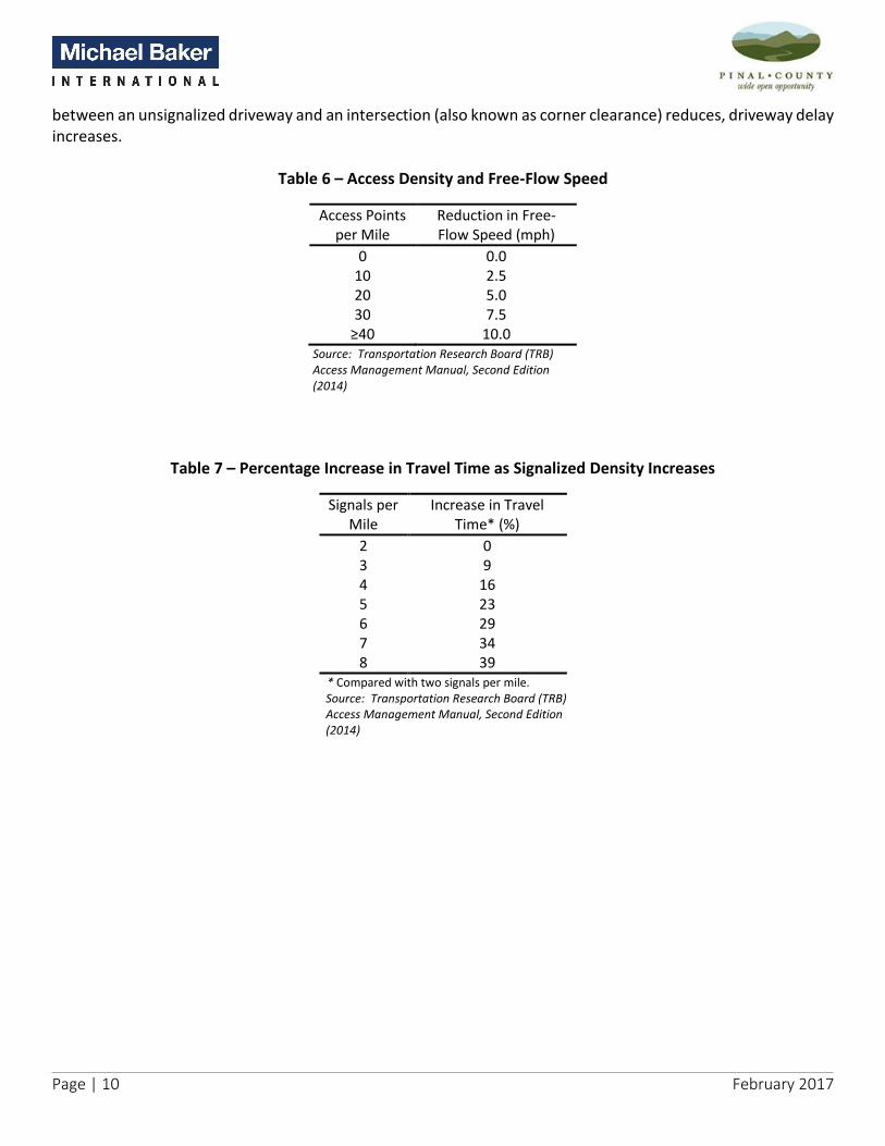
Page | 10 February 2017
between an unsignalized driveway and an intersection (also known as corner clearance) reduces, driveway delay increases.
Table 6 – Access Density and Free-Flow Speed
Access Points per Mile
Reduction in Free-Flow Speed (mph)
0 0.0 10 2.5 20 5.0 30 7.5
≥40 10.0 Source: Transportation Research Board (TRB) Access Management Manual, Second Edition (2014)
Table 7 – Percentage Increase in Travel Time as Signalized Density Increases
Signals per Mile
Increase in Travel Time* (%)
2 0 3 9 4 16 5 23 6 29 7 34 8 39
* Compared with two signals per mile. Source: Transportation Research Board (TRB) Access Management Manual, Second Edition (2014)

Page | 11 February 2017
Table 8 presents the safety and operational benefits of commonly used access management techniques.
Table 8 – Safety and Operational Benefits of Common Access Management Techniques
Treatment Effect
Add continuous TWLTL
35% reduction in total crashes
30% decrease in delay
30% increase in capacity
Add non-traversable median
≥55% reduction in total crashes
30% decrease in delay
30% increase in capacity
Replace TWLTL with non-traversable median
15% to 57% reduction in crashes on four-lane roads
25% to 50% reduction in crashes on six-lane roads
Add left-turn bay
25% to 50% reduction in crashes on four-lane roads
Up to 75% reduction in total crashes at unsignalized access
25% increase in capacity
Type of left-turn improvement: Painted 32% reduction in total crashes Separator or raised divider 67% reduction in total crashes
Add right-turn bay 20% reduction in total crashes
Limit right-turn interference with platooned flow, increased capacity
Increase driveway speed from 5 to 10 mph 50% reduction in delay per maneuver; less exposure time to following vehicles
Visual cue at driveways, driveway illumination
42% reduction in crashes
Prohibition of on-street parking 30% increase in traffic flow
20% to 40% reduction in crashes
Long signal spacing with limited access
42% reduction in total vehicle hours of travel
59% reduction in delay
57,500 gal of fuel saved per mile per year Note: TWLTL = two-way left-turn lane. Source: Transportation Research Board (TRB) Access Management Manual, Second Edition (2014)
2.2.3 Economic Benefits The research from NCHRP Report 420 concludes that the economic impact of access management techniques depends on the extent that access is improved, restricted, or denied. The impact to a specific business establishment also depends on the type of business activity and on background economic conditions. Where direct access is denied, some motorist will change their driving and shopping patterns to continue patronizing specific business establishment. Some repetitive pass-by traffic will use well designed or conveniently located U-turn locations to access their destination. In some cases, business sales may increase as overall mobility along the corridor improves. The synthesis of research on the economic benefits/impacts of access management as stated in the TRB Access Management Manual (Second Edition) are discussed below:

Page | 12 February 2017
Median projects generally have little overall adverse impact on business activity. Business owner perception of potential impacts of change in access tend to be much worse than actual impacts.
Poorly designed vehicular access not only adversely affects roadway safety and efficiency but also could reduce economic vitality of the corridor.
Closely spaced and poorly designed access connections result in reduced travel speeds, increased travel times, and reduce the market area for businesses. Table 9 shows the effects of average speed reduction on market area.
Access managed corridors had little or no impact on uses of properties abutting the corridors. Property values in access managed corridors remained unchanged or increased.
If access to a business is perceived by the customer to be unsafe, customers may take their business else-where resulting in loss of market share.
Delays along a poorly access managed corridor can increase shipping and distribution cost for businesses along the corridor.
Business deliveries and distribution routes that have high crash frequency can result in insurance companies increasing their premiums.
Table 9 – Effect of Average Speed Reduction on Market Area
Reduction in Average Speed
Market Area Relative to Previous Size
0% 100% 10% 81% 20% 65% 30% 45% 40% 36% 50% 25%
Source: Transportation Research Board (TRB) Access Management Manual, Second Edition (2014)
In essence, where loss in market area/share or increase in business cost is significant, businesses may close or relocate, the value of investment along a business corridor is lost, property values decline, and municipalities lose both property tax and sales tax revenues.
2.2.4 Land Use and Sustainability Benefits Requirements for access managed roadways further the orderly layout and use of land. Similarly, access management strategies that discourage strip development and promote clustering of land uses into unified activity centers lead to sustainable land use development. The land use and sustainability benefits/impacts of access management are summarized below:
Aesthetic - strategies that reduce curb cuts, consolidate driveways, and promote construction of landscaped medians and buffered parking lots create a visually pleasing and aesthetic corridor.
Basic accessibility - policies that promote multi-modal transportation are in line with the transportation sustainability goal of providing accessibility to all users to fulfill at least their basic needs.
Equity and equal mobility - provide options that allow affordable and equitable transportation opportunity for all sections of society.

Page | 13 February 2017
System efficiency - ensure transportation system’s functionality and efficiency are maintained and enhanced.
Safety - provide safe transportation system for all users and general public.
Prosperity - ensure that transportation system’s development and operations support economic development and prosperity.
Economic viability - ensure economic feasibility of transportation investment over time.
Ecosystem - protect and enhance environmental and ecological systems while developing and operating transportation systems.
Resource consumption - reduce use of nonrenewable resources and promote use of renewable replacements.
Emissions and air quality - reduce transportation related emissions of air pollution and greenhouse gases.
Waste generation - reduce waste generation by transportation related activities.

Page | 14 February 2017
3.0 Access Management Policies and Ordinances The 2008 RSRSM Access Management Manual presented rules, policies and ordinances from the Arizona State Transportation Board, ADOT and Pinal County. Several of these documents referenced have been updated since the compilation of the 2008 manual. The following sections report on the documents addressing access management that have since been updated.
3.1 Arizona State Transportation Board Policy on Access Management The Arizona State Transportation Board approved a revised set of Arizona State Transportation Board Policies in December of 2015. Policy 12 provides the following guidance with respect to access management:
a) Encouraging ADOT to develop an access management classification system for the State Highways with appropriate access management standards for each access management classification.
b) Encouraging ADOT to develop comprehensive access management guidelines within ADOT’s Roadway Design Guidelines to guide the uniform application of access management throughout the state.
c) The Board and ADOT shall work closely with the regional planning agencies and local governments to encourage early notification to ADOT of zoning and other land use decisions such as large developments and major traffic generators that will impact the State Highway System in order to coordinate system planning.
d) Compensating property owners where appropriate under State law. e) Maintaining that the approximate minimum spacing between local cross road interchanges on the
limited access State and Interstate Highway Systems be three (3) miles in rural areas, two (2) miles in suburban or transitional areas, and one (1) mile in urban areas.
f) Reassessing road segments as demand changes over time.
3.2 Arizona Department of Transportation The rules, policies and ordinances for granting access to developments along the ADOT state highway system and for highway and encroachment permits summarized in the 2008 Access Management Manual are still applicable. However, the ADOT Traffic Engineering Policies, Guidelines and Procedures was updated in June 2015 and is now referred to as ADOT Traffic Engineering Guidelines and Processes (ADOT TGP). ADOT TGP still provides typical access characteristics and spacing standards, medians standards, guidance on when grade separations are needed and when to provide pedestrian and crossing devices as well as detailed design standards for street cross-sections, sight distance, deceleration and turning lanes, driveways, truck loading areas, median openings, pedestrian, bicycle, and transit facilities.
3.3 Pinal County Comprehensive Plan 2009 The 2009 Pinal County Comprehensive Plan amendments became effective on November 29, 2009, and all the amendments for 2010 through 2015 are incorporated into the plan document. The Comprehensive Plan lists seven vision components that provide the framework for the 2009 Plan. These vision components are Sense of Community, Mobility and Connectivity, Economic Sustainability, Open Spaces and Places, Environmental Stewardship, Healthy, Happy Residents, and Quality Educational Opportunities. Several policies listed under the vision components relate to access, management policies. The text element includes:
Policy 3.2.1.2 Encourage limiting access to SR 77 and SR 79 to ensure their continuance as high speed transportation corridors.
Page | 15 February 2017
Policy 3.2.1.3: Be cognizant of linear or strip commercial developments along SR 77 and SR 79 frontages, to minimize negative visual impacts and promote efficient vehicular circulation.
Policy 3.6.1.2: Cooperate with Pinal County, Maricopa County and neighboring jurisdictions to coordinate infrastructure planning and development which is critical to economic development [for the Gateway/Superstition Visas Growth Area].
Policy 3.9.1.9: Maintain access to SR 77 to promote safe and efficient movement of traffic [through the Tri-Communities Growth Area].
Policy 4.1.1.7: Promote smooth functioning of the principal arterial network with Interstate highways, high capacity roadways, enhanced parkways, parkways, and local roads.
Policy 4.1.1.8: Encourage development that adheres to Pinal County’s access management system and standards on designated roadways as required by the Pinal County RSRSM Access Management Manual.
3.4 Pinal Regional Transportation Plan The Regional Transportation Plan for Pinal was approved in May 2016. Numerous elements were discussed in the Pinal Regional Transportation Plan including the Access Management Element. The Access Management Element states that:
An Access Management Element will establish a desired level of access control on roadways throughout the County in an effort to help retain the capacity of roadways, while maintaining public safety and ensuring access to public lands. Goals and objectives, and recommendations will be established to effectively manage and plan for the implementation of transportation and land use strategies intended to improve roadway safety and functionality at the Countywide level. The element will define a variety of methods for access control, utilize best practices, and establish guidelines for effective access management.
The following sections were included to address the access management guidelines and policies for local governments surrounding Pinal County.
3.5 City of Casa Grande City of Casa Grande City Code Section 16.16.080 provides the following statement with respect to access management:
Lots shall not, in general, derive access exclusively from an arterial street. Where driveway access from an arterial street may be necessary for several adjoining lots, the planning and zoning commission may require that such lots be served by a combined access drive in order to limit possible traffic hazards on the street. Where possible, driveways should be designed and arranged so as to avoid requiring vehicles to back into traffic on arterial streets. (Ord. 1179 § 4.2(D), 1987).
Additionally, Section 6.3 the City of Casa Grande 2015 Access Management Standards (not formally adopted by the City Council) includes the following general policies:
• Traffic signals should be installed only at major intersections when warranted in accordance to the Manual on Uniform Traffic Control Devices.

Page | 16 February 2017
• Left- and right-turn lanes should be provided on all approaches to major intersections. Left-turn lanes should be provided on all approaches to intermediate intersections. Right-turn lanes should be provided where warranted by projected traffic demands of arterial-collector and arterial-local intersections.
• As new development and redevelopment occurs, existing roadway and driveway access points should be eliminated or consolidated, where it is reasonable and feasible to do so.
• The collector street network of proposed major land developments should provide access to streets that intersect/connect with the City’s arterial street system. The review process associated with an Access Permit affecting State routes must be coordinated through the District Engineer of ADOT’s Tucson District.
• Any median opening along State routes passing through the City requires application through the District Engineer of ADOT’s Tucson District.
• The minimum spacing of signalized intersections along State routes and the City’s major arterials should be one mile in rural areas and one-half mile in urban areas.
3.6 Town of Florence Town of Florence Town Code Section 150.238 – Street Location and Arrangement includes the following ordinances for access management:
Certain proposed streets, as designated by the Site Plan Review Committee, shall be extended to the tract boundary to provide future connection with adjoining unplatted lands.
Local streets shall be so arranged as to discourage their use by through traffic.
Where a proposed subdivision abuts or contains an existing or proposed arterial route, the Site Plan Review Committee may require access or frontage streets, or reverse frontage combined with a one-foot non-access easement abutting the arterial route, or the other treatment as may be justified for protection of residential properties from function of the arterial route.
Where a subdivision abuts or contains the right-of-way of a limited access highway or an irrigation canal or abuts a commercial or industrial land use, the Site Plan Review Committee may recommend location of street approximately parallel to and on each side of the right-of-way at a distance suitable for appropriate use of the intervening land. The distance shall be determined with due regard for approach grades, drainage, bridges or future grade separations.
3.7 City of Apache Junction Apache Junction Code of Ordinances, Chapter 10, Section 10-1-4: Policies Related to Development Improvements, outlines the City’s policies related to various improvements associated with the development process. Section 10-1-4 (A): Street Improvement Policy, includes the following policies:
1. All developments within the city shall provide an interior street system adequate to ensure that all parcels and/or facilities within the development shall have reasonable access to the balance of the public street system. Further, they shall provide access into the development for public service and/or emergency operations. Such facilities shall be of such width and structural strength as to provide safe and unrestricted access.
2. In single-family developments it is the intent of the city that the street system be designed in conformance with current street classifications. There shall be minimal direct access to the collectors, secondary streets, and extremely limited access to the arterials.

Page | 17 February 2017
3. When the development occurs adjacent to a boundary street, it is the city's policy that it shall be the responsibility of the developer to install improvements along their frontage to the ultimate grade and alignment for that boundary street. This may include removal and replacement of the existing street surface to the centerline if that structure is inadequate to meet the current design guidelines. Street lighting, landscaping, irrigation and burial of overhead utilities will be required, at the sole or substantial expense of the developer.
Chapter 10, Section 10-3-6: Street Improvements of the Apache Junction Code of Ordinances includes policies for Median Opening. The following describes the Median Opening Policies:
a) Raised medians on major streets are provided to reduce conflicts and improve traffic flow. Careful consideration should be given to requests for median cuts to ensure that the purpose of the median is not defeated by a proliferation of indiscriminate median cuts.
b) There are 2 types of median cuts used in Apache Junction. 1. Full access. The full access cut allows left-turns from the street into a site as well as left-turns
from a site onto the street. 2. Partial access. The partial access opening allows left-turns from the street into a site, but it
prohibits left-turns from a site on to the street. The partial access opening allows fewer traffic conflicts and has a lower potential for crashes than the full access opening.
c) Median openings shall be designed per the following criteria. 1. Median opening spacing is measured from the center of the median opening to the center of the
adjacent median opening or intersection. 2. In general, full access median cuts may be provided at 1/6-mile or 880-foot points along an
arterial street. Additional median openings are allowed but should be the partial access type. 3. A median cut closer than 880 feet to an arterial-to-arterial intersection shall be the partial access
type. 4. Median cuts less than 660 feet from an arterial-to-arterial intersection are not allowed. 5. Median cuts less than 660 feet from any signalized intersection or an intersection likely to be
signalized are not allowed. 6. Median cuts less than 880 feet from a freeway interchange generally are not permitted, although
each case will be evaluated based on the configuration of the particular interchange. 7. Adjacent median cuts should not be so closely spaced as to eliminate all of the area available for
landscaping in the median. 8. Left-turn storage shall be provided for both directions on the major street. 9. There may be unique geometric conditions at some locations that would affect the ability to
provide a median cut. Variations from these Guidelines may be appropriate depending on the particular design features of the street under consideration. Variations may be approved by the City Engineer.
d) The design and construction of median openings for private businesses shall be the responsibility of those establishments, subject to approval by the city.
3.8 Town of Queen Creek Town of Queen Creek Subdivision Ordinance presented in Chapter 6, Subdivision Design Standards and Principles includes the following guidelines for Access Requirements:

Page | 18 February 2017
1. Every lot shall have frontage onto a fully-improved, publicly-dedicated and accepted right-of-way that meets the Town of Queen Creek street standards as shown in the Town of Queen Creek Design Standards and Procedures Manual. Private streets that meet Town of Queen Creek street standards may provide frontage to lots if the development is approved through the Planned Area Development (PAD) process.
2. Rural and Estate subdivisions shall, where possible, front onto and take access from collector and local streets. Where arterial access is required to accommodate new subdivisions, the need for frontage roads will be evaluated by the Town Engineering Manager and Traffic Engineer.
3. Suburban and Urban type developments shall be designed to either: a. Provide lots that front to local streets as set forth in the Circulation Element of the General Plan;
or b. Utilize a frontage road and provide lots that face and take access from the frontage road.
4. Pathways, which include pedestrian, bicycle and equestrian ways, or access to schools, playgrounds, shopping centers, transportation and other community facilities shall have a minimum right-of-way width of 20 feet for circulation. Pedestrian ways may be used for utility purposes.
5. For Suburban and Urban developments a non-buildable parcel, easement or additional right-of-way equal to the street side setback of the Zoning District, or thirty (30) feet, whichever is greater, shall be platted between any street side or rear-yard property line of any developable lot and the right-of-way line of any Major Collector or Arterial Street.
6. Commercial and industrial lots which are developed and platted as part of a Planned Area Development (PAD) which designates and incorporates private driveways or roadways as tracts on the subdivision plat and in the project Covenants, Conditions and Restrictions (CC&R’s) will be deemed to have access to a public right-of-way.

Page | 19 February 2017
4.0 Access Spacing Requirements Introduction of new access connections along a corridor creates more conflicts and friction in the traffic flow. More conflicts means a higher potential for crashes, and more friction means longer travel time and increased delay. Therefore, it is very important for an access management program to establish minimum requirements for access spacing. This section sets forth guidelines for establishing access spacing criteria for the following:
• Signalized street access connections; • Unsignalized street access connections; • Full and partial median openings; • Access connection spacing along frontage/service roads; and • Access connection spacing near freeway interchanges.
Furthermore, this section documents the access spacing guidance for alternative intersections design applications such as:
• Grade separated intersections; • Indirect left-turn intersections; • Continuous flow intersections; • Roundabouts; and • Florida T-intersections.
4.1 Signalized Street Access Connections The TRB Access Management Manual (Second Edition) states that closely spaced or irregularly spaced signalized street access connections on major roadways result in frequent stops unnecessary delays, and higher crash rates. Further spaced and uniformly spaced signalized access connections allow better traffic progression and result in fewer stops, greater roadway capacity, reduced delays, and lower crash rates. Furthermore, they allow implementation of signal timing plans that can efficiently accommodate varying traffic conditions during peak and off-peak time periods, and changing traffic patterns and demands as land use development/changes occur over time. Long and uniform signal spacing increases the range of cycle lengths and speeds that can produce efficient two-way traffic progression. For example, a uniform spacing of ½-mile provides for efficient two-way traffic progression for cycle lengths between 80 and 120 seconds and speeds of 35 to 45 mph along major roadways. Pinal County and other local jurisdictions within Arizona employ a transportation grid system: arterial roadways are at 1-mile spacing and collectors are at ½-mile spacing. This transportation grid system naturally promotes signal spacing of ½-mile. Table 10 presents the spacing requirements for signalized access.

Page | 20 February 2017
Table 10 – Signalized Street Access Spacing*
Classification Rural Urban
Arizona Parkway/Parkway 1 mile 1/2 mile
Major Arterial 1/2 mile 1/4 mile
Minor Arterial 1/2 mile 1/4 mile
Major Collector 1/4 mile 1/8 mile
Minor Collector n/a n/a
Local n/a n/a
* Distance measured from intersection centerline to intersection centerline.
4.2 Unsignalized Full Access Street Connections Unsignalized full access street connections introduce conflict and friction in the traffic stream as vehicles enter and leave the through traffic along a roadway. Under high traffic volume and high travel speed conditions, the gaps in the traffic stream and the driver perception-reaction time reduces. This leads to rear-end and lane change crashes upstream of an unsignalized full access street connection. When traffic volumes and travel speeds are low, large gaps occur in the traffic stream and drivers have more perception-reaction time to decelerate without braking or brake in response to a vehicle entering or leaving the through traffic at an unsignalized full access street connection. Therefore, greater spacing of unsignalized full access street connections is needed along important high volume roadways. In rural conditions, high speeds and longer driver perception-reaction time require greater spacing of unsignalized full access street connections to achieve safety.
Table 11 presents the required spacing for unsignalized full access points. Unsignalized full access spacing may be less than 660 feet along major roadways in dense urban settings as permitted by the County Engineer.
Table 11 – Unsignalized Street Access Spacing*
Classification Rural Urban
Arizona Parkway/Parkway n/a n/a
Major Arterial 1,320 feet 660 feet
Minor Arterial 660 feet 330 feet
Major Collector 660 feet 330 feet
Minor Collector 660 feet 150 feet
Local 330 feet 100 feet
* Distance measured from intersection centerline to intersection centerline.
4.3 Full and Partial Median Openings Median openings typically permit all movements and are provided at major at-grade intersections (arterial-arterial and arterial-collector). A full median opening is often allowed at busy locations where there is good potential for installation of a traffic signal. A full median break is also allowed in locations where land development needs dictate all movement access. In allowing median openings, it is important to consider the traffic control needs for that location. A full median opening with traffic signal control should only be considered at locations where installation of a traffic signal will not interfere with efficient traffic progression. A full median

Page | 21 February 2017
opening with a stop control on the minor approach should be considered at locations where such openings do not result in increased collisions and delays to the major approach through traffic. At locations where traffic signal installation is not desirable due to spacing constraints and unsignalized full median openings are deemed unsafe and inefficient, a partial (directional) median opening should be considered. Partial median openings typically maintain full access along the major street (left, through, right, and U-turns) and restricted access along the minor street (right-turns only). The spacing of full median opening is governed by spacing of signalized and unsignalized full access connections. The spacing of partial (directional) median openings is governed by major street left-turning vehicle storage requirements and minimum unsignalized driveway spacing requirements. Table 12 presents the median opening spacing requirements.
Table 12 – Median Opening *
Classification Full Access Partial Access
Arizona Parkway/Parkway 2,640 feet 660 feet
Major Arterial 1,320 feet 660 feet
Minor Arterial 660 feet 330 feet
Major Collector n/a n/a
Minor Collector n/a n/a
Local n/a n/a
* Distance measured from intersection centerline to intersection centerline.
4.4 Access Connection Spacing Along Frontage/Service Roads Frontage roads, also referred to as service roads, are typically constructed parallel to a freeway or an expressway. In dense urban conditions, frontage roads are constructed parallel to an arterial. Access to the frontage roads from Freeways/Arterials is provided through entry/exit ramps. Direct access to frontage roads in the vicinity of these ramp connections is typically prohibited. Frontage roads should be considered in order to provide direct access to abutting developments in locations where:
1. Alternative access is not available and the development would otherwise be landlocked; and 2. It is not feasible for the local jurisdiction to purchase access rights along a corridor.
Table 13 presents the minimum connection spacing for one-way and two-way frontage roads as a function of posted speed limit along the frontage road. It should be noted that these spacing requirements meet or exceed the stopping sight distance requirements.
Page | 22 February 2017
Table 13 – Frontage Road Access Spacing
Posted Speed (mph)
One-way Frontage Road* (feet)
Two-way Frontage Road* (feet)
30 200 200 35 250 300 40 305 360 45 360 435 50 425 510
* Distance measured from inside edge-of-pavement to inside edge-of-pavement.
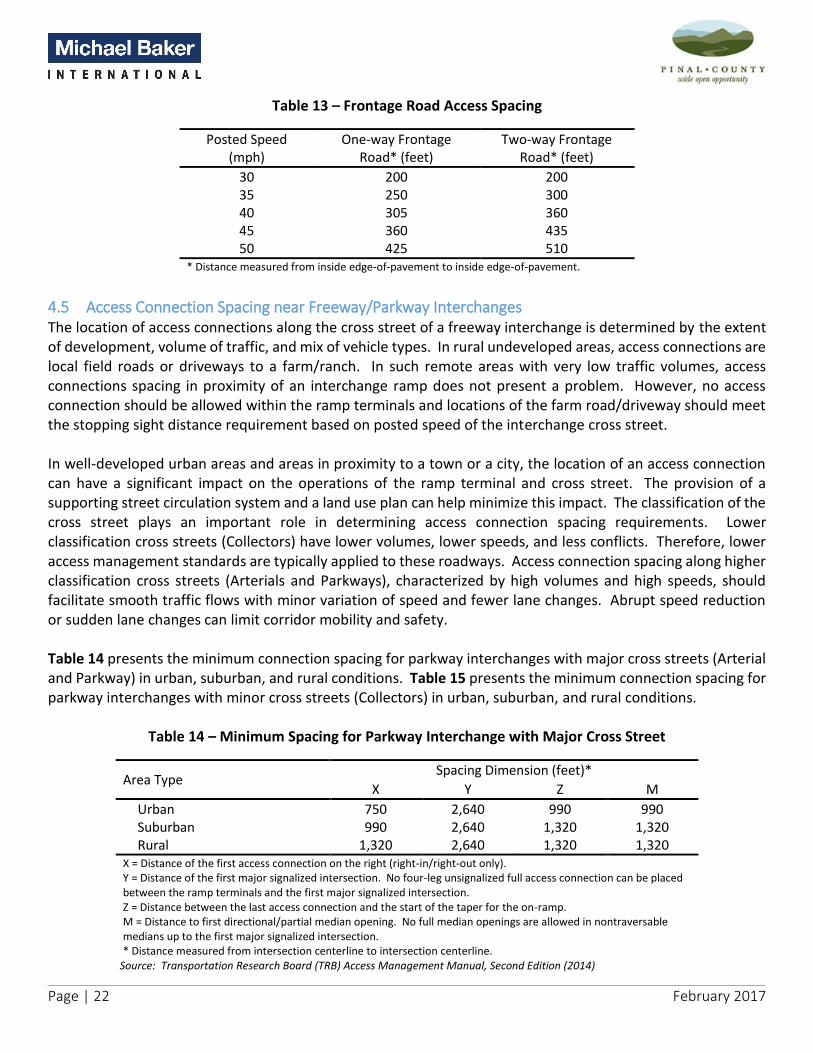
4.5 Access Connection Spacing near Freeway/Parkway Interchanges The location of access connections along the cross street of a freeway interchange is determined by the extent of development, volume of traffic, and mix of vehicle types. In rural undeveloped areas, access connections are local field roads or driveways to a farm/ranch. In such remote areas with very low traffic volumes, access connections spacing in proximity of an interchange ramp does not present a problem. However, no access connection should be allowed within the ramp terminals and locations of the farm road/driveway should meet the stopping sight distance requirement based on posted speed of the interchange cross street. In well-developed urban areas and areas in proximity to a town or a city, the location of an access connection can have a significant impact on the operations of the ramp terminal and cross street. The provision of a supporting street circulation system and a land use plan can help minimize this impact. The classification of the cross street plays an important role in determining access connection spacing requirements. Lower classification cross streets (Collectors) have lower volumes, lower speeds, and less conflicts. Therefore, lower access management standards are typically applied to these roadways. Access connection spacing along higher classification cross streets (Arterials and Parkways), characterized by high volumes and high speeds, should facilitate smooth traffic flows with minor variation of speed and fewer lane changes. Abrupt speed reduction or sudden lane changes can limit corridor mobility and safety. Table 14 presents the minimum connection spacing for parkway interchanges with major cross streets (Arterial and Parkway) in urban, suburban, and rural conditions. Table 15 presents the minimum connection spacing for parkway interchanges with minor cross streets (Collectors) in urban, suburban, and rural conditions.
Table 14 – Minimum Spacing for Parkway Interchange with Major Cross Street
Area Type Spacing Dimension (feet)*
X Y Z M
Urban 750 2,640 990 990 Suburban 990 2,640 1,320 1,320 Rural 1,320 2,640 1,320 1,320
X = Distance of the first access connection on the right (right-in/right-out only). Y = Distance of the first major signalized intersection. No four-leg unsignalized full access connection can be placed between the ramp terminals and the first major signalized intersection. Z = Distance between the last access connection and the start of the taper for the on-ramp. M = Distance to first directional/partial median opening. No full median openings are allowed in nontraversable medians up to the first major signalized intersection. * Distance measured from intersection centerline to intersection centerline.
Source: Transportation Research Board (TRB) Access Management Manual, Second Edition (2014)

Page | 23 February 2017
Table 15 – Minimum Spacing for Parkway Interchange with Minor Cross Street
Area Type Spacing Dimension (feet)*
X W Y Z M
Urban (35 mph Design) 2 Lane 250 850 850 325 n/a 4 Lane 250 850 850 325 325
Suburban (45 mph Design) 2 Lane 360 860 860 410 n/a 4 Lane 360 860 860 410 410
Rural (55 mph Design) 2 Lane 495 670 670 520 n/a 4 Lane 495 670 670 520 520
X = Distance of the first access connection on the right (right-in/right-out only). W = Distance from the last driveway to first major signalized intersection. Y = Distance of the first major signalized intersection. Y must be greater than or equal to X+W if a driveway is allowed between ramp terminal and first major signalized intersection. Z = Distance between the last access connection and the start of the taper for the on-ramp. M = Distance to first directional/partial median opening. No full median openings are allowed in nontraversable medians up to the first major signalized intersection. * Distance measured from inside edge-of-pavement to inside edge-of-pavement. Source: Transportation Research Board (TRB) Access Management Manual, Second Edition (2014)
Any development planned within or near right-of-way corridors, must also follow the ADOT Red-Letter notification process to help limit escalation of right-of-way costs.
4.6 Alternative Intersection Applications For a jurisdiction/public agency to have a robust access management policy, it is important to have the ability to implement alternative intersection designs at locations where installation of a traffic signal is not desirable or feasible. Alternative intersection design typically include grade separated intersections, indirect left-turn intersections, continuous flow (displaced left-turn) intersections, roundabouts, and Florida T-intersections. Due to the geometric and right-of-way requirements associated with alternative intersection designs, special consideration and coordination with adjacent property owners will be required. The TRB Access Management Manual (Second Edition) identifies the following access spacing guidance for alternative intersections design applications:
1. Direct access should be prohibited within the functional area/physical boundaries of these intersections. It should be noted that the physical boundary of these intersections is typically larger than a conventional intersection.
2. The location of the first unsignalized right-in/right-out access connections should meet the stopping sight distance requirements based on the posted speed. For roundabouts, this distance should meet decision sight distance based on roundabout design speed.
3. The location of the first unsignalized partial median opening should meet the stopping sight distance plus the left-turn queue storage requirements. For roundabouts, this distance should be based on decision sight distance as per roundabout design speed plus the left-turn queuing requirements.
4. The location of the first signalized/unsignalized full access connection should meet the stopping sight distance plus the intersection queue storage requirements. For roundabouts, this distance should be

Page | 24 February 2017
based on decision sight distance as per roundabout design speed plus the intersection queuing requirements.
5. The location of the first signalized access connection in a coordinated signal network should be based on the functional classification of the roadway (parkway, arterial, collector, etc.) as discussed in signalized access connection section of this manual.
Table 16 presents the minimum connection spacing from a roundabout along major and minor streets (Arterial and Collector) in urban, suburban, and rural conditions per the TRB Access Management Manual (Second Edition). For all other alternative intersection applications, access spacing criteria provided for traditional interchange cross streets in the previous section (see Table 14 and Table 15) can be applied.
Table 16 – Minimum Access Connection Spacing from Roundabouts
Area Type Roundabout Design
Speed (mph)
Spacing Dimension (feet)*
X W Y Z M
Urban Area
2 Lane 25 400 1,000 1,000 400 n/a 30 490 1,090 1,090 400 n/a 35 590 1,140 1,140 400 n/a
4 Lane 25 400 1,000 1,000 450 475 30 490 1,090 1,090 450 565 35 590 1,140 1,140 450 665
Suburban Area
2 Lane 25 400 925 925 460 n/a 30 490 915 915 460 n/a 35 590 965 965 460 n/a
4 Lane 25 400 925 925 510 340 30 490 915 915 510 400 35 590 965 965 510 475
Rural Area
2 Lane 25 280 530 530 545 n/a 30 350 525 525 545 n/a 35 425 500 500 545 n/a
4 Lane
25 280 530 530 545 205
30 350 525 525 545 245
35 425 500 500 545 300 X = Distance of the first access connection on the right (right-in/right-out only). W = Distance from the last driveway to first major signalized intersection. Y = Distance of the first major signalized intersection. Y must be greater than or equal to X+W if a driveway is allowed between roundabout and first major signalized intersection. Z = Distance between the last access connection and the start of the roundabout taper. M = Distance to first directional/partial median opening. No full median openings are allowed in nontraversable medians up to the first major signalized intersection. * Distance measured from inside edge-of-pavement to inside edge-of-pavement.
Source: Transportation Research Board (TRB) Access Management Manual, Second Edition (2014)

Page | 25 February 2017
5.0 Design Standards Documentation
5.1 Street Cross-Sections The design of cross-section elements depends upon the facility’s intended use. Design standards for parkway and frontage road cross-sections were developed based on the following documents:
1. Pinal County East-West Corridor Study between SR 347 and I-10, Final Design Concept Report dated December 2015;
2. Pinal County Comprehensive Plan dated November 2009; and 3. American Association of State and Transportation Officials’ (AASHTO) A Policy on Geometric Design of
Highways and Streets.
Design standards for parkways and frontage roads are described in the following sections. Design standards for all other roadway classifications can be found in the Pinal County Subdivision & Infrastructure Design Manual.
5.1.1 Arizona Parkways/Parkways or RSR Parkways A parkway is generally characterized by a large median with the elimination of left-turn movements at arterial intersections. For vehicles wishing to turn left, they would have to utilize strategically placed U-Turn facilities along the parkway which effectively reverses their direction of travel. By implementing the parkway concept, efficiency and safety of intersections are greatly enhanced as there is only two phases of operation. The parkway requires a wider than normal median in order to allow the design vehicle adequate space to execute the U-Turn movement. The width of the median is dependent upon the design vehicle selected for the project and the anticipated turning movements. Due to the larger median widths, the minimum right-of-way required for a parkway is 200 feet (approximately 162 feet of street width from back-of-curb to back-of-curb). Design criteria for parkways are included in Table 17.
5.1.2 Frontage Roads Frontage Road, also known as an access road, service road, parallel road, etc., is a local road running parallel to a higher-speed, limited-access road. A frontage road is often used to provide access to private driveways, shops, houses, industries or farms. Design standards included in Table 17 for frontage roads are based on the AASHTO A Policy on Geometric Design of Highways and Streets.

Page | 26 February 2017
Table 17 – Design Standards by Roadway Classification
Design Element Parkways Major
Arterials Minor
Arterials Collector
Roads Local
Streets Frontage
Roads
Number of Lanes 6 * * * * 1-2
Lane Width 12' * * * * 12'
Shoulder Width 6' (outside)
* * * * 2’-4’ 4' (inside)
Median Width 78' * * * * n/a
Design Speed (mph) 50-65 * * * * 25-35
Right-of-Way 200' * * * * within ROW
of adj. roadway
Median Crossover Interval
Urban 1/4 mile spacing n/a n/a n/a n/a n/a Rural 1/4 mile spacing n/a n/a n/a n/a n/a
*See design standards in Pinal County Subdivision & Infrastructure Design Manual
5.2 Sight Distance Requirements Sight distance is the continuous length of street ahead visible to the driver. Sight distances for horizontal and vertical curves shall be provided based on AASHTO’s A Policy of Geometric Design of Highways and Streets, 2011 Edition. In addition to AASHTO’s sight distance requirements at intersections, Pinal County Subdivision & Infrastructure Design Manual states that a minimum 33’ x 33’ sight visibility triangle easements (SVTE) shall be provided for all intersections of collector or arterial streets. A minimum 21’ x 21’ SVTE shall be provide for all local street intersections.
5.3 Turn Lanes (left-turn and right-turn) Refer to the Pinal County Subdivision & Infrastructure Design Manual and the Pinal County Traffic Impact Assessment Guidelines & Procedures dated January 2007 for turn lane design standards. Turning lanes permit separation of conflicting traffic movements and removes turning vehicles from the intersection area. Raised medians shall be used as directed by the County Engineer to separate traffic flows, channelize left-turns and reduce conflicts. On minor arterial and major collector streets, painted medians provide space between the through traffic lanes for left-turning vehicles. Right-turn lanes shall be provided on arterial streets at all street intersections where warranted per the Traffic Impact Analysis. Turn lane warrants shall be applied to all intersections within the study area where the use of turn lanes are not apparent or required to meet the minimum level of service during an intersection’s analysis.
Page | 27 February 2017
5.4 Driveway Locations
5.4.1 Driveway Spacing The following requirements are an update to the driveway spacing guidelines provided in the Pinal County Subdivision & Infrastructure Design Manual and the Pinal County Small Area Transportation Study dated August 2006. A maximum of one driveway opening shall be permitted to a particular residential site or residential parcel from each abutting street. One additional driveway entrance may be permitted by the County Engineer. A new driveway will not be allowed within 30 feet of any commercial property line, except when it is a joint use driveway, serving two abutting commercial properties and access agreements have been exchanged between, and recorded by, the two abutting property owners. Commercial driveways will not be allowed within 50 feet of the right-of-way line of an intersecting non-arterial street or within 600 feet of two intersection arterial streets. Exceptions may be permitted by the County Engineer. Driveway spacing shall be based on speed and/or roadway classification. A driveway spacing of 65 feet to 85 feet along roadways with 20 to 30 mph posted speed limits will provide adequate spacing along local streets. Therefore, driveway spacing along local roads shall be 75 feet. As the speed and classification increase, the driver perception-reaction time is reduced and greater spacing of driveways is required. Driveway spacing along arterial and collector roadways shall be 360 feet and 250 feet, respectively. Typically, an arterial roadway will have a posted speed limit of 40 to 50 mph while a collector roadway will have a posted speed limit of 35 to 40 mph. Figure 4 shows the driveway spacing standards, measured from centerline to centerline, for Pinal County.
5.4.2 Corner Clearance Corner clearance is the distance between the corner of an intersection and the first driveway. Adequate corner clearance is important to effectively separate conflict points and allow drivers enough time to make safe maneuvers. The required corner clearance is 360 feet from an intersection to an access driveway along an arterial roadway and 250 feet along a collector roadway. Figure 4 shows the corner clearance standards, measured from inside edge to inside edge, for Pinal County. Any deviations to the corner clearance requirements shall be approved by the County Engineer.

Page | 28 February 2017
Figure 4 – Driveway Spacing and Corner Clearance
5.5 Cross and Shared Access Based on the Pinal County Regionally Significant Routes for Safety and Mobility document dated October 2008, joint access/cross access provides for a unified on-site circulation plan serving several properties on a commercial corridor. Cross access connects adjacent parcels and allows for circulation between the parcels without using the arterial street system. In the case that lot frontage is inadequate, joint access/cross access can achieve adequate driveway spacing. The method requires that joint-use driveways and cross access easements need to be established between adjacent properties. Additionally, building sites must reflect the circulation system. The jurisdiction with the zoning authority would need to adopt cross access standards. The jurisdiction that maintains the roadway the properties are adjacent too will dictate the standards to follow.

Page | 29 February 2017
5.6 Local/Frontage Access Lanes Local access lanes may be used in residential and commercial areas along arterial roadways and include the following benefits:
Reduction in number of conflict points between various road users (vehicles, pedestrian and bicycles);
Reduce congestion on the roadway;
Provides more area for landscaping;
Provides a safer environment for bicycles and pedestrians;
Ability to provide parking lane; and
Fewer delays accessing businesses as the business patrons encounter less congestion.
5.7 Driveway Curb Radius The radii of the curb returns shall be in accordance with the guidelines detailed in the Pinal County Subdivision & Infrastructure Design Manual.
5.8 Unsignalized Driveway Design Based on the Pinal County Subdivision & Infrastructure Design Manual, driveways are to be constructed in accordance with the Maricopa Association of Governments (MAG) Uniform Standard Details. The minimum residential driveway length is 20 feet, measured from the face of the garage opening to the back of sidewalk or the back of curb if no sidewalk is provided. The minimum length for a commercial or industrial driveway is 30 feet, measured from the entrance of the off-street parking area to the back of sidewalk or the back of curb if no sidewalk is provided. Driveway entry widths shall be based on the MAG Standard Details 250-1, 250-2 and 251. The spacing of unsignalized driveways/connections shall be based on the recommendations from Section 5.4 of this manual.
5.9 Signalized Driveway Design The cross-section and throat lengths at signalized driveways shall be in accordance with the turn lane requirements and lengths calculated based on the traffic impact analysis. The spacing of signalized driveways/connections shall be based on the recommendations from Section 4.1 of this manual.
5.10 Driveway Turning Movement Restrictions Based on FHWA’s Access Management in the Vicinity of the Intersections, the number and type of conflict points at the intersection of a driveway and public road influence the safety of motorists. It is desirable to minimize the number of conflict points created with existing and future driveways since more conflict points increase the risk of a crash occurring. Where restricting turning movements to and from a driveway is possible, it is most beneficial from a safety perspective to prohibit left-turning movements. Reducing or eliminating left-turns to and/or from driveways enhances safety. Driveway turning movement restrictions shall be used for all driveways that do not meet full access spacing requirements from Section 4 of this manual. On roadways without a raised median, techniques proven to restrict turning movements, such as islands, should be used.

Page | 30 February 2017
5.11 Median Design Based on the Pinal County Subdivision & Infrastructure Design Manual, raised medians shall be used as directed by the County Engineer to separate traffic flows, channelize left-turns and reduce conflicts. On minor arterials and major collector streets, painted medians provide space between the through traffic lanes and left-turning vehicles. A median less than 4 feet wide shall be paved. The pave surface shall be crowned and have the same cross slope as the street pavement. Acceptable paving materials are asphalt concrete or concrete. Medians wider than 4-feet shall be landscaped. Landscaping in medians shall follow the guidelines detailed in Chapter 11 of the Pinal County Subdivision & Infrastructure Design Manual. Median widths may vary between 2 feet and 80 feet based on the type of roadway and the design vehicle used for the project. Refer to the AASHTO Geometric Design of Highways and Streets for specific median widths. The AASHTO Geometric Design of Highways and Streets also states that a median nose can be a semicircular nose for narrow medians and bullet nose design for wider medians. For a median width of 10 feet or more, the bullet nose is superior to the semicircular nose and should be used in the design. Median opening design controls and minimum median opening widths are shown in Table 18 and Table 19 respectively per the AASHTO guidelines.
Table 18 – Design Controls for Minimum Median Openings
Design Vehicle Accommodated
Control Radius (feet)
40 50 75
Predominant P SU WB-40 Occasional SU WB-40 WB-50
Source - AASHTO Geometric Design of Highways and Streets
Table 19 – Minimum Median Opening
Median Width (feet)
Minimum Median Opening (feet)
Semi-Circular Bullet Nose
10 90 62 20 80 44 30 70 40 min 40 60 40 min 50 50 40 min 60 40 40 min
Source - AASHTO Geometric Design of Highways and Streets
5.12 U-Turn Design Chapter 17 of the TRB Access Management Manual (Second Edition) includes guidelines for U-Turn design on roadways. Table 20 shows the minimum width of a median separator required for various U-Turn maneuvers and design vehicles.
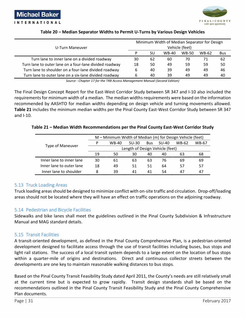
Page | 31 February 2017
Table 20 – Median Separator Widths to Permit U-Turns by Various Design Vehicles
U-Turn Maneuver Minimum Width of Median Separator for Design
Vehicle (feet)
P SU WB-40 WB-50 WB-62 Bus
Turn lane to inner lane on a divided roadway 30 62 60 70 71 62 Turn lane to outer lane on a four-lane divided roadway 18 50 49 59 59 50 Turn lane to shoulder on a four-lane divided roadway 6 40 39 49 49 46 Turn lane to outer lane on a six-lane divided roadway 6 40 39 49 49 40
Source - Chapter 17 for the TRB Access Management Manual (Second Edition)
The Final Design Concept Report for the East-West Corridor Study between SR 347 and I-10 also included the requirements for minimum width of a median. The median widths requirements were based on the information recommended by AASHTO for median widths depending on design vehicle and turning movements allowed. Table 21 includes the minimum median widths per the Pinal County East-West Corridor Study between SR 347 and I-10.
Table 21 – Median Width Recommendations per the Pinal County East-West Corridor Study
Type of Maneuver
M – Minimum Width of Median (m) for Design Vehicle (feet)
P WB-40 SU-30 Bus SU-40 WB-62 WB-67
Length of Design Vehicle (feet)
19 50 30 40 40 63 68
Inner lane to inner lane 30 61 63 63 76 69 69 Inner lane to outer lane 18 49 51 51 64 57 57
Inner lane to shoulder 8 39 41 41 54 47 47
5.13 Truck Loading Areas Truck loading areas should be designed to minimize conflict with on-site traffic and circulation. Drop-off/loading areas should not be located where they will have an effect on traffic operations on the adjoining roadway.
5.14 Pedestrian and Bicycle Facilities Sidewalks and bike lanes shall meet the guidelines outlined in the Pinal County Subdivision & Infrastructure Manual and MAG standard details.
5.15 Transit Facilities A transit-oriented development, as defined in the Pinal County Comprehensive Plan, is a pedestrian-oriented development designed to facilitate access through the use of transit facilities including buses, bus stops and light rail stations. The success of a local transit system depends to a large extent on the location of bus stops within a quarter-mile of origins and destinations. Direct and continuous collector streets between the developments are one key to maintain reasonable walking distances to bus stops. Based on the Pinal County Transit Feasibility Study dated April 2011, the County’s needs are still relatively small at the current time but is expected to grow rapidly. Transit design standards shall be based on the recommendations outlined in the Pinal County Transit Feasibility Study and the Pinal County Comprehensive Plan documents.

Page | 32 February 2017
6.0 Implementation Methods It is challenging to implement access management policies through access permitting, roadway improvements and retrofitting process alone. Land use zoning strategies, land development and subdivision regulations, site plan review and transportation impact study procedures play an important role in implementing access management policies adopted by a local jurisdiction. This section discusses the zoning strategies, land development strategies, subdivision regulations, site plan review, transportation impact study procedures, and retrofitting procedures for implementing access management policies. Furthermore, procedures for granting variance from strict application of access management policies in cases of extraordinary hardship or practical difficulties in land/site development are discussed.
6.1 Zoning Strategies Zoning establishes the designation of land use (residential, commercial, industrial, recreational, etc.) and regulates the layout and intensity of development. The primary purpose of zoning is to promote orderly growth, prevent overcrowding, and separate incompatible land uses. Lot layout requirements such as lot depth, width, and size of the property regulated by a zoning code can help ensure adequate spacing of driveways, good on-site circulation, adequate provision of parking, proper dimension of driveway throat length, and channelization of driveways as dictated by traffic needs. Increasingly, communities are relying on zoning codes to incorporate contemporary planning objectives such as reducing urban sprawl, promoting activity centers, preventing strip development, and creating transit oriented development. A variety of zoning strategies are being employed to meet these planning objectives that include: Form-Based Codes – are a contemporary method of regulating development that focuses on a desired form or context (e.g. district, neighborhood, or corridor). Form-based codes link building forms and streets and block development to a specific regulating plan. The codes containing regulation may be mandatory throughout a community, applied only in a specific district, or applied as an overlay option that can be added to underlying regulations. These codes are highly prescriptive and therefore have clear and predictable implication on access management. They can reinforce an urban or village block pattern and require buildings to locate at the street line, with on-street parking, and access via alleys in certain districts. The codes could help in introducing a diverse mix of land uses into an activity center with a good internal street network. The codes can also be adapted to provide appropriate levels of access control as the corridor transitions from one context to another (urban district to sub-urban neighborhood). Modular Zoning – breaks the elements of each zoning district into modules that can be mixed and matched. This zoning would allow permitted uses, dimensional standards (depths, widths, etc.), and other development standards (parking, landscape requirements, etc.) to be combined in different ways. Although this strategy increases flexibility to achieve planning objectives, it can result in numerous and complex zoning districts. Incentive Zoning Rewards – would allow a developer to increase land use density in exchange for advancing the access management goal of promoting shared use driveways. A challenge in using this strategy is to separate issues that can typically occur (e.g. inter-parcel cross access) from those where incentives are often needed to achieve results (e.g. shared use driveway). Cluster Zoning – relaxes the land use designation and dimensional standards within a zone to promote creative site design. It allows meeting of performance standards for a given zone without limiting how it will be achieved.

Page | 33 February 2017
Land use intensity may increase in one part of the site and be relaxed in another part of the site while still maintaining the overall land use intensity to meet planning objectives. Cluster zoning can be employed to promote access management in the following ways:
In creating mixed-use clusters that work with the natural topography of the site and integrate land use, access, and circulation into a unified design.
In clustering various uses in a single development so as to avoid encroaching on future right-of-way of a planned transportation facility.
Mandating cluster zoning along a busy commercial corridor could be an effective strategy in advancing access management by preventing strip development.
Mandating cluster zoning along a rural highway helps promote shared access roadways for residential and commercial uses.
Planned Unit Development (PUD) Zoning – standards provide for clustering and mixed-use development within a parcel. PUD Zoning relaxes lot dimensional requirements and apply density restrictions to an entire parcel rather than a single lot. PUD process involves more extensive site plan review and allows considerable discretionary authority to the review agency. Overlay Zoning – adds special requirements onto an existing zoning district while retaining other requirements of the underlying zone. Overlay zoning offers a flexible method of managing access along a busy corridor by allowing standards to be tailored to meet the corridor needs. Overlay zoning requirements can address issues such as shared/joint access, cross access between lots, reverse frontage, minimum lot frontage, driveway spacing, restricting new driveways and lot subdivisions.
6.2 Land Development Strategies The following land development strategies were identified in the original access management manual (dated October 2008) and are still relevant today in regulating access:
Acquisition of Access Rights;
Dedication and Exactions;
Interim Use Allowances;
Purchase of Development Rights; and
Transfer of Development Rights.
6.3 Subdivision Regulations Subdivision regulations provide guidance on the division and subdivision of land into lots, blocks, and streets. These regulations complement the underlying zoning regulations. They establish review procedures for processing plats, setting design standards for public infrastructure and utilities, and establishing financial and maintenance responsibilities. Subdivision regulations provide an opportunity to ensure proper access and street layout in relation to existing and planned roadways. Some commonly used subdivision regulations for access management are as follows: Reverse Frontage Regulation – In residential subdivisions that abut an arterial or major collector roadway, the reverse frontage regulation can force the lots to back the major street and gain access from an interior local

Page | 34 February 2017
street. Similar regulations can be applied to residential lots that front two streets. Subdivision regulations can require obtaining access through a lower classification street unless doing so will adversely impact safety or otherwise be impractical. Regulating Minor Subdivision and Lot Splits – Unregulated minor subdivisions and lot splits allow property owners to subdivide land incrementally and avoid going through an expensive platting process. However, the resulting lot configurations may require long private access easements, increased demand for direct access, and long cul-de-sacs with inadequate emergency access and lack of street connectivity. To avoid such access problems, jurisdictions can adopt subdivision regulations that cover all land division activity, including residential lot splits and commercial subdivisions. One example might be to allow rural property owners to create small concept plans with shared driveway access and allow gravel/low-cost surface options to be built to appropriate standards. An additional example might be the freezing of access rights on major roadways (parkways and arterials) with lots that have not been extensively subdivided and allowing only one access per existing lot (property owners granting vehicular non-access easement to the County), preventing future subdivided lots from adding additional access points. These regulations can provide for streamlined local review of minor land division activity to ensure that proper access requirements are met without placing unnecessary burden on the abutting street network. Outparcel Requirements – Outparcels (or outlots) along the perimeter of a large commercial development (such as a shopping center) created for commercial marketability can cause access and circulation problems if treated as individual parcels that have separate access requirements. Jurisdictions can implement outparcel regulations that foster coordinated on-site circulation that serves outparcels as well as interior development thereby reducing the need for multiple driveways on the abutting roadway. Outparcel regulations may include standards governing the number of outparcels, minimum lot frontage, access requirements, unified parking and circulation, landscaping and pedestrian amenities, transit and bicycle facilities. Continuation and Connectivity of Subdivisions – Subdivisions with dead-end streets, cul-de-sacs, and gated communities can impede emergency access and transit services, force more traffic to use major roadways, reduce bicycle and pedestrian mobility, and increase the length of trips. The common reason for not promoting subdivision connectivity is to discourage cut-through traffic. However, modified grid design, circuitous through streets, curvilinear street design and implementing traffic calming design elements can address the cut-through traffic issues while preserving street connectivity. Therefore, subdivision regulations can include policies for new subdivisions to continue or extend planned street networks or connect to the surrounding street network. Establishing a connectivity index (number of roadway links divided by number of nodes or link ends) in the subdivision code for review of new developments can help promote local street network density and connectivity. Cul-de-Sac Requirements – Subdivisions that are long and narrow (referred to as bowling alley subdivisions), served by single access cul-de-sac can create traffic congestion during peak hours of the day, traffic safety issues (speeding during the off-peak hours), and impede emergency/fire access. This problem can occur in phased subdivisions where additional access is provided with a future phase that does not get built for a long period of time. Subdivision regulations can address this issue by limiting the number of lots (that determines amount of traffic) that can be served by a cul-de-sac, limiting the length (that determines the speed) of a cul-de-sac, and requiring minimum turning radius and other design elements of a cul-de-sac that can accommodate emergency vehicles.

Page | 35 February 2017
Service Road Regulations – Service roads (or frontage roads) serve as collector-distributors to commercial tracts along a major roadway. Continuous service roads can cause safety and operational issues at their intersection with major roadways unless sufficient distance is provided between the service road connection and the major intersection. To address this challenge, service road regulations can be implemented when land is being subdivided or consolidated for development purposes. Service road regulations could include standards governing offset requirement, full or partial access, design, construction and maintenance responsibility.
6.4 Site Plan Review The purpose of site plan review for access management is to determine whether the location and design of the proposed site access connections will operate safely and efficiently, or if the proposed internal site circulation will have an impact on the abutting street network and may cause unacceptable queue spillback onto the abutting street network. Access management issues to consider in the site plan review process include the following:
Is the road network designed to meet the projected site traffic demand and does the road network consist of a hierarchy of roads designed in accordance to function?
Are the proposed access driveways/roads meeting sight distance requirements, connection spacing requirements, operational capacity, and other traffic considerations?
Do individual parcels front on and obtain direct access from the minor side street, rather than major roadway?
Does the site layout allow good on-site circulation without having to rely on the peripheral street network?
Does the project avoid areas unsuitable or incompatible with the proposed use?
Does the bicycle and pedestrian path system link buildings with parking areas, entrances to the development, open spaces, and recreational and other community facilities?
Has the applicant provided a detailed description of requested variance and proof of necessity for the variance request?
Incomplete site plans make it difficult to evaluate the adequacy of access and on-site circulation. The TRB Access Management Manual (Second Edition) identifies the following checklist items that should be reviewed as a part of site plan review process: Vehicular Access
Are all buildings and improvements (including billboards) located outside planned easements and right-of-way areas?
Is there an opportunity to provide alternative access to the site from a service road or existing local road? Is the number of proposed driveways the minimum necessary to serve the site and the proposed use? Is there an opportunity to reduce the number of driveways serving the site? Can the proposed site provide a cross-access connection or easement to an abutting parcel? Do the adjacent sites have cross-access easements that should be connected to the site under review? Should the site be redesigned to better accommodate cross-access? Can the proposed site accommodate joint or shared access with an adjacent parcel? Can the site be designed to provide an opportunity to allow joint access in the future?

Page | 36 February 2017
Can access be achieved from this parcel to an adjacent traffic signal? Is the site driveway located outside the functional area of an adjacent intersection as defined by the
adopted spacing standards or engineering analysis? If the access is within an intersection’s functional area, has the site access been moved to the outside
edge of the property line, or can access be shared with the adjacent properties? Do the locations of the site access connections provide adequate sight distance? Do proposed signs, landscaping, or other improvements potentially obstruct the sight distance of drivers
exiting the proposed access? Are the driveways adequately offset from opposing driveways or streets across the roadway if no median
is present? Is there adequate uninterrupted throat length for any driveways and frontage roads that serve the site? Are turning restrictions or access restrictions desirable for a proposed driveway located within the
influence zone of an adjacent intersection? Is the site driveway located directly across from an existing driveway or at a location allowing for future
shared use? Does the site plan show the property lines for properties to the rear, both sides, and across the street? Does the parking lot design facilitate safe movements? Does the proposed project connect with surrounding street system?
Pedestrian, Bicycle and Transit Access
Does the site plan include a sidewalk that connects to adjacent properties and the adjacent roadway network and ends at a logical terminus?
Do sidewalks extend across the driveway opening? Are there sidewalk connections between the building entrance and the public sidewalk system? Is there an internal pedestrian connection to connect the building with the parking area? If there are multiple buildings on the parcel, is there an adequate pedestrian connection between the
buildings? Do access locations and parking layouts minimize potential conflicts with pedestrians and bicyclists? Is bicycle parking provided? Does the site plan include connections to existing or planned Open Space and Trails (OS&T)? Is there an adequate pedestrian connection to a transit stop on both sides of the roadway? Are measures needed to direct pedestrians to safe crossing points and pedestrian access ways? Are pedestrian travel zones clearly delineated from other modes of traffic through the use of striping,
colored or textured pavement, signs, and other methods? Are building entrances located and designed to be obvious and easily accessible to pedestrians? Does the site include pedestrian lighting where appropriate? Will snow storage disrupt pedestrian access or visibility? Is the path clear from temporary and permanent obstructions?
Intergovernmental Coordination
Has the state department of transportation (DOT) been identified as an interested or involved agency? If so, has the DOT been contacted?

Page | 37 February 2017
Has the county been identified as an interested or involved agency? If so, has the county been contacted?
Has the access permit application process of other affected agencies been started? Have all necessary comments been received from other affected agencies relative to the proposed
access?
6.5 Traffic Impact Study Procedure A traffic impact analysis (also known as traffic impact study) is a specialized analysis that documents the impacts of a development on the surrounding transportation network and identifies mitigation measures or traffic improvements needed to support the development. They are essential for implementing many access management policies such as number and location of site access driveways, level of access (full or partial), traffic control (signal or stop) installation, turn lane and storage requirements, internal site circulation, etc. A traffic impact analysis is typically required to be prepared by the developer and submitted to the reviewing jurisdiction/agency for approval under following conditions:
All proposed new developments or additions to existing developments that generate more than 100 new peak hour trips (total of inbound and outbound trip-ends) during a typical weekday or weekend. The peak hour can vary from land use to land use and is determined by the reviewing agency/jurisdiction.
All proposed new developments or additions to existing developments that generate less than 100 new peak hour trips in locations that are congested or have safety issues. This determination will be made by the reviewing agency/jurisdiction.
All proposed new developments or additions to existing developments that require new access connection to a major roadway or alter/modify the existing level and control of access along the major roadway.
All development applications for rezoning or special exceptions.
All development applications for annexations.
All planned area developments requiring major amendments.
All development applications where a development agreement is necessary to determine financial contributions (impact fee) to a major roadway or transportation system improvement.
All undeveloped sites where the original traffic impact study is outdated (more than 2 years old), site access decisions have not been made, and background traffic and land use conditions have changed since the site plan approval.
It should be noted that Pinal County has specific requirements for a traffic impact study outlined in Pinal County Traffic Impact Assessment Guidelines & Procedures document (dated January 2007).
6.6 Retrofit Procedure for Existing Land Uses and Corridors The retrofit procedures for existing land uses and corridors were identified in the original access management manual (dated October 2008) and are still relevant today.
6.7 Access Variance Procedure Agencies cannot always predict the challenges of developing a site and the circumstances that may force a developer to seek a variance or an exception from strict application of access management policies in development of a site. However, a variance that is granted has the impact of lowering standards and opens a

Page | 38 February 2017
path for other developers to seek such variance. Agencies are obligated to apply access management policies consistently. Therefore, agencies should carefully review their past variance decisions in developing a consistent approach to future decisions. Given the complexity of site development and site access being such an important component to the success of a project, many agencies have adopted procedures that make a distinction between “variance” and “waivers”. Waivers are typically used to address administrative exceptions. For example, granting a zoning variance to allow a developer relief from regulatory access standards. Variances are typically used to address engineering exceptions to an access policy, for example, lack of sight distance, driveway spacing, scope of design elements (length of turn lane), etc. Engineering variance may further be classified as major and minor variances from the access policy. This classification can help agency staff with decision-making authority over minor and reasonable variance (such as constraints caused by natural topography or existing man-made structures) from established standards. Major variance would require a more extensive review process and detailed engineering analysis. The developer would be entirely responsible for such detailed engineering analysis and provide proof of necessity. When compliance with the access management standards and policies would cause extraordinary and unnecessary hardship, the County Engineer may allow a property owner/developer to submit a petition for variance from the access management standards. A detailed traffic study or other relevant information may be required when reviewing a variance request. A variance may be granted if it is in harmony with the general intent and purpose of the access management standards, and will not adversely affect traffic safety or negatively impact the efficient operation of the roadway network.

Page | 39 February 2017
7.0 Access Approval and Permit Process The 2008 RSRSM Access Management Manual laid out a comprehensive approach to access approval along Regionally Significant Routes (RSR) within the County jurisdiction. The current update to this access management manual expands the access approval process to include all County roads including collector and local roadways.
7.1 Access Permitting Process for all County Roads The access permitting process for all County roads would include an access application process to be reviewed by the County officials. Figure 5 illustrates the access permitting process for situations where a development is in compliance with access management standards and also when a development is seeking a variance.
7.1.1 Incorporation of Access Management into Development Review Procedures The access management review process can be incorporated into development projects that may or may not require a rezoning approval. The general requirements and procedures for submission of tentative and final plats for subdivisions are contained in the Pinal County Subdivision Regulations. Table 22 describes how the access management review can be incorporated into development projects involving all County roadways under the following processes:
• The pre-development process; • The development process where no rezoning is required for commercial and for residential projects;
and • The development process when rezoning is required.
In the case where a rezoning would be required, Table 22 presents an example of the addition of a PAD overlay. The incorporation of the access management review into a rezoning process that does not include an overlay district would be very similar except that there would be only “underlying” zoning, so there would be no conformance check.

Page | 40 February 2017
Source: Transportation Research Board (TRB) Access Management Manual, Second Edition (2014)
Figure 5 - Access Permitting Process for all County Roadways

Page | 41 February 2017
Table 22 - Summary of Development Review Processes
Development Phase Agency ActivitiesHow Access Management is
Incorporated in this ProcessAgency Action Items
Due-diligence by
developer
Preliminary staff
coordination.
Initial Meeting
Plan of development
Submittal
Improvement plan
submittal
Reviewed by staff - if it
meets approval then
construction can commence.
Include new access
management standards as
part of the review process.
Amend review process to
include access management
review and access variance
request review if needed.
Provide developer new
access management
standards.
Send a Early Alert Process
regarding plan of
development submittal to
neighboring jurisdictions and
to Pinal County.
Information exchange
on upcoming plans
Agency staff provides the
developer with site plan
requirements.
Include the new access
management checklist.
Designate appropriate
review staff to be the lead on
access management
standards.
Send a Early Alert Process
regarding plan of
development submittal to
neighboring jurisdictions and
to Pinal County.
Are there requirements from
neighboring communities
that should be addressed?
Reviewed by staff - if it
meets criteria, it is approved.
Include new access
management standards into
plan review process.If access standards are not
met, provide variance
procedure requirements to
developer.
If the development abuts
neighboring jurisdiction,
send plan of development to
neighboring jurisdiction.
Amend plan of development
checklist to include access
management standards
review.
Send plan of development to
neighboring jurisdictions if
appropriate.
Pre-Development Process
Development Process - No Rezoning, Commercial or Industrial Property
Michael Baker INTERNATIONAL PINAL • COUNTY
widt 9fX'I9PJml•••l)

Page | 42 February 2017
Table 22 – Summary of Development Review Processes (cont.)
Development Phase Agency ActivitiesHow Access Management is
Incorporated in this ProcessAgency Action Items
Send a Early Alert Process
regarding tentative plat
submittal to neighboring
jurisdictions and to Pinal
County.
Tentative Plat
Submittal / Revisions
Application submittal and
plat are reviewed by staff
and if completeness criteria
are met, plat is forwarded to
the Subdivision Coordinating
Committee. When the
Planning Director has
considered all required
reviews, the plat is declared
ready to be forwarded to the
Planning & Zoning (P&Z)
Commission and is scheduled
for P&Z review. The P&Z can
continue the matter,
conditionally approve the
tentative plat, or deny the
tentative plat.
Amend the specifications for
tentative plats (Article 4 of
Regulations) to include
access management standard
review.
If the development abuts
neighboring jurisdiction,
send plan of development to
neighboring jurisdiction.
Send tentative plat to
neighboring jurisdictions if
appropriate. ADOT is also a
reviewer if the project is
adjacent to a state highway.
Initial Meeting -
Tentative Plat Pre-
Application Review
Agency staff (Planning
Department and the Public
Works Department) meets
with developer to review the
initial design concept and
provides the developer with
site plan requirements and
relevant plans.
Include the new access
management checklist.
Include the new access
management standards into
the plat review process.
Are there requirements from
neighboring communities
that should be addressed?
Development Process - No Rezoning, Residential Subdivision
Designate appropriate
review staff to be the lead on
access management
standards.
Assure that the Subdivision
Coordinating Committee
members are aware of
roadway that the project will
impact.
Michael Baker INTERNATIONAL PINAL • COUNTY
widt 9fX'I9PJml•••l)

Page | 43 February 2017
Table 22 – Summary of Development Review Processes (cont.)
Development Phase Agency ActivitiesHow Access Management is
Incorporated in this ProcessAgency Action Items
Final Plat
If access standards are not
met, provide variance
procedure requirements to
developer.
Improvement plan
submittal
Reviewed by staff - if it
meets approval then
construction can commence.
Include new access
management standards as
part of the review process.
Amend improvement plan
review to include access
management review and
access variance review if
needed.
Preliminary staff review.Zoning Application and
documents and, if for a
PAD, Preliminary Plan
of development
submitted
Incorporate access
management standards into
staff review process.
Revise and resubmit as
required.
Preliminary Staff
Coordination
Make access management
standards available to the
developer.
Develop information packet
of access management
standards and distribute.
Send Early Alert Process to
surrounding jurisdictions and
to Pinal County.
Application submittal and
final plat are reviewed by the
Planning Department, and
the other county
departments and agencies.
After any revisions the
Planning Director may deem
the final plat read for Board
review and action. Board
action is to approve and
record the final plat with the
County Recorder, or to
disapprove.
Include new access
management standards as
part of the review process.
Amend the specifications for
tentative plats (Article 4 of
Regulations) to include
access management review.
Send tentative plat to
neighboring jurisdictions if
appropriate.
Incorporate access
management checklist into
zoning plans, area plans.
Designate appropriate
review staff to be the lead on
access management
standards.
In conformance - plan to P&Z
Commission Public Hearing.
Review plan of development
for access management
standards compliance.Not in conformance - plan
goes to P&Z Preliminary
Hearing.
If for a PAD:
Determine if the plan
of development is in
conformance with
Comprehensive Plan,
any area plan, and
Zoning Ordinance
Development Process - Rezoning Required (PAD Example)
Designate appropriate
review staff to be the lead on
and access management
requirements.
Michael Baker INTERNATIONAL PINAL • COUNTY
widt 9fX'I9PJml•••l)

Page | 44 February 2017
Table 22 – Summary of Development Review Processes (cont.)
7.1.2 Incorporation of Access Management into Capital Improvement Plan Process Access management guidelines and standards should be considered during all phases of capital/roadway improvement projects. Activities that may warrant a review of access management considerations include:
• Request for traffic signal installation or other traffic control devices – Plan review should include a check as to whether the traffic signal will maintain the traffic signal spacing specified in the access management plan to achieve safety and mobility on the route.
• Intersection Improvements – Intersection improvements should be developed using the criteria for signal spacing and median control developed for the routes.
• Corridor Plans – Corridor plans should be developed using the access management standards developed to achieve safety and mobility on the specific route based on its functional classification. The corridor plan review process should verify that this has been done.
• Design Concept Reports – Design criteria should include access management criteria, including safety and mobility standards.
• Design Plans and Traffic Control Plans during Construction – Plan review check should note that the plans were developed in accordance with the access management plan for the road’s functional classification.
Development Phase Agency ActivitiesHow Access Management is
Incorporated in this ProcessAgency Action Items
Either:
Or
Denied - developer can
submit a consent petition,
which if successful,
project will go to the P&Z
Public Hearing. If
unsuccessful, rezoning
case will be closed.
Either recommended
approval or denial to Board of
Supervisors or Mayor and
Council.
Either conditional approval
with time limits and rezoning
requirements, or denial
(rezoning case closed).
Board of Supervisors
or Mayor and Council
Public Hearing
Comments on access
compliance or variance
granted can be part of input
to Public Hearing.
Provide input on access
management to P&Z
Commission.
Provide input on access
management to Public
Hearing and to elected
officials.
Planning & Zoning
Commission
Preliminary Hearing
Comments on access
compliance or variance
granted can be part of input
to P&Z Commission.
Approved - goes to P&Z
Public Hearing;
Provide input on access
management to P&Z
Commission Preliminary
Hearing.
Planning & Zoning
Commission Public
Hearing
Comments on access
compliance or variance
granted can be part of input
to P&Z Commission.