plan change 85d - rural living environment change 85d: rural living environment 2 contents 1....
TRANSCRIPT
1
Prior to Notification Part 6
JUNE 2016
Section 32 Evaluation Report
Plan Change 85D:
Rural Living Environment

2
Contents
1. Introduction .................................................................................................................................... 3
1.1 Purpose of the report ........................................................................................................ 3
1.2 Overview and background ................................................................................................ 3
1.3 The proposed plan change ............................................................................................... 5
2. Section 32 analysis ....................................................................................................................... 8
2.1 Appropriateness in terms of purpose of the RMA ............................................................ 8
2.2 Appropriateness in relation to the WDP ......................................................................... 10
2.3 Appropriateness in relation to higher order documents ................................................. 11
2.4 Effectiveness and efficiency of proposed policies and methods .................................... 13
3. Conclusion ................................................................................................................................... 34
Appendix 1: Rural Development Strategy Rural Living Ranking Criteria
Appendix 2: Summary of Identification of Rural Living Environment Boundaries
Appendix 3: Assessment Criteria for Rural Living Areas
3
1. Introduction
1.1 Purpose of the report
1. This forms Part 6 of the section 32 (s32) evaluation reports for the Rural Plan Changes. This part
should be read in conjunction with the other Parts 1 – 9. The general introduction, statutory
assessment and analysis of higher order policy documents are contained in Part 1. Rural Area (RA)
objectives, policies and performance standards are evaluated in terms of s32 within Part 2.
2. This Part of the report is in relation to a proposal to rezone parts of the Countryside Environment
(CE) and Coastal Countryside Environment (CCE) to a proposed new zone recognising and
providing for rural living development: the Rural Living Environment (RLE). The report has been
prepared in accordance with the requirements of Schedule 1 of the Resource Management Act 1991
(RMA) and incorporates an evaluation under s32. S32 evaluations are iterative, and therefore the
evaluation in this report constitutes the initial evaluation, with this being further revised throughout
the plan change process.
1.2 Overview and background
3. In 2010 Council adopted the Whangarei District Growth Strategy Sustainable Futures 30/50 (30/50).
30/50 sets out broad direction for the development of the district over a planning horizon of 30 and
50 years.
4. At the time of its adoption in 2010 30/50 highlighted that:
“Future development options are, and will continue to be, influenced by past development. A
substantial amount of recent land development has occurred outside of the urbanised area of our
main settlements. This type of development is often considered lifestyle development, and has been
very popular in many parts of the district. This has led to an oversupply of lifestyle lots in many parts
of the district. There are estimated to be around 6,000 vacant lots across the district, many of these
in rural and coastal areas. The existing availability of this number of vacant lots scattered across the
district will impact on efforts to create a more consolidated settlement pattern for a considerable
period of time. “
5. In 2013 the Council adopted the Rural Development Strategy (RDS). The RDS emerged in
recognition of the need to sustainably manage growth in rural areas so that the communities in and
around Whangarei can benefit socially, economically, and culturally while safeguarding resources for
future generations.
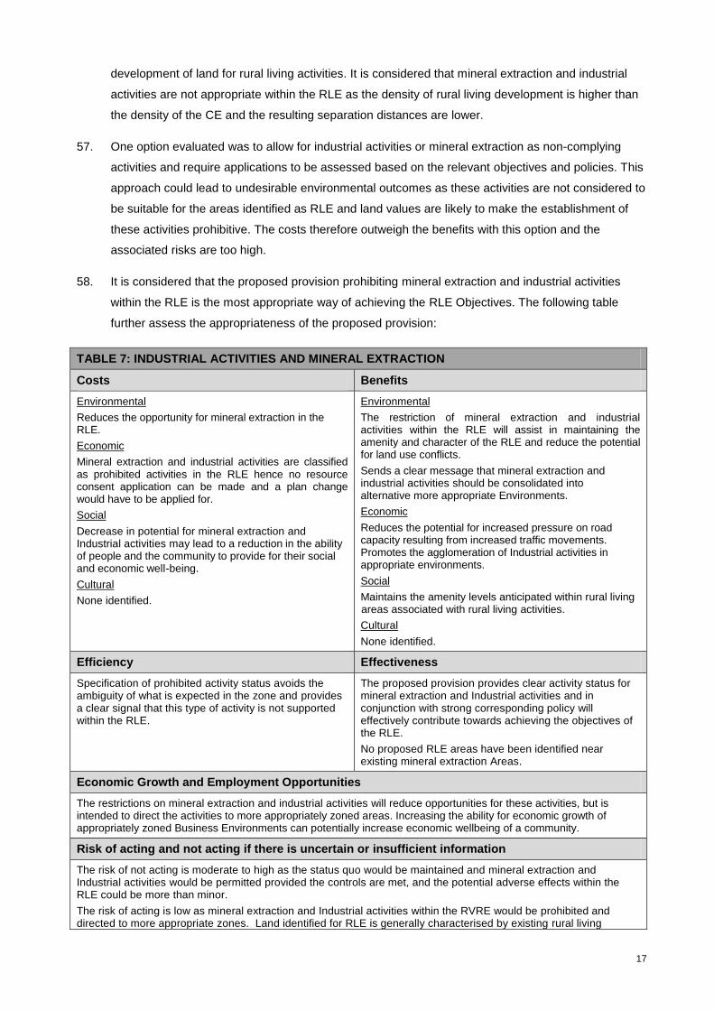
6. A key action arising from the RDS was to carry out a plan change to change the current approach to
rural subdivision. The rural and coastal subdivision rules in the Operative WDP were determined by
appeals to the Environment Court. The Proposed District Plan (PDP) provided for subdivision down
1 ha as a controlled activity. The minimum lot size was later altered by variation to 4ha. These
subdivision rules lead to the fragmentation of rural land and a proliferation of small lots scattered
throughout the rural area. The decision of the Court was to impose rules to set a holding pattern via
a blanket 20ha minimum lot size until the Council was able to promote a plan change to deal more
appropriately with rural subdivision. The Court decision notes that “the Countryside Environment is

4
an omnibus zone ill-suited to the multiple resource management requirements of a diverse rural
district.”
7. The 20ha rule has been an effective halt to the fragmentation of rural land to an extent. However as
described by the Court, it is a ‘blunt instrument’. The proliferation of small subdivisions that have
occurred prior to the 20ha rule has left WDC a legacy of cumulative, and reverse sensitivity issues.
Scattered small lots impact on rural production activities through complaints about rural odours,
noise, dust and spray drift that occur from time to time in the rural environment. Rural living
development also raises land values which affects the rates burden on neighbouring rural properties.
In extreme cases this can make it uneconomic to farm which rationalises further subdivision of
otherwise productive rural land.
8. Whangarei district has small pockets of elite and highly versatile soils, particularly in areas west of
the city. These areas were traditionally used for market gardens, horticulture, and other productive
rural activities. However, much of the elite and highly versatile soils that are located close to the city
have been developed for residential activities.
9. Fragmented rural land results in long-term reductions in rural production and productivity with smaller
allotments becoming less adaptable to changing demands from local and world markets. This type of
approach to rural land subdivision is not sustainable, and will not result in a sustainable use of land.
As land is taken out of production, that production must be established elsewhere on land of lower
natural productivity. Doing so requires greater inputs to achieve the same levels of production or
productivity. It is likely also to result in additional transport costs, as these areas will be located
further from the urban population and transport links to main markets.
10. Scattered subdivision also impacts Council (and therefore, ratepayers) as the provider of
infrastructure, particularly for roading, with demands to seal rural roads which were not anticipated or
programmed. Existing land use patterns with small lots scattered throughout the rural environment
also make it difficult for councils to justify declining subdivision applications based on the effects on
rural production activities when similar sized lots are already present. It is notoriously difficult to
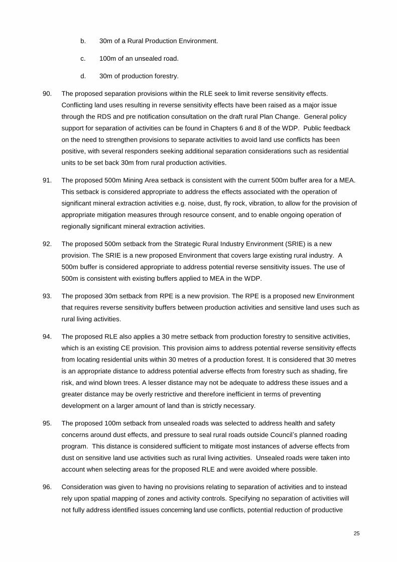
identify the ‘tipping point’ where introducing more people into the rural environment begins to have
unacceptable effects on productive rural land uses.
11. Consultation for the RDS indicated that 20 ha was not a useful size for either rural production or rural
living purposes. Feedback from the public was that rural land should be prioritised for rural use over
living, which should be directed to the city and city fringe. The feedback lent towards a tightening of
subdivision rules in the CE and CCE to protect rural activities. This is addressed by the introduction
of the proposed RPE.
12. Nevertheless it is recognised that there is demand for living opportunities outside the city and rural
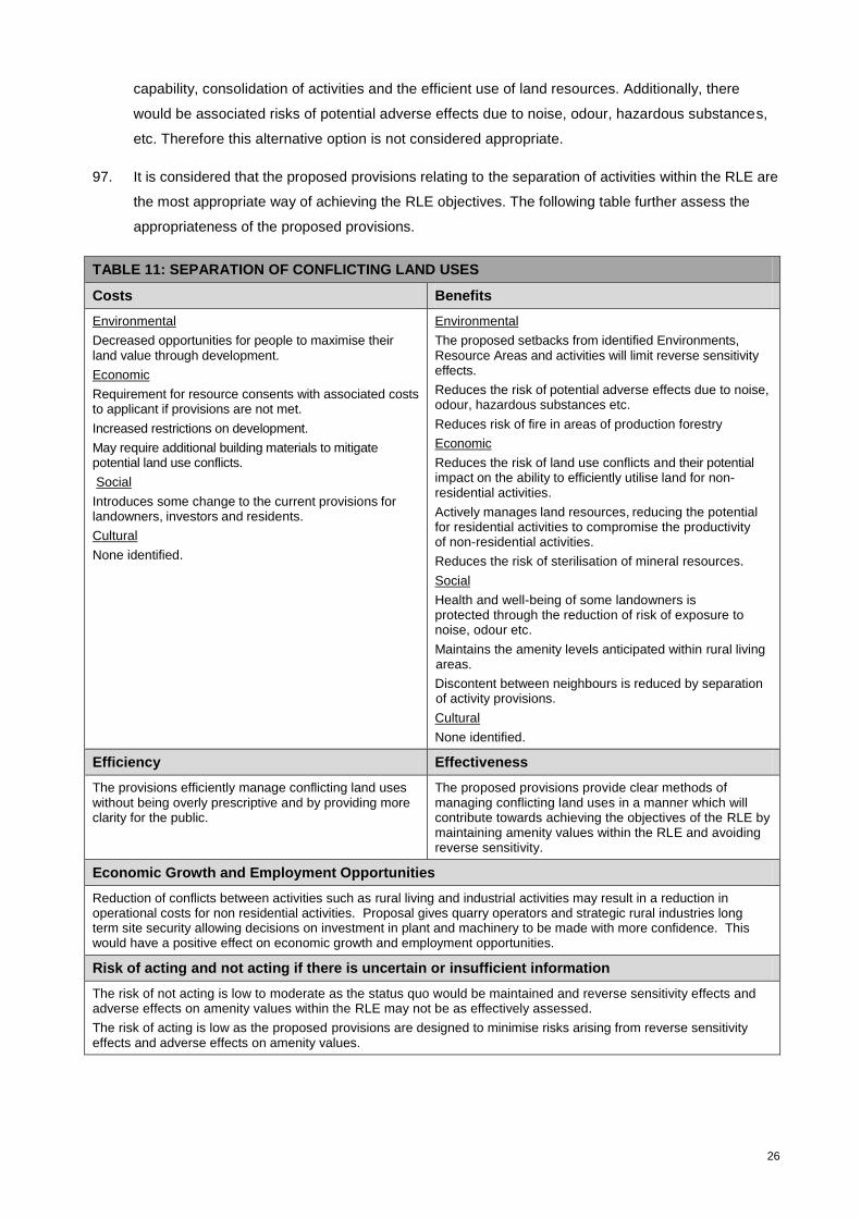
villages, and it is important that Council facilitates development of a range of housing choices for its
residents. To this end the RLE is proposed, to legitimise pockets of existing rural living development
in the rural environment, and to meet the future demand for rural living by providing additional
development capacity in the most appropriate areas.

5
13. Plan Change 85D (PC85D) responds directly to the proposals in the RDS and to the growth
projection figures derived from the 2013 census. As part of the WDP rolling review it also satisfies
the Council obligation to review the provisions of the district plan every 10 years as required by the
RMA.
1.3 The proposed plan change
Proposed Rural Living Environment
14. PC85D proposes introduce a new RLE chapter into the WDP with objectives, policies and rules for
the RLE including land use and subdivision provisions. The proposed plan change will amend the
WDP Environment Maps to denote the RLE and rezone areas from CE and CCE to RLE.
15. The purpose of PC85D is:
To recognise existing and future demand for rural living development in rural areas.
To rezone areas of existing rural residential development to a more appropriate zone reflecting
the existing levels of development and land use activities.
To consolidate areas of existing rural living development that are no longer in primary
production activities within the CE and CCE.
To rezone areas of the CE to provide limited future rural living opportunities for rural residential
development in appropriate locations.
16. The CE covers approximately 80% of the district and encompasses a wide variety of development
densities and land uses, ranging from remote areas with large allotments in native bush, forestry,
and pastoral farms to areas of rural living development nearer to the city and coast. The areas
identified for the proposed RLE fall into the latter category, having an existing level of rural living
development that is more intense than what is generally anticipated by the rules for the CE. The
character and amenity values associated with the identified areas tend more toward a low density
residential character associated with the proposed RLE rather than rural production character. The
areas proposed for the RLE have generally high amenity values associated with a rural residential
living. However, as they are set within a productive rural environment there may be activities that
can be expected to occur from time to time that may affect amenity values in terms of noise, dust
and odour. These seasonal activities are important to the functioning of the rural environment and
for the continuation of rural production activities.
17. The potential for the rural living areas to be used for rural production activities has already been
somewhat compromised by development. Therefore regularising the existing development and
allowing a slight increase in rural living development to occur is considered to be more in keeping
with the character of the existing environment and an appropriate use of land in these locations.
18. The proposed RLE seeks to provide for peoples economic and social wellbeing by catering for the
demand for rural living properties. It is expected that this zone (progressed in tandem with the
proposed RPE in PC85A) will reduce demand pressures for the creation of smaller allotments

6
scattered throughout the rural environment which adversely impacts on the capability of productive
rural land, a finite resource. In doing so it is considered that the introduction of the proposed RLE
meets the purpose of the RMA.
Identification of RLE – Stage 1 Rural Development Strategy
19. The areas that have been proposed as RLE were identified by using two multi criteria analysis
techniques.
20. In the preparation of the RDS, 35 areas were identified as possibly being suitable for rezoning as
rural living areas by locating pockets of small parcels within the CE and CCE from the cadastre. This
was followed up by site visits to each area to check any recent development and identify key
features or issues that may make the areas suitable or unsuitable for development. The areas were
then ranked to find the most appropriate areas using a number of criteria which were assigned a
positive or negative weighting depending on their compatibility with rural living development.
21. The criteria used were based on information held in the WDC GIS system and are listed in Appendix
1. Factors taken into account included avoidance of hazards, highly versatile soils, ecological areas
and potential reverse sensitivity effects (such as sawmills or orchards) and distance from existing
development. This included distance to reticulated services, distance to nearest primary school,
distance to Whangarei post office, and whether the road was sealed or unsealed.
22. Scores of 1, 0, or -1 were assigned to each area for each factor and totalled, with the range of scores
varying between 7 and -6 (Appendix 3). The areas were then ranked in order. Due to issues around
dust on rural roads it was decided that development accessed by unsealed roads should be avoided
so these areas were removed. The top 12 areas were identified in the RDS maps.
Identification of RLE – Stage 2 Plan Change 85D
23. Following the adoption of the RDS, a second spatial mapping approach was undertaken in order to
confirm the suitability of the proposed areas for rezoning to rural living using the ArcMap GIS
program. A set of overlays were developed that mapped areas to be avoided, and resources that
were either compatible or incompatible with rural living development. Factors were identified that
made the prospect of the RLE more attractive and were given a positive weighting. These layers
were overlaid with their assigned values aggregated to give an overall score.
24. The criteria were designed to avoid hazard zones, network utilities, and natural features incompatible
with development. Criteria were also given positive weightings where there was the potential for
environmental enhancement. There was an intentional bias assigned to areas with existing
development in order to consolidate development.
25. The rationale behind zoning for rural living development is to promote it in areas that are ideal for this
type of development. Because rural living development has had a tendency to occur in largely
unconstrained locations throughout the rural environment, there needs to be a demonstrably net
positive benefit to it occurring, rather than being merely neutral in its effects. Scores within two
points either side of zero are considered to be within the margin of error in terms of mapping

7
accuracy, so are grouped within the unsuitable ranking. Positive scores of 3-4 are classed as
suitable, and 5 or greater are classed as highly suitable. Negative scores of 3-6 are classed as
unsuitable and less than -6 are classed as highly unsuitable.
26. Clusters that were located on unsealed roads were again excluded as it was decided that
intensifying development on unsealed roads should be avoided where possible due to the current
issues Council is experiencing with dust and health problems, and the demands to seal rural roads.
27. Areas that were zoned CE but fell within the limits of the Urban Growth Strategy (UGS) were initially
excluded. It was considered that land within the UGS boundary should be considered by a more
detailed study, including looking at areas suitable for urban expansion at the city fringe. This study
has been undertaken as part of the proposed PC86 and involved the identification of areas for Living
1, Living 3 and a proposed new zone, the Rural (Urban Expansion) Environment (RUEE). This study
also identified an additional area suitable for RLE at Crane Road which is proposed to be added to
the proposed Apotu Road RLE cluster.
28. Site visits were conducted to verify the results and define the boundaries of the proposed RLE
clusters. Initially boundaries were drawn based on a desktop analysis and the outputs from the GIS
constraint mapping. Following site visits the boundaries were refined and are based on
topographical features where possible, avoiding areas subject to natural hazards, or where the rural
character tipped into a predominantly rural residential character.
29. The site visits allowed any further factors to be identified that made sites desirable or undesirable for
lifestyle development along with an assessment of whether the character of the area had tipped from
rural production to rural living in character. The main consideration at this stage was whether the
level of existing development lends itself more towards rural living development, or should remain in
rural production. Appendix 2 provides some commentary on why the boundaries for each RLE
location were proposed. The constraints that were used in the assessment weightings in the overall
analysis are explained in detail in Appendix 3. This process resulted in 14 areas meeting the criteria
to be proposed as RLE, which are listed in Table 1 below.
Rural Living Environment capacity
30. Some of the areas are at capacity under the proposed subdivision rules and will have little
opportunity for further development. These areas have been identified to reflect the level of existing
development in the area, which is much more intensive than the current CE or CCE zoning allows.
31. Some areas provide opportunities for a modest level of subdivision to cater for expected demand for
rural living development in areas free of development constraints and where adverse effects can be
avoided, remedied or mitigated. However, the majority of green field land zoned to meet rural
residential demand is expected to be provided for closer to the city in the proposed RUEE.
32. The following table shows the size and potential additional capacity of each proposed RLE cluster.
The data for vacant parcels was obtained from the WDC ratings database with properties identified
with the code vacant rural, vacant lifestyle, or vacant residential in January 2016. Potential capacity

8
was derived from the number of existing vacant parcels added to the number of lots that could
potentially be developed from properties over 4ha under the proposed 2ha average lot size rule.
33. The proposed zoning would recognise 808 existing rural living lots and would add the potential for an
additional 274 residential units within the RLE. As the areas proposed for RLE have been identified
through constraint mapping there is a realistic potential that this number of additional lots will be
developed over time.
RLE growth projections
34. To establish demand and provide accurate short term projections for the Rural Plan Changes
population projections have been established based upon the Whangarei District Growth Model
2014. Currently the population of the District is growing at a little under 1% per year. The potential
development capacity of the rural area including the proposed RLE, RUEE, and RPE easily
accommodates this level of growth over the life of the plan (as identified in Table 14, Part 3 –
PC85A).
2. Section 32 analysis
2.1 Appropriateness in terms of purpose of the RMA
35. Council must evaluate in accordance with s32 of the RMA, the extent to which each objective
proposed in PC85D is the most appropriate way to achieve the purpose of the Act. To confirm the
appropriateness of the proposed objectives, they are evaluated for consistency with the purpose of
the RMA, and consistency with existing higher order provisions of the WDP.
TABLE 1: POTENTIAL CAPACITY IN RLE
Number Description Total Area (ha)
Parcels Vacant parcels Extra capacity >4ha
Potential Capacity
1 Whakapara 32.5 20 2 5 7
2 Apotu/Crane Rd 557.5 313 43 39 82
3 Matarau 107.0 76 8 6 14
4 Glenbervie 162.1 56 4 36 40
5 Whareora 112.7 39 2 22 24
6 Kara Road North 36.8 12 1 4 5
7 Kara Road South 110.9 61 5 10 15
8 Newton Road 19.9 28 1 0 1
9 Whatatiri 77.8 36 6 5 11
10 Snooks Rd 46.2 32 5 0 5
11 Te Rongo Road 119.7 55 14 11 25
12 Prescott Road 75.0 28 15 10 25
13 Mountfield Road 57.5 18 3 14 17
14 Cullen Road 29.6 32 3 0 3
Totals 1565.2 808 112 162 274

9
36. PC85D has identified the following objectives:
1. Provide for a variety of rural living opportunities whilst preserving rural character and amenity
values.
2. Ensure that a variety of site sizes are provided to enable rural land use activities to occur in
combination with rural living development options.
3. Enable the establishment of non rural activities that are of a scale, nature and character
appropriate to, and compatible with the characteristics of RLEs.
4. Rural living options are provided which promote opportunities to pursue space-intensive
hobbies, self-sufficiency, hobby farming, or home occupations, compatible with rural
production activities and the sustainable function of ecosystems.
5. Consolidate rural living development in appropriate locations where rural production activities
are already compromised, and adverse effects can be avoided.
6. Growth within the RLE is managed to protect the viability of Rural Villages.
37. The following table assesses the appropriateness of the proposed objectives in achieving the
purpose of the Act.
TABLE 2: EVALUATION OF PROPOSED RLE OBJECTIVES AGAINST PART
2 OF THE RMA
Proposed Rural Living Environment Objectives
RLE.1.2.1 RLE.1.2.2 RLE.1.2.3 RLE.1.2.4 RLE.1.2.5 RLE1.2.6
Res
ou
rce
Ma
na
ge
me
nt
Act
Pa
rt 2
Se
cti
on
s
5(2)(a) √ √ √ √ √
5(2)(b) √
5(2)(c) √ √ √ √ √ √
6(c) √
7(b) √ √ √ √ √ √
7(c) √ √ √ √
7(d) √
7(f) √ √ √ √
7(g) √
38. It is also considered that the proposed objectives are consistent with the principles of the Treaty of
Waitangi (section 8) and that the preparation of PC85D has had particular regard to the principle of
consultation. The proposed plan change was presented to Te Huinga on 3 September 2015 with an
update provided on 6 November 2015.
39. It is considered that the proposed RLE objectives (in conjunction with the objectives for the other
proposed rural zones) represent the most appropriate way to achieve Part 2 of the RMA, particularly
in light of the current approach which has resulted in ad hoc development throughout the rural
10
environment, fragmentation of rural land and increased reverse sensitivity conflicts. More specifically
the proposed objectives provide a framework by which mapping and provisions can be developed to
allow suitable areas to be utilised for rural living development.
40. It is expected that identifying land to meet the demand for rural living development will contribute to
the retention and protection of productive rural land uses in the proposed RPE. This approach will
also protect productive activities by reducing reverse sensitivity effects that can occur when sensitive
land uses establish in a productive rural environment. The proposed objectives recognise the need
to provide a choice of different living options for people to allow them to provide for their wellbeing
while protecting the amenity values and character of the local environment.
2.2 Appropriateness in relation to the WDP
41. The proposed RLE objectives are subservient to the higher order district wide objectives set out in
Part C of the WDP. The proposed objectives do not alter or diverge from the outcomes sought by
the higher order objectives, which being settled are considered to achieve the purpose of the RMA.
Instead the proposed objectives supplement and provide further specific details in relation to the
outcomes sought in this proposed Environment, as envisaged by the regulatory methods set out in
the district wide Chapters.
42. Using the rationale set out on the Long Bay decision the proposed RLE objectives need to be
examined as to whether they are the most appropriate way to achieve the purpose of the settled
higher order objectives. Having considered this principle, the objectives proposed in RLE directly
relate to, and are therefore considered to be the most appropriate way of achieving the following
Anticipated Environmental Results identified in the WDP, as shown in the table below:
11
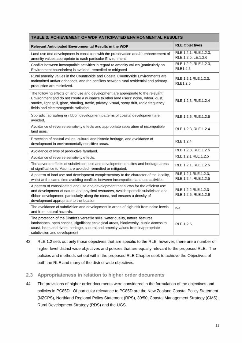
TABLE 3: ACHIEVEMENT OF WDP ANTICIPATED ENVIRONMENTAL RESULTS
Relevant Anticipated Environmental Results in the WDP RLE Objectives
Land use and development is consistent with the preservation and/or enhancement of
amenity values appropriate to each particular Environment
RLE.1.2.1, RLE.1.2.3,
RLE.1.2.5, LE.1.2.6
Conflict between incompatible activities in regard to amenity values (particularly on
Environment boundaries) is avoided, remedied or mitigated
RLE.1.2.2, RLE.1.2.3,
RLE1.2.5
Rural amenity values in the Countryside and Coastal Countryside Environments are
maintained and/or enhances, and the conflicts between rural residential and primary
production are minimized.
RLE.1.2.1 RLE.1.2.3,
RLE1.2.5
The following effects of land use and development are appropriate to the relevant
Environment and do not create a nuisance to other land users: noise, odour, dust,
smoke, light spill, glare, shading, traffic, privacy, visual, spray drift, radio frequency
fields and electromagnetic radiation.
RLE.1.2.3, RLE.1.2.4
Sporadic, sprawling or ribbon development patterns of coastal development are
avoided. RLE.1.2.5, RLE.1.2.6
Avoidance of reverse sensitivity effects and appropriate separation of incompatible
land uses. RLE.1.2.3, RLE.1.2.4
Protection of natural values, cultural and historic heritage, and avoidance of
development in environmentally sensitive areas. RLE.1.2.4
Avoidance of loss of productive farmland. RLE.1.2.3, RLE.1.2.5
Avoidance of reverse sensitivity effects. RLE.1.2.1 RLE.1.2.5
The adverse effects of subdivision, use and development on sites and heritage areas
of significance to Maori are avoided, remedied or mitigated. RLE.1.2.1, RLE.1.2.5
A pattern of land use and development complementary to the character of the locality,
whilst at the same time avoiding conflicts between incompatible land use activities.
RLE.1.2.1 RLE.1.2.3,
RLE.1.2.4, RLE.1.2.5
A pattern of consolidated land use and development that allows for the efficient use
and development of natural and physical resources, avoids sporadic subdivision and
ribbon development, particularly along the coast, and ensures a density of
development appropriate to the location
RLE.1.2.2 RLE.1.2.3
RLE.1.2.5, RLE.1.2.6
The avoidance of subdivision and development in areas of high risk from noise levels
and from natural hazards. n/a
The protection of the District’s versatile soils, water quality, natural features,
landscapes, open spaces, significant ecological areas, biodiversity, public access to
coast, lakes and rivers, heritage, cultural and amenity values from inappropriate
subdivision and development
RLE.1.2.5
43. RLE.1.2 sets out only those objectives that are specific to the RLE, however, there are a number of
higher level district wide objectives and policies that are equally relevant to the proposed RLE. The
policies and methods set out within the proposed RLE Chapter seek to achieve the Objectives of
both the RLE and many of the district wide objectives.
2.3 Appropriateness in relation to higher order documents
44. The provisions of higher order documents were considered in the formulation of the objectives and
policies in PC85D. Of particular relevance to PC85D are the New Zealand Coastal Policy Statement
(NZCPS), Northland Regional Policy Statement (RPS), 30/50, Coastal Management Strategy (CMS),
Rural Development Strategy (RDS) and the UGS.

12
Part 1 of the s32 report provides a comprehensive evaluation of the consistency of the package of
rural Plan Changes in relation to relevant higher order documents. The following table provides an
overview of the links between the proposed RLE objectives and relevant higher order documents.
TABLE 4: EVALUATION OF PROPOSED RLE OBJECTIVES AGAINST
RELEVANT HIGHER ORDER DOCUMENTS
Proposed Rural Urban Interface Environment Objectives
RLE.1.2.1 RLE.1.2.2 RLE.1.2.3 RLE.1.2.4 RLE.1.2.5 RLE1.2.6
Re
lev
an
t H
igh
er
Ord
er
Do
cu
me
nt
NZCPS √ √
RPS √ √ √ √ √ √
30/50 √ √ √ √ √ √
CMS √ √ √ √
RDS √ √ √ √ √ √
UGS √ √ √ √ √
45. The overarching Rural Area objectives and their links to the proposed RLE objectives are shown in
the table below. This table illustrates that the objectives of the RLE are effectively linked to the
overall objectives and policies of the Rural Area, which in turn has been assessed to be consistent
with the existing objectives and policies of the WDP (refer to Part 2 of the s32).

13
TABLE 5: LINKAGE OF PROPOSED RLE OBJECTIVES WITH RURAL AREA OBJECTIVES AND
POLICIES
Proposed Rural Area
Objective
Proposed Rural
Area Policy
Proposed RLE
Objective
Proposed RLE
Policy
Propose RLE
Method
RA.1.2.1 Protect
productive functions
RA.1.3.2, 1.3.3,
1.3.10 and 1.3.11
RLE.1.2.5 RLE.1.3.3, RLE.1.3.7, RLE.1.3.12
RLE.2.3.1(b), RLE.2.3.1(d)
RA.1.2.2 Avoid, remedy,
mitigate reverse
sensitivity impacts
RA.1.3.4, 1.3.9,
1.3.10 and 1.3.11
RLE.1.2.5, RLE1.2.3
RLE.1.3.1, RLE.1.3.7
RLE.2.3.1
RA.1.2.3 Avoid
cumulative
impacts/unplanned
development
RA.1.3.2, 1.3.3, 1.3.5
1.3.6 1.3.8 and 1.3.10
RLE.1.2.5, RLE.1.2.6, RLE.1.2.1
RLE.1.3.7, RLE.1.3.8, RLE.1.3.2
RLE.2.1.1, RLE.2.1.2, RLE.2.3.1, RLE.3.1.1 Mapping
RA.1.2.4 Avoid hazards RA.1.3.7 RLE.1.2.5 RLE.1.3.11 RLE.3.3.1,
Mapping
RA.1.2.5 Recognise
amenity values and
character
RA.1.3.1, 1.3.2, 1.3.3,
1.3.4, 1.3.5, 1.3.6,
1.3.9 and 1.3.10
RLE.1.2.1, RLE.1.2.3, RLE.1.2.5
RLE.1.3.1, RLE.1.3.3, RLE.1.3.4, RLE.1.3.5, RLE 1.3.6, RLE 1.3.8, RLE 1.3.11
RLE.2.1.1, RLE.2.1.2, RLE.2.3.1, RLE.2.3.2 RLE 2.3.3, RLE 2.3.4, RLE.2.3.6 RLE 2.3.7 RLE.3.3.1
RA.1.2.6 Consolidate
rural living
RA.1.3.3, 1.3.5 and
1.3.6
RLE.1.2.5, RLE.1.2.6
RLE.1.3.1, RLE.1.3.3, RLE.1.3.4, RLE.1.3.6, RLE.1.3.11, RLE.1.3.12
RLE.2.3.6 RLE.3.3.1 Mapping
RA.1.2.7 Provide for
areas of rural-residential
development on city
fringe
RA.1.3.6 RLE.1.2.5 RLE.1.3.1,
RLE.1.3.3
Mapping
RA.1.2.8 Provide range
of land uses
RA.1.3.1, 1.3.2, 1.3.3,
1.3.4, 1.3.5, 1.3.6,
1.3.9, 1.3.10 and
1.3.11
RLE.1.2.1,
RLE.1.2.2,
RLE.1.2.3,
RLE.1.2.4
RLE.1.3.1,
RLE.1.3.2,
RLE.1.3.4,
RLE.1.3.8
RLE.2.1.1,
RLE.2.1.2,
RLE.2.1.3,
RLE.2.3.6,
RLE.2.3.7
RA.1.2.9 Provide for
managed growth of rural
villages
RA.1.3.5, 1.3.8,
1.3.10 and 1.3.12
RLE.1.2.6 RLE.1.3.4, RLE1.3.6
RLE.2.3.2 RLE.2.3.6 RLE.3.1.1 RLE.3.3.1 Mapping
RA.1.2.10 Provision of
infrastructure
RA.1.3.8, 1.3.12 and
1.3.13
RLE.1.2.5,
RLE.1.2.6
RLE.1.3.9,
RLE1.3.10,
RLE.1.3.11
RLE.3.3.4
2.4 Effectiveness and efficiency of proposed policies and methods
46. For the purposes of the s32 assessment it is important to determine whether the preferred approach
will be more effective and efficient than other alternatives and whether this effectiveness and

14
efficiency comes at a higher cost than other alternatives. It is also important that the Council
considers whether the costs of the proposed provisions potentially outweigh the benefits.
47. Section 32(2)(a) states that an environmental, economic, social and cultural effects assessment be
undertaken in relation to the proposed provisions including economic growth and employment
opportunities provided or reduced.
48. It is considered that the level of analysis undertaken in this report is appropriate to the scale of the
proposal. It was not considered practicable to quantify the costs and benefits of the proposal. For
ease of evaluation the provisions have been packaged by issue topic.
Evaluation of the Mapping of the RLE Options
49. Spatial mapping is one method of achieving the objectives of the RLE. Spatial mapping identifies
where provisions do or do not apply. In accordance with s32, options must be considered to
determine the most appropriate way to achieve the RLE objectives including the identification of
other reasonably practicable options.
50. Due to the geographic isolation from cities and towns of these areas the most realistic option for an
alternative zone would be for the rural living areas to remain as RPE.
51. Reasonably practicable options for identifying the spatial location of the RLE are:
Option 1: Map using the criteria identified Appendix 3, and the rural Plan Changes package (plan
change option).
Option 2A: Map using different criteria (more RLE identified).
Option 2B: Map using different criteria (less RLE identified)
Option 3: Don’t map, have provisions for RLE applying to sites that meet the criteria on a case by
case basis.
52. Evaluation of these alterative options have been summarised in the table below:
TABLE 6: ALTERNATIVES EVALUATION - MAPPING
Costs Benefits
Option 1: Map using criteria. (Plan change option).
Environmental
Allows for greater development within RLE areas, with resulting changes in amenity.
Economic
Less development opportunities for rural living development outside of the RLE.
Social
None identified.
Cultural
None identified.
Environmental
Council will fulfil its duties under S31(1)(a) to achieve the integrated management of the effects of the use and development of the land and resources.
Gives effect to the consolidation direction of 30/50.
Consistent criteria applied across the RLE resulting in sustainable management of land on the urban fringe.
Economic
Provides certainty of areas RLE applies to, for investment.
Social
Provides for existing rural living clusters and future rural living development.
Cultural

15
None identified.
Option 2A: Map using different criteria. (more RLE
identified).
Environmental
Allows for greater development within RLE areas, with resulting amenity changes.
Developing more land as RLE could potentially result in groundwater contamination from on site sewerage systems.
Does not give effect to the consolidation direction and encourages more rural living development than is projected to be required by 30/50.
Economic
More productive land used for rural living development.
Steralisation of productive soils not already compromised by development.
Greater potential for reverse sensitivity conflicts
Social
None identified.
Cultural
None identified.
Environmental
Council will fulfil its duties under section 31(1)(a) to achieve the integrated management of the effects of the use and development of the land and resources.
Consistent criteria applied across the RLE resulting in sustainable management of land on the urban fringe.
More development capacity provided to avoid residential development in the RPE
Economic
Provides certainty of areas RLE applies to, for investment.
More development opportunities for rural living development in the proposed RLE.
Social
Provides for existing rural living clusters and future urban development.
Cultural
None identified.
Option 2B: Map using different criteria. (less RLE identified).
Environmental
Allows for some development within RLE areas, with resulting amenity changes.
May not achieve the outcomes of the RLE, resulting in unsustainable management of land.
Existing clusters of development not recognised by the WDP. Some areas may have an inappropriate zone if zoned RPE.
Economic
Less development opportunities for development in the RLE.
More ad hoc development as capacity is taken up in the proposed RPE.
More non-complying subdivision as people seek to develop land in the RPE.
Social
None identified.
Cultural
None identified.
Environmental
Council will fulfil its duties under section 31(1)(a) to achieve the integrated management of the effects of the use and development of the land and resources.
More development directed to the residential (living) zones would give better effect to 30/50 through consolidated development on the urban fringe.
More productive farmland retained in productive uses.
Economic
Provides certainty of areas RLE applies to, for investment.
Gives effect to the consolidation direction of 30/50
Social
Provides for existing rural living clusters and future urban development.
Cultural
None identified.
Option 3: Don’t map, assess using criteria on a case by base basis. (Status quo).
Environmental
Uncertain effects, capacity for development is unknown if development undertaken on a case by case basis. The status quo has resulted in the fragmentation of rural land.
Economic
Uncertainty may influence investment decisions, resulting in less development, or wastage on proposed development that may be declined.
Costs associated with resource consent applications.
Social
Doesn’t provide for existing clusters of rural living development on city fringe.
Cultural
None identified.
Environmental
Consistent criteria applied across the city fringe.
Economic
Leaves it up to the market/individuals to apply for appropriate development.
Social
None identified.
Cultural
None identified.
Efficiency Effectiveness

16
Option 1: Option 1 is considered to be an efficient method of achieving the outcomes of the RLE.
Option 1 is considered to be effective in achieving the outcomes of the RLE
Option 2A: Option 2A could be an efficient method of achieving rural subdivision in consolidated areas through controlled activity subdivision.
Option 2A could potentially release too much land for development in isolated areas undermining 30/50 and the purpose of the proposed RPE
Option 2B: Option 2 is not considered to be an efficient method as the criteria may not result in the outcomes of the RLE being achieved.
Option 2 would not be effective existing clusters of development where rural living should be consolidated would not be zoned appropriately.
Option 3: Option 3 (status quo) is considered to be inefficient in achieving the outcomes of the RLE, as there is uncertainty in its outcomes.
Option 3 is not effective in achieving the objectives of RLE.
Economic Growth and Employment Opportunities
Option 1: This option provides low to medium growth and employment opportunities. Capacity analysis has estimated an additional 324 lots could be created, with associated economic growth and employment opportunities. Option 1 also allows for future intensification or expansion of RLE areas, with further growth and employment opportunities.
Option 2A: This option could provide growth opportunities in the land development and construction sector, however there would also be lost opportunities through the loss of versatile soils, productive farmland, and increased reverse sensitivity effects.
Option 2B: This option provides low growth and employment opportunities in the RLE. Depending on the criteria less subdivision and development could result as most RLE clusters would be developed to capacity and the RLE would largely be recognising existing development.
Option 3: This option provides low economic growth and employment opportunities. Spatial mapping and locations for the zone control what provisions apply. If the spatial extent of zoning is unclear then it is unclear which will apply.
Risk of acting and not acting if there is uncertain or insufficient information
There is no risk due to insufficient information for Option 1 and 2. Option 3 has a risk of uncertainty, with scattered rural living activity potentially continuing to adversely affecting rural production activities.
53. Option 1 is considered to be the most efficient and effective method for identifying where the
proposed RLE provisions apply. Consistent criteria can be applied to consider mapped zoning
changes through submissions or future plan change applications.
RLE Landuse Provisions
Industrial and Mineral Extraction
54. The following proposed provision implements Policies RLE.1.3.1, 1.3.4 and 1.3.6 relating to industrial
and mineral extraction activities.
RLE.2.1 Eligibility Rules
1. Industrial Activities and Mineral Extraction are Prohibited activities.
55. Industrial and mineral extraction activities are proposed to be classified as prohibited activities within
the proposed RLE to maintain and enhance the existing amenity and character values and to require
these activities to be located in appropriate zones. These activities are likely to have more than
minor adverse effects that are not compatible with rural living activities, particularly in terms of
increased traffic and noise and vibration, signage, and loss of residential neighbours and sense of
community.
56. Currently under the WDP, mineral extraction and industrial activities are permitted in the CE provided
that relevant controls are met. The proposed RLE seeks to provide opportunities for the ongoing
17
development of land for rural living activities. It is considered that mineral extraction and industrial
activities are not appropriate within the RLE as the density of rural living development is higher than
the density of the CE and the resulting separation distances are lower.
57. One option evaluated was to allow for industrial activities or mineral extraction as non-complying
activities and require applications to be assessed based on the relevant objectives and policies. This
approach could lead to undesirable environmental outcomes as these activities are not considered to
be suitable for the areas identified as RLE and land values are likely to make the establishment of
these activities prohibitive. The costs therefore outweigh the benefits with this option and the
associated risks are too high.
58. It is considered that the proposed provision prohibiting mineral extraction and industrial activities
within the RLE is the most appropriate way of achieving the RLE Objectives. The following table
further assess the appropriateness of the proposed provision:
TABLE 7: INDUSTRIAL ACTIVITIES AND MINERAL EXTRACTION
Costs Benefits
Environmental
Reduces the opportunity for mineral extraction in the RLE.
Economic
Mineral extraction and industrial activities are classified as prohibited activities in the RLE hence no resource consent application can be made and a plan change would have to be applied for.
Social
Decrease in potential for mineral extraction and Industrial activities may lead to a reduction in the ability of people and the community to provide for their social and economic well-being.
Cultural
None identified.
Environmental
The restriction of mineral extraction and industrial activities within the RLE will assist in maintaining the amenity and character of the RLE and reduce the potential for land use conflicts.
Sends a clear message that mineral extraction and industrial activities should be consolidated into alternative more appropriate Environments.
Economic
Reduces the potential for increased pressure on road capacity resulting from increased traffic movements. Promotes the agglomeration of Industrial activities in appropriate environments.
Social
Maintains the amenity levels anticipated within rural living areas associated with rural living activities.
Cultural
None identified.
Efficiency Effectiveness
Specification of prohibited activity status avoids the ambiguity of what is expected in the zone and provides a clear signal that this type of activity is not supported within the RLE.
The proposed provision provides clear activity status for mineral extraction and Industrial activities and in conjunction with strong corresponding policy will effectively contribute towards achieving the objectives of the RLE.
No proposed RLE areas have been identified near existing mineral extraction Areas.
Economic Growth and Employment Opportunities
The restrictions on mineral extraction and industrial activities will reduce opportunities for these activities, but is intended to direct the activities to more appropriately zoned areas. Increasing the ability for economic growth of appropriately zoned Business Environments can potentially increase economic wellbeing of a community.
Risk of acting and not acting if there is uncertain or insufficient information
The risk of not acting is moderate to high as the status quo would be maintained and mineral extraction and Industrial activities would be permitted provided the controls are met, and the potential adverse effects within the RLE could be more than minor.
The risk of acting is low as mineral extraction and Industrial activities within the RVRE would be prohibited and directed to more appropriate zones. Land identified for RLE is generally characterised by existing rural living

18
development with high land values, effectively sterilising the land for mineral extraction activities. This approach seeks to avoid the risk of land use conflicts and reverse sensitivity effects.
Commercial Activities and Places of Assembly
59. The following proposed provisions implement Policies RLE.1.3.1, 1.3.3, 1.3.5, 1.3.6 and 1.3.8
relating to commercial activities, and the protection of rural character and amenity values.
RLE.2.1 Eligibility Rules
2. Commercial Activities are Non-Complying activities.
RLE.2.3 Discretionary Activities
3 Any Place of Assembly.
60. Commercial Activities have been establishing throughout the rural environment. This sprawl of
activities can result in a number of issues such as:
Changes in rural amenity and character.
Potential nuisance effects such as noise, odour, light spill.
Increased traffic movements on rural roads.
Pressure and demand on infrastructure services.
Lack of consolidation of Business activities.
61. The CE and CCE provisions provide for commercial activities as a permitted activity provided that it
does not involve certain activities, does not exceed 500m2 in GFA and is not located within 100m of
a residential unit on a separate site, or the Open Space Environment. Given the definition of Bulk
Format Retail, this provision essentially allows for a large retail store to locate in the rural
environment.
62. Currently places of assembly are permitted activities within the CE and CCE.
63. Whangarei city has large areas of land zoned specifically for Business activities, as do rural villages.
Use of this land and revitalisation, and consolidation of activities to these zones are not occurring
because of lower land values in rural environments and the ease of gaining consent to operate there.
There are very few provisions restricting the sprawl of commercial and industrial activities throughout
the CE and CCE. Commercial activities are also not considered to be compatible with low density,
rural living development due to effects on rural character and amenity.
64. Public feedback on the introduction of stricter management of commercial activities in rural areas
was positive, however there was a general consensus that ‘appropriate’ land use activities should
occur if they were specifically associated with a primary rural activity.
65. Within the RLE, benefits associated with allowing commercial activities have been balanced against
potential effects on rural amenity. Methods for the avoidance of commercial sprawl and maintenance

19
and enhancement of existing rural amenity within the proposed RLE include the classification of
commercial activities as non-complying activities.
66. The benefits associated with allowing places of assembly within the proposed RLE must also be
balanced against potential effects on rural amenity and character. The effects associated with
places of assembly depend on the scale nature and frequency of events, as well as the receiving
environment. These activities may be appropriate within the proposed RLE, therefore, it is
considered appropriate to classify places of assembly as a discretionary activity so that any
applications may be assessed in accordance with the RLE objectives and policies.
67. Consideration was given to prohibit commercial activities. Commercial activities can adversely affect
amenity values, in particular through noise and traffic effects. This option was rejected as some
forms of commercial activity (such as visitor accommodation) may be compatible with activities in the
proposed rural living environment. Rule RLE2.2.1 retains the possibility for proposals to be publically
notified and the proposed policies are strong in maintaining amenity values and preventing the
operation of commercial activities. Therefore it is expected that proposals will only be approved when
their effects will be minor under the first limb of the Section 104D test.
68. Consideration was given to retaining the status quo for places of assembly. Council’s 5 Year Review
of the District Plan Efficiency and Effectiveness (August 2012) identified the sprawl of non-residential
activities as a threat to rural amenity values. Therefore it is considered that a more proactive
approach is necessary to appropriately asses the effects of places of assembly within the proposed
RLE.
69. Another alternative method of managing places of assembly is to avoid them via prohibited activity
status. While this would help protect amenity levels, it would not allow for the necessary range of
activities and services that may be appropriate within the proposed RLE. The benefits associated
with allowing places of assembly within the RLE must be balanced against potential effects on rural
amenity and character. Thus it is considered that the avoidance of places of assembly altogether is
not an appropriate method of achieving the RLE objectives.
70. The proposed approach to commercial activities and places of assembly is consistent with other
proposed rural Plan Changes (Rural Village and RUEE) and the approach taken in recent plan
changes (e.g. Kamo Walkability Environment).
71. It is considered that the proposed provisions relating to commercial activities and places of assembly
within the proposed RLE are the most appropriate way of achieving the RLE objectives. The
following table further assess the appropriateness of the proposed provisions:

20
TABLE 8: COMMMERCIAL ACTIVITIES AND PLACES OF ASSEMBLY
Costs Benefits
Environmental
Reduces the opportunity for people to maximise their land for potential commercial activities.
Non-complying test is relatively high test making it difficult for applicants to attempt to gain approval to undertake commercial activities.
Economic
Restricts people’s choice to live and work from a rural living location if trained in a commercial trade.
Control based upon activity type rather than effects of activities may require consent for small scale activities.
Significant costs associated with consenting should an applicant choose to seek approval to undertake a non-complying activity.
Places of Assembly will require discretionary consent
Social
Often local businesses (including commercial and industrial) support local social events, the limitation of these activities can result a reduction in social support.
Decrease in Commercial Activities may lead to a reduction in the ability of people and the community to provide for their social and economic well-being.
Cultural
Churches halls and Marae complexes are places of assembly will require discretionary activity resource consent
Environmental
Council fulfils its duties under section 31(1)(a).
Avoids the risk of adverse environmental effects associated with Commercial Activities.
Sends a clear message that Commercial Activities are generally inappropriate in this zone and should be located in Business Environments to avoid issues such as land use conflicts.
Gives effect to 30/50 consolidated growth pattern.
Maintains amenity values in the RLE
Places of assembly are often associated with higher number of traffic movements. Discretionary activity status is a method of managing the scale of effects, potentially resulting from increased traffic movements.
Opportunity to assess applications for noise effects on neighbouring properties.
Economic
Consolidates commercial activities to Business Environments improving economic viability of the city.
Reduced risk to landowners of incompatible land uses establishing on their boundaries, affecting amenity values and land values
Reduces the potential for increased pressure on road capacity resulting from increased traffic movements.
Social
Maintains the opportunity to undertake rural activities, supporting the tie that rural communities have to the environment, to rural activities and social aspects that are often associated with seasonal rural activities.
Limits the changes in amenity values in the RLE
Cultural
Reduced risk of sprawling commercial/industrial activities, having the potential to impact on cultural resources and values particularly as a majority of Māori land and Sites of Significance to Māori are located in the rural environment.
Efficiency Effectiveness
Specification of non-complying status provides efficient and strong message that activities should not be occurring.
The proposed Places of Assembly provision clearly identifies the nature and scale of activity appropriate to the RLE.
Specification of activity status provides an efficient method of assessing activities against strong supporting policies.
Effective method to control activities in accordance with strong corresponding policy thorough clear activity status.
Economic Growth and Employment Opportunities
This option has a moderate to high impact in terms of economic growth and employment. Stopping the sprawl of commercial activities into the rural environment increases the ability for economic growth of the appropriately zoned Business Environments leading to the potential to increase job opportunities in the City. Agglomeration of commercial activities within the Business Environments creates greater efficiencies of services and infrastructure.
Risk of acting and not acting if there is uncertain or insufficient information
Failure to actively manage rural land resources would mean that non-rural activities, particularly commercial activities, and Places of Assembly may compromise the productivity of rural land and reduce the ability of people and the community to provide for their social and economic well-being.
Not acting would fail to recognise the potential effects on neighbouring properties in a zone which is expected to have high amenity values.

21
Residential Units
72. The following proposed provisions implements Policies RLE.1.3.1, 1.3.3 and 1.3.8 relating to
residential density and amenity values.
RLE.2.3 Discretionary Activities
2. Construction of more than one Residential Unit per site.
73. The proposed RLE objectives seek to provide for a variety of rural living opportunities whilst
preserving character and amenity values of the RLE. Higher density rural living development has the
potential to undermine this objective. It is considered that allowing increased density as of right will
lead to adverse effects on the amenity of the rural environment, adverse effects from clusters of
stormwater and wastewater disposal systems, and potential demands for infrastructure services.
74. Once a residential unit has been constructed is it easier to justify (in terms of potential environmental
effects) a subdivision of that unit. Therefore it is essential that the residential density be controlled.
75. The WDP currently provides for an additional residential unit within a site in the CE and CCE,
provided there is at least 20.0ha of net site area associated with each residential unit.
76. It is proposed that the allotment size within the RLE is a minimum of 4,000m2 with a 2ha average (the
subdivision provisions are discussed further in Table 14 below). Allowing more than one residential
unit on a site with an area of 4,000m2 would provide for a density similar to the Living 1 and 3
Environments. As it is anticipated that density will remain relatively low within the RLE it is
considered that the effects of constructing more than one Residential Unit should be assessed
through the resource consent process.
77. Consideration was given to prohibiting the construction of more than one Residential Unit within a
site; however, taking into account that Whangarei district has an aging population, concern has been
raised in feedback that residential density should allow for the development of additional residential
units for aging family members to retire and remain living close to relatives (over and above the
provision of a minor residential unit). This may be appropriate on some sites, but not others
depending on their size and receiving environment. Therefore a discretionary activity status is
considered appropriate.
78. Consideration was also given to having no limit on the number of residential units and instead to rely
on building bulk and location provisions. However, this approach would is considered to be too
permissive and would not appropriately maintain and protect the character and amenity values
anticipated within the RLE.
79. It is considered that the proposed provision relating to residential density within the RLE is the most
appropriate way of achieving the proposed RLE objectives. The following table further assess the
appropriateness of the proposed provision.

22
TABLE 9: RESIDENTIAL UNITS
Costs Benefits
Environmental
Residential units may establish on vacant land when they could have been accommodated on existing sites with dwellings.
Economic
Costs associated with applying for discretionary resource consent.
Land may not be developed to its full potential due to disincentive of the resource consent process
Social
Resource consent process may be a barrier to establishing residential units for family members on the same property.
Cultural
Requires resource consent application for development of family land.
Environmental
Maintains amenity values appropriate to the expectations for the RLE.
Consideration of applications through the resource consent process will allow consideration of effects on the receiving environment.
Effects of increased wastewater disposal will be assessed.
Economic
No resource consent requirements for the first residential unit per site
Increases the development potential of sites.
Social
Allows the development of more than one residential unit where appropriate to the site and locality.
Provides opportunities for families to live on the same property as relatives.
Cultural
Allows development of family land in appropriate areas.
Efficiency Effectiveness
No resource consent requirements for the first residential building. Additional residential units will require an assessment of environmental effects
Will allow second residential units to be approved where appropriate on a case by case basis.
Economic Growth and Employment Opportunities
The proposed provision will allow construction of the first residential unit on a site as a permitted activity, and additional units may be allowed depending on the appropriateness of the receiving environment.
Risk of acting and not acting if there is uncertain or insufficient information
Risk of acting is low. Second residential units in the CE currently require resource consents (unless there is at least 20ha associated with each residential unit).
Risk of not acting to limit residential units is medium-high as additional residential units on a site could result in adverse effects.
Minor Residential Units
80. The following proposed provisions implement Policies RLE.1.3.1, 1.3.3, 1.3.4 and 1.3.6 relating to
development density, amenity values and traffic movements.
RLE.2.3 Discretionary Activities
6. Construction of Minor Residential units:
a. Resulting in more than one Minor Residential Unit per site.
b. That has a separate access/driveway from the Principal Residential unit.
81. Within the CE and CCE the construction of a Minor Residential Unit (MRU) is currently provided for
as a permitted activity, provided that it will be the only Minor Residential Unit on the site and the
minimum net site area of the allotment within each Environment is 8,000m2 and 1.2ha respectively.
The proposed provision is generally in keeping with the status quo in terms of the resulting density of
development anticipated by permitting the first MRU.

23
82. It is proposed to require that the MRU utilises the same access/driveway as the Principal Residential
Unit. A MRU can be used independently but should be viewed in conjunction with the main
residential unit. It should look as though there is only one residential unit on the site. It is considered
that if a new MRU utilises the same access as the main dwelling a minor but acceptable increase in
existing traffic movements can be expected. If a separate access way is proposed, it is considered
reasonable that the effects on neighbours and on traffic safety are considered, and an application for
a discretionary activity will be required.
83. Consideration was given to applying discretionary status for the construction of any minor residential
unit. Council records show that MRU’s in the CE are used as justification for subdivision of the MRU
from the main residential unit with smaller allotments than are considered appropriate to the zone.
Because the MRU is capable of operating independently from the main dwelling, and the building is
part of the existing environment, Council has been unable to decline subdivision applications as the
effects already exist. This has resulted in further fragmentation of rural land and changes to rural
character and amenity.
84. Following the approval of a subdivision application (depending on the subdivision layout) the main
dwelling may be able to then create another MRU as a permitted activity, and the new title containing
the existing MRU may be able to accommodate a new main residential unit as a permitted activity.
The way the rule has been used allows applicants to effectively double the intensity of development
on a site with no consideration of effects.
85. Taking into account that Whangarei district has an aging population, concern has been raised that
the WDP should allow for the development of minor residential units. This type of dwelling is
typically used by elderly people or people with illnesses who may want to downsize, retire, or may be
widowed and cannot take care of a large house on their own. The provision of a MRU allows them
to retain their independence and remain living close to relatives who can support and take care of
them. The MRU may also be used for visitor accommodation, home stays, housing adult children or
be constructed on a block of land while the owner saves up for the construction of a more substantial
residential unit.
86. Provision is therefore proposed for one MRU as a permitted activity. However subsequent MRU
would require consent. This recognises that a second MRU may be appropriate on some sites but
not others depending on their size and receiving environment, therefore a discretionary activity
status is considered appropriate.
87. Allowing the first MRU allows people to provide for their social and economic wellbeing. However to
address the fact that they are used to justify subdivision, a rule has been included in the subdivision
rules prohibiting subdivision of a minor residential unit from its parent title. This is discussed below
(Proposed Rule RLE.3.1.1)
88. It is considered that the proposed provision relating to Minor Residential Units within the RLE is the
most appropriate way of achieving the RLE objectives. The following table further assess the
appropriateness of the proposed provision.

24
TABLE 10: MINOR RESIDENTIAL UNITS
Costs Benefits
Environmental
Increased residential density compared to existing provisions that do not allow MRU’s on smaller sites.
Economic
Resource consent costs only for second and subsequent Minor Residential Unit
Social
None identified.
Cultural
None identified.
Environmental
First minor residential unit acceptable in terms of expected density and amenity of RLE.
Will allow the environmental effects of multiple minor residential units to be assessed through the resource consent process.
The provision for a shared driveway will result in no more than minor effects on traffic safety and amenity.
Economic
Will allow elderly people to downsize from larger homes and live closer to family who can take care of them without going through the resource consent process.
Utilises existing physical resources by sharing driveway.
Allows people to add value to their property through construction of a minor residential unit.
Social
Will allow elderly people to live in contact with their families or friends, while maintaining their independence rather than going into a rest home. Also provides for adult children to live close to family.
Cultural
Provides opportunities for elders to live close to their whanau.
Efficiency Effectiveness
More efficient utilisation of the existing housing stock. Elderly people will be able to vacate houses that have become unmanageable, which can then be owned/rented by larger families. Allows families to take care of elderly or infirm relatives rather than sending them into full time care reducing pressure on hospitals and aged care facilities.
Allows the location and design of more than one Minor Residential Unit to be assessed on a case by case basis to assess effects on neighboring properties, and ensure that it is appropriate to the receiving environment.
Economic Growth and Employment Opportunities
Permitted activity status will remove barriers to development of MRU. May result in additional construction work and economic growth of building supplies industry. May allow employment opportunities for people working from home as carers, or small scale visitor accommodation. Having grandparents living on site to assist with household duties and child care may give extra flexibility and present increased employment opportunities for parents.
Risk of acting and not acting if there is uncertain or insufficient information
Risk of acting is low as proposal will result in a small increase in residential density, in line with expectations for the RLE.
Risk of not acting is high as minor residential units can play an important social role, and improve quality of life for the elderly and infirm and their families.
Separation
89. The following proposed provisions implement Policies RLE1.3.1 and 1.3.7 relating to the protection
of rural amenity and character values and managing reverse sensitivity effects.
RLE.2.3 Discretionary Activities
1. Any Sensitive Activity (excluding non-habitable buildings) within:
a. 500m of a Mineral Extraction Area, a Strategic Rural Industry Environment or a
Business Environment.
25
b. 30m of a Rural Production Environment.
c. 100m of an unsealed road.
d. 30m of production forestry.
90. The proposed separation provisions within the RLE seek to limit reverse sensitivity effects.
Conflicting land uses resulting in reverse sensitivity effects have been raised as a major issue
through the RDS and pre notification consultation on the draft rural Plan Change. General policy
support for separation of activities can be found in Chapters 6 and 8 of the WDP. Public feedback
on the need to strengthen provisions to separate activities to avoid land use conflicts has been
positive, with several responders seeking additional separation considerations such as residential
units to be set back 30m from rural production activities.
91. The proposed 500m Mining Area setback is consistent with the current 500m buffer area for a MEA.
This setback is considered appropriate to address the effects associated with the operation of
significant mineral extraction activities e.g. noise, dust, fly rock, vibration, to allow for the provision of
appropriate mitigation measures through resource consent, and to enable ongoing operation of
regionally significant mineral extraction activities.
92. The proposed 500m setback from the Strategic Rural Industry Environment (SRIE) is a new
provision. The SRIE is a new proposed Environment that covers large existing rural industry. A
500m buffer is considered appropriate to address potential reverse sensitivity issues. The use of
500m is consistent with existing buffers applied to MEA in the WDP.
93. The proposed 30m setback from RPE is a new provision. The RPE is a proposed new Environment
that requires reverse sensitivity buffers between production activities and sensitive land uses such as
rural living activities.
94. The proposed RLE also applies a 30 metre setback from production forestry to sensitive activities,
which is an existing CE provision. This provision aims to address potential reverse sensitivity effects
from locating residential units within 30 metres of a production forest. It is considered that 30 metres
is an appropriate distance to address potential adverse effects from forestry such as shading, fire
risk, and wind blown trees. A lesser distance may not be adequate to address these issues and a
greater distance may be overly restrictive and therefore inefficient in terms of preventing
development on a larger amount of land than is strictly necessary.
95. The proposed 100m setback from unsealed roads was selected to address health and safety
concerns around dust effects, and pressure to seal rural roads outside Council’s planned roading
program. This distance is considered sufficient to mitigate most instances of adverse effects from
dust on sensitive land use activities such as rural living activities. Unsealed roads were taken into
account when selecting areas for the proposed RLE and were avoided where possible.
96. Consideration was given to having no provisions relating to separation of activities and to instead
rely upon spatial mapping of zones and activity controls. Specifying no separation of activities will
not fully address identified issues concerning land use conflicts, potential reduction of productive
26
capability, consolidation of activities and the efficient use of land resources. Additionally, there
would be associated risks of potential adverse effects due to noise, odour, hazardous substances,
etc. Therefore this alternative option is not considered appropriate.
97. It is considered that the proposed provisions relating to the separation of activities within the RLE are
the most appropriate way of achieving the RLE objectives. The following table further assess the
appropriateness of the proposed provisions.
TABLE 11: SEPARATION OF CONFLICTING LAND USES
Costs Benefits
Environmental
Decreased opportunities for people to maximise their land value through development.
Economic
Requirement for resource consents with associated costs to applicant if provisions are not met.
Increased restrictions on development.
May require additional building materials to mitigate potential land use conflicts.
Social
Introduces some change to the current provisions for landowners, investors and residents.
Cultural
None identified.
Environmental
The proposed setbacks from identified Environments, Resource Areas and activities will limit reverse sensitivity effects.
Reduces the risk of potential adverse effects due to noise, odour, hazardous substances etc.
Reduces risk of fire in areas of production forestry
Economic
Reduces the risk of land use conflicts and their potential impact on the ability to efficiently utilise land for non-residential activities.
Actively manages land resources, reducing the potential for residential activities to compromise the productivity of non-residential activities.
Reduces the risk of sterilisation of mineral resources.
Social
Health and well-being of some landowners is protected through the reduction of risk of exposure to noise, odour etc.
Maintains the amenity levels anticipated within rural living areas.
Discontent between neighbours is reduced by separation of activity provisions.
Cultural
None identified.
Efficiency Effectiveness
The provisions efficiently manage conflicting land uses without being overly prescriptive and by providing more clarity for the public.
The proposed provisions provide clear methods of managing conflicting land uses in a manner which will contribute towards achieving the objectives of the RLE by maintaining amenity values within the RLE and avoiding reverse sensitivity.
Economic Growth and Employment Opportunities
Reduction of conflicts between activities such as rural living and industrial activities may result in a reduction in operational costs for non residential activities. Proposal gives quarry operators and strategic rural industries long term site security allowing decisions on investment in plant and machinery to be made with more confidence. This would have a positive effect on economic growth and employment opportunities.
Risk of acting and not acting if there is uncertain or insufficient information
The risk of not acting is low to moderate as the status quo would be maintained and reverse sensitivity effects and adverse effects on amenity values within the RLE may not be as effectively assessed.
The risk of acting is low as the proposed provisions are designed to minimise risks arising from reverse sensitivity effects and adverse effects on amenity values.

27
Bulk and Location Provisions
98. The following proposed provisions implement Policies RLE1.3.1, RLE1.3.3, RLE 1.3.8, and 1.3.9
relating to the protection of rural amenity and character values, and the management of stormwater:
RLE.2.3 Discretionary Activities
3. Any building:
a. That exceeds a height equal to 3m plus the shortest horizontal distance between that
part of the building and the site boundary.
b. That exceeds a maximum height of 8m.
c. Within 10 metres of any road boundary or within 3m of any other boundary.
d. That results in site coverage exceeding 500m2.
e. Within 27m of Mean High Water Springs, (excluding bridges, culverts and fences).
f. Within 27m of the top of the bank of any river that has a width exceeding 3m (excluding
bridges, culverts and fences).
5 Impervious areas greater than 15% of the net site area.
99. The proposed maximum building height of 8 metres is consistent with the current Living 1
Environment provisions, rather than the 10 metre height in the CE or the 8.5m height in the CCE. It is
considered that 8 metres is a suitable height limit for the RLE as higher buildings could cause
shading and outlook problems on sites that potentially could be developed down to 4000m2. The
height limit was not proposed to be more restrictive as the scale was considered appropriate relative
to existing development and an overly restrictive control may deter development.
100. In conjunction with the maximum building height rule it is proposed to impose a height in relation to
boundary rule (RLE2.2.4(a)) to further protect amenity values within the RLE. The WDP currently
imposes rules relating to daylight angles within CE and CCE (Rule 38.4.10). However, there has
been a lack of clarity regarding daylight angles and it is considered that the proposed height in
relation boundary rule will allow for more clarity in interpretation and implementation. This approach
is also consistent with the existing controls in the Urban Transition and Kamo Walkability
Environments.
101. The new location provisions proposed in the RLE include a 10m setback from a road boundary and a
3m setback from any other boundary. Currently in the CE and CCE there is an 8m setback from a
road boundary and a 3m setback from any other boundary. Generally the current setback provisions
have operated effectively and efficiently however, with an increased level of development it was
considered that a slightly larger setback would be more effective in reducing impacts from traffic
noise.
102. The amount of building coverage permitted can dramatically affect the open space nature of a
neighbourhood and can change the perception of the intensity of development. In the CE and CCE a
28
building coverage that does not exceed 500m2 or 5% of the net site area (whichever is the greater) is
permitted. Permitting building coverage of 5% of the net site area may be inappropriate in some
instances in the RLE where sites are relatively large and a 5% building may have more than minor
adverse effects that should be assessed. In the interest of streamlining the WDP the proposed
building coverage rule has been simplified in the RLE.
103. The 27.0m setback from MHWS and rivers over 3 metres in width is consistent with the current CE
and CCE provisions that aim to ensure that land is available for esplanade reserves/strips and that
those areas are protected for conservation, ecological, recreational, access and hazard mitigation
purposes. This distance was arrived at through Environment Court mediation on the WDP.
104. The proposed impervious area limit of 15% seeks to manage the quantity and quality of stormwater
runoff; it also limits built development to maintain the openness and rural character of the proposed
RLE. Currently there are no impervious area limits within the CE and CCE. It is considered
appropriate to manage stormwater within the RLE where stormwater is managed on-site by
developers. Accordingly the status quo is not considered to be an appropriate method of stormwater
management.
105. Consideration was given to proposing a more restrictive impervious area limit. However it is
important to retain sufficient space for ancillary activities such as accessory buildings, parking and
manoeuvring areas, landscaping and private open space to be accommodated on-site. It was
considered that reducing the permitted impervious area may compromise landowners’ abilities to
provide these ancillary activities and is therefore not appropriate.
106. Allowing for 15% of the net site area to be impervious surfaces would allow for 600m2 based on the
proposed 4000m2 minimum lot size. On a larger allotment more impervious surfaces would be
allowed before a resource consent is required. Concerns were raised during the pre-notification
consultation around unfair restrictions on hot houses and shade houses. It is considered appropriate
that if the 15% limit is breached, the effects of increased runoff to waterways and neighbouring
properties and effects on rural character should be assessed through the resource consent process,
107. Consideration was given to not specifying any bulk and location provisions and instead to rely on
minimum site size and engineering standards. However in the absence of rules built development
can occur ad hoc resulting in potential for serious land use conflicts, adverse effects on amenity
values and health risks. Therefore this approach is not considered appropriate as the associated risks
are too high.
108. It is considered that the proposed provisions relating to building bulk and location within the RLE are
the most appropriate way of achieving the proposed RLE Objectives. The following table further
assess the appropriateness of the proposed provisions.

29
TABLE 12: BUILDING BULK AND LOCATION CONTROLS
Costs Benefits
Environmental
None identified.
Economic
Decreased opportunities for people to maximise their land value through development.
Requirement for resource consents with associated cost to applicant if provisions are not met.
Increased restrictions on development.
Social
Social costs remain consistent, proximity to neighbours, maintenance of privacy, maintenance of rural outlook and health remains the same.
Cultural
None identified.
Environmental
The proposed height and setback restrictions will limit adverse effects on neighbouring properties and allow for consideration of reverse sensitivity considerations and provision of mitigation where possible.
Reduces the risk of potential adverse effects due to noise, odour, hazardous substances etc.
Maintains a similar level of amenity as the status quo.
Impervious area limits will help manage the quality and quantity of stormwater runoff and retain the openness and character of the RLE
Economic
The bulk and location requirements will maintain the character of the area and protect privacy and amenity of neighbouring properties. This will ensure property values are maintained and protected.
Actively manages land resources, reducing the potential for residential activities to compromise the productivity of non-residential activities.
Actively manages stormwater to reduce the likelihood of retrospective or repair work being required
Social
Health and well-being of some landowners is protected through the reduction of risk of exposure to noise, odour etc.
Maintains the amenity levels anticipated within RLE areas.
Streamlined rules for ease of use and more clarity for interpretation and implementation.
Cultural
Puts mechanism in place to manage runoff and the effects of stormwater on water quality in rivers and streams.
Efficiency Effectiveness
The provisions efficiently administer building bulk and location without being overly prescriptive and by providing clarity for the public.
The proposed provisions provide clear methods of managing bulk and location in a manner which will contribute towards achieving the objectives of the RLE by maintaining amenity values within the RLE.
Economic Growth and Employment Opportunities
There is a low impact in terms of economic growth and employment associated with the proposed provisions. Bulk and location provisions have a direct relationship to the amenity and sense of place of an area. These controls have the ability to increase or decrease development costs associated with built development. Building costs do have an effect on overall economic growth. However it is considered that the provisions present reasonable mitigation with a low cost implication.
Risk of acting and not acting if there is uncertain or insufficient information
The risk of not acting is low as the status quo would be maintained and the proposed rules are similar to the status quo, but slightly more restrictive to avoid potential adverse effects and risks.
The risk of acting is low as the proposed provisions are designed to minimise risks arising from reverse sensitivity effects and adverse effects on amenity values.
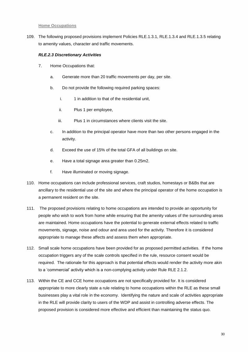
30
Home Occupations
109. The following proposed provisions implement Policies RLE.1.3.1, RLE.1.3.4 and RLE.1.3.5 relating
to amenity values, character and traffic movements.
RLE.2.3 Discretionary Activities
7. Home Occupations that:
a. Generate more than 20 traffic movements per day, per site.
b. Do not provide the following required parking spaces:
i. 1 in addition to that of the residential unit,
ii. Plus 1 per employee,
iii. Plus 1 in circumstances where clients visit the site.
c. In addition to the principal operator have more than two other persons engaged in the
activity.
d. Exceed the use of 15% of the total GFA of all buildings on site.
e. Have a total signage area greater than 0.25m2.
f. Have illuminated or moving signage.
110. Home occupations can include professional services, craft studios, homestays or B&Bs that are
ancillary to the residential use of the site and where the principal operator of the home occupation is
a permanent resident on the site.
111. The proposed provisions relating to home occupations are intended to provide an opportunity for
people who wish to work from home while ensuring that the amenity values of the surrounding areas
are maintained. Home occupations have the potential to generate external effects related to traffic
movements, signage, noise and odour and area used for the activity. Therefore it is considered
appropriate to manage these affects and assess them when appropriate.
112. Small scale home occupations have been provided for as proposed permitted activities. If the home
occupation triggers any of the scale controls specified in the rule, resource consent would be
required. The rationale for this approach is that potential effects would render the activity more akin
to a ‘commercial’ activity which is a non-complying activity under Rule RLE 2.1.2.
113. Within the CE and CCE home occupations are not specifically provided for. It is considered
appropriate to more clearly state a rule relating to home occupations within the RLE as these small
businesses play a vital role in the economy. Identifying the nature and scale of activities appropriate
in the RLE will provide clarity to users of the WDP and assist in controlling adverse effects. The
proposed provision is considered more effective and efficient than maintaining the status quo.

31
114. Consideration was given to identifying home occupations as a non-complying activity, as per
commercial activities. While this would help protect amenity levels within the proposed RLE, it would
not provide for the many existing land uses that are already occurring. Many of these activities
generate no adverse effects and are compatible with rural living development. It is considered more
efficient and effective to provide a permitted activity standard below which, resource consent is not
required. It is considered that the providing for home occupations within the proposed limits is an
appropriate method of achieving the RLE Objectives.
115. It is considered that the proposed provisions relating to home occupations within the RLE are the
most appropriate way of achieving the RLE objectives. The following table further assess the
appropriateness of the proposed provisions:
TABLE 13: HOME OCCUPATIONS
Costs Benefits
Environmental
Potential effects on amenity values of unregulated home occupations operating as permitted activities.
Economic
Consenting costs associated with Discretionary Home Occupations.
Social
None identified.
Cultural
None identified.
Environmental
Sends a clear message as to the scale and nature of Home Occupations that are considered appropriate within the proposed RLE.
Encourages larger scale activities to locate in more appropriate zones.
Economic
The provisions will have social and economic work-life benefits to individuals and wider economic benefits to the local community by providing clear direction regarding Home Occupations and enabling activities of an appropriate scale.
Increased consolidation of larger scale activities to the Business zones.
Reduces the potential for increased pressure on road network resulting from increased traffic movements.
Social
The proposed provision more clearly identifies the nature and scale of activity appropriate to the RLE. It is anticipated that the rules will provide for more clarity in interpretation.
Maintains the amenity levels anticipated within the RLE.
Cultural
None identified.
Efficiency Effectiveness
The proposed provisions more clearly identify the nature and scale of activity appropriate to the RLE and allow for activities of a suitable scale as a permitted activity.
Specification of activity status provides efficient method of assessing activities against strong supporting policies.
The proposed provisions provide clear activity status for home occupations and in conjunction with strong corresponding policy will effectively contribute towards achieving the objectives of the RLE.
Economic Growth and Employment Opportunities
The provisions will have social and economic work-life benefits to individuals and wider economic benefits to the local
community by more clearly providing for home occupations that are of a nature and scale suitable for the RLE. This
proposal may facilitate more employment by allowing flexibility for parents of young children.
Risk of acting and not acting if there is uncertain or insufficient information
There is a risk that if the provision was not included, that activities that do not meet the definition of a commercial or
industrial activity, but that may have similar effects on the rural character and amenity of the receiving environment

32
could establish as a permitted activity. There is also a risk that if provision was not made for a level of home
occupation as a permitted activity, that productive uses would that are quite appropriate to the environment may not
establish. This would adversely affect the district’s economy.
There is a risk of acting that existing home occupations within the proposed RLE may not meet the limits set in the
rules. They may then have to rely on existing use rights to continue to operate with implications for proving that they
are legally established, or seek a resource consent.
RLE Subdivision Provisions
116. The following proposed provisions implement Policy RLE.1.3.1,1.3.4, 1.3.7, 1.3.9 1.3.11 and 1.3.12,
relating to subdivision, rural character and amenity, reverse sensitivity and stormwater
RLE.3.1 Eligibility
1. Subdivision of a minor residential unit from a residential unit is a prohibited activity.
2. Any other subdivision proposals shall be considered as a discretionary activity.
RLE.3.3 Controlled Activities
1. Subdivision where:
a. The proposed allotments are created from an allotment that existed on [operative date]
b. The average size of proposed allotments is not less than 2ha.
c. The minimum size of the proposed allotments is not less than 4000m2.
d. Each allotment:
i. Is provided with a connection to an electrical supply system at the boundary of the
site.
ii. Does not result in more than 8 allotments having shared access to the road.
iii. Can accommodate a minimum 100m2 building area on which a residential unit can
be built so that there is compliance as a permitted activity with the relevant rules in
this Plan.
iv. Can accommodate management of stormwater and wastewater in accordance
with Whangarei District Council’s Environmental Engineering Standards 2010.
117. In determining the minimum lot size for subdivision in the proposed RLE a range of sizes between
0.5 and 10 ha were evaluated. Due to previous regimes there are currently many allotments in the
1-4 ha, range as well as more recently created lots between 4000m2 and 4 ha that have been
developed under the WDP. The RLE has been proposed where the productive uses of land are
compromised by existing clusters of rural living blocks (i.e. lots of less than 4 ha) to recognise the
existing level of development, and in some cases, to provide for growth in areas where this could be
accommodated without compromising surrounding land uses.

33
118. The existing CE rules allow for an average lot size of 4ha per allotment as a discretionary activity.
This has resulted in clusters of lots 4 ha and smaller. In order to create opportunities for
development in these areas it was considered that an average lot size of 2ha would be most
appropriate with a minimum lot size of 4000m2 to allow for a range of lot sizes and flexibility to
enable people to design subdivisions around existing development.
119. Feedback received during pre-notification consultation indicated that the traditional 4ha (10 acre)
lifestyle block was too big for most people to manage and was an inefficient use of land.
120. Consideration was also given to a 1ha average lot size. However the larger lot size was preferred to
ensure that each lot was able to accommodate on-site services and in order to differentiate the zone
from rural residential areas such as the UTE and proposed RUEE to provide a variety of lifestyle
options for residents.
121. An evaluation considered whether controlled, discretionary or non-complying is the most appropriate
activity status for subdivision within the RLE where an application meets the minimum and average
lot sizes. It was determined that controlled activity was the most efficient and effective activity status,
as the areas that have been identified for RLE are considered suitable for rural living development.
Controlled activity status would reduce the uncertainty and costs that are inherent in applying for
discretionary or non-complying applications. Additionally, a controlled activity status would
incentivise rural living development in the RLE as opposed to continued small lot subdivision in the
proposed RPE absorbing demand led development pressure.
122. A provision restricting controlled activity subdivision to titles that existed on the operative date of the
plan change has been proposed (RLE.3.2.3). This is to discourage a series of 2 lot subdivisions
comprising of a large balance lot and a smaller 4000m2 lot giving a 2 ha average. The development
of larger allotments into one 4000m2 lot at a time (which would be possible under the averaging rule)
will not meet the expectations of the zone. The rule is intended to encourage landowners to consider
the development of the full site to an average of 2ha when subdividing, enabling them to select the
most suitable building platforms and drawing the lot boundaries accordingly based on the features of
the site. This will avoid a uniform pattern of development at the minimum lot size and retain the
rural-living character of the areas.
123. Based on the number of existing vacant lots combined with the potential for landowners to subdivide
existing lots over 4ha as a controlled activity, PC85D would give the potential for around 274
additional dwellings to be constructed across the 14 Rural Living areas. This assumes that all
allotments over 4ha would be subdivided to their maximum potential, as a controlled activity
subdivision. Realistically some landowners will not wish to subdivide, however subdivision into
smaller allotments may be also consented under the discretionary provisions.
124. In recent years there have been approximately 120 new builds per year in the CE and CCE.
Combined with the proposed RUEE which provides for 232 additional lots, as well as construction
that could occur as of right on vacant land in the RPE, it is expected that the combination of new
zones at the proposed densities will provide for at least 10 years capacity.
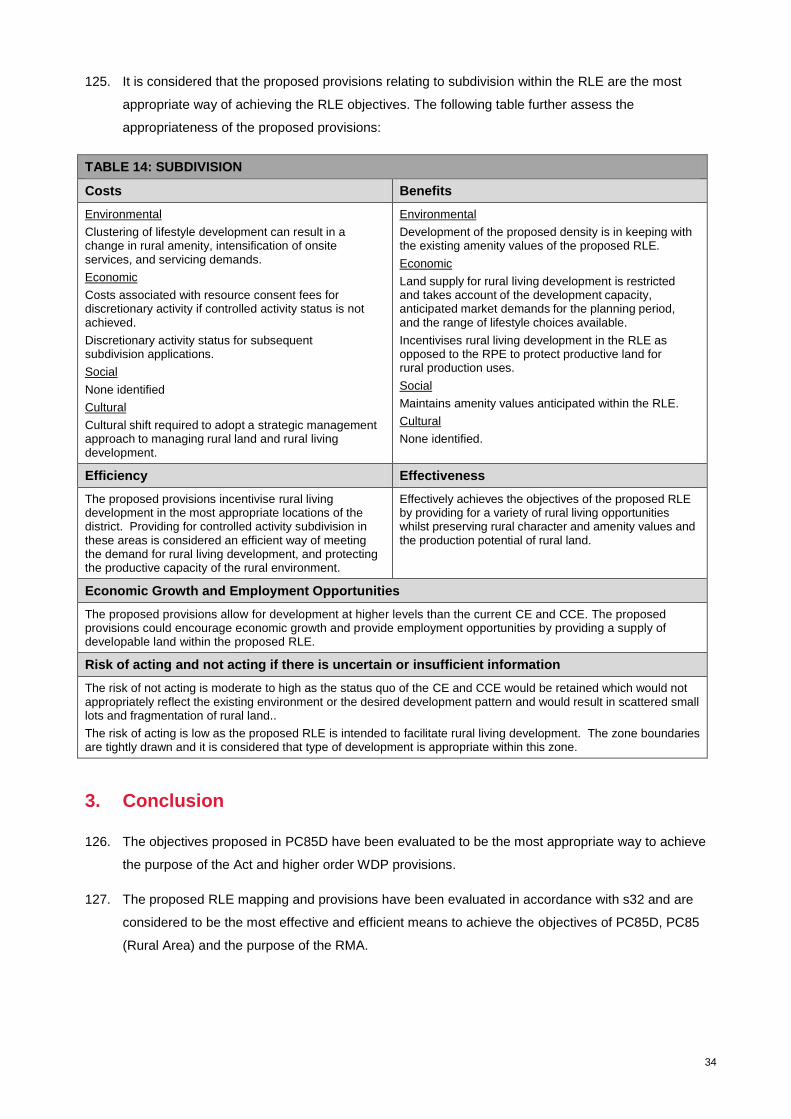
34
125. It is considered that the proposed provisions relating to subdivision within the RLE are the most
appropriate way of achieving the RLE objectives. The following table further assess the
appropriateness of the proposed provisions:
TABLE 14: SUBDIVISION
Costs Benefits
Environmental
Clustering of lifestyle development can result in a change in rural amenity, intensification of onsite services, and servicing demands.
Economic
Costs associated with resource consent fees for discretionary activity if controlled activity status is not achieved.
Discretionary activity status for subsequent subdivision applications.
Social
None identified
Cultural
Cultural shift required to adopt a strategic management approach to managing rural land and rural living development.
Environmental
Development of the proposed density is in keeping with the existing amenity values of the proposed RLE.
Economic
Land supply for rural living development is restricted and takes account of the development capacity, anticipated market demands for the planning period, and the range of lifestyle choices available.
Incentivises rural living development in the RLE as opposed to the RPE to protect productive land for rural production uses.
Social
Maintains amenity values anticipated within the RLE.
Cultural
None identified.
Efficiency Effectiveness
The proposed provisions incentivise rural living development in the most appropriate locations of the district. Providing for controlled activity subdivision in these areas is considered an efficient way of meeting the demand for rural living development, and protecting the productive capacity of the rural environment.
Effectively achieves the objectives of the proposed RLE by providing for a variety of rural living opportunities whilst preserving rural character and amenity values and the production potential of rural land.
Economic Growth and Employment Opportunities
The proposed provisions allow for development at higher levels than the current CE and CCE. The proposed provisions could encourage economic growth and provide employment opportunities by providing a supply of developable land within the proposed RLE.
Risk of acting and not acting if there is uncertain or insufficient information
The risk of not acting is moderate to high as the status quo of the CE and CCE would be retained which would not appropriately reflect the existing environment or the desired development pattern and would result in scattered small lots and fragmentation of rural land..
The risk of acting is low as the proposed RLE is intended to facilitate rural living development. The zone boundaries are tightly drawn and it is considered that type of development is appropriate within this zone.
3. Conclusion
126. The objectives proposed in PC85D have been evaluated to be the most appropriate way to achieve
the purpose of the Act and higher order WDP provisions.
127. The proposed RLE mapping and provisions have been evaluated in accordance with s32 and are
considered to be the most effective and efficient means to achieve the objectives of PC85D, PC85
(Rural Area) and the purpose of the RMA.

Appendix 1: Rural Development Strategy Rural Living Ranking Criteria
Land Use Capacity Class
Flood Susceptible Area
At Risk Aquifer
Forestry
Landscape Sensitivity
Native Bush % Cover
Esplanade Priority Areas
Unsuitability for Effluent Disposal
DOC Land
Protected Natural Areas
Potential Reverse Sensitivity
Airstrip
Distance to Primary School
Distance to Local Centre
Distance to Node
Distance to Reticulated Services
Road Type
Heritage Resources
Transpower Corridor
Gas Lines
Distance to Whangarei Central Post Office

Appendix 2: Summary of Identification of Rural Living Environment
Boundaries
1. Whakapara – The south side of McLennan Rd is identified as proposed RLE. The southern
boundary is drawn to encompass the existing rural living development and rounded off to provide
opportunities for a modest level of new development. The north side of the road is subject to a flood
susceptible area and is predominantly in rural production activities at present so was excluded from
the area.
2. Apotu Road – Boundaries are drawn to encompass smaller land holdings and to avoid the flood
susceptible areas. There are a number of orchards and farms in this area and larger allotments with
areas of highly versatile soils (LUC 3s2). Some rural production activities still exist in isolated
pockets (small scale horticulture and grazing activities), however it is considered that the productive
capacity of the area is already significantly compromised by rural living development, and is now
predominantly rural living in character. A buffer is provided between the identified RLE area and the
State Highway and existing industrial activities on the eastern side to avoid potential reverse
sensitivity effects, although it is noted that the topography of the land will mitigate against these
effects.
3. Matarau –Boundaries are drawn to incorporate the existing rural living development on the north side
of Pipiwai and Matarau Roads from the corner of Finlayson Road west. Flood Susceptible Areas are
excluded, as are properties accessed from Tudehope Rd (unsealed).
4. Glenbervie – This area was the subject of a number of responses relating to the protection of
horticultural operations when the draft plan change was notified. As a result it has been significantly
reduced in size. The area contains versatile soils, however these have been subject to a significant
level of rural living development. The southern boundary is based on a stream and the western and
northern boundaries are based on large land holdings in horticulture, farmland, and forestry. The
eastern boundary is defined by a larger land holding south of Ngunguru Road, and on the north side
the boundary is drawn so that a number of horticultural operations on LUC Class 3s1 soil remain in
the RPE.
5. Whareora – The northern boundary is defined by a stream and a flood susceptible area. The
eastern and western boundaries are based on roads and the south boundary incorporates buffers
from a timber processing plant and a small area of production forestry.
6. Kara Road North – The boundaries in this area are based on Kara Road in the north, and a stream
to the south.
7. Kara Road South – Boundaries are drawn to encompass existing rural living allotments. This area
contains a large area of versatile soil (class 3) reflected in a number of avocado orchards. However
the area is dominated by a significant level of rural living development.
8. Newton Road – The boundaries of this area are drawn tightly around existing rural living
development. This rural living enclave is located on and surrounded by farmland on versatile soils
and is over an identified at risk aquifer, therefore further residential development using on site
services is undesirable. Impacts on the safety and efficiency of State Highway 14 are also a factor
here.
9. Whatitiri – This area is defined by Whatitiri Road in the north and east. Properties are included that
can gain access off Whatitiri, and Springs Roads and Kahikatea Drive as they are sealed. Properties
gaining access off Carruth Road (unsealed) are excluded. Three properties at the south end of
Kahikatea Drive were removed from the draft maps as a result of requests from landowners.
10. Snooks Road – Boundaries are drawn to encompass existing development. Snooks Rd and Roose
Rise are used as boundaries as well as areas of bush, partially zoned Open Space. This area has
Class 3 soils and pastoral farmland surrounding the cluster and should remain in RPE

11. Te Rongo Road – Bush blocks on the northern side of Te Rongo Road and bordered at their north
boundary by a stream are included. Properties gaining access from the south side of Te Rongo Rd
are included with the southern boundary defined by larger allotments.
12. Prescott Road – Boundaries are drawn along Prescott Road and SH1 to encompass rural living
allotments with access from Prescott Rd and Heatherlea Drive.
13. Mountfield Road –Boundaries are drawn to encompass the group of rural living allotments north of
Mountfield Road and exclude larger parcels of production land. The flood susceptible area to the
south is excluded.
14. Cullen Road – Boundaries are drawn tight around existing rural living allotments. Larger lots to the
south of the cluster are excluded to provide a buffer between the serviced area of Waipu Cove and
the RLE. An unformed road is used as a boundary at the northern end. Properties to the south are
excluded to provide separation from the serviced area of Waipu Cove.

Appendix 3: Assessment Criteria for Rural Living Areas
Avoid Development Hazards
Flood Susceptible Areas
The PRPS places an emphasis on avoiding further residential development in flood susceptible areas.
Score -1
Erosion Prone Land
Rural living development is likely to include site earthworks relating to the formation of access and building
platforms. It is preferable if these areas are avoided Score -1
At Risk Aquifer
Areas were identified using data from NRC. Generally further intensification of uses that demand water, or
prevent aquifer recharge through the introduction of impermeable surfaces should be avoided. Score -1
On-site wastewater suitability
Rural living development will generally use on-site wastewater systems. Areas that were identified as
highly unsuitable for on-site wastewater disposal should be avoided and were given a score of -1.
Buffers around Mineral Extraction Areas
Mineral extraction is an important component in regional economic development and the areas this activity
occurs in are important long term strategic resources. The current WDP rules seek to control the effects of
reverse sensitivity by imposing controls on dwellings within 500m of Mineral Extraction Areas. It is
appropriate that these buffer areas are avoided when planning for future development. Score -1.
Unsealed Roads
The effects of dust from unsealed roads can cause nuisance effects on rural living activities. Dust enters
houses, settles on roofs, and infiltrates drinking water supplies, settles on washing drying on washing lines,
and generally disturbs outdoor activities particularly during the summer time. In situations where this
currently occurs Council can come under pressure to seal these roads, with financial impacts on
ratepayers. Because the impacts of dust can vary depending on wind direction, topography, sub-surface
soil type, traffic volumes and other factors, areas within a distance of 100m from unsealed roads have been
excluded and have been given a score of -1.
Production forestry
Rural living activities are generally incompatible with production forestry activities. Effects of standing
forests can include shading, lower amenity values, effects from pollen, and increasing the risk of fire.
Harvesting forests also causes disturbance in terms of noise and traffic impacts on nearby residents.
Information on the location of production forestry was obtained from MfE’s land cover data base. DoC
recommends a setback of 100m to avoid increasing the risk of fire, therefore areas within 100m of the
production forest were given a score of -1.
Horticultural activities
Rural living activities can be incompatible with horticulture activities. Effects associated with horticulture
activities include noise, odour, spray drift, dust, traffic and shading from shelter belts. The MfE Land Cover
Database was used to identify areas classified as ‘vineyard’ ‘orchard’ and ‘other perennial crops. A 25m
buffer was used as based on guidance from the Quality Planning website’s guidance note on ‘Planning for
the Wine industry’ with reference to Tasman District Council’s setback requirements. Properties within this
buffer were scored -1
Avoid Primary Production Activities

The Ministry for the Environment Land Cover Database was used to identify primary production activities.
This included areas of pasture, forestry, horticulture and quarries. Areas were selected from the database
where their classification was noted as High producing exotic grassland or Short rotation cropland. Any
properties were smaller than 4 ha were removed from the selection, as properties this size are generally
considered to be too small for pastoral production. The remaining properties were identified and given a
score of -1
Areas noted in the Land cover data base as ‘Pine Forest’, and ‘Afforestation’ were identified. This includes
all standing and harvested exotic forests. These area were given a score of -1
Areas noted in the Land Cover Database as Orchard, Other Perennial Crops, and Vineyard were identified
and given a score of -1.
Mineral Extraction Activities are identified in the WDP’s planning maps. Residential development within
these areas is a non-complying activity under the current rules. These areas were given a score of -1.
Recognising Existing Development Patterns
Identifying Existing Residential Units
Information showing the GPS location of residential power meters was obtained from Northpower.
Development in the vicinity of existing residential units is preferable in terms of the protection of open
space, rural amenity values and the avoidance of sprawl into the RPE. Based on the operative Urban
Transition Environment, and taking into account built development patterns in ‘rural’ situations, a 50m
buffer was applied around all residential units located outside urban zones. It is preferable to locate new
residential units in the rural environment near existing development land within 50m of existing dwellings
was give a positive value of +1.
Identified Rural Living Sized Parcels
Parcels within the CE and CCE that are larger than 1ha and smaller than 4ha were selected. This size
range was set to capture those parcels that have been created since the 1ha rule was introduced to the
Proposed District Plan, as well as smaller properties created under the current 4ha averaging rule.
Properties larger than 4ha (10 acre blocks) have traditionally been considered as having a degree of
production capability. In the RDS the approach was adopted to consolidate lifestyle development in areas
where productive potential has already been compromised, therefore these areas are given a positive bias,
and scored +1.
Identification of vacant land parcels.
Separately rateable parcels that are less than 4ha in area, and do not contain a Northpower meter relating
to a residential dwelling, business, or other principal land uses were identified. This also excluded land
occupied by land use activities like telecommunication services or pump sheds. Taking into account the
existing bias towards existing small parcels of land under other criteria, this measure recognises that land
that has already been subdivided from larger holdings, and is being rated separately (owned separately)
should be used up before further land is subdivided. Also as a mater of fairness, where there are vacant
parcels of land that have been created under the resource consent process and sold for rural living
development this should be recognised. These areas were therefore given a positive score of +1
Commuter travel times
Information relating to parcel size and land value ($/m2) indicates that there is a comfortable commuting
distance to the City within which there is a higher demand for rural living properties. The Census
demographic data also indicates that these peri-urban areas also contain higher than average populations
aged 10-18 years. To test this correlation, urban colleges (and Northtec) were used as points of reference
to calculate travel times to rural areas using Garmin Mapsource. There appears to be a high degree of
correlation between land values, parcel size and 10 minute commuting distance from colleges. Given the
seemingly high level of demand for rural living closer to the City a positive bias is given to areas within a 10

minute travel time (with an additional 500m buffer to account for a reasonable margin of error) and areas
within this limit were scored +1.
Buffers to Urban Areas
Rural living in close proximity to urban areas (and infrastructure services) are often seen as a future
residential area by owners and or investors in these areas. In order to discourage that perception RLE
clusters should be located a sufficient distance from urban zones. A buffer of 500m was chosen as being a
distance over which the cost of extending reticulated services (or upgrading roads, footpaths etc) would be
less appealing in economic terms and a score of -1 was applied.
Buffers to Future Urban Areas
Future urban areas as identified in the Urban and Coastal Structure Plans adopted by Council in February
2009 were selected and a 500m buffer was applied. The rationale for this is similar to the existing urban
areas above, but ‘double weighting’ those areas that are adjacent to future urban areas serves to avoid
any potential for these future growth areas to be impeded or constrained by development in the proposed
RLE. These areas were scored -1.
Recognise Natural Resources
Protected Natural Areas
The Department of Conservation’s Protected Natural Areas Program (PNAP) identified areas that contain
features or habitats that are sensitive to residential development (including domestic activities such as the
keeping of cats and dogs) these natural areas can be compromised by rural living activities so should be
avoided where possible. They were assigned a score of -1.
Reserves and Reservations
Information on reserve areas was sourced from LINZ. These areas included gazetted reserves and other
areas that have protected reserve status. Rural living development cannot be lawfully established within
these areas and they were scored -1.
Native Vegetation
Information sourced from the second edition of MfE’s Land Cover Database (LCDB2). Areas selected are
those identified as ‘Indigenous Forest’ or ‘Broadleaf Indigenous Hardwoods’. These areas of
predominantly mature indigenous vegetation should be preserved where possible and therefore, avoided
for rural living development. Where these features were present a -1 score was assigned.
Stone Wall Setbacks
Stone walls have been mapped through previous surveys. The walls themselves are a notable feature of
several areas of the District and many are also protected as Historic Places. Development in these
locations should be avoided therefore a 10m buffer from the stonewalls was identified, and a score of -1
was assigned. This is equivalent to the 10m yard setback for rural properties.
Rivers and Streams
Data on rivers and streams obtained from NRC are classified by river order. All rivers that are classified as
2nd
order or higher are buffered by 20m (the standard esplanade area width) to delineate river margins that
should not be developed for rural living due to potential effects on water quality through runoff, and
sedimentation. Land within this buffer was scored -1.
Natural Character Areas
Information on natural character areas were sourced from the RPS. The NZCPS and the RPS require that
inappropriate subdivision and development should be avoided in areas of significant natural character.
Rural living areas should therefore be discouraged from location within these areas and a score of -1 was
assigned.

The Coastal Environment
The NZCPS and the RPS discourage the proliferation of subdivision and development in the coastal
environment, directing coastal development toward existing settlements where natural character has been
compromised. 30/50 also encourages consolidation around existing settlements. Rural living should
therefore be discouraged from locating within the coastal environment and a score of -1 was assigned.
Outstanding Natural Landscapes
Information on Outstanding Natural Landscapes was obtained from the RPS. The NZCPS and the RPS
require that the effects of inappropriate subdivision and development should be avoided in outstanding
natural landscapes. Rural living activities should be discouraged in these areas and a score of -1 was
assigned.
Outstanding Natural Features
Information on Outstanding Natural Features was obtained from the RPS. The RPS requires that the
adverse effects on Outstanding Natural Features should be avoided. Rural living activities should be
discouraged in these areas and a score of -1 was assigned.
Areas of High Kiwi Concentration
The Department of Conservation has produced maps identifying areas of high kiwi concentrations. The
presence of kiwi so close to Whangarei City is a unique feature of the District. Kiwi are very vulnerable to
cats and dogs, particularly when they are chicks. Rural living development increases the potential for harm
to kiwi from domestic pets therefore, areas identified as having high kiwi concentrations should be avoided
and have been scored -1.
QII Covenant Areas
These areas are generally protected in perpetuity by way of legal covenant on the certificate of title. It is
not appropriate that these areas be identified as rural living areas. They were scored -1.
Recognise Network Utilities
Buffers around Bore Water Supply Locations
Point source data was obtained from NRC and a 20 m buffer applied (in accordance with Regional Plan
setback requirements) As rural living will utilise on site wastewater disposal systems which generally
involve discharge to ground, concentrations of this type of development should not be located in close
proximity to water bores and were assigned a score of -1.
Setbacks from Arterial Roads and State Highways
A 75m buffer was applied to arterial roads and state highways. This is the distance determined by NZTA to
be potentially affected by traffic noise and other traffic related effects. To avoid increased number of
vehicle crossings onto arterial roads and state highways (which introduces greater ‘side friction’)
development should be set back from these roads. They were scored -1.
Railway Corridors
A 75m buffer was also applied to railway corridors. Rural living activities should be discouraged from
location in areas that are subject to noise and vibration from railway activities. These areas were scored -
1.
Rural Airfields
Rural airfields serve an important function for rural production activities, by servicing top dressing planes.
As an important rural resource these areas should not be occupied for rural living activities and were
assigned a score of -1.

Buffers to Rural Airfields
Rural airfields have the potential to generate adverse noise effects on adjoining activities. Development in
close proximity to established runways could have reverse sensitivity effects on the operation of the
runway. A setback should therefore be provided for around rural airfields. A 500m buffer has been used in
similar circumstances around Mineral Extraction Activities and this distance would be sufficient in this
situation. Within the 500m buffer a score of -1 was applied.
Gas and Petroleum Pipelines
Gas and petroleum pipelines provide an essential service to many of the District’s most important
industries. To avoid potential adverse effects in relation to the management of this infrastructure and to
minimise the risk to people and property in the event of an emergency, rural living should not be located
within the designated corridor. A score of -1 was applied.
Critical Electricity Lines (Northpower)
The operative WDP contains setbacks from identified Critical Electricity Lines. These setbacks include
controls over land uses and building. To avoid compromising the electricity network, rural living should not
be located within the designated corridor. Properties within the corridor were scored -1.
Electricity Transmission Lines
The NPS and NES for Electricity Transmission and the WDP require the management of corridors along
the National Grid. Residential dwellings constitute sensitive activities so should not be encouraged within
these corridors. They were scored -1.
Promoting Environmental Enhancement.
Stone Walls
Allowing the subdivision and development of properties that contain stone walls provides an opportunity for
the walls to be legally protected as an environmental off-set. To incentivise the protection of these
features, such parcels can be promoted for development that provides for better stewardship of these
heritage resources. They were assigned a score of +1
Archaeological Sites
Allowing the subdivision and development of properties that contain archaeological sites provides an
opportunity for the sites to be legally protected as an environmental off-set. To incentivise the protection of
these features, such parcels can be promoted for development that provides for better stewardship of these
heritage resources. They were assigned a score of +1.
Land Use Capability Class 4 and 5
There has been an ongoing debate about whether high class or elite soils should be protected for their
production values. Rather than viewing high class soils as a limitation on development, the argument can
be reversed by encouraging the development of rural living on the lower quality soils. Those soils with the
greatest limitations (LUC Class 6-8) would be better managed without the site construction works and
demands placed by rural living development. Classes 4 and 5 are considered optimum for rural living due
to their relative abundance, and more favourable topography for rural living. These classes are generally
elevated with views, but are not so steep to be inaccessible and were assigned as Score of +1.
Parcels Fronting Sealed Rural Roads
To avoid ongoing community pressure for the sealing of unsealed roads, rural living development should be
preferred and encouraged in areas where the roads are already sealed. Parcels were selected that are
within 20 metres of the centre line of rural roads with pavement types of tar seal or concrete and assigned
a score of +1

Rivers and Streams
Water quality can be improved by excluding stock from streams through fencing and riparian protection.
Subdivision of parcels that contain second order streams or larger provides an opportunity for stream
fencing as an environmental offset. These parcels were scored +1.
Indigenous Vegetation
Subdivision of parcels that contain indigenous vegetation provides an opportunity for the legal and physical
protection of features as an environmental offset. These areas were scored +1.