planning application pl14/024620– 154– 166 willi amsons
TRANSCRIPT

COUNCIL AGENDA 26 May 2015
PAGE 1 Item No:
Planning Application PL14/024620 – 154 – 166 Willi amsons Road, Doncaster – Construction of a part five-store y apartment building comprising sixty-four (64) dwell ings and an attached row of eight (8), two-storey dwellings and basement carparking
Responsible Director: Director Planning & Environment File No. PL14/024620 Neither the responsible Director, Manager nor the Officer authoring this report has a conflict of interest in this matter. Land: Lot 1 TP136753B, Lot 1 LP86073 &
Lot 1 TP139290A & Lot 4 LP15302 Zone General Residential Zone, Schedule
3 Adjacent to a Road Zone Category 1
Applicant: CES - Glenelg Pty Ltd C/O Urbis Pty Ltd
Ward: Koonung Melway Reference: 33 E9 Time to consider: 15 May 2015
SUMMARY
It is proposed to develop a part five-storey apartment building with semi-basement car parking and an attached row of eight, two-storey dwellings over four lots (4373m2) on land known as 154 – 166 Williamsons Road, Doncaster. The apartment building proposes a yield 64 dwellings consisting of a mixture of one and two bedroom apartments. The row of eight attached dwellings orientated to Henry Street will be all two-bedrooms. The basement car park will provide for 74 car spaces for residents, including the row of eight dwellings. No provision for visitor car spaces will be provided within the basement. Four visitor car spaces will be provided within the forecourt and six indented car spaces will be created on Henry Street.
The application was advertised and 8 objections were received to the proposal, of which two contain multiple signatures (23 and 19 signatures respectively). Grounds mainly relate to impact on neighbourhood character, intensity and scale of the proposed development, inadequate on-site car parking and parking overflow, height and scale, traffic capacity of Henry Street and safety, visual bulk and loss of monetary value to surrounding properties.
It is considered that the height and scale of the apartment building lacks strategic policy basis. The significant height has no relationship to the residential built forms within the immediate surrounding area and is inconsistent with the preferred neighbourhood character, where an ‘incremental’ level of change is envisaged.
The row of eight attached townhouses on Henry Street is a linear rectangular form with no stepping and physical articulation between the levels. No visual break or separation is provided to the 51.4m length built form (equivalent to four and half
COUNCIL AGENDA 26 May 2015
PAGE 2 Item No:
properties). It is noted that no other properties on Henry Street will have the same opportunity to develop their land at a similar intensity due to the prevailing lot sizes. The significant length of the building is at odds with the separation and pattern of dwelling spacing within Henry Street. Additionally, the third floor of the apartment building will encroach over the rooftop of the row of eight dwellings. Therefore, the middle section of the row of dwellings (D.04 – D.07) will appear as a four storey built form with a maximum building height of 14.15m, whereas the maximum building height is 10.0m.
The indented parking bays on Henry Street are not supported as it is contrary to Council’s Nature Strip Planting Guidelines.
There is inadequate provision for visitor car spaces (shortfall of 8) pursuant to Clause 52.06 and the indented car spaces on Henry Street cannot be counted as visitor car spaces exclusively for the development. The proposed development does not meet the short-term peak visitor car parking demand and will likely place additional pressures on existing on-street parking on Henry Street, as the car spaces for the row of eight townhouses are within the basement and the close proximity of the indented car spaces directly in front of the townhouses will likely be used by the residents.
It is recommended to not support the application, as it has failed to comply with the Manningham Planning Scheme and the development does not constitute orderly planning.
1 BACKGROUND
Site Description
1.1 The irregularly shaped development site is made up of four properties (Nos. 154, 156 – 158 & 160 – 166). The site forms part of a larger holding by the applicant company which includes vacant land and No. 59 Margot Avenue, with a total area of 2.8ha. Two large, adjacent house lots (Nos. 1 & 3 Henry Street) protrude 72.42m into the overall land holding, effectively separating the two development sites. The two house lots at Nos. 1 & 3 Henry Street are still owned by members of the Morrison family.
1.2 All properties are located on the eastern side of Williamsons Road. The land parcel (application site) is 4373m2 in area with a combined frontage of 124.29m and a maximum depth of 63.4m.
1.3 The development site was formerly used by the Morrison family who ran a retail plant nursery business on the western part of the property, while maintaining the greater part of the land to the east at Nos. 160 – 166 was an orchard. This part of the land is not part of the development, only a small part of the front, which will be a shared vehicle access. All of the buildings associated with this previous business have been removed.
1.4 A report on the potential for ground contamination from orchard activities was submitted with the development of the land to the east (part of application PL14/024208 for 105 dwellings in various rows of two and three-storey townhouses) and indicates that residue pesticide concentrations are below residential ecological and health investigation levels. Several “hotspots” were identified but can easily be removed as part of the site works and then validated as being clear.

COUNCIL AGENDA 26 May 2015
PAGE 3 Item No:
1.5 Up until 5 months ago, the street frontage on Williamsons Road was characterised by a row of over fifty mature Monterey Pines, which formed a windbreak for the orchard. The trees were described in an arborist report submitted part of application PL14/024208 as “senescent” (aging) with “fair” health and “poor” structure. The trees were removed in early November 2014 (no planning permit required).
1.6 The property at No.154 contains a tennis court and a 1.5m – 1.6m high steel mesh fence on the Henry Street and on Williamsons Road. A row of Moneterey Pines are located behind the fence. The property rises 1.76m from south-east to south-west. The land is legally referred to as Lot 1 TP136753B Volume 9752, Folio 399.
1.7 The property at Nos. 156 – 158 contains a single-storey brick dwelling with a front setback of 7.0m from Williamsons Road. Vehicle access is via a concrete driveway and crossover located adjacent to the northern boundary. The property frontage is unfenced. The property rises 2.91m from south-east to south-west. The land is legally referred to as Lot 1 TP139290A Volume 9807, Folio 289.
1.8 The property at Nos. 160 – 166 contains two separate legal titles. The small southern portion contains a single-storey brick dwelling and a swimming pool at the rear, with a front setback of 23m. Vehicle access is via a crossover and driveway located adjacent to the southern boundary. A 1.9m high brick fence is located on the Williamsons Road frontage. A 1.22m wide drainage easement is located on the northern boundary. No asset is located within the easement. One Moneterey Pine is located on the naturestrip, with its canopy overhanging the frontage. The property rises 2.08m from south-east to south-west. This part of the property is legally referred to as Lot 1 LP86073 Volume 8972, Folio 716.
1.9 The remaining portion of Nos. 160 – 166 contains two detached brick buildings with access to a 7.4m wide vehicle crossover on Williamsons Road. A 2.4m high chain wire mesh gate is located 10.0m from the frontage. Two Monterey Pines are located in front of one of the brick building and six Monterey Pines are located on the northern common boundary, which adjoins Nos. 168 Williamsons Road. A 2.2m high chain wire mesh fence is located on the southern part of the frontage. The property has a 2.0m crossfall from north to south. This part of the property is legally referred to as Lot 4 LP15302 Volume 6368, Folio 600.
1.10 The subject land has a 2.0m high timber paling fence on the eastern boundary (Nos. 156 – 158 & 160 – 166), with the exception of No. 154, where the rear boundary is unfenced. A 2.0m brick wall is located on the northern boundary of Nos. 160-166 Lot 4 LP15302, which adjoins No. 168 Williamsons Road.
1.11 The site offers glimpses of Westfield Doncaster to the south and extensive easterly views towards Ruffey Lake Park and to distant ranges.
Neighbourhood Description
1.12 The site is located in an attractive suburban precinct which is generally defined by King Street to the north, Williamsons Road to the west, George Street to the south and Ruffey Lake Park to the east. The residential area is located over undulating land with a predominant fall to the south-east. The streets are generally characterised by a curvilinear set out, rollover kerbs and

COUNCIL AGENDA 26 May 2015
PAGE 4 Item No:
constructed footpaths. There is mixed tree planting along grassed nature strips and power lines are generally underground.
1.13 Built form is clearly dominant over the landscape form, with many properties containing a predominance of exotic tree and shrubs species. There is no sense of a tree canopy, particularly as this suburban area was former orchard land. There are some scattered, larger trees throughout. The former row of pine trees along the Henry Street frontage was a strong landscape element that was visible for some distance.
1.14 Overall, the character of the neighbourhood is relatively homogenous and is typified by predominantly one and two-storey brick dwellings, generally designed with hipped, tiled roofs (often with eaves). Housing in this area has been constructed since the mid-1970’s, but with some relatively recent in-fill developments in streets near the subject land. Lot sizes are quite varied, along Henry Street. Multi-unit development is limited and is generally located along George Street. There are, however, some newer dwellings.
1.15 As an overview of the most typical housing, associated garages are dominant elements, generally being to one side and on a boundary. There is a predominance of face brick and render wall finishes. Many frontages are open to the street, generally being defined by landscape treatments. Where front fences are in place, there is a predominance of brick construction, but with little consistency in terms of style or height.
1.16 The site has abuttals with 3 adjoining properties, which will have an interface with the proposed development, and across Williamsons Road to the west is Council’s Aquatic Facility. Surrounding development is described as follows:
Direction Address Description
North 168 Williamsons Road
The southern and eastern boundaries of this large, well landscaped property are common with the site. The property contains a centrally positioned older dwelling which is two-storey and a garage which presents as a side wall to the southern boundary. The dwelling is well distanced from the common boundaries and there is a wide brick paved driveway to its south. There is a spread of large native and exotic trees over the property and some peripheral planting and an Oak tree near the subject land. This site is a potential development site having regard to its size and location on Williamsons Road.
The property has its main

COUNCIL AGENDA 26 May 2015
PAGE 5 Item No:
Direction Address Description
160 – 166 Williamsons Road (Lot 4 LP15302) (includes 5 – 17 Henry Street & 59 Margot Avenue)
driveway and crossover access to Williamsons Road adjacent to the common boundary. This access and associated retaining walls within the nature strip are not shown on the Plan of Survey. There is a secondary point of vehicle access to Margot Avenue.
A high fence to the eastern boundary is constructed in unpainted metal sheeting and is visually unaesthetic.
Planning Permit PL14/024208 was issued on 21 January 2015 for 105 dwellings, with creation of a new access road (proposed to be named North Road), which intersects with Williamsons Road that provides a signalised intersection. The planning permit was issued, subject to Council agreeing to a Consent Order, after successful mediation at the Tribunal. An additional four more internal roads will be created within the development to provide vehicle access to the dwellings. The dwellings will be in an attached form with a mix of two and three-storey built forms, with provision for a single garage and a tandem car space. The dwellings located on the outer perimeter of the site will be two-storey, whereas the two rows of 18 dwellings (36 total, bounded by four new internal roads), located in the centre of the development will be three-storey.
East 1 Henry Street
This is the nearest adjacent residential lot to the development. These twin lots have a maximum depth of 72.42m and a maximum frontage of 57.91m. No. 1 contains a “Y” shaped, single-

COUNCIL AGENDA 26 May 2015
PAGE 6 Item No:
Direction Address Description
3 Henry Street
storey brick dwelling with a hipped, tiled roof and an elongated garage wing to the front, with a street setback of 10.4m. There is extensive paving to the west of the garage wing. The larger rear yard contains a swimming pool and a shade pergola.
The frontage is heavily screened with Pittosporums which cascade onto the nature strip. Exotic screen planting also exists along property boundaries, with a predominance of Pittosporums to the east and north.
This property is the second of the twin lots, which contains a single-storey, brick dwelling with a hipped, tiled roof. The dwelling is setback 21.9m from Henry Street. There is an integrated carport at the front which is accessed via an unsealed driveway. The front yard is heavily planted with native and exotic species and there is steel mesh fence to the frontage (1.6m high). The rear yard contains a range of fruit trees. The eastern and northern boundaries are open to site.
West 139 – 153 Williamsons Road (Aquarena Aquatic and Leisure Centre)
This extensive area of Council owned land is developed with public swimming pools (indoor and outdoor) and fitness facilities which are currently undergoing a substantial upgrade and expansion. The land slopes down quite steeply to the west and several wide parking terraces provide a substantial separation from the road frontage. There is a single access point to Williamsons Road which is controlled by traffic signals and provides for left and right turns, as well as

COUNCIL AGENDA 26 May 2015
PAGE 7 Item No:
Direction Address Description
“straight through” traffic flow over to the entry of the former plant nursery.
South
152 Williamsons Road
2 & 2A Henry Street
This property contains a two-storey, brick dwelling with a hipped, tiled roof. The dwelling is setback 5.4m from Williamsons Road, with a garage orientated to Henry Street. Vehicle access is via a crossover and driveway from Henry Street. A high brick fence is located on both Williamsons Road and Henry Street frontages. A row of 5 medium size evergreen canopy trees and one large Eucalyptus tree is located on the nature strip on Henry Street in front of the property.
These two properties were created as part of a two-lot subdivision under Planning Permit PL99/011092. The property at No. 2 Henry Street contains a two-storey Neo-Georgian style dwelling with a hipped, tiled roof. The dwelling is setback 6.4m. The property at No.2A Henry Street contains a two-storey brick dwelling in a contemporary conservative style with a hipped, tiled roof. The dwelling is setback 7.4m. Both properties are provided with vehicle access to Henry Street.
1.17 The site entry is located approximately 680m to the north-east of the Manningham Road/Williamsons Road intersection. From the Williamsons Road entry, Westfield Doncaster is approximately 1.0km away by road. Ruffey Lake Park is approximately 220m to the east and can be conveniently accessed via local streets.
1.18 Williamsons Road is a declared arterial road pursuant to the Road Management Act 2004 and VicRoads is responsible for its management. In this location, there is divided carriageway with two southbound traffic lanes pasing the site and right turn lane serving the Aquarena Aquatic and Leisure

COUNCIL AGENDA 26 May 2015
PAGE 8 Item No:
Centre. A left-turn into the site is currently achieved from the outer through lane. There are also two through lanes serving northbound traffic, but with protected left and right-turn lanes. This section of Williamsons Road carries high volumes of traffic, especially during morning and evening peak periods. The speed limit is 70kph.
1.19 Based on the applicant’s Traffic Impact Assessment, prepared by GTA Consultants, dated 26 August 2014, (survey date – 20 February 2014), the report indicates that 23,000 vehicles passed the site per day, with an assumption of 10% peak-to-daily ratio (equivalent to 2300 vehicles).
1.20 The traffic signals which serve the Aquarena Aquatic and Leisue Centre and the site entry provide pedestrian crossing facilities on the southern side of the intersection. A formed footpath is provided in front of the site.
1.21 Public bus services provide access to Westfield Doncaster, Box Hill, Greensborough and Chelsea/Airport West (Smart Buss). There is a slightly indented bus stop just to the south-west of the site access.
1.22 Henry Street is a local road and has a trafficable carriageway width of 4.5m, within a 15m wide road reserve. Unrestricted kerbside parking is permitted on both sides of Henry Street. The mildly curvilinear alignment of the street results in some wider sections of nature strip adjacent to the site, which splays towards the south, on the southern side. Mountable kerbs are provided and there is a concrete footpath on the northern side, off-set from the southern boundary of the site.
Planning History
1.23 The application was presented to the Sustainable Design Taskforce on 28 August 2014.
1.24 As part of the request for additional information, pursuant to Section 54 of the Act, Council officers raised some concerns, in particular with respect to the non-compliance with the maximum building height, the non-compliance with respect to provision of visitor car spaces, and the suggestion to provide a break between the row of eight attached townhouses, so that there is two separate built forms.
1.25 On 9 October 2014, VicRoads objected to the application, pursuant to Section 55 of the Act, as the development relies on the construction of the internal road network and intersection mitigating works as part of PL14/024208.
1.26 No changes were made with the resubmission of the plans. The application was advertised between 17 February 2015 – 15 March 2015. A total of 8 objections were received, of which two contain multiple signatures. No formal consultation meeting was held.
1.27 On 19 March 2015, VicRoads provided conditional consent to the proposal. The main condition relates to the access and mitigating works associated with PL14/024208, at no cost to VicRoads.
2 PROPOSAL
2.1 It is proposed to demolish the existing buildings on the site and to construct a part five storey apartment building, comprising 64 dwellings on the main part

COUNCIL AGENDA 26 May 2015
PAGE 9 Item No:
of the site and a row of eight, attached two-storey dwellings orientated to Henry Street.
Apartment Building
2.2 The building is shaped like a “z”, with the eastern section linked by a 1.85m wide corridor and a twin lift core, to the western most section. A series of steps will be provided from Williamsons Road, including a footpath linked from the south-western corner of Williamsons Road to the entry on Williamsons Road and to the emergency stairs which protrudes from the basement (south-west corner of Apartment G.12).
2.3 The building features 28 one-bedroom apartments and 36 two-bedroom apartments. The one-bedroom apartments are generally similar in size, ranging between 47.4m2 to 52.6m2.The two-bedroom apartments vary in size between 67.5m2 to 78m2. The apartments on the ground floor will have access to a curvilinear terrace ranging from 9.2m2 to 55.1m2 (G.1 – G.16). The terraces on the ground floor orientated to the forecourt will have a 1.7m high privacy screens. All above ground apartments will have access to a balcony. The balconies vary in size between 8.6m2 to 20.8m2 with a minimum dimension of 2.55m.
2.4 In terms of basement car parking, there will be 66 spaces, which will be all allocated to residents of the apartment and 8 single type parking spaces for the two-storey dwellings on Henry Street.
2.5 The basement will have storage for 62 apartments, spread out in store rooms (an area with 46, 3 & 4 stores and 6 & 3 car spaces with over bonnet stores) and over bonnet stores. Provision is made for 16 residential bicycle racks adjacent to the south-west of the basement. Bin storage and hard waste is proposed adjacent to the row of 46 store rooms. Two utilities service rooms will be located adjacent to the basement entry. A twin lift core will be located to the south-west of the basement, adjacent to Car space No. 62.
2.6 The building has the following setbacks:
• Front setback:
○ Basement – 4.07m
○ Ground Floor – 5.18m
○ First Floor – 5.18m
○ Second Floor – 5.28m
○ Third Floor – 5.22m
• Southern boundary (Henry Street):
○ Basement – 5.37m
○ Ground Floor – 13.8m
○ First Floor – 13.8m
○ Second Floor – 13.8m
○ Third Floor – 9.37m
• Eastern (rear boundary):
○ Basement – 200mm

COUNCIL AGENDA 26 May 2015
PAGE 10 Item No:
○ Ground Floor – 9.89m
○ First Floor – 9.74m
○ Second Floor – 9.74m
○ Third Floor – 9.74m
2.7 The roof top of the building will have provision for 28 photovoltaic solar panels and hot water systems. A car park exhaust will also be located adjacent to the solar panels.
2.8 The apartment building will have a maximum building height of 16.75m above natural ground level and a height of 18.06m to the plant screen.
The row of 8 dwellings on Henry Street
2.9 The row of dwellings orientated to Henry Street will be two-storey with a maximum building height of 8.3m.
2.10 The dwellings will have a setback of 6.3m from Williamsons Road and a minimum setback of 5.91m from Henry Street. The dwellings will have an eastern setback of 3.33m. The first floor will have a setback of 5.53m from Henry Street.
2.11 All dwellings will be two-bedrooms with an open plan kitchen, living area. The dwellings will vary in size between 104.3m2 to109.6m2.
2.12 The dwellings will be provided with a courtyard within the front yard with an area ranging from 29.5m2 to 40.7m2. A 1.7m high blockwork privacy screen will be erected within the property frontage with a staggered front setback of 400mm to 1.76m. A 1.7m high steel dividing fence will be erected between the dwellings to provide privacy within the courtyards.
2.13 Dwellings 1, 2, 3, & 8 will be provided with a rear curvilinear terrace with an area ranging from 15.4m2 to 25.5m2. Dwellings 4, 5, 6 & 7, which are centrally located (and are attached to the southern side of the apartment building) do not have access to any north-facing windows and will only have access to the south-facing courtyard as the primary private open space.
2.14 A 1.4m wide pedestrian pathway will be provided adjacent to the eastern boundary (near Dwelling D.01), which links with the forecourt within the rear of the apartment building.
Access
2.15 The basement is accessed via a new internal road (proposed to be named North Road), which will intersect with Williamsons Road and provision will be made for a traffic signal. North Road will have a carriageway width of 8.5m. A small lane (proposed to be named West Lane) with a carriageway width of 5.5m will be linked to North Road and will be constructed as part of Planning Permit PL14/024208. West Lane will provide vehicle access to the apartment building and for the three-storey townhouses bound between North Road and Little West Lane, approved under Planning Permit PL14/024208.
2.16 The ramp will have a gradient of 1:14.7.5, descending into the basement entry. The ramp will also extend to the south, enabling vehicles to proceed to the forecourt for drop off or to utilise the visitor car spaces. The ramp will have a gradient of 1:20 for a length of 5.2m, then a gradient of 1:8 for 2.0m and the remaining section (length of 13.8m to forecourt) at a gradient of 1:5.

COUNCIL AGENDA 26 May 2015
PAGE 11 Item No:
Car Parking
2.17 All car spaces within the basement will be allocated to residents. Parking for the eight dwellings on Henry Street will also be provided within the basement. These car spaces are located adjacent to the southern boundary. The eight dwellings are provided with a store room, where a 2000 litre capacity rainwater tank is also located and a toilet generally with an area of 12m2 located adjacent to the respective car space.
2.18 The basement will have a total of 74 car spaces, which will be allocated to residents, as no visitor car spaces are provided within the basement (includes 2 surplus residential car spaces). All car spaces are provided with dimensions of 2.6m by 4.9m, with a minimum aisle width of 5.5m to 6.4m.
2.19 There is provision for 4 visitor car spaces within the forecourt. Each visitor car space will have dimensions 2.6m by 5.4m. Adjacent to the visitor car spaces are 8 bicycle racks for visitors within the forecourt.
On-Street Car Parking
2.20 Provision is made for 6 indented car spaces on the northern side of Henry Street, as part of the nature strip which is wider than the remainder of Henry Street. The indented bays will be in two sections, with each bay having the capacity to accommodate three parked vehicles. The first section to the east will have a minimum length of 20.0m, widening to a splay angle of 22.6m. The second section to the west will have a minimum length of 20.6m, widening to a splay angle of 23.0m. The two indented parking bays will have a minimum separation of 5.8m.
Materials
2.21 The apartment building will generally be in an applied finish in light beige with vertical stained timber cladding. Balcony balustrades will be in an applied finish in mid beige. Feature vertical metal cladding in mid grey will be erected on the south-western corner. All windows will be glazed with a grey tint. The basement projection will be clad in a charcoal metal finish. The roof will be in an applied finish in dark grey and the plant equipment screen will be glazing in a grey tint.
2.22 The row of eight dwellings on Henry Street will be clad in charcoal metal with vertical stained timber finish and glazing to all windows in a grey tint. Generally walls and roofs will be in an applied finish dark grey. Some vertical elements in an applied finish light beige colour will define and delineate each dwelling.
2.23 The front fences on Henry Street will be in a combination of blockwork in ‘off white’ interspersed with metal cladding in charcoal , which also extends to the dividing fences.
Landscaping
2.24 The proposal will result in the creation of a pocket park, proposed on the north-eastern side of the site, between North Road and West Lane. The pocket park will include 5 Liquidambar styraciflua, 3 Pyrus ussuriensis, and 3 Eucalyptus leucoxylon. It is noted that Council Officers have advised the Applicant that Council has no interest in the management of the pocket park, due to its small size and isolated location. Therefore, it should be managed by the Owners Corporation.

COUNCIL AGENDA 26 May 2015
PAGE 12 Item No:
2.25 All existing canopy trees on the site are proposed to be remove with the exception of a 15m high Yellow Gum located within the bus stop on Williamsons Road. This tree will be retained and protected during construction.
2.26 A series of curvilinear Gabion with basalt infill retaining walls are proposed within the front setback on Williamsons Road. The Gabion feature retaining walls will wrap around proposed landscaping.
2.27 The frontage on Williamsons Road will be landscaped with a Liquidambar styraciflua and a Eucalyptus leucoxylon. Around the Gabion feature retainng walls and near the entry will include 7 Pyrus ussuriensis and perimeter screen trees, such as Waterhousea floribunda, ‘Whisper’ acmena smithii sp, Camellia japonica and Elaeocarpus sp.
2.28 The southern end of the ramp, extending from West Lane will include 7 perimeter screens and 10 Pyrus ussuriensis (which extends to the pedestrian pathway to Henry Street).
2.29 The forecourt will include feature paving to the driveway roundabout and a central garden bed with Phoenix canariensis (palm tree). Around the ground floor terraces of the apartments and the rear of Dwellings D.01 – D.03 will be planted with Pyrus ussuriensis.
Site Coverage
2.30 The two proposed buildings will have a site coverage of 44% with a 25% permeability.
Ecologically Sustainable Development Initiatives
2.31 A Sustainability Management Plan, prepared by ADP Consulting: Engineering, (dated 29 August 2014). Some of the key initiatives include:
• An average of 6 stars energy rating for the apartments;
• A minimum of 6 stars energy rating for the dwellings;
• High efficiency gas hot water systems;
• High efficiency LED and compact fluorescent lighting;
• Intelligent sensors to reduce lighting energy;
• Bike parking; and
• Photovoltaic solar panels.
Traffic Management
2.32 A Transport Impact Assessment, prepared by GTA Consultats (dated 26 August 2014). The report provides an assessment and analysis of the road capacity, including an assessment of the parking reduction sought. The Appendix provides swept path analysis for manoeuvres within tight confirmed car spaces.
Waste Management
2.33 A Waste Management Plan prepared by Waste Tech, (dated 28 August 2014) was submitted to support the application. Waste collection for the apartment building will be undertaken within the basement, via North Road and West Lane. Collection is envisaged to be twice a week. The waste
COUNCIL AGENDA 26 May 2015
PAGE 13 Item No:
removal truck will have a maximum height of 2.08m, with a total length of 6.35m. The vehicle will require a minimum height clearance from the basement entry of 2.1m. The apartment will be provided with 8, 1100 litre bins (4 garbage and 4 commingled recycle).
2.34 Waste collection for the eight dwellings will be undertaken by Council from the kerbside of Henry Street. Each resident will move their own 80 litre and 240 litre bins from the courtyard to the kerbside of Henry Street.
3 PRIORITY/TIMING
3.1 The statutory time for considering a planning application is 60 days. Allowing for the time taken to advertise the application, the statutory time lapses on 15 May 2015.
4 RELEVANT LEGISLATION
4.1 The Planning and Environment Act 1987 is the relevant legislation governing planning in Victoria. The Act identifies subordinate legislation in the form of Planning Schemes to guide future land use and development.
4.2 Section 60 of the Act outlines what matters a Responsible Authority must consider in the determination of an application. The Responsible Authority is required to consider:
• the relevant planning scheme; and
• the objectives of planning in Victoria; and
• all objections and other submissions which it has received and which have not been withdrawn; and
• any decision and comments of a referral authority which it has received; and
• any significant effects which the responsible authority considers the use or development may have on the environment or which the responsible authority considers the environment may have on the use or development
4.3 Section 61(4) of the Act makes specific reference to covenants however, this is not relevant to this application given none of the lots are burdened by a covenant.
5 MANNINGHAM PLANNING SCHEME
5.1 The site and surrounds are located within a General Residential Zone, Schedule 3 (GRZ3) and is not subject to any overlay controls.
5.2 A planning permit is required to construct two or more dwellings on a lot under the General Residential Zone.
State Planning Policy Framework
5.3 Clause 15.01-1 (Urban Design) seeks to create urban environments that are safe, functional and provide good quality environments with a sense of place and cultural identity. Strategies towards achieving this are identified as follows:

COUNCIL AGENDA 26 May 2015
PAGE 14 Item No:
• Promote good urban design to make the environment more liveable and attractive.
• Ensure new development or redevelopment contributes to community and cultural life by improving safety, diversity and choice, the quality of living and working environments, accessibility and inclusiveness and environmental sustainability.
• Require development to respond to its context in terms of urban character, cultural heritage, natural features, surrounding landscape and climate.
• Ensure transport corridors integrate land use planning, urban design and transport planning and are developed and managed with particular attention to urban design aspects.
• Encourage retention of existing vegetation or revegetation as part of subdivision and development proposals.
5.4 Clause 15.01-2 (Urban Design Principle) policy objective is:
• To achieve architectural and urban design outcomes that contribute positively to local urban character and enhance the public realm while minimising detrimental impact on neighbouring properties.
5.5 The strategy to achieve this is to apply the listed strategies to development proposals for non-residential development or residential development not covered by Clause 54, Clause 55 or Clause 56.
5.6 Responsible Authorities are also required to have regard to the State’s Design Guidelines for Higher Density Housing, which is referenced at Clause 15.01 of the Scheme.
5.7 The strategies include the application of design principles to the proposed development relating to context, public realm, safety, pedestrian spaces, energy and resource efficiency, architectural quality and landscape quality.
5.8 Clause 15.01-4 (Design for Safety) policy objective is:
• To improve community safety and encourage neighbourhood design that makes people feel safe.
5.9 The policy seeks to improve community safety and encourage neighbourhood design that makes people feel safe. The strategy identified to achieve this objective is to ensure the design of buildings, public spaces and the mix of activities contribute to safety and perceptions of safety.
5.10 Clause 15.01-5 (Cultural Identity and Neighbourhood Character) policy objective is:
• To recognise and protect cultural identity, neighbourhood character and sense of place.
5.11 The clause includes several strategies to achieve this objective, including to:
• Ensure development responds and contributes to existing sense of place and cultural identity.

COUNCIL AGENDA 26 May 2015
PAGE 15 Item No:
• Ensure development recognises distinctive urban forms and layout and their relationship to landscape and vegetation.
• Ensure development responds to its context and reinforces special characteristics of local environment and place by emphasising:
• The underlying natural landscape character.
• The heritage values and built form that reflect community identity.
• The values, needs and aspirations of the community.
5.12 Clause 15.02-1 Sustainable development: Energy and resource efficiency
5.13 The policy objective is:
• To encourage land use and development that is consistent with the efficient use of energy and the minimisation of greenhouse gas emissions.
5.14 The clause has the following strategies:
• Ensure that buildings and subdivision design improves efficiency in energy use.
• Promote consolidation of urban development and integration of land use and transport.
• Improve efficiency in energy use through greater use of renewable energy.
• Support low energy forms of transport such as walking and cycling.
5.15 Clause 16.01-1 Residential development: Integrated housing
5.16 The policy objective is:
• To promote a housing market that meets community needs.
5.17 The clause has the following strategies:
• Increase the supply of housing in existing urban areas by facilitating increased housing yield in appropriate locations, including under-utilised urban land.
• Ensure that the planning system supports the appropriate quantity, quality and type of housing, including the provision of aged care facilities.
• Ensure housing developments are integrated with infrastructure and services, whether they are located in existing suburbs, growth areas or regional towns.
• Encourage housing that is both water efficient and energy efficient.
5.18 Clause 16.01-2 Residential development: Location of residential development
5.19 The policy objective is:

COUNCIL AGENDA 26 May 2015
PAGE 16 Item No:
• To locate new housing in or close to activity centres and employment corridors and at other strategic redevelopment sites that offer good access to services and transport.
5.20 The clause includes several strategies to achieve this objective, they include:
• Increase the proportion of housing in Metropolitan Melbourne to be developed within the established urban area, particularly at activity centres, employment corridors and at other strategic sites, and reduce the share of new dwellings in greenfield and dispersed development areas.
• Encourage higher density housing development on sites that are well located in relation to activity centres, employment corridors and public transport.
• Ensure an adequate supply of redevelopment opportunities within the established urban area to reduce the pressure for fringe development.
• Facilitate residential development that is cost-effective in infrastructure provision and use, energy efficient, incorporates water efficient design principles and encourages public transport use.
• Identify opportunities for increased residential densities to help consolidate urban areas.
5.21 Clause 16.01-3 Strategic redevelopment sites
5.22 The policy objective is:
• To identify strategic redevelopment sites for large residential development in Metropolitan Melbourne.
5.23 Specific reference is made at clause 16.01-3 to “strategic redevelopment sites” which are described as:
• in and around Central Activity Centres;
• in or within easy walking distance of Principal or Major Activity Centres;
• in or beside Neighbourhood Activity Centres that are well served by public transport;
• on or abutting tram, train, light rail and bus routes that are part of the Principal Public Transport Network and close to employment corridors, Central Activities Districts, Principal or Major Activity Centres;
• in or near major modal public transport interchanges that are not in Principal or Major Activity Centres;
• able to provide ten or more dwellings, close to activity centres and well served by public transport.
5.24 Clause 16.01-4 Housing diversity
5.25 The policy objective is:

COUNCIL AGENDA 26 May 2015
PAGE 17 Item No:
• To provide for a range of housing types to meet increasingly diverse needs.
5.26 Clause 18.01-1 integrated Transport: Land use and transport planning
5.27 The policy objective is:
• To create a safe and sustainable transport system by integrating land-use and transport.
5.28 Clause 18.02-1 Movement networks: Sustainable personal transport
5.29 The policy objective is:
• To promote the use of sustainable personal transport.
5.30 Clause 18.02-2 Cycling
5.31 The policy objective is:
• To integrate planning for cycling with land use and development planning and encourage as alternative modes of travel.
5.32 The clause includes several strategies to achieve this objective including to:
Require the provision of adequate bicycle parking and related facilities to meet demand at education, recreation, shopping and community facilities and other major attractions when issuing planning approvals.
5.33 Clause 18.02-4 Management of the road system
5.34 The policy objective is:
• To manage the road system to achieve integration, choice and balance by developing and efficient and safe network and making the most of existing infrastructure.
5.35 Clause 18.02-5 Car parking
5.36 The policy objective is:
• To ensure an adequate supply of car parking that is appropriately designed and located.
5.37 The policy is relevant to the proposal because the application seeks a reduction in the standard car parking requirement of the Scheme. The objective is to ensure an adequate supply of car parking that is appropriately designed and located. It is also required to allocate or require land to be set aside for car parking subject to the existing and potential modes of access including public transport, the demand for off-street car parking, road capacity and the potential for demand management of car parking. Proposals are also encouraged to facilitate the use of public transport.
Municipal Strategic Statement (Clause 21)
5.38 Clause 21.03 (Key Influences) identifies that future housing need and residential amenity are critical land-use issues. The MSS acknowledges that there is a general trend towards smaller household size as a result of an aging population and smaller family structure which will lead to an imbalance between the housing needs of the population and the actual housing stock that is available.

COUNCIL AGENDA 26 May 2015
PAGE 18 Item No:
5.39 This increasing pressure for re-development raises issues about how these changes affect the character and amenity of our local neighbourhoods. In meeting future housing needs, the challenge is to provide for residential redevelopment in appropriate locations, to reduce pressure for development in more sensitive areas, and in a manner that respects the residential character and amenity valued by existing residents.
5.40 Clause 21.05 (Residential) applies to development in a General Residential Zone. This policy outlines the division of Manningham into four Residential Character Precincts. The site is within “Precinct 4 Post 1975 Residential Areas”.
5.41 This precinct includes areas that have been predominately developed since 1975 with a substantial amount of development occurring between late 1980s and the 1990s. Although some of the housing built in the 1970s is single storey, housing built in the 1980s and 1990s is predominantly double storey and in some instances three storeys.
5.42 In this precinct there is minimal unit development.
5.43 An incremental level of change is anticipated in this precinct, most likely due to the comparatively “young” housing stock.
5.44 Clause 21.05-4 (Built form and Neighbourhood Character) contains the following policy relevant objectives:
• To accommodate Manningham’s projected population growth.
• To ensure that housing choice, quality and diversity will be increased to better meet the needs of the local community and reflect demographic changes.
• To ensure that higher density housing is located close to activity centres and along main roads in accordance with relevant strategies.
• To promote affordable and accessible housing to enable residents with changing needs to stay within their local neighbourhood or the municipality.
• To encourage development of key Redevelopment Sites to support a diverse residential community that offers a range of dwelling densities and lifestyle opportunities.
• To encourage high quality and integrated environmentally sustainable development.
5.45 The strategies to achieve this objective include:
• Encourage the provision of housing stock which responds to the needs of the municipality’s population.
• Promote the consolidation of lots to provide for a diversity of housing types and design options.
• Encourage and guide higher density residential development close to activity centres and along main roads identified as Precinct 2 on the Residential Framework Plan 1 and Map 1 to this clause.

COUNCIL AGENDA 26 May 2015
PAGE 19 Item No:
• Encourage development to be designed to respond to the needs of people with limited mobility, which may for example, incorporate lifts into three storey developments.
• Support an incremental level of change that respects existing neighbourhood character in residential areas developed post 1975 identified as Precinct 4 on the Residential Framework Plan 1 and Map 1 to this clause.
• Investigate the most appropriate suite of planning controls to achieve the desired outcomes for key redevelopment sites.
5.46 Clause 21.05-4 Built form and neighbourhood character has the following objective:
• To encourage residential development that enhances the existing or preferred neighbourhood character of the residential character precincts as shown on Map 1 to this Clause.
5.47 The strategies to achieve this objective include:
• Require residential development to be designed and landscaped to make a positive contribution to the streetscape and the character of the local area.
• Ensure that where development is constructed on steeply sloping sites that any development is encouraged to adopt suitable architectural techniques that minimise earthworks and building bulk.
• Ensure that development is designed to provide a high level of internal amenity for residents.
• Require residential development to include stepped heights, articulation and sufficient setbacks to avoid detrimental impacts to the area’s character and amenity.
5.48 Clause 21.10 (Ecologically Sustainable Development) highlights Council’s commitment to ESD and outlines a number of ESD principles to which regard must be given. These are:
• Building energy management
• Water sensitive design
• External environmental amenity Waste Management
• Quality of public and private realm
• Transport
Local Planning Policies
5.49 Clause 22.08 (Safety through urban design policy) includes the following objective:
• To provide and maintain a safer physical environment for those who live in, work in or visit the City of Manningham.
5.50 Key design matters are as follows:
COUNCIL AGENDA 26 May 2015
PAGE 20 Item No:
• The location of building entrances and windows maximise opportunities for passive surveillance of streets and other public spaces.
• Buildings be orientated to maximise surveillance of entrances and exits from streets.
• Building design and layout avoid potential entrapment points, such as “blind” alcoves and “dead-ends”.
• Balconies be separated between dwellings.
• Streetscapes be attractive, and have clearly defined areas for pedestrian and vehicle movement by providing a nature strip, change in levels, different building materials and appropriate lighting.
• The streetscape should provide natural surveillance and visibility for pedestrians, drivers and occupants of adjacent buildings/properties.
• The design, location and management of car parks promote public safety and maximise visibility and sightlines to eliminate hidden car spaces, blind corners and areas of potential entrapment.
5.51 Clause 22.09 (Access for disable people policy) includes the following objectives:
• To facilitate the integration of people with a disability into the community.
• To ensure that people with a disability have the same level of access to buildings, services and facilities as any other person.
Clause 32 Residential Zones
5.52 Clause 32.08 General Residential Zone contains the following purposes:
• To implement the State Planning Policy Framework and the Local Planning Policy Framework, including the Municipal Strategic Statement and the Local Planning Policy.
• To encourage development that respects the neighbourhood character of the area.
• To implement neighbourhood character policy and adopted neighbourhood character guidelines.
• To provide a diversity of housing types and moderate housing growth in locations offering good access to services and transport.
• To allow education, recreational, religious, community and a limited range of other non-residential uses to serve local community needs in appropriate locations.
5.53 Schedule 3 to Clause 32.08 General Residential Zone relates to “Post 1975 Residential Areas” and contains no special requirements in relation to Clause 55 Standards.

COUNCIL AGENDA 26 May 2015
PAGE 21 Item No:
5.54 Guidelines for Higher Density Residential Development applies to the apartment building, as it is a part five storey building, elevated by the semi-basement.
5.55 Clause 55 (Two or more dwellings on a lot and residential buildings) applies to the row of eight, two-storey dwellings on Henry Street. Clause 55 sets out various Objectives, which must be met. Various Standards are provided as a method of achieving the required Objective.
Particular Provisions
5.56 Clause 52.06 (Car Parking) sets out parking rates and provides a decision making framework to vary such rates. The Clause also sets out design standards for car spaces and vehicular access (including ramps). The required parking rate for a dwelling is as follows:
• One car space to each one or two bedroom dwelling; plus
• Twp car spaces to each three or more bedroom dwelling (with studies or studios that are separate rooms, counted as a bedroom); plus
• One car space for visitors to every five dwellings for development of five or more dwellings.
• This clause also sets out design standards for driveways and car park layout.
5.57 Clause 52.29 (Land adjacent to a Road Zone, Category 1 or a Public Acquisition Overlay for a Category 1 Road) outlines that a planning permit is required to create or alter vehicle access to a road within a Road Zone, Category 1. A permit is therefore required. Referral to VicRoads, as the relevant road authority is required and the conditions of this authority must be included in any approval.
5.58 Clause 52.34 (Bicycle Facilities) applies to the apartment building, as it is a part five storey building.
5.59 Pursuant to the Table to Clause 52.34-3, one bicycle space is required to each 5 dwellings for residents and one bicycle space is required to each 10 dwellings for visitors. Therefore, 13 bicycle spaces are required for residential and 6 bicycle spaces are required for visitors.
General Provisions
5.60 Clause 65 (Decision Guidelines) outlines that before deciding on an application, the responsible authority must consider, as appropriate:
• The State Planning Policy Framework and the Local Planning Policy Framework, including the Municipal Strategic Statement and local planning policies.
• The purpose of the zone, overlay or other provision.
• The orderly planning of the area.
• The effect on the amenity of the area.

COUNCIL AGENDA 26 May 2015
PAGE 22 Item No:
6 ASSESSMENT
6.1 The subject land is in Council’s ‘Post 1975’s character precinct where an incremental level of change is encouraged, and meets the criteria for a “strategic redevelopment site” (Clause 16.01-3) under the State Planning Policy Framework. It is highly suited to residential development on Williamsons Road, which is directly opposite the Aquarena Aquatic and Leisure Centre and with a bus stop in front of the site. Clause 21.05 of the Municipal Strategic Statement encourages redevelopment of key strategic sites and urban consolidation. The key strategic site identified in the MSS only acknowledges the Eastern Golf Course.
6.2 The application site provides for an increase in development potential as a result of having the development spread out over four properties, in comparison to traditional housing.
6.3 The requirement for a planning permit is triggered by buildings and works in this instance and the Council, as the responsible authority, needs to be assured that the development is appropriate in a more specific context, including but not limited to:
• Is the built form of the apartment building and the row of eight dwellings appropriate in a public realm context, when viewed from Williamsons Road and from Henry Street, including its massing and setbacks?
• Is the building height of the apartment building supported by strategic policies?
• Does the apartment building provide an acceptable level of transition from adjoining properties?
• Does the row of eight dwellings on Henry Street meet an “incremental level of change”, including the preferred neighbourhood character?
• Is car parking provided in accordance with the Planning Scheme, including the number of spaces provided and its design?
• Is there adequate area set aside for landscaping and the proposed landscaping works appropriate?
• Are there any unreasonable amenity impacts on neighbouring residents?
• Does the apartment building and the row of eight dwellings provide reasonable internal amenity for future occupants, sufficient diversity, adequate private open space, natural light and ESD measures?
6.4 The main planning controls that require assessment are:
• Clause 15.01-2 Urban Design Principles
• Clause 52.06 Car Parking
• Clause 52.34 Bicycle Parking
• Clause 55 (ResCode)

COUNCIL AGENDA 26 May 2015
PAGE 23 Item No:
Clause 15.01-2 Urban Design Principles
Clause 15.01-2 and the Guidelines for Higher Density Residential Development is only applied to the assessment of the apartment building, orientated to Williamsons Road, which is not covered by Clause 55 (ResCode).
Context
6.5 The application site is located on the eastern side of Williamsons Road and is bound by Henry Street to the south. The site has a moderate slope as it rises to the south-east, is open and is accessible from Williamsons Road and Henry Street. The land is well served by bus services, is directly opposite a major public recreational facility and is located less than 1km from Westfield Doncaster. Ruffey Lake Park, which is an expansive open space reserve, is also located within close walking distance.
6.6 The immediate surrounding area is characterised by predominately one and two-storey brick dwellings, generally designed with hipped, tiled roofs with eaves. Housing in this area has been constructed since the mid-1970’s with some relatively recent in-fill developments, such as Nos. 2 & 2A Henry Street. Multi-unit development is limited and is generally located along George Street.
6.7 More recently Planning Permit PL11/024208 will provide 105 new dwellings, with creation of a new access road (proposed to be named North Road). The development will be located to the eastern part of No. 160 – 166 Williamsons Road (Lot 4 LP15302) and includes 5 – 17 Henry Street and 59 Margot Avenue. An additional four new internal roads will be created within the development to provide vehicle access to the dwellings. The dwellings will be in an attached form with a mix of two, and three-storey built forms, with provision for a single garage and a tandem car space. The dwellings located on the outer perimeter of the site will be two-storey, whereas the two rows of 18 dwellings (36 total) are located in the centre of the development will be three-storey.
6.8 Objective 2.1 of the State Guidelines and State policy at Clause 15.01-5 of the Manningham Planning Scheme seeks to recognise and protect neighbourhood character and sense of place by development that responds and contributes to the existing sense of place and identity. They also seek to ensure that development responds to its context and reinforces special characteristics of the local environment and built form that reflects community identity.
6.9 For the subject site, the identity of the Williamsons Road frontage is predominately low-rise, detached residential built form, with an absence of non-residential buildings, with the exception of the aquatic centre. The site will be visually prominent, due to the sites elevated position. There are expansive views to the site from the north of Williamsons Road. Therefore, a part-five storey apartment building on the Williamsons Road frontage will dominant viewlines and is at odds with the low-rise residential built forms in the immediate surrounding area. It is considered that the apartment building has failed to provide for an acceptable transition from the one and two-storey, residential built forms to a larger, part-five storey building, despite having the positive locational attributes discussed previously. The apartment building has not provided physical articulation, in the form of a greater

COUNCIL AGENDA 26 May 2015
PAGE 24 Item No:
setback on the upper levels, so that it is recessed and alleviates the dominating appearance of the upper levels.
6.10 It is considered that the apartment building lacks pedestrian related scale. The massing and scale of the “z” shaped building is visually overwhelming. The recessing of the upper levels would mitigate a “canyon” effect and would make the upper levels “disappear” when viewed at the street level. The apartment building could present a strong built form at the ground level but the upper levels should be presented with a tiered form, so that taller elements are stepped down to the street (northern and eastern side of building). The introduction of “smaller broken forms”, such as portal frames may also mediate differences in scale and provide a better transition in built form.
6.11 Having regard to the immediate surrounding area and the neighbourhood character precinct in Clause 21.05, it is considered that the apartment building lacks the strategic policy support for such a scale of development and fails to achieve an “incremental” level of change anticipated for the area.
Public realm
6.12 Clause 15.01-2 of the Scheme seeks to protect and enhance the public realm (which includes pedestrian spaces, streets, parks and walkways). The subject site has a street frontage on Williamsons Road and that the apartment building would provide an active street frontage at the ground level and passive surveillance of the public realm at the upper levels.
Safety
6.13 The proposed development would create an urban environment that enhances personal safety and property security, where people feel safe to live, work and move in at any time.
Landmarks, views and vistas
6.14 The apartment building would dominant the viewline, given the undulating nature of Williamsons Road. However, the proposed development would not have a negative impact on any landmarks, views or vistas specified in the Scheme.
Pedestrian spaces
6.15 The apartment building will be provided with a pedestrian entry from Williamsons Road, which entails multiple steps, whereas another entry is provided from the forecourt to the rear (accessed via West Lane or from pedestrian pathway from Henry Street), which provides entry at ground level. The entries, in particular the forecourt area, when landscaped would become a main focal point of entry and provide a sense of identity and visual interest to the public realm.
Consolidation of sites and empty sites
6.16 The consolidation of the four sites at Nos. 154, 156 – 158 & 160 – 166 Williamsons Road has created a higher density development with adequate vehicle access.
Light and shade

COUNCIL AGENDA 26 May 2015
PAGE 25 Item No:
6.17 The apartment building would not result in any overshadowing of Williamsons Road and any unreasonable overshadowing to any adjoining property.
6.18 At the morning period, there will be two small areas on Williamsons (in front of the site) which will be overshadowed but from 11am onwards, the angle of the overshadowing will be directed to the south, with no part of Williamsons Road being overshadowed by the building. At 3pm, there will be some additional overshadowing (beyond the boundary fence) to the rear of No. 1 Henry Street.
Energy and resource efficiency
6.19 The site has access to all relevant reticulated service utilities. The bus stop located in front of the site, in addition to the many bus services on Williamsons Road would reduce the need of occupants relying on private vehicles. Good cross-ventilation is provided to the apartment and photovoltaic solar panels will be installed on the rooftop.
Architectural quality
6.20 The apartment building will have a significant and prominent impact on Williamsons Road streetscape. The building will dominate the views to the site, as previously mentioned. Due to the angled frontage on Williamsons Road and the “z” shaped of the building, the northern section will appear in the background and recessive, due to the indentation, and the southern part will be emphasised, as it is projected forward. Therefore, the building will never be viewed as one elongated building.
6.21 However, the northern and southern section of the building still appears to be visually bulky. There is no stepping between the levels, no modulation and there lacks visual interest and variety in the materials. The colours of the building are generally two different shades of beige with a charcoal coloured wall and glazed windows in a grey tint with small sections of vertical timber cladding. The balconies do not provide depth and emphasis as they are provided with very similar setbacks and are located directly below each other. The layout on each level is repeated throughout the building. Architecturally, the building lacks coherence and is bland. Essentially, the building exhibits two rectangular forms on Williamsons Road or a ‘box-like’ form on the northern elevation. It is considered that the building is not innovative and of a high architectural standard.
Off-site amenity
6.22 The policy framework for amenity considerations is contained within the State Guidelines. Clause 55 of the Scheme provides guidance on off-site amenity, however this is not applicable to the proposal given that the proposal is over four storeys.
Visual Bulk
6.23 The immediate surrounding properties are within a General Residential Zone, Schedule 3 (Post 1975’s residential area) and the properties on the western side of Williamsons Road (opposite the application site) are within A General Residential Zone, Schedule 1 (Residential areas removed from activity centres and main roads), where residents have a higher level of amenity standard expectation.

COUNCIL AGENDA 26 May 2015
PAGE 26 Item No:
6.24 The apartment building will not be visually dominating when viewed from Henry Street, although it will be visible. The building will appear in the background, as a row of eight attached townhouses will be orientated to the Henry Street frontage.
6.25 The apartment building will have a dominating presence on Williamsons Road and will be visible from the north of Williamsons Road, as Williamsons Road and surrounding land are undulating and falls to the north. The semi-basement will project 3.2m above the ground, elevating the building to a height of 16.45m (North Elevation) and 17.75m to plant screen. The height and scale of the building are at odds with the residential built forms on the immediate surrounding properties, and there is no stepping between the levels to alleviate the bulky appearance. The building mass is emphasised by the horizontal appearance of the balconies. The building lacks vertical elements and portal frames that project forwards, in addition to stepping and variation to the setbacks and location of balconies.
Overshadowing
6.26 The building will not have any unreasonable overshadowing impact to any adjoining secluded private open space. Overshadowing will generally be confined to the shadowing cast by the existing boundary fence. At 3pm, there will be some additional overshadowing (beyond the boundary fence) to the rear of No. 1 Henry Street.
Overlooking
6.27 The ground level terraces orientated to Williamsons Road and to the north will be provided with a 1.0m solid balustrade and a 900mm high charcoal metal fence with 25% permeability. All terraces orientated to the forecourt will also be provided with 1.7m high privacy screens. All upper floor north, south, east and west-facing balconies will be provided with a solid 1.0m balustrade with a 300mm, glazed grey tint glass to prevent internal and external overlooking and privacy. It appears that there is an over reliance on screening devices to prevent internal and external overlooking. If the building was provided with adequate physical articulation, then the downward views from the upper floor balconies will be screened by the respective level below, hence reducing the need for screening devices.
Building Height
6.28 Whilst the provision of Clause 55 does not apply to the apartment building, as a principle the maximum building height of Standard B7, stipulates that the maximum building height is 9m or 10m (subject to slope requirements). The maximum building height in this instance is 10m and that “changes in between existing buildings and new buildings should be graduated” and one of the decision guidelines of Clause 55.03-2 stipulates that consideration should be given to “the relationship to the proposed building height and the height of existing buildings”. As previously discussed, the immediate surrounding properties are characterised by one or two-storey residential built forms, whereas the apartment building seeks to provide a part-five storey built form. It is noteworthy that the semi-basement projects 3.2m above the ground from the north to west (Williamsons Road), which is the lowest side on the site and elevates the building height further. The northern aspect of the site is also the most visually prominent, due to the slope.

COUNCIL AGENDA 26 May 2015
PAGE 27 Item No:
6.29 Properties on this part of Williamsons Road are either in a General Residential Zone, Schedule 1 (west of Williamsons Road) or General Residential Zone, Schedule 3 (east of Williamsons Road), a further 921m north on Williamsons Road are properties within a Low Density Residential Zone and 475m south on Williamsons Road (and extending beyond to Manningham Road) are properties within a Residential Growth Zone, Schedule 2. The application site is situated between a Residential Growth Zone and a Low Density Residential Zone. The maximum building height for buildings within a Residential Growth Zone is 11.0m and three-storey apartment style developments are encouraged, whereas the application site is within a Post 1975’s residential area, which seeks to achieve an “incremental” level of change, as the dwellings are newer and there is a lack of multi-unit development. Therefore, a 16.76m (west elevation) high, apartment building on the subject site, exceeds 5.76m of buildings within a Residential Growth Zone. Furthermore, the gabion retaining walls (with height exceeding 2.8m) within the front (western side) of the apartment building emphasises the dominating appearance further.
6.30 It is considered that the site within this context is to provide a transition between properties within a Residential Growth Zone and a Low Density Residential Zone. Therefore, the intensity and scale of development should provide an appropriate transition in building height. An appropriately designed development, which meets the maximum building height, with articulated facades and stepping between the levels, presenting a tier built form, in addition to basement benched into the ground could be considered. However, a part-five storey building within this context is at odds with the prevailing built forms and would be visually dominating when viewed from the north and beyond the site. Given that the Activity Centre Zone is located 873m south of the site, the development of such a height and scale is appropriately located. If the apartment building is approved, it will tower over all properties on Williamsons Road and beyond. It is considered that the apartment building has no relationship to the prevailing built forms and there is no strategic policy to support such a scale of development.
Building layout and design
6.31 An objective of the State’s guidelines is to ensure that a good standard of natural light and ventilation is provided to internal building spaces. The guidelines encourage the provision of direct light and air to all rooms wherever possible and encourages direct natural light and ventilation to all habitable rooms in the form of operable windows. The ‘borrowing’ of light and air should be avoided, particularly in ventilating. It is recognised that this may not always be possible for bedrooms.
6.32 The proposal includes a mix of dwelling sizes. The building layout allows good access to natural daylight, noting that a high number of dwellings would benefit from an east and westerly aspect. All habitable rooms will be provided with direct natural light and ventilation. No dwellings will be provided with ‘borrowed light’. Direct access is provided to a terrace or balcony from a living area. All terraces or balconies are provided with an area between 8.6m2 to 20.8m2 with a minimum dimension of 2.55m.
6.33 The apartment building is provided with a 1.55m wide corridor on the northern and southern side. The dwellings located at the end of these corridors (namely G.03 & G.04, G.11 & G.12, 1.03 & 1.04, 1.11 & 1.12, 2.03

COUNCIL AGENDA 26 May 2015
PAGE 28 Item No:
& 2.04, 2.11 & 2.12, 3.03 & 3.04, 3.11 & 3.12) have entries that are directly located opposite each other. The entries should be offset so that they are located slightly opposite each other, which alleviates noise movement and door slamming from the opposite occupant.
6.34 Storage units are provided for each dwelling within the basement car park. Some are separate store rooms, whereas others are over bonnet storage located within the respective car space. Although, it appears that 2 storage units are missing for the apartment building.
Circulation and services
6.35 In relation to corridor widths, State Guidelines recommend a width of 1.8m. All corridor widths are 1.55m, with the exception of the corridor located outside of the twin lift entrance, which is 1.85m. Therefore, the width of the corridors does not meet State Guidelines, although it will be adequate accommodate wheel chair access.
6.36 Vehicle access to the car parking is provided via two new internal roads from Williamsons Road. The car parking and services provided will be hidden from public view. Site services are located to allow for ease of service and maintenance by private contractors.
Traffic, car parking and bicycle parking
6.37 Pursuant to Clause 52.29 of the Scheme, a planning permit is required to alter access to road in a Road Zone Category 1. Vehicle access to the semi-basement will be via two new internal roads, North Road (with a signalised intersection on Williamsons Road) and West Lane. Both internal roads will be constructed as part of the approved development as part of Planning Permit PL14/024208. VicRoads support the proposal subject to conditions and the construction of the two internal roads approved under PL14/024208.
Clause 52.06 Car Parking
6.38 This control requires resident parking at a rate of 1 car space for 1 or 2 bedroom dwellings and 2 car spaces for three or more bedroom dwellings. It also requires visitor parking at a rate of 1 space for every 5 dwellings where 5 or more dwellings are proposed. All the dwellings within the apartment building will either be one or two-bedroom and all of the eight townhouses will be two-bedroom. Therefore, only one residential car space will be required for all dwellings. These requirements equate to a total parking requirement of 72 resident car spaces (including the 8 townhouses) and 14 visitor car spaces. The basement has provision for 74 residential car spaces (2 surplus residential car spaces) and the forecourt has 4 visitor spaces. Therefore, there is a shortfall of 8 car spaces (if the 2 surplus car spaces are allocated to visitors instead, otherwise will be 10), which will require a reduction to the car parking requirement, pursuant to Clause 52.06-6. The Applicant also proposes 6 indented visitor car spaces (two bays with 3 spaces each) within the naturestrip on Henry Street, however these spaces cannot be exclusively allocated for visitors to the development.
6.39 Before granting a permit to reduce the number of spaces, the responsible authority must consider the following:
• The Car Parking Demand Assessment.
• Any relevant local planning policy or incorporated plan.

COUNCIL AGENDA 26 May 2015
PAGE 29 Item No:
• The availability of alternative car parking in the locality of the land, including:
• Efficiencies gained from the consolidation of shared car parking spaces.
• Public car parks intended to serve the land.
• On street parking in non residential zones.
• Streets in residential zones specifically managed for non-residential parking.
• On street parking in residential zones in the locality of the land that is intended to be for residential use.
• The practicality of providing car parking on the site, particularly for lots of less than 300 square metres.
• Any adverse economic impact a shortfall of parking may have on the economic viability of any nearby activity centre.
• The future growth and development of any nearby activity centre.
• Any car parking deficiency associated with the existing use of the land.
• Any credit that should be allowed for car parking spaces provided on common land or by a Special Charge Scheme or cash-in-lieu payment.
• Local traffic management in the locality of the land.
• The impact of fewer car parking spaces on local amenity, including pedestrian amenity and the amenity of nearby residential areas.
• The need to create safe, functional and attractive parking areas.
• Access to or provision of alternative transport modes to and from the land.
• The equity of reducing the car parking requirement having regard to any historic contributions by existing businesses.
• The character of the surrounding area and whether reducing the car parking provision would result in a quality/positive urban design outcome.
• Any other matter specified in a schedule to the Parking Overlay.
• Any other relevant consideration.
6.40 A Transport Impact Assessment, prepared by GTA Consultants (dated 26 August 2014) has indicated that a peak residential visitor parking rate of 0.12 car spaces per dwelling is more typical for apartment developments. Application of this rate to the proposal indicates that a peak residential visitor parking demand of up to nine car spaces can be expected, noting that such

COUNCIL AGENDA 26 May 2015
PAGE 30 Item No:
demand is typically short in its duration, such as 2 hours and variable throughout the week and day.
6.41 The report states that the four visitor car spaces within the forecourt, in addition to the six indented car spaces on Henry Street adjacent to the site (a total of 10 new visitor spaces) will adequately cater for the peak visitor car parking demand. The report also states that the development at Nos. 160-166 Williamsons (105 dwellings) approved under PL14/024208 provides 33 visitor car spaces and 8 indented car spaces on Henry Street in addition to the 4 visitor spaces within the forecourt and the six indented car spaces will be adequate to cater for short term visitor car parking needs for both developments.
6.42 It is considered that the indented car spaces on Henry Street cannot be counted towards the parking provision for the development, as the car spaces will not be exclusively allocated for the development (and Council will not support its exclusive allocation). The apartment building and the eight townhouses only have 4 visitor car spaces at the forecourt, and 2 surplus residential car spaces within the basement, which will not be allocated for visitors. The proposed development does not meet the short-term peak visitor car parking demand and will likely place additional pressures on existing on-street parking on Henry Street, as the car spaces for the row of eight townhouses are within the basement and the close proximity of the indented car spaces directly in front of the townhouses will likely be used by the residents.
6.43 An example of this behaviour is the development of the former Commowealth Games Village, which includes detach dwellings and smaller carriageway streets with indented car spaces on nature strips. The indented car spaces are used mainly by residents of the dwellings, as generally most dwellings have access to a garage (only a few dwellings have access to their own crossover and driveway), which is accessed by a common laneway shared by five other dwellings. This is similar to the development of the eight townhouses on Henry Street, which has access to a secure car space within the basement, but residents may choose to use the indented car spaces, as it is conveniently located in front of the dwellings. Furthermore, there is existing parking issues on Henry Street and Stage 1 of PL14/024208 have already commenced; therefore a relatively higher on-street parking demand within Henry Street can be expected.
6.44 Additionally, Council has updated the Naturestrip Planting Guidelines recently and according to these guidelines, “individual requests for car parking on nature strips will not be considered”. Therefore, the 6 indented car spaced in front of the site on Henry Street also would not be supported.
6.45 Council’s Traffic Engineers have advised that due to existing on-street parking demands and the higher expected parking that will be generated by the development as part of PL14/024208, parking restrictions are expected to be implemented in the near future to address the issues related to on-street parking. On this basis, the car parking reduction is not supported.
Design Standard Met/Not Met 1 - Accessways Not Met
The access ramp has a width 7.0m, as the road is a Road
COUNCIL AGENDA 26 May 2015
PAGE 31 Item No:
Zone Category 1 and serves more than four car spaces. Two separate lanes will be provided at the basement entry, each with an internal width of 3.3m. The basement will have a minimum head room clearance of 2.4m, providing 1.9m clearance for infrastructure and garage door overhang and motor. A passing area at the entrance of the basement can be accommodated (5.0m by 7.0m) but is not noted. Should approval be granted, plan notations showing a passing area be shown on the basement car park (TP01.50 Revision A). The entrance of the ramp is provided with adequate clear sightlines to West Lane. Three store doors are proposed to open into Car Space 13, which is not considered safe. Door can be modified to sliding or relocated. The west of the staircase has a door opening out to Car Space 14, which is considered unsafe. A number of car spaces are proposed with above bonnet storage (Nos, 15 – 20 & 29 – 31). A minimum headroom clearance of 2.1m is required to accommodate a vehicle with a wheel base of 2.8m in accordance with this design standard.
2 – Car Parking Spaces Not Met Car Space No. 12 is located along a blind wall, which requires an additional 300mm width.
3 - Gradients Met The ramp will have a gradient of 1:14.75 for a length of 5.9m within the entry of the basement. The driveway within the West Lane will be levelled and the driveway, which extends to the forecourt will have a gradient of 1:20 for a length of 5.2m, then 1:8 for a length of 2.0, at the steepest will be 1:5 for 13.8m, transitioning to 1:8 for 2.0m. The basement entry, including the ramp to the forecourt meets the ramp gradients specified for this design standard.
4 – Mechanical Parking N/A
5 – Urban Design Met – with conditions The garage doors will be orientated internally to the site (east) so that it will not dominant the front of the site. The basement projection on the western side of the building will be adequately screened by canopy trees and curvilinear Gabion retaining walls. The basement projection (3.2m above ground) on the northern side will be visually dominating, as

COUNCIL AGENDA 26 May 2015
PAGE 32 Item No:
land falls to the north and the canopy trees proposed within the pocket park would only soften the upper level, rather than the basement. Should approval be granted, decorative screens will be provided to this façade.
6 – Safety Not Met Pedestrian access to the building’s foyer is separate from the vehicle access. Access to the building’s foyer is accessible via Williamsons Road and from the forecourt, including a pedestrian pathway located adjacent to the eastern boundary on Henry Street (adjacent to Dwelling D.01). It is considered that the pedestrian pathway from Henry Street (adjacent to Dwelling D.01) creates an unsafe space, due to its remoteness and lack of passive surveillance. The eastern wall of Dwelling D.01 is a blank wall with two small windows, which does not encourage pedestrian activity within this area. The blank sheer wall of Dwelling D.01 may also attract graffiti and become an unsafe space (area with a length of 14m).
7 – Landscaping Not Met There are adequate areas for landscaping, which will increase water infiltration and soften the appearance of paved surfaces and the built form of the building. However, the northern basement wall with a height of 3.2m is visually dominating and will require significant landscaping to soften its appearance.
Clause 52.34 Bicycle Parking
6.46 Pursuant to Clause 52.34 of the Scheme, in developments of four or more storeys, 1 bicycle space is required to each 5 dwellings and 1 bicycle space is required to each 10 dwellings for visitors. Therefore, the apartment building will require a minimum of 13 bicycle spaces for residents and 6 for visitors. Within the basement car park, there is provision for 16 bicycle racks and within the forecourt, there is provision for 8 visitor bicycle racks.
Clause 52.59 Land Adjacent to a Road Zone Category 1 or a Public Acquisition Overlay for a Category 1 Road
6.47 This provision requires a planning approval to alter vehicle access to a road within a Road Zone Category 1. In this instance, the site is adjacent to Williamsons Road, which is a Road Zone Category 1. Referral to VicRoads is required and conditions must be included in any approval. In this instance, VicRoads has supported the proposal subject to planning permit conditions.
Clause 55 Assessment – Two or more dwellings on a l ot and residential buildings
6.48 This clause sets out a range of objectives which must be met for dwellings up to four storeys. Each objective is supported by standards which should be met. If an alternative design solution to the relevant standards meets the objective, the alternative may be considered.

COUNCIL AGENDA 26 May 2015
PAGE 33 Item No:
6.49 The following table sets out the level of compliance with the objectives of this clause with respect to the row of eight attached townhouses orientated to Henry Street.
OBJECTIVE LEVEL OF COMPLIANCE (Having regard to relevant Standards)
55.02-1 Neighbourhood Character To ensure that the design respects the existing neighbourhood character or contributes to a preferred neighbourhood character. To ensure that development responds to the features of the site and the surrounding area.
Not Met The site is located within Precinct 4 Post 1975’s Residential Area. The character of the neighbourhood is relatively homogenous and is typified by predominantly one and two-storey brick dwellings, generally designed with hipped, tiled roofs (often with eaves). Housing in this area has been constructed since the mid-1970’s, but with some relatively recent in-fill developments (Nos. 2 & 2A Henry Street is an example of this). The character of the area is typified by detached dwelling forms with a garage located on a boundary. Lot size vary from 329 – 429m2 with the properties at the end of Henry Street (Nos. 19 & 21) being 1700m2. Over time, the larger lots were subdivided into four lots, with two properties orientated to the south of Henry Street and two to the north of Clancy Street. The application site is of a significant size and the individual properties on Henry Street will never have an opportunity to develop their land at a similar intensity. The row of eight townhouses on Henry Street is one linear attached built form of a contemporary design. They are monotonous with repetitive design elements. No visual break or separation is provided to the 51.4m length built form (equivalent to four and half properties). The significant length of the building is at odds with the separation and pattern of dwelling spacing within Henry Street. The dwellings will have a strong presence on the streetscape. Additionally, the third floor of the apartment building will encroach over the rooftop of the row of eight dwellings (setback 9.37m from Henry Street). Therefore, the middle section of the row of dwellings (D.04 – D.07) will appear as a four storey built form. Essentially, the townhouses appear as one large rectangle with a pop-up middle section. Having regard to the decision guidelines, it is considered that the proposed design does not respect the preferred neighbourhood character, which seeks to achieve an “incremental” level of change. The intensity of the development with the no physical articulation and separation between the dwellings is inconsistent with the prevailing character of dwelling spacing on Henry Street.
55.02-2 Residential Policy To ensure that residential development is provided in accordance with any policy for housing in the State Planning Policy Framework and the Local Planning Policy Framework, including the
Met The proposal is considered to be generally in accordance with relevant planning policy and provides a boost to “more affordable” housing stock in a location that is well served by public transport, community infrastructure and services. In particular, the proposed dwellings will suit smaller households including single persons and couples.

COUNCIL AGENDA 26 May 2015
PAGE 34 Item No:
OBJECTIVE LEVEL OF COMPLIANCE (Having regard to relevant Standards)
Municipal Strategic Statement and local planning policies. To support medium densities in areas where development can take advantage of public transport and community infrastructure and services.
55.02-3 Dwelling Diversity To encourage a range of dwelling sizes and types in developments of ten or more dwellings.
Not Met The design provides for two-bedroom townhouses. The dwellings are all similar in size and layout (generally 104m2). An open plan living area is provided at the ground floor and two bedrooms on the first floor.
55.02-4 Infrastructure To ensure development is provided with appropriate utility services and infrastructure. To ensure development does not unreasonably overload the capacity of utility services and infrastructure.
Met All services are available to the site and there is a point of discharge for drainage. There are no apparent service capacity issues in this location. An on-site stormwater detention system will be required by way of condition. This will assist with the regulation of stormwater flow from the site.
55.02-5 Integration with the street To integrate the layout of development with the street.
Not Met The dwellings are orientated to Henry Street. A 1.7m high fence and a dividing fence are proposed adjacent to the property frontage, which will result in the loss of open frontages. Should approval be granted, the front and dividing fences should be deleted.
55.03-1 Street Setback To ensure that the setbacks of buildings from a street respect the existing or preferred neighbourhood character and make efficient use of the site.
Not Met Pursuant to the Standard, the minimum front setback is 9.0m, as the adjoining property at No.1 Henry Street is setback 10.4m. The properties on the southern side of Henry Street generally have a front setback of 6.4m to 7.2m. The 105 dwellings approved for PL14/024208 will generally have a setback of 6.0m on Henry Street. The row of eight dwellings will have a minimum front setback of 5.8m to 5.91m from Henry Street. It is considered the minimum front setback does not reflect the prevailing setbacks in Henry Street. Having regards to the decision guidelines, the attached dwellings when viewed from Henry Street, in addition to a reduced front setback will be visually dominating. The 51.4m length of dwellings will be unable to accommodate canopy trees within the front setback, as the frontages will be paved to provide primary private open spaces. A greater front setback, applied in a staggered manner would be more appropriate within the

COUNCIL AGENDA 26 May 2015
PAGE 35 Item No:
OBJECTIVE LEVEL OF COMPLIANCE (Having regard to relevant Standards) streetscape. It is considered that the objective and standard are not met.
55.03-2 Building Height To ensure that the height of buildings respects the existing or preferred neighbourhood character.
Not Met The row of dwellings will have a maximum building height of 8.3m. However, the pop up section where the apartment building encroaches over the rooftop will be 14.15m. The maximum building height for the site is 10.0m, due to the slope. Therefore, the standard is not met. Having regard to the decisions guidelines, it is considered that the maximum building height has no relationship to the predominant single and two-storey building heights on Henry Street. Even the dwellings approved under PL14/024208 orientated on Henry Street are only two-storey, the three-storey townhouses are located central to the site, where it is not visible. The development provides for two additional storeys more than the prevailing built form in the immediate surrounding area. The pop top level will be visually dominant when viewed from the north of Williamsons Road. It is considered that the maximum building height does not meet the preferred neighbourhood character and the building height objective.
55.03-3 Site Coverage To ensure that the site coverage respects the existing or preferred neighbourhood character and responds to the features of the site.
Met The proposal will have a site coverage of 44% (includes apartment building and basement projection). It is considered that the objective and standard are met.
55.03-4 Permeability To reduce the impact of increased stormwater run-off on the drainage system. To facilitate on-site stormwater infiltration.
Met The proposed permeable surface is 25%. This exceeds the 20% minimum required by the Standard. Peripheral garden areas will allow some stormwater infiltration on site and the permeable area is reflected in the extent of landscaping provided within the development.
55.03-5 Energy Efficiency To achieve and protect energy efficient dwellings. To ensure the orientation and layout of development reduce fossil fuel energy use and make appropriate use of daylight and solar energy.
Met Energy rating criteria will be assessed through the Building Permit process, although the applicant has provided a general statement in relation to minimising energy consumption. A Sustainability Management Plan, prepared by ADP Consulting: Engineering, (dated 29 August 2014). Some of the key initiatives which are combined with the apartment building (due to shared basement use) include:
• An average of 6 stars energy rating for the apartments; • A minimum of 6 stars energy rating for the dwellings; • High efficiency gas hot water systems;

COUNCIL AGENDA 26 May 2015
PAGE 36 Item No:
OBJECTIVE LEVEL OF COMPLIANCE (Having regard to relevant Standards)
• High efficiency LED and compact fluorescent lighting; • Intelligent sensors to reduce lighting energy; • Bike parking; and • Photovoltaic solar panels.
55.03-6 Open Space To integrate the layout of development with any public and communal open space provided in or adjacent to the development.
Not Met A pocket park is proposed to the northern side of the apartment building. There is no direct pedestrian links from the apartment building or townhouses to the pocket park. From the plans, it is unclear which part of the site will be private and which will be public. Should approval be granted, private and public land should be clearly demarcated. It is uncertain if this park will be vested in Council’s ownership and management. However Council Officers have indicated that Council have no interest in the management of the park. There is also no information as to how the pocket park will be managed (if it is part of Owners’ Corporation).
55.03-7 Safety To ensure the layout of development provides for the safety and security of residents and property.
Not Met The entrance to the dwellings are visible from Henry Street, however, it is difficult to distinguish the entries from one dwelling to the other given the monotonous design and repetitive materials. Additionally, the pedestrian pathway located to the eastern side of Dwelling D.01 results in an unsafe space, as the pathway is tucked between the edge of the townhouses and the eastern boundary fence. The eastern facade of D.01 is characterised by a sheer blank wall with two small windows, which does not provide passive surveillance of the pathway, thereby creating an unsafe space. The blank wall of Dwelling D.01 could become a blank canvas for graffiti, due to its isolated location.
55.03-8 Landscaping To encourage development that respects the landscape character of the neighbourhood. To encourage development that maintains and enhances habitat for plants and animals in locations of habitat importance. To provide appropriate landscaping. To encourage the retention of mature vegetation on the site.
Not Met The frontage on Williamsons Road will be landscaped with a Liquidambar styraciflua and a Eucalyptus leucoxylon. Around the Gabion feature retaining walls and near the entry will include 7 Pyrus ussuriensis and perimeter screen trees, such as Waterhousea floribunda, ‘Whisper’ acmena smithii sp, Camellia japonica and Elaeocarpus sp. The southern end of the ramp, extending from West Lane will include 7 perimeter screens and 10 Pyrus ussuriensis (which extends to the pedestrian pathway to Henry Street). The forecourt will include feature paving to the driveway roundabout and a central garden bed with Phoenix canariensis (palm tree). Around the ground floor terraces of the apartments and the rear of Dwellings D.01 – D.03 will be planted with Pyrus ussuriensis. A series of blue stone pavers in stack bond formation are proposed around the edge of the road reserve on Williamsons Road and Henry Street. The blue stone pavers are visually attractive but are impractical as it is within the road reserve. Intermittent grassed, blue stone pavers provided from Williamsons Road to the entry foyer should be fully paved.

COUNCIL AGENDA 26 May 2015
PAGE 37 Item No:
OBJECTIVE LEVEL OF COMPLIANCE (Having regard to relevant Standards) It is considered that there is inadequate canopy trees provided on the Williamsons Road reserve and there are inadequate canopy trees within the front setback to soften the built form and to provide a visual separation. Additionally, the small linear spaces in front of the fences on Henry Street will be unable to support substantial canopy trees and given that this area is south facing, the area will always be overshadowed. Therefore, it will be difficult for landscaping to establish.
55.03-9 Access To ensure the number and design of vehicle crossovers respects the neighbourhood character.
Met – with conditions VicRoads has no objection to the proposed development, subject to conditions. Vehicle access will be via two new internal roads constructed as part of PL14/024208. The proposed crossover will not have any impact any street tree. The crossover will not be visible from Williamsons Road, as it will be located within West Lane. Having regard to the decision guidelines, the proposed design response is considered appropriate and only one vehicle access is proposed. It is considered the objective is met.
55.03-10 Parking Location To provide convenient parking for resident and visitor vehicles. To protect residents from vehicular noise within developments.
Met The provision of basement car parking with lift and stair access to the apartments is convenient for all residents. The basement car park will be solely designated for residents. Only 4 on-site visitor car spaces are provided at the forecourt. In terms of on-site vehicular noise, concrete slab floor construction will provide ample sound attenuation to the ground level from any limited noise associated with the basement parking activity.
55.04-1 Side and Rear Setbacks To ensure that the height and setback of a building from a boundary respects the existing or preferred neighbourhood character and limits the impact on the amenity of existing dwellings.
Met The proposed row of dwellings are provided with the following setbacks:
Wall Maximum Wall Height
Minimum Setback
Setback Proposed
Comply ��
Eastern First Floor 8.3m 3.40m 3.33m �
It is considered that the standard and objective is met.
55.04-2 Walls on Boundaries To ensure that the location, length and height of a wall on a boundary respects the existing
Met No part of the dwellings is proposed to be located on a boundary.

COUNCIL AGENDA 26 May 2015
PAGE 38 Item No:
OBJECTIVE LEVEL OF COMPLIANCE (Having regard to relevant Standards)
or preferred neighbourhood character and limits the impact on the amenity of existing dwellings. 55.04 3 Daylight to Existing Windows To allow adequate daylight into existing habitable room windows.
Met There are no adjoining existing habitable windows located within close proximity to the site.
55.04-4 North Facing Windows To allow adequate solar access to existing north-facing habitable room windows.
Met There are no adjoining north-facing windows located in close proximity to the application site.
55.04-5 Overshadowing Open Space To ensure buildings do not significantly overshadow existing secluded private open space.
Met At the control period (September equinox), there will be only a small amount of additional overshadowing at 3pm to the front of No. 1 Henry Street. The adjoining secluded private open space at No. 1 Henry Street will not be overshadowed by the row of 8 dwellings throughout the day. The amount of shadowing cast easily complies with the Standard. It is considered that the objective and standard are met.
55.04-6 Overlooking To limit views into existing secluded private open space and habitable room windows.
Met The row of attached dwellings will not have any overlooking potential to No. 1 Henry Street. It is considered that the objective and standard are met.
55.04-7 Internal Views To limit views into the secluded private open space and habitable room windows of dwellings and residential buildings within a development.
Not Met The first floor south-facing bedroom windows will have internal overlooking into the adjoining courtyards (namely D.02’s window into the courtyard of D.01, D.03 into D.02, D.04 into D.03, D.03 into D.04, D.04 into D.05, D.05 into D.04, D.05 into D.06, D.06 into D.05, D.06 into D.07, D.07 into D.06, D.07 into D.08 and D.08 into D.07) and it is uncertain how the downward views into the adjoining courtyards will be restricted, as the plans show the windows to be sliding. The first floor north-facing bedroom windows will have internal overlooking into the adjoining ground floor terrace (namely D.01 into D.02 and D.02 into D.03). It is noted that an internal North Elevation for the row of dwellings have not been submitted with the application, so it is uncertain on the window size and opening type.

COUNCIL AGENDA 26 May 2015
PAGE 39 Item No:
OBJECTIVE LEVEL OF COMPLIANCE (Having regard to relevant Standards) It is considered that the habitable room windows have not been orientated and designed so that it prevents internal overlooking into adjoining private open spaces. If the habitable room windows are to be screened, then it is not an ideal outcome as it does not provide future occupants with any outlook and views beyond the site (particularly the north-facing windows which provides natural light and expansive views), thereby resulting in poor internal amenity. It is considered that the window design and orientation is a missed opportunity to provide future occupants with a good outlook with ample natural daylight. Additionally, it is uncertain how the curvilinear ground floor terraces of D.01 – D.03 & D.08 will be provided with privacy. Should the approval be granted to the development, screening is required to the terraces.
55.04-8 Noise Impacts To contain noise sources in developments that may affect existing dwellings. To protect residents from external noise.
Met Potential sources of noise from the development would be limited to mechanical ventilation which is located within the basement. Mechanical ventilation and any other utility services will be located wholly within the building. The placement of air-conditioning units should be regulated to ensure appropriate positioning (mainly for aesthetic reasons). Should approval be granted, a condition will be placed to ensure that air-conditioning units are located where they are not visible from the public realm. Given that the development is located on major arterial road, it is considered appropriate to require double glazing on all windows for noise attenuation relating to Dwelling D.08.
55.05-1 Accessibility To encourage the consideration of the needs of people with limited mobility in the design of developments.
Met The proposed access arrangements will be suited to all users and will enable a barrier-free approach to the front entry of each dwelling. The individual dwellings will have stairs, which can be fitted with a chair lift.
55.05-2 Dwelling Entry To provide each dwelling or residential building with its own sense of identity.
Not Met The entries project forward of the dwellings but are not provided with a porch or architectural element to emphasise its prominence. The monotonous design and repetitive materials of the dwellings makes it difficult to distinguish one dwelling from another. Each dwelling entry should be designed to provide for its own sense of identity.
55.05-3 Daylight to New Windows
Met

COUNCIL AGENDA 26 May 2015
PAGE 40 Item No:
OBJECTIVE LEVEL OF COMPLIANCE (Having regard to relevant Standards)
To allow adequate daylight into new habitable room windows.
All bedrooms will have either have access to a south-facing window or a north-facing window. No bedrooms will be reliant on borrowed light.
55.05-4 Private Open Space To provide adequate private open space for the reasonable recreation and service needs of residents.
Met All dwellings are provided with a south-facing courtyard. The courtyards have an area between 29.5m2 to 40.7m2 with a minimum dimension of 5.6m. Four dwellings will also be provided with a north-facing terrace to the rear (D.01, - D.03 & D.08). It is considered that the size and dimension of the private open spaces are adequate to meet the recreational needs of future occupants. Although, the courtyards are south-facing, this will be overshadowed most of the time. The north-facing terraces will provide good natural sunlight and an outlook.
55.05-5 Solar Access to Open Space To allow solar access into the secluded private open space of new dwellings and residential buildings.
Not Met All dwellings are provided with a south-facing courtyard, which is the primary secluded private open space. Pursuant to the standard, the southern wall of the dwellings (street elevation) should be provided with a setback of 9.47m. The courtyards have a dimension of 5.6m from the northern side of the dwelling. Therefore, the dwellings do not comply with this standard. Having regards to the decision guidelines, it is considered the south-facing courtyards are not appropriate forms of private open space, as they will be overshadowed throughout the day during the equinox. Therefore, only the dwellings (D.01 –D.03 & D.08) with north-facing terraces will have good solar access to private open space. It is considered that the objective and standard are not met.
55.05-6 Storage To provide adequate storage facilities for each dwelling.
Met (subject to conditions) A store is provided within the basement, adjacent to the respective car space for the dwellings. A store is also provided for all of the apartments, however, there are only 62 stores. Therefore, there is a shortfall of 2 stores. Should approval be granted to the development, provision is made for 2 additional stores, including a sectional diagram showing the design and capacity of each store, ensuring adequate height clearance is provided within the car space.
55.06-1 Design Detail To encourage design detail that respects the existing or preferred neighbourhood character.
Not Met The prevailing area is characterised by detached, single and two-storey, brick dwellings with traditional, hipped, tiled roofs with eaves. The attached row of eight dwellings offers a contemporary statement that has no has relationship to the prevailing residential built forms on Henry Street. The rectangular form of the dwellings is ‘box-like’ in design. The dwellings lack articulation and the first floor has not been recessed from the ground floor to mitigate visual bulk. The lack of break and modulation, in addition to pop-

COUNCIL AGENDA 26 May 2015
PAGE 41 Item No:
OBJECTIVE LEVEL OF COMPLIANCE (Having regard to relevant Standards) top level exacerbates the visual dominance within the streetscape. The eastern wall of Dwelling D.01 is a sheer, blank facade with two small windows. The western wall of Dwelling D.08 is also characterised by a sheer wall. These blank facades require articulation and fenestration to alleviate its blank appearance. The western wall of Dwelling D.08 is a particularly poor presentation, as the sheer wall is orientated to the corner of Williamsons Road and Henry Street. The absence of a porch and the monotonous materials used fails to provide visual interest. The materials palette has no regard to the prevailing materials used in the immediate surrounding area. A Decision Guideline associated with this clause requires the Responsible Authority to determine whether the visual bulk of a building is acceptable in the neighbourhood setting. In this regard, the dwellings will be inappropriate, as there is no visual interest through variety of materials and the development is not considered innovative and of a high architectural standard. The development fails to provide a degree of transition to surrounding development through height and articulation.
55.06-2 Front Fence To encourage front fence design that respects the existing or preferred neighbourhood character.
Not Met A 1.7m high in blockwork ‘off-white’ is proposed between 800mm – 1.63m of the property frontage. The front fence will be intermittently spaced with metal cladding in charcoal with varying front setbacks. Each dwelling is also provided with a 1.7m high dividing fence in metal charcoal to provide privacy within the courtyards. It is considered the front and dividing fence to be inappropriate within the streetscape, which is characterised by low transparent fences or open frontages with shrubs and canopy trees. The height and materials of the fence will result in the loss of open frontages and the close proximity of the dividing fences is an anomaly, which is clustered within this part of the streetscape. It is considered that the objective is not met.
55.06-3 Common Property To ensure that communal open space, car parking, access areas and site facilities are practical, attractive and easily maintained. To avoid future management difficulties in areas of common ownership.
Met The forecourt and the pocket park, including the perimeter landscaping will be common areas. The communal areas around the building and the dwellings will be maintained by an Owners’ Corporation.
55.06-4 Site Services To ensure that site services can
Met There are no apparent service supply issues in this area.

COUNCIL AGENDA 26 May 2015
PAGE 42 Item No:
OBJECTIVE LEVEL OF COMPLIANCE (Having regard to relevant Standards)
be installed and easily maintained. To ensure that site facilities are accessible, adequate and attractive.
A preliminary Waste Management Plan submitted with the application indicates that a private rubbish collection service is to be used for the dwellings within the apartment building whereas the dwellings orientated to Henry Street will be provided with Council waste collection service.
Clause 65 Decision Guidelines
6.50 Pursuant to Clause 65, a planning permit can be granted, does not imply that a permit should or would be granted. The Responsible Authority must decide whether the proposal will produce acceptable outcomes in terms of the decision guidelines of this clause.
6.51 Having regards to the decision guidelines of this clause, it is considered that the proposed development does not constitute orderly planning. The development fails to provide a high quality architectural response, which incorporates articulation, design detail and visual interest to reduce visual bulk. No provision for visual break and modulation is provided to the apartment building and the row of townhouses.
6.52 The development has not provided for adequate visitor car parking and will exacerbate existing on-street parking pressures. There is no strategic policy support for a 16.76m high apartment building on Williamsons Road and is contrary to Council’s broad residential strategy. The development will be an anomaly when viewed beyond the site. The row of eight attached dwellings on Henry Street has no relationship to the built forms, separation and setbacks to the existing dwellings on Henry Street. As the dwellings on Henry Street are “younger” housing, the existing dwellings will remain unaltered for another 20 or more years. Therefore, the row of attached townhouses will be at odds with the predominant character and fails to achieve an “incremental” level of change that is envisaged for this neighbourhood character precinct.
7 REFERRALS
7.1 The application was referred to VicRoads, as the relevant road management authority for Williamsons Road. VicRoads has no objection to the proposal, pending conditions relating to the construction of the internal road networks in accordance with Planning Permit PL14/024208. These will be added on any decision to issue.
7.2 The application was also referred to a number of Service Units within Council and the following table summarises their responses.
Services Unit Comments
Engineering & Technical Services (Drainage)
• Requires an OSD or similar system.
• All runoff is to be directed to the point of discharge.
• Batter slopes must not be steeper than a gradient

COUNCIL AGENDA 26 May 2015
PAGE 43 Item No:
Services Unit Comments
of 1:3.
Engineering & Technical Services (Traffic)
• Recommendation to allocate the two surplus car spaces within the basement for visitors.
• Reduction to the visitor car parking.
• Traffic impacts considered for Stage 1 PL14/024208 assessed having 450 daily vehicle movements, which included provision for this development.
• Adequate bicycle provision.
• Car Space No.12 located along a blind wall. This space requires an additional width of 300mm.
• Store doors opening to Car Space No.13 are not considered safe. Doors must be relocated or sliding doors be provided.
• Area adjacent to northern staircase is unclear. A door opens out to Car Space No.14, which is unsafe. This door must be relocated. Details are also required to demonstrate how this space will be accessed, if a vehicle occupies this space.
• Over bonnet storages are proposed above Car Space No.15 – 20 and 29- 31. A minimum headroom clearance of 2.1m is required in accordance with Design Standard 1 of Clause 52.06-8.
• The proposed storage is between Car Spaces 63 and 64. The door of this storage opens towards the aisle is not considered safe. Sliding doors needs to be installed.
• It appears that the lift access and the staircases to the north and west of the car park need to be directed and exit signage needs to be provided.
• Storage is proposed between the staircase to the west and car space of Dwelling D.08. The proposed storage doors open out to the aisle, which is not considered safe. It affects the vehicle manoeuvres of Car Space Nos. 65 and 66, D.06, D.07 and D.08. A sliding door is recommended to this storage space.
• A bollard needs to be placed to the south of Car Space No.01 to improve safety within the car park.
• Pedestrian warning signage must be installed in the lift lobby, to improve pedestrian safety.
• Additional 300mm width to visitor car spaces 1 and
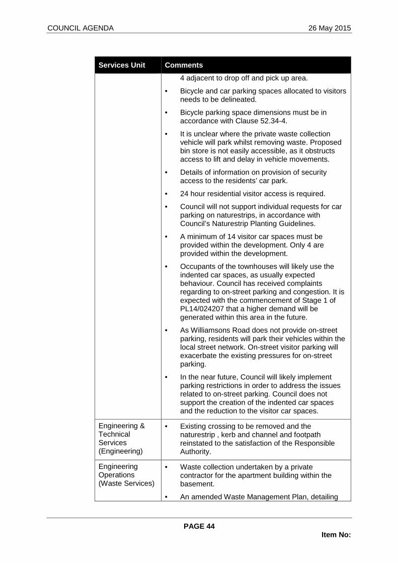
COUNCIL AGENDA 26 May 2015
PAGE 44 Item No:
Services Unit Comments
4 adjacent to drop off and pick up area.
• Bicycle and car parking spaces allocated to visitors needs to be delineated.
• Bicycle parking space dimensions must be in accordance with Clause 52.34-4.
• It is unclear where the private waste collection vehicle will park whilst removing waste. Proposed bin store is not easily accessible, as it obstructs access to lift and delay in vehicle movements.
• Details of information on provision of security access to the residents’ car park.
• 24 hour residential visitor access is required.
• Council will not support individual requests for car parking on naturestrips, in accordance with Council’s Naturestrip Planting Guidelines.
• A minimum of 14 visitor car spaces must be provided within the development. Only 4 are provided within the development.
• Occupants of the townhouses will likely use the indented car spaces, as usually expected behaviour. Council has received complaints regarding to on-street parking and congestion. It is expected with the commencement of Stage 1 of PL14/024207 that a higher demand will be generated within this area in the future.
• As Williamsons Road does not provide on-street parking, residents will park their vehicles within the local street network. On-street visitor parking will exacerbate the existing pressures for on-street parking.
• In the near future, Council will likely implement parking restrictions in order to address the issues related to on-street parking. Council does not support the creation of the indented car spaces and the reduction to the visitor car spaces.
Engineering & Technical Services (Engineering)
• Existing crossing to be removed and the naturestrip , kerb and channel and footpath reinstated to the satisfaction of the Responsible Authority.
Engineering Operations (Waste Services)
• Waste collection undertaken by a private contractor for the apartment building within the basement.
• An amended Waste Management Plan, detailing

COUNCIL AGENDA 26 May 2015
PAGE 45 Item No:
Services Unit Comments
information on waste collection methodology, including who will undertake the waste collection and the location of bins for collection.
• Swept path diagram to demonstrate a waste vehicle can undertake a 3-point turn within the basement.
• Information showing apartments will be insulated from noise to comply with residential amenity provisions if they are adjacent or above the rubbish chutes or waste storage facilities.
• Clarification on where the private waste collection vehicle will stop to undertake waste collection, so that waste collection will not impede vehicle movement within the basement.
• Council waste collection provided for the eight dwellings orientated to Henry Street.
Sustainability Engineer
• An amended Sustainability Management Plan with the following details:
2.2.7 Artificial Lighting System
o Warm white LED fittings throughout due to cost parity to CFLs which are also nearing obsolescence;
2.3.1 Rainwater Harvesting
o Indicate on plans 32,000L total rainwater capacity;
o Indicate overflow to detention system via gravity flow for rainwater tanks; and
o Indicate on plans the rainwater tank connection to all toilets and irrigation as per STORM report.
Urban Design Apartment building
• The building material palette is limited, and the building elevations are repetitive and monotonous. The building design would benefit from some stepping of levels to reduce visual bulk, the incorporation of architectural framing elements, additional recessed and extruded building elements, feature screening elements and other devices designed to define individual apartments and create visually interesting and dynamic facades.
• Orientation and internal arrangement does not maximise access to views and natural light; with

COUNCIL AGENDA 26 May 2015
PAGE 46 Item No:
Services Unit Comments
most apartments having only morning or afternoon sun.
• More substantial canopy tree planting is required to maintain the landscape character along Williamsons Road. (Refer to Open Space comments regarding the provision of a tree reserve).
Townhouses
• ‘Box-like’ design with minimal articulation of the Henry Street frontage is not in keeping with properties on the south side of Henry Street, which have conventional sloping roof lines.
• Orientation is poor. Outdoor courtyards on the south-side are shaded all day, only four dwellings will have northerly balconies and these are small. Four of the townhouses have only south windows.
Open Space Planning
• The ‘pocket park’ provided as part of this development is not an adequate size or in a location that would service any function other than being an attractive landscaped frontage for this development. This area does not provide benefit to the broader community. It should be made clear that Council has no interest in the management of the space.
• Council should require this development to provide a consistent tree reserve along the Williamsons Road frontage of this development.
• There needs to be clear demarcation of public and private pedestrian links to Henry Street and to the pocket park.
• There is no pedestrian route provided between the apartments and the pocket park on either the east or west side of apartment.
• Apartments and townhouses on the south side of the development should provide an active facade on Henry Street, including transparent fencing and low planting, not the private courtyards proposed. Overshadowing will be significant under the current proposal and the amenity and viability of planting will questionable.
• Entry pedestrian paving treatment from Williamsons Road is attractive but unpractical, and cannot be provided in the road reserve. Fully paved access to the building should be provided, not intermittent grassed.

COUNCIL AGENDA 26 May 2015
PAGE 47 Item No:
Services Unit Comments
• More details are required regarding the pocket park/communal open space to ensure it is viable and amenable, in addition to clarification on ‘shared enclosed landscaped area’ (i.e will it be designated for only the apartment building or also part of the development at PL14/024208, fenced/locked and details of fencing).
8 CONSULTATION
8.1 The application was advertised by sending notices to adjoining and surrounding property owners and occupiers, and erecting four signs on site between the 17 February 2015 to 15 March 2015. A total of 8 objections have been received, of which two contain multiple signatures.
8.2 Details are as follows:
Affected Property Address
50 Margot Avenue, DONCASTER VIC 3108
2 Birbank Court, DONCASTER VIC 3108
36 Henry Street, DONCASTER VIC 3108*
25 Magnolia Drive, TEMPLESTOWE LOWER VIC 3107
2A Henry Street, DONCASTER VIC 3108
8A Henry Street, DONCASTER VIC 3108
10 Henry Street, DONCASTER VIC 3108
27 Henry Street, DONCASTER VIC 3108*
8.3 * indicates multi-signatories to the one objection (23 & 19 signatures respectively)
8.4 The issues are summarised below:
• Appropriateness of an apartment within the context of the surrounding area;
• Compliance with the General Residential Zone, Schedule 3;
• Inadequate on-site parking provision;
• Height of apartment building;
• Visual bulk of apartment building;
• General loss of amenity (overshadowing and privacy)
• Appropriateness of the row of eight attached townhouses within the context of the surrounding area;
• Capacity of Henry Street for safe traffic flow;
• Extent of notification during advertising period (resident resides at No. 2 Birbank Court); and
• Inadequate provision for landscaping.

COUNCIL AGENDA 26 May 2015
PAGE 48 Item No:
Appropriateness of an apartment within the context of the surrounding area
8.5 The character of the neighbourhood is relatively homogenous and is typified by predominantly one and two-storey brick dwellings, generally designed with hipped, tiled roofs (often with eaves). Housing in this area has been constructed since the mid-1970’s, but with some relatively recent in-fill developments in streets near the subject land.
8.6 The application site is located within Precinct 4 Post 1975 Residential Areas” of Clause 21.05 and seeks to achieve an “incremental” level of change. As the dwellings on Henry Street are “younger” housing, the existing dwellings will remain unaltered for another 20 more years. The application site is an unusually large site within the surrounding area and can support a variety of development. However, there is no strategic policy support that seeks to encourage an apartment style development within this part of the municipality. The site is located between a Residential Growth Zone and an Activity Centre Zone to the south and a Low Density Residential Zone to the north. It appears that an apartment style development will be inconsistent with Council’s broad residential strategy, as a lower scale and less intense development will provide an acceptable transition to the predominate residential built form within the surrounding area.
8.7 Furthermore, the site falls to the north and Williamsons Road is an undulating road with views beyond the site. Therefore, a part-five storey apartment building will be very prominent beyond the site.
Compliance with the General Residential Zone, Sched ule 3
8.8 The site is within a General Residential Zone, Schedule 3 and there is no policy support for an apartment style development. Council has designated areas which support higher density, apartment style developments, such as properties within a Residential Growth Zone, General Residential Zone, Schedule 2 within a Design and Development Overlay and the Activity Centre Zone. This site has not been included in any of these zones, even when the new residential zones were implemented in June 2014.
8.9 Pursuant to the General Residential Zone, Schedule 3, the maximum building height is 10.0m due to the slope of the land. The apartment building does not comply with the maximum building height (16.76m and 18.06m to plant screen).
Inadequate on-site parking provision
8.10 Pursuant to Table 1 of Clause 52.06, a minimum of one car space is required for one and two bedroom dwellings for residents and one car space per five dwellings is required for visitors. Therefore, the development requires a minimum of 72 car spaces for residents and 14 car spaces for visitors.
8.11 The apartment building will have two surplus car spaces, which will be allocated to residents and only 4 visitor car spaces will be provided within the forecourt area. The 6 indented car spaces within the naturestrip cannot be counted towards the visitor car spaces, as these spaces will not be exclusively allocated for visitors of the development and Council will not support the indented car spaces within the naturestrip.
8.12 Therefore, the development has a shortfall of 8 car spaces (if the two surplus residential car spaces within the basement are allocated for visitors,

COUNCIL AGENDA 26 May 2015
PAGE 49 Item No:
otherwise will be 10). Based on the decision guidelines of Clause 52.06, the proposed development does not meet the short-term (2 hours) peak visitor car parking demand and will likely place additional pressures on existing on-street parking on Henry Street, as the car spaces for the row of eight townhouses are within the basement and the close proximity of the indented car spaces directly in front of the townhouses will likely be used by the residents.
8.13 Council’s Traffic Engineers have advised that due to existing on-street parking demands and the higher expected parking that will be generated by the development as part of PL14/024208, parking restrictions are expected to be implemented in the near future to address the issues related to on-street parking. On this basis, the car parking reduction is not supported.
Height of apartment building
8.14 The maximum building height for apartment style developments within a Residential Growth Zone and General Residential Zone Schedule 2 within the Design and Development Overlay is 11m and three-storey apartment style developments (if conditions are met). The proposed apartment building has a maximum building height of 16.76m (18.06m to plant screen) exceeds even the maximum building height of developments within these designated areas by 5.76m. Pursuant to the General Residential Zone, the maximum building height is 10.0m.
8.15 Pursuant to Standard B7, “changes in between existing buildings and new buildings should be graduated” and one of the decision guidelines of Clause 55.03-2 stipulates that consideration should be given to “the relationship to the proposed building height and the height of existing buildings”. As previously discussed, the immediate surrounding properties are characterised by one or two-storey residential built forms, whereas the apartment building seeks to provide a part-five storey built form. It is noteworthy that the semi-basement projects 3.2m above the ground from the north to west (Williamsons Road), which is the lowest side on the site and elevates the building height further. The northern aspect of the site is also the most visually prominent, due to the slope.
8.16 A part-five storey building within this context appears at odds with the prevailing built forms and would be visually dominating when viewed from the north and beyond the site. The height and scale of this building appears more fitting within the Activity Centre Zone. Given that the Activity Centre Zone is located 873m south of the site, the development of such a height and scale is located on the wrong site. If the apartment building is approved, it will tower over all properties on Williamsons Road and beyond. It is considered that the apartment building has no relationship to the prevailing built forms and there is no strategic policy to support such a significant height.
Visual bulk of apartment building
8.17 There is no stepping between the levels to alleviate the bulky appearance and there lacks variety in materials that adds visual interest. The building mass is emphasised by the horizontal appearance of the balconies. The building lacks vertical elements and portal frames that project forwards, in addition to modulation, stepping and variation to the setbacks and location of balconies. The bulky appearance is emphasised further by the 3.2m high

COUNCIL AGENDA 26 May 2015
PAGE 50 Item No:
elevated semi-basement and the high Gabion retaining walls within the Williamsons Road frontage.
General loss of amenity (overshadowing and privacy relating to apartment building)
8.18 The apartment building would not result in any overshadowing of Williamsons Road and any unreasonable overshadowing to any adjoining property.
8.19 At the morning period, there will be two small areas on Williamsons Road (in front of the site) which will be overshadowed but from 11am onwards, the angle of the overshadowing will be directed to the south, with no part of Williamsons Road being overshadowed by the building. At 3pm, there will be some additional overshadowing (beyond the boundary fence) to the rear of No. 1 Henry Street.
Appropriateness of the row of eight attached townho uses within the context of the surrounding area
8.20 The row of eight townhouses on Henry Street is one linear attached built form. They are monotonous with repetitive design elements. No visual break or separation is provided to the 51.4m length built form (equivalent to four and half properties). It is noted that no other properties on Henry Street will have the same opportunity to develop their land at a similar intensity due to the prevailing lot sizes. The significant length of the building is at odds with the separation and pattern of dwelling spacing within Henry Street. The dwellings will have a strong presence on the streetscape. Additionally, the third floor of the apartment building will encroach on the rooftop of the row of eight dwellings (setback 9.37m from Henry Street). Therefore, the middle section of the row of dwellings (D.04 – D.07) will appear as a four storey built form with a maximum building height of 14.15m, whereas the maximum building height is 10.0m (exceeding by the maximum building height by 4.15m). Essentially, the townhouses appear as one large rectangle with a pop-up middle section.
8.21 The attached row of eight dwellings offers a contemporary statement that has no has relationship to the prevailing residential built forms on Henry Street. The rectangular form of the dwellings is ‘box-like’ in design. The dwellings lack articulation and the first floor has not been recessed from the ground floor to mitigate visual bulk. The lack of break and modulation, in addition to pop-top level exacerbates the visual dominance within the streetscape. It is considered that the proposed design does not respect the preferred neighbourhood character, which seeks to achieve an “incremental” level of change. The intensity of the development with no physical articulation and separation between the dwellings to provide a ‘break’ is inconsistent with the prevailing character of dwelling spacing on Henry Street.
Capacity of Henry Street for safe traffic flow
8.22 Henry Street is a local road and has a trafficable carriageway width of 4.5m, within a 15m wide road reserve. Unrestricted kerbside parking is permitted on both sides of Henry Street. The mildly curvilinear alignment of the street results in some wider sections of nature strip adjacent to the site, which splays towards the south, on the southern side. Mountable kerbs are

COUNCIL AGENDA 26 May 2015
PAGE 51 Item No:
provided and there is a concrete footpath on the northern side, off-set from the southern boundary of the site.
8.23 Due to its narrow carriageway width, vehicles are parked on naturestrips and sometimes parked vehicles hover between the kerb and street. Due to the existing pressures of on-street parking and the potential impact of Stage 1 of PL14/024208, parking restrictions will be implemented in the near future to ensure that adequate trafficable carriageway is provided for safe traffic flow.
8.24 Based on the last traffic count taken in front of 40 Henry Street (October 2013), the traffic volume on Henry Street was 440 vehicles per day and the 85th percentile speed was 43.9kph. Henry Street has the capacity to accommodate 1200 to 1500 vehicles per day before any residential amenity is adversely affected. The proposed development will result in 413 vehicles per day and 45 vehicles in peak hour. The traffic volume per day is well within the acceptable limits for a classified local street network and Henry Street serves a fairly defined catchment, as it does not attract too much ‘rat runs’ given that alternative routes to Williamsons Road are available, such as Clancys Lane and Margot Avenue.
Extent of notification during advertising period
8.25 A resident that resides at No.2 Birbank Court claims that they did not receive a personal letter from Council during the notification period and that they should have. The property is located 1.2km from the closest part of the application site, which does not adjoin the land. Council has fulfilled the notice requirements in accordance with Section 52 of the Act, by erecting 4 signs on site and sending notices to adjoining properties. The purpose of the notices is to ensure that surrounding residents are aware of the application. It is considered that Council has more than satisfied the notice requirements, as the residents are aware of the application.
Inadequate provision for landscaping
8.26 It is considered that there are inadequate canopy trees provided on the Williamsons Road reserve and there are inadequate canopy trees within the front setback to soften the built form and to provide a visual separation. Council’s Open Space concurs that the lack of canopy trees within the Williamsons Road reserve fails to provide for a consistent treed streetscape.
8.27 Additionally, the small linear spaces in front of the fences on Henry Street will be unable to support substantial canopy trees and given that this area is south facing, the area will always be overshadowed. Therefore, it will be difficult for landscaping to establish within this area.
9 CONCLUSION
9.1 It is considered appropriate to not support the application as a part-five storey apartment building grossly exceeds the maximum building height and it is contrary to Council’s residential strategy. The significant height and scale of the apartment building is at odds with the prevailing residential built forms and will be visually prominent when viewed beyond the site. It is considered that the apartment is not innovative and not of a high architectural standard.
9.2 The row of eight attached townhouses orientated on Henry Street results in a long linear built form with no break or separation that will overwhelm the homogenous streetscape. The building with the middle ‘pop-top’ section will

COUNCIL AGENDA 26 May 2015
PAGE 52 Item No:
result in a height that is at odds with the existing residential scale of adjoining properties.
9.3 The development does not meet the minimum visitor car parking requirements of Clause 52.06, and relies on the creation of indented car spaces and on-street parking on Henry Street to meet the peak short-term visitor car parking.
9.4 The indented parking bays on Henry Street are not supported as it is contrary to Council’s Nature strip Planting Guidelines
RECOMMENDATION That having considered all objections A NOTICE OF R EFUSAL TO GRANT A PERMIT be issued in relation to Planning Application No.PL 14/024620 for the development and use of No.154-166 Williamsons Road (Lot 1 TP136753B , Lot 1 LP86073 & Lot 1 TP139290A & Lot 4 LP15302) for the purpose of cons truction of a part five-storey apartment building comprising sixty-four (64) dwell ings and an attached row of eight (8), two-storey dwellings orientated to Henry Stree t, in addition to a basement car park comprising of 74 car spaces and 4 visitor car space s on the forecourt at the ground level, in addition to the creation of 6 indented ca r spaces on Henry Street, a reduction of eight (8) car spaces in the provision of on-site car parking in accordance with Clause 52.06 and alteration to vehicle access for a road in a Road Zone Category 1 and for no other purpose in accordance with the end orsed plan and subject to the following grounds-
Apartment Building
1. The apartment building lacks pedestrian related scale and the 3.2m basement projection elevates the height further, wh ich will dominant viewlines and is considered to be at odds with the low-rise residential built form in the immediate surrounding area, thus not meeting Clauses 15.01-2 and 15.01-5.
2. It is considered that the height and scale of th e apartment building lacks strategic policy support and is contrary to Council ’s Residential Strategy, thus not meeting Clause 21.05 – Residenti al within the Municipal Strategic Statement (Precinct 4 – Post 19 75 Residential Areas) which anticipates an incremental level of change.
3. The development does not meet the minimum visito r car parking requirements of Clause 52.06, and relies on the cre ation of indented car spaces and on-street parking on Henry Street to mee t the peak short-term visitor parking.
4. The creation of the 6 indented car spaces on Hen ry Street will not be supported, as it is contrary to Council’s policy “N ature Strip Planting Guidelines”.
5. A number of car spaces have doors opening out fr om storage and services, thus not meeting Clause 52.06 Design Stan dard 1 – Accessways.
6. It is considered that the pedestrian pathway fro m Henry Street (adjacent to Dwelling D.01) creates an unsafe space, due to i ts remoteness and lack of passive surveillance, thus not meeting Clau se 22.08 and Clause 52.06 Design Standard 6 – Safety.

COUNCIL AGENDA 26 May 2015
PAGE 53 Item No:
Townhouses
7. The attached row of eight townhouses results in a long linear building that is at odds with the separation and pattern of dwelling spacing within Henry Street. The intensity of the development with no physical articulation and separation between the dwellings i s inconsistent with the preferred neighbourhood character, thus not mee ting Clause 21.05 Clause 21.05 – Residential within the Municipal Str ategic Statement (Precinct 4 – Post 1975 Residential Areas) and Clau se 55.02-1 Neighbourhood Character.
8. It is considered that the minimum front setback does not reflect the prevailing setbacks in Henry Street. The row of att ached dwellings with a reduced front setback, in addition to the inability to accommodate canopy trees within the front setback, as the front ages will be paved to provide primary open spaces, thus not meeting Claus e 55.03-1 Street Setback.
9. The pop-top section where the apartment building encroaches over the rooftop of the townhouses will result in a building height of 14.15m. It is considered that the maximum building height does no t meet the preferred neighbourhood character and the building height standard and objective of Clause 55.03-2.
10. There is no direct pedestrian links from the ap artment building or townhouses to the pock park, thus not meeting Claus e 55.03-6 Open Space.
11. It is considered that there is inadequate canop y trees provided on the Williamsons Road reserve and within the front setba ck to soften the built form and to provide a visual separation. Additional ly, the small linear spaces in front of the fences on Henry Street will be unable to support substantial canopy trees, given this area is south- facing and will always be overshadowed, thus not meeting Clause 55.03-8 La ndscaping.
12. The habitable room windows have not been orient ated and designed so that is prevent internal overlooking into adjoining private courtyards. The screening of habitable room windows will limit views beyond the site and natural light, thereby resulting in poor intern al amenity, thus not meeting Clause 55.04-7 Internal Views.
13. The monotonous design and repetitive materials of the dwellings makes it difficult to distinguish one dwelling from anoth er. Each dwelling should be designed to provide for its own sense of identity, Clause 55.05-2 Dwelling Entry.
14. The south-facing courtyards are in appropriate forms of private open space as they will be overshadowed throughout the d ay, only the dwellings with north-facing terraces will have good solar access. The south-facing courtyards do not meet the standard an d objective of Clause 55.05-5 Solar Access to Open Space.
15. The development fails to provide a high quality architectural response, which incorporates articulation, design detail and visual interest to reduce visual bulk. No provision for visual break a nd modulation is provided. In addition, the eastern wall of Dwelling D.01 and the western wall of Dwelling D.08 are characterised by sheer bl ank walls, in addition

COUNCIL AGENDA 26 May 2015
PAGE 54 Item No:
to the repetitive materials fail to provide visual interest. The development fails to provide a degree of transition to surround ing development through height and articulation, thus not meeting C lause 55.06-1.
General
16. The proposed development does not represent an “incremental” level of change and fails to provide for a development that reinforces a higher level of amenity that is expected by residents with in the apartment, due to the east and west orientation and the primary so uth-facing private open spaces for the townhouses. Accordingly, the pr oposal is considered an overdevelopment.
“Refer Attachments”
* * * * *