planning commission meeting agenda monday, january … · planning commission . meeting agenda ....
TRANSCRIPT

PLANNING COMMISSION
Meeting Agenda
Monday, January 8, 2018
7:00 PM City Council Chambers – 222 NE 2nd Avenue
Commissioner John Savory (Chair)
Commissioner Larry Boatright (Vice Chair) Commissioner John Serlet
Commissioner Derrick Mottern Commissioner Tyler Hall
Commissioner Shawn Varwig Commissioner Andrey Chernishov
1. CALL TO ORDER
a. Invocation and Pledge of Allegiance
b. Chair & Vice-Chair Nominations
2. CITIZEN INPUT ON NON-AGENDA ITEMS
3. MINUTES
a. Approval of Planning Commission Minutes for December 11, 2017.
4. NEW BUSINESS
5. PUBLIC HEARING
a. Consider a request for an Annexation, Zone Map Amendment, and to adopt the South West
Canby Development Concept Plan for seven different parcels located in the southwest portion of
the City of Canby’s Urban Growth Boundary in the vicinity of S Fir Street, west of Hope Village,
and the west side of S Ivy Street, south of Hope Village. (ANN 17-02/ZC 17-03 Southwest
Canby/Stafford).
6. FINAL DECISIONS
(Note: These are final, written versions of previous oral decisions. No public testimony.)
a. Annexation, Zone Map Amendment, and to adopt the South West Canby Development Concept
Plan for seven different parcels located in the southwest portion of the City of Canby’s Urban
Growth Boundary in the vicinity of S Fir Street, west of Hope Village, and the west side of S Ivy
Street, south of Hope Village. (ANN 17-02/ZC 17-03 Southwest Canby/Stafford).
7. ITEMS OF INTEREST/REPORT FROM STAFF
a. Next regularly Planning Commission Meeting scheduled for Monday, January 22, 2018.
b. One-year Extension of Development Agreement and Conceptual Master Plan for Phase 4,
Northwood Estates Subdivision
8. ITEMS OF INTEREST/GUIDANCE FROM PLANNING COMMISSION
9. ADJOURNMENT
The meeting location is accessible to persons with disabilities. A request for an interpreter for the hearing impaired or for other accommodations
for person with disabilities should be made at least 48 hours before the meeting at 503-266-7001. A copy of this agenda can be found on the City’s web page at www.canbyoregon.gov . City Council and Planning Commission Meetings are broadcast live and can be viewed on OCTS Channel 5.
For a schedule of the playback times, please call 503-263-6287.
1
ANNEXATION AND ZONE CHANGE STAFF REPORT FILE #: ANN 17-02/ZC 17-03
Prepared for the January 8, 2018 Planning Commission Meeting
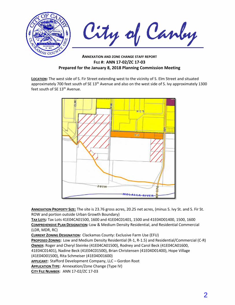
LOCATION: The west side of S. Fir Street extending west to the vicinity of S. Elm Street and situated approximately 700 feet south of SE 13th Avenue and also on the west side of S. Ivy approximately 1300 feet south of SE 13th Avenue.
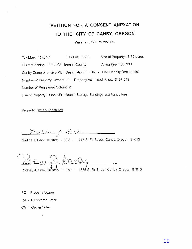
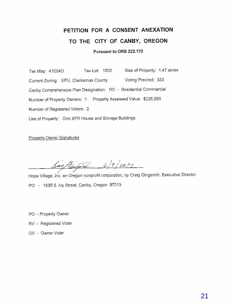
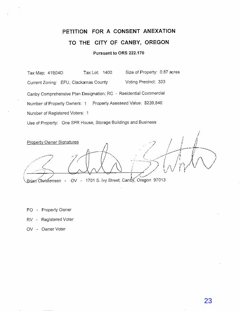
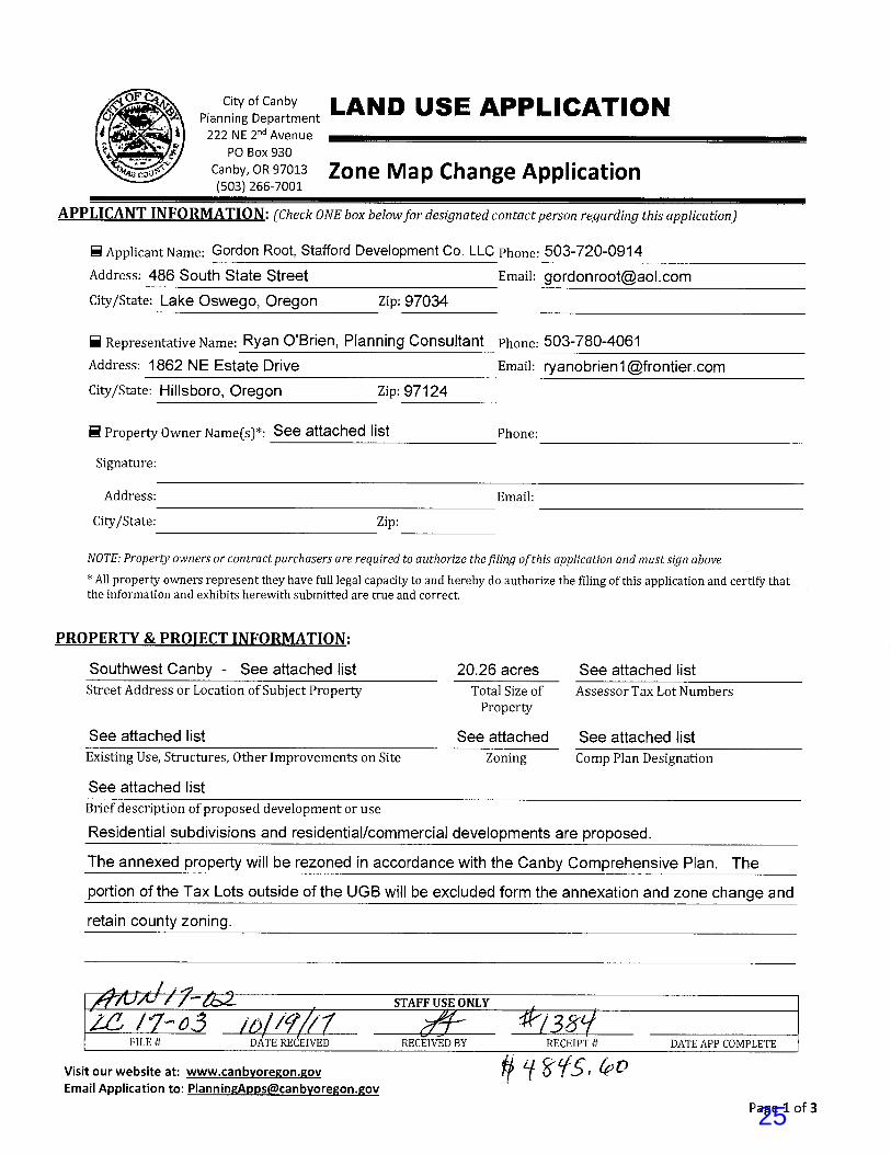
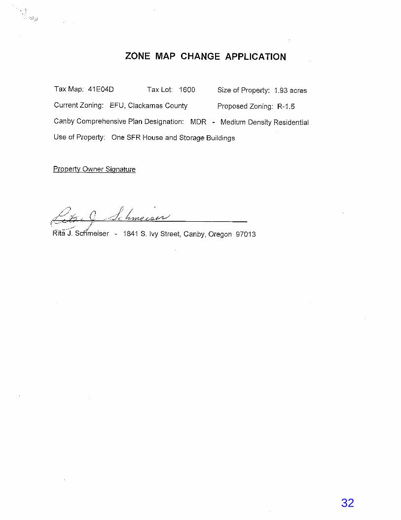
ANNEXATION PROPERTY SIZE: The site is 23.76 gross acres, 20.25 net acres, (minus S. Ivy St. and S. Fir St. ROW and portion outside Urban Growth Boundary) TAX LOTS: Tax Lots 41E04CA01500, 1600 and 41E04C01401, 1500 and 41E04D01400, 1500, 1600 COMPREHENSIVE PLAN DESIGNATION: Low & Medium Density Residential, and Residential Commercial (LDR, MDR, RC) CURRENT ZONING DESIGNATION: Clackamas County: Exclusive Farm Use (EFU) PROPOSED ZONING: Low and Medium Density Residential (R-1, R-1.5) and Residential/Commercial (C-R) OWNER: Roger and Cheryl Steinke (41E04CA01500), Rodney and Carol Beck (41E04CA01600, 41E04C01401), Nadine Beck (41E04C01500), Brian Christensen (41E04D01400), Hope Village (41E04D01500), Rita Schmeiser (41E04D01600) APPLICANT: Stafford Development Company, LLC – Gordon Root APPLICATION TYPE: Annexation/Zone Change (Type IV) CITY FILE NUMBER: ANN 17-02/ZC 17-03
City of Canby
2
I. PROJECT OVERVIEW & EXISTING CONDITIONS
The property owners of seven different parcels located in the southwest portion of the City of Canby’s Urban Growth Boundary (UGB) propose annexation into the city limits. The property owners also propose a zone change application to change the current zoning from the Clackamas County EFU, Exclusive Farm Use designation to City of Canby’s R-1, Low Density Residential, R 1.5, Medium Density Residential, and C-R Residential/Commercial Zones. The subject parcels are not all contiguous but separated by intervening properties that are not included in this annexation. Four tax lots are located on the west side of S. Fir Street and the three remaining parcels are situated approximately 950 feet to the east and on the west side of S. Ivy Street. Property owners of tax lots 41E04CA01500, 01600, 41E04C01401, and 41E04D01600 request to zone their parcels R-1.5, tax lot 41E04C01500 R-1, and tax lots 41E04D01400, 01500 C-R. The properties are currently in residential, open space, and agriculture uses. The City of Canby’s annexation ordinance requires a Concept Development Plan for properties that are a part of an annexation request when located in a Development Concept Area as indicated on the City of Canby Annex Development Map. The Southwest Canby Development Concept Plan (SCDCP) for properties in the area was developed by Stafford Land Development with input from The Mayberry Group, Inc. who is doing a separate annexation application in the same DCP area and also with input from the property owners within the SCDCP. However, the plan has yet to be adopted by the Canby City Council and must be in conjunction with approval to annex any properties within the DCP area. The existing annexation area is located within the City of Canby’s Urban Growth Boundary. The City of Canby Comprehensive Plan has envisioned the ultimate urbanization of this area and its intended land use, and the Comprehensive Plan Map for these particular lots indicates a mixture of Low Density Residential, Medium Density Residential, and Residential Commercial uses. These designations correspond to the zone changes requested by the applicants. The area is currently within Clackamas County’s jurisdiction and is presently zoned as Exclusive Farm Use (EFU). This zone change is to rezone the properties involved to the City zoning of R-1, R-1.5, and C-R zones in accordance with the corresponding City Comprehensive Plan Map land use designation. The zone designations will take effect when the properties are annexed as indicated in this application. The Southwest Canby Development Concept Plan (SCDCP) is intended to address City of Canby infrastructure requirements for the southwest Canby area. The SCDCP is not a specific development proposal, but a design concept that provides an understanding and framework prior to annexation of how the properties must be developed when brought into the City.
II. ATTACHMENTS
A. Application Forms B. Submitted Written Narrative and materials C. Chart of Available Platted Lot Supply in Canby D. Chart of Available lots and Permits Issued in Last Ten Years E. Neighborhood Meeting Notes/Attendance List/Notification Letter F. Pre-Annexation application Meeting Minutes G. Consent to Annexation Petition
3
H. Survey of Property to Be Annexed and Legal Description of Private Property and adjacent S. Fir St. and S. Ivy St. Right-of-Way to be Annexed
I. Tax Lot Ownership Survey J. Maps: Aerial Vicinity Map, Assessor Map, Canby Comprehensive Plan Map, Proposed
Annexation Area Map K. Development Concept Plan Submittal Packet L. Traffic Analysis - contracted by applicant with City’s Consulting Traffic Engineer M. Agency/Citizen Comments
III. APPLICABLE REVIEW CRITERIA & FINDINGS
Major approval criteria used in evaluating this application include the following Chapters from the City of Canby’s Municipal Code including the Land Development and Planning Ordinance (Title 16):
16.84 Annexations
16.54 Amendments to Zoning Map
16.89 Application and Review Procedures
16.16 R-1 Low Density Residential Zone
16.18 R-1.5 Medium Density Residential Zone
16.24 C-R Residential/Commercial Zone
City of Canby Comprehensive Plan Policies and Implementation Measures Clackamas County/City of Canby Urban Growth Management Agreement (UGMA) State Statutes- ORS 195.065 and 222
C h a p t e r 1 6 . 8 4 A n n e x a t i o n C o m p l i a n c e
16.84.040. A.1.b. Annexation Development Map.
A. The following criteria shall apply to all annexation requests.
1. The City of Canby Annexation Development Map shall determine which properties are
required to submit either (See Figure 16.84.040):
a. A Development Agreement (DA) binding for all properties located within the
boundaries of a designated DA area as shown on the City of Canby Annexation
Development Map. The terms of the Development Agreement may include, but are
not limited to:
1. Timing of the submittal of an application for zoning
2. Dedication of land for future public facilities including park and open space
land
3. Construction of public improvements
4. Waiver of compensation claims
5. Waiver of nexus or rough proportionality objections to future exactions
6. Other commitments deemed valuable to the City of Canby
4
For newly annexed properties that are within the boundaries of a DA area as designated on the
City of Canby Annexation Development Map: A Development Agreement shall be recorded as a
covenant running with the land, binding on the landowner’s successors in interest prior to the
City Council granting a change in zoning classification.
b. A Development Concept Plan (DCP) binding for all properties located within the
boundaries of a designated DCP area as shown on the City of Canby Annexation
Development Map. A Development Concept Plan shall address City of Canby
infrastructure requirements including:
1. Water
2. Sewer
3. Storm water
4. Access
5. Internal Circulation
6. Street Standards
7. Fire Department requirements
8. Parks and open space
For newly annexed properties that are within the boundaries of a DCP area as designated on the City of Canby Annexation Development Map: A Development Concept Plan shall be adopted by the Canby City Council prior to granting a change in zoning classification. (Ord. 1294, 2008) Findings: A copy of the Southwest Canby Development Concept Plan (SCDCP) is included in the file. The SCDCP provided an extensive packet of information to address City of Canby future infrastructure requirements for the area, and engineering level work has gone into planning for how the concept plan defined area would best be developed and served by all necessary infrastructure. A traffic analysis of the entire subject area was incorporated into the plan to address traffic impacts associated with anticipated full development of the properties in accordance with the applicable zoning designation. DKS Engineering provided a TIA, dated September 29, 2017 that summarized how the requirements of Oregon Administrative Rule (OAR) 660-012-0060, the Transportation Planning Rule (TPR), are met for the subject properties as well as the SCDCP area. The surrounding roadways and intersections were found to have sufficient capacity to accommodate the proposed annexation, zone change, and for the development concept plan. The Transportation Planning Rule requirements of State Statue were determined to have been met as documented in the TIA. All necessary utility services are generally available or can be made available through service line extensions to the annexation area. The Concept Plan maps, along with the Concept Plan & Infrastructure narrative, indicate the options for necessary infrastructure to serve this area. Stormwater was discussed in the SCDCP, and stormwater management for street runoff will be handled with the installation of new public underground injection wells and the associated catch basins and pollution control manholes for water quality treatment. Private property runoff will be handled on-site with infiltration facilities on each lot within the individual yard areas.
5

The SCDCP proposed three “pocket parks” and a 2,500 foot trail that will extend along the south boundary of the concept area. Based on calculations included in the concept plan the park acres to dwelling units ratio requires 5.24 acres of parks or open space. The proposed parks and trail area results in 3.65 acres, and the plan indicates that the remaining 1.59 acres will be collected by the City as a fee in lieu as a park system development charge. The basic strategy recommended for park appropriation is that Parks SDC fees paid by property owners who are not dedicating land be collected into a “Parks SDC Account” or similar, and that these funds be used to compensate property owners who dedicate land. In order for this mechanism to work, the value of property owners’ land contributions needs to be established by appraisal. A more detailed explanation of this process is located in the SCDCP. This criterion can be met.
Criteria 16.84.040.A.2 Analysis of the need for additional property within the city limits shall be provided. The analysis shall include the amount of developable land (within the same class of zoning – low density residential, light industrial, etc.) Currently within the city limits; the approximate rate of development of those lands; and how the proposed annexation will affect the supply of developable land within the city limits. A supply of developable residential land to provide for the anticipated population growth over the following three years is considered to be sufficient. Findings: A land needs analysis is required with all annexations to assess the current amount of developable land within the same zone designation of that requested in the application. A 3-year supply of developable R-1, R 1.5, and C-R zoned land is to be considered sufficient. The City Council previously provided a defined policy direction to staff that stated, analysis of actual number of platted lots based on a reasonable assessment of expected consumption rate moving forward, is the appropriate metric to utilize in determining the adequacy of the developable land supply. The applicant included in the file an analysis indicating the deficiency of Canby’s 3-year supply of developable land based on population data and existing available platted lots. The study determined that currently forty-six R-1 zoned vacant platted lots remain as inventory within the city limits, no R-1.5 zoned vacant lots, and one C-R zoned vacant lot. The city has had an average absorption rate of nearly 45 lots per year for the last 10 years. The information stated that, based on a three year average of 2017, 2018, and 2019, a total of 379 single-family platted lots needed through 2020 with 46 currently available which leaves a deficiency of 333 lots. This indicates the supply of readily available platted lots with all necessary infrastructures is below a three-year supply. The applicant also provided an additional analysis that included subdivisions that are preliminarily approved and have yet to record platted lots. The consideration of the additional lots still left a deficiency of 80 lots. If annexed, this property would add to the buildable land supply. It will likely take 2 to 3 years for this land to be fully platted and the lots made available. Staff concludes that information indicates this criterion is met.
Criteria 16.84.040.A.3 Statement of potential physical, aesthetic and related social effects of the proposed development on the community as a whole and on the neighborhood of which it will become a part; and proposed actions to mitigate identified concerns, if any. A neighborhood meeting is required as per Table 16.89.020 of the City of Canby Land Development and Planning Ordinance.
6

Findings: Future development is anticipated to develop the site at a higher net density per acre. However, potential traffic generation has been shown to be within the capabilities of the surrounding road system with no mitigation necessary. The addition of three new small neighborhood parks and a walking trail along the UGB boundary will be located within the SCDCP, will add to the social and aesthetic effects of development on the subject properties and the future development of the neighborhood livability. Staff does not foresee any significant impacts from the proposal or need to mitigate any identified concerns. Staff agrees the annexation and future development of the subject parcels is consistent with development indicated by the Development Concept Plan and appropriate in this area of Canby. This criterion is satisfied.
Criteria 16.84.040.A.4 Statement of availability, capacity and status of existing water, sewer, drainage, transportation, park and school facilities Findings: The Southwest Canby Development Concept Plan provides maps that demonstrate how utility infrastructure will be made available, and unmanageable capacity issues were not identified by City departments and agencies during the SCDCP review process. The proposed public parks and trail will be beneficial in serving this area of Canby. There are significant tree resources available for the park area and the conceptual plan provides easy direct access from the subject properties to the park trails and facilities. This criterion can be met at the time of development.
Criteria 16.84.040.A.5 Statement of increased demand for such facilities to be generated by the proposed development, if any, at this time Findings: Staff finds that the information contained in the SCDCP infrastructure section is sufficient, and the applicable criteria can be met. Full development of the SCDCP area will require the City to build a new sewer pump station at the southeast corner of the DCP area to serve a large portion of the DCP.
Criteria 16.84.040.A.6 Statement of additional facilities, if any, required to meet the increased demand and any proposed phasing of such facilities in accordance with projected demand.
Findings: This staff report incorporates the infrastructure sections of the SCDCP as findings. All necessary utility extensions are available to serve this area when development occurs after annexation. The infrastructure section of the SCDCP indicates that connections to existing facilities are available and preferred depending on the development project. However, the City Engineer commented that a new pump station and pressure main construction will be required. Staff finds that with appropriate conditions of approval, the SCDCP information is sufficient and this criterion is or can be met.
Criteria 16.84.040.A.7 Statement outlining method and source of financing required to provide additional facilities, if any.
Findings: The applicant will pay the necessary costs of their own development. Information in the SCDCP indicated that most infrastructure facilities in the southwest Canby area are expected to be built by individual developers. The exception is the proposed park that can be
7
likely funded with City capital improvements project funds from SDC fees. Staff finds that information in the SCDCP is sufficient for this case, and the applicable criteria can be met.
Criteria 16.84.040.A.8 Statement indicating the type and nature of any comprehensive plan text or map amendments or zoning text or map amendments that may be required to complete the proposed development.
Findings: The applicant intends to follow the low density residential, medium density residential, and residential commercial zoning designation of the Comprehensive Plan. The only change is a zoning map amendment to change the zone to R-1, R-1.5, and C-R and the Zone Map Change Application that accompanies this annexation request to satisfy the Development Concept Plan. Staff finds that the criterion in 16.84.040.A.8 can be met.
Criteria 16.84.040.A.9 Compliance with other applicable city ordinances or policies
Findings: Based on available information, staff concludes that the proposal complies with all other city ordinances and policies.
Criteria 16.84.040.A.10 Compliance of the application with the applicable sections of Oregon Revised Statutes Chapter 222 Findings: Oregon Revised Statutes (ORS) Chapter 222 provides regulation of city boundary changes and other development requirements. Staff concludes that this proposal complies with all applicable provisions in the Oregon Revised Statutes. The applicable criteria can be met.
C h a p t e r 1 6 . 5 4 A m e n d m e n t s t o t h e Z o n i n g M a p A n a l y s i s
The assignment of an appropriate zoning district is a part of any annexation application within the City of Canby. The approval criteria are similar to that for approval of an annexation.
16.54.010 & 0.20 & 0.30 Amendments to the Zoning Map
Findings: 16.54.010 – Authorization to initiate amendments: The property owners have authorized initiation of the proposed annexation and map amendment by signing an application form and Consent to Annex Form. This criterion has been met. 16.54.020 – Application and Fee: The map amendment application and associated fee were received from the applicant. This criterion has been met. 16.54.030 – Public Hearing on Amendment: This criterion will be met when the Planning Commission holds a public hearing and makes a recommendation to the City Council and when the City Council conducts its own hearing and issues a decision.
16.54.040 Standards and criteria
In judging whether or not the zoning map should be amended or changed, the Planning
Commission and City Council shall consider:
8
A. The Comprehensive Plan of the city, giving special attention to Policy 6 of the land use element
and implementation measures therefore, and the plans and policies of the county, state and local
districts in order to preserve functions and local aspects of land conservation and development;
Findings: The subject properties and the SCDCP are not identified as being in an “Area of Special Concern” that is delineated in Policy 6 of the Comprehensive Plan. Additionally, the proposed zone for the properties is consistent with the zone designation on the Comprehensive Plan Map. Staff concludes that the request meets provisions in Policy 6 and the Comprehensive Plan.
B. Whether all required public facilities and services exist or will be provided concurrent with
development to adequately meet the needs of any use or development which would be permitted
by the new zoning designation. (Ord. 749 section 1(B), 1984; Ord.740 section 10.3.85(D), 1984)
Findings: Problems or issues in the extension of utility services have not been raised by City service providers that would prevent services at the time of development. It appears that future development of the properties can meet standards for adequate public facilities. 16.08.150 Traffic Impact Study (TIS) A. Determination based on information provided by the applicant about the proposed
development, the city will determine when a TIS is required and will consider the following when making that determination. 1. Changes in land use designation, zoning designation, or development standard. 2. Changes in use or intensity of use. 3. Projected increase in trip generation. 4. Potential impacts to residential areas and local streets. 5. Potential impacts to priority pedestrian and bicycle routes, including, but not limited to
school routes and multimodal street improvements identified in the TSP. 6. Potential impacts to intersection level of service (LOS).
Findings: The Transportation Planning Rule within State Statute (OAR 660-12-0060-9) requires that there be a record of traffic generation findings which are consistent with the City’s Transportation System Plan with any Comprehensive Plan Map Amendment or Zoning Map Amendment. As previously mentioned, DKS Engineering provided a section of the SCDCP that confirmed the proposed annexation met provisions of the TPR. Additionally, a Traffic Analysis was incorporated in the SCDCP to discuss any future traffic impacts when development occurred with zone change proposals. The findings of the analysis determined that the zone change contemplated and the resulting traffic, if developed as allowed, was assumed for trip modeling in the 2010 Canby Transportation System Plan, and therefore, the Transportation Planning Rule requirements are met. The zone change from the proposed annexation would not have a significant effect on the surrounding transportation network, and no mitigation measures would be required to satisfy TPR requirements. This review criterion is met.
C h a p t e r 1 6 . 8 9 . 0 6 0 P r o c e s s C o m p l i a n c e
16.89.060 Type IV Decision
9

For certain applications, the City Council makes a final decision after a recommendation by the
Planning Commission. These application types are referred to as Type IV decisions.
A. Pre-application conference. A pre-application conference may be required by the Planning
Director for Type IV applications.
B. Neighborhood meetings. The applicant may be required to present their development
proposal at a neighborhood meeting (see Section 16.89.070). Table 16.89.020 sets the
minimum guidelines for neighborhood review but the Planning Director may require
other applications to go through neighborhood review as well.
C. Application requirements. Type IV applications shall be made on forms provided by the
Planning Director. The application shall be accompanied by all required information and
fees.
D. Public notice and hearings. The public notice and hearings process for the Planning
Commission’s review of Type IV applications shall follow that for Type III applications, as
provided in subsections 16.89.050.D and 16.89.050.E.
E. Decision process.
1. Approval or denial of a Type IV decision shall be based on the standards and criteria
located in the code.
2. The hearings body shall issue a final written order containing findings and conclusions
recommending that the City Council approve, approve with conditions, or deny the
application.
3. The written decision shall explain the relevant criteria and standards, state the facts
relied upon in rendering the decision, and justify the decision according to the criteria,
standards, and facts.
4. In cases involving attorneys, the prevailing attorney shall prepare the findings,
conclusions, and final order. Staff shall review and, if necessary, revise, these materials
prior to submittal to the hearings body.
F. City Council proceedings:
1. Upon receipt of the record of the Planning Commission proceedings, and the
recommendation of the Commission, the City Council shall conduct a review of that
record and shall vote to approve, approve with conditions, or deny the recommendation
of the Planning Commission.
2. The City Council may question those individuals who were a party to the public hearing
conducted by the Planning Commission if the Commission’s record appears to be lacking
sufficient information to allow for a decision by the Council. The Council shall hear
arguments based solely on the record of the Commission.
10
3. The City Council may choose to conduct public hearings on Comprehensive Plan
amendments, amendments to the text of this title, zone map amendments, and
annexations. If the Council elects to conduct such hearings, it may do so in joint session
with the Planning Commission or after receiving the written record of the Commission.
(Ord. 1080, 2001) Findings: Annexations are processed as a Type IV “quasi-judicial” process which is considered through a public hearing at the Planning Commission that forwards a recommendation to the City Council. The City Council also holds a public hearing and issues a final decision. The notice requirements are the same as for Type III applications. In this particular case, the annexation request will not be scheduled for a public vote. On March 15, 2016, the Governor signed Senate Bill SB1573 that mandates some properties, meeting certain criteria, to file for annexation without going through a public vote process that might otherwise currently be in effect through local City Charter provisions and adopted code. This application meets the criteria stated in SB1573, and a public vote will not be held for this annexation application. Notice of this application and the Planning Commission and Council Hearing dates was made to surrounding property owners on November 21, 2017, at least 20-days prior to the hearing. Prior notification and neighborhood meetings were completed during the Southwest Canby Development Concept Plan process. The site was posted with a Public Hearing Notice sign by December 28, 2017. A notice meeting ordinance requirements of the public hearings was published in the Canby Herald on December 27, 2017. A pre-application meeting was held March 9, 2017. These findings indicate that all processing requirements have been satisfied with this application to date.
P u b l i c T e s t i m o n y R e c e i v e d
Notice of this application and opportunity to provide comment was mailed to owners of lots within 500 feet of the subject properties and to all applicable public agencies and City departments on November 21, 2017. Complete comments are documented in the file. As of the date of this Staff Report, the following comments were received by City of Canby from the following persons/agencies: Persons/Agency/City Department Comments. Comments were received from the following persons/agencies/city departments:
Canby Fire Tom Scott Canby City Engineer
C o n c l u s i o n R e g a r d i n g C o n s i s t e n c y w i t h t h e S t a n d a r d s o f t h e C a n b y M u n i c i p a l C o d e
Staff concludes, as detailed in the submittal from the applicant and as indicated here in this staff report, including all attachments hereto, that:
1. The applications and proposed use is in conformance with applicable sections of the City’s
11

Comprehensive Plan and Land Development and Planning Ordinance when the determinations contained in this staff report are applied.
2. A City adopted Development Concept Plan and explanatory narrative must be submitted detailing how all necessary infrastructures to the properties proposed to be annexed will serve the area as required by the annexation ordinance.
3. The proposed annexation can meet the approval criteria set forth in CMC 16.84.040.A. 4. The zoning of the property, if annexed, should be R-1, R-1.5, and C-R as indicated in the
application and pursuant to the approval criteria set forth for map amendments in CMC 16.54.040.
5. The proposed annexation’s requested zoning district of R-1, R-1.5, and C-R is in conformance with the Comprehensive Plan Land Use Plan Map.
6. The application complies with all applicable Oregon Revised Statutes. 7. There are sufficient public and private agency utility and service capacity to serve the site at
the anticipated development intensity. 8. In accordance with the UGMA with Clackamas County, this proposed annexation application
includes a description of the adjacent S. Fir Street and S. Ivy Street road right-of-way with the properties proposed for annexation.
9. It has been determined that existing land available is below a three-year supply of developed R-1, R-1.5, and C-R zoned lots within the City limits. Therefore, the supply does not exceed a three-year supply and there is a “need” for low density residential zoned land for development at this time.
1 6 . 8 9 R e c o m m e n d a t i o n
Based on the application submitted and the facts, findings and conclusions of this report, but without benefit of a public hearing, staff recommends that the Planning Commission recommend to the City Council that:
1. ANN 17-02/ZC 17-03 be approved and, 2. Upon annexation, the zoning of the subject properties be designated as R-1, R-1.5, and C-R as
indicated by the Southwest Canby Development Concept Plan Map and the Canby Comprehensive Plan Map.
12

13

14

15
16

17

18
19

20
21

22
23

24
25
26
27
28

29
30

31
32

33
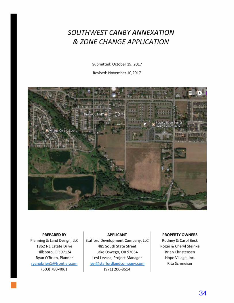
Submitted: October 19, 2017
Revised: November 10,2017
PREPARED BY APPLICANT PROPERTY OWNERS
Planning & Land Design, LLC Stafford Development Company, LLC Rodney & Carol Beck
1862 NE Estate Drive 485 South State Street Roger & Cheryl Steinke
Hillsboro, OR 97124 Lake Oswego, OR 97034 Brian Christensen
Ryan O'Brien, Planner Levi Levasa, Project Manager Hope Village, Inc.
[email protected] [email protected] Rita Schmeiser
(503) 780‐4061 (971) 206‐8614
SOUTHWEST CANBY ANNEXATION & ZONE CHANGE APPLICATION
34
Table of Contents I. Introduction ........................................................................................................................................................ 1
II. Site Description ................................................................................................................................................... 2
III. Facilities and Services ......................................................................................................................................... 3
IV. Neighborhood Meeting....................................................................................................................................... 5
V. Approval Criteria ................................................................................................................................................. 6
Canby Municipal Code ............................................................................................................................................... 6
DIVISION VI. – CHAPTER 16.84 – ANNEXATIONS ................................................................................................... 6
16.84.020 State regulations .............................................................................................................................. 6
16.84.040 Standards and criteria. .................................................................................................................... 6
DIVISION III. – CHAPTER 16.54 – AMENDMENTS TO ZONING MAP .................................................................... 18
16.54.010 Authorization to initiate amendments. ................................................................................... 18
16.54.020 Application and fee. ................................................................................................................. 18
16.54.030 Public hearing on amendment ................................................................................................ 18
16.54.040 Standards and criteria. ............................................................................................................ 18
Comprehensive Plan Policies ................................................................................................................................... 21
LAND USE ELEMENT ............................................................................................................................................ 21
Policy No. 1: ..................................................................................................................................................... 21
Policy No. 2: ..................................................................................................................................................... 21
Policy No. 3: ..................................................................................................................................................... 22
Policy No. 4: ..................................................................................................................................................... 22
Policy No. 5: ..................................................................................................................................................... 22
Policy No. 6: ..................................................................................................................................................... 23
Urban Growth Management Agreement (UGMA) .................................................................................................. 24
1. Boundary ................................................................................................................................................. 24
2. Comprehensive Planning, Plan Amendments...; ..................................................................................... 24
3. Development Proposals for Unincorporated UGMB Areas; .................................................................... 24
4. County Notice to and Coordination with the City; .................................................................................. 24
5. City Notice to and Coordination with the County; .................................................................................. 25
6. City Annexation and Sewer, Water and Road Service; ............................................................................ 25
7. Terms of Agreement ................................................................................................................................ 25
Oregon Revised Statutes ......................................................................................................................................... 26
ORS 195 ............................................................................................................................................................... 26
ORS 222 ............................................................................................................................................................... 26
35
List of Exhibits
1. City of Canby Annexation Development Map
2. Annexation, Zone Change, Ownership & Net Acreage Map
3. Southwest Canby Existing Conditions and Topography
4. Beck and Steinke Existing Conditions and Topography Map
5. Southwest Canby DCP Area Master Plan
6. Southwest Canby Water Line Master Plan
7. Southwest Canby Sanitary Sewer Master Plan
8. Pre‐Application Meeting Minutes
9. Neighborhood Meeting Materials a. Neighborhood Association Map b. Neighborhood Meeting Notice c. Neighborhood Meeting Sign‐In Sheet d. Neighborhood Meeting Minutes
10. U.S. Census Bureau Data
a. 2010 Demographic Profile Data b. 2010 Census Summary File 1 c. 2016 Population Estimates
11. Southwest Canby Development Concept Plan
36
1Southwest Canby Annexation and Zone Change
I. Introduction
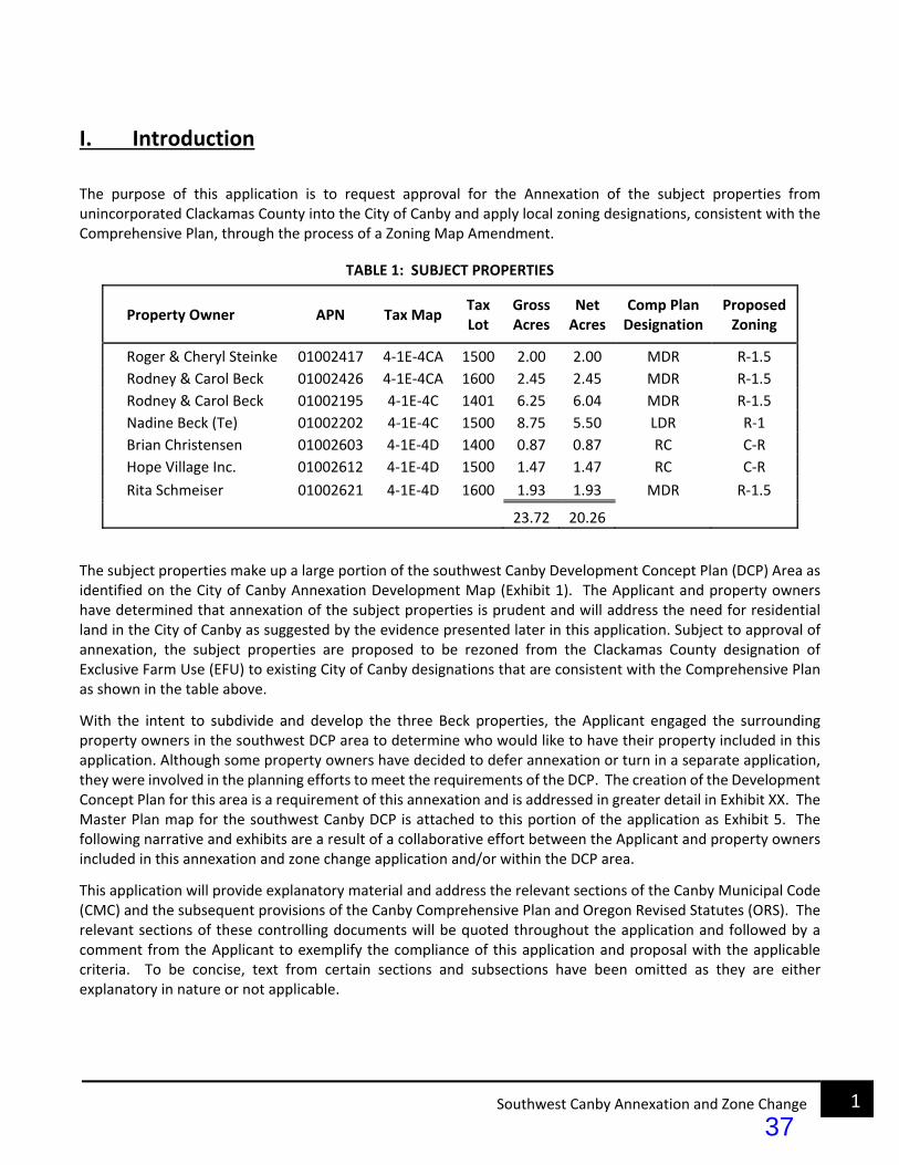
The purpose of this application is to request approval for the Annexation of the subject properties from unincorporated Clackamas County into the City of Canby and apply local zoning designations, consistent with the Comprehensive Plan, through the process of a Zoning Map Amendment.
TABLE 1: SUBJECT PROPERTIES
Property Owner APN Tax Map Tax Lot
Gross Acres
Net Acres
Comp Plan Designation
Proposed Zoning
Roger & Cheryl Steinke 01002417 4‐1E‐4CA 1500 2.00 2.00 MDR R‐1.5
Rodney & Carol Beck 01002426 4‐1E‐4CA 1600 2.45 2.45 MDR R‐1.5
Rodney & Carol Beck 01002195 4‐1E‐4C 1401 6.25 6.04 MDR R‐1.5
Nadine Beck (Te) 01002202 4‐1E‐4C 1500 8.75 5.50 LDR R‐1
Brian Christensen 01002603 4‐1E‐4D 1400 0.87 0.87 RC C‐R
Hope Village Inc. 01002612 4‐1E‐4D 1500 1.47 1.47 RC C‐R
Rita Schmeiser 01002621 4‐1E‐4D 1600 1.93 1.93 MDR R‐1.5
23.72 20.26
The subject properties make up a large portion of the southwest Canby Development Concept Plan (DCP) Area as identified on the City of Canby Annexation Development Map (Exhibit 1). The Applicant and property owners have determined that annexation of the subject properties is prudent and will address the need for residential land in the City of Canby as suggested by the evidence presented later in this application. Subject to approval of annexation, the subject properties are proposed to be rezoned from the Clackamas County designation of Exclusive Farm Use (EFU) to existing City of Canby designations that are consistent with the Comprehensive Plan as shown in the table above.
With the intent to subdivide and develop the three Beck properties, the Applicant engaged the surrounding property owners in the southwest DCP area to determine who would like to have their property included in this application. Although some property owners have decided to defer annexation or turn in a separate application, they were involved in the planning efforts to meet the requirements of the DCP. The creation of the Development Concept Plan for this area is a requirement of this annexation and is addressed in greater detail in Exhibit XX. The Master Plan map for the southwest Canby DCP is attached to this portion of the application as Exhibit 5. The following narrative and exhibits are a result of a collaborative effort between the Applicant and property owners included in this annexation and zone change application and/or within the DCP area.
This application will provide explanatory material and address the relevant sections of the Canby Municipal Code (CMC) and the subsequent provisions of the Canby Comprehensive Plan and Oregon Revised Statutes (ORS). The relevant sections of these controlling documents will be quoted throughout the application and followed by a comment from the Applicant to exemplify the compliance of this application and proposal with the applicable criteria. To be concise, text from certain sections and subsections have been omitted as they are either explanatory in nature or not applicable.
37
2Southwest Canby Annexation and Zone Change
II. Site Description
The subject properties identified in Exhibit 2 are located within the southwest Canby DCP area (Exhibit 3) as identified on the City of Canby Annexation Development Map (Exhibit 1). The boundary of the DCP and annexation area follows the Urban Growth Boundary (UGB), which is set at the 18% break in slope identified in several of the Exhibits. The location of the UGB boundary bisects five of the properties within the DCP and two of the properties that are the subject of this annexation application. The resulting net annexation area of the subject properties is equal to 20.26 net acres, which excludes 3.46 acres that are beyond the 18% break in slope and UGB. Also not included in the 20.26 net acres is the right‐of‐way along the frontage of S Fir and Ivy Streets that will be annexed as a part of this application. Existing conditions of the DCP area and annexation properties can be seen in Exhibit 3.
The annexation area includes groups of properties on the eastern and western edges of the DCP area. The eastern group includes the Hope Village, Christensen, and Schmeiser properties. The western group includes the Beck properties and Steinke property. Property owned by McMartin Farms, LLC is located between the two groupings included in this application. The McMartin property owners have elected to submit their own annexation application, which will also be subject to the DCP that is a part of this application. The eastern grouping of the Christensen, Hope Village, and Schmeiser properties is located on the western frontage of South Ivy Street and surrounded by farm land. To the west is the McMartin Farms property and to the east of S Ivy St. is primarily farm land. Adjacent property to the north is controlled by Hope Village and is anticipated to develop in the near future. Further to the north/northwest is the Hope Village Assisted Living facility. To the northeast is the recently completed Dinsmore Estates subdivisions. The western grouping of the Beck (3 parcels) and Steinke (1 parcel) properties is located between South Fir and South Elm Streets. Single‐family homes are currently sited on 3 of these 4 parcels. This area is very flat, with an elevation change of only 2 feet from the near the northwest corner (168 ft.) to the southeast corner (170 ft.). A detailed topographical survey of the western group properties can be seen in Exhibit 4. Development to the north and west of these properties consists primarily of manufactured home communities with private streets. To the east/northeast is the Hope Village Senior Living Community. Property to the east/southeast is vacant farm land. Property to the south, and within the DCP area, consists of 3 single‐family homes on large lots with only 1 to 2 acres within the UGB. Development potential on these properties is limited and the owners have elected to keep their properties in Unincorporated Clackamas County. To the south/southwest is land outside of the UGB and along the Molalla River corridor. Further expansion of the UGB to the south/southwest is not likely to occur due to the steep slopes and natural features in the vicinity. Access to the property is available with 3 north/south streets; Elm, Fir and Ivy Streets. These streets connect to 13th Avenue to the north, an east/west arterial street. Most urban infrastructure has been extended to the edge of the annexation area. Local services and facilities will be available for the proposed annexation area or can be made available through short service extensions.
The subject properties and other properties in the DCP area have characteristics typical of a rural area with single‐family residences located on large and acreage lots with some engaging in farming operations or home‐based businesses. This is consistent with other undeveloped properties in the south Canby area. Opportunities for additional single‐family residential developments are limited in the nearby surrounding areas, especially near the western grouping of these annexation properties.
38

3Southwest Canby Annexation and Zone Change
III. Facilities and Services
Annexation of the subject properties with R‐1, R‐1.5, and C‐R zoning is a reasonable expansion of the City of Canby based on the level of development in the surrounding area and the existing facilities and services that are available to serve the DCP area. The City of Canby staff indicated at a pre‐application meeting that all utility service providers and utilities are available in the DCP area or can be made available through development of the site. Pre‐application meeting minutes are attached as Exhibit 8.
Water: Reference Exhibit 6: DCP Water Line Master Plan
Water is provided through Canby Utility’s Water Department. A 10‐inch water line is available in Fir Street, a 12‐inch line in Ivy Street and an 8‐inch line in Elm Street. All 3 water lines will be extended into the DCP area. The 12‐inch water line will be constructed in the east‐west streets between Ivy and Fir Streets (17th and 18th Avenues) and possibly between Fir and Elm Streets (16th Avenue) based on a final water line flow and pressure calculations (See Exhibit 6). The rest of the streets will have looped 8‐inch water lines which connect to the existing 10‐inch and 12‐inch water lines as shown by Exhibit 6. Public water lines will be located in all the public streets. If Hope Village builds private streets in their development, their water lines may be private rather than public.
Sanitary Sewer: Reference Exhibit 7: DCP Sanitary Sewer Master Plan
Sanitary sewer is provided by the City of Canby. Three existing sewer lines are available to this DCP area. The first existing sewer line is 8‐inches in diameter and located to the north at the intersection of 16th Avenue and Ivy Street. The invert elevation is XXXX feet. It can be extended approximately XXX feet to the south along Ivy Street as shown by Exhibit 7. The ground elevation of the DCP along Ivy Street is about 178 to 179 feet. Shallow sewer lines extending to the existing sewer lines will conflict with the water lines with only 3 feet of cover. The pump station will be required to lower the depth of the sewer lines to 6 to 8 feet as shown by Exhibit 8.
At the pre‐application conference, city staff indicated the city will not plan for or fund the pump station until the city knows for sure development will occur. Construction of the pump station and the associated force main will be paid for with City Systems Development Fees collected by the City. Gravity mains are paid by the developers of the subdivisions. Annexation of property will not trigger the need for the pump station. It will be constructed by the City when the McMartin property and Hope Village properties are approved for development by the City.
The second sewer line is 8‐inches in diameter and located in Fir Street at the northeast corner of the Steinke property, Tax Lot 1500, Map 4‐1E‐4CA. The invert elevation is 163.68 feet. This sewer line will serve the northeastern portion of the Beck property as show by Exhibit 7.
The third sewer line is 8‐inches in diameter and located in Elm Street at the north‐west corner of the Beck property, Tax Lot 1401, Map 4‐1E‐4C. The invert elevation is 161.57. This sewer line will serve all of the remaining Beck property.
Storm Drainage:
Roof drains from homes within the subdivision will drain to privately owned and maintained infiltration facilities on each individual lot. Street drainage will be directed to sumped catch basins and pollution control manholes for
39

4Southwest Canby Annexation and Zone Change
water quality treatment and then to dry wells located throughout the development area for disposal through underground injection. All street storm drainage facilities are proposed to be public facilities consistent with the newly adopted City of Canby Stormwater Master Plan and the Canby Public Works Design Standards. When development proposals are submitted, the issue of storm water management and drywell location can be discussed in greater detail.
Private Utilities:
Private utilities providing service for telephone, natural gas, cable, garbage, recycling collection and wave broadband are all available in Elm, Fir and Ivy Streets. These utilities generally operate on a franchise basis. Electrical power is provided through Canby Utility’s Electrical Department in conjunction with PGE. Dry utilities such as power, communications and natural gas are available north of the DCP area. Extension of these utility lines will occur with each development phase.
Fire Protection:
Fire protection for the local neighborhood is currently provided by Canby Fire Department, which serves the City of Canby and the surrounding area. Service to this site could come from the existing fire facilities within the city. Canby Fire has indicated that it can serve the property when annexed. If the property is developed consistent with adopted standards, the Canby Fire Department will be able to serve future development. Specific Fire Department comments regarding service are withheld until the detailed development plans are submitted to the city for review.
Police Protection:
Police protection is currently provided by the Clackamas County Sherriff’s Department. The service will transfer to the Canby Police Department when the property is annexed to the city.
Schools:
The entire DCP area is within the Canby School District. The schools are very close to the subject properties. Lee Elementary and Ackerman Middle Schools are located at the northeast corner of Ivy Street and 13th Avenue. Canby High School is located at the southeast corner of Highway 99E and 4th Avenue. These schools have athletic fields which provide active recreational opportunities on weekends, during summers, and when school is not in session.
Parks: Park facilities in the city are administered by the Canby Parks Department. New park facilities will be provided as shown on the SW Canby DCP. The new park facilities are assumed to be owned by the City and will be for use by all residents and visitors. The existing City parks that are close to the DCP area are as follows:
1. Legacy Park is located at 1200 SE 13th Avenue next to Ackerman Middle School and features playgrounds, soccer fields, a picnic shelter and a meditation garden.
40
5Southwest Canby Annexation and Zone Change
2. Community River Park is located at 1348 S. Berg Parkway southwest of Canby High School. This is a natural park with picnic facilities, barbecue pits, playground equipment, ball fields and a fishing pond for youth age 17 and under.
3. The Community Swim Center is located at 1150 S. Ivy Street just north of 13th Avenue.
4. The Adult Center is located at 1250 S. Ivy Street at the northeast intersection of 13th Avenue and Ivy Street.
5. Three new pocket parks and a trail along the Molalla River corridor are shown on the DCP Master Plan Map (Exhibit 5). The pocket parks next to the trail can take advantage of the large stand of trees located along the south side of the trail. The trees provide shade for passive recreational opportunities such as walkways, picnic tables, and benches. Additional recreational opportunities include nature walks, playground equipment and picking. The pocket parks will be used as rest stops along the trail. Park improvements may be constructed by the project developer or developed by the City of Canby. See Section VI (Park Dedication) of the Development Concept Plan for additional information.
IV. Neighborhood Meeting
One of the requirements of submitting for annexation is holding an informative neighborhood meeting. The purpose of the meeting is to inform neighbors within 500 feet of the subject property about the intent to annex the subject property to the city and rezone in accordance with the Canby Comprehensive Plan. The notice to the neighbors included a potential Master Plan for the property and proposed zoning for each tax lot. The mailing list was prepared by a title company and was based on Clackamas County Assessor’s records.
The Applicant held a neighborhood meeting in compliance with the requirements of CMC 16.89.070 on Tuesday, April 18, 2017 from 7 to 8 pm at the Canby Adult Center located at 1250 S. Ivy Street. The notice was sent to all property owners and occupants within 500 feet of the SW Canby DCP area and the representative of the SW Canby Neighborhood Association. Approximately 30 people attended, but not everyone signed in. Exhibit 9 contains the materials associated with the neighborhood meeting including the following:
‐ A map showing the boundaries of the Neighborhood Association. ‐ A copy of the Notice letter and preliminary master plan that was mailed. ‐ The sign‐up sheet with approximately 22 names. ‐ And the Minutes for the meeting.
The Applicant gave a presentation and explained the proposed annexation and the subsequently required Development Concept Plan and project and answered questions. The majority of the owners that are a party to this application and included in the annexation were invited to join during the neighborhood meeting.
The requirement to host a neighborhood meeting has been satisfied by the Applicant.
41

6Southwest Canby Annexation and Zone Change
V. Approval Criteria
This section will address the applicable standards and criteria for approval of annexation into the City of Canby and a Zoning Map Amendment and the subsequent criteria of the Comprehensive Plan, Urban Growth Management Agreement between Clackamas County and the City of Canby, and the Oregon Revised Statutes. Code sections will be quoted in italic, followed by a comment from the applicant Evidencing the compliance of this request and proposal. Text from certain sections of the quoted codes have been omitted because they are explanatory in nature, are not the responsibility of the Applicant, or do not apply to this application.
Canby Municipal Code
DIVISION VI. – CHAPTER 16.84 – ANNEXATIONS
16.84.005 Background [omitted]
16.84.010 Purpose [omitted]
16.84.020 State regulations The regulations and requirements of Oregon Revised Statutes Chapter 222 are adopted by reference and made a part of this division. (Ord. 740 section 10.6.20, 1984) COMMENT:
These regulations are addressed on page XX of this application.
16.84.030 Filing procedure [omitted]
16.84.040 Standards and criteria. A. The following criteria shall apply to all annexation requests.
1. The City of Canby Annexation Development Map shall determine which properties are required to submit either (See Figure 16.84.040):
a. A Development Agreement (DA) binding for all properties located within the boundaries of a designated DA area as shown on the City of Canby Annexation Development Map. The terms of the Development Agreement may include, but are not limited to: [portions of this subsection omitted for brevity]
COMMENT:
The subject properties are not within a Development Agreement area as identified on the City of Canby Annexation Development Map. This criterion is not applicable.
42
7Southwest Canby Annexation and Zone Change
b. A Development Concept Plan (DCP) binding for all properties located within the boundaries of a designated DCP area as shown on the City of Canby Annexation Development Map. A Development Concept Plan shall address City of Canby infrastructure requirements including:
1. Water 2. Sewer 3. Stormwater 4. Access 5. Internal Circulation 6. Street Standards 7. Fire Department requirements 8. Parks and open space
For newly annexed properties that are within the boundaries of a DCP area as designated on the City of Canby Annexation Development Map: A Development Concept Plan shall be adopted by the Canby City Council prior to granting a change in zoning classification. (Ord 1294, 2008)
COMMENT:
The subject properties are part of a Development Concept Plan (DCP) area as identified on the City of Canby Annexation Development Map (Exhibit 1). The Applicant has prepared a DCP for the southwest Canby DCP area and included a narrative and exhibits addressing the infrastructure requirements. The DCP can be found in Exhibit 11 of this application. The Development Concept Plan has been inserted as the final Exhibit so it can function independent of this application if approved and contains its own exhibits. A review of the DCP will show that these criteria have been met.
2. Analysis of the need for additional property within the city limits shall be provided. The analysis shall include the amount of developable land (within the same class of zoning ‐ low density residential, light industrial, etc.) Currently within the city limits; the approximate rate of development of those lands; and how the proposed annexation will affect the supply of developable land within the city limits. A supply of developable residential land to provide for the anticipated population growth over the following three years is considered to be sufficient;
COMMENT:
The applicant has reviewed available data and determined that the City of Canby has an insufficient supply of developable land in the same class of zoning that would be applied to the subject properties upon Annexation and approval of a zone change. Forecasted population growth outweighs the current and anticipated availability of lots within the R‐1 (Low Density), R‐1.5 (Medium Density), and C‐R (Residential Commercial) zones that are ready for development. The following tables and analysis will detail the availability of buildable lots for each of the proposed designations of the subject properties.
Population Growth and Housing Needs
Population growth is the driving force behind increased demand for housing of all types. As such, the Applicant has analyzed historic data and projections, actual conditions, and recent population growth forecasts. In addition, the Applicant considers the impacts of other market conditions, including the average household size.
43
8Southwest Canby Annexation and Zone Change
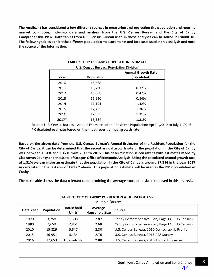
The Applicant has considered a few different sources in measuring and projecting the population and housing market conditions, including data and analysis from the U.S. Census Bureau and the City of Canby Comprehensive Plan. Data tables from U.S. Census Bureau used in these analyses can be found in Exhibit 10. The following tables exhibit the different population measurements and forecasts used in this analysis and note the source of the information.
TABLE 2: CITY OF CANBY POPULATION ESTIMATE
U.S. Census Bureau, Population Division
Year Population Annual Growth Rate
(calculated)
2010 16,668 ‐
2011 16,730 0.37%
2012 16,808 0.47%
2013 16,950 0.84%
2014 17,191 1.42%
2015 17,425 1.36%
2016 17,653 1.31%
2017* 17,884 1.31%
Source: U.S. Census Bureau ‐ Annual Estimates of the Resident Population: April 1,2010 to July 1, 2016 * Calculated estimate based on the most recent annual growth rate
Based on the above data from the U.S. Census Bureau’s Annual Estimates of the Resident Population for the City of Canby, it can be determined that the recent annual growth rate of the population in the City of Canby was between 1.31% and 1.42% from 2013 to 2016. This determination is consistent with estimates made by Clackamas County and the State of Oregon Office of Economic Analysis. Using the calculated annual growth rate of 1.31% we can make an estimate that the population in the City of Canby is around 17,884 in the year 2017 as calculated in the last row of Table 2 above. This population estimate will be used as the 2017 population of Canby.
The next table shows the data relevant to determining the average household size to be used in this analysis.
TABLE 3: CITY OF CANBY POPULATION & HOUSEHOLD SIZE Multiple Sources
Data Year Population Household
Units Average
Household Size Source
1970 3,758 1,308 2.87 Canby Comprehensive Plan, Page 145 (US Census)
1980 7,659 2,861 2.68 Canby Comprehensive Plan, Page 146 (US Census)
2010 15,829 5,647 2.80 U.S. Census Bureau, 2010 Demographic Profile
2015 16,951 6,134 2.76 U.S. Census Bureau, 2015 ACS Survey
2016 17,653 Unavailable 2.80 U.S. Census Bureau, 2016 Annual Estimates
44

9Southwest Canby Annexation and Zone Change
The above table lists projections and measurements that largely come from the U.S. Census Bureau, some of which have been used in prior analyses and planning by the City of Canby. For this analysis, the Average Household Size will be assumed to be 2.80 persons per household unit which is justified by the data above. This will be beneficial in projecting additional need for housing based on population growth.
Table 4 below gives the long‐range projections for population growth in the City of Canby per the Metro Regional Population and Employment Range Forecasts report that was created in 2009.
TABLE 4: CITY OF CANBY POPULATION FORECAST
Year Projected Population
Low Range High Range
2010 15,829 15,829
2015 17,998 18,520
2020 20,464 21,668
2025 23,268 25,352
2030 26,456 29,662
2035 30,080 34,705
2040 34,201 40,605
Source: METRO Regional Population and Employment Range Forecasts, 2009 (City of Canby Storm Sewer Master Plan, 2017)
Conveniently, the above projections for the 2020 population can be used in determining the housing needs three years from the date of this application consistent with the criteria of this subsection. However, you can see that even the low range projections from the Metro report for the year 2015 in Table 4 are considerably higher than that of Table 2. The data from the 2016 U.S. Census Bureau’s Annual Estimates shown in Table 2 estimates the population in 2015 to be about 97% of what was forecast by the Metro report. To be conservative in our analysis, we will use only 97% of the 2020 low range population estimate from the Metro report. Thus, the population estimate for the year 2020 that we will use in this analysis is 19,850. This is a key component in projecting housing needs for the anticipated population growth.
The table below consolidates the estimates that have been calculated in the tables above regarding the population growth, household size, and the additional housing units needed over the next three years.
TABLE 5: CALCULATED 3‐YEAR POPULATION AND HOUSING FORECAST
Year Population Average
Household Size Housing Units
2017 17,884 2.8 6,387
2020 19,850 2.8 7,089
2017‐2020 Increase 1,966 2.8 702
Average Annual Increase 655 2.8 234
45

10Southwest Canby Annexation and Zone Change
Based on an average household size of 2.8 persons per unit, an additional 702 housing units will be needed to accommodate the projected population increase of 1,966 residents by the end of 2020. Assuming the growth is spread evenly over the next three years, an additional 234 units will be needed to supply the housing demanded by an additional 655 residents each of the next three years. The needed housing units over the next three years will be supplied in a variety of housing types. Further analysis of the need for the proposed housing types on the subject properties will be provided below.
Single Family Residential Lots:
The availability of developable lots is insufficient to meet the three‐year supply needs in the R‐1 and R‐1.5 zones within the City of Canby. There are currently no developable platted lots within the City of Canby that are zoned R‐1.5. As such, we will assume that a non‐existent inventory of R‐1.5 is insufficient. However, the following analysis that relies primarily on data for R‐1 lots will focus on the need for single family residential (SFR) detached housing which is permitted on both R‐1 and R‐1.5 lots. Additionally, the subject properties zoned R‐1.5 are likely to be proposed as detached single‐family homes. The following analysis will summarize recent development activity, determine the recent absorption rate of R‐1 and R‐1.5 lots and the proportion of the new housing units needed that should be accommodated by single family detached housing. Ultimately, the necessary supply to meet the anticipated 2020 demand for detached SFR housing units will be determined.
The following tables exhibit the existing inventory of developable SFR lots within the City of Canby that have recorded by subdivision or partition since 2007 and 2010 respectively, as of September 30, 2017. There are 12 existing platted vacant lots from subdivisions and partition plats recorded prior to these dates. These lots are developed at a rate inconsistent with current market trends for a variety of reasons and as such will be excluded from this portion of the analysis. Recording and Permit info used in the following tables was gathered from the most recent Clackamas County, Title, and City of Canby records available.
TABLE 6‐A: AVAILABLE PLATTED LOTS IN CANBY BY SUBDIVISIONS This data only includes property zoned R‐1 and R‐1.5 and excludes subdivisions that recorded prior to 2007
Date Recorded
Plat # Subdivision Name Zone Total Lots
Issued Permits
Pending Permits
Remaining Lots
12/2/2014 4396 Northwood Estates No. 2 R‐1 33 27 2 4
3/20/2015 4409 Dinsmore Estates ‐ 2 R‐1 41 41 0 0
6/26/2015 4422 Pine Meadow R‐1 19 19 0 0
10/26/2015 4433 Faist Addition No. 6 R‐1 30 21 2 7
11/17/2015 4436 Dinsmore Estates ‐ 3 R‐1.5 10 10 0 0
6/9/2016 4457 Franz Meadow R‐1 18 18 0 0
10/1/2016 4475 Faist Addition No. 7 R‐1 6 2 0 4
3/31/2017 4488 Caitlyns Place R‐1 6 4 0 2
9/26/2017 4509 Northwood Estates No. 3 R‐1 21 0 0 21
Total Subdivision Plat Lots 184 142 4 38
46

11Southwest Canby Annexation and Zone Change
TABLE 6‐B: AVAILABLE PLATTED LOTS IN CANBY BY PARTITIONS
This data only includes property zoned R‐1 and R‐1.5 and excludes partitions that recorded prior to 2010
Date Recorded
Plat # Partition Applicant Zone Total Lots
Issued Permits
Pending Permits
Remaining Lots
1/14/2015 PP2015‐004 White River Homes R‐1 2 1 0 1
9/28/2016 PP2016‐098 White River Homes R‐1 2 1 0 1
5/5/2017 PP2017‐035 Wild Hare Rentals R‐1 2 1 0 1
6/13/2017 PP2017‐044 Allee and Brito R‐1 3 1 0 2
6/20/2017 PP2017‐048 Pierce R‐1 3 0 0 3
Total Partition Plat Lots 12 4 0 8
*Total Remaining Buildable R‐1 Lots 46**
* All remaining buildable lots have an R‐1 zoning designation as there are no remaining R‐1.5 lots ** Excluding 12 lots platted by subdivision or partition prior to 2007 and 2010 respectively
The data from Tables 6A and 6B above shows that only 46 developable lots remain in the City of Canby to accommodate single family detached housing needs. Additional analysis below will determine the required inventory of buildable lots to accommodate the expected demand through 2020.
The tables below identify the number of recorded lots in each of the past three full years and the number of building permits issued by year to show the rate that the recorded lots are developed. Permit counts for 2017 include those pending as of the date of this applications submittal.
TABLE 7‐A: 2014 PLATTED R‐1 LOT ABSORPTION
Recording Date: Dec. 2 Lots Recorded: 33
Year Permitted Permit Count Annual Absorption Total Absorption
2014 0 0% 0%
2015 9 27% 27%
2016 10 30% 58%
2017 10 30% 88%
Vacant 4
Note: Late year recording date skews absorption rate calculations
TABLE 7‐B: 2015 PLATTED R‐1 LOT ABSORPTION
Recording Date: Mar. 20 ‐ Sep. 11 Lots Recorded: 90
Year Permitted Permit Count Annual Absorption Total Absorption
2015 47 52% 52%
2016 31 34% 87%
2017 5 6% 92%
47

12Southwest Canby Annexation and Zone Change
Vacant 7
TABLE 7‐C: 2016 PLATTED R‐1 LOT ABSORPTION
Recording Date: Jun. 9 ‐ Oct. 1 Lots Recorded: 24
Year Permitted Permit Count Annual Absorption Total Absorption
2016 15 63% 63%
2017 5 21% 83%
Vacant 4
Tables 7‐A, B & C calculate the rate of absorption for lots recorded in each of the last three years. Since there have only been ten R‐1.5 lots recorded in the last several years, they have been excluded from this portion of the analysis. The resulting data above gives us a good idea of the rate at which recorded single family residential lots develop. In general, the above data suggests that over 50% of recorded lots are permitted for home building within 12 months of recording. Additionally, over 80% are permitted by the end of the calendar year following recording. A closer look shows that over 90% of the recorded lots are permitted for homes within 24 months of recording. These numbers are fairly consistent with industry standard for subdivision buildout in the Portland Metro area and Willamette Valley, but are taking slightly longer. This is likely due to single‐builder subdivisions.
The following table combines data from the analyses above and calculates the number of SFR lots needed to meet the 3‐year lot demand within the City.
TABLE 8: PROJECTED HOUSING NEEDED BASED ON PROJECTED POPULATION INCREASE
Year Population Pop.
Increase Growth Rate
Average Household
Size
New Housing Needed
SFR Housing Needed
(R‐1&R‐1.5)
SFR Housing as % of Needed Housing
2014 17,191 ‐ ‐ ‐ ‐ ‐ ‐
2015 17,425 234 1.36% 2.76 85 59 70%
2016 17,653 228 1.31% 2.8 81 63 77%
2017 17,884 231 1.31% 2.8 82 Incomplete
2018 18,539 655 ‐ 2.8 234 161 68.7%
2019 19,194 655 ‐ 2.8 234 161 68.7%
2020 19,849 655 ‐ 2.8 234 161 68.7%
3‐Year Housing and SFR Lot Supply Needed 702 482
Notes: Population forecast for 2018 ,2019, and 2010 is based on 97% of the Metro low estimates for 2020 averaged over 3 years.
Bold font number indicates estimated or calculated outcomes based on existing data.
48

13Southwest Canby Annexation and Zone Change
The information from Table 8 shows that in 2015 and 2016 the increase in population (per the U.S. Census Bureau) estimated the need for an additional 85 and 81 housing units respectively based on the average household size at the time. The actual number of housing permits issued in the City of Canby in 2015, including Single Family and Multi‐Family Residential units was 85 which matches the calculated estimate. This is a good indicator of accurate calculations. The actual number of those permits issued to properties in the R‐1 and R‐1.5 zones was 59, which makes up 70% of the housing that was needed in 2015. Continuing with the same calculation methods for 2017 thru 2020 and using population projections based on previous analyses in this report, the average number of housing units needed over each of the next 3 years is 234. Rather than assuming the proportion of SFR housing will continue to be over 70% of the total housing needed, the Clackamas County average of 68.7% Single Family detached housing will be used in our analysis of 2017‐2020. This is done to be conservative and to account for the rapid growth that is projected. Typically, rapid growth will shift a larger share of the population from single family detached housing into attached or multifamily housing. Current and future apartment developments, along with the hopeful expansion of the Hope Village Senior Living Community (which is included in the DCP portion of this application) will house a larger share of the population. This is a natural progression in the growth of a city. Using the 68.7% proportion of SFR housing to Total housing, an average of 161 new SFR lots or housing units will be needed over each of the next 3 years, totaling 482, to accommodate the projected population growth through 2020.
The following tables combine the available platted lots inventory from Tables 6A and 6B with pending R‐1 and R‐1.5 subdivision lots that have recently received preliminary approval. While these pending approvals may not guarantee recordation of lots, including them in this available/existing inventory will allow us to see that additional land is needed regardless of whether those lots record.
TABLE 9: TOTAL AVAILABLE OR PENDING SFR LOTS
Available or Pending Lots Lot Count
Remaining Subdivision Lots 38
Remaining Partition Lots 8
Pending Subdivision Lots:
Faist Addition No. 8 24
Faist Addition No. 9 6
Timber Park 105
Tanoak Subdivision 8
Ivy Park 6
Total Available or Pending Lots 195
TABLE 10: ANALYSIS SUMMARY
Description Lot Count
SFR Housing Needed through 2020 482
Available and Pending SFR Lots 195
Current Deficiency 287
49
14Southwest Canby Annexation and Zone Change
Even including the pending/unrecorded subdivision lots, the City of Canby has a significant deficiency in buildable lots. 195 lots is a 14‐month SFR lot supply. Based on the demand for 482 new single family detached residential dwelling units within the City of Canby over the next three years, and the above calculated 195 existing or pending lots, there is currently a deficiency of 287 buildable single‐family residential lots as of right now. Based on the analyses above, there is a great need for additional lot supply in the City of Canby to meet the anticipated market demands through 2020. This analysis consistently assumed the lowest growth projections based on existing data and projections, and the need for additional residential land remains evident. To meet the anticipated demand for single family detached housing, additional R‐1 and R‐1.5 land should be annexed into the City of Canby. The subject properties, and particularly the Beck properties, are the best candidates in the UGB for annexation.
Annexation of the subject properties will not immediately trigger the development of each property. The potential housing units that could be developed on the subject properties is 93. However, the only properties likely to develop in the year or two following annexation includes the Beck properties which, based on the DCP, includes a potential 40 lots zoned R‐1.5 and 22 lots zoned R‐1. These lots would not likely contribute to the buildable lot supply until the end of 2018 at the earliest. The subject properties in the eastern grouping along S Ivy St. will not be able to develop until the City agrees to build a sanitary sewer pump station which could be beyond the 2020 horizon. No other property owners that could develop without the pump station have immediate plans to develop their property. The R‐1.5 housing from the Beck properties would likely be absorbed quickly as there are no other single‐family lots of comparable size currently available in the city.
According to the “Growth Priorities Map” on page 32 of the Comprehensive Plan, the subject properties make up a portion of a Priority Area, where growth is anticipated to take place initially. The annexation of the subject properties is a natural first step in the development of the southwest Canby DCP area as gravity sewer can serve the western group of the subject properties of which the Beck properties will almost certainly develop first.
Residential Commercial Developable Land:
A single parcel in the C‐R zone that is 2.59 acres (Taxlot 41E04DA04800), is the only remaining C‐R zoned lot in the City limits that has a portion of the property undeveloped. However, there is an existing residence on the lot which significantly lowers the likelihood of development. This single C‐R zoned parcel that is underdeveloped does not sufficiently accommodate the variety of development opportunities available to C‐R zoned land. In the case of the C‐R subject properties, the land is anticipated to be used in the expansion the Hope Village Senior Living Community, adding a potential 6 housing units to the property owned by Hope Village. Hope Village would also be a likely candidate to develop the Christensen property, which could accommodate another 6 units within their community.
Conclusion
This analysis has conclusively shown that the current inventory of developable lots within the City of Canby is insufficient for providing housing to accommodate the anticipated population growth over the next three years. As such, the requested annexation of the subject properties is timely and needed to increase the supply of housing in the City of Canby in each of the R‐1, R‐1.5, and C‐R zones. The requirements of this subsection have been met.
3. Statement of potential physical, aesthetic and related social effects of the proposed development on the community as a whole and on the neighborhood of which it will become a part; and proposed actions to mitigate identified concerns, if any. A neighborhood meeting is required as per Table 16.89.020 of the City of Canby Land Development and Planning Ordinance.
50
15Southwest Canby Annexation and Zone Change
COMMENT:
The Applicant has identified and recognizes the physical and aesthetic changes that may result from future development of the subject properties and believes that the project and associated changes will have an overall positive social and economic effect on the City of Canby. Development of the properties included in this annexation and in the DCP area will be consistent with the existing character of the City of Canby, and more specifically, south Canby. Future development on any of the subject properties will substantially conform to the Development Concept Plan for this area which has been submitted as a part of this application.
The recent phases of the Dinsmore Estates and Faist Addition projects on the east side of S Ivy St., and on the south and north sides of 13th avenue respectively, are good examples of what the proposed R‐1 and R‐1.5 properties will look like when fully developed. The housing type, streetscape, and landscaping will all be very similar to the nearby subdivision. The main difference will be that the subject properties will have a greater proportion of lots in the R‐1.5 zone. The greater proportion of R‐1.5 land in future developments of the subject properties and DCP properties will help address the need for medium density residential housing types that is evidenced in the Applicant’s response to the previous subsection.
The development pattern of the existing Hope Village community is a good example of what the subject properties proposed for the C‐R zoning will look like when fully developed. Hope Village has been very involved in this planning process and hopes to expand their community to include the subject properties in the C‐R zones in addition to the High Density Residential portion of the McMartin Property. The positive social and economic impacts of the other nearby subdivisions and communities will continue with the development of the southwest Canby area as the market supports the continued growth of Canby.
Southwest Canby is a unique area in Canby because of its potential for future residential development. Southwest Canby is the best place for expansion because of the large lots controlled by few land owners and has the ability to absorb a significant amount of development. The City should recognize and encourage this type of growth to provide more options for residential housing in Canby.
The additional needs coincident to any development regarding transportation, park space, and other utility and city services is addressed in detail in other parts of this application and in the DCP.
The Applicant held a neighborhood meeting in compliance with the requirements of CMC 16.89.070 on Tuesday, April 18, 2017. Additional information is available in Section IV of this application.
4. Statement of availability, capacity and status of existing water, sewer, drainage, transportation, park and school facilities;
COMMENT:
An analysis regarding the availability of water, sanitary sewer, storm sewer and drainage, transportation, schools, and other necessary facilities is partially covered in Section III of this application and in the attached SW Canby Development Concept Plan (Exhibit 11). The DCP and Section III show that the necessary services, utilities, and facilities can be made available to the subject properties and DCP area and will not inhibit future expansion. For additional information, reference those sections of the application.
51

16Southwest Canby Annexation and Zone Change
The proposed annexation will create additional need and demand for local park facilities. The DCP shows 3.65 acres of park facilities which includes a trail that is 2,500 feet in length and 3 pocket parks. Two of the pocket parks are adjacent to the trail which follows the top of bank 18% slope along the Molalla River corridor.
Additional annexation will have some impact on the capacity of schools, however, the rate and scale of that impact is likely very low. Based on the 2010 census data, around 20% of the population in Canby was between the ages of 5 and 18 years old. Based on a household size of 2.8, that means approximately 45 new potential students between the ages of 5 and 18 would likely move to the annexation properties. That is an average increase of about 3.5 students per grade level. This is a relatively low impact, especially considering that full build out of just the Beck properties would be at least a couple of years away.
5. Statement of increased demand for such facilities to be generated by the proposed development, if any, at this time;
COMMENT:
Adding an additional 93 housing units at full build out of the subject properties will increase the demand on all facilities. However, after completion of the first 62 units in two or three years from now, there could be a period of time where development of the remaining 31 planned units will be on hold due to a lack of gravity sewer. The increase in demand from future development will have a minimal immediate impact on these facilities. Additional transportation studies have been completed by DKS Associates for the DCP and future Beck developments that indicate there is little concern regarding the capacity of the transportation. Their recommendations can be found in the report included with the DCP in Exhibit 11.
6. Statement of additional facilities, if any, required to meet the increased demand and any proposed phasing of such facilities in accordance with projected demand;
COMMENT:
The proposed annexation and development as planned would require increased demand for facilities, services, and utilities. Sanitary sewer, water service, storm drainage management, and street improvements will be constructed by the developers. The Development Concept Plan submitted with this application describes the availability of public facilities and services necessary for the development of the site. These improvements will occur when the site is developed, not with the annexation.
7. Statement outlining method and source of financing required to provide additional facilities, if any;
COMMENT:
The developers will pay the improvement costs for their own projects. The only exception will be the sanitary sewer pump station required for the 23 houses along Ivy Street. The city of Canby staff indicated the city will pay for the pump station. Development of the Beck property between Elm and Fir Street will not require a pump station. This property has gravity sanitary sewer availability.
52
17Southwest Canby Annexation and Zone Change
8. Statement indicating the type and nature of any comprehensive Plan text or map amendments or Zoning text or map amendments that may be required to complete the proposed development. (Ord 1292, 2008)
COMMENT:
No Comprehensive Plan text or map amendment is requested. The property owners are requesting a zone map amendment to rezone this property with the annexation in accordance with the Comprehensive Plan. The existing Clackamas County zoning is Exclusive Farm Use (EFU).
9. Compliance with other applicable city ordinances or policies;
COMMENT:
Other official documents that are applicable to the requested annexation include Policy 6 of the of the land use element of the Comprehensive Plan; two state statutes (ORS 195.065 and ORS 222); and the Urban Growth Management Agreement (UGMA) between Clackamas County and the City of Canby. These documents are addressed later in this application narrative.
10.Compliance of the application with the applicable sections of Oregon Revised Statutes Chapter 222. (Ord. 740 section 10.6.40, 1984; Ord. 981 section 37, 1997; Ord. 1294, 2008)
COMMENT:
Compliance with ORS 222 is addressed later in this application narrative.
16.84.050 ‐ 16.84.090 [omitted]
53
18Southwest Canby Annexation and Zone Change
DIVISION III. – CHAPTER 16.54 – AMENDMENTS TO ZONING MAP
16.54.010 Authorization to initiate amendments. An amendment to the zoning map may be initiated by the City Council, by the Planning Commission, or by application of the property owner or his authorized agent. The Planning Commission shall, within forty days after closing the hearing, recommend to the City Council, approval, disapproval or modification of the proposed amendment. (Ord. 740 section 10.3.45 (A), 1984)
COMMENT:
The Applicant requesting an amendment to the zoning map is an authorized agent of the owners of the subject properties. This criterion is met.
16.54.020 Application and fee. Application procedures shall be as described in Chapter 16.89. (Ord. 740 section 10.3.85(B), 1984; Ord. 981 section 7, 1997; Ord. 1019 section 13, 1999; Ord. 1080, 2001)
COMMENT:
The application for an amendment to the zoning map to apply the R‐1, R‐1.5, and C‐R zoning designations to the subject properties is submitted to the City along with the required fee. The City will follow the procedures set forth in CMC 16.89. This criterion is satisfied.
16.54.030 Public hearing on amendment Before taking final action on a proposed amendment, the Planning Commission shall hold a public hearing on the amendment following the requirements for advertising and conduct of hearing prescribed in Division VIII. (Ord. 740 section 10.3.85(C), 1984)
COMMENT:
The Planning Commission will schedule a public hearing once the application is deemed complete. Following the Planning Commission’s public hearing and recommendation, the City Council will hold its own public hearing to make a final decision. By holding these public hearings, this criterion will be met.
16.54.040 Standards and criteria. In judging whether or not the zoning map should be amended or changed, the Planning Commission and City Council shall consider:
A. The Comprehensive Plan of the city, giving special attention to Policy 6 of the land use element and implementation measures therefore, and the plans and policies of the county, state and local districts in order to preserve functions and local aspects of land conservation and development;
54

19Southwest Canby Annexation and Zone Change
COMMENT:
This zone change will allow the subject properties to be developed with primarily single family detached houses and a few attached senior housing units. Policy 6 is addressed in the Comprehensive Plan section below. This proposed development will be an integral part of the Canby community. Housing development is consistent with plans, goals and policies of the city, county, state and local districts. This development will be efficient and compact in compliance with function and land conservation goals.
B. Whether all required public facilities and services exist or will be provided concurrent with
development to adequately meet the needs of any use or development which would be permitted by the new zoning designation. (Ord. 749 section 1(B), 1984; Ord.740 section 10.3.85(D), 1984)
COMMENT:
The SW Canby DCP demonstrates that all required public facilities and services can be made available to serve the subject property.
16.54.050 (Ord. 740 section 10.3.85(E), 1984 [omitted]
16.54.060 Improvement conditions. A. In acting on an application for a zone change, the Planning Commission may recommend and the City Council may impose conditions to be met by the proponents of the change before the proposed change takes effect. Such conditions shall be limited to improvements or physical changes to the property which are directly related to the health, safety or general welfare of those in the area. Further, such conditions shall be limited to improvements which clearly relate to and benefit the area of the proposed zone change. Allowable conditions of approval may include, but are not necessarily limited to:
1. Street and sidewalk construction or improvements; 2. Extension of water, sewer, or other forms of utility lines; 3. Installation of fire hydrants.
B. The city will not use the imposition of improvement conditions as a means of preventing planned development, and will consider the potential impact of the costs or required improvements on needed housing. The Planning Commission and City Council will assure that the required improvements will not reduce housing densities below those anticipated in the Comprehensive Plan. (Ord. 749 section 1(C), 1984: Ord. 740 section 10.3.85 (F). 1984)
COMMENT:
The developers will provide reasonable improvement of public and private facilities and services for the subject property when a development is approved by the city. The developers will pay for those improvements if required. When oversizing or “late‐comers agreements” are appropriate, the developers will request a pay back of some funds expended for expansion of facilities and services when the improvements are more than required for the development of the subject property. The requirements of this subsection will be satisfied when Conditions of Approval are imposed by the City with approval of a development application. No
55

20Southwest Canby Annexation and Zone Change
improvements are required or necessary as a result of this zone change application. Required improvements will not cause a reduction of the housing densities anticipated by the Comprehensive Plan. These criteria can be met.
16.54.070 Record of amendments. [omitted]
Next section on the following page
56

21Southwest Canby Annexation and Zone Change
Comprehensive Plan Policies
LAND USE ELEMENT
GOAL: To guide the development and uses of land so that they are orderly, efficient, aesthetically pleasing, and suitably related to one another.
COMMENT:
The proposed development of the subject property will be compatible with existing development in the area. Since the subject property is within the UGB, and contiguous to the existing city limits, annexation of the property is a natural step in the development of Canby. The property is in a designated DCP area and should be the first property to annex to the city.
Policy No. 1: “Canby shall guide the course of growth and development so as to separate conflicting or incompatible uses while grouping compatible uses”
COMMENT:
The proposed annexation of the subject property is a result of the guidance from the City of Canby planning documents. The adjacent land is already developed with urban uses. The goal of this Policy will be realized by the annexation and development of the subject properties.
Implementation Measure H: “Continue to work towards a gradual increase in the density and intensity of development allowed within the City, discouraging wasteful development practices and designs.”
COMMENT:
Fulfillment of this Policy and Implementation Measures is the goal of the Applicant’s development plans.
Policy No. 2: Canby shall encourage a general increase in the intensity and density of permitted development as a means of minimizing urban sprawl.
Implementation Measure A: Continue to implement the policies of the Housing Element to increase the range of housing opportunities and diversify housing types.
57

22Southwest Canby Annexation and Zone Change
Implementation Measure C: Continue to utilize density bonuses and other inducements to encourage development to improve designs and utilize Planned Unit Development procedures.
COMMENT:
This annexation and zone change and subsequent development will increase the low, medium and high‐density housing opportunities and diversity of housing types in compliance with the above Policy and Implementation Measures above. Development of the southwest Canby area will help diversify the current housing stock and intensify the density.
Policy No. 3: Canby shall discourage any development which will result in overburdening any of the community’s public facilities and services.
COMMENT:
The Development Concept Plan and this report identify the availability of adequate infrastructure to allow development of the subject property. Therefore, the proposed annexation, zone change, and subsequent development are in compliance with this Policy.
Policy No. 4: Canby shall limit development in areas identified as having an unacceptable level of risk because of natural hazards.
COMMENT:
The subject site is not within any area identified as a natural hazard area. Therefore, this policy does not apply. However, geotechnical studies will be required to determine building setbacks from the 18% slope along the Molalla River Corridor.
Policy No. 5: Canby shall utilize the land use map as the basis of zoning and other planning or public facility decisions.
Implementation Measure B: Rezone properties, as necessary, to conform with the Land Use Map.
COMMENT:
The “Residential and Residential Commercial” Comprehensive Plan designations and the commensurate R‐1, R‐1.5 and C‐R zoning allow for annexation and development in keeping with the City’s Comprehensive Plan.
58
23Southwest Canby Annexation and Zone Change
Policy No. 6: Canby shall recognize the unique character of certain areas and will utilize the following special requirements, in conjunction with the requirements of the land development and planning ordinance, in guiding the use and development of these unique areas.
COMMENT:
The property is not in an area of special concern. Therefore, this policy does not apply.
Next section on the following page
59
24Southwest Canby Annexation and Zone Change
Urban Growth Management Agreement (UGMA)
The UGMA between Canby and Clackamas County is codified as part of Resolution 519, dated Sept. 23, 1992, and requires certain actions and procedures for a variety of action relative to lands within the Urban Growth Management Boundary area. The UGMA contains seven specific issues on which the City of Canby and Clackamas County agree. Rather than quote each of the seven issues, they will be identified by title and addressed:
1. Boundary
COMMENT:
The subject site is within the Urban Growth Boundary of Canby, thus satisfying this criterion.
2. Comprehensive Planning, Plan Amendments and Public Facilities Planning for Lands in Unincorporated UGMB;
COMMENT:
The subject site is within the UGB, and has been included in long range planning for land use, traffic, services and facilities, utilities, and all similar and appropriate elements. The planning designation proposed for this site is consistent with the designated on the Canby Comprehensive Plan map (Low and Medium Density Residential and Residential Commercial). Proposed zoning (R‐1, R‐1.5 and C‐R) is consistent with the Comprehensive Plan. Upon annexation, the city will assume all planning responsibilities for the subject property. Once the site is annexed to the city by final legislative action, Clackamas County will have no further jurisdiction over or interest in the subject property. Therefore, this criterion is fulfilled.
3. Development Proposals for Unincorporated UGMB Areas;
COMMENT:
This criterion does not apply because the property will already be annexed to the city before development applications are submitted to the city for review.
4. County Notice to and Coordination with the City;
COMMENT:
This criterion is not applicable because any development action will occur within the City of Canby and not in the jurisdiction of Clackamas County.
60
25Southwest Canby Annexation and Zone Change
5. City Notice to and Coordination with the County;
COMMENT:
Because this is a proposed annexation and zone change, the City is required under Subsection A to notify Clackamas County of the impending action.
6. City Annexation and Sewer, Water and Road Service;
COMMENT:
Subsection A: The City agrees to undertake any annexations in accordance with process and procedures agreed to by the County. The adjacent right‐of‐way is required to be included in the annexation and the county will not oppose such annexations.
Subsection B: The city is required to accept jurisdiction of Elm and Fir Streets. The applicant will be required to construct “half street improvements” along the frontage of these streets to current City of Canby standards when development is proposed.
Subsection E: Public water and sanitary sewer are not currently available to the site for use in site development, but can be made available upon approval of the annexation application. This subject site is not, however, a health hazard.
7. Terms of Agreement
COMMENT:
This UGMA is between the City of Canby and Clackamas County. However, no part or measure of the proposed annexation of the subject site, nor the subsequent development for approximately 93 residential lots and houses, violates or otherwise circumvents the measures required under this UGMA. Therefore, all criterion of this UGMA have been satisfied and/or fulfilled.
61

26Southwest Canby Annexation and Zone Change
Oregon Revised Statutes
ORS 195
ORS 195.065 requires various agreements between jurisdictions when urban services are to be provided. The Clackamas County Urban Growth Management Agreement (UGMA) states what agency will provide which services. While the applicants will benefit from the existence of such an agreement, the proposed annexation will not create any special or heretofore unforeseen circumstances where the provisions of the UGMA will not apply. The proposed annexation is exactly in keeping with what the City of Canby envisioned within its urban growth area. No new agreements, or any deviation from the provisions of the existing UGMA, will be required for this proposed annexation of this 20.26 acre site.
ORS 222
ORS 222 requires several issues be considered prior to an annexation becoming effective. For example, ORS 222.040 provides that an annexation shall not become effective until an election has been conducted. Part of the process of applying for an annexation is meeting the application deadline in order that internal actions by the Planning Commission and City Council take place prior to the election. The city will provide proper notice as required, and agreements with local service providers will be enacted regarding inclusion of the subject site for service purposes after annexation (ORS 222.005).
The procedures specified under ORS 222.111 will be followed by the city, which is the city’s duty rather than one assigned to the applicant. Other sections such as ORS 222.130 (Annexation election; notice); ORS 222.150 (Election results); ORS 222.160 (Procedure when annexation is submitted to city vote); ORS 222.177 (Filing of annexation records with Secretary of State); and ORS 222.180 (Effective date of annexation) are all parts of the process the city must follow for any annexation.
Sections ORS 222.510 through ORS 222.830, as applicable, deal with the change of service jurisdiction for properties serviced with urban services (water, sanitary sewer, fire protection, etc.) which may have been provided by other non‐urban area providers when the property is in the jurisdiction of Clackamas County. The heading of this Section is “Annexation of Public Service Districts” and deals with the transfer of service rights and obligations once a property is annexed. Whatever is required under these sections will be accomplished as part of the city’s annexation process.
This annexation does not involve a merger of cities, or health abatement, as included in sections included in ORS 222.700’s; ORS 222.800’s; or ORS 222.900’s. Therefore, the proposed annexation complies with, meets, or otherwise fulfills all specific requirements contained in the appropriate and applicable sections of ORS, Ch. 222. However, an “Island” will be created by the exclusion of Tax Lot 1400, Tax Map 4‐1E‐4CA. This property is owned by the Wenrick Trust. The property owners were contacted on several occasions and they have not responded to the request to be included in the annexation and zone change applications. To eliminate this island, the city needs to include this property in the annexation and zone change applications.
62

1
MEMORANDUM
To: City of Canby Planning Department
From: Levi Levasa, Project Manager, Stafford Development Company, LLC
Date: December 14, 2017
Subject: Southwest Canby Annexation – City File ANN 17-02/ZC 17-03
The purpose of this memo is to provide supplemental information and analysis to the Annexation and Zoning Map Amendment applications submitted by Stafford Development Company, LLC on October 19th, 2017, which was deemed complete on November 22, 2017.
Upon review of the submitted applications, City of Canby staff found that population data collected by Portland State University’s Population Research Center (Exhibit A) should be considered in the Applicant’s response to Section 16.84.040(A)(2) of the Canby Municipal Code, which begins on page 7 of the application narrative, and analyzes the need for additional residential land in the City of Canby.
The Applicant’s original analysis of the need for additional housing used population and housing data from sources including the U.S. Census Bureau, METRO Regional Population and Employment Range Forecasts, and City of Canby Storm Sewer Master Plan. These sources will still be used in the following analysis, but population data collected by the Population Research Center (PRC) will replace population estimates for 2015, 2016, and 2017. While this new data is useful in understanding the recent history of the Canby population, a population forecast is not provided. Therefore, the same methodology used in the application narrative will be used in this analysis.
The data collected by the PRC is summarized in Table 1M below.
TABLE 1M: POPULATION ESTIMATE - PSU POPULATION RESEARCH CENTER (PRC) Year PRC Population Est. Metro Low Estimate PRC % of Metro Est. 2015 16,010 17,998 89% 2016 16,420 - - 2017 16,660 - - 2020 18,204* 20,464 89%
*Calculated based on the ratio of the PRC to Metro Est. in 2015 (PRC Est. = 89% of Metro Est.)
Without projections from the Population Research Center for 2020, the applicant believes using a ratio consistent with each report’s 2015 estimate is the best way to come up with a projection that reflects what has been measured by the Population Research Center. Like the original narrative estimates, the table above calculates the 2020 population estimate by using the low-end projection of the METRO Regional Population and Employment Range Forecasts report for 2020 and reducing it to 89% of the projection, consistent with the disparity between the two reports seen in 2015.
63

2
Based on the estimates and calculations from Table 1M above, the population will increase by an average of 514.6 residence per year. Table 2M below indicates the additional housing needed based on an average household size of 2.8 residents per housing unit, which is the same number used by the PRC in their analyses.
TABLE 2M: PROJECTED HOUSING NEEDED BASED ON POPULATION FORECAST (LOW)
Year Population Population Increase*
Average Household
Size
New Housing Needed
SFR Detached Housing Needed
(R-1&R-1.5)
SFR Detached Housing as %
of Needed Housing
2017 16,660 2018 17,174 514 2.8 184 126 68.7% 2019 17,689 515 2.8 184 126 68.7% 2020 18,204 515 2.8 184 126 68.7%
3-Year SFR Detached Lot Supply Needed 551 379 68.7% * Population Increase is based on Table 1M population estimate for 2020 averaged over 3 years.
Based on the data above, an additional 551 new housing units will be needed over the next 3 years to accommodate the projected increase in population through 2020. Of the 551 new housing units, 379 will need to be single family detached residences consistent with Clackamas County trends and data, which indicate that 68.7% of housing provided countywide are single family detached units. While the 68.7% proportion is lower than recent trends for the City of Canby, this low estimate is used to be conservative in this analysis.
City staff has indicated that, by policy, developable land to be considered in the available inventory should include only lots that have been recorded as part of a plat. The City of Canby currently has 46 buildable single family residential lots per Table 6-A and 6-B of the application narrative. Table 3M below summarizes the current deficiency of platted single family detached lots in Canby.
TABLE 3M: DEFICIENCY OF PLATTED LOTS Platted Lots Needed Through 2020 379 Available SFR Detached Lots 46 Current Deficiency of SFR Detached Lots 333
Based on the above analysis, the City of Canby is deficient by 333 single family detached platted lots as of the date the application was submitted, and the Applicant’s request for annexation of the subject properties should be approved to meet the demand for housing.
While the deficiency is evident based on platted lot criteria, the Applicant has elected to do additional analysis that includes preliminarily approved subdivisions that have yet to complete construction and record platted lots. Table 4M below summarizes the total number of buildable platted lots, as shown in Table 3M above, and pending lots for projects that received preliminary land use approval. Table 4M is similar to Table 9 from the original application narrative, but includes subdivisions that have been
64
3
approved as recently as December 12, 2017 and excludes the recently denied Ivy Park, which included six single family detached lots.
TABLE 4M: TOTAL AVAILABLE OR APPROVED LOTS Description Count Remaining Platted Lots 46 Approved Subdivision Lots:
Faist Addition No. 8 24 Faist Addition No. 9 6 Timber Park 105 Tanoak Subdivision 8 7-Acres 22 Redwood Landing 88 Subtotal Approved Lots 253
Total Platted or Approved Lots 299
TABLE 3M: DEFICIENCY OF PLATTED OR APPROVED LOTS Platted Lots Needed Through 2020 379 Available or Approved SFR Detached Lots 299 Current Deficiency of SFR Detached Lots 80
The data and calculations of Tables 4M and 5M are included to further exemplify the current deficiency of platted lots in the City of Canby. If all 253 of the single family detached lots that have been approved were to record a final plat today, there would still be a deficiency of 80 platted single family detached lots. This deficiency alone would justify annexation of the subject properties and more because platted lots will be absorbed quickly and future demand for 2021 will come into the 3-year horizon before the annexation area is ready for development.
The inventory of buildable lots is a dynamic number. As approved subdivisions continue to be developed, plats recorded, and homes constructed, the available inventory of buildable platted lots will fluctuate. Considering the recent rates of absorption, the projected population growth, and the length of time it takes to turn raw land into platted lots, it will be difficult to close the deficiency gap of 333 platted lots, even after the 253 approved lots are platted over the next year.
This memo has considered the new data as requested by city staff and reached the same conclusion as the application narrative. The current inventory of developable single family detached lots within the City of Canby is insufficient for providing housing to accommodate the projected population growth over the next three years. As such, the requested annexation of the subject properties is timely and needed. The requirements of Section 16.84.040(A)(2) of the Canby Municipal Code have been met.
65

66

67

College of Urban and Public Affaors
Population Research Center
Post Office Box 751
Portland, Oregon 97207-0751
780 Urban Center
506 SW Mlll St
503-725-3922 tel
503-725-5199 fax
www.pdx.edu/prc
Portland StateUNIVERSITY
- IMPORTANT NOTICE -
Preliminary 2017 Population Estimate
November 15, 2017
To: Canby city
Listed below is the preliminary population estimate for July 1, 2017. Also included are
the certified 2016 estimate and 2010 Census figure. The July 1, 2017 estimate will be
certifiedfollowingtherevie<vperiodonDecemberl5,2017. a
PRELIMINARY POPULATION ESTIMATE:
JULYI, 2017: 16,660
CERTIFIED POPULATION ESTIMATE:
JULYI, 2016:16,420
CERTIFIED CENSUS FIGURE:
APRILI, 2010: 15,829
The 2017 CERTIFIED population estimates will be posted to our web site by the close of
business December 15, 2017 at the following page URI,:
http://www..pdx.edu/.prc/population-reports-estimates
If you have any questions or c6mments about the preliminary population estimate, please
contact:
Charles Rynerson
Population Research Center
Portland State University
PO Box 751
Portland, OR 97207-0751
Telephone: (503) 725-5157
E-mail: [email protected]
Printed on 100 percent post-consumer waste, FSC and Green-e certified stock 68
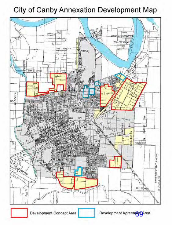
&,7<�2)�&$1%<'HFHPEHU�����
&KDSWHU�������± 3DJH��
)LJXUH����������
69

STAFFORD
Annex, 10/9/2017 2:34:21 PM
70

EXHIBIT 371

72
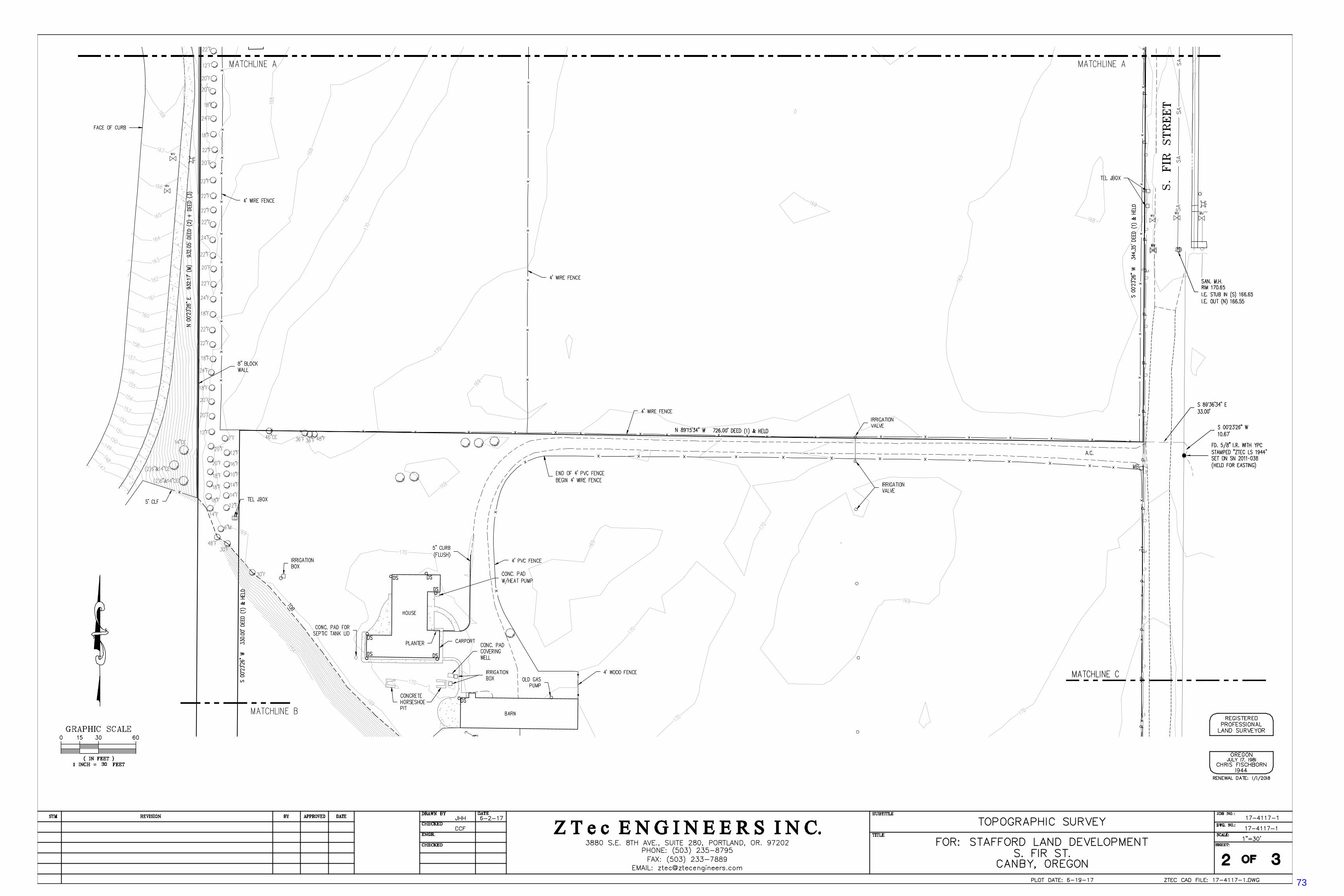
73
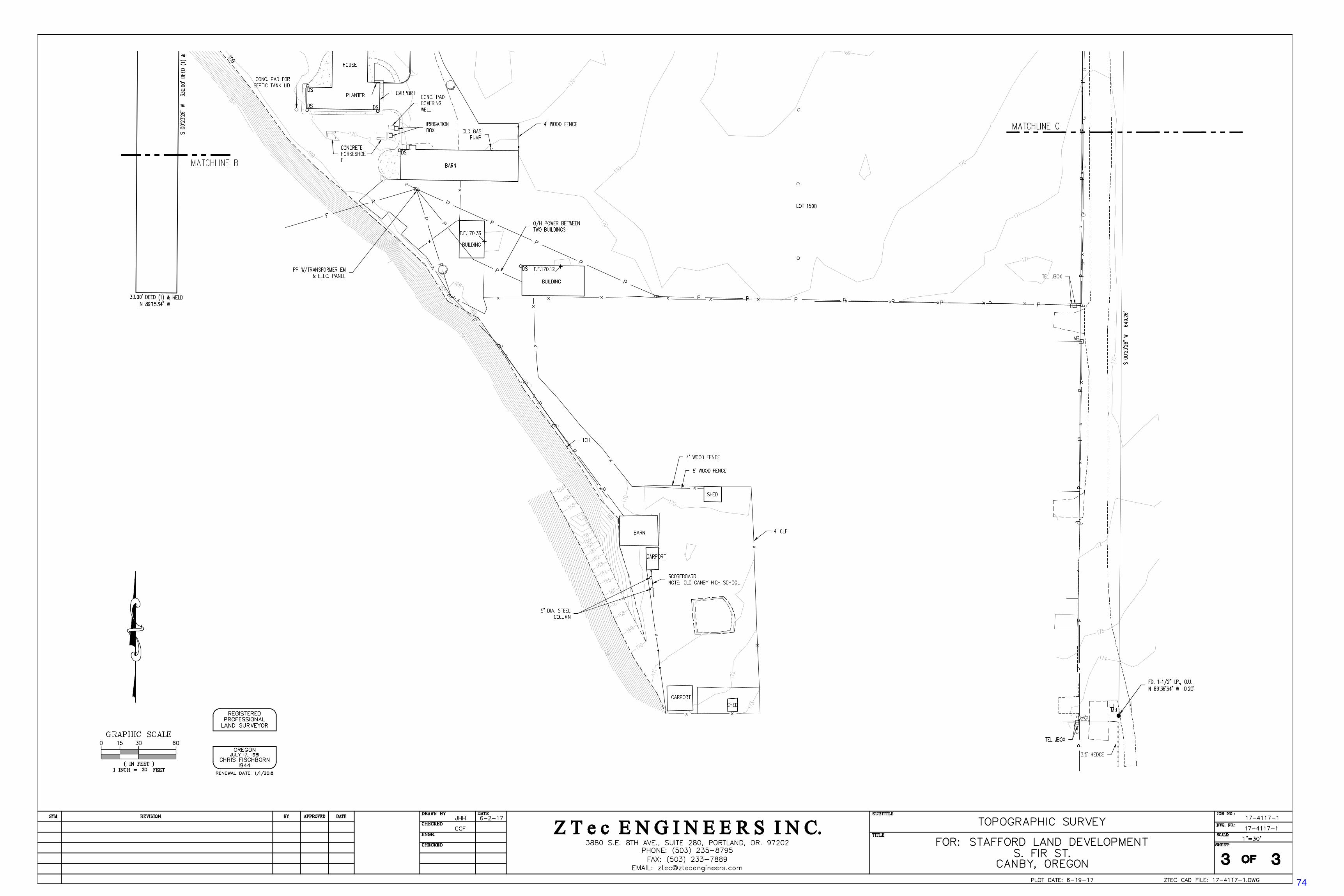
74

EXHIBIT 575
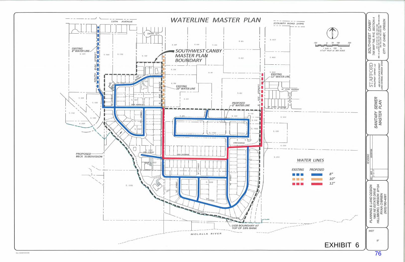
EXHIBIT 676
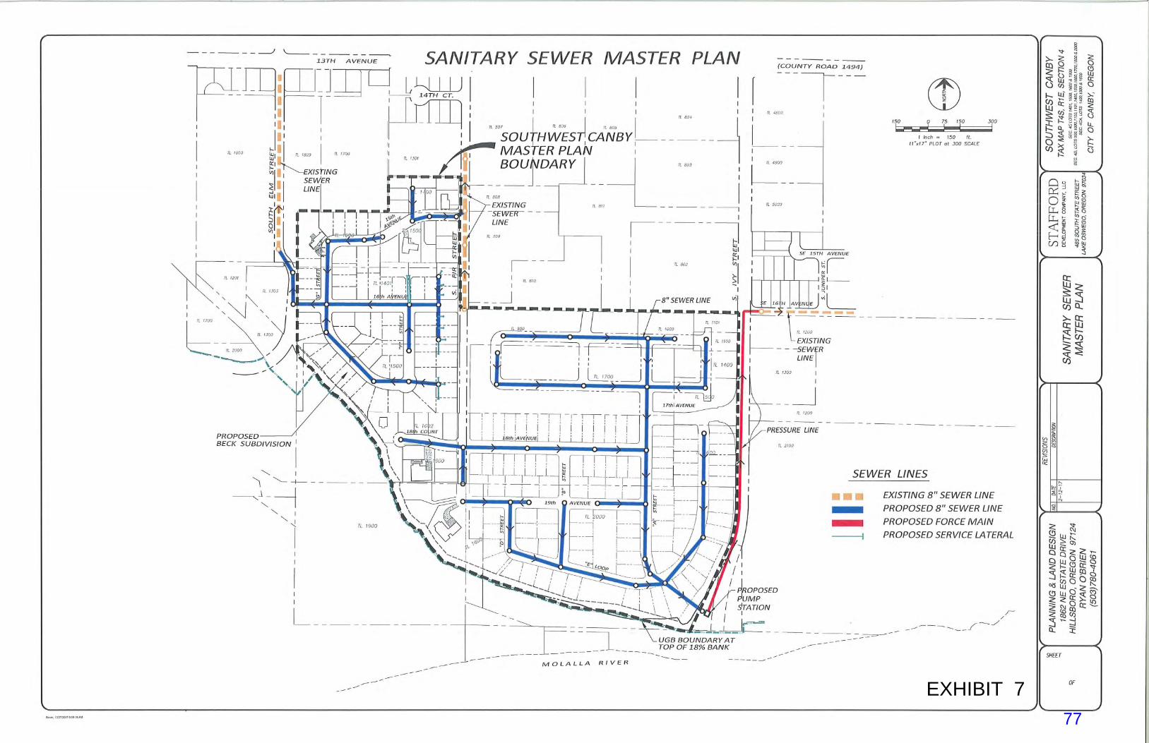
EXHIBIT 777

Pre-application Meeting
65 Lot Subdivision March 9, 2017
10:30 am Attended by: Ryan O’Brien, Planning and Land Designs, 503-708-4051 Bryan Brown, Planning Department, 503-266-0702 Hassan Ibrahim, Curran-McLeod Engineering, 503-684-3478 Gordon Root, Stafford Development, 503-720-0914 Levi Levasa, Stafford Development, 503-250-3651 Gary Stockwell, Canby Utility Electric, 503-263-4307 Doug Quan, Canby Utility, Water Department, 971-563-6314 Jim Stuart, Canby Utility, 971-563-1375 Tim Gettel, Wave Broadband, 503-307-0029
This document is for preliminary use only and is not a contractual document. STAFFORD DEVELOPMENT, Gordon Root We are bringing in this property between S Ivy and S Fir Streets and on the west side of S Fir
Street. There are multiple properties involved in this project area and I want to clarify with the process of the subdivision application with annexation, can it be concurrent and Bryan said no, you will have to annex first. Gordon gave a list of the properties:
o Rodney Beck o Nadine Beck o McMartins o Mootz o Hope Village
The different zonings will have multiple uses. The R-2 as shown on the master plan is the McMartin’s property and Hope Village wants to purchase it and expand their overall site. The Mootz property and Hope Village are presently negotiating to purchase the property and they have tentatively reached an agreement in principal.
We are thinking of bringing a future extension of SW 17th Avenue connecting S Ivy to S Fir Street. This will be on the southern section of the Mootz’s property line and it will be the dividing line between the R-2 HDR property and the lower density residential property.
We anticipate doing the extension of S Fir Street all the down into and through our project. We have been in discussions with Ed Netter who owns a 1 acre parcel and along with the Beck’s. We are trying to get the majority of landowners in the projected area to go along with the annexation.
Gordon said Hope Village will be coming in for their application and Doug asked if this will be a separate application. Gordon said this will be combined for annexation and the land use application will be separate. Doug said the construction will be separate from yours and the answer was yes, but we will construction SW 17th Avenue.
78

Pre-application Meeting 65 Lot Subdivision March 9, 2017 Page 2
CANBY UTILITY, ELECTRIC DEPARTMENT, Gary Stockwell Are you going to piece meal the construction of the project or annex it all at once? Gordon
said it will be driven by the gravity fed sewer mains and we will start with the Beck’s property first being fed into S Elm Street.
Before I will be able to do any electrical design work, even the Beck property, I will need the comprehensive plan and have the city’s approval because there will be a lot of infrastructure to serve in its entirety. The master plan will be very important to me to be able to put together an electrical plan. Bryan said you will need to make sure everything has been adopted and Gary agreed. Gary said some of the work to be done will be placing the overhead lines underground for the homes that are staying.
We have worked together on previous jobs and you know our scope of work. You will provide the trenching, staking, grading and backfill and we will provide the conduit, vaults and transformers.
Depending on the street section where the transformers and vaults will be located behind sidewalk and we may need addition easement to make it fit, especially in the high density areas.
On the private streets we no longer offer leased street lighting and the private street lighting will be your responsibility.
CURRAN-MCLEOD ENGINEERING, Hassan Ibrahim S Fir Street is currently a county street, but as a result of the annexation it will become a city
street. It is classified in the Transportation System Plan (TSP) as a local street and you have proposed a 60 ft right-of-way (ROW). We have 36 ft wide streets and we will continue with the 60 ft ROW, making 18 ft half streets. If the other half is not improved then we need to make sure it will be a 20 ft wide minimum allowable two lanes of traffic.
S Ivy Street is an arterial county street and it will remain a county street. You will have to go through the process with the county on the access spacing and all permits necessary through them. Hassan handed Ryan a drawing from Dinsmore Estates phase 3 to show what the parameters would be for S Ivy Street and it will need to be continued. It is 23 ft from center line, 46 ft pavement in a 60 ROW.
Any of the city’s streets will have to be built to our current design standards and the cul-de-sac has to be 48 ft to the curb line in a 54 ft ROW. I noticed you have not met the 50 ft minimum tangent point coming out of the intersection before you turn the radius. The minimum radius is 165 ft for the local streets onto local streets we have allowed a 50 ft ROW if you cannot meet the lot minimum size and the sidewalks can be in the easement. Ryan said we will need to have a 6 ft sidewalk and a 4-1/2 ft minimum planter strip with 1/2 foot curb (face of the curb to the front of the walk). Hassan said you will need a larger ROW if we put the sidewalks in the easement. Gary said do not forget the public utility easement (PUE) will be behind the sidewalks and Ryan asked how much and Hassan stated the frontage PUE is 12 ft from the ROW line. Gary said I will need to make sure we have enough PUE for our utilities and typically we will need at least 6 ft behind the sidewalk for trenching and when you come to a property line where we place a transformer you will need to bump out the PUE to 12 ft.
79
Pre-application Meeting 65 Lot Subdivision March 9, 2017 Page 3
Clackamas County sent in their comments and due to the large size of the development there will be a traffic study required to see what the impacts are on the signal light on SE/SW 13th Avenue and S Ivy Street. Signal modifications may be required.
We tentatively think we can serve this area with gravity feed sewers and it is not budgeted to build the pump station yet and until we know for sure this development is going in and it is warranted and needed. We do not want to build the lift station and let it sit. As the project progresses and we move into building this phase here we will budget it and Bryan said what may also trigger it will be Hope Village’s development. Hassan said if Hope Village decides to build it the sewers should be deep enough right now at 8 or 9 ft.
Gordon asked what they were responsible for and Hassan said we will be responsible for the pump station and the forced main and everything else will be the responsibility of the developer and you will need to provide a 15 ft easement. Bryan asked if we needed to purchase the land for the pump station and Hassan said he thought we had adequate ROW in this area. Bryan said this information will need to be put in your narrative when you submit for your annexation and the concept plan. We have to have this service pinned down for the entire concept plan area and show the council we have thought and know about all of the parts can be served and how the financing is going to work. Bryan asked how long does it take for a pump station to be built and Hassan said it usually takes 3 to 4 months normally.
The storm drainage for each tax lot will stay on site. You will need to figure out the public street stormwater system and if you want to do retention ponds or drywells. The drywells will be at a 26 ft minimum with a 4 ft diameter and it will be preceded by a water quality sedimentation manhole. Ryan asked if we have public works standards and Hassan said they will provide them to you.
There is a 267 ft restriction radius of placing a drywell near any existing water wells. Ryan asked about the sewer treatment plant capacity and Hassan stated we are at 50 percent
capacity as of this morning. Street lights will be required throughout the project and Canby Utility installs them and Gary
said they will be included in the construction costs I will send to you. CANBY UTILITY, WATER DEPARTMENT, Doug Quan The water system will be interesting to say the least since you have multiple developments.
Hope Village will be addressed with Hope Village’s application because it is not a part of your construction. As far as the Beck property it looks like we may have conflicts with the sewer system and there are standard state requirements for separation between water and sewer. The water line is at a depth of 36 inches with cover and we have specifications in our construction guidelines and if the sewer line for the property is above the water line you will have to use a one piece length of HDPE pipe from cleanout to main. Ryan said this is conceptual and we do not know the exact elevation. Doug said fusion couplings are allowed if you cannot do a 20 ft length of pipe, which is a standard pipe length for most of the 6 inch.
You can access water in both S Fir (10 inch main) and S Ivy (12 inch main) Streets. All your dead ends will require a hydro guard HD 4 automatic flushing station with dechlorination and piped into the storm system. Gordon asked what water main size are you wanting in SW 17th Avenue and Doug said 12 inch water main.
80

Pre-application Meeting 65 Lot Subdivision March 9, 2017 Page 4
Depending on how you want to set the fire hydrant for the cul-de-sac you can reduce the line size going into the cul-de-sac and as long as you meet the fire department’s rule for fire suppression.
Construction standards are on the Canby Utility’s website. We have gone to a sole source hydrant and we have changed our meter boxes to a poly-meter
box that is 20 K rated along with a 20 K rated lid. These will all be located in the planter strips.
If there are any wells in the area you need to let us know if they will be decommissioned and going away, Canby Utility would like the water rights transferred to the city. If they are not going away because we need to look at the properties they will serve and get the proper back flow devices. Gordon said we plan on keeping the well on the Beck’s property and Doug asked if they will remain on the well and the answer was yes. Doug asked if the developer is going to put in a service to the property with the well for future needs and the answer was yes. Ryan asked if the rule for drywells still stand being 267 ft from any existing well and the answer was yes. Gordon stated that could dictate us abandoning the well and Hassan said yes, if the drywell happened to be in the low point and it was within the 267 ft.
WAVE BROADBAND, Tim Gettel Let us know when the trenches are open and if we can get a copy of the power schematic it
helps us with our plan. Hassan said also in the trench line is DirectLink and NW Natural. CITY OF CANBY, PLANNING DEPARTMENT, Bryan Brown The annexation application is not necessarily including all 15 property owners in the master
plan area or are you attempting it? Gordon said he was initially going to do both Beck and McMartin properties, but since then we have decided the Mootz property needs to be in this annexation. Bryan said this further complicates issues and we would need to have our comprehensive plan show the different designations within the projected area and therefore you will be amending the comprehensive plan to make that designation. It is a separate application to be completed. Discussion ensued. Bryan said the annexation is whoever wants to annex now, but the concept development plan is for the whole acreage and it will get adopted and be official for anyone annexing in the future and they have to know they will be conforming to that plan. You will need to contact all the land owners in this projected amendment area and have a neighborhood meeting. You have to have a concept plan that the city feels it is very reasonable and efficient way for this to develop and addresses all the basic criteria in the concept plan.
It is not in our code right now, but we do not allow 28 ft streets unless you are willing to prohibit parking on one side. Ryan asked how many feet does a street have to be in order to have parking on both sides and Bryan said 34 ft.
Ryan asked if they needed to do a topographical map to get to the 18 percent line and Bryan said the 18 percent is not an absolute magic number and it is more of a guide we use since our concept plan does not tell us where the top of bluff is. Discussion followed.
Clackamas County is certainly requiring a traffic study and the city will also. There is a minimum requirement by state law we do a transportation planning rule (TPR) analysis for all the properties being rezoned for an annexation. What this means is the properties you are
81
Pre-application Meeting 65 Lot Subdivision March 9, 2017 Page 5
annexing will have to be a part of a traffic analysis demonstrating a conformance with the TPR and it can be in simple terms of traffic studies. If everything was accounted for and you are following the comprehensive zone designations in our adopted transportation system plan (TSP) and our traffic consultants can demonstrate it in a paragraph from the data they have collected during the TSP. We need to satisfy the state requirement by accounting for all the expected traffic if this develops under these scenarios. We will also need some sort of generalized traffic analysis for the entire master plan area and we have the assurance in front of the council stating if this all develops and is annexed as proposed by the master plan, we have an adequate circulatory internal streets and on the edge to handle it. The traffic study should tell us and the county on what impact this development will have on the intersection of SE/SW 13th Avenue and S Ivy Street. The scope of work is for this type of informational studies and even where SW 17th Avenue comes out and I am hopeful you have the best location for it, but sight distances up and down the roadway. Hassan said the county has access spacing requirements on the arterial streets. Bryan said the third item will be a detailed traffic study for the Beck subdivision and since you are following up with it right away, it is possible to have the traffic study with all three components and you do not have to do them separately. You could do a generalized study for the annexation and a TPR and do another focused traffic study for the Beck subdivision when you make that application. One of the main things the professional traffic consultants state in an annexation or a TPR analysis is not the same as a specific development, which is what you are proposing and that kind of study is different on what they look at when they do a generalized reasonable worst case scenario because we do not know how you are going to develop it. You need to get this traffic study started so it does not delay your annexation plans and I would suggest you think about your options and bring us a deposit for $500 to start the scope. Just for your information once you get approval for annexation it takes the state several months to validate it.
Gordon asked Bryan about SE 16th Avenue and Bryan said Hope Village had discussed bringing SE 16th Avenue across. Gordon said it would be good to have SE 16th Avenue go across and I will talk to them about making their parking lot a street. Discussion ensued. Bryan said it could come out of the traffic study and Hassan said the county may have a problem with the spacing. Gordon asked what the spacing was and Hassan said his best guestimate was 500 ft. You will have to go to the county on the spacing requirements.
I need to get some more information on the master plan, the urban growth boundary and how it relates to the river, the actual tax lots and the ownership of the property. I know a couple of years ago the legislature passed a law that would allow the property to be partitioned where an urban growth boundary was. Ryan said you have the option of annexing or partitioning if part of the property is in the city and part is out and you can annex the entire piece of property or they allow you to partition without meeting the code requirements of the EFU zone. Bryan said part of our answer lies in our master parks plan that has our Emerald Trail following the Molalla River and if there are ownerships going out beyond the urban growth boundary and there may be some advantage to have it annexed and dedicated as a conservation easement and/or a pedestrian easement for the city’s use. Discussion ensued. Bryan said we need park land in this part of town and we are basically requiring you to dedicate per the ordinance requirements in the code. It will tell you the total acreage of the
82
Pre-application Meeting 65 Lot Subdivision March 9, 2017 Page 6
master plan you need to dedicate for a park to avoid any system development charges (SDC). We still have to get the acceptance of the city administrator and he knows this project is going through and we are going to have the same issue of park maintenance. I need to get answer on whether we force you to dedicate the required amount of land and if the land can be partly the trail with something internal. There is a question on whether we can build a walking trail on the 18 percent slope and I think it is not a good idea, we need it down at the bottom or right at the top on the UG boundary where we can build it. You need to help us to determine it or we are going to say no because you are not meeting our parks master plan requirements to have a trail connect from S Ivy to S Elm Streets. The easements for the trail system is a minimum of 15 ft wide but 20 ft is better.
Bryan asked who owned S 20th Avenue adjacent to the Molalla River and Gary said it is a private road for Canby Sand and Gravel and Parker NW Paving Company. Bryan said the properties we are discussing today do not actually go to the Molalla River and the answer was no.
Ryan asked Bryan about the 3 year supply with an annexation. Bryan said we are using a policy and it is interpreted by a 3 year land supply based upon platted lots. The charts are available to assist you and Gordon said he used Pat Sisul’s information for our annexation and Bryan said we can help you also. The council and the Planning Commission look at this information in regards to accepting new annexations for our 3 year supply.
You are required by the code to have a neighborhood meeting prior to annexation. You will need to get all the names of the property owners within the radius and all the names of the owners within the master plan area. You will need to share with them the master plan and tell them they will have to follow it when they decide to develop or if any one sells their property.
Timing wise it takes at least three weeks to do a traffic scope and a study could take six weeks. Ryan asked who is our traffic engineer and Bryan said DKS Associates. To get this started you need to send a $500 deposit to us and by city ordinance the city with help from our traffic engineer is required to produce the scope of work. You have the option to choose another traffic firm to do the study and they will have to follow the task set for them. Our engineer will review the study and make sure they followed the proper procedures and all the tasks. You will need to have the traffic study done to hold the public hearings with the Planning Commission.
You will need to pin down the parks dedication through the formula in the code, identifying where you are going to put it in the master plan for a trail and it is very important because we need the emerald necklace trail and/or a park.
Gordon asked what the timing would be for this process and Bryan stated you will need to have a traffic study complete (6 to 8 weeks), a neighborhood meeting, your application reviewing the criteria in the annexation section of the code, Chapter 16.54 are amendments to the zoning map. Once you submit your application and in 45 days you will have a Planning Commission hearing date. We do send a 35-day notice once you have made an application for a proposed re-zone and an annexation. Gordon said 60 days to be deemed possibly complete and Bryan said the Planning Commission meets twice a month. Gordon asked after the Planning Commission what time factor do we have and Bryan said in approximately 25 days you will be in front of the council and they make the final decision and after that a 20
83
Pre-application Meeting 65 Lot Subdivision March 9, 2017 Page 7
day appeal period. Then we send the annexation and rezoning ordinance to the Secretary of the State’s office.
84

IVY
SPT CO
1ST
13TH
HO
LLY
FIR
MU
LIN
O
MO
LALL
A FO
RE
ST
22ND
HWY
99E
PIN
E
TOWNSHIP
GR
AN
T
LOC
UST
4TH
20TH
2ND
10TH
WA
LNU
T
3RD
MAP
LE
BER
GBI
RC
H
HAIN
ES
8TH9TH
CEDAR
SEQUOIA
LEAV
ITT
BAKE
R
OA
K
WIL
CO
CK
JUN
IPER
16TH
B
TERRITORIAL
TULL
7TH
ELM
37TH
31ST
KNIGHTS BRIDGE
17TH
11TH
A
ASH
OTTO
HW
Y 17021ST
6TH5TH
15TH
MAN
ZAN
ITA
BELLEVUE14TH
12TH
RIV
ER
WO
OD
BREMER
KNO
TT
RE
DW
OO
D
PEAC
H C
OVE
34TH
LAR
CH
HAZEL DELL
FAWVER
DO
UG
LAS
ASPE
N
TEAKWO
OD
VINE
ISLE
WAY
CARRIAGE
18TH
ALDE
R
CO
UN
TRY
CLU
B
RIVER PARK
19TH
RIVERBEND
SPIT
ZM
EADO
W S
PRIN
GS
PON
DER
OS
A
HAW
THO
RN
E
LAU
RE
LWO
OD
LUP
INE
RIV
ER
LAN
E
FAIRWAY
MAD
RO
NA
ELM
WO
OD
PEPP
ER
WO
OD
DUTC
H VI
STA
DAHLIA
HA
ZELN
UT
30TH
NOBLE
PLU
M
TERRACE
13TH
17TH
14TH
3RD
9TH
6TH
MAPLE
LUP
INE
13TH
5TH
HO
LLY
11TH
14TH
4TH
PIN
E
6TH
10TH
12TH
10TH
3RD
8TH
20TH
16TH
1ST
LOCUSTJU
NIPER
TEAK
WO
OD
BIRCH12TH
5TH
14TH
9TH
4TH
2ND
KNO
TT
PON
DER
OS
A
3RD
4TH
11TH
5TH
14TH
10TH
15TH
8TH
FIR
7TH
FIR
11TH
ELM
7TH
16TH
LUP
INE
20TH
10TH
BIR
CH
14TH
20TH
HWY 99E
9TH
5TH
12TH
BAKER
DOU
GLAS
21ST
12TH
KNO
TT
ASPE
N
10TH
OA
K
11TH
12TH12TH
13TH
1ST
2ND
11TH
ASH
6TH
BIR
CH
JUNIPER
14TH
12TH
LOC
UST
4TH
9TH
17TH
13TH
PON
DER
OS
A
6TH
NO
BLE
ASH
IVY
16TH
7TH
MAP
LE
OAK
FIR
13TH
8TH
31ST
3RD
11TH
7TH
LUP
INE
LOCU
ST
6TH
SPT CO
HOLLY
1ST
RE
DW
OO
D
2ND
ASPE
N
5TH
LOC
UST
GR
AN
T
OA
K
8TH
1ST
FIR13TH
BIRCHELM
7TH
14TH
10TH11TH
15TH
14TH
COUNTRY CLUB
RiversideNeighborhoodAssociation
NE CanbyNeighborhoodAssociation
SE CanbyNeighborhoodAssociation
SW CanbyNeighborhoodAssociation
SITE
85

April 3, 2017
RE: Southwest Canby Master Plan – Neighborhood Meeting
Dear Neighbor,
We would like to invite you to a neighborhood meeting to discuss the Master Plan we are proposing for
property located in the southwest corner of the Canby Urban Growth Boundary. The properties
included in the Master Plan Area are identified on the map on the reverse side of this letter. Before any
property in this area can be annexed to the City of Canby and rezoned in accordance with the Canby
Comprehensive Plan Map, a Master Plan must be approved by the City of Canby. It is our goal to annex
specific properties that we have an interest in within the Master Plan Area. Our application for
annexation is also an opportunity for other property owners to join our annexation application if they so
desire. Only the property owners that request annexation to the city will be included in the Annexation
and Zone Change applications. Property owners that do not want to be annexed to the city can be
included in the Master Plan, but are not required to be annexed to the city.
While this Neighborhood Meeting is a requirement for submitting a Master Plan, we think it is a valuable
opportunity to provide clarity to the process and our intentions as the applicant and receive feedback
and answer questions from community members. The focus of the meeting will be the Southwest
Master Plan application and associated Annexation and Zone Change applications. The attached draft
Master Plan shows proposed zoning in compliance with the Canby Comprehensive Plan as well as a
concept layout depicting a potential development pattern for the near or distant future depending on
owner preferences. Each property owner will be able to design plans for their own property which may
be different than the attached plan. We hope you will be able to join us for this meeting.
Meeting Location: Canby Adult Center 1250 S Ivy Street Canby, OR 97013
Meeting Date & Time: Tuesday, April 18, 2017 from 7:00pm to 8:00pm
Please feel free to call or email me with any questions or comments if you are unable to attend this
meeting.
Sincerely,
Levi Levasa ‐ Project Manager
Email: [email protected]
Phone: 971.206.8614
86
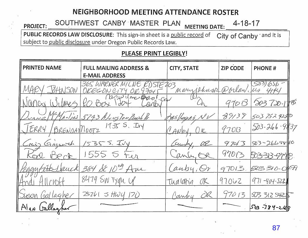
87
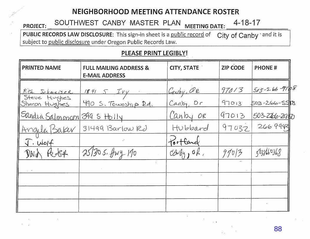
88

89
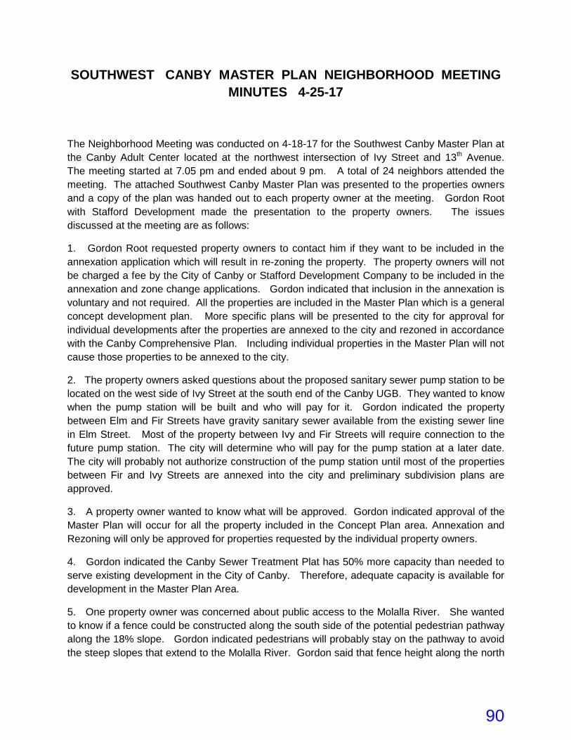
SOUTHWEST CANBY MASTER PLAN NEIGHBORHOOD MEETING MINUTES 4-25-17
The Neighborhood Meeting was conducted on 4-18-17 for the Southwest Canby Master Plan at the Canby Adult Center located at the northwest intersection of Ivy Street and 13th Avenue. The meeting started at 7.05 pm and ended about 9 pm. A total of 24 neighbors attended the meeting. The attached Southwest Canby Master Plan was presented to the properties owners and a copy of the plan was handed out to each property owner at the meeting. Gordon Root with Stafford Development made the presentation to the property owners. The issues discussed at the meeting are as follows:
1. Gordon Root requested property owners to contact him if they want to be included in the annexation application which will result in re-zoning the property. The property owners will not be charged a fee by the City of Canby or Stafford Development Company to be included in the annexation and zone change applications. Gordon indicated that inclusion in the annexation is voluntary and not required. All the properties are included in the Master Plan which is a general concept development plan. More specific plans will be presented to the city for approval for individual developments after the properties are annexed to the city and rezoned in accordance with the Canby Comprehensive Plan. Including individual properties in the Master Plan will not cause those properties to be annexed to the city.
2. The property owners asked questions about the proposed sanitary sewer pump station to be located on the west side of Ivy Street at the south end of the Canby UGB. They wanted to know when the pump station will be built and who will pay for it. Gordon indicated the property between Elm and Fir Streets have gravity sanitary sewer available from the existing sewer line in Elm Street. Most of the property between Ivy and Fir Streets will require connection to the future pump station. The city will determine who will pay for the pump station at a later date. The city will probably not authorize construction of the pump station until most of the properties between Fir and Ivy Streets are annexed into the city and preliminary subdivision plans are approved.
3. A property owner wanted to know what will be approved. Gordon indicated approval of the Master Plan will occur for all the property included in the Concept Plan area. Annexation and Rezoning will only be approved for properties requested by the individual property owners.
4. Gordon indicated the Canby Sewer Treatment Plat has 50% more capacity than needed to serve existing development in the City of Canby. Therefore, adequate capacity is available for development in the Master Plan Area.
5. One property owner was concerned about public access to the Molalla River. She wanted to know if a fence could be constructed along the south side of the potential pedestrian pathway along the 18% slope. Gordon indicated pedestrians will probably stay on the pathway to avoid the steep slopes that extend to the Molalla River. Gordon said that fence height along the north
90

side of the trail next to the residential lots will be limited to 4 feet in height or be required to be seen through, to provide “eyes on the trail” to control vandalism and other problems.
6. Gordon indicated Canby has a lot of parks but lacks the funds to maintain all the parks. Locations of other parks in the Master Plan Area will be evaluated by the city when specific development plans are submitted to the city for review.
7. One property owners asked if they can advocate for more parks when this Master Plan is reviewed by the city. Gordon indicated it would be appropriate for the residents in the area to provide comments about parks to the Planning Commission and City Council at the public hearings.
8. The property owners indicated Ivy Street has too much traffic. They also identified problems with high speeds and sight distance issues with existing driveways, “S” curves just north of the Molalla River and the vertical curves of Ivy Street. The property owners commented on the large number of accidents on Ivy Street from the constraints identified above. Gordon indicated a general traffic study will be prepared for the Master Plan Area and a detained traffic study for the Beck property between Elm and Fir Streets and will be reviewed by Rick Nys at Clackamas County.
9. The property owner of Tax Lot 1600 on the west side of Ivy Street identified a blind spot on Ivy Street when exiting Tax Lot 1600. Gordon indicated this blind spot will be evaluated with the Traffic Study to determine the best location for a new east/west road between Ivy and Fir Streets. The proposed Master Plan currently shows a new east/west street. This new street will probably be named 17th Avenue.
10. One property owner wanted to know how to determine the value of their property. Gordon indicated they work backwards from the house price, house construction and site development costs. All these costs are fixed. The only variable cost is the land price.
11. Gordon indicated Canby is a commuter city to the Portland Metro Area, Tualatin and Wilsonville.
12. The property owners questioned the jurisdiction of Ivy Street. Is it controlled by the State or Clackamas County? They said ODOT was not very responsive to their concerns about traffic accidents, the safety of Ivy Street and reducing the speed limit. They also questioned the future jurisdiction of the other street in the general area. Gordon indicted the city will probably take jurisdiction of all local streets and ODOT will probably retain jurisdiction of Ivy Street.
13. The property owners asked questions about the Commercial Residential Zone. Gordon will get back to those property owners to answer their questions.
91

MasterPlan, 3/31/2017 1:20:27 PM
92
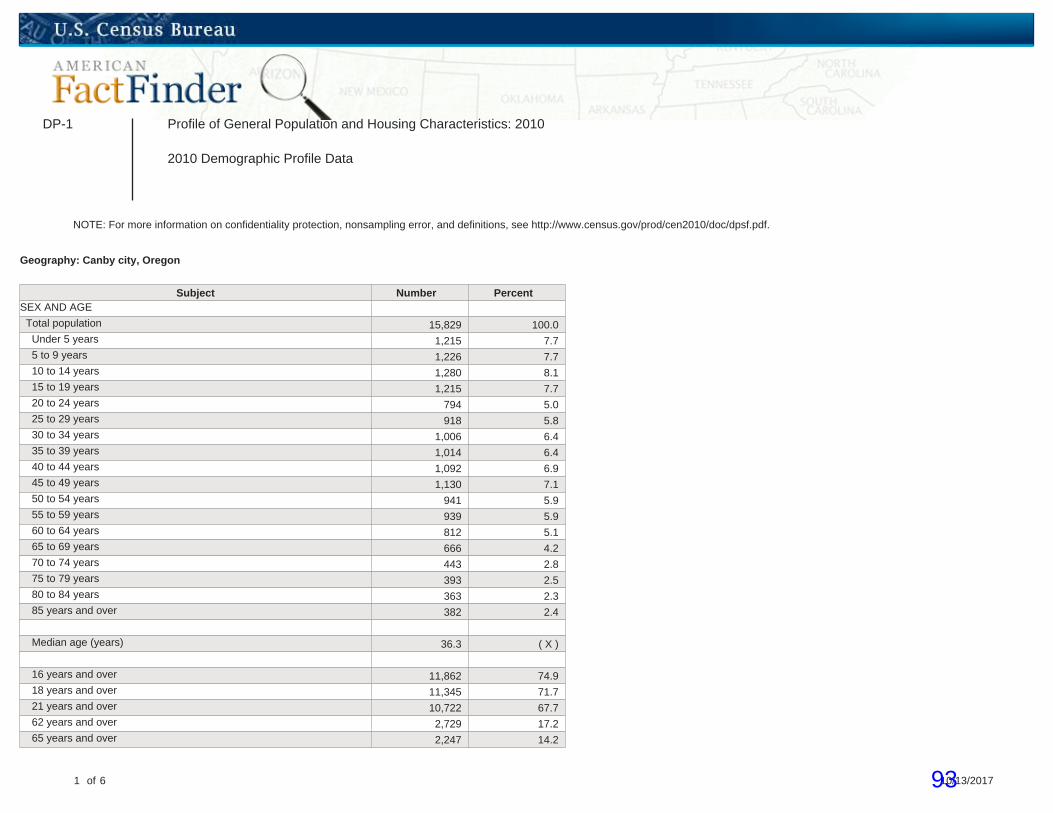
DP-1 Profile of General Population and Housing Characteristics: 2010
2010 Demographic Profile Data
NOTE: For more information on confidentiality protection, nonsampling error, and definitions, see http://www.census.gov/prod/cen2010/doc/dpsf.pdf.
Geography: Canby city, Oregon
Subject Number PercentSEX AND AGE
Total population 15,829 100.0 Under 5 years 1,215 7.7 5 to 9 years 1,226 7.7 10 to 14 years 1,280 8.1 15 to 19 years 1,215 7.7 20 to 24 years 794 5.0 25 to 29 years 918 5.8 30 to 34 years 1,006 6.4 35 to 39 years 1,014 6.4 40 to 44 years 1,092 6.9 45 to 49 years 1,130 7.1 50 to 54 years 941 5.9 55 to 59 years 939 5.9 60 to 64 years 812 5.1 65 to 69 years 666 4.2 70 to 74 years 443 2.8 75 to 79 years 393 2.5 80 to 84 years 363 2.3 85 years and over 382 2.4
Median age (years) 36.3 ( X )
16 years and over 11,862 74.9 18 years and over 11,345 71.7 21 years and over 10,722 67.7 62 years and over 2,729 17.2 65 years and over 2,247 14.2
1 of 6 10/13/201793

Subject Number Percent
Male population 7,596 48.0 Under 5 years 614 3.9 5 to 9 years 617 3.9 10 to 14 years 640 4.0 15 to 19 years 640 4.0 20 to 24 years 397 2.5 25 to 29 years 453 2.9 30 to 34 years 472 3.0 35 to 39 years 512 3.2 40 to 44 years 532 3.4 45 to 49 years 544 3.4 50 to 54 years 440 2.8 55 to 59 years 453 2.9 60 to 64 years 387 2.4 65 to 69 years 304 1.9 70 to 74 years 205 1.3 75 to 79 years 145 0.9 80 to 84 years 128 0.8 85 years and over 113 0.7
Median age (years) 34.7 ( X )
16 years and over 5,591 35.3 18 years and over 5,312 33.6 21 years and over 5,009 31.6 62 years and over 1,115 7.0 65 years and over 895 5.7
Female population 8,233 52.0 Under 5 years 601 3.8 5 to 9 years 609 3.8 10 to 14 years 640 4.0 15 to 19 years 575 3.6 20 to 24 years 397 2.5 25 to 29 years 465 2.9 30 to 34 years 534 3.4 35 to 39 years 502 3.2 40 to 44 years 560 3.5 45 to 49 years 586 3.7 50 to 54 years 501 3.2 55 to 59 years 486 3.1 60 to 64 years 425 2.7 65 to 69 years 362 2.3 70 to 74 years 238 1.5
2 of 6 10/13/201794

Subject Number Percent 75 to 79 years 248 1.6 80 to 84 years 235 1.5 85 years and over 269 1.7
Median age (years) 38.0 ( X )
16 years and over 6,271 39.6 18 years and over 6,033 38.1 21 years and over 5,713 36.1 62 years and over 1,614 10.2 65 years and over 1,352 8.5
RACE
Total population 15,829 100.0 One Race 15,371 97.1 White 12,816 81.0 Black or African American 93 0.6 American Indian and Alaska Native 192 1.2 Asian 169 1.1 Asian Indian 14 0.1 Chinese 29 0.2 Filipino 11 0.1 Japanese 12 0.1 Korean 21 0.1 Vietnamese 40 0.3 Other Asian [1] 42 0.3 Native Hawaiian and Other Pacific Islander 29 0.2 Native Hawaiian 14 0.1 Guamanian or Chamorro 3 0.0 Samoan 0 0.0 Other Pacific Islander [2] 12 0.1 Some Other Race 2,072 13.1 Two or More Races 458 2.9 White; American Indian and Alaska Native [3] 123 0.8 White; Asian [3] 77 0.5 White; Black or African American [3] 48 0.3 White; Some Other Race [3] 151 1.0
Race alone or in combination with one or more other races: [4]
White 13,244 83.7 Black or African American 157 1.0 American Indian and Alaska Native 334 2.1 Asian 270 1.7 Native Hawaiian and Other Pacific Islander 54 0.3 Some Other Race 2,251 14.2
3 of 6 10/13/201795

Subject Number Percent
HISPANIC OR LATINO
Total population 15,829 100.0 Hispanic or Latino (of any race) 3,368 21.3 Mexican 3,099 19.6 Puerto Rican 20 0.1 Cuban 7 0.0 Other Hispanic or Latino [5] 242 1.5 Not Hispanic or Latino 12,461 78.7
HISPANIC OR LATINO AND RACE
Total population 15,829 100.0 Hispanic or Latino 3,368 21.3 White alone 991 6.3 Black or African American alone 58 0.4 American Indian and Alaska Native alone 68 0.4 Asian alone 1 0.0 Native Hawaiian and Other Pacific Islander alone 10 0.1 Some Other Race alone 2,061 13.0 Two or More Races 179 1.1 Not Hispanic or Latino 12,461 78.7 White alone 11,825 74.7 Black or African American alone 35 0.2 American Indian and Alaska Native alone 124 0.8 Asian alone 168 1.1 Native Hawaiian and Other Pacific Islander alone 19 0.1 Some Other Race alone 11 0.1 Two or More Races 279 1.8
RELATIONSHIP
Total population 15,829 100.0 In households 15,735 99.4 Householder 5,647 35.7 Spouse [6] 3,242 20.5 Child 5,152 32.5 Own child under 18 years 4,019 25.4 Other relatives 969 6.1 Under 18 years 388 2.5 65 years and over 110 0.7 Nonrelatives 725 4.6 Under 18 years 76 0.5 65 years and over 45 0.3
Unmarried partner 325 2.1 In group quarters 94 0.6
4 of 6 10/13/201796
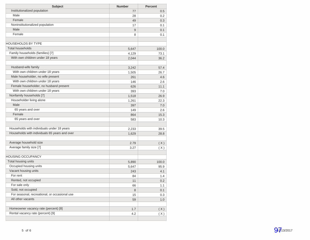
Subject Number Percent Institutionalized population 77 0.5 Male 28 0.2 Female 49 0.3 Noninstitutionalized population 17 0.1 Male 9 0.1 Female 8 0.1
HOUSEHOLDS BY TYPE
Total households 5,647 100.0 Family households (families) [7] 4,129 73.1 With own children under 18 years 2,044 36.2
Husband-wife family 3,242 57.4 With own children under 18 years 1,505 26.7 Male householder, no wife present 261 4.6 With own children under 18 years 146 2.6 Female householder, no husband present 626 11.1 With own children under 18 years 393 7.0 Nonfamily households [7] 1,518 26.9 Householder living alone 1,261 22.3 Male 397 7.0 65 years and over 149 2.6 Female 864 15.3 65 years and over 583 10.3
Households with individuals under 18 years 2,233 39.5 Households with individuals 65 years and over 1,629 28.8
Average household size 2.79 ( X ) Average family size [7] 3.27 ( X )
HOUSING OCCUPANCY
Total housing units 5,890 100.0 Occupied housing units 5,647 95.9 Vacant housing units 243 4.1 For rent 84 1.4 Rented, not occupied 11 0.2 For sale only 66 1.1 Sold, not occupied 8 0.1 For seasonal, recreational, or occasional use 15 0.3 All other vacants 59 1.0
Homeowner vacancy rate (percent) [8] 1.7 ( X ) Rental vacancy rate (percent) [9] 4.2 ( X )
5 of 6 10/13/201797
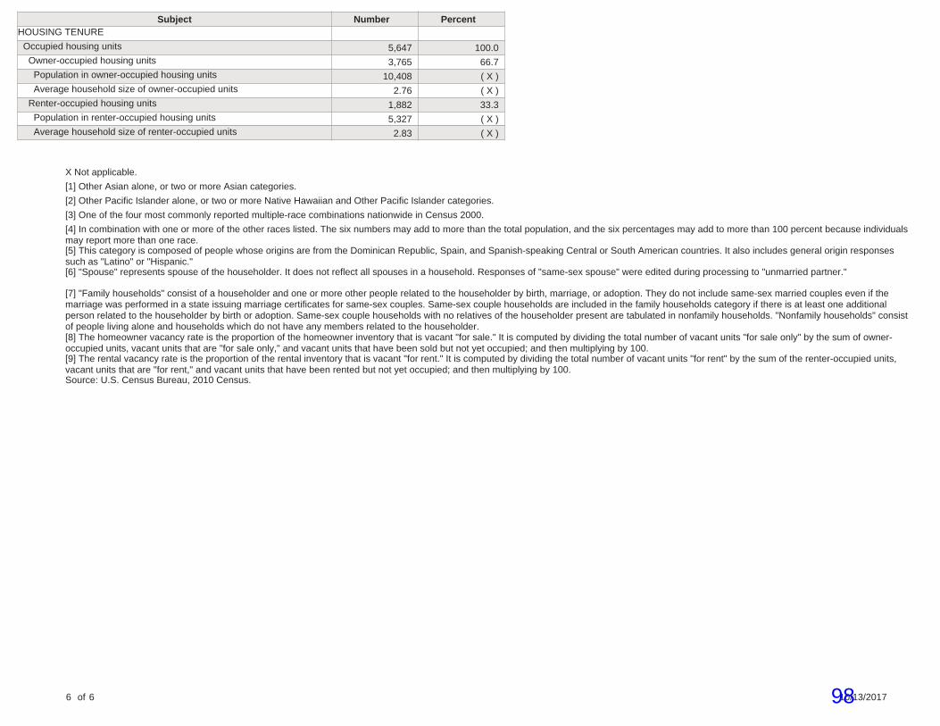
Subject Number PercentHOUSING TENURE
Occupied housing units 5,647 100.0 Owner-occupied housing units 3,765 66.7 Population in owner-occupied housing units 10,408 ( X ) Average household size of owner-occupied units 2.76 ( X ) Renter-occupied housing units 1,882 33.3 Population in renter-occupied housing units 5,327 ( X ) Average household size of renter-occupied units 2.83 ( X )
X Not applicable.
[1] Other Asian alone, or two or more Asian categories.
[2] Other Pacific Islander alone, or two or more Native Hawaiian and Other Pacific Islander categories.
[3] One of the four most commonly reported multiple-race combinations nationwide in Census 2000.
[4] In combination with one or more of the other races listed. The six numbers may add to more than the total population, and the six percentages may add to more than 100 percent because individualsmay report more than one race.[5] This category is composed of people whose origins are from the Dominican Republic, Spain, and Spanish-speaking Central or South American countries. It also includes general origin responsessuch as "Latino" or "Hispanic."[6] "Spouse" represents spouse of the householder. It does not reflect all spouses in a household. Responses of "same-sex spouse" were edited during processing to "unmarried partner."
[7] "Family households" consist of a householder and one or more other people related to the householder by birth, marriage, or adoption. They do not include same-sex married couples even if themarriage was performed in a state issuing marriage certificates for same-sex couples. Same-sex couple households are included in the family households category if there is at least one additionalperson related to the householder by birth or adoption. Same-sex couple households with no relatives of the householder present are tabulated in nonfamily households. "Nonfamily households" consistof people living alone and households which do not have any members related to the householder.[8] The homeowner vacancy rate is the proportion of the homeowner inventory that is vacant "for sale." It is computed by dividing the total number of vacant units "for sale only" by the sum of owner-occupied units, vacant units that are "for sale only," and vacant units that have been sold but not yet occupied; and then multiplying by 100.[9] The rental vacancy rate is the proportion of the rental inventory that is vacant "for rent." It is computed by dividing the total number of vacant units "for rent" by the sum of the renter-occupied units,vacant units that are "for rent," and vacant units that have been rented but not yet occupied; and then multiplying by 100.Source: U.S. Census Bureau, 2010 Census.
6 of 6 10/13/201798

PEPANNRES Annual Estimates of the Resident Population: April 1, 2010 to July 1, 2016
2016 Population Estimates
Geography April 1, 2010 Population Estimate (as of July 1)
Census Estimates Base 2010 2011 2012 2013Canby city, Oregon 15,829 16,646 16,668 16,730 16,808 16,950
1 of 2 10/13/201799
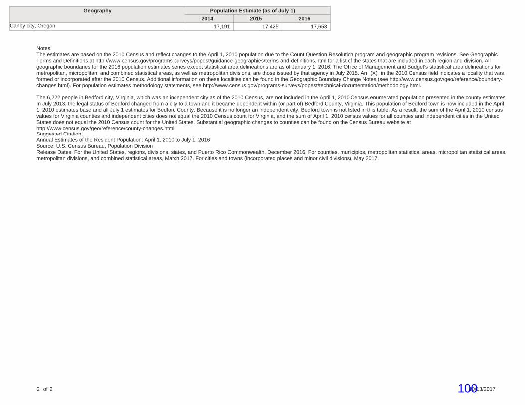
Geography Population Estimate (as of July 1)
2014 2015 2016Canby city, Oregon 17,191 17,425 17,653
Notes:The estimates are based on the 2010 Census and reflect changes to the April 1, 2010 population due to the Count Question Resolution program and geographic program revisions. See GeographicTerms and Definitions at http://www.census.gov/programs-surveys/popest/guidance-geographies/terms-and-definitions.html for a list of the states that are included in each region and division. Allgeographic boundaries for the 2016 population estimates series except statistical area delineations are as of January 1, 2016. The Office of Management and Budget's statistical area delineations formetropolitan, micropolitan, and combined statistical areas, as well as metropolitan divisions, are those issued by that agency in July 2015. An "(X)" in the 2010 Census field indicates a locality that wasformed or incorporated after the 2010 Census. Additional information on these localities can be found in the Geographic Boundary Change Notes (see http://www.census.gov/geo/reference/boundary-changes.html). For population estimates methodology statements, see http://www.census.gov/programs-surveys/popest/technical-documentation/methodology.html.
The 6,222 people in Bedford city, Virginia, which was an independent city as of the 2010 Census, are not included in the April 1, 2010 Census enumerated population presented in the county estimates.In July 2013, the legal status of Bedford changed from a city to a town and it became dependent within (or part of) Bedford County, Virginia. This population of Bedford town is now included in the April1, 2010 estimates base and all July 1 estimates for Bedford County. Because it is no longer an independent city, Bedford town is not listed in this table. As a result, the sum of the April 1, 2010 censusvalues for Virginia counties and independent cities does not equal the 2010 Census count for Virginia, and the sum of April 1, 2010 census values for all counties and independent cities in the UnitedStates does not equal the 2010 Census count for the United States. Substantial geographic changes to counties can be found on the Census Bureau website athttp://www.census.gov/geo/reference/county-changes.html.Suggested Citation:Annual Estimates of the Resident Population: April 1, 2010 to July 1, 2016Source: U.S. Census Bureau, Population DivisionRelease Dates: For the United States, regions, divisions, states, and Puerto Rico Commonwealth, December 2016. For counties, municipios, metropolitan statistical areas, micropolitan statistical areas,metropolitan divisions, and combined statistical areas, March 2017. For cities and towns (incorporated places and minor civil divisions), May 2017.
2 of 2 10/13/2017100

Southwest Canby Development Concept Plan
Updated 12-22-17
Prepared by Planning & Land Design LLC 1862 NE Estate Drive, Hillsboro, Oregon 97124 Ryan O’Brien Phone (503) 780-4061 [email protected]
101

Table of Contents
I. Purpose
II. Existing Conditions
III. Opportunities and Constraints
IV. Concept Plan
V. Utility Service
VI. Park Dedication
VII. Development Concept Plan Maps
1. Vicinity Aerial Map 2. Close up Aerial Photo 3. SW Canby Master Plan & Proposed Zoning 4. Existing Conditions with Topo & Houses 5. Ownership Map with Net Acres in UGB 6. Neighborhood Meeting Minutes 7. Canby Soils Map 8. Sanitary Sewer Plan 9. Water Line Plan 10. Canby Comprehensive Plan Map 11. Canby Zoning Map 12. Canby Transportation System Plan Map 13. Canby Street Sections 14. SW Canby Traffic Study 15. Ivy Street and 16th Avenue Roundabout Plan 16. Pedestrian Pathway Along Elm Street 17. Pedestrian Pathway Along Top of Bank and Ivy Street
VIII. City Approval Summary
102
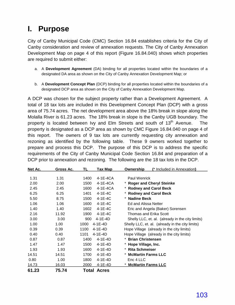
I. Purpose
City of Canby Municipal Code (CMC) Section 16.84 establishes criteria for the City of Canby consideration and review of annexation requests. The City of Canby Annexation Development Map on page 4 of this report (Figure 16.84.040) shows which properties are required to submit either:
a. A Development Agreement (DA) binding for all properties located within the boundaries of a designated DA area as shown on the City of Canby Annexation Development Map; or
b. A Development Concept Plan (DCP) binding for all properties located within the boundaries of a designated DCP area as shown on the City of Canby Annexation Development Map.
A DCP was chosen for the subject property rather than a Development Agreement. A total of 18 tax lots are included in this Development Concept Plan (DCP) with a gross area of 75.74 acres. The net development area above the 18% break in slope along the Molalla River is 61.23 acres. The 18% break in slope is the Canby UGB boundary. The property is located between Ivy and Elm Streets and south of 13th Avenue. The property is designated as a DCP area as shown by CMC Figure 16.84.040 on page 4 of this report. The owners of 9 tax lots are currently requesting city annexation and rezoning as identified by the following table. These 9 owners worked together to prepare and process this DCP. The purpose of this DCP is to address the specific requirements of the City of Canby Municipal Code Section 16.84 and preparation of a DCP prior to annexation and rezoning. The following are the 18 tax lots in the DCP.
Net Ac. Gross Ac. TL Tax Map Ownership (* Included in Annexation)
1.31 1.31 1400 4-1E-4CA Paul Wenrick 2.00 2.00 1500 4-1E-4CA * Roger and Cheryl Steinke 2.45 2.45 1600 4-1E-4CA * Rodney and Carol Beck 6.25 6.25 1401 4-1E-4C * Rodney and Carol Beck 5.50 8.75 1500 4-1E-4C * Nadine Beck 1.06 1.06 1600 4-1E-4C Ed and Alissa Netter 1.40 1.40 1602 4-1E-4C Eric and Angela (Baker) Sorensen 2.16 11.92 1900 4-1E-4C Thomas and Erika Scott 3.00 3.00 900 4-1E-4D Shelly LLC, et. al. (already in the city limits) 1.00 1.00 1000 4-1E-4D Shelly LLC, et. al. (already in the city limits) 0.39 0.39 1100 4-1E-4D Hope Village (already in the city limits) 0.40 0.40 1101 4-1E-4D Hope Village (already in the city limits) 0.87 0.87 1400 4-1E-4D * Brian Christensen 1.47 1.47 1500 4-1E-4D * Hope Village, Inc. 1.93 1.93 1600 4-1E-4D * Rita Schmeiser 14.51 14.51 1700 4-1E-4D * McMartin Farms LLC 0.80 1.00 1800 4-1E-4D Enc 4 LLC 14.73 16.03 2000 4-1E-4D * McMartin Farms LLC 61.23 75.74 Total Acres
103

Figure 16.84.040
104
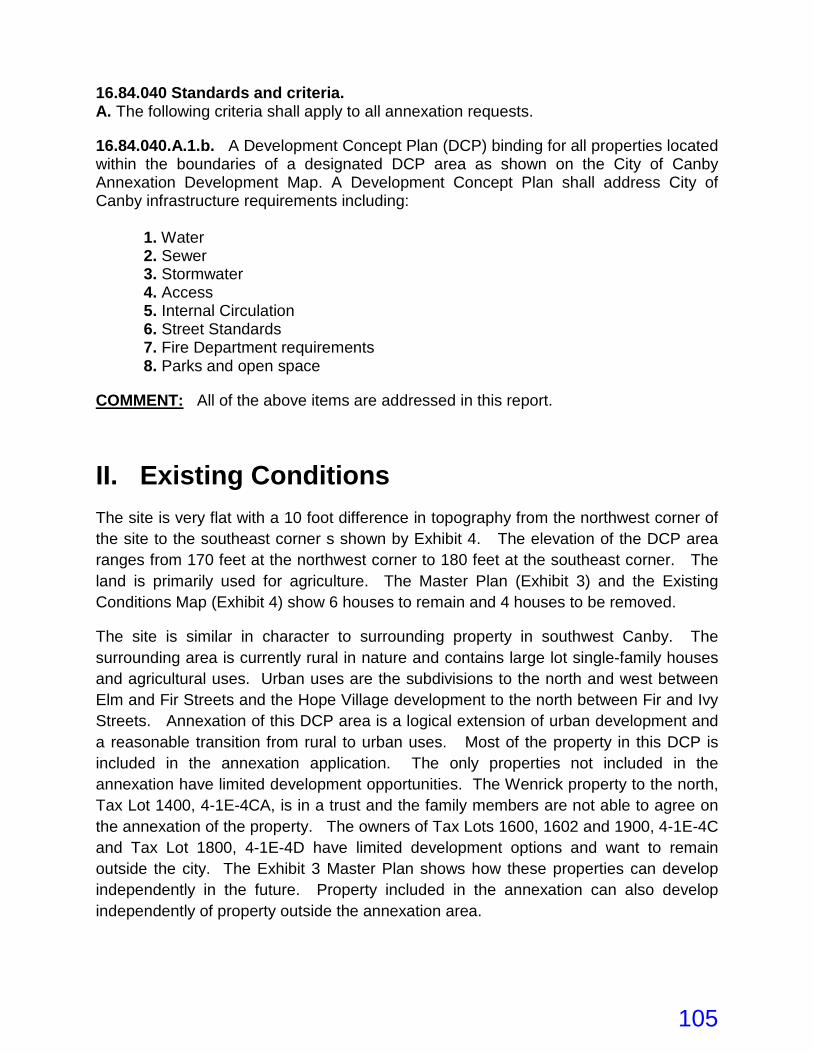
16.84.040 Standards and criteria. A. The following criteria shall apply to all annexation requests. 16.84.040.A.1.b. A Development Concept Plan (DCP) binding for all properties located within the boundaries of a designated DCP area as shown on the City of Canby Annexation Development Map. A Development Concept Plan shall address City of Canby infrastructure requirements including:
1. Water 2. Sewer 3. Stormwater 4. Access 5. Internal Circulation 6. Street Standards 7. Fire Department requirements 8. Parks and open space
COMMENT: All of the above items are addressed in this report.
II. Existing Conditions The site is very flat with a 10 foot difference in topography from the northwest corner of the site to the southeast corner s shown by Exhibit 4. The elevation of the DCP area ranges from 170 feet at the northwest corner to 180 feet at the southeast corner. The land is primarily used for agriculture. The Master Plan (Exhibit 3) and the Existing Conditions Map (Exhibit 4) show 6 houses to remain and 4 houses to be removed.
The site is similar in character to surrounding property in southwest Canby. The surrounding area is currently rural in nature and contains large lot single-family houses and agricultural uses. Urban uses are the subdivisions to the north and west between Elm and Fir Streets and the Hope Village development to the north between Fir and Ivy Streets. Annexation of this DCP area is a logical extension of urban development and a reasonable transition from rural to urban uses. Most of the property in this DCP is included in the annexation application. The only properties not included in the annexation have limited development opportunities. The Wenrick property to the north, Tax Lot 1400, 4-1E-4CA, is in a trust and the family members are not able to agree on the annexation of the property. The owners of Tax Lots 1600, 1602 and 1900, 4-1E-4C and Tax Lot 1800, 4-1E-4D have limited development options and want to remain outside the city. The Exhibit 3 Master Plan shows how these properties can develop independently in the future. Property included in the annexation can also develop independently of property outside the annexation area.
105
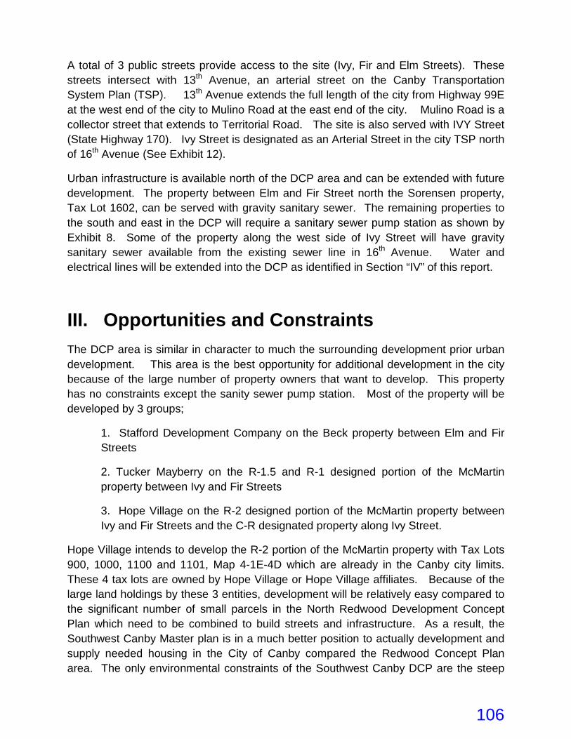
A total of 3 public streets provide access to the site (Ivy, Fir and Elm Streets). These streets intersect with 13th Avenue, an arterial street on the Canby Transportation System Plan (TSP). 13th Avenue extends the full length of the city from Highway 99E at the west end of the city to Mulino Road at the east end of the city. Mulino Road is a collector street that extends to Territorial Road. The site is also served with IVY Street (State Highway 170). Ivy Street is designated as an Arterial Street in the city TSP north of 16th Avenue (See Exhibit 12).
Urban infrastructure is available north of the DCP area and can be extended with future development. The property between Elm and Fir Street north the Sorensen property, Tax Lot 1602, can be served with gravity sanitary sewer. The remaining properties to the south and east in the DCP will require a sanitary sewer pump station as shown by Exhibit 8. Some of the property along the west side of Ivy Street will have gravity sanitary sewer available from the existing sewer line in 16th Avenue. Water and electrical lines will be extended into the DCP as identified in Section “IV” of this report.
III. Opportunities and Constraints
The DCP area is similar in character to much the surrounding development prior urban development. This area is the best opportunity for additional development in the city because of the large number of property owners that want to develop. This property has no constraints except the sanity sewer pump station. Most of the property will be developed by 3 groups;
1. Stafford Development Company on the Beck property between Elm and Fir Streets
2. Tucker Mayberry on the R-1.5 and R-1 designed portion of the McMartin property between Ivy and Fir Streets
3. Hope Village on the R-2 designed portion of the McMartin property between Ivy and Fir Streets and the C-R designated property along Ivy Street.
Hope Village intends to develop the R-2 portion of the McMartin property with Tax Lots 900, 1000, 1100 and 1101, Map 4-1E-4D which are already in the Canby city limits. These 4 tax lots are owned by Hope Village or Hope Village affiliates. Because of the large land holdings by these 3 entities, development will be relatively easy compared to the significant number of small parcels in the North Redwood Development Concept Plan which need to be combined to build streets and infrastructure. As a result, the Southwest Canby Master plan is in a much better position to actually development and supply needed housing in the City of Canby compared the Redwood Concept Plan area. The only environmental constraints of the Southwest Canby DCP are the steep
106
slopes along the Molalla River Corridor. The steep slopes are outside the UGB and will not be annexed to the city.
Schools - The schools are very close to the Southwest Canby DCP. Lee Elementary and Ackerman Middle Schools are located at the northeast corner of Ivy Street and 13th Avenue. Canby High School is located at the southeast corner of Highway 99E and 4th Avenue. These schools have athletic fields which provide active recreational opportunities on weekends, during summers, and when school is not in session.
Bike and Walking Trails – A bicycle and walking trail will be provided along the 18% top of slope from Ivy Street to Elm Street with 3 pocket parks as shown by Exhibit 3. Page 107 of the Canby Comprehensive Plan shows a bike path will be provided along Ivy Street.
SE 13th Avenue & Ivy Street - SE 13th Avenue and Ivy Street are designated arterial streets in the City of Canby Transportation System Plan. SE 13th Avenue provides convenient east-west trips between S Mulino Road and 99E. Because SE 13th Avenue is an arterial, intersections are limited to a spacing guideline established by the City. Ivy Street provides a north-south connection to downtown Canby and neighboring cities and communities to the south.
East-West Connection - Exhibit 3 shows an east-west street connection between Ivy and Fir Streets. These streets are referred to as 17th and 18th Avenues in this report. 17th Avenue lines up with the flag pole of Tax Lot 1200, Map 4-1E-4D located on the east side of Ivy Street to create a major intersection. The Traffic Study addresses this intersection and recommends construction of a roundabout at this intersection to reduce high speeds on Ivy Street from north and south bound traffic. Appendix “E” of the DKS Traffic report shows a preliminary design for this traffic circle (Exhibit 14). A more precise plan for this roundabout is shown by Exhibit 15.
A second east-west street, 16th Avenue, is located between Fir and Elm Streets on the Beck property directly across from the Hope Village access on the east side of Fir Street. The 16th Avenue access on Elm Street is in the proper location for adequate sight distance in both directions. These 3 new east-west streets will connect the 3 north-south streets in the DCP area to provide an adequate traffic circulation system for the DCP area.
Fire Department Requiements - The Master Plan has been designed to provide adequate fire truck access to all dwelling units. All the streets are looped except for one cul-de-sac on the west side of Fir Street. Water lines will be designed to provide adequate fire hydrant flows and pressure and looped to existing 8, 10 and 12-inch diameter water lines (Exhibit 9).
107
IV. Concept Plan Zoning: The DCP land use designations are the same as the City of Canby Comprehensive Plan. The Comprehensive Plan identifies 4 separate plans designations:
LDR - Low Density Residential with R-1 Low Density Residential Zoning
MDR - Medium Density Residential with R-1.5 Medium Density Residential Zoning
HDR - High Density Residential with R-2 High Density Residential Zoning
RC - Residential Commercial with C-R Residential Commercial Zoning
Exhibit 3 shows both the Comprehensive Plan designation and proposed Zoning. Since the proposed Zoning designations are the same as the Comprehensive Plan, no Comprehensive Plan Amendments are required with this application.
Canby Municipal Code (CMC) Chapter 16.16 (R-1 Low Density Residential Zone) permits one single family dwelling per lot in addition to other Conditional Uses. Lots in the R-1 zone are required to be 7,000 sf in area unless a PUD or lot averaging is proposed. Canby Municipal Code (CMC) Chapter 16.18 (R-1.5 Medium Density Residential Zone) allows uses permitted in the R-1 zone and two or three family dwellings (one duplex or tri-plex on each lot). Four-Family and Single-Family common wall dwelling units are permitted as Conditional Uses. The current property owners in the DCP do not intend to develop attached or multiple family dwelling units in the R-1.5 zone. Only detached houses are proposed. Lots in the R-1.5 zone are required to be 5,000 sf in area unless a PUD or lot averaging is proposed. Canby Municipal Code (CMC) Chapter 16.20 (R-2 High Density Residential Zone) permits single family dwellings with common wall construction, uses permitted in the R-1.5 zone and other uses such as multi-family dwelling units. Hope Village intends to develop the R-2 and C-R zoned land in the DCP with approximately 43 duplexes, triplexes and fourplexes and 18 three-story senior apartment units. Canby Municipal Code (CMC) Chapter 16.24 (C-R Residential Commercial Zone) permits one single family dwelling per lot, uses permitted in the R-1.5 zone and Conditional Uses such as multi-family dwelling units. Hope Village intends to develop the C-R zoned land the same as the R-2 zone land with a PUD application, even though only R-1.5 uses and standards are permitted.
108
Streets: The proposed Master Plan (Exhibit 2) shows connection to 3 existing streets; Elm, Fir and Ivy Streets. All of these streets connect to 13th Avenue, an Arterial Street. 13th Avenue extends the full length of the City of Canby. Most of the interior streets will be developed with the Low-Volume Street Section with 28 feet of pavement, 52 feet of right-of-way and parking on both sides of the street. This street section is appropriate for less than 500 vehicle trips per day (VTD). The only exceptions will be the east-west streets between Elm and Ivy Street (17th and 18th Avenues) and Elm and Fir Streets (16th Avenue). These streets will carry over 500 VTD and will develop with the Standard Local Street section with 34 foot of pavement and 58 feet of right-of-way. Both of these street sections are consistent with the local street connections in the attached Figure 7-6 of the Canby TSP (See Exhibit 13). Ivy Street is an Arterial Street and will develop in accordance with the attached two-way arterial street section in Figure 7-4 (Exhibit 13) with 60 to 80 feet of right-of-way and 34 to 50 feet of pavement. Page 107 of the Canby Comprehensive Plan shows a bike path will be provided along Ivy Street.
Parks: The existing City parks that are close to the DCP area are as follows:
1. Legacy Park is located at 1200 SE 13th Avenue next to Ackerman Middle School and features playgrounds, soccer fields, a picnic shelter and a meditation garden. 2. Community River Park is located at 1348 S. Berg Parkway southwest of Canby High School. This is a natural park with picnic facilities, barbecue pits, playground equipment, ball fields and a fishing pond for youth age 17 and under. 3. The Community Swim Center is located at 1150 S. Ivy Street just north of 13th Avenue. 4. The adult Center is located at 1250 S. Ivy Street at the northeast intersection of 13th Avenue and Ivy Street.
A total of 3 new pocket parks are shown on the Master Plan (Exhibit 3). The First Pocket Park is located on the McMartin property between 2 local streets. This park is 0.73 acres and size and will be developed with recreational facilities. The extent of the facilities will be determined when the subdivision application is reviewed by the city. The Second Pocket Park is adjacent to one local street and fronts along a proposed trail which follows the 18% slope adjacent to the Molalla River corridor. This park is 1.65 acres in size with the trail included. On-street parking is available for visitors of both parks. Two pedestrian pathways at the east and west ends of the McMartin subdivision connect the future subdivision to this trail. A bicycle and walking trail will be
109
developed along the Molalla River Corridor. The trail right-of-way will be generally 35 feet in width and 1000-feet in length. The area of this trail and both parks on the McMartin property is 2.38 acres. This trail extends from Ivy Street to Elm Street. The Third Pocket Park on the Beck property is 0.80 acres in size. The trial on the Scott and ENC LLC properties is 0.52 acres. This pocket park can be developed with the Beck subdivision or when a new public street is extended from Fir Street along the common property line of Tax Lots 1600 and 1602, Map 4-1E-4C, as shown by Exhibit 3. The total length of this future trail in the future will be 2500-feet. The area of this trial right-of-way is 1.21 acres. The total area of all parks and trails combined is 3.73 acres. The need for park land for this DCP is 5.21acres as identified below leaving a shortage of 1.48 acres. The following is the open space and park calculation: 193 - Total single family detached dwelling units 61 - Hope Village attached senior housing units (private open space provided) 254 - Total Number of Dwelling Units 0.01 acres of park and open space per person x 2.7 persons per house x 193 detached houses (excluding Hope Village units) = 5.21 acres - 3.73 acres = 1.48 acres of additional park and open space to be purchased by the City of Canby with Parks System Development Fees. All lots in this Master Plan either dedicate land for parks or pay City SDC fee or a combination of both alternatives. The 3 new pocket parks and the trail will provide significant recreational opportunities for future residents in this DCP. Additional recreational opportunities are available at the south end of Tax Lot 1500, Map 4-1E-4C outside the UGB. Access to this property is available through an existing road next to Pocket Park 3. The pocket parks next to the trail will take advantage of the large stand of trees located along the south side of the trail. The trees provide shade for passive recreational opportunities such as walkways, picnic tables, and benches. Additional recreational opportunities include nature walks, playground equipment and picking. The pocket parks will be used as rest stops along the trail. Park improvements may be constructed by the project developer or the City of Canby. See Section VI (Park Dedication), for additional information.
V. Utility Service
Annexation of the subject property with R-1, R-1.5, R-2 and C-R zoning is a reasonable expansion of the City of Canby based on the level of development in the surrounding
110
area and the existing facilities and services that are available to serve the DCP area. The City of Canby staff indicated at a pre-application meeting that all utility service providers and utilities are available in this DCP area or can be made available through development of the site. Water: Water is provided through Canby Utility’s Water Department. A 10-inch water line is available in Fir Street, a 12-inch line in Ivy Street and an 8-inch line in Elm Street. All 3 water lines will be extended into the DCP area. The 12-inch water line will be constructed in the east-west streets between Ivy and Fir Streets (17th and 18th Avenues) and possibly between Fir and Elm Streets (16th Avenue) based on a final water line flow and pressure calculations (See Exhibit 9). The rest of the streets will have looped 8-inch water lines which connect to the existing 10-inch and 12-inch water lines as shown by Exhibit 9. Public water lines will be located in all the public streets. If Hope Village builds private streets in their development, their water lines may still be public rather than private. Sanitary Sewer: Sanitary sewer is provided by the City of Canby. Three existing sewer lines are available to this DCP area (See Exhibit 8). The first existing sewer line is 8-inches in diameter and located at the intersection of 16th Avenue and Ivy Street. This sewer line can be extended to the south along Ivy Street for an undetermined distance to provide gravity sewer service for property on the west side of Ivy Street. A survey of the existing sewer IE and topo of adjacent property will determine the exact distance. The ground elevation of the DCP along Ivy Street is about 178 to 179 feet. Shallow sewer lines conflict with the water lines which only have 3 feet of cover. The pump station will be required to lower the depth of the sewer lines below the water liens to at least 6 to 8 feet as shown by Exhibit 8. At the pre-application conference, city staff indicated the city will not plan for or fund the pump station until the city knows for sure development will occur. Construction of the pump station and the associated force main will be paid for with City Systems Development Fees collected by the City. Gravity mains are paid by the developers of the subdivisions. Annexation of property will not trigger the need for the pump station. It will be constructed by the City when the McMartin property and Hope Village properties are approved for development by the City. The second existing sewer line is 8-inches in diameter and located in Fir Street at the northeast corner of the Steinke property, Tax Lot 1500, Map 4-1E-4CA. The invert elevation is 163.68 feet. This sewer line will serve the northeastern portion of the Beck property as show by Exhibit 8. The third existing sewer line is 8-inches in diameter and located in Elm Street at the north-west corner of the Beck property, Tax Lot 1401, Map 4-1E-4C. The invert
111
elevation is 161.57. This sewer line will serve all of the remaining Beck property s shown by Exhibit 8. Storm Drainage: Roof drains from homes will flow to privately owned and maintained infiltration facilities on each individual lot. Street drainage will flow to sumped catch basins and pollution control manholes for water quality treatment and then to dry wells for disposal through underground injection. All street storm drainage facilities are proposed to be public facilities design to be in compliance with the adopted City of Canby Stormwater Master Plan and the Canby Public Works Design Standards. When development proposals are submitted, the storm water management and drywell locations will be discussed in greater detail. Private Utilities: Private utility service such as telephone, natural gas, cable, garbage, recycling collection and wave broadband are all available to the north in Elm, Fir and Ivy Streets. These utilities generally operate on a franchise basis. Electrical power is provided through Canby Utility’s Electrical Department in conjunction with PGE. Extension of these utility lines will occur with each development phase.
VI. Park Dedication
General: Three new pocket parks and a 2,500 foot long trail are proposed with this DCP. The total combined area of the parks and trail is 3.73 acres. This DCP requires 5.21 acres of park land based on the calculation in Section IV of this report. The City of Canby will be required to purchase 1.48 acres of additional park land with Park System Development Fees to increase the total park land area to 5.21 acres. These 3 new pocket parks and trail will provide significant recreational opportunities for the residents in this DCP. The parks next to the trail can take advantage of the large stand of trees located along the south side of the trail. The trees will provide shade for passive recreational opportunities such as walkways, picnic tables, and benches. Other recreational opportunities include nature walks, playground equipment and picking. The pocket parks will be used as rest stops along the trail. Park improvements may be constructed by the project developer or developed by the City of Canby. As mentioned in Section IV of this report, additional park land is available on the Beck property, Tax Lot 1500, Map 4-1E-4C outside the UGB and south of the trail. Access to this potential park land is available through an existing road next to Pocket Park on the Beck property. Sale of Park Land to City: All of the 3 pocket parks and 1,900 linear feet of the 2,500 linear foot trail are located in the annexation and proposed for development. Four tax
112
lots between the Beck and the McMartin properties are excluded from the annexation. Only 600 feet of the trail on 2 tax lots are excluded from the annexation (Tax Lot 1900, Map 4-1E-4C owned by Scott and Tax Lot 1800, Map 4-1E-4D owned by Nutter under the name of ENC LLC). The sale of the park land will occur after the properties are annexed to the city and approved for development. The park land will be appraised during land sale negotiations with the City and property owners. Park land value is established by a MAI appraisal prepared jointly for the City of Canby and the property owners. The City cannot pay more than the appraised value. Park improvements such as walkways, picnic tables, benches, playground equipment and restrooms can either be completed by the site developer or the City of Canby as chosen by the developer. If the developer improves the parks, the improvements are included in the appraised value which increases the price the city will pay for the parks.
Park SDC Obligation: Per the City of Canby’s park dedication formula, a park dedication of 5.21 acres is required to satisfy the Park SDC obligations for 193 lots. Since Hope Village will provide private parks, the proposed Hope Village housing units are not include in the park dedication formula. Any shortage of park dedication will be mitigated by payment of City Park SDC fees at the time building permits are issued for each individual single family detached house. Anticipated Amenities: Construction of park amenities will require approval by the City Parks Board or City Parks Staff prior to construction. These amenities may include walkways, playground equipment, picnic tables, benches and a restroom facility. This list could be modified based on the desires of the City at the time of park dedication and development. Landscaping and signage will be provided to create an aesthetically pleasing park entrance along the public streets. Directional and information signs will be provided along the public street in front of the parks and along the trail.
VII. Development Concept Plan Maps & Reports
1. Vicinity Aerial Map 2. Close up Aerial Photo 3. SW Canby Master Plan & Proposed Zoning 4. Existing Conditions with Topo & Houses 5. Ownership Map with Net Acres in UGB 6. Neighborhood Meeting Minutes 7. Canby Soils Map 8. Sanitary Sewer Plan 9. Water Line Plan
113
10. Canby Comprehensive Plan Map 11. Canby Zoning Map 12. Canby Transportation System Plan Map 13. Canby Street Sections 14. SW Canby Traffic Study 15. Ivy Street and 16th Avenue Roundabout Plan 16. Pedestrian Pathway along Elm Street 17. Pedestrian Pathway Along Top of Bank and Ivy Street
VIII. City Approvals
114

Canby MarketCenter
Canby Square
KendalFloral LLC
Clackamas CountyEvent Center
Canby PoliceStation
Canby Community
Park
WillametteValley
Country Club
AmericanSteel
PioneerPumpInc.
IvyStreet
Oregon Pacific Molalla Branch
Union Pacific Main Line
®0 0.5 10.25
Miles
City of Canby Aerial Map
The information depicted on this map is for general reference only. The City of Canby cannot accept any responsibility for errors, omissions, or positional accuracy.
Map based on 2012 aerial photographs - August 13th, 2013
Baker PrairieMiddleSchool
JohnsonControls
Eco-
Park
Canby High
School
Shimadzu USAManufacturing
TrostElementary
School
LegacyPark
Urban Growth Boundary
City
Limits
NE Territorial Road
Willamette River
S Knights Bridge Road
Molal
laRi
ver
SOUTHWEST CANBY CONCEPT PLAN
EXHIBIT 1
115

EXHIBIT 2
SOUTHWEST CANBYDEVELOPMENTCONCEPT PLANBOUNDARY
116
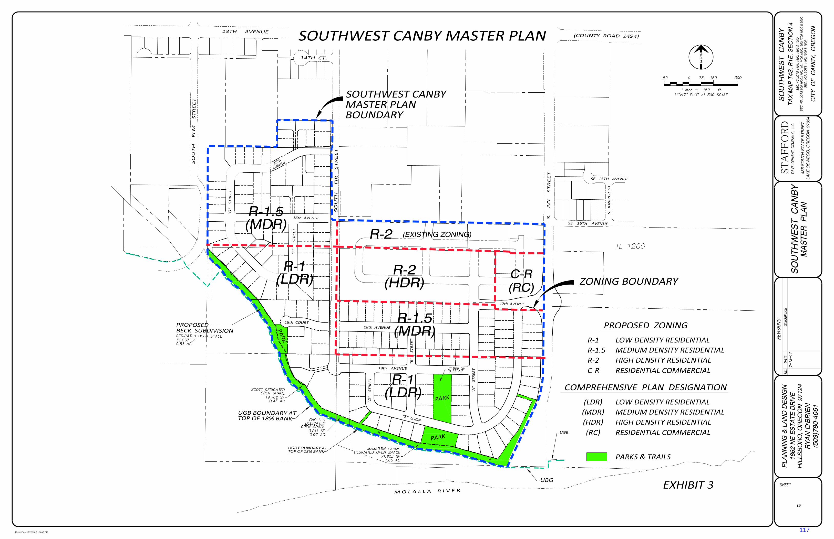
STAFFORD
MasterPlan, 12/22/2017 1:38:45 PM
117

STAFFORD
TOPO, 12/22/2017 7:29:57 AM
118

STAFFORD
Ownership, 12/22/2017 1:07:51 PM
119

EXHIBIT 6
120
121
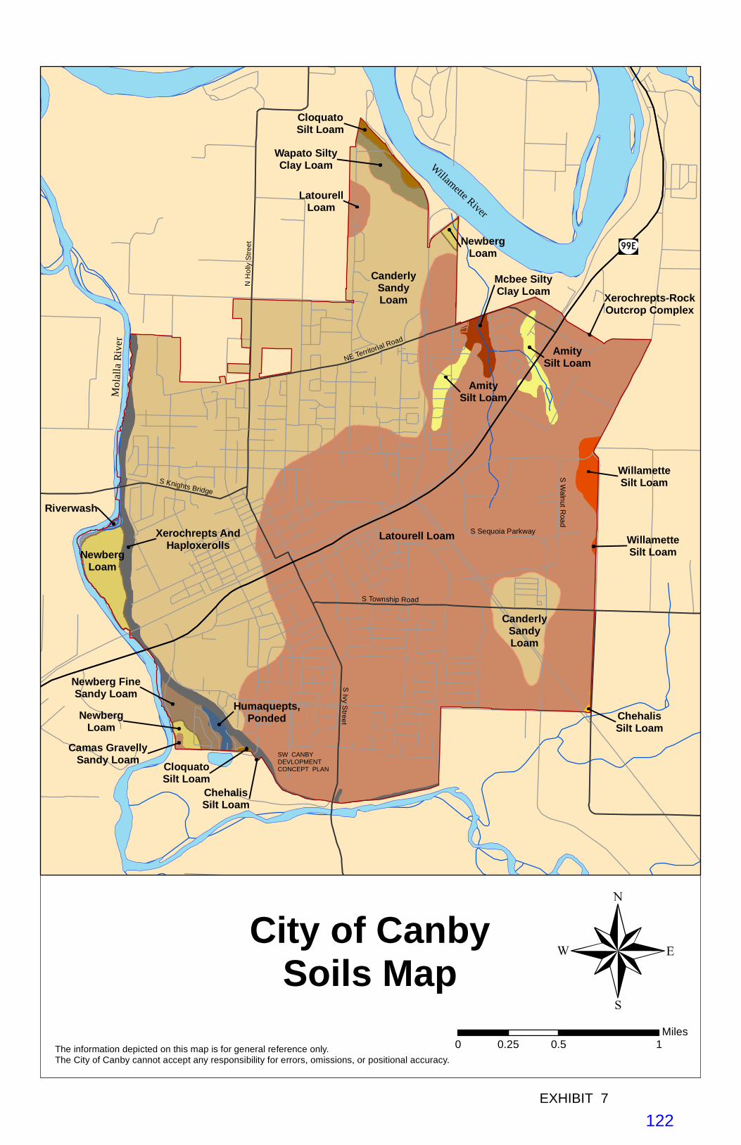
Willam
ette River
Mo
lall
aR
iver
SIvy
Street
S Township Road
NE Territorial Road
S Knights Bridge
NH
olly
Stre
e t
Latourell Loam
CanderlySandyLoam
CanderlySandyLoam
NewbergLoam
Xerochrepts AndHaploxerolls
AmitySilt Loam
Newberg FineSandy Loam
Wapato SiltyClay Loam
AmitySilt Loam
LatourellLoam
WillametteSilt Loam
Mcbee SiltyClay Loam
CloquatoSilt Loam
NewbergLoam
Humaquepts,Ponded
NewbergLoam
Riverwash
Camas GravellySandy Loam
WillametteSilt Loam
ChehalisSilt Loam
CloquatoSilt Loam
ChehalisSilt Loam
Xerochrepts-RockOutcrop Complex
City of CanbySoils Map
The information depicted on this map is for general reference only. The City of Canby cannot accept any responsibility for errors, omissions, or positional accuracy.
0 0.5 10.25Miles
®
S W
alnut Road
S Sequoia Parkway
EXHIBIT 7
SW CANBYDEVLOPMENTCONCEPT PLAN
122
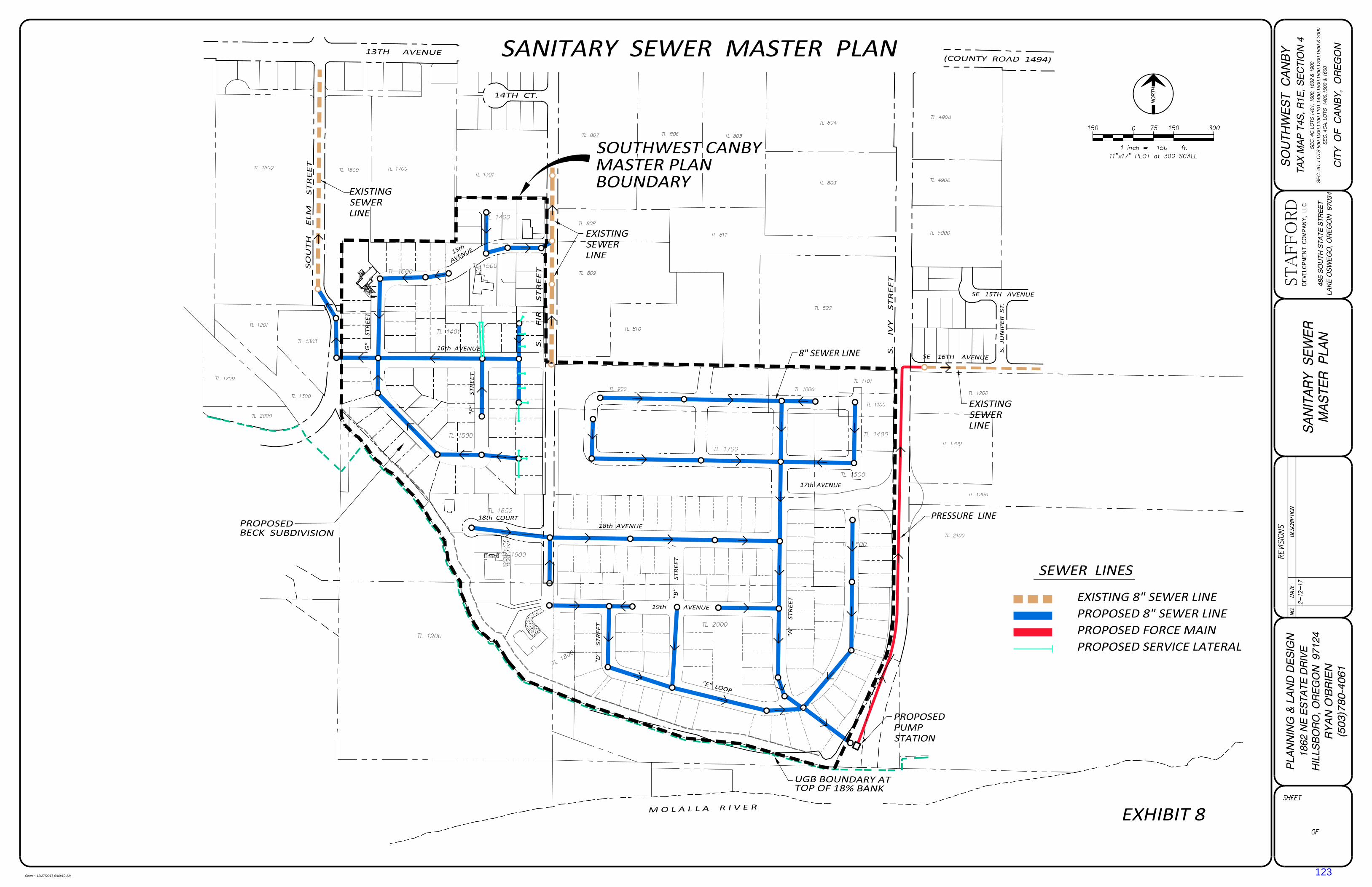
STAFFORD
Sewer, 12/27/2017 6:09:19 AM
123

STAFFORD
Water, 12/22/2017 10:31:20 AM
124
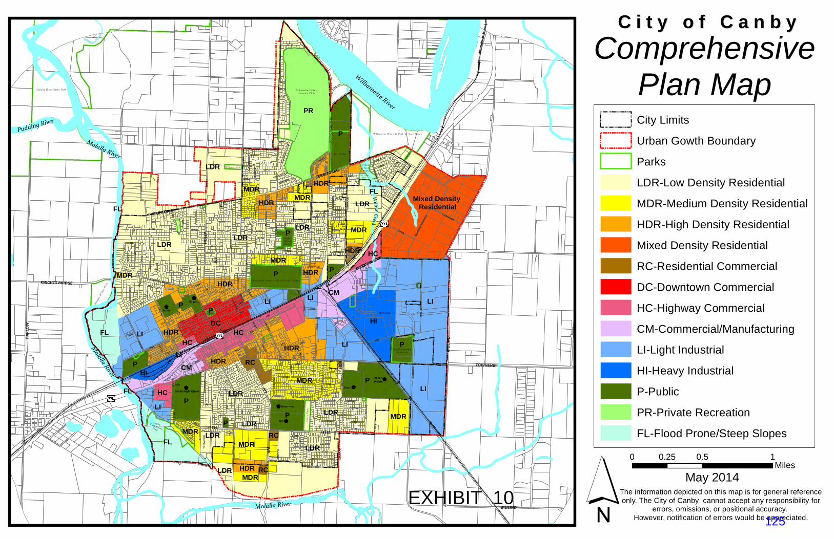
$
$
$
$
$
$
$
IVY
Molalla River
ParkTERRITORIAL
Park
13TH
Park
PIN
E
WillowCreek
P
Molalla River
Molalla River
LI
Pudding River
Baker Prairie
Cemetary
LOGGING RO
AD TRAIL
Baker Prairie
JUN
IPE
R LDR
Canby Skatepark
Molalla River State Park Willamette Valley Country Club
Willamette Wayside Park & Open Space
Eco-Park
Clackamas County Fair & Event Center
Canby CommunityPark
Knig
hts
Bridge P
ark
Legacy P
ark
Zion Memorial Cemetary
MapleStreetPark
Willow Creek Park
Wait Park
19th Loop Park
Arn
eson
Gard
en
Future Park
No
rthw
oo
ds
Locust St.
Faist
LI
LDR
Mixed Density Residential
LDR
PR
HI
LDR
P
LI
LDR
P
LDR
P
LI
PLDR
P
FL
HCFLHDR
MDR
CMP
P
HI
HDR
LI
CM
DC
MDR
LI
LI
HDR
HDR
MDR
P
LDR
RC
MDR
FLLDRHDR
MDR
HC
HC
MDR
MDRP
HDR
LDR
HDR
HDR
MDR
P
MDRLDR
HDR
HC
P
RC
RC
LI
MDR
HDR
FL
FL
IVY
HOLLY
TOWNSHIP
BARL
OW
MULINO
TERRITORIAL
KNIGHTS BRIDGE
IVY
FIR
MA
PLE
HO
LLY
1ST
PIN
E
MULIN
O
GRANT
TOWNSHIP
4TH
2ND
10TH
LOG
GIN
G R
OA
D T
RA
IL
WA
LNU
T
3RD
HAIN
ES
6TH
BE
RG
BAKER
8TH
9TH
CEDAR
13TH
SEQUOIA
JUN
IPE
R
OA
K
16TH
7TH
ELM
BIR
CH
11TH
17TH
AS
H
OTTO
21ST
LOC
UST
5TH
15TH
MA
NZ
AN
ITA
KNIGHTS BRIDGE
34TH
14TH
12TH
20TH
KN
OTT
RE
DW
OO
D
LAR
CH
HAZEL DELL
DO
UG
LAS
ASP
EN
TEAKW
OO
D
VIN
E
CARRIAGE
18TH
ALD
ER
CO
UN
TRY
CLU
B
19TH
SPIT
Z
MEA
DOW
SPR
ING
S
PO
ND
ER
OS
A
HA
WTH
OR
NE
LAU
RE
LWO
OD
LUP
INE
LOG
GIN
G R
AO
D T
RA
IL
23RD
FAIRWAY
FOREST
ELM
WO
OD
DAHLIA
30TH
NOBLE
31ST
PLU
M
TERRACE
29TH
GREENVIEW
12TH
ELM
15TH
LOC
US
T
7TH
13TH
PO
ND
ER
OS
A
5TH
13TH
GR
AN
T
16TH
6TH
7TH
1ST
HOLLY
BIR
CH
7TH
6TH
MA
PLE
11TH
AS
H
14TH
9TH
JUN
IPER
HO
LLY
12TH
AS
PE
N
21ST
8TH
6TH
FIR
4TH
12TH
1ST
OA
K
11TH
11TH
15TH
8TH5TH
LOC
US
T
RE
DW
OO
D
8TH
14TH
13TH
WAL
NUT
LUP
INE
LUP
INE
KNO
TT
12TH
LAU
RE
LWO
OD
10TH
PO
ND
ER
OS
A
PIN
E
7TH
AS
PE
N
5TH
20TH
RE
DW
OO
D
13TH
GR
AN
T
3RD
CE
DA
R
AS
H
KNO
TT
11TH
20TH
12TH
13TH
16TH
14TH
9TH
5TH
10TH
14TH
10TH
OAK
10TH
FIR
9TH
17TH
1ST
5TH
3RD
NO
BLE
LOC
UST
3RD
19TH
ELM
10TH
14TH
BIR
CH
OAK
2ND
7TH
BA
KE
R
RE
DW
OO
D
11TH
14TH
9TH
21ST
LUP
INE
LUP
INE
11TH
14TH
TEA
KW
OO
D
13TH
5TH 4TH
PIN
E
MAP
LE
2ND
DOUG
LAS
6TH
AS
PE
N
ASPEN
8TH
SE
QU
OIA
15TH
10TH
2ND
OA
K
7TH
13TH
FIR
KNOTT
PIN
E
4TH
13TH
11TH
ELM
12TH
3RD6TH
17TH
CEDAR
16TH
14TH
4TH
12TH
19TH
Lee
Trost
Knight
Eccles
Ackerman
Canby High School
C i t y o f C a n b y C i t y o f C a n b y Comprehensive
Plan Map City Limits
Urban Gowth Boundary
Parks
LDR-Low Density Residential
MDR-Medium Density Residential
HDR-High Density Residential
Mixed Density Residential
RC-Residential Commercial
DC-Downtown Commercial
HC-Highway Commercial
CM-Commercial/Manufacturing
LI-Light Industrial
HI-Heavy Industrial
P-Public
PR-Private Recreation
FL-Flood Prone/Steep Slopes
´ May 2014The information depicted on this map is for general referenceonly. The City of Canby cannot accept any responsibility for
errors, omissions, or positional accuracy. However, notification of errors would be appreciated.
0 0.5 10.25Miles
Williamette River
EXHIBIT 10125
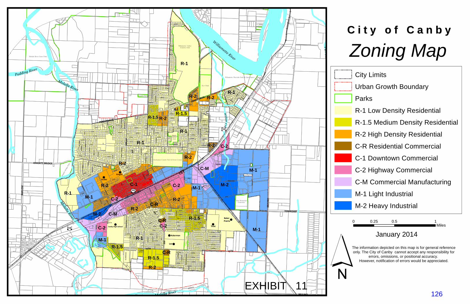
$
$
$
$
$
$
$
Molalla River
IVY
TERRITORIAL
TERRITORIAL
Par
k
IVY
13TH
Pudding River
Molalla River
Molalla River
Williamette River
Parrott Creek
WillowCreek
Locust St.
Park
FaistPark
LOGGING ROAD TRAIL
Baker Prairie
Lee
Trost
KnightEccles
Ackerman
Canby High School
Molalla River State Park
Willamette ValleyCountry Club
Willamette Wayside Park & Open Space
Eco-Park
Clackamas County Fair & Event Center
Canby Community Park
Kni
ght
s Bri
dge
Par
k
Legacy P
ark
Zion MemorialCemetary
MapleStreetPark
Willow CreekPark
Wait Park
19th Loop Park
Arn
eson
Gard
en
Future Park
Nort
hw
oods
Baker Prairie
Cemetary
R-1
R-1
R-1
M-1
R-2 M-1
R-2
M-2
M-1
R-1C-2
M-1
C-1
R-1
C-M
C-M R-1.5
R-1.5
R-2
R-2
R-2
C-2
R-2
R-1.5M-1
M-2
R-1.5
C-2
R-2
R-1
R-1.5
R-2
R-2
C-RC-2
C-R
C-2C-R
R-2
R-21ST
IVY
HOLLY
TOWNSHIP
BARL
OW
MULINO
KNIGHTS BRIDGE
FIR
MA
PLE
1ST
PIN
E
MULIN
OGR
AN
T
TOWNSHIP
4TH
2ND
10TH
LOG
GIN
G R
OA
D T
RA
IL
WA
LNU
T
3RD
HAIN
ES
6TH
BE
RG
BAKER
8TH
9TH
CED
AR
13TH
SEQUOIA
JUN
IPE
R
OA
K
16TH
7TH
ELM
BIR
CH
11TH
17TH
AS
H
OTTO
21ST
LOC
UST
5TH
15TH
MA
NZ
AN
ITA
34TH
14TH
12TH
20TH
KN
OTT
RE
DW
OO
D
HAZEL DELL
DO
UG
LAS
AS
PE
N
TEAKWO
OD
VINE
CARRIAGE
ALD
ER
CO
UN
TRY
CLU
B
19TH
SPIT
Z
MEA
DO
W S
PRIN
GSPO
ND
ER
OS
A
HAW
THO
RN
E
LAU
RE
LWO
OD
LUP
INE
LOG
GIN
G R
AO
D T
RA
IL
23RD
FAIRWAY
FOREST
ELM
WO
OD
PE
PP
ER
WO
OD
DAHLIA
HA
ZELN
UT
30TH
NOBLE
31ST
PLU
M
TERRACE
29TH
GREENVIEW
12TH
ELM
15TH
LOC
US
T
7TH
13TH
PO
ND
ER
OS
A
BIRC
H
5TH
13TH
GR
AN
T
16TH
6TH
7TH
1ST
HO
LLY
BIR
CH
JUN
IPER
HAW
THO
RN
E
6TH
MA
PLE
11TH
AS
H
HO
LLY
14TH
9TH
JUN
IPER
HO
LLY
12TH
AS
PE
N
21ST
8TH
6TH
FIR
4TH
12TH
1STO
AK
11TH
11TH
15TH
8TH5TH
LOC
US
T
RE
DW
OO
D
8TH
14TH
13TH
LUP
INE
LUP
INE
KNO
TT
12TH
10TH
19TH
JUN
IPE
R
PONDEROSA
PIN
E
20TH
7TH
AS
PE
N
5TH
RE
DW
OO
D
13TH
GR
AN
T
3RD
CE
DA
R
AS
H
KNO
TT
11TH
12TH
13TH
16TH
14TH
9TH
5TH
IVY
10TH
14TH
10TH
OA
K
10TH
FIR
9TH
17TH
1ST5TH
3RD
NO
BLE
LOC
UST
3RD
19TH
ELM
10TH
14TH
BIR
CH
OAK
2ND
7TH
BA
KE
R
RE
DW
OO
D
14TH
9TH
LUP
INE
LUP
INE
11TH
14TH
TEA
KW
OO
D
13TH
4TH
PIN
EM
AP
LE
2ND
DO
UG
LAS
6TH
ASPEN
8TH
SE
QU
OIA
15TH
10TH
2ND
OA
K
7TH
13TH
FIR
KNO
TT
PIN
E
4TH
MA
PLE
13TH
11TH
ELM
12TH
3RD6TH
17TH
16TH
14TH
4TH
12TH
19TH
´
C i t y o f C a n b y C i t y o f C a n b y Zoning Map
January 2014
City Limits
Urban Growth Boundary
Parks
R-1 Low Density Residential
R-1.5 Medium Density Residential
R-2 High Density Residential
C-R Residential Commercial
C-1 Downtown Commercial
C-2 Highway Commercial
C-M Commercial Manufacturing
M-1 Light Industrial
M-2 Heavy Industrial
The information depicted on this map is for general referenceonly. The City of Canby cannot accept any responsibility for
errors, omissions, or positional accuracy. However, notification of errors would be appreciated.
0 0.5 10.25Miles
EXHIBIT 11126
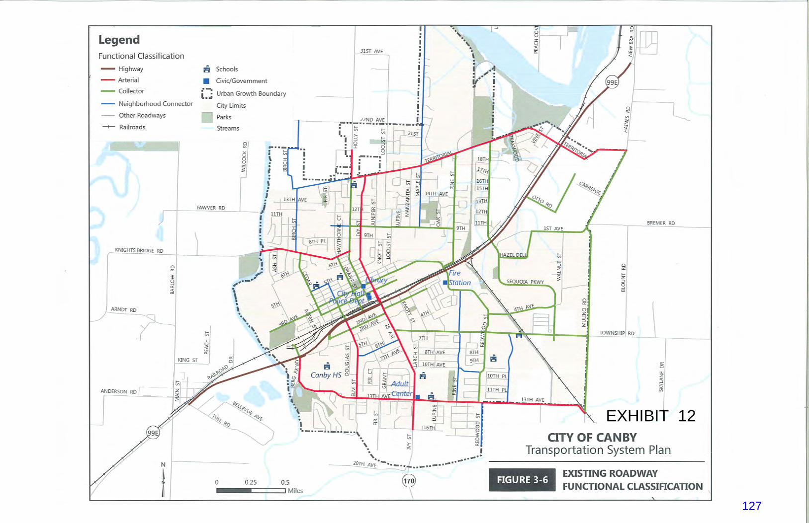
EXHIBIT 12
127

EXHIBIT 13128

Traffic Impact Analysis
CANBY STAFFORD ANNEXATION DEVELOPMENT CONCEPT PLAN (DCP)
CITY OF CANBY, OR
Prepared by
Project No. 17118‐000
Submitted September 29th, 2017
DKS Associates
Chris Maciejewski, P.E., PTOE Jeffrey Heald, P.E. (CA) Rohit Itadkar, T.E. (CA)
720 SW Washington Street
Suite 500
Portland, OR
Telephone (503) 243‐3500
EXHIBIT 14
129

General Plan Amendment & Zone Change – Crowther & Placentia – Traffic Impact Analysis ii
TABLE OF CONTENTS
1.0 INTRODUCTION ............................................................................................................... 2 Site Location and Study Area .............................................................................................. 2
2.0 EXISTING CONDITIONS ................................................................................................... 3 Pedestrian and Bicycle Facilities ......................................................................................... 3 Transit Facilities .................................................................................................................. 3
3.0 SUMMARY OF 2010 CANBY TSP ................................................................................... 4 Functional Roadway Classification and Cross Sections ...................................................... 4 Truck Routes ....................................................................................................................... 6 Local Street Connectivity .................................................................................................... 6 Financially Constrained Motor Vehicle Improvements ........................................................ 7 Neighborhood Traffic Management (NTM) .......................................................................... 7 Access Spacing Standards ................................................................................................. 8
4.0 DATA COLLECTION .......................................................................................................... 9 Existing Traffic Volumes ...................................................................................................... 9 Safety Analysis ..................................................................................................................11
5.0 DCP TRANSPORTATION NETWORK EVALUATION ....................................................12 Land Use Summary ...........................................................................................................12 Internal Roadway Cross-Section ........................................................................................12 Internal Circulation and Sight Distance ..............................................................................14 Access Spacing .................................................................................................................14 Multi-Modal Connectivity ....................................................................................................14 Existing Intersection Operations Analysis ..........................................................................16 Future 2035 Plus Project Scenario .....................................................................................17 Area Safety and Urban Design ..........................................................................................20 Transportation Planning Rule (TPR) Evaluation .................................................................21
APPENDICES
Appendix A –Becks Subdivision Traffic Impact Study Appendix B – Existing Traffic Counts Appendix C – Existing (2017) Intersection Level of Service Worksheets Appendix D –Future (2035) Plus Project Level of Service Worksheets Appendix E – Roundabout Sketch Appendix F – Transportation Planning Rule (TPR) Evaluation
130
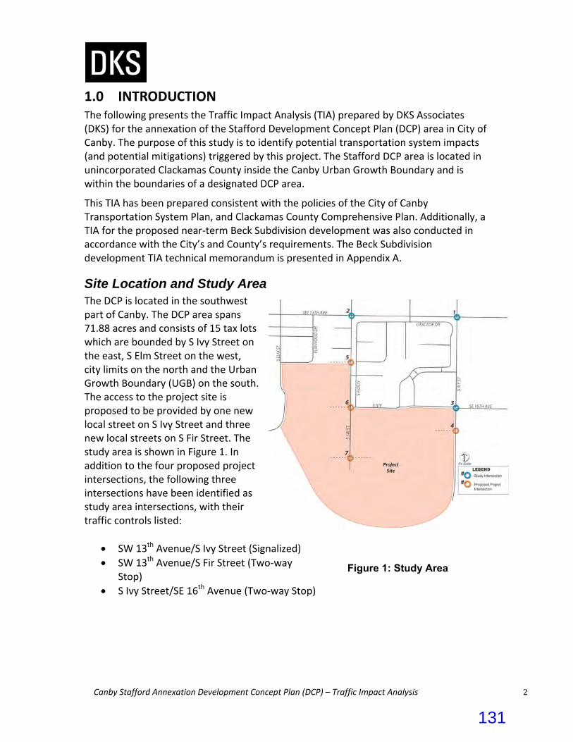
Canby Stafford Annexation Development Concept Plan (DCP) – Traffic Impact Analysis 2
1.0 INTRODUCTION The following presents the Traffic Impact Analysis (TIA) prepared by DKS Associates (DKS) for the annexation of the Stafford Development Concept Plan (DCP) area in City of Canby. The purpose of this study is to identify potential transportation system impacts (and potential mitigations) triggered by this project. The Stafford DCP area is located in unincorporated Clackamas County inside the Canby Urban Growth Boundary and is within the boundaries of a designated DCP area.
This TIA has been prepared consistent with the policies of the City of Canby Transportation System Plan, and Clackamas County Comprehensive Plan. Additionally, a TIA for the proposed near‐term Beck Subdivision development was also conducted in accordance with the City’s and County’s requirements. The Beck Subdivision development TIA technical memorandum is presented in Appendix A.
Site Location and Study Area The DCP is located in the southwest part of Canby. The DCP area spans 71.88 acres and consists of 15 tax lots which are bounded by S Ivy Street on the east, S Elm Street on the west, city limits on the north and the Urban Growth Boundary (UGB) on the south. The access to the project site is proposed to be provided by one new local street on S Ivy Street and three new local streets on S Fir Street. The study area is shown in Figure 1. In addition to the four proposed project intersections, the following three intersections have been identified as study area intersections, with their traffic controls listed:
SW 13th Avenue/S Ivy Street (Signalized)
SW 13th Avenue/S Fir Street (Two‐way Stop)
S Ivy Street/SE 16th Avenue (Two‐way Stop)
Figure 1: Study Area
131

Canby Stafford Annexation Development Concept Plan (DCP) – Traffic Impact Analysis 3
2.0 EXISTING CONDITIONS
Pedestrian and Bicycle Facilities An inventory of existing pedestrian and bicycle facilities was conducted to determine the current locations of sidewalks and bicycle lanes within the study area. For the purpose of this inventory, “bike lanes” included areas on roadways where shoulders were specifically designated for bicycle use through pavement markings, as well as other paved shoulders of at least five feet in width that could be used for bicycle travel. Table 1 presents the study area roadways with pedestrian and bicycle facilities.
Table 1: Existing Pedestrian and Bicycle Facilities
Roadway Sidewalks Bike Facilities
SW 13th Avenue Both Sides Both Sides
S Fir Street East Side Only None
S Ivy Street None Both Sides
Existing pedestrian facilities are provided along SW 13th Avenue and S Fir Street. A side walk is provided on the east side of S Fir Street. There are no sidewalks along the S Fir Street through the project site. There are also existing bicycle facilities along SW 13th Avenue. A Class II bike lane is provided on both sides of this roadway. Along S Ivy Street, marked shoulders on both sides of the roadway can be used as bike lanes. Pedestrian and bicycle count data was also collected during the AM and PM peak period at study area intersections. The observed pedestrian activity was low at all study intersections but could be significantly higher on school days.1 Maximum pedestrians are observed at the intersection of SW 13th Avenue/S Fir Street (6 pedestrians during AM and PM peak hour). No bicycle activity was observed at any of the study intersections.
Transit Facilities Transit service in Canby is provided by Canby Area Transit (CAT). CAT provides a fixed route bus service and Dial‐a‐ride within the City and to neighboring communities. There are four CAT routes (Green Line, Blue Line, Purple Line, and Orange Line) which run five days a week. There is a transit stop along 16th Avenue between S Fir Street and S Ivy Street which gets served approximately on an hourly basis during a 24 hour period by the Blue line.
1 Based on intersection turn movement counts conducted on July 11th, 2017.
132

Canby Stafford Annexation Development Concept Plan (DCP) – Traffic Impact Analysis 4
3.0 SUMMARY OF 2010 CANBY TSP The 2010 Canby Transportation System Plan (TSP)2 identified specific transportation improvement projects and programs needed throughout Canby to guide the City’s transportation investment. These projects and programs support the City’s goals and policies, serve planned growth through the year 2030, and improve safety and mobility for all travel modes in Canby. The TSP addressed all areas of Canby, including the Stafford development area.
The sections from the 2010 TSP that are most applicable to the current Stafford planning effort are summarized in the paragraphs below. Corresponding clips of figures—which are zoomed in on the project area—are also provided.
Functional Roadway Classification and Cross Sections Canby’s functional roadway classification hierarchy includes Arterials, Collectors, Neighborhood Routes, and Local Streets. As shown in Figure 7‐1 from the City’s TSP, S Ivy Street and SW 13th Avenue are classified as Arterials, while S Fir Street is a Local Street. All the remaining streets that may be constructed within the project site would likely become Local Streets.
The Canby TSP provides Standard Cross‐Sections for each of the City’s functional classifications as shown in Figure 7‐4 and 7‐6 in the City’s TSP. The Arterial cross‐section includes two travel lanes with center turn lane that may be used for turning vehicles or a median. It also includes bike lanes and sidewalks. Neighborhood Traffic Management (NTM) may also be used under special conditions. The Local Street consists of two travel lanes separated by a center line marking. It included on‐street parking and sidewalks on both sides of the roadway.
2 Canby Transportation System Plan (TSP), December 2010.
TSP Figure 7-1: Functional Classification
133
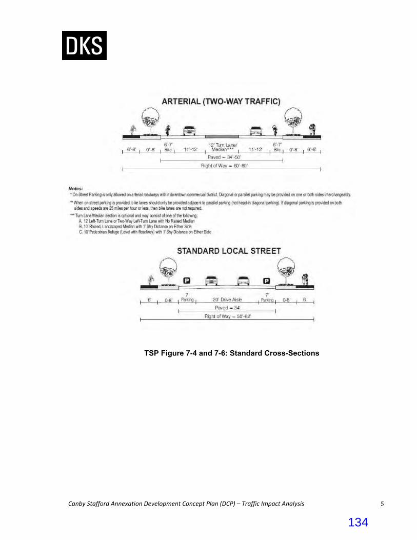
Canby Stafford Annexation Development Concept Plan (DCP) – Traffic Impact Analysis 5
TSP Figure 7-4 and 7-6: Standard Cross-Sections
134
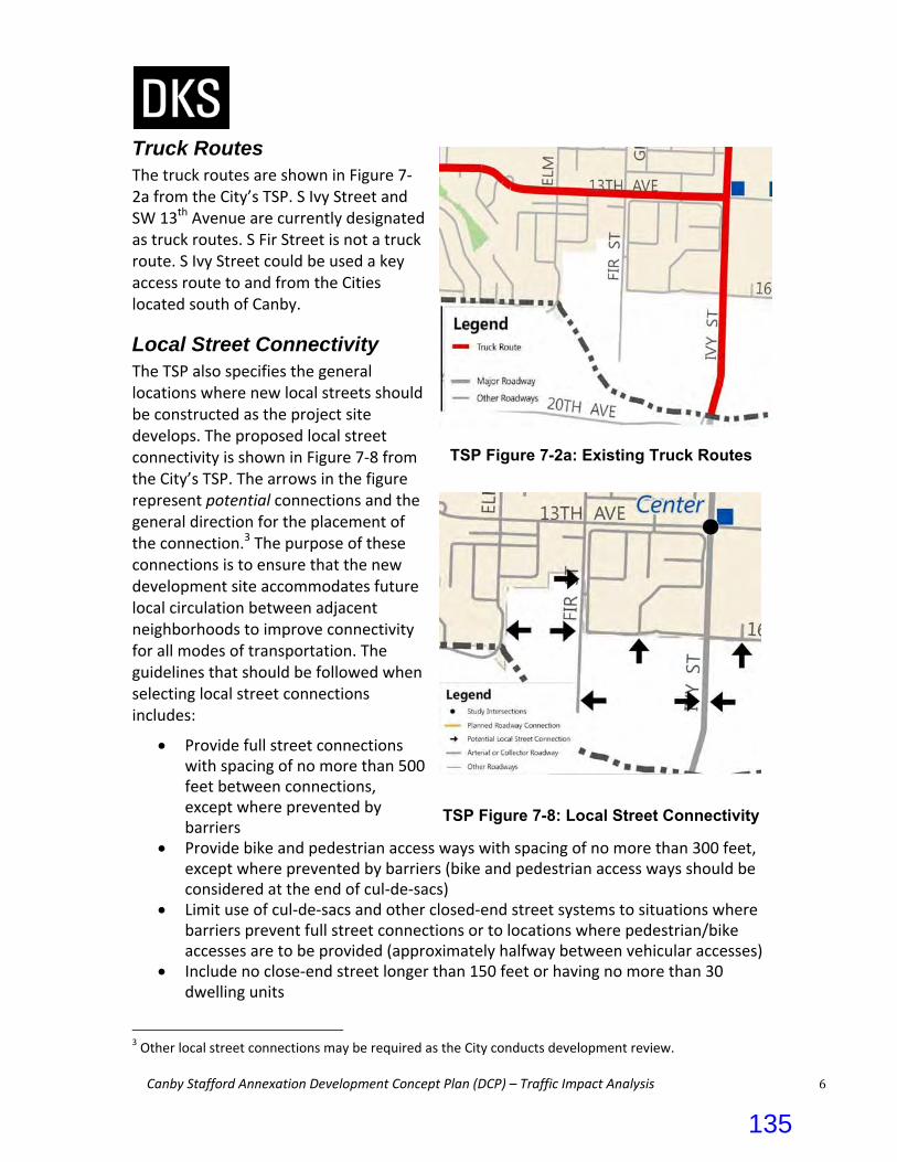
Canby Stafford Annexation Development Concept Plan (DCP) – Traffic Impact Analysis 6
Truck Routes The truck routes are shown in Figure 7‐2a from the City’s TSP. S Ivy Street and SW 13th Avenue are currently designated as truck routes. S Fir Street is not a truck route. S Ivy Street could be used a key access route to and from the Cities located south of Canby.
Local Street Connectivity The TSP also specifies the general locations where new local streets should be constructed as the project site develops. The proposed local street connectivity is shown in Figure 7‐8 from the City’s TSP. The arrows in the figure represent potential connections and the general direction for the placement of the connection.3 The purpose of these connections is to ensure that the new development site accommodates future local circulation between adjacent neighborhoods to improve connectivity for all modes of transportation. The guidelines that should be followed when selecting local street connections includes:
Provide full street connections with spacing of no more than 500 feet between connections, except where prevented by barriers
Provide bike and pedestrian access ways with spacing of no more than 300 feet, except where prevented by barriers (bike and pedestrian access ways should be considered at the end of cul‐de‐sacs)
Limit use of cul‐de‐sacs and other closed‐end street systems to situations where barriers prevent full street connections or to locations where pedestrian/bike accesses are to be provided (approximately halfway between vehicular accesses)
Include no close‐end street longer than 150 feet or having no more than 30 dwelling units
3 Other local street connections may be required as the City conducts development review.
TSP Figure 7-2a: Existing Truck Routes
TSP Figure 7-8: Local Street Connectivity
135
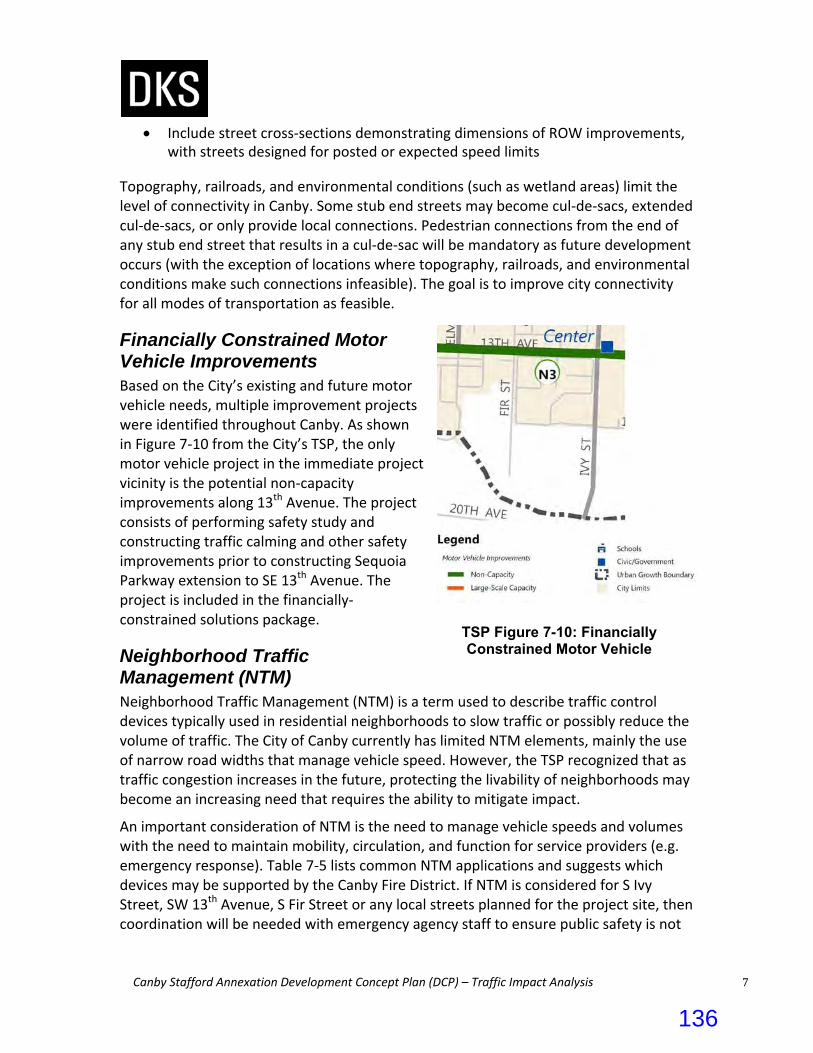
Canby Stafford Annexation Development Concept Plan (DCP) – Traffic Impact Analysis 7
Include street cross‐sections demonstrating dimensions of ROW improvements, with streets designed for posted or expected speed limits
Topography, railroads, and environmental conditions (such as wetland areas) limit the level of connectivity in Canby. Some stub end streets may become cul‐de‐sacs, extended cul‐de‐sacs, or only provide local connections. Pedestrian connections from the end of any stub end street that results in a cul‐de‐sac will be mandatory as future development occurs (with the exception of locations where topography, railroads, and environmental conditions make such connections infeasible). The goal is to improve city connectivity for all modes of transportation as feasible.
Financially Constrained Motor Vehicle Improvements Based on the City’s existing and future motor vehicle needs, multiple improvement projects were identified throughout Canby. As shown in Figure 7‐10 from the City’s TSP, the only motor vehicle project in the immediate project vicinity is the potential non‐capacity improvements along 13th Avenue. The project consists of performing safety study and constructing traffic calming and other safety improvements prior to constructing Sequoia Parkway extension to SE 13th Avenue. The project is included in the financially‐constrained solutions package.
Neighborhood Traffic Management (NTM) Neighborhood Traffic Management (NTM) is a term used to describe traffic control devices typically used in residential neighborhoods to slow traffic or possibly reduce the volume of traffic. The City of Canby currently has limited NTM elements, mainly the use of narrow road widths that manage vehicle speed. However, the TSP recognized that as traffic congestion increases in the future, protecting the livability of neighborhoods may become an increasing need that requires the ability to mitigate impact.
An important consideration of NTM is the need to manage vehicle speeds and volumes with the need to maintain mobility, circulation, and function for service providers (e.g. emergency response). Table 7‐5 lists common NTM applications and suggests which devices may be supported by the Canby Fire District. If NTM is considered for S Ivy Street, SW 13th Avenue, S Fir Street or any local streets planned for the project site, then coordination will be needed with emergency agency staff to ensure public safety is not
TSP Figure 7-10: Financially Constrained Motor Vehicle
I
136

Canby Stafford Annexation Development Concept Plan (DCP) – Traffic Impact Analysis 8
compromised. The proposed project intersection along S Ivy Street is planned to be a roundabout to reduce the speeds along S Ivy Street.
Table 7‐5: Allowed Traffic Calming Measures by Roadway Functional Classification
Traffic Calming Measure
Is Measure Supported? (per Roadway Classification)a
Arterial Collector Neighborhood Route/
Local Street
Curb Extensions Supported Supported
Calming measures are supported on roads
that have connectivity (more than two accesses) and are accepted and field tested by the Canby
Fire District.
Roundabouts Supported Supported
Medians and Pedestrian Islands Supported Supported
Pavement Texture Supported Supported
Speed Hump Not Supported Not Supported
Raised Crosswalk Not Supported Not Supported
Speed Cushion (provides emergency pass‐through with no vertical
deflection)
Not Supported Not Supported
Choker Not Supported Not Supported
Traffic Circle Not Supported Not Supported
Diverter (with emergency vehicle pass through)
Not Supported Supported
Chicanes Not Supported Not Supported
a Traffic calming measures are supported with the qualification that they meet Canby Fire District guidelines including minimum street width, emergency vehicle turning radius, and accessibility/connectivity.
Access Spacing Standards Access spacing standards along City roadways is another important consideration when developing or redeveloping a parcel of land. Table 7‐2 of the Canby TSP specifies access spacing standards for City roadways based on functional classification. Non‐conforming access should work to achieve a condition as close to standard as possible. For example, consolidated or shared accesses should be explored; however, parcels shall not be landlocked by access spacing policies.
For the purpose of reviewing the access spacing along S Ivy Street which is a County roadway, the access spacing standards from the Clackamas County Roadway Standards would be used. The minimum spacing for local street intersections along a Major Arterial (S Ivy Street is classified as a Major Arterial in the County’s Transportation System Plan) is 250’. 4
4 Table 2‐2, Clackamas County Roadway Standards, February 2013.
137

Canby Stafford Annexation Development Concept Plan (DCP) – Traffic Impact Analysis 9
Table7‐2: Access Spacing Standards for City Street Facilitiesa
Street Facility Maximum spacingb of roadways
Minimum spacingb of roadways
Minimum spacingb of roadway to drivewayc
Minimum Spacingb
driveway to drivewayc
Arterial 1,000 feet 660 feet 330 feet 330 feet or combine
Collector 600 feet 250 feet 100 feet 100 feet or combine
Neighborhood/Local 600 feet 150 feet 50 feet 10 feet
a Exceptions may be made in the downtown commercial district, if approved by the City Engineering or Public Works Department, where alleys and historic street grids do not conform to access spacing standards.
b Measured centerline to centerline c Private access to arterial roadways shall only be granted through a requested variance of access spacing policies when access to a lower classification facility is not feasible (which shall include an access management plan evaluation)
4.0 DATA COLLECTION
Existing Traffic Volumes Vehicle turn movement counts were conducted at all study area intersections during the weekday AM peak period (7:00 am to 9:00 am) and PM peak period (4:00 pm to 6:00 pm) on July 11, 2017. Since the counts collected were during the beginning of summer season when the Canby Public Schools are not in session, the counts did not include the on‐street traffic occurring when school is in session. Therefore, the counts were adjusted with school traffic during both peak hours. The City of Canby Travel Forecast Tool developed for the City’s Transportation System Plan was utilized for the traffic counts data adjustment. The weekday AM and PM peak hour volumes developed for the study intersections are presented in Figure 2. The raw traffic counts data is included in Appendix B. In addition to the turning movement counts at the study intersections, 24‐hour vehicles counts, classification counts and speed data was collected during a typical weekday on S Fir Street adjacent to SW 14th Court.
138

Canby Stafford Annexation Development Concept Plan (DCP) – Traffic Impact Analysis 10
Figure 2: Existing Peak Hour Intersection Volumes
139

Canby Stafford Annexation Development Concept Plan (DCP) – Traffic Impact Analysis 11
Safety Analysis The most recent three years (2013 – 2015) of available collision data for the study area was obtained from ODOT and used to evaluate the collision history.5 The individual collision types at study intersections were examined to see if any patterns would emerge. Table 2 breaks down the collision types and severities experienced, showing quantities of each. Of the total 9 collisions at study intersections, one was a rear‐end collision, six were angled collision, and two were turning movement collision. There were no fatal collisions at the study intersections during this three‐year period. Observed crash rates at the study intersections were calculated to identify problem areas in need of safety mitigation. The total number of crashes experienced at an intersection is typically proportional to the number of vehicles entering it. Therefore, a crash rate describing the frequency of crashes per million entering vehicles (MEV) based on the critical crash rate procedure in the Highway Safety Manual (HSM) Network Screening chapter is used to evaluate each intersection.6 Intersections with an observed crash rate greater than the critical crash rate warrant further review. Table 2 displays the total reported collisions at each study intersection as well as the calculated observed crash rate and the critical crash rates for similar intersections. As shown in Table, the observed crash rates do not exceed the critical crash rates at all study intersections.
Table 2: Summary of Intersection Collection History
Intersection Total
Crashes
Crash Type Crash SeverityObserved Crash Rate (per MEV*)
Critical Crash Rate (per MEV*) Rear‐
End Angle Turn Other PDO**
Minor Injury
Major Injury
SW 13th
Avenue/S Ivy Street
6
1
4
1
0
0
6
0
0.26
0.65
SW 13th
Avenue/S Fir Street
3
0
2
1
0
0
1
2
0.28
0.78
S Ivy Street/SE 16
th Avenue
0
0
0
0
0
0
0
0
0.0
1.31
*MEV: Million Entering Vehicles **PDO: Property Damage Only
5 ODOT reported collisions for January 1, 2013 through December 31, 2015. 6 2010 Highway Safety Manual (HSM), Chapter 4, Page 4‐11: The critical crash rate is a threshold value that allows for relative comparison among site with similar characteristics. The critical crash rate depends on the average crash rate at similar sites, traffic volume, and a statistical constant that represents a desired level of significance.
140