pmrda - pcntda.maharashtra.etenders.in · queries were raised by the prospective bidders on the bid...
TRANSCRIPT
1
PMRDA
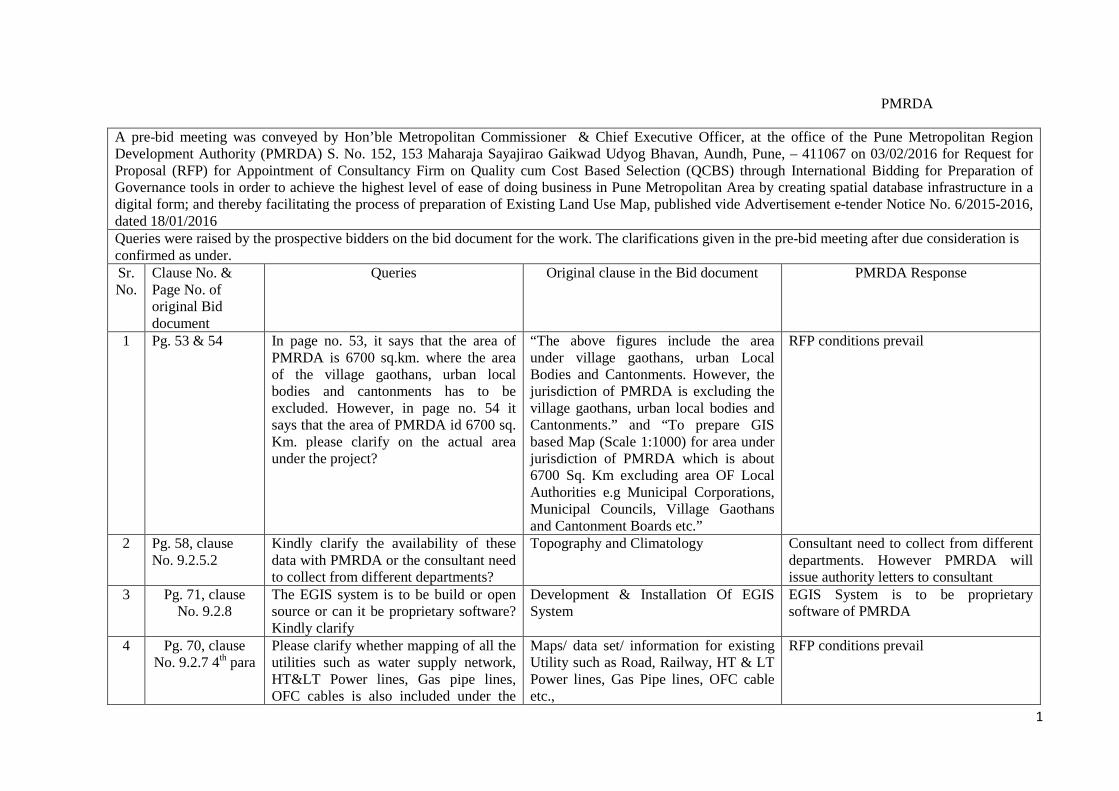
A pre-bid meeting was conveyed by Hon’ble Metropolitan Commissioner & Chief Executive Officer, at the office of the Pune Metropolitan Region Development Authority (PMRDA) S. No. 152, 153 Maharaja Sayajirao Gaikwad Udyog Bhavan, Aundh, Pune, – 411067 on 03/02/2016 for Request for Proposal (RFP) for Appointment of Consultancy Firm on Quality cum Cost Based Selection (QCBS) through International Bidding for Preparation of Governance tools in order to achieve the highest level of ease of doing business in Pune Metropolitan Area by creating spatial database infrastructure in a digital form; and thereby facilitating the process of preparation of Existing Land Use Map, published vide Advertisement e-tender Notice No. 6/2015-2016, dated 18/01/2016 Queries were raised by the prospective bidders on the bid document for the work. The clarifications given in the pre-bid meeting after due consideration is confirmed as under. Sr. No.
Clause No. & Page No. of original Bid document
Queries Original clause in the Bid document PMRDA Response
1 Pg. 53 & 54 In page no. 53, it says that the area of PMRDA is 6700 sq.km. where the area of the village gaothans, urban local bodies and cantonments has to be excluded. However, in page no. 54 it says that the area of PMRDA id 6700 sq. Km. please clarify on the actual area under the project?
“The above figures include the area under village gaothans, urban Local Bodies and Cantonments. However, the jurisdiction of PMRDA is excluding the village gaothans, urban local bodies and Cantonments.” and “To prepare GIS based Map (Scale 1:1000) for area under jurisdiction of PMRDA which is about 6700 Sq. Km excluding area OF Local Authorities e.g Municipal Corporations, Municipal Councils, Village Gaothans and Cantonment Boards etc.”
RFP conditions prevail
2 Pg. 58, clause No. 9.2.5.2
Kindly clarify the availability of these data with PMRDA or the consultant need to collect from different departments?
Topography and Climatology Consultant need to collect from different departments. However PMRDA will issue authority letters to consultant
3 Pg. 71, clause No. 9.2.8
The EGIS system is to be build or open source or can it be proprietary software? Kindly clarify
Development & Installation Of EGIS System
EGIS System is to be proprietary software of PMRDA
4 Pg. 70, clause No. 9.2.7 4th para
Please clarify whether mapping of all the utilities such as water supply network, HT< Power lines, Gas pipe lines, OFC cables is also included under the
Maps/ data set/ information for existing Utility such as Road, Railway, HT & LT Power lines, Gas Pipe lines, OFC cable etc.,
RFP conditions prevail

2
scope of work? The mapping of these utilities is to be done from existing data sets or through ground survey? For underground utilities, is GPR surveys need to be conducted?
5 Pg. 70, clause No. 9.2.7 6th para
GIS maps to be used directly for preparation of Geological maps or Geological maps are need to be prepared from the Aerial Photos? Kindly clarify
“Maps/ data set/ information related to Geology of the planning area. Geological maps shall be prepared using remote sensing techniques include surficial deposit / bedrock mapping, lithological mapping, structural mapping, sand and gravel (aggregate) exploration/ exploitation, mineral exploration”
RFP conditions prevail
6 Pg. 71, Ground verification and
attribute data collection for
Final Base Map
Ground measurement of each property and various Utilities on ground is also included as part of survey scope? Kindly clarify
“The detailed measurement if required of each parcel of land, structures, Roads, Water bodies, Utility lines and other infrastructure, etc. shall be mapped properly along with Attribute data necessary for preparation of GIS”
RFP conditions prevail
7 Pg. 6, E-tender Time schedule,
point no. 4
We request to kindly provide time duration of minimum 15 days for bid submission from the date of release of pre-bid clarifications.
Bid submission date - 10/02/2016 Refer revised schedule as per CSD
8 Pg. 21, Technical Capacity, point
no. 8
We request to kindly relax the said criteria to 10 Nos. of Dual frequency GNSS receivers & 50 Nos. of ETS
Availability of minimum 20 Nos. of Dual frequency GNSS receivers & 100 Nos. ETS
RFP conditions prevail
9 Data sheet Page no. 6
We request the authorities to kindly clarify if the bidders have to complete the upload process as per the time mentioned in the RFP.
Close for Technical and price bid Date 09/02/2016 at 17.00 hours to Date 10/02/2016 at 14.00 hours.
Refer revised schedule as per CSD
10 Data sheet Page no. 6
We request the authorities to kindly clarify if the uploaded documents will have to be submitted in the stipulated time.
Bid submission Date 10/02/2016 at 14.01 hours to Date 11/02/2016 at 13.00 hours
Refer revised schedule as per CSD
11 Schedule of The submission date and time vary as per Proposal Due Date On line submission Refer CSD

3
selection process Page no. 18
the data sheet mentioned in page no. 6 and the schedule of selection process. Please confirm the date and time of bid submission.
09/02/2016
12 Section 2.2.2 Page no. 21
We request the authorities to kindly amend the clause to “Preparation of Existing Land Use Maps for at least one Urban / Regional Local Body/State Govt./Central Govt./PSU/Utility firm.”
Preparation of Existing Land Use Maps for at least one Urban / Regional Local Body.
RFP conditions prevail
13 Section 3.1.3 Page no. 45
We request the authorities to kindly amend the clause to “Preparation and acceptance of existing land use maps for urban local bodies/state govt. /central govt./PSU/Utility firm.”
Preparation and acceptance of existing land use maps for urban/regional local bodies
RFP conditions prevail
14 9.2.5 PREPARATION
OF GEO REFERENCE
EXISTING LAND USE
MAP (Page No: 58)
What will be the scale and tentative no of existing map sheets?
PREPARATION OF GEO REFERENCE EXISTING LAND USE MAP
Currently there is no existing data available with PMRDA. The consultant will have to collect the various data sets from the respective Depts. PMRDA shall provide authorization letters to collect the same.
15 9.2.8, Page No. 71
The bidder shall integrate this
entire database with the
digitized/geo-referenced GIS
base map with all forward and backward linkages.
Explain what functionality is intended for forward and backward linkages.
DEVELOPMENT & INSTALLATION OF EGIS SYSTEM
Geodatabse need to be prepared as per layers mentioned in the RFP.
16 9.2.8, Page No. 71
Will PMRDA provide SMS gateway and cost incurred for the SMS gateway
DEVELOPMENT & INSTALLATION OF EGIS SYSTEM
The successful bidder need to provide functionality related to SMS gateway.
4
The system should have
automated SMS and E mail
facility to citizen
usage? Similar to http://gateway.mahaonline.gov.in/DOMASMS/ Do PMRDA has the email server to which the integration for e-mail notification workflow can be done?
“The system should have automated SMS and E mail facility to citizen on every stages of the workflow as per PMRDA requirement.”
The cost associated with SMS gateway will be borne by PMRDA. Yes. This functionality will be taken in to account at the time of SRS finalization.
17 9.2.8, Page No. 71
Bidder should provide MIS and
GIS reporting module which
can help PMRDA administrators at different levels to generate reports
as per requirements
Can you please explain the MIS and GIS reporting module. How many reports were expected to be developed?
DEVELOPMENT & INSTALLATION OF EGIS SYSTEM “Bidder should provide MIS and GIS reporting module which can help PMRDA administrators at different levels to generate reports as per requirements”
The successful bidder shall do due diligence so that the entire E-GIS system is flawless, user-friendly and efficient working
18 9.2.8, Page No. 71
Bidder will also be responsible for sizing of servers,
hardware and network
requirements for successful
operation of the application
Who will be responsible for hardware procurement? Servers, desktops, networking & Infrastructure.
DEVELOPMENT & INSTALLATION OF EGIS SYSTEM “Bidder will also be responsible for sizing of servers, hardware and network requirements for successful operation of the application”
The successful bidder shall be responsible for hardware procurement.
19 9.2.8, Page No. 71
Is PMRDA expecting no licensing change even if the server is upgraded with RAM, Processor and cores to meet the changing business demands.
DEVELOPMENT & INSTALLATION OF EGIS SYSTEM
RFP conditions prevail

5
20 9.2.9, Page No. 71
Workstation, tablet and mobile
device support
Is the Web application expected to work on all the environments like Workstation, tablet and mobile device (Mobiles and Tabs).
GEOPORTAL a. Workstation, tablet and mobile
device support
Yes.
21 9.2.9, Page No. 71
View control
Can you please explain the functionality expected in View control?
GEOPORTAL b. View control
View control based on scale of data and map extent. This will be finalized during SRS stage
22 9.2.9, Page No. 71
Data attribute interrogation
Can you please explain the Data attribute interrogation functionality
GEOPORTAL c. Data attribute interrogation
Refer CSD
23 9.2.9, Page No. 71
Results of flood modeling
Do PMRDA having any software /solution on flood modeling. If not should the selected vendor to provide a complete solution for the flood modeling?
GEOPORTAL f -vi Results of flood modeling
Application should have ability to include future developments, including workflows supporting Results of flood modeling
24 9.2.9, Page No. 71&72
Governance tools
along with Supply/
preparation/ of Software capable of being used as
web based mobile platform with unlimited transactions.
Do PMRDA having any preferred GIS platform? Is GIS in use at PMRDA? Please list the software used and licenses available with PMRDA.
GEOPORTAL “Bidder shall Synchronization of e-formatted newly generated database with officially available data & Integration with PMRDA portal, Identification and preparation of Governance tools along with Supply/ preparation/ of Software capable of being used as web based mobile platform with unlimited transactions”
No preferences. Successful bidder may propose the appropriate GIS Platform
25 9.2.11, Page No. 72
Should the implementing vendor to provide all software licenses with AMC
UP GRADATION & MAINTENANCE OF DATA FOR 5 YEARS
Yes

6
Bidder shall
provide service for up gradation and maintenance of the data and system for 5 years after
completion of the assignment. Bidder shall include cost
towards the same in his quote.
and Warranty for 5 years. For upgradation of the data, Is PMRDA expecting to have this work done at PMRDA premises at PUNA only.
“Bidder shall provide service for up gradation and maintenance of the data and system for 5 years after completion of the assignment. Bidder shall include cost towards the same in his quote.”
All developmental activities can be carried out at successful bidder’s office. However implementation is to be done at PMRDA office in Pune.
26 13.11, Page No. 78
Bidder shall provide service for up gradation and maintenance of the data and system for 5 years after
completion of the assignment. Bidder shall include cost
towards the same in his quote.
Is the system to be upgraded on release of new version of the COTS software used? Is there any mandate to have system upgradation to be done within certain period (eg: 5 months on release of new patch, version of any software’s)?
Deliverable For Up Gradation & Maintenance of Data For 5 Years “Bidder shall provide service for up gradation and maintenance of the data and system for 5 years after completion of the assignment”
All releases / versions developed as part of the application is to be updated. There is no any fixed period for upgrade.
27 10, Page No. 72
The total duration for executing the consultancy work
shall be 12
Should the implementation vendor deploy all the resources onsite at PMRDA premises for entire project duration?
TIME AND PAYMENT SCHEDULE “The total duration for executing the consultancy work shall be 12 months The Consultant shall deploy its Key Personnel throughout the assignment”
Not Required. However the successful bidder has to complete the entire scope as per RFP

7
months The Consultant shall deploy its Key
Personnel throughout the
assignment. 28 2.2.2 ( D ), Page
No. 22 Availability of Key Personnel:
The Bidder shall offer and make
available all Key Personnel
meeting the requirements
specified in sub-clause (D) below.
Should all the resources listed under section 2.2.2 (E) of RFP be deployed at PMRDA premises for entire project duration of implementation and subsequent UP GRADATION & MAINTENANCE 5 year’s duration?
Availability of Key Personnel: “The Bidder shall offer and make available all Key Personnel meeting the requirements specified in sub-clause (D) below”
RFP conditions prevail
29 13.11, Page No. 78
Bidder shall provide service for up gradation and maintenance of the data and system for 5 years after
completion of the assignment. Bidder shall include cost
towards the same in his quote.
Who is responsible for hardware maintenance? Do PMRDA having its IT center where server, software can be deployed.
Deliverable For Up Gradation & Maintenance of Data For 5 Years “Bidder shall provide service for up gradation and maintenance of the data and system for 5 years after completion of the assignment”
RFP conditions prevail
30 Pg. 5 Pt. 1 Request to reduce the amount of EMD to Rs. 2.5 Million instead of Rs. 7.5 Million
Earnest Money Deposit - INR 7.5 million RFP conditions prevail

8
31 Pg. 5 Pt. 1 Request to accept Bank Guarantee for EMD and also provide the template of EMD BG
Earnest Money Deposit - INR 7.5 million Refer CSD
32 Pg. 21 Pt. B-5 Request to consider ownership or availability of 1 fixed wing aircraft instead of 2 No.s. As the total area of data acquisition is only 6700Sq.km and within the specified time period, this task can be carried out with only 1 fixed wing aircraft
Availability/ Capacity to make available of minimum 2 nos of fixed wing Aircraft for Aerial photography.
RFP conditions prevail
33 Pg. 21 Pt. B-8 Request to reduce the ETS to 50 No.s instead of 100
Availability of minimum 20 Nos. of Dual frequency GNSS receivers & 100 Nos. ETS
RFP conditions prevail
34 Pg. 68 Pt. 9.2.6.4 &
9.2.6.5
We request PMRDA to remove the Clause 9.2.6.4 (Generation of Draft LPM And Distribution) and 9.2.6.5 (Output Guidelines For Agency), as they cannot be completed within 12 months period and it should be carried out as separate assignment under NLRMP without linking to the present scope.
Generation of Draft LPM And Distribution. Output Guidelines For Agency.
RFP conditions prevail
35 Pg. 72 Pt. 10 Request to change Point No. 8 as upon submission of Georeferenced Digital Cadastral Maps on Base map – 20%
TIME AND PAYMENT SCHEDULE On submission of LPM on pro rata basis- From 4th- 20%
RFP conditions prevail
36 Pg. 116 Pt. 2 Regarding the release of payments, please indicate the maximum time period from the date of invoice within which the payment shall be made by PMRDA
Break-up of the fees payable for the different periods- Payment Schedule
RFP conditions prevail
37 Pg. 58 Pt. 9.2.5.2
In Clause 9.2.5.2 “TOPOGRAPHY AND CLIMATOLOGY” Point A) i) it is mentioned as Terrain mapping with 0.1 mtr and in clause 13.7. Deliverable for Creation of Base map it is mentioned as 0.5m contour. We request PMRDA to accept 0.5m contour only, as achieving 0.1m contour with 10cm data is not
TOPOGRAPHY AND CLIMATOLOGY A. Geographical Setting and Topography i)Terrain mapping with 0.1 mtr. contour
Refer CSD
38 Pg. 77 Pt. 13.7
Deliverable for Creation of Base map for entire PMRDA region

9
possible 39 Pg. 78 Pt. 13.11 All the updations will be carried out from
the office on the softcopy of the database created and there will be no field checks or visits.
Deliverable For Up Gradation & Maintenance of Data For 5 Years
RFP conditions prevail
40 Pg. 42 Pt. 2.26 Request to remove the Clause 2.26: Indemnity, as we are submitting a PBG of 5%
Indemnity Refer CSD
41 Pg. 67 Pt. 9.2.6.2 Please mention various input data being provided by PMRDA as part of this project and their format and time for data handover after contract sign
Collection of input data from PMRDA Successful bidder will be responsible for collection of all data , however PMRDA will issue authority letters to successful bidder
42 Other General Query
In view of the various steps and operational complexity involved in submitting the tender online we request PMRDA to grant a time extension of at least 2 weeks from the current date of submission.
Refer CSD
43 Other General Query
Request PMRDA to nominate the list of personnel who would be the onboard security officers before award of work itself, as the permission / clearance should be obtained from MoD.
PMRDA will nominate onboard security officer
44 Other General Query
We request PMRDA to provide us the work space in plug and play condition for setting up the Data Center to process the Aerial Data acquired as part of this project
PMRDA will provide work space.
45 Other General Query
We assume that PMRDA would provide the Survey of India GTS control points falling in the area of interest. Please confirm
Successful bidder will have to procure GTS control points following due procedure
46 Other General Query
Please provide a list of all the data that is existing with PMRDA which can be provided to the agency as input for execution of this project. Also we request
RFP conditions prevail

10
Other General Query PMRDA to indicate what necessary support shall be provided for the data that is missing and which needs to be procured / obtained from other Depts.
47 Other General Query
We request PMRDA to provide us the Village wise Cadastral Map in the digital format and also assume that PMRDA shall procure the cadastral data from Revenue Dept. and provide the same to agency. Please confirm
Successful bidder has to procure all data and maps. PMRDA will only issue authority letters to successful bidder
48 Page 44 clause 3.1.3, Item code
1 (ii)
Request to through and remove typographic mistake
similar assignment Refer CSD
49 Page 44 clause 3.1.3, Item code
1 (iii)
Probably should have been 1000 Million or 1 Billion
Average Turnover Refer CSD
50 Page 44 clause 3.1.3, Item code
2 (i)
Request to through and remove typographic mistake
Experience Refer CSD
51 Page 46 clause 3.1.3, Item code
6 (i)
Request to give more clarity Letter of appraisal from professional body
RFP conditions prevail
52 Page 117 clause 5 of annex 6
Penalty for Substitution - Request to go through and remove typographic mistake.
RFP conditions prevail
53 Pg. No. 5 clause No.1
Keeping in mind the complexity of work we request you to make the time limit of 18 months (excluding monsoon)
Time Limit – 12 Months RFP conditions prevail
54 Pg. No. 5 clause No.1
Request to reduce the amount of EMD to Rs. 2.0 Million instead of Rs. 7.5 Million
Earnest Money Deposit - INR 7.5 million RFP conditions prevail
55 Pg. No. 21 clause No.B-8
We request you to reduce minimum number of Dual frequency GNSS receivers to 06 and minimum ETS to 15 Nos.
Availability of minimum 20 Nos. of Dual frequency GNSS receivers & 100 Nos. ETS
RFP conditions prevail
56 Pg. No. 44 clause Request you to give more clarification The scoring criteria Refer CSD

11
No.3.1.3 -1(iii)
≥0001million – 4 Marks
57 Pg. No. 44 clause No. 1 (ii)
Request you to give more clarification similar assignment ≥3 4NosMarks –
Refer CSD
58 Pg. No. 7 clause Letter of Invitation
We request you to accept the Earnest Money Deposit in the form of Bank Guarantee.
Earnest Money Deposit of INR 7.5 million shall be paid on line through E-Payment Gateway
Refer CSD
59 Pg. No. 7 clause 9.2.6.4
We request you to delete this clause Generation of Draft LPM RFP conditions prevail
60 Pg. No. 42 clause 2.26 - Indemnity
Since there is a provision of Performance Bank Guarantee clause in the tender we request you to delete this Indemnity clause.
The consultant shall, subject to the Provisions of the Agreement indemnify the Authority for an amount not exceeding 3 (three) times the value of the Agreement for any direct loss or damage that is caused due to any deficiency in services
Refer CSD
61 Pg. No. 72 clause 1 of 10.2 –
We request you to make provision of 12 % on Submission of Inception Report and 10% On submission of aerial photographs
On Submission of Inception Report - 05% and On submission of aerial photographs – 05 %
RFP conditions prevail
62 Pg. No. 72 clause 9.2.11 –
We request you to clarify whether it includes any site Survey / data collection or just an updation in the computer database only.
Up Gradation & Maintenance of Data for 5 Year
RFP conditions prevail
63 Pg. No. 21 clause (C)
We request you to reduce minimum Annual Turnover to INR 150 million.
Financial Capacity The Bidder shall have received a minimum Annual Turnover of INR 250 million per annum from professional fees for the last 3 (three) financial years preceding the Proposal Due Date
RFP conditions prevail
64 Page 6 Kindly extend the bid submission date till 28th February 2016.
Bi Submission Refer CSD

12
65 Page 21, Point 2.2.2 (B) 2
Please explain in details Preparation of Existing Land Use Maps for at least one Urban/ Regional Local Body.
RFP conditions prevail.
66 Page 21, Point 2.2.2 (B) 4
Please explain in details Capability/ Experience of conducting land Measurements for acquiring land parcels.
RFP conditions prevail
67 Page 21, Point 2.2.2, B, Sr. No.
6
Please remove the condition. Should have own NSOP (Non Scheduled Operator Permit) and Experience of obtaining Flying permissions from DGCA/ MOD.
RFP conditions prevail
68 Page 21, Point 2.2.2, B, Sr. No.8
Please reduce the quantity for qualification criteria.
Availability of minimum 20 No's. of Dual frequency GNSS receivers & 100 nos. ETS
RFP conditions prevail
69 Page 22 Please allow B.Com/ B.sc graduate candidate with 5 year experience of job.
Aerial Sensor Operators and Flight Operations Manager- Post Graduate in Engineering or Science
RFP conditions prevail
70 Page 23 Please allow B.Com/ B.sc graduate candidate with 5 year experience of job.
Survey Engineer-Graduate in Civil Engineering
RFP conditions prevail
71 Page 23 Please allow B.Com/ B.sc graduate candidate with 5 year experience of job.
Cadastral and Revenue Expert RFP conditions prevail
72 Page 23,Point 2.2.2,(E)9
Please allow B.Com/ B.sc graduate candidate with 5 year experience of job.
GIS/Remote Sensing Specialist RFP conditions prevail
73 Page 23,Point 2.2.2,(E), sr no
11
Please allow B.Com/ B.sc graduate candidate with 5 year experience of job.
Environmental Expert RFP conditions prevail
74 Page 53 Who will give the boundary map? Table of Taluka and sq. RFP conditions prevail 75 Page 72, Point
10.2,Sr. No 8 Please explain On submission of LPM on pro rata basis-
From 4th to 12th month- 20% RFP conditions prevail
76 Page no. 21 ( 2.2.2 ) – (B ) –
Description Point no. 8
Request to reduce the availability of minimum 12 Nos. of Dual frequency GNSS receivers instead of 20 nos. and 40 nos. of ETS instead of 100 Nos.
Availability of minimum 20 Nos. of Dual frequency GNSS receivers & 100 Nos. ETS
RFP conditions prevail
77 Page no. 21 ( 2.2.2 ) – (B ) –
Description Point
NSOP (Non-Scheduled Operator Permit) in India for aerial mapping project are rare and acquiring NSOP license to work
Should have own NSOP (Non-Scheduled Operator Permit) and Experience of obtaining Flying permissions from
RFP conditions prevail

13
no. 6 in India is not viable. However license from other existing available flight operator should be consider
DGCA / MoD.
78 Page no. 21 ( 2.2.2 ) – (B ) –
Description Point no. 5
Availability/ Capacity to make available of minimum 1 no. of fixed wing Aircraft for Aerial photography if any problem occur in the aircraft alternate aircraft need to be arrange without hampering the work.
Availability/ Capacity to make available of minimum 2 nos. of fixed wing Aircraft for Aerial photography
RFP conditions prevail
79 As it asked in the tender that Bidder should deal with the multiple Government department to get necessary data or approval/clearance ( For example 1:- land Survey no. data available with land department need to be superimposed and cross check with land parcel data prepared from Aerial Images and ETS survey ; 2) masking of Defence Area on the captured Aerial photography as per defence guideline in Defence premises), however it is mentioned in th pre-bid meeting that PMRDA will issue the Letter to respective Government department in getting the data or will help in getting the necessary approval/clearance from Concern Government department. In this case we request PMRDA to play active role in getting the data from concern Government department and set the timeline to concern department in getting the requested data from the date of letter issued to concern department by PMRDA and in case of delay from concern department in terms of no. days then it should be added to 12 months
RFP conditions prevail

14
project duration time 80 Please note that the data available with
the land department should be in digital format (.DXF, .DWG & .SHP ) in order to superimposed in requested GIS system). If data available with the Land department is in paper format then we need to scan this data and then superimposed on Georefrenced aerial images. In this case we request you to consider the time required for this particular activity depending on the no. of paper document available with the Land department. Usually time required for this kind of activity on higher side so we request you to consider and suitably extended the project duration time
RFP conditions prevail
81 As data generated during a project is very sensitive and handling this kind of data need to follow standard procedure as per CMMI-3 Level and as per ISO standard, hence we request you that bidder or any of the consortium member should be at least CMMI Level 3 and also should be certified for ISO 9001-2008
RFP conditions prevail
82 Page 6 This is a very complex and detailed specifications so May we request to extend the bid submission date till 28th February 2016, to ensure detailed and complete responses.
Bid Submission Refer CSD
83 Page 21 Conditions of Eligibility of
Bidders 2.2.2 (B) 2
We request PMRDA to consider the land use maps prepared based on Satellite Image & Development Plan (DP) are eligible under this condition. Please confirm.
Preparation of Existing Land Use Maps for at least one Urban / Regional Local Body.
RFP conditions prevail
84 Page 21 We request PMRDA to consider City Capability/ Experience of Carrying out RFP conditions prevail

15
Conditions of Eligibility of
Bidders 2.2.2 (B) 3
survey as the survey of utilities in the city area and the digitization of the same on GIS image. Please Confirm.
City Survey for Local body areas.
85 Page No. 46. 3.1.4 (a)
“preparation of Large scale maps through Aerial Photography (≤10 GSD or better), Existing Land Use mapping, cadastral Surveys, Joint Measurement for revenue department, Engineering data collection and city Survey for land records department” shall be deemed as eligible Assignments (the “Eligible Assignments”):
86 Page 21 Conditions of Eligibility of
Bidders 2.2.2 (B) 4
As per our understanding, the joint measurement taken with authorities in the Local body for acquisition of Land for Utility works such and Water supply/ UGD/Storm Water etc. are eligible under this point. Please Confirm.
Capability/Experience of conducting land Measurements for acquiring land parcels.
RFP conditions prevail
87 Page 21 , Point 2.2.2,B,
Sr. No 6
DGCA rules allow aircraft to be flown in India under other company’s NSOP; this is common practice. May we request to alter the first part of this requirement to “Should provide supporting letter from NSOP holder”.
Should have own NSOP (Non-Scheduled Operator Permit) and Experience of obtaining Flying permissions from DGCA / MoD.
RFP conditions prevail
88 Page 21 , Point 2.2.2,
B, Sr. No 8
Kindly reconsider the equipment nos. Availability of minimum 20 Nos. of Dual frequency GNSS receivers & 100 Nos. ETS
RFP conditions prevail
89 Page 22 There are no relevant post graduate courses for these positions anywhere in the world. Having a post graduate in Engineering or Science does not infer any ability in Aerial Sensor or Flight Operations. Kindly consider 10 years’ experience for Aerial Sensor Operators and Flight Operations Manager
Aerial Sensor Operators and Flight Operations Manager- Post Graduate in Engineering or Science
RFP conditions prevail
16
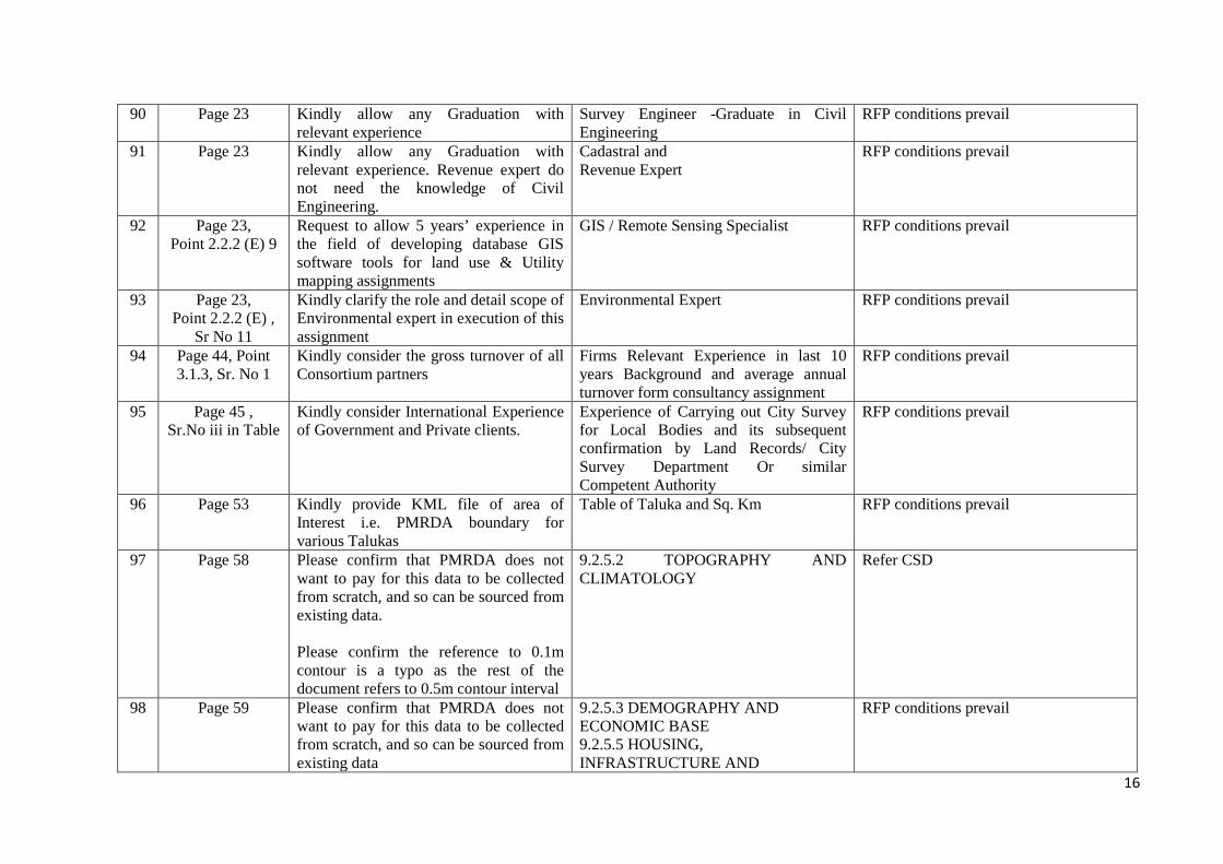
90 Page 23 Kindly allow any Graduation with relevant experience
Survey Engineer -Graduate in Civil Engineering
RFP conditions prevail
91 Page 23 Kindly allow any Graduation with relevant experience. Revenue expert do not need the knowledge of Civil Engineering.
Cadastral and Revenue Expert
RFP conditions prevail
92 Page 23, Point 2.2.2 (E) 9
Request to allow 5 years’ experience in the field of developing database GIS software tools for land use & Utility mapping assignments
GIS / Remote Sensing Specialist RFP conditions prevail
93 Page 23, Point 2.2.2 (E) ,
Sr No 11
Kindly clarify the role and detail scope of Environmental expert in execution of this assignment
Environmental Expert RFP conditions prevail
94 Page 44, Point 3.1.3, Sr. No 1
Kindly consider the gross turnover of all Consortium partners
Firms Relevant Experience in last 10 years Background and average annual turnover form consultancy assignment
RFP conditions prevail
95 Page 45 , Sr.No iii in Table
Kindly consider International Experience of Government and Private clients.
Experience of Carrying out City Survey for Local Bodies and its subsequent confirmation by Land Records/ City Survey Department Or similar Competent Authority
RFP conditions prevail
96 Page 53 Kindly provide KML file of area of Interest i.e. PMRDA boundary for various Talukas
Table of Taluka and Sq. Km RFP conditions prevail
97 Page 58 Please confirm that PMRDA does not want to pay for this data to be collected from scratch, and so can be sourced from existing data. Please confirm the reference to 0.1m contour is a typo as the rest of the document refers to 0.5m contour interval
9.2.5.2 TOPOGRAPHY AND CLIMATOLOGY
Refer CSD
98 Page 59 Please confirm that PMRDA does not want to pay for this data to be collected from scratch, and so can be sourced from existing data
9.2.5.3 DEMOGRAPHY AND ECONOMIC BASE 9.2.5.5 HOUSING, INFRASTRUCTURE AND
RFP conditions prevail

17
COMMUNITY FACILITY 9.2.5.6 TRAFFIC AND TRANSPORTATION 9.2.5.9 PUBLIC UTILITES AND SERVICES
99 Page No. 58, Point 9.2.5
We Understand that scope includes collection of data in the prescribed format only for those buildings which are Outside the village gaothans, urban local bodies and cantonments.
The Consultant shall visit and record the information of each of the building (excluding village gaothans, urban local bodies and cantonments) and the premise of specific use such as residential, commercial, industrial ……..etc. & fill up the information in appropriate tables attached herewith, and indicate the use on the base map.
RFP conditions prevail
100 Page 70 Kindly clarify the time frame for this deliverables.
9.2.7 CREATION OF BASE MAP FOR ENTIRE PMRDA REGION: - Maps/ data set/ information for existing Utility such as Road, Railway, HT & LT Power lines, Gas Pipe lines, OFC cable etc., -Maps/ data set/ information for existing Vegetation cover, Tree census with Physical Attributes
RFP conditions prevail
101 Page 72, Point 10.2, Sr no 3
Kindly release 15% of total bid proposal amount, as flight operation is very costly.
On submission of aerial photographs RFP conditions prevail
102 Page 72, Point 10.2,
Sr no 8
Kindly clarify about Pro rata basis . We would like to request to released payment after completion and submission of every 50 sq. km completed LPM data.
On submission of LPM on pro rata basis – From 4th to 12th month - 20%
RFP conditions prevail
103 Page 72, Point 10.2,
Sr. no 8
The time period limit to generate LPM of PMRDA region is 4th to 12th months. May we request to extend the time frame from 4th month to 24th month.
On submission of LPM on pro rata basis – From 4th to 12th month - 20%
RFP conditions prevail
104 Page 71 9.2.8 May we request to provide details of Hardware (computer system).
Hardware for the system The successful bidder shall be responsible for hardware procurement.

18
105 Page 77 ,Point 13.C
May we request to consider 1:5000 for entire region to keep the project affordable for PMRDA
c) GIS Base map on a scale of 1:1,000 for Entire PMRDA area in stereo mode consisting of geo referenced details such as roads along with road furniture, railway lines, Pipe lines, well, pond, permanent and temporary structures, electrical lines, water supply lines , tower lines, telephone lines, mobile towers, water bodies, river, nala, stream , canals, temple, mosque, churches, tomb , other religious places, etc.
RFP conditions prevail
106 Page 67 Creation Of Geo
referenced Land Records System
Please confirm that the ownership records and land records data will be provided by PMRDA and that this is a desktop audit task
The project requires the capture and creation of comprehensive land information system (LIS) including that of parcel boundaries and ownership records and digitization of land records data and change detection and flagging for conflict resolution for entire project area along with Geo referencing of Survey records available with State Revenue / Land Records department and other Government, semi Government agencies.
Consultant need to collect from different departments. However PMRDA will issue authority letters to consultant
107 Page 70 5th paragraph
Please confirm that PMRDA does not want to pay for this data to be collected from scratch, and so can be sourced from existing data
Maps/ data set/ information related to Geology of the planning area. Geological maps shall be prepared using remote sensing techniques include surficial deposit / bedrock mapping, lithological mapping, structural mapping, sand and gravel (aggregate) exploration/ exploitation, mineral exploration
Consultant need to collect from different departments. However PMRDA will issue authority letters to consultant
Metropolitan Commissioner & Chief Executive Officer Pune Metropolitan Region Development Authority
1
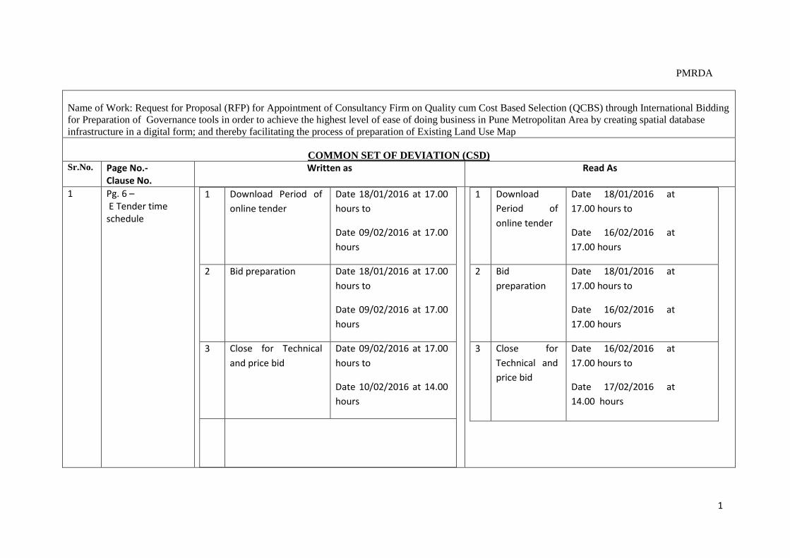
PMRDA
Name of Work: Request for Proposal (RFP) for Appointment of Consultancy Firm on Quality cum Cost Based Selection (QCBS) through International Bidding for Preparation of Governance tools in order to achieve the highest level of ease of doing business in Pune Metropolitan Area by creating spatial database infrastructure in a digital form; and thereby facilitating the process of preparation of Existing Land Use Map
COMMON SET OF DEVIATION (CSD) Sr.No. Page No.-
Clause No. Written as Read As
1 Pg. 6 – E Tender time schedule
1 Download Period of online tender
Date 18/01/2016 at 17.00 hours to
Date 09/02/2016 at 17.00 hours
2 Bid preparation Date 18/01/2016 at 17.00 hours to
Date 09/02/2016 at 17.00 hours
3 Close for Technical and price bid
Date 09/02/2016 at 17.00 hours to
Date 10/02/2016 at 14.00 hours
1 Download Period of online tender
Date 18/01/2016 at 17.00 hours to
Date 16/02/2016 at 17.00 hours
2 Bid preparation
Date 18/01/2016 at 17.00 hours to
Date 16/02/2016 at 17.00 hours
3 Close for Technical and price bid
Date 16/02/2016 at 17.00 hours to
Date 17/02/2016 at 14.00 hours

2
4 Bid submission Date 10/02/2016 at 14.01 hours to
Date 11/02/2016 at 13.00 hours
5 Place, Date and timing of opening of Bid
Date 11/02/2016 at 14.15 hours at Office of the PCNTDA
4 Bid submission
Date 17/02/2016 at 14.01 hours to
Date 18/02/2016 at 13.00 hours
5 Place, Date and timing of opening of Bid
Date 18/02/2016 at 14.15 hours at Office of the PCNTDA
2 Pg. 18 – clause 1.8 Schedule of Selection Process
4 Proposal Due Date On line submission
09/02/2016
5 Opening of Proposals 10/02/2016 6 Letter of Award (LOA) 25/02/2016
4 Proposal Due Date On line submission
16/02/2016
5 Opening of Proposals 18/02/2016 6 Letter of Award (LOA) 03/03/2016
3 Pg. 7 Letter of Invitation para 3
Earnest Money Deposit of INR 7.5 million shall be paid on line through E-Payment Gateway.
Earnest Money Deposit of INR 7.5 million shall be paid on line through E-Payment Gateway / in the form of Bank guarantee issued by one of the Nationalized Bank in India in favor of ‘Metropolitan Commissioner & Chief Executive Officer Pune Metropolitan Region Development Authority’ payable at Pune, valid for a minimum period of 150 days from the last date of submission of proposal. In case of foreign Bank, the Bank Guarantee issued by foreign bank should be counter guaranteed by any Nationalized Bank in India and payable at Pune.
4 Pg. 71 9.2.9 – c GEOPORTAL
c. Data attribute interrogation c. Data attribute integration

3
5 Pg. 44 & 45 Clause 3.1.3 – The scoring criteria
Item Parameter Maximum Criteria for Marking
Code Marks
1 ii) Similar Assignments
≥2 Nos2 Marks - ≥34NosMarks –
iii) Average Turnover in INR in Last 3 Years ≥250 million – 1 Mark
≥0001million – 4 Marks
2. Experience of the Firm in carrying out similar 45
assignment
i)Experience of preparation of Digital maps 10 ≥7000– 03SqMark. Km
by Acquisition of aerial photos of 10 cm
GSD by using digital aerial camera (DMC)
≥20000 – 06SqMark.Km
≥35000 – 10SqMark.Km
using Digital photogrammetric Technique
iv) Experience of carrying out survey of land parcels / land sub divisions and its confirmation by Dy. SLR / SLR office or similar competent authority
15
≥ Survey02Mark
≥ Confirmation15Mark
Item Code
Parameter Maximum Marks
Criteria for Marking
1 ii) similar Assignments
≥2 Nos. – 2 Marks ≥3 Nos. – 4 Marks
iii) Average Turnover in INR in Last 3 Years
≥250 million – 1 Mark ≥1000 million – 4 Marks
2 i)Experience of preparation of Digital maps by Acquisition of aerial photos of 10 cm GSD by using digital aerial camera (DMC) using Digital photogrammetric Technique
10 ≥ 7000 Sq. Km. – 03 Marks ≥ 20000 Sq. Km. – 06 Marks ≥ 35000 Sq. Km. – 10 Marks
iv) Experience of carrying out survey of land parcels / land sub-division and its confirmation by Dy. SLR / SLR office or similar competent Authority
15 Survey – 02 Marks Confirmation – 15 Marks
4
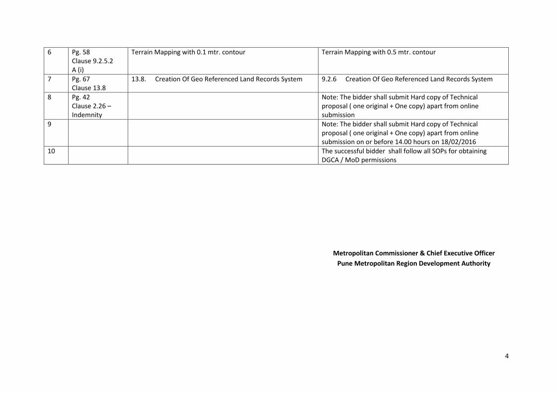
6 Pg. 58 Clause 9.2.5.2 A (i)
Terrain Mapping with 0.1 mtr. contour Terrain Mapping with 0.5 mtr. contour
7 Pg. 67 Clause 13.8
13.8. Creation Of Geo Referenced Land Records System 9.2.6 Creation Of Geo Referenced Land Records System
8 Pg. 42 Clause 2.26 – Indemnity
Note: The bidder shall submit Hard copy of Technical proposal ( one original + One copy) apart from online submission
9 Note: The bidder shall submit Hard copy of Technical proposal ( one original + One copy) apart from online submission on or before 14.00 hours on 18/02/2016
10 The successful bidder shall follow all SOPs for obtaining DGCA / MoD permissions
Metropolitan Commissioner & Chief Executive Officer Pune Metropolitan Region Development Authority