pollinator habitat mapping in oslo potential policy applications · 2019-02-08 · pollinator...
TRANSCRIPT

Pollinator habitat mappingin Oslo – potential policy
applications
David N. Barton, Zofie Cimburova, Erik Stange(NINA)
Enhancing Resilience of urban ecosystems through green infrastructure"
EnRoute Final conference – 14th meeting of the Technical Platform
Conference co-organised by the Committee of the Regions and the European Commission , Brussels, 29 January 2019

• ESTIMAP Pollination method
• Policy applications• Beehive carrying capacity
• Beehive optimal location
• Green roof habitat restoration
• Lessons learned
Overview
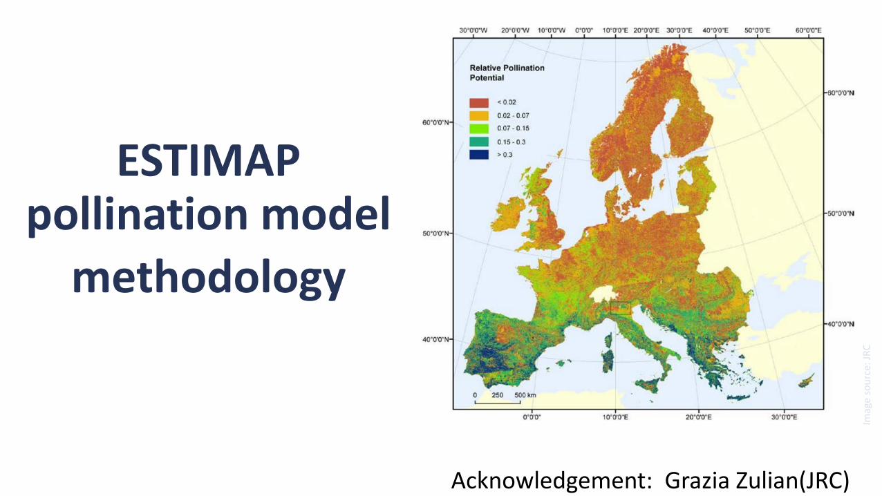
ESTIMAP pollination model
methodology
Imag
e so
urc
e: J
RC
Acknowledgement: Grazia Zulian(JRC)

ESTIMAP mapping methodology

Result: Pollinator habitat suitability map at highresolution (10m pixel) and regional planning scale
Local
Habitat suitabilityscore
City-wideFunctionalurban area

Local application #1: Zoning of honey bee hive
locationsto protect endangered wild bees

Red listed bee speciesand protected meadows
Map: Erik Stange, NINA
Proposed precautionary zonesFor honey bee keeping
Valuable nature types
Red listed bee species SensitiveNear endangered
MeadowsOpen calcarious

Map: Erik Stange, NINA
Proposed precautionary zonesFor honey bee keeping
Beehive locations(2015)
Beehive locations
1-4 beehives5 or more hives

Honey bee competition potential- quantitative data on foraging resources needed to assess beehive carrying capacity
Stange EE, Zulian G, Rusch GM, Barton D, Nowell M (2017) Ecosystem services mapping for
municipal policy: ESTIMAP and zoning for urban beekeeping. One Ecosystem 2:
e14014. https://doi.org/10.3897/oneeco.2.e14014
Honeybee foraging abundance index [0, 1]
=f(N hives, flight distance)
Pollinator habitat suitabilityscore [0, 1]
Honeybee competitionpotential [-1.0 , +1.0]

Local application #2: Optimal productive location of
beehives

Productivitypotential ofexistingbeehives basedon availablehabitat potential
Map: Zofie Cimburova
Local application #3: Roof potential for pollinator
habitat off-setting & restoration

Targeting for beekeeping(hotspots)
Pollinator habitatpotential ofavailable roofarea (>10m2, <5o slope)
Map: Zofie Cimburova

Map: Zofie Cimburova
Targeting for green roofdevelopment(cold spots)
Pollinator habitatpotential ofavailable roofarea (>10m2, <5o slope)

Reliability requirement
policies and management practices aimed at environmental sustainability
1 da1 ha
10 ha1 km2
100 m2
Source: adapted from Zulian, G. et al. (2017) Practical application of spatial ecosystem service models to aid decision support (in press) Ecosystem Services
Lessons learned from
ESTIMAP Pollination at
local level in Oslo
public awareness
potential ecosystem
service indicator
spatial zoning of
landuses
(beekeeping)
targeting of habitat
restoration measures
carrying capacity
assessment

Thank you!